Embed Size (px)
Citation preview
LETTER Earth Planets Space, 58, 1599–1604, 2006
Aftershock seismicity and fault structure of the 2005 West Off FukuokaPrefecture Earthquake (MJMA7.0) derived from urgent joint observations
Hiroshi Shimizu1, Hiroaki Takahashi2, Tomomi Okada3, Toshihiko Kanazawa4, Yoshihisa Iio5, Hiroki Miyamachi6,Takeshi Matsushima1, Masayoshi Ichiyanagi2, Naoki Uchida3, Takaya Iwasaki4, Hiroshi Katao5, Kazuhiko Goto6,
Satoshi Matsumoto1, Naoshi Hirata4, Shigeru Nakao6, Kenji Uehira1, Masanao Shinohara4, Hiroshi Yakiwara6, Nobuki Kame7,Taku Urabe4, Norimichi Matsuwo1, Tomoaki Yamada4, Atsushi Watanabe1, Kazuo Nakahigashi4, Bogdan Enescu5,
Kazunari Uchida1, Shin’ichi Hashimoto4, Syuichiro Hirano6, Takeo Yagi4, Yuhki Kohno1,Tomotake Ueno5, Masaki Saito1, and Mio Hori1
1Institute of Seismology and Volcanology, Faculty of Sciences, Kyushu University, Shimabara 855-0843, Japan2Institute of Seismology and Volcanology, Graduate School of Science, Hokkaido University, Sapporo 060-0810, Japan
3Research Center for Prediction of Earthquakes and Volcanic Eruptions, Graduate School of Science,Tohoku University, Sendai 980-8578, Japan
4Earthquake Research Institute, University of Tokyo, Tokyo 113-0032, Japan5Disaster Prevention Research Institute, Kyoto University, Uji 611-0011, Japan
6Nansei-Toko Observatory for Earthquakes and Volcanoes, Faculty of Science, Kagoshima University, Kagoshima 892-0871, Japan7Faculty of Sciences, Kyushu University, Fukuoka 812-8581, Japan
(Received April 19, 2006; Revised September 19, 2006; Accepted September 22, 2006; Online published February 2, 2007)
On March 20, 2005, a large MJMA7.0 earthquake occurred in the offshore area, west of Fukuoka prefecture,northern Kyushu, Japan. A series of joint observations were carried out by teams from several universities inJapan with the aim of investigating the aftershock activity. Six online telemetered and 17 offline recording seismicstations were installed on land around the aftershock area immediately followed the occurrence of the mainshock.Because aftershocks were located mainly in offshore regions, we also installed 11 ocean bottom seismometers(OBSs) just above the aftershock region and its vicinity in order to obtain accurate locations of hypocenters.The OBS observation was carried out from March 27 to April 13, 2005. We further conducted temporary GPSobservations in which ten GPS receivers were deployed around the aftershock region. The aftershocks weremainly aligned along an approximately 25-km-long NW-SE trend, and the hypocenters of the main aftershockregion were distributed on a nearly vertical plane at depths of 2–16 km. The mainshock was located near thecentral part of the main aftershock region at a depth of approximately 10 km. The largest aftershock of MJMA5.8occurred near the southeastern edge of the main aftershock region, and the aftershock region subsequentlyextended about 5 km in the SE direction as defined by secondary aftershock activity. Enlargement of theaftershock region did not occur after the peak in aftershock activity, and the aftershock activity gradually declined.The distribution of hypocenters and seismogenic stress as defined by aftershocks suggest that the 2005 West OffFukuoka Prefecture Earthquake occurred on the fault that is the NW extension of the Kego fault, which extendsNW-SE through the Fukuoka metropolitan area, and that the largest aftershock occurred at the northwestern tipof the Kego fault.Key words: The 2005 West Off Fukuoka Prefecture Earthquake, intraplate earthquake, mainshock, aftershock,seismic observation, hypocenter distribution, active fault, Kego fault.
1. IntroductionOn March 20, 2005, a large intraplate earthquake with
a Japan Meteorological Agency magnitude (MJMA) of 7.0occurred in Genkainada, in the offshore region west ofFukuoka prefecture, in northern Kyushu, Japan. Manyhouses and infrastructure were damaged in the surround-ing area, especially on Genkaijima Island and in and aroundFukuoka City. One resident was killed by the collapse of aconcrete-block wall and more than 1,000 people were in-jured in the earthquake.
Kyushu is located at the junction of the Southwestern
Copyright c© The Society of Geomagnetism and Earth, Planetary and Space Sci-ences (SGEPSS); The Seismological Society of Japan; The Volcanological Societyof Japan; The Geodetic Society of Japan; The Japanese Society for Planetary Sci-ences; TERRAPUB.
Japan Arc and the Ryukyu Arc. Interplate earthquakesof M = 7 occur here in response to subduction of thePhilippine-sea plate at Hyuganada, east of Kyushu, in off-shore regions at an interval of several tens of years. Thetectonics of onshore Kyushu is characterized by north-southextension (e.g. Tada, 1984), where the Beppu-Shimabaragraben has been formed in central Kyushu (Matsumoto,1979). Strain in central Kyushu is very high. Geodetic dataacquired during the past 100 years by the Geographical Sur-vey Institute reveals a N-S extension at a rate of about 1.4cm/year (strain rate=20–30×10−8/year) and subsidence of2 mm/year in the graben (Tada, 1985; GSI, 1987). The rateof intraplate earthquake production is also high in centralKyushu (e.g., Shimizu et al., 1993). Alternatively, the tec-tonics in northern Kyushu is relatively inactive: the crustal
1599

1600 H. SHIMIZU et al.: AFTERSHOCK SEISMICITY AND FAULT STRUCTURE OF THE FUKUOKA EARTHQUAKE
Table 1.
strain rate near the northern coast of Kyushu has been ap-proximately 5 × 10⁻⁸/year during the past 100 years (GSI,1987), and fewer than 20 earthquakes with magnitudes ofless than 2.5 have been detected at the source region of the2005 West Off Fukuoka Prefecture Earthquake during thepast 20 years.
The 2005 West Off Fukuoka Prefecture Earthquake wasone of the major intraplate earthquakes in the inner arc ofboth the Southwestern Japan Arc and the Ryukyu Arc, andthe largest event in northern Kyushu since the 1700 Iki-Tsushima earthquake (M = 7). In northern Kyushu, adestructive earthquake of MJMA6.0 occurred in 1898 at theItoshima peninsula about 20 km south of the 2005 West OffFukuoka Prefecture Earthquake (Usami, 1966). However adetailed hypocenter location and focal mechanism were notdetermined for this event. Our investigations of the 2005Fukuoka Earthquake are therefore important in terms of re-vealing the generation mechanism of intraplate earthquakesoccurring in northern Kyushu, the junction of the South-western Japan Arc and the Ryukyu Arc. Furthermore, theKego fault, which is an active fault crossing the Fukuokametropolitan area, extends towards the source region of the2005 Fukuoka Prefecture Earthquake, and it is possible thatthe Kego fault slipped in the 2005 earthquake (Meteorolog-ical Research Institute, 2005; Geological Survey of Japan,
2005). We carried out joint observations in a collaborativeeffort by several universities in Japan with the aim of inves-tigating the aftershock activity of the 2005 earthquake. Inthis paper, we report these observations and the space-timepatterns of the aftershock sequence.
2. Aftershock ObservationSeismic networks of the Japan Meteorological Agency
(JMA), the National Research Institute for Earth Scienceand Disaster Prevention (NIED), and Kyushu University areoperative in northern Kyushu, and their seismic data aremutually exchanged in real time. These networks consist ofpermanent seismic stations and they were spaced at about30-km intervals in the inland area, which enabled us todetermine the hypocenter of the 2005 West Off FukuokaPrefecture Earthquake and define the aftershock sequence.
In an effort to determine the aftershock activity in moredetail, observations of aftershocks began the day after themainshock by Kyushu University, Hokkaido University, To-hoku University, the University of Tokyo, Kyoto University,and Kagoshima University. The installation of all 17 of-fline seismic stations was completed within 3 days after themainshock occurred. In addition to the offline stations, wealso installed six online temporary seismic stations. Theseseismic stations were located on islands and along the coast-
H. SHIMIZU et al.: AFTERSHOCK SEISMICITY AND FAULT STRUCTURE OF THE FUKUOKA EARTHQUAKE 1601
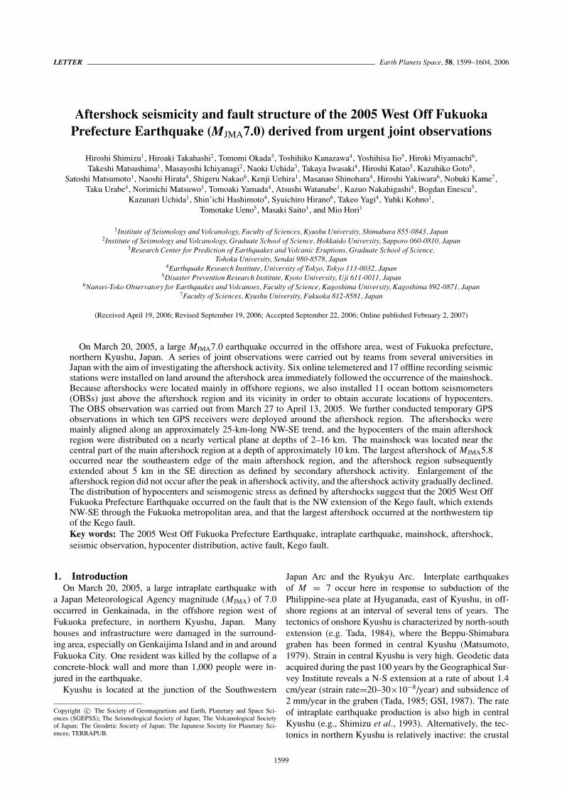
Fig. 1. Location map of the seismic stations. Crosses, small stars, trian-gles and circles indicate the permanent online, temporary online, tem-porary offline and temporary OBS stations, respectively. The epicen-ter distribution before the urgent joint observation period is also shownin the map. The large star represents the epicenter of the mainshock(MJMA7.0), and the green dots denote the epicenters of aftershocks. Thegrey shaded area shows the Fukuoka metropolitan area.
line of Fukuoka prefecture in a 50×50-km area surroundingthe aftershock region (Fig. 1).
Each offline station consisted of a three-component geo-phone and digital data logger with GPS clock (accuracy ofapprox. 1 ms). Seismic data were continuously recordedat the logger with a sampling frequency of 100 or 200Hz. The dynamic range of the system varied by logger-type and ranged from 14 to 24 bit. Each online stationconsisted of a three-component geophone and a teleme-try system that mainly used the Integrated Services Dig-ital Network (ISDN). The dynamic range of the teleme-try system was from 14 to 24 bit. On Genkaijima andShikanoshima Islands, which were close to the aftershockregion and strongly damaged by the mainshock, we firstdeployed portable radio-wave and satellite (VSAT: VerySmall Aperture Terminal) telemetry systems, respectively,because they were able to be set up in a damaged area with-out usable infrastructure. These two stations were opera-tive from March 21, the day after the mainshock, and weremoved to the neighborhoods, thereby replacing the teleme-try system with the ISDN system, on April 1 for Genkai-jima and May 20 for Shikanoshima. Seismic data of theonline stations were telemetered to the Institute of Seis-mology and Volcanology (SEVO), Kyushu University, andwere processed together with data from the permanent seis-mic networks. In addition, seismic data of the four stationsamong online stations were transmitted to the JMA in orderto support monitoring of the aftershock activity.
Because most of the aftershocks occurred offshore, wedeployed ocean bottom seismometers (OBSs) for the ac-curate determination of hypocenter locations. Temporaryobservations for 19 days with 11 pop-up type OBSs werecarried out around the aftershock area starting 6 days afterthe mainshock by SEVO, the Earthquake Research Insti-tute (ERI), and the University of Tokyo (Fig. 1). The de-
ployment of OBSs was conducted using M/V Fujisan-maru(Dokai Marine Co., Japan) chartered by Kyushu Universityon March 26 and 27, and all the OBSs were successfully re-covered by P/V Genkai belonging to the Fukuoka Fisheriesand Marine Technology Research Center, Fukuoka Prefec-ture, on April 13 and 14. The OBSs used in our obser-vations had been originally developed by The EarthquakeResearch Institute and consisted of a three-component 4.5-Hz geophone and a continuously recording hard-disk unithoused in the pressure sphere. The sampling frequency anddynamic range of the system were 128 Hz and 16 bit, re-spectively.
Seismic event data recorded at offline land stations andthe ocean bottom were combined with those recorded at on-line stations and subsequently used for the hypocenter de-termination and focal mechanism analysis. The specifica-tion of all the temporary seismic stations in the observationsis listed in Table 1.
In addition to seismic observations, a temporary GPS ob-servation was carried out by Kyushu University, HokkaidoUniversity and Kagoshima University in order to detect thepost-seismic crustal deformation. We installed ten GPS re-ceivers around the aftershock region, and analyzed our GPSdata together with the GEONET data of the GeographicalSurvey Institute (GSI), Japan. The results of the GPS ob-servation are reported by Nakao et al. (2006).
3. Hypocenter Distribution of AftershocksHypocenter determination of the earthquakes, based on
detection by the seismic network of SEVO, Kyushu Uni-versity, was carried out. Event detection and the pickingof P- and S-wave arrival times were performed using theWIN system (Urabe and Tsukada, 1991), and a maximum-likelihood method was used in the calculation of hypocenterlocations (Hirata and Matsu’ura, 1987). In the calculationof hypocenters and focal mechanisms, we assumed the one-dimensional velocity structure model used in the data pro-cessing at SEVO (see figure 2 of Uehira et al., 2006). Themagnitudes of aftershocks were determined using maxi-mum amplitudes of velocity seismograms, which are empir-ically consistent with JMA magnitudes (Watanabe, 1971).
About 13,000 hypocenters were determined from March20 to November 20, 2005 for the aftershocks, with magni-tudes ranging from 0.0 to 5.8. With respect to the main-shock and the aftershocks that occurred within a day of themainshock, data from the permanent seismic networks wereused in the hypocenter determination because the temporaryobservation stations were not yet operating. The numberof seismic stations subsequently used in the hypocenter de-termination subsequently increased with the deployment oftemporary seismic stations. The accuracy of the hypocen-ter locations therefore improved with time, and the mostprecise hypocenters were obtained from March 27 to April13 because of the OBS observations. Since details of thehypocenter distribution in the period of OBS observationare discussed by Uehira et al. (2006), we limit our discus-sion in this article to the distribution of aftershocks in thesequence and the fault system inferred from aftershock ac-tivity.
Figure 2 shows the hypocenter of the mainshock of

1602 H. SHIMIZU et al.: AFTERSHOCK SEISMICITY AND FAULT STRUCTURE OF THE FUKUOKA EARTHQUAKE
Fig. 2. Hypocenter distribution of the aftershocks before the largestaftershock of MJMA5.8 occurred (March 20–April 20, 2005). The starindicates the mainshock (MJMA7.0) on March 20. The distribution ofactive faults, as determined by the Research Group for Active Faults ofJapan (1991), is shown by the thick lines in the map. Note that the mapis rotated counterclockwise by 30◦ so that the cross sections becomeapproximately parallel and perpendicular to the alignment of aftershockdistribution.
March 20 and aftershocks from March 20 to April 20. Theepicenters were mainly aligned NW-SE in an approximately25-km-long trend. Minor clusters are located at the SE ex-tension of the main aftershock region. Hypocenters of themain aftershock region are distributed on a nearly verticalplane, and their depths range from 2 to 16 km. The main-shock was located near the central part of the region at adepth of approximately 10 km. The focal mechanism solu-tion of the mainshock was a strike-slip fault type, and oneof the nodal planes was consistent with the trend of the af-tershock distribution (Matsumoto et al., 2006; Uehira et al.,2006).
These results revealed the orientation of the fault planeof the 2005 West Off Fukuoka Prefecture Earthquake: thestrike and dip of the fault were approximately N60◦W and90◦, respectively, and the length and width of the fault wereabout 25 km and 14 km, respectively. The rupture with aleft-lateral strike-slip dislocation initiated near the center ofthe aftershock sequence and expanded bilaterally about 10km toward the NW and 15 km toward the SE. The rupture ofthe mainshock stopped beneath Shikanoshima Island, about10 km northwest of the central Fukuoka City. About 5 kmfrom the northwestern end of the fault, it changed geometryin a bend oriented about N45◦W as based on the hypocenterdistribution (Fig. 2). Focal mechanism solutions of theaftershocks also changed near the northwestern end of thefault in correspondence to the bend (Uehira et al., 2006).
The largest aftershock of MJMA5.8 occurred near thesoutheastern edge of the main aftershock region on April20, 2005. The secondary aftershock activity followed thelargest aftershock, and the aftershock region subsequentlyextended about 5 km in the SE direction (Fig. 3). The focal
Fig. 3. Hypocenter distribution of the aftershocks during the month imme-diately following the largest aftershock (April 20–May 20, 2005). Thestar indicates the largest aftershock (MJMA5.8) on April 20. The clusterof the secondary aftershocks of the largest aftershock is recognized atthe SE side of the largest aftershock.
mechanism solution of the largest aftershock was a strike-slip fault type with E-W compression and N-S extension,similar to that of the mainshock (Uehira et al., 2006). Thesesuggest that the largest aftershock occurred by the southeastextension of the rupture of the mainshock fault. However,the distribution of epicenters of the secondary aftershocksin Fig. 3 and a nodal plane of the focal mechanism solutionfor the largest aftershock imply that the strike of the largestaftershock fault was oriented here approximately 10◦ to thesouth compared with that of the mainshock (Ito et al., 2006;Uehira et al., 2006).
The aftershock activity decreased gradually with time, al-though the seismicity increased during periods associatedwith major aftershocks. Figure 4 shows the monthly dis-tribution of aftershock epicenters from May 20, 2005 toNovember 20, 2005. The enlargement of the aftershock re-gion was not obviously recognizable in this period. Theaftershock occurrence was roughly uniform, and no spa-tial bias of seismicity was found in the aftershock region.However, major aftershocks (M > 4) had a tendency to oc-cur near the hypocenter of the mainshock, the northwesternend, and the southeastern end of the aftershock region.
4. DiscussionThe JMA (2005) determined the hypocenter distributions
of the mainshock and aftershocks of the 2005 West OffFukuoka Prefecture Earthquake with the aim of monitor-ing seismic activity. The hypocenters determined by theJMA are distributed about 30 km in the NW-SE directionand 5–16 km in depth. Alternatively, the hypocenters inthis study are about 2–16 km deep, as shown in Fig. 2, andthe upper boundary of the distribution is about 3 km shal-lower than those by the JMA. It was confirmed that the

H. SHIMIZU et al.: AFTERSHOCK SEISMICITY AND FAULT STRUCTURE OF THE FUKUOKA EARTHQUAKE 1603
Fig. 4. Epicenter distributions of aftershocks from May 20 to November20, 2005. The thick lines represent the active faults. The major after-shocks (M > 4) are shown by the large circles. (a) May 20–June 20,2005, (b) June 20–July 20, 2005; (c) July 20–August 20, 2005; (d) Au-gust 20—September 20, 2005; (e) September 20–October 20, 2005; (f)October 20–November 20, 2005.
hypocenter depths for the shallow events were less accurateand assessed to be deeper in the absence of data from thetemporary stations close to the source region (Uehira et al.,2006). The accuracy of hypocenter locations, especially thehypocenter depths, was clearly improved by the joint obser-vations produced by our work.
The 2005 West Off Fukuoka Prefecture Earthquake andmost of the major aftershocks are consistent with EW-compressional and NS-tensional stresses. Figure 5 showsthe orientation of the maximum principal stresses (com-pression axes) and the minimum principal stresses (tensionaxes) derived from focal mechanism solutions of the earth-quakes shallower than 30 km in the Kyushu district. Thecompression and tension axes are oriented roughly in theE-W or NE-SW direction and the N-S or NW-SE direction,respectively, in the region. Both compression and tensionaxes are nearly horizontal, and thus strike slip faults aredominant in northern Kyushu. In central Kyushu, however,we note that some compression axes are inclined and someof them are nearly vertical. This is consistent with the de-velopment of normal faults that form the Beppu-Shimabaragraben. The orientation of principal stresses in southwest-ern Kyushu is slightly rotated counterclockwise comparedwith that in northern Kyushu; consequently, the NE-SWcompression and NW-SE tension become dominant.
129°
E
130°
E
31°N
32°N
33°N
34°N
50 km
131°
E
132°
E
P
129°
E
130°
E
31°N
32°N
33°N
34°N
50 km
132°
E
T
131°
E
Fig. 5. Distribution of the principal stress orientation inferred from thefocal mechanism solutions for the earthquakes shallower than 30 kmin Kyushu. The results of the focal mechanism analysis for the 2005West Off Fukuoka Prefecture Earthquake and its major aftershocks areincluded in the distribution of the principal stress orientation. (a) Themaximum principal stresses (compression axes); (b) the minimum prin-cipal stresses (tension axes).
The past major earthquakes in the inner-arc of the South-western Japan Arc, such as the 1943 Tottori Earthquake ofMJMA7.2 (Kanamori, 1972), the 1995 Hyogo-ken NanbuEarthquke of MJMA7.2 (JMA, 1995), and the 2000 West-ern Tottori Earthquake of MJMA7.3 (JMA, 2001), were allgenerated by strike slip faulting with nearly horizontal E-W compression and N-S tension axes. These features arethe same as those earthquakes in northern Kyushu shown inFig. 5 and imply that the 2005 West Off Fukuoka Prefec-ture Earthquake was caused by the regional stress field inthe inner-arc of the Southwestern Japan Arc.
There are several active faults formed in the regional tec-tonic stress field in northern Kyushu (The Research Groupfor Active Faults of Japan, 1991). Although the active faultwhich corresponds to the 2005 West Off Fukuoka Prefec-ture Earthquake has not been mapped previously as such,the Kego fault is located at the SE extension of the after-shock region. The Kego fault strikes in the NW-SE direc-tion and is aligned with secondary aftershocks of the largestaftershock (Fig. 3). Based on seismic sounding and pistoncoring exploration in the Hakata bay, Okamura et al. (2006)found that the Kego fault extends about 7 km northwest-ward and extends nearly to Shikanoshima Island. There-fore, it is considered that the fault of the 2005 West OffFukuoka Prefecture Earthquake is the offshore extension ofthe Kego fault, as mapped on Shikanoshima Island. Themainshock occurred as a slip on the NW segment of thefault system. Alternatively, the largest aftershock probablyinitiated at the junction of the segments and partially frac-tured the northwestern tip of the SE segment (i.e., the Kegofault). Because the aftershock region has not been extendedafter the largest aftershock activity in May 2005 (Fig. 4),we argue that most of the SE segment did not slip in thisevent. Iio et al. (2006) showed that the secondary after-shocks of the largest aftershock are characterized by largestress drops. These features suggest the possibility of thestress concentration on the northwestern part of the SE seg-ment.

1604 H. SHIMIZU et al.: AFTERSHOCK SEISMICITY AND FAULT STRUCTURE OF THE FUKUOKA EARTHQUAKE
5. ConclusionThe urgent joint observations conducted after the 2005
West Off Fukuoka Prefecture Earthquake (MJMA7.0) byteams from Kyushu University, Hokkaido University, To-hoku University, the University of Tokyo, Kyoto University,and Kagoshima University were based on data collectedat temporary seismic stations on the islands and along thecoast surrounding the aftershock region. In addition, wedeployed pop-up type OBSs on the sea floor just above andaround the aftershock area.
The urgent joint observations revealed the space-timecharacteristics of the aftershock activity. The aftershockswere mainly aligned approximately 25 km in the NW-SEdirection, and the hypocenters of the main aftershock regionwere distributed on a nearly vertical plane at depths of 2–16km. The mainshock was located near the central part of themain aftershock region, with a depth of approximately 10km. The largest aftershock of MJMA5.8 occurred near thesoutheastern edge of the main aftershock region, and theaftershock region extended about 5 km in the SE directionas a result of secondary aftershock activity. Following themost intense aftershock activity, the enlargement of the af-tershock region did not obviously occur, and the aftershockactivity gradually declined.
The hypocenter distribution and seismogenic stress ofthe aftershocks suggest that the fault of the 2005 West OffFukuoka Prefecture Earthquake belongs to the same faultsystem as the Kego fault and that the main aftershock regioncorresponds to the NW segment of the fault system. Thelargest aftershock activity probably occurred at the north-western tip of the SE segment.
Acknowledgments. We thank Fukuoka Prefectural Government,Fukuoka City Office, Oro Elementary School, Genkai ElementarySchool, Genkai Junior High School, Kitazaki Elementary School,Kitazaki Junior High School, Noko Elementary School, NokoJunior High School, Shikanoshima Elementary School, ShinguTown Office, Ainoshima Elementary School, UminonakamichiSeaside Park, and the Fishery Research Laboratory of KyushuUniversity for their cooperation in the urgent joint observations.The authors are grateful to the crews of M/V Fujisan-maru andP/V Genkai for their help in the installation and recovery of theOBSs. The comments from Prof. Hasemi and an anonymousreviewer were helpful for improving the manuscript. We used theseismic data from the Japan Meteorological Agency, the NationalResearch Institute for Earth Science and Disaster Prevention, andFukuoka City.
ReferencesGeographical Survey Institute, Horizontal strain in Japan 1985–1883, As-
sociation for the Development of Earthquake Prediction, 133 pp., 1987(in Japanese).
Geological Survey of Japan, Spatial forecasting of aftershocks calculatingstatic stress changes caused by the 2005 Fukuoka-ken Seiho-oki earth-quake, Rep. Coord. Commun. Earthq. Predict., 74, 517–519, 2005 (inJapanese).
Hirata, N. and M. Matsu’ura, Maximum-likelihood estimation of hypocen-ter with origin time eliminated using nonlinear inversion technique,Phys. Earth Planet. Inter., 47, 50–61, 1987.
Iio, Y., H. Katao, T. Ueno, B. Enescu, N. Hirano, T. Okada, N. Uchida, S.Matsumoto, T. Matsushima, K. Uehira, and H. Shimizu, Spatial distribu-tion of static stress drops for aftershocks of the 2005 West Off Fukuoka
Prefecture earthquake, Earth Planets Space, 58, this issue, 1611–1615,2006.
Ito, Y., K. Obara, T. Takeda, K. Shiomi, T. Matsumoto, S. Sekiguchi, and S.Hori, Initial-rupture fault, main-shock fault, and aftershock faults: Faultgeomotry and bends inferred from centroid moment tensor inversion ofthe 2005 west off Fukuoka prefecture earthquake, Earth Planets Space,58, 69–74, 2006.
Japan Meteorological Agency, The 1995 Hyogoken-Nanbu earthquake andits aftershocks, Rep. Coord. Commun. Earthq. Predict., 54, 584–592,1995 (in Japanese).
Japan Meteorological Agency, Outline of the western Tottori Prefectureearthquake in 2000, Rep. Coord. Commun. Earthq. Predict., 65, 525–535, 2001 (in Japanese).
Japan Meteorological Agency, An outline of the earthquake occurred westoff Fukuoka prefecture on March 20, 2005, Rep. Coord. Commun.Earthq. Predict., 74, 465–471, 2005 (in Japanese).
Kanamori, H., Determination of effective tectonic stress associated withearthquake faulting. The Tottori Earthquake of 1943, Phys. EarthPlanet. Inter., 5, 426–434, 1972.
Matsumoto, T., Y. Ito, H. Matsubayashi, and S. Sekiguchi, Spatial distribu-tion of F-net moment tensors for the 2005 West Off Fukuoka PrefectureEarthquake determined by the extended method of the NIED F-net rou-tine, Earth Planets Space, 58, 63–67, 2006.
Matsumoto, Y., Some problems on volcanic activities and depression struc-tures in Kyushu, Japan, Mem. Geol. Soc. Jpn., 16, 127–139, 1979 (inJapanese).
Meteorological Research Institute, Coulomb failure stress change for Kegofault caused by the earthquake (M7.0) that occurred on March 20, 2005west off Fukuoka prefecture, Rep. Coord. Commun. Earthq. Predict.,74, 472–473, 2005 (in Japanese).
Nakao, S., H. Takahashi, T. Matsushima, Y. Kohno, and M. Ichiyanagi,Postseismic deformation following the 2005 West Off Fukuoka Pre-fecture Earthquake (M7.0) derived by GPS observation, Earth PlanetsSpace, 58, this issue, 1617–1620, 2006.
Okamura, M., K. Matsuoka, K. Shimazaki, N. Chida, T. Nakata, and K. Hi-rata, Paleoseismicity on the extension of Kego Fault in Hakata Bay, Rep.Coord. Commun. Earthq. Predict., 75, 555–559, 2006 (in Japanese).
Shimizu, H., K. Umakoshi, and N. Matsuwo, Seismic activity in mid-dle and western Kyushu, Mem. Geol. Soc. Jpn., 41, 13–18, 1993 (inJapanese).
Tada, T., Spreading of the Okinawa trough and its relation to the crustaldeformation in Kyushu, J. Seismol. Soc. Jpn., 37, 407–415, 1984 (inJapanese).
Tada, T., Spreading of the Okinawa Trough and its relation to the crustaldeformation in Kyushu (2), J. Seismol. Soc. Jpn., 38, 1–12, 1985 (inJapanese).
The Research Group for Active Faults of Japan, Active Faults in Japan (re-vised edition), University of Tokyo Press, 448 pp., 1991 (in Japanese).
Uehira, K. ,T. Yamada, M. Shinohara, K. Nakahigashi, H. Miyamachi, Y.Iio, T. Okada, H. Takahashi, N. Matsuwo, K. Uchida, T. Kanazawa,and H. Shimizu, Precise aftershock distribution of the 2005 West OffFukuoka Prefecture Earthquake (Mj=7.0) using a dense onshore andoffshore seismic network, Earth Planets Space, 58, this issue, 1605–1610, 2006.
Urabe, T. and S. Tsukada, A workstation-assisted processing system forwaveform data from microearthquake network, Abstracts of SpringMeeting of Seismological Society of Japan, 70, 1991 (in Japanese).
Usami, T., Materials for Comprehensive List of Destructive Earthquakesin Japan (Revised and Enlarged Edition), University of Tokyo Press,Japan, 493 pp., 1996 (in Japanese).
Watanabe, H., Determination of earthquake magnitude at regional dis-tance in and near Japan, J. Seismol. Soc. Jpn., 24, 189–200, 1971 (inJapanese).
H. Shimizu (e-mail: [email protected]), H. Takahashi, T.Okada, T. Kanazawa, Y. Iio, H. Miyamachi, T. Matsushima, M. Ichiyanagi,N. Uchida, T. Iwasaki, H. Katao, K. Goto, S. Matsumoto, N. Hirata,S. Nakao, K. Uehira, M. Shinohara, H. Yakiwara, N. Kame, T. Urabe,N. Matsuwo, T. Yamada, A. Watanabe, K. Nakahigashi, B. Enescu, K.Uchida, S. Hashimoto, S. Hirano, T. Yagi, Y. Kohno, T. Ueno, M. Saito,and M. Hori