Embed Size (px)
Citation preview

1
African Space Strategy Towards economic, political and social integration
Version 4

2
Table of Contents
Table of Contents ........................................................................................................ 2
Executive Summary..................................................................................................... 3
1 Introduction .......................................................................................................... 4
2 How Space can address Africa’s challenges ............................................................ 4 2.1 Earth Observation Applications .............................................................................................................. 5 2.2 Navigation and Positioning Applications ............................................................................................ 6 2.3 Satellite Communication Applications ................................................................................................ 6 2.4 Space Science and Astronomy ................................................................................................................. 7
3 Situational Analysis ............................................................................................... 9 3.1 SWOT Analysis ............................................................................................................................................... 9 3.2 Developing the Strengths and Addressing the Weaknesses .................................................... 10 3.3 Responding to the Opportunities and Managing the Threats ................................................. 11 3.4 Building on Africa’s Space Heritage.................................................................................................... 11
4 Strategic Context ................................................................................................. 12 4.1 Vision ............................................................................................................................................................... 12 4.2 Goals ................................................................................................................................................................ 12 4.3 Strategic Objectives ................................................................................................................................... 12 4.4 Expected Outcomes ................................................................................................................................... 12 4.5 Expected Impact ......................................................................................................................................... 13
4.5.1 The Macro Level Impact .......................................................................................................................... 13 4.5.2 The Micro Level impact ........................................................................................................................... 13
6 The Implementation Framework/Key Deliverables .............................................. 13 6.1 Key Priority Areas ...................................................................................................................................... 14 6.2 Space Discipline .......................................................................................................................................... 17
6.2.1 Earth Observation ...................................................................................................................................... 17 6.2.2 Navigation and Positioning ................................................................................................................... 18 6.2.3 Satellite Communications....................................................................................................................... 19 6.2.4 Space Science and Astronomy .............................................................................................................. 19
7 Implementation Guidelines/Critical Success Factors ............................................ 20 7.1 Functional Platforms ................................................................................................................................ 21
7.1.1 Mission Requirements .............................................................................................................................. 21 7.1.2 Enabling Technologies ............................................................................................................................. 22 7.1.3 Mission Operations .................................................................................................................................... 23 7.1.4 Space Applications ..................................................................................................................................... 25
7.2 Supporting Platforms ............................................................................................................................... 26 7.2.1 Human capital development and space awareness ................................................................... 26 7.2.2 Infrastructure .............................................................................................................................................. 27 7.2.3 International partnerships .................................................................................................................... 28 7.2.4 Industrial participation and development ..................................................................................... 30 7.2.6 Economic Model ............................................................................ Error! Bookmark not defined.
10 Key Performance Indicators ................................................................................ 30
11 Conclusion .......................................................................................................... 30
3 The global space economy ................................................................................... 33

3
Executive Summary
[This will be completed at the end, once the draft strategy is in place]

4
1 Introduction Africa is facing major challenges in ensuring the adequate provision of basic necessities,
such as food, shelter, a clean and healthy environment and proper education for the
growing population on the continent. Only through sustainable development can one
hope to address these challenges. The concept of sustainability is closely linked to the
carrying capacity of ecosystems, which sets the physical limits to economic development
and may be defined as the maximum rate of resource consumption and waste discharge
that can be sustained on a permanent basis in a defined planning region without
impairing productivity and ecological integrity. Economic, political and social
commitments are only effective if there is a global partnership for sustainable
development and to ensure the equitable allocation of available resources.
Africa’s challenges
STISA 2024
Societal Needs Policy Framework Required Information & Products
Food Security CAADP Land Policy
Rainfall, Yield, production, Crops Distribution.
Water Resources African Water Vision Hydrography, Aquifers, Water bodies, Quality
Marine and Coastal Zones
2050 Africa’s Integrated Maritime Strategy
Coastal zones degradation, Fisheries potential
Environment NEPAD - EPF Ecosystems, biodiversity, Vegetation, Land cover
Climate Change Climate Development Africa Rainfall, temperature, wind, aerosols…
Security and Emergency
Africa Regional Strategy on Disaster
Vulnerability, Risk
Health Planning Africa Health Strategy Disease vectors, environmental factors distribution…
Governance and Commerce
e-Government Strategy Location- based mobile services (LBMS); spatial depicting of biotechnology and creative industries; mapping of Government ICT infrastructures, data, applications and services delivery.
Infrastructure Programme on Infrastructure Development
Spatial information
2 How Space can address Africa’s challenges The benefits from space infrastructure are becoming more evident in the management
of long-term and significant challenges faced by modern society. In the case of natural
disaster management (e.g. floods), remote sensing from space can provide data for the
whole cycle of information for flood prevention and mitigation, pre-flood assessment,
response (during the flood), recovery (after the flood) and weather newscasts. Timely
satellite imagery and communications links in hard-to-reach places can help stem
catastrophic economic and human losses. The key contributions of space technology to
meeting society’s challenges include:
• The ability to communicate anywhere in the world;
• The ability to observe any spot on earth very accurately; and
• The ability to locate a fixed or moving object anywhere on the surface of the globe.

5
Space science and technology has and continues to contribute to sustainable
development and offers many benefits to mankind. Depending on their mission,
satellites have different orbits. Weather and communication satellites are placed in
geostationary orbits (altitude of 36,000km) above the equator, from which they have a
constant gaze on the same hemisphere of the Earth by completing one orbit around the
Earth every 24 hours. Other satellites are placed in Low Earth Orbits (LEO), which
complete on average one orbit around the earth every 100 minutes. Because the Earth
rotates in the plane of the orbit, such a satellite eventually covers the whole Earth. Such
orbits are used for remote sensing, and navigation and positioning applications.
In what follows we attempt to demonstrate the value that space science and technology
brings to the four key areas of space science and technology, namely (i) Earth
observation, (ii) navigation and positioning, (iii) satellite communications, and (iv)
space science and astronomy. In so doing we aim to enthuse our political principles and
decision makers on the value and benefits of space science and technology in addressing
our manifold socio-economic challenges.
2.1 Earth Observation Applications
Earth observation/remote sensing satellites use modern instruments to gather
information about the nature and condition of the land, sea, and atmosphere. Located in
various orbits, these satellites use sensors that can “see” a broad area and report very
fine details about the weather, the terrain, and the environment. The sensors receive
electromagnetic emissions in various spectral bands, which show objects that are
visible, such as clouds, hills, lakes, and many other features. These instruments can
detect an objects temperature and composition, the wind’s direction and speed and
environmental conditions, such as erosion, fires, and pollution. Included below is a
selection of specific examples of the benefits of remote sensing.
In countries where the failure of a harvest may mean the difference between bounty and
starvation, satellites have helped planners manage scarce resources and head off
potential disasters before insects or other blights could wipe out an entire crop. For
example, in agricultural regions near the fringes of the Sahara desert, scientists used
satellite images to predict where locust swarms were breeding and were able to prevent
the locusts from swarming, thus saving large areas of cropland.
Remote sensing data can also help us manage scarce resources by showing us the best
places to drill for water or oil. From space, astronauts can easily see fires burning in the
rain forests of South America as trees are cleared for farms and roads. Remote sensing
satellites have become a formidable weapon against the destruction of the environment
because they can systematically monitor large areas to assess the spread of pollution
and other damages. Such monitoring capabilities are critical for the long-term
sustainable use of our scarce resources.
Remote sensing technology has also helped mapmakers. With satellite imagery, they can
produce maps in a fraction of the time it would take using laborious ground surveys. The
use of synthetic aperture radars or stereoscopic imaging provides topographic maps of
the landscape. This capability enables city planners to keep up with urban sprawl and
gives deployed troops the latest maps of unfamiliar terrain. The latter is vitally
important for peacekeeping missions in Africa.
Because remote sensing satellites cover the whole globe, they are important for the
study of large-scale phenomena like ocean circulations, climate change, desertification

6
and deforestation. Satellites make it possible to monitor environmental change caused
by human activity and natural processes. Because data is collected in a consistent
manner, satellites can reveal subtle changes that might otherwise remain undetected.
For example, the well known “ozone hole” over Antarctica and the phenomena of
atmospheric ozone depletion was discovered using satellites.
2.2 Navigation and Positioning Applications
Satellite navigation uses satellites as reference points to calculate positions accurate to
within a few meters. With advanced techniques and augmentations, satellite navigation
can make measurements down to centimeter levels. Navigation and positioning
receivers have been miniaturized and are becoming economical thus making the
technology accessible to everyone. For example, GNSS (Global Navigation Satellite
Services) receivers are currently built into cars, boats, planes, construction equipment
and even laptops to provide accurate geographic coordinates of these valuable assets.
Navigation and positioning is the main element of the international air traffic
management system providing worldwide navigation coverage to support all phases of
flight. With appropriate augmentation systems, navigation and positioning satellites will
enable gate-to-gate navigation and all weather capabilities for suitably equipped
aircraft. With more precise navigation tools and accurate landing systems flying do not
only become safer, but also more efficient by reducing delays, diversions and
cancellation of flights. These interventions also assist in CO2 emissions reduction in the
aviation sector.
In general, mariners use the Global Positioning System (GPS) for either navigation or
positioning. GPS has also recently been applied to the surveillance of illegal shipping
activities, such as fisheries. The latter has also been extended to monitor oil spills and
the ensuing environmental damages. The use of remote sensing satellites has been used
extensively to map ocean colour, temperature, currents, salinity and wind direction.
Such rich information is vital for protecting and extracting economic value from our
Economic Exclusion Zones and better understanding of the climate change models.
Many automotive navigation and positioning applications fit within the description of
intelligent transportation systems (ITS). ITS programmes are intended to improve
traveller safety; improve travel efficiency by reducing congestion; save energy through
reduction of fuel requirements; and lessen the environmental impact of travel.
Automobile navigation applications also help the driver to make the most efficient
routing decisions – this application is also valuable for fleet vehicle management and the
tracking of valuable assets, especially across national borders.
2.3 Satellite Communication Applications
Satellite communications is the key technology that could bring developing countries to
participate in the build up of the global information infrastructure. Research indicates
that wireless systems are the most cost effective way to develop or upgrade
telecommunications networks in areas where user density is lower than 200
subscribers per square kilometer. Such wireless systems can be installed 5-10 times
faster and at a 50% lower cost than landline networks.
The Internet in Africa is limited by a lower penetration rate when compared to the rest
of the world, and overall available bandwidth indicates that Africa is way behind the
"digital divide". This is the era of internet of things and things of the internet. According
to 2011 estimates, about 13.5% of the African population has Internet access. While
Africa accounts for 15.0% of the world's population, only 6.2% of the World's Internet
subscribers are Africans. Africans who have access to broadband connections are

7
estimated to be in percentage of 1% or lower. In September 2007, African broadband
subscribers were 1,097,200, with a major part of these subscriptions from large
companies or institutions. Satellite communications can fill the gap and increase
broadband access, particularly in land locked countries and rural areas where cable
penetration is non-existent.
Integrating information and communication technologies (ICTs) into governance
processes can greatly enhance the delivery of public services to all citizens. ICT
integration will not only improve the performance of governance systems, it will also
transform relationships amongst stakeholders, thereby influencing policymaking
processes and regulatory frameworks. In the developing world, however, the potential
of ICTs for effective governance remains largely unexplored and unexploited. Such
services can be delivered through connectivity via satellite links in areas with minimal
access to internet. Satellite connectivity involving post offices may be used for access to
such services for those who have no access to internet.
Technologies for education and training, in particular distant education and multimedia,
may be instrumental in meeting the needs of countries that have to train and integrate a
large number of workers in widely dispersed and under-equipped areas. This allows for
a constant renewal of skills without being limited by Information Technology (IT)
infrastructure. The use of VSAT terminals coupled with communication satellites makes
education more accessible, especially in rural areas.
Many countries have to cope with large-scale disease outbreaks and telemedicine may
help to meet these challenges by improving the organisation and management of health
care. Databases may be linked through networks to monitor the development of
diseases, provide access to medical expertise through tele-consultation and support
remote medical assistance. In this regard, satellite communications can contribute to
preparing and implementing health policies. Telemedicine is a cost-effective solution for
providing affordable health care in rural areas.
National weather forecasts begin with a current satellite view of Earth. At a glance one
can tell which parts of the country are clear or cloudy. When satellite maps are put in
motion we easily see the direction of clouds and storms. An untold number of lives are
saved every year by this simple ability to track the paths of hurricanes and other deadly
storms. By providing farmers valuable climatic data and agricultural planners with
information, this technology has improved food production and crop management.
Weather satellites are integrated in the Global Telecommunications System, as an
essential element of global, regional and national coverage.
2.4 Space Science and Astronomy
The exploration of the universe from our solar system to the most remote parts
represents one of the greatest intellectual quests of humankind. The last few decades
have shaped our views of the universe, the implications of which are still to be fully
realised both from a scientific and a practical point of view. Space exploration
achievements of the last five decades have captured the world’s attention, interest and
imagination. People have shared the excitement of discovering and exploring the new
worlds of our solar system. The perspectives gained from space science also help us to
understand the challenges facing Earth.
Geomagnetic surveys are important tools in the commercial exploration of natural
resources, such as the search for oil and gas. However, space weather related
perturbations create signals in survey data that can be mistaken for signatures of sub-

8
surface resources. Such disturbances can induce direct currents in long power lines, resulting in power outages, or surface charge effects on satellites, resulting in satellite
failures. Space weather monitoring would therefore provide an effective tool for mitigation against these various effects.
The runaway greenhouse effect on Venus, caused by an excess of carbon dioxide in its
atmosphere, has led to an understanding of the dangers of carbon dioxide build-up on
Earth and the resulting global climate change. In addition, finding aerosols in the
atmosphere of Venus and observing how they interact with the molecules has led to
knowledge about what happens when aerosols are introduced into Earth’s atmosphere.
Observing and analyzing the dust storms on Mars have provided scientists with models
of what happens to a planet’s climate if massive amounts of dust were blown into the
atmosphere, as would happen on Earth from a volcano or from a large impact of an
extraterrestrial object.
Astronomy is a science that reaches from planets to stars to galaxies and the universe as
a whole, from the first light up to the present, 14 billion years later. It embraces all of
physics in an endeavour to understand the origin and evolution of the universe and its
constituents. Astronomy is a way into advances science that, until recently, has been the
preserve of the industrialised world. Increasing public interest in astronomy and
improving scientific education helps develop a more skilled workforce and which skills,
both conceptual and practical, are easily transferred to applied fields such as
meteorology, computer science and information technologies.
List of promising space applications
Distance learning and telemedicine - broadcasting to remote areas and across
national borders, medical remote surveillance.
E-Commerce - enabling changing work patterns due to mobile workforce/home
working and economic consequences, HDTV teleconferencing.
Entertainment - digital radio, TV, data and multimedia broadcasting to fixed
assets, high bandwidth to the home/convergence of different media.
Location-based consumer services - driver assistance and navigation aids,
insurance based on real-time usage data, vehicle fleet management, high-value asset
tracking and road repair management.
Traffic management - location and positioning of aircraft and ships,
optimisation of airport traffic management, optimisation – road pricing – driver
behaviour logging.
Precision farming and natural resources management - precision agriculture for
maximal efficiency in equipment and application of fertiliser, deforestation and
forestry management.
Urban planning - plans, maps and numerical terrain models, precise positioning
of engineering structures and buildings, automatic control of job site vehicles,
management and optimisation of job site vehicle routes.
Disaster, prevention and management - telecom capability in the absence of
ground infrastructure, remote assessment of damage and pollution for insurance
claims.
Meteorology and climate change - meteorological and sea condition forecasting

9
3 Situational Analysis
3.1 SWOT Analysis
Strengths • Growing political goodwill that provides significant growth potential through the
development of high-tech sectors, including the space sector.
• Increasing support of African governments for the establishment of national and
regional space programmes.
• Growing intra-continental partnerships, such as the African Resources Management
Constellation (ARMC), that fosters space science collaboration.
• Abundant natural resources that can fuel economic growth and address social
challenges if harnessed in a sustainable manner.
• Large rural communities that are sparsely populated and whose needs can be
supported and provided for by a suite of space products and services.
• Africa’s strategic location with a unique landmass and latitude coverage that is
suitable for astronomical and space physics facilities.
• Close proximity to the southern ocean islands, Antarctica and the South Atlantic
Magnetic Anomaly that is suitable for space physics studies.
• A young population that provides a pipeline for postgraduate students that could
easily serve the requirements of an indigenous space sector.
• Increasing public awareness and knowledge of the societal benefits of space science
and technology.
• Existing nodes of space expertise and in-situ capabilities that could be used as a
basis to grow the space sector.
• A number of satellite assembly, integration and testing facilities together with a
growing expertise in space engineering.
• The experience gained through the manufacture and/or operation of satellites that
are owned by a number of African countries.
Weaknesses • Not all African countries are at the same technical readiness level and hence the
disparity in space expertise and capabilities on the continent.
• The African user needs are not well quantified, which is exacerbated by the relatively
poor management of our natural resources.
• There is no governance structure in place on the continent that could effectively coordinate and manage continental level space activities.
• There is a lack of a critical mass of core skills that is compounded by the limited number of space initiatives thus leading to a poor retention of skills.
• Duplication of efforts and suboptimal coordination leads to a lack of and uneven
distribution of instrumentation, infrastructure, expertise and funding.
• The limited financial capital coupled with the relatively weak industrial sector, poses
a challenge to the long-term sustainability of space initiatives.
• Not all African countries share the political will for continental level space
initiatives, amidst pressing national socio-economic priorities.
• The lack of data management and sharing policies reduce continental efforts to disjointed national efforts.
• Language barriers, immigration issues, and cross border taxes and tariffs poses a significant challenge for coordination.
• Poor internet connectivity and unreliable electrical power limits the ability to host
appropriate space infrastructure.
• The safety and security concerns relating to both equipment and personnel reduces
the location and scope of ground based space related infrastructure.

10
• Access to libraries, journals, and scientific and technical databases is limited thus
constraining the ability to develop appropriate human capital.
• The regulatory environments in each country are different, leading to a lack of a
coordinated approach to international treaties and conventions.
Opportunities • Africa has a spatial market that is characterised by a population of approximately
900 million people spread over 30.3 million km2.
• Africa’s endowment with natural resources provides a significant socio-economic
growth potential.
• Global change and the associated adaptation and mitigation measures that are
needed, require the extensive use of space products and services.
• Attraction of skilled Africans abroad presents a unique opportunity for leveraging on
the skills and expertise of the African Diaspora.
• The increasing international partnerships provide opportunities for the co-
development of space platforms, products and services.
• Existing space initiatives in many African countries provide a foundation on which
future space initiatives could be expand or built upon.
• A collaborative plan on the allocation and use of frequencies will provide
opportunities for the hosting and operations of key equipment and facilities.
• Sharing of capacity among various African countries will assist in minimising
duplication and strengthening coordination.
• Learning from indigenous satellite programmes and RASCOM could assist in
strengthening the future satellite expertise and capacity on the continent.
Threats • The over reliance on support outside of the continent could erode the African space
aspirations through an infiltration of external interests.
• Political instability and the weak financial base could detract attention away from future investments in the space sector.
• The brain drain could effectively erode the current space expertise that exists on the continent.
• There are many international contenders for frequencies allocated to Africa that could effectively limit the future usage of such resources.
• Rapid technological advancements could reduce the effectiveness and
competitiveness of the space technology base in Africa.
• Existing space services and products become obsolete due to the rate of
environmental degradation related to anthropogenic and/or global change. • National space interests are prioritised, which leads to limited collaboration and
coordination, and a duplication of efforts. • Future treaties and policies on space debris, GEO slots, fiber optic networks rollouts,
etc, could constrain the African space agenda.
3.2 Developing the Strengths and Addressing the Weaknesses
• Ensure a robust public awareness campaign that targets and solicits the support of
all sectors of society, including politicians and decision makers, about the manifold
benefits of space science and technology and its potential to fuel economic growth and address social challenges, especially the needs of large rural communities.
• Promote programmes and projects that fosters intra-continental partnerships by
strengthening the existing nodes of space and in-situ capabilities; harmonising and
standardising the suite of critical facilities and infrastructure; adopting appropriate
data management and sharing policies to promote data access; and sharing the

11
space experience to bolster the capacity of member states that wish to pursue national space programmes.
• Leverage Africa’s strategic location to attract mega-science projects in astronomy and space physics studies that will enhance the scientific profile of the continent
and support the building of critical scientific infrastructure, which will also be used to develop the cohort of skills and expertise required to service the various
scientific disciplines.
• Establish human capacity development programmes that attract the young student
population into a postgraduate pipeline that primarily serves the requirements of an indigenous space sector and the broader requirements for high-end skills within
the changing socio-economic landscape.
• Institute an appropriate governance structure that is contextualised on an African
space agenda and adequately resourced, both financially and human capacity wise, to ensure effective implementation of the African space programme, from a
continental to sub-regional levels.
• Ensure a regulatory environment that is conducive to the promotion of the African
space agenda, but yet is cognisant of the international obligations and
responsibilities for ensuring the long-term sustainable use of outer space resources.
• Use the extensive rollout of optical fibre networks across Africa to secure
broadband capacity that will be needed to operate scientific equipment and
infrastructure and to ensure seamless connection that will be needed for data
management and sharing.
3.3 Responding to the Opportunities and Managing the Threats
• Link the spatial market needs and the management of the natural resources in a
manner that takes into account global change, and the associated responses, and
ensures the sustainable long-term socio-economic development and growth of the African continent.
• Use the international partnerships and the African Diaspora to build local skills and
expertise, and to support the co-development of space platforms, products and
services and in so doing provide the absorptive capacity that will limit brain drain and minimise over-reliance on foreign support.
• Leverage on the existing space initiatives, space experience, national space
programmes and the collective capacity of African countries to build and expand the
indigenous space capabilities and state of the art infrastructure, and to minimise
duplication of effort.
• Pursue a common regulatory framework on the continent that will counter any
limitations imposed on the African space agenda and ensure the long-term
sustainable use of outer space resources.
• Adopt a collaborative plan on the allocation and use of frequencies so as to protect
and maximise the usage of those frequencies allocated for Africa and in so doing
maximise the opportunities for hosting and operating key space equipment and
facilities.
3.4 Building on Africa’s Space Heritage
[Need to reflect on the following • Draw on existing space programmes
• Learn from RASCOM and ARMC
• Development of new and expanded capabilities]
12
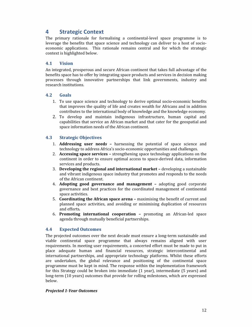
4 Strategic Context The primary rationale for formalising a continental-level space programme is to
leverage the benefits that space science and technology can deliver to a host of socio-
economic applications. This rationale remains central and for which the strategic
context is highlighted below.
4.1 Vision
An integrated, prosperous and secure African continent that takes full advantage of the
benefits space has to offer by integrating space products and services in decision making processes through innovative partnerships that link governments, industry and
research institutions.
4.2 Goals
1. To use space science and technology to derive optimal socio-economic benefits
that improves the quality of life and creates wealth for Africans and in addition
contributes to the international body of knowledge and the knowledge economy.
2. To develop and maintain indigenous infrastructure, human capital and
capabilities that service an African market and that cater for the geospatial and
space information needs of the African continent.
4.3 Strategic Objectives
1. Addressing user needs – harnessing the potential of space science and
technology to address Africa's socio-economic opportunities and challenges.
2. Accessing space services – strengthening space technology applications on the continent in order to ensure optimal access to space-derived data, information
services and products.
3. Developing the regional and international market – developing a sustainable
and vibrant indigenous space industry that promotes and responds to the needs
of the African continent.
4. Adopting good governance and management – adopting good corporate
governance and best practices for the coordinated management of continental
space activities.
5. Coordinating the African space arena – maximising the benefit of current and
planned space activities, and avoiding or minimising duplication of resources
and efforts.
6. Promoting international cooperation – promoting an African-led space
agenda through mutually beneficial partnerships.
4.4 Expected Outcomes
The projected outcomes over the next decade must ensure a long-term sustainable and
viable continental space programme that always remains aligned with user
requirements. In meeting user requirements, a concerted effort must be made to put in
place adequate human and financial resources, strategic intercontinental and
international partnerships, and appropriate technology platforms. Whilst these efforts
are undertaken, the global relevance and positioning of the continental space
programme must be kept in mind. The response within the implementation framework
for this Strategy could be broken into immediate (1 year), intermediate (5 years) and
long-term (10 years) outcomes that provide for rolling milestones, which are expressed
below.
Projected 1-Year Outcomes

13
• Establishing the governance elements needed for a sustainable space programme, including regional centres of excellence;
• Approval and rollout of an intercontinental and international partnership plan; • Approval and rollout of a human capital and infrastructure development plan; and
• Ongoing research and development, and technology programmes that will
contribute to building the foundations for a continental space programme.
Projected 5-Year Outcomes
• A fully established continental space programme; • Appropriate technology platforms in place to support the building blocks of a
continental space programme; • Advances in human capital development that supports the continental space
programme;
• Strategic partnerships, both intercontinental and international, through projects
that promote research and technology development; and
• Operational and ongoing developments of space application services and products
for the broader public good.
Projected 10-Year Outcomes
• A continental space programme that is globally positioned and ranked in the top 10;
• Independent Earth observation high-resolution satellite data available for all of
Africa from a constellation of satellites designed and manufactured in Africa;
• Appropriate services and products relating to space applications;
• Resident space capacity both in terms of technology platforms and human capital;
• Spin-off enterprises emanating from space activities and programmes; and
• Strategic partnerships, both intercontinental and international, that are translated
into viable space missions, applications, products and services.
4.5 Expected Impact
The impacts of a continental space programme can be measured on two fronts, namely,
at a macro level and a micro level. The macro view relates to impacts made at a macro economic level, whereas the micro view relates to impacts made with respect to
responding to the appropriate needs of an indigenous market.
4.5.1 The Macro Level Impact
[Need to indicate the expected macro level impacts]
4.5.2 The Micro Level impact
[Need to indicate the expected micro level impacts
6 The Implementation Framework/Key Deliverables
The strategic approach in implementing an African Space Programme is to adopt a
needs pull philosophy, where relevant user requirements, that are contingent on space applications, are responded to. In the process of attempting to address user
requirements, recognition must be given to the current and potential technology options available in and to the continental space landscape. These options should also provide a
basis from which future technology needs should stem from through appropriate research and development initiatives. Hence, the user requirements, expressed through
a set of key priority areas, provide the broad parameters within which the appropriate technology platforms, both new and current, should evolve. The key deliverables, shown
in Figure 1, for an African space programme, therefore, must be premised on a set of key
priority areas, reflective of the needs of the African user community, and which is

14
contingent on select thematic areas that help support the user requirements.
Figure 1: Implementation Framework/Key Deliverables
6.1 Key Priority Areas
Today, Africa faces major pressing issues: climate change impact, water scarcity, energy
shortage, environmental stresses and food crisis, which affect citizens, business and the
community at large. On all these challenges, the constitution of coherent seamless and
up-to-date spatially enabled information is an essential precondition for setting up
coordinated policy and strategy. Space technology is useful in constituting factual,
precise and updated information. Such information is required for various developmental decisions, such as natural resources development, environmental
protection and management, food security and vulnerability monitoring, human
settlements planning and land reform, transport and communication infrastructure
planning and management, peace, security and stability promotion, service delivery in
commerce and government, health, education, governance and social welfare, and
tourism development and management.
The strategic approach in implementing an African space programme is to adopt a needs
pull philosophy where relevant user requirements, that are contingent on space applications, are responded to. In view of the manifold interests that could be vested in
an African space programme, any proposed priorities must emulate the highest priorities on the continent for which effective coordination becomes the central focus.
The continental level priorities can be cogently expressed, as shown in Figure 2, through the interface among the political, economic and social spheres that underlie the complex
spectrum of public affairs and everyday life issues affecting the African continent.

15
Figure 2: Key priorities for a continental level space programme
These spheres need to be seamlessly integrated to ensure optimal benefits that ultimately translate into wealth creation and improved quality of life on the continent.
These benefits must be underpinned by prosperity, peach and unity, as the intersect
between the identified spheres and collectively lead to economic, political and social integration. Hence, the key priorities for the African continent will be categorised
according to the political, economic and social affairs, and for which the following definitions apply:
• Political affairs – at the continental level, refers to the notion of social and economic cohesion and integration, which is largely underpinned by political
stability, peace and security. • Economic affairs – at the continental level, refers to the sustainable utilisation
and mobilisation of resources to support robust economic growth in a manner
that ensures economic integration. • Social affairs – at the continental level, refers to the cultural aspects and the
health and wellbeing of the citizens of Africa that is gauged through an improved
quality of life for all. The priorities that encompass these key priority areas are as follows:
Disasters: Reducing loss of life and property from natural and human-induced disasters.
Disaster losses can be reduced through observations relating to hazards such as: wild
land fires; volcanic eruptions; earthquakes; tsunamis; subsidence; landslides;
avalanches; ice; floods; extreme weather; and pollution events. There is a need for timely dissemination of information through better coordinated systems for
monitoring, predicting, risk assessment, early warning, mitigating, and responding to hazards at local, national, regional, and global levels.
Health: Understanding environmental factors affecting human health and well-being.
Health issues with Earth observation needs include: airborne, marine, and water
pollution; stratospheric ozone depletion; persistent organic pollutants; nutrition; and
monitoring weather-related disease vectors. There is a need to improve the flow of
appropriate environmental data and health statistics to the health community, promoting a focus on prevention and contributing to the continued improvements in
human health worldwide.
Integration
Economic
Political Social
Unity Prosperity
Peace

16
Energy: Improving management of energy resources. The outcomes in the energy area will support: environmentally responsible and equitable energy management; better
matching of supply and demand of energy; reduction of risks to energy infrastructure; more accurate inventories of greenhouse gases and pollutants; and a better
understanding of renewable energy potential.
Climate: Understanding, assessing, predicting, mitigating, and adapting to climate
variability and change. The climate has impacts in each of the other priority areas.
Coping with climate change and variability demands good scientific understanding
based on sufficient and reliable observations. There is a need to enhance the capacity to
model, mitigate, and adapt to climate change and variability. Better understanding of
the climate and its impacts on the Earth system, including its human and economic aspects, will contribute to improved climate prediction and facilitate sustainable
development while avoiding dangerous perturbation to the climate system.
Water: Improving water resource management through better understanding of the
water cycle. Water-related issues will include: precipitation; soil moisture; streamflow;
lake and reservoir levels; snow cover; glaciers and ice; evaporation and transpiration;
groundwater; and water quality and water use. There is a need to improve integrated
water resource management by bringing together observations, prediction, and
decision support systems and by creating better linkages to climate and other data. In
situ networks and the automation of data collection will be consolidated, and the
capacity to collect and use hydrological observations will be built where it is lacking.
Weather: Improving weather information, forecasting and warning. The weather observations are based on the requirements for timely short- and medium-term
forecasts. There is a need to help fill critical gaps in the observation of—for example—
wind and humidity profiles, precipitation, and data collection over ocean areas; extend
the use of dynamic sampling methods globally; improve the initialization of forecasts;
and increase the capacity in developing countries to deliver essential observations and
use forecast products. Every country will have severe weather event information
needed to mitigate loss of life and reduce property damage.
Ecosystems: Improving the management and protection of terrestrial, coastal and marine resources. Observations are needed on the area, condition, and natural resource
stock levels in ecosystems such as forests, rangelands, and oceans. There is a need to ensure that methodologies and observations are available on a global and regional basis
to detect and predict changes in ecosystem condition and to define resource potentials
and limits. Ecosystem observations will be better harmonized and shared, spatial and
topical gaps will be filled, and in situ data will be better integrated with space-based
observations. Continuity of observations for monitoring wild fisheries, the carbon and
nitrogen cycles, canopy properties, ocean color, and temperature will also be
prioritised.
Agriculture: Supporting sustainable agriculture and combating desertification. Issues to be addressed will include: crop production; livestock, aquaculture and fishery statistics;
food security and drought projections; nutrient balances; farming systems; land use and
land cover change; and changes in the extent and severity of land degradation and
desertification. There is a need to address the continuity of critical data, such as high-
resolution observation data from satellites. A regional mapping and information service,
integrating spatially explicit socio-economic data with agricultural, forest, and
aquaculture data will be necessary, with applications in poverty and food monitoring,
planning, and sustainable development.
Biodiversity: Understanding, monitoring and conserving biodiversity. Issues in this area
include the condition and extent of ecosystems, distribution and status of species, and

17
genetic diversity in key populations. There is a need to unify many disparate biodiversity- observing systems and create a platform to integrate biodiversity data
with other types of information.
Additional Priorities
• Peace, Security and Stability
• Human migration and settlements
• Education
• Communications
• Trade and Industry
• Transport
• Infrastructure
• Human resources
6.2 Space Discipline
In the process of attempting to address user requirements, recognition must be given to
the current technology options and programmes available on the continent. These
options provide a basis from which future technology needs and programmes should
stem from. Hence, the key priority areas provide the broad parameters within which the appropriate technology platforms and programmes, both new and current, should
evolve. Hence, to deliver on the key priority areas, four thematic areas, identified
as important for a viable space programme, need to be pursued. These thematic
areas include: 1. Earth observation – the development of integrated Earth observation services
and products that respond to user needs and addresses Africa’s socio-economic
opportunities and challenges;
2. Navigation and Positioning – the development of a sustainable space based
augmentation system in Africa that enhances navigation and positioning
applications and improves safety-of-life applications;
3. Satellite Communications – the development of technologies and applications to
improve information communications technologies for commercial purposes and
for the broader public good, especially in rural areas;
4. Space Science and Astronomy – the development of mission driven initiatives
that assist in understanding our solar-terrestrial environment and the universe
and to leverage the related human capital and technological spinoffs.
6.2.1 Earth Observation
Earth observation will form the primary focus of an African space programme, as it has
the most potential to address the socio-economic challenges of the continent. The
benefits relating to Earth observation services and products have already been
highlighted in preceding sections. In order to address the associated opportunities and challenges there is a need to strengthen the full value chain of activities that support
Earth observation. The Earth observation value chain consists of three segments, namely:
1. Infrastructure – this consists of data that is obtained through a variety of platforms that include space, air, ocean, balloon and ground based datasets; data
centres that serves as a distributed repositories for data archiving; and portals that allow users to log in and extract data and information.
2. Human capacity – this consist of the requisite expertise and skills that ensures a
convenient platform for further human capital development and engagement in research and development that focuses on developing the Earth observation

18
value chain. 3. Products and services – this comprise of the essential core goods that respond to
the user needs, both for commercial exploitation and the broader public good, and which are primarily tailored to address the socio-economic challenges on
the continent.
The three segments provides for the consolidated acquisition of space and in-situ data
for regional and national needs. The platform will also support intra-continental and
international initiatives, such as the African Resource and Environmental Management
Constellation (ARMC), GMES and Africa, the Committee on Earth Observing Satellites
(CEOS) and the Group on Earth Observation System of Systems (GEOSS).
Specific interventions relating to Earth observation must include:
•••• Develop the critical mass of skills and expertise in Earth observation
applications and usage.
•••• Develop and improve Earth observation institutions in Africa. •••• Foster knowledge sharing among African experts, users and stakeholders. •••• Develop space based and in-situ infrastructure that helps in achieving the user
needs and societal benefits.
•••• Develop Earth observation services and products using web-based and
appropriate technologies in order to meet user needs. •••• Foster stakeholder engagement to ensure the generation of the relevant
services and products that maximises the benefits of Earth observation
applications. •••• Raising awareness among the public, users, policy and decision makers.
6.2.2 Navigation and Positioning
Satellite navigation systems are space-based radio positioning systems that include one or more satellite constellations, augmented as appropriate to support the intended
operations, and that provides 24-hour three dimensional position, velocity and time information to suitably equipped users anywhere on, or near, the surface of the Earth.
Satellite navigation systems are not yet completely suitable for applications requiring high levels of accuracy and reliability. Under certain conditions their use is limited and
there are concerns that the integrity of the signal may not be sufficient for applications
where this is vital, for example in air traffic control.
Progress is under way to overcome the current weaknesses of these systems. The major
technological challenges are to improve the reliability, accuracy and integrity of
positioning systems. In this regard, the development of new differential GNSS systems,
such as augmentation systems and overlay services, significantly increase the quality
and robustness of the signal. Satellite augmentation involves using external information,
often integrated into the calculation process, to improve the accuracy, availability, or
reliability of the satellite navigation signal.

19
Specific interventions relating to navigation and positioning must include:
• Develop the critical mass of skills and expertise in navigation and positioning
applications and usage. • Ensuring seamless integration into existing global navigation satellite services;
• Build on existing infrastructure such as ASECNA, EGNOS, TRIGNET and AFREF; • Promote an African array study for seismic applications using seismic reference
receivers; • Developing an indigenous continental level navigation augmentation system; and
• Developing navigation and position application products and services to support
user requirements.
6.2.3 Satellite Communications
There is a rising demand for mobile satellite services on the continent, often
characterised by a lack of an adequate terrestrial telephone line infrastructure. Mobile satellite service systems offer three types of services, namely:
1. Worldwide personal communications services to users via single or dual mode
cellular/satellite phones;
2. Mobile data terminals used to transmit “store and forward” messages; and
3. Fixed applications in developing countries and emerging markets such as “village phones”.
Satellite systems have important features that fibre optics lack, namely, (i) mobility – mobile users cannot be connected to the fibre network directly, (ii) flexibility – once
terrestrial infrastructure is built, it is extremely expensive to restructure it, (iii) rural and remote connections – it is still not cost effective to deploy high-capacity fibre
networks in areas with low-density traffic and difficult topography, and (iv) broadcast capability – where point-to-multi-point connections are able to reach millions
simultaneously in a cost-effective way.
Satellite communications is thus a key technology that could enable Africa to participate
in the build-up of the global information infrastructure. Satellite communication systems, featured by large “footprints”, ranging in size from a country to a continent,
avoid the need for terrestrial infrastructure and shorten the time for establishing basic and advanced communications, especially in rural areas. These services also provide
numerous opportunities for commercial applications such as fleet and cargo tracking and monitoring; low cost message to rescue workers, especially during post disaster
recovery; and transmitting data from remotely monitored automated devices.
Specific interventions relating to satellite communications must include:
• Developing technologies for communication applications in rural areas;
• Developing technologies for e-applications;
• Providing flexible extensions for the terrestrial network expansion; and
• Developing platforms to support disaster management.
6.2.4 Space Science and Astronomy
The exploration of the universe from our solar system to the most remote parts represents one of the greatest intellectual adventures of humankind. The past four
decades have witnessed a dramatic change in our views about the universe and its constituent parts. This is an ongoing revolution whose implications are still to be fully
understood not only in the scientific context, but also from a practical view. Scientific
illiteracy is one of the world’s greatest problems and an increasingly divisive factor
between developed and developing countries. Increase in the quality of life and
economic growth now depend to a large extent on scientific and technical awareness

20
and on the ability to incorporate new knowledge and devices into the economies of societies and the lives of individuals. The technology of space science and astronomy is
crucial in this respect.
Basic scientific exploration has invariably been a catalyst for the development of a variety of new technologies. Space technology is no exception, driven as it is by the
exacting requirements of space science and astronomical experiments requiring very
accurate pointing mechanisms, better attitude control systems and a variety of highly
sensitive sensors. It is widely recognized that today’s science is tomorrow’s technology
and that any nation that wants to advance technologically cannot afford to ignore
investments in space science and astronomy. In addition, the power of space science in
the educational system to motivate the learning of such skills cannot be overestimated.
It captures public interest and provides a vision like little else in modern science and
technology.
Specific interventions relating to space science and astronomy must include:
• Developing robust and coordinated programmes in the various disciplines of
space science and astronomy, such as space physics, space geodesy, aeronomy,
and optical-, gamma- and radio-astronomy;
• Instituting capacity and capability building programmes to ensure sustainable space science and astronomy initiatives.
• Developing and maintaining the appropriate infrastructure and facilities for a vibrant space science and astronomy programmes.
• To ensure value addition to Africa’s economy through the spinoff development
of human capital and technologies in space science and astronomy.
7 Implementation Guidelines/Critical Success Factors The key deliverables are necessary for informing a viable and sustainable space
programme, but are not in themselves sufficient. They will rely on a number of critical success factors that are needed in order to realise the key deliverables in an effective
and efficient manner. The critical success factors, as shown in Figure 3, will include functional programmes, which are indicative of the operational requirements of an
African space programme; support platforms, which assist in consolidating and strengthening the African space programme; space awareness, which is intended to
ensure that there is broad public buy-in and appreciation of an African space
programme; and the economic model, which is needed to ensure that the African space programme is appropriately resourced.

21
Figure 3: Key deliverables and critical success factors.
7.1 Functional Platforms
Functional programmes represent the means to achieving the key deliverable and are primarily embedded in the underlying technology platforms. It represents the key
elements for a space mission concept, which comprise of the collection of satellites, orbits, launch vehicles, operations networks, and all other elements that make a space
mission possible. Functional programmes support each of the thematic areas, which
seeks to organise the scientific and engineering capacities into four large clusters, where
each cluster carries out specific functions, which are summarised as follows:
1. Through mission requirements, provision is made for identifying the
appropriate technology platforms that support the key deliverables. The related
activities include the development of space missions through the definition,
critical design, manufacturing, integration, testing and delivery phases leading to
the launch and early operations of space systems.
2. Through enabling technologies provision is made for leadership, coordination
and support to applied research in order to increase the knowledge base, devise
new applications through space missions, and allow for the transfer of intellectual
property and proven technologies to local industry, academia, and government
organisations.
3. Through space mission operations, support is given to space missions through
ground support, personnel training, mission analysis and planning, in-orbit
ground control operations, systems monitoring, maintenance and logistics
support, as well as data handling and delivery.
4. Through space mission applications, value is delivered to stakeholders by
employing best practices in developing new and advanced applications to support
stakeholder user requirements through the provision of relevant services and
products.
7.1.1 Mission Requirements
At the heart of the space architecture is the mission. Simply stated, the mission is why
we’re going to space. All space missions begin with a need, such as the need to monitor
water resources or to monitor pollution in the upper atmosphere. Understanding this
need is central to understanding the entire space mission architecture. For any mission
the need informs the mission statements that include three elements: 1. The mission objective – why do the mission;
2. The mission users or customers – who will benefit; 3. The mission operations concept – how the mission elements work together.
The specific needs identified under each key priority area can be mapped onto the thematic areas. Focusing on the Earth observation requirements there are a range of
spatial resolutions that are required to cover the array of user needs. We note that at the lower spatial resolution end (> 10m) datasets are readily available, but as we progress
to higher spatial resolutions the availability diminishes – with limited access to sub 1m resolution data.
The focus of the Earth observation satellite missions should therefore revolve around medium to high-resolution satellites. Apart from the satellite missions with optical
payloads, there is a definite need for Synthetic Aperture Radar (SAR) data. This is essential for continuous data coverage, especially where cloud cover would limit optical
satellite missions. In addition, SAR data is important for military applications where
terrain profiling and mapping is critical for the deployment of ground troops, especially
in hostile and remote territories.

22
The focus in the area of navigation and positioning will concentrate on augmentation
systems to improve the accuracy and integrity of satellite signals on the continent. The augmentation systems will form secondary payload options on future satellite missions
and where necessary these will be complemented by indigenous ground based
augmentation systems.
In the area of satellite communications a two-pronged approach will be followed:
1. Development and operations of communication transponders as secondary
payload options on future LEO satellites with the prime focus being for disaster
management communications, uploading of ground sensor signals and low data
rate applications.
2. Development and operations of a dedicated GEO communications satellite for
commercial end-to-end services and for extending communications access to
rural communities.
The mission requirements can therefore be summarised as follows:
• Low Earth orbiting satellites with multispectral and hyper spectral optical
payloads and navigation augmentation payload systems.
• Low Earth orbiting SAR radar satellites to complement the optical satellite
missions.
• A geostationary orbiting communications satellite with multiple communication
transponders and a navigation augmentation payload system.
• Ground based augmentation systems that complement the space based GNSS
systems.
7.1.2 Enabling Technologies
Following identification of the primary mission requirements we now move to the
satellite systems technology and engineering requirements. This consists of two broad
categories shown in Figure 9 below, namely:
1. Payloads – consist of single or multiple sensors that receive and/or transmit
electromagnetic signals.
2. Subsystems – provides all housekeeping functions needed to operate the
payload/s and get the data to users.
Payloads – in line with the high-level mission requirements identified above, a series of
payloads will be required and these consist of the following platforms:
• Optronic sensors – passive optical sensors that collect reflected signals from
objects under observation and converts these to pixel information;
• Synthetic aperture radars – a form of radar in which multiple radar images are
processed to yield higher-resolution images than would be possible by
conventional means;
• Navigation augmentation systems – produce time coded signals that are used to
accurately measure distance and position; and
• Communications transponders – active sensors that either transmit or receive
radio waves to or from the ground, respectively.
Subsystems – in order to optimally support the payload operations, a number of housekeeping functions are required and these comprise of:
• Spacecraft control – a satellite has to have the right attitude, or orientation, to point payloads at targets on Earth and to be able to control its position and
velocity so that it can get to where it needs to go.
23
• Communication and data handling – consists of computers, internal data communications networks, and radios needed to process mission data, as well as
send and receive information from operators on the ground. • Electrical power – converts energy from some source into usable electrical
power to run the other subsystems and the payload.
• Structural subsystems – holds together all the other subsystems and payload and
withstands launch and mission stresses.
• Propulsion subsystems – provides torque and thrust needed by the spacecraft
control subsystem.
In order to ensure that the payload and subsystem requirements are met for future
satellite missions there is a need for technology development. However, in order to
identify the approaches to be adopted in developing the various technology platforms, it
is appropriate to gauge the sense of technology readiness in each of these. The readiness
of the African space industry to participate in several possible future space missions will critically rely on a systems engineering approach, where a consortium of African
countries undertakes research and development, and subsequent operational activities.
The general guidelines for the future satellite missions, as per the payload and
subsystem technology options, are as follows:
• Develop a fully indigenous capability for the medium to high resolution payloads
and subsystems; • Develop the SAR payload and subsystem requirements;
• For the communications satellite [Need to discuss the approach here
o Full procurement through international tenders; o Procurement through international tenders with African participation
on the technology and engineering front o Partnerships with other technologically advanced partners]
• All satellite subsystems will rely on a fully indigenous capability.
7.1.3 Mission Operations
Mission operations include all “cradle to grave” activities needed to take a mission from a blank sheet of paper to on-orbit reality, to the time when the satellite is terminated.
The mission operations systems include the ground and space based infrastructure needed to coordinate all elements of the space mission concept. It is the glue that holds
the mission together and includes manufacturing and testing facilities to build the satellite, launching facilities, communications networks and operation centres to
coordinate activities once a satellite is in orbit.
In order to unpack the requirements for mission operations, we will focus at some of the
critical operations systems that function during the three basic phases of a satellite’s life
and these include:
• Satellite manufacturing – the systems that support design, assembly, integration
and testing.
• Orbital slots - • Launch – the systems that bring the satellite and launch vehicle together and get
them safely off the pad. • Operations – including communication, command, and control systems.
Satellite Manufacturing

24
To ensure the highest quality, most satellite components are assembled and integrated in dedicated clean rooms to limit the exposure of sensitive components, such as sensor
lenses, to particulates that could damage them or reduce their performance in space. The discipline required by working in a clean room creates a carefully controlled work
environment that helps to prevent carelessness and mistakes.
Ground support equipment (GSE) helps during subsystem and system assembly,
integration and testing (AIT). After the satellite is assembled and integrated, testing can
begin. Prior to this, individual components and subsystems need to undergo their own
testing. Functional testing determines how well the subsystems work as required under
a range of operational scenarios. Environmental testing, on the other hand, ensures that
the satellite can survive heat, cold, vacuum, radiation, vibration and g-force loading it
will experience throughout the mission.
Orbital slots
Countries in Africa are lifeline users of spectrum and satellite resources, perhaps more
than developing countries in other continents. Most of their international traffic is
channeled through satellites to the rest of the world. Thus, developments in satellite
policy and governance are of priority concern to the continent.
To allow radio interference-free operation, the Geostationary Satellite Orbit Spectrum
becomes an international limited natural resource, requiring for its orderly use, the
application of Radio Regulations as formulated by World Radio Conferences (WRCs) of
the ITU. Such a procedure entails the frequency coordination among administrations of
satellite networks that might cause unacceptable mutual radio interference due to their
close spacing to one another in the Geostationary Satellite Orbit. The congestion of the Geostationary Satellite Orbit Spectrum as reflected by the above large number of filings
for the limited resource is causing considerable complication to the coordination procedure.
In reforming ITU, principles of “first come first served” on these scarce and finite resources should be reviewed. Those who are poor today and without technological
power will not be so forever. Hence, principles of equity and conservation should prevail
to ensure access by humankind in present and future generations. In seeking solutions
to the satellite backlog issues and increasing cost recovery in processing fees, care
should be taken to ensure that new barriers for excluding the developing world are not created. An affirmative asymmetric approach with defined transition periods should be
considered, so that the statement of transforming the digital divide into digital
opportunity does not become just another slogan. African countries will stand a better
chance of securing orbital slots and spectrum resource if they file as a block.
After securing the Orbital Slot and Associated Frequencies, then concerned countries
start the 4-5 year process of specifying, ordering, launching & insuring the satellite, which once launched, will operate for up to 15 years and the license can no longer be
modified.
Launch [Launch to be done in Africa]
The launch of a satellite can sometimes account for nearly 30% of a mission cost. Not
only is the launch vehicle expensive, but we also pay for the complex operations systems
that provide the infrastructure to get the launch vehicle and the satellite off the ground
and into space. These systems include:
• The launch site and its associated range;
• The launch pad;

25
• Payload and vehicle processing facilities; and • Launch operations centre.
[Need to discuss if we would want to pursue launch capabilities, as a continent]
Operations
For space missions, communication is the exchange of commands and engineering data
between the spacecraft and ground controllers, as well as the processing and
transmitting of payload data to users. The communication architecture is the
configuration of satellites and ground stations in a space system and the network that
links them together and comprise of four elements:
• Satellites – the space borne elements of the system.
• Ground stations – Earth-based antennas, transmitters, and receivers that talk to
the satellites.
• Control centre – the command authority that controls the spacecraft and all other elements in the network.
To receive mission data, antennas on the ground must point at the satellite whenever it’s
within range. This means ground stations must know where the satellite is at all times.
This is an extensive operation and requires dedicated ground support.
The testing facilities that will be required include:
• AIT and design centre
• Ground segments • Space segment
o Control centres • Securing appropriate geostationary orbital slots
7.1.4 Space Applications
Space applications form the cornerstone of a space programme and will therefore form
the primary performance indicator for the sector. All technology options presented thus
far are a means for realising various services and products that respond to user needs.
Central to addressing the user needs is the Earth observation value chain. This comprise
of the requisite infrastructure and skills and expertise needed to support the
development and maintenance of the products and services.
In terms of developing a suite of products and services for the broader public good, each region will champion the definition and scoping of the services and products pertinent
to that region, whereas the continental space programme will respond by investing in
the common base platform that is required. In the case of commercial goods, the private
sector will pay for the cost of accessing the data and the full costs associate with the
development of the services and products.
[What are the key elements we would want to see with respect to?
• Infrastructure
• People • Products and services]

26
In order to ensure that the services and products developed in response to the user
needs are indeed relevant, the following must be enabled:
• Data policy
• Timely access to the right data sets at the procurement end;
• The provision of appropriate services and products that respond to all user needs identified under the three key priority areas;
• Robust processing capabilities to ensure that timely access to the requisite services and products is available to the end users;
• Ensure that all tiers of governments are able to access space and ground based
data through a centralised portal;
• Provision of data for education, and research and development; and
• Provision of data for commercial exploitation at a minimal cost.
7.2 Supporting Platforms
Supporting platforms are critical for the realisation of the technology platforms needed for the various functional platforms and comprise of the following:
1. Human capital – the appropriate expertise and skills necessary for an African space programme will be an area that will receive priority attention, as without
this all existing and envisaged programmes and infrastructure will be of limited
value.
2. Infrastructure – appropriate infrastructure is the cornerstone of an effective
space programme, enabling technology transfer and human capacity development
initiatives.
3. International partnerships – strategic partnerships with foreign partners are
necessary for tangible and intangible technology transfer and a viable and
sustainable space programme that is underpinned by mutual benefits. 4. Industrial participation and development – development of the continental
space industry to participate in the various functional platforms is a key
requirement for the sustainability of a formal space programme.
5. Space Awareness - for the African space programme to be meaningful to the
broader public there is a need for creating public awareness relating to the
benefits that space technology and its manifold application products and services
can deliver.
7.2.1 Human capital development and space awareness
(Group: Nana, John, Jiwaji, Pascal) The realization of envisage vision of the space science and astronomy strategy can be realized if there is a need for dedicated and qualified human resources to drive the
process. In order to realize the above, the general population should be knowledgeable to accept and appreciate astronomy and space science as a useful tool for development.
• Mainstreaming Astronomy and Space Science Programs (ASSP) into all levels of
society
• Intervention of ASSP into the school curriculum in the primary and secondary
level
• Demystify misconceptions in ASSPs arising from common experiences
• Introduce programs and attract best minds from schools to ASSP
o Encourage science and astronomy clubs
• Introduce ASSP at undergraduate degree programmes in the universities with
multiple exits – technical and academic
• Policy for attracting the best minds towards ASSP at the national level

27
• Opportunities for postgraduate at any African country should be open to any
African university
• Creating an enabling environment for graduates to be attracted for opportunity
for employment
• Basic astronomy courses for introducing the non-science students at university
level and for teacher trainees
• Development of curriculum and teaching aids towards ASSPs
• Public outreach programs
o Regular bulletin, current affairs in the Media o Training of journalists and media men
o Astronomy activities o Public lectures
o Science centers and Planetarium
• Data pull on indigenous knowledge
7.2.2 Infrastructure
(Group: Adil, Kofi, Paul)
Initial investment in space technology is considered “Strategic” and might prove difficult
to attract private sector investment. However, through the integration of space
technology into other sectors of the economy, it shall lead the sector to become a self-
sustaining business model. The key success factor is the creation of a linkage between
Mission requirements
• Promote gender parity in ASSP
• Encourage science and astronomy clubs
• Develop of curriculum and teaching aids towards ASSPs at all levels of education
• Provide an enabling environment for: o attracting the best minds towards ASSP at the national level
o teaching and learning of science in all universities in Africa o postgraduate training opportunities in ASSP at African universities
o graduates to be attracted for opportunity for employment in ASS industry o engaging scientists and engineers in the diaspora
• Provide ASSP training for science teacher trainees
• Develop basic astronomy courses for non-science students
• Build mechanisms for facilities and funding for research
• Create public awareness through
o Regular bulletin, current affairs in the Media o Training of journalists and media men
o Astronomy activities
o Public lectures
o Science centers and Planetarium
o Contribution of experiences from diaspora
• Collect data pool on indigenous knowledge

28
space and other sectors such as communication, agriculture, energy, transport, peace and security … etc
Leverage on existing facilities in Africa as well as Public and private sector partnership
to help build infrastructure in Africa. Member states in the African Space consortium
may build the infrastructure and avail for use at a negotiated fee. The public -private
partnerships, partnership with some external space agency (ies) to help build
infrastructure for manufacturing of space hardware and software.
Propose the following:
� Build and Strengthen Pan African Space University to enable it to support space
centers across the continent
� Build centers of excellence across regions in Africa and expand and upgrade
existing ones.
� Build AITs centers in the continent
� Build data banks and high performance computing centers and/or use existing
ones.
� Leverage on partnerships to build space based industry for manufacturing space
hardware and software and could serve as center of hands-on training
� Develop and expand existing mission control centers (e.g centers in Kenya,
Algeria, Nigeria, Egypt, South Africa.. etc)
� Develop and strengthen research and development center so that they be
accessible by researchers across the entire continent
� Expand existing observing infrastructure and ensure data accessibility for
research (e.g GPS receivers, Magnetometers, ionosondes, etc)
7.2.3 International partnerships
(Group: Mohomed, Mahama, Ridha, Dinga)
The development of the African space strategy should take advantage from a strong and
diversified cooperation and partnership network established through a clearly shared
understanding of relevant international treaties and best uses and practices.
To that end, specific actions should be conducted to :
Promote a panafrican cooperation and partnership specific framework and networking
process for the development of the intracontinental complementarity in the fields of :
. Human ressources development
. space Infrastructure development
. Space industry development.
. Space R&D
Establish cooperation agreements with governemental and intergovernemental and
regional organizations and agencies (such as the International Telecommunications
Union, and Committee of Peaceful use of Outer Space), in charge of space activities. Such
agreements should focus on exchange of experiences and launching common programs
with the objective of reducing the space divide and technological gaps in terms of space
access and space R&D.
encourage African Academia to establish partnership arrangement with Academic
networks concerned by space activities and join such networks.

29
Establish the appropriate framework for the development of an African space industry
operating in close cooperation with the foreign space industry with the purpose of establishing a complementarity between them.
To make appropriate efforts in order to integrate the African space infrastructure and
programs as a part of the global space infrastructure with a clear recognition of the
African rights in this regard.

30
7.2.4 Industrial participation and development
(Group: Islam, Tich, Mash, Harry)
Space industry will be an ultimate goal for Africa to begin harvesting the resources of
space both for their use in space and to increase the wealth and prosperity of the African
citizens. This will develop a coherent and sustainable indigenous space industry that creates a competitive and reputable global market. This will be a continental space
industry that will participate in the various functional platforms for a sustainable space programme. Such space industry will be 0built on existing African heritage and
resources, human capital and local private sector with strong public-private partnerships. The motivation of Africa Space industry is to provide services and
products for Africa to improve the life quality and wealth with strong contribution to the global market.
The anticipated indigenous space industry include:
• Design, test and manufacture of satellite subsystems for: o Global position systems satellites
o Communication satellites
o Earth observation satellites • Design and manufacture of ground segment (launching, control and receiving
stations, AIT facilities)
• Develop software engineering for data processing and applications
• Strengthen industry - research and development partnerships (spin-offs and entrepreneurships)
• Strengthen public-private partnerships • Promote and support SMEs
It is also important to note that any technology platform can only be embraced if there is
broad scale understanding of the value and functionality of the said platforms. In addition, there is a need to ensure the long-term sustainable use of the outer space
environment through appropriate legislation and knowledge sharing. Therefore,
awareness and advocacy programmes will be vital to the development of a long-term
sustainable African space programme.
10 Key Performance Indicators [This section should list the KPIs relating to the success of a continental space
programme]
11 Conclusion [This will be done at the end]

31
3 The global space economy Estimates of the size of the global space economy vary widely owing to the lack of
internationally comparable data. However, from institutional budgets and new
commercial revenues from space-derived products and services, it appears that the
underlying trend in the global space economy is one of growth. Figure 1 shows the space
budgets of selected Organisation for Economic Development and Cooperation (OECD)
and non-OECD countries in 2005.
Figure 1: Space budgets of selected OECD and non-OECD countries for 2005 (Source: OECD Report, Space Economy at a Glance, 2007)
In terms of the relative spend of these budgets; there are more downstream space
activities (applications) than in the traditional upstream segment (manufacturing). In
2006, manufacturing revenues (e.g. satellites, rockets) were estimated at around USD12
billion, and space-related services (e.g. direct to home satellite television, GNSS) were
estimated at more than USD100 billion. In terms of servicing these different segments, in
2006 an estimated 120 000 people in OECD countries were employed in upstream sectors. Figure 2 shows the revenues generated for different technology platforms in the
space sector.
Figure 2: Worldwide revenues of space industry per sector
(Source: OECD Report, Space Economy at a Glance, 2007)
Revenues from satellite manufacturing and launch services averaged USD14.6 billion
per year over the decade 2001 to 2011, with a record high of USD18.7 billion in 2011.
Government customers have dominated the decade in terms of revenues generated from
$19.6
$3.0
$9.5
$32.2
$21.0
$3.7
$11.0
$35.6
$21.5
$3.2
$9.8
$39.8
$22.8
$2.8
$10.2
$46.9
$25.2
$3.0
$7.8
$52.8
$28.8
$2.7
$12.0
$62.6
$0.0
$20.0
$40.0
$60.0
$80.0
$100.0
$120.0
Revenue (in
Billio
n $
US)
2001 2002 2003 2004 2005 2006
Year
Ground Equipment Launch Industry Satellite Manufacturing Satellite Services
0.09
0.12
0.12
0.12
0.14
0.21
0.22
0.28
0.31
0.65
0.71
1.08
1.38
1.52
2.04
2.07
0.0 0.5 1.0 1.5 2.0 2.5 3.0 3.5 4.0 4.5 5.0
Brazil
Sweden
South Korea
Switzerland
Netherlands
Spain
Belgium
Canada
United Kingdom
Russian Federation
India
Italy
Germany
China
Japan
France
US
Billions of current US dollars
36.6

32
satellite manufacturing and launches (USD94 billion), while commercial customers generated USD52 billion, almost all of them derived from geostationary communication
satellites. The historical dominance of the space industry by governments is explained by the number of satellites launched per year and their high cost driven by complex and
mission specific requirements, especially for space science and military applications,
mainly in the domain of communications, navigation and imagery intelligence.
Capital stocks for space assets, as well as annual levels of investment in them, are very
difficult to estimate. However, focusing on satellite values, a 2005 study estimated that
the 937 satellites in the Earth's orbit at the time had a replacement value of USD170 to
230 billion. During the last decade extending from 2002 to 2011, the world satellite
industry launched an average of 79 satellites per year. Governments dominate the space
industry with 525 of the 791 satellites launched. The remaining 266 satellites were for
commercial satellites with 203 being in the geostationary (GEO) and 63 in low Earth
orbit (LEO).
Commercial operators dominate in terms of mass traffic to orbit, with 865 tons launched
over the decade 2001 to 2011 versus 849 tons for governments, as a result of larger
communications and broadcasting satellites launched into geostationary orbit.
Government traffic to orbit is dominated by military satellites accounting for 60% of the
849 tons. Because of their small masses, the 63 commercial satellites launched into LEO
during the decade represented only 40 tons to orbit. The mass to orbit grew by 14%
between 2010 and 2011 to reach 222 tons. The market value for satellite manufacturing
and launch services grew by 26% in 2011 to a record of USD18.7 billion. As a reflection
of the mass traffic to orbit, the past five years averaged USD16 billion of annual
revenues, up from an average of USD13.3 billion between 2002 and 2006.
Patent data is considered an indicator of technological innovation and the economic vigour of a given sector and, between 1990 and 2000, the number of space-related
patents tripled in both Europe and the United States of America, with the USA, France, Germany and Japan accounting for a major portion of these. These patents have
significant commercialisation potential and result in economic spinoffs. In Norway, the
"spin-off effect" of space programmes on space firms has been measured at 4.4, implying
that for every 1 million of Norwegian Kroners (NOK) of governmental support, the space
sector companies have on average attained a turnover of NOK 4.4 million. Although this impact measure may vary widely depending on the country and level of specialisation, it
is indicative of possible increased competitiveness owing to involvement in the space sector.