Embed Size (px)
Citation preview

5.Climbing
Climbing in Sierra de Grazalema. Manuel García. PANGEA CENTRAL
Climbing is a sport in which participants climb up or across craggy rock formation or rock walls using their hands and feet to ascend.
The most common type of climbing is sport climbing, a form of rock climbing that relies on permanent anchors and bolts fi xed to the rock for safety. The rope is tied into the climber’s harness in order to ascend the route and the loose end of it is handled by a belayer to protect him in the event of a fall.
AC
TIV
E T
OU
RIS
M
78

G U I D E : A C T I V E T O U R I S M I N T H E S E R R A N Í A D E R O N D A 79
AC
TI
VE
TO
UR
IS
M5 . C L I M B I N G
In traditional climbing, the fi rst climber attaches quick-draws to the most suitable bolts, and then clips the rope through the hanging end of the quickdraw, while the belayer ‘belays’ him holding the rope. It is then that the second climber starts to ascend through the route already set up by his fellow climber who belays him now from a safe point.
Nowadays, you can practise several Type of climbing such as bouldering, where climbers have to climb up boulders in a medium high without the use of security ropes or harnesses.
All Type of climbing require high technical knowledge, a good specialised equipment and very good physical and psychological condition to practise them.
The Serranía de Ronda’s topography, where limestone with no vegetation is abundant, becomes a real paradise for those who love climbing, especially for those who practise sport climbing with different levels of diffi culty rather than ascending big rock walls or summits. For this reason, there are hundreds of sport climbing routes, those routes with permanent anchors and bolts fi xed to the rock for safety, ranging from easy to diffi cult.
Due to space limits, this guide only offers an information sheet of each climbing area with useful details such as the number of routes or the diffi culty level. Further information about the climbing area can be found in the section To fi nd out more!
79
AC
TI
VE
TO
UR
IS
M
Climbing walls for every skill levels. Salvador Moreno

80 G U I D E : A C T I V E T O U R I S M I N T H E S E R R A N Í A D E R O N D A
AC
TI
VE
TO
UR
IS
M5 . C L I M B I N G
The companies engaged in active tourism offer all the necessary equipment and professional climbers to help you with all the basic techniques to ascend and descend.
Climbing area
Posi
tion
No.
of
rout
es
Dif
ficu
lty
1. El Hondón Southwest 8 7º
2. Tajo del Abanico Southeast 12 6º-8º
3. Puerto del Viento East 65 III-8º
4. Gran Atún South 30 V-7º
5. El Hundidero Various 51 6º-8º
6. Las Banderas East 14 IV-VI
7. Benaoján Various 72 IV-7º
8. Peñón de Benadalid East 90 IV-8ª
9. El Poyato de Benalauría
South 12 6º
10. Gaucín. Castillo del Águila
Various 24 IV-7º
11. Igualeja Southwest 12 6º-7º
Diffi culty scale: (Easy) III IV V 6º 7º 8º (Extremely Diffi cult)
• Harness • Helmet • Rock Climbing Footwear • Rock Climbing Ropes • Belayer • Descender • Wire Express • Locking carabiners • Suitable clothes based on the season • Water • Mobile phone with a spare battery • First-aid kit
REQUIRED EQUIPMENT
G U I D E : A C T I V E T O U R I S M I N T H E S E R R A N Í A D E R O N D A 81
AC
TI
VE
TO
UR
IS
M5 . C L I M B I N G
Link to the webpage zonasdeescalada.com where you could fi nd out valuable information about the most important climbing areas in the province of Málaga.
http://www.zonasdeescalada.com/busquedaavanzadaescuelas?title=&fi eld_comunidad_ciudad_tid=192&field_escuela_calidad_zona_tid=All&field_escuela_mejor_epoca_tid=All&fi eld_tipos_de_escalada_tid=All&fi eld_escuela_roca_tid=All&fi eld_escuela_Access_con_ninyos_value=All
Link to the renowned blog Sotoclimb with useful information about the climbing routes in the Serranía de Ronda. You will fi nd out photos and sketches of the different climbing areas.http://www.sotoclimb.blogspot.com.es/search/label/Croquis%20Serran%C3%ADa%20de%20Ronda
www.pangeacentral.comwww.sierraventuraronda.eswww.aventuraronda.comwww.alandalusactiva.com
TO FIND OUT MORE
SPECIALISED COMPANIES
PHOTO. Rafael Flores
82 G U I D E : A C T I V E T O U R I S M I N T H E S E R R A N Í A D E R O N D A
AC
TI
VE
TO
UR
IS
M5 . C L I M B I N G
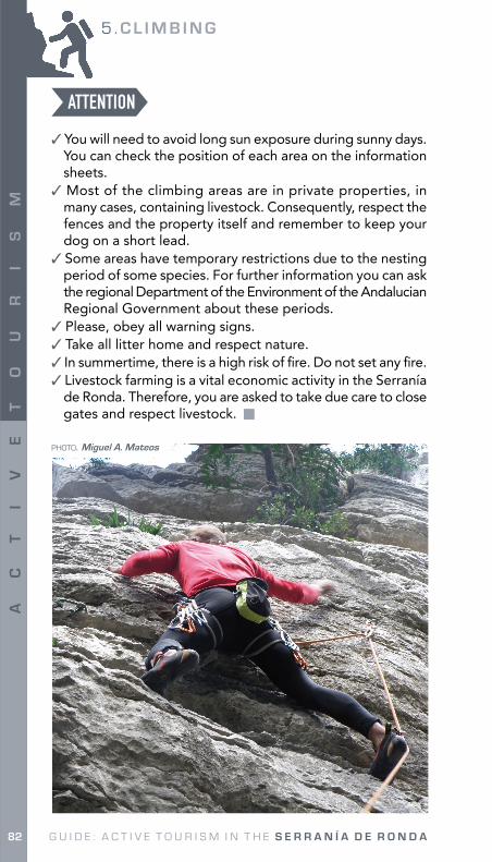
✓ You will need to avoid long sun exposure during sunny days. You can check the position of each area on the information sheets.
✓ Most of the climbing areas are in private properties, in many cases, containing livestock. Consequently, respect the fences and the property itself and remember to keep your dog on a short lead.
✓ Some areas have temporary restrictions due to the nesting period of some species. For further information you can ask the regional Department of the Environment of the Andalucian Regional Government about these periods.
✓ Please, obey all warning signs. ✓ Take all litter home and respect nature. ✓ In summertime, there is a high risk of fi re. Do not set any fi re. ✓ Livestock farming is a vital economic activity in the Serranía
de Ronda. Therefore, you are asked to take due care to close gates and respect livestock.
ATTENTION
PHOTO. Miguel A. Mateos

G U I D E : A C T I V E T O U R I S M I N T H E S E R R A N Í A D E R O N D A 83
AC
TI
VE
TO
UR
IS
M5 . C L I M B I N G
PHOTO. Miguel A. Mateos
83
AC
TI
VE
TO
UR
IS
M

5 . C L I M B I N G : E L H O N D Ó N
84 G U I D E : A C T I V E T O U R I S M I N T H E S E R R A N Í A D E R O N D A
AC
TI
VE
TO
UR
IS
M
1. El HondónMunicipality. Ronda Nearest town. Ronda
Coordinates. x: 301069 y: 4072649
Direction. Southeast Sectors: Only one sector: El Hondón
Assessment of the route: Good.
Number of routes: 8 routes when this guide was written.
Type of climbing: Sport climbing dominated by overhanging walls.
Recommended season: All seasons, except in winter when the walls are wet.
Climbing grading system:
Up to 5º Route grade 5º
Route grade 6º
Route grade 7º
Route grade 8º
- - - 100 % -
CLIMBING AREA
8484
AC
TI
VE
TO
UR
IS
M
PHOTO. Nuria Capacete

5 . C L I M B I N G : E L H O N D Ó N
G U I D E : A C T I V E T O U R I S M I N T H E S E R R A N Í A D E R O N D A 85
AC
TI
VE
TO
UR
IS
M
Access. If you drive from Ronda, you will need to take the road A-374 towards Seville and after nearly 10 kilometres you will see a swimming area and a restaurant called El Hondón on the right side. You can park your car there. Next to the restaurant, you will fi nd a path which will lead you to the climbing area after a fi ve minutes’ walk.
Brief review. This climbing area is highly recommended for those who love routes of 8º. The sector is dominated by overhanging walls with a good grip.
Restrictions. No restrictions are applied, although it is necessary to be aware that it is a private property.
http://es.wikiloc.com/wikiloc/view.do?id=3008588
T R A C K
PHOTO. Carlos Guerrero

5 . C L I M B I N G : T A J O d e l A B A N I C O
86 G U I D E : A C T I V E T O U R I S M I N T H E S E R R A N Í A D E R O N D A
AC
TI
VE
TO
UR
IS
M
2.Tajo del Abanico
PHOTO. David Barrera
Municipality. Ronda Nearest town. RondaCoordinates. x: 304554 y: 4064941Direction. Southeast. Area protected from the sun. Sectors: Only one sector: Tajo del Abanico.Assessment of the route: Good.Number of routes: 12 routes when this guide was written.Type of climbing: Sport climbing. It is dominated by overhanging walls and arches.Recommended season: All seasons. Be aware that the wall could be wet in winter.Climbing grading system:
Up to 5º Route grade 5º
Route grade 6º
Route grade 7º
Route grade 8º
- - 8 % 68 % 24 %
CLIMBING AREA
8686
AC
TI
VE
TO
UR
IS
M

5 . C L I M B I N G : T A J O d e l A B A N I C O
G U I D E : A C T I V E T O U R I S M I N T H E S E R R A N Í A D E R O N D A 87
AC
TI
VE
TO
UR
IS
M
PHOTO. David Barrera
Access. If you come from Ronda, you will need to fi nd the path towards the chapel Virgen de la Cabeza. Just at the beginning of the path, you will need to take the SL-40 from Ronda to Tajo del Abanico. You can drive your car until the end of the paved path. Then, you will need to walk along a path, sometimes cobbled, for about 15 minutes.
Brief review. This climbing area presents rough routes with 7º and 8º where it is normally practised speed climbing in arches.
Restrictions. There are no restrictions applied in the gorge Tajo del Abanico. Therefore, you can freely climb. It is recommended to park the car in the car park so you will not obstruct any private properties entrance.
http://es.wikiloc.com/wikiloc/view.do?id=3008790
www.youtube.com/watch?v=yzjcdf51nJM
TRACK
VIDEO

5 . C L I M B I N G : P U E R T O d e l V I E N T O
88 G U I D E : A C T I V E T O U R I S M I N T H E S E R R A N Í A D E R O N D A
AC
TI
VE
TO
UR
IS
M
3.Puerto del Viento
PHOTO. Salvador Moreno
Municipality. Ronda Nearest town. Ronda
Coordinates. x: 317315 y: 4073591
Assessment of the route: Reasonably good for the oldest routes, good for the new ones. Direction. South and east
Number of routes: 65 routes when this guide was written.
Type of climbing: Sport climbing with slabs, off-widths and overhanging walls. Traditional climbing can also be practised in a spectacular environment and with routes easy to belay. There are plenty of possibilities to practise bouldering as well.
Recommended season: All seasons, except during the hottest months in summer.
Climbing grading system:
Up to 5º Route grade 5º
Route grade 6º
Route grade 7º
Route grade 8º
Traditional climbing routes
5 % 19 % 28 % 11 % 2 % 10 %
CLIMBING AREA
8888
AC
TI
VE
TO
UR
IS
M

5 . C L I M B I N G : P U E R T O d e l V I E N T O
G U I D E : A C T I V E T O U R I S M I N T H E S E R R A N Í A D E R O N D A 89
AC
TI
VE
TO
UR
IS
M
Sectors.1. Diedro Rojo. 5 routes of V, 6º and 8º. Height: 40m.2. Nido de Víboras. 3 routes of traditional climbing. Height: about 40m. 3. Placa Juana. 9 routes, most of them are 6º. Height: about 50m. 4. Espolón Falo. 5 routes, most of them are V. Height: about 35 to 50m.5. Bulder. 4 routes of 6º. Height: less than 10m.6. Vientos del Sur. 5 routes, most of them are 6º. Height: 35m.7. Luna Llena. 2 routes of 6º and 7º. Height: 35m.8. Cristal de Roca. 7 routes of III and IV. Height: less than 25m.9. Puertecito. 3 different routes. Height: less than 20m.10. Siddharta. 3 routes, most of them are 6º. Height: about 20m.11. Gran Techo. 4 routes, most of them are 6º. Height: more than 60m.12. Estrella Fugaz. 1 route of traditional climbing. Height: 50m.13. Crespúsculo Rojo. 1 route of traditional climbing. Height: more than 70m.14. El Centinela. 6 routes of 7º and one of 8º, Height: more than 20m.15. Colmillo Blanco. 1 route of 6º. Height: 15m.16. Espolón Santi. 3 routes, most of them are 6º. Height: more than 40m17. El Hueso. 3 different routes. Height: 20m.
Access. If you are driving from Ronda, you will need to take the road A-366 towards the town El Burgos to arrive at the mountain pass Puerto del Viento, where you can park your car. You will then walk up along the path for about 15 minutes to reach the climbing area.Brief review. This climbing area is the most traditional in the Serranía de Ronda. Different Type of climbing and routes with a wide range of grades are offered within the 17 sectors as some of the routes were set up in the 80’s.Restrictions. No restrictions are applied, although it is necessary to be aware that it is a private property. If you intend to set up new routes, it is important to notify it to the personnel of the climbing area so you do not destroy the already set up routes.
http://www.manuelsuarez.org/INFOMONT/resesescalada/Deportiva/Andalucia/Puerto%20del%20Viento.pdf
http://es.wikiloc.com/wikiloc/view.do?id=3034769
L I N K S
PHOTO. Miguel A. Mateos

5 . C L I M B I N G : G R A N A T Ú N
90 G U I D E : A C T I V E T O U R I S M I N T H E S E R R A N Í A D E R O N D A
AC
TI
VE
TO
UR
IS
M
4.Gran Atún
PHOTO. Miguel A. Mateos
Municipality. Ronda Nearest town. Montejaque
Coordinates. x: 300644 y: 4070728
Direction. South Sectors: Only one sector: Gran Atún
Assessment of the route: Good.
Number of routes: 30 routes when this guide was written.
Type of climbing: Sport climbing dominated by slabs and overhanging walls.
Recommended season: All seasons, except the hottest month in summer.
Climbing grading system:
Up to 5º Route grade 5º
Route grade 6º
Route grade 7º
Route grade 8º
1 % 10 % 66 % 17 % 6 %
CLIMBING AREA
9090
AC
TI
VE
TO
UR
IS
M

5 . C L I M B I N G : G R A N A T Ú N
G U I D E : A C T I V E T O U R I S M I N T H E S E R R A N Í A D E R O N D A 91
AC
TI
VE
TO
UR
IS
M
Access. Once you have arrived in Montejaque, you will take the road MA-8403 towards the road Ronda-Seville. On the 3.5 kilometre, you will fi nd a path which will lead you to the entrance of the cave Cueva del Hundidero and to a big esplanade where you could park your car. You can guess from there that the climbing area is located behind the crops. You will walk for about 5 minutes from the car park to reach the climbing area.
Brief review. It consists of a varied climbing area, dominated by slabs and edges and some overhanging walls. Most of the routes have a middle height, no more than 20 metres. It boasts very good 6º’s.
Restrictions. Although it is located in the Sierra de Grazalema Natural Park, there are no restrictions applied. You will need to jump a fence, which protects the livestock. It is really clear the place where it must be done. You need to be respectful with the property and the cattle. Remember to keep your dog on a short lead.
http://es.wikiloc.com/wikiloc/view.do?id=3008577
T R A C K
PHOTO. Miguel A. Mateos

5 . C L I M B I N G : E L H U N D I D E R O
92 G U I D E : A C T I V E T O U R I S M I N T H E S E R R A N Í A D E R O N D A
AC
TI
VE
TO
UR
IS
M
5.El Hundidero
PHOTO. Carlos Guerrero
Municipality. Montejaque Nearest town. MontejaqueCoordinates. x: 300495 y: 4070130Direction. South, Southwest. Assessment of the route: Good.Number of routes: 51 routes when this guide was written.Type of climbing: Sport climbing dominated by slabs, overhanging walls, roofs and arches.Recommended season: All seasons except the hottest months in summer.Climbing grading system:
Route grade 5º
Route grade 6º
Route grade 7º
Route grade 8º Sin graduar
- 16 % 30 % 16 % 38 %
CLIMBING AREA
9292
AC
TI
VE
TO
UR
IS
M

5 . C L I M B I N G : E L H U N D I D E R O
G U I D E : A C T I V E T O U R I S M I N T H E S E R R A N Í A D E R O N D A 93
AC
TI
VE
TO
UR
IS
M
T R A C K
PHOTO. Nuria Capacete
Sectors.1. Sector Placa Gris. 11 routes dominated by slabs and slightly
overhanging walls. It boasts very good 6º’s.
2. Sector El Corral. 9 routes. It is a very rough area dominated by 8’s. When this guide was written, there were nine new routes planned.
3. Sector Churril. 6 routes with a grade higher than 7b. Two more routes without grades also found. It is dominated by overhanging walls.
4. Sector Bovedita. 7 routes dominated by arches and overhanging walls. There are two new routes planned with a grade of at least 7a.
5. Sector Buena Pal Piel. 13 routes dominated by 8’s. The rest are rough routes of 7’s with slabs and overhanging walls. One of the routes has two pitches long. Some of the routes have no grades.
Access. Once you have arrived in Montejaque, you will take the road MA-8403 towards the road Ronda-Seville. By the 3.5 kilometre, you will fi nd big terrace where you could park your car. You will then walk down along a path which will lead you to the entrance of the cave Cueva del Hundidero until you could see the red walls on the left side. You will walk for about 5 minutes from the car park to reach the climbing area.
Brief review. It consists of a climbing area with fi ve sectors which boast very good 7º’s. It is constantly changing and improving so the information on guides can be out-dated.
Restrictions. Although it is located in the Sierra de Grazalema Natural Park, there are no restrictions applied.
http://es.wikiloc.com/wikiloc/imgServer.do?id=1240379

5 . C L I M B I N G : L A S B A N D E R A S
94 G U I D E : A C T I V E T O U R I S M I N T H E S E R R A N Í A D E R O N D A
AC
TI
VE
TO
UR
IS
M
6.Las Banderas
PHOTO. Miguel A. Mateos
Municipality. Benaoján Nearest town. BenaojánCoordinates. x: 299157 y: 4067188Direction. East Sectors: Only one sector: Las BanderasAssessment of the route: Good.Number of routes: 14 routes when this guide was written.Type of climbing: Sport climbing. It is dominated by slabs with a good grip.Recommended season: All seasons, except during the hottest month in summer.Climbing grading system:
Up to 5º Route grade 5º
Route grade 6º
Route grade 7º
Route grade 8º
7 % 29 % 64 % - -
CLIMBING AREA
9494
AC
TI
VE
TO
UR
IS
M

5 . C L I M B I N G : L A S B A N D E R A S
G U I D E : A C T I V E T O U R I S M I N T H E S E R R A N Í A D E R O N D A 95
AC
TI
VE
TO
UR
IS
M
Access. Once you have arrived in Benaoján, you will drive towards Montejaque. Immediately after Benaoján, approximately 100m after the crossroad of Cortes de la Frontera, you will fi nd a wider part in the road where you could park your car. You will then cross the road and you will have arrived at the climbing area.
Brief review. This climbing area is located in Benaoján. It consists of a small but very comfortable sector, with easy routes available for all type of climbers.
Restrictions. Although it is located in the Sierra de Grazalema Natural Park, there are no restrictions applied.
http://es.wikiloc.com/wikiloc/view.do?id=3008883
T R A C K
PHOTO. Salvador Moreno

5 . C L I M B I N G : B E N A O J Á N
96 G U I D E : A C T I V E T O U R I S M I N T H E S E R R A N Í A D E R O N D A
AC
TI
VE
TO
UR
IS
M
7. Benaoján
PHOTO. Miguel A. Mateos
Municipality. Benaoján
Nearest town. Benaoján y Estación de Benaoján
Coordinates. x: 299246 y: 4065704
Direction. South and southeast
Assessment of the route: Good.
Number of routes: 72 routes when this guide was written.
Type of climbing: Sport climbing with slabs, overhanging walls and roofs… a little bit of everything.
Recommended season: All seasons.
Climbing grading system:
Up to 5º Route grade 5º
Route grade 6º
Route grade 7º
Route grade 8º
13 % 26 % 45 % 15 % 1 %
CLIMBING AREA
9696
AC
TI
VE
TO
UR
IS
M

5 . C L I M B I N G : B E N A O J Á N
G U I D E : A C T I V E T O U R I S M I N T H E S E R R A N Í A D E R O N D A 97
AC
TI
VE
TO
UR
IS
M
Sectors.1. Cueva del Zuque. It is a tougher sector dominated by middle grades. 2. Las Banderas. It is ideal for amateurs and families and it is dominated by
slabs of IV. Some short routes of 6º can also be found.3. Bóveda. This is the most diffi cult sector of this climbing area with routes of
7º and 8º, although this one is unconfi rmed.4. Cuevas de Pepe. Small sector with three technical routes of 6c and 7a. 5. Norte. It is a sector dominated by routes of Vº with big sections, ideal for
amateurs.
Access. The road MA-8400 is next to the pitches. There is 5 minutes from the car park to the climbing area.
Brief review. It consists of a varied climbing area, with pitches dominated by hard slabs and overhanging walls and other ideal pitches for amateurs and families. It offers walls in different angles, arches, overhanging walls…
Restrictions. Climbing is permitted during the whole year. If you intend to set up new routes, it is important to notify it to personnel in the Sierra de Grazalema Natural Park.
http://es.wikiloc.com/wikiloc/imgServer.do?id=1264455
http://www.manuelsuarez.org/INFOMONT/resesescalada/Deportiva/Andalucia/Benaojan.pdf
L I N K S
PHOTO. Carlos Guerrero

5 . C L I M B I N G : P E Ñ Ó N d e B E N A D A L I D
98 G U I D E : A C T I V E T O U R I S M I N T H E S E R R A N Í A D E R O N D A
AC
TI
VE
TO
UR
IS
M
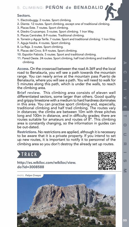
8.Peñón de Benadalid
PHOTO. Miguel A. Mateos
Municipality. Benadalid Nearest town. BenalauríaCoordinates. x: 296355 y: 4052391Direction. East. Assessment of the route: Good.Number of routes: 90 routes when this guide was written.Type of climbing: Bouldering, sport climbing, half trad climbing and traditional climbing. Routes normally have between one to three pitches long. It is dominated by vertical walls and slabs with off-widths. It is an ideal climbing area for amateurs in traditional climbing.Recommended season: All seasons. The most recommended one are spring and autumn.Climbing grading system:
Up to 5º Route grade 5º
Route grade 6º
Route grade 7º
Route grade 8º Vías de Clásica
3 % 10 % 45 % 14 % 3 % 25 %
CLIMBING AREA
9898
AC
TI
VE
TO
UR
IS
M
5 . C L I M B I N G : P E Ñ Ó N d e B E N A D A L I D
G U I D E : A C T I V E T O U R I S M I N T H E S E R R A N Í A D E R O N D A
AC
TI
VE
TO
UR
IS
M
99
PHOTO. Felipe Crespo
Sectors.1. Electrobuggy. 2 routes. Sport climbing.2. Diente. 12 routes. Sport climbing, except one of traditional climbing.3. Placas Este. 7 routes. Sport climbing.4. Diedro Cruzcampo. 5 routes. Sport climbing. 1 Iron Way.5. Placas Centrales. 8-9 routes. Traditional climbing.6. Torreón y Aguja Tarifa. 7 routes. Sport and traditional climbing. 1 Iron Way.7. Aguja hiedra. 4 routes. Sport climbing.8. La Raja. 3 routes. Sport climbing.9. Placas del Circo. 8-9 routes. Sport climbing.10. Espolón Fabiola. 5 routes. Sport and traditional climbing.11. Pared Oeste. 24 routes. Sport climbing, half trad climbing and traditional
climbing.
Access. On the crossroad between the road A-369 and the local road to Benalauría, you will see a path towards the mountain range. You can nearly arrive at the mountain pass Puerto de Benalauría, where you will see a path. You will need to walk for 5 minutes along this path, which is under the walls, to reach the climbing area.Brief review. This climbing area consists of eleven well differentiated sectors, some larger than others. Good quality and grippy limestone with a medium to hard hardness dominates in this area. You can practise sport climbing and, especially, traditional climbing and half trad climbing. The routes vary in distances; the climbs are between 10m with three pitches long and 100m in distance, and in diffi culty grades; there are routes suitable for amateurs and routes of 8º. This climbing area is constantly changing, so the information in guides can be out-dated.Restrictions. No restrictions are applied, although it is necessary to be aware that it is a private property. If you intend to set up new routes, it is important to notify it to personnel of the climbing area so you don’t destroy the already set up routes.
http://es.wikiloc.com/wikiloc/view.do?id=3008588
T R A C K

5. CLIMBING : POYATO de BENALAURÍA
100 G U I D E : A C T I V E T O U R I S M I N T H E S E R R A N Í A D E R O N D A
AC
TI
VE
TO
UR
IS
M
9.Poyato de Benalauría
PHOTO. Miguel A. Mateos
Municipality. Benalauría Nearest town. Benalauría
Coordinates. x: 296275 y: 4052455
Direction. South and southeast Sectors: Only one sector: Poyato
Assessment of the route: Good.
Number of routes: 12 routes when this guide was written.
Type of climbing: Sport climbing. It is dominated by slabs.
Recommended season: All seasons, except during the hottest month in summer.
Climbing grading system:
Up to 5º Route grade 5º
Route grade 6º
Route grade 7º
Route grade 8º
- - 100 % - -
CLIMBING AREA
100100
AC
TI
VE
TO
UR
IS
M

5 . C L I M B I N G : P O Y A T O d e B E N A L A U R Í A
G U I D E : A C T I V E T O U R I S M I N T H E S E R R A N Í A D E R O N D A
AC
TI
VE
TO
UR
IS
M
101
Access. On the crossroad between the road A-369 and the local road to Benalauría, you will see a path towards the mountain range. You can nearly arrive at the mountain pass Puerto de Benalauría, where you will see a path. You will need to walk for 5 minutes along this path, which is under the walls, to arrive at the climbing area.
Brief review. It consists of a climbing area with a few sport routes set up in the 90’s. The climb is dominated by slabs, some off-widths and slightly overhanging walls. A single-pitch trad route is found.
Restrictions. No restrictions are applied, although it is necessary to be aware that it is a private property.
http://sotoclimb.blogspot.com
L I N K S
PHOTO. Miguel A. Mateos

5. CLIMBING: CASTILLO del ÁGUILA
102 G U I D E : A C T I V E T O U R I S M I N T H E S E R R A N Í A D E R O N D A
AC
TI
VE
TO
UR
IS
M
10. Castillo del Águila
PHOTO. María Conejo
Municipality. Gaucín Nearest town. Gaucín
Coordinates. x: 293148 y: 4043942
Direction. East Sectors: Only one sector: Gaucín
Assessment of the route: Good.
Number of routes: 24 routes when this guide was written.
Type of climbing: Sport climbing dominated by slabs and some isolated overhanging walls.
Recommended season: All seasons.
Climbing grading system:
Up to 5º Route grade 5º
Route grade 6º
Route grade 7º
Route grade 8º
16 % 21 % 50 % 13 % -
CLIMBING AREA
102102
AC
TI
VE
TO
UR
IS
M

5. CLIMBING: CASTILLO del ÁGUILA
G U I D E : A C T I V E T O U R I S M I N T H E S E R R A N Í A D E R O N D A
AC
TI
VE
TO
UR
IS
M
103
Access. Once you arrive in the town Gaucín, you will need to fi nd the signs towards the castle Castillo del Águila, where you could park your car. After parking the car, you will walk for about ten minutes along the returning path of the Iron Way, which will lead you to the climbing area.
Brief review. This climbing area boasts a spectacular mountainous environment, even if Gaucín is really close, perfect for a superb climbing. Thanks to its direction, it is really nice to climb even in hot days. Limestone with a good grip is found. A great range of grades are offered with a domination of slabs and spires.
Restrictions. No restrictions are applied, as the Iron Way in this area has no restrictions applied, the climbing area should be the same.
http://es.wikiloc.com/wikiloc/view.do?id=3031582
T R A C K
PHOTO. María Conejo

5 . C L I M B I N G : I G U A L E J A
104 G U I D E : A C T I V E T O U R I S M I N T H E S E R R A N Í A D E R O N D A
AC
TI
VE
TO
UR
IS
M
11. IgualejaMunicipality. Igualeja
Nearest town. Igualeja
Coordinates. x: 311471 y: 4058406
Direction. South Sectors: Only one sector: Igualeja
Assessment of the route: Good.
Number of routes: 12 routes when this guide was written.
Type of climbing: Sport climbing. It is dominated by slabs.
Recommended season: It is not recommended in summer.
Climbing grading system:
Up to 5º Route grade 5º
Route grade 6º
Route grade 7º Sin graduar
- - 33 % 33 % 34 %
CLIMBING AREA
104104
AC
TI
VE
TO
UR
IS
M
PHOTO. David Barrera

5 . C L I M B I N G : I G U A L E J A
G U I D E : A C T I V E T O U R I S M I N T H E S E R R A N Í A D E R O N D A 105
AC
TI
VE
TO
UR
IS
M
Access. This climbing area is located next to the road MA-7304 towards the town Igualeja. You can park your car in a wider part of the road just after a pronounced curve on the right, two kilometres away from the crossroad of the road Ronda-San Pedro. From that curve, you will need to walk up along a gentle slope and in less than fi ve minutes you will arrive at the climbing area.
Brief review. This is a small climbing area but that it is constantly growing. Therefore, the guides may present out-dated information. It is dominated by routes of 7º with slabs and edges.
Restrictions. No restrictions are applied, although it is necessary to be aware that it is a private property.
http://es.wikiloc.com/wikiloc/view.do?id=3008892
https://www.youtube.com/watch?v=jYQAnAFHwbY
TRACK
VIDEO
PHOTO. Miguel A. Mateos

24
HO
W
TO
U
SE
T
HE
G
UI
DE
G U I D E : A C T I V E T O U R I S M I N T H E S E R R A N Í A D E R O N D ALong-distance trail (GR) Ronda Cartográfica24
HO
W
TO
U
SE
T
HE
G
UI
DE

25
HO
W
TO
U
SE
T
HE
G
UI
DE
G U I D E : A C T I V E T O U R I S M I N T H E S E R R A N Í A D E R O N D A
The Serranía de Ronda is a great place for active tourism with a wealth of possibilities within your reach. This guide delves into fourteen of the main activities and each of
them has a different icon and colour to make searching easier.Each pursuit is divided into different sections to organise
the wide range of information offered. These sections are:
• DEFINITION. It consists of a general description of the activity as well as the most interesting tourist attractions and resources available in the Serranía de Ronda to practise it. It is been considered convenient to include an information sheet
How to use the guideDavid Barrera

26
HO
W
TO
U
SE
T
HE
G
UI
DE
G U I D E : A C T I V E T O U R I S M I N T H E S E R R A N Í A D E R O N D A
for some activities such as Iron Way, climbing, canyoning and the network of viewpoints with extra details. All the other pursuits have been considered as a whole.
• REQUIRED EQUIPMENT. It has been specifi ed compulsory equipment for a personal protection and technical requirements to practise the activity. If you decided to rely on a specialised company, it will provide the necessary equipment.
• TO FIND OUT MORE. It is a section with a wide variety of essential bibliography about the activity in the Serranía de Ronda as well as with links to specialised web pages to fi nd out more information.
• VIDEOS. It is a collection of links to check out institutional and private videos which will show you the different experiences you can live in the Serranía de Ronda before plunging into it.
• SPECIALISED COMPANIES. It is a full list of specialised companies focused in active tourism.
• ATENTION. It is a summary of rules and advices which need to be taken. They could be general rules, like litter collection, or more specifi c advices, as checking on the weather forecast before practising canyoning.
Cherry Blossom. Felipe Crespo

27
HO
W
TO
U
SE
T
HE
G
UI
DE
G U I D E : A C T I V E T O U R I S M I N T H E S E R R A N Í A D E R O N D A
Stairs in “Puente de los Alemanes”. Miguel A. Mateos
27
HO
W
TO
U
SE
T
HE
G
UI
DE


![[97] espaã±a grazalema blanca](https://img.dokumen.tips/doc/110x75/55addf3d1a28ab0c108b4622/97-espaaa-grazalema-blanca.jpg)