Embed Size (px)
Citation preview
DPS Verizon Waterbury Communications Tower Project Waterbury, Vermont
Aesthetic Analysis Report December 30, 2015
Prepared for:
Public Service Department
State of Vermont
Prepared by:

ii
PSD Verizon Waterbury Center
iii
Table of Contents
I. Introduction ...................................................................................................................... 1
II. Project Description ...................................................................................................... 2
III. Methodology .................................................................................................................... 4
IV. Evaluation of Impacts ................................................................................................... 8
V. Project Mitigation ......................................................................................................... 14
VI. Community Standards ................................................................................................ 15
VII. Shocking and Offensive ............................................................................................. 18
VIII. Findings and Conclusions ........................................................................................ 19
IX. References ...................................................................................................................... 20
Appendices
Appendix A ...................................................................................................... Project Maps 1-3
Appendix B ................................................. Photographic Inventory of Existing Conditions
Appendix C . Photographic Simulations Prepared by All-Points Technology Corporation
Appendix D ............................................................................. Community Standards Excerpts

Aesthetic Analysis Report
1
I. Introduction T. J. Boyle Associates, LLC (“TJBA”), a landscape architecture and planning firm located in Burlington, Vermont, was retained by the State of Vermont’s Public Service Department (“PSD”) to conduct a visual analysis to evaluate potential impacts resulting from the construction of a new communications tower on property owned by Christopher Curtis and Tari Swenson at 657 Ruby Raymond Road, Waterbury, Vermont. T. J. Boyle Associates has reviewed the Applicant’s application, conducted field investigations, analyzed Geographic Information System (“GIS”) data, and used the latest computer technologies to understand the Project and how planned improvements will alter the visual character of the landscape for which the Project is proposed. This aesthetic analysis utilizes the Quechee Test to determine whether changes to the landscape’s visual character attributable to the proposed Project are adverse, and if so, whether these changes are also undue. During this review, it was determined that there are several areas within a 3-mile study area where the Project would have an adverse aesthetic impact. However, the effect on the area as a whole is considered NOT UNDULY ADVERSE. The following report details this analysis.

PSD Verizon Waterbury Center
2
II. Project Description The project site, is located on the military crest south of North Hill’s peak in the town of Waterbury, approximately 50 feet from the border with Stowe, Vermont. The site is forested with mature trees ranging from 53 to 89 feet tall. The site is in the center of the peak, near the ridgeline, as shown in Figure 1. The following project description is taken from the project application (Vermont RSA Limited Partnership and Cellco Partnership 2015) and pre-file testimony of Lanpher (2015) and Hodgetts (2015). The tower is designed to resemble a leafless tree, 90 feet in height with the topmost antennas and branches extending to approximately 93 feet above ground level, as shown in Figure 2. A total of twelve (12) panel antennas and nine (9) Remote Radio Heads (RRHs)) will be centered just below the top of the tower on a triangular mounting frame, with four (4) antennas and three (3) RRHs per side or “sector.” Each sector will consist of:
One (1) 850 MHz cellular antenna (76.1” long by 11.9” wide) One (1) 1900 MHz PCS antenna (57.9” long by 10.8” wide) One (1) 700 MHz LTE or “4G” antenna (76.1” long by 11.9” wide) One (1) 2100 MHz AWS/LTE antenna (76.1” long by 6.1” wide) The RRHs, measuring either 36.6” long and 10.6” wide or 24.4” long and 10.6” wide will be
mounted directly behind the panel antennas. Two (2) cable distribution boxes will be mounted on the tower at the same centerline as the
antennas. The tower and antennas will be painted brown to better blend with the surrounding and will be located within a 20-by-20-foot fenced compound. A 12-by-30-foot shelter will be constructed on the ground inside the fenced compound to the northwest of the tower. A proposed access and utility easement will extend approximately 3,800 feet (0.72 miles) from the end of Ruby Raymond Road to the compound. The proposed access and utility easement will extend southward from Ruby Raymond Road, following an existing dirt farm road through wooded portions of the property and continuing to follow the farm road as it turns sharply northward. The access will then turn northeastward, diverging from the existing farm road, and rising steeply upward until it reaches the compound near the height of land in the eastern corner of the property. Underground utilities will follow the proposed access from an existing modular transformer cabinet to the compound and will run alongside or under the access road. At the completion of construction, the proposed access road and all utility trenching will be mulched and seeded, allowing them to return to
Figure 1: View from Route 100, the Green Mountain Byway, the Project site is 1.2 miles distant, at the location marked by the arrow.
Aesthetic Analysis Report
3
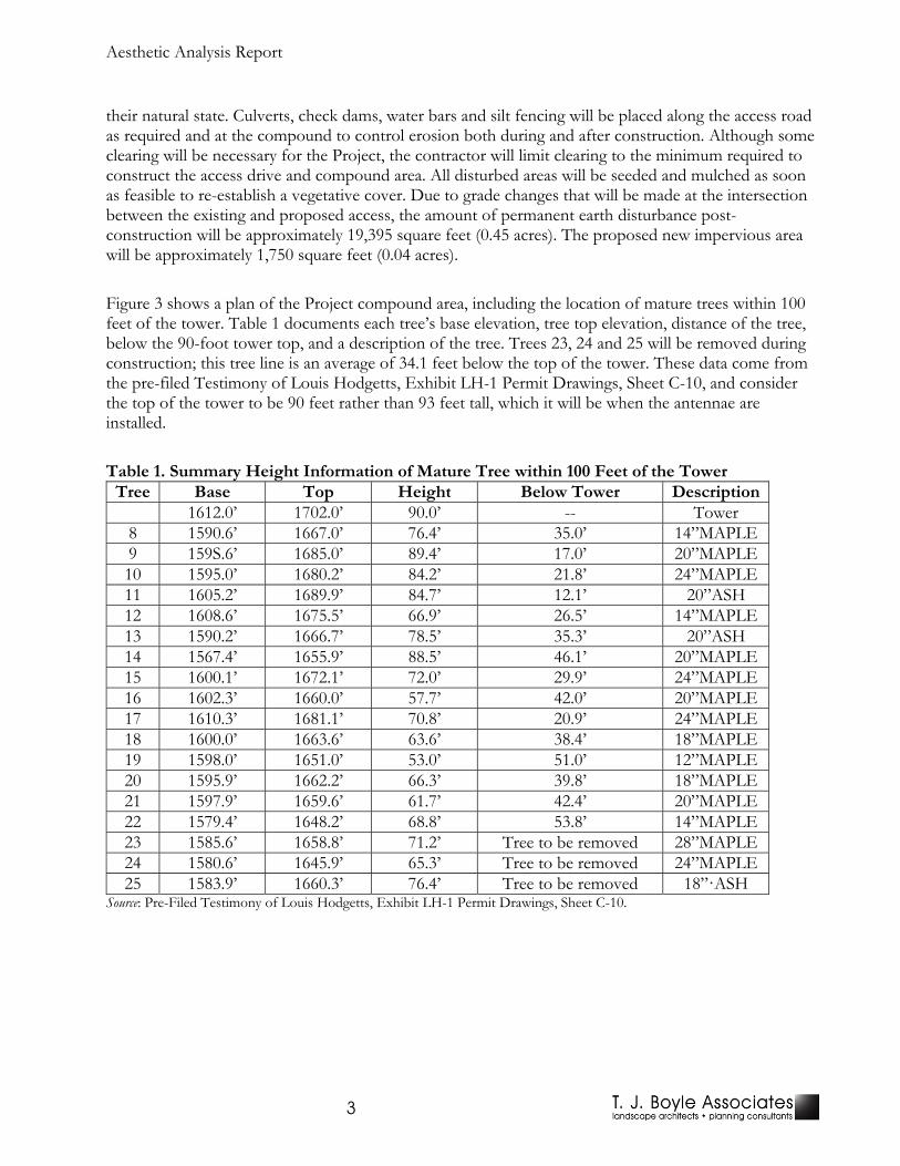
their natural state. Culverts, check dams, water bars and silt fencing will be placed along the access road as required and at the compound to control erosion both during and after construction. Although some clearing will be necessary for the Project, the contractor will limit clearing to the minimum required to construct the access drive and compound area. All disturbed areas will be seeded and mulched as soon as feasible to re-establish a vegetative cover. Due to grade changes that will be made at the intersection between the existing and proposed access, the amount of permanent earth disturbance post-construction will be approximately 19,395 square feet (0.45 acres). The proposed new impervious area will be approximately 1,750 square feet (0.04 acres). Figure 3 shows a plan of the Project compound area, including the location of mature trees within 100 feet of the tower. Table 1 documents each tree’s base elevation, tree top elevation, distance of the tree, below the 90-foot tower top, and a description of the tree. Trees 23, 24 and 25 will be removed during construction; this tree line is an average of 34.1 feet below the top of the tower. These data come from the pre-filed Testimony of Louis Hodgetts, Exhibit LH-1 Permit Drawings, Sheet C-10, and consider the top of the tower to be 90 feet rather than 93 feet tall, which it will be when the antennae are installed. Table 1. Summary Height Information of Mature Tree within 100 Feet of the Tower
Tree Base Top Height Below Tower Description 1612.0’ 1702.0’ 90.0’ -- Tower 8 1590.6’ 1667.0’ 76.4’ 35.0’ 14”MAPLE 9 159S.6’ 1685.0’ 89.4’ 17.0’ 20”MAPLE 10 1595.0’ 1680.2’ 84.2’ 21.8’ 24”MAPLE 11 1605.2’ 1689.9’ 84.7’ 12.1’ 20”ASH 12 1608.6’ 1675.5’ 66.9’ 26.5’ 14”MAPLE 13 1590.2’ 1666.7’ 78.5’ 35.3’ 20”ASH 14 1567.4’ 1655.9’ 88.5’ 46.1’ 20”MAPLE 15 1600.1’ 1672.1’ 72.0’ 29.9’ 24”MAPLE 16 1602.3’ 1660.0’ 57.7’ 42.0’ 20”MAPLE 17 1610.3’ 1681.1’ 70.8’ 20.9’ 24”MAPLE 18 1600.0’ 1663.6’ 63.6’ 38.4’ 18”MAPLE 19 1598.0’ 1651.0’ 53.0’ 51.0’ 12”MAPLE 20 1595.9’ 1662.2’ 66.3’ 39.8’ 18”MAPLE 21 1597.9’ 1659.6’ 61.7’ 42.4’ 20”MAPLE 22 1579.4’ 1648.2’ 68.8’ 53.8’ 14”MAPLE 23 1585.6’ 1658.8’ 71.2’ Tree to be removed 28”MAPLE 24 1580.6’ 1645.9’ 65.3’ Tree to be removed 24”MAPLE 25 1583.9’ 1660.3’ 76.4’ Tree to be removed 18”·ASH
Source: Pre-Filed Testimony of Louis Hodgetts, Exhibit LH-1 Permit Drawings, Sheet C-10.

PSD Verizon Waterbury Center
4
Figure 2. Elevation of the proposed stealth “leafless tree” tower design and the utility structure. . (Source: Pre-Filed Testimony of Louis Hodgetts, Exhibit LH-1 Permit Drawings, Sheet C-11.)

Aesthetic Analysis Report
5
Figure 3. Site plan of Project compound indicating location of mature trees within 100 feet of the tower. (Source: Pre-Filed Testimony of Louis Hodgetts, Exhibit LH-1 Permit Drawings, Sheet C-10.)

PSD Verizon Waterbury Center
6
III. Methodology
Section 6086 (a) in Title 10, Vermont Statutes requires that “Before granting a permit, the district commission shall find that the subdivision or development: … (8) Will not have an undue adverse effect on the scenic or natural beauty of the area, aesthetics….” In “Re: Quechee Lakes Corporation, No. 3W0411-EB and No. 3W0439-EB (November 4, 1985),” the Vermont Environmental Board elaborated the process to evaluate the aesthetic impact of projects, which has come to be known as the Quechee Analysis:
In judging the impact of a proposed project on the values described in Criterion 8, the cornerstone is the question: Will the proposed project be in harmony with its surroundings–will it “fit” the context within which it will be located? Several specific features must be evaluated in answering this question:
1) What is the nature of the project's surroundings? Is the project to be located in an urban, suburban, village, rural or recreational resort area? What land uses, presently exist? What is the topography like? What structures exist in the area? What vegetation is prevalent? Does the area have particular scenic values?
2) Is the project's design compatible with its surroundings? Is the
architectural style of the buildings compatible with other buildings in the area? Is the scale of the project appropriate to its surroundings? Is the mass of structures proposed for the site consistent with land use and density patterns in the vicinity?
3) Are the colors and materials selected for the project suitable for the
context within which the project will be located? 4) Where can the project be seen from? Will the project be in the viewer's
foreground, middleground or background? Is the viewer likely to be stationary so that the view is of long duration, or will the viewer be moving quickly by the site so that the length of view is short?
5) What is the project's impact on open space in the area? Will it
maintain existing open areas, or will it contribute to a loss of open space? All of these factors must be weighed collectively in deciding “whether the proposed project is in harmony with–i.e., “fits”–its surroundings. The land uses which surround a project are crucial to the analysis. The same building which may add to the aesthetic qualities of an urban area may detract from those qualities in a rural setting, because the context is different. The visual impact of a single large building may be lessened if its mass is broken up into several smaller structures. A building which may project itself toward the viewer because it is painted white or red, may tend to recede into the background if it were painted in darker tones. Loss of open space areas tends to be "adverse" from a strictly aesthetic standpoint, because open space is an important feature in the scenic beauty of Vermont.

Aesthetic Analysis Report
7
The expert witnesses agreed that certain types of land forms are especially sensitive to change, because these land forms tend to be visible from a wide area or they are seen by large numbers of people. These sensitive areas include ridgelines, steep slopes, shorelines and floodplains. Other features are sensitive because they are aesthetically unique; examples may include historic structures, wetlands and natural areas. In evaluating a project proposed in a sensitive area, the Board and District Commissions should give special attention in assessing whether the scenic qualities of these sites will be maintained. If after a collective analysis of these factors, we conclude that the proposed project would have an adverse impact on the aesthetics or scenic or natural beauty of the area, the next step is to determine whether the adverse impact is "undue." We conclude that an adverse impact is undue, and therefore violates Criterion 8, if we reach a positive conclusion with regard to any one of the following:
1) Does the project violate a clear, written community standard intended to
preserve the aesthetics or scenic, natural beauty of the area? Such standards may, for example, be set forth in the local or regional plan, or be adopted in the creation of an historic design district, or be incorporated into a municipal or State scenic road designation. If the Board or Commissions find that such standards do exist, and that the project as designed would violate those standards, the adverse impact would be undue.
2) Does the project offend the sensibilities of the average person? The
Legislature has directed the Commissions and this Board, composed of lay people from many different communities within Vermont, to determine what is acceptable in terms of new developments' impact on aesthetics and scenic and natural beauty. If our sensibilities are, collectively, offended by a project, its impact under Criterion 8 is undue. It is not enough that we might prefer to see a different design or style of building, or that we might prefer a different type of land use, but that the project, when viewed as a whole, is offensive or shocking, because it is out of character with its surroundings, or significantly diminishes the scenic qualities of the area.
3) Has the Applicant failed to take generally available mitigating steps which
a reasonable person would take to improve the harmony of the proposed project with its surroundings? Such steps may include selection of less obtrusive colors and building materials, implementation of a landscaping plan, selection of a less obtrusive building site within the project area, or reduction of the mass or density of a project. If there are reasonable alternatives available to the Applicant that would mitigate the adverse impact of the project, failure to take advantage of those alternatives may, in some circumstances, render undue an otherwise acceptable aesthetic impact.
In summary, we approach the Criterion 8 evaluation of the Quechee projects by first deciding whether or not those projects are in harmony with their surroundings. In

PSD Verizon Waterbury Center
8
performing this analysis, special scrutiny must be given to sensitive natural features. If we determine that a project's impact on its surroundings would be adverse in some manner, we then must determine whether the impact is "undue" because the project would violate an express community standard pertaining to aesthetics, would be offensive or shocking to the sensibilities of the average person, or has failed to incorporate reasonable mitigating steps which would improve its harmony with its surroundings.”
For this Project, four distinct methods are used in conducting the Quechee analysis, and in preparing this report: (1) Background data collection, (2) GIS viewshed analysis mapping, (3) Field investigation, and (4) Project visualization. The background data and field investigation are used to characterize the study area. The GIS viewshed mapping and field investigation are used to identify areas with potential visibility of the Project. The visualization is used to determine how the Project will be visually perceived from various locations. All four methods are used to evaluate whether there are in fact ‘adverse’ impacts and if so, whether those impacts could be considered ‘undue’.
1. Background Data Collection. Standard data that can help describe the landscape within three miles of the project are assembled in a GIS database. The GIS is used to calculate the viewshed analysis, display GPS waypoints documenting the areas visited during the field investigation, locate the viewpoint locations from which photographs and field notes were recorded, and prepare the maps used in this report. The sources of the data are listed in the Reference section of the report. The standard data in the GIS database include project elements (e.g., tower location and height), topography, water, forest cover, transportation—roads, railroads, and trails, buildings, outdoor recreation sites, and aerial photography.
In addition, regional and municipal plans for the project location are reviewed for locally designated areas of scenic significance. This information is then used in the Quechee Analysis to evaluate whether an adverse impact is undue.
2. GIS Viewshed Analysis. The GIS data are used to identify areas that may have potential views of the Project. The study area is limited to three miles surrounding the project tower. An area of three miles is chosen because it is near the limits of visual recognition of a standard communications tower. The analysis results, portrayed as two viewshed maps, are the basis for organizing the field investigation. Figure 4 illustrates how line-of-sight is determined in the viewshed analysis.

Aesthetic Analysis Report
9
a. First, a “Terrain Viewshed” map is created to evaluate how the existing land form may block views of the tower. The elevation data used for this analysis come from the National Elevation Dataset (NED). The visibility map distinguishes between potential visibility from “open” areas (without forest cover) and areas within forests. For the purposes of this map, a viewshed was run using the structural height of the proposed tower and antennae (93’).
b. A second map is created that represents a “Vegetated Viewshed.” This map shows how buildings and forest canopy, in addition to landform, may block views of the Project. The forest canopy is identified from the 2011 National Land Cover Data (NLCD 2011), and areas of evergreen, deciduous and mixed forest are all assigned a nominal canopy height of 12 meters (40 feet). The screening effect is supplemented by digitizing the area of buildings, hedgerows, and other obvious obstructions that appear from aerial photography to be 40 feet or taller. For the purposes of this map, a viewshed was run using the structural height of the proposed tower and antennae (93’).
These viewshed maps are a useful tool in preparing for field investigation. When properly reviewed, they indicate areas most likely to have views, emphasizing areas likely to have the greatest impacts, and identifying areas that are unlikely to have views. However, the assumptions used to calculate these maps are not perfect, and due since the forest canopy is typically higher than 40 feet and development is only partially accounted for, the maps tend to over-estimate Project visibility. Thus, these maps are primarily used in preparation of the field investigation, which more fully evaluates the landscape context, Project visibility, and potential impacts. It is inappropriate to use these maps as the only basis to evaluate visual impacts.
3. Field Investigation. The viewshed maps focus the field investigation to areas most likely to have views of the Project. The purpose of the field investigation is to verify potential visibility as indicated on the viewshed maps, photographically document landscape visual character within the study area, photograph views toward the project, record notes concerning each viewpoint where photographs are taken and the landscape character throughout the study area. All field photography used a Nikon D7000 camera and a zoom lens set to either 18 mm (wide angle) or 35 mm (normal) focal length, which respectively have a 66.5 and 37.3-degree horizontal angle of view.
Figure 4. Topographic Viewshed versus a Vegetated Viewshed

PSD Verizon Waterbury Center
10
The location of photograph viewpoints was recorded using a global positioning system (“GPS”) and are shown on Map 1 in Appendix A.
The documentation of the field investigation includes (1) the route traveled and location of photograph viewpoints, (2) catalog of photographs, and (3) table of field notes. All three components are coordinated by being indexed to the viewpoint number. A selection of photos focusing on views oriented toward the proposed tower is used to illustrate this report.
4. Project Visualizations. It is normally helpful to create visualizations as an aid to evaluate visual
impacts. A photographic simulation is particularly helpful in describing how the project will appear to the affected public. The specific selection of the simulation viewpoint is typically based on the extent of the project’s visibility, the probable frequency and sensitivity of viewers, and the availability of a suitable photograph from the field investigation. Each simulation attempts to illustrate the most visible condition for the area it represents.
Visual simulations prepared by All-Points Technology Corporation were included as part of the 248a petition in Steele’s (2015) pre-riled testimony. These simulations are included as Appendix C of this review. The pre-filed testimony describes the simulation process in this way:
Q.9 How did you determine how the Project will look in its proposed surroundings?
A.9 I reviewed the results of a "balloon test" conducted on May 8, 2014 in order to predict and better understand the impact of the proposed tower on the Town's scenic resources. The deciduous trees were without leaves thereby maximizing the opportunity for views of the project site. With balloons in the air to mark the location and height of the Tree, and with monitoring to ensure that any drifting of the balloons was taken into account, Verizon Wireless' consultant All Points Technology Corporation traveled public roads in the vicinity of the project to find prominent public vantage points from which the balloons could be seen. As a result, 17 viewpoints were selected for further analysis, and photographic simulations were created to demonstrate what the proposed Tree would look like in the surrounding landscape when seen from these viewpoints.
This same text is found in Steele’s Visual Impact Analysis (VIA), which is an Exhibit JS-1 to his testimony. The VIA also includes this additional information.
Please note that the balloon was floated to a height of 95 feet above ground level (AGL), and the simulated tower assumed to be that high. In fact, the tower portion of this installation will be 90 feet AGL, with the highest appurtenances extending to 93 feet AGL.
The report by All-Points Technology Corporation (2015) only includes photographs of 17 viewpoints, simulations from those viewpoints, and a map locating each viewpoint. The report does not include any text; specifically there is no description of the methods used to assure that the balloon was at the appropriate height or how the simulations were created. Typically the balloon would be tethered with a line that that is the length of the tower height

Aesthetic Analysis Report
11
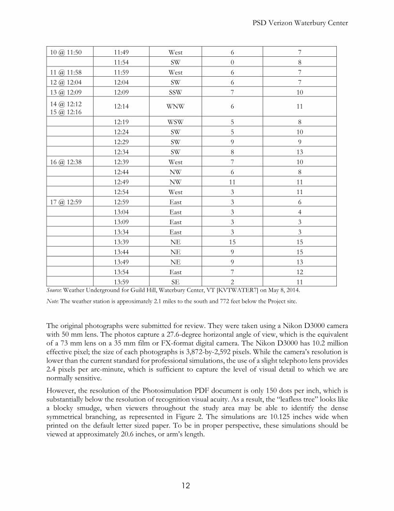
The closest weather station to the Project site is located on Guild Hill (latitude 44.389, longitude -72.714, and elevation 840 feet), close to viewpoint 10 in Appendix B and 2.1 miles south of the Project. The archived wind speed and direction data for May 8, 2015 obtained from the Weather Underground are shown in Table 2. Most of the photos were taken when the wind was 6 mph, which is a light breeze on the Beaufort Wind Scale—weather vanes are active, wind is felt on the face and leaves rustle. There are gusts up to 10 or more mph, which is a gentle breeze sufficient to move leaves and small twigs or extend light flags. It is our experience that such winds are sufficient to cause considerable movement and elevation change of the balloon.
The simulations are apparently created using a digital paint program, such as Adobe PhotoShop. An image of the “leafless tree,” perhaps from the elevation in Figure 2, is copied to second image layer, where it is positioned and scaled between the ground level of the ridgeline and the bottom of the balloon. The tower is 93-feet tall and the balloon was tethered to a nominal 95 feet. However, given the breeze it was almost certainly below that height; perhaps even below 93 feet. The simulations all show the tower being located well below the balloon’s level. This can be checked in Adobe Acrobat by going to the View menu, scrolling to Page Display and selecting Single Page View. Next, in the View menu select Full Screen Mode. Each viewpoint’s existing photograph and proposed simulation should be registered so that one can easily go back and forth between the two views using the Page Up and Page Down keys on the keyboard. Using a pencil or pen, point to the balloon in the existing photograph and then Page Down to the proposed simulation. It is clear that the tower is always located well below the balloon.
Table 2. Wind Speed and Direction at the Time the Simulation Photos Were Taken Photo taken Time Wind Direction WindSpeed (mph) WindSpeedGust (mph)
10:01 West 6 6
10:06 WSW 6 7
10:11 SW 4 7
10:16 SW 3 7
10:21 West 2 5
10:26 NW 5 5
10:31 WSW 5 8
10:36 West 1 7
10:41 West 2 6
1 @ 10:48 10:46 WSW 6 10
10:51 WSW 6 9
2 @ 10:55 3 @ 10:59 4 @ 11:06 5 @ 11:11
10:56 WSW 6 6
6 @ 11:24 7 @ 11:28 8 @ 11:34 9 @ 11:34
11:44 West 6 0
PSD Verizon Waterbury Center
12
10 @ 11:50 11:49 West 6 7
11:54 SW 0 8
11 @ 11:58 11:59 West 6 7
12 @ 12:04 12:04 SW 6 7
13 @ 12:09 12:09 SSW 7 10
14 @ 12:12 15 @ 12:16
12:14 WNW 6 11
12:19 WSW 5 8
12:24 SW 5 10
12:29 SW 9 9
12:34 SW 8 13
16 @ 12:38 12:39 West 7 10
12:44 NW 6 8
12:49 NW 11 11
12:54 West 3 11
17 @ 12:59 12:59 East 3 6
13:04 East 3 4
13:09 East 3 3
13:34 East 3 3
13:39 NE 15 15
13:44 NE 9 15
13:49 NE 9 13
13:54 East 7 12
13:59 SE 2 11 Source: Weather Underground for Guild Hill, Waterbury Center, VT [KVTWATER7] on May 8, 2014.
Note: The weather station is approximately 2.1 miles to the south and 772 feet below the Project site.
The original photographs were submitted for review. They were taken using a Nikon D3000 camera with 50 mm lens. The photos capture a 27.6-degree horizontal angle of view, which is the equivalent of a 73 mm lens on a 35 mm film or FX-format digital camera. The Nikon D3000 has 10.2 million effective pixel; the size of each photographs is 3,872-by-2,592 pixels. While the camera’s resolution is lower than the current standard for professional simulations, the use of a slight telephoto lens provides 2.4 pixels per arc-minute, which is sufficient to capture the level of visual detail to which we are normally sensitive.
However, the resolution of the Photosimulation PDF document is only 150 dots per inch, which is substantially below the resolution of recognition visual acuity. As a result, the “leafless tree” looks like a blocky smudge, when viewers throughout the study area may be able to identify the dense symmetrical branching, as represented in Figure 2. The simulations are 10.125 inches wide when printed on the default letter sized paper. To be in proper perspective, these simulations should be viewed at approximately 20.6 inches, or arm’s length.
Aesthetic Analysis Report
13
The visual analysis is reported in two parts. The first part characterizes the landscape within three miles of the proposed tower (the study area). This section uses the topographic and vegetated viewshed maps to identify publicly accessible areas. Special attention is paid to areas of statewide or locally designated significance that have potential views of the Project as applicable. The visual character and potential visibility from these areas are verified during the field inventory. The second part of the visual analysis applies the two-part Quechee Analysis to evaluate the impact of potential views as seen from publicly accessible places within the study area. If the view is deemed out of character with the surroundings to the degree it causes an adverse impact, the three Quechee criteria are used to determine if the adverse impact is undue.

PSD Verizon Waterbury Center
14
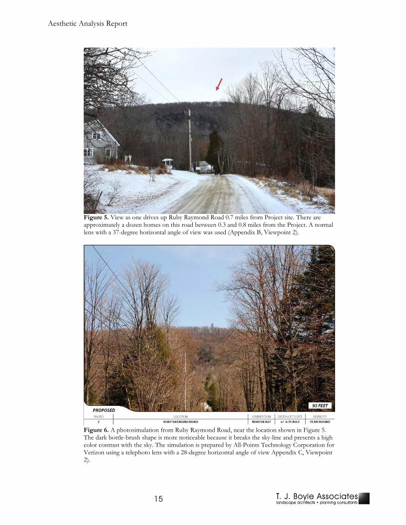
IV. Evaluation of Impacts The first step in evaluating scenic impacts using the Quechee Analysis is to consider “will the project be in harmony with its surroundings—will it ‘fit’ the context within which it will be located?” The answer to this question is based on the collective evaluation five considerations described at the beginning of the methodology section. In order to do this, it is necessary to understand the existing conditions in areas where the Project may be visible. To this end, a characterization of the surrounding area is provided, such as residential density, park or recreational uses, agricultural fields, and commercial. Additionally, the typical class of roadways in the surrounding area is provided, such as Class 2 collector road or Class 30 state highway. Together, these descriptions are utilized to portray the land-use and intensity of development and travel in the areas with potential visibility. Views of the proposed Project are described using three distance zones. These are areas within a 1-mile radius, areas between a 1- to 2-mile radius, and areas between a 2 to 3-mile radius. Due to the significant reduction of Project visibility and visual magnitude, areas outside of a 3-mile radius were not considered to be adversely affected by the proposed Project. The following outline is a descriptive inventory of these areas, and is meant to be reviewed in conjunction with Appendices A through C. A. Areas Within a 1-Mile Radius The landscape character of Waterbury and Stowe within one mile of the Project the land is primarily forest cover that appears to be managed and much of it is on high ridges with steep slopes. The proposed tower is located on one of these high ridges, which creates a sky-line that is not seen against other landforms in the background. There are several open fields appear to have been planted in corn or hay that have the effect of increasing visual access to the Project ridgeline. There is also a scattering of large-lot or low density residential accessed primarily from unpaved town roads The residential areas in Waterbury include a few houses on Burt Farm Lane, Gregg Hill Road, Maggies Way, Russell Road, and Tayer Lane. In addition, there is potential visibility from perhaps a dozen houses along Ruby Raymond Road and twice that many on Spruce Haven. In Stowe, there are over 20 large lot residences off North Hill Road. In addition, there are a several large lot houses on South Hollow Road/Hollow’s End, Raven Hill Road, Ayers Farm Road, and Points North. Vermont Route 100 is the Green Mountain Byway, a designated Vermont Scenic Byway that skirts the western side of this area for approximately a mile and a half. It is the only primary state highway within 3 miles of the Project. By and large there is no visibility from Rt. 100 within a mile of the Project. However, there is considerable visibility from varying distances along the unpaved town roads that serve the residential areas. The closest residence is on Hollow’s End, about a quarter of a mile from the project. A representative example is shown in Figure 5, where after turning onto Ruby Raymond Road, residents will be looking directly at the tower as they drive a quarter of a mile; there will be potential visibility from most other areas of this neighborhood. The field photographs in Appendix B within a mile of the Project are from viewpoints 1, 2 and 9. Figure 6 shows a simulation of how the structure will appear from a nearby location. Portions along Burt Farm Lane, Gregg Hill Road, South Hollow Road/Hollow’s End, Russell Road, Spruce Haven, Tayer Lane, will be similarly affected.
Aesthetic Analysis Report
15
Figure 5. View as one drives up Ruby Raymond Road 0.7 miles from Project site. There are approximately a dozen homes on this road between 0.3 and 0.8 miles from the Project. A normal lens with a 37-degree horizontal angle of view was used (Appendix B, Viewpoint 2).
Figure 6. A photosimulation from Ruby Raymond Road, near the location shown in Figure 5. The dark bottle-brush shape is more noticeable because it breaks the sky-line and presents a high color contrast with the sky. The simulation is prepared by All-Points Technology Corporation for Verizon using a telephoto lens with a 28-degree horizontal angle of view Appendix C, Viewpoint 2).

PSD Verizon Waterbury Center
16
Figure 5Figure 6 are representative the views to the project from a distance of up to 1 mile. The proposed Photosimulations 1 through 10, and 17 in Appendix C are all within 1 mile of the project. These views are primarily from town roads and numerous residences on large lots; the Ruby Raymond Road, Spruce Haven, and Hollow Road neighborhoods will be particularly affected. There is relatively little visibility from Rt. 100 in this area. The site is located on a ridgeline over 1,600 feet in elevation that is forested with mixed hardwoods. The setting is typical of scenic rural Vermont; in the fall it will be ablaze with bright colors. The site stands against the sky in the background, and the proposed “leafless-tree” will appear like a dark bottlebrush rising above the horizon. The Project will catch the eye because of its regular shape and uniform color; it will appear like a column rising above the horizon line. It is very unlikely that a typical Vermont resident would mistake the Project as represented in the photosimulations for a natural tree. For these reasons the Project will have an ADVERSE scenic impact. B. Areas Between a 1- to 2-Mile Radius The land cover in the area 1 to 2 miles from the Project is still dominated by forest, but a large proportion is also in open fields, particularly hay fields, which opens up more views toward the Project site. On the Waterbury side, several roads run south to north through this ring: Gregg Hill Road, Maggie’s Way, Barnes Hill Road, and Sweet Road. These are town roads, largely unpaved with scattered farms and residences along them. There will be clear or filtered visibility of the Project from many stretches of these road, as is apparent from the field photography at viewpoints 3 through 6, 8, and 10 through 14 in Appendix B. On the Stowe side of the boarder there is a greater amount of large-lot and low intensity residential development. The through roads continue north from Waterbury: Barnes Hill Road becomes Stowe Hollow Road, Sweet Road becomes Waterworks Road. There are also several east-west connecting roads: Moscow Road, Gold Brook Road, and Dewey Hill Road. There is an extensive number of small residential roads branching from these primary toads. These are also town roads that are mostly unpaved. The only potential visibility is near the border with Waterbury—along Waterworks Road and Barnes Hill Road (different road than Barnes Hill Road in Waterbury). However, field investigation found that it is quite unlikely that there will be visibility from Stowe, even in this area. There is approximately 1.4 miles of Rt. 100—the Green Mountain Byway—in this 1 to 2-mile ring that is in the town of Waterbury and approximately 1.3 miles in Stowe. There are a few businesses as well as residences along these stretches of Rt. 100, the annual average daily traffic (AADT) as measured in 2014 is 9,500. There will be clear or filtered visibility of the Project from many stretches of Rt. 100 in Waterbury, as represented by Figure 7Figure 8. It is unlikely that the Project will be visible from Rt. 100 in Stowe. There is considerable visibility from Waterbury of the Project within the 1 to 2-mile ring, as represented by the simulations in Appendix C from viewpoints 11 through 15. In particular there is a significant amount of visibility from Rt. 100, the Green Mountain Byway, which is a designated Vermont Scenic Byway. This byway is a primary destination for leaf-peepers in the fall and is heavily traveled all year long. The visual affect from the 1 to 2-mile ring is similar to that from within 1 mile of the Project as can be seen from comparing the simulations in Figure 6Figure 9. The Project presents an apparently solid cylinder that extends will above the horizon, creating an eye-catching anomaly on the horizon. Distance begins to ameliorate the visual magnitude, however the visual affect remains ADVERSE.

Aesthetic Analysis Report
17
Figure 7. View toward the Project site from the Green Mountain Club picnic area at a distance of 1.7 miles. A normal lens with a 37-degree horizontal angle of view was used (Appendix B, Viewpoint 6).
Figure 8. View from Rt. 100--the Green Mountain Byway—to the Project site 1.1 miles away. A normal lens with a 37-degree horizontal angle of view was used (Appendix B, Viewpoint 5).

PSD Verizon Waterbury Center
18
Figure 9. A photosimulation from Rt. 100, the Green Mountain Byway, near the location shown in Figure 8. The simulation is prepared by All-Points Technology Corporation for Verizon using a telephoto lens with a 28-degree horizontal angle of view (Appendix C, Viewpoint 11).
C. Areas Between a 2- to 3-Mile Radius The land uses within a 2- to 3-mile radius of the Project are more diverse than in the other two areas. Forest cover still is dominant, but Waterbury Reservoir is a large area of open water, and more developed portions of Waterbury Center and Lower Stowe Village fall within this area. There are a large number of residential roads at the northern side of the area surrounding Stowe and the southern end surrounding Waterbury Center. The Project site is situated on a high ridge and continues to be visible from area roads, particularly those oriented north-south or when the view is over an open field. There will be visibility from Rt. 100—the Green Mountain Byway—that is similar to the visibility from within the 1 to 2-mile ring, as shown in Figure 10. No simulations were prepared from this distance. However, there is relatively little visibility from Waterbury Reservoir due to screening from the steep terrain on the eastern shore. While the viewshed maps in Appendix A indicate the potential for visibility in and around Waterbury Center, in fact the field investigation found that buildings and trees effectively screen views toward the Project. There is also no apparent visibility from the developed areas of Stowe Village. The visual affect from the 2 to 3-mile ring is similar to that from within 1 to 2-miles of the Project. The Project presents an apparently solid cylinder that extends will above the horizon, creating an eye-catching anomaly on the horizon. However, the visual affect is largely ameliorate by distance, and the visual magnitude of the Project is now minimal. Nonetheless, the visual effect of a structure breaking through the horizon line is eye-catching and the result remains ADVERSE.

Aesthetic Analysis Report
19
Figure 10. The view traveling north on Rt. 100—the Green Mountain Byway, 2.3 miles from the Project site. A normal lens with a 37-degree horizontal angle of view was used (Appendix B, Viewpoint 7).

PSD Verizon Waterbury Center
20
V. Community Standards When a project is found to have an Adverse scenic impact, as was found above, the three criteria of the Quechee test are employed to determine if this impact is Undue. The first test criterion is whether “the project violates a clear, written community standard intended to preserve the aesthetics or scenic beauty of the area.” What constitutes a clear, written community standard is frequently contested among various parties to a project. In its Order for Docket Number 7508 on the Petition of Georgia Mountain Community Wind. LLC for a Certificate of Public Good, the Public Service Board has clarified what they understand a clear, written community standard to be.
In order for a provision to be considered a clear, written community standard, it must be “intended to preserve the aesthetics or scenic beauty of the area” where the proposed project is located and must apply to specific resources in the proposed project area (page 52). Zoning regulations have been interpreted to constitute a clear, written community standard for purposes of the Quechee test. Given our statutory charge, we conclude that zoning regulations are not the most appropriate source for a clear, written community standard under the Quechee test, as applied by the Board in Section 248 proceedings. Because towns often grant exceptions and variances to these ordinances on a case-by-case basis, it is difficult to rely on a zoning ordinance as a clear and consistent statement of a community's policies or standards. The ability of a town to grant zoning variances will, in many cases, result in different zoning standards being applied depending upon the individual circumstances of the permit application. Therefore, it is more appropriate to rely on the town plan as the primary source of clear written community standards (page 53). Pursuant to Board precedent, we consider the societal benefits associated with a project when evaluating the project's aesthetic impacts (page 54).
For this Project, the primary planning documents are the Central Vermont Regional Planning Commission’s Central Vermont Regional Plan 2008, adopted September 9, 2008, amended September 8, 2015, and amended October 13, 2015 (the “Regional Plan”), and the Town and Village of Waterbury’s Municipal Plan 2013-2018. , adopted December 9, 2013 (the “Town Plan”), set forth the community standards that affect the Project location. Pages from these two plans that are relevant to the aesthetic impacts of the Project are included in Appendix D. These two planning documents make explicit reference to Waterbury’s Zoning Regulations. They also reference the Green Mountain Byway, and the Green Mountain Byway Vermont Byway Corridor Management Plan, which was prepared by LandWorks. The regional planning commissions submitted this plan on behalf of the town governments to the State, which subsequently accepted it and designated the Green Mountain Byway as a Vermont Scenic Byway. Relevant pages from these documents are also included in Appendix D for information purposes.

Aesthetic Analysis Report
21
Following is a discussion of the scenic standards from the Regional and Municipal Plans that are relevant to the Project. In particular, they concern three issue: (1) scenic resources, (2) protection of high ridgelines, and (3) siting telecommunications facilities. REGIONAL PLAN A. Scenic Resources The Regional Plan states that the Central Vermont Regional Planning Commission (CVRPC):
Views the Plan primarily as a means to enhance the lives of the Region’s residents. Accordingly, the preservation and enhancement of the "quality of life" for all Central Vermont residents is the guiding principle of this Plan…any analysis of quality of life must address both our basic needs and our desires and aspirations. … Among these are… Natural Beauty - We place a high value on the scenery and resources the landscape provides.
Scenery and scenic resources are described in the Resource Protection section of Chapter 2: Land Use Element. However, it is less than 100 words and so general as to apply to almost anywhere in Vermont. The fifth land use goal is “To preserve the aesthetic quality of the Region.” There are policies to “inventory and map the Region’s scenic resources” and “track indicators that show impacts on aesthetic quality and natural beauty.” However, the Regional Plan does not include specific scenic resources or report indicators aesthetic impacts. The CVRPC did participate in the creation of the Green Mountain Byway Vermont Byway Corridor Management Plan, which it submitted to the State on behalf of Waterbury. This subsequently resulted in its designation as a Vermont Scenic Byway. B. Protection of High Ridgelines One of the policies in the Resource Protection section of Chapter 2: Land Use Element is:
2. Unless effectively screened, or clearly in the best interest of the general public, ridge
line development or conspicuous development on locally prominent landscape features is discouraged.
C. Siting Telecommunications Facilities The Regional Plan also recognizes that wireless communication has become a part of everyday.
While Central Vermonters want and expect good cellular service, they also expect the placement and design of new facilities to be guided by a respect for the integrity of the Region’s landscape … As such, it is important to balance aesthetics, signal quality, health, business and personal needs when deciding whether and where to build new towers and other facilities.
One of the policies in the Resource Protection section of Chapter 2: Land Use Element is: 3. The scale and siting of new structures should be in keeping with the surrounding
landscape and architecture; however, towers should utilize stealth technology.
PSD Verizon Waterbury Center
22
The Regional Plan’s Wireless Telecommunication Faculties Goal is for “Effective and efficient communication systems.” Among the related policies are:
2. Telecommunication facilities should be sited, designed, maintained and operated so as to minimize negative impacts on natural, cultural and scenic resources. Use of stealth design and/or use of existing structures are encouraged where appropriate. New towers should be no taller than necessary to provide coverage. The policies of this Plan addressing ridgeline and hilltop development (see Land Use Element, Goal 5) are intended to apply to telecommunication facilities.
9. Access roads should be designed to minimize their impact on scenic, agricultural,
forestry, and natural resources. D. Conclusion In conclusion, the Regional Plan states that scenic values are important to its residents’ quality-of-life, but it has not inventoried or otherwise located these resources. There are references to the scenic sensitivity of high ridgelines. The Regional Plan also recognizes the importance of modern wireless communications, while identifying the need to minimize the scenic impacts from tower siting and access roads. The Regional Plan appears to lack the specificity of a clear, written community standard for aesthetics. Relevant selections from the Regional Plan are included in Appendix D. MUNICIPAL PLAN A. Scenic Resources The Municipal Plan states that “according to the community survey, nearly 85% of residents rate their ability to enjoy scenic views in Waterbury as good to excellent. When asked about the most important resources to protect in Waterbury, scenic views ranked second behind historic buildings.” However, the Town Plan identifies few specific scenic resources, and usually, they are mentioned as examples rather than clearly designated scenic resources. A major exception is Route 100 through the Towns of Waterbury and Stowe. It was nominated by the regional planning commission on behalf of the two towns in 2008 and “was enthusiastically accepted into the program and is officially designated as the ‘Green Mountain Byway’. It should be noted that “the Byway Corridor encompasses both towns in their entirety and is not limited to Route 100 or its right-of-way.” In the section on Open Lands and Scenic Resources, the Municipal Plan states:
Waterbury has numerous scenic vistas of surrounding mountains and valleys, which contribute to its visual character. Both the Green and Worcester Mountain Ranges are prominent features when traveling east or west on the highways adjacent to the Winooski River in the southwest part of town. From hills to the west and east of Route 100, the mountains, the Winooski River Valley, and the Waterbury Reservoir create a magnificent view. Travelers along Route 100 can see broad expanses of mountains and rolling hills and the snowy peak of Mount Mansfield in Stowe.

Aesthetic Analysis Report
23
It is for these reasons and others that Waterbury and Stowe joined together to nominate Route 100 to the Vermont Byways Program in 2008. The nomination was enthusiastically accepted into the program and is officially designated as the “Green Mountain Byway”. It should be noted that the Byway Corridor encompasses both towns in their entirety and is not limited to Route 100 or its right-of-way. The nomination cited the following intrinsic resources: historic and archaeological qualities, cultural qualities, natural qualities, recreational qualities, and scenic qualities. The “Green Mountain Byway Vermont Byway Corridor Management Plan” dated October 30, 2008 fully details each intrinsic quality. The Natural Qualities and Scenic Qualities sections speak directly to the open lands and scenic resources this plan strives to protect. The management plan summarizes that sustaining activities such as agriculture, forestry and recreation depend on and have thrived on the rich abundance of natural resources of the land. Protecting and increasing public awareness of these resources within the corridor will be an essential part of sustaining harmony between humans and the environment. The plan goes on to rank the corridor’s scenic quality high (+3 on a scale of +3 to -3) for its long distance views of high ridges, alternating patterns of undeveloped meadows and historic farmsteads and their associated cultivated lands, historic buildings and settlement patterns, and the variety and extent of classic Vermont scenes and landscape patterns which contribute to this area’s unique sense of place. Waterbury adopted regulations in 2006 to ensure residential development in high elevations and steep slopes would not have a detrimental impact on scenic and natural resources. As Waterbury continues to accommodate and direct new growth, and the pressure to develop its open land increases, difficult decisions will need to be made regarding the value of such open lands to the community and perhaps the region. Some resources may be more critical to Waterbury’s environmental, economic, and cultural wellbeing than others. Such lands should be identified and adequate measures developed to ensure their protection for future generations.
In the Municipal Plan’s section on Existing Settlement Patterns – Town there is additional description of the importance of Route 100.
Route 100. The Route 100 corridor is a 5.6-mile stretch along the state highway from Route 2 (Main Street) in Waterbury Village to the Stowe town line. Route 100 is a major feature of Waterbury as it is the primary access to the Stowe resort area and for many visitors it is their only experience of Waterbury. Many historically significant and architecturally distinctive structures are located along Route 100, particularly in Colbyville and Waterbury Center village. Several scenic views, including distant mountain peaks and broad expanses of open space, can be experienced while traveling along Route 100. The Shutesville Hill area in northern Waterbury has been identified as a significant wildlife crossing between habitat blocks to the east and west. The Route 100 corridor in both Waterbury and Stowe has state and federal designation as the Green Mountain Byway. This designation recognizes the area’s intrinsic values of scenic quality, and resources in the areas of culture, history, recreation, and wildlife. Yet, Route 100 is being transformed from a rural, residential transportation route to a growing commercial strip. In 1996 Waterbury revised the zoning regulations for the Route 100 area to

PSD Verizon Waterbury Center
24
help promote better access management and protection of open space with commercial development. Yet, the CVRPC analysis indicates that the “current zoning may be reinforcing low density commercial sprawl.” When asking residents where more commercial development should occur, Route 100 ranked as the lowest. (2013 Survey)
The Zoning Regulations include a Route 100 District that extends approximately 1,000 feet to either side of the Byway. While there are development restrictions within the Route 100 District, the Project site is outside this area. Nonetheless, the Municipal Plan recognizes that the scenic sensitivity of “the Byway Corridor encompasses both towns in their entirety and is not limited to Route 100 or its right-of-way.” The scenic values of the corridor are described and evaluated in the Green Mountain Byway Vermont Byway Corridor Management Plan, which is included in Appendix D. B. Protection of High Ridgelines A major scenic protection tool described in the Town Plan is the protection of ridgelines and hillsides over 1,200 feet from development,
In addition to the potential for sedimentation and erosion, development on steep slopes and hillsides is likely to be more visible from a greater number of locations throughout Waterbury. Because higher elevation land often serves as the background to the community’s most scenic views, development in such areas can stand in stark contrast to its surroundings. To address these concerns, it is important that development on steep slopes and ridgelines are reviewed for potential environmental and visual impacts. In 2006, Waterbury adopted the Ridgeline, Hillside, Steep Slope Overlay Zoning District which applies to land above 1,200 feet in elevation. Land development in this area, including subdivisions, are subject to conditional use review. In addition, the overlay district regulations requires applicants to present habitat studies, erosion control plans and visual analysis’s to help protect natural resources for development in the areas that are above 1,500 feet in elevation.
The Project is within the most restrictive 1,500 zone. The Zoning Regulations describe various conditions that may restrict placement of structures:
(3) Placement of Structures: Consideration shall be given to the location of proposed or potential structures relative to site conditions, existing vegetation, and the location of fragile features (including but not limited to steep slopes, streams, and identified habitat and natural areas). The clustering of houses and other structures is encouraged to retain larger blocks of forest and fields and to help retain the aesthetic character and wildlife value of the RHS Overlay District. The location of proposed or potential structures may be restricted to ensure that development:
(A) Is minimally visible, as defined in this bylaw;
(B) Is designed so that the height of any structure does not exceed the height of the adjacent tree canopy serving as the visual backdrop to the structure;
(C) Is located so that buildings are not placed on existing steep slopes equal to or greater than 25 percent;
(D) Is located down-grade of ridge lines and is designed so that the proposed structures shall not break the skyline; and

Aesthetic Analysis Report
25
(E) Is located at or near the edge of existing and new clearings and fields or in the interior of existing wooded areas.
The relevant sections of the Zoning Regulations and the overlay map are in Appendix D. C. Siting Telecommunications Facilities The Town Plan recognizes there is a role for wireless communications. However, it also states that:
The extent of local coverage for wireless, cellular services is also improving – at the cost of siting new telecommunications towers that can mar the landscape if not sited appropriately in relation to their context. … The Town and Village of Waterbury amended zoning regulations in 1999 to regulate the siting, installation, and removal of telecommunications facilities.
There is reference to the Zoning Regulations for telecommunication siting, but no specific scenic standards are mentioned in the Municipal Plan. The Zoning Regulations include clear standards limiting a tower’s height above the surrounding trees,
(3) Height Limitations. In order to protect public safety and to preserve the scenic character and appearance of the area, the height limit for towers, antennas and tower-related fixtures in all districts shall not exceed twenty (20) feet above the average height of the tree line within one hundred (100) feet of the base of the tower. Notwithstanding the above, additional height may be approved upon a finding by the Development Review Board that the additional height is necessary in order to provide adequate coverage, or to accomplish collocation as outlined in Section 1.7, and that the additional height will not have an undue visual impact on the scenic character or appearance of the area.
Table 1 shows that the tower will be approximately 34 feet above the tree line within 100 feet. There is also a list of considerations for the protection of scenic ridges and hillsides.
(9) Protection of Scenic Ridges and Hillsides. Towers shall, when possible, be sited off ridge lines and where their visual impact is least detrimental to scenic areas. In determining whether the proposed tower will have an undue adverse visual impact on the scenic beauty of a ridge of hillside, the Development Review Board shall consider, among other things, the following:
(A) The period of time during which the proposed tower will be viewed by the traveling public on a public highway, public trail, or public body of water;
(B) The frequency of the view of the proposed tower by the traveling public;
(C) The degree to which the view of the tower is screened by existing vegetation, the topography of the land, and existing structures;
(D) Background features in the line of sight to the proposed tower that obscure the facility or make it more conspicuous;
(E) The distance of the tower from the viewing vantage point and the proportion of the facility that is visible above the skyline;

PSD Verizon Waterbury Center
26
(F) The number of travelers or vehicles traveling on a public highway, public trail, or public body of water at or near the critical vantage point; and
(G) The sensitivity or unique value of the particular view affected by the proposed tower.
To assist the Development Review Board in its review, the Development Review Board may require the applicant to fly or raise a three-foot diameter balloon at the maximum height of the proposed facility at a location within fifty (50) horizontal feet of the center of the proposed facility. The applicant shall provide photographs of the balloon test taken from at least four vantage points previously designated by the Development Review Board. The Development Review Board may, at its sole discretion, waive any of the requirements of this subsection [(905(a)(9)] for the purpose of approving the development of a wireless communications facility utilizing innovative siting techniques that camouflage or conceal the presence of antennas or towers.
The Public Service Board has found that similar telecommunications regulations do not constitute a clear, written community standard because they do not apply to specific locations, and “because towns often grant exemptions and variances to these ordinances on a case-by-case basis, it is difficult to rely on a zoning ordinance as a clear and consistent statement of a community’s policies or standards.”. D. Conclusion The Municipal Plan clearly states that scenic resources are important to the quality of life of Waterbury’s residents. The Green Mountain Byway, a designated Vermont Scenic Byway, is highlighted as a scenic resource. The Municipal Plan states that “the Byway Corridor encompasses both towns in their entirety and is not limited to Route 100 or its right-of-way.” The Green Mountain Byway Vermont Byway Corridor Management Plan is referenced in the Municipal Plan as the appropriate reference describing and evaluating this scenic resource. While the scenic importance and sensitivity of the Green Mountain Byway is asserted, no clear, written standards are presented in the Municipal Plan to protect this resource. The Zoning Regulations include a Route 100 District that regulates development along the Green Mountain Byway, but the Project is outside this zone. Ridgelines are identified in the Municipal Plan as important scenic resources that are sensitive to degradation from development above 1,200 feet and references the Ridgeline, Hillside, Steep Slope Overlay Zoning District described in the Zoning Regulation as the way the town is protecting these resources; the Project is within this district. The Town Plan also identifies the need to provide modern communications facilities while protecting the town’s scenic resources and refers to the procedures described in the Zoning Regulation. Relevant selections from the Town Plan, Zoning Regulations and Green Mountain Byway Management Plan are included in Appendix D. Both the regional and municipal plan recognize the importance of scenic quality in the area, but fail to provide a standard to protect scenic quality. While the zoning regulations do include standards, they also provide the town flexibility to allow exemptions to these standards, and therefore cannot be considered a clear written community standard under section 248 review. In conclusion, these documents do not provide a clear written community standard to preserve the aesthetic and scenic, natural beauty of the area.

Aesthetic Analysis Report
27
VI. Shocking and Offensive The second criterion of the Quechee test is whether “the project offends the sensibilities of the average person—when viewed as a whole is the project offensive or shocking, because it is out of character with its surroundings, or significantly diminishes the scenic qualities of the area.” When evaluating whether a project would offend the sensibilities of the average person, the criteria to make this assessment is related back to the first part of the Quechee Analysis; how the project ‘fits’ within its surroundings. An ‘average person’ is considered a disinterested party, not an affected neighbor; perhaps someone sightseeing on the Green Mountain Byway. The threshold for a project to be shocking or offensive is relatively high and a project would need to be entirely inconsistent with the surrounding land uses or exceptionally out of scale with the surroundings. In its Order for Docket No. 7527, the Public Service Board (2009) found that three 120-foot free standing steel lattice telecommunications towers located in Essex and Milton “would not be considered shocking or offensive to the average viewer,” and referenced the pre-testimony of David Raphael of LandsWorks (Exh. DPS-DR-1 at 13):
Does the Project offend the sensibilities of the average person? It can be concluded that the project(s) will not offend the sensibilities of the average person, to the point that such a person would find these towers, at each of the four sites, to be shocking or offensive. Telecommunication towers, for better or worse, have become widespread in our landscape, and though they are not readily embraced, and often do result in a visual intrusion and impact, they are familiar enough that the view of one cannot be considered shocking. The exception to this would be if such a tower were to be placed in a pristine landscape where little if any development had occurred and truly undermined a viewer's experience or expectations for that environment. That is not the case here. Those individuals who live near to or next to these projects and have full views of them might make a case that these towers have the potential to offend them. But these individuals cannot be considered to be an "average" viewer.
This perspective referenced by the PSB is that communications towers can reasonably be considered an ADVERSE scenic impact, but they are now such common elements in the landscape as seen from public roads that a typical person is unlikely to be genuinely shocked by its presence. Raphael suggests that the exception would be if the site context were “pristine.” Pristine means unspoiled or untouched, a landscape without visible signs of development. The view of North Hill could be reasonably considered pristine, but Rt. 100/Green Mountain Byway or the nearby neighborhoods in which a viewer would be standing certainly are not. Offensive can mean unpleasant, disgusting or insulting, and there is a further sense of it being belligerent or invasive. Inappropriate siting might lead to a typical person being offended—such as a lattice tower right next to a large war memorial. Poorly implemented camouflage that results in higher visual contrast and larger visual magnitude might be considered offensive to the typical viewers who are confronted daily with a so-called Franken-pine. On the other hand, there are examples of camouflage that are convincing and completely hide the tower from recognition.
PSD Verizon Waterbury Center
28
VII. Project Mitigation Finally, the third criterion of the Quechee test is whether “the Applicant failed to take generally available mitigating steps which a reasonable person would take to improve the harmony of the proposed project with its surroundings.” The Project proposes two forms of mitigation.
It is sited on the southern military crest of North Hill, which greatly reduces visibility of the Project from the Town of Stowe.
It proposes to use a “relatively low 90 foot stealth tree type tower without leaves or needles in order to construct a project that is compatible with its surroundings. The photographic simulations demonstrate overall success in achieving compatibility and avoiding adversity.”
This review has found that proper siting has provided an effective form of mitigation, largely screening the Town of Stowe from visibility of the Project. The use of stealth concealment of the tower and antenna is proposed as a form of mitigation, and encouraged by the town and region. However, this review cautions the assertion that the “leafless tree” is an affective form of mitigation. The only visual information about this “tree type tower” is the elevation shown in Figure 2 above. This “tree” has the dense narrow “bottlebrush” appearance of a specimen spruce, and not the irregular appearance of the emergent white pine “wolf tree” one might expect to see on a hillside of mixed hardwoods in this area. This tower is located on a visually sensitive ridgeline above 1,500, and will be visible from several stretches of Rt. 100—the Green Mountain Byway—a Vermont Scenic Byway. This is a highly traveled designated scenic route. It is only appropriate to use a high quality camouflaged tower. A poorly camouflaged tower would simply increase the bulk of the structure and increase its prominence within the landscape. If a convincing camouflaged tower is not available, then it may be more reasonable to use a traditional tower configuration painted in gray tones so that it does not contrast as much with the sky. An additional mitigation that should be implemented is to permanently protect the trees around the tower form being cut or the effectiveness of their screening reduced in other ways. If they become so damaged, then they should be replaced.

Aesthetic Analysis Report
29
VIII. Findings and Conclusions In review, the findings of this analysis conclude that overall aesthetic effects of the proposed Verizon Waterbury Communications Tower Project will be clearly ADVERSE to roads and open areas within a 1-mile radius. This effect will diminish with distance, though the scenically sensitive ridgeline location means that it may be considered ADVERSE way within a 3-mile radius, particularly from the Green Mountain Byway. While there were three areas where the Project may have an adverse effect, the vast majority of the area outside of a 1-mile radius would have an incremental change that would not typically be noticeable by the average person. While the Project is considered to be adverse from nearby areas, these effects may not be considered UNDUE because:
1. The Project is unlikely to be offensive or shocking to the average person. The Public Service Board has referenced findings that communications facilities are so common in the landscape that they could only be considered offensive or shocking if located in a scenically pristine location. However, this review also finds that viewer sensitivity from a Vermont Scenic Byway warrants the use of convincing camouflage technology, and that the information provided by the application suggests that the “leafless tree” camouflage will not convince anyone. The poorly implemented camouflage that results in higher visual contrast and larger visual magnitude might be considered offensive to the typical viewers who are confronted daily with a so-called Franken-pine. It is possible that this could constitute an UNDUE ADVERSE effect.
2. The applicant has taken all reasonably-available mitigation steps given the scope of the Project. a. The Project is well sited to reduce visual exposure in the Town of Stowe, which is not a
targeted service area. b. The Project does employ stealth tower technology, as recommended in the Regional
Plan. However, the information provided suggests that it will be unconvincing; given the scenic sensitivity of views from the Green Mountain Byway this mitigation should be improved.
A reasonable condition of a Certificate of Public Good, if one should be granted, would be to require a conservation easement that protects trees within a reasonable distance of the tower from be cut or otherwise damaged.
3. The conformance review found that the Project does not violate a clear written community standard. While both the regional and municipal plan recognize the importance of scenic quality in the area, they fail to provide a standard to protect scenic quality. While the zoning regulations do include standards, they also provide the town flexibility to allow exemptions to these standards, and therefore cannot be considered a clear written community standard under section 248 review.
In conclusion, the Project meets the Quechee analysis in so far that the Project will not result in an UNDULY ADVERSE impact to the aesthetics and scenic and natural beauty of the area.

PSD Verizon Waterbury Center
30
IX. References All-Points Technology Corporation. 2015. Visibility analysis, Waterbury Center, Ruby Raymond Road,
Waterbury, Vermont. Central Vermont Regional Planning Commission. 2015. Central Vermont Regional 2008 Plan. (Adopted
September 9, 2008; Amended September 8, 2015; Amended October 13, 2015). http://centralvtplanning.org/wp-content/uploads/2012/04/AMENDED-CVRPC-2008-Regional-Plan-and-Maps-in-Effect-2015-11-131.pdf (Accessed December 14, 2015).
Hodgetts, Louis. 2015. Affidavit of Louis Hodgetts, P.E. on behalf of Vermont RSA Limited
Partnership and Cellco Partnership, each d/b/a Verizon Wireless. (Notarized on August 27, 2015). LandWorks. 2008. Green Mountain Byway Vermont Byway Corridor Management Plan.
https://www.google.com/url?sa=t&rct=j&q=&esrc=s&source=web&cd=3&cad=rja&uact=8&ved=0ahUKEwjD3a2I6ODJAhUMbT4KHUoJDk0QFggjMAI&url=http%3A%2F%2Fwww.lcpcvt.org%2Fvertical%2Fsites%2F%257B3C01460C-7F49-40F5-B243-0CA7924F23AF%257D%2Fuploads%2FGMB_CMP_Final.pdf&usg=AFQjCNEOx5WSk5QiTzPxJxsWs0QYb2agIg&sig2=F7X_yP1nqltPqZtTldoiYA&bvm=bv.110151844,d.cWw (Accessed December 14, 2015).
Lanpher, A. J. 2015. Affidavit of AJ Lanpher on behalf of Vermont RSA Limited Partnership and Cellco
Partnership, each d/b/a Verizon Wireless. (Notarized on September 3, 2015). Steele, John A. 2015a. Affidavit of John A. Steele on behalf of Vermont RSA Limited Partnership and
Cellco Partnership, each d/b/a Verizon Wireless. (Notarized on September 26, 2015). Steele, John A. 2015b. Visual Impact analysis: Verizon Wireless Telecommunication Facility, Waterbury
Center, Waterbury, Vermont. (Exhibit JS-1 to Steele’s pre-filed testimony) Town and Village of Waterbury, Vermont. 2013. Municipal Plan 2013-2018. (Adopted December 9,
2013). https://www.google.com/url?sa=t&rct=j&q=&esrc=s&source=web&cd=1&ved=0ahUKEwi-kZfuqNzJAhXH2T4KHaGXDDYQFggdMAA&url=https%3A%2F%2Fwww.waterburyvt.com%2Ffileadmin%2Ffiles%2FZoning_Planning%2FMunicipal_Plan_12-9-13.pdf&usg=AFQjCNFCgaMIyMNIZ46T0hedvx3QYT0KoA&sig2=eaOdM_9sPEQaZq6pIhevoA&cad=rja (Accessed December 14, 2015).
Town and Village of Waterbury, Vermont. 2013. Town and Village of Waterbury Zoning Regulations. (As
amended through April 15, 2013). http://www.waterburyvt.com/fileadmin/files/Zoning_Planning/Zoning_Regulations_2013_Revised.pdf (Accessed December 14, 2015).
Vermont Center for Geographic Information. 2004. Reflective and Bare Earth LiDAR ordered online.
http://vcgi.vermont.gov/

Aesthetic Analysis Report
31
Vermont Public Service Board. 2009. Petition of Georgia Mountain Community Wind, LLC for a Certificate of Public Good, pursuant to 30 V.S.A. § 248, authorizing the construction and operation of a 5-turbine, 12 MW wind generation facility, with associated electric and interconnection facilities, on Georgia Mountain in the Towns of Milton and Georgia, Vermont, to be known as the “Georgia Mountain Community Wind Project.” Docket No. 7508. Final Order entered June 11, 2010.
Vermont Public Service Board. 2009. Petition of Telephone Operating Company of Vermont, LLC,
d/b/a FairPoint Communications, for authority, pursuant to 30 V.S.A. Section 248a, to construct broadband telecommunications facilities in Essex and Milton, Vermont. Docket No. 7527. Final Order entered December 3, 2009.
Vermont RSA Limited Partnership and Cellco Partnership. 2015. Application of Vermont RSA Limited
Partnership and Cellco Partnership, each d/b/a Verizon Wireless, for a Certificate of Public Good pursuant to 20 V.S.A. Section 248a.


Appendix A
Project Maps 1-3


Appendix B
Photographic Inventory of Existing Conditions


Appendix C
Photographic Simulations
Prepared by All-Points Technology Corporation

Appendix D
Community Standards Excerpts