Embed Size (px)
Citation preview
Aerosoft
Iceland X

Aerosoft Iceland X 1.00 Manual
Page 2 of 20
Contents Introduction ..................................................................................................................................... 4 Copyrights ........................................................................................................................................ 5 Credits .............................................................................................................................................. 5 System requirements ....................................................................................................................... 5 Contact support ............................................................................................................................... 6 Installation and removal .................................................................................................................. 6 General............................................................................................................................................. 6 Iceland seasons ................................................................................................................................ 7 Places to visit ................................................................................................................................... 8 Texture Tool ..................................................................................................................................... 9 Display settings .............................................................................................................................. 10 Graphics menu ............................................................................................................................... 10 Scenery settings ............................................................................................................................. 10 Traffic settings ............................................................................................................................... 11 Airport Information........................................................................................................................ 11 BIAR - Akureyri ............................................................................................................................... 11 BIBA - Bakki .................................................................................................................................... 11 BIBD - Bildudalur ............................................................................................................................ 12 BIBL - Blonduos .............................................................................................................................. 12 BIBR - Budardalur ........................................................................................................................... 12 BIBV - Breiddalsvik ......................................................................................................................... 12 BIEG - Egilsstadir ............................................................................................................................ 12 BIFF - Faskrudsfjordur .................................................................................................................... 13 BIGJ - Gjogur .................................................................................................................................. 13 BIGR - Grimsey ............................................................................................................................... 13 BIHK - Holmavik ............................................................................................................................. 13 BIHL - Hella ..................................................................................................................................... 13 BIHN - Hofn .................................................................................................................................... 14 BIHT - Holt ...................................................................................................................................... 14 BIHU - Husavik ............................................................................................................................... 14 BIHV - Hvammstangi ...................................................................................................................... 14 BIHZ - Husafell ................................................................................................................................ 14 BIID - Onundarfjordur .................................................................................................................... 14 BIIS - Isafjordur ............................................................................................................................... 15 BIKF - Keflavik * .............................................................................................................................. 15 BIKP - Kopasker .............................................................................................................................. 15 BIKR - Alexander (Saudarkrokur) ................................................................................................... 16 BIMS - Tungubakkar ....................................................................................................................... 16 BINF - Nordfjordur ......................................................................................................................... 16 BIOF - Olafsfjordur ......................................................................................................................... 16 BIPA - Patreksfjordur ..................................................................................................................... 16 BIRF - Olafsvik/Rif........................................................................................................................... 16 BIRG - Raufarhofn .......................................................................................................................... 17 BIRK - Reykjavik .............................................................................................................................. 17 BIRL - Reykjahild ............................................................................................................................. 18 BISA - Sanda ................................................................................................................................... 18 BISF - Selfoss .................................................................................................................................. 18 BISI - Siglufjordur ........................................................................................................................... 18 BISR - Storikroppur ......................................................................................................................... 18
Aerosoft Iceland X 1.00 Manual
Page 3 of 20
BISS - Sandskeid ............................................................................................................................. 18 BIST - Stykkisholmur ...................................................................................................................... 18 BITE - Thingeyri .............................................................................................................................. 19 BITH - Saudanes ............................................................................................................................. 19 BITM - Thorsmork .......................................................................................................................... 19 BITN - Thorshofn ............................................................................................................................ 19 BIVM - Vestmannaeyjar ................................................................................................................. 19 BIVO - Vopnafjordur....................................................................................................................... 19 Charts ............................................................................................................................................. 20 F.A.Qs. ............................................................................................................................................ 20

Aerosoft Iceland X 1.00 Manual
Page 4 of 20
Introduction Iceland is one of the most fascinating places in the world. With FSX being able to render landscape
much better than any other simulator before, we decided it is time to finally develop a product
dedicated to this unique island.
This add-on covers the whole island with thousands of lakes and rivers, mountains and fjords, glac-
iers and lava fields, big cities and tiny villages, waterfalls, geysers, volcanoes, islands, roads, bridg-
es, landmarks – and of course more than 40 airports around the island.
In cooperation with the Icelandic FlightSim community we created the best Iceland add-on ever
and hope that you will enjoy this add-on as much as we did developing it. If you do like it, there's
no question where your next (real-world) holiday destination should be: the land of Ice and Fire!

Aerosoft Iceland X 1.00 Manual
Page 5 of 20
Copyrights The manual, documentation, video images, software, and all the related materials are copyrighted
and cannot be copied, photocopied, translated or reduced to any electronic medium or machine
legible form, neither completely nor in part, without the previous written consent of AEROSOFT.
THE SOFTWARE IS FURNISHED «AS IS» AND IT DOES NOT COME FURNISHED WITH ANY GUARANTEE
IMPLICIT OR EXPRESS. THE AUTHOR DECLINES EVERY RESPONSIBILITY FOR CONTINGENT MAL-
FUNCTIONS, DECELERATION, AND ANY DRAWBACK THAT SHOULD ARISE, USING THIS SOFTWARE.
Copyright © 2010 AEROSOFT. All rights reserved. Microsoft Windows, and Flight Simulator are reg-
istered trademarks or trademarks of Microsoft Corporation in the United States and/or other Coun-
tries. All trademarks and brand names are trademarks or registered trademarks of the respective
owners. Copyrights are serious stuff. If you find any pirated copies of this software please notify us
at
[email protected]. We will make sure reports of copyrights violation are rewarded.
Aerosoft GmbH
Lindberghring 12
D-33142 Büren
Germany
www.aerosoft.com
Credits Concept: .........................................................Aerosoft
Programming: ................................................Thorsten Reichert
Scenery placement:........................................Thorsten Reichert, Karl Georg Karlsson
Project Management: ....................................Thorsten Reichert
Manual, documentation: ...............................Thorsten Reichert, Mathijs Kok
Installer: .........................................................Andreas Mügge
Testing: ...........................................................Several good folks who will all be getting a copy
Aerial image used by courtesy. The developer wants to say a big thank you to some people from
Iceland without whom this add-on would not have been possible. This is for you!
System requirements Intel Core 2 Duo E6850 CPU (Core 2 Quad advised)
2 GB RAM
Direct X 9 compatible Graphics Card with minimal 512 MB
Microsoft FSX (with SP2 or Acceleration)
Windows XP, Windows VISTA, Windows 7 (fully updated)
Adobe Acrobat® Reader 8 minimal to read and print the manual (1)
(1) Available for free, download at: http://www.adobe.com/prodindex/acrobat/readstep.html
Aerosoft Iceland X 1.00 Manual
Page 6 of 20
Contact support Support for this product is done by Aerosoft. We prefer to do support on the support forum for one
simple reason, it is fast and efficient because customers help customers when we are sleeping.
Aerosoft forums: http://www.forum.aerosoft.com/
We feel strongly about support. Buying one of our products gives you the right to waste out time
with questions you feel might be silly. They are not.
Installation and removal Installation is simple. Start the exe file you downloaded and follow the instructions on your screen.
Make sure FSX is closed and we do advise you to reboot your system before installing. Make sure
you are logged on as Administrator on the machine! After installing it can help to defragment your
hard disk.
Removal should never be done manually but only using the software removal applet you will find
the Windows Control panel.
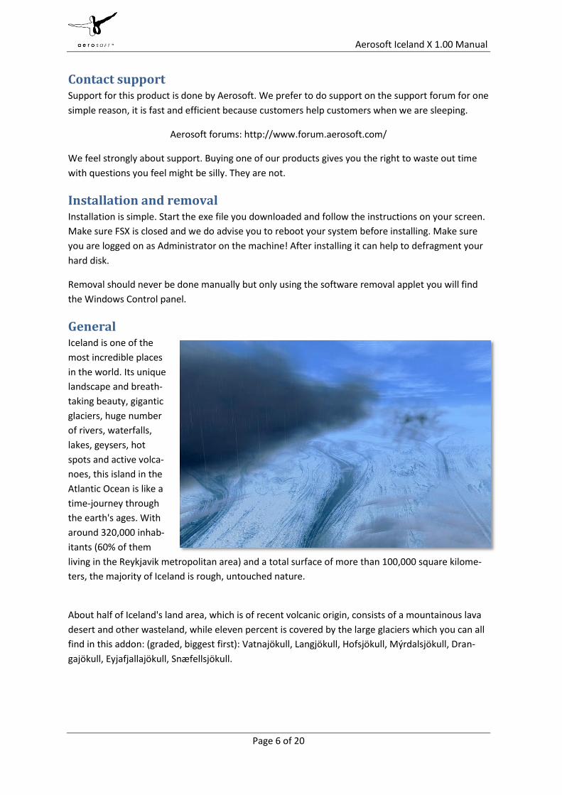
General Iceland is one of the
most incredible places
in the world. Its unique
landscape and breath-
taking beauty, gigantic
glaciers, huge number
of rivers, waterfalls,
lakes, geysers, hot
spots and active volca-
noes, this island in the
Atlantic Ocean is like a
time-journey through
the earth's ages. With
around 320,000 inhab-
itants (60% of them
living in the Reykjavik metropolitan area) and a total surface of more than 100,000 square kilome-
ters, the majority of Iceland is rough, untouched nature.
About half of Iceland's land area, which is of recent volcanic origin, consists of a mountainous lava
desert and other wasteland, while eleven percent is covered by the large glaciers which you can all
find in this addon: (graded, biggest first): Vatnajökull, Langjökull, Hofsjökull, Mýrdalsjökull, Dran-
gajökull, Eyjafjallajökull, Snæfellsjökull.

Aerosoft Iceland X 1.00 Manual
Page 7 of 20
Apart from the fact that the country became world-famous from the ash cloud after the latest
eruption of the Eyjafjallajökull volcano in 2010, it attracts tourists from all over the world mostly
because of the unique nature spectacles. (See “places to visit” below)
Due to the rough landscape and the low population density, there are limited means of transporta-
tion in Iceland. To explore the island you have two options: Either you go by car, driving along
Route 1, the famous Ring Road that connects all important towns on the main island (you can fol-
low Route 1 on your tour around the island as well as it is easily spotted from above). The second
option is, obviously, by airplane. Iceland features more than 50 airports, from the international hub
in Keflavik down to literal dirt strips, a surprisingly high number of airfields can be found across the
island. Apart from a few dirt/grass strips this add-on contains all Icelandic airports (except Keflavik
which will be released as a separate add-on due to its size and special importance for international
aviation). You will find a complete airport list with all necessary information in the appendix.
While only Keflavik airport connects Iceland with airports across Europe and America, the airport of
Reykjavik is the main hub for national flights. Air Iceland, better known as “Flugfélag Íslands”, oper-
ates flights from Reykjavik to Akureyri, Egilsstadir, Grimsey (via Akureyri), Isafjordur, the Vestman-
naeyjar islands and across the sea to Greenland and the Faeroer Islands, using Fokker 50 and Dash
8 aircraft. If you use AI traffic addons like MyTraffic2010 or UT2 you will see those aircraft in FSX as
well.
As most airports were not included in FSX default traffic as well as AI traffic addons, we created a
custom General Aviation traffic file that generates realistic VFR traffic on most of the airports in this
addon.
Of course you will not only see air traffic in Iceland but also ship traffic, for example the ferries to
Vestmannaeyjar and Grimsey, cargo ships that connect Iceland with the Faeroer Islands as well as
major European harbors like Rotterdam. You can even find fishing vessels around the island and
the tourist attracting whale watching ships that depart from Husavik in the north.
Iceland seasons To render Iceland as real as it gets we created not 4 but 12 seasons for Iceland. Each month the
island will look different, with a white covered north and green fields in spring and snow covering
the whole island for a very short period only due to the warm Gulfstream, that gives Reykjavik a
mild, warm climate. The north country with Isafjordur and Akureyri on the other hand features a
strong and wet climate with up to 200 days of rain or snow per year (use online weather to experi-
ence this yourself).
Choose different months in FSX to see how Iceland slowly changes from a snow covered country to
green colors full of contrast in summer, with rather dreary colors and snow covered mountains in
autumn.
To get the full experience you need to run the Texture Tool prior to opening FSX and starting your
flight to make sure the airport textures match the season of the scenery around you. In winter you
will see snow covered roofs on all airport buildings. If you use online weather in spring, autumn or
winter it might happen that it starts snowing even though the scenery does not feature winter tex-

Aerosoft Iceland X 1.00 Manual
Page 8 of 20
tures. FSX recognizes this and changes the terrain textures to snow after a few minutes. With this
feature the terrain will always match the current weather.
Due to the fact that we used the standard airport design method for all airports except Egilsstadir,
you will also see snowy runways in winter and water effects on all hard airport surfaces as soon as
it starts raining or snowing.
Places to visit If you come to Iceland, there are several must-see places that mustn't be missed on your tour
around the island. The famous geysers, waterfalls, glaciers and, most recently of course, the Ey-
jafjallajökull volcano are the reason why every year more than 300,000 tourists (that's more than
Iceland's population!) visit the island from all over the world. If you want to visit those places in FSX
you can either explore the island in free flight using the map or start the Iceland X - Tour mission
that will lead you to all must-see points across the country.
Some of the most important places:
Reykjavik (with the Perlan and the Hallgrimskirkja)
The glaciers (Eyjafjallajökull is not only a must-see but lies close to the Skogarfoss and Sel-
jandsfoss waterfalls)
The Vestmannaeyjar Islands
The waterfalls (Dettifoss, Godafoss, Skogarfoss,...)
The world-famous geysers at Geysir and (very close-by) Strokkur
Hot spots around the country, the Blue Lagoon being the most famous one
The Peace Tower (a powerful light beam in the Reakjavik area that was constructed as a
memorial for John Lennon and is lit from October 9th (his birthday) until December 8th
(the day he was shot) every year.

Aerosoft Iceland X 1.00 Manual
Page 9 of 20
Texture Tool This add-on includes a tool to adjust seasonal textures. You can also switch Mipmapping on and off
using this tool. This is important if you face blurry textures, flickering or the Moiré effect on some
buildings.
To start the Texture Tool navigate to the Aerosoft - Iceland X folder in your windows start menu.
You can also use the Seasons.exe in the Aerosoft folder, using the windows explorer, it is the same
tool.
Seasons: FSX adjusts seasonal textures automatically, except textures of photo airport
backgrounds and building textures. In order to get correct seasonal textures for the BIEG
airport background as well as seasonal changes for buildings and other objects (mostly
snow covered roofs in winter), chose the season you want and click OK. You will then be
asked if you want to use MipMaps.
MipMaps: Unfortunately FSX handles textures in a way that leads to rather different re-
sults depending on the graphic card used. The most important factor in this matter is Mip-
Maps. While some users tend to like textures without MipMaps (because they offer sharp-
er texture resolution in the distance), others might suffer texture flickers and Moiré pat-
terns if using textures without MipMaps. We think it's best to let you decide yourself. Simp-
ly click on "Yes" or "No" to select/unselect MipMap textures.
Restart FSX and you will immediately see the difference.

Aerosoft Iceland X 1.00 Manual
Page 10 of 20
Display settings In order to change your scenery settings, go to Settings -> Display
Note: All other settings not mentioned here are up to you. They don’t actually affect the scenery
very much. Keep in mind to do your settings with care otherwise you may overload your system.
Graphics menu
Target frame rate set to Unlimited is strongly recommended.
Global texture resolution should be at Very high to get the full detail in textures.
Advanced animations has to set to ON.
Light bloom set to On will allow you to see the lighting in more detail and the low demands
on fps should make this setting possible.
Scenery settings
Mesh is important for this scenery. Set Mesh Complexity to 100 and resolution to 5 meters.
Texture resolution should be at 1 m or less to get the best resolution of the aerial image
under the 3D objects.
Scenery Complexity strongly affects the speed of the scenery. Start with Extremely dense
and reduce that if your system finds it hard to cope.
Autogen Complexity: Iceland has very few trees and other vegetation. For this reason you
should get a very good performance even with extremely high autogen settings, but you
might want to reduce autogen if you suffer a frame-rate impact in Reykjavik.
Ground scenery shadows can be On or Off depending on your own preference.
Special effects details should be on High to see all the special animations.

Aerosoft Iceland X 1.00 Manual
Page 11 of 20
Traffic settings
Airport Information All Icelandic airports are included in this add-on (with the exception of some airstrips that do not
feature any buildings, lights, objects or taxiways).
You will notice that several airports feature almost the same buildings. This is no laziness of the
developer but rather a result of Iceland being a rather small country and most airports constructed
by the same company. The smaller aiport may deviate a bit from their real archetypes though as it
was very tough to acquire material of all airports.
BIAR - Akureyri Lat/Long: N65-39.5/W018-04.3
Airport Light Intensity: HIGH
Variation: 16W
Approaches: LOC/DME VOR
Open 24 Hours: No
Fuel Available: AVGAS JET
Elevation (ft): 7
Max. hard surfaced runway (ft): 6365 x 148
Comms: Appr 118.20
Tower 118.20
BIBA - Bakki Lat/Long: N63-33.4/W020-08.2
Airport Light Intensity: LOW
Variation: 17W
Approaches: VFR
Open 24 Hours: No
Fuel Available: AVGAS
Elevation (ft): 30
Max. hard surfaced runway (ft): 3280 x 98
Comms: Multicom 122.97

Aerosoft Iceland X 1.00 Manual
Page 12 of 20
BIBD - Bildudalur Lat/Long: N65-38.5/W023-32.8
Airport Light Intensity: LOW
Variation: 19W
Approaches: NDB GPS
Open 24 Hours: No
Fuel Available: JET
Elevation (ft): 26
Max. hard surfaced runway (ft): 3084 x 98
Comms: FSS 119.10
BIBL - Blonduos Lat/Long: N65-38.7/W020-17.2 Airport Light Intensity: LOW Variation: 19W Approaches: VFR Open 24 Hours: No Fuel Available: AVGAS Elevation (ft): 131 Max. hard surfaced runway (ft): 3170 x 98 Comms: FSS 118.60
BIBR - Budardalur (no Information available)
BIBV - Breiddalsvik Lat/Long: N64-47.4/W014-01.3 Airport Light Intensity: NONE Variation: 14W Approaches: VFR Open 24 Hours: No Fuel Available: AVGAS Elevation (ft): 8 Max. hard surfaced runway (ft): 3018 x 98 Comms: FSS 118.10
BIEG - Egilsstadir Lat/Long: N65-17.0/W014-24.1 Airport Light Intensity: HIGH Variation: 12W Approaches: ILS/DME NDB Open 24 Hours: Yes, with restrictions Fuel Available: AVGAS JET Elevation (ft): 76 Max. hard surfaced runway (ft): 6562 x 148 Comms: Multicom 119.40

Aerosoft Iceland X 1.00 Manual
Page 13 of 20
BIFF - Faskrudsfjordur Lat/Long: N64-55.9/W014-02.8 Airport Light Intensity: NONE Variation: 14W Approaches: VFR Open 24 Hours: No Fuel Available: AVGAS Elevation (ft): 3 Max. hard surfaced runway (ft): 2952 x 82 Comms: FSS 132.12
BIGJ - Gjogur Lat/Long: N65-59.7/W021-19.6 Airport Light Intensity: MEDIUM Variation: 20W Approaches: VFR Open 24 Hours: No Fuel Available: AVGAS Elevation (ft): 113 Max. hard surfaced runway (ft): 3031 x 98 Comms: FSS 118.60
BIGR - Grimsey Lat/Long: N66-33.3/W018-01.1 Airport Light Intensity: HIGH Variation: 16W Approaches: NDB GPS Open 24 Hours: No Fuel Available: NO FUEL Elevation (ft): 81 Max. hard surfaced runway (ft): 3380 x 75 Comms: FSS 118.10
BIHK - Holmavik Lat/Long: N65-42.2/W021-41.8 Airport Light Intensity: NONE Variation: 20W Approaches: VFR Open 24 Hours: No Fuel Available: AVGAS Elevation (ft): 72 Max. hard surfaced runway (ft): 3268 x 98 Comms: FSS 118.60
BIHL - Hella (no Information available)

Aerosoft Iceland X 1.00 Manual
Page 14 of 20
BIHN - Hofn Lat/Long: N64-17.7/W015-13.6 Airport Light Intensity: MEDIUM Variation: 13W Approaches: GPS NDB Open 24 Hours: No Fuel Available: AVGAS JET Elevation (ft): 24 Max. hard surfaced runway (ft): 4921 x 98 Comms: Multicom 118.10
BIHT - Holt (no Information available)
BIHU - Husavik Lat/Long: N65-57.1/W017-25.6 Airport Light Intensity: MEDIUM Variation: 16W Approaches: LOC/DME NDB Open 24 Hours: No Fuel Available: AVGAS JET Elevation (ft): 48 Max. hard surfaced runway (ft): 5265 x 98 Comms: Multicom 118.10
BIHV - Hvammstangi (no Information available)
BIHZ - Husafell (no Information available)
BIID - Onundarfjordur Lat/Long: N66-03.0/W023-41.8 Airport Light Intensity: NONE Variation: 21W Approaches: VFR Open 24 Hours: No Fuel Available: AVGAS JET Elevation (ft): 68 Max. hard surfaced runway (ft): 2362 x 78 Comms: Multicom 125.52

Aerosoft Iceland X 1.00 Manual
Page 15 of 20
BIIS - Isafjordur Lat/Long: N66-03.5/W023-08.1 Airport Light Intensity: MEDIUM Variation: 19W Approaches: LOC/DME GPS Open 24 Hours: No Fuel Available: AVGAS JET Elevation (ft): 8 Max. hard surfaced runway (ft): 4593 x 140 Comms: Multicom 118.80
BIKF - Keflavik * Lat/Long: N63-59.1/W022-36.3 Airport Light Intensity: HIGH Variation: 18W Approaches: ILS/DME NDB Open 24 Hours: Yes Fuel Available: AVGAS JET Elevation (ft): 171 Max. hard surfaced runway (ft): 10056 x 197 Comms: Appr 118.30 Appr 118.70 Appr 119.30 Appr 134.10 Tower 118.30 Clearance 121.00 Departure 119.30 Ground 121.90 ATIS 128.30 * This airport is not included in the addon but will be released as a separate add-on "Keflavik X"
BIKP - Kopasker Lat/Long: N66-18.6/W016-28.0 Airport Light Intensity: NONE Variation: 17W Approaches: VFR Open 24 Hours: No Fuel Available: AVGAS Elevation (ft): 20 Max. hard surfaced runway (ft): 3280 x 75 Comms: FSS 118.10

Aerosoft Iceland X 1.00 Manual
Page 16 of 20
BIKR - Alexander (Saudarkrokur) Lat/Long: N65-43.9/W019-34.4 Airport Light Intensity: HIGH Variation: 18W Approaches: ILS NDB/DME Open 24 Hours: No Fuel Available: JET ONLY Elevation (ft): 8 Max. hard surfaced runway (ft): 6191 x 164 Comms: Multicom 118.10
BIMS - Tungubakkar (no Information available)
BINF - Nordfjordur Lat/Long: N65-07.9/W013-44.8 Airport Light Intensity: NONE Variation: 14W Approaches: VFR Open 24 Hours: No Fuel Available: AVGAS Elevation (ft): 5 Max. hard surfaced runway (ft): 3618 x 98 Comms: Multicom 118.10
BIOF - Olafsfjordur (no Information available)
BIPA - Patreksfjordur Lat/Long: N65-33.4/W023-57.9 Airport Light Intensity: MEDIUM Variation: 19W Approaches: NDB Open 24 Hours: No Fuel Available: AVGAS ONLY Elevation (ft): 11 Max. hard surfaced runway (ft): 2624 x 98 Comms: Multicom 119.10
BIRF - Olafsvik/Rif Lat/Long: N64-54.7/W023-49.4 Airport Light Intensity: LOW Variation: 20W Approaches: NDB Open 24 Hours: No Fuel Available: AVGAS JET Elevation (ft): 34 Max. hard surfaced runway (ft): 3757 x 98 Comms: FSS 118.10

Aerosoft Iceland X 1.00 Manual
Page 17 of 20
BIRG - Raufarhofn Lat/Long: N66-24.4/W015-55.1 Airport Light Intensity: LOW Variation: 17W Approaches: VFR Open 24 Hours: No Fuel Available: AVGAS Elevation (ft): 39 Max. hard surfaced runway (ft): 3522 x 118 Comms: Multicom 118.10
BIRK - Reykjavik Lat/Long: N64-07.8/W021-56.4 Airport Light Intensity: HIGH Variation: 17W Approaches: ILS/DME NDB Open 24 Hours: Yes, with restrictions Fuel Available: AVGAS JET Elevation (ft): 45 Max. hard surfaced runway (ft): 5141 x 148 Comms: Appr 119.00 Appr 123.90 Appr 125.50 Appr 125.70 Appr 126.75 Appr 132.20 Appr 132.30 Tower 118.00 Departure 119.00 Ground 121.70 ATIS 128.10 Approach lights Rwy 19 on from dusk until dawn and on request, set Nav2 to 114.70.

Aerosoft Iceland X 1.00 Manual
Page 18 of 20
BIRL - Reykjahild Lat/Long: N65-39.3/W016-55.1 Airport Light Intensity: NONE Variation: 17W Approaches: VFR Open 24 Hours: No Fuel Available: AVGAS Elevation (ft): 1030 Max. hard surfaced runway (ft): 3038 x 98 Comms: FSS 118.10
BISA - Sanda (no Information available)
BISF - Selfoss (no Information available)
BISI - Siglufjordur Lat/Long: N66-08.0/W018-55.0 Airport Light Intensity: NO LIGHT Variation: 17W Approaches: VFR Open 24 Hours: No Fuel Available: NO FUEL Elevation (ft): 10 Max. hard surfaced runway (ft): 3555 x 105 Comms: FSS 118.10
BISR - Storikroppur (no Information available)
BISS - Sandskeid (no Information available)
BIST - Stykkisholmur Lat/Long: N65-03.5/W022-47.6 Airport Light Intensity: MEDIUM Variation: 20W Approaches: NDB Open 24 Hours: No Fuel Available: NO FUEL Elevation (ft): 42 Max. hard surfaced runway (ft): 675 x 108 Comms: FSS 118.10

Aerosoft Iceland X 1.00 Manual
Page 19 of 20
BITE - Thingeyri Lat/Long: N65-52.2/W023-33.6 Airport Light Intensity: NONE Variation: 21W Approaches: VFR Open 24 Hours: No Fuel Available: NO FUEL Elevation (ft): 36 Max. hard surfaced runway (ft): 3609 x 98 Comms: Multicom 119.10
BITH - Saudanes (no Information available)
BITM - Thorsmork (no Information available)
BITN - Thorshofn Lat/Long: N66-13.1/W015-20.1 Airport Light Intensity: HIGH Variation: 14W Approaches: NDB GPS Open 24 Hours: No Fuel Available: NO FUEL Elevation (ft): 64 Max. hard surfaced runway (ft): 3933 x 98 Comms: FSS 118.10
BIVM - Vestmannaeyjar Lat/Long: N63-25.5/W020-16.7 Airport Light Intensity: MEDIUM Variation: 16W Approaches: NDB/DME Open 24 Hours: No Fuel Available: AVGAS JET Elevation (ft): 326 Max. hard surfaced runway (ft): 3953 x 148 Comms: Tower 118.50
BIVO - Vopnafjordur Lat/Long: N65-43.2/W014-51.0 Airport Light Intensity: NONE Variation: 15W Approaches: VFR Open 24 Hours: No Fuel Available: AVGAS Elevation (ft): 10 Max. hard surfaced runway (ft): 3051 x 98 Comms: Multicom 118.10

Aerosoft Iceland X 1.00 Manual
Page 20 of 20
Charts You can find charts and additional airport information on www.ca..is. Examples:
http://www.caa.is/media/PDF/AD_2_BIRK.pdf
http://www.caa.is/media/PDF/AD_2_BIVM.pdf
F.A.Qs. Q: Is this add-on DX10 compatible?
A: Apart from the 3d Light cones (that can be disabled), yes.
Q: Is this add-on compatible with other add-ons in the area?
A: Not as far as we are aware.
Q: There seem to be issues with the airport lighting at day/night transitions. Is this normal?
A: No but it isn't curable. FSX sometimes has its own ways of switching day/night textures. If you
face any texture or scenery problems, open the scenery library and click OK (or use the "refresh
scenery" shortcut) to reload scenery and textures.
Q: AI aircraft vanish after landing, get stuck before take-off or turn around on the runway. How can
I fix this?
A: This is default FSX behaviour that cannot be fixed by the scenery. We included some tricks
though, that should prevent AI aircraft from using wrong taxiways and turning on the runway 99%
of the time.
Q: The 3D light cones disappear on rainy days. How can I fix this?
A: Unfortunately there is no way of rendering the light cones in front of clouds. You can disable this
option in the Visuals Tool though.
Q: I get blurry or flickering textures all over the airport. What can I do?
A: Try enabling/disabling MipMaps using the Visuals Tool.