Embed Size (px)
Citation preview
Aeronautical charts/ Preparation/ En-Route
Navigation/ Basic Radio Navigation
Balazs Farkas

Nav
igat
ion
IntroductionBasics
Earth as reference systemHorizontal navigation
Velocities / Velocity triangleASICompass
Magnetic compassDI
Vertical navigationAltimeter
Time
NavigationThe earth as reference 2.Aeronautical chartsFlight planningEn route navigation
Introduction to Radio Navigation
Outline

Nav
igat
ion
The Earth
Coordinates
Latitude Longitude
543927N 0061257WDecode:54o39’27’’ North6o12’57’’ West
orN5439.5 W00613.0North 54o39.5’West 6o13.0’
Shortest distance: Great Circle (GC) (Orthodrome) track. Heading gradually changes
Constant heading: Rhumb Line (RL) (Loxodrome)
1min of latitude = 1nmNB! 1min of longitude only at the equator at the equator = 1 nm

Nav
igat
ion
Great Circle/Orthodromic distance
The Spherical Law of Cosines (if Radius=1)
cos 𝑐 = cos 𝑎 cos 𝑏 + sin(𝑎)sin(b)cos(γ)(arc length =central angle [rad] x R)
Distance:
D = 60arccos 𝑐 [𝑛𝑚]e.g.Boston(42o19’N, 071o05’W)-Addis Ababa (09o03’N, 038o42’)
𝑎 = 90𝑜 − 42.32𝑜 = 47.68𝑜
𝑏 = 90𝑜 − 09.05𝑜 = 80.95𝑜
𝑏 = 38.70𝑜 − − 71.08𝑜 = 109.78𝑜
𝐷 = 60 · 98𝑜 = 5880𝑛𝑚
Nav
igat
ion
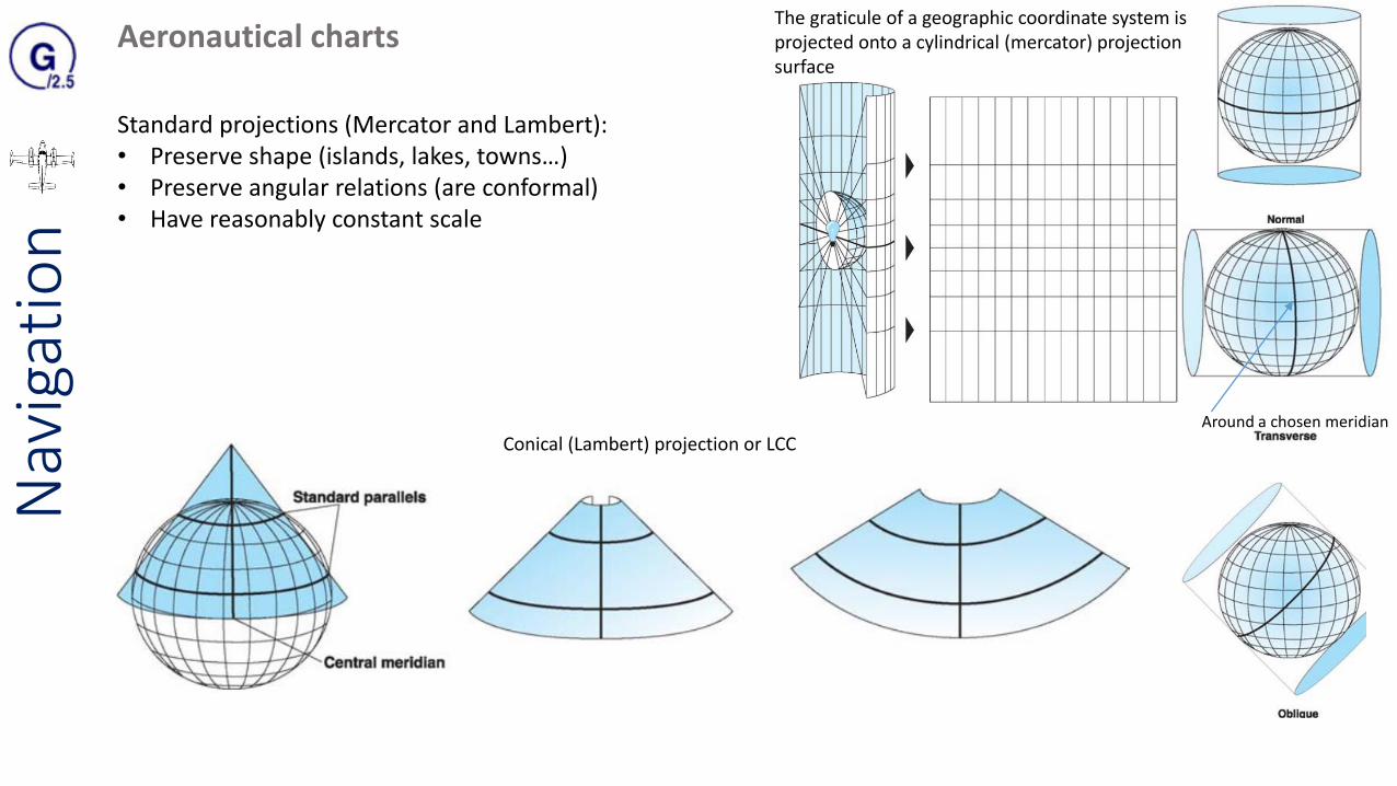
Aeronautical chartsThe graticule of a geographic coordinate system is projected onto a cylindrical (mercator) projection surface
Conical (Lambert) projection or LCC
Standard projections (Mercator and Lambert):• Preserve shape (islands, lakes, towns…)• Preserve angular relations (are conformal)• Have reasonably constant scale
Around a chosen meridian

Nav
igat
ion
Aeronautical charts
• ICAO Aeronautical Chart, scale 1:500,000 (half million)• Topographical Air Chart, scale 1:250,000 (quarter-million)• Operational Navigational Chart (ONC), scale 1:1,000,000 (one
million)
• Conformal • Constant scale (in practical terms)• Shapes are preserved (in practical
terms)• Track between two places is a straight
line (rhumb line tracks and great circle tracks align in practical terms)
NON UK STANDARD VFR (VISUAL) NAV-CHART • WAC(World Aeronautical Chart) 1:1.000.000 • ONC (Operational Navigation Chart) 1:1.000.000 • SAC (Sectional Aeronautical Chart) 1:500.000• TMA (Terminal Area Chart) 1:250.000• HRC (Helicopter Routing Chart) 1:50.000
S𝑐𝑎𝑙𝑒 =𝑐ℎ𝑎𝑟𝑡 𝑙𝑒𝑛𝑔𝑡ℎ
𝑒𝑎𝑟𝑡ℎ 𝑑𝑖𝑠𝑡𝑎𝑛𝑐𝑒

Nav
igat
ion
Aeronautical charts
CAA 1:250,000 Charts:• Up to 5000ft (controlled airspaces only bellow 5000ft amsl or FL55 are marked fyi)• Topographical information• Cultural information (cities, towns, motorways, railway lines)• Aeronautical information• If QNH is bellow 1013hPa controlled airspace can fall bellow 5.000 ft but does not appear on the chart!!
Topographical information (only the most important)Drainage and water featuresRelief (ground contour)Spot elevationsMaximum Elevation Figures (MEF) (big red numbers provide 1000ft clearance in lowland and 2000ft in mountainous area)Hachuring and hill shadingCultural features (see legend bellow map)

Nav
igat
ion
Aeronautical informationEffective Date of ImplementationNB! Aerodrome Traffic Zone (ATZ) are only shown when outside of controlled airspace but all of them are listed on the chart with VHF-COM of the Air Traffic Service Unit (ATSU)
Airspace restriction and other hazard informationD Danger AreaP Prohibited areaR Restricted area (restricted in accordance with certain spec. conditions (AIP ENR /NOTAM) (Aeronautical Information Package / Notice to Airmen)Military Low Flying SystemBird SanctuaryRadio facilities
High intensity radio transmission area (HIRTA)Areas of Intense Air Activity (AIAA)
Magnetic information: Isogonals

Nav
igat
ion
Route preparation
Aircraft performanceTerrainWeatherAirspaceHazardsCheckpointsAlternates
ChartsCurrent, Adequate coverage (+50nm radius)Preparation (Markings: Track, Distance/Time markings)

Nav
igat
ion
Compiling a flight log
Planning: Calm environment relative to flying and lot of time: Precise calculations!

Nav
igat
ion
Flight Plan
You can file a flight plan for ANY flight
•Aircraft Identification
•Departure Time (UTC in Hungary as well)
•Cruising Speed (N0105 = 105nm/h)
•Planed route (DCT = direct)
•EET Estimated Elapsed Time (Estimated duration of the flight)
•Endurance (Amount of fuel on board converted to flight time)
•Transponder type (A, C or S)
•Persons on Board
•Emergency radio availability
•Aircraft colour and markings
•Contact person in case of accident
Call FIC (06-1-296-91-43 inland VFR) to file the Flight Plane
Flight plane is valid if take of completed within 30 mins from the
estimated Departure Time
Online FPL: homebriefing.hu
With FPL flight advisory service is provided (Aeronautical
Information Service (AIS))

Nav
igat
ion
En-Route Navigation
Deduced (Dead) – Reckoning• Starting at a know position – Fix• Measuring the track and distance on a chart to the next point chosen along the desired
track• Applying the best W/V available to estimate HDG and GS
Using Map reading as backupFixing the aircrafts position time to time (10-15mins), periodically identify landmarks!Decrease the interval if precise tracking required (Entry/Exit Lanes)
Fly accurate heading! Fly accurately: HDG, ALT, IAS! Keep looking out from the cockpit
Check the instruments in every 10 seconds, build up a routine (FREDA)!
NEVER WORK HEAD DOWN IN THE COCKPIT!Keep your paperwork organizedUse the trims!
Check weather (Flight Information Service (FSI)
Check Time!

Nav
igat
ion
The flight sequence/Departure
Departure from an aerodrome:Regulation? (Controlled Airspace), Direction? Surrounding terrain?
Turning in the direction of the circuit
Climbing straight ahead
Log the Actual Time of DepartureMake departure report
Rough check of departure track (against a ground feature en route 10-15nm of the aerodrome)

Nav
igat
ion
The flight sequence/Cruise
When reaching cruise ALT check TAS!If significantly different from expected check: • Correct power set• Correct aircraft configuration
GS=distance/speed
Good checkpoint features separated by 20-30nm
Check GS!If significantly different from expected check: • Revise estimated time of arrivals (ETA)• Check W/V
Select good checkpoint features:• flight visibility• dimension• relationship to the other features• plan outline (if you look at it from the top when
flying high)• elevation and side appearance when flying low

Nav
igat
ion
Long feature• Maintain accurate track
(keep the feature at your right for better visibility), or
• Check GS
Relation ship between your selected feature and other ground features helps to obtain positive identification (M7, M1 from LHBS)
positive identification
Position Line (PL, LoP): extended straight line joining two points along which the aeroplane was located at particular time, an be obtained:• From long narrow features• From two features (fixes) • Radio position line (e.g. NDB, VOR)
Look for a definite feature at a definite time! Chose a unique feature to avoid ambiguity

Nav
igat
ion
Log keeping to:• Calculation of HDG• Calculation GS and ETI to access ETA for the next
Checkpoint• Anticipation and recognition of checkpoints• Recalculations
What should be logged:• Take- off time• ATD• Fixes (position and time on the
chart)• TMG (on chart)• Changes of HDG and IAS and the
time of making them• Calculated GS• ETIs and revised ETAs• altitudes
Off track heading correction
Track Error (TE): The angle between TMG and the required TRClosing Angle (CA):
The 1-in-60 rule

Nav
igat
ion
Of track heading correctionEye-Balling and Inverse-Ratio method
CA~6o
Fraction gone: 2/3Alter heading 6ox3/2=9o
Time gone: 26minRevised total time: 25min x 3/2 = 39min Revised ETA: 1417+39 = 1456 UTC

Nav
igat
ion
En-route diversion
60 deg diversion:• Equilateral triangle-easy to
estimate corrigated ETI
Diversion to alternate aerodromeIf the diversion is less than 15deg, use simple 1-in-60 method
NB! Above 15deg Have to consider W/V
(Example)

Nav
igat
ion
Uncertain of position or Lost
If checkpoint does not appear at the expected timeLog HDG (Compass and DI)If DI was incorrect recalculate headingIf DI was correct: Landmark was covered or hidden by terrain or cluds
Maintain Heading (terrain, visibility and controlled airspace) and keep flying ~10% of the time since your last positive fix
check if the magnetic compass was affected by magnetic anomalycheck if VAR and Drift was correctly appliedcheck if the track direction on chart is the same as the one on the
flight plan
Look for significant ground features and try to determine them on the chart
Establish most probable areaestablish a safety altitudecheck large features determine on chartincrease most prob. Areaclimb higher ALTsteer back to your last fix
CALL ATC!
Nav
igat
ion
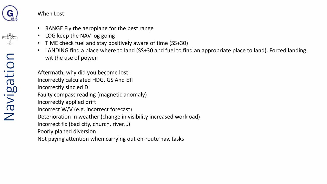
When Lost
• RANGE Fly the aeroplane for the best range• LOG keep the NAV log going• TIME check fuel and stay positively aware of time (SS+30)• LANDING find a place where to land (SS+30 and fuel to find an appropriate place to land). Forced landing
wit the use of power.
Aftermath, why did you become lost:Incorrectly calculated HDG, GS And ETIIncorrectly sinc.ed DIFaulty compass reading (magnetic anomaly) Incorrectly applied driftIncorrect W/V (e.g. incorrect forecast)Deterioration in weather (change in visibility increased workload)Incorrect fix (bad city, church, river…)Poorly planed diversionNot paying attention when carrying out en-route nav. tasks

Nav
igat
ion
Nav
igat
ion
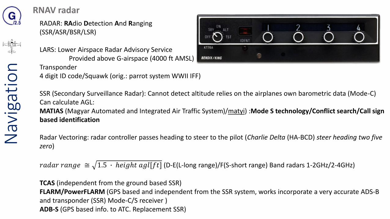
RNAV radar
RADAR: RAdio Detection And Ranging(SSR/ASR/BSR/LSR)
LARS: Lower Airspace Radar Advisory ServiceProvided above G-airspace (4000 ft AMSL)
Transponder4 digit ID code/Squawk (orig.: parrot system WWII IFF)
SSR (Secondary Surveillance Radar): Cannot detect altitude relies on the airplanes own barometric data (Mode-C) Can calculate AGL: MATIAS (Magyar Automated and Integrated Air Traffic System)/matyi) :Mode S technology/Conflict search/Call signbased identification
Radar Vectoring: radar controller passes heading to steer to the pilot (Charlie Delta (HA-BCD) steer heading two five zero)
𝑟𝑎𝑑𝑎𝑟 𝑟𝑎𝑛𝑔𝑒 ≅ 1.5 ∙ ℎ𝑒𝑖𝑔ℎ𝑡 𝑎𝑔𝑙[𝑓𝑡] (D-E(L-long range)/F(S-short range) Band radars 1-2GHz/2-4GHz)
TCAS (independent from the ground based SSR)FLARM/PowerFLARM (GPS based and independent from the SSR system, works incorporate a very accurate ADS-B and transponder (SSR) Mode-C/S receiver ) ADB-S (GPS based info. to ATC. Replacement SSR)

Nav
igat
ion
RNAV DME
Generally coupled with VOR or Localiser (ILS) Freq. selection VHF-NAV Radio (NAV1/NAV2)Freq. range: 962-1,213/1 MHz (tuning VOR (108-117,95MHz) will automatically interrogate the correct DME)
ON/OFF, NAV 1, NAV 2, and DME HOLD. Tune the remote DME to NAV 1 or NAV 2. DME HOLD allows the DME to stay on the current frequency, while the navigational receiver is re-tuned to another.

Nav
igat
ion
RNAV NDB/ADF
Non Directional Beacon (grond)/Automatic Direction Finder (aircraft)Band 200-1750kHz
Just ADFADF + DI
NDB stations own identification signal which is a two or three letter Morse code
T-aerial slung

Nav
igat
ion
NDB accuracy up to ±2o
Affecting factors:• Thunderstorms• Night effect: reflect signals from the ionosphere interfere• Mountain effect• Costal effect
BCO (Beat Frequency Oscillator)
RBI Relative Bearing Indicator: Fixed-card ADF indicatorRMI: Radio Magnetic Indicator
Rotatable card ADF
ADF interception

Nav
igat
ion
RADIO NAV VOR
• Reduced susceptibility• Elimination night effect
Applications:• Orientation and position fixing• Tracking • Holding• Instrument approaches to land
VHF 108-117.95Mhz
Measures Phase difference
Range (VHF) ≅ 1.5 ∙ ℎ𝑒𝑖𝑔ℎ𝑡 𝑎𝑔𝑙[𝑓𝑡]
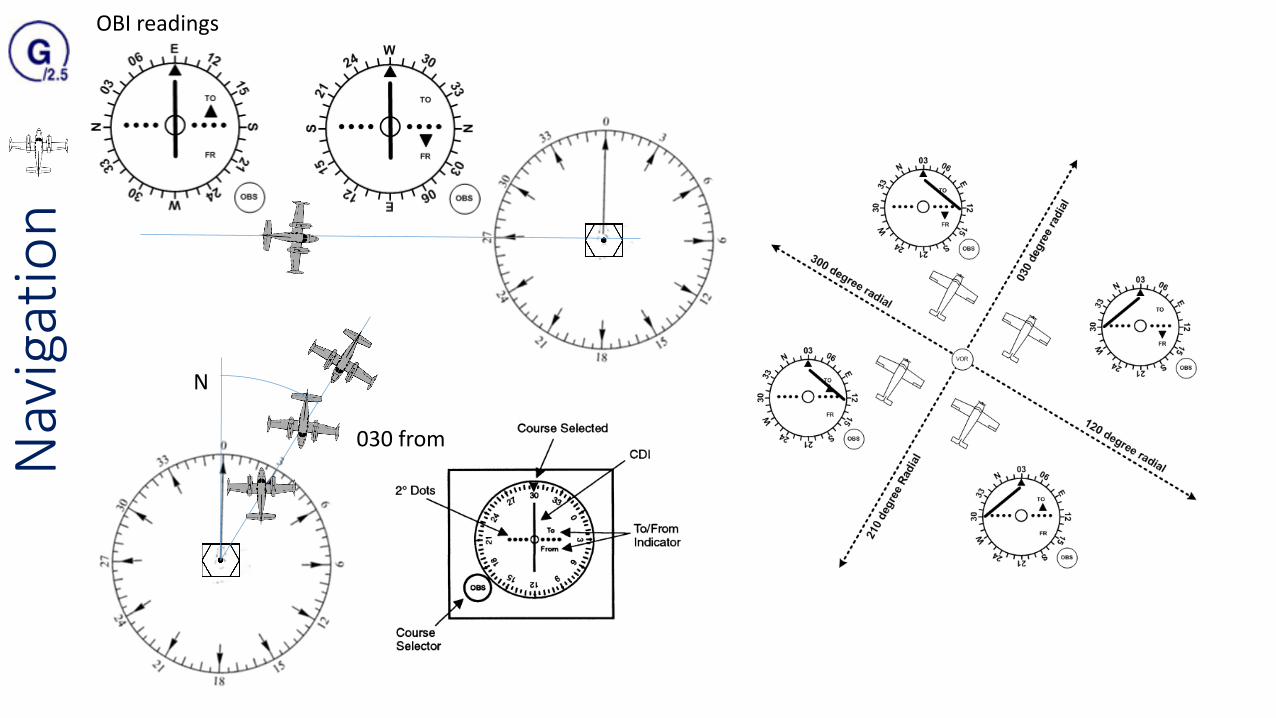
Omni Bearing Indicator (OBI)Course deviation Indicator (CDI)
OBS
Nav
igat
ion
030 from
N
OBI readings
Nav
igat
ion
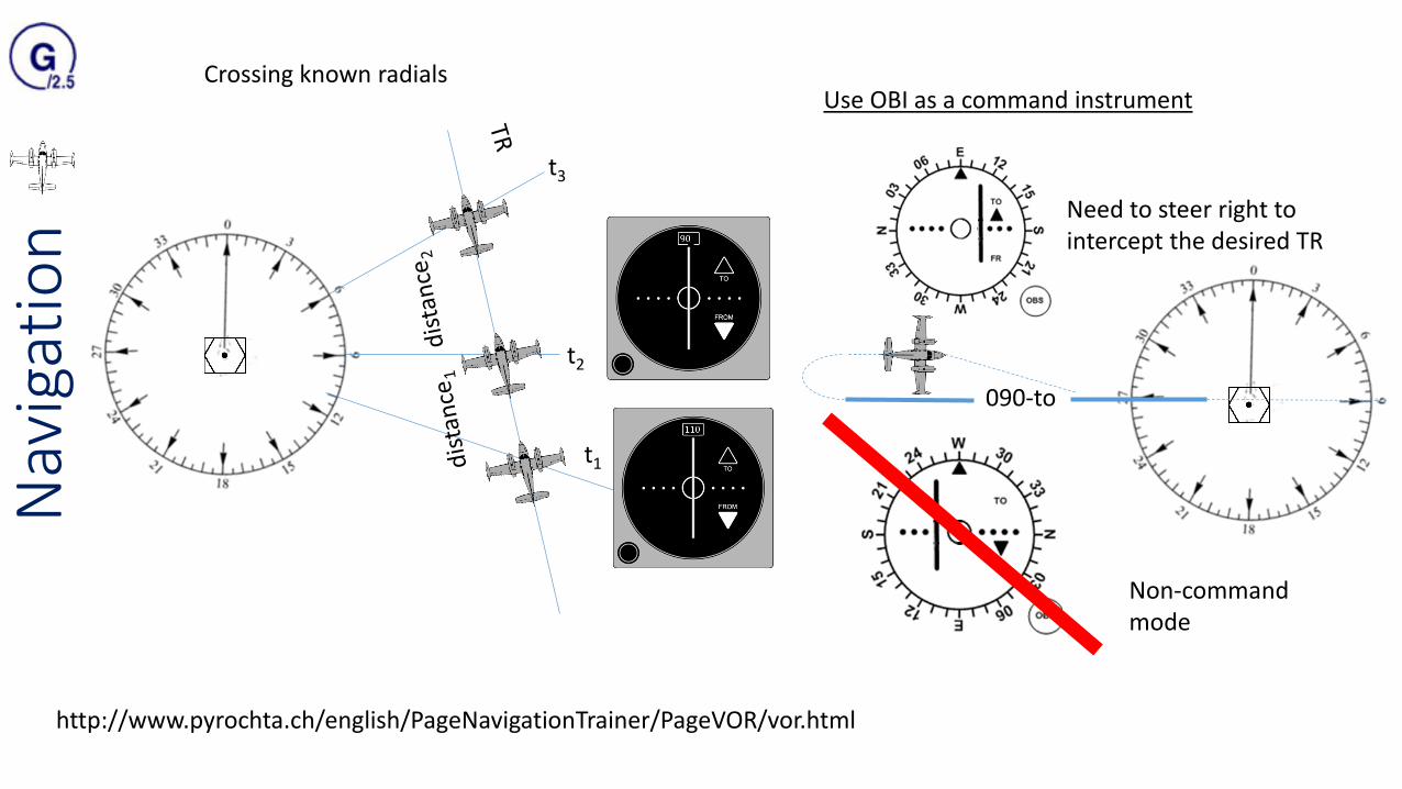
Crossing known radials
t1
t2
t3
Use OBI as a command instrument
090-to
Non-command mode
Need to steer right to intercept the desired TR
http://www.pyrochta.ch/english/PageNavigationTrainer/PageVOR/vor.html

Nav
igat
ion
The percentage of days in a typical year during which magnetic declination will fluctuate by more than a given amount from its normal value

Nav
igat
ion
Distance units1nautical mile =1852 meter1.15078 statute mile
6076.12 feet 72913.4 inch

Nav
igat
ion
QDM, QTE, QDRQDR: Q Direction RadialQDM: Q Direction MagneticQTE: Q True EmanationQUJ:

Nav
igat
ion
A1484/09 NOTAMN Q) EGTT/QMRXX/IV/NBO/A/000/999/5129N00028W005 A) EGLL B) 0908231540 C) 0910310500 EST E) RWY 09R/27L DUE WIP NO CENTRELINE, TDZ OR SALS LIGHTING AVBL
A1484/09 - one letter to indicate the Series, a 4-digit NOTAM number followed by a stroke and two digits to indicate the year.
NOTAMN - N for new NOTAM. /R for replacing /C for one cancelling another.
Q(ualifiers):• 1) FIR (here EGTT, London FIR) • 2) NOTAM CODE: Q+2nd3rd letter def. concern (RAC - Rules of the Air and Air Traffic Services) AK : RESUMED NORMAL
OPS AL : OPERATIVE (OR RE-OPERATIVE) SUBJECT TO PREVIOUSLY PUBLISHED LIMITATIONS/CONDITIONS AO : OPERATIONAL CC : COMPLETED XX : PLAIN LANGUAGE (not in the NOTAM Code list, insert "XX
• 3) TRAFFIC I = IFR V = VFR IV = IFR/VFR is of interest to both types of flights. K = NOTAM is a checklist• 4) PURPOSE N = NOTAM selected for the immediate attention of aircraft operators B = NOTAM selected for PIB entry O =
Operationally significant for IFR flights M = Miscellaneous NOTAM; not subject for a briefing, but it is available on request. K = NOTAM is a checklist
• 5) SCOPE A = Aerodrome E = En-route W = Nav Warning K = NOTAM is a checklist• 6) and 7) LOWER/UPPER LOWER and UPPER limits shall in flight levels (FL)• 8) COORDINATES, RADIUSA) ICAO location indicator of aerodrome or FIR in which the facility, airspace, or condition being reported on is located.

Nav
igat
ion
A1484/09 NOTAMN Q) EGTT/QMRXX/IV/NBO/A/000/999/5129N00028W005 A) EGLL B) 0908231540 C) 0910310500 EST E) RWY 09R/27L DUE WIP NO CENTRELINE, TDZ OR SALS LIGHTING AVBL
B) 0908231540 - Date/time group (UTC) when this NOTAM becomes effective
C) 0910310500 EST - Date/time group (UTC) when the NOTAM ceases to be effective. Note "EST" means "estimated" (NOT Eastern Standard Time!). All NOTAM with EST remain in force until cancelled or replaced.
E) Decoded NOTAM Code
F) and G) These items are normally applicable to navigation warnings or airspace restrictions and are usually part of the PIBentry. Insert lower and upper height limits of activities or restrictions, clearly indicating reference datum and units of measurement.
A Pre-Flight Information Bulletin (PIB) is a presentation of current NOTAM information of operational
significance prepared prior to flight. It contains a recapitulation of current NOTAM and other information of an
urgent character and is made available to flight crews in plain language.
http://www.crewbriefing.com/PdfFiles/CBNOTAMsSelectorHelp_Ver2_2_0.pdf

Nav
igat
ion
http://ais.hungarocontrol.hu/aip/#accordion-1-0
http://lazarus.elte.hu/hun/digkonyv/szakdolg/bsc/2013-schlammer.pdf
Az AIP (Aeronautical Information Publication – Légiforgalmi Tájékoztató Kiadvány) egy nemzeti kiadvány, amit az ICAO országai adnak ki saját magukról, az interneten elérhető, és minden információt, törvényt, szabályzatot, eljárást megtalálhatunk benne, ami a légi közlekedésre illetve a repülőterekre vonatkozik. Magyarországon a HungaroControl Magyar Légiforgalmi Szolgálat Zrt. adja ki a Nemzeti Közlekedési Hatóság Légiközlekedési Igazgatósága jóváhagyásával.