Embed Size (px)
Citation preview
RST-TTO, BAS @ GEO-CRADLE Regional Workshop in Sofia, 24th March 2017
AERO-SPACE TECHNOLOGIES FOR
SUSTAINABLE AND SECURE ENVIRONMENT
Kamen Iliev
Director RST-TTO, BAS
RISK SPACE TECHNOLOGY TRANSFER
Bulgarian Academy of Sciences

RST-TTO, BAS @ GEO-CRADLE Regional Workshop in Sofia, 24th March 2017
CONTENT:
1) Introduction
2) Technology demonstration projects - RST
3) Technology transfer projects – TAKT IKI
4) EMOWAF Project
Objectives & Requirements
Technical activities
Pilot areas and preliminary algorithm testing
Expected results and Potential users

RST-TTO, BAS @ GEO-CRADLE Regional Workshop in Sofia, 24th March 2017
Contract of National Programme “Competitiveness” - ERDF
Project partners:SPACE RESEARCH AND TECHNOLOGY INSTITUTE (SRTI) - BASCENTER FOR NATIONAL SECURITY AND DEFENSE RESEARCH (CNSDR)
Project period: 24 months
RISK SPACE TRANSFER OFFICE - BAS

RST-TTO, BAS @ GEO-CRADLE Regional Workshop in Sofia, 24th March 2017
TAKT-IKI
• Space Physics• Remote sensing of
Earth and Planets• Aerospace systems
and Technologies• Observatory
• CM & DR Policy• Security, Defence,
CM Planning• Management &
Coordination
Bulgarian Academy of Science
TAKT-IKI LtdInnovative SME

RST-TTO, BAS @ GEO-CRADLE Regional Workshop in Sofia, 24th March 2017
Our mission
Project / program management
BAS Business National, regional,
EU, NATO
Technology centers
Laboratories TTO Networks
Testing, demonstration
and validation of technology or
service
Marketing researches
and analysis
Analysis and evaluation of
technology and innovations
Business NGO’s State and municipal
administration
Universities BAS Clusters Incubators
RST-TTO, BAS @ GEO-CRADLE Regional Workshop in Sofia, 24th March 2017
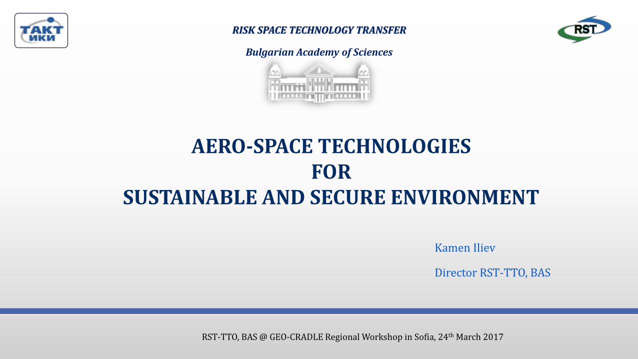
Our vision
Private Sector
Research Centers–COEs, Labs…
Universities Gov.
Sector
Public Sector
N
E
E
D
S
BAS TTO

RST-TTO, BAS @ GEO-CRADLE Regional Workshop in Sofia, 24th March 2017
Main Domains
• Business plan and
marketing strategy
• Multi risk analysis
and data acquisition
• Analysis and
evaluation of UAV
• Online data transfer
• Certification and
legal consultation for
data acquisition
• Critical methodology
assessment
infrastructure
• Web Geo portal
• Prototype system for
monitoring
• Demonstration and
testing of Smart
Sensors for data
processing
Feasibility study and
evaluation
Marketing and
certificationTesting and
demonstration
Carried out 9 Technology demonstration Projects

RST-TTO, BAS @ GEO-CRADLE Regional Workshop in Sofia, 24th March 2017
RST
Technology demonstration
Projects
Multi-risk Analysis
UAVs survey
Critical methodology assessment infrastructure
Remote Sensing Applications
GIS Capabilities
Web Capabilities
Feasibility study
and evaluation
domain
Marketing and
certification
domain
Testing and
demonstration
domain
RST-TTO, BAS @ GEO-CRADLE Regional Workshop in Sofia, 24th March 2017
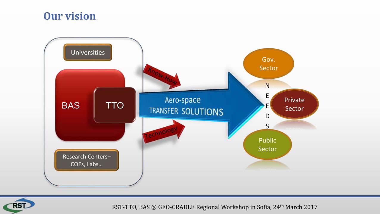
Multi-risk Analysis
Multi-risk analysis of data acquisition from operational monitoring of natural and anthropogenic catastrophes
Results• Analysis of aerial camera filming with their
specification• Analysis of the major operational satellites
for remote sensing of the Earth• Methodological guidelines for generalized
multi-risk analysis to assess the possibilities of using aero-space data systems for crisis management
Feasibility study and evaluation domain

RST-TTO, BAS @ GEO-CRADLE Regional Workshop in Sofia, 24th March 2017
UAVs survey
Business plan and marketing strategy for monitoring and crisis management and control using UAV.
Results• Business plan• Marketing strategy
Feasibility study and evaluation domain

RST-TTO, BAS @ GEO-CRADLE Regional Workshop in Sofia, 24th March 2017
Critical methodology assessment infrastructure
Marketing and certification domain
- Database scheme for assessment the criticality at different levels: • objects as a part of an infrastructure • the infrastructure as a whole.
Definition of criticality of the objects:- Criticality assessment of objects for fires, earthquakes, floods, etc.

RST-TTO, BAS @ GEO-CRADLE Regional Workshop in Sofia, 24th March 2017
UAV survey
< video with UAV
UAV’s flight trajectory
Feasibility study and evaluation domain

RST-TTO, BAS @ GEO-CRADLE Regional Workshop in Sofia, 24th March 2017
Remote Sensing Applications
Crisis Management Analyzer
It has been developed a special module thatsupports automatic and semi-automaticinterpretation of the areas affected ofnatural disasters and accidents.
Testing and demonstration domain

RST-TTO, BAS @ GEO-CRADLE Regional Workshop in Sofia, 24th March 2017
GIS Capabilities
Web portal for natural and anthropogenic disasters
Disaster layers panel
Fire
Flood
Earthquake
Industrial crisis
Landslide
Storm
Search panel- Includes six thematic sections - offers a different number and type searches specific to any crisis event.
Information for the event, overview and detail maps
Testing and demonstration domain

RST-TTO, BAS @ GEO-CRADLE Regional Workshop in Sofia, 24th March 2017
Web Capabilities
Geo Database for aero-photo & satellite images
Testing and demonstration domain

RST-TTO, BAS @ GEO-CRADLE Regional Workshop in Sofia, 24th March 2017
WEB CapabilitiesWeb portal for natural and anthropogenic disasters
Disaster Web system based on geodatabase layers.
Testing and demonstration domain

RST-TTO, BAS @ GEO-CRADLE Regional Workshop in Sofia, 24th March 2017
BG CDIAS Component
developed
To be developed…
Testing and demonstration domain
National Sentinel Mirror Site
RST-TTO, BAS @ GEO-CRADLE Regional Workshop in Sofia, 24th March 2017
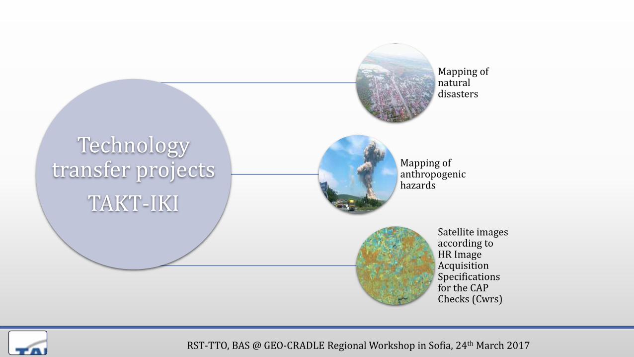
Technology transfer projects
TAKT-IKI
Mapping ofnatural disasters
Mapping of anthropogenic hazards
Satellite images according to HR Image Acquisition Specifications for the CAP Checks (Cwrs)

RST-TTO, BAS @ GEO-CRADLE Regional Workshop in Sofia, 24th March 2017
Mapping of past flood events. Flooding in town of Miziya, Bulgaria,01.08.2014
Satellite image, RapidEye,
6.5 m GSD 08/12/2014
Infrastructure Flooded area
Evaluation Orthophoto map of the effects and damages
Mapping of natural disasters

RST-TTO, BAS @ GEO-CRADLE Regional Workshop in Sofia, 24th March 2017
Map products
Mapping of past flood eventsMapping of natural disasters

RST-TTO, BAS @ GEO-CRADLE Regional Workshop in Sofia, 24th March 2017
Straldzha–Marazh blast incident, 05.06.2012
Mapping of anthropogenic hazards

RST-TTO, BAS @ GEO-CRADLE Regional Workshop in Sofia, 24th March 2017
Straldzha–Marazh blast incident Mapping of anthropogenic hazards
RST-TTO, BAS @ GEO-CRADLE Regional Workshop in Sofia, 24th March 2017
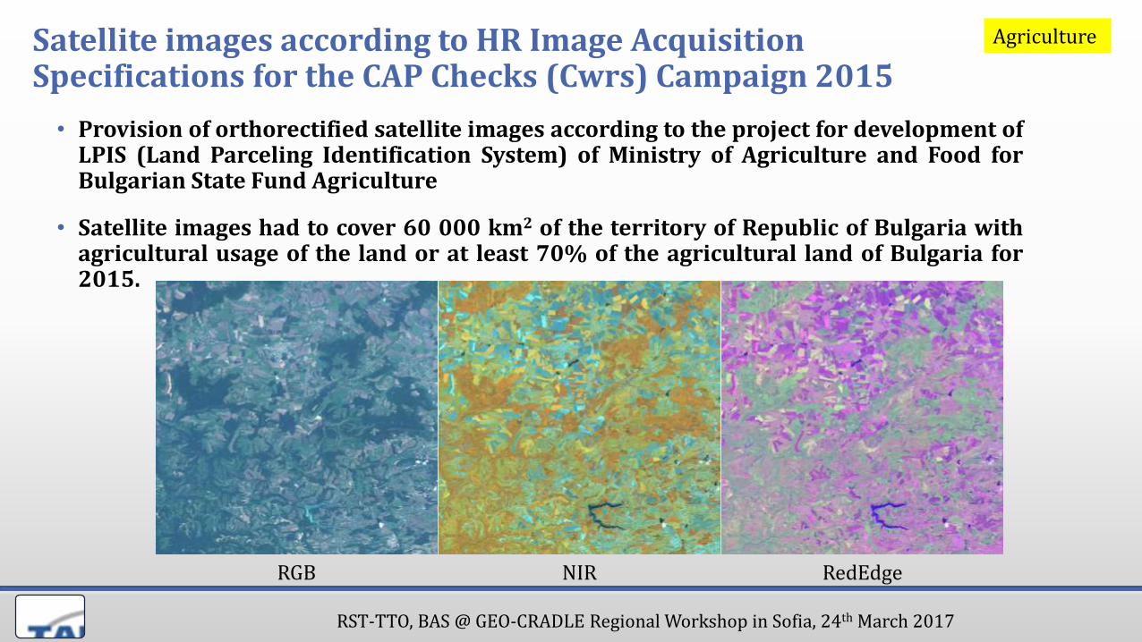
Satellite images according to HR Image Acquisition Specifications for the CAP Checks (Cwrs) Campaign 2015
• Provision of orthorectified satellite images according to the project for development ofLPIS (Land Parceling Identification System) of Ministry of Agriculture and Food forBulgarian State Fund Agriculture
• Satellite images had to cover 60 000 km2 of the territory of Republic of Bulgaria withagricultural usage of the land or at least 70% of the agricultural land of Bulgaria for2015.
RGB NIR RedEdge
Agriculture
RST-TTO, BAS @ GEO-CRADLE Regional Workshop in Sofia, 24th March 2017
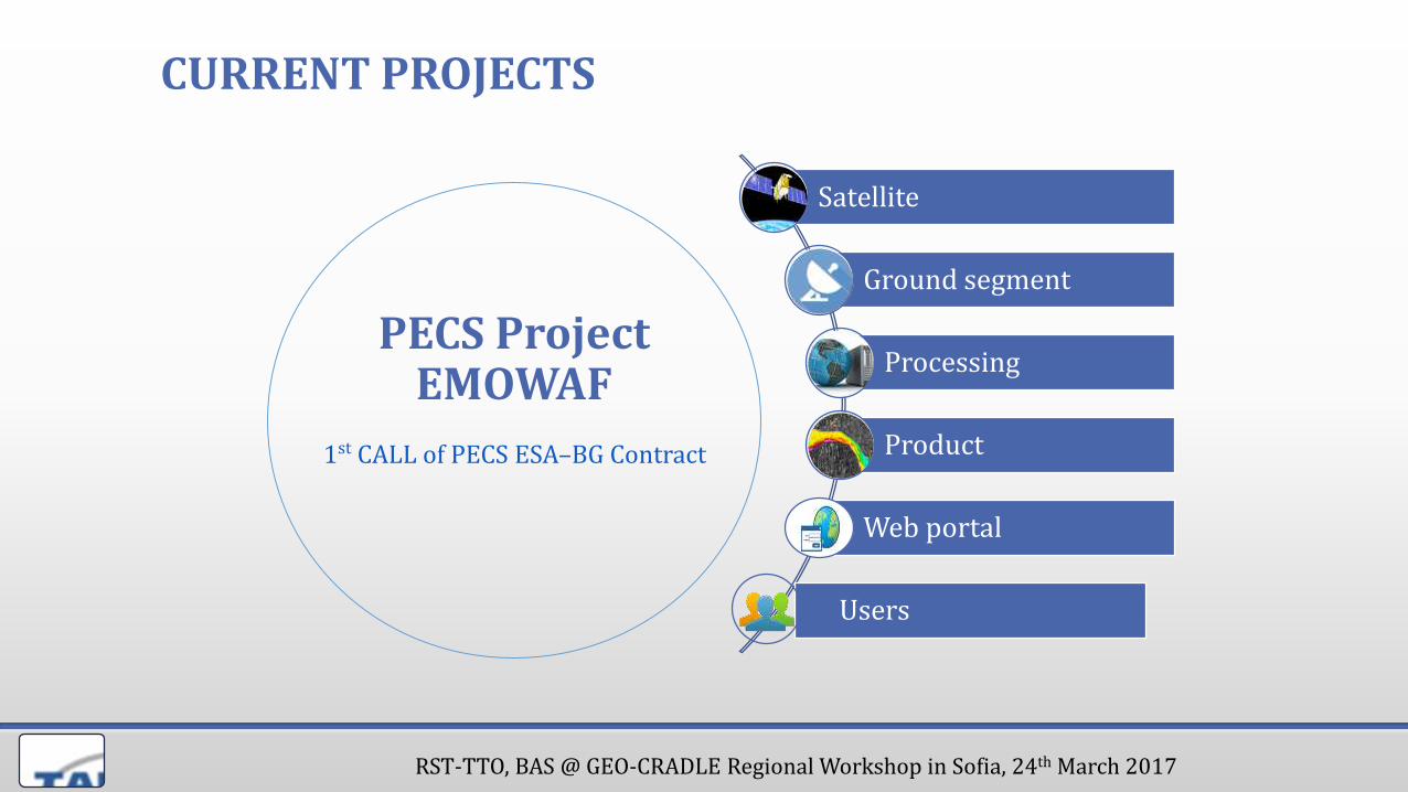
CURRENT PROJECTS
Satellite
Ground segment
Processing
Product
Web portal
Users
PECS ProjectEMOWAF
1st CALL of PECS ESA–BG Contract

RST-TTO, BAS @ GEO-CRADLE Regional Workshop in Sofia, 24th March 2017
RSICS, BULGARIA
TAKT-IKI, BULGARIA
Programme: 1st CALL of PECS ESA–BG Contract
Subject: Space applications, products and services making use of space infrastructure that is already existing or scheduled for operation in the near term
Project : Earth Observation Monitoring For Better Water Management And Flood Prevention In Bulgaria (EMOWAF)
Duration: September 2016 – March 2018
Consortia:

RST-TTO, BAS @ GEO-CRADLE Regional Workshop in Sofia, 24th March 2017
Objectives and requirements
• Overall objectives:
• to establish Earth Observation based waterquality services to support Bulgarianwater authorities responsible for inlandwater quality in lakes for implementationof Water Frame Directive (WFD) of EU;
• to develop new downstream service-linebased on Web-based geo-informationsystem for provision of Earth Observationdata (satellite and airborne), integratedwith in-situ data for water qualitymonitoring as additional tools to theNational System for EnvironmentalMonitoring – Water Monitoring Subsystem(NSEM -WMSs) of Bulgaria.
Requirements
WFD&
Nat. Reg.
EO, airborne and in-situ
data integration
for WQ monitoring
Derive Biophysical
water parameters
conform to in-situ
methodology
WMS & WFS
Easy access
via Web app
Cartographic and
additional data

RST-TTO, BAS @ GEO-CRADLE Regional Workshop in Sofia, 24th March 2017
Application of the results of EU FP-7 Projects in the field of water quality:
• Ingesting large quantities of satellite observation data and processing into higher level products;
• Developing additional airborne hyperspectral data-mining of the test areas/lakes and to make comparison with Sentinel-2,-3 data;
• Adaptation of water quality algorithms to Sentinel-2/ Sentinel-3-OLCI and AHySpD data for the selected areas of interest;
• Research and analysis of additional physical-chemical elements (organic/nonorganic) and specific pollutants;
• Validation of the Earth Observation (EO) based results;
• Developing data-mining and other tools to work with the data;
• Developing a Web-based prototype system for an end-user (iEMOWAF), which will integrate EO measurements with in-situ data and provide graphical tools for data extraction and visualization.
Space applications, products and services making use of space infrastructure that is already existing or scheduled for operation in the near term
RST-TTO, BAS @ GEO-CRADLE Regional Workshop in Sofia, 24th March 2017
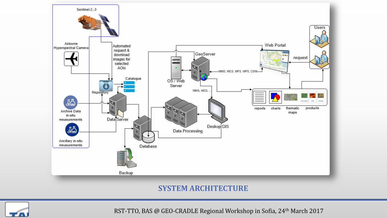
SYSTEM ARCHITECTURE

RST-TTO, BAS @ GEO-CRADLE Regional Workshop in Sofia, 24th March 2017
Multi-satellite processors for water quality
WorldView-2,3RapidEye, Pleiades,
SPOT…
Landsat 5, 7 & 8Sentinel 2 a/b
Temporal resolution
Spatial resolution
Daily
Weekly
Monthly
2 m 30 m 300 m
Sentinel 3,MODIS Aqua & Terra
MERIS†2012
© EOMAP

RST-TTO, BAS @ GEO-CRADLE Regional Workshop in Sofia, 24th March 2017
MethodologyPhysics based data processing, retrieving harmonized optical properties and related water constituents
water color « absorption, scattering « water properties
300 350 400 450 500 550 600 650 700 750 800
0,0
0,2
0,4
0,6
0,8
1,0
CH
L a
bso
rptio
n*0
,75
[m
^-1
]wavelength [nm]
Chlorophyll-a
400 450 500 550 600 650 700 750 800
0,126
0,127
0,128
0,129
0,130
0,131
0,132
0,133
0,134
0,135
0,136
TS
M a
bsor
ptio
n [m
^-1]
Wavelength [nm]
Total suspende matter/TUR
Turbidity
Suspended Matter, …
Organic-/anorg. absorption
Organic/anorganic comp.
Chlorophyll absorption
Eutrophication,
Specific algae indicators
Blue algae indicator
Water depth, bottom
Habitat mapping, bathym.

RST-TTO, BAS @ GEO-CRADLE Regional Workshop in Sofia, 24th March 2017
PILOT AREA-I - PRELIMINARY TESTS
Pilot area 1 – Iskar Dam Lake
Turbidity, Lake Iskar, BulgariaGSD:10 m29-07-2015
Chlorophyll_aLake Iskar,BulgariaGSD:10 m29-07-2015
HAB IndicatorLake Iskar, BulgariaGSD:10 m29-07-2015
©

RST-TTO, BAS @ GEO-CRADLE Regional Workshop in Sofia, 24th March 2017
PILOT AREAS - PRELIMINARY ALGORITHM TESTING
Pilot area 2 – Varna Lake
RST-TTO, BAS @ GEO-CRADLE Regional Workshop in Sofia, 24th March 2017
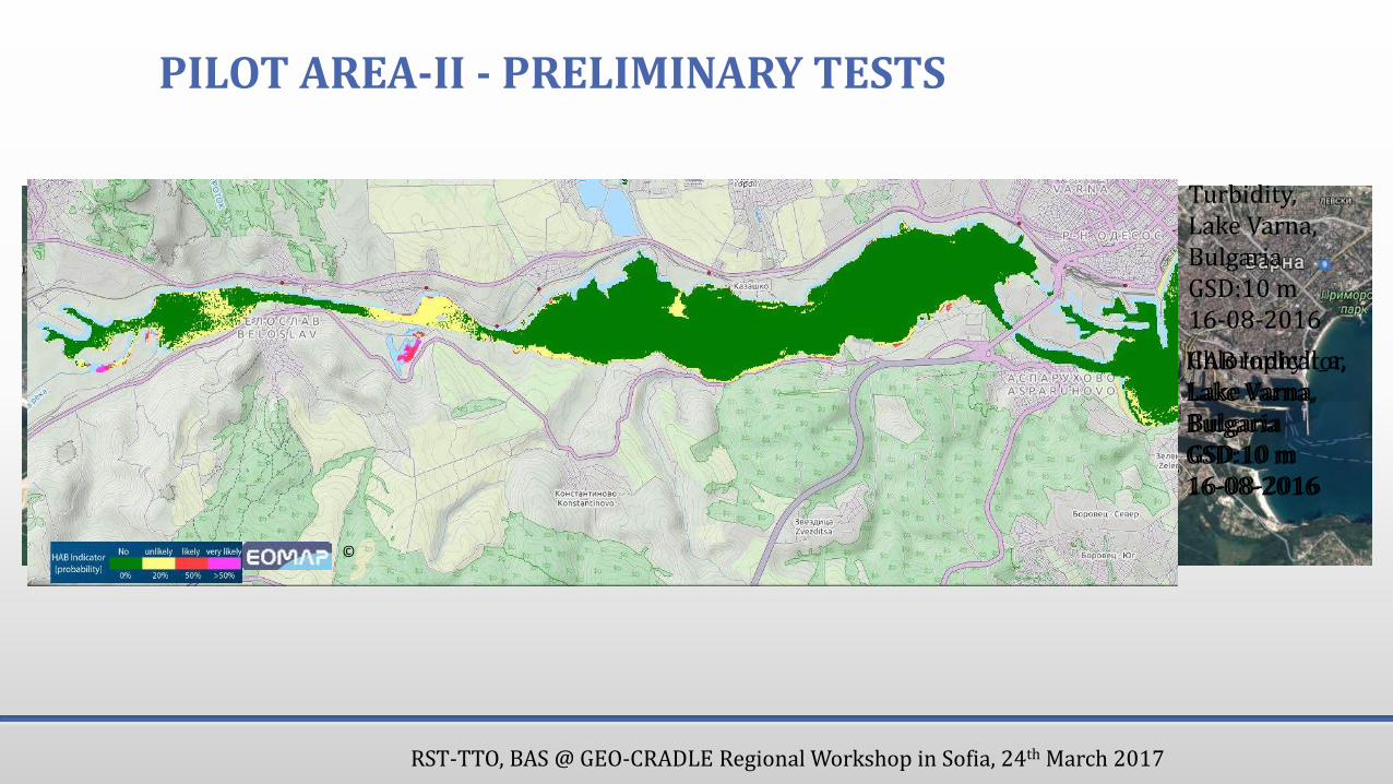
PILOT AREA-II - PRELIMINARY TESTS
Turbidity, Lake Varna, BulgariaGSD:10 m16-08-2016
Chlorophyll_a, Lake Varna, BulgariaGSD:10 m16-08-2016
HAB Indicator, Lake Varna, BulgariaGSD:10 m16-08-2016
©

RST-TTO, BAS @ GEO-CRADLE Regional Workshop in Sofia, 24th March 2017
Prototype view of EMOWAF web-portal

RST-TTO, BAS @ GEO-CRADLE Regional Workshop in Sofia, 24th March 2017
Expected results & potential users
• The main goals are to provide:
• integration
• customization
• confidence
• and acceptance of EO existing products and data for end users.
• Potential users:
• State Organization MoEW/MoAF/ MoRD
• Public organisation – university, research labs (BAS);
• Industry.

RST-TTO, BAS @ GEO-CRADLE Regional Workshop in Sofia, 24th March 2017
THANK YOU !
Address:Acad. G. Bonchev str.Block 1, Sofia [email protected]://www.rst-tto.com
RISK SPACE TECHNOLOGY TRANSFER