Embed Size (px)
Citation preview

Advisory Visit to Scalby Beck, Nr Scarborough
11th April 2014

1
1.0 Introduction
This report is the output of a site visit undertaken by Gareth Pedley of the
Wild Trout Trust to Scalby Beck on Friday 11th April, 2014. Comments in this
report are based on observations on the day of the site visit and discussions
with Andy Tucker, Chris Mollen and Brian Dove of Scalby Beck Angling Club.
Normal convention is applied throughout the report with respect to bank
identification, i.e. the banks are designated left hand bank (LB) or right hand
bank (RB) whilst looking downstream. Location coordinates are given using
the Ordnance Survey National Grid Reference system.
2.0 Catchment / Fishery Overview
Scalby Beck lies to the southern end of the North York Moors and Hills
Natural Area, with a catchment area predominated by sandstone, siltstone
and mudstone base geology. These are in turn overlain by clay deposits and
till. The upper catchment is of relatively low gradient which increases
significantly in the lower reaches; this is particularly evident in the lower
1.5km, where the beck flows through a steep-sided gorge to join the sea at
the northern end of Scarborough’s North Bay.
Like many rivers across the UK, the beck has been significantly altered for
industry, land drainage and flood alleviation (as evident by visual inspection
on the site visit and Google Earth). The upper catchment is subject to
significant realignment, leaving a relatively uniform straight channel that will
significantly increase flood conveyance. In addition to this, the beck had also
been connected hydrologically to its larger neighbouring river (River
Derwent) to take a portion of the Derwent’s flood flow, via the Sea Cut. The
impact of this is two-fold, not only has the physical habitat been significantly
degraded but the beck is now subject to much higher peak flows than would
naturally occur. A suite of very large weirs also fragment habitat along the
beck.
Land adjacent to the beck in the upper catchment is predominantly arable,
with good buffer strips and un-cultivated strips along the watercourse.
Towards the downstream end, the beck flows through a more urban area,
but significant un-cultivated buffer of woodland remains along the beck,
which transitions into scrub/heathland in the lower kilometre.

2
The club fishing extends from the sea at Scalby Mills to approximately one
mile above Scalby village (both banks). The section of water between Newby
Road Bridge and Hackness Road Bridge is free fishing, this is reserved for
young non-members up to the age of 17 years. The fishing on the beck is for
brown trout, grayling and sea trout, chub, eel and gudgeon with other minor
fish species present. The club does not issue day tickets for coarse fishing
and does not allow any other method of fishing, other than fly fishing, on a
day ticket.
400 (7-9”) and 400 (9-11”) diploid brown trout are stocked to the Beck
annually, predominantly in the middle reaches around the impounded
sections upstream of, and between the weirs. In addition to this, there is a
stock of wild trout, a portion of which are migratory sea trout.
(http://www.scalbybeckanglingclub.co.uk/about_us/about_us.html)
The length of beck inspected covers most of the club water, starting at the
sea (NGR: TA 03557 90830), to a point upstream of the Hackness road
bridge (NGR: TA 00824 89843), a distance of approximately 3.4km.
Under the Water Framework Directive, the Burniston Beck/Sea Cut/Scalby
Beck Catchment to North Sea waterbody (ID GB104027067980) is classed
as ‘heavily modified’ (almost certainly due to the channel realignment, weirs
and altered hydrology) and as being at ‘moderate potential’. Very strangely,
while the ‘overall hydromorphological quality’ is classed as ‘not high’, which
recognises the serious physical modifications, hydrology is classed as ‘high’,
which is unlikely to be the actual case but more likely an error in
classification (http://maps.environment-agency.gov.uk).
It is predicated that out of the c.30 members of the club, only around 25
actively fish (roughly 10 being sea trout fishers and 15 trout fishers).
Current catch data suggest that less than 50 fish are killed per year out of
the 450 caught (all numbers are approximate).
3
3.0 Habitat Assessment
3.1 Estuary to Scalby Road Bridge (A171)
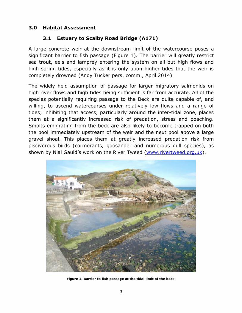
A large concrete weir at the downstream limit of the watercourse poses a
significant barrier to fish passage (Figure 1). The barrier will greatly restrict
sea trout, eels and lamprey entering the system on all but high flows and
high spring tides, especially as it is only upon higher tides that the weir is
completely drowned (Andy Tucker pers. comm., April 2014).
The widely held assumption of passage for larger migratory salmonids on
high river flows and high tides being sufficient is far from accurate. All of the
species potentially requiring passage to the Beck are quite capable of, and
willing, to ascend watercourses under relatively low flows and a range of
tides; inhibiting that access, particularly around the inter-tidal zone, places
them at a significantly increased risk of predation, stress and poaching.
Smolts emigrating from the beck are also likely to become trapped on both
the pool immediately upstream of the weir and the next pool above a large
gravel shoal. This places them at greatly increased predation risk from
piscivorous birds (cormorants, goosander and numerous gull species), as
shown by Nial Gauld’s work on the River Tweed (www.rivertweed.org.uk).
Figure 1. Barrier to fish passage at the tidal limit of the beck.

4
Moving upstream, the beck flows through a relatively steep-sided gorge with
high quality juvenile trout habitat within the pockets of shallow water among
bouldery sections. There are also, however, several sections of bank subject
to recent land slippage, leaving a lack of bankside trees and cover.
Figure 2. High quality juvenile habitat (background), with deeper pool habitat lacking in aerial cover
(foreground).
Further upstream the adjacent land becomes wooded, with a good number
of bankside trees present. Trees provide improved bank stability and in-
channel cover though their root systems, in places; however, historic
maintenance and pruning has left a serious lack of low-level aerial and
trailing cover for fish (Figure 3). While it is argued that this action makes it
easier to cast and cover the water, it also greatly reduces the carrying
capacity of the beck (number of fish it can hold), not only for adult trout but
juveniles, as there is less available habitat and a lack of cover in which to
evade predation.
5
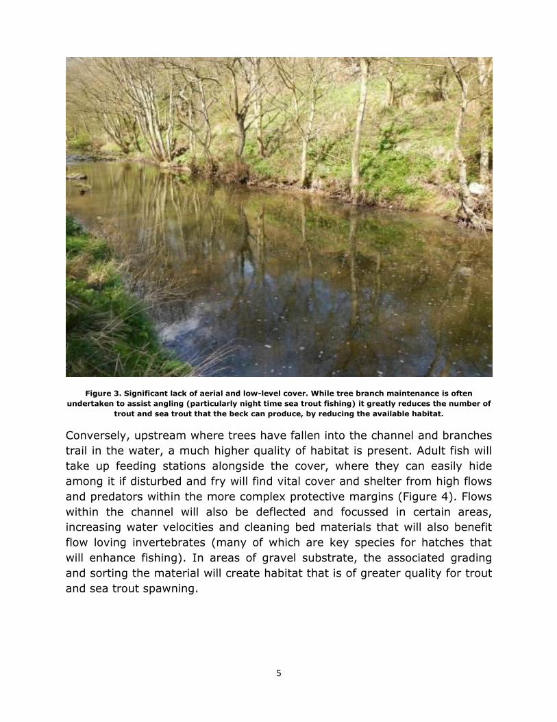
Figure 3. Significant lack of aerial and low-level cover. While tree branch maintenance is often
undertaken to assist angling (particularly night time sea trout fishing) it greatly reduces the number of
trout and sea trout that the beck can produce, by reducing the available habitat.
Conversely, upstream where trees have fallen into the channel and branches
trail in the water, a much higher quality of habitat is present. Adult fish will
take up feeding stations alongside the cover, where they can easily hide
among it if disturbed and fry will find vital cover and shelter from high flows
and predators within the more complex protective margins (Figure 4). Flows
within the channel will also be deflected and focussed in certain areas,
increasing water velocities and cleaning bed materials that will also benefit
flow loving invertebrates (many of which are key species for hatches that
will enhance fishing). In areas of gravel substrate, the associated grading
and sorting the material will create habitat that is of greater quality for trout
and sea trout spawning.

6
Figure 4. Excellent cover and protection for juvenile fish in the margins among tree branches, with
flows being beneficially focussed down the far side of the channel. If left in place the ley created
behind such structures should also encourage vital deposition and retention of the vital smaller gravels
that are currently being washed out during floods. This will create new areas that can be utilised for
spawning.
Figure 5 demonstrates another great, natural example of aerial cover, where
a hawthorn has fallen down over the channel. This will provide valuable
shade and the trailing branches within the water will provide structure that is
harder to negotiate for most predators than it is for fish, assisting their
escape. This should be retained at all costs as great example of the cover
that is widely lacking on the beck. If flows do catch the bush, it should
simply swing round to lie along the margin. There it will still provide benefit,
but not as much as it provides in its current location. The pool may be
slightly harder to cover with some fishing techniques, but the enhanced
habitat will hold and produce a greater number of fish to try for. It is vital to
consider that all fish stocks are reliant upon the juvenile populations that can
be produced, so their habitat must be retained and enhanced.

7
Figure 5. Excellent example of the low-level and trailing cover that is so scarce on the beck that needs
to be increased to improve the numbers of fish that the beck can produce and hold.
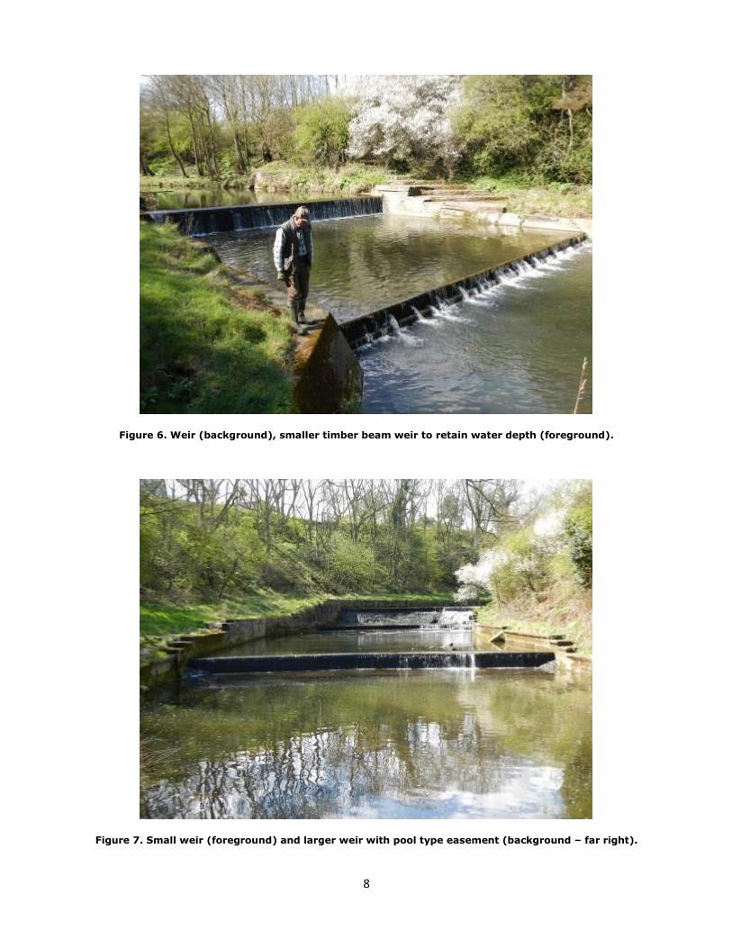
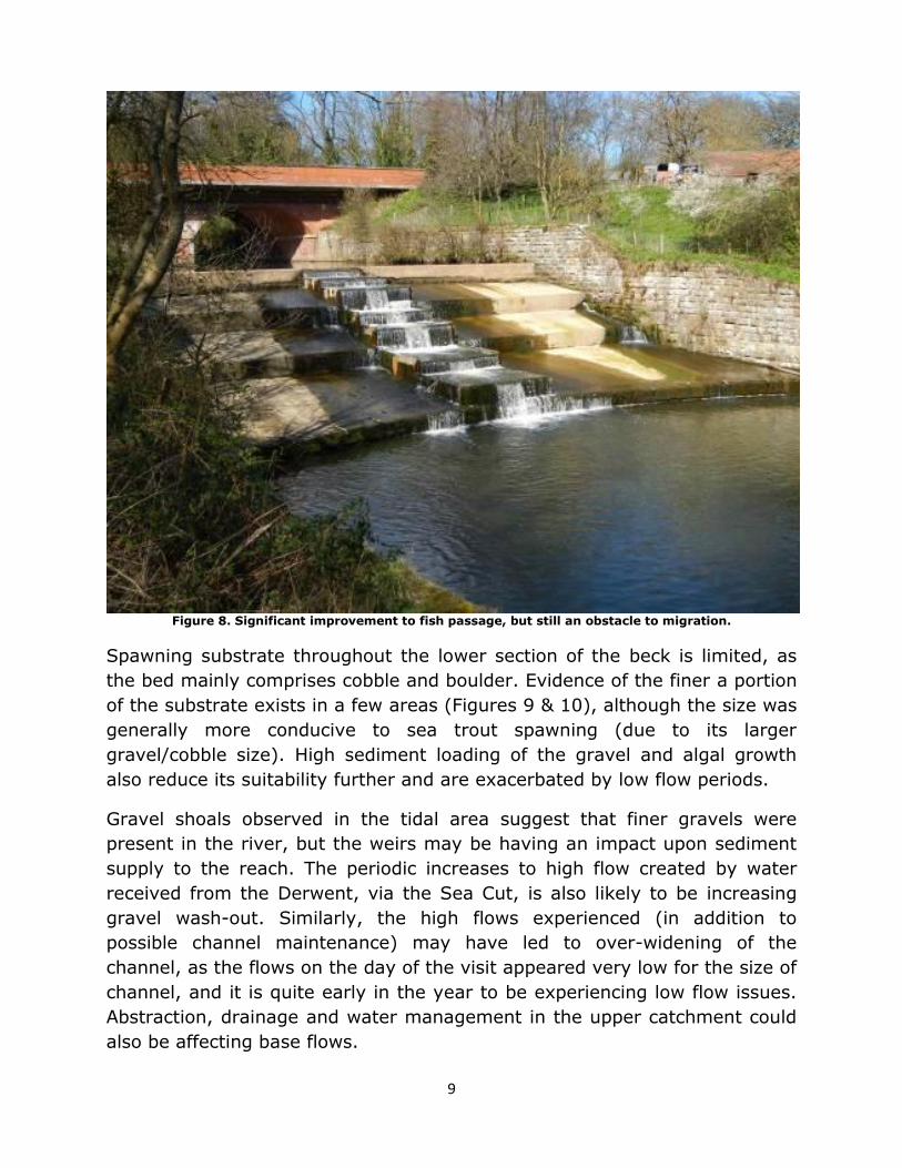
A short distance upstream the beck becomes impounded by a series of
massive concrete weirs (Figures 6, 7 & 8). All of these are barriers to fish
passage. Although some fish will be able to pass them under certain flows,
they significantly inhibit both sea trout and resident brown trout migrations
and dispersal. It is important to consider that even resident brown trout
migrate significant distances within the river throughout their life to exploit
the different habitat requirements of their life stages. This is particularly true
when it comes to the upstream migrations to find suitable gravel spawning
substrate and nursery areas which are often found on tributaries.
At the farthest downstream structure, Scalby Beck AC, with the assistance of
East Yorkshire Chalk Rivers Trust have installed easements to fish passage
on the structures. A timber beam on the apron of the lower weir structure to
increase the depth of water over the apron and assist fish in jumping over
the >1m weir (Figure 6). Pool traverse type easements have also been
installed on the two largest of the next tree weirs upstream (Figures 7 & 8).
8
Figure 6. Weir (background), smaller timber beam weir to retain water depth (foreground).
Figure 7. Small weir (foreground) and larger weir with pool type easement (background – far right).
9
Figure 8. Significant improvement to fish passage, but still an obstacle to migration.
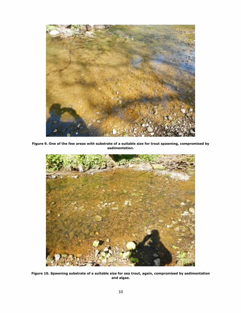
Spawning substrate throughout the lower section of the beck is limited, as
the bed mainly comprises cobble and boulder. Evidence of the finer a portion
of the substrate exists in a few areas (Figures 9 & 10), although the size was
generally more conducive to sea trout spawning (due to its larger
gravel/cobble size). High sediment loading of the gravel and algal growth
also reduce its suitability further and are exacerbated by low flow periods.
Gravel shoals observed in the tidal area suggest that finer gravels were
present in the river, but the weirs may be having an impact upon sediment
supply to the reach. The periodic increases to high flow created by water
received from the Derwent, via the Sea Cut, is also likely to be increasing
gravel wash-out. Similarly, the high flows experienced (in addition to
possible channel maintenance) may have led to over-widening of the
channel, as the flows on the day of the visit appeared very low for the size of
channel, and it is quite early in the year to be experiencing low flow issues.
Abstraction, drainage and water management in the upper catchment could
also be affecting base flows.
10
Figure 9. One of the few areas with substrate of a suitable size for trout spawning, compromised by
sedimentation.
Figure 10. Spawning substrate of a suitable size for sea trout, again, compromised by sedimentation
and algae.

11
3.2 Scalby Road Bridge (A171) to Newby Road Bridge
In Figure 11, upstream of Scalby Road Bridge, the impounding effect upon
water level and flows of the significant weir at the upstream end of the lower
section is clearly evident (Figure 8). Here, removal of tree branches has also
denuded the beck of low cover and in-channel structure, both of which would
be vital aspects for cover and flow disruption in such a ponded section. The
combination of these two impacts creates relatively poor quality habitat for
trout, with very little cover to inhabit or evade predators.
Figure 11. Impounded water with little cover, flow diversity or structure for trout habitat.
A short distance upstream another major weir poses an impassable barrier
and effectively, completely disconnects the lower river from the upper
sections (Figure 12). As with the other weirs, it also creates a further
significant impounded section (Figure 13) and massive sediment trap that
prevents natural replenishment of gravels to the reaches downstream.

12
Figure 12. Impassable weir that disconnects the lower river from the upper.
Figure 13. Impounded section upstream of the large impassable weir.

13
Upstream, out of the influence of the impoundment, the beck again show a
pool and riffle sequence, with some improvement in substrate quality and
diversity. This creates more opportunity for spawning and provides better
habitat for trout and aquatic invertebrates (Figure 14).
Figure 14. Pool and riffle sequence upstream of the impoundment.
Large woody debris (LWD) is also present in areas (Figure 15), which greatly
improves the quality of habitat through cover and flow disruption and
provides much needed refuge from predators and high flows. The channel
constriction created also helps to scour and maintain the pool depth around
it. As with low cover and trailing branches, LWD is a vital natural habitat
enhancement that should be retained and, wherever possible, encouraged.

14
Figure 15. An excellent example of LWD enhancing a pool. Interestingly, one of the few fish spotted
within the section was patrolling around the structure.
Further upstream, Cow Wath Beck enters Scalby Beck and poses the first
opportunity for higher quality trout spawning and juvenile habitat. Cow Wath
Beck exhibits more natural dimension for the flow it receives and supports
higher quality, shallow-water juvenile habitat. Cow Wath Beck actually
appeared to supply a good proportion of the flow within Scalby Beck, which
is surprising, bearing in mind its much smaller dimensions and catchment.
This may again suggest altered hydrology within the upper Scalby Beck, and
that areas of the beck may have been widened to accommodate the
additional Sea Cut water or scoured wider by the additional flows.
The pool at the confluence of Scalby and Cow Wath Becks has apparently
accumulated bed material over recent years. This may be due to material
from Cow Wath Beck, or Scalby Beck, but the fact that the pool is over
capacity for the flow it receives, means that it will inevitably infill over time.
For exactly this reason in-channel structure (LWD and trailing branches) are
vital to facilitate scour that will naturally maintain pool depth.

15
Figure 16. Cow Wath Beck, just upstream of Scalby Beck – potentially a good spawning tributary.
Increased low-level and trailing cover would be beneficial.
Figure 17. Scalby Beck at the confluence with Cow Wath Beck which has apparently in-filled with
material over recent years; the exposed gravel shoal in the middle of the channel supports this
assumption. The issue is that the channel is over-capacity for the usual flow it receives.

16
Progressing further upstream another significant barrier to fish passage
exists, in the form of a concrete weir. Alone, the weir would be a significant
barrier, but coupled with the concrete apron downstream which prevents
development of any pool depth the barrier becomes impassable in all but the
highest of flows.
Figure 18. Weir that is impassable in most conditions, made worse by the concrete apron downstream.
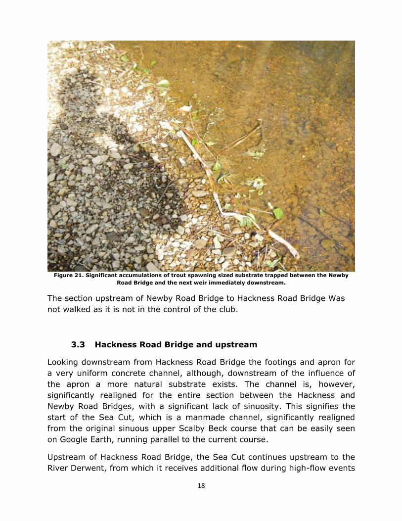
Again, a short distance upstream two more impassable weirs in close
succession cause further disconnection of habitats and fish populations on
the beck (Figure 19 & 20 which forms part of the Newby Road Bridge
structure). The issues posed to substrate transport by the weirs is also
painfully obvious as although the downstream of the two weirs is >2m high,
a notable portion of the pool has in-filled with gravel (Figure 21).

17
Figure 19. Weir downstream of the Newby Road Bridge Weir that impounds flows and significant
accumulations of trout spawning substrate.
Figure 20. Newby Road Bridge Weir/Bridge Footings.
18
Figure 21. Significant accumulations of trout spawning sized substrate trapped between the Newby
Road Bridge and the next weir immediately downstream.
The section upstream of Newby Road Bridge to Hackness Road Bridge Was
not walked as it is not in the control of the club.
3.3 Hackness Road Bridge and upstream
Looking downstream from Hackness Road Bridge the footings and apron for
a very uniform concrete channel, although, downstream of the influence of
the apron a more natural substrate exists. The channel is, however,
significantly realigned for the entire section between the Hackness and
Newby Road Bridges, with a significant lack of sinuosity. This signifies the
start of the Sea Cut, which is a manmade channel, significantly realigned
from the original sinuous upper Scalby Beck course that can be easily seen
on Google Earth, running parallel to the current course.
Upstream of Hackness Road Bridge, the Sea Cut continues upstream to the
River Derwent, from which it receives additional flow during high-flow events

19
on the Derwent. <0.5km of this section was walked, but in this distance it
was apparent that flows were impounded for the first 200m upstream of
Hackness Road Bridge, due to the bridge footings and raised concrete invert.
The lack of flow in this section means that it is not particularly high quality
trout habitat, providing limited habitat for adult trout and older juveniles.
The habitat available in this area is heavily reliant upon overhanging and
trailing cover with some of the best examples on the entire beck (Figure 22).
Figure 22. Impounded section upstream of Hackness Road Bridge. Good tree fringe and
overhanging/trailing cove is present.
Further upstream, outside the influence of the impoundment, habitat quality
improved, with a greater diversity of depths and flow conditions, partially
aided by stone weirs that have been installed to create fishing pools (Figure
23). While providing some benefit, these weirs would be better maintained
as pinch points with a gap in the centre of the channel; this would focus
flows into that area, encouraging scour and maintenance of deeper areas
without unduly interrupting sediment transport. This will also facilitate gravel
retention and natural narrowing downstream of the structures that would

20
also benefit flows and fish habitat. In the future, however, the same effect
could be better achieved with LWD or by laying bankside trees and shrubs
into the channel to create cover and constrict areas of the channel to
increase scour.
Figure 23. The Sea Cut, upstream of the impoundment caused by Hackness Road Bridge, where some
flow diversity and cleaner gravel substrate provide better fish and invertebrate habitat, along with
some potential for trout spawning and juvenile habitat.
4.0 Recommendations
4.1.1 Barriers
It is recommended that an investigation be undertaken into whether the
concrete weir at the tidal limit of Scalby beck can be removed. Discussions
with Scalby AC members indicate that the weir was originally created to
house a sewage pipe that is no longer in use (Andy Tucker and Chris Mollen
pers. comm., April 2014). If this were the case, a project to remove at least
21
a section of the weir would greatly assist upstream and downstream
migration of all fish species.
The extent of work that can be undertaken on the other weirs is limited due
to their immense size and the fact that they often support infrastructure
(e.g. road crossings and bridge footings); however, there may be a
possibility to lower the weir depicted in Figure 12. This would then increase
the feasibility of installing an easement on the remaining weir, while also
significantly reducing the impounding effect upon water upstream and
enhancing a significant length of habitat.
It may also be possible to remove or notch the weir in Figure 18, if it is
established that it contains no services and it could be ensured that this
would not destabilise the footings of the viaduct upstream. Owing to the age
of the viaduct (appears significantly older than the weir) it is to be expected
that the viaduct should be a stand-alone structure, but this should be
investigated before any attempts are made to lower it. Alternatively, a series
of pools could be created, in a similar way those on the weirs shown in
Figures 7 and 8, accepting that this would not reduce the negative impact of
the impoundment and would never be such an improvement as full removal.
4.1.2 Tree planting
Planting of shrubs would be beneficial along the bank in any open areas,
particularly where bank slippage has occurred and trees have been lost.
While possibly impeding casting, the improvements that better cover make
to fish holding and survival will create benefits that far outweigh the
inconvenience.
The quickest and easiest way to plant willow is by pushing short sections of
willow whip into the ground around the water line (where it will get plenty of
water). This can be undertaken at any time of the year, but will have the
greatest success if undertaken within the dormant season, shortly before
spring growth begins (ideally late Jan-early March). 400-600mm (c.16-24”)
whips should be planted into soft, wet earth/sediment so that there is a
greater length within the ground than out of it to minimise the distance that
water has to be transported up the stem. Leaving only 1/3 of the whip
protruding from the ground is sufficient.

22
Willow can also be planted as living willow bundles, which consist of a
several willow branches tied together into a faggot. These can then be
staked along the waterline, ideally with the majority of the bundle
submerged in most flows. This method can rapidly increase the availability of
low, dense canopy over and within the water.
It is preferable to source willow locally, from adjacent areas of the bank.
This ensures that it is suited to the conditions and helps to avoid potential
issues with transportation of non-native species. There are numerous willow
species found on river banks, but the smaller shrub varieties are usually the
best for these habitat enhancements, as they remain small and low to the
water and require less maintenance.
These methods would be particularly beneficial in areas shown on Scalby AC
maps (Appendices) between (3) Long Pool and (6) Doves Corner/ (7)
Colleys, (8) Mollons Pool, (10) Towse Island, between (26) Summer House
and (27) Trings Reach, but also anywhere else that cover is lacking.
A cursory glance at the downstream end of Cow Wath Beck suggest that it
too might benefit from this treatment to enhance the habitat for juvenile
trout and hopefully increase their survival.
4.1.3 Tree Management
4.1.3.1 Laying
Where trees are already established along the bank side habitat
improvements can often be attained through laying some or all of the
branches/trunks down into the watercourse to increase low cover and
structure within the channel. This method is generally limited to species that
can be easily manipulated without snapping (e.g. willow, elm, hazel,
hawthorn and small alder). Also, for this reason, small to medium shrubs
tend to work best, although large willow can be successfully laid.
The process involves cutting part way through the stem/trunk (a bit at a
time) until it can be forced over into the channel (Figure 23). Care should be
taken to limit the depth of the cut to only that which is required to bend the
limb over, thereby a substantial hinge is retained to provide maximum
strength and health of the tree.

23
Figure 24. Hinged willow.
This treatment would be beneficial on willows in the area around the
following locations on the Scalby Beck AC map: (7) Colleys and Nr. (27)
Trings Reach (Figure 12), along with willow in the impounded section
upstream of Hackness Road Bridge.
4.1.3.2 Coppicing
Coppicing of bankside trees, particularly where the lower branches have
been lost through past maintenance would be highly beneficial to promote
lower level regrowth. This treatment would be beneficial in the following
locations: (7) Colleys (Figure 3) and (23) Youth Hostel (Figure 11).

24
4.1.4 Large Woody Debris
It is vital that all LWD and in-channel structure that is present within the
beck or that enters the beck is retained to provide cover and flow disruption,
as around (9) Habitat Weirs and (31) Collins Pool (Figures 4 and 14
respectively). These features could also be created through the use of tree
kickers, where trees are felled into the channel and cabled to their own
stump. More information on this can be found on the Wild Trout Trust
website in Section 5.4 of the Upland Rivers Habitat Manual, Page 10/11
(http://www.wildtrout.org/sites/default/files/library/uplands_section5.pdf).
4.1.5 Non-native Invasive species
Several non-native invasive species were observed throughout the beck, but
were particularly evident in the following locations:
Giant Hogweed - (3) Long Pool, (6) Doves Corner and upstream, (9)
Habitat weirs, between (26) Summer House and (27) Trings Reach.
Himalayan Balsam (6) Doves Corner.
Japanese Knotweed (40) Viaduct.
It is strongly recommended that the club liaises with landowners, the
Environment Agency and the local rivers trust to ascertain if a programme of
non-native invasive species eradication could be initiated.
4.1.6 General management
As the river is so fragmented by weirs it is hard to develop a one size fits all
management plan for the river. The weirs will undoubtedly also reduce the
potential for resident trout to fully access and utilise the habitat that is
available. That said there were areas in which the river is likely to support
trout spawning and juvenile habitat (e.g. more natural areas upstream of
Hackness Road Bridge, the area around Cow Wath Beck and the lower
section below the weirs that migratory trout have access to). For this reason
the native trout of the beck should be protected and supported. The ideal
way to do this would be to reduce the number of wild fish that are killed

25
(ideally none), with a small number of infertile (triploid), marked farm fish
stocked that can be easily identified if fish are required to be taken.
If detailed catch returns were required from every angler, the level of
exploitation of the fish could also be ascertained. This would greatly assist
with future management by showing the contribution of both stocked and
wild fish to angler catches, informing future stocking levels to ensure that no
more fish are stocked than are required. This would reduce the potential for
competition with the wild fish stocks and save the club from wasting money
on fish that do not contribute to angler catches.
5.0 Making it Happen
WTT may be able to offer further assistance such as:
WTT Project Proposal
o Further to this report, WTT can devise a more detailed project proposal report. This would usually detail the next steps to take
and highlighting specific areas for work (e.g. locations of LWD or
tree kicker installations), with the report forming part of a land drainage consent application.
WTT Practical Visit o Where clubs are in need of assistance to carry out the kind of
improvements highlighted in an advisory visit report, there is the possibility of WTT staff conducting a practical day for a club. This
would consist of 1-3 days work with a WTT Conservation Officer teaming up with interested club members to demonstrate the
habitat enhancement methods described above. The recipient would be asked to contribute only to reasonable travel and
subsistence costs of the WTT Officer. WTT Fundraising advice
o Help and advice on how to raise funds for habitat improvement work can be found on the WTT website -
http://www.wildtrout.org/content/project-funding
The WTT officer responsible for fundraising advice is Denise Ashton:
In addition, the WTT website library has a wide range of free materials in
video and PDF format on habitat management and improvement:
http://www.wildtrout.org/content/index
26
We have also produced a 70 minute DVD called ‘Rivers: Working for Wild
Trout’ which graphically illustrates the challenges of managing river habitat
for wild trout, with examples of good and poor habitat and practical
demonstrations of habitat improvement. Additional sections of film cover key
topics in greater depth, such as woody debris, enhancing fish stocks and
managing invasive species.
The DVD is available to buy for £10.00 from our website shop
http://www.wildtrout.org/product/rivers-working-wild-trout-dvd-0 or by
calling the WTT office on 02392 570985.
6.0 Acknowledgement
The Wild Trout Trust would like to thank the Environment Agency for their
continued support of the advisory visit service.
7.0 Disclaimer
This report is produced for guidance and not for specific advice; no liability
or responsibility for any loss or damage can be accepted by the Wild Trout
Trust as a result of any other person, company or organisation acting, or
refraining from acting, upon guidance made in this report. Accordingly, no
liability or responsibility for any loss or damage can be accepted by the Wild
Trout Trust as a result of any other person, company or organisation acting,
or refraining from acting, upon comments made in this report.

27
Appendix 1

28