Embed Size (px)
Citation preview

ADULT FISHWAY INSPECTIONS ON THE COLUMBIA AND SNAKE RIVERS
2016 ANNUAL REPORT
David A. Benner, Field Operations Coordinator
FISH PASSAGE CENTER
A Collaborative Program of United States Fish and Wildlife Service
Oregon Department of Fish and Wildlife Washington Department of Fish and Wildlife
Idaho Department of Fish and Game National Oceanic and Atmospheric Administration
2016

g:\staff\david\fishway inspections\2016\2016 ann report\adult fishway inspections 2016 ann report final w comments (autosaved).docx i
Table of Contents
INTRODUCTION ........................................................................................................................................ 1
BACKGROUND .......................................................................................................................................... 1
GENERAL RESULTS .................................................................................................................................. 4
SUMMARY BY PROJECT ......................................................................................................................... 5
CORPS OF ENGINEER DAMS .................................................................................................................. 6
Bonneville Dam .................................................................................................................... 6
The Dalles Dam .................................................................................................................. 11
John Day Dam ..................................................................................................................... 14
McNary Dam ...................................................................................................................... 17
Ice Harbor Dam ................................................................................................................... 20
Lower Monumental Dam .................................................................................................... 23
Little Goose Dam ................................................................................................................ 26
Lower Granite Dam ............................................................................................................ 29
PUBLIC UTILITY DISTRICT PROJECTS ............................................................................................... 33
Priest Rapids Dam ............................................................................................................... 33
Wanapum Dam ................................................................................................................... 36
Rock Island Dam ................................................................................................................. 39
Rocky Reach Dam .............................................................................................................. 42
Wells Dam .......................................................................................................................... 45
GENERAL PROJECT RECOMMENDATIONS ...................................................................................... 47
SUMMARY OF FISHWAY CRITERIA ................................................................................................... 48
SUMMARY OF 2016–2017 COLUMBIA/SNAKE RIVER FISHWAY OUTAGES .............................. 49
ACKNOWLEDGMENTS .......................................................................................................................... 50

g:\staff\david\fishway inspections\2016\2016 ann report\adult fishway inspections 2016 ann report final w comments (autosaved).docx ii
1
FISHWAY INSPECTIONS AT COLUMBIA AND SNAKE RIVER DAMS, 2016
INTRODUCTION This season was the 32nd year of a continuing fish passage facilities inspection program that was coordinated through the Fish Passage Center (FPC) at 13 hydroelectric dams located on the Snake and Columbia rivers. These projects were inspected on a monthly basis by Federal or State Fish Agency personnel to assure that fish facilities were being operated according to established criteria documented in the Corps of Engineer (COE) Fish Passage Plan (FPP), or in the Fishery Operating Plans for the Public Utility District (PUD) projects in the Mid-Columbia. This report summarizes results obtained from the individual project inspections during the 2016 fish passage season. The inspection program spans from April through October at all projects, with an additional inspection in March and/or November at the four lower Columbia projects. These months encompass the main passage season for adult and juvenile fish at the mainstem dams. The objective of a fishway inspection is to assess passage conditions at the time of the inspection and assure that facilities are operating according to established criteria. The agency inspector is responsible for coordinating immediate problems or out-of-criteria conditions to project personnel for resolution. The individual inspection reports and this final Report by the FPC operations coordinator will serve to alert the operating agency of problems that were noted during the inspections and areas that may require resolution.
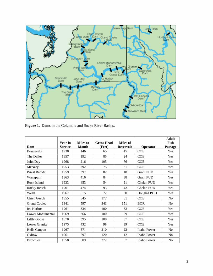
BACKGROUND Adult fish passage facilities were incorporated into 13 mainstem Columbia and Snake River dams as early as 1933 at Rock Island Dam with the latest dam construction at the Bonneville new powerhouse in 1981. Upstream passage of adult salmonids was blocked in the Columbia River with the completion of Grand Coulee Dam by 1938, and in the Snake River at Brownlee Dam in 1958 (Figure 1). Mainstem passage issues were addressed as each dam was built to assure that salmon species could pass and migrate safely to upstream spawning areas. Criteria were developed and refined through the years to achieve known hydraulic conditions within a fishway that were basically within the fishes’ swimming abilities. In addition, research studies or modeling studies have been accomplished that have shown areas in the fishways where passage problems existed; be it potential migration delays or, in extreme cases, mortality of upstream migrating adult fish. The COE and PUDs are to operate their fish facilities within standards in the agreed upon Fish Passage Plan at COE projects or according to standards to meet the NOAA Fisheries Biological Opinions (BiOp) and/or Habitat Conservation Plans (HCP) at the PUD projects. The operating agencies are responsible for maintenance of the fish facilities and for operating them at the agreed upon criteria year round, with special or annual maintenance accomplished during the winter maintenance period. Planned fishway outages occur mainly when adult fish passage is minimal, during the winter season. Repairs and other maintenance issues that could affect passage of adult fish during the fish passage season require special coordination between the operating entities and the fishery agencies and tribes. At the COE and PUD dams, project personnel are required to daily inspect adult fish facilities. Most adult fishways operate in an automatic mode and require no manual adjustments unless the equipment
2
malfunctions. All fishways can be operated in Manual Mode should the automatic control system malfunction. Project operators or fishway attendants will normally restore an out-of-criteria item in the fishway as soon as the discrepancy is found or a Trouble Report issued if the problem requires additional mechanical, electrical, or other support to repair the item. The State and Federal fishway inspectors schedule an inspection of the fish facilities with project personnel and check into the project office or with the project biologist prior to initiating an inspection. The inspectors are responsible for contacting project operations personnel to review the inspection and coordinate problems that require correction. A completed copy of the inspection report can be left at the project or later sent to the COE project operations biologist or PUD personnel. The FPC fishway coordinator receives a copy of the inspection report, reviews it, and then follows up on problem areas that were earlier noted or discussed with the COE project or district fish biologists. Key items recorded during an inspection include: • Powerhouse operations including number of turbines operating and at what Megawatt or flow level,
number of spill bays operating and quantity of spill, water temperature and turbidity, • Weir gate depths or width of gate opening at the main fishway entrances, • Hydraulic head differentials at the entrances and along the channels, • Water velocities in the collection or transportation channels, • Head differentials across trashracks and picketed leads, • Depth of water over the fish ladder weirs, • Condition or readability of staff gages or water level sensors and related controlling equipment for
the fishway elevations, • A comment section to list special conditions or out-of-criteria areas, and where applicable,
Inspections of juvenile fish facilities are normally completed while on site. The Fish Passage Center has been coordinating fishway inspections at the mainstem Columbia and Snake River projects since 1984. The 2016 season was a continuation of the long-term inspection program that the State and Federal fish agencies have endorsed since the 1960s. Funding for the inspection program is provided from Idaho Department of Fish and Game (IDFG), Oregon Department of Fish and Wildlife (ODFW), Washington Department of Fish and Wildlife (WDFW), National Oceanic and Atmospheric Administration (NOAA), and the United States Fish and Wildlife Service (USFWS).
3
Figure 1. Dams in the Columbia and Snake River Basins.
Dam Year in Service
Miles to Mouth
Gross Head (Feet)
Miles of Reservoir Operator
Adult Fish
Passage Bonneville 1938 146 65 45 COE Yes The Dalles 1957 192 85 24 COE Yes John Day 1968 216 105 76 COE Yes McNary 1953 292 75 61 COE Yes Priest Rapids 1959 397 82 18 Grant PUD Yes Wanapum 1963 416 84 38 Grant PUD Yes Rock Island 1933 453 54 21 Chelan PUD Yes Rocky Reach 1961 474 93 42 Chelan PUD Yes Wells 1967 515 72 30 Douglas PUD Yes Chief Joseph 1955 545 177 51 COE No Grand Coulee 1941 597 343 151 BOR No Ice Harbor 1961 334 100 32 COE Yes Lower Monumental 1969 366 100 29 COE Yes Little Goose 1970 395 100 37 COE Yes Lower Granite 1975 432 98 39 COE Yes Hells Canyon 1967 571 210 22 Idaho Power No Oxbow 1961 597 120 12 Idaho Power No Brownlee 1958 609 272 57 Idaho Power No

4
GENERAL RESULTS With few exceptions, the Fish and Wildlife Agencies inspected adult fish facilities at 13 mainstem Columbia and Snake River dams on a monthly basis from March/April through October/November. Fish agency inspection reports and results were normally coordinated with COE and PUD operations biologists or operations personnel at the time of the inspection. Factors affecting fishway operations and/or the ability to inspect fishways at the mainstem dams during the 2016 fish passage season are listed below: • The January to July runoff volume at The Dalles Dam was approximately 97.6 million acre-feet or 96
percent of normal (1981–2010) and the April to August runoff volume at Lower Granite Dam was approximately 17.4 million acre-feet or 83 percent of normal (1981–2010). There was spill at most projects during the spring and summer months to improve passage conditions for the juvenile fish migrations in the Snake and Columbia rivers.

5
SUMMARY BY PROJECT Fishway inspections by the State and Federal fishery agencies were completed at the 13 mainstem dams between March and October with NOAA inspecting Bonneville, and McNary; FPC inspecting Ice Harbor; PSMFC inspecting Lower Monumental dam; FPC/CRITFC inspecting Priest Rapids and Wanapum dams; WDFW inspecting Rock Island, Rocky Reach, and Wells dams; and ODFW inspecting The Dalles, John Day, Little Goose and Lower Granite dams.
AGENCY INSPECTOR DAMS INSPECTED FPC/CRITFC David Benner/Tom Skiles Priest Rapids & Wanapum NOAA Gary Fredricks Bonneville NOAA Jeff Brown McNary ODFW Howard Takata The Dalles & John Day ODFW Anne Dowdy Little Goose & Lower Granite FPC David Benner Ice Harbor PSMFC Monty Price Lower Monumental WDFW Brandon Haynes Wells WDFW Mauro Solorio Rock Island & Rocky Reach
Results from inspections are summarized by project below. Dates of inspections and problem areas are noted as well as special activities that occurred during the year. Criteria used to evaluate operations of a fishway are found in the FPP or Operating Plans for each project.
CORPS OF ENGINEER DAMS The four lower Columbia River dams, Bonneville to McNary dams, and the four Snake River dams, Ice Harbor to Lower Granite dams comprise the COE projects that were constructed with adult fishways incorporated into their original designs. Fish turbines or fish pumps along with gravity-flow systems were integrated into the fishway designs to supply water to the adult fishways. These eight COE dams have collection channels across the downstream face of the powerhouses with main fishway entrance gates at each end of the channel. Along the face of the collection channel, openings (orifice or sluice gates) were provided to allow entrance for adult fish approaching and passing along the powerhouses. In recent years, many of these collection channel gates have been closed and only the main entrance gates located at each end of the powerhouse are now operated. Most spill schedules have been modeled at the COE’s hydraulic laboratory in Vicksburg, Mississippi, and were designed to improve juvenile passage at the dams, reduce high levels of dissolved gas entrainment in the tailwater at the projects, and still provide good passage conditions for adult fish approaching the projects. In many cases, the juvenile and adult spill schedules are similar. Normally, the COE has Project biologists stationed at each dam that complete fishway inspections on a daily basis.

6
BONNEVILLE DAM (photographs on page A-x) Bonneville Dam has two powerhouses: the original powerhouse (PH1) constructed in the late 1930s and located on the Oregon shore or south shore of the Columbia River, and the new powerhouse (PH2) completed in 1980/81 and located on the Washington or north shore of the Columbia River. PH1 consists of ten main turbine units while PH2 has eight main turbine units and two smaller fish turbines that supply auxiliary water to the Washington shore fishway. Between the two powerhouses is the spillway (part of the original construction) that incorporates 18 spillbays to pass excess or designated flow past the project. Gravity-flow water supplies flow to the main fishway entrances at PH1 and the spillway entrances. At PH2, the two fish turbines each supply a maximum of 5,000 cfs of water to the auxiliary water system that distributes flow to the four main entrances and the orifice gates along the powerhouse collection channel. In recent years, numerous improvements have been installed in Bonneville Dam fishways intended to aid in the passage of adult Lamprey. In 2002, a Lamprey Passage System (LPS) was designed and installed in the Bradford Island fishway exit. In 2004, the Bradford Island LPS was extended to the forebay and added PIT-tag readers and resting boxes. In 2007, a dual ramp LPS was installed in the Auxiliary Water Supply (AWS) channel of the Washington Shore Fishway. Also in 2007, nighttime tests were conducted at Washington Shore Entrances that compared standard head differentials (1–2 feet) versus reduced head differentials (0.5 feet) in an effort to evaluate if reduced entrance velocities would improve lamprey entrance rates. Results of the 2007 tests showed some variation in the number of lamprey entering the ladder during reduced nighttime head differentials between the north and south entrances; as a result, the tests were repeated in 2009 with more study blocks. At the Cascade Island fishway, “keyhole” entrance weirs were installed in 2009 and intended to aid lamprey in entering the ladder by providing a wider opening at the bottom of the weir with reduced entrance velocities making it easier for lamprey to negotiate. In addition to the modified entrance weir, rock floors, a PIT-tag reader, and a prototype LPS were added to the Cascade Island ladder in 2009. More recent improvements (2010/2011) to the Bonneville Dam fishways intended for lamprey include raising the Washington Shore picketed leads by 1.5 inches along with adding a ramp up to the base of the picketed leads to improve the use of the LPS in the AWS channel and to reduce the use of the serpentine section of the Washington Shore fishway (known problem area for lamprey). The picketed leads at the Washington Shore count station were replaced in 2012 with ¾-inch gap pickets. Over the winter maintenance period of 2012/2013, several notable lamprey improvements were made at Bonneville Dam.
1. Bonneville Washington Shore entrance Lamprey Flume: Installed the prototype Lamprey Flume System (LFS) at the North Downstream Entrance intended to provide a bypass route around the fishway. A conventional Lamprey Passage Structure (LPS/lamprey ramp) connects to the terminus of the LFS and terminates in a holding tank on the tailrace deck.
2. Bonneville Cascade Island LPS modifications: Being converted into a fully volitional passage route with an exit directly into the forebay, adjacent to the Cascades Island fish ladder exit.

7
Nine adult fishway inspections have taken place at Bonneville Dam:
Date Inspector(s), Agency March 25, 2016 Gary Fredricks (NOAA) April 8, 2016 Gary Fredricks (NOAA) May 6, 2016 Gary Fredricks (NOAA) June 3, 2016 Gary Fredricks (NOAA) July 15, 2016 Gary Fredricks (NOAA) August 12, 2016 Gary Fredricks (NOAA) September 9, 2016 Gary Fredricks (NOAA) October 21, 2016 Gary Fredricks (NOAA) November 4, 2016 Gary Fredricks (NOAA)
Bradford Island (PH1) Fishway The auxiliary water supply to the fishway is gravity-flow water from the forebay of the project. The auxiliary water source normally supplies required flow to meet fishway criteria through high and low tailwater elevations. The Bradford Island Fishway main entrances are operated in pairs (i.e., Gate 2 and Gate 64, or Gate 1 and Gate 65 depending on tailwater elevation). PH1 Inspections Weir Gate 1/2, located at the south end of PH1, had head differentials (site reading) that ranged between 0.9 ft and 1.4 ft and met criteria (1.0 ft) during eight of nine fishway inspections in 2016. During the August 12th, 2017 inspection, the head differential at Weir Gate 1/2 was slightly below criteria at 0.9 ft. The gate depths at Weir 1/2 ranged from a low of 2.5 ft to a high reading of 10.7 ft for the season. The gate depth was less than 8 ft during one of the nine inspections. During the September inspections the tailwater was below 10 ft. At tailwater elevation 13.5 ft or less, gate depth of 8 ft or > will exceed conduit pressure of 10 psi. With the sill at elevation 2 ft, any tailwater less than 10 ft will also result in gate depths of less than 8 ft. The Bonneville southern powerhouse tailwater was below 10 feet during the September inspection. Weir Gate 64/65 was operating during each inspection in 2016. The gate depths at the A-Branch entrance (Gate 64/65) ranged from 2.3 ft. to 8.7 ft., with head differentials through the season ranging from 1.4 ft to 1.8 ft. The gate depth was less than 8 ft. during one of the nine inspections (September) when the tailwater was too low to achieve criteria (less than 10 ft.). The head differential at the A-branch entrance was within criteria (1.0–2.0 feet) during all nine inspections in 2016. South Spillway or B-branch Fishway and the North Spillway or Cascades Island Fishway is part of the original fishway system at Bonneville Dam. Gravity flow water is supplied from the forebay, through a diffusion system and exits through the downstream entrance gates at the lower end of the fish ladder. It should be pointed out that the diffusion system suppling water to the A-Branch has developed some leaks, leading inspectors to note the presence of a “geyser.” Both fishways have similar main entrances (design-wise) with side and downstream entrances that operate as continuously open free-flowing vertical slots. Adjacent to each entrance is a spill bay (1 or 18) that is operated at a minimum of 4–6 inches open and passes about 1.8 Kcfs of water. Each main entrance is operated to meet the head differential criteria of 1.0 to 2.0 ft with a preferred head differential of 1.5 ft. The B-branch Fishway (South Spillway) head differentials ranged between 1.1 and 2.1 feet and were within criteria during all nine inspections in 2016. It should be pointed out that the B-Branch tailwater gauge was missing/not readable during five of the nine inspections in 2016, head differentials during these periods came from PLC readings.

8
The Cascades Island (North Spillway) entrances were operated throughout 2016. Head differentials at the Cascades Island fishway ranged from 1.3 to 1.8 ft. and were operated within criteria during all nine inspections in 2016. Cascade Island tailwater gauge was missing/not readable during all eight of nine inspections in 2016, head differentials came from PLC readings. Fish Ladder: Depth of water measured over the Bradford Island fish ladder weirs ranged from 1.0 to 1.2 ft. in 2016. The Bradford Island weirs were within criteria during all inspections in 2016. The depth of water measured at A-Branch weir ranged from 1.0 ft. to 1.3 ft. during the year, meeting criteria during all inspections in 2016. The depth of water measured at the B-Branch weir ranged from 1.0 ft. to 1.2 ft. during the 2016 fishway inspection season, meeting criteria during each inspection. At the Cascades Island fish ladder, water depth over the weirs ranged from 0.9 ft. to 1.2 ft.; readings were within criteria during seven inspections of 2016, two inspections (April and October) fell just short of the 1.0 ft. minimum criteria (0.9 ft.). The fish ladder exit at Bradford Island was reported as clean during eight of nine inspections in 2016. During the August Inspection the Bradford Island exit was noted as not clean. PH2 Fishway Fish Turbine Units F1 and F2 each supply a maximum of 5,000 cfs of water to the four main entrances and 12 orifice gates along the powerhouse collection channel. With the exception of F2 being off during the September inspection due to low tailwater, both fish turbines operated satisfactorily throughout the fish migration season in 2016. Head differentials measured at the main entrances, North Upstream, North Downstream, South Upstream, and South Downstream ranged between 0.9 ft and 1.7 ft at the North entrance gates with the South entrance gates reporting head between 0.6 ft and 1.3 ft. Most readings at both the South and North shores were equal or greater than the 1.0 ft minimum with the exception of the October inspection when both SUE and SDE were 0.9 ft. and 0.6 ft., respectively. During both the April and July inspections, one of the four Washington Shore entrances recorded a head differential just shy of criteria (0.9 ft). Missing/broken/dirty staff gauges during four of the nine fishway inspections at the Washington shore Fishway lead to limited visual readings, in some cases electronic readings were utilized. Gate depths at the Washington Shore Fishway ranged between 4.9 ft. and 14.6 ft. for the season. Gate depth criteria at the Washington Shore Fishway is dependent upon the tailwater elevation. At tailwater elevations greater than 14 feet, the depths over the Washington Shore Entrances should be 13 feet or greater; at a tailwater below 14 feet entrance gates should be fully lowered. The lowest gate depths in 2016 came during the September Inspection when F2 was off due to low tailwater. In 2016, all Washington Shore gates were operated to criteria, given tailwater depths. Along the Washington Shore powerhouse collection channel, floating orifice gates were operated well throughout inspections in 2016. Fish Ladder: The fish ladder exit and the serpentine section of the Washington fish ladder was reported clear of debris during all nine inspections during 2016. Water depth measured over the Washington fish ladder weirs was 1.0 ft to 1.2 ft at Weir 67 and was within the required range for all inspections in 2016 when the ladder was in service.

9
Table 1. Pertinent Data for Fish Facility Inspections in 2016 at BONNEVILLE DAM.CRITERIA ITEMS DATE OF INSPECTIONBradford Island Fishway 25-Mar 8-Apr 6-May 3-Jun 15-Jul 12-Aug 9-Sep 21-Oct 4-NovBradford Island EntrancesCriteria: (Head Differ. = 1.0-2.0 ft); (Weir Depth + 8 ft or >); (Depth over ladder weirs = 1-1.3 ft); (Velocity + 1.5-4.0 ft)Head at A-Branch entrance ft 1.5 1.6 1.4 1.6 1.8 1.5 1.6 1.7 1.8Depth over Gate 64/65 ft 8.2 8.4 8.7 8.4 8.1 8.6 2.3 8.4 8.3Head at South ph entrance ft 1.0 1.3 1.1 1.4 1.3 0.9 1.3 1.1 1.0Depth over Gate 1/2 ft 9.3 10.4 10.7 10.1 9.7 9.3 2.5 9.2 9.8Channel Velocity fps 2.5 2.4 2.5 2.5 2.8 2.8 1.5 2.6 2.5Depth- Bradford Is. ladder weirs ft 1.0 1.0 1.0 1.2 1.0 1.0 1.0 1.0 1.0Depth - A-Branch ladder weirs ft 1.1 1.1 1.1 1.3 1.1 1.1 1.0 1.1 1.1Exit clean (Yes or No) yes yes yes yes yes no yes yes yes
B-Branch EntranceHead at B Branch entrance ft 1.7 1.2 1.3 1.1 1.2 1.3 2.1 1.0 2.0Staff gages clean no no no no no yes yes yes yesDepth over ladder weir ft 1.0 1.0 1.0 1.2 1.0 1.0 1.0 1.0 1.0
Cascades Island EntranceHead at main entrance ft 1.6 1.5 1.3 1.5 1.9 1.3 1.8 1.6 1.7Staff gages clean no no no no no no no no yesDepth over ladder weir ft 1.0 0.9 1.0 1.2 1.0 1.0 1.0 0.9 1.0
Washington Shore FishwayWA Shore Entrance:Depth over entrance weir (Criteria = 13.0 ft or >) NUE ft 13.2 14.0 14.6 13.6 14.4 12.7 5.0 12.5 12.8 NDE ft 13.2 14.2 13.7 13.6 12.9 12.6 4.9 11.0 11.3 SUE ft 13.2 13.6 13.6 13.6 12.2 11.7 5.1 12.3 12.7 SDE ft 13.2 13.6 13.6 13.5 12.3 11.5 5.0 12.4 12.8Head at entrance (Criteria = 1.0-2.0 ft) NUE ft 1.2 1.2 1.5 1.4 1.1 1.6 1.2 1.7 1.6 NDE ft 1.0 0.9 1.1 1.2 1.1 1.3 1.3 1.1 1.4 SUE ft 1.0 1.2 1.0 1.0 1.1 1.1 1.1 0.9 1.2 SDE ft 0.9 1.1 0.9 1.0 0.9 1.1 1.3 0.6 1.0
Depth over ladder weir (67) ft 1.0 1.0 1.0 1.2 1.0 1.0 1.0 1.0 1.0OOS 2.3 2.3 2.3 2.3 2.3 2.5 2.5 2.3
Ladder exit clean yes yes yes yes yes yes yes yes yesStaff gages clean yes yes yes yes no yes no no no
Comment # (if applicable) 1 2 2 2 2 3 4Comments:1. No tailwater staff gauges for bradford, bbranch, or Cascades Is ladders. ACCH velocity meter not in service.2. No tailwater staff gauges for bradford, bbranch, or Cascades Is ladders.3. No tailwater staff gauges for bradford, bbranch, or Cascades Is ladders, bradford exit needed cleaning.4. F2 off due to low tailwater and AWS needs.
Channel Velocity (Elect. Meter)
10
Summary and Recommendations Areas of note at Bonneville Dam in 2016:
• During the August Inspection the Bradford Island exit was noted as not clean. • Most head differential readings at the Washington Shore Fishway were equal or greater than the
1.0 ft. minimum (considering tailwater elevations) with the exception of the October when both SUE and SDE were 0.9 ft. and 0.6 ft., respectively.
• As stated for the last several years, many staff gauges around the Bonneville fishways are broken or missing. Some of the gauges are visible at certain tailwater elevations and not at others, while other gauges, particularly at the spillway and NDE at the Washington Shore Fishway, are missing altogether. These unreadable/broken/missing staff gauges combined with failures of the PLC systems can make it difficult to determine if the project fishways are within criteria. This issue has been discussed at recent Fish passage Operations and Maintenance (FPOM) meetings and is in the process of being corrected.

11
THE DALLES DAM (photographs on page A-x) The Dalles Dam was completed in 1957 with 22 main turbine units and two smaller turbine units. The two smaller turbines, Units F-1 and F-2, were part of the original construction and supply attraction flow water to the main fishway entrance gates on the Oregon fishway. The spillway is located between the powerhouse and north shore fishway and incorporates 20 spillbays to pass excess or designated flow past the project. Approximately 5,000 cfs of water was originally distributed from these small turbines to the East, West, and South fishway entrances as well as to the orifice gates along the powerhouse collection channel. The closure of the orifice gates along the powerhouse collection channel in 2000 changed flow requirements to about 4,200 to 4,500 cfs to meet depth and head criteria at these main entrances. In the early 1990s, Wasco County PUD installed a small turbine on the old auxiliary water supply at the Washington shore fishway. This turbine normally supplies about 800 cfs through the diffusers to the operating entrance, usually Gate N-1. In recent years, improvements have been implemented in The Dalles Dam fishways intended to aid in the passage of adult Lamprey. In the East Fish Ladder, ladder weir orifices have been chamfered (2-inch radius) in the lower section, lamprey plating has been installed, picketed leads have been raised 1.5 inches off the fishway floor, and the count slot slightly modified to provide better attachment points for lamprey. In the North Fish Ladder, ladder weir orifices have been chamfered (2-inch radius) and picketed leads have been raised 1.5 inches off the fishway floor. Seven adult fishway inspections have taken place at The Dalles Dam:
Date Inspector(s), Agency March 29, 2016 Howard Takata (ODFW) April 27, 2016 Howard Takata (ODFW) May 26, 2016 Howard Takata (ODFW) June 23, 2016 Howard Takata (ODFW) July 27, 2016 Howard Takata (ODFW) August 24, 2016 Howard Takata (ODFW) September 28, 2016 Howard Takata (ODFW)
Results of the inspections are discussed below and listed in Table 2. East Fishway Inspections The East fishway entrance gates (E-2 and E-3) were submerged 8.0 feet or greater on all inspections in 2016 (11.9-13.4 ft.). Head differentials ranged from 1.3 ft. to 1.7 ft. The East fishway entrances were operating within established criteria range for gate depths (8 ft. or >) and head differentials met criteria during all inspections in 2016. The East entrances generally pass the majority of the fish at The Dalles. The West fishway entrances (W-1 and W-2) were submerged 8.0 feet or greater on all inspections during 2016. The gate depths ranged from 8.2 ft. to 13.5 ft. with head differential readings that ranged from 1.3 ft. to 1.7 ft. All inspections met criteria in 2016 at the West Entrances.

12
Flow to the South fishway entrances (S-1 and S-2) occurs through a separate channel that originates in the junction pool and ends near the South end of the spill basin. S-1 and S-2 met weir depth criteria in all seven inspections in 2016, ranging from 8.2 ft. to 9.3 ft. Head differentials ranged between 1.3 ft. and 1.5 ft. at S-1 and S-2, meeting criteria during all seven inspections. Fish Ladder: The picketed leads located at the Oregon fish counting station were reported clear of debris on all inspections. The depth of water over the fish ladder weirs ranged between 1.0 ft and 1.3 ft during the season, meeting criteria on all inspections. The exit was reported clear of debris on all inspections. North Shore Fishway Inspections At the Washington fishway, a single fish turbine supplies flow through a diffuser system and to the main fishway entrance. The turbine is screened and a juvenile bypass facility is incorporated in the design and operation of the facility. Wasco PUD has operated the facility since the early 1990s. The fishway equipment and associated facilities operated satisfactorily throughout the 2016 fish passage season. Flow was sufficient to meet gate depth and head differential criteria at the North Shore for all inspections this season. The North entrance gate, N-1, was operated throughout the fish passage season. Gate depths ranged from 9.4 to 10.0 feet over the season. Head differentials at N-1 ranged from 1.2 to 1.5 ft. The Washington fishway was operated within criteria during all inspections in 2016. Fish Ladder: The ladder exit was reported clear of debris on all inspections and the PUD trash racks were reported clear of debris on all 2016 inspections. The picketed leads were reported clear of debris during all inspections during the passage season. The depth of water recorded over the ladder weirs showed the fish ladder in proper criteria during all seven inspections with a range of 1.0 ft. to 1.1 ft. Summary and Recommendations The Oregon and the Washington fishways at The Dalles Dam were operated very well in 2016. All aspects of the fishways were within criteria during the fish facility inspections completed in 2016.

13
Table 2. Pertinent Data for Fish Facility Inspections in 2016 at THE DALLES DAM.CRITERIA ITEMS
DATE OF INSPECTIONSOUTH SHORE FISHWAY 29-Mar 27-Apr 26-May 23-Jun 27-Jul 24-Aug 28-SepEast Entrance:Depth over entrance weirE-1 (gate set at elev. 83.5 ft) ft na na na na na na naE-2 (crit. = 8 ft or >) ft 13.1 13.4 12.5 11.9 13.0 13.1 12.9E-3 (crit. = 8 ft or >) ft 13.1 13.4 12.5 12.0 13.1 13.0 13.0Head at main entrance (crit. = 1-2 ft) ft 1.3 1.5 1.5 1.7 1.5 1.6 1.4
Depth over ladr. weir (crit. = 1-1.3 ft) ft 1.0 1.0 1.0 1.3 1.0 1.0 1.0Ladder exit clean (yes or no) yes yes yes yes yes yes yesSelsyns/PLC operating (yes or no) yes yes yes yes yes yes yesPicket leads clean (yes or no) yes yes yes yes yes yes yesWest Entrance:Depth over entrance weirW-1 (crit. = 8 ft or >) ft 11.2 13.4 9.0 9.4 8.4 8.2 9.6W-2 (crit. = 8 ft or >) ft 11.2 13.5 9.0 9.4 8.4 8.3 9.6W-3 (crit. = 8 ft or >) ft na na na na na na naHead at main entrance (crit. = 1-2 ft) ft 1.3 1.4 1.7 1.5 1.5 1.4 1.6South Entrance:Depth over entrance weirS-1 (Crit. = 8 ft or >) ft 9.3 8.6 8.3 8.6 8.4 8.2 8.3S-2 (Crit. = 8 ft or >) ft 9.3 8.5 8.3 8.6 8.4 8.3 8.2Head at main entrance (Crit. = 1-2 ft) ft 1.3 1.4 1.5 1.5 1.4 1.4 1.5
NORTH SHORE FISHWAYNorth Shore Entrance:Depth over entrance weirN-1 (crit. = 8 ft or >) ft 9.6 9.8 9.6 9.9 10.0 9.8 9.4Head at main entrance (Crit. = 1-2 ft) ft 1.4 1.4 1.5 1.4 1.2 1.3 1.4
Depth over ladr. weir (Crit. = 1-1.3 ft) ft 1.1 1.0 1.0 1.0 1.0 1.0 1.0Ladder exit clean yes yes yes yes yes yes yesSelsyns operating yes yes yes yes yes yes yesPicket leads clean yes yes yes yes yes yes yesPUD trash rack clean (yes or no) yes yes yes yes yes yes yes
Comment Number (if applicable)Comments

14
JOHN DAY DAM (photographs on page A-x)
John Day Dam is a COE-operated project that went on-line for power production in 1968 with 16 main turbine units and twenty spillbays located on the north end of the powerhouse. Major changes to the project have been the addition of spillway deflectors into the spillbays and the addition of a screened juvenile fish bypass system. The spillway deflectors allow additional flow to pass through spill without greatly increasing dissolved gas levels at the project. Three turbine-driven pumps pull water from the tailwater of the dam and this water supplies attraction flow for adult fish passing the Oregon shore adult fishway. This water is supplied through a floor diffuser system and exits from one main entrance on the south shore and two main entrances at the north end of the powerhouse. The project can normally operate two of the three pumps to meet criteria levels of the main entrances as well as the floating orifice gates along the powerhouse collection channel. Six electric pumps are operable on the Washington shore to supply water to the diffusers located at the lower end of the fish ladder. However, a maximum of only four pumps (normally three pumps) can operate at any one time at the north shore. Beginning in 2000, only one main entrance gate at the north end of the spillway was operated rather than two as in previous years. The exit section of the Oregon fish ladder was modified prior to the 2003 fish passage season. No longer is the section a serpentine-like ladder, but is now more similar to The Dalles north shore fish ladder exit. The modification has been successful in reducing holding of fish in the fish ladders while still providing a good passage route from the overflow weir section to the exit from the fish ladder. Over the winter of 2009/2010 a similar modification occurred on the north shore fish ladder and included lamprey passage improvements. Seven adult fishway inspections have taken place at John Day Dam:
Date Inspector(s), Agency March 29, 2016 Howard Takata (ODFW) April 27, 2016 Howard Takata (ODFW) May 26, 2016 Howard Takata (ODFW) June 23, 2016 Howard Takata (ODFW) July 27, 2016 Howard Takata (ODFW) August 24, 2016 Howard Takata (ODFW) September 28, 2016 Howard Takata (ODFW)
Table 3 lists the criteria items and the inspection dates for 2016, with the text below detailing some of the results. South (Oregon Shore) Fishway Inspections Gate SE-1 was operated at the South Shore Fishway throughout the season. The gate depth ranged from 7.3 to 10.3 ft. over the seven inspections. The head differential ranged from 1.1 ft. to 1.5 ft. for the season. All SE-1 head differentials and all but one gate depth met criteria during the 2016 fishway inspection season. During the March 29, 2016 inspection, south fish pumps one and two were out of service causing the SE-1 entrance gate depth to be slightly below criteria (8 ft.). Overall, entrance conditions at Gate SE-1 should have provided satisfactory fish passage during the 2016 inspections conducted by ODFW.

15
The North powerhouse entrance gates, NE-1 and NE-2, operated at head differentials within the range of 1.3 to 1.9 ft. with gate depths that ranged from 7.8 ft. to 11.7 ft. Gate depth and head differential criteria were met at NE-1 and NE-2 throughout the 2016 fishway inspection season, with the exception of the NE-2 entrance gate being closed during the March inspection and both NE-1 and NE-2 being slightly below criteria during the September 28, 2016 inspection. Attraction flows from these gates should have provided satisfactory conditions for adult fish approaching those entrance gates over 2016.
Table 3. Pertinent Data for Fish Facility Inspections in 2016 at JOHN DAY DAM. CRITERIA ITEMS
DATE OF INSPECTIONSOUTH SHORE FISHWAY 29-Mar 27-Apr 26-May 23-Jun 27-Jul 24-Aug 28-SepSouth Shore Entrance:Depth over entrance weirSE-1 (Crit. = 8 ft or >) ft 7.3 8.6 10.3 9.2 9.3 8.1 8.9Head at SE-1 (Crit. = 1-2 ft) ft 1.3 1.4 1.3 1.2 1.1 1.5 1.5Dep. over ladr. weir (Crit.=1.0 +/-0.1) ft [normal] & 1.3 ft shad season) ft 1.0 1.0 1.0 1.3 1.0 1.0 1.0
Ladder exit clean (Yes or No) yes yes yes yes yes yes yesStaff gages clean (Yes or No) yes yes yes yes yes yes yesPicket Leads Clean (Yes or No) yes yes yes yes yes yes yesPumps operating 1 2 2 2 2 2 2Rpm for pumps 68 64 58/60 59/60 59/60 59/60 60
North Powerhouse Entrance:Depth over entrance weirNE-1 (Crit. = 8 ft or >) ft 8.0 11.7 8.0 8.1 8.1 8.0 7.8NE-2 (Crit. = 8 ft or >) ft OOS 11.6 8.1 8.3 8.0 8.0 7.8Head at NE-1&2 (Crit. = 1-2 ft) ft 1.9 1.3 1.8 1.3 1.4 1.5 1.5
Staff gages clean (yes or no) yes yes yes yes yes yes yes
NORTH SHORE FISHWAYNorth Shore Entrance:Depth over entrance weirN-1 (Crit. = 8 ft or >) ft fixed fixed fixed fixed fixed fixed fixedHead at N-1(Crit. = 1-2 ft) Targ - 1.5' ft 1.6 1.4 1.4 1.4 1.6 1.6 1.4
Depth over ldr weir (Crit.=1.0 +/-0.1) ft 1.0 1.1 1.1 1.2 1.0 1.0 1.0Ladder exit clean yes yes yes yes yes yes yesStaff gages clean yes yes yes yes yes yes yesPicket leads clean yes yes yes yes no yes yes
Pumps Operating 3 4 3 3 3 3 3
Comment number (if applicable) 1 2 2 2 3 2
Comments:1. South fish pumps 1 and 2 were OOS due to bearing failure, pump #3 was operating at higher RPM to compensate. Pump #2will return later this week, NE-2 was closed and SE-1 was out of criteria due to pump situation.2. Sourth Fish Pump #1 OOS.3. South Fish Pump #1 OOS, north picketed leads need cleaning.

16
Fish Ladder: The exit from the fish ladder, staff gauges, and the picketed leads were all reported as clean during all inspections in 2016. The fishway exit was noted as clean during all inspections in 2016. The depth of water measured over the ladder weirs was 1.0–1.3 ft. for the 2016 season and were within the criteria range during all inspections. North Shore Fishway Inspections The north shore fishway entrance (N-1) has been replaced with a variable-width weir that is at a fixed elevation. Therefore, there is no longer an 8-foot depth criterion at the North Shore fishway. There continues to be head differential criteria at the N-1 entrance. In 2016, the head differentials at N-1 were maintained between 1.4 ft and 1.6 ft (targeted 1.5 ft) and met criteria during all inspections in 2016. Fish Ladder: The exit from the ladder and the picketed leads at the count station were reported clear of debris on all inspections for the 2016 season. The depth over the North Shore ladder weirs met criteria during all 2016 inspections. Summary and Recommendations Overall, the main entrances at the Oregon and the Washington fishways were operated within criteria levels during the majority of the 2016 fish passage season. Overall, the fishways at John Day were operated well in 2016.
17
MCNARY DAM (photographs on page A-x) McNary hydroelectric project is a COE-operated dam completed in 1953. Fourteen main turbine units and 22 spillbays are incorporated in this dam. The Oregon and Washington shore fish ladders incorporate full overflow weirs and have submerged orifices in each weir. On the Oregon fishway, three large electric fish pumps pull water from the tailrace of the project plus about 1,000 cfs of gravity flow from the forebay, and supply water to the main entrance gates located at each end of the powerhouse. Twelve floating orifice gates operate along the powerhouse collection channel with each gate supplying about 60 cfs of water to attract adult fish into the channel. In the mid-1990s, the water supply for the Washington fishway was changed from the pressurized system to a non-pressurized system as Wasco/Klickitat PUDs installed a small turbine on the water supply from the forebay that produces electricity for the PUD and also supplies flow (about 1,500 to 1,700 cfs) to meet gate depth and head differential requirements for the two main entrance gates. With the construction of the new juvenile bypass system, about 450 cfs of water (bleed-off from the bypass flow) is routed to the north end of the powerhouse and enters the fishway via a screened area at the NPEs. Seven adult fishway inspections took place at McNary Dam in 2016:
Date Inspector(s), Agency April 29, 2016 Jeff Brown (NOAA) May 18, 2016 Jeff Brown (NOAA) June 22, 2016 Jeff Brown (NOAA) July 22, 2016 Jeff Brown (NOAA) August 24, 2016 Jeff Brown (NOAA) September 27, 2016 Jeff Brown (NOAA) October 31, 2016 Jeff Brown (NOAA)
Results of the inspections are discussed below with Table 4 displaying data collected from each inspection. The project typically can meet criteria standards operating with two of the three pumps at the Oregon fishway. When three pumps operate, the angle opening normally ranges between 20°–24°. When two pumps operate the blade angle is typically increased several degrees to help achieve fish way criteria under fewer pumps. In 2016, blade angles were limited to 26 degrees due to electrical issues http://www.nwd-wc.usace.army.mil/tmt/documents/FPOM/2010/NWW%20Memos%20of%20Coordination%20and%20Notification/MCN%20MOC%20and%20MFR/15MCN13%20MFR%20Fish%20pump%201%20and%203%20tripped%20offline.pdf. In addition to the pumped and gravity-flow water, about 450 cfs of water from the juvenile bypass system is added to the north end of the powerhouse. Wall screens are present to exclude adult fish from entering this water source. South Shore (Oregon) Fishway Inspections During 2016, Fish Pump #2 was out of service during the entire inspection season and the Oregon Fishway at McNary Dam was therefore limited to a two pump operation. The main entrances at the south shore (SFEW-1 & 2) were reported with gate depths that ranged between 7.7 ft and 8.2 ft for the year. The gate depth criteria at SFEW 1 and 2 is now 8.0 feet or greater (2013 change to the Fish Passage Plan: 13MCN004 2.3.2.2. Ladder Depth Criteria). Most inspections in 2016

18
were at or above the 8.0-foot gate depth criteria, with the exception of both the August and October inspections when one of the two entrance gates was slightly below the criteria level. During the August 24th, 2016 Inspection, entrance gate SFEW-2 was just 0.1 ft. below the 8.0 ft. entrance weir criteria, and during the October 31st, 2016 Inspection entrance gate SFEW-1 was 0.3 ft. below criteria. The head differentials ranged from 1.2 to 1.4 ft. at SFEW-1 & 2, with all inspections having head differentials within criteria. The north powerhouse entrances, NFEW 2 and 3, operated over 2016. North powerhouse entrances were primarily very close to or above criteria during all seven inspections recorded in 2016 as gate depths ranged from 7.5 ft. to 8.1 ft. During the May, June and September inspections, five of six gate depths were just shy of the 8.0 ft. criteria, at 7.9 ft. During the August 24th, 2016 inspection, both the North Powerhouse entrances were below criteria (7.5 and 7.6 ft.) with a pump angle of 24 degrees (limited to 24 degrees in warm weather periods). With the blade angles on fish pumps limited to a maximum of 26 degrees under ideal (cooler) periods in 2016, gate depth criteria sometimes could not be achieved, this was magnified during warmer moths when pumps were the most restricted. The North Powerhouse head differentials ranged from 1.2 ft. to 1.4 ft., and were at or above criteria during all inspections in 2016. Surface velocity was estimated at the northern and southern end of the collection channel by timing a wood chip or floating object a given distance along the channel. Water velocity was between 2.9 fps and 3.2 fps at the north end of the collection channel (North Powerhouse). Water velocities at the southern end of the powerhouse ranged between 1.4-1.6 fps. Water velocity met criteria during all inspections in 2016 at the northern end of the powerhouse, while velocities during two inspections at the southern end of the powerhouse were slightly (0.1 fps) below the minimum velocity criteria (1.5 fps). Fish Ladder: The South Shore Fishway picketed leads were reported clean during all inspections in 2016. The ladder exit were reported clear of debris during all inspections in 2016. The depth of water reported over the south fishway ladder weirs ranged from 1.0 ft to 1.2 ft. and was within criteria on all inspections. North Shore (Washington) Fishway Inspections The Washington shore fishway entrances WFE 2 and 3 were operable over 2016. The Washington shore fishway entrances were submerged from 7.6 ft. to 9.5 ft., meeting criteria (8 ft. or greater) during all inspections expect during the June 22, 2017 inspection. During the June inspection, both Washington shore entrance gate depths were below criteria (7.6 ft. and 7.8 ft.). Head differentials at the Washington shore fishway ranged from 1.1 ft. to 1.5 ft. Head differentials were operated within acceptable criteria range throughout all of the 2016 season. Fish Ladder: The fishway exit was reported as clean during all seven inspections in 2016. The picketed leads were reported as clean during all inspections in 2016. The depth of water reported over the north fishway ladder weirs ranged from 1.0 ft. to 1.1 ft. and were within criteria during all inspections in 2016. Summary and Recommendations Overall, the fishways at McNary Dam operated satisfactorily considering the limitation to two fish pumps for the entire 2016 fishway season. Some problem areas to note are:
• Fish Pump #2 was out of service during the entire 2016 inspection season. • During several inspections in 2016, gate depths were operated close to the minimum criteria
levels, resulting in multiple cases where gate depths were slightly below criteria. During these

19
periods, although only two fish pumps were available, the two operable fish pumps were restricted in output due to electrical issues.
Table 4. Pertinent Data for Fish Facility Inspections in 2016 at MCNARY DAM.
CRITERIA ITEMSDATE OF INSPECTION
SOUTH SHORE FISHWAY 29-Apr 18-May 22-Jun 22-Jul 24-Aug 27-Sep 31-OctSouth Shore Entrance:Depth over entrance weir (Criteria: 8 ft or > gate depth at SFEW-1,2 & NFEW-1,2)SFEW-1 ft 8.1 8.1 8.0 8.2 8.0 8.1 7.7SFEW-2 ft 8.1 8.0 8.0 8.1 7.9 8.1 8.1Head at SFEW-1,2 (Crit.= 1-2 ft) ft 1.3 1.4 1.3 1.2 1.2 1.2 1.2
Dep. over ladr. weir(Crit.= 1-1.3’) ft 1.2 1.2 1.0 1.1 1.0 1.0 1.0Channel velocity (Crit.= 1.5-4.0 fps) fps 3.2 3.0 2.9 3.0 3.2 2.9 3.1Ladder exit clean yes yes yes yes yes yes yesPicket leads clean yes yes yes yes yes yes yesOrifice Gates Operating - 12 yes yes yes yes yes yes yesPumps Operating & degrees open 2--26 2--24/26 2--25/26 2--24/26 2--24 2--26 2--24/25
North Powerhouse Entrance:Depth over entrance weirNFEW-2 ft 8.0 7.9 7.9 8.0 7.6 7.9 8.1NFEW-3 ft 8.0 7.9 7.9 8.0 7.5 8.0 8.0Head at NFEW-2&3 (Crit. = 1-2 ft) ft 1.8 1.4 1.4 1.1 1.3 1.4 1.4
WA.SHORE FISHWAYNorth Shore Entrance:Depth over entrance weir WFE-2 (Crit. = 8 ft or >) ft 8.4 8.8 7.6 9.2 8.5 9.2 9.0 WFE-3 (Crit. = 8 ft or >) ft 8.6 8.8 7.8 9.5 8.4 9.2 9.1Head at WFE-2&3 (Crit. = 1-2 ft) ft 1.5 1.2 1.4 1.1 1.2 1.1 1.2
Dep. over ladr. weir (Crit. = 1-1.3 ft) ft 1.1 1.1 1.0 1.0 1.0 1.0 1.1Ladder exit clean yes yes yes yes yes yes yesPicket leads clean yes yes yes yes yes yes yes
Comment number (if applicable) 1
Comments:1. Floating orifice gates 3 and 4 were stuck down during ispection, Bio thought was due to rapidly declining TW,these gates were rehabbed last winter.

20
ICE HARBOR DAM (photographs on page A-x) Ice Harbor Dam was the initial dam constructed in the lower Snake River and was completed in 1961. The COE-operated project has six main turbine units and ten spillbays to pass water at the dam. A Removable Spillway Weir is now in place at the project and is operated throughout most of the fish passage season. The adult fish passage facilities consist of a separate water supply system for the south and for the north shore fishway. Attraction flow to the south fishway is supplied by up to eight electric pumps and about 200 cfs bleed-off flow from the juvenile bypass system. The juvenile bypass flow is added into the pumped water supply system. Five to eight fish pumps operate, depending on the tailwater elevation. Under most river flow conditions, the project should have the capability to maintain the south fishway within acceptable criteria for gate depth and head differential. Two electric fish pumps supply attraction water to the north shore fishway with the pumped flow normally able to meet criteria under high to medium flow conditions. The north shore fishway does have three pumps available, but can operate only two at one time due to electrical constraints. Improvements have been installed in fishways at Ice Harbor Dam intended to aid in the passage of adult lamprey. Adult lamprey passage improvements were made to upper fish ladder weirs at Ice Harbor Dam during the winter of 2011/2012. These included cutting horizontal slots in weirs at the fishway floor to allow adult lamprey attachment through a level pathway through the weir. Ramps were installed from the fish ladder floor to the bottom of elevated salmon orifices in the upper ladder weirs to assist lamprey moving through these areas. Additionally, plates were installed on diffuser grating adjacent to orifices in the Ice Harbor north fish ladder to provide attachment surfaces for lamprey in higher-velocity areas. Six adult fishway inspections have taken place at Ice Harbor Dam:
Date Inspector(s), Agency April 27, 2016 David Benner (FPC) June 8, 2016 David Benner (FPC) July 28, 2016 David Benner (FPC) August 25, 2016 David Benner (FPC) September 29, 2016 David Benner (FPC) November 10, 2016 David Benner (FPC)
Details of the inspections are found in Table 5 and a summary of the inspections reported in the section below. South Shore Fishway Inspections Five or six fish pumps were operating on all inspections completed this season. Excess flow from the juvenile bypass system and pumped flow water is passed through diffusers to supply water to the main fishway entrances and the orifice gates along the powerhouse collection channel. The South shore entrance gate (SFEW-1) was submerged from 7.5 ft. to 8.5 ft. during the 2016 season. Gate SFEW-1 did not meet the 8-foot depth criteria during the last five inspections in 2016. During the last four inspections of 2016, gate SFEW-1 was recorded on sill and could not be lowered further. However, during the June 8th, 2016 Inspection, the recorded gate depth at SFEW-1 was 7.7 feet, with this entrance weir set several feet above sill, entrance criteria could have been met (8.0 ft.) had the gate been dropped closer to the sill elevation. During the inspections on June 8th, 2017 an operator was informed of SFEW-1 being less than criteria and not near the sill elevation; the depth of this gate was immediately

21
increased to meet the 8 foot criteria. Head differentials measured at SFEW-1 ranged from 1.4 ft. to 1.9 ft. for the season. Head differential criteria were met during all inspections in 2016.
Table 5. Pertinent Data for Fish Facility Inspections in 2016 at ICE HARBOR DAM.CRITERIA ITEMS 27-Apr 8-Jun 28-Jul 25-Aug 29-Sep 10-Nov
SOUTH SHORE FISHWAYSouth Shore Entrance:Depth over entrance weirSFEW-1 ( Crit. = 8 ft or >) ft 8.5 7.7 7.5 7.7 7.5 7.9Head at SFEW-1 (Criteria = 1-2 ft) ft 1.8 1.8 1.9 1.4 1.7 1.8Gate on Sill (yes or no) 332.25 no no yes yes yes yes
Dep. over ladr. weir (Cr. = 1-1.3 ft) ft 1.3 1.3 1.2 1.2 1.2 1.2Channel velocity (Crit. = 1.5-4 fps) fps 1.7 1.8 2.0 2.5 2.6 2.3Ladder exit clean (yes or no) yes yes yes yes yes yesStaff gages clean (yes or no) yes yes yes yes yes yesPicket leads clean (yes or no) yes yes yes yes yes yesPumps Operating (8 available) 6 5 5 5 5 5
North Powerhouse Entrance:Depth over entrance weirNFE-2 (Criteria = 8 ft or >) ft 11.7 10.3 7.5 7.6 7.6 7.5Head at NFE-2 (Criteria = 1-2 ft) ft 1.1 1.1 1.5 1.4 1.7 1.8Gate on Sill (yes or no) 332.25 no no yes yes yes yesStaff gages clean ft yes yes yes yes yes yes
NORTH SHORE FISHWAYNorth Shore Entrance:Depth over entrance weirNEW-1 (Criteria = 8 ft or >) ft 10.1 9.2 6.2 7.0 8.0 7.4Head at NEW-1 (Criteria = 1-2 ft) ft 1.4 1.5 2.4 1.8 1.2 1.7Gate on Sill (yes or no) 332.25 no no yes yes no yes
Dep. over ladr. weir (Crit. = 1-1.3 ft) ft 1.2 1.2 1.1 1.0 1.1 1.2Ladder exit clean yes yes yes yes yes yesStaff gages clean yes yes yes yes yes yesPicket leads clean yes yes yes yes yes yesPumps Operating (3 available) 2 2 2 2 2 2
Comment Number (if applicable) 1 2
Comments:1. Unit #5 OOS, no orifice open in gatewells- discussed at FPOM, opened.2. SFEW-1 slightly out of criteria- talked with operator who made adjustements.
22
The north powerhouse entrance gate (NFE-2) was operating with weir depths that ranged between 7.5 ft. and 11.7 ft. for the season. Gate NFE-2 did not meet the 8-foot depth criteria during the last four inspections in 2016 (July through November). During the last four inspections when criteria were not met, NFE-2 was recorded on sill. Head differentials measured at NFE-2 ranged from 1.1 ft. to 1.8 ft. for the season. Head differential criteria were met during all inspections in 2016. Four floating orifice gates operated satisfactorily along the powerhouse collection channel throughout the fish passage season. The collection channel velocity meter was functional for all six inspections in 2016. The water velocity in the collection channel during over the 2016 season ranged between 1.7 and 2.6 fps; all recorded channel velocities were within the desired range (1.5–4.0 fps). Fish Ladder: The exit from the fish ladder was reported clear of debris on all inspections. The picketed leads located at the counting station were also recorded as clean on all inspections. Depth of water over the ladder weirs was reported between 1.2 and 1.3 ft. for the six inspections, all within criteria. North Shore Fishway Inspections Gate NEW-1 was submerged 8.0 ft. or more in depth during three of six inspections. Gate depths ranged from 6.2 ft. to 10.1 ft. During the three inspections of 2016 (July, August, and November), the NEW-1 gate depth was below criteria; however, the gate was on sill and could not be lowered further. Head differentials were reported in the following range: 1.2 ft. to 2.4 ft. Head differentials at the North Shore Fishway were within criteria during all inspections in 2016. Fish Ladder: The exit from the north shore fish ladder and also the picketed leads at the counting station were reported clear of debris throughout the inspection season. Depth of water over the ladder weirs was reported to be 1.0–1.2 ft. for all inspections. All inspections were within criteria. Summary and Recommendations Fish facilities at Ice Harbor appeared to operate well in 2016 considering entrance weir sill elevations. Overall, multiple gate depths did not meet criteria; however, in most cases, gates were operated as low as possible (on sill). There was only one instance in 2016 when entrance gate depth criteria was not met and gates were not at sill elevations (June 8th, 2016, SFEW-1). During this occasion, the operator was notified and the gate was immediately lowered to criteria depth.

23
LOWER MONUMENTAL DAM (photographs on page A-x) The COE completed construction and began operation of Lower Monumental Dam in 1969. Six main turbine units and eight spillbays pass flow at the project. Three turbine-driven pumps pull water from the tailrace and supply water to a conduit that distributes this flow to the diffuser system along the collection channel and the north and south shore collection systems. The south shore fishway has a separate fish ladder, but no separate water supply was added to that side of the dam. After the completion of the new juvenile fish bypass system, about 200 cfs of excess water flow was added to the north shore supply diffusers. Normally the juvenile bypass system operates from March through December. Since that time, and with other changes made to the fish pumps, the project can normally meet gate depth and head differential criteria with two pumps, but standard operating procedure is to operate the three pumps on a continual basis. Floating orifice gates (formerly 4) remain permanently closed at this project. Improvements have been installed in Lower Monumental Dam fishways intended to aid in the passage of adult lamprey. Like those made at Ice Harbor, adult lamprey passage improvements were made to upper fish ladder weirs at Lower Monumental Dam during the winter of 2011/2012. These included cutting horizontal slots in weirs at the floor to allow adult lamprey attachment through a level pathway through the weir. Additionally, ramps were installed from the fish ladder floor to the bottom of elevated salmon orifices in the upper ladder weirs to assist lamprey in maintaining attachment as they move through these areas. Se adult fishway inspections have taken place at Lower Monumental Dam:
Date Inspector(s), Agency April 27, 2016 David Benner, FPC May 31, 2016 Monty Price, PSMFC June 16, 2016 Monty Price, PSMFC July 21, 2016 Monty Price, PSMFC August 6, 2016 Monty Price, PSMFC September 14, 2016 Monty Price, PSMFC
Data from the inspections are reported in the discussion below as well as in Table 6. North Shore Fishway The north shore fishway entrance gates, NSE-1 and NSE-2, were operated with gate depths ranging from 7.9 ft. to 8.7 ft. during the 2016 inspections. Gate depths at NSE-1 and NSE-2 were within criteria for the majority of inspections in 2016, with the one exception of the April 27th, 2016 inspection when NSE-1 and NSE-2 were slightly below criteria (0.1 ft.). Head differentials ranged from 1.2 ft. to 1.8 ft. over the 2016 inspections and were within criteria during all inspections in 2016. Discharge and velocity through the NSE-1 and NSE-2 entrance gates should have provided satisfactory passage conditions at the north shore entrance gates.

24
Table 6. Pertinent Data for Fish Facility Inspections in 2016 at LOWER MONUMENTAL DAM
CRITERIA ITEMSDATE OF INSPECTION
NORTH SHORE FISHWAY 27-Apr 31-May 16-Jun 21-Jul 6-Aug 14-SepNorth Shore Entrance:Depth over entrance weirNSE-1 (Criteria = 8 ft or >) ft 7.9 8.1 8.2 8.2 8.7 8.4NSE-2 (Criteria = 8 ft or>) ft 7.9 8.1 8.2 8.2 8.7 8.4Head at NSE-1 & 2 (Crit. = 1-2 ft) ft 1.2 1.3 1.8 1.6 1.4 1.3Gate on Sill (yes or no) 429ft no no yes yes yes no
Dep. over ladr. weir (Cr. = 1-1.3 ft) ft 1.0 1.2 1.2 1.2 1.0 1.0Channel velocity (Crit. = 1.5 - 4 fps) fps 2.8 2.8 2.8 2.8 2.6 2.9Ladder exit clean (yes or no) yes yes yes yes yes yesStaff gages clean (yes or no) yes yes yes yes yes yesPicket leads clean (yes or no) yes yes yes yes yes yes
South Powerhouse Entrance:Depth over entrance weirSPE-1 (Criteria = 8 ft or >) ft 8.7 6.5 5.2 5.2 5.5 7.5SPE-2 (Criteria = 8 ft or >) ft 8.7 6.5 5.2 5.2 5.5 7.5Head at SPE-1 & 2 (Crit. = 1-2 ft) ft 1.1 1.3 2.0 1.6 1.0 1.3Gate on Sill (Yes or No) 432ft no yes yes yes yes yesStaff gages clean/readable (yes or no) yes yes yes yes yes yes
SOUTH SHORE FISHWAYSouth Shore Entrance:Depth over entrance weirSSE-1 (Criteria = 8 ft or >) ft 10.7 6.0 5.7 5.8 6.2 3.5SSE-2 (permanent) 6-feet ft 6.0 6.0 6.0 6.0 6.0 6.0Head at SSE-1 & 2 (Crit. = 1-2 ft) ft 1.1 1.7 1.6 1.6 1.5 1.2Gate on Sill (yes or no) 431ft yes yes yes yes yes yesDep. over ladr. weir (Crit. = 1-1.3') ft 1.1 1.1 1.1 1.2 1.1 1.0Ladder exit clean yes yes yes yes yes yesPicket leads clean yes yes yes yes yes yes
Pump speed rpm 74/76 74 74 73/75 74 74/75# of Pumps Operating (3 available) 2 2 2 2 2
Comment Number (if applicable)
Comments:

25
An electronic velocity meter located in the northern end of the collection channel gave water velocity readings throughout the 2016 Inspection season. Over 2016, velocities ranged from 2.6 fps to 2.9 fps and were within criteria (1.5–4.0 fps). The south powerhouse entrance gates, SPE-1 and SPE-2, were operated with gate depths ranging from 5.2 ft. to 8.7 ft. The SPE entrances met gate depth criteria (8 ft. or greater) during one of six inspections in 2016; however the SPEs were on sill during all inspections in 2016 that did not meet standard criteria (May through September), so no further depth could be obtained. Head differentials recorded at the SPE gates ranged from 1.0 to 2.0 feet. The head differential readings met standard operating criteria (or sill criteria) during all six inspections in 2016. Fish Ladder: The depth of water over the north shore fish ladder weirs was 1.0–1.2 ft. on all inspections and therefore met criteria during all inspections in 2016. The North fishway exit was reported as clean during all six inspections in 2016. The north picketed leads were reported as clean during all inspections in 2016. Staff gauges were reported as clean during the all inspections in 2016. South Shore Fishway Two south shore entrances are operated (both downstream, no side entrance) to attract fish to the spillway or south fish ladder. All auxiliary water is supplied from the north shore turbine-driven pumps except for the 200 cfs flow that enters from the juvenile bypass system. Gate SSE-2 is a fixed-open gate that remains 6-ft open while Gate SSE-1 is to be submerged 8 ft. or more during normal operation. Gate depths at SSE-1 ranged from 3.5 ft. to 10.7 ft. SSE-1 met standard gate depth criteria during the April Inspection. During all other inspections in 2016, SSE-1 was on sill and could not be lowered any further (sill criteria met). The head differentials at the south entrances ranged from 1.1 ft. to 1.6 ft. and were within criteria for all inspections during the 2016 season. Fish Ladder: The south shore exit was recorded as clear of debris during all 2016 inspections. The picketed lead section at the fish counting station was reported clear of debris for all inspections this season. The depth of water over the ladder weir was 1.0-1.1 ft. during 2016 inspections. Summary and Recommendations Overall, fishways at the project were found to be operating very well considering the constraints of gate sill elevations.

26
LITTLE GOOSE DAM (photographs on page A-x)
Little Goose Dam was completed in fall 1970 and is operated by the COE. The project consists of six main turbine units and eight spillbays to pass flow. A Spillway Weir was installed in spill bay 1 in 2009. The adult fish passage facilities are comprised of one fish ladder located on the south shore, two south shore entrances, a powerhouse collection channel, two entrances at the north end of the powerhouse, and two north shore entrances with a transportation channel underneath the spillway to the powerhouse collection channel. All orifice gates along the powerhouse collection channel were closed in 2001. Three turbine-driven pumps and about 200 cfs excess flow from the juvenile bypass system supply water to the adult fishway. The adult fish facilities can normally operate near acceptable criteria through varying high and low flow conditions. Over the last several years, improvements have been installed in Little Goose Dam fishways intended to aid in the passage of adult lamprey. In 2011, picketed leads were modified near the floor of the adult fish ladder at the count station. This was done to enable adult lamprey passage under the picketed leads, providing a low-velocity passage route for lamprey around the adult fish count slot. Over the 2012/2013 winter maintenance period, horizontal slots were cut in weirs at the floor to allow adult lamprey attachment through a level pathway through the weir. Additionally, ramps were installed from the fish ladder floor to the bottom of elevated salmon orifices in the upper ladder weirs to assist lamprey in maintaining attachment as they move through these areas. Over the summer of 2016, temporary pumps were used from July 1-Spetember 9 to draw 25 cfs of deep forebay near the fishway exit, to help alleviate temperature differentials in the fishway. The temporary pumps pulled water from a depth of 66 feet in the forebay. The long-term thought at Little Goose is to install permanent pumps that draw water from a depth of 80 feet, where a cooler water layer exists. Seven adult fishway inspections have taken place in 2016 at Little Goose Dam.
Date Inspector(s), Agency April 21, 2016 A. Dowdy (ODFW) May 20, 2016 A. Dowdy (ODFW) June 23, 2016 A. Dowdy (ODFW) July 15, 2016 A. Dowdy (ODFW) August 21, 2016 A. Dowdy (ODFW) September 29, 2016 A. Dowdy (ODFW) October 21, 2016 A. Dowdy (ODFW)
Two fish pumps were in use during the April through July inspections as Fish Pump #1 was out of service. During the August through October inspection, all three pumps were in service and utilized. When two pumps were in service, they were operated between 77 and 79 rpm. When all three pumps were in service, operations were between 69-75 rpm. Fishway Inspections In 2016, the Fishway Control System was reprogrammed. During this reprogramming, entrance sill elevations were set elevations that were slightly different than what was known in previous years. For the sake of this report, the elevations set during reprograming were used as the minimum elevations in this report. Some investigation is currently occurring by COE personnel as to the true minimum elevations of these entrance sills. The two South Shore Entrance Gates, SSE-1 and SSE-2, are operated to achieve an
27
8.0 feet or greater weir submergence with a head differential between 1.0 and 2.0 ft. During the 2016 fish passage season, gate depths at the SSEs ranged from 7.5 to 8.8 ft. with head differentials that ranged from 1.1 ft. to 1.7 ft. During the June 23, 2016 inspection, gate depths were below 8 ft.; however, the entrance weir was on sill (according to the reprogramming). In 2016, all gate depths and head differentials met criteria (or sill criteria) during all inspections. The North Powerhouse Entrances, NPE-1 and NPE-2, were operated to meet the depth criteria of 7.0 ft. or greater submergence below tailwater and head differential of 1.0 to 2.0 ft. The gate depths ranged from 4.9 ft. to 7.2 ft. with head differentials that ranged from 1.1 to 1.8 ft. The NPE gates were on sill during all seven inspections in 2016. During five inspections (April through August), gate depth criteria was not met at NPE 1 and 2; however gates were fully down to sill elevations. All head differentials at the north powerhouse entrances were within criteria during each inspection. The water velocity measured at the north end of the collection channel gave readings that ranged from 1.8 fps to 2.0 fps over the seven inspections in 2016; all recordings met the minimum criteria of 1.5 fps. The water velocity measured at the north shore fishway ranged from 1.8 fps to 2.4 fps over the inspections in 2016 (no reading in April); all recordings met the minimum criteria of 1.5 fps. The North Shore Entrances were set to operate at 6.0 ft. or more depth below tailwater, with the head differential in the range of 1.0 ft. to 2.0 ft. NSE-1 gate depths ranged from 4.2 ft. to 6.8 ft. and were on the reprogramed sill elevation during the first five inspections of 2016. NSE-2 gate depths ranged from 4.6 ft. to 6.5 ft. and were also on sill during the first five inspections in 2016. All entrance gate depths met criteria or were on sill during all inspections in 2016. NSE head differentials ranged from 1.1 to 1.6 ft., meeting differential criteria during all seven inspections. Fish Ladder: The fish ladder exit was clean during all inspections in 2016. The picketed lead section of the fish counting facility was reported as clear during all inspection in 2016. The depth of water over the fish ladder weirs was at 1.1 to 1.2 ft. during each inspection in 2016, all within the proper criteria range (1.0-1.3 feet). Staff gauges were reported as clean during inspections in 2016. Summary and Recommendations All in all, the adult fishways at Little Goose Dam were operated in a satisfactory manner considering the limitations of sill elevations. One issue was noted during the 2016 fishway inspection season:
• Fish Pump #1 was Out of Service during the first five inspections of 2016.

28
Table 7. Pertinent Data for Fish Facility Inspections in 2016 at LITTLE GOOSE DAM.
CRITERIA ITEMS 21-Apr 20-May 23-Jun 15-Jul 21-Aug 29-Sep 21-Oct
SOUTH SHORE FISHWAYSouth Shore Entrance:Depth over entrance weirSSE-1 (Criteria = 8 ft or >) ft 8.4 8.9 7.5 8.9 8.1 8.8 8.5SSE-2 (Criteria = 8 ft or >) ft 8.5 8.8 7.6 8.6 8.2 8.8 8.5Head at SSE-1 & 2 (Criteria = 1-2 ft) ft 1.1 1.1 1.3 1.1 1.7 1.6 1.6
Dep. over ladr. weir (Crit. = 1-1.3 ft) ft 1.2 1.2 1.1 1.2 1.2 1.2 1.2Channel velocity (Criteria = 1.5-4 fps) fps 1.8 2.0 1.8 1.9 2.0 1.8 2.2Channel velocity (North Shore) fps na 2.0 1.8 1.8 2.0 2.4 2.4Ladder exit clean (yes or no) yes yes yes yes yes yes yesStaff gages clean (yes or no) yes yes yes yes yes yes yesPicket leads clean (Criteria = 0.3' max) yes yes yes yes yes yes yes
North Powerhouse Entrance:Depth over entrance weirNPE-1 (Criteria = 7 ft or >) ft 6.6 6.2 5.4 5.9 4.9 7.2 7.2NPE-2 (Criteria = 7 ft or >) ft 6.5 6.2 5.3 5.8 5.8 7.1 7.1Head at NPE-1 & 2 (Criteria = 1-2 ft) ft 1.5 1.3 1.6 1.1 1.8 1.4 1.5Gate on Sill (Yes or No) yes yes yes yes yes yes yesStaff gages clean yes yes yes yes yes yes yesPump speed rpm 77/79 79 77/78 79/79 69-70 73-75 73Pumps Operating (3 available) 2 2 2 2 2 3 3
North Shore Entrance:Depth over entrance weirNSE-1 (Criteria = 6 ft or >) ft 5.7 5.4 4.6 5.0 4.2 6.5 6.8NSE-2 (Criteria = 6 ft or >) ft 5.7 5.4 4.6 5.0 5.0 6.5 6.3Head at NSE-1 & 2 (Criteria = 1-2 ft) ft 1.3 1.1 1.2 1.1 1.6 1.3 1.1
Staff gages clean yes yes yes yes yes yes yes
Comment number (if applicable) 1 2 3 4 5 6
Comments:1. NPE did not meet criteria but on sill. NSE did not meet criteria but program is limited to 532.6 ft (sill is 530.6 ft). Tailrace eddy at south, picketed leads rattling (need wedges installed). Pump #1 OOS.2. NPE on sill, NSE restricted to 532.6 ft per fishway program (sill 2 ft below). LGS needs fishway computer system working properly.The upper picketed lead still knocking- needs wedge installed. Pump #1 OOS.3. Same comment about fishway program need updating. Pump #1 OOS.4. Same comment about fishway program need updating. Pump #1 OOS. 3 cooling pumps in operation at exit.5 . Same comment about fishway program need updating. Pump #1 back in service, 3 cooling pumps in operation at exit.6 Fishway returned to auto on aug 9, had probles and returned tomanaul on sept 19, aux pumps off sept 9.
DATE OF INSPECTION

29
LOWER GRANITE DAM (photographs on page A-xx) Lower Granite Dam was the final lower Snake River project constructed by the COE; the project began operation in 1975. The powerhouse consists of six main turbine units and eight spillbays that are equipped with spillway deflectors. A removable spillway weir was incorporated into the south spillbay to pass juvenile fish at the project in 2002. In the fish ladder, an adult fish sampling/trapping facility was incorporated in the original construction of the project. Since that date, major modifications to the facility have occurred. Presently, the site includes modern detection equipment, both CWT and PIT-tag automated detectors that have the ability to shunt adult fish to the holding facility or, in the case of the PIT-tag system, the fish can be separated by its PIT-tag code if desired. A new set of PIT-tag detectors was installed during winter 2003 in the upper exit section of the fish ladder and also worked satisfactorily through 2016. This system provides adult detection capabilities without handling the fish or diverting them to the adult trap return channel. Three electric fish pumps supply water to the fishway; however, only two pumps can be operated at one time. Attraction flows are directed to two south shore entrances, two north powerhouse entrances, four operating orifice gates along the powerhouse collection channel, and two north shore entrances. No excess juvenile bypass water is incorporated into the adult attraction flow system at Lower Granite as occurs at the other three Snake River projects. Over the last several years, improvements have been installed in Lower Granite Dam fishways intended to aid in the passage of adult lamprey. In 2011, picketed leads were raised and secured 1.5″ off of the floor of the adult fish ladder at the count station. This was done to enable adult lamprey passage under the picketed leads, providing a low-velocity passage route for lamprey around the adult fish count slot. Over the 2012/2013 winter maintenance period, horizontal slots were cut in weirs at the floor to allow adult lamprey attachment through the weir. Additionally, ramps were installed from the fish ladder floor to the bottom of elevated salmon orifices in the upper ladder weirs. Over the winter maintenance period of 2015/2016 the COE installed multiple improvements geared toward reducing the upper ladder temperatures at Lower Granite Dam. The intake for the three forebay auxiliary supply pumps was extended from approximately 30 feet deep in the forebay to around 70 feet, which now feeds a 50 cfs “shower” which deposits in front of the fishway exit (a radius of 30-50 feet) (Picture in Appendix A). In 2016, it appeared that the “shower” did have a positive impact in terms of lowering upper fishway temperatures. Additionally, the intake to diffuser #14 was extended from 10-20 feet deep to approximatley 70 feet deep. To accomplish this, the COE used a chimney that extended from slighly above the forebay water surface, covered the intake to diffuser #14, and extended down to a depth of approximatley 70 feet Pict. Diffuser #14 supplies water into the upper overflow section of the Lower Granite Ladder and adult fish trap. Seven adult fishway inspections have taken place at Lower Granite Dam in 2016:
Date Inspector(s), Agency April 22, 2016 A. Dowdy (ODFW) May 19, 2016 A. Dowdy (ODFW) June 24, 2016 A. Dowdy (ODFW) July 25, 2016 A. Dowdy (ODFW) August 26, 2016 A. Dowdy (ODFW)

30
September 30, 2016 A. Dowdy (ODFW) October 27, 2016 A. Dowdy (ODFW)
Details of the inspections can be found in Table 8 and text that follows. Fishway Inspections Two fishway entrances, SSE-1 and SSE-2, are operated on the south shore of the project. The location of the entrances is fairly unique in that SSE-2 is downstream of the SSE-1 entrance by about 150 ft. These two entrance gates are narrow (4-feet wide) compared to most gates at other COE projects. In 2016, gates SSE-1 and SSE-2 operated with depths that ranged from 7.8 ft. to 9.2 ft. and head differentials that ranged from 1.1 ft. to 2.0 ft. During the passage season, gate depths were operated within criteria at the SSE’s during all seven inspection dates, with the exception of the May 19th, 2016 inspection when both SSE 1 and 2 were slightly below criteria. It should be pointed out that although the gate depth criteria were not met according to the FSC readings, gate depths met criteria according to the actual winch elevations. Head differentials at SSE 1 and 2 met criteria for all inspections in 2016. Inconsistencies in the FSC board readings were due to program errors in the new fish ladder control system installed during the 2015-2016 winter maintenance season. Water velocities at the southern end of the collection channel ranged between 1.9 fps to 2.6 fps. Velocity readings were within criteria in the southern end of the collection channel during all inspections in 2016. The North Powerhouse Entrances, NPE-1 and NPE-2, were operated with the gates on sill for six of seven inspections. During all of the inspections that the NPE’s were on sill, the project was unable to meet the 8.0 ft. criteria for gate depth. During the October 27, 2016 inspection when the gates were not on sill, the NPE gates did met or exceeded the 8.0 ft. criteria. Gate depths for the season ranged from 5.6 ft. to 8.1 ft. Head differentials ranged from 1.0 ft. to 1.5 ft. for the season; all seven inspections recorded differential readings within criteria in 2017. For the most part, inspections showed the NPE gates operating within criteria (given the sill elevations); head differentials were also within criteria during all inspections in 2016. At the North Shore Entrances, NSE-2 was closed during all inspections of the year. Reported gate depths at the open NSE-1 entrance ranged between 7.0 and 10.4 feet, and met depth criteria during all inspections. The project also met head differential criteria during all seven inspections at North Shore Entrances over 2016. Fish Ladder: The ladder exit was reported as clean during all seven inspections. The picketed leads (count station) were reported clear of debris during all seven inspections during the fish passage season. The depth of water over the fish ladder weirs ranged between 1.0 and 1.3 ft., and was within criteria during all inspections.

31
Table 8. Pertinent Data for Fish Facility Inspections in 2016 at LOWER GRANITE DAM.CRITERIA ITEMS DATE OF INSPECTION
SOUTH SHORE FISHWAY 22-Apr 19-May 24-Jun 25-Jul 26-Aug 30-Sep 27-OctSouth Shore EntranceDepth over entrance weirs
ft 8.2 7.8 9.0 8.3 8.2 8.0 8.0ft 8.2 7.8 9.2 8.3 8.2 8.0 8.0ft 1.5 1.5 1.1 1.1 1.2 1.3 2.0
ft 1.2 1.0 1.1 1.1 1.1 1.1 1.3fps 2.6 2.1 2.1 1.9 2.1 2.1 2.4
Channel velocity (n shore) 1.7 NA 1.6 1.7 2.2 1.5 1.9Ladder exit clean (yes or no) yes yes yes yes yes yes yesStaff gages clean (yes or no) yes yes yes yes yes yes yesPicket leads clean (yes or no) yes yes yes yes yes yes yes
North Powerhouse Entrance:Depth over entrance weir
6.9 6.8 6.6 5.6 5.9 6.4 8.16.7 6.8 6.6 5.6 5.9 6.4 8.11.5 1.4 1.4 1.1 1.0 1.2 1.5
Gate on sill (Yes or No) yes yes yes yes yes yes no
Staff gages clean yes yes yes yes yes yes yes North Shore Entrance:
10.4 7.0 7.6 7.1 7.1 7.0 7.1 NSE-2 (Criteria = 7 ft or >) Closed closed closed closed closed closed closedHead at NSE-1&2 (Criteria = 1-2 ft) 1.2 1.3 1.2 1.3 1.3 1.1 1.3Staff gages clean yes yes yes yes yes yes yes
Ladder Exit Cooling Pumps (On/Off) Off Off On On on off off
Comment number (if applicable) 1 2 3
Comments:
NPE-2 (Criteria = 8 ft or >)Head at NPE-1&2 (Criteria = 1-2 ft)
2. SSE short of criteria via FSC Board, but meet criteria with winch readings. Saw attraction lights.
SSE-1 (Criteria = 8 ft or >) SSE-2 (Criteria = 8 ft or >)Head at SSE-1 & 2 (Crit. = 1 - 2 ft)
Depth over ladr. Weir (Crit.= 1-1.3 ft)Channel velocity (Crit. = 1.5-4 fps)
NPE-1 (Criteria = 8 ft or >)
Depth over entrance weir NSE-1 (Criteria = 7 ft or >)
1. NSE-1 manually positioned on sill, NSE-2 closed. Unable to detect attraction lighting at NPE, but told its working.
3. Could not see attraction lighting, ladder cooling "donut" in operation (began June 5, 2016).

32
Summary and Recommendations Overall, Lower Granite Dam fishway operators did an excellent job of maintaining fishway criteria in 2016. Taking into account sill limitations, only one inspection had only slightly below criteria (0.2 ft.) gate depths (May 19, 2016), and during this inspection, criteria was met according to visual winch readings.

33
PUBLIC UTILITY DISTRICT PROJECTS The Public Utility District Projects are comprised of five mainstem Columbia River dams from Priest Rapids Dam located above the free-flowing Hanford Reach section of the Columbia River to Wells Dam located about 45 miles upstream from Wenatchee, Washington. Grant County PUD owns and operates the lower two dams, Priest Rapids and Wanapum dams; Chelan County PUD – Rock Island and Rocky Reach dams; and Douglas County PUD – Wells Dam. These dams use a variety of pump systems or gravity-flow water to supply AWS channels that feed this water through diffusion systems into the main collection chambers. At Priest Rapids and Wanapum dams, orifice gates along the powerhouse collection were sealed off in 2002, and these gates will remain closed in future years. Adult fish will be attracted to and passed only through the main entrance gates. Rocky Reach still operates with six orifice gates along its powerhouse collection channel. Wells and Rock Island dams do not have orifice gates along their powerhouses; main entrance gates are located at each end of the powerhouse channel to attract fish to the fish ladder. In addition to the adult fish facilities, spill has been the main passage route that juvenile fish are bypassed to below an individual project. Spill schedules have been developed to assist juvenile fish passage but not impact adult fish passage. In 2003, a permanent surface bypass collector to pass juvenile salmonids was completed at Rocky Reach Dam and will continue to operate in future years. Inspections of adult fish facilities are summarized for the individual projects in the sections below.
PRIEST RAPIDS DAM (photographs on page A-xx) Construction of Priest Rapids Dam was completed in 1959. The hydropower plant contains ten main turbine units and 22 spillbays. The project is owned and operated by Grant County Public Utility District (GPUD). The adult fish facilities consist of two fishways, one located on the left bank and the other on the right bank of the Columbia River. Make-up water for the lower end of the fish ladder is stored in Auxiliary Water Supply (AWS) pools at each bank. The AWS pools are filled by five electric pumps that pull water from the tailrace and a Gravity Intake Gate (GIG) that pulls water from the forebay of the project. AWS pool water is channeled through a diffusion system (mostly floor diffusers) into the collection channel (left bank only) and lower end of the fish ladder at both shores of the project. The main slotted entrance on the Left Bank fishway is located at the eastern end (shore entrance) and the western end of the powerhouse. All orifice gates were closed along the powerhouse collection channel in late summer 2001. One main slotted entrance is operated at the right bank fishway. Adult PIT-tag detectors were added to the right and left bank fish ladders prior to the 2003 fish passage season. Seven adult fishway inspections took place at Priest Rapids Dam in 2016:
Date Inspector(s), Agency April 26, 2016 Skiles (CRITFC), Benner (FPC) May 24, 2016 Skiles (CRITFC), Benner (FPC) June 26, 2016 Skiles (CRITFC) July 27, 2016 Benner (FPC) August 24, 2016 Benner (FPC) September 28, 2016 Benner (FPC) October 25, 2016 Skiles (CRITFC)
An operator, a fish biologist or fish technician, and an engineer from Grant County PUD normally accompanied inspectors during the inspections. The adult fishways are computer controlled and computer

34
printouts identifying set points and actual readings can be generated as needed. The computer-generated readings are normally compared to the site readings to assess whether calibration of the equipment was necessary, or if tailwater elevations or project operations were changed during the inspection. Left Bank Fishway Slotted entrance LSE-2 is located at the western end of the powerhouse and it was open continually throughout the fish migration season. The head differential target is 1.2 feet at LSE-2, with an acceptable range of 1 to 2 feet. Head differentials ranged from 1.5 ft to 2.0 ft over the seven inspections. The project was operating at acceptable criteria during the 2016 inspection season as the head differential was within the 1- to 2-foot range and always greater than the 1.2 ft target for the all of the seven inspections. Slotted entrance LSE-4 is located on the eastern end of the powerhouse and operated continually throughout the fish migration season. The head differential target is 1.5 feet at LSE-4, with an acceptable range of 1 to 2 feet. Head differentials ranged from 1.4 ft to 1.8 ft over the seven inspections. During the 2016 inspection season all the head differentials meet the criteria range and four inspections were equal or greater than the target of 1.5 feet. Water velocity in the collection channel was estimated at the upstream end of the powerhouse channel and readings ranged between 1.5 and 2.8 fps. Water velocities in the collection channel were equal or above the 1.5 fps criteria on all inspections over the 2016 season. Fish Ladder: At the left bank fish ladder, the depth of water over the ladder weirs ranged between 1.0 and 1.1 ft during all seven inspections. All depth over left bank ladder weir readings were within the acceptable range of 1–1.2 feet. The exit from the fish ladder was clear of debris for the season and the staff gauges were reported clean during all inspections on the left bank fishway. Right Bank Fishway Slotted Entrance RSE-1 operated during the 2016 fish passage season. RSE-1 is required to operate within the following range: 1.0 to 2.0 ft for head differential with the target being 1.5 ft. RSE-1 had head differentials ranging from 1.2 to 1.5 ft for the season. RSE-1 was operated within the acceptable criteria range of 1.0 to 2.0 ft during each fishway inspection in 2016. RSE-1 was within head differential target levels during two of the seven inspections. Fish Ladder: The depth of water reported over the fish ladder weirs was at 1.0–1.2 ft on all inspections in 2016. The depth over the right bank ladder weir was within criteria for each inspection in 2016. The ladder exit was reported clear of debris on all inspections and the right bank staff gauges were reported clean during all inspections in 2016.

35
Summary and Recommendations
• Overall, Priest Rapids Fishways were found to be in good condition in 2016. Entrance head differentials met criteria at all entrances in 2016.
Table 9. Pertinent Data for Fish Facility Inspections in 2016 at PRIEST RAPIDS DAM.CRITERIA ITEMS
LEFT BANK FISHWAY 26-Apr 24-May 26-Jun 27-Jul 24-Aug 28-Sep 25-OctLeft Bank Entrance:
Head at main entrances (Criteria = 1-2 ft)LSE-2 (1.2 ft target) ft 2.0 1.9 1.6 1.7 1.5 1.5 2.0
LSE-4 (1.5 ft target) ft 1.4 1.6 1.4 1.4 1.8 1.7 1.7
Depth over ladr. weir (Crit. = 1-1.2 ft) ft 1.1 1.0 1.0 1.1 1.0 1.0 1.0
Water velocity (Crit. = 1.5-4 fps) fps 2.0 2.8 2.3 2.5 2.5 1.5 1.9
Ladder exit clean (Crit. = yes or no) yes yes yes yes yes yes yes
Staff gages clean (Crit. = yes or no) yes yes yes yes yes yes yes
RIGHT BANK FISHWAYRight Bank Entrance:Head at Entrance (Criteria = 1-2 ft)RSE-1 (1.5 ft target) ft 1.4 1.2 1.4 1.5 1.4 1.5 1.3
Depth over ladr. weir (Crit. = 1-1.2 ft) ft 1.2 1.1 1.2 1.2 1.0 1.0 1.0
Ladder exit clean (Crit. = yes or no) yes yes yes yes yes yes yes
Staff gages clean (Crit. = yes or no) yes yes yes yes yes yes yes
Comment number (if applicable)
Comments:
36
WANAPUM DAM (photographs on page A-xx) Wanapum Dam hydro project was completed in 1963 with ten main turbine units for power production and 12 spill gates to pass excess flow. The project is owned and operated by Grant County PUD. Two turbine-operated pumps that pull water from the tailwater of the dam and are driven by gravity flow water from the forebay of the dam supply make-up water to the left bank Auxiliary Water Supply (AWS) pool. Two 10-foot diameter butterfly valves provide a backup system for the turbine-driven pumps. Fishway water flows through the two main slotted fishway entrances: LSE-2 at the eastern end of the powerhouse (shore), and LSE-3 at the western end of the powerhouse. Auxiliary water for the right bank fishway is a gravity-flow system that pulls water from the forebay of the dam. This water normally supplies sufficient flow to the diffusers located in the lower end of the fish ladder to meet head differential criteria established for slotted entrance, RSE-2. Seven adult fishway inspections took place at Wanapum Dam in 2016:
Date Inspector(s), Agency April 26, 2016 Skiles (CRITFC), Benner (FPC) May 24, 2016 Skiles (CRITFC), Benner (FPC) June 26, 2016 Skiles (CRITFC) July 27, 2016 Benner (FPC) August 24, 2016 Benner (FPC) September 28, 2016 Benner (FPC) October 25, 2016 Skiles (CRITFC)
A summary of the inspections is listed in Table 10 and in the text below. Left Bank Fishway The east slotted entrance LSE-2 operates as the primary entrance with a head differential criterion of 1.0 ft to 2.0 ft and a target of 1.5 ft. Slotted entrance LSE-2 operated within a range of 1.4 ft to 1.9 ft over seven inspections in 2016. Head differentials at LSE-2 were within the acceptable criteria range over the entire season (1–2 feet) and at or above the target head differential for five of seven inspections in 2016. Entrance conditions for adult fish at LSE-2 should have been excellent throughout the 2016 migration season. The operational criterion for LSE-3 head differential is from 1.0 ft. to 2.0 ft. with the targeted head differential of 1.2 ft. LSE-3 operated within the following range: 1.3 ft. to 1.8 ft. for the fish passage season. The head differential target at LSE-3 was exceeded during all inspections in 2016. LSE-3 should have provided excellent entrance conditions for adult fish throughout the 2016 passage season. Water velocity was estimated at the upstream end of the powerhouse channel and readings ranged between 1.5 and 2.2 fps. All readings met or exceeded the minimum criteria of 1.5 fps during the 2016 Inspection season. Fish Ladder: The depth of water over the left bank fish ladder weirs was 1.0 to 1.1 ft. during each inspection in 2016; all readings were satisfactory for the season. The ladder exit was clear of debris on all inspections in 2016.

37
Right Bank Fishway The right bank slotted entrance RSE-2 is targeted to operate with a head differential of 1.2 ft. and within the range of 1.0 ft. to 2.0 ft. RSE-2 was operated with head differentials that ranged from 1.4 ft. to 1.7 ft. during the 2016 season. All inspections met and exceeded the head differential target in 2016. Fish Ladder: The right bank fish ladder operated with a depth of water over the weir crests ranging between 1.0 ft. and 1.1 ft. for the season. All readings were satisfactory for the season. The fish ladder exit was clear of debris and staff gauges were clean on all inspections. Summary and Recommendations Overall, the Wanapum Dam fish facilities were well maintained throughout the 2016 fish passage season.

38
Table10. Pertinent Data for Fish Facility Inspections in 2016 at WANAPUM DAM.
CRITERIA
LEFT BANK FISHWAY 26-Apr 24-May 26-Jun 27-Jul 24-Aug 28-Sep 25-OctLeft Bank Entrance:Head at entrances (Criteria = 1-2 ft) LSE-2 (target head = 1.5 ft) ft 1.6 1.4 1.6 1.7 1.9 1.5 1.4
LSE-3 (target head = 1.2 ft) ft 1.7 1.6 1.8 1.5 1.4 1.3 1.6
Dep. over ladr. weir (Crit. = 1.0-1.2ft) ft 1.0 1.1 1.1 1.1 1.0 1.0 1.1
Channel velocity (Crit. = 1.5-4.0 fps) fps 1.8 1.9 2.2 2.0 2.0 2.0 1.5
Staff gages clean (Crit. = yes or no) yes yes yes yes yes yes yes
Auxiliary H20 Pumps rpm 99/0 135/141 138/141 136/137 117/139 99/102 97/102
Ladder exit clean (Crit. = yes or no) yes yes yes yes yes yes yes
RIGHT BANK FISHWAYRight Bank Entrance:Head at Entrance (Criteria = 1-2 ft)RSE-2 (target head = 1.2 ft) ft 1.6 1.5 1.7 1.4 1.6 1.6 1.5
Depth over ladder weir ft 1.1 1.0 1.0 1.1 1.0 1.0 1.1
Ladder exit clean yes yes yes yes yes yes yes
Staff gages clean yes yes yes yes yes yes yes
Comment number (if applicable)Comments:
DATE OF INSPECTION

39
ROCK ISLAND DAM (photographs on page A-xx) The Rock Island hydro-project is owned and operated by Chelan County PUD. The dam is comprised of two powerhouses: an old powerhouse with ten main turbine units that was constructed in 1933, with a major upgrade of the turbine units in 1953. A new powerhouse with eight main turbine units and located on the right bank of the Columbia River was completed in 1979. The spillway, consisting of 32 spillbays, is located between the two powerhouses. Several spill gates have been notched to provide “surface flow” for the juvenile fish to pass downstream of the project. The old powerhouse adult fish facilities consist of the left bank fishway and the middle or spillway fishway, with the right bank fishway located at the new powerhouse. Gravity-fed water is used to supply attraction flows to the fishways at the old powerhouse with a combination of pumped and gravity-fed water at the new powerhouse. Each fishway has a fish counting station located near the top of the fish ladder and new PIT-tag systems located in the exit section of each ladder. The final installation of the adult PIT-tag system was completed prior to the 2004 adult fish passage season. Seven adult fishway inspections have taken place at Rock Island Dam in 2016:
Date Inspector(s), Agency April 19, 2016 Solorio (WDFW) May 25, 2016 Solorio (WDFW), Benner (FPC) June 22, 2016 Solorio (WDFW) July 20, 2016 Solorio (WDFW) August 17, 2016 Solorio (WDFW) September 21, 2016 Solorio (WDFW) October 26, 2016 Solorio (WDFW)
Results and discussion of the inspections follow in the text below and in Table 11. Left Bank Fishway Gravity-fed water is supplied from the forebay to the lower end of the left bank fish ladder through diffuser gratings. This auxiliary water supplies sufficient flow to allow Gates LO5 and LO6 to operate at 6.0 ft or greater depth with a corresponding head differential of 1.0 ft. minimum at all tailwater elevations. Gates LO5 and LO6 were submerged a similar depth during the 2016 season. Gate depths ranged from 6.8 ft. to 9.3 ft. Left bank fishway head differentials ranged between 1.3 ft. and 1.5 ft. The gate depth and head differential readings were all found within acceptable criteria range through the 2016 inspection season. Fish Ladder: Depth of water measured over the left bank fish ladder weirs was 1.0-1.1 ft. during all inspections of the 2016 passage season. The trash racks located at the exit from the fish ladder and the picketed leads at the counting station were clear of debris during all the inspections. Middle Fishway Gravity-fed water from the forebay of the dam supplies water to the lower end of the fish ladder through floor diffusers. The end gate and a fixed-open side gate operate to attract adult fish from the spillway section of the dam. The end gate, MO3, is required to operate at 8.5 ft. or greater depth below tailwater,

40
while the side gate is continually open and depends on head differential to be within acceptable criteria. The head differential required for both gates is the standard 1.0-ft to 2.0-ft range. Gate MO3 depths recorded at the Middle Ladder during the inspections ranged from 8.2 ft. to 10.1 ft. with head differentials that ranged from 1.2 ft. to 1.8 ft. Middle fishway gate depths and head differentials at the entrances met criteria during all inspections in 2016 with the exception of the gate depth being slightly below criteria during the September 21st, 2016 inspection. Fish Ladder: The depth of water over the fish ladder weirs was reported as 1.0-1.1 ft during all seven inspections in 2016. The picketed leads and the ladder exit were clear of debris during the inspections. Right Bank Fishway Auxiliary water is supplied to the right bank fishway from three fish pumps that pull water from the tailwater and gravity-fed water from the forebay of the dam. Most of this flow enters the fishway in the lower end of the fish ladder through sidewall diffusers. This attraction water is distributed to an entrance at the downstream end of the project, one main entrance at the left end of the powerhouse, and through two entrances at the right end of the powerhouse. Each entrance has a 3-foot wide opening, but its depth will increase as flow and tailwater elevation increases. The entrances are operated to meet head differential criteria of 1.0 to 2.0 ft. In addition to the entrance flow, a high velocity flow of water is discharged below the water surface near the right powerhouse entrances. The purpose of this high velocity flow is to attract fish to the right powerhouse entrances from across the face of the dam. The three pumps are normally operated at 60%–100% open with the gravity water valve operated at 35%-100% open. The entrance gates, TPE, LPE, and the RPEs were reported with head differentials that ranged from 0.9 ft to 1.7 ft throughout the season. Head differentials at the right fishway were met during all inspections in 2016 except for the TRE entrance during the June 22nd, 2016 inspection when this entrance was slightly below the minimum criteria (0.9 feet). During this inspection flows and tailwater (575.6 feet) were very high. As in past years, the right fishway has struggled to meet head differential criteria at all four entrances when the tailwater was above 574.5 feet. Water velocity recorded in the powerhouse transportation channel was measured using a portable flow meter; velocities ranged between 1.5 to 4.5 fps during the inspections. Even with these higher-measured water velocities in the Rock Island transport channels, adult fish pass through both channel sections with little or no delay based on radio telemetry studies. Fish Ladder: Depth of water measured over the ladder weirs was 1.0–1.1 ft. for all seven inspections at the right ladder and met criteria in all inspections in 2016. The exit from the fish ladder was clear of debris during all inspections, as were the picketed lead section at the fish counting station. Summary and Recommendations
Overall, fishway attendants at Rock Island Dam have done a good job of maintaining adult fishway criteria. The only minor fishway issue at Rock Island Dam occurred during the September 21, 2016 inspection when the M03 entrance was slightly below depth criteria.
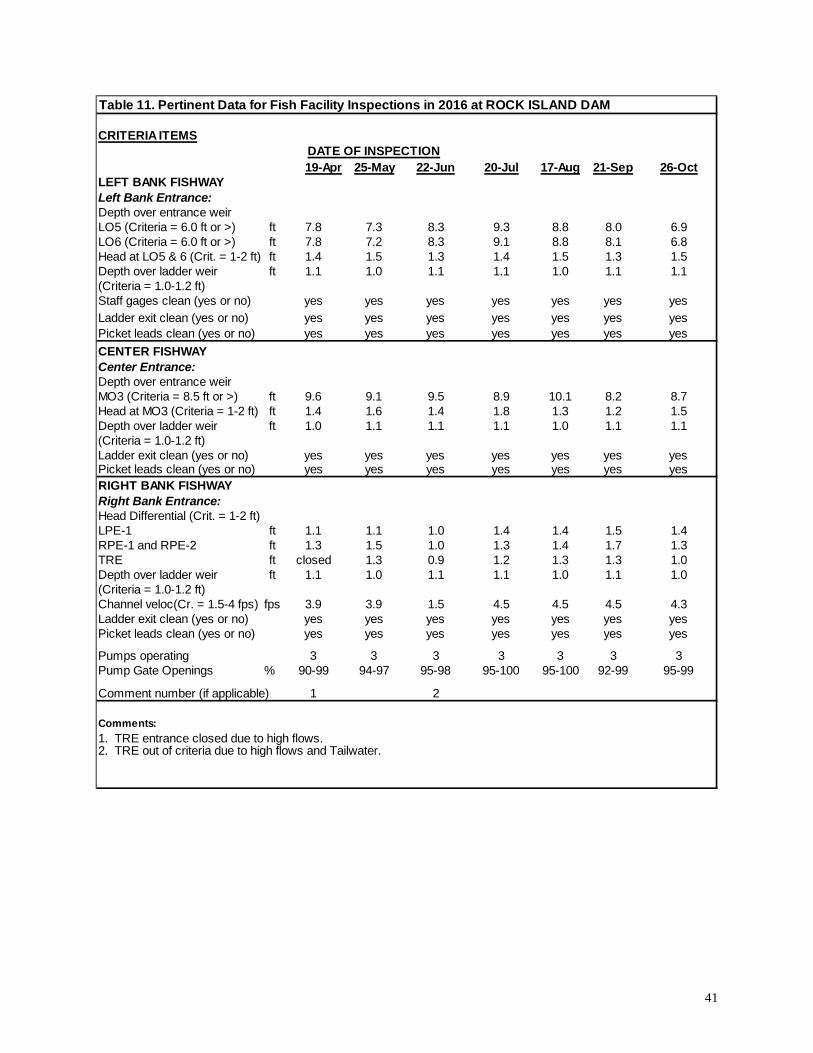
41
Table 11. Pertinent Data for Fish Facility Inspections in 2016 at ROCK ISLAND DAM
CRITERIA ITEMSDATE OF INSPECTION19-Apr 25-May 22-Jun 20-Jul 17-Aug 21-Sep 26-Oct
LEFT BANK FISHWAYLeft Bank Entrance:Depth over entrance weirLO5 (Criteria = 6.0 ft or >) ft 7.8 7.3 8.3 9.3 8.8 8.0 6.9LO6 (Criteria = 6.0 ft or >) ft 7.8 7.2 8.3 9.1 8.8 8.1 6.8Head at LO5 & 6 (Crit. = 1-2 ft) ft 1.4 1.5 1.3 1.4 1.5 1.3 1.5Depth over ladder weir ft 1.1 1.0 1.1 1.1 1.0 1.1 1.1(Criteria = 1.0-1.2 ft)Staff gages clean (yes or no) yes yes yes yes yes yes yesLadder exit clean (yes or no) yes yes yes yes yes yes yesPicket leads clean (yes or no) yes yes yes yes yes yes yesCENTER FISHWAYCenter Entrance:Depth over entrance weirMO3 (Criteria = 8.5 ft or >) ft 9.6 9.1 9.5 8.9 10.1 8.2 8.7Head at MO3 (Criteria = 1-2 ft) ft 1.4 1.6 1.4 1.8 1.3 1.2 1.5Depth over ladder weir ft 1.0 1.1 1.1 1.1 1.0 1.1 1.1(Criteria = 1.0-1.2 ft)Ladder exit clean (yes or no) yes yes yes yes yes yes yesPicket leads clean (yes or no) yes yes yes yes yes yes yesRIGHT BANK FISHWAYRight Bank Entrance:Head Differential (Crit. = 1-2 ft)LPE-1 ft 1.1 1.1 1.0 1.4 1.4 1.5 1.4RPE-1 and RPE-2 ft 1.3 1.5 1.0 1.3 1.4 1.7 1.3TRE ft closed 1.3 0.9 1.2 1.3 1.3 1.0Depth over ladder weir ft 1.1 1.0 1.1 1.1 1.0 1.1 1.0(Criteria = 1.0-1.2 ft)Channel veloc(Cr. = 1.5-4 fps) fps 3.9 3.9 1.5 4.5 4.5 4.5 4.3Ladder exit clean (yes or no) yes yes yes yes yes yes yesPicket leads clean (yes or no) yes yes yes yes yes yes yes
Pumps operating 3 3 3 3 3 3 3Pump Gate Openings % 90-99 94-97 95-98 95-100 95-100 92-99 95-99
Comment number (if applicable) 1 2
Comments:1. TRE entrance closed due to high flows.2. TRE out of criteria due to high flows and Tailwater.

42
ROCKY REACH DAM (photographs on page A-xx) Rocky Reach Dam was completed in 1961 and is owned and operated by Chelan County PUD. The project is comprised of 11 main turbine units and 12 spillbays to pass water through the dam. Originally, four turbines were fixed-blade units (8–11); however, these units have been modified and were adjustable blade turbines over the 2016 fish passage season. Flow from the turbine units is at right angle to the river and spillway flow. The adult fish facilities are comprised of three turbine-driven propeller-type fish pumps that supply water from the tailwater of the project for the powerhouse fishway entrances, most of the spillway entrance flow, and the six orifice gates along the powerhouse collection channel. The fish pumps operated satisfactorily during the 2016 fish passage season. Additional gravity-flow water can be supplied at the main spillway entrance to maintain the agreed upon criteria for that entrance. The powerhouse collection, left powerhouse, and spillway channels merge in the junction pool area to form the transportation channel that guides fish to the lower end of the fish ladder. The fish ladder exit is located on the right bank of the Columbia River. A prototype juvenile fish passage facility was tested for several years at the project with the new Corner Surface Collector completed prior to the 2003 fish passage season. The system has operated satisfactorily since that time with the juvenile bypass season that lasts from about April 1 to late August. When the bypass system operates, the south powerhouse turbines (1–5) are normally prioritized to attract juvenile fish to the area of the juvenile collector’s entrances. Seven adult fishway inspections have taken place at Rocky Reach Dam in 2016:
Date Inspector(s), Agency April 19, 2016 Solorio (WDFW) May 25, 2016 Solorio (WDFW), Benner (FPC) June 22, 2016 Solorio (WDFW) July 20, 2016 Solorio (WDFW) August 17, 2016 Solorio (WDFW) September 21, 2016 Solorio (WDFW) October 26, 2016 Solorio (WDFW)
Table 12 lists inspections and pertinent data with the text filling in details of the activities for this season. Powerhouse Entrances The Right Powerhouse Entrances, RPE-1 and RPE-2, are rotary wing gates that operate with a 3-ft opening, and require head differential of 1.0 ft. to 2.0 ft. The head differentials at RPE-1 and RPE-2 ranged from 1.0 ft. to 1.3 ft. for the season, all within criteria.
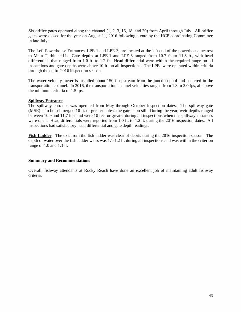
43
Six orifice gates operated along the channel (1, 2, 3, 16, 18, and 20) from April through July. All orifice gates were closed for the year on August 11, 2016 following a vote by the HCP coordinating Committee in late July. The Left Powerhouse Entrances, LPE-1 and LPE-3, are located at the left end of the powerhouse nearest to Main Turbine #11. Gate depths at LPE-1 and LPE-3 ranged from 10.7 ft. to 11.8 ft., with head differentials that ranged from 1.0 ft. to 1.2 ft. Head differential were within the required range on all inspections and gate depths were above 10 ft. on all inspections. The LPEs were operated within criteria through the entire 2016 inspection season. The water velocity meter is installed about 150 ft upstream from the junction pool and centered in the transportation channel. In 2016, the transportation channel velocities ranged from 1.8 to 2.0 fps, all above the minimum criteria of 1.5 fps. Spillway Entrance The spillway entrance was operated from May through October inspection dates. The spillway gate (MSE) is to be submerged 10 ft. or greater unless the gate is on sill. During the year, weir depths ranged between 10.9 and 11.7 feet and were 10 feet or greater during all inspections when the spillway entrances were open. Head differentials were reported from 1.0 ft. to 1.2 ft. during the 2016 inspection dates. All inspections had satisfactory head differential and gate depth readings. Fish Ladder: The exit from the fish ladder was clear of debris during the 2016 inspection season. The depth of water over the fish ladder weirs was 1.1-1.2 ft. during all inspections and was within the criterion range of 1.0 and 1.3 ft. Summary and Recommendations Overall, fishway attendants at Rocky Reach have done an excellent job of maintaining adult fishway criteria.
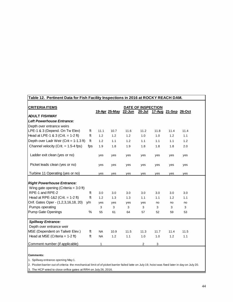
44
Table 12. Pertinent Data for Fish Facility Inspections in 2016 at ROCKY REACH DAM.
CRITERIA ITEMS DATE OF INSPECTION19-Apr 25-May 22-Jun 20-Jul 17-Aug 21-Sep 26-Oct
ADULT FISHWAY Left Powerhouse Entrance:Depth over entrance weirs
ft 11.1 10.7 11.6 11.2 11.8 11.4 11.4ft 1.2 1.2 1.2 1.0 1.0 1.2 1.1ft 1.2 1.1 1.2 1.1 1.1 1.1 1.2
fps 1.9 1.8 1.9 1.8 1.8 1.8 2.0
yes yes yes yes yes yes yes
yes yes yes yes yes yes yes
Turbine 11 Operating (yes or no) yes yes yes yes yes yes yes
Right Powerhouse Entrance: Wing gate opening (Criteria = 3.0 ft)
ft 3.0 3.0 3.0 3.0 3.0 3.0 3.0ft 1.2 1.3 1.3 1.1 1.1 1.2 1.1
Orif. Gates Oper - (1,2,3,16,18, 20) y/n yes yes yes yes no no no Pumps operating 3 3 3 3 3 3 3Pump Gate Openings % 55 61 64 57 52 59 53
Spillway Entrance: Depth over entrance weir
ft NA 10.9 11.5 11.3 11.7 11.4 11.5ft NA 1.2 1.1 1.0 1.0 1.2 1.1
Comment number (if applicable) 1 2 3
Comments:1. Spillway entrance opening May 1.2. Piccket barrier out of criteria- the mechanical limit of of picket barrier failed latte on July 19, hoist was fixed later in day on July 20.3. The HCP voted to close orifice gates at RRH on July 26, 2016.
Channel velocity (Crit. = 1.5-4 fps)
LPE-1 & 3 (Depend. On Tw Elev) Head at LPE-1 & 3 (Crit. = 1-2 ft)Depth over Ladr Weir (Crit = 1-1.3 ft)
MSE (Dependent on Tailwtr Elev.) Head at MSE (Criteria = 1-2 ft)
Picket leads clean (yes or no)
RPE-1 and RPE-2 Head at RPE-1&2 (Crit. = 1-2 ft)
Ladder exit clean (yes or no)
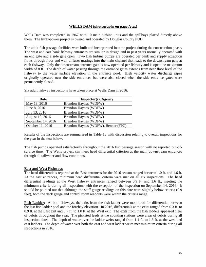
45
WELLS DAM (photographs on page A-xx) Wells Dam was completed in 1967 with 10 main turbine units and the spillbays placed directly above them. The hydropower project is owned and operated by Douglas County PUD. The adult fish passage facilities were built and incorporated into the project during the construction phase. The west and east bank fishway entrances are similar in design and in past years normally operated with an end gate and a side gate open. Two fish turbine pumps are operated per bank and supply attraction flows through floor and wall diffuser gratings into the main channel that leads to the downstream gate at each fishway. Only the downstream entrance gate is now operated per fishway and is open the maximum width of 8 ft. The depth of water passing through the entrance gates extends from near floor level of the fishway to the water surface elevation in the entrance pool. High velocity water discharge pipes originally operated near the side entrances but were also closed when the side entrance gates were permanently closed. Six adult fishway inspections have taken place at Wells Dam in 2016.
Date Inspector(s), Agency May 18, 2016 Brandon Haynes (WDFW) June 8, 2016 Brandon Haynes (WDFW) July 13, 2016 Brandon Haynes (WDFW) August 10, 2016 Brandon Haynes (WDFW) September 14, 2016 Brandon Haynes (WDFW) October 11, 2016 Brandon Haynes (WDFW), Benner (FPC)
Results of the inspections are summarized in Table 13 with discussion relating to overall inspections for the year in the text below. The fish pumps operated satisfactorily throughout the 2016 fish passage season with no reported out-of-service time. The Wells project can meet head differential criterion at the main downstream entrances through all tailwater and flow conditions. East and West Fishways The head differentials reported at the East entrances for the 2016 season ranged between 1.0 ft. and 1.6 ft. At the east entrances, minimum head differential criteria were met on all six inspections. The head differential readings at the West fishway entrances ranged between 0.9 ft. and 1.6 ft., meeting the minimum criteria during all inspections with the exception of the inspection on September 14, 2016. It should be pointed out that although the staff gauge readings on this date were slightly below criteria (0.9 feet), both the deck gauge and control room readouts were within the criteria range. Fish Ladder: At both fishways, the exits from the fish ladder were monitored for differential between the last fish ladder pool and the forebay elevation. In 2016, differentials at the exits ranged from 0.3 ft. to 0.9 ft. at the East exit and 0.7 ft. to 1.0 ft. at the West exit. The exits from the fish ladders appeared clear of debris throughout the year. The picketed leads at the counting stations were clear of debris during all inspection dates. The depth of water over the ladder weirs ranged from 1.1 ft. to 1.3 ft. at the west and east ladders. The depth of water over both the east and west ladder weirs met minimum criteria during all inspections in 2016.

46
Summary and Recommendations Overall, the adult fishways at Wells Dam were well operated. During one inspection (May), one staff gauge was reported as not clean.
Table 13. Pertinent Data for Fish Facility Inspections in 2016 at WELLS DAM.
CRITERIA ITEMSEAST FISHWAY: 18-May 8-Jun 13-Jul 10-Aug 14-Sep 11-OctHead at main entrance (Target = 1.5ft) ft 1.0 1.0 1.2 1.4 1.2 1.6
D/Stream entrance open (Criteria = 8-ft) ft 8ft 8ft 8 ft 8 ft 8 ft 8 ft
Depth over ladder weir (Crit.= 1-1.2 ft) ft 1.3 1.2 1.2 1.1 1.1 1.2
Ladder exit differential ft 0.7 0.7 0.7 0.7 0.3 0.9
Staff gages clean/readable (yes or no) yes yes yes yes yes yes
Picket leads clean (yes or no) yes yes yes yes yes yes
Auxiliary Fish Pump Speed (rpm) 19 43/50 45/50 35/59 38/43 43/50
WEST FISHWAY: (Criteria same as East)Head at main entrance ft 1.6 1.3 1.3 1.0 0.9 1.6
Downstream entrance open ft 8 ft 8 ft 8 ft 8 ft 8 ft 8 ft
Depth over ladder weir ft 1.3 1.2 1.2 1.2 1.2 1.2
Ladder exit differential ft 0.8 0.8 0.9 0.7 0.9 1.0
Staff gages clean/readable no yes yes yes yes yes
Picket leads clean yes yes yes yes yes yes
Auxiliary Fish Pump Speed (rpm) 42/41 54/48 43/47 43/43 38/38 32/25
Comment Number (if applicable) 1 2
Comments:1. West channel staff gauge dirty/unreadable2. According to channel staff gauge west bank entrance slightly out of criteria, control room readout had higher channel elevation and was within criteria.
47
GENERAL PROJECT RECOMMENDATIONS Most recommendations relating to adult fish passage and improvements to fish facilities are normally discussed at the FPOM committee meetings for COE projects or in MCOL committee meetings both prior to and during a year. Main issues relating to passage of adult fish have been addressed in a broad way via the Biological Opinion that was completed by NOAA Fisheries. Some general recommendations to improve fish passage conditions follow.
• Projects should assure that water-measuring devices are easy to read at all water elevations during the year. Preferred conditions would be those where staff gauges can be cleaned easily and/or have benchmarks available so sensor readings can be taken.
• Projects should evaluate back-up water supply sources to assure that adequate water is available to attract adult fish should the main water supply fail.
• Projects should monitor ladder temperatures during warm water periods of the year. At projects such Lower Granite where adult passage has been impacted by water temperature differentials between the ladder and tailrace, plans should continue to be developed that attempt to alleviate this issue.
• Projects should assure that diffuser gratings are intact and clear of debris before the main fish passage season begins and at some point during the season. Videotape, divers, or other acceptable means should accomplish this task.
• All projects should have a plan of action on how to deal with removal of debris from the forebay of each dam. This would help assure that fish turbines/pumps, exits from the dams, picketed leads, or other areas would have less chance of plugging or causing damage to mechanical systems of the fishways or to the adult or juvenile fish passing the dams.
• Sharp projections or other obstacles located in the fish ladders, collection or transportation channels, should be removed.
• Based on past performance of the fishway equipment, the projects should purchase spare parts of critical operating equipment that would allow “quick” fix during the fish passage season should equipment fail.
• Dewatering plans or other fish handling tasks should be reviewed and annually updated where necessary.

48
SUMMARY OF FISHWAY CRITERIA Summary of fishway criteria for mainstem dams on the Columbia and Snake River Detailed criteria for COE dams can be found in the COE’s Fish Passage Plan, or at PUD projects in Fishery Operating Plans (adult criteria) for each District. This Appendix summarizes the general standards for the fishways at each project. Entrance Head Differentials: 1.0 to 2.0 feet standard at all projects. Wells, Wanapum, Priest Rapids, and Bonneville dams target 1.5 ft at some entrances, Priest Rapids and Wanapum target 1.25 ft. Entrance Weir Gate Depths:
Bonneville - At the old powerhouse, maintain 8.0 ft or more depth at Gate 1/2 and 64/65; at the new powerhouse maintain 13′ or > depth when tailwater elevation is above elevation 14 (sill = elev 1.0′). The Dalles, John Day (OR fishway), McNary (OR fishway and north shore), Ice Harbor (south, north ph) Lower Monumental, Little Goose (south), and Lower Granite (south, north ph) - 8 ft or > depth at Entrance Gates.
Rock Island (spillway entrance) - 8.5 ft or > gate depth. Rock Island left bank, Little Goose north shore - 6.0 ft or > gate depth. Lower Granite north shore, Little Goose north powerhouse - 7.0 ft or > gate depth. Rocky Reach left powerhouse & spillway - 10’ or > gate depth.
Entrance Wing Gate Openings: Wells - 8.0 ft open end gate.
Rock Island - 2.0 ft open on center fishway side gate; 3.0 ft open on the new powerhouse entrance gates.
Rocky Reach - 3.0 ft open on right powerhouse gates. Entrance (fixed-open) Gates: Maintain head differential of 1.0-2.0 ft
Bonneville (spillway entrances) Wanapum (all entrances) Priest Rapids (all entrances) John Day North Lower Monumental (south shore, SSE-2 is a permanent fix 6-ft open gate).
Turbine Unit Operating Priority: Specific to each dam (See year 2016 FPP for COE projects). Spillway Operation: Specific to each dam (See 2016 FPP for COE projects and DFOP/LSOP and HCPs for PUD projects). Collection or Transportation Channel Velocities: 1.5 to 4.0 fps at all projects. Staff Gauges or other Elevation Gauges: At all projects, gauges must be maintained throughout the fish passage season and readable at all elevations. Fish Ladder Depth of Water over Fish Ladder Weirs: 1.0 ft ± 0.1 ft; most projects use a 1.0 ft to 1.2 ft or 1.3 ft. Head on Picketed Leads: Maximum of four inches at most projects (0.3 ft); 6.0 inches is required at Chelan PUD projects. Head on Exit Trash Racks: Maximum of 0.5 ft greater than reading with a clean trash rack. Debris should be removed when significant amounts accumulate.
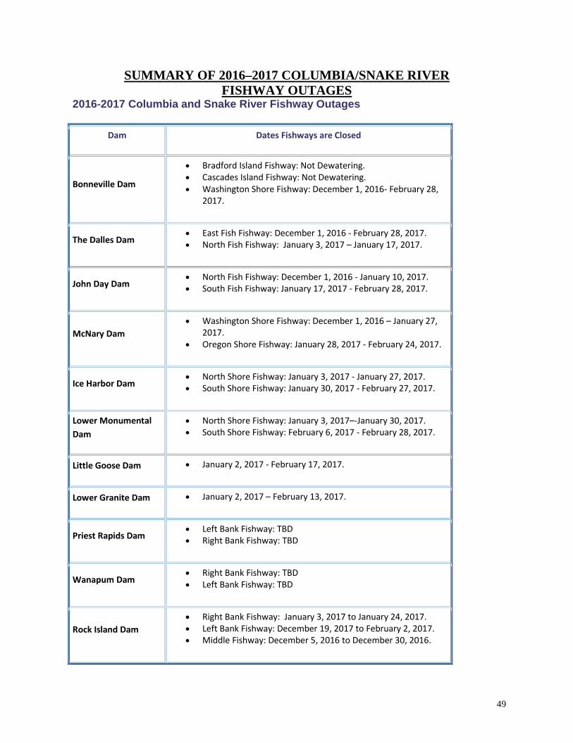
49
SUMMARY OF 2016–2017 COLUMBIA/SNAKE RIVER FISHWAY OUTAGES
2016-2017 Columbia and Snake River Fishway Outages
Dam Dates Fishways are Closed
Bonneville Dam
• Bradford Island Fishway: Not Dewatering. • Cascades Island Fishway: Not Dewatering. • Washington Shore Fishway: December 1, 2016- February 28,
2017.
The Dalles Dam • East Fish Fishway: December 1, 2016 - February 28, 2017. • North Fish Fishway: January 3, 2017 – January 17, 2017.
John Day Dam • North Fish Fishway: December 1, 2016 - January 10, 2017. • South Fish Fishway: January 17, 2017 - February 28, 2017.
McNary Dam • Washington Shore Fishway: December 1, 2016 – January 27,
2017. • Oregon Shore Fishway: January 28, 2017 - February 24, 2017.
Ice Harbor Dam • North Shore Fishway: January 3, 2017 - January 27, 2017. • South Shore Fishway: January 30, 2017 - February 27, 2017.
Lower Monumental Dam
• North Shore Fishway: January 3, 2017–-January 30, 2017. • South Shore Fishway: February 6, 2017 - February 28, 2017.
Little Goose Dam • January 2, 2017 - February 17, 2017.
Lower Granite Dam • January 2, 2017 – February 13, 2017.
Priest Rapids Dam • Left Bank Fishway: TBD • Right Bank Fishway: TBD
Wanapum Dam • Right Bank Fishway: TBD • Left Bank Fishway: TBD
Rock Island Dam • Right Bank Fishway: January 3, 2017 to January 24, 2017. • Left Bank Fishway: December 19, 2017 to February 2, 2017. • Middle Fishway: December 5, 2016 to December 30, 2016.

50
ACKNOWLEDGMENTS Oregon Department of Fish and Wildlife, Washington Department of Fish and Wildlife, CRITFC, PSMFC, and NOAA Fisheries provided personnel to inspect adult fishways during the 2016 fish passage season. The Fish Passage Center appreciated the time and commitment from the individual inspectors and from the Agencies who assured that fishery personnel were available to complete inspections at the mainstem dams each month. Fishery agency personnel who participated in the inspection program during 2016 are listed below.
AGENCY INSPECTOR DAMS INSPECTED FPC/CRITFC David Benner/Tom Skiles Priest Rapids & Wanapum NOAA Gary Fredricks Bonneville NOAA Jeff Brown McNary ODFW Howard Takata The Dalles & John Day ODFW Anne Dowdy Little Goose & Lower Granite FPC David Benner Ice Harbor PSMFC Monty Price Lower Monumental WDFW Brandon Haynes Wells WDFW Mauro Solorio Rock Island & Rocky Reach
Project operations personnel and biologists from Portland and Walla District Corps of Engineers provided on-site assistance whenever necessary to assure that the agency inspector could thoroughly inspect the adult and juvenile fishways. The inspectors were appreciative of assistance provided by project personnel at Corps of Engineers dams. Grant, Chelan, and Douglas Public Utility Districts provided access and assistance for the State and Federal fishway inspectors at their projects. This continued cooperation and assistance was greatly appreciated by the FPC and WDFW inspectors. Funding for the FPC staff coordination of the inspections was provided by the following fishery agencies: ODFW, IDFG, WDFW, USFWS, and NOAA.