Embed Size (px)
Citation preview
AVDLP 5Aylesbury
5 AYLESBURY
INTRODUCTION
51 Aylesbury is the county town of Buckinghamshire and the administrative centre of both the County and District Councils Over the last forty years it has grown into a thriving commercial town combining traditional character with modern development and progressive economic aspirations
52 In 1997 the town had a population of approximately 58000 and provided employment for about 32000 people That represented well over 40 of the population of the District and over 50 of all jobs in the District
53 This Plan proposes that some 65 of the Districtrsquos development be concentrated at Aylesbury in accordance with its role as a sub-regional growth centre Taking into account expected completions and windfall sites this entails building some 3800 houses between 2001 and 2011 (see Table 3 on page 17) First priority is given to locating these houses on brownfield sites which it is estimated can accommodate some 1100 houses This leaves some 2700 houses to be built on new sites The population of Aylesbury is envisaged to grow to about 75500 by 2011 representing an increase of 29 on the 1996 population
AYLESBURY LAND USETRANSPORT STRATEGY
54 Concentrating development at Aylesbury offers the best opportunities for reducing reliance on the car and encouraging more sustainable forms of transport Since 1994 the District and County Councils have jointly worked on preparing a land usetransport strategy (ALUT Strategy) for the town the purpose of which is to maximise these opportunities and take fullest advantage of them
55 The formulation of the ALUT Strategy has been based on traditional planning principles including landscape quality agricultural quality avoiding settlement coalescence surface water management and site specific concerns and on the
Aylesbury Vale District Local Plan January 2004
95
AVDLP 5 Aylesbury
principle of minimising the need to travel and facilitating journeys by means other than the private car The latter principle is to be achieved by maximising opportunities to encourage the use of public transport and developing a comprehensive pedestrian and cycle network
56 In this context the ALUT Strategy is in accordance with BCCrsquos Integrated Transport Strategy (ITS) in looking to reduce the proportion of residents in the town who travel to work and other destinations by car and invoke a consequent increase in travel to work by more sustainable means The ITS targets subscribed to are indicated in paragraph 310
57 Key to the implementation of the strategy will be a requirement for development to fund facilities and infrastructure where a need is created by that development The local highway network is already unacceptably congested at peak times in terms of delay and effect on the environment Where new development would add to the level of traffic the District and County Councils will in accordance with national and regional guidance refuse permission on the basis that the environmental and operational capacity of the highway network has been reached and further development would exacerbate the current situation Therefore to accommodate the level of growth proposed development will be required to fund facilities and a package of transport (as well as other) proposals which will reduce the level and mitigate the effect of traffic which would otherwise have been created by that development
58 Combining these factors with government advice on the benefits of planning for major mixed-use developments which tend to reduce travel demand the ALUT Strategy proposes development at a limited number of locations to the north-west north and south east of the town These locations best satisfy normal planning criteria and the more specific but crucial transport objectives
59 The Council proposes that the Land UseTransport Strategy for Aylesbury be based upon the following principles
a) maximising the potential for housing on brownfield sites (those sites within the urban area which have or have had built development on them)
b) concentrating development at three major development areas (MDAs) including two mixed-use development areas at Berryfields and Weedon Hill and an employment area at Aston Clinton Road
96 Aylesbury Vale District Local Plan January 2004
AVDLP 5Aylesbury
c) as a first priority each MDA will be responsible for securing the construction of a Primary Public Transport Corridor to the town centre (along with cycling and walking measures) and equitable contributions made to the construction of town centre measures linking the corridors together
d) developing a comprehensive network of pedestrian and cycle links throughout the town including to the MDAs and to all the surrounding villages
e) minimising the amount of new road building required that is comprising (i) that required to directly serve the MDAs and to provide essential linkages between the MDAs and (ii) that required to serve the general needs of the town such roads being designed to a standard sufficient to meet local needs without attracting long distance through traffic nor generating undue levels of additional trips and
f) requiring development to fund new or improved transport infrastructure required in association with that development with public funding for other elements
510 This strategy is divided into its component parts and detailed in later sections of this Chapter
511 The primary consideration in locating the MDAs has been where developments of this scale can be accommodated taking into account all normal constraints and the extent to which they can be served by an enhanced public transport system The transport advantages of locating the larger MDAs to the northshywest north and south east of the town are reinforced by
z the MDAs being directly linked to the existing major employment areas of Rabans LaneBicester Road and the town centre
z locating the main employment allocation at Aston Clinton Road - this provides a balance to the existing employment concentration on Bicester Road
z maximising the use of Bicester Road which has the capacity to accommodate public transport priority measures
z maximising the use of appropriate parts of the Inner Relief Road which have the capacity to accommodate public transport priority measures and
z the strategy allowing for and being able to take advantage of the possibility of the re-opening of the railway northward for passengers
Aylesbury Vale District Local Plan January 2004
97
AVDLP 5 Aylesbury
512 As well as the MDAs it is important to ensure that all decisions relating to developments at Aylesbury are consistent with and serve to enforce the principles set out in paragraph 59
AY1 All traffic-generating proposals will be considered against the principles of the ALUT Strategy as set out in paragraph 59 A primary consideration will be the effectiveness of development proposals in minimising the need to travel and facilitating or encouraging journeys by means other than the private car
IMPLEMENTATION
513 To secure implementation of the ALUT Strategy a framework is proposed defining the nature and scale of developer contributions The MDAs will generate trips that will use both the new and existing transport infrastructure Similarly existing development will generate trips that will use new and existing infrastructure The location of the MDAs has to a large measure been defined by the ALUT Strategy Without this strategy particularly the creation of the Primary Public Transport Corridors development of the MDAs cannot proceed In this situation the Councilrsquos approach is to require the MDAs to fund new or improved transport infrastructure identified as essential to them and not to make a contribution to other town-wide transport infrastructure measures It is envisaged these town-wide measures will be jointly funded by public sources and contributions from other developments in the town This is a broad-based approach to the developer funding strategy in which
z the MDAs fund the whole of the Primary Public Transport Corridor that connects them to the town and each other and is an essential pre-requisite to their development
z the MDAs fund the revenue costs during the first three years of public transport bus improvements along the Primary Public Transport Corridors
z each MDA makes an equitable proportional contribution to the whole of the Primary Public Transport Corridor dependant on the total vehicle trip movements likely to be generated by that development As a first priority each MDA will be responsible for securing the construction of a Primary Public Transport Corridor to the town centre (along with identified cycling and walking measures) and equitable contributions made to the construction of town centre measures linking the corridors together and
98 Aylesbury Vale District Local Plan January 2004
AVDLP 5Aylesbury
z all non-MDA development in the town makes a contribution to be added to public funding towards other town-wide elements of the ALUT Strategy this contribution to be based on the new vehicle trip movements they are likely to generate
514 The funding strategy for the various elements of the ALUT Strategy shall be based on the following categories
Category 1 (wholly MDA funded)
a) Primary Public Transport Corridors linking Berryfields and Weedon Hill to Aston Clinton Road (via Bicester Road Buckingham Road the town centre and along the Tring Road corridor)
b) revenue costs during the first three years following occupation of the first dwellingsemployment unit of public transport bus improvements along the Primary Public Transport Corridors
c) cycle and pedestrian connections from each MDA to the existing network and town centre and
d) a new road (the Western Link Road) linking Berryfields to Weedon Hill (A41 to A413)
Category 2 (non-MDA developer and public funded)
a) town-wide transport measures including
i) public transport improvements to radials other than the Primary Public Transport Corridors
ii) enhancements to town-wide (outside MDAs) walking and cycling strategy and
iii) other traffic management measures associated with developments
Where necessary the relevant local authorities will use appropriate powers (eg Compulsory Purchase Orders) to facilitate the acquisition of land necessary for successful implementation of the ALUT Strategy
515 The specific requirements for each MDA to fund andor contribute to elements of the ALUT Strategy are given later in this Chapter
516 In addition to MDA funding it is acknowledged that all new developments in the town will place demands by way of potential trip generation on the local transport network Because the network is currently at capacity at peak times these demands and therefore the development would normally
Aylesbury Vale District Local Plan January 2004
99
AVDLP 5 Aylesbury
be unacceptable To accommodate such development in a way that is acceptable in terms of impact on the network all new development (except for the very smallest) which would add travel demand onto the network will be required to make a contribution toward the implementation of the ALUT Strategy
The Buckinghamshire 517 The ALUT Strategy takes into account the anticipated amount Local Transport Plan of brownfield development proposed in the Plan and sets out a (LTP) consists of a set of actions and initiatives that aim to improve the quality of life for Buckinghamshirersquos residents and visitors by providing wider travel
comprehensive programme of transport measures to accommodate the effects of that development on a town-wide level It is fully in accordance with government advice on planning obligations (Circular 197) to require developers to contribute to infrastructure required as a result of that development The level of contribution will be based on the
choice tackling the number of vehicle trips the development is likely to generate effects of traffic and and on the principle that non-MDA development at Aylesbury maintaining the transport network The bids for funding support are submitted to the government each year
will be required to jointly fund town-wide transport proposals as defined in the ALUT Strategy except those to be 100 MDA funded The public element of this funding will be secured through the Local Transport Plan
by Buckinghamshire County Council 518 The proportion of non-MDA development funding to public
funding of the town-wide transport proposals (Category 2) is to be based on the following The total number of trips generated by the existing population of Aylesbury will continue to grow to 2011 due to natural growth whether additional development takes place or not The proportion of non-MDA developer funding will be based therefore on the increase in trips generated by these developments over that generated by the natural growth in trips of the existing population between 1994 (the base year of the ALUT Strategy model) and 2011
519 Contributions will be related to programmed works along the appropriate radial route serving the development within the town or to provide essential transport links to other radial routes or works within and to the town centre Programmed works refer to those schemes included in the relevant Local Transport Plan
520 Full details of the calculation methodology and means of implementing these requirements will be given in separate Supplementary Planning Guidance
100 Aylesbury Vale District Local Plan January 2004
AVDLP 5Aylesbury
AY2 All non-MDA developments that could be expected to add more than 50 vehicle movements to the network per day will be required to make a financial contribution towards the implementation of the ALUT Strategy The methodology for calculating this contribution relevant thresholds and exemptions and the arrangements for collecting and administering it is published in Supplementary Planning Guidance
PHASING
521 Investment in the ALUT Strategy must keep pace with the level of development achieved and accord with in terms of timing and prioritisation the objectives of the Strategy Transport model testing has been undertaken to establish the amount of development that in the absence of the link road but with radial measures in place (including those related to public transport walking and cycling) would result in the network-wide congestion index exceeding the agreed threshold
522 The principle of the phasing policy will be to ensure that the public transport walking and cycling elements of the ALUT Strategy related to any development are available before first occupation of part of that development The Berryfields MDA must fund the Primary Public Transport Corridor improvements along the A41 Bicester Road corridor The Weedon Hill MDA must fund the Primary Public Transport Corridor along the A413 Buckingham Road corridor The Aston Clinton Road MDA must contribute financially toward the Primary Public Transport Corridor along the Tring Road corridor All the MDAs must jointly fund linkages of the Primary Public Transport Corridors around the town centre The Primary Public Transport Corridor shown on the Proposals Map running along the Western Link Road is not required to be in place in advance of the road Also required at this stage is the minimum new road construction necessary to give access to the development and accommodate essential public transport linkages The development threshold at which completion of the link road will be required has been set at when 33 of the MDA development is complete
523 Before development of the Berryfields and Weedon Hill MDAs exceeds either jointly or individually 33 of their cumulative proposed size the Western Link Road must be constructed and open to traffic
524 Exceptional circumstances may justify a limited departure from the principle that no more than 33 of the MDAs can be built before the Western Link Road is open to traffic In such
Aylesbury Vale District Local Plan January 2004
101
AVDLP 5 Aylesbury
circumstances a financial contribution will be required to secure the later construction of the section of link road and any appropriate temporary measures Such arrangements are also likely only to permit development to a higher threshold of the total development of the MDA The details of any such exception shall be secured through legal agreement
525 Other exceptional circumstances that are beyond the control of developers may apply that prevent the operation of Primary Public Transport Corridor services upon first completion even though all the physical highway works are in place In such circumstances it would be inappropriate to delay occupation of the earliest phases of development provided there was firm evidence that the Primary Public Transport Corridors will commence operation in the near future
AY3 The Council will require that the off-site public transport and category 1 walking and cycling elements of the ALUT strategy relating to each MDA development corridor are implemented before occupation of the first dwelling or occupation of the first employment unit whichever is the sooner Before development of the Berryfields and Weedon Hill MDAs exceeds either jointly or individually 33 of their cumulative proposed size the Western Link Road must be constructed and open to traffic Exceptional circumstances may justify a limited departure from the 33 principle In such circumstances a financial contribution will be required to secure the later construction of the section of link road and any appropriate temporary measures The details of any such exceptions shall be secured through legal agreement In exceptional circumstances that are beyond the control of the developers and which delay the operation of services along the Primary Public Transport Corridors initial occupations will be acceptable provided it is demonstrated that the Primary Public Transport Corridors will commence operation in the near future
HOUSING
526 Sufficient land has been identified which together with that already committed will meet the housing needs of the town Table 3 on page 17 shows that land is proposed for 1100 houses on brownfield sites and 2700 houses on new sites (MDAs)
BROWNFIELD REALLOCATED HOUSING SITES
527 In accordance with national and regional policy the Council is committed to maximising the amount of housing development
102 Aylesbury Vale District Local Plan January 2004
AVDLP 5Aylesbury
on previously developed vacant derelict or under-used sites (so-called ldquobrownfield sitesrdquo) within Aylesbury This will reduce the need to develop greenfield sites A number of significant sites have recently been redeveloped for housing for example the former Coca-Cola Schweppes factory on Bierton Road and the former Council offices on Oxford Road
528 There are a number of very significant redevelopment opportunities remaining that the Council wishes to encourage for housing These include
z identified sites that are expected to come forward with some housing as part of a mixed-use scheme (Category A - 625 houses) and
z sites not identified in advance that are expected to come forward from a general policy favouring brownfield development (Category B - 475 houses)
529 It is important that the development of brownfield sites is accompanied by measures to improve public transport and the network of pedestrian and cycle routes consistent with the transport proposals of the Plan
Site
Tring Road (AY4) 100
Friarage Road (all complete) 25
Stoke Mandeville Hospital (AY5) 275
Bearbrook House (AY6) 50
TA Centre (AY7) 50
Ardenham Lane (AY8) 50
Park Street (AY9) 25
Exchange Street (AY 34) 25
Walton Street (AY 32) 25
Total 625
General Brownfield Policy (AY10) 475
Grand Total 1100
TABLE 5 - Brownfield Housing at Aylesbury
Aylesbury Vale District Local Plan January 2004
103
AVDLP 5 Aylesbury
Mixed Use Schemes (Category A)
530 There are six brownfield sites where although housing is not appropriate for the entire site the opportunity exists for some housing within them These are Tring Road (former BPCC factory) Stoke Mandeville Hospital Bearbrook House (following public consultation and the adoption by the Council of a Planning Brief for the site in July 2003 employment is no longer considered appropriate for this site) the TA Centre Ardenham Lane and Park Street
Tring Road (former BPCC factory)
531 This site is occupied by the former BPCC (Hazellrsquos) printing works It immediately adjoins the Tring Road Tesco food superstore It is adjacent to the Aylesbury Arm of the Grand Union Canal To the south it is bounded by existing housing
532 In part the site could accommodate an expansion of the foodstore in accordance with the Planrsquos food retail strategy (see Policy AY27)
533 Allowing for the expansion of the foodstore it is estimated that the site could accommodate approximately 100 houses Should the expansion of the foodstore not occur the area allocated for that purpose should instead be developed for housing
534 There is the possibility that employment activity will continue in the industrial unit on the east of the site (this is in separate ownership) If this is the case the Council will need to be satisfied that a satisfactory residential environment can be achieved
AY4 The Council proposes that land at the former BPCC factory Tring Road Aylesbury (as defined on the Proposals Map) be developed for housing and a food retail extension to the existing food superstore subject to
a) the development being in accordance with a comprehensive plan to be prepared for the whole of the site (to include the housing site and the site for the expanded foodstore)
b) an equitable contribution being made to the category 2 transport infrastructure improvements to public transport and facilities for walking and cycling
c) satisfactory vehicular access
d) enhancement of the setting and environment of the canal to provide for direct pedestriancycle links from the site and enhance the setting and environment of the towpath and canal
104 Aylesbury Vale District Local Plan January 2004
AVDLP 5Aylesbury
e) protecting the amenity of the residents of the new housing from the foodstore to the east and the industrial area to the north of the canal and if retained the employment activity to the east
f) providing for a mix of housing types and sizes including in particular at least 10 as low cost market housing and providing for a minimum of 20 and up to 30 as affordable housing The Council will assess the circumstances of the site and of the particular proposed development taking into account the considerations set out in GP2 The Council will also wish to ensure that the affordable dwellings are occupied initially by qualifying persons and are retained for successive qualifying persons
g) protecting the amenity of residents of existing adjoining houses and
h) provision of public open space and associated equipment at the equivalent of 243 hectares per thousand people
Stoke Mandeville Hospital
535 Stoke Mandeville Hospital NHS Trust is redeveloping the hospital to improve patient facilities Part of the hospital site will be available for redevelopment as a result This will involve land controlled by the National Health Service Executive and currently leased to the Trust
536 Because of its proximity to adjacent housing areas and its immediate access to public transport the site is considered appropriate for housing and local neighbourhood shopping including a community hall at a scale appropriate to the overall number of dwellings The requirement to safeguard existing trees within the site will be based upon an agreed or joint tree survey
537 The Council supports the creation of a new railway halt to serve the Hospital the Guttmann Sports Centre and surrounding housing A site is reserved adjacent to the existing pedestrian underpass for a railway halt (See Policy AY18)
538 The site at Stoke Mandeville Hospital could accommodate approximately 275 houses and a neighbourhood retail store There are a number of existing houses and flats on the site which accommodate hospital staff (approximately 80 units) It is expected that these will be replaced within that part of the site that is retained as a hospital If they are not the net gain of houses from the identified site will be reduced
Aylesbury Vale District Local Plan January 2004
105
AVDLP 5 Aylesbury
AY5 The Council proposes that land at Stoke Mandeville Hospital Aylesbury (as defined on the Proposals Map) be developed for community uses and housing subject to
a) the development being in accordance with a comprehensive plan to be prepared for the whole of the existing hospital site (to include the housing site the neighbourhood centre site and the site for the new hospital development)
b) an equitable contribution being made to the category 2 transport infrastructure improvements to public transport and facilities for walking and cycling
c) provision of segregated pedestrian and cycle links within the site and to the existing and planned local network including the Stoke Mandeville Hospital to Aylesbury route the underpass to Elm Farm Park and onto Lower Road Mandeville Road
d) satisfactory vehicular accesses
e) providing for a mix of housing types and sizes including in particular at least 10 as low cost market housing and providing for a minimum of 20 and up to 30 as affordable housing The Council will assess the circumstances of the site and of the particular proposed development taking into account the considerations set out in GP2 The Council will also wish to ensure that the affordable dwellings are occupied initially by qualifying persons and are retained for successive qualifying persons
f) protecting the amenity of residents of adjoining houses
g) protecting the amenity of the residents of the new housing from the new hospital buildings to be constructed to the south
h) retaining existing suitable trees within the site
i) provision of public open space at the equivalent of 243 hectares per thousand people and
j) provision of appropriate community facilities including providing for local neighbourhood shopping (up to 1000 sq m of net retail floorspace)
Bearbrook House Oxford Road
539 The site is made up of the former District Councilrsquos offices and a factory to the rear (both now demolished) Comprehensive development of the whole site could include an element of housing probably on the frontage of Oxford Road
106 Aylesbury Vale District Local Plan January 2004
AVDLP 5Aylesbury
540 In terms of vehicular access to Oxford Road this site should be considered together with the TA Centre (see over) in order that the means of access to the two sites can be rationalised As part of the redevelopment of the sites the number of access points from Oxford Road should be reduced to two Emergency access from Gatehouse Close and to Oxford Road will be required A Traffic Impact Assessment will be required in order to establish the form of the junction
541 It is estimated that the site could accommodate approximately 50 houses
AY6 The Council proposes the development of Bearbrook House and surrounding land at Oxford Road Aylesbury (as defined on the Proposals Map) for housing and employment subject to the following
a) the development being in accordance with a comprehensive plan to be prepared for the whole of the site
b) an equitable contribution being made to the category 2 transport infrastructure improvements to public transport and facilities for walking and cycling
c) improvements to the existing cycle and pedestrian network beyond the site including the provision of new or enhancement of existing crossing facilities across the Oxford Road
d) vehicular access being from Oxford Road serving this site and the TA Centre site to allow rationalisation of existing access points
e) providing for a mix of housing types and sizes and providing for a minimum of 15 (or other appropriate figure determined by a housing needs survey) as affordable housing including in particular at least 10 as low cost market housing and providing for a minimum of 20 and up to 30 as affordable housing The Council will assess the circumstances of the site and of the particular proposed development taking into account the considerations set out in GP2 The Council will also wish to ensure that the affordable dwellings are occupied initially by qualifying persons and are retained for successive qualifying persons
f) protecting the amenity of residents of existing adjoining houses
g) retaining trees on the Oxford Road frontage and utilising the stream as a feature
Aylesbury Vale District Local Plan January 2004
107
AVDLP 5 Aylesbury
h) provision of public open space at the equivalent of 243 hectares per thousand people and
i) an appropriate archaeological evaluation shall be made of the entire site prior to the submission of any proposals which should secure mitigation of the impact of development on archaeological remains
Territorial Army Centre Oxford Road
542 The Territorial Army (TA) occupies and owns a large site off Oxford Road The TA site is also used by cadet units and the Army Careers Office An adjacent site owned by the TA is occupied by the Red Cross Development of this site for housing would consolidate an existing residential area
543 The TA may rationalise its Aylesbury site as a result of the defence review to be completed in 1998 The Red Cross is considering options for improving their accommodation at Aylesbury The entire site has a capacity of approximately 50 houses
544 Access to the site should be provided from Oxford Road (see AY6 above) A Traffic Impact Assessment will be required to establish the form of the junction
AY7 The Council proposes that land at the Territorial Army Centre on Oxford Road Aylesbury (as defined on the Proposals Map) be developed for housing subject to the following
a) the development should be in accordance with a comprehensive plan to be prepared for the site
b) an equitable contribution to the category 2 transport infrastructure improvements to public transport and facilities for walking and cycling
c) vehicular access from Oxford Road serving this site and the Bearbrook House site to allow rationalisation of existing points of access
d) providing for a mix of housing types and sizes including in particular at least 10 as low cost market housing and providing for a minimum of 20 and up to 30 as affordable housing The Council will assess the circumstances of the site and of the particular proposed development taking into account the considerations set out in GP2 The Council will also wish to ensure that the affordable dwellings are occupied initially by qualifying persons and are retained for successive qualifying persons
108 Aylesbury Vale District Local Plan January 2004
AVDLP 5Aylesbury
e) protecting the amenity of residents of existing adjoining houses
f) provision of public open space and associated equipment at the equivalent of 243 hectares per thousand people and
g) an appropriate archaeological evaluation shall be made of the entire site prior to the submission of any proposals which should secure mitigation of the impact of development on archaeological remains
Ardenham Lane
545 The site includes Ardenham House previously occupied by the Health Authority allotments which are not fully utilised an unused car park and a number of offices on Oxford Road some of which are substantially vacant It is in a variety of ownerships It is estimated that the site could accommodate approximately 50 houses even though the main area with potential on the site Ardenham House has been granted planning permission for sheltered accommodation There may be some opportunity for housing development on the unused car park or with the consolidation of the allotments (if alternative provision can be provided elsewhere) There may be additional scope for conversion of offices on the Oxford Road frontage (one of these has been granted planning permission for conversion to flats)
AY8 The Council proposes the development of land andor the conversion of existing offices at Ardenham Lane Aylesbury (as defined of the Proposals Map) for housing subject to
a) the development being in accordance with a comprehensive plan to be prepared for the whole of the site or where part is the subject of development a plan which shall describe the proposals in the context of and relate them to other uses of the remainder of the site
b) an equitable contribution being made to the category 2 transport infrastructure improvements to public transport and facilities for walking and cycling
c) vehicular access from Ardenham Lane
d) providing for a mix of housing types and sizes including in particular at least 10 as low cost market housing and providing for a minimum of 20 and up to 30 as affordable housing The Council will assess the circumstances of the site and of the particular proposed development taking into account the considerations set out in GP2 The Council will also wish to ensure that the affordable dwellings are occupied initially by qualifying persons and are retained for successive qualifying persons
Aylesbury Vale District Local Plan January 2004
109
AVDLP 5 Aylesbury
e) protecting the amenity of residents of existing adjoining houses
f) provision of public open space at the equivalent of 243 hectares per thousand people
g) retention of trees on the site
h) the retention and appropriate re-use of the listed building Ardenham House
i) an appropriate archaeological evaluation shall be made of the entire site prior to the submission of any proposals which should secure mitigation of the impact of development on archaeological remains
j) provide for the retention and upgrading to cycleway of the pedestrian route from the end of Mount Pleasant to Whitehill Surgery and
k) development of the site should retain a minimum of 50 of the existing allotments and secure the enhancement of that remaining allotment land
Car Showroom Park Street
546 This site includes a car showroom garage and various open uses to the north The site was included in the Aylesbury Local Plan as a housing allocation although land availability assessments have acknowledged that it would not come forward until after 2001 It is estimated that the site could accommodate approximately 25 houses together with businessoffice uses
AY9 The Council proposes the redevelopment of the site at Park Street Aylesbury (as defined on the Proposals Map) for residential and businessoffice use subject to
a) an equitable contribution being made to the category 2 transport infrastructure improvements to public transport and facilities for walking and cycling
b) vehicular access from Park Street
c) providing for a mix of housing types and sizes including in particular at least 10 as low cost market housing and providing for a minimum of 20 and up to 30 as affordable housing The Council will assess the circumstances of the site and of the particular proposed development taking into account the considerations set out in GP2 above The Council will also wish to ensure that the affordable dwellings are occupied initially by qualifying persons and are retained for successive qualifying persons
110 Aylesbury Vale District Local Plan January 2004
AVDLP 5Aylesbury
d) protecting the amenity of residents of existing adjoining houses and the residents of new houses from adjacent roads and commercial uses
e) provision of public open space at the equivalent of 24 hectares per thousand people and
f) the development shall be in accordance with a comprehensive plan to be prepared for the site
General Brownfield Policy (Category B)
547 The Council considers that there are a number of sites within Aylesbury which offer potential for housing development but are not capable of specific identification in advance because of uncertainties over ownership andor redevelopment capability These include outworn employment sites and vacant and under-used areas of land consistent with national and regional policy It is important to maximise the housing potential of such sites so minimising the need to develop greenfield sites
548 In encouraging such redevelopment for housing it is also important not to lose viable employment sites which would undermine the objective of matching housing growth with job growth at Aylesbury It is only those outworn sites not readily capable of re-use for employment andor sites that cause unacceptable impact on adjacent residential areas that are potentially suitable Other areas of land may perform an important open space function and should not be developed for that reason
549 It will be important to ensure that a satisfactory environment can be achieved for the residents of the new houses on these sites This will be a particular issue with sites that border or contain non-residential uses Development of brownfield sites should contribute to the achievement of improved public transport and facilities for walking and cycling at Aylesbury
AY10 Within the built-up area of Aylesbury consent for the redevelopment for housing of vacant derelict or under-used land will be subject to
a) avoiding the loss of valuable open space
b) avoiding the loss of viable employment sites
c) an equitable contribution being made to the category 2 transport infrastructure improvements to public transport and facilities for walking and cycling
Aylesbury Vale District Local Plan January 2004
111
AVDLP 5 Aylesbury
d) achievement of a satisfactory residential environment
e) compliance with other policies of the plan and
f) provision of public open space at the equivalent of 24 hectares per thousand people
550 It is estimated that some 475 houses will be brought forward through the application of this policy
Reallocated Sites
551 The Council proposes to modify the allocation made in the 1991 Aylesbury Local Plan on land east of Oakfield Road known as Circus Fields from development for general industrial andor business use to a mixed-use development based around a new canal-basin and associated uses and which may include residential leisure andor commercial uses
552 The provision of a new canal basin on the Aylesbury Arm of the Grand Union Canal is an essential element of the regeneration proposals for Aylesbury Town Centre set out in policy AY34 The former Circus Fields employment allocation provides the best available site as it is adjacent to the Canal and has good road and footpath connections to the town centre and to destinations outside the town but does not visually intrude into the countryside
553 Surrounding fields and the Canal support some protected animal and plant species and a full ecological survey will be required to determine necessary on- and off-site mitigation The Council aspires to the provision of a country park around Aylesbury and it is important therefore that pedestrian and cycle linkages are made into the countryside making use of the towpath canal bridges and rights of way network
AY11 The Council proposes the development of 298 hectares of land at Circus Fields Aylesbury (as shown on the Proposals Map) for mixed-use development including a canal-basin with associated uses A comprehensive plan should be prepared for the site which takes account of an ecological assessment and includes appropriate ecological mitigation measures
112 Aylesbury Vale District Local Plan January 2004
AVDLP 5Aylesbury
MAJOR DEVELOPMENT AREAS
INTRODUCTION
554 The proposals for the MDAs at the mixed development sites at Berryfields and Weedon Hill and the employment park at Aston Clinton Road provide the opportunity for creating a sustainable and attractive form of development for Aylesbury The scale of these developments at such concentrated locations is unprecedented for the town Each MDA will involve creating substantial new satellite communities in greenfields on the edge of but linked to Aylesbury When complete the largest of these at Berryfields involves creating a community three-quarters the size of Buckingham
555 This scale of development provides important opportunities that can be exploited to benefit the whole town The Council is keen to explore and apply with developers best practice in planning for attractive safe sustainable communities
556 A primary objective will be to create new vibrant communities (what are commonly known as lsquourban villagesrsquo) on the edge of but with strong links to the existing built-up area of Aylesbury Each community should clearly be a different place with its own identity
557 The MDAs should create a human-scale environment with a rich and varying townscape complemented by a sensitive imaginative relationship with the surrounding countryside and a design that incorporates elements of the countryside and historic landscape within and through each development area Within each MDA there should be a strong sense of differing but related neighbourhoods that offer security and close and easy access on foot to shops schools jobs open spaces and leisure facilities
558 The important and wide ranging implications of developing these sites will require comprehensive consideration of each site as a whole
559 A standard blueprint is not proposed for the MDAs The Council will work with the developers involved to jointly prepare planning briefs for each MDA These planning briefs will develop the principles and details highlighted above Each will be separately consulted upon and the approved briefs will be adopted as Supplementary Planning Guidance
Aylesbury Vale District Local Plan January 2004
113
AVDLP 5 Aylesbury
AY12 Planning briefs are to be prepared for each of the MDAs These will be the subject of public consultation and adopted by the Council as Supplementary Planning Guidance Applications for planning permission for the development of all or part of any MDA will be determined having regard to the provisions of relevant policies in this plan and adopted Supplementary Planning Guidance Adherence to their principles shall be secured by means of planning conditions andor planning obligation agreements made pursuant to section 106 of the Town and Country Planning Act 1990
560 The earliest sections of this chapter detailing the ALUT Strategy highlight the need for development funding for key parts of the transport proposals Additionally all surface and foul water drainage elements all services and necessary community facilities such as schools sports fields play areas other leisure facilities and landscaped amenity space will have to be provided by the development In seeking these services and facilities the Council will apply the appropriate standards
561 The local education authority calculates that three new combined schools will be required to meet the needs generated by the new development Two will be required at Berryfields and one at Weedon Hill
562 The education authority has also calculated that the scale of new development proposed at Aylesbury will be sufficient to generate the equivalent of half of one new 1500 place secondary school As insufficient capacity is available to expand existing facilities a new secondary school is proposed at Berryfields (the largest of the MDAs) The education authority have indicated the need to re-organise secondary school provision in the northern part of the town re-locating the existing Quarrendon School to the new site at Berryfields This will result in a full-sized 1500 place secondary school being built at Berryfields
563 On the basis that future playing field provision in the MDAs and those associated with the schools could be shared facilities the education authority advises that a 65ha site would be required to accommodate a secondary school and 165ha would be required for a combined school
564 The amount of housing on the Berryfields and to a slightly lesser degree Weedon Hill sites will generate a requirement to provide indoor sports facilities (see GP90) Indoor sports facilities to a standard and design to be agreed with the Council should be provided by way of an enhanced community facility This should include a multi-sportscommunity uses hall
114 Aylesbury Vale District Local Plan January 2004
AVDLP 5Aylesbury
changing rooms and an outdoors multi-purpose area immediately adjacent the hall
565 The MDAs are required to fund the whole of the transport infrastructure costs identified as category 1 works (see paragraphs 513-514) Each MDA will be required to make an equitable and proportional contribution to this total cost based on the total trip movements likely to be generated by that development (the secondary school at Berryfields will be excluded from this calculation)
BERRYFIELDS
566 The Berryfields site which comprises almost 200 hectares is proposed for a mixed development comprising housing employment and a full range of community facilities The development has the potential to accommodate 3000 houses on some 85 hectares of land Of this 3000 no more than 1850 are to be built within the Plan period and the remainder proposed after 2011 There is potential therefore for this site to meet future County Structure Plan requirements with the likelihood of further growth being promoted at Aylesbury beyond 2011
567 The local education authority requires the provision of a secondary school within the Berryfields MDA This requirement is explained in more detail in paragraphs 562-563
AY13 Proposals for development at Berryfields (as defined on the Proposals Map) will only be permitted where that development comprises a comprehensive scheme for the site in accordance with AY12 No development shall extend beyond the MDA boundary The Council proposes that development of the site shall include
a) provision of a single carriageway distributor road (the Western Link Road) from a junction on the A41 Bicester Road near the Berryfields junction (that also provides access to land on the southern side of the A41) to the eastern edge of the development site and with further junctions on the distributor road providing access into the development area north of Bicester Road
b) provision of an additional junction onto the A41 Bicester Road near the existing Berryfields Farm access serving land on both sides of the A41
c) a 100 contribution to the A41 Bicester Road Primary Public Transport Corridor and a proportional contribution to Primary Public Transport Corridor linkages around the town centre (as described in paragraphs 513-517 522-523
Aylesbury Vale District Local Plan January 2004
115
AVDLP 5 Aylesbury
and proposal AY3) and the revenue costs during the first three years after occupation of the first dwelling of public transport bus improvements along that corridor and a proportional contribution towards the provision of the category 1 funded sections of the Western Link Road between the Berryfields and Weedon Hill MDA boundaries
d) the establishment and safeguarding of a suitable network of segregated cycleways footpaths and bridleways within the site and alongside the River Thame with crossing(s) of the river the Western Link Road and A41 and with connections to the existing network and town centre
a) provision of land (not more than 85ha) for 3000 new houses of which not more than 1850 houses shall be built in the period to 2011
f) prov i s ion o f l and (approx imate ly 10ha) f or employment purposes
g) provision of land buildings and car parking sufficient for two separate combined schools (with associated playing field) the size to be determined by generated pupil numbers
h) provision of land for a new 1500 place secondary school inclusive of associated playing field and a proportional contribution based on generated pupil numbers for the buildings and ancillary facilities
i) provision of land buildings and car parking sufficient for a neighbourhood centre including community hall indoor sports facilities local shops including 1400 sq m net food retail floorspace and other community facilities
j) provision of land (17ha) for a Park-and-Ride facility adjacent to the railway line and the A41 Bicester Road (land is additionally reserved for a rail halt - see AY18)
k) provision of land in accordance with NPFA standards for the laying out of and the maintenance of sports pitches and associated changing rooms
l) provision of land in accordance with NPFA standards for childrens play areas and the provision of equipment including their maintenance
m) the provision and safeguarding of land within and around the periphery of the developed area of the site (all within the extent of the MDA boundary) for open amenity land
n) the safeguarding as far as possible of important natural features such as trees hedges and streams particularly those that could form the basis of strong axis links through the site
116 Aylesbury Vale District Local Plan January 2004
AVDLP 5Aylesbury
o) the provision of all necessary supporting infrastructure any surface water balancing shall be fully integrated into the landscaping scheme
p) providing for a mix of housing types and sizes including in particular at least 10 as low cost market housing and providing for a minimum of 20 and up to 30 as affordable housing The Council will assess the circumstances of the site and of the particular proposed development taking into account the considerations set out in GP2 above and also the local need for low cost housing The Council will also wish to ensure that the affordable dwellings are occupied initially by qualifying persons and are retained for successive qualifying persons
q) an appropriate archaeological evaluation shall be made of the site as part of the preparation of the planning brief in order to assess potential archaeological importance or features The development shall take account of this evaluation and
r) the development shall take account of the importance of the scheduled ancient monument at Quarrendon and the protection of its setting
568 The Council wishes to encourage the reopening of the railway line to passenger traffic to meet as varied travel needs as possible Therefore any development of this site should not prejudice this possibility and not miss opportunities for operating an enhanced service along the line in particular serving the site The 17ha site safeguarded at Berryfields for a Park-and-Ride facility should be located to enable it to serve both bus and rail services from any future rail halt
WEEDON HILL
569 The Weedon Hill site extends to about 50 hectares It is proposed for a mixed development comprising 850 houses and a full range of community facilities
AY14 Proposals for the development at Weedon Hill (as defined on the Proposals Map) will only be permitted where it comprises a comprehensive scheme for the site in accordance with AY12 No
development should extend beyond the MDA boundary The Council proposes that the development of the site shall include a) provision of a section of single carriageway distributor road
from a new junction on the A413 to the northern edge of the development site and a junction on the link road providing access into the site
Aylesbury Vale District Local Plan January 2004
117
AVDLP 5 Aylesbury
b) provision of a new junction connection to the site from the A413 Buckingham Road at the Watermead roundabout and the signalisation of the whole of that junction
c) a 100 contribution to the A413 Buckingham Road Primary Public Transport Corridor and a proportional contribution to Primary Public Transport Corridor linkages around the town centre (as described in paragraphs 513-517 522-523 and proposal AY3) and the revenue costs during the first three years after occupation of the first dwelling of public transport bus improvements along that corridor and a proportional contribution towards the provision of the category 1 funded sections of the Western Link Road between the Berryfields and Weedon Hill MDA boundaries
d) the establishment and safeguarding of a suitable network of segregated cycleways footpaths and bridleways within the site and alongside the River Thame with crossing(s) of the river the A413 and with connections to the existing network and town centre
e) a proportional contribution based on generated pupil numbers toward providing a new secondary school at Berryfields
f) provision of land (not more than 22ha) for housing development
g) provision of land buildings and ancillary facilities sufficient for a combined school (with associated playing field) the size to be determined by generated pupil numbers
h) provision of land buildings and car parking sufficient for a neighbourhood centre including community hall indoor sports facilities local shops and other community facilities
i) provision of land (17ha) for a Park-and-Ride facility adjacent the A413Western Link Road junction
j) provision of land for the laying out of and the maintenance of sports pitches and associated changing rooms upon that land
k) provision of land in accordance with NPFA standards for childrens play areas and the provision of equipment including their maintenance
l) the provision and safeguarding of land within and around the periphery of the developed area of the site (all within the extent of the MDA boundary) for open amenity land
m) providing for a mix of housing types and sizes including in particular at least 10 as low cost market housing and providing for a minimum of 20 and up to 30 as affordable housing The Council will assess the circumstances of the site and of the particular proposed
118 Aylesbury Vale District Local Plan January 2004
AVDLP 5Aylesbury
development taking into account the considerations set out in GP2 and also the local need for low cost housing The Council will also wish to ensure that the affordable dwellings are occupied initially by qualifying persons and are retained for successive qualifying persons
n) the safeguarding as far as possible of important natural features such as trees hedges and streams particularly those that could form the basis of strong axis links through the site
o) the provision of all necessary infrastructure any surface water balancing shall be fully integrated into the landscaping scheme
p) an appropriate archaeological evaluation shall be made of the site as part of the preparation of the planning brief in order to assess potential archaeological importance or features The development shall take account of this evaluation and
q) the development shall take account of the importance of the scheduled ancient monument at Quarrendon and the protection of its setting
ASTON CLINTON ROAD
570 The Aston Clinton Road site which comprises 26 hectares is proposed for a business park set in amenity parkland and a Park-and-Ride site
AY15 Proposals for development at Aston Clinton Road (as defined on the Proposals Map) will only be permitted where it conforms with a comprehensive scheme for the site as required in AY12 No development should extend beyond the MDA boundary The Council proposes that the development of the site shall include
a) any development being against the background of a comprehensive plan for the whole of the site
b) a proportional contribution (see paragraphs 513-517 522shy523 and proposal AY3) towards the Tring Road Primary Public Transport Corridor and the revenue costs during the first three years after occupation of the first employment user of public transport bus improvements along those corridors
c) the establishment and safeguarding of a suitable network of segregated cycleways footpaths and bridleways within the site and with crossings of the A41 Aston Clinton Road and Broughton Lane to the existing and proposed network and town centre
d) provision of land buildings and car parking for a business park
Aylesbury Vale District Local Plan January 2004
119
AVDLP 5 Aylesbury
e) provision of land (17ha) for a Park-and-Ride facility adjacent the A41 Aston Clinton Road
f) the provision and safeguarding of open amenity land within the comprehensive development site the location of which will be determined in the planning brief
g) the provision of all necessary infrastructure any surface water balancing shall be fully integrated into the landscaping scheme
h) the protection of and addition to existing trees and hedgerows particularly where they screen the site (save where the retention of existing trees and hedgerows would prevent the most satisfactory comprehensive scheme being achieved) and
i) an archaeological evaluation shall be made of the entire site prior to the submission of any proposals which should secure mitigation of the impact of development on archaeological remains
EMPLOYMENT
571 Aylesbury provides employment for about 32000 people about half of whom live in the town the remainder commute from elsewhere in the District and beyond Its location on the A41 with easy access to London the Midlands Heathrow and the M1 M25 and M40 motorways makes it an attractive employment location
The Town and Country Planning (Use Classes) Order 1987 as amended gives detailed guidance on uses which fall within each class of development though in general
B1 = Business B2 = General Industrial B8 = Storage or distribution
572 Aylesbury is identified as a sub-regional growth centre in the adopted County Structure Plan In order to meet its growth requirement and continue to successfully attract new employment investment and reinvestment substantial new land allocations must be made to supplement that which exists already Accordingly a further 250ha of land is proposed for (B1 B2 and B8) office industrial and distribution uses around the periphery of the town Additionally land is proposed for retail warehouse uses hotel and conference accommodation and a number of sites in and around the town centre are proposed for retail and leisure purposes Provision is also made as necessary to accommodate employment uses displaced from brownfield sites within the existing urban area
573 According to the Councilrsquos own advisers the local Chambers of Commerce other business support agencies and local business representatives the main employment allocation should be
120 Aylesbury Vale District Local Plan January 2004
AVDLP 5Aylesbury
made at Aston Clinton Road That location is considered most marketable and most accessible to major markets ie London Heathrow and the Thames Valley
574 A part of the Berryfields site next to the A41 and proposed Western Link Road is expected to provide opportunities for existing businesses in the town who wish to expand much as Brunel Road and the new Coldharbour FarmFairford Leys developments do at present The employment needs of the Weedon Hill area are provided for at Berryfields and along the Bicester Road employment area
OTHER EMPLOYMENT SITES
575 Two sites at Stocklake with a cumulative area of 28 ha and 07 ha off Telford Close (originally proposed for employment purposes in the Aylesbury Local Plan) remain available for development
AY16 The Council proposes that the three sites listed below be developed for employment uses
a) Stocklake (west) 20 ha
b) Stocklake (east) 08 ha and
c) Telford Close 07 ha
TRANSPORT
576 Aylesbury is both a significant generator and attractor of transport movements In 1994 there were nearly 238000 person trips by all modes made on a typical weekday Almost 90 of these trips have an origin or destination or both in the Aylesbury area Only 11 of the daily trips are traffic passing through the town and this figure is nearly halved for the morning peak period With car ownership levels expected to continue to grow in line with increased wealth a major objective of the Plan is to manage in a more sustainable manner the transport demands of the town
577 The ALUT Strategy which has been devised jointly with BCC is contained at the beginning of this chapter This strategy is divided into its component parts and detailed over
PUBLIC TRANSPORT
578 Improved public transport provision is a key requirement in providing alternatives to journeys made by car Public transport
Aylesbury Vale District Local Plan January 2004
Facts and figures on transport in Aylesbury can be found in the Aylesbury Land UseTransport Strategy Background Paper
121
AVDLP 5 Aylesbury
has a number of social economic and environmental advantages over the car
z it is more cost effective
z it makes better use of road space
z it produces lower levels of pollution per passengermile
z it limits parking problems and
z it has a better safety record
579 At present public transport in Aylesbury is relatively poorly used The 1991 Census identified that fewer than 4 of journeys to work in the town were made by bus A study carried out in 1997 indicated that patronage was rising but only very slowly
580 Passenger rail services extend southwards on two routes to London The line to the north has no passenger service Rail at present caters more for longer distance journeys to and from the town rather than for local travel
581 Bus transport often has advantages over rail for local journeys especially in that
z it has lower costs of provision
z it has lower costs of operation and
z it provides far greater flexibility and accessibility to more closely match the large number of diverse trip origins and destinations prevalent in Aylesbury
Buses
582 The key to the success of an enhanced bus network will be its quality It is vital that the quality of the whole public transport network is improved This will include introducing newer cleaner quieter buses that run frequently and reliably The supporting network of bus stops information on timetables the bus station and general marketing will all need improvement Much of this improvement will only be achieved through joint working between the two Councils and the bus companies
583 It is proposed to develop a range of preference measures along the main radial roads serving the town to assist bus access and services These include bus lanes bus priority measures vehicle activated initiatives improved bus stops shelters and
122 Aylesbury Vale District Local Plan January 2004
AVDLP 5Aylesbury
information facilities and ensuring that new developments make appropriate provision for bus services and access
584 The creation of Primary Public Transport Corridors linking the MDAs north-west north and east of the town via the town centre is the first priority for implementation in the overall strategy for bus improvements Bus priority improvements are proposed along Bicester Road linking the Berryfields MDA to the town centre in and around the town centre along the Buckingham Road linking the Weedon Hill MDA to the town centre and in the Tring Road Corridor linking Aston Clinton Road MDA to the town centre
585 Within the Primary Public Transport Corridors (as defined on the Proposals Map) and other priority bus corridors measures to improve and enhance bus operation and access will be developed Measures will include as appropriate
a) bus lanes bus operated traffic signals and other innovative priority measures introduced on a comprehensive basis along each corridor
b) additional bus stops at appropriate locations with better shelters improved information facilities and other amenities and
c) co-ordinated up-to-date timetable information at the main bus station the main shopping centres and other major public transport nodes
586 Improvements to assist bus priority will be implemented on the other main radials in the town A418 Oxford Road A41 Tring Road A413 Wendover Road and B4443 Lower Road Mandeville Road
AY17 Proposals for residential and employment development on sites in Aylesbury should make appropriate provision for integration of the uses with the public transport system In deciding applications the Council will have regard to the need for development layouts to incorporate routes and accesses suitable for buses
Rail
587 Rail services in Aylesbury are important for travel to and from London but do little for more local travel A study looking at the possibilities of rail accommodating local journeys was commissioned as part of the background work to the Local Plan
Aylesbury Vale District Local Plan January 2004
123
AVDLP 5 Aylesbury
The study looked at the potential of both existing rail and light rapid transit (LRT) proposals for Aylesbury
588 The study showed that there is no viable case for an LRT system to serve Aylesbury On existing rail the study concluded that while there is no firm case for new stations at the moment there may be cause over the Plan period to review the situation with regard to station stops at Stoke Mandeville Hospital and as part of the Berryfields MDA because of this land for station stops at both sites will be safeguarded in the Plan
AY18 The Proposals Map indicates the preferred position of new rail station stops at Berryfields and Stoke Mandeville
Planning proposals that would prejudice the development of such facilities will not be permitted
589 For some time the Council has been concerned to exploit all opportunities to diversify and expand Aylesburyrsquos local economy This includes improving the townrsquos overall accessibility A key element in this is to improve rail services and links both north and south of the town
590 The District and County Councils are members of a consortium looking to encourage the development of an improved East West rail link from the South Midlands to East Anglia The re-opening to passenger and freight services of the Bicester to Bletchley line including a link from Aylesbury to Bletchley is an integral part of the proposal This has the support of both Councils
591 In the late 1980s a rail proposal was put forward to link areas east and west of London via new tunnels under the centre of the city This is known as CrossRail and involves the linking of Aylesbury and Reading in the west via the City of London to Stratford and Shenfield Essex in the east
592 Development likely to prejudice the implementation of Crossrail or the re-opening of the line running northwards from Aylesbury Station to passenger and freight services will be refused
AY19 The Council will resist proposals for development that would prejudice the re-opening of the railway line north of Aylesbury for passenger and freight traffic or the Crossrail proposal linking Aylesbury to central London
124 Aylesbury Vale District Local Plan January 2004
AVDLP 5Aylesbury
CYCLING
593 The benefits of cycling are well known It is an efficient cheap and healthy means of transport and has environmental benefits The Government is actively promoting the potential of the bicycle In 1991 some 4 of journeys to work in Aylesbury were by cycle By 1994 a travel survey indicated that this had dropped to about 25 BCCrsquos ITS looks to raise this to 5 by 2011 Countywide
594 The topography of Aylesbury and the surrounding Vale lends itself to cycling The ALUT Strategy includes a Cycle Network (ALUT Strategy Background Papers) designed in conjunction with local user groups Suitable routes have been identified using
z minor low trafficked roads
z modified road layouts giving advantages to cyclists
z special cycle facilities including dedicated cycle lanes or routes and advanced stop lines at appropriate junctions and
z where appropriate shared use of footways or footpaths
595 The Council in conjunction with the County Council intends to produce Supplementary Planning Guidance to define the Cycle Network The Cycle Network has been designed to cater for the multiplicity of trip origins and destinations in Aylesbury such as journeys to work shop school and leisure facilities An overall aim is to provide a safe continuous convenient and direct cycle network throughout the town along with adequate storage and parking facilities
596 The Cycle Network relates to the existing developed urban area but is designed to link in to new routes within the approved and proposed development areas and to surrounding villages Work on developing the network has begun in various parts of the town including
z WendoverHalton via the A413 to Aylesbury town centre
z A41 Bicester Road
z Stone via the A418 to Aylesbury town centre and
z within the Coldharbour FarmFairford Leys development
Aylesbury Vale District Local Plan January 2004
125
AVDLP 5 Aylesbury
AY20 The Aylesbury Cycle Network is defined in Supplementary Planning Guidance The Council will resist development that compromises the convenience or safety of cyclists on this network When considering development proposals the Council will seek in conjunction with the proposed scheme to extend the Cycle Network with dedicated cycle lanes or shared cyclepedestrian routes and to provide secure cycle parking for its users
WALKING
597 In the travel survey conducted in 1994 walking at 18 of all trips was second only to the car as a choice of transport mode during the morning peak period The development of a quality cycle network will also provide benefits to pedestrians and wheelchair users in providing safe attractive and direct routes and safe and easy crossing points of main roads A complementary pedestrian network has been drawn up with BCC
PARKING
598 Car parking is a key factor that can influence transport demand and choice of transport for making journeys In Aylesbury some 60 of people travelling to work in the town centre have free parking and at out of centre employment leisure and shopping locations this is nearer 100 Local authority control over this parking is limited This situation common to much of the country has arisen through attempts to accommodate massive growth in car traffic and a relatively unrestrained parking policy operated over the last two to three decades Free and readily available parking while currently the expected norm generates traffic and contributes to congestion
599 The ability or scope for an authority to promote speedy radical changes to the existing parking regimes is limited Any highly restrictive policy arrived at unilaterally may have a detrimental impact on the town by deterring existing and potential investors in the town by driving them away to nearby settlements with a more lax policy towards the car
5100 In the light of this the Local Plan is looking to adopt a strategy based on the advice in PPG13 and PPG6 which recognises that this is the beginning of an incremental change in policy over the Local Plan period to 2011 The principles of this approach are included in GP24
5101 The parking strategy is to allow adequate short stay parking close to the town centre and limited long stay parking in and
126 Aylesbury Vale District Local Plan January 2004
AVDLP 5Aylesbury
around the town centre complemented by the introduction of Park-and-Ride facilities at the edge of the town The Parking Guidelines will be subject to regular review to accommodate changing circumstances and policy changes
5102 In looking to begin reducing town centre long stay private nonshyresidential parking (PNR) it is proposed that an ldquooperational parking onlyrdquo zone be designated in the town centre within and adjacent the area bounded by the Inner Relief Road (IRR) The only developments for which more than operational parking would be allowed are residential and major foodbulky goods retail warehousing development This will lead to a reduction in unnecessary car access into the heart of the town much of which is a designated Conservation Area and subject to pedestrian priority proposals
5103 ldquoOperational needrdquo is that parking required for cars and other vehicles that are regularly and necessarily involved in the operation of the business or land use This will include collecting and delivering goods and the setting down of passengers The storing or servicing of vehicles where this is an integral part of the business or use is not precluded
5104 Restricting on-site car parking provision will provide greater potential for maximising development on a site and will lead to additional demands being made on the transport network Therefore in addition to the developer contribution referred to in paragraphs 513-520 developments except for residential and major foodbulky goods retail warehousing within the ldquooperational parking onlyrdquo zone will be required to provide additional contributions to the ALUT Strategy These will be based on a sum equivalent to the cost of providing surface level car parking which would otherwise have been required in accordance with the Parking Guidelines This sum will be payable to the Council and used for the provision of alternative transport choices as developed in the ALUT Strategy This will include the provision of bus cycle walking facilities and public car parking provision including Park-and-Ride sites facilities and bus services
5105 There are and will be large areas which lie outside the IRR but which are well served by public transport for example sites just outside the IRR the neighbourhood centres in the MDAs and sites adjacent to the public transport corridors Proposals for development that can be shown to be well served by public transport including residential should be considered as in the above paragraph
Aylesbury Vale District Local Plan January 2004
127
AVDLP 5 Aylesbury
AY21 Within the urban area of Aylesbury special parking principles will apply
Inside the Inner Relief Road on-site parking provision associated with all development proposals other than food superstores (and bulky goods retail warehousing) will be restricted to that required for the operational needs of the business or land use
For other parts of the urban area well served by public transport planning proposals will not be required to provide the maximum parking levels set out in the Councils parking guidelines In considering these applications the Council will apply a reduced parking standard consistent with the accessibility of the site to public transport options and the essential needs of the development
5106 There will remain a need to control the demand for car parking to prevent it merely being displaced into surrounding residential and other areas Problems usually result where long-stay parking demand conflicts with residents and other users in these areas In conjunction with BCC it is therefore intended to introduce a Special Parking Area (SPA) to cover the town centre and surrounding areas in order to control on-street parking and prevent the displacement of long-stay parking into unsuitable areas To be effective charges will be required within the SPA to fund the necessary enforcement Any proposals would accommodate the needs of residents and other essential users although charges may be levied for permits to help cover the cost of enforcement and administration
Park-and-Ride
5107 Proposals for Park-and-Ride generally involve the relocation of long-stay parking from the town centre into new car parks towards the edge of the urban area and provide dedicated passenger transport services into the centre or to other employment areas
5108 The Council proposes to safeguard land for possible future Park-and-Ride sites within the MDAs on the periphery of the town Some 2ha of land are required to provide sites for parking up to 600 cars and associated Park-and-Ride facilities The locations of the safeguarded areas are shown on the Proposals Map
128 Aylesbury Vale District Local Plan January 2004
AVDLP 5Aylesbury
5109 The safeguarded Park-and-Ride site at Berryfields is located to take advantage of either bus or rail initiatives if they become viable
5110 The Council will keep under review the need and requirements for Park-and-Ride sites to serve the radial corridors of Oxford Road (A418) and Wendover Road (A413)
HIGHWAY NETWORK AND PROPOSALS
5111 The ALUT Strategy provides for the minimum amount of new road building This is defined as
z that which is required to directly access the MDAs and provide essential links between one another and the existing urban area and
z that which is required to serve the general needs of the town and accordingly would be designed to a sufficient standard to meet local travel needs without attracting long distance through traffic nor generating undue levels of additional trips
5112 To directly access the MDAs a new road is proposed linking Berryfields and Weedon Hill MDAs (as defined on the Proposals Map)
AY22 The following road is proposed (as defined on the Proposals Map) - Western Link (connecting Berryfields and Weedon Hill MDAs)
TOWN CENTRE
INTRODUCTION
5113 Aylesbury is fortunate in having successfully retained its historic centre in recognisable form whilst accommodating significant modern developments A major part of its attraction is the proximity of the ldquoOld Townrdquo centred around St Maryrsquos Church to the main shopping area and that within the shopping area there is a miscellany of attractive and interesting old buildings and frontages
5114 Recent years have seen significant investment in the town with the major redevelopment of the Friars Square Centre and refurbishment and redevelopment of other shopping areas The town is well represented by the national multiples and has two department stores
Aylesbury Vale District Local Plan January 2004
129
AVDLP 5 Aylesbury
5115 The success of the High Street and Market Square pedestrianisation schemes is to be enhanced by further restrictions of traffic in these areas and the extension of the pedestrian priority zone to include Kingsbury and adjoining streets These works were programmed to commence early in 1999
5116 In seeking to enhance Aylesburyrsquos role as county town and subshyregional shopping centre the Council has approved the Vision Statement for the Development of Aylesbury Town Centre (May 1998) which includes the following principle
To provide for all possible dimensions of town centre activity whilst always seeking to make the centre of the County Town safer more prosperous more vibrant and more attractive
5117 This statement highlights the fact that there are a number of uses and activities that have to be accommodated in the town centre including shopping leisure employment housing worship and tourism It is one of the main purposes of this Plan to accommodate these sometimes competing uses in a way which most benefits the whole of the town centre
5118 The Council has embarked on a programme of measures to improve security and safety in the town centre These measures and the policy related to them are included in paragraphs 4139-4141 and GP45
A PLACE TO SHOP
5119 In accordance with the general shopping strategy outlined earlier in Chapter 4 a main objective of the Plan is to concentrate new shopping development at Aylesbury and that this development should be concentrated within or on the edge of Aylesburyrsquos town centre Aylesburyrsquos town centre embraces a multitude of uses and activities including shops homes jobs pubs and clubs restaurants leisure sports and community facilities that are mainly concentrated within the Inner Relief Road For the purpose of implementing PPG6 the town centre should be defined so as to embrace this multiplicity of purpose
AY23 The town centre is defined as that area within the Inner Relief Road as shown on the Proposals Map Proposals for development within this area will be considered having regard to their town centre location
130 Aylesbury Vale District Local Plan January 2004
AVDLP 5Aylesbury
New Floorspace Requirements
5120 As the population grows with the expansion of the town there is a need for the townrsquos shopping facilities to expand and improve in order to maintain Aylesburyrsquos role as the main retail focus in Aylesbury Vale and as a sub-regional centre in the County Substantial requirements for additional provision of comparison food and retail warehouse floorspace during the Plan period have been identified (see Shopping Background Paper) The scope for accommodating this on town centre and edge of centre sites has been examined (see Development Sites Appraisal Background Paper)
Town Centre Comparison Goods
5121 To maintain Aylesburyrsquos existing share and role in the comparison goods sector about 19000 sq m net sales area of additional floorspace will be required This is not seen as a prescriptive target rather as a reasonable guide To accord with the principles of sustainable development and to seek enhanced prosperity for the town additional development may be sought to reduce outflow of expenditure from Aylesburyrsquos catchment area The potential to increase Aylesburyrsquos market share through development opportunities that arise in accordance with the general shopping strategy will be carefully considered
5122 It is essential to locate comparison shopping in such a way as extends range and choice and allows shoppers to be able readily to compare between competing traders The first priority is therefore to accommodate the additional floorspace within the retail core of the town centre in locations that best satisfy these criteria
5123 The availability of appropriate town centre sites that meet the strict location criteria and which can accommodate the scale of development required is severely limited The Aylesbury Local Plan (1991) identified the Upper Hundreds site for town centre comparison goods This site has been redeveloped for almost 3900 sq m net sales area (which contributes towards the 19000 sq m floorspace requirement) Another edge of centre site the former Cattle Market has been redeveloped as a multiplex cinema and other leisure uses
5124 The only remaining significant available and appropriate site which adjoins the Central Shopping Area is Exchange Street (N) currently occupied by the Civic Centre former Maxwell pool the Civic Centre car park and the open space between the car park and Exchange Street The proposed relocation of the Civic Centre to the southern side of Exchange Street and the
Aylesbury Vale District Local Plan January 2004
The Shopping Background Paper and Development Sites Appraisal Background Paper contain relevant information identified floorspace and examination of edge of centre sites
131
AVDLP 5 Aylesbury
relocation of the former pool to an enhanced facility on Vale Park provides an opportunity for re-developing this area It is well related to the existing shopping centre and provides the opportunity for strong linkages to the Hale Leys Centre and potentially by including additional properties through to the High Street
5125 The primary purpose of the Exchange Street (N) site would be for approximately 16000 sq m net sales area of town centre comparison goods shopping The physical characteristics of the site and the scale and height of surrounding buildings provide the opportunity of also accommodating other uses including a public space replacement car parking offices and leisure uses
AY24 The Proposals Map defines a site north of Exchange Street for comprehensive mixed-use redevelopment based principally on retail uses
In considering proposals for the redevelopment of this area the Council will have regard to the results of public consultation on any preferred schemes
5126 Two smaller sites previously identified in the Aylesbury Local Plan (1991) at Exchange StreetCanal Basin and immediately north of Marks amp Spencer remain available for development appropriate to a town centre setting (including retail uses) The Exchange StreetCanal Basin site is considered suitable for a mixture of uses including retail but also including arts and leisure residential hotel and cafeacuterestaurant uses (see AY34) The land north of Marks amp Spencer was identified in the Aylesbury Local Plan as a part of the Upper Hundreds redevelopment site It remains available for retail development purposes
5127 Other proposals for town centre comparison goods shopping will be judged against policies AY25 and AY28-AY30 In particular the development or redevelopment of smaller sites can lead to qualitative improvements in shopping facilities and can readily be accommodated within and enhance the town centre
AY25 Within the Central Shopping Area proposals for infill retail developments that enhance the shopping environment will be permitted
132 Aylesbury Vale District Local Plan January 2004
AVDLP 5Aylesbury
Retail Warehousing
5128 The Shopping Background Paper (1996) identified a need for further bulky goods retail warehouse floorspace emerging towards the year 2000 Beyond that the potential for a further substantial retail warehouse park was identified by about the middle of the Plan period Recent work undertaken for the Council has revealed that the timing of capacity for further floorspace has receded and will not now be required until the end of the Plan period Any such requirements will be considered in a review of the Local Plan
5129 Sites for new retail warehousing in or on the edge of the town centre are severely limited Current edge-of-centre provision is concentrated at Cambridge Close which suffers compared to modern retail parks because of its poor layout and ageing structures The Council has long recognised the important contribution retail warehousing plays in supporting the town centre and has sought to strengthen this role by encouraging the redevelopment and modernisation of Cambridge Close
5130 It is therefore proposed to redevelop and extend Cambridge Close Retail Park to include the sites of the existing fire station and former Council depot This would allow for the floorspace to be redeveloped and extended to meet modern requirements and bring the site closer to the town centre so strengthening its supportive role bolstering the town centre
5131 Cambridge Close is restricted to the sale of retail bulky goods only (with Argos trading on a personal permission to their name) It remains appropriate to restrict the sale of goods to prevent inappropriate competition with the town centre and to maximise development prospects of the Exchange Street (N) site
5132 At Cambridge Close the Council may exceptionally approve proposals for non-bulky goods outlets which require large premises that cannot readily be accommodated on town centre sites provided such proposals would not harm the vitality and viability of the town centre Under no circumstances will such exceptions be made for outlets normally found in town centres such as those selling fashion goods clothes or shoes
AY26 The Proposals Map defines a site adjacent to the Cambridge Close retail park for mixed-use development based principally on the retail sales of bulky goods Such development should respect the residential amenities of nearby households
Aylesbury Vale District Local Plan January 2004
133
AVDLP 5 Aylesbury
In granting permission for retail warehousing the Council will impose conditions or seek planning obligations intended to restrict the range and type of goods sold and regulate the size of the retail outlets Proposals for changes of use to comparison or convenience shops will be resisted
Food Retailing
5133 Aylesbury is well served by food superstores at Broadfields Tring Road and within and on the edge of the town centre Growth of the town and consumer spending will generate a need for approximately 6000 sq m - 8000 sq m of additional floorspace during the Plan period
5134 Application of the shopping strategy (set out in GP31) directs that to accommodate the new floorspace requirement first preference should be for town centre sites followed by edge-ofshycentre sites district and local centres and only then by out-ofshycentre sites in locations that are or can be accessible by a choice of means of transport
5135 Given the restricted nature and number of available sites (see Retail Background Paper and Aylesbury Development Sites Background Paper) and the need to accommodate other appropriate town centre uses the only appropriate opportunity for major food floorspace is on land adjoining the Buckingham Street store (Sainsburyrsquos) occupied by the former Odeon cinema
5136 The former Odeon site adjoining Sainsburyrsquos car park became available with the development of a multiplex cinema on the Cattle Market This provides the opportunity for a major extension to the Sainsbury store increasing its sales area from 1500 sq m to approximately 2400 sq m so providing an enlarged food store on this side of the town centre
5137 Planning permission has been granted on the edge of the town centre for a modest extension to the Safeway store in Friarage Road In the absence of any other town centre or edge of centre sites and applying the sequential approach to the selection of sites elsewhere the major influencing factors are the need to provide a balanced distribution of food-store floorspace across the town (including the MDAs) and the need to locate this floorspace on sites accessible by a choice of means of transport This entails in the first instance being well related to the Primary Public Transport Corridor
134 Aylesbury Vale District Local Plan January 2004
AVDLP 5Aylesbury
5138 To meet the recognised floorspace deficiency in the south-east of the town there is an opportunity to extend the Tesco Tring Road store with the closure of the adjoining printing works This is likely to provide approximately 1400 sq m of additional food-sales floorspace The redevelopment of Stoke Mandeville Hospital releases land that is proposed for housing development A local centre-sized food store of some 900 sq m should be provided as part of this redevelopment which would also serve local food shopping needs in this part of the town
5139 Finally development of the Berryfields MDA will include a significant local centre This will act as a focus for the new community The site will be well served by public transport and footpathcycle links Taking into account the proximity of the Tesco store at Broadfields the local centre at Berryfields should include a food store of between 1000-1400 sq m The final size of the store will be dependent on the design and facilities to be accommodated at the local centre and on any revisions agreed to the total floorspace requirements
5140 Taking into account the development of these sites and the most recent retail advice (G L Hearn Aylesbury Vale Convenience Capacity Update 2002) it is likely there will remain a food retailing deficit of 1600 - 2000 sq m emerging post-2006 This issue should be addressed in a review of the Plan However in the meantime other opportunities may arise in appropriate locations which accord with the food retail strategy and may meet some or all of this deficit
AY27 The Proposals Map defines the following sites for food retailing
a) Buckingham StreetOdeon
b) High Street and
c) Tring Road (shown on the Proposals Map - see policy AY4)
The Council will resist development that prejudices the use of these sites for that purpose
Primary Shopping Frontages and Central Shopping Area
5141 The part of the town centre devoted mainly to shopping is defined on the Proposals Map as the Central Shopping Area There are primary frontages within the Central Shopping Area where premises are wholly or mainly used for retail purposes that the Council wishes to maintain in that use To ensure the various parts of the centre form a cohesive whole it is essential to maintain important shopping frontages on primary
Aylesbury Vale District Local Plan January 2004
135
AVDLP 5 Aylesbury
pedestrian routes and key sites along those routes in predominantly shopping use
5142 The Primary Shopping Frontages where the Council wishes to maintain and strengthen the shopping function and character are shown on the Proposals Map
AY28 The Proposals Map defines Primary Shopping Frontages within the Central Shopping Area
Within these primary frontages the Council will not permit changes of use to non-retail uses that weaken the shopping strength and interest of the area
Redevelopment that incorporates ground floor shopping uses and enhances the trading characteristics and liveliness of the central area will be permitted
5143 During the last ten years a considerable number of premises outside the Primary Shopping Frontages have been converted to non-shop uses particularly for financial and personal services (A2 use) The diversity of small independent retailers a characteristic of Aylesbury town centre has been diluted Therefore the further conversion of shops outside the Primary Shopping Frontages and within the Central Shopping Area to non-shop uses will be permitted only exceptionally
AY29 Outside the Primary Shopping Frontages of the Central Shopping Area preference will be given to retail uses Non-shop uses that complement the diversity of uses in these parts of the town centre may be permitted between retail premises where the attractiveness and interest of the street scene is maintained but adjacent non-shop uses will be resisted
5144 Throughout the town centre and on some of the radial approaches to it there are a great many food take-away uses However the town is relatively poorly served by cafeacuterestaurants Such uses add significantly to the attractiveness of the centre They help add vitality during both the daytime and the evening and thus contribute to a safer and generally more pleasant environment
5145 The Council will actively favour the development of new cafeacuterestaurants and the conversion of premises outside the Primary Shopping Frontages to cafeacuterestaurant use Areas
136 Aylesbury Vale District Local Plan January 2004
AVDLP 5Aylesbury
particularly well suited for such development will be the squares and streets immediately adjacent the Primary Shopping Frontages especially Kingsbury Temple Square Temple Street Bourbon Street Buckingham Street Cambridge Street and the lower part of High Street between Britannia Street and Railway Street
5146 The Town and Country Planning (Use Classes) Order 1987 as amended permits conversion from cafeacute or restaurant to takeshyaway without the need for planning consent since all are defined as Class A3 The Council is anxious to ensure that new cafeacute and restaurant facilities are provided but does not wish to encourage takeaway uses which are already well provided for
AY30 Within the Central Shopping Area proposals for cafeacutes and restaurants that harmonise with the character and appearance of the town centre without adversely affecting its shopping function or relevant residential interests will be permitted where permission is granted conditions will be imposed to regulate the operation of the business and subsequent changes of use
A PLACE TO LIVE AND WORK
5147 Residential uses in Aylesbury town centre are mainly concentrated in the lsquoOld Townrsquo area around St Maryrsquos Church extending along Church Street and Parsons Fee to Castle Street and Rickfords Hill and north from the church along Nelson Terrace Granville Street and Ripon Street
5148 It is important to ensure that the residential role of the town centre is not lost in the pressure to reinforce Aylesburyrsquos retail leisure and employment roles Existing residential properties will therefore be protected (see GP5)
5149 Providing more housing within and close to the town centre is a prime objective of the Plan More housing in the town centre is sustainable it will provide greater choice a better balance of uses accommodation for those who wish to be less reliant on the motor car and increased activity outside peak periods It will help provide a more attractive and safer town centre environment and add positively to the quality of the centrersquos urban fabric The redevelopment of the Exchange StreetCanal Basin site will include residential uses (see AY34)
5150 Considerable scope exists not only for the re-use of vacant office and retail premises but also older office buildings and the
Aylesbury Vale District Local Plan January 2004
137
AVDLP 5 Aylesbury
upper floors above shops the latter being particularly suitable for conversion to flats
AY31 The Council will seek provision of additional housing within Aylesbury town centre as follows
a) upper floors above shops
b) conversion of older offices or
c) as subsidiary parts of (re)development and larger development subject to compliance with other policies in this Plan
5151 Aylesbury town centre is not only a place to shop and live it is also a place of work Many major employment uses are concentrated on the approaches to the town centre
5152 The town centre provides a convenient and largely attractive working environment with a wide choice of office accommodation The range of support services for employers and employees within the centre plays an important part in this
5153 Maintaining and improving the centrersquos attractiveness and ambience and the range of facilities it has to offer are key factors in securing the vitality and viability of the centre
AY32 The Proposals Map identifies land reserved for urban uses including residential employment or leisure purposes at Old Brewery CloseWalton St and the former Council offices and adjoining car park at Walton Street
Development likely to prejudice such uses will not be permitted in considering proposals for these sites the Council will have regard to the need to include public car parking and may impose conditions on planning permissions or seek obligations for that purpose
The Council endorses the redevelopment of employment sites in the town centre and its environs for urban uses that do not otherwise conflict with policies of the Local Plan
138 Aylesbury Vale District Local Plan January 2004
AVDLP 5Aylesbury
A PLACE OF LEISURE
5154 Aylesbury town centre and the adjoining areas of Vale Park and the Canal Basin provides the focus for much of the townrsquos and a significant proportion of the Districtrsquos leisure needs The town centre already provides such facilities as the Civic Centre a bowling alley swimming pools gymnasia a cinema a park restaurants bars and nightclubs
5155 However existing facilities fail to provide the range or quality of entertainment offered by other towns within easy reach of Aylesbury and the District Consequently people travel some distance out of the District for many of their leisure and recreation pursuits
5156 A major leisure development on the Cattle Market car park has been completed comprising a 6-screen cinema two restaurantbars a nightclub and a new shop unit
5157 The former Vale Park open-air swimming pool has been redeveloped for a new much larger swimming and gymnasium complex comprising three separate pools and the Council has plans to enhance the remainder of the Park
AY33 The Council will retain and enhance the balance of Vale Park as a formally landscaped recreational area following the development of the swimming pool complex
5158 A 25ha site in Exchange Street beside the Canal Basin and opposite the Cattle Market site is proposed for a mixed development comprising residential arts and leisure uses including a hotelconference centre and cafeacutebarrestaurant(s) The intention of this redevelopment is to provide an artsleisure axis extending from the town centre through the Cattle Market site and on to Vale Park
AY34 The Proposals Map identifies a site between Exchange Street and the Canal Basin reserved for mixed-use redevelopment based principally on residential and leisure uses Development that jeopardises these objectives will not be permitted
The range of uses planned should include an hotel and conference centre cafeacute-bars and restaurants and other compatible uses taking advantage of the waterside setting and facilities for the arts
Aylesbury Vale District Local Plan January 2004
139
AVDLP 5 Aylesbury
The Council will have regard to the results of public consultation on any preferred schemes
TOWNSCAPE DESIGN AND ENVIRONMENT
5159 In order to improve the environmental quality of the town centre and in so doing make it more attractive to those living working shopping or otherwise enjoying its facilities the Council has embarked upon a programme of environmental enhancement
5160 The first phases of creating pedestrian priority areas were based on the upper part of High Street and Market Square areas Together with a revision of the traffic management regime the pedestrian priority areas are to be extended into Kingsbury and adjoining streets This work was programmed to commence in early 1999 An initial phase of work was carried out in 2000 Subsequent phases including introduction of new traffic orders for Kingsbury will be implemented in accordance with the recommendations of the Inspectorrsquos Report following the Public Inquiry held in November 1997
5161 No further pedestrian priority areas are proposed for the town centre The Council does propose however to continue the programme of enhancement schemes within the Inner Relief Road This will take the form of general traffic calming outside pedestrian priority areas and other enhancement schemes based on improving the environment generally and giving less space to vehicles and more space to pedestrians particularly in the Old Town part of the town centre Any such schemes will take into account local access and local residents parking requirements and will be subject to public consultation with all interested parties
AYLESBURY COUNTRY PARK
5162 The large scale development of the MDAs around Aylesbury with their associated areas of amenity open space and parkland provide the opportunity to create a comprehensive series of linked informal country parkland areas around the town The Council will seek to exploit this potential and will negotiate with other landowners to provide additional areas of land and footpath links to enhance this facility
140 Aylesbury Vale District Local Plan January 2004
AVDLP 5 Aylesbury
principle of minimising the need to travel and facilitating journeys by means other than the private car The latter principle is to be achieved by maximising opportunities to encourage the use of public transport and developing a comprehensive pedestrian and cycle network
56 In this context the ALUT Strategy is in accordance with BCCrsquos Integrated Transport Strategy (ITS) in looking to reduce the proportion of residents in the town who travel to work and other destinations by car and invoke a consequent increase in travel to work by more sustainable means The ITS targets subscribed to are indicated in paragraph 310
57 Key to the implementation of the strategy will be a requirement for development to fund facilities and infrastructure where a need is created by that development The local highway network is already unacceptably congested at peak times in terms of delay and effect on the environment Where new development would add to the level of traffic the District and County Councils will in accordance with national and regional guidance refuse permission on the basis that the environmental and operational capacity of the highway network has been reached and further development would exacerbate the current situation Therefore to accommodate the level of growth proposed development will be required to fund facilities and a package of transport (as well as other) proposals which will reduce the level and mitigate the effect of traffic which would otherwise have been created by that development
58 Combining these factors with government advice on the benefits of planning for major mixed-use developments which tend to reduce travel demand the ALUT Strategy proposes development at a limited number of locations to the north-west north and south east of the town These locations best satisfy normal planning criteria and the more specific but crucial transport objectives
59 The Council proposes that the Land UseTransport Strategy for Aylesbury be based upon the following principles
a) maximising the potential for housing on brownfield sites (those sites within the urban area which have or have had built development on them)
b) concentrating development at three major development areas (MDAs) including two mixed-use development areas at Berryfields and Weedon Hill and an employment area at Aston Clinton Road
96 Aylesbury Vale District Local Plan January 2004
AVDLP 5Aylesbury
c) as a first priority each MDA will be responsible for securing the construction of a Primary Public Transport Corridor to the town centre (along with cycling and walking measures) and equitable contributions made to the construction of town centre measures linking the corridors together
d) developing a comprehensive network of pedestrian and cycle links throughout the town including to the MDAs and to all the surrounding villages
e) minimising the amount of new road building required that is comprising (i) that required to directly serve the MDAs and to provide essential linkages between the MDAs and (ii) that required to serve the general needs of the town such roads being designed to a standard sufficient to meet local needs without attracting long distance through traffic nor generating undue levels of additional trips and
f) requiring development to fund new or improved transport infrastructure required in association with that development with public funding for other elements
510 This strategy is divided into its component parts and detailed in later sections of this Chapter
511 The primary consideration in locating the MDAs has been where developments of this scale can be accommodated taking into account all normal constraints and the extent to which they can be served by an enhanced public transport system The transport advantages of locating the larger MDAs to the northshywest north and south east of the town are reinforced by
z the MDAs being directly linked to the existing major employment areas of Rabans LaneBicester Road and the town centre
z locating the main employment allocation at Aston Clinton Road - this provides a balance to the existing employment concentration on Bicester Road
z maximising the use of Bicester Road which has the capacity to accommodate public transport priority measures
z maximising the use of appropriate parts of the Inner Relief Road which have the capacity to accommodate public transport priority measures and
z the strategy allowing for and being able to take advantage of the possibility of the re-opening of the railway northward for passengers
Aylesbury Vale District Local Plan January 2004
97
AVDLP 5 Aylesbury
512 As well as the MDAs it is important to ensure that all decisions relating to developments at Aylesbury are consistent with and serve to enforce the principles set out in paragraph 59
AY1 All traffic-generating proposals will be considered against the principles of the ALUT Strategy as set out in paragraph 59 A primary consideration will be the effectiveness of development proposals in minimising the need to travel and facilitating or encouraging journeys by means other than the private car
IMPLEMENTATION
513 To secure implementation of the ALUT Strategy a framework is proposed defining the nature and scale of developer contributions The MDAs will generate trips that will use both the new and existing transport infrastructure Similarly existing development will generate trips that will use new and existing infrastructure The location of the MDAs has to a large measure been defined by the ALUT Strategy Without this strategy particularly the creation of the Primary Public Transport Corridors development of the MDAs cannot proceed In this situation the Councilrsquos approach is to require the MDAs to fund new or improved transport infrastructure identified as essential to them and not to make a contribution to other town-wide transport infrastructure measures It is envisaged these town-wide measures will be jointly funded by public sources and contributions from other developments in the town This is a broad-based approach to the developer funding strategy in which
z the MDAs fund the whole of the Primary Public Transport Corridor that connects them to the town and each other and is an essential pre-requisite to their development
z the MDAs fund the revenue costs during the first three years of public transport bus improvements along the Primary Public Transport Corridors
z each MDA makes an equitable proportional contribution to the whole of the Primary Public Transport Corridor dependant on the total vehicle trip movements likely to be generated by that development As a first priority each MDA will be responsible for securing the construction of a Primary Public Transport Corridor to the town centre (along with identified cycling and walking measures) and equitable contributions made to the construction of town centre measures linking the corridors together and
98 Aylesbury Vale District Local Plan January 2004
AVDLP 5Aylesbury
z all non-MDA development in the town makes a contribution to be added to public funding towards other town-wide elements of the ALUT Strategy this contribution to be based on the new vehicle trip movements they are likely to generate
514 The funding strategy for the various elements of the ALUT Strategy shall be based on the following categories
Category 1 (wholly MDA funded)
a) Primary Public Transport Corridors linking Berryfields and Weedon Hill to Aston Clinton Road (via Bicester Road Buckingham Road the town centre and along the Tring Road corridor)
b) revenue costs during the first three years following occupation of the first dwellingsemployment unit of public transport bus improvements along the Primary Public Transport Corridors
c) cycle and pedestrian connections from each MDA to the existing network and town centre and
d) a new road (the Western Link Road) linking Berryfields to Weedon Hill (A41 to A413)
Category 2 (non-MDA developer and public funded)
a) town-wide transport measures including
i) public transport improvements to radials other than the Primary Public Transport Corridors
ii) enhancements to town-wide (outside MDAs) walking and cycling strategy and
iii) other traffic management measures associated with developments
Where necessary the relevant local authorities will use appropriate powers (eg Compulsory Purchase Orders) to facilitate the acquisition of land necessary for successful implementation of the ALUT Strategy
515 The specific requirements for each MDA to fund andor contribute to elements of the ALUT Strategy are given later in this Chapter
516 In addition to MDA funding it is acknowledged that all new developments in the town will place demands by way of potential trip generation on the local transport network Because the network is currently at capacity at peak times these demands and therefore the development would normally
Aylesbury Vale District Local Plan January 2004
99
AVDLP 5 Aylesbury
be unacceptable To accommodate such development in a way that is acceptable in terms of impact on the network all new development (except for the very smallest) which would add travel demand onto the network will be required to make a contribution toward the implementation of the ALUT Strategy
The Buckinghamshire 517 The ALUT Strategy takes into account the anticipated amount Local Transport Plan of brownfield development proposed in the Plan and sets out a (LTP) consists of a set of actions and initiatives that aim to improve the quality of life for Buckinghamshirersquos residents and visitors by providing wider travel
comprehensive programme of transport measures to accommodate the effects of that development on a town-wide level It is fully in accordance with government advice on planning obligations (Circular 197) to require developers to contribute to infrastructure required as a result of that development The level of contribution will be based on the
choice tackling the number of vehicle trips the development is likely to generate effects of traffic and and on the principle that non-MDA development at Aylesbury maintaining the transport network The bids for funding support are submitted to the government each year
will be required to jointly fund town-wide transport proposals as defined in the ALUT Strategy except those to be 100 MDA funded The public element of this funding will be secured through the Local Transport Plan
by Buckinghamshire County Council 518 The proportion of non-MDA development funding to public
funding of the town-wide transport proposals (Category 2) is to be based on the following The total number of trips generated by the existing population of Aylesbury will continue to grow to 2011 due to natural growth whether additional development takes place or not The proportion of non-MDA developer funding will be based therefore on the increase in trips generated by these developments over that generated by the natural growth in trips of the existing population between 1994 (the base year of the ALUT Strategy model) and 2011
519 Contributions will be related to programmed works along the appropriate radial route serving the development within the town or to provide essential transport links to other radial routes or works within and to the town centre Programmed works refer to those schemes included in the relevant Local Transport Plan
520 Full details of the calculation methodology and means of implementing these requirements will be given in separate Supplementary Planning Guidance
100 Aylesbury Vale District Local Plan January 2004
AVDLP 5Aylesbury
AY2 All non-MDA developments that could be expected to add more than 50 vehicle movements to the network per day will be required to make a financial contribution towards the implementation of the ALUT Strategy The methodology for calculating this contribution relevant thresholds and exemptions and the arrangements for collecting and administering it is published in Supplementary Planning Guidance
PHASING
521 Investment in the ALUT Strategy must keep pace with the level of development achieved and accord with in terms of timing and prioritisation the objectives of the Strategy Transport model testing has been undertaken to establish the amount of development that in the absence of the link road but with radial measures in place (including those related to public transport walking and cycling) would result in the network-wide congestion index exceeding the agreed threshold
522 The principle of the phasing policy will be to ensure that the public transport walking and cycling elements of the ALUT Strategy related to any development are available before first occupation of part of that development The Berryfields MDA must fund the Primary Public Transport Corridor improvements along the A41 Bicester Road corridor The Weedon Hill MDA must fund the Primary Public Transport Corridor along the A413 Buckingham Road corridor The Aston Clinton Road MDA must contribute financially toward the Primary Public Transport Corridor along the Tring Road corridor All the MDAs must jointly fund linkages of the Primary Public Transport Corridors around the town centre The Primary Public Transport Corridor shown on the Proposals Map running along the Western Link Road is not required to be in place in advance of the road Also required at this stage is the minimum new road construction necessary to give access to the development and accommodate essential public transport linkages The development threshold at which completion of the link road will be required has been set at when 33 of the MDA development is complete
523 Before development of the Berryfields and Weedon Hill MDAs exceeds either jointly or individually 33 of their cumulative proposed size the Western Link Road must be constructed and open to traffic
524 Exceptional circumstances may justify a limited departure from the principle that no more than 33 of the MDAs can be built before the Western Link Road is open to traffic In such
Aylesbury Vale District Local Plan January 2004
101
AVDLP 5 Aylesbury
circumstances a financial contribution will be required to secure the later construction of the section of link road and any appropriate temporary measures Such arrangements are also likely only to permit development to a higher threshold of the total development of the MDA The details of any such exception shall be secured through legal agreement
525 Other exceptional circumstances that are beyond the control of developers may apply that prevent the operation of Primary Public Transport Corridor services upon first completion even though all the physical highway works are in place In such circumstances it would be inappropriate to delay occupation of the earliest phases of development provided there was firm evidence that the Primary Public Transport Corridors will commence operation in the near future
AY3 The Council will require that the off-site public transport and category 1 walking and cycling elements of the ALUT strategy relating to each MDA development corridor are implemented before occupation of the first dwelling or occupation of the first employment unit whichever is the sooner Before development of the Berryfields and Weedon Hill MDAs exceeds either jointly or individually 33 of their cumulative proposed size the Western Link Road must be constructed and open to traffic Exceptional circumstances may justify a limited departure from the 33 principle In such circumstances a financial contribution will be required to secure the later construction of the section of link road and any appropriate temporary measures The details of any such exceptions shall be secured through legal agreement In exceptional circumstances that are beyond the control of the developers and which delay the operation of services along the Primary Public Transport Corridors initial occupations will be acceptable provided it is demonstrated that the Primary Public Transport Corridors will commence operation in the near future
HOUSING
526 Sufficient land has been identified which together with that already committed will meet the housing needs of the town Table 3 on page 17 shows that land is proposed for 1100 houses on brownfield sites and 2700 houses on new sites (MDAs)
BROWNFIELD REALLOCATED HOUSING SITES
527 In accordance with national and regional policy the Council is committed to maximising the amount of housing development
102 Aylesbury Vale District Local Plan January 2004
AVDLP 5Aylesbury
on previously developed vacant derelict or under-used sites (so-called ldquobrownfield sitesrdquo) within Aylesbury This will reduce the need to develop greenfield sites A number of significant sites have recently been redeveloped for housing for example the former Coca-Cola Schweppes factory on Bierton Road and the former Council offices on Oxford Road
528 There are a number of very significant redevelopment opportunities remaining that the Council wishes to encourage for housing These include
z identified sites that are expected to come forward with some housing as part of a mixed-use scheme (Category A - 625 houses) and
z sites not identified in advance that are expected to come forward from a general policy favouring brownfield development (Category B - 475 houses)
529 It is important that the development of brownfield sites is accompanied by measures to improve public transport and the network of pedestrian and cycle routes consistent with the transport proposals of the Plan
Site
Tring Road (AY4) 100
Friarage Road (all complete) 25
Stoke Mandeville Hospital (AY5) 275
Bearbrook House (AY6) 50
TA Centre (AY7) 50
Ardenham Lane (AY8) 50
Park Street (AY9) 25
Exchange Street (AY 34) 25
Walton Street (AY 32) 25
Total 625
General Brownfield Policy (AY10) 475
Grand Total 1100
TABLE 5 - Brownfield Housing at Aylesbury
Aylesbury Vale District Local Plan January 2004
103
AVDLP 5 Aylesbury
Mixed Use Schemes (Category A)
530 There are six brownfield sites where although housing is not appropriate for the entire site the opportunity exists for some housing within them These are Tring Road (former BPCC factory) Stoke Mandeville Hospital Bearbrook House (following public consultation and the adoption by the Council of a Planning Brief for the site in July 2003 employment is no longer considered appropriate for this site) the TA Centre Ardenham Lane and Park Street
Tring Road (former BPCC factory)
531 This site is occupied by the former BPCC (Hazellrsquos) printing works It immediately adjoins the Tring Road Tesco food superstore It is adjacent to the Aylesbury Arm of the Grand Union Canal To the south it is bounded by existing housing
532 In part the site could accommodate an expansion of the foodstore in accordance with the Planrsquos food retail strategy (see Policy AY27)
533 Allowing for the expansion of the foodstore it is estimated that the site could accommodate approximately 100 houses Should the expansion of the foodstore not occur the area allocated for that purpose should instead be developed for housing
534 There is the possibility that employment activity will continue in the industrial unit on the east of the site (this is in separate ownership) If this is the case the Council will need to be satisfied that a satisfactory residential environment can be achieved
AY4 The Council proposes that land at the former BPCC factory Tring Road Aylesbury (as defined on the Proposals Map) be developed for housing and a food retail extension to the existing food superstore subject to
a) the development being in accordance with a comprehensive plan to be prepared for the whole of the site (to include the housing site and the site for the expanded foodstore)
b) an equitable contribution being made to the category 2 transport infrastructure improvements to public transport and facilities for walking and cycling
c) satisfactory vehicular access
d) enhancement of the setting and environment of the canal to provide for direct pedestriancycle links from the site and enhance the setting and environment of the towpath and canal
104 Aylesbury Vale District Local Plan January 2004
AVDLP 5Aylesbury
e) protecting the amenity of the residents of the new housing from the foodstore to the east and the industrial area to the north of the canal and if retained the employment activity to the east
f) providing for a mix of housing types and sizes including in particular at least 10 as low cost market housing and providing for a minimum of 20 and up to 30 as affordable housing The Council will assess the circumstances of the site and of the particular proposed development taking into account the considerations set out in GP2 The Council will also wish to ensure that the affordable dwellings are occupied initially by qualifying persons and are retained for successive qualifying persons
g) protecting the amenity of residents of existing adjoining houses and
h) provision of public open space and associated equipment at the equivalent of 243 hectares per thousand people
Stoke Mandeville Hospital
535 Stoke Mandeville Hospital NHS Trust is redeveloping the hospital to improve patient facilities Part of the hospital site will be available for redevelopment as a result This will involve land controlled by the National Health Service Executive and currently leased to the Trust
536 Because of its proximity to adjacent housing areas and its immediate access to public transport the site is considered appropriate for housing and local neighbourhood shopping including a community hall at a scale appropriate to the overall number of dwellings The requirement to safeguard existing trees within the site will be based upon an agreed or joint tree survey
537 The Council supports the creation of a new railway halt to serve the Hospital the Guttmann Sports Centre and surrounding housing A site is reserved adjacent to the existing pedestrian underpass for a railway halt (See Policy AY18)
538 The site at Stoke Mandeville Hospital could accommodate approximately 275 houses and a neighbourhood retail store There are a number of existing houses and flats on the site which accommodate hospital staff (approximately 80 units) It is expected that these will be replaced within that part of the site that is retained as a hospital If they are not the net gain of houses from the identified site will be reduced
Aylesbury Vale District Local Plan January 2004
105
AVDLP 5 Aylesbury
AY5 The Council proposes that land at Stoke Mandeville Hospital Aylesbury (as defined on the Proposals Map) be developed for community uses and housing subject to
a) the development being in accordance with a comprehensive plan to be prepared for the whole of the existing hospital site (to include the housing site the neighbourhood centre site and the site for the new hospital development)
b) an equitable contribution being made to the category 2 transport infrastructure improvements to public transport and facilities for walking and cycling
c) provision of segregated pedestrian and cycle links within the site and to the existing and planned local network including the Stoke Mandeville Hospital to Aylesbury route the underpass to Elm Farm Park and onto Lower Road Mandeville Road
d) satisfactory vehicular accesses
e) providing for a mix of housing types and sizes including in particular at least 10 as low cost market housing and providing for a minimum of 20 and up to 30 as affordable housing The Council will assess the circumstances of the site and of the particular proposed development taking into account the considerations set out in GP2 The Council will also wish to ensure that the affordable dwellings are occupied initially by qualifying persons and are retained for successive qualifying persons
f) protecting the amenity of residents of adjoining houses
g) protecting the amenity of the residents of the new housing from the new hospital buildings to be constructed to the south
h) retaining existing suitable trees within the site
i) provision of public open space at the equivalent of 243 hectares per thousand people and
j) provision of appropriate community facilities including providing for local neighbourhood shopping (up to 1000 sq m of net retail floorspace)
Bearbrook House Oxford Road
539 The site is made up of the former District Councilrsquos offices and a factory to the rear (both now demolished) Comprehensive development of the whole site could include an element of housing probably on the frontage of Oxford Road
106 Aylesbury Vale District Local Plan January 2004
AVDLP 5Aylesbury
540 In terms of vehicular access to Oxford Road this site should be considered together with the TA Centre (see over) in order that the means of access to the two sites can be rationalised As part of the redevelopment of the sites the number of access points from Oxford Road should be reduced to two Emergency access from Gatehouse Close and to Oxford Road will be required A Traffic Impact Assessment will be required in order to establish the form of the junction
541 It is estimated that the site could accommodate approximately 50 houses
AY6 The Council proposes the development of Bearbrook House and surrounding land at Oxford Road Aylesbury (as defined on the Proposals Map) for housing and employment subject to the following
a) the development being in accordance with a comprehensive plan to be prepared for the whole of the site
b) an equitable contribution being made to the category 2 transport infrastructure improvements to public transport and facilities for walking and cycling
c) improvements to the existing cycle and pedestrian network beyond the site including the provision of new or enhancement of existing crossing facilities across the Oxford Road
d) vehicular access being from Oxford Road serving this site and the TA Centre site to allow rationalisation of existing access points
e) providing for a mix of housing types and sizes and providing for a minimum of 15 (or other appropriate figure determined by a housing needs survey) as affordable housing including in particular at least 10 as low cost market housing and providing for a minimum of 20 and up to 30 as affordable housing The Council will assess the circumstances of the site and of the particular proposed development taking into account the considerations set out in GP2 The Council will also wish to ensure that the affordable dwellings are occupied initially by qualifying persons and are retained for successive qualifying persons
f) protecting the amenity of residents of existing adjoining houses
g) retaining trees on the Oxford Road frontage and utilising the stream as a feature
Aylesbury Vale District Local Plan January 2004
107
AVDLP 5 Aylesbury
h) provision of public open space at the equivalent of 243 hectares per thousand people and
i) an appropriate archaeological evaluation shall be made of the entire site prior to the submission of any proposals which should secure mitigation of the impact of development on archaeological remains
Territorial Army Centre Oxford Road
542 The Territorial Army (TA) occupies and owns a large site off Oxford Road The TA site is also used by cadet units and the Army Careers Office An adjacent site owned by the TA is occupied by the Red Cross Development of this site for housing would consolidate an existing residential area
543 The TA may rationalise its Aylesbury site as a result of the defence review to be completed in 1998 The Red Cross is considering options for improving their accommodation at Aylesbury The entire site has a capacity of approximately 50 houses
544 Access to the site should be provided from Oxford Road (see AY6 above) A Traffic Impact Assessment will be required to establish the form of the junction
AY7 The Council proposes that land at the Territorial Army Centre on Oxford Road Aylesbury (as defined on the Proposals Map) be developed for housing subject to the following
a) the development should be in accordance with a comprehensive plan to be prepared for the site
b) an equitable contribution to the category 2 transport infrastructure improvements to public transport and facilities for walking and cycling
c) vehicular access from Oxford Road serving this site and the Bearbrook House site to allow rationalisation of existing points of access
d) providing for a mix of housing types and sizes including in particular at least 10 as low cost market housing and providing for a minimum of 20 and up to 30 as affordable housing The Council will assess the circumstances of the site and of the particular proposed development taking into account the considerations set out in GP2 The Council will also wish to ensure that the affordable dwellings are occupied initially by qualifying persons and are retained for successive qualifying persons
108 Aylesbury Vale District Local Plan January 2004
AVDLP 5Aylesbury
e) protecting the amenity of residents of existing adjoining houses
f) provision of public open space and associated equipment at the equivalent of 243 hectares per thousand people and
g) an appropriate archaeological evaluation shall be made of the entire site prior to the submission of any proposals which should secure mitigation of the impact of development on archaeological remains
Ardenham Lane
545 The site includes Ardenham House previously occupied by the Health Authority allotments which are not fully utilised an unused car park and a number of offices on Oxford Road some of which are substantially vacant It is in a variety of ownerships It is estimated that the site could accommodate approximately 50 houses even though the main area with potential on the site Ardenham House has been granted planning permission for sheltered accommodation There may be some opportunity for housing development on the unused car park or with the consolidation of the allotments (if alternative provision can be provided elsewhere) There may be additional scope for conversion of offices on the Oxford Road frontage (one of these has been granted planning permission for conversion to flats)
AY8 The Council proposes the development of land andor the conversion of existing offices at Ardenham Lane Aylesbury (as defined of the Proposals Map) for housing subject to
a) the development being in accordance with a comprehensive plan to be prepared for the whole of the site or where part is the subject of development a plan which shall describe the proposals in the context of and relate them to other uses of the remainder of the site
b) an equitable contribution being made to the category 2 transport infrastructure improvements to public transport and facilities for walking and cycling
c) vehicular access from Ardenham Lane
d) providing for a mix of housing types and sizes including in particular at least 10 as low cost market housing and providing for a minimum of 20 and up to 30 as affordable housing The Council will assess the circumstances of the site and of the particular proposed development taking into account the considerations set out in GP2 The Council will also wish to ensure that the affordable dwellings are occupied initially by qualifying persons and are retained for successive qualifying persons
Aylesbury Vale District Local Plan January 2004
109
AVDLP 5 Aylesbury
e) protecting the amenity of residents of existing adjoining houses
f) provision of public open space at the equivalent of 243 hectares per thousand people
g) retention of trees on the site
h) the retention and appropriate re-use of the listed building Ardenham House
i) an appropriate archaeological evaluation shall be made of the entire site prior to the submission of any proposals which should secure mitigation of the impact of development on archaeological remains
j) provide for the retention and upgrading to cycleway of the pedestrian route from the end of Mount Pleasant to Whitehill Surgery and
k) development of the site should retain a minimum of 50 of the existing allotments and secure the enhancement of that remaining allotment land
Car Showroom Park Street
546 This site includes a car showroom garage and various open uses to the north The site was included in the Aylesbury Local Plan as a housing allocation although land availability assessments have acknowledged that it would not come forward until after 2001 It is estimated that the site could accommodate approximately 25 houses together with businessoffice uses
AY9 The Council proposes the redevelopment of the site at Park Street Aylesbury (as defined on the Proposals Map) for residential and businessoffice use subject to
a) an equitable contribution being made to the category 2 transport infrastructure improvements to public transport and facilities for walking and cycling
b) vehicular access from Park Street
c) providing for a mix of housing types and sizes including in particular at least 10 as low cost market housing and providing for a minimum of 20 and up to 30 as affordable housing The Council will assess the circumstances of the site and of the particular proposed development taking into account the considerations set out in GP2 above The Council will also wish to ensure that the affordable dwellings are occupied initially by qualifying persons and are retained for successive qualifying persons
110 Aylesbury Vale District Local Plan January 2004
AVDLP 5Aylesbury
d) protecting the amenity of residents of existing adjoining houses and the residents of new houses from adjacent roads and commercial uses
e) provision of public open space at the equivalent of 24 hectares per thousand people and
f) the development shall be in accordance with a comprehensive plan to be prepared for the site
General Brownfield Policy (Category B)
547 The Council considers that there are a number of sites within Aylesbury which offer potential for housing development but are not capable of specific identification in advance because of uncertainties over ownership andor redevelopment capability These include outworn employment sites and vacant and under-used areas of land consistent with national and regional policy It is important to maximise the housing potential of such sites so minimising the need to develop greenfield sites
548 In encouraging such redevelopment for housing it is also important not to lose viable employment sites which would undermine the objective of matching housing growth with job growth at Aylesbury It is only those outworn sites not readily capable of re-use for employment andor sites that cause unacceptable impact on adjacent residential areas that are potentially suitable Other areas of land may perform an important open space function and should not be developed for that reason
549 It will be important to ensure that a satisfactory environment can be achieved for the residents of the new houses on these sites This will be a particular issue with sites that border or contain non-residential uses Development of brownfield sites should contribute to the achievement of improved public transport and facilities for walking and cycling at Aylesbury
AY10 Within the built-up area of Aylesbury consent for the redevelopment for housing of vacant derelict or under-used land will be subject to
a) avoiding the loss of valuable open space
b) avoiding the loss of viable employment sites
c) an equitable contribution being made to the category 2 transport infrastructure improvements to public transport and facilities for walking and cycling
Aylesbury Vale District Local Plan January 2004
111
AVDLP 5 Aylesbury
d) achievement of a satisfactory residential environment
e) compliance with other policies of the plan and
f) provision of public open space at the equivalent of 24 hectares per thousand people
550 It is estimated that some 475 houses will be brought forward through the application of this policy
Reallocated Sites
551 The Council proposes to modify the allocation made in the 1991 Aylesbury Local Plan on land east of Oakfield Road known as Circus Fields from development for general industrial andor business use to a mixed-use development based around a new canal-basin and associated uses and which may include residential leisure andor commercial uses
552 The provision of a new canal basin on the Aylesbury Arm of the Grand Union Canal is an essential element of the regeneration proposals for Aylesbury Town Centre set out in policy AY34 The former Circus Fields employment allocation provides the best available site as it is adjacent to the Canal and has good road and footpath connections to the town centre and to destinations outside the town but does not visually intrude into the countryside
553 Surrounding fields and the Canal support some protected animal and plant species and a full ecological survey will be required to determine necessary on- and off-site mitigation The Council aspires to the provision of a country park around Aylesbury and it is important therefore that pedestrian and cycle linkages are made into the countryside making use of the towpath canal bridges and rights of way network
AY11 The Council proposes the development of 298 hectares of land at Circus Fields Aylesbury (as shown on the Proposals Map) for mixed-use development including a canal-basin with associated uses A comprehensive plan should be prepared for the site which takes account of an ecological assessment and includes appropriate ecological mitigation measures
112 Aylesbury Vale District Local Plan January 2004
AVDLP 5Aylesbury
MAJOR DEVELOPMENT AREAS
INTRODUCTION
554 The proposals for the MDAs at the mixed development sites at Berryfields and Weedon Hill and the employment park at Aston Clinton Road provide the opportunity for creating a sustainable and attractive form of development for Aylesbury The scale of these developments at such concentrated locations is unprecedented for the town Each MDA will involve creating substantial new satellite communities in greenfields on the edge of but linked to Aylesbury When complete the largest of these at Berryfields involves creating a community three-quarters the size of Buckingham
555 This scale of development provides important opportunities that can be exploited to benefit the whole town The Council is keen to explore and apply with developers best practice in planning for attractive safe sustainable communities
556 A primary objective will be to create new vibrant communities (what are commonly known as lsquourban villagesrsquo) on the edge of but with strong links to the existing built-up area of Aylesbury Each community should clearly be a different place with its own identity
557 The MDAs should create a human-scale environment with a rich and varying townscape complemented by a sensitive imaginative relationship with the surrounding countryside and a design that incorporates elements of the countryside and historic landscape within and through each development area Within each MDA there should be a strong sense of differing but related neighbourhoods that offer security and close and easy access on foot to shops schools jobs open spaces and leisure facilities
558 The important and wide ranging implications of developing these sites will require comprehensive consideration of each site as a whole
559 A standard blueprint is not proposed for the MDAs The Council will work with the developers involved to jointly prepare planning briefs for each MDA These planning briefs will develop the principles and details highlighted above Each will be separately consulted upon and the approved briefs will be adopted as Supplementary Planning Guidance
Aylesbury Vale District Local Plan January 2004
113
AVDLP 5 Aylesbury
AY12 Planning briefs are to be prepared for each of the MDAs These will be the subject of public consultation and adopted by the Council as Supplementary Planning Guidance Applications for planning permission for the development of all or part of any MDA will be determined having regard to the provisions of relevant policies in this plan and adopted Supplementary Planning Guidance Adherence to their principles shall be secured by means of planning conditions andor planning obligation agreements made pursuant to section 106 of the Town and Country Planning Act 1990
560 The earliest sections of this chapter detailing the ALUT Strategy highlight the need for development funding for key parts of the transport proposals Additionally all surface and foul water drainage elements all services and necessary community facilities such as schools sports fields play areas other leisure facilities and landscaped amenity space will have to be provided by the development In seeking these services and facilities the Council will apply the appropriate standards
561 The local education authority calculates that three new combined schools will be required to meet the needs generated by the new development Two will be required at Berryfields and one at Weedon Hill
562 The education authority has also calculated that the scale of new development proposed at Aylesbury will be sufficient to generate the equivalent of half of one new 1500 place secondary school As insufficient capacity is available to expand existing facilities a new secondary school is proposed at Berryfields (the largest of the MDAs) The education authority have indicated the need to re-organise secondary school provision in the northern part of the town re-locating the existing Quarrendon School to the new site at Berryfields This will result in a full-sized 1500 place secondary school being built at Berryfields
563 On the basis that future playing field provision in the MDAs and those associated with the schools could be shared facilities the education authority advises that a 65ha site would be required to accommodate a secondary school and 165ha would be required for a combined school
564 The amount of housing on the Berryfields and to a slightly lesser degree Weedon Hill sites will generate a requirement to provide indoor sports facilities (see GP90) Indoor sports facilities to a standard and design to be agreed with the Council should be provided by way of an enhanced community facility This should include a multi-sportscommunity uses hall
114 Aylesbury Vale District Local Plan January 2004
AVDLP 5Aylesbury
changing rooms and an outdoors multi-purpose area immediately adjacent the hall
565 The MDAs are required to fund the whole of the transport infrastructure costs identified as category 1 works (see paragraphs 513-514) Each MDA will be required to make an equitable and proportional contribution to this total cost based on the total trip movements likely to be generated by that development (the secondary school at Berryfields will be excluded from this calculation)
BERRYFIELDS
566 The Berryfields site which comprises almost 200 hectares is proposed for a mixed development comprising housing employment and a full range of community facilities The development has the potential to accommodate 3000 houses on some 85 hectares of land Of this 3000 no more than 1850 are to be built within the Plan period and the remainder proposed after 2011 There is potential therefore for this site to meet future County Structure Plan requirements with the likelihood of further growth being promoted at Aylesbury beyond 2011
567 The local education authority requires the provision of a secondary school within the Berryfields MDA This requirement is explained in more detail in paragraphs 562-563
AY13 Proposals for development at Berryfields (as defined on the Proposals Map) will only be permitted where that development comprises a comprehensive scheme for the site in accordance with AY12 No development shall extend beyond the MDA boundary The Council proposes that development of the site shall include
a) provision of a single carriageway distributor road (the Western Link Road) from a junction on the A41 Bicester Road near the Berryfields junction (that also provides access to land on the southern side of the A41) to the eastern edge of the development site and with further junctions on the distributor road providing access into the development area north of Bicester Road
b) provision of an additional junction onto the A41 Bicester Road near the existing Berryfields Farm access serving land on both sides of the A41
c) a 100 contribution to the A41 Bicester Road Primary Public Transport Corridor and a proportional contribution to Primary Public Transport Corridor linkages around the town centre (as described in paragraphs 513-517 522-523
Aylesbury Vale District Local Plan January 2004
115
AVDLP 5 Aylesbury
and proposal AY3) and the revenue costs during the first three years after occupation of the first dwelling of public transport bus improvements along that corridor and a proportional contribution towards the provision of the category 1 funded sections of the Western Link Road between the Berryfields and Weedon Hill MDA boundaries
d) the establishment and safeguarding of a suitable network of segregated cycleways footpaths and bridleways within the site and alongside the River Thame with crossing(s) of the river the Western Link Road and A41 and with connections to the existing network and town centre
a) provision of land (not more than 85ha) for 3000 new houses of which not more than 1850 houses shall be built in the period to 2011
f) prov i s ion o f l and (approx imate ly 10ha) f or employment purposes
g) provision of land buildings and car parking sufficient for two separate combined schools (with associated playing field) the size to be determined by generated pupil numbers
h) provision of land for a new 1500 place secondary school inclusive of associated playing field and a proportional contribution based on generated pupil numbers for the buildings and ancillary facilities
i) provision of land buildings and car parking sufficient for a neighbourhood centre including community hall indoor sports facilities local shops including 1400 sq m net food retail floorspace and other community facilities
j) provision of land (17ha) for a Park-and-Ride facility adjacent to the railway line and the A41 Bicester Road (land is additionally reserved for a rail halt - see AY18)
k) provision of land in accordance with NPFA standards for the laying out of and the maintenance of sports pitches and associated changing rooms
l) provision of land in accordance with NPFA standards for childrens play areas and the provision of equipment including their maintenance
m) the provision and safeguarding of land within and around the periphery of the developed area of the site (all within the extent of the MDA boundary) for open amenity land
n) the safeguarding as far as possible of important natural features such as trees hedges and streams particularly those that could form the basis of strong axis links through the site
116 Aylesbury Vale District Local Plan January 2004
AVDLP 5Aylesbury
o) the provision of all necessary supporting infrastructure any surface water balancing shall be fully integrated into the landscaping scheme
p) providing for a mix of housing types and sizes including in particular at least 10 as low cost market housing and providing for a minimum of 20 and up to 30 as affordable housing The Council will assess the circumstances of the site and of the particular proposed development taking into account the considerations set out in GP2 above and also the local need for low cost housing The Council will also wish to ensure that the affordable dwellings are occupied initially by qualifying persons and are retained for successive qualifying persons
q) an appropriate archaeological evaluation shall be made of the site as part of the preparation of the planning brief in order to assess potential archaeological importance or features The development shall take account of this evaluation and
r) the development shall take account of the importance of the scheduled ancient monument at Quarrendon and the protection of its setting
568 The Council wishes to encourage the reopening of the railway line to passenger traffic to meet as varied travel needs as possible Therefore any development of this site should not prejudice this possibility and not miss opportunities for operating an enhanced service along the line in particular serving the site The 17ha site safeguarded at Berryfields for a Park-and-Ride facility should be located to enable it to serve both bus and rail services from any future rail halt
WEEDON HILL
569 The Weedon Hill site extends to about 50 hectares It is proposed for a mixed development comprising 850 houses and a full range of community facilities
AY14 Proposals for the development at Weedon Hill (as defined on the Proposals Map) will only be permitted where it comprises a comprehensive scheme for the site in accordance with AY12 No
development should extend beyond the MDA boundary The Council proposes that the development of the site shall include a) provision of a section of single carriageway distributor road
from a new junction on the A413 to the northern edge of the development site and a junction on the link road providing access into the site
Aylesbury Vale District Local Plan January 2004
117
AVDLP 5 Aylesbury
b) provision of a new junction connection to the site from the A413 Buckingham Road at the Watermead roundabout and the signalisation of the whole of that junction
c) a 100 contribution to the A413 Buckingham Road Primary Public Transport Corridor and a proportional contribution to Primary Public Transport Corridor linkages around the town centre (as described in paragraphs 513-517 522-523 and proposal AY3) and the revenue costs during the first three years after occupation of the first dwelling of public transport bus improvements along that corridor and a proportional contribution towards the provision of the category 1 funded sections of the Western Link Road between the Berryfields and Weedon Hill MDA boundaries
d) the establishment and safeguarding of a suitable network of segregated cycleways footpaths and bridleways within the site and alongside the River Thame with crossing(s) of the river the A413 and with connections to the existing network and town centre
e) a proportional contribution based on generated pupil numbers toward providing a new secondary school at Berryfields
f) provision of land (not more than 22ha) for housing development
g) provision of land buildings and ancillary facilities sufficient for a combined school (with associated playing field) the size to be determined by generated pupil numbers
h) provision of land buildings and car parking sufficient for a neighbourhood centre including community hall indoor sports facilities local shops and other community facilities
i) provision of land (17ha) for a Park-and-Ride facility adjacent the A413Western Link Road junction
j) provision of land for the laying out of and the maintenance of sports pitches and associated changing rooms upon that land
k) provision of land in accordance with NPFA standards for childrens play areas and the provision of equipment including their maintenance
l) the provision and safeguarding of land within and around the periphery of the developed area of the site (all within the extent of the MDA boundary) for open amenity land
m) providing for a mix of housing types and sizes including in particular at least 10 as low cost market housing and providing for a minimum of 20 and up to 30 as affordable housing The Council will assess the circumstances of the site and of the particular proposed
118 Aylesbury Vale District Local Plan January 2004
AVDLP 5Aylesbury
development taking into account the considerations set out in GP2 and also the local need for low cost housing The Council will also wish to ensure that the affordable dwellings are occupied initially by qualifying persons and are retained for successive qualifying persons
n) the safeguarding as far as possible of important natural features such as trees hedges and streams particularly those that could form the basis of strong axis links through the site
o) the provision of all necessary infrastructure any surface water balancing shall be fully integrated into the landscaping scheme
p) an appropriate archaeological evaluation shall be made of the site as part of the preparation of the planning brief in order to assess potential archaeological importance or features The development shall take account of this evaluation and
q) the development shall take account of the importance of the scheduled ancient monument at Quarrendon and the protection of its setting
ASTON CLINTON ROAD
570 The Aston Clinton Road site which comprises 26 hectares is proposed for a business park set in amenity parkland and a Park-and-Ride site
AY15 Proposals for development at Aston Clinton Road (as defined on the Proposals Map) will only be permitted where it conforms with a comprehensive scheme for the site as required in AY12 No development should extend beyond the MDA boundary The Council proposes that the development of the site shall include
a) any development being against the background of a comprehensive plan for the whole of the site
b) a proportional contribution (see paragraphs 513-517 522shy523 and proposal AY3) towards the Tring Road Primary Public Transport Corridor and the revenue costs during the first three years after occupation of the first employment user of public transport bus improvements along those corridors
c) the establishment and safeguarding of a suitable network of segregated cycleways footpaths and bridleways within the site and with crossings of the A41 Aston Clinton Road and Broughton Lane to the existing and proposed network and town centre
d) provision of land buildings and car parking for a business park
Aylesbury Vale District Local Plan January 2004
119
AVDLP 5 Aylesbury
e) provision of land (17ha) for a Park-and-Ride facility adjacent the A41 Aston Clinton Road
f) the provision and safeguarding of open amenity land within the comprehensive development site the location of which will be determined in the planning brief
g) the provision of all necessary infrastructure any surface water balancing shall be fully integrated into the landscaping scheme
h) the protection of and addition to existing trees and hedgerows particularly where they screen the site (save where the retention of existing trees and hedgerows would prevent the most satisfactory comprehensive scheme being achieved) and
i) an archaeological evaluation shall be made of the entire site prior to the submission of any proposals which should secure mitigation of the impact of development on archaeological remains
EMPLOYMENT
571 Aylesbury provides employment for about 32000 people about half of whom live in the town the remainder commute from elsewhere in the District and beyond Its location on the A41 with easy access to London the Midlands Heathrow and the M1 M25 and M40 motorways makes it an attractive employment location
The Town and Country Planning (Use Classes) Order 1987 as amended gives detailed guidance on uses which fall within each class of development though in general
B1 = Business B2 = General Industrial B8 = Storage or distribution
572 Aylesbury is identified as a sub-regional growth centre in the adopted County Structure Plan In order to meet its growth requirement and continue to successfully attract new employment investment and reinvestment substantial new land allocations must be made to supplement that which exists already Accordingly a further 250ha of land is proposed for (B1 B2 and B8) office industrial and distribution uses around the periphery of the town Additionally land is proposed for retail warehouse uses hotel and conference accommodation and a number of sites in and around the town centre are proposed for retail and leisure purposes Provision is also made as necessary to accommodate employment uses displaced from brownfield sites within the existing urban area
573 According to the Councilrsquos own advisers the local Chambers of Commerce other business support agencies and local business representatives the main employment allocation should be
120 Aylesbury Vale District Local Plan January 2004
AVDLP 5Aylesbury
made at Aston Clinton Road That location is considered most marketable and most accessible to major markets ie London Heathrow and the Thames Valley
574 A part of the Berryfields site next to the A41 and proposed Western Link Road is expected to provide opportunities for existing businesses in the town who wish to expand much as Brunel Road and the new Coldharbour FarmFairford Leys developments do at present The employment needs of the Weedon Hill area are provided for at Berryfields and along the Bicester Road employment area
OTHER EMPLOYMENT SITES
575 Two sites at Stocklake with a cumulative area of 28 ha and 07 ha off Telford Close (originally proposed for employment purposes in the Aylesbury Local Plan) remain available for development
AY16 The Council proposes that the three sites listed below be developed for employment uses
a) Stocklake (west) 20 ha
b) Stocklake (east) 08 ha and
c) Telford Close 07 ha
TRANSPORT
576 Aylesbury is both a significant generator and attractor of transport movements In 1994 there were nearly 238000 person trips by all modes made on a typical weekday Almost 90 of these trips have an origin or destination or both in the Aylesbury area Only 11 of the daily trips are traffic passing through the town and this figure is nearly halved for the morning peak period With car ownership levels expected to continue to grow in line with increased wealth a major objective of the Plan is to manage in a more sustainable manner the transport demands of the town
577 The ALUT Strategy which has been devised jointly with BCC is contained at the beginning of this chapter This strategy is divided into its component parts and detailed over
PUBLIC TRANSPORT
578 Improved public transport provision is a key requirement in providing alternatives to journeys made by car Public transport
Aylesbury Vale District Local Plan January 2004
Facts and figures on transport in Aylesbury can be found in the Aylesbury Land UseTransport Strategy Background Paper
121
AVDLP 5 Aylesbury
has a number of social economic and environmental advantages over the car
z it is more cost effective
z it makes better use of road space
z it produces lower levels of pollution per passengermile
z it limits parking problems and
z it has a better safety record
579 At present public transport in Aylesbury is relatively poorly used The 1991 Census identified that fewer than 4 of journeys to work in the town were made by bus A study carried out in 1997 indicated that patronage was rising but only very slowly
580 Passenger rail services extend southwards on two routes to London The line to the north has no passenger service Rail at present caters more for longer distance journeys to and from the town rather than for local travel
581 Bus transport often has advantages over rail for local journeys especially in that
z it has lower costs of provision
z it has lower costs of operation and
z it provides far greater flexibility and accessibility to more closely match the large number of diverse trip origins and destinations prevalent in Aylesbury
Buses
582 The key to the success of an enhanced bus network will be its quality It is vital that the quality of the whole public transport network is improved This will include introducing newer cleaner quieter buses that run frequently and reliably The supporting network of bus stops information on timetables the bus station and general marketing will all need improvement Much of this improvement will only be achieved through joint working between the two Councils and the bus companies
583 It is proposed to develop a range of preference measures along the main radial roads serving the town to assist bus access and services These include bus lanes bus priority measures vehicle activated initiatives improved bus stops shelters and
122 Aylesbury Vale District Local Plan January 2004
AVDLP 5Aylesbury
information facilities and ensuring that new developments make appropriate provision for bus services and access
584 The creation of Primary Public Transport Corridors linking the MDAs north-west north and east of the town via the town centre is the first priority for implementation in the overall strategy for bus improvements Bus priority improvements are proposed along Bicester Road linking the Berryfields MDA to the town centre in and around the town centre along the Buckingham Road linking the Weedon Hill MDA to the town centre and in the Tring Road Corridor linking Aston Clinton Road MDA to the town centre
585 Within the Primary Public Transport Corridors (as defined on the Proposals Map) and other priority bus corridors measures to improve and enhance bus operation and access will be developed Measures will include as appropriate
a) bus lanes bus operated traffic signals and other innovative priority measures introduced on a comprehensive basis along each corridor
b) additional bus stops at appropriate locations with better shelters improved information facilities and other amenities and
c) co-ordinated up-to-date timetable information at the main bus station the main shopping centres and other major public transport nodes
586 Improvements to assist bus priority will be implemented on the other main radials in the town A418 Oxford Road A41 Tring Road A413 Wendover Road and B4443 Lower Road Mandeville Road
AY17 Proposals for residential and employment development on sites in Aylesbury should make appropriate provision for integration of the uses with the public transport system In deciding applications the Council will have regard to the need for development layouts to incorporate routes and accesses suitable for buses
Rail
587 Rail services in Aylesbury are important for travel to and from London but do little for more local travel A study looking at the possibilities of rail accommodating local journeys was commissioned as part of the background work to the Local Plan
Aylesbury Vale District Local Plan January 2004
123
AVDLP 5 Aylesbury
The study looked at the potential of both existing rail and light rapid transit (LRT) proposals for Aylesbury
588 The study showed that there is no viable case for an LRT system to serve Aylesbury On existing rail the study concluded that while there is no firm case for new stations at the moment there may be cause over the Plan period to review the situation with regard to station stops at Stoke Mandeville Hospital and as part of the Berryfields MDA because of this land for station stops at both sites will be safeguarded in the Plan
AY18 The Proposals Map indicates the preferred position of new rail station stops at Berryfields and Stoke Mandeville
Planning proposals that would prejudice the development of such facilities will not be permitted
589 For some time the Council has been concerned to exploit all opportunities to diversify and expand Aylesburyrsquos local economy This includes improving the townrsquos overall accessibility A key element in this is to improve rail services and links both north and south of the town
590 The District and County Councils are members of a consortium looking to encourage the development of an improved East West rail link from the South Midlands to East Anglia The re-opening to passenger and freight services of the Bicester to Bletchley line including a link from Aylesbury to Bletchley is an integral part of the proposal This has the support of both Councils
591 In the late 1980s a rail proposal was put forward to link areas east and west of London via new tunnels under the centre of the city This is known as CrossRail and involves the linking of Aylesbury and Reading in the west via the City of London to Stratford and Shenfield Essex in the east
592 Development likely to prejudice the implementation of Crossrail or the re-opening of the line running northwards from Aylesbury Station to passenger and freight services will be refused
AY19 The Council will resist proposals for development that would prejudice the re-opening of the railway line north of Aylesbury for passenger and freight traffic or the Crossrail proposal linking Aylesbury to central London
124 Aylesbury Vale District Local Plan January 2004
AVDLP 5Aylesbury
CYCLING
593 The benefits of cycling are well known It is an efficient cheap and healthy means of transport and has environmental benefits The Government is actively promoting the potential of the bicycle In 1991 some 4 of journeys to work in Aylesbury were by cycle By 1994 a travel survey indicated that this had dropped to about 25 BCCrsquos ITS looks to raise this to 5 by 2011 Countywide
594 The topography of Aylesbury and the surrounding Vale lends itself to cycling The ALUT Strategy includes a Cycle Network (ALUT Strategy Background Papers) designed in conjunction with local user groups Suitable routes have been identified using
z minor low trafficked roads
z modified road layouts giving advantages to cyclists
z special cycle facilities including dedicated cycle lanes or routes and advanced stop lines at appropriate junctions and
z where appropriate shared use of footways or footpaths
595 The Council in conjunction with the County Council intends to produce Supplementary Planning Guidance to define the Cycle Network The Cycle Network has been designed to cater for the multiplicity of trip origins and destinations in Aylesbury such as journeys to work shop school and leisure facilities An overall aim is to provide a safe continuous convenient and direct cycle network throughout the town along with adequate storage and parking facilities
596 The Cycle Network relates to the existing developed urban area but is designed to link in to new routes within the approved and proposed development areas and to surrounding villages Work on developing the network has begun in various parts of the town including
z WendoverHalton via the A413 to Aylesbury town centre
z A41 Bicester Road
z Stone via the A418 to Aylesbury town centre and
z within the Coldharbour FarmFairford Leys development
Aylesbury Vale District Local Plan January 2004
125
AVDLP 5 Aylesbury
AY20 The Aylesbury Cycle Network is defined in Supplementary Planning Guidance The Council will resist development that compromises the convenience or safety of cyclists on this network When considering development proposals the Council will seek in conjunction with the proposed scheme to extend the Cycle Network with dedicated cycle lanes or shared cyclepedestrian routes and to provide secure cycle parking for its users
WALKING
597 In the travel survey conducted in 1994 walking at 18 of all trips was second only to the car as a choice of transport mode during the morning peak period The development of a quality cycle network will also provide benefits to pedestrians and wheelchair users in providing safe attractive and direct routes and safe and easy crossing points of main roads A complementary pedestrian network has been drawn up with BCC
PARKING
598 Car parking is a key factor that can influence transport demand and choice of transport for making journeys In Aylesbury some 60 of people travelling to work in the town centre have free parking and at out of centre employment leisure and shopping locations this is nearer 100 Local authority control over this parking is limited This situation common to much of the country has arisen through attempts to accommodate massive growth in car traffic and a relatively unrestrained parking policy operated over the last two to three decades Free and readily available parking while currently the expected norm generates traffic and contributes to congestion
599 The ability or scope for an authority to promote speedy radical changes to the existing parking regimes is limited Any highly restrictive policy arrived at unilaterally may have a detrimental impact on the town by deterring existing and potential investors in the town by driving them away to nearby settlements with a more lax policy towards the car
5100 In the light of this the Local Plan is looking to adopt a strategy based on the advice in PPG13 and PPG6 which recognises that this is the beginning of an incremental change in policy over the Local Plan period to 2011 The principles of this approach are included in GP24
5101 The parking strategy is to allow adequate short stay parking close to the town centre and limited long stay parking in and
126 Aylesbury Vale District Local Plan January 2004
AVDLP 5Aylesbury
around the town centre complemented by the introduction of Park-and-Ride facilities at the edge of the town The Parking Guidelines will be subject to regular review to accommodate changing circumstances and policy changes
5102 In looking to begin reducing town centre long stay private nonshyresidential parking (PNR) it is proposed that an ldquooperational parking onlyrdquo zone be designated in the town centre within and adjacent the area bounded by the Inner Relief Road (IRR) The only developments for which more than operational parking would be allowed are residential and major foodbulky goods retail warehousing development This will lead to a reduction in unnecessary car access into the heart of the town much of which is a designated Conservation Area and subject to pedestrian priority proposals
5103 ldquoOperational needrdquo is that parking required for cars and other vehicles that are regularly and necessarily involved in the operation of the business or land use This will include collecting and delivering goods and the setting down of passengers The storing or servicing of vehicles where this is an integral part of the business or use is not precluded
5104 Restricting on-site car parking provision will provide greater potential for maximising development on a site and will lead to additional demands being made on the transport network Therefore in addition to the developer contribution referred to in paragraphs 513-520 developments except for residential and major foodbulky goods retail warehousing within the ldquooperational parking onlyrdquo zone will be required to provide additional contributions to the ALUT Strategy These will be based on a sum equivalent to the cost of providing surface level car parking which would otherwise have been required in accordance with the Parking Guidelines This sum will be payable to the Council and used for the provision of alternative transport choices as developed in the ALUT Strategy This will include the provision of bus cycle walking facilities and public car parking provision including Park-and-Ride sites facilities and bus services
5105 There are and will be large areas which lie outside the IRR but which are well served by public transport for example sites just outside the IRR the neighbourhood centres in the MDAs and sites adjacent to the public transport corridors Proposals for development that can be shown to be well served by public transport including residential should be considered as in the above paragraph
Aylesbury Vale District Local Plan January 2004
127
AVDLP 5 Aylesbury
AY21 Within the urban area of Aylesbury special parking principles will apply
Inside the Inner Relief Road on-site parking provision associated with all development proposals other than food superstores (and bulky goods retail warehousing) will be restricted to that required for the operational needs of the business or land use
For other parts of the urban area well served by public transport planning proposals will not be required to provide the maximum parking levels set out in the Councils parking guidelines In considering these applications the Council will apply a reduced parking standard consistent with the accessibility of the site to public transport options and the essential needs of the development
5106 There will remain a need to control the demand for car parking to prevent it merely being displaced into surrounding residential and other areas Problems usually result where long-stay parking demand conflicts with residents and other users in these areas In conjunction with BCC it is therefore intended to introduce a Special Parking Area (SPA) to cover the town centre and surrounding areas in order to control on-street parking and prevent the displacement of long-stay parking into unsuitable areas To be effective charges will be required within the SPA to fund the necessary enforcement Any proposals would accommodate the needs of residents and other essential users although charges may be levied for permits to help cover the cost of enforcement and administration
Park-and-Ride
5107 Proposals for Park-and-Ride generally involve the relocation of long-stay parking from the town centre into new car parks towards the edge of the urban area and provide dedicated passenger transport services into the centre or to other employment areas
5108 The Council proposes to safeguard land for possible future Park-and-Ride sites within the MDAs on the periphery of the town Some 2ha of land are required to provide sites for parking up to 600 cars and associated Park-and-Ride facilities The locations of the safeguarded areas are shown on the Proposals Map
128 Aylesbury Vale District Local Plan January 2004
AVDLP 5Aylesbury
5109 The safeguarded Park-and-Ride site at Berryfields is located to take advantage of either bus or rail initiatives if they become viable
5110 The Council will keep under review the need and requirements for Park-and-Ride sites to serve the radial corridors of Oxford Road (A418) and Wendover Road (A413)
HIGHWAY NETWORK AND PROPOSALS
5111 The ALUT Strategy provides for the minimum amount of new road building This is defined as
z that which is required to directly access the MDAs and provide essential links between one another and the existing urban area and
z that which is required to serve the general needs of the town and accordingly would be designed to a sufficient standard to meet local travel needs without attracting long distance through traffic nor generating undue levels of additional trips
5112 To directly access the MDAs a new road is proposed linking Berryfields and Weedon Hill MDAs (as defined on the Proposals Map)
AY22 The following road is proposed (as defined on the Proposals Map) - Western Link (connecting Berryfields and Weedon Hill MDAs)
TOWN CENTRE
INTRODUCTION
5113 Aylesbury is fortunate in having successfully retained its historic centre in recognisable form whilst accommodating significant modern developments A major part of its attraction is the proximity of the ldquoOld Townrdquo centred around St Maryrsquos Church to the main shopping area and that within the shopping area there is a miscellany of attractive and interesting old buildings and frontages
5114 Recent years have seen significant investment in the town with the major redevelopment of the Friars Square Centre and refurbishment and redevelopment of other shopping areas The town is well represented by the national multiples and has two department stores
Aylesbury Vale District Local Plan January 2004
129
AVDLP 5 Aylesbury
5115 The success of the High Street and Market Square pedestrianisation schemes is to be enhanced by further restrictions of traffic in these areas and the extension of the pedestrian priority zone to include Kingsbury and adjoining streets These works were programmed to commence early in 1999
5116 In seeking to enhance Aylesburyrsquos role as county town and subshyregional shopping centre the Council has approved the Vision Statement for the Development of Aylesbury Town Centre (May 1998) which includes the following principle
To provide for all possible dimensions of town centre activity whilst always seeking to make the centre of the County Town safer more prosperous more vibrant and more attractive
5117 This statement highlights the fact that there are a number of uses and activities that have to be accommodated in the town centre including shopping leisure employment housing worship and tourism It is one of the main purposes of this Plan to accommodate these sometimes competing uses in a way which most benefits the whole of the town centre
5118 The Council has embarked on a programme of measures to improve security and safety in the town centre These measures and the policy related to them are included in paragraphs 4139-4141 and GP45
A PLACE TO SHOP
5119 In accordance with the general shopping strategy outlined earlier in Chapter 4 a main objective of the Plan is to concentrate new shopping development at Aylesbury and that this development should be concentrated within or on the edge of Aylesburyrsquos town centre Aylesburyrsquos town centre embraces a multitude of uses and activities including shops homes jobs pubs and clubs restaurants leisure sports and community facilities that are mainly concentrated within the Inner Relief Road For the purpose of implementing PPG6 the town centre should be defined so as to embrace this multiplicity of purpose
AY23 The town centre is defined as that area within the Inner Relief Road as shown on the Proposals Map Proposals for development within this area will be considered having regard to their town centre location
130 Aylesbury Vale District Local Plan January 2004
AVDLP 5Aylesbury
New Floorspace Requirements
5120 As the population grows with the expansion of the town there is a need for the townrsquos shopping facilities to expand and improve in order to maintain Aylesburyrsquos role as the main retail focus in Aylesbury Vale and as a sub-regional centre in the County Substantial requirements for additional provision of comparison food and retail warehouse floorspace during the Plan period have been identified (see Shopping Background Paper) The scope for accommodating this on town centre and edge of centre sites has been examined (see Development Sites Appraisal Background Paper)
Town Centre Comparison Goods
5121 To maintain Aylesburyrsquos existing share and role in the comparison goods sector about 19000 sq m net sales area of additional floorspace will be required This is not seen as a prescriptive target rather as a reasonable guide To accord with the principles of sustainable development and to seek enhanced prosperity for the town additional development may be sought to reduce outflow of expenditure from Aylesburyrsquos catchment area The potential to increase Aylesburyrsquos market share through development opportunities that arise in accordance with the general shopping strategy will be carefully considered
5122 It is essential to locate comparison shopping in such a way as extends range and choice and allows shoppers to be able readily to compare between competing traders The first priority is therefore to accommodate the additional floorspace within the retail core of the town centre in locations that best satisfy these criteria
5123 The availability of appropriate town centre sites that meet the strict location criteria and which can accommodate the scale of development required is severely limited The Aylesbury Local Plan (1991) identified the Upper Hundreds site for town centre comparison goods This site has been redeveloped for almost 3900 sq m net sales area (which contributes towards the 19000 sq m floorspace requirement) Another edge of centre site the former Cattle Market has been redeveloped as a multiplex cinema and other leisure uses
5124 The only remaining significant available and appropriate site which adjoins the Central Shopping Area is Exchange Street (N) currently occupied by the Civic Centre former Maxwell pool the Civic Centre car park and the open space between the car park and Exchange Street The proposed relocation of the Civic Centre to the southern side of Exchange Street and the
Aylesbury Vale District Local Plan January 2004
The Shopping Background Paper and Development Sites Appraisal Background Paper contain relevant information identified floorspace and examination of edge of centre sites
131
AVDLP 5 Aylesbury
relocation of the former pool to an enhanced facility on Vale Park provides an opportunity for re-developing this area It is well related to the existing shopping centre and provides the opportunity for strong linkages to the Hale Leys Centre and potentially by including additional properties through to the High Street
5125 The primary purpose of the Exchange Street (N) site would be for approximately 16000 sq m net sales area of town centre comparison goods shopping The physical characteristics of the site and the scale and height of surrounding buildings provide the opportunity of also accommodating other uses including a public space replacement car parking offices and leisure uses
AY24 The Proposals Map defines a site north of Exchange Street for comprehensive mixed-use redevelopment based principally on retail uses
In considering proposals for the redevelopment of this area the Council will have regard to the results of public consultation on any preferred schemes
5126 Two smaller sites previously identified in the Aylesbury Local Plan (1991) at Exchange StreetCanal Basin and immediately north of Marks amp Spencer remain available for development appropriate to a town centre setting (including retail uses) The Exchange StreetCanal Basin site is considered suitable for a mixture of uses including retail but also including arts and leisure residential hotel and cafeacuterestaurant uses (see AY34) The land north of Marks amp Spencer was identified in the Aylesbury Local Plan as a part of the Upper Hundreds redevelopment site It remains available for retail development purposes
5127 Other proposals for town centre comparison goods shopping will be judged against policies AY25 and AY28-AY30 In particular the development or redevelopment of smaller sites can lead to qualitative improvements in shopping facilities and can readily be accommodated within and enhance the town centre
AY25 Within the Central Shopping Area proposals for infill retail developments that enhance the shopping environment will be permitted
132 Aylesbury Vale District Local Plan January 2004
AVDLP 5Aylesbury
Retail Warehousing
5128 The Shopping Background Paper (1996) identified a need for further bulky goods retail warehouse floorspace emerging towards the year 2000 Beyond that the potential for a further substantial retail warehouse park was identified by about the middle of the Plan period Recent work undertaken for the Council has revealed that the timing of capacity for further floorspace has receded and will not now be required until the end of the Plan period Any such requirements will be considered in a review of the Local Plan
5129 Sites for new retail warehousing in or on the edge of the town centre are severely limited Current edge-of-centre provision is concentrated at Cambridge Close which suffers compared to modern retail parks because of its poor layout and ageing structures The Council has long recognised the important contribution retail warehousing plays in supporting the town centre and has sought to strengthen this role by encouraging the redevelopment and modernisation of Cambridge Close
5130 It is therefore proposed to redevelop and extend Cambridge Close Retail Park to include the sites of the existing fire station and former Council depot This would allow for the floorspace to be redeveloped and extended to meet modern requirements and bring the site closer to the town centre so strengthening its supportive role bolstering the town centre
5131 Cambridge Close is restricted to the sale of retail bulky goods only (with Argos trading on a personal permission to their name) It remains appropriate to restrict the sale of goods to prevent inappropriate competition with the town centre and to maximise development prospects of the Exchange Street (N) site
5132 At Cambridge Close the Council may exceptionally approve proposals for non-bulky goods outlets which require large premises that cannot readily be accommodated on town centre sites provided such proposals would not harm the vitality and viability of the town centre Under no circumstances will such exceptions be made for outlets normally found in town centres such as those selling fashion goods clothes or shoes
AY26 The Proposals Map defines a site adjacent to the Cambridge Close retail park for mixed-use development based principally on the retail sales of bulky goods Such development should respect the residential amenities of nearby households
Aylesbury Vale District Local Plan January 2004
133
AVDLP 5 Aylesbury
In granting permission for retail warehousing the Council will impose conditions or seek planning obligations intended to restrict the range and type of goods sold and regulate the size of the retail outlets Proposals for changes of use to comparison or convenience shops will be resisted
Food Retailing
5133 Aylesbury is well served by food superstores at Broadfields Tring Road and within and on the edge of the town centre Growth of the town and consumer spending will generate a need for approximately 6000 sq m - 8000 sq m of additional floorspace during the Plan period
5134 Application of the shopping strategy (set out in GP31) directs that to accommodate the new floorspace requirement first preference should be for town centre sites followed by edge-ofshycentre sites district and local centres and only then by out-ofshycentre sites in locations that are or can be accessible by a choice of means of transport
5135 Given the restricted nature and number of available sites (see Retail Background Paper and Aylesbury Development Sites Background Paper) and the need to accommodate other appropriate town centre uses the only appropriate opportunity for major food floorspace is on land adjoining the Buckingham Street store (Sainsburyrsquos) occupied by the former Odeon cinema
5136 The former Odeon site adjoining Sainsburyrsquos car park became available with the development of a multiplex cinema on the Cattle Market This provides the opportunity for a major extension to the Sainsbury store increasing its sales area from 1500 sq m to approximately 2400 sq m so providing an enlarged food store on this side of the town centre
5137 Planning permission has been granted on the edge of the town centre for a modest extension to the Safeway store in Friarage Road In the absence of any other town centre or edge of centre sites and applying the sequential approach to the selection of sites elsewhere the major influencing factors are the need to provide a balanced distribution of food-store floorspace across the town (including the MDAs) and the need to locate this floorspace on sites accessible by a choice of means of transport This entails in the first instance being well related to the Primary Public Transport Corridor
134 Aylesbury Vale District Local Plan January 2004
AVDLP 5Aylesbury
5138 To meet the recognised floorspace deficiency in the south-east of the town there is an opportunity to extend the Tesco Tring Road store with the closure of the adjoining printing works This is likely to provide approximately 1400 sq m of additional food-sales floorspace The redevelopment of Stoke Mandeville Hospital releases land that is proposed for housing development A local centre-sized food store of some 900 sq m should be provided as part of this redevelopment which would also serve local food shopping needs in this part of the town
5139 Finally development of the Berryfields MDA will include a significant local centre This will act as a focus for the new community The site will be well served by public transport and footpathcycle links Taking into account the proximity of the Tesco store at Broadfields the local centre at Berryfields should include a food store of between 1000-1400 sq m The final size of the store will be dependent on the design and facilities to be accommodated at the local centre and on any revisions agreed to the total floorspace requirements
5140 Taking into account the development of these sites and the most recent retail advice (G L Hearn Aylesbury Vale Convenience Capacity Update 2002) it is likely there will remain a food retailing deficit of 1600 - 2000 sq m emerging post-2006 This issue should be addressed in a review of the Plan However in the meantime other opportunities may arise in appropriate locations which accord with the food retail strategy and may meet some or all of this deficit
AY27 The Proposals Map defines the following sites for food retailing
a) Buckingham StreetOdeon
b) High Street and
c) Tring Road (shown on the Proposals Map - see policy AY4)
The Council will resist development that prejudices the use of these sites for that purpose
Primary Shopping Frontages and Central Shopping Area
5141 The part of the town centre devoted mainly to shopping is defined on the Proposals Map as the Central Shopping Area There are primary frontages within the Central Shopping Area where premises are wholly or mainly used for retail purposes that the Council wishes to maintain in that use To ensure the various parts of the centre form a cohesive whole it is essential to maintain important shopping frontages on primary
Aylesbury Vale District Local Plan January 2004
135
AVDLP 5 Aylesbury
pedestrian routes and key sites along those routes in predominantly shopping use
5142 The Primary Shopping Frontages where the Council wishes to maintain and strengthen the shopping function and character are shown on the Proposals Map
AY28 The Proposals Map defines Primary Shopping Frontages within the Central Shopping Area
Within these primary frontages the Council will not permit changes of use to non-retail uses that weaken the shopping strength and interest of the area
Redevelopment that incorporates ground floor shopping uses and enhances the trading characteristics and liveliness of the central area will be permitted
5143 During the last ten years a considerable number of premises outside the Primary Shopping Frontages have been converted to non-shop uses particularly for financial and personal services (A2 use) The diversity of small independent retailers a characteristic of Aylesbury town centre has been diluted Therefore the further conversion of shops outside the Primary Shopping Frontages and within the Central Shopping Area to non-shop uses will be permitted only exceptionally
AY29 Outside the Primary Shopping Frontages of the Central Shopping Area preference will be given to retail uses Non-shop uses that complement the diversity of uses in these parts of the town centre may be permitted between retail premises where the attractiveness and interest of the street scene is maintained but adjacent non-shop uses will be resisted
5144 Throughout the town centre and on some of the radial approaches to it there are a great many food take-away uses However the town is relatively poorly served by cafeacuterestaurants Such uses add significantly to the attractiveness of the centre They help add vitality during both the daytime and the evening and thus contribute to a safer and generally more pleasant environment
5145 The Council will actively favour the development of new cafeacuterestaurants and the conversion of premises outside the Primary Shopping Frontages to cafeacuterestaurant use Areas
136 Aylesbury Vale District Local Plan January 2004
AVDLP 5Aylesbury
particularly well suited for such development will be the squares and streets immediately adjacent the Primary Shopping Frontages especially Kingsbury Temple Square Temple Street Bourbon Street Buckingham Street Cambridge Street and the lower part of High Street between Britannia Street and Railway Street
5146 The Town and Country Planning (Use Classes) Order 1987 as amended permits conversion from cafeacute or restaurant to takeshyaway without the need for planning consent since all are defined as Class A3 The Council is anxious to ensure that new cafeacute and restaurant facilities are provided but does not wish to encourage takeaway uses which are already well provided for
AY30 Within the Central Shopping Area proposals for cafeacutes and restaurants that harmonise with the character and appearance of the town centre without adversely affecting its shopping function or relevant residential interests will be permitted where permission is granted conditions will be imposed to regulate the operation of the business and subsequent changes of use
A PLACE TO LIVE AND WORK
5147 Residential uses in Aylesbury town centre are mainly concentrated in the lsquoOld Townrsquo area around St Maryrsquos Church extending along Church Street and Parsons Fee to Castle Street and Rickfords Hill and north from the church along Nelson Terrace Granville Street and Ripon Street
5148 It is important to ensure that the residential role of the town centre is not lost in the pressure to reinforce Aylesburyrsquos retail leisure and employment roles Existing residential properties will therefore be protected (see GP5)
5149 Providing more housing within and close to the town centre is a prime objective of the Plan More housing in the town centre is sustainable it will provide greater choice a better balance of uses accommodation for those who wish to be less reliant on the motor car and increased activity outside peak periods It will help provide a more attractive and safer town centre environment and add positively to the quality of the centrersquos urban fabric The redevelopment of the Exchange StreetCanal Basin site will include residential uses (see AY34)
5150 Considerable scope exists not only for the re-use of vacant office and retail premises but also older office buildings and the
Aylesbury Vale District Local Plan January 2004
137
AVDLP 5 Aylesbury
upper floors above shops the latter being particularly suitable for conversion to flats
AY31 The Council will seek provision of additional housing within Aylesbury town centre as follows
a) upper floors above shops
b) conversion of older offices or
c) as subsidiary parts of (re)development and larger development subject to compliance with other policies in this Plan
5151 Aylesbury town centre is not only a place to shop and live it is also a place of work Many major employment uses are concentrated on the approaches to the town centre
5152 The town centre provides a convenient and largely attractive working environment with a wide choice of office accommodation The range of support services for employers and employees within the centre plays an important part in this
5153 Maintaining and improving the centrersquos attractiveness and ambience and the range of facilities it has to offer are key factors in securing the vitality and viability of the centre
AY32 The Proposals Map identifies land reserved for urban uses including residential employment or leisure purposes at Old Brewery CloseWalton St and the former Council offices and adjoining car park at Walton Street
Development likely to prejudice such uses will not be permitted in considering proposals for these sites the Council will have regard to the need to include public car parking and may impose conditions on planning permissions or seek obligations for that purpose
The Council endorses the redevelopment of employment sites in the town centre and its environs for urban uses that do not otherwise conflict with policies of the Local Plan
138 Aylesbury Vale District Local Plan January 2004
AVDLP 5Aylesbury
A PLACE OF LEISURE
5154 Aylesbury town centre and the adjoining areas of Vale Park and the Canal Basin provides the focus for much of the townrsquos and a significant proportion of the Districtrsquos leisure needs The town centre already provides such facilities as the Civic Centre a bowling alley swimming pools gymnasia a cinema a park restaurants bars and nightclubs
5155 However existing facilities fail to provide the range or quality of entertainment offered by other towns within easy reach of Aylesbury and the District Consequently people travel some distance out of the District for many of their leisure and recreation pursuits
5156 A major leisure development on the Cattle Market car park has been completed comprising a 6-screen cinema two restaurantbars a nightclub and a new shop unit
5157 The former Vale Park open-air swimming pool has been redeveloped for a new much larger swimming and gymnasium complex comprising three separate pools and the Council has plans to enhance the remainder of the Park
AY33 The Council will retain and enhance the balance of Vale Park as a formally landscaped recreational area following the development of the swimming pool complex
5158 A 25ha site in Exchange Street beside the Canal Basin and opposite the Cattle Market site is proposed for a mixed development comprising residential arts and leisure uses including a hotelconference centre and cafeacutebarrestaurant(s) The intention of this redevelopment is to provide an artsleisure axis extending from the town centre through the Cattle Market site and on to Vale Park
AY34 The Proposals Map identifies a site between Exchange Street and the Canal Basin reserved for mixed-use redevelopment based principally on residential and leisure uses Development that jeopardises these objectives will not be permitted
The range of uses planned should include an hotel and conference centre cafeacute-bars and restaurants and other compatible uses taking advantage of the waterside setting and facilities for the arts
Aylesbury Vale District Local Plan January 2004
139
AVDLP 5 Aylesbury
The Council will have regard to the results of public consultation on any preferred schemes
TOWNSCAPE DESIGN AND ENVIRONMENT
5159 In order to improve the environmental quality of the town centre and in so doing make it more attractive to those living working shopping or otherwise enjoying its facilities the Council has embarked upon a programme of environmental enhancement
5160 The first phases of creating pedestrian priority areas were based on the upper part of High Street and Market Square areas Together with a revision of the traffic management regime the pedestrian priority areas are to be extended into Kingsbury and adjoining streets This work was programmed to commence in early 1999 An initial phase of work was carried out in 2000 Subsequent phases including introduction of new traffic orders for Kingsbury will be implemented in accordance with the recommendations of the Inspectorrsquos Report following the Public Inquiry held in November 1997
5161 No further pedestrian priority areas are proposed for the town centre The Council does propose however to continue the programme of enhancement schemes within the Inner Relief Road This will take the form of general traffic calming outside pedestrian priority areas and other enhancement schemes based on improving the environment generally and giving less space to vehicles and more space to pedestrians particularly in the Old Town part of the town centre Any such schemes will take into account local access and local residents parking requirements and will be subject to public consultation with all interested parties
AYLESBURY COUNTRY PARK
5162 The large scale development of the MDAs around Aylesbury with their associated areas of amenity open space and parkland provide the opportunity to create a comprehensive series of linked informal country parkland areas around the town The Council will seek to exploit this potential and will negotiate with other landowners to provide additional areas of land and footpath links to enhance this facility
140 Aylesbury Vale District Local Plan January 2004
AVDLP 5Aylesbury
c) as a first priority each MDA will be responsible for securing the construction of a Primary Public Transport Corridor to the town centre (along with cycling and walking measures) and equitable contributions made to the construction of town centre measures linking the corridors together
d) developing a comprehensive network of pedestrian and cycle links throughout the town including to the MDAs and to all the surrounding villages
e) minimising the amount of new road building required that is comprising (i) that required to directly serve the MDAs and to provide essential linkages between the MDAs and (ii) that required to serve the general needs of the town such roads being designed to a standard sufficient to meet local needs without attracting long distance through traffic nor generating undue levels of additional trips and
f) requiring development to fund new or improved transport infrastructure required in association with that development with public funding for other elements
510 This strategy is divided into its component parts and detailed in later sections of this Chapter
511 The primary consideration in locating the MDAs has been where developments of this scale can be accommodated taking into account all normal constraints and the extent to which they can be served by an enhanced public transport system The transport advantages of locating the larger MDAs to the northshywest north and south east of the town are reinforced by
z the MDAs being directly linked to the existing major employment areas of Rabans LaneBicester Road and the town centre
z locating the main employment allocation at Aston Clinton Road - this provides a balance to the existing employment concentration on Bicester Road
z maximising the use of Bicester Road which has the capacity to accommodate public transport priority measures
z maximising the use of appropriate parts of the Inner Relief Road which have the capacity to accommodate public transport priority measures and
z the strategy allowing for and being able to take advantage of the possibility of the re-opening of the railway northward for passengers
Aylesbury Vale District Local Plan January 2004
97
AVDLP 5 Aylesbury
512 As well as the MDAs it is important to ensure that all decisions relating to developments at Aylesbury are consistent with and serve to enforce the principles set out in paragraph 59
AY1 All traffic-generating proposals will be considered against the principles of the ALUT Strategy as set out in paragraph 59 A primary consideration will be the effectiveness of development proposals in minimising the need to travel and facilitating or encouraging journeys by means other than the private car
IMPLEMENTATION
513 To secure implementation of the ALUT Strategy a framework is proposed defining the nature and scale of developer contributions The MDAs will generate trips that will use both the new and existing transport infrastructure Similarly existing development will generate trips that will use new and existing infrastructure The location of the MDAs has to a large measure been defined by the ALUT Strategy Without this strategy particularly the creation of the Primary Public Transport Corridors development of the MDAs cannot proceed In this situation the Councilrsquos approach is to require the MDAs to fund new or improved transport infrastructure identified as essential to them and not to make a contribution to other town-wide transport infrastructure measures It is envisaged these town-wide measures will be jointly funded by public sources and contributions from other developments in the town This is a broad-based approach to the developer funding strategy in which
z the MDAs fund the whole of the Primary Public Transport Corridor that connects them to the town and each other and is an essential pre-requisite to their development
z the MDAs fund the revenue costs during the first three years of public transport bus improvements along the Primary Public Transport Corridors
z each MDA makes an equitable proportional contribution to the whole of the Primary Public Transport Corridor dependant on the total vehicle trip movements likely to be generated by that development As a first priority each MDA will be responsible for securing the construction of a Primary Public Transport Corridor to the town centre (along with identified cycling and walking measures) and equitable contributions made to the construction of town centre measures linking the corridors together and
98 Aylesbury Vale District Local Plan January 2004
AVDLP 5Aylesbury
z all non-MDA development in the town makes a contribution to be added to public funding towards other town-wide elements of the ALUT Strategy this contribution to be based on the new vehicle trip movements they are likely to generate
514 The funding strategy for the various elements of the ALUT Strategy shall be based on the following categories
Category 1 (wholly MDA funded)
a) Primary Public Transport Corridors linking Berryfields and Weedon Hill to Aston Clinton Road (via Bicester Road Buckingham Road the town centre and along the Tring Road corridor)
b) revenue costs during the first three years following occupation of the first dwellingsemployment unit of public transport bus improvements along the Primary Public Transport Corridors
c) cycle and pedestrian connections from each MDA to the existing network and town centre and
d) a new road (the Western Link Road) linking Berryfields to Weedon Hill (A41 to A413)
Category 2 (non-MDA developer and public funded)
a) town-wide transport measures including
i) public transport improvements to radials other than the Primary Public Transport Corridors
ii) enhancements to town-wide (outside MDAs) walking and cycling strategy and
iii) other traffic management measures associated with developments
Where necessary the relevant local authorities will use appropriate powers (eg Compulsory Purchase Orders) to facilitate the acquisition of land necessary for successful implementation of the ALUT Strategy
515 The specific requirements for each MDA to fund andor contribute to elements of the ALUT Strategy are given later in this Chapter
516 In addition to MDA funding it is acknowledged that all new developments in the town will place demands by way of potential trip generation on the local transport network Because the network is currently at capacity at peak times these demands and therefore the development would normally
Aylesbury Vale District Local Plan January 2004
99
AVDLP 5 Aylesbury
be unacceptable To accommodate such development in a way that is acceptable in terms of impact on the network all new development (except for the very smallest) which would add travel demand onto the network will be required to make a contribution toward the implementation of the ALUT Strategy
The Buckinghamshire 517 The ALUT Strategy takes into account the anticipated amount Local Transport Plan of brownfield development proposed in the Plan and sets out a (LTP) consists of a set of actions and initiatives that aim to improve the quality of life for Buckinghamshirersquos residents and visitors by providing wider travel
comprehensive programme of transport measures to accommodate the effects of that development on a town-wide level It is fully in accordance with government advice on planning obligations (Circular 197) to require developers to contribute to infrastructure required as a result of that development The level of contribution will be based on the
choice tackling the number of vehicle trips the development is likely to generate effects of traffic and and on the principle that non-MDA development at Aylesbury maintaining the transport network The bids for funding support are submitted to the government each year
will be required to jointly fund town-wide transport proposals as defined in the ALUT Strategy except those to be 100 MDA funded The public element of this funding will be secured through the Local Transport Plan
by Buckinghamshire County Council 518 The proportion of non-MDA development funding to public
funding of the town-wide transport proposals (Category 2) is to be based on the following The total number of trips generated by the existing population of Aylesbury will continue to grow to 2011 due to natural growth whether additional development takes place or not The proportion of non-MDA developer funding will be based therefore on the increase in trips generated by these developments over that generated by the natural growth in trips of the existing population between 1994 (the base year of the ALUT Strategy model) and 2011
519 Contributions will be related to programmed works along the appropriate radial route serving the development within the town or to provide essential transport links to other radial routes or works within and to the town centre Programmed works refer to those schemes included in the relevant Local Transport Plan
520 Full details of the calculation methodology and means of implementing these requirements will be given in separate Supplementary Planning Guidance
100 Aylesbury Vale District Local Plan January 2004
AVDLP 5Aylesbury
AY2 All non-MDA developments that could be expected to add more than 50 vehicle movements to the network per day will be required to make a financial contribution towards the implementation of the ALUT Strategy The methodology for calculating this contribution relevant thresholds and exemptions and the arrangements for collecting and administering it is published in Supplementary Planning Guidance
PHASING
521 Investment in the ALUT Strategy must keep pace with the level of development achieved and accord with in terms of timing and prioritisation the objectives of the Strategy Transport model testing has been undertaken to establish the amount of development that in the absence of the link road but with radial measures in place (including those related to public transport walking and cycling) would result in the network-wide congestion index exceeding the agreed threshold
522 The principle of the phasing policy will be to ensure that the public transport walking and cycling elements of the ALUT Strategy related to any development are available before first occupation of part of that development The Berryfields MDA must fund the Primary Public Transport Corridor improvements along the A41 Bicester Road corridor The Weedon Hill MDA must fund the Primary Public Transport Corridor along the A413 Buckingham Road corridor The Aston Clinton Road MDA must contribute financially toward the Primary Public Transport Corridor along the Tring Road corridor All the MDAs must jointly fund linkages of the Primary Public Transport Corridors around the town centre The Primary Public Transport Corridor shown on the Proposals Map running along the Western Link Road is not required to be in place in advance of the road Also required at this stage is the minimum new road construction necessary to give access to the development and accommodate essential public transport linkages The development threshold at which completion of the link road will be required has been set at when 33 of the MDA development is complete
523 Before development of the Berryfields and Weedon Hill MDAs exceeds either jointly or individually 33 of their cumulative proposed size the Western Link Road must be constructed and open to traffic
524 Exceptional circumstances may justify a limited departure from the principle that no more than 33 of the MDAs can be built before the Western Link Road is open to traffic In such
Aylesbury Vale District Local Plan January 2004
101
AVDLP 5 Aylesbury
circumstances a financial contribution will be required to secure the later construction of the section of link road and any appropriate temporary measures Such arrangements are also likely only to permit development to a higher threshold of the total development of the MDA The details of any such exception shall be secured through legal agreement
525 Other exceptional circumstances that are beyond the control of developers may apply that prevent the operation of Primary Public Transport Corridor services upon first completion even though all the physical highway works are in place In such circumstances it would be inappropriate to delay occupation of the earliest phases of development provided there was firm evidence that the Primary Public Transport Corridors will commence operation in the near future
AY3 The Council will require that the off-site public transport and category 1 walking and cycling elements of the ALUT strategy relating to each MDA development corridor are implemented before occupation of the first dwelling or occupation of the first employment unit whichever is the sooner Before development of the Berryfields and Weedon Hill MDAs exceeds either jointly or individually 33 of their cumulative proposed size the Western Link Road must be constructed and open to traffic Exceptional circumstances may justify a limited departure from the 33 principle In such circumstances a financial contribution will be required to secure the later construction of the section of link road and any appropriate temporary measures The details of any such exceptions shall be secured through legal agreement In exceptional circumstances that are beyond the control of the developers and which delay the operation of services along the Primary Public Transport Corridors initial occupations will be acceptable provided it is demonstrated that the Primary Public Transport Corridors will commence operation in the near future
HOUSING
526 Sufficient land has been identified which together with that already committed will meet the housing needs of the town Table 3 on page 17 shows that land is proposed for 1100 houses on brownfield sites and 2700 houses on new sites (MDAs)
BROWNFIELD REALLOCATED HOUSING SITES
527 In accordance with national and regional policy the Council is committed to maximising the amount of housing development
102 Aylesbury Vale District Local Plan January 2004
AVDLP 5Aylesbury
on previously developed vacant derelict or under-used sites (so-called ldquobrownfield sitesrdquo) within Aylesbury This will reduce the need to develop greenfield sites A number of significant sites have recently been redeveloped for housing for example the former Coca-Cola Schweppes factory on Bierton Road and the former Council offices on Oxford Road
528 There are a number of very significant redevelopment opportunities remaining that the Council wishes to encourage for housing These include
z identified sites that are expected to come forward with some housing as part of a mixed-use scheme (Category A - 625 houses) and
z sites not identified in advance that are expected to come forward from a general policy favouring brownfield development (Category B - 475 houses)
529 It is important that the development of brownfield sites is accompanied by measures to improve public transport and the network of pedestrian and cycle routes consistent with the transport proposals of the Plan
Site
Tring Road (AY4) 100
Friarage Road (all complete) 25
Stoke Mandeville Hospital (AY5) 275
Bearbrook House (AY6) 50
TA Centre (AY7) 50
Ardenham Lane (AY8) 50
Park Street (AY9) 25
Exchange Street (AY 34) 25
Walton Street (AY 32) 25
Total 625
General Brownfield Policy (AY10) 475
Grand Total 1100
TABLE 5 - Brownfield Housing at Aylesbury
Aylesbury Vale District Local Plan January 2004
103
AVDLP 5 Aylesbury
Mixed Use Schemes (Category A)
530 There are six brownfield sites where although housing is not appropriate for the entire site the opportunity exists for some housing within them These are Tring Road (former BPCC factory) Stoke Mandeville Hospital Bearbrook House (following public consultation and the adoption by the Council of a Planning Brief for the site in July 2003 employment is no longer considered appropriate for this site) the TA Centre Ardenham Lane and Park Street
Tring Road (former BPCC factory)
531 This site is occupied by the former BPCC (Hazellrsquos) printing works It immediately adjoins the Tring Road Tesco food superstore It is adjacent to the Aylesbury Arm of the Grand Union Canal To the south it is bounded by existing housing
532 In part the site could accommodate an expansion of the foodstore in accordance with the Planrsquos food retail strategy (see Policy AY27)
533 Allowing for the expansion of the foodstore it is estimated that the site could accommodate approximately 100 houses Should the expansion of the foodstore not occur the area allocated for that purpose should instead be developed for housing
534 There is the possibility that employment activity will continue in the industrial unit on the east of the site (this is in separate ownership) If this is the case the Council will need to be satisfied that a satisfactory residential environment can be achieved
AY4 The Council proposes that land at the former BPCC factory Tring Road Aylesbury (as defined on the Proposals Map) be developed for housing and a food retail extension to the existing food superstore subject to
a) the development being in accordance with a comprehensive plan to be prepared for the whole of the site (to include the housing site and the site for the expanded foodstore)
b) an equitable contribution being made to the category 2 transport infrastructure improvements to public transport and facilities for walking and cycling
c) satisfactory vehicular access
d) enhancement of the setting and environment of the canal to provide for direct pedestriancycle links from the site and enhance the setting and environment of the towpath and canal
104 Aylesbury Vale District Local Plan January 2004
AVDLP 5Aylesbury
e) protecting the amenity of the residents of the new housing from the foodstore to the east and the industrial area to the north of the canal and if retained the employment activity to the east
f) providing for a mix of housing types and sizes including in particular at least 10 as low cost market housing and providing for a minimum of 20 and up to 30 as affordable housing The Council will assess the circumstances of the site and of the particular proposed development taking into account the considerations set out in GP2 The Council will also wish to ensure that the affordable dwellings are occupied initially by qualifying persons and are retained for successive qualifying persons
g) protecting the amenity of residents of existing adjoining houses and
h) provision of public open space and associated equipment at the equivalent of 243 hectares per thousand people
Stoke Mandeville Hospital
535 Stoke Mandeville Hospital NHS Trust is redeveloping the hospital to improve patient facilities Part of the hospital site will be available for redevelopment as a result This will involve land controlled by the National Health Service Executive and currently leased to the Trust
536 Because of its proximity to adjacent housing areas and its immediate access to public transport the site is considered appropriate for housing and local neighbourhood shopping including a community hall at a scale appropriate to the overall number of dwellings The requirement to safeguard existing trees within the site will be based upon an agreed or joint tree survey
537 The Council supports the creation of a new railway halt to serve the Hospital the Guttmann Sports Centre and surrounding housing A site is reserved adjacent to the existing pedestrian underpass for a railway halt (See Policy AY18)
538 The site at Stoke Mandeville Hospital could accommodate approximately 275 houses and a neighbourhood retail store There are a number of existing houses and flats on the site which accommodate hospital staff (approximately 80 units) It is expected that these will be replaced within that part of the site that is retained as a hospital If they are not the net gain of houses from the identified site will be reduced
Aylesbury Vale District Local Plan January 2004
105
AVDLP 5 Aylesbury
AY5 The Council proposes that land at Stoke Mandeville Hospital Aylesbury (as defined on the Proposals Map) be developed for community uses and housing subject to
a) the development being in accordance with a comprehensive plan to be prepared for the whole of the existing hospital site (to include the housing site the neighbourhood centre site and the site for the new hospital development)
b) an equitable contribution being made to the category 2 transport infrastructure improvements to public transport and facilities for walking and cycling
c) provision of segregated pedestrian and cycle links within the site and to the existing and planned local network including the Stoke Mandeville Hospital to Aylesbury route the underpass to Elm Farm Park and onto Lower Road Mandeville Road
d) satisfactory vehicular accesses
e) providing for a mix of housing types and sizes including in particular at least 10 as low cost market housing and providing for a minimum of 20 and up to 30 as affordable housing The Council will assess the circumstances of the site and of the particular proposed development taking into account the considerations set out in GP2 The Council will also wish to ensure that the affordable dwellings are occupied initially by qualifying persons and are retained for successive qualifying persons
f) protecting the amenity of residents of adjoining houses
g) protecting the amenity of the residents of the new housing from the new hospital buildings to be constructed to the south
h) retaining existing suitable trees within the site
i) provision of public open space at the equivalent of 243 hectares per thousand people and
j) provision of appropriate community facilities including providing for local neighbourhood shopping (up to 1000 sq m of net retail floorspace)
Bearbrook House Oxford Road
539 The site is made up of the former District Councilrsquos offices and a factory to the rear (both now demolished) Comprehensive development of the whole site could include an element of housing probably on the frontage of Oxford Road
106 Aylesbury Vale District Local Plan January 2004
AVDLP 5Aylesbury
540 In terms of vehicular access to Oxford Road this site should be considered together with the TA Centre (see over) in order that the means of access to the two sites can be rationalised As part of the redevelopment of the sites the number of access points from Oxford Road should be reduced to two Emergency access from Gatehouse Close and to Oxford Road will be required A Traffic Impact Assessment will be required in order to establish the form of the junction
541 It is estimated that the site could accommodate approximately 50 houses
AY6 The Council proposes the development of Bearbrook House and surrounding land at Oxford Road Aylesbury (as defined on the Proposals Map) for housing and employment subject to the following
a) the development being in accordance with a comprehensive plan to be prepared for the whole of the site
b) an equitable contribution being made to the category 2 transport infrastructure improvements to public transport and facilities for walking and cycling
c) improvements to the existing cycle and pedestrian network beyond the site including the provision of new or enhancement of existing crossing facilities across the Oxford Road
d) vehicular access being from Oxford Road serving this site and the TA Centre site to allow rationalisation of existing access points
e) providing for a mix of housing types and sizes and providing for a minimum of 15 (or other appropriate figure determined by a housing needs survey) as affordable housing including in particular at least 10 as low cost market housing and providing for a minimum of 20 and up to 30 as affordable housing The Council will assess the circumstances of the site and of the particular proposed development taking into account the considerations set out in GP2 The Council will also wish to ensure that the affordable dwellings are occupied initially by qualifying persons and are retained for successive qualifying persons
f) protecting the amenity of residents of existing adjoining houses
g) retaining trees on the Oxford Road frontage and utilising the stream as a feature
Aylesbury Vale District Local Plan January 2004
107
AVDLP 5 Aylesbury
h) provision of public open space at the equivalent of 243 hectares per thousand people and
i) an appropriate archaeological evaluation shall be made of the entire site prior to the submission of any proposals which should secure mitigation of the impact of development on archaeological remains
Territorial Army Centre Oxford Road
542 The Territorial Army (TA) occupies and owns a large site off Oxford Road The TA site is also used by cadet units and the Army Careers Office An adjacent site owned by the TA is occupied by the Red Cross Development of this site for housing would consolidate an existing residential area
543 The TA may rationalise its Aylesbury site as a result of the defence review to be completed in 1998 The Red Cross is considering options for improving their accommodation at Aylesbury The entire site has a capacity of approximately 50 houses
544 Access to the site should be provided from Oxford Road (see AY6 above) A Traffic Impact Assessment will be required to establish the form of the junction
AY7 The Council proposes that land at the Territorial Army Centre on Oxford Road Aylesbury (as defined on the Proposals Map) be developed for housing subject to the following
a) the development should be in accordance with a comprehensive plan to be prepared for the site
b) an equitable contribution to the category 2 transport infrastructure improvements to public transport and facilities for walking and cycling
c) vehicular access from Oxford Road serving this site and the Bearbrook House site to allow rationalisation of existing points of access
d) providing for a mix of housing types and sizes including in particular at least 10 as low cost market housing and providing for a minimum of 20 and up to 30 as affordable housing The Council will assess the circumstances of the site and of the particular proposed development taking into account the considerations set out in GP2 The Council will also wish to ensure that the affordable dwellings are occupied initially by qualifying persons and are retained for successive qualifying persons
108 Aylesbury Vale District Local Plan January 2004
AVDLP 5Aylesbury
e) protecting the amenity of residents of existing adjoining houses
f) provision of public open space and associated equipment at the equivalent of 243 hectares per thousand people and
g) an appropriate archaeological evaluation shall be made of the entire site prior to the submission of any proposals which should secure mitigation of the impact of development on archaeological remains
Ardenham Lane
545 The site includes Ardenham House previously occupied by the Health Authority allotments which are not fully utilised an unused car park and a number of offices on Oxford Road some of which are substantially vacant It is in a variety of ownerships It is estimated that the site could accommodate approximately 50 houses even though the main area with potential on the site Ardenham House has been granted planning permission for sheltered accommodation There may be some opportunity for housing development on the unused car park or with the consolidation of the allotments (if alternative provision can be provided elsewhere) There may be additional scope for conversion of offices on the Oxford Road frontage (one of these has been granted planning permission for conversion to flats)
AY8 The Council proposes the development of land andor the conversion of existing offices at Ardenham Lane Aylesbury (as defined of the Proposals Map) for housing subject to
a) the development being in accordance with a comprehensive plan to be prepared for the whole of the site or where part is the subject of development a plan which shall describe the proposals in the context of and relate them to other uses of the remainder of the site
b) an equitable contribution being made to the category 2 transport infrastructure improvements to public transport and facilities for walking and cycling
c) vehicular access from Ardenham Lane
d) providing for a mix of housing types and sizes including in particular at least 10 as low cost market housing and providing for a minimum of 20 and up to 30 as affordable housing The Council will assess the circumstances of the site and of the particular proposed development taking into account the considerations set out in GP2 The Council will also wish to ensure that the affordable dwellings are occupied initially by qualifying persons and are retained for successive qualifying persons
Aylesbury Vale District Local Plan January 2004
109
AVDLP 5 Aylesbury
e) protecting the amenity of residents of existing adjoining houses
f) provision of public open space at the equivalent of 243 hectares per thousand people
g) retention of trees on the site
h) the retention and appropriate re-use of the listed building Ardenham House
i) an appropriate archaeological evaluation shall be made of the entire site prior to the submission of any proposals which should secure mitigation of the impact of development on archaeological remains
j) provide for the retention and upgrading to cycleway of the pedestrian route from the end of Mount Pleasant to Whitehill Surgery and
k) development of the site should retain a minimum of 50 of the existing allotments and secure the enhancement of that remaining allotment land
Car Showroom Park Street
546 This site includes a car showroom garage and various open uses to the north The site was included in the Aylesbury Local Plan as a housing allocation although land availability assessments have acknowledged that it would not come forward until after 2001 It is estimated that the site could accommodate approximately 25 houses together with businessoffice uses
AY9 The Council proposes the redevelopment of the site at Park Street Aylesbury (as defined on the Proposals Map) for residential and businessoffice use subject to
a) an equitable contribution being made to the category 2 transport infrastructure improvements to public transport and facilities for walking and cycling
b) vehicular access from Park Street
c) providing for a mix of housing types and sizes including in particular at least 10 as low cost market housing and providing for a minimum of 20 and up to 30 as affordable housing The Council will assess the circumstances of the site and of the particular proposed development taking into account the considerations set out in GP2 above The Council will also wish to ensure that the affordable dwellings are occupied initially by qualifying persons and are retained for successive qualifying persons
110 Aylesbury Vale District Local Plan January 2004
AVDLP 5Aylesbury
d) protecting the amenity of residents of existing adjoining houses and the residents of new houses from adjacent roads and commercial uses
e) provision of public open space at the equivalent of 24 hectares per thousand people and
f) the development shall be in accordance with a comprehensive plan to be prepared for the site
General Brownfield Policy (Category B)
547 The Council considers that there are a number of sites within Aylesbury which offer potential for housing development but are not capable of specific identification in advance because of uncertainties over ownership andor redevelopment capability These include outworn employment sites and vacant and under-used areas of land consistent with national and regional policy It is important to maximise the housing potential of such sites so minimising the need to develop greenfield sites
548 In encouraging such redevelopment for housing it is also important not to lose viable employment sites which would undermine the objective of matching housing growth with job growth at Aylesbury It is only those outworn sites not readily capable of re-use for employment andor sites that cause unacceptable impact on adjacent residential areas that are potentially suitable Other areas of land may perform an important open space function and should not be developed for that reason
549 It will be important to ensure that a satisfactory environment can be achieved for the residents of the new houses on these sites This will be a particular issue with sites that border or contain non-residential uses Development of brownfield sites should contribute to the achievement of improved public transport and facilities for walking and cycling at Aylesbury
AY10 Within the built-up area of Aylesbury consent for the redevelopment for housing of vacant derelict or under-used land will be subject to
a) avoiding the loss of valuable open space
b) avoiding the loss of viable employment sites
c) an equitable contribution being made to the category 2 transport infrastructure improvements to public transport and facilities for walking and cycling
Aylesbury Vale District Local Plan January 2004
111
AVDLP 5 Aylesbury
d) achievement of a satisfactory residential environment
e) compliance with other policies of the plan and
f) provision of public open space at the equivalent of 24 hectares per thousand people
550 It is estimated that some 475 houses will be brought forward through the application of this policy
Reallocated Sites
551 The Council proposes to modify the allocation made in the 1991 Aylesbury Local Plan on land east of Oakfield Road known as Circus Fields from development for general industrial andor business use to a mixed-use development based around a new canal-basin and associated uses and which may include residential leisure andor commercial uses
552 The provision of a new canal basin on the Aylesbury Arm of the Grand Union Canal is an essential element of the regeneration proposals for Aylesbury Town Centre set out in policy AY34 The former Circus Fields employment allocation provides the best available site as it is adjacent to the Canal and has good road and footpath connections to the town centre and to destinations outside the town but does not visually intrude into the countryside
553 Surrounding fields and the Canal support some protected animal and plant species and a full ecological survey will be required to determine necessary on- and off-site mitigation The Council aspires to the provision of a country park around Aylesbury and it is important therefore that pedestrian and cycle linkages are made into the countryside making use of the towpath canal bridges and rights of way network
AY11 The Council proposes the development of 298 hectares of land at Circus Fields Aylesbury (as shown on the Proposals Map) for mixed-use development including a canal-basin with associated uses A comprehensive plan should be prepared for the site which takes account of an ecological assessment and includes appropriate ecological mitigation measures
112 Aylesbury Vale District Local Plan January 2004
AVDLP 5Aylesbury
MAJOR DEVELOPMENT AREAS
INTRODUCTION
554 The proposals for the MDAs at the mixed development sites at Berryfields and Weedon Hill and the employment park at Aston Clinton Road provide the opportunity for creating a sustainable and attractive form of development for Aylesbury The scale of these developments at such concentrated locations is unprecedented for the town Each MDA will involve creating substantial new satellite communities in greenfields on the edge of but linked to Aylesbury When complete the largest of these at Berryfields involves creating a community three-quarters the size of Buckingham
555 This scale of development provides important opportunities that can be exploited to benefit the whole town The Council is keen to explore and apply with developers best practice in planning for attractive safe sustainable communities
556 A primary objective will be to create new vibrant communities (what are commonly known as lsquourban villagesrsquo) on the edge of but with strong links to the existing built-up area of Aylesbury Each community should clearly be a different place with its own identity
557 The MDAs should create a human-scale environment with a rich and varying townscape complemented by a sensitive imaginative relationship with the surrounding countryside and a design that incorporates elements of the countryside and historic landscape within and through each development area Within each MDA there should be a strong sense of differing but related neighbourhoods that offer security and close and easy access on foot to shops schools jobs open spaces and leisure facilities
558 The important and wide ranging implications of developing these sites will require comprehensive consideration of each site as a whole
559 A standard blueprint is not proposed for the MDAs The Council will work with the developers involved to jointly prepare planning briefs for each MDA These planning briefs will develop the principles and details highlighted above Each will be separately consulted upon and the approved briefs will be adopted as Supplementary Planning Guidance
Aylesbury Vale District Local Plan January 2004
113
AVDLP 5 Aylesbury
AY12 Planning briefs are to be prepared for each of the MDAs These will be the subject of public consultation and adopted by the Council as Supplementary Planning Guidance Applications for planning permission for the development of all or part of any MDA will be determined having regard to the provisions of relevant policies in this plan and adopted Supplementary Planning Guidance Adherence to their principles shall be secured by means of planning conditions andor planning obligation agreements made pursuant to section 106 of the Town and Country Planning Act 1990
560 The earliest sections of this chapter detailing the ALUT Strategy highlight the need for development funding for key parts of the transport proposals Additionally all surface and foul water drainage elements all services and necessary community facilities such as schools sports fields play areas other leisure facilities and landscaped amenity space will have to be provided by the development In seeking these services and facilities the Council will apply the appropriate standards
561 The local education authority calculates that three new combined schools will be required to meet the needs generated by the new development Two will be required at Berryfields and one at Weedon Hill
562 The education authority has also calculated that the scale of new development proposed at Aylesbury will be sufficient to generate the equivalent of half of one new 1500 place secondary school As insufficient capacity is available to expand existing facilities a new secondary school is proposed at Berryfields (the largest of the MDAs) The education authority have indicated the need to re-organise secondary school provision in the northern part of the town re-locating the existing Quarrendon School to the new site at Berryfields This will result in a full-sized 1500 place secondary school being built at Berryfields
563 On the basis that future playing field provision in the MDAs and those associated with the schools could be shared facilities the education authority advises that a 65ha site would be required to accommodate a secondary school and 165ha would be required for a combined school
564 The amount of housing on the Berryfields and to a slightly lesser degree Weedon Hill sites will generate a requirement to provide indoor sports facilities (see GP90) Indoor sports facilities to a standard and design to be agreed with the Council should be provided by way of an enhanced community facility This should include a multi-sportscommunity uses hall
114 Aylesbury Vale District Local Plan January 2004
AVDLP 5Aylesbury
changing rooms and an outdoors multi-purpose area immediately adjacent the hall
565 The MDAs are required to fund the whole of the transport infrastructure costs identified as category 1 works (see paragraphs 513-514) Each MDA will be required to make an equitable and proportional contribution to this total cost based on the total trip movements likely to be generated by that development (the secondary school at Berryfields will be excluded from this calculation)
BERRYFIELDS
566 The Berryfields site which comprises almost 200 hectares is proposed for a mixed development comprising housing employment and a full range of community facilities The development has the potential to accommodate 3000 houses on some 85 hectares of land Of this 3000 no more than 1850 are to be built within the Plan period and the remainder proposed after 2011 There is potential therefore for this site to meet future County Structure Plan requirements with the likelihood of further growth being promoted at Aylesbury beyond 2011
567 The local education authority requires the provision of a secondary school within the Berryfields MDA This requirement is explained in more detail in paragraphs 562-563
AY13 Proposals for development at Berryfields (as defined on the Proposals Map) will only be permitted where that development comprises a comprehensive scheme for the site in accordance with AY12 No development shall extend beyond the MDA boundary The Council proposes that development of the site shall include
a) provision of a single carriageway distributor road (the Western Link Road) from a junction on the A41 Bicester Road near the Berryfields junction (that also provides access to land on the southern side of the A41) to the eastern edge of the development site and with further junctions on the distributor road providing access into the development area north of Bicester Road
b) provision of an additional junction onto the A41 Bicester Road near the existing Berryfields Farm access serving land on both sides of the A41
c) a 100 contribution to the A41 Bicester Road Primary Public Transport Corridor and a proportional contribution to Primary Public Transport Corridor linkages around the town centre (as described in paragraphs 513-517 522-523
Aylesbury Vale District Local Plan January 2004
115
AVDLP 5 Aylesbury
and proposal AY3) and the revenue costs during the first three years after occupation of the first dwelling of public transport bus improvements along that corridor and a proportional contribution towards the provision of the category 1 funded sections of the Western Link Road between the Berryfields and Weedon Hill MDA boundaries
d) the establishment and safeguarding of a suitable network of segregated cycleways footpaths and bridleways within the site and alongside the River Thame with crossing(s) of the river the Western Link Road and A41 and with connections to the existing network and town centre
a) provision of land (not more than 85ha) for 3000 new houses of which not more than 1850 houses shall be built in the period to 2011
f) prov i s ion o f l and (approx imate ly 10ha) f or employment purposes
g) provision of land buildings and car parking sufficient for two separate combined schools (with associated playing field) the size to be determined by generated pupil numbers
h) provision of land for a new 1500 place secondary school inclusive of associated playing field and a proportional contribution based on generated pupil numbers for the buildings and ancillary facilities
i) provision of land buildings and car parking sufficient for a neighbourhood centre including community hall indoor sports facilities local shops including 1400 sq m net food retail floorspace and other community facilities
j) provision of land (17ha) for a Park-and-Ride facility adjacent to the railway line and the A41 Bicester Road (land is additionally reserved for a rail halt - see AY18)
k) provision of land in accordance with NPFA standards for the laying out of and the maintenance of sports pitches and associated changing rooms
l) provision of land in accordance with NPFA standards for childrens play areas and the provision of equipment including their maintenance
m) the provision and safeguarding of land within and around the periphery of the developed area of the site (all within the extent of the MDA boundary) for open amenity land
n) the safeguarding as far as possible of important natural features such as trees hedges and streams particularly those that could form the basis of strong axis links through the site
116 Aylesbury Vale District Local Plan January 2004
AVDLP 5Aylesbury
o) the provision of all necessary supporting infrastructure any surface water balancing shall be fully integrated into the landscaping scheme
p) providing for a mix of housing types and sizes including in particular at least 10 as low cost market housing and providing for a minimum of 20 and up to 30 as affordable housing The Council will assess the circumstances of the site and of the particular proposed development taking into account the considerations set out in GP2 above and also the local need for low cost housing The Council will also wish to ensure that the affordable dwellings are occupied initially by qualifying persons and are retained for successive qualifying persons
q) an appropriate archaeological evaluation shall be made of the site as part of the preparation of the planning brief in order to assess potential archaeological importance or features The development shall take account of this evaluation and
r) the development shall take account of the importance of the scheduled ancient monument at Quarrendon and the protection of its setting
568 The Council wishes to encourage the reopening of the railway line to passenger traffic to meet as varied travel needs as possible Therefore any development of this site should not prejudice this possibility and not miss opportunities for operating an enhanced service along the line in particular serving the site The 17ha site safeguarded at Berryfields for a Park-and-Ride facility should be located to enable it to serve both bus and rail services from any future rail halt
WEEDON HILL
569 The Weedon Hill site extends to about 50 hectares It is proposed for a mixed development comprising 850 houses and a full range of community facilities
AY14 Proposals for the development at Weedon Hill (as defined on the Proposals Map) will only be permitted where it comprises a comprehensive scheme for the site in accordance with AY12 No
development should extend beyond the MDA boundary The Council proposes that the development of the site shall include a) provision of a section of single carriageway distributor road
from a new junction on the A413 to the northern edge of the development site and a junction on the link road providing access into the site
Aylesbury Vale District Local Plan January 2004
117
AVDLP 5 Aylesbury
b) provision of a new junction connection to the site from the A413 Buckingham Road at the Watermead roundabout and the signalisation of the whole of that junction
c) a 100 contribution to the A413 Buckingham Road Primary Public Transport Corridor and a proportional contribution to Primary Public Transport Corridor linkages around the town centre (as described in paragraphs 513-517 522-523 and proposal AY3) and the revenue costs during the first three years after occupation of the first dwelling of public transport bus improvements along that corridor and a proportional contribution towards the provision of the category 1 funded sections of the Western Link Road between the Berryfields and Weedon Hill MDA boundaries
d) the establishment and safeguarding of a suitable network of segregated cycleways footpaths and bridleways within the site and alongside the River Thame with crossing(s) of the river the A413 and with connections to the existing network and town centre
e) a proportional contribution based on generated pupil numbers toward providing a new secondary school at Berryfields
f) provision of land (not more than 22ha) for housing development
g) provision of land buildings and ancillary facilities sufficient for a combined school (with associated playing field) the size to be determined by generated pupil numbers
h) provision of land buildings and car parking sufficient for a neighbourhood centre including community hall indoor sports facilities local shops and other community facilities
i) provision of land (17ha) for a Park-and-Ride facility adjacent the A413Western Link Road junction
j) provision of land for the laying out of and the maintenance of sports pitches and associated changing rooms upon that land
k) provision of land in accordance with NPFA standards for childrens play areas and the provision of equipment including their maintenance
l) the provision and safeguarding of land within and around the periphery of the developed area of the site (all within the extent of the MDA boundary) for open amenity land
m) providing for a mix of housing types and sizes including in particular at least 10 as low cost market housing and providing for a minimum of 20 and up to 30 as affordable housing The Council will assess the circumstances of the site and of the particular proposed
118 Aylesbury Vale District Local Plan January 2004
AVDLP 5Aylesbury
development taking into account the considerations set out in GP2 and also the local need for low cost housing The Council will also wish to ensure that the affordable dwellings are occupied initially by qualifying persons and are retained for successive qualifying persons
n) the safeguarding as far as possible of important natural features such as trees hedges and streams particularly those that could form the basis of strong axis links through the site
o) the provision of all necessary infrastructure any surface water balancing shall be fully integrated into the landscaping scheme
p) an appropriate archaeological evaluation shall be made of the site as part of the preparation of the planning brief in order to assess potential archaeological importance or features The development shall take account of this evaluation and
q) the development shall take account of the importance of the scheduled ancient monument at Quarrendon and the protection of its setting
ASTON CLINTON ROAD
570 The Aston Clinton Road site which comprises 26 hectares is proposed for a business park set in amenity parkland and a Park-and-Ride site
AY15 Proposals for development at Aston Clinton Road (as defined on the Proposals Map) will only be permitted where it conforms with a comprehensive scheme for the site as required in AY12 No development should extend beyond the MDA boundary The Council proposes that the development of the site shall include
a) any development being against the background of a comprehensive plan for the whole of the site
b) a proportional contribution (see paragraphs 513-517 522shy523 and proposal AY3) towards the Tring Road Primary Public Transport Corridor and the revenue costs during the first three years after occupation of the first employment user of public transport bus improvements along those corridors
c) the establishment and safeguarding of a suitable network of segregated cycleways footpaths and bridleways within the site and with crossings of the A41 Aston Clinton Road and Broughton Lane to the existing and proposed network and town centre
d) provision of land buildings and car parking for a business park
Aylesbury Vale District Local Plan January 2004
119
AVDLP 5 Aylesbury
e) provision of land (17ha) for a Park-and-Ride facility adjacent the A41 Aston Clinton Road
f) the provision and safeguarding of open amenity land within the comprehensive development site the location of which will be determined in the planning brief
g) the provision of all necessary infrastructure any surface water balancing shall be fully integrated into the landscaping scheme
h) the protection of and addition to existing trees and hedgerows particularly where they screen the site (save where the retention of existing trees and hedgerows would prevent the most satisfactory comprehensive scheme being achieved) and
i) an archaeological evaluation shall be made of the entire site prior to the submission of any proposals which should secure mitigation of the impact of development on archaeological remains
EMPLOYMENT
571 Aylesbury provides employment for about 32000 people about half of whom live in the town the remainder commute from elsewhere in the District and beyond Its location on the A41 with easy access to London the Midlands Heathrow and the M1 M25 and M40 motorways makes it an attractive employment location
The Town and Country Planning (Use Classes) Order 1987 as amended gives detailed guidance on uses which fall within each class of development though in general
B1 = Business B2 = General Industrial B8 = Storage or distribution
572 Aylesbury is identified as a sub-regional growth centre in the adopted County Structure Plan In order to meet its growth requirement and continue to successfully attract new employment investment and reinvestment substantial new land allocations must be made to supplement that which exists already Accordingly a further 250ha of land is proposed for (B1 B2 and B8) office industrial and distribution uses around the periphery of the town Additionally land is proposed for retail warehouse uses hotel and conference accommodation and a number of sites in and around the town centre are proposed for retail and leisure purposes Provision is also made as necessary to accommodate employment uses displaced from brownfield sites within the existing urban area
573 According to the Councilrsquos own advisers the local Chambers of Commerce other business support agencies and local business representatives the main employment allocation should be
120 Aylesbury Vale District Local Plan January 2004
AVDLP 5Aylesbury
made at Aston Clinton Road That location is considered most marketable and most accessible to major markets ie London Heathrow and the Thames Valley
574 A part of the Berryfields site next to the A41 and proposed Western Link Road is expected to provide opportunities for existing businesses in the town who wish to expand much as Brunel Road and the new Coldharbour FarmFairford Leys developments do at present The employment needs of the Weedon Hill area are provided for at Berryfields and along the Bicester Road employment area
OTHER EMPLOYMENT SITES
575 Two sites at Stocklake with a cumulative area of 28 ha and 07 ha off Telford Close (originally proposed for employment purposes in the Aylesbury Local Plan) remain available for development
AY16 The Council proposes that the three sites listed below be developed for employment uses
a) Stocklake (west) 20 ha
b) Stocklake (east) 08 ha and
c) Telford Close 07 ha
TRANSPORT
576 Aylesbury is both a significant generator and attractor of transport movements In 1994 there were nearly 238000 person trips by all modes made on a typical weekday Almost 90 of these trips have an origin or destination or both in the Aylesbury area Only 11 of the daily trips are traffic passing through the town and this figure is nearly halved for the morning peak period With car ownership levels expected to continue to grow in line with increased wealth a major objective of the Plan is to manage in a more sustainable manner the transport demands of the town
577 The ALUT Strategy which has been devised jointly with BCC is contained at the beginning of this chapter This strategy is divided into its component parts and detailed over
PUBLIC TRANSPORT
578 Improved public transport provision is a key requirement in providing alternatives to journeys made by car Public transport
Aylesbury Vale District Local Plan January 2004
Facts and figures on transport in Aylesbury can be found in the Aylesbury Land UseTransport Strategy Background Paper
121
AVDLP 5 Aylesbury
has a number of social economic and environmental advantages over the car
z it is more cost effective
z it makes better use of road space
z it produces lower levels of pollution per passengermile
z it limits parking problems and
z it has a better safety record
579 At present public transport in Aylesbury is relatively poorly used The 1991 Census identified that fewer than 4 of journeys to work in the town were made by bus A study carried out in 1997 indicated that patronage was rising but only very slowly
580 Passenger rail services extend southwards on two routes to London The line to the north has no passenger service Rail at present caters more for longer distance journeys to and from the town rather than for local travel
581 Bus transport often has advantages over rail for local journeys especially in that
z it has lower costs of provision
z it has lower costs of operation and
z it provides far greater flexibility and accessibility to more closely match the large number of diverse trip origins and destinations prevalent in Aylesbury
Buses
582 The key to the success of an enhanced bus network will be its quality It is vital that the quality of the whole public transport network is improved This will include introducing newer cleaner quieter buses that run frequently and reliably The supporting network of bus stops information on timetables the bus station and general marketing will all need improvement Much of this improvement will only be achieved through joint working between the two Councils and the bus companies
583 It is proposed to develop a range of preference measures along the main radial roads serving the town to assist bus access and services These include bus lanes bus priority measures vehicle activated initiatives improved bus stops shelters and
122 Aylesbury Vale District Local Plan January 2004
AVDLP 5Aylesbury
information facilities and ensuring that new developments make appropriate provision for bus services and access
584 The creation of Primary Public Transport Corridors linking the MDAs north-west north and east of the town via the town centre is the first priority for implementation in the overall strategy for bus improvements Bus priority improvements are proposed along Bicester Road linking the Berryfields MDA to the town centre in and around the town centre along the Buckingham Road linking the Weedon Hill MDA to the town centre and in the Tring Road Corridor linking Aston Clinton Road MDA to the town centre
585 Within the Primary Public Transport Corridors (as defined on the Proposals Map) and other priority bus corridors measures to improve and enhance bus operation and access will be developed Measures will include as appropriate
a) bus lanes bus operated traffic signals and other innovative priority measures introduced on a comprehensive basis along each corridor
b) additional bus stops at appropriate locations with better shelters improved information facilities and other amenities and
c) co-ordinated up-to-date timetable information at the main bus station the main shopping centres and other major public transport nodes
586 Improvements to assist bus priority will be implemented on the other main radials in the town A418 Oxford Road A41 Tring Road A413 Wendover Road and B4443 Lower Road Mandeville Road
AY17 Proposals for residential and employment development on sites in Aylesbury should make appropriate provision for integration of the uses with the public transport system In deciding applications the Council will have regard to the need for development layouts to incorporate routes and accesses suitable for buses
Rail
587 Rail services in Aylesbury are important for travel to and from London but do little for more local travel A study looking at the possibilities of rail accommodating local journeys was commissioned as part of the background work to the Local Plan
Aylesbury Vale District Local Plan January 2004
123
AVDLP 5 Aylesbury
The study looked at the potential of both existing rail and light rapid transit (LRT) proposals for Aylesbury
588 The study showed that there is no viable case for an LRT system to serve Aylesbury On existing rail the study concluded that while there is no firm case for new stations at the moment there may be cause over the Plan period to review the situation with regard to station stops at Stoke Mandeville Hospital and as part of the Berryfields MDA because of this land for station stops at both sites will be safeguarded in the Plan
AY18 The Proposals Map indicates the preferred position of new rail station stops at Berryfields and Stoke Mandeville
Planning proposals that would prejudice the development of such facilities will not be permitted
589 For some time the Council has been concerned to exploit all opportunities to diversify and expand Aylesburyrsquos local economy This includes improving the townrsquos overall accessibility A key element in this is to improve rail services and links both north and south of the town
590 The District and County Councils are members of a consortium looking to encourage the development of an improved East West rail link from the South Midlands to East Anglia The re-opening to passenger and freight services of the Bicester to Bletchley line including a link from Aylesbury to Bletchley is an integral part of the proposal This has the support of both Councils
591 In the late 1980s a rail proposal was put forward to link areas east and west of London via new tunnels under the centre of the city This is known as CrossRail and involves the linking of Aylesbury and Reading in the west via the City of London to Stratford and Shenfield Essex in the east
592 Development likely to prejudice the implementation of Crossrail or the re-opening of the line running northwards from Aylesbury Station to passenger and freight services will be refused
AY19 The Council will resist proposals for development that would prejudice the re-opening of the railway line north of Aylesbury for passenger and freight traffic or the Crossrail proposal linking Aylesbury to central London
124 Aylesbury Vale District Local Plan January 2004
AVDLP 5Aylesbury
CYCLING
593 The benefits of cycling are well known It is an efficient cheap and healthy means of transport and has environmental benefits The Government is actively promoting the potential of the bicycle In 1991 some 4 of journeys to work in Aylesbury were by cycle By 1994 a travel survey indicated that this had dropped to about 25 BCCrsquos ITS looks to raise this to 5 by 2011 Countywide
594 The topography of Aylesbury and the surrounding Vale lends itself to cycling The ALUT Strategy includes a Cycle Network (ALUT Strategy Background Papers) designed in conjunction with local user groups Suitable routes have been identified using
z minor low trafficked roads
z modified road layouts giving advantages to cyclists
z special cycle facilities including dedicated cycle lanes or routes and advanced stop lines at appropriate junctions and
z where appropriate shared use of footways or footpaths
595 The Council in conjunction with the County Council intends to produce Supplementary Planning Guidance to define the Cycle Network The Cycle Network has been designed to cater for the multiplicity of trip origins and destinations in Aylesbury such as journeys to work shop school and leisure facilities An overall aim is to provide a safe continuous convenient and direct cycle network throughout the town along with adequate storage and parking facilities
596 The Cycle Network relates to the existing developed urban area but is designed to link in to new routes within the approved and proposed development areas and to surrounding villages Work on developing the network has begun in various parts of the town including
z WendoverHalton via the A413 to Aylesbury town centre
z A41 Bicester Road
z Stone via the A418 to Aylesbury town centre and
z within the Coldharbour FarmFairford Leys development
Aylesbury Vale District Local Plan January 2004
125
AVDLP 5 Aylesbury
AY20 The Aylesbury Cycle Network is defined in Supplementary Planning Guidance The Council will resist development that compromises the convenience or safety of cyclists on this network When considering development proposals the Council will seek in conjunction with the proposed scheme to extend the Cycle Network with dedicated cycle lanes or shared cyclepedestrian routes and to provide secure cycle parking for its users
WALKING
597 In the travel survey conducted in 1994 walking at 18 of all trips was second only to the car as a choice of transport mode during the morning peak period The development of a quality cycle network will also provide benefits to pedestrians and wheelchair users in providing safe attractive and direct routes and safe and easy crossing points of main roads A complementary pedestrian network has been drawn up with BCC
PARKING
598 Car parking is a key factor that can influence transport demand and choice of transport for making journeys In Aylesbury some 60 of people travelling to work in the town centre have free parking and at out of centre employment leisure and shopping locations this is nearer 100 Local authority control over this parking is limited This situation common to much of the country has arisen through attempts to accommodate massive growth in car traffic and a relatively unrestrained parking policy operated over the last two to three decades Free and readily available parking while currently the expected norm generates traffic and contributes to congestion
599 The ability or scope for an authority to promote speedy radical changes to the existing parking regimes is limited Any highly restrictive policy arrived at unilaterally may have a detrimental impact on the town by deterring existing and potential investors in the town by driving them away to nearby settlements with a more lax policy towards the car
5100 In the light of this the Local Plan is looking to adopt a strategy based on the advice in PPG13 and PPG6 which recognises that this is the beginning of an incremental change in policy over the Local Plan period to 2011 The principles of this approach are included in GP24
5101 The parking strategy is to allow adequate short stay parking close to the town centre and limited long stay parking in and
126 Aylesbury Vale District Local Plan January 2004
AVDLP 5Aylesbury
around the town centre complemented by the introduction of Park-and-Ride facilities at the edge of the town The Parking Guidelines will be subject to regular review to accommodate changing circumstances and policy changes
5102 In looking to begin reducing town centre long stay private nonshyresidential parking (PNR) it is proposed that an ldquooperational parking onlyrdquo zone be designated in the town centre within and adjacent the area bounded by the Inner Relief Road (IRR) The only developments for which more than operational parking would be allowed are residential and major foodbulky goods retail warehousing development This will lead to a reduction in unnecessary car access into the heart of the town much of which is a designated Conservation Area and subject to pedestrian priority proposals
5103 ldquoOperational needrdquo is that parking required for cars and other vehicles that are regularly and necessarily involved in the operation of the business or land use This will include collecting and delivering goods and the setting down of passengers The storing or servicing of vehicles where this is an integral part of the business or use is not precluded
5104 Restricting on-site car parking provision will provide greater potential for maximising development on a site and will lead to additional demands being made on the transport network Therefore in addition to the developer contribution referred to in paragraphs 513-520 developments except for residential and major foodbulky goods retail warehousing within the ldquooperational parking onlyrdquo zone will be required to provide additional contributions to the ALUT Strategy These will be based on a sum equivalent to the cost of providing surface level car parking which would otherwise have been required in accordance with the Parking Guidelines This sum will be payable to the Council and used for the provision of alternative transport choices as developed in the ALUT Strategy This will include the provision of bus cycle walking facilities and public car parking provision including Park-and-Ride sites facilities and bus services
5105 There are and will be large areas which lie outside the IRR but which are well served by public transport for example sites just outside the IRR the neighbourhood centres in the MDAs and sites adjacent to the public transport corridors Proposals for development that can be shown to be well served by public transport including residential should be considered as in the above paragraph
Aylesbury Vale District Local Plan January 2004
127
AVDLP 5 Aylesbury
AY21 Within the urban area of Aylesbury special parking principles will apply
Inside the Inner Relief Road on-site parking provision associated with all development proposals other than food superstores (and bulky goods retail warehousing) will be restricted to that required for the operational needs of the business or land use
For other parts of the urban area well served by public transport planning proposals will not be required to provide the maximum parking levels set out in the Councils parking guidelines In considering these applications the Council will apply a reduced parking standard consistent with the accessibility of the site to public transport options and the essential needs of the development
5106 There will remain a need to control the demand for car parking to prevent it merely being displaced into surrounding residential and other areas Problems usually result where long-stay parking demand conflicts with residents and other users in these areas In conjunction with BCC it is therefore intended to introduce a Special Parking Area (SPA) to cover the town centre and surrounding areas in order to control on-street parking and prevent the displacement of long-stay parking into unsuitable areas To be effective charges will be required within the SPA to fund the necessary enforcement Any proposals would accommodate the needs of residents and other essential users although charges may be levied for permits to help cover the cost of enforcement and administration
Park-and-Ride
5107 Proposals for Park-and-Ride generally involve the relocation of long-stay parking from the town centre into new car parks towards the edge of the urban area and provide dedicated passenger transport services into the centre or to other employment areas
5108 The Council proposes to safeguard land for possible future Park-and-Ride sites within the MDAs on the periphery of the town Some 2ha of land are required to provide sites for parking up to 600 cars and associated Park-and-Ride facilities The locations of the safeguarded areas are shown on the Proposals Map
128 Aylesbury Vale District Local Plan January 2004
AVDLP 5Aylesbury
5109 The safeguarded Park-and-Ride site at Berryfields is located to take advantage of either bus or rail initiatives if they become viable
5110 The Council will keep under review the need and requirements for Park-and-Ride sites to serve the radial corridors of Oxford Road (A418) and Wendover Road (A413)
HIGHWAY NETWORK AND PROPOSALS
5111 The ALUT Strategy provides for the minimum amount of new road building This is defined as
z that which is required to directly access the MDAs and provide essential links between one another and the existing urban area and
z that which is required to serve the general needs of the town and accordingly would be designed to a sufficient standard to meet local travel needs without attracting long distance through traffic nor generating undue levels of additional trips
5112 To directly access the MDAs a new road is proposed linking Berryfields and Weedon Hill MDAs (as defined on the Proposals Map)
AY22 The following road is proposed (as defined on the Proposals Map) - Western Link (connecting Berryfields and Weedon Hill MDAs)
TOWN CENTRE
INTRODUCTION
5113 Aylesbury is fortunate in having successfully retained its historic centre in recognisable form whilst accommodating significant modern developments A major part of its attraction is the proximity of the ldquoOld Townrdquo centred around St Maryrsquos Church to the main shopping area and that within the shopping area there is a miscellany of attractive and interesting old buildings and frontages
5114 Recent years have seen significant investment in the town with the major redevelopment of the Friars Square Centre and refurbishment and redevelopment of other shopping areas The town is well represented by the national multiples and has two department stores
Aylesbury Vale District Local Plan January 2004
129
AVDLP 5 Aylesbury
5115 The success of the High Street and Market Square pedestrianisation schemes is to be enhanced by further restrictions of traffic in these areas and the extension of the pedestrian priority zone to include Kingsbury and adjoining streets These works were programmed to commence early in 1999
5116 In seeking to enhance Aylesburyrsquos role as county town and subshyregional shopping centre the Council has approved the Vision Statement for the Development of Aylesbury Town Centre (May 1998) which includes the following principle
To provide for all possible dimensions of town centre activity whilst always seeking to make the centre of the County Town safer more prosperous more vibrant and more attractive
5117 This statement highlights the fact that there are a number of uses and activities that have to be accommodated in the town centre including shopping leisure employment housing worship and tourism It is one of the main purposes of this Plan to accommodate these sometimes competing uses in a way which most benefits the whole of the town centre
5118 The Council has embarked on a programme of measures to improve security and safety in the town centre These measures and the policy related to them are included in paragraphs 4139-4141 and GP45
A PLACE TO SHOP
5119 In accordance with the general shopping strategy outlined earlier in Chapter 4 a main objective of the Plan is to concentrate new shopping development at Aylesbury and that this development should be concentrated within or on the edge of Aylesburyrsquos town centre Aylesburyrsquos town centre embraces a multitude of uses and activities including shops homes jobs pubs and clubs restaurants leisure sports and community facilities that are mainly concentrated within the Inner Relief Road For the purpose of implementing PPG6 the town centre should be defined so as to embrace this multiplicity of purpose
AY23 The town centre is defined as that area within the Inner Relief Road as shown on the Proposals Map Proposals for development within this area will be considered having regard to their town centre location
130 Aylesbury Vale District Local Plan January 2004
AVDLP 5Aylesbury
New Floorspace Requirements
5120 As the population grows with the expansion of the town there is a need for the townrsquos shopping facilities to expand and improve in order to maintain Aylesburyrsquos role as the main retail focus in Aylesbury Vale and as a sub-regional centre in the County Substantial requirements for additional provision of comparison food and retail warehouse floorspace during the Plan period have been identified (see Shopping Background Paper) The scope for accommodating this on town centre and edge of centre sites has been examined (see Development Sites Appraisal Background Paper)
Town Centre Comparison Goods
5121 To maintain Aylesburyrsquos existing share and role in the comparison goods sector about 19000 sq m net sales area of additional floorspace will be required This is not seen as a prescriptive target rather as a reasonable guide To accord with the principles of sustainable development and to seek enhanced prosperity for the town additional development may be sought to reduce outflow of expenditure from Aylesburyrsquos catchment area The potential to increase Aylesburyrsquos market share through development opportunities that arise in accordance with the general shopping strategy will be carefully considered
5122 It is essential to locate comparison shopping in such a way as extends range and choice and allows shoppers to be able readily to compare between competing traders The first priority is therefore to accommodate the additional floorspace within the retail core of the town centre in locations that best satisfy these criteria
5123 The availability of appropriate town centre sites that meet the strict location criteria and which can accommodate the scale of development required is severely limited The Aylesbury Local Plan (1991) identified the Upper Hundreds site for town centre comparison goods This site has been redeveloped for almost 3900 sq m net sales area (which contributes towards the 19000 sq m floorspace requirement) Another edge of centre site the former Cattle Market has been redeveloped as a multiplex cinema and other leisure uses
5124 The only remaining significant available and appropriate site which adjoins the Central Shopping Area is Exchange Street (N) currently occupied by the Civic Centre former Maxwell pool the Civic Centre car park and the open space between the car park and Exchange Street The proposed relocation of the Civic Centre to the southern side of Exchange Street and the
Aylesbury Vale District Local Plan January 2004
The Shopping Background Paper and Development Sites Appraisal Background Paper contain relevant information identified floorspace and examination of edge of centre sites
131
AVDLP 5 Aylesbury
relocation of the former pool to an enhanced facility on Vale Park provides an opportunity for re-developing this area It is well related to the existing shopping centre and provides the opportunity for strong linkages to the Hale Leys Centre and potentially by including additional properties through to the High Street
5125 The primary purpose of the Exchange Street (N) site would be for approximately 16000 sq m net sales area of town centre comparison goods shopping The physical characteristics of the site and the scale and height of surrounding buildings provide the opportunity of also accommodating other uses including a public space replacement car parking offices and leisure uses
AY24 The Proposals Map defines a site north of Exchange Street for comprehensive mixed-use redevelopment based principally on retail uses
In considering proposals for the redevelopment of this area the Council will have regard to the results of public consultation on any preferred schemes
5126 Two smaller sites previously identified in the Aylesbury Local Plan (1991) at Exchange StreetCanal Basin and immediately north of Marks amp Spencer remain available for development appropriate to a town centre setting (including retail uses) The Exchange StreetCanal Basin site is considered suitable for a mixture of uses including retail but also including arts and leisure residential hotel and cafeacuterestaurant uses (see AY34) The land north of Marks amp Spencer was identified in the Aylesbury Local Plan as a part of the Upper Hundreds redevelopment site It remains available for retail development purposes
5127 Other proposals for town centre comparison goods shopping will be judged against policies AY25 and AY28-AY30 In particular the development or redevelopment of smaller sites can lead to qualitative improvements in shopping facilities and can readily be accommodated within and enhance the town centre
AY25 Within the Central Shopping Area proposals for infill retail developments that enhance the shopping environment will be permitted
132 Aylesbury Vale District Local Plan January 2004
AVDLP 5Aylesbury
Retail Warehousing
5128 The Shopping Background Paper (1996) identified a need for further bulky goods retail warehouse floorspace emerging towards the year 2000 Beyond that the potential for a further substantial retail warehouse park was identified by about the middle of the Plan period Recent work undertaken for the Council has revealed that the timing of capacity for further floorspace has receded and will not now be required until the end of the Plan period Any such requirements will be considered in a review of the Local Plan
5129 Sites for new retail warehousing in or on the edge of the town centre are severely limited Current edge-of-centre provision is concentrated at Cambridge Close which suffers compared to modern retail parks because of its poor layout and ageing structures The Council has long recognised the important contribution retail warehousing plays in supporting the town centre and has sought to strengthen this role by encouraging the redevelopment and modernisation of Cambridge Close
5130 It is therefore proposed to redevelop and extend Cambridge Close Retail Park to include the sites of the existing fire station and former Council depot This would allow for the floorspace to be redeveloped and extended to meet modern requirements and bring the site closer to the town centre so strengthening its supportive role bolstering the town centre
5131 Cambridge Close is restricted to the sale of retail bulky goods only (with Argos trading on a personal permission to their name) It remains appropriate to restrict the sale of goods to prevent inappropriate competition with the town centre and to maximise development prospects of the Exchange Street (N) site
5132 At Cambridge Close the Council may exceptionally approve proposals for non-bulky goods outlets which require large premises that cannot readily be accommodated on town centre sites provided such proposals would not harm the vitality and viability of the town centre Under no circumstances will such exceptions be made for outlets normally found in town centres such as those selling fashion goods clothes or shoes
AY26 The Proposals Map defines a site adjacent to the Cambridge Close retail park for mixed-use development based principally on the retail sales of bulky goods Such development should respect the residential amenities of nearby households
Aylesbury Vale District Local Plan January 2004
133
AVDLP 5 Aylesbury
In granting permission for retail warehousing the Council will impose conditions or seek planning obligations intended to restrict the range and type of goods sold and regulate the size of the retail outlets Proposals for changes of use to comparison or convenience shops will be resisted
Food Retailing
5133 Aylesbury is well served by food superstores at Broadfields Tring Road and within and on the edge of the town centre Growth of the town and consumer spending will generate a need for approximately 6000 sq m - 8000 sq m of additional floorspace during the Plan period
5134 Application of the shopping strategy (set out in GP31) directs that to accommodate the new floorspace requirement first preference should be for town centre sites followed by edge-ofshycentre sites district and local centres and only then by out-ofshycentre sites in locations that are or can be accessible by a choice of means of transport
5135 Given the restricted nature and number of available sites (see Retail Background Paper and Aylesbury Development Sites Background Paper) and the need to accommodate other appropriate town centre uses the only appropriate opportunity for major food floorspace is on land adjoining the Buckingham Street store (Sainsburyrsquos) occupied by the former Odeon cinema
5136 The former Odeon site adjoining Sainsburyrsquos car park became available with the development of a multiplex cinema on the Cattle Market This provides the opportunity for a major extension to the Sainsbury store increasing its sales area from 1500 sq m to approximately 2400 sq m so providing an enlarged food store on this side of the town centre
5137 Planning permission has been granted on the edge of the town centre for a modest extension to the Safeway store in Friarage Road In the absence of any other town centre or edge of centre sites and applying the sequential approach to the selection of sites elsewhere the major influencing factors are the need to provide a balanced distribution of food-store floorspace across the town (including the MDAs) and the need to locate this floorspace on sites accessible by a choice of means of transport This entails in the first instance being well related to the Primary Public Transport Corridor
134 Aylesbury Vale District Local Plan January 2004
AVDLP 5Aylesbury
5138 To meet the recognised floorspace deficiency in the south-east of the town there is an opportunity to extend the Tesco Tring Road store with the closure of the adjoining printing works This is likely to provide approximately 1400 sq m of additional food-sales floorspace The redevelopment of Stoke Mandeville Hospital releases land that is proposed for housing development A local centre-sized food store of some 900 sq m should be provided as part of this redevelopment which would also serve local food shopping needs in this part of the town
5139 Finally development of the Berryfields MDA will include a significant local centre This will act as a focus for the new community The site will be well served by public transport and footpathcycle links Taking into account the proximity of the Tesco store at Broadfields the local centre at Berryfields should include a food store of between 1000-1400 sq m The final size of the store will be dependent on the design and facilities to be accommodated at the local centre and on any revisions agreed to the total floorspace requirements
5140 Taking into account the development of these sites and the most recent retail advice (G L Hearn Aylesbury Vale Convenience Capacity Update 2002) it is likely there will remain a food retailing deficit of 1600 - 2000 sq m emerging post-2006 This issue should be addressed in a review of the Plan However in the meantime other opportunities may arise in appropriate locations which accord with the food retail strategy and may meet some or all of this deficit
AY27 The Proposals Map defines the following sites for food retailing
a) Buckingham StreetOdeon
b) High Street and
c) Tring Road (shown on the Proposals Map - see policy AY4)
The Council will resist development that prejudices the use of these sites for that purpose
Primary Shopping Frontages and Central Shopping Area
5141 The part of the town centre devoted mainly to shopping is defined on the Proposals Map as the Central Shopping Area There are primary frontages within the Central Shopping Area where premises are wholly or mainly used for retail purposes that the Council wishes to maintain in that use To ensure the various parts of the centre form a cohesive whole it is essential to maintain important shopping frontages on primary
Aylesbury Vale District Local Plan January 2004
135
AVDLP 5 Aylesbury
pedestrian routes and key sites along those routes in predominantly shopping use
5142 The Primary Shopping Frontages where the Council wishes to maintain and strengthen the shopping function and character are shown on the Proposals Map
AY28 The Proposals Map defines Primary Shopping Frontages within the Central Shopping Area
Within these primary frontages the Council will not permit changes of use to non-retail uses that weaken the shopping strength and interest of the area
Redevelopment that incorporates ground floor shopping uses and enhances the trading characteristics and liveliness of the central area will be permitted
5143 During the last ten years a considerable number of premises outside the Primary Shopping Frontages have been converted to non-shop uses particularly for financial and personal services (A2 use) The diversity of small independent retailers a characteristic of Aylesbury town centre has been diluted Therefore the further conversion of shops outside the Primary Shopping Frontages and within the Central Shopping Area to non-shop uses will be permitted only exceptionally
AY29 Outside the Primary Shopping Frontages of the Central Shopping Area preference will be given to retail uses Non-shop uses that complement the diversity of uses in these parts of the town centre may be permitted between retail premises where the attractiveness and interest of the street scene is maintained but adjacent non-shop uses will be resisted
5144 Throughout the town centre and on some of the radial approaches to it there are a great many food take-away uses However the town is relatively poorly served by cafeacuterestaurants Such uses add significantly to the attractiveness of the centre They help add vitality during both the daytime and the evening and thus contribute to a safer and generally more pleasant environment
5145 The Council will actively favour the development of new cafeacuterestaurants and the conversion of premises outside the Primary Shopping Frontages to cafeacuterestaurant use Areas
136 Aylesbury Vale District Local Plan January 2004
AVDLP 5Aylesbury
particularly well suited for such development will be the squares and streets immediately adjacent the Primary Shopping Frontages especially Kingsbury Temple Square Temple Street Bourbon Street Buckingham Street Cambridge Street and the lower part of High Street between Britannia Street and Railway Street
5146 The Town and Country Planning (Use Classes) Order 1987 as amended permits conversion from cafeacute or restaurant to takeshyaway without the need for planning consent since all are defined as Class A3 The Council is anxious to ensure that new cafeacute and restaurant facilities are provided but does not wish to encourage takeaway uses which are already well provided for
AY30 Within the Central Shopping Area proposals for cafeacutes and restaurants that harmonise with the character and appearance of the town centre without adversely affecting its shopping function or relevant residential interests will be permitted where permission is granted conditions will be imposed to regulate the operation of the business and subsequent changes of use
A PLACE TO LIVE AND WORK
5147 Residential uses in Aylesbury town centre are mainly concentrated in the lsquoOld Townrsquo area around St Maryrsquos Church extending along Church Street and Parsons Fee to Castle Street and Rickfords Hill and north from the church along Nelson Terrace Granville Street and Ripon Street
5148 It is important to ensure that the residential role of the town centre is not lost in the pressure to reinforce Aylesburyrsquos retail leisure and employment roles Existing residential properties will therefore be protected (see GP5)
5149 Providing more housing within and close to the town centre is a prime objective of the Plan More housing in the town centre is sustainable it will provide greater choice a better balance of uses accommodation for those who wish to be less reliant on the motor car and increased activity outside peak periods It will help provide a more attractive and safer town centre environment and add positively to the quality of the centrersquos urban fabric The redevelopment of the Exchange StreetCanal Basin site will include residential uses (see AY34)
5150 Considerable scope exists not only for the re-use of vacant office and retail premises but also older office buildings and the
Aylesbury Vale District Local Plan January 2004
137
AVDLP 5 Aylesbury
upper floors above shops the latter being particularly suitable for conversion to flats
AY31 The Council will seek provision of additional housing within Aylesbury town centre as follows
a) upper floors above shops
b) conversion of older offices or
c) as subsidiary parts of (re)development and larger development subject to compliance with other policies in this Plan
5151 Aylesbury town centre is not only a place to shop and live it is also a place of work Many major employment uses are concentrated on the approaches to the town centre
5152 The town centre provides a convenient and largely attractive working environment with a wide choice of office accommodation The range of support services for employers and employees within the centre plays an important part in this
5153 Maintaining and improving the centrersquos attractiveness and ambience and the range of facilities it has to offer are key factors in securing the vitality and viability of the centre
AY32 The Proposals Map identifies land reserved for urban uses including residential employment or leisure purposes at Old Brewery CloseWalton St and the former Council offices and adjoining car park at Walton Street
Development likely to prejudice such uses will not be permitted in considering proposals for these sites the Council will have regard to the need to include public car parking and may impose conditions on planning permissions or seek obligations for that purpose
The Council endorses the redevelopment of employment sites in the town centre and its environs for urban uses that do not otherwise conflict with policies of the Local Plan
138 Aylesbury Vale District Local Plan January 2004
AVDLP 5Aylesbury
A PLACE OF LEISURE
5154 Aylesbury town centre and the adjoining areas of Vale Park and the Canal Basin provides the focus for much of the townrsquos and a significant proportion of the Districtrsquos leisure needs The town centre already provides such facilities as the Civic Centre a bowling alley swimming pools gymnasia a cinema a park restaurants bars and nightclubs
5155 However existing facilities fail to provide the range or quality of entertainment offered by other towns within easy reach of Aylesbury and the District Consequently people travel some distance out of the District for many of their leisure and recreation pursuits
5156 A major leisure development on the Cattle Market car park has been completed comprising a 6-screen cinema two restaurantbars a nightclub and a new shop unit
5157 The former Vale Park open-air swimming pool has been redeveloped for a new much larger swimming and gymnasium complex comprising three separate pools and the Council has plans to enhance the remainder of the Park
AY33 The Council will retain and enhance the balance of Vale Park as a formally landscaped recreational area following the development of the swimming pool complex
5158 A 25ha site in Exchange Street beside the Canal Basin and opposite the Cattle Market site is proposed for a mixed development comprising residential arts and leisure uses including a hotelconference centre and cafeacutebarrestaurant(s) The intention of this redevelopment is to provide an artsleisure axis extending from the town centre through the Cattle Market site and on to Vale Park
AY34 The Proposals Map identifies a site between Exchange Street and the Canal Basin reserved for mixed-use redevelopment based principally on residential and leisure uses Development that jeopardises these objectives will not be permitted
The range of uses planned should include an hotel and conference centre cafeacute-bars and restaurants and other compatible uses taking advantage of the waterside setting and facilities for the arts
Aylesbury Vale District Local Plan January 2004
139
AVDLP 5 Aylesbury
The Council will have regard to the results of public consultation on any preferred schemes
TOWNSCAPE DESIGN AND ENVIRONMENT
5159 In order to improve the environmental quality of the town centre and in so doing make it more attractive to those living working shopping or otherwise enjoying its facilities the Council has embarked upon a programme of environmental enhancement
5160 The first phases of creating pedestrian priority areas were based on the upper part of High Street and Market Square areas Together with a revision of the traffic management regime the pedestrian priority areas are to be extended into Kingsbury and adjoining streets This work was programmed to commence in early 1999 An initial phase of work was carried out in 2000 Subsequent phases including introduction of new traffic orders for Kingsbury will be implemented in accordance with the recommendations of the Inspectorrsquos Report following the Public Inquiry held in November 1997
5161 No further pedestrian priority areas are proposed for the town centre The Council does propose however to continue the programme of enhancement schemes within the Inner Relief Road This will take the form of general traffic calming outside pedestrian priority areas and other enhancement schemes based on improving the environment generally and giving less space to vehicles and more space to pedestrians particularly in the Old Town part of the town centre Any such schemes will take into account local access and local residents parking requirements and will be subject to public consultation with all interested parties
AYLESBURY COUNTRY PARK
5162 The large scale development of the MDAs around Aylesbury with their associated areas of amenity open space and parkland provide the opportunity to create a comprehensive series of linked informal country parkland areas around the town The Council will seek to exploit this potential and will negotiate with other landowners to provide additional areas of land and footpath links to enhance this facility
140 Aylesbury Vale District Local Plan January 2004
AVDLP 5 Aylesbury
512 As well as the MDAs it is important to ensure that all decisions relating to developments at Aylesbury are consistent with and serve to enforce the principles set out in paragraph 59
AY1 All traffic-generating proposals will be considered against the principles of the ALUT Strategy as set out in paragraph 59 A primary consideration will be the effectiveness of development proposals in minimising the need to travel and facilitating or encouraging journeys by means other than the private car
IMPLEMENTATION
513 To secure implementation of the ALUT Strategy a framework is proposed defining the nature and scale of developer contributions The MDAs will generate trips that will use both the new and existing transport infrastructure Similarly existing development will generate trips that will use new and existing infrastructure The location of the MDAs has to a large measure been defined by the ALUT Strategy Without this strategy particularly the creation of the Primary Public Transport Corridors development of the MDAs cannot proceed In this situation the Councilrsquos approach is to require the MDAs to fund new or improved transport infrastructure identified as essential to them and not to make a contribution to other town-wide transport infrastructure measures It is envisaged these town-wide measures will be jointly funded by public sources and contributions from other developments in the town This is a broad-based approach to the developer funding strategy in which
z the MDAs fund the whole of the Primary Public Transport Corridor that connects them to the town and each other and is an essential pre-requisite to their development
z the MDAs fund the revenue costs during the first three years of public transport bus improvements along the Primary Public Transport Corridors
z each MDA makes an equitable proportional contribution to the whole of the Primary Public Transport Corridor dependant on the total vehicle trip movements likely to be generated by that development As a first priority each MDA will be responsible for securing the construction of a Primary Public Transport Corridor to the town centre (along with identified cycling and walking measures) and equitable contributions made to the construction of town centre measures linking the corridors together and
98 Aylesbury Vale District Local Plan January 2004
AVDLP 5Aylesbury
z all non-MDA development in the town makes a contribution to be added to public funding towards other town-wide elements of the ALUT Strategy this contribution to be based on the new vehicle trip movements they are likely to generate
514 The funding strategy for the various elements of the ALUT Strategy shall be based on the following categories
Category 1 (wholly MDA funded)
a) Primary Public Transport Corridors linking Berryfields and Weedon Hill to Aston Clinton Road (via Bicester Road Buckingham Road the town centre and along the Tring Road corridor)
b) revenue costs during the first three years following occupation of the first dwellingsemployment unit of public transport bus improvements along the Primary Public Transport Corridors
c) cycle and pedestrian connections from each MDA to the existing network and town centre and
d) a new road (the Western Link Road) linking Berryfields to Weedon Hill (A41 to A413)
Category 2 (non-MDA developer and public funded)
a) town-wide transport measures including
i) public transport improvements to radials other than the Primary Public Transport Corridors
ii) enhancements to town-wide (outside MDAs) walking and cycling strategy and
iii) other traffic management measures associated with developments
Where necessary the relevant local authorities will use appropriate powers (eg Compulsory Purchase Orders) to facilitate the acquisition of land necessary for successful implementation of the ALUT Strategy
515 The specific requirements for each MDA to fund andor contribute to elements of the ALUT Strategy are given later in this Chapter
516 In addition to MDA funding it is acknowledged that all new developments in the town will place demands by way of potential trip generation on the local transport network Because the network is currently at capacity at peak times these demands and therefore the development would normally
Aylesbury Vale District Local Plan January 2004
99
AVDLP 5 Aylesbury
be unacceptable To accommodate such development in a way that is acceptable in terms of impact on the network all new development (except for the very smallest) which would add travel demand onto the network will be required to make a contribution toward the implementation of the ALUT Strategy
The Buckinghamshire 517 The ALUT Strategy takes into account the anticipated amount Local Transport Plan of brownfield development proposed in the Plan and sets out a (LTP) consists of a set of actions and initiatives that aim to improve the quality of life for Buckinghamshirersquos residents and visitors by providing wider travel
comprehensive programme of transport measures to accommodate the effects of that development on a town-wide level It is fully in accordance with government advice on planning obligations (Circular 197) to require developers to contribute to infrastructure required as a result of that development The level of contribution will be based on the
choice tackling the number of vehicle trips the development is likely to generate effects of traffic and and on the principle that non-MDA development at Aylesbury maintaining the transport network The bids for funding support are submitted to the government each year
will be required to jointly fund town-wide transport proposals as defined in the ALUT Strategy except those to be 100 MDA funded The public element of this funding will be secured through the Local Transport Plan
by Buckinghamshire County Council 518 The proportion of non-MDA development funding to public
funding of the town-wide transport proposals (Category 2) is to be based on the following The total number of trips generated by the existing population of Aylesbury will continue to grow to 2011 due to natural growth whether additional development takes place or not The proportion of non-MDA developer funding will be based therefore on the increase in trips generated by these developments over that generated by the natural growth in trips of the existing population between 1994 (the base year of the ALUT Strategy model) and 2011
519 Contributions will be related to programmed works along the appropriate radial route serving the development within the town or to provide essential transport links to other radial routes or works within and to the town centre Programmed works refer to those schemes included in the relevant Local Transport Plan
520 Full details of the calculation methodology and means of implementing these requirements will be given in separate Supplementary Planning Guidance
100 Aylesbury Vale District Local Plan January 2004
AVDLP 5Aylesbury
AY2 All non-MDA developments that could be expected to add more than 50 vehicle movements to the network per day will be required to make a financial contribution towards the implementation of the ALUT Strategy The methodology for calculating this contribution relevant thresholds and exemptions and the arrangements for collecting and administering it is published in Supplementary Planning Guidance
PHASING
521 Investment in the ALUT Strategy must keep pace with the level of development achieved and accord with in terms of timing and prioritisation the objectives of the Strategy Transport model testing has been undertaken to establish the amount of development that in the absence of the link road but with radial measures in place (including those related to public transport walking and cycling) would result in the network-wide congestion index exceeding the agreed threshold
522 The principle of the phasing policy will be to ensure that the public transport walking and cycling elements of the ALUT Strategy related to any development are available before first occupation of part of that development The Berryfields MDA must fund the Primary Public Transport Corridor improvements along the A41 Bicester Road corridor The Weedon Hill MDA must fund the Primary Public Transport Corridor along the A413 Buckingham Road corridor The Aston Clinton Road MDA must contribute financially toward the Primary Public Transport Corridor along the Tring Road corridor All the MDAs must jointly fund linkages of the Primary Public Transport Corridors around the town centre The Primary Public Transport Corridor shown on the Proposals Map running along the Western Link Road is not required to be in place in advance of the road Also required at this stage is the minimum new road construction necessary to give access to the development and accommodate essential public transport linkages The development threshold at which completion of the link road will be required has been set at when 33 of the MDA development is complete
523 Before development of the Berryfields and Weedon Hill MDAs exceeds either jointly or individually 33 of their cumulative proposed size the Western Link Road must be constructed and open to traffic
524 Exceptional circumstances may justify a limited departure from the principle that no more than 33 of the MDAs can be built before the Western Link Road is open to traffic In such
Aylesbury Vale District Local Plan January 2004
101
AVDLP 5 Aylesbury
circumstances a financial contribution will be required to secure the later construction of the section of link road and any appropriate temporary measures Such arrangements are also likely only to permit development to a higher threshold of the total development of the MDA The details of any such exception shall be secured through legal agreement
525 Other exceptional circumstances that are beyond the control of developers may apply that prevent the operation of Primary Public Transport Corridor services upon first completion even though all the physical highway works are in place In such circumstances it would be inappropriate to delay occupation of the earliest phases of development provided there was firm evidence that the Primary Public Transport Corridors will commence operation in the near future
AY3 The Council will require that the off-site public transport and category 1 walking and cycling elements of the ALUT strategy relating to each MDA development corridor are implemented before occupation of the first dwelling or occupation of the first employment unit whichever is the sooner Before development of the Berryfields and Weedon Hill MDAs exceeds either jointly or individually 33 of their cumulative proposed size the Western Link Road must be constructed and open to traffic Exceptional circumstances may justify a limited departure from the 33 principle In such circumstances a financial contribution will be required to secure the later construction of the section of link road and any appropriate temporary measures The details of any such exceptions shall be secured through legal agreement In exceptional circumstances that are beyond the control of the developers and which delay the operation of services along the Primary Public Transport Corridors initial occupations will be acceptable provided it is demonstrated that the Primary Public Transport Corridors will commence operation in the near future
HOUSING
526 Sufficient land has been identified which together with that already committed will meet the housing needs of the town Table 3 on page 17 shows that land is proposed for 1100 houses on brownfield sites and 2700 houses on new sites (MDAs)
BROWNFIELD REALLOCATED HOUSING SITES
527 In accordance with national and regional policy the Council is committed to maximising the amount of housing development
102 Aylesbury Vale District Local Plan January 2004
AVDLP 5Aylesbury
on previously developed vacant derelict or under-used sites (so-called ldquobrownfield sitesrdquo) within Aylesbury This will reduce the need to develop greenfield sites A number of significant sites have recently been redeveloped for housing for example the former Coca-Cola Schweppes factory on Bierton Road and the former Council offices on Oxford Road
528 There are a number of very significant redevelopment opportunities remaining that the Council wishes to encourage for housing These include
z identified sites that are expected to come forward with some housing as part of a mixed-use scheme (Category A - 625 houses) and
z sites not identified in advance that are expected to come forward from a general policy favouring brownfield development (Category B - 475 houses)
529 It is important that the development of brownfield sites is accompanied by measures to improve public transport and the network of pedestrian and cycle routes consistent with the transport proposals of the Plan
Site
Tring Road (AY4) 100
Friarage Road (all complete) 25
Stoke Mandeville Hospital (AY5) 275
Bearbrook House (AY6) 50
TA Centre (AY7) 50
Ardenham Lane (AY8) 50
Park Street (AY9) 25
Exchange Street (AY 34) 25
Walton Street (AY 32) 25
Total 625
General Brownfield Policy (AY10) 475
Grand Total 1100
TABLE 5 - Brownfield Housing at Aylesbury
Aylesbury Vale District Local Plan January 2004
103
AVDLP 5 Aylesbury
Mixed Use Schemes (Category A)
530 There are six brownfield sites where although housing is not appropriate for the entire site the opportunity exists for some housing within them These are Tring Road (former BPCC factory) Stoke Mandeville Hospital Bearbrook House (following public consultation and the adoption by the Council of a Planning Brief for the site in July 2003 employment is no longer considered appropriate for this site) the TA Centre Ardenham Lane and Park Street
Tring Road (former BPCC factory)
531 This site is occupied by the former BPCC (Hazellrsquos) printing works It immediately adjoins the Tring Road Tesco food superstore It is adjacent to the Aylesbury Arm of the Grand Union Canal To the south it is bounded by existing housing
532 In part the site could accommodate an expansion of the foodstore in accordance with the Planrsquos food retail strategy (see Policy AY27)
533 Allowing for the expansion of the foodstore it is estimated that the site could accommodate approximately 100 houses Should the expansion of the foodstore not occur the area allocated for that purpose should instead be developed for housing
534 There is the possibility that employment activity will continue in the industrial unit on the east of the site (this is in separate ownership) If this is the case the Council will need to be satisfied that a satisfactory residential environment can be achieved
AY4 The Council proposes that land at the former BPCC factory Tring Road Aylesbury (as defined on the Proposals Map) be developed for housing and a food retail extension to the existing food superstore subject to
a) the development being in accordance with a comprehensive plan to be prepared for the whole of the site (to include the housing site and the site for the expanded foodstore)
b) an equitable contribution being made to the category 2 transport infrastructure improvements to public transport and facilities for walking and cycling
c) satisfactory vehicular access
d) enhancement of the setting and environment of the canal to provide for direct pedestriancycle links from the site and enhance the setting and environment of the towpath and canal
104 Aylesbury Vale District Local Plan January 2004
AVDLP 5Aylesbury
e) protecting the amenity of the residents of the new housing from the foodstore to the east and the industrial area to the north of the canal and if retained the employment activity to the east
f) providing for a mix of housing types and sizes including in particular at least 10 as low cost market housing and providing for a minimum of 20 and up to 30 as affordable housing The Council will assess the circumstances of the site and of the particular proposed development taking into account the considerations set out in GP2 The Council will also wish to ensure that the affordable dwellings are occupied initially by qualifying persons and are retained for successive qualifying persons
g) protecting the amenity of residents of existing adjoining houses and
h) provision of public open space and associated equipment at the equivalent of 243 hectares per thousand people
Stoke Mandeville Hospital
535 Stoke Mandeville Hospital NHS Trust is redeveloping the hospital to improve patient facilities Part of the hospital site will be available for redevelopment as a result This will involve land controlled by the National Health Service Executive and currently leased to the Trust
536 Because of its proximity to adjacent housing areas and its immediate access to public transport the site is considered appropriate for housing and local neighbourhood shopping including a community hall at a scale appropriate to the overall number of dwellings The requirement to safeguard existing trees within the site will be based upon an agreed or joint tree survey
537 The Council supports the creation of a new railway halt to serve the Hospital the Guttmann Sports Centre and surrounding housing A site is reserved adjacent to the existing pedestrian underpass for a railway halt (See Policy AY18)
538 The site at Stoke Mandeville Hospital could accommodate approximately 275 houses and a neighbourhood retail store There are a number of existing houses and flats on the site which accommodate hospital staff (approximately 80 units) It is expected that these will be replaced within that part of the site that is retained as a hospital If they are not the net gain of houses from the identified site will be reduced
Aylesbury Vale District Local Plan January 2004
105
AVDLP 5 Aylesbury
AY5 The Council proposes that land at Stoke Mandeville Hospital Aylesbury (as defined on the Proposals Map) be developed for community uses and housing subject to
a) the development being in accordance with a comprehensive plan to be prepared for the whole of the existing hospital site (to include the housing site the neighbourhood centre site and the site for the new hospital development)
b) an equitable contribution being made to the category 2 transport infrastructure improvements to public transport and facilities for walking and cycling
c) provision of segregated pedestrian and cycle links within the site and to the existing and planned local network including the Stoke Mandeville Hospital to Aylesbury route the underpass to Elm Farm Park and onto Lower Road Mandeville Road
d) satisfactory vehicular accesses
e) providing for a mix of housing types and sizes including in particular at least 10 as low cost market housing and providing for a minimum of 20 and up to 30 as affordable housing The Council will assess the circumstances of the site and of the particular proposed development taking into account the considerations set out in GP2 The Council will also wish to ensure that the affordable dwellings are occupied initially by qualifying persons and are retained for successive qualifying persons
f) protecting the amenity of residents of adjoining houses
g) protecting the amenity of the residents of the new housing from the new hospital buildings to be constructed to the south
h) retaining existing suitable trees within the site
i) provision of public open space at the equivalent of 243 hectares per thousand people and
j) provision of appropriate community facilities including providing for local neighbourhood shopping (up to 1000 sq m of net retail floorspace)
Bearbrook House Oxford Road
539 The site is made up of the former District Councilrsquos offices and a factory to the rear (both now demolished) Comprehensive development of the whole site could include an element of housing probably on the frontage of Oxford Road
106 Aylesbury Vale District Local Plan January 2004
AVDLP 5Aylesbury
540 In terms of vehicular access to Oxford Road this site should be considered together with the TA Centre (see over) in order that the means of access to the two sites can be rationalised As part of the redevelopment of the sites the number of access points from Oxford Road should be reduced to two Emergency access from Gatehouse Close and to Oxford Road will be required A Traffic Impact Assessment will be required in order to establish the form of the junction
541 It is estimated that the site could accommodate approximately 50 houses
AY6 The Council proposes the development of Bearbrook House and surrounding land at Oxford Road Aylesbury (as defined on the Proposals Map) for housing and employment subject to the following
a) the development being in accordance with a comprehensive plan to be prepared for the whole of the site
b) an equitable contribution being made to the category 2 transport infrastructure improvements to public transport and facilities for walking and cycling
c) improvements to the existing cycle and pedestrian network beyond the site including the provision of new or enhancement of existing crossing facilities across the Oxford Road
d) vehicular access being from Oxford Road serving this site and the TA Centre site to allow rationalisation of existing access points
e) providing for a mix of housing types and sizes and providing for a minimum of 15 (or other appropriate figure determined by a housing needs survey) as affordable housing including in particular at least 10 as low cost market housing and providing for a minimum of 20 and up to 30 as affordable housing The Council will assess the circumstances of the site and of the particular proposed development taking into account the considerations set out in GP2 The Council will also wish to ensure that the affordable dwellings are occupied initially by qualifying persons and are retained for successive qualifying persons
f) protecting the amenity of residents of existing adjoining houses
g) retaining trees on the Oxford Road frontage and utilising the stream as a feature
Aylesbury Vale District Local Plan January 2004
107
AVDLP 5 Aylesbury
h) provision of public open space at the equivalent of 243 hectares per thousand people and
i) an appropriate archaeological evaluation shall be made of the entire site prior to the submission of any proposals which should secure mitigation of the impact of development on archaeological remains
Territorial Army Centre Oxford Road
542 The Territorial Army (TA) occupies and owns a large site off Oxford Road The TA site is also used by cadet units and the Army Careers Office An adjacent site owned by the TA is occupied by the Red Cross Development of this site for housing would consolidate an existing residential area
543 The TA may rationalise its Aylesbury site as a result of the defence review to be completed in 1998 The Red Cross is considering options for improving their accommodation at Aylesbury The entire site has a capacity of approximately 50 houses
544 Access to the site should be provided from Oxford Road (see AY6 above) A Traffic Impact Assessment will be required to establish the form of the junction
AY7 The Council proposes that land at the Territorial Army Centre on Oxford Road Aylesbury (as defined on the Proposals Map) be developed for housing subject to the following
a) the development should be in accordance with a comprehensive plan to be prepared for the site
b) an equitable contribution to the category 2 transport infrastructure improvements to public transport and facilities for walking and cycling
c) vehicular access from Oxford Road serving this site and the Bearbrook House site to allow rationalisation of existing points of access
d) providing for a mix of housing types and sizes including in particular at least 10 as low cost market housing and providing for a minimum of 20 and up to 30 as affordable housing The Council will assess the circumstances of the site and of the particular proposed development taking into account the considerations set out in GP2 The Council will also wish to ensure that the affordable dwellings are occupied initially by qualifying persons and are retained for successive qualifying persons
108 Aylesbury Vale District Local Plan January 2004
AVDLP 5Aylesbury
e) protecting the amenity of residents of existing adjoining houses
f) provision of public open space and associated equipment at the equivalent of 243 hectares per thousand people and
g) an appropriate archaeological evaluation shall be made of the entire site prior to the submission of any proposals which should secure mitigation of the impact of development on archaeological remains
Ardenham Lane
545 The site includes Ardenham House previously occupied by the Health Authority allotments which are not fully utilised an unused car park and a number of offices on Oxford Road some of which are substantially vacant It is in a variety of ownerships It is estimated that the site could accommodate approximately 50 houses even though the main area with potential on the site Ardenham House has been granted planning permission for sheltered accommodation There may be some opportunity for housing development on the unused car park or with the consolidation of the allotments (if alternative provision can be provided elsewhere) There may be additional scope for conversion of offices on the Oxford Road frontage (one of these has been granted planning permission for conversion to flats)
AY8 The Council proposes the development of land andor the conversion of existing offices at Ardenham Lane Aylesbury (as defined of the Proposals Map) for housing subject to
a) the development being in accordance with a comprehensive plan to be prepared for the whole of the site or where part is the subject of development a plan which shall describe the proposals in the context of and relate them to other uses of the remainder of the site
b) an equitable contribution being made to the category 2 transport infrastructure improvements to public transport and facilities for walking and cycling
c) vehicular access from Ardenham Lane
d) providing for a mix of housing types and sizes including in particular at least 10 as low cost market housing and providing for a minimum of 20 and up to 30 as affordable housing The Council will assess the circumstances of the site and of the particular proposed development taking into account the considerations set out in GP2 The Council will also wish to ensure that the affordable dwellings are occupied initially by qualifying persons and are retained for successive qualifying persons
Aylesbury Vale District Local Plan January 2004
109
AVDLP 5 Aylesbury
e) protecting the amenity of residents of existing adjoining houses
f) provision of public open space at the equivalent of 243 hectares per thousand people
g) retention of trees on the site
h) the retention and appropriate re-use of the listed building Ardenham House
i) an appropriate archaeological evaluation shall be made of the entire site prior to the submission of any proposals which should secure mitigation of the impact of development on archaeological remains
j) provide for the retention and upgrading to cycleway of the pedestrian route from the end of Mount Pleasant to Whitehill Surgery and
k) development of the site should retain a minimum of 50 of the existing allotments and secure the enhancement of that remaining allotment land
Car Showroom Park Street
546 This site includes a car showroom garage and various open uses to the north The site was included in the Aylesbury Local Plan as a housing allocation although land availability assessments have acknowledged that it would not come forward until after 2001 It is estimated that the site could accommodate approximately 25 houses together with businessoffice uses
AY9 The Council proposes the redevelopment of the site at Park Street Aylesbury (as defined on the Proposals Map) for residential and businessoffice use subject to
a) an equitable contribution being made to the category 2 transport infrastructure improvements to public transport and facilities for walking and cycling
b) vehicular access from Park Street
c) providing for a mix of housing types and sizes including in particular at least 10 as low cost market housing and providing for a minimum of 20 and up to 30 as affordable housing The Council will assess the circumstances of the site and of the particular proposed development taking into account the considerations set out in GP2 above The Council will also wish to ensure that the affordable dwellings are occupied initially by qualifying persons and are retained for successive qualifying persons
110 Aylesbury Vale District Local Plan January 2004
AVDLP 5Aylesbury
d) protecting the amenity of residents of existing adjoining houses and the residents of new houses from adjacent roads and commercial uses
e) provision of public open space at the equivalent of 24 hectares per thousand people and
f) the development shall be in accordance with a comprehensive plan to be prepared for the site
General Brownfield Policy (Category B)
547 The Council considers that there are a number of sites within Aylesbury which offer potential for housing development but are not capable of specific identification in advance because of uncertainties over ownership andor redevelopment capability These include outworn employment sites and vacant and under-used areas of land consistent with national and regional policy It is important to maximise the housing potential of such sites so minimising the need to develop greenfield sites
548 In encouraging such redevelopment for housing it is also important not to lose viable employment sites which would undermine the objective of matching housing growth with job growth at Aylesbury It is only those outworn sites not readily capable of re-use for employment andor sites that cause unacceptable impact on adjacent residential areas that are potentially suitable Other areas of land may perform an important open space function and should not be developed for that reason
549 It will be important to ensure that a satisfactory environment can be achieved for the residents of the new houses on these sites This will be a particular issue with sites that border or contain non-residential uses Development of brownfield sites should contribute to the achievement of improved public transport and facilities for walking and cycling at Aylesbury
AY10 Within the built-up area of Aylesbury consent for the redevelopment for housing of vacant derelict or under-used land will be subject to
a) avoiding the loss of valuable open space
b) avoiding the loss of viable employment sites
c) an equitable contribution being made to the category 2 transport infrastructure improvements to public transport and facilities for walking and cycling
Aylesbury Vale District Local Plan January 2004
111
AVDLP 5 Aylesbury
d) achievement of a satisfactory residential environment
e) compliance with other policies of the plan and
f) provision of public open space at the equivalent of 24 hectares per thousand people
550 It is estimated that some 475 houses will be brought forward through the application of this policy
Reallocated Sites
551 The Council proposes to modify the allocation made in the 1991 Aylesbury Local Plan on land east of Oakfield Road known as Circus Fields from development for general industrial andor business use to a mixed-use development based around a new canal-basin and associated uses and which may include residential leisure andor commercial uses
552 The provision of a new canal basin on the Aylesbury Arm of the Grand Union Canal is an essential element of the regeneration proposals for Aylesbury Town Centre set out in policy AY34 The former Circus Fields employment allocation provides the best available site as it is adjacent to the Canal and has good road and footpath connections to the town centre and to destinations outside the town but does not visually intrude into the countryside
553 Surrounding fields and the Canal support some protected animal and plant species and a full ecological survey will be required to determine necessary on- and off-site mitigation The Council aspires to the provision of a country park around Aylesbury and it is important therefore that pedestrian and cycle linkages are made into the countryside making use of the towpath canal bridges and rights of way network
AY11 The Council proposes the development of 298 hectares of land at Circus Fields Aylesbury (as shown on the Proposals Map) for mixed-use development including a canal-basin with associated uses A comprehensive plan should be prepared for the site which takes account of an ecological assessment and includes appropriate ecological mitigation measures
112 Aylesbury Vale District Local Plan January 2004
AVDLP 5Aylesbury
MAJOR DEVELOPMENT AREAS
INTRODUCTION
554 The proposals for the MDAs at the mixed development sites at Berryfields and Weedon Hill and the employment park at Aston Clinton Road provide the opportunity for creating a sustainable and attractive form of development for Aylesbury The scale of these developments at such concentrated locations is unprecedented for the town Each MDA will involve creating substantial new satellite communities in greenfields on the edge of but linked to Aylesbury When complete the largest of these at Berryfields involves creating a community three-quarters the size of Buckingham
555 This scale of development provides important opportunities that can be exploited to benefit the whole town The Council is keen to explore and apply with developers best practice in planning for attractive safe sustainable communities
556 A primary objective will be to create new vibrant communities (what are commonly known as lsquourban villagesrsquo) on the edge of but with strong links to the existing built-up area of Aylesbury Each community should clearly be a different place with its own identity
557 The MDAs should create a human-scale environment with a rich and varying townscape complemented by a sensitive imaginative relationship with the surrounding countryside and a design that incorporates elements of the countryside and historic landscape within and through each development area Within each MDA there should be a strong sense of differing but related neighbourhoods that offer security and close and easy access on foot to shops schools jobs open spaces and leisure facilities
558 The important and wide ranging implications of developing these sites will require comprehensive consideration of each site as a whole
559 A standard blueprint is not proposed for the MDAs The Council will work with the developers involved to jointly prepare planning briefs for each MDA These planning briefs will develop the principles and details highlighted above Each will be separately consulted upon and the approved briefs will be adopted as Supplementary Planning Guidance
Aylesbury Vale District Local Plan January 2004
113
AVDLP 5 Aylesbury
AY12 Planning briefs are to be prepared for each of the MDAs These will be the subject of public consultation and adopted by the Council as Supplementary Planning Guidance Applications for planning permission for the development of all or part of any MDA will be determined having regard to the provisions of relevant policies in this plan and adopted Supplementary Planning Guidance Adherence to their principles shall be secured by means of planning conditions andor planning obligation agreements made pursuant to section 106 of the Town and Country Planning Act 1990
560 The earliest sections of this chapter detailing the ALUT Strategy highlight the need for development funding for key parts of the transport proposals Additionally all surface and foul water drainage elements all services and necessary community facilities such as schools sports fields play areas other leisure facilities and landscaped amenity space will have to be provided by the development In seeking these services and facilities the Council will apply the appropriate standards
561 The local education authority calculates that three new combined schools will be required to meet the needs generated by the new development Two will be required at Berryfields and one at Weedon Hill
562 The education authority has also calculated that the scale of new development proposed at Aylesbury will be sufficient to generate the equivalent of half of one new 1500 place secondary school As insufficient capacity is available to expand existing facilities a new secondary school is proposed at Berryfields (the largest of the MDAs) The education authority have indicated the need to re-organise secondary school provision in the northern part of the town re-locating the existing Quarrendon School to the new site at Berryfields This will result in a full-sized 1500 place secondary school being built at Berryfields
563 On the basis that future playing field provision in the MDAs and those associated with the schools could be shared facilities the education authority advises that a 65ha site would be required to accommodate a secondary school and 165ha would be required for a combined school
564 The amount of housing on the Berryfields and to a slightly lesser degree Weedon Hill sites will generate a requirement to provide indoor sports facilities (see GP90) Indoor sports facilities to a standard and design to be agreed with the Council should be provided by way of an enhanced community facility This should include a multi-sportscommunity uses hall
114 Aylesbury Vale District Local Plan January 2004
AVDLP 5Aylesbury
changing rooms and an outdoors multi-purpose area immediately adjacent the hall
565 The MDAs are required to fund the whole of the transport infrastructure costs identified as category 1 works (see paragraphs 513-514) Each MDA will be required to make an equitable and proportional contribution to this total cost based on the total trip movements likely to be generated by that development (the secondary school at Berryfields will be excluded from this calculation)
BERRYFIELDS
566 The Berryfields site which comprises almost 200 hectares is proposed for a mixed development comprising housing employment and a full range of community facilities The development has the potential to accommodate 3000 houses on some 85 hectares of land Of this 3000 no more than 1850 are to be built within the Plan period and the remainder proposed after 2011 There is potential therefore for this site to meet future County Structure Plan requirements with the likelihood of further growth being promoted at Aylesbury beyond 2011
567 The local education authority requires the provision of a secondary school within the Berryfields MDA This requirement is explained in more detail in paragraphs 562-563
AY13 Proposals for development at Berryfields (as defined on the Proposals Map) will only be permitted where that development comprises a comprehensive scheme for the site in accordance with AY12 No development shall extend beyond the MDA boundary The Council proposes that development of the site shall include
a) provision of a single carriageway distributor road (the Western Link Road) from a junction on the A41 Bicester Road near the Berryfields junction (that also provides access to land on the southern side of the A41) to the eastern edge of the development site and with further junctions on the distributor road providing access into the development area north of Bicester Road
b) provision of an additional junction onto the A41 Bicester Road near the existing Berryfields Farm access serving land on both sides of the A41
c) a 100 contribution to the A41 Bicester Road Primary Public Transport Corridor and a proportional contribution to Primary Public Transport Corridor linkages around the town centre (as described in paragraphs 513-517 522-523
Aylesbury Vale District Local Plan January 2004
115
AVDLP 5 Aylesbury
and proposal AY3) and the revenue costs during the first three years after occupation of the first dwelling of public transport bus improvements along that corridor and a proportional contribution towards the provision of the category 1 funded sections of the Western Link Road between the Berryfields and Weedon Hill MDA boundaries
d) the establishment and safeguarding of a suitable network of segregated cycleways footpaths and bridleways within the site and alongside the River Thame with crossing(s) of the river the Western Link Road and A41 and with connections to the existing network and town centre
a) provision of land (not more than 85ha) for 3000 new houses of which not more than 1850 houses shall be built in the period to 2011
f) prov i s ion o f l and (approx imate ly 10ha) f or employment purposes
g) provision of land buildings and car parking sufficient for two separate combined schools (with associated playing field) the size to be determined by generated pupil numbers
h) provision of land for a new 1500 place secondary school inclusive of associated playing field and a proportional contribution based on generated pupil numbers for the buildings and ancillary facilities
i) provision of land buildings and car parking sufficient for a neighbourhood centre including community hall indoor sports facilities local shops including 1400 sq m net food retail floorspace and other community facilities
j) provision of land (17ha) for a Park-and-Ride facility adjacent to the railway line and the A41 Bicester Road (land is additionally reserved for a rail halt - see AY18)
k) provision of land in accordance with NPFA standards for the laying out of and the maintenance of sports pitches and associated changing rooms
l) provision of land in accordance with NPFA standards for childrens play areas and the provision of equipment including their maintenance
m) the provision and safeguarding of land within and around the periphery of the developed area of the site (all within the extent of the MDA boundary) for open amenity land
n) the safeguarding as far as possible of important natural features such as trees hedges and streams particularly those that could form the basis of strong axis links through the site
116 Aylesbury Vale District Local Plan January 2004
AVDLP 5Aylesbury
o) the provision of all necessary supporting infrastructure any surface water balancing shall be fully integrated into the landscaping scheme
p) providing for a mix of housing types and sizes including in particular at least 10 as low cost market housing and providing for a minimum of 20 and up to 30 as affordable housing The Council will assess the circumstances of the site and of the particular proposed development taking into account the considerations set out in GP2 above and also the local need for low cost housing The Council will also wish to ensure that the affordable dwellings are occupied initially by qualifying persons and are retained for successive qualifying persons
q) an appropriate archaeological evaluation shall be made of the site as part of the preparation of the planning brief in order to assess potential archaeological importance or features The development shall take account of this evaluation and
r) the development shall take account of the importance of the scheduled ancient monument at Quarrendon and the protection of its setting
568 The Council wishes to encourage the reopening of the railway line to passenger traffic to meet as varied travel needs as possible Therefore any development of this site should not prejudice this possibility and not miss opportunities for operating an enhanced service along the line in particular serving the site The 17ha site safeguarded at Berryfields for a Park-and-Ride facility should be located to enable it to serve both bus and rail services from any future rail halt
WEEDON HILL
569 The Weedon Hill site extends to about 50 hectares It is proposed for a mixed development comprising 850 houses and a full range of community facilities
AY14 Proposals for the development at Weedon Hill (as defined on the Proposals Map) will only be permitted where it comprises a comprehensive scheme for the site in accordance with AY12 No
development should extend beyond the MDA boundary The Council proposes that the development of the site shall include a) provision of a section of single carriageway distributor road
from a new junction on the A413 to the northern edge of the development site and a junction on the link road providing access into the site
Aylesbury Vale District Local Plan January 2004
117
AVDLP 5 Aylesbury
b) provision of a new junction connection to the site from the A413 Buckingham Road at the Watermead roundabout and the signalisation of the whole of that junction
c) a 100 contribution to the A413 Buckingham Road Primary Public Transport Corridor and a proportional contribution to Primary Public Transport Corridor linkages around the town centre (as described in paragraphs 513-517 522-523 and proposal AY3) and the revenue costs during the first three years after occupation of the first dwelling of public transport bus improvements along that corridor and a proportional contribution towards the provision of the category 1 funded sections of the Western Link Road between the Berryfields and Weedon Hill MDA boundaries
d) the establishment and safeguarding of a suitable network of segregated cycleways footpaths and bridleways within the site and alongside the River Thame with crossing(s) of the river the A413 and with connections to the existing network and town centre
e) a proportional contribution based on generated pupil numbers toward providing a new secondary school at Berryfields
f) provision of land (not more than 22ha) for housing development
g) provision of land buildings and ancillary facilities sufficient for a combined school (with associated playing field) the size to be determined by generated pupil numbers
h) provision of land buildings and car parking sufficient for a neighbourhood centre including community hall indoor sports facilities local shops and other community facilities
i) provision of land (17ha) for a Park-and-Ride facility adjacent the A413Western Link Road junction
j) provision of land for the laying out of and the maintenance of sports pitches and associated changing rooms upon that land
k) provision of land in accordance with NPFA standards for childrens play areas and the provision of equipment including their maintenance
l) the provision and safeguarding of land within and around the periphery of the developed area of the site (all within the extent of the MDA boundary) for open amenity land
m) providing for a mix of housing types and sizes including in particular at least 10 as low cost market housing and providing for a minimum of 20 and up to 30 as affordable housing The Council will assess the circumstances of the site and of the particular proposed
118 Aylesbury Vale District Local Plan January 2004
AVDLP 5Aylesbury
development taking into account the considerations set out in GP2 and also the local need for low cost housing The Council will also wish to ensure that the affordable dwellings are occupied initially by qualifying persons and are retained for successive qualifying persons
n) the safeguarding as far as possible of important natural features such as trees hedges and streams particularly those that could form the basis of strong axis links through the site
o) the provision of all necessary infrastructure any surface water balancing shall be fully integrated into the landscaping scheme
p) an appropriate archaeological evaluation shall be made of the site as part of the preparation of the planning brief in order to assess potential archaeological importance or features The development shall take account of this evaluation and
q) the development shall take account of the importance of the scheduled ancient monument at Quarrendon and the protection of its setting
ASTON CLINTON ROAD
570 The Aston Clinton Road site which comprises 26 hectares is proposed for a business park set in amenity parkland and a Park-and-Ride site
AY15 Proposals for development at Aston Clinton Road (as defined on the Proposals Map) will only be permitted where it conforms with a comprehensive scheme for the site as required in AY12 No development should extend beyond the MDA boundary The Council proposes that the development of the site shall include
a) any development being against the background of a comprehensive plan for the whole of the site
b) a proportional contribution (see paragraphs 513-517 522shy523 and proposal AY3) towards the Tring Road Primary Public Transport Corridor and the revenue costs during the first three years after occupation of the first employment user of public transport bus improvements along those corridors
c) the establishment and safeguarding of a suitable network of segregated cycleways footpaths and bridleways within the site and with crossings of the A41 Aston Clinton Road and Broughton Lane to the existing and proposed network and town centre
d) provision of land buildings and car parking for a business park
Aylesbury Vale District Local Plan January 2004
119
AVDLP 5 Aylesbury
e) provision of land (17ha) for a Park-and-Ride facility adjacent the A41 Aston Clinton Road
f) the provision and safeguarding of open amenity land within the comprehensive development site the location of which will be determined in the planning brief
g) the provision of all necessary infrastructure any surface water balancing shall be fully integrated into the landscaping scheme
h) the protection of and addition to existing trees and hedgerows particularly where they screen the site (save where the retention of existing trees and hedgerows would prevent the most satisfactory comprehensive scheme being achieved) and
i) an archaeological evaluation shall be made of the entire site prior to the submission of any proposals which should secure mitigation of the impact of development on archaeological remains
EMPLOYMENT
571 Aylesbury provides employment for about 32000 people about half of whom live in the town the remainder commute from elsewhere in the District and beyond Its location on the A41 with easy access to London the Midlands Heathrow and the M1 M25 and M40 motorways makes it an attractive employment location
The Town and Country Planning (Use Classes) Order 1987 as amended gives detailed guidance on uses which fall within each class of development though in general
B1 = Business B2 = General Industrial B8 = Storage or distribution
572 Aylesbury is identified as a sub-regional growth centre in the adopted County Structure Plan In order to meet its growth requirement and continue to successfully attract new employment investment and reinvestment substantial new land allocations must be made to supplement that which exists already Accordingly a further 250ha of land is proposed for (B1 B2 and B8) office industrial and distribution uses around the periphery of the town Additionally land is proposed for retail warehouse uses hotel and conference accommodation and a number of sites in and around the town centre are proposed for retail and leisure purposes Provision is also made as necessary to accommodate employment uses displaced from brownfield sites within the existing urban area
573 According to the Councilrsquos own advisers the local Chambers of Commerce other business support agencies and local business representatives the main employment allocation should be
120 Aylesbury Vale District Local Plan January 2004
AVDLP 5Aylesbury
made at Aston Clinton Road That location is considered most marketable and most accessible to major markets ie London Heathrow and the Thames Valley
574 A part of the Berryfields site next to the A41 and proposed Western Link Road is expected to provide opportunities for existing businesses in the town who wish to expand much as Brunel Road and the new Coldharbour FarmFairford Leys developments do at present The employment needs of the Weedon Hill area are provided for at Berryfields and along the Bicester Road employment area
OTHER EMPLOYMENT SITES
575 Two sites at Stocklake with a cumulative area of 28 ha and 07 ha off Telford Close (originally proposed for employment purposes in the Aylesbury Local Plan) remain available for development
AY16 The Council proposes that the three sites listed below be developed for employment uses
a) Stocklake (west) 20 ha
b) Stocklake (east) 08 ha and
c) Telford Close 07 ha
TRANSPORT
576 Aylesbury is both a significant generator and attractor of transport movements In 1994 there were nearly 238000 person trips by all modes made on a typical weekday Almost 90 of these trips have an origin or destination or both in the Aylesbury area Only 11 of the daily trips are traffic passing through the town and this figure is nearly halved for the morning peak period With car ownership levels expected to continue to grow in line with increased wealth a major objective of the Plan is to manage in a more sustainable manner the transport demands of the town
577 The ALUT Strategy which has been devised jointly with BCC is contained at the beginning of this chapter This strategy is divided into its component parts and detailed over
PUBLIC TRANSPORT
578 Improved public transport provision is a key requirement in providing alternatives to journeys made by car Public transport
Aylesbury Vale District Local Plan January 2004
Facts and figures on transport in Aylesbury can be found in the Aylesbury Land UseTransport Strategy Background Paper
121
AVDLP 5 Aylesbury
has a number of social economic and environmental advantages over the car
z it is more cost effective
z it makes better use of road space
z it produces lower levels of pollution per passengermile
z it limits parking problems and
z it has a better safety record
579 At present public transport in Aylesbury is relatively poorly used The 1991 Census identified that fewer than 4 of journeys to work in the town were made by bus A study carried out in 1997 indicated that patronage was rising but only very slowly
580 Passenger rail services extend southwards on two routes to London The line to the north has no passenger service Rail at present caters more for longer distance journeys to and from the town rather than for local travel
581 Bus transport often has advantages over rail for local journeys especially in that
z it has lower costs of provision
z it has lower costs of operation and
z it provides far greater flexibility and accessibility to more closely match the large number of diverse trip origins and destinations prevalent in Aylesbury
Buses
582 The key to the success of an enhanced bus network will be its quality It is vital that the quality of the whole public transport network is improved This will include introducing newer cleaner quieter buses that run frequently and reliably The supporting network of bus stops information on timetables the bus station and general marketing will all need improvement Much of this improvement will only be achieved through joint working between the two Councils and the bus companies
583 It is proposed to develop a range of preference measures along the main radial roads serving the town to assist bus access and services These include bus lanes bus priority measures vehicle activated initiatives improved bus stops shelters and
122 Aylesbury Vale District Local Plan January 2004
AVDLP 5Aylesbury
information facilities and ensuring that new developments make appropriate provision for bus services and access
584 The creation of Primary Public Transport Corridors linking the MDAs north-west north and east of the town via the town centre is the first priority for implementation in the overall strategy for bus improvements Bus priority improvements are proposed along Bicester Road linking the Berryfields MDA to the town centre in and around the town centre along the Buckingham Road linking the Weedon Hill MDA to the town centre and in the Tring Road Corridor linking Aston Clinton Road MDA to the town centre
585 Within the Primary Public Transport Corridors (as defined on the Proposals Map) and other priority bus corridors measures to improve and enhance bus operation and access will be developed Measures will include as appropriate
a) bus lanes bus operated traffic signals and other innovative priority measures introduced on a comprehensive basis along each corridor
b) additional bus stops at appropriate locations with better shelters improved information facilities and other amenities and
c) co-ordinated up-to-date timetable information at the main bus station the main shopping centres and other major public transport nodes
586 Improvements to assist bus priority will be implemented on the other main radials in the town A418 Oxford Road A41 Tring Road A413 Wendover Road and B4443 Lower Road Mandeville Road
AY17 Proposals for residential and employment development on sites in Aylesbury should make appropriate provision for integration of the uses with the public transport system In deciding applications the Council will have regard to the need for development layouts to incorporate routes and accesses suitable for buses
Rail
587 Rail services in Aylesbury are important for travel to and from London but do little for more local travel A study looking at the possibilities of rail accommodating local journeys was commissioned as part of the background work to the Local Plan
Aylesbury Vale District Local Plan January 2004
123
AVDLP 5 Aylesbury
The study looked at the potential of both existing rail and light rapid transit (LRT) proposals for Aylesbury
588 The study showed that there is no viable case for an LRT system to serve Aylesbury On existing rail the study concluded that while there is no firm case for new stations at the moment there may be cause over the Plan period to review the situation with regard to station stops at Stoke Mandeville Hospital and as part of the Berryfields MDA because of this land for station stops at both sites will be safeguarded in the Plan
AY18 The Proposals Map indicates the preferred position of new rail station stops at Berryfields and Stoke Mandeville
Planning proposals that would prejudice the development of such facilities will not be permitted
589 For some time the Council has been concerned to exploit all opportunities to diversify and expand Aylesburyrsquos local economy This includes improving the townrsquos overall accessibility A key element in this is to improve rail services and links both north and south of the town
590 The District and County Councils are members of a consortium looking to encourage the development of an improved East West rail link from the South Midlands to East Anglia The re-opening to passenger and freight services of the Bicester to Bletchley line including a link from Aylesbury to Bletchley is an integral part of the proposal This has the support of both Councils
591 In the late 1980s a rail proposal was put forward to link areas east and west of London via new tunnels under the centre of the city This is known as CrossRail and involves the linking of Aylesbury and Reading in the west via the City of London to Stratford and Shenfield Essex in the east
592 Development likely to prejudice the implementation of Crossrail or the re-opening of the line running northwards from Aylesbury Station to passenger and freight services will be refused
AY19 The Council will resist proposals for development that would prejudice the re-opening of the railway line north of Aylesbury for passenger and freight traffic or the Crossrail proposal linking Aylesbury to central London
124 Aylesbury Vale District Local Plan January 2004
AVDLP 5Aylesbury
CYCLING
593 The benefits of cycling are well known It is an efficient cheap and healthy means of transport and has environmental benefits The Government is actively promoting the potential of the bicycle In 1991 some 4 of journeys to work in Aylesbury were by cycle By 1994 a travel survey indicated that this had dropped to about 25 BCCrsquos ITS looks to raise this to 5 by 2011 Countywide
594 The topography of Aylesbury and the surrounding Vale lends itself to cycling The ALUT Strategy includes a Cycle Network (ALUT Strategy Background Papers) designed in conjunction with local user groups Suitable routes have been identified using
z minor low trafficked roads
z modified road layouts giving advantages to cyclists
z special cycle facilities including dedicated cycle lanes or routes and advanced stop lines at appropriate junctions and
z where appropriate shared use of footways or footpaths
595 The Council in conjunction with the County Council intends to produce Supplementary Planning Guidance to define the Cycle Network The Cycle Network has been designed to cater for the multiplicity of trip origins and destinations in Aylesbury such as journeys to work shop school and leisure facilities An overall aim is to provide a safe continuous convenient and direct cycle network throughout the town along with adequate storage and parking facilities
596 The Cycle Network relates to the existing developed urban area but is designed to link in to new routes within the approved and proposed development areas and to surrounding villages Work on developing the network has begun in various parts of the town including
z WendoverHalton via the A413 to Aylesbury town centre
z A41 Bicester Road
z Stone via the A418 to Aylesbury town centre and
z within the Coldharbour FarmFairford Leys development
Aylesbury Vale District Local Plan January 2004
125
AVDLP 5 Aylesbury
AY20 The Aylesbury Cycle Network is defined in Supplementary Planning Guidance The Council will resist development that compromises the convenience or safety of cyclists on this network When considering development proposals the Council will seek in conjunction with the proposed scheme to extend the Cycle Network with dedicated cycle lanes or shared cyclepedestrian routes and to provide secure cycle parking for its users
WALKING
597 In the travel survey conducted in 1994 walking at 18 of all trips was second only to the car as a choice of transport mode during the morning peak period The development of a quality cycle network will also provide benefits to pedestrians and wheelchair users in providing safe attractive and direct routes and safe and easy crossing points of main roads A complementary pedestrian network has been drawn up with BCC
PARKING
598 Car parking is a key factor that can influence transport demand and choice of transport for making journeys In Aylesbury some 60 of people travelling to work in the town centre have free parking and at out of centre employment leisure and shopping locations this is nearer 100 Local authority control over this parking is limited This situation common to much of the country has arisen through attempts to accommodate massive growth in car traffic and a relatively unrestrained parking policy operated over the last two to three decades Free and readily available parking while currently the expected norm generates traffic and contributes to congestion
599 The ability or scope for an authority to promote speedy radical changes to the existing parking regimes is limited Any highly restrictive policy arrived at unilaterally may have a detrimental impact on the town by deterring existing and potential investors in the town by driving them away to nearby settlements with a more lax policy towards the car
5100 In the light of this the Local Plan is looking to adopt a strategy based on the advice in PPG13 and PPG6 which recognises that this is the beginning of an incremental change in policy over the Local Plan period to 2011 The principles of this approach are included in GP24
5101 The parking strategy is to allow adequate short stay parking close to the town centre and limited long stay parking in and
126 Aylesbury Vale District Local Plan January 2004
AVDLP 5Aylesbury
around the town centre complemented by the introduction of Park-and-Ride facilities at the edge of the town The Parking Guidelines will be subject to regular review to accommodate changing circumstances and policy changes
5102 In looking to begin reducing town centre long stay private nonshyresidential parking (PNR) it is proposed that an ldquooperational parking onlyrdquo zone be designated in the town centre within and adjacent the area bounded by the Inner Relief Road (IRR) The only developments for which more than operational parking would be allowed are residential and major foodbulky goods retail warehousing development This will lead to a reduction in unnecessary car access into the heart of the town much of which is a designated Conservation Area and subject to pedestrian priority proposals
5103 ldquoOperational needrdquo is that parking required for cars and other vehicles that are regularly and necessarily involved in the operation of the business or land use This will include collecting and delivering goods and the setting down of passengers The storing or servicing of vehicles where this is an integral part of the business or use is not precluded
5104 Restricting on-site car parking provision will provide greater potential for maximising development on a site and will lead to additional demands being made on the transport network Therefore in addition to the developer contribution referred to in paragraphs 513-520 developments except for residential and major foodbulky goods retail warehousing within the ldquooperational parking onlyrdquo zone will be required to provide additional contributions to the ALUT Strategy These will be based on a sum equivalent to the cost of providing surface level car parking which would otherwise have been required in accordance with the Parking Guidelines This sum will be payable to the Council and used for the provision of alternative transport choices as developed in the ALUT Strategy This will include the provision of bus cycle walking facilities and public car parking provision including Park-and-Ride sites facilities and bus services
5105 There are and will be large areas which lie outside the IRR but which are well served by public transport for example sites just outside the IRR the neighbourhood centres in the MDAs and sites adjacent to the public transport corridors Proposals for development that can be shown to be well served by public transport including residential should be considered as in the above paragraph
Aylesbury Vale District Local Plan January 2004
127
AVDLP 5 Aylesbury
AY21 Within the urban area of Aylesbury special parking principles will apply
Inside the Inner Relief Road on-site parking provision associated with all development proposals other than food superstores (and bulky goods retail warehousing) will be restricted to that required for the operational needs of the business or land use
For other parts of the urban area well served by public transport planning proposals will not be required to provide the maximum parking levels set out in the Councils parking guidelines In considering these applications the Council will apply a reduced parking standard consistent with the accessibility of the site to public transport options and the essential needs of the development
5106 There will remain a need to control the demand for car parking to prevent it merely being displaced into surrounding residential and other areas Problems usually result where long-stay parking demand conflicts with residents and other users in these areas In conjunction with BCC it is therefore intended to introduce a Special Parking Area (SPA) to cover the town centre and surrounding areas in order to control on-street parking and prevent the displacement of long-stay parking into unsuitable areas To be effective charges will be required within the SPA to fund the necessary enforcement Any proposals would accommodate the needs of residents and other essential users although charges may be levied for permits to help cover the cost of enforcement and administration
Park-and-Ride
5107 Proposals for Park-and-Ride generally involve the relocation of long-stay parking from the town centre into new car parks towards the edge of the urban area and provide dedicated passenger transport services into the centre or to other employment areas
5108 The Council proposes to safeguard land for possible future Park-and-Ride sites within the MDAs on the periphery of the town Some 2ha of land are required to provide sites for parking up to 600 cars and associated Park-and-Ride facilities The locations of the safeguarded areas are shown on the Proposals Map
128 Aylesbury Vale District Local Plan January 2004
AVDLP 5Aylesbury
5109 The safeguarded Park-and-Ride site at Berryfields is located to take advantage of either bus or rail initiatives if they become viable
5110 The Council will keep under review the need and requirements for Park-and-Ride sites to serve the radial corridors of Oxford Road (A418) and Wendover Road (A413)
HIGHWAY NETWORK AND PROPOSALS
5111 The ALUT Strategy provides for the minimum amount of new road building This is defined as
z that which is required to directly access the MDAs and provide essential links between one another and the existing urban area and
z that which is required to serve the general needs of the town and accordingly would be designed to a sufficient standard to meet local travel needs without attracting long distance through traffic nor generating undue levels of additional trips
5112 To directly access the MDAs a new road is proposed linking Berryfields and Weedon Hill MDAs (as defined on the Proposals Map)
AY22 The following road is proposed (as defined on the Proposals Map) - Western Link (connecting Berryfields and Weedon Hill MDAs)
TOWN CENTRE
INTRODUCTION
5113 Aylesbury is fortunate in having successfully retained its historic centre in recognisable form whilst accommodating significant modern developments A major part of its attraction is the proximity of the ldquoOld Townrdquo centred around St Maryrsquos Church to the main shopping area and that within the shopping area there is a miscellany of attractive and interesting old buildings and frontages
5114 Recent years have seen significant investment in the town with the major redevelopment of the Friars Square Centre and refurbishment and redevelopment of other shopping areas The town is well represented by the national multiples and has two department stores
Aylesbury Vale District Local Plan January 2004
129
AVDLP 5 Aylesbury
5115 The success of the High Street and Market Square pedestrianisation schemes is to be enhanced by further restrictions of traffic in these areas and the extension of the pedestrian priority zone to include Kingsbury and adjoining streets These works were programmed to commence early in 1999
5116 In seeking to enhance Aylesburyrsquos role as county town and subshyregional shopping centre the Council has approved the Vision Statement for the Development of Aylesbury Town Centre (May 1998) which includes the following principle
To provide for all possible dimensions of town centre activity whilst always seeking to make the centre of the County Town safer more prosperous more vibrant and more attractive
5117 This statement highlights the fact that there are a number of uses and activities that have to be accommodated in the town centre including shopping leisure employment housing worship and tourism It is one of the main purposes of this Plan to accommodate these sometimes competing uses in a way which most benefits the whole of the town centre
5118 The Council has embarked on a programme of measures to improve security and safety in the town centre These measures and the policy related to them are included in paragraphs 4139-4141 and GP45
A PLACE TO SHOP
5119 In accordance with the general shopping strategy outlined earlier in Chapter 4 a main objective of the Plan is to concentrate new shopping development at Aylesbury and that this development should be concentrated within or on the edge of Aylesburyrsquos town centre Aylesburyrsquos town centre embraces a multitude of uses and activities including shops homes jobs pubs and clubs restaurants leisure sports and community facilities that are mainly concentrated within the Inner Relief Road For the purpose of implementing PPG6 the town centre should be defined so as to embrace this multiplicity of purpose
AY23 The town centre is defined as that area within the Inner Relief Road as shown on the Proposals Map Proposals for development within this area will be considered having regard to their town centre location
130 Aylesbury Vale District Local Plan January 2004
AVDLP 5Aylesbury
New Floorspace Requirements
5120 As the population grows with the expansion of the town there is a need for the townrsquos shopping facilities to expand and improve in order to maintain Aylesburyrsquos role as the main retail focus in Aylesbury Vale and as a sub-regional centre in the County Substantial requirements for additional provision of comparison food and retail warehouse floorspace during the Plan period have been identified (see Shopping Background Paper) The scope for accommodating this on town centre and edge of centre sites has been examined (see Development Sites Appraisal Background Paper)
Town Centre Comparison Goods
5121 To maintain Aylesburyrsquos existing share and role in the comparison goods sector about 19000 sq m net sales area of additional floorspace will be required This is not seen as a prescriptive target rather as a reasonable guide To accord with the principles of sustainable development and to seek enhanced prosperity for the town additional development may be sought to reduce outflow of expenditure from Aylesburyrsquos catchment area The potential to increase Aylesburyrsquos market share through development opportunities that arise in accordance with the general shopping strategy will be carefully considered
5122 It is essential to locate comparison shopping in such a way as extends range and choice and allows shoppers to be able readily to compare between competing traders The first priority is therefore to accommodate the additional floorspace within the retail core of the town centre in locations that best satisfy these criteria
5123 The availability of appropriate town centre sites that meet the strict location criteria and which can accommodate the scale of development required is severely limited The Aylesbury Local Plan (1991) identified the Upper Hundreds site for town centre comparison goods This site has been redeveloped for almost 3900 sq m net sales area (which contributes towards the 19000 sq m floorspace requirement) Another edge of centre site the former Cattle Market has been redeveloped as a multiplex cinema and other leisure uses
5124 The only remaining significant available and appropriate site which adjoins the Central Shopping Area is Exchange Street (N) currently occupied by the Civic Centre former Maxwell pool the Civic Centre car park and the open space between the car park and Exchange Street The proposed relocation of the Civic Centre to the southern side of Exchange Street and the
Aylesbury Vale District Local Plan January 2004
The Shopping Background Paper and Development Sites Appraisal Background Paper contain relevant information identified floorspace and examination of edge of centre sites
131
AVDLP 5 Aylesbury
relocation of the former pool to an enhanced facility on Vale Park provides an opportunity for re-developing this area It is well related to the existing shopping centre and provides the opportunity for strong linkages to the Hale Leys Centre and potentially by including additional properties through to the High Street
5125 The primary purpose of the Exchange Street (N) site would be for approximately 16000 sq m net sales area of town centre comparison goods shopping The physical characteristics of the site and the scale and height of surrounding buildings provide the opportunity of also accommodating other uses including a public space replacement car parking offices and leisure uses
AY24 The Proposals Map defines a site north of Exchange Street for comprehensive mixed-use redevelopment based principally on retail uses
In considering proposals for the redevelopment of this area the Council will have regard to the results of public consultation on any preferred schemes
5126 Two smaller sites previously identified in the Aylesbury Local Plan (1991) at Exchange StreetCanal Basin and immediately north of Marks amp Spencer remain available for development appropriate to a town centre setting (including retail uses) The Exchange StreetCanal Basin site is considered suitable for a mixture of uses including retail but also including arts and leisure residential hotel and cafeacuterestaurant uses (see AY34) The land north of Marks amp Spencer was identified in the Aylesbury Local Plan as a part of the Upper Hundreds redevelopment site It remains available for retail development purposes
5127 Other proposals for town centre comparison goods shopping will be judged against policies AY25 and AY28-AY30 In particular the development or redevelopment of smaller sites can lead to qualitative improvements in shopping facilities and can readily be accommodated within and enhance the town centre
AY25 Within the Central Shopping Area proposals for infill retail developments that enhance the shopping environment will be permitted
132 Aylesbury Vale District Local Plan January 2004
AVDLP 5Aylesbury
Retail Warehousing
5128 The Shopping Background Paper (1996) identified a need for further bulky goods retail warehouse floorspace emerging towards the year 2000 Beyond that the potential for a further substantial retail warehouse park was identified by about the middle of the Plan period Recent work undertaken for the Council has revealed that the timing of capacity for further floorspace has receded and will not now be required until the end of the Plan period Any such requirements will be considered in a review of the Local Plan
5129 Sites for new retail warehousing in or on the edge of the town centre are severely limited Current edge-of-centre provision is concentrated at Cambridge Close which suffers compared to modern retail parks because of its poor layout and ageing structures The Council has long recognised the important contribution retail warehousing plays in supporting the town centre and has sought to strengthen this role by encouraging the redevelopment and modernisation of Cambridge Close
5130 It is therefore proposed to redevelop and extend Cambridge Close Retail Park to include the sites of the existing fire station and former Council depot This would allow for the floorspace to be redeveloped and extended to meet modern requirements and bring the site closer to the town centre so strengthening its supportive role bolstering the town centre
5131 Cambridge Close is restricted to the sale of retail bulky goods only (with Argos trading on a personal permission to their name) It remains appropriate to restrict the sale of goods to prevent inappropriate competition with the town centre and to maximise development prospects of the Exchange Street (N) site
5132 At Cambridge Close the Council may exceptionally approve proposals for non-bulky goods outlets which require large premises that cannot readily be accommodated on town centre sites provided such proposals would not harm the vitality and viability of the town centre Under no circumstances will such exceptions be made for outlets normally found in town centres such as those selling fashion goods clothes or shoes
AY26 The Proposals Map defines a site adjacent to the Cambridge Close retail park for mixed-use development based principally on the retail sales of bulky goods Such development should respect the residential amenities of nearby households
Aylesbury Vale District Local Plan January 2004
133
AVDLP 5 Aylesbury
In granting permission for retail warehousing the Council will impose conditions or seek planning obligations intended to restrict the range and type of goods sold and regulate the size of the retail outlets Proposals for changes of use to comparison or convenience shops will be resisted
Food Retailing
5133 Aylesbury is well served by food superstores at Broadfields Tring Road and within and on the edge of the town centre Growth of the town and consumer spending will generate a need for approximately 6000 sq m - 8000 sq m of additional floorspace during the Plan period
5134 Application of the shopping strategy (set out in GP31) directs that to accommodate the new floorspace requirement first preference should be for town centre sites followed by edge-ofshycentre sites district and local centres and only then by out-ofshycentre sites in locations that are or can be accessible by a choice of means of transport
5135 Given the restricted nature and number of available sites (see Retail Background Paper and Aylesbury Development Sites Background Paper) and the need to accommodate other appropriate town centre uses the only appropriate opportunity for major food floorspace is on land adjoining the Buckingham Street store (Sainsburyrsquos) occupied by the former Odeon cinema
5136 The former Odeon site adjoining Sainsburyrsquos car park became available with the development of a multiplex cinema on the Cattle Market This provides the opportunity for a major extension to the Sainsbury store increasing its sales area from 1500 sq m to approximately 2400 sq m so providing an enlarged food store on this side of the town centre
5137 Planning permission has been granted on the edge of the town centre for a modest extension to the Safeway store in Friarage Road In the absence of any other town centre or edge of centre sites and applying the sequential approach to the selection of sites elsewhere the major influencing factors are the need to provide a balanced distribution of food-store floorspace across the town (including the MDAs) and the need to locate this floorspace on sites accessible by a choice of means of transport This entails in the first instance being well related to the Primary Public Transport Corridor
134 Aylesbury Vale District Local Plan January 2004
AVDLP 5Aylesbury
5138 To meet the recognised floorspace deficiency in the south-east of the town there is an opportunity to extend the Tesco Tring Road store with the closure of the adjoining printing works This is likely to provide approximately 1400 sq m of additional food-sales floorspace The redevelopment of Stoke Mandeville Hospital releases land that is proposed for housing development A local centre-sized food store of some 900 sq m should be provided as part of this redevelopment which would also serve local food shopping needs in this part of the town
5139 Finally development of the Berryfields MDA will include a significant local centre This will act as a focus for the new community The site will be well served by public transport and footpathcycle links Taking into account the proximity of the Tesco store at Broadfields the local centre at Berryfields should include a food store of between 1000-1400 sq m The final size of the store will be dependent on the design and facilities to be accommodated at the local centre and on any revisions agreed to the total floorspace requirements
5140 Taking into account the development of these sites and the most recent retail advice (G L Hearn Aylesbury Vale Convenience Capacity Update 2002) it is likely there will remain a food retailing deficit of 1600 - 2000 sq m emerging post-2006 This issue should be addressed in a review of the Plan However in the meantime other opportunities may arise in appropriate locations which accord with the food retail strategy and may meet some or all of this deficit
AY27 The Proposals Map defines the following sites for food retailing
a) Buckingham StreetOdeon
b) High Street and
c) Tring Road (shown on the Proposals Map - see policy AY4)
The Council will resist development that prejudices the use of these sites for that purpose
Primary Shopping Frontages and Central Shopping Area
5141 The part of the town centre devoted mainly to shopping is defined on the Proposals Map as the Central Shopping Area There are primary frontages within the Central Shopping Area where premises are wholly or mainly used for retail purposes that the Council wishes to maintain in that use To ensure the various parts of the centre form a cohesive whole it is essential to maintain important shopping frontages on primary
Aylesbury Vale District Local Plan January 2004
135
AVDLP 5 Aylesbury
pedestrian routes and key sites along those routes in predominantly shopping use
5142 The Primary Shopping Frontages where the Council wishes to maintain and strengthen the shopping function and character are shown on the Proposals Map
AY28 The Proposals Map defines Primary Shopping Frontages within the Central Shopping Area
Within these primary frontages the Council will not permit changes of use to non-retail uses that weaken the shopping strength and interest of the area
Redevelopment that incorporates ground floor shopping uses and enhances the trading characteristics and liveliness of the central area will be permitted
5143 During the last ten years a considerable number of premises outside the Primary Shopping Frontages have been converted to non-shop uses particularly for financial and personal services (A2 use) The diversity of small independent retailers a characteristic of Aylesbury town centre has been diluted Therefore the further conversion of shops outside the Primary Shopping Frontages and within the Central Shopping Area to non-shop uses will be permitted only exceptionally
AY29 Outside the Primary Shopping Frontages of the Central Shopping Area preference will be given to retail uses Non-shop uses that complement the diversity of uses in these parts of the town centre may be permitted between retail premises where the attractiveness and interest of the street scene is maintained but adjacent non-shop uses will be resisted
5144 Throughout the town centre and on some of the radial approaches to it there are a great many food take-away uses However the town is relatively poorly served by cafeacuterestaurants Such uses add significantly to the attractiveness of the centre They help add vitality during both the daytime and the evening and thus contribute to a safer and generally more pleasant environment
5145 The Council will actively favour the development of new cafeacuterestaurants and the conversion of premises outside the Primary Shopping Frontages to cafeacuterestaurant use Areas
136 Aylesbury Vale District Local Plan January 2004
AVDLP 5Aylesbury
particularly well suited for such development will be the squares and streets immediately adjacent the Primary Shopping Frontages especially Kingsbury Temple Square Temple Street Bourbon Street Buckingham Street Cambridge Street and the lower part of High Street between Britannia Street and Railway Street
5146 The Town and Country Planning (Use Classes) Order 1987 as amended permits conversion from cafeacute or restaurant to takeshyaway without the need for planning consent since all are defined as Class A3 The Council is anxious to ensure that new cafeacute and restaurant facilities are provided but does not wish to encourage takeaway uses which are already well provided for
AY30 Within the Central Shopping Area proposals for cafeacutes and restaurants that harmonise with the character and appearance of the town centre without adversely affecting its shopping function or relevant residential interests will be permitted where permission is granted conditions will be imposed to regulate the operation of the business and subsequent changes of use
A PLACE TO LIVE AND WORK
5147 Residential uses in Aylesbury town centre are mainly concentrated in the lsquoOld Townrsquo area around St Maryrsquos Church extending along Church Street and Parsons Fee to Castle Street and Rickfords Hill and north from the church along Nelson Terrace Granville Street and Ripon Street
5148 It is important to ensure that the residential role of the town centre is not lost in the pressure to reinforce Aylesburyrsquos retail leisure and employment roles Existing residential properties will therefore be protected (see GP5)
5149 Providing more housing within and close to the town centre is a prime objective of the Plan More housing in the town centre is sustainable it will provide greater choice a better balance of uses accommodation for those who wish to be less reliant on the motor car and increased activity outside peak periods It will help provide a more attractive and safer town centre environment and add positively to the quality of the centrersquos urban fabric The redevelopment of the Exchange StreetCanal Basin site will include residential uses (see AY34)
5150 Considerable scope exists not only for the re-use of vacant office and retail premises but also older office buildings and the
Aylesbury Vale District Local Plan January 2004
137
AVDLP 5 Aylesbury
upper floors above shops the latter being particularly suitable for conversion to flats
AY31 The Council will seek provision of additional housing within Aylesbury town centre as follows
a) upper floors above shops
b) conversion of older offices or
c) as subsidiary parts of (re)development and larger development subject to compliance with other policies in this Plan
5151 Aylesbury town centre is not only a place to shop and live it is also a place of work Many major employment uses are concentrated on the approaches to the town centre
5152 The town centre provides a convenient and largely attractive working environment with a wide choice of office accommodation The range of support services for employers and employees within the centre plays an important part in this
5153 Maintaining and improving the centrersquos attractiveness and ambience and the range of facilities it has to offer are key factors in securing the vitality and viability of the centre
AY32 The Proposals Map identifies land reserved for urban uses including residential employment or leisure purposes at Old Brewery CloseWalton St and the former Council offices and adjoining car park at Walton Street
Development likely to prejudice such uses will not be permitted in considering proposals for these sites the Council will have regard to the need to include public car parking and may impose conditions on planning permissions or seek obligations for that purpose
The Council endorses the redevelopment of employment sites in the town centre and its environs for urban uses that do not otherwise conflict with policies of the Local Plan
138 Aylesbury Vale District Local Plan January 2004
AVDLP 5Aylesbury
A PLACE OF LEISURE
5154 Aylesbury town centre and the adjoining areas of Vale Park and the Canal Basin provides the focus for much of the townrsquos and a significant proportion of the Districtrsquos leisure needs The town centre already provides such facilities as the Civic Centre a bowling alley swimming pools gymnasia a cinema a park restaurants bars and nightclubs
5155 However existing facilities fail to provide the range or quality of entertainment offered by other towns within easy reach of Aylesbury and the District Consequently people travel some distance out of the District for many of their leisure and recreation pursuits
5156 A major leisure development on the Cattle Market car park has been completed comprising a 6-screen cinema two restaurantbars a nightclub and a new shop unit
5157 The former Vale Park open-air swimming pool has been redeveloped for a new much larger swimming and gymnasium complex comprising three separate pools and the Council has plans to enhance the remainder of the Park
AY33 The Council will retain and enhance the balance of Vale Park as a formally landscaped recreational area following the development of the swimming pool complex
5158 A 25ha site in Exchange Street beside the Canal Basin and opposite the Cattle Market site is proposed for a mixed development comprising residential arts and leisure uses including a hotelconference centre and cafeacutebarrestaurant(s) The intention of this redevelopment is to provide an artsleisure axis extending from the town centre through the Cattle Market site and on to Vale Park
AY34 The Proposals Map identifies a site between Exchange Street and the Canal Basin reserved for mixed-use redevelopment based principally on residential and leisure uses Development that jeopardises these objectives will not be permitted
The range of uses planned should include an hotel and conference centre cafeacute-bars and restaurants and other compatible uses taking advantage of the waterside setting and facilities for the arts
Aylesbury Vale District Local Plan January 2004
139
AVDLP 5 Aylesbury
The Council will have regard to the results of public consultation on any preferred schemes
TOWNSCAPE DESIGN AND ENVIRONMENT
5159 In order to improve the environmental quality of the town centre and in so doing make it more attractive to those living working shopping or otherwise enjoying its facilities the Council has embarked upon a programme of environmental enhancement
5160 The first phases of creating pedestrian priority areas were based on the upper part of High Street and Market Square areas Together with a revision of the traffic management regime the pedestrian priority areas are to be extended into Kingsbury and adjoining streets This work was programmed to commence in early 1999 An initial phase of work was carried out in 2000 Subsequent phases including introduction of new traffic orders for Kingsbury will be implemented in accordance with the recommendations of the Inspectorrsquos Report following the Public Inquiry held in November 1997
5161 No further pedestrian priority areas are proposed for the town centre The Council does propose however to continue the programme of enhancement schemes within the Inner Relief Road This will take the form of general traffic calming outside pedestrian priority areas and other enhancement schemes based on improving the environment generally and giving less space to vehicles and more space to pedestrians particularly in the Old Town part of the town centre Any such schemes will take into account local access and local residents parking requirements and will be subject to public consultation with all interested parties
AYLESBURY COUNTRY PARK
5162 The large scale development of the MDAs around Aylesbury with their associated areas of amenity open space and parkland provide the opportunity to create a comprehensive series of linked informal country parkland areas around the town The Council will seek to exploit this potential and will negotiate with other landowners to provide additional areas of land and footpath links to enhance this facility
140 Aylesbury Vale District Local Plan January 2004
AVDLP 5Aylesbury
z all non-MDA development in the town makes a contribution to be added to public funding towards other town-wide elements of the ALUT Strategy this contribution to be based on the new vehicle trip movements they are likely to generate
514 The funding strategy for the various elements of the ALUT Strategy shall be based on the following categories
Category 1 (wholly MDA funded)
a) Primary Public Transport Corridors linking Berryfields and Weedon Hill to Aston Clinton Road (via Bicester Road Buckingham Road the town centre and along the Tring Road corridor)
b) revenue costs during the first three years following occupation of the first dwellingsemployment unit of public transport bus improvements along the Primary Public Transport Corridors
c) cycle and pedestrian connections from each MDA to the existing network and town centre and
d) a new road (the Western Link Road) linking Berryfields to Weedon Hill (A41 to A413)
Category 2 (non-MDA developer and public funded)
a) town-wide transport measures including
i) public transport improvements to radials other than the Primary Public Transport Corridors
ii) enhancements to town-wide (outside MDAs) walking and cycling strategy and
iii) other traffic management measures associated with developments
Where necessary the relevant local authorities will use appropriate powers (eg Compulsory Purchase Orders) to facilitate the acquisition of land necessary for successful implementation of the ALUT Strategy
515 The specific requirements for each MDA to fund andor contribute to elements of the ALUT Strategy are given later in this Chapter
516 In addition to MDA funding it is acknowledged that all new developments in the town will place demands by way of potential trip generation on the local transport network Because the network is currently at capacity at peak times these demands and therefore the development would normally
Aylesbury Vale District Local Plan January 2004
99
AVDLP 5 Aylesbury
be unacceptable To accommodate such development in a way that is acceptable in terms of impact on the network all new development (except for the very smallest) which would add travel demand onto the network will be required to make a contribution toward the implementation of the ALUT Strategy
The Buckinghamshire 517 The ALUT Strategy takes into account the anticipated amount Local Transport Plan of brownfield development proposed in the Plan and sets out a (LTP) consists of a set of actions and initiatives that aim to improve the quality of life for Buckinghamshirersquos residents and visitors by providing wider travel
comprehensive programme of transport measures to accommodate the effects of that development on a town-wide level It is fully in accordance with government advice on planning obligations (Circular 197) to require developers to contribute to infrastructure required as a result of that development The level of contribution will be based on the
choice tackling the number of vehicle trips the development is likely to generate effects of traffic and and on the principle that non-MDA development at Aylesbury maintaining the transport network The bids for funding support are submitted to the government each year
will be required to jointly fund town-wide transport proposals as defined in the ALUT Strategy except those to be 100 MDA funded The public element of this funding will be secured through the Local Transport Plan
by Buckinghamshire County Council 518 The proportion of non-MDA development funding to public
funding of the town-wide transport proposals (Category 2) is to be based on the following The total number of trips generated by the existing population of Aylesbury will continue to grow to 2011 due to natural growth whether additional development takes place or not The proportion of non-MDA developer funding will be based therefore on the increase in trips generated by these developments over that generated by the natural growth in trips of the existing population between 1994 (the base year of the ALUT Strategy model) and 2011
519 Contributions will be related to programmed works along the appropriate radial route serving the development within the town or to provide essential transport links to other radial routes or works within and to the town centre Programmed works refer to those schemes included in the relevant Local Transport Plan
520 Full details of the calculation methodology and means of implementing these requirements will be given in separate Supplementary Planning Guidance
100 Aylesbury Vale District Local Plan January 2004
AVDLP 5Aylesbury
AY2 All non-MDA developments that could be expected to add more than 50 vehicle movements to the network per day will be required to make a financial contribution towards the implementation of the ALUT Strategy The methodology for calculating this contribution relevant thresholds and exemptions and the arrangements for collecting and administering it is published in Supplementary Planning Guidance
PHASING
521 Investment in the ALUT Strategy must keep pace with the level of development achieved and accord with in terms of timing and prioritisation the objectives of the Strategy Transport model testing has been undertaken to establish the amount of development that in the absence of the link road but with radial measures in place (including those related to public transport walking and cycling) would result in the network-wide congestion index exceeding the agreed threshold
522 The principle of the phasing policy will be to ensure that the public transport walking and cycling elements of the ALUT Strategy related to any development are available before first occupation of part of that development The Berryfields MDA must fund the Primary Public Transport Corridor improvements along the A41 Bicester Road corridor The Weedon Hill MDA must fund the Primary Public Transport Corridor along the A413 Buckingham Road corridor The Aston Clinton Road MDA must contribute financially toward the Primary Public Transport Corridor along the Tring Road corridor All the MDAs must jointly fund linkages of the Primary Public Transport Corridors around the town centre The Primary Public Transport Corridor shown on the Proposals Map running along the Western Link Road is not required to be in place in advance of the road Also required at this stage is the minimum new road construction necessary to give access to the development and accommodate essential public transport linkages The development threshold at which completion of the link road will be required has been set at when 33 of the MDA development is complete
523 Before development of the Berryfields and Weedon Hill MDAs exceeds either jointly or individually 33 of their cumulative proposed size the Western Link Road must be constructed and open to traffic
524 Exceptional circumstances may justify a limited departure from the principle that no more than 33 of the MDAs can be built before the Western Link Road is open to traffic In such
Aylesbury Vale District Local Plan January 2004
101
AVDLP 5 Aylesbury
circumstances a financial contribution will be required to secure the later construction of the section of link road and any appropriate temporary measures Such arrangements are also likely only to permit development to a higher threshold of the total development of the MDA The details of any such exception shall be secured through legal agreement
525 Other exceptional circumstances that are beyond the control of developers may apply that prevent the operation of Primary Public Transport Corridor services upon first completion even though all the physical highway works are in place In such circumstances it would be inappropriate to delay occupation of the earliest phases of development provided there was firm evidence that the Primary Public Transport Corridors will commence operation in the near future
AY3 The Council will require that the off-site public transport and category 1 walking and cycling elements of the ALUT strategy relating to each MDA development corridor are implemented before occupation of the first dwelling or occupation of the first employment unit whichever is the sooner Before development of the Berryfields and Weedon Hill MDAs exceeds either jointly or individually 33 of their cumulative proposed size the Western Link Road must be constructed and open to traffic Exceptional circumstances may justify a limited departure from the 33 principle In such circumstances a financial contribution will be required to secure the later construction of the section of link road and any appropriate temporary measures The details of any such exceptions shall be secured through legal agreement In exceptional circumstances that are beyond the control of the developers and which delay the operation of services along the Primary Public Transport Corridors initial occupations will be acceptable provided it is demonstrated that the Primary Public Transport Corridors will commence operation in the near future
HOUSING
526 Sufficient land has been identified which together with that already committed will meet the housing needs of the town Table 3 on page 17 shows that land is proposed for 1100 houses on brownfield sites and 2700 houses on new sites (MDAs)
BROWNFIELD REALLOCATED HOUSING SITES
527 In accordance with national and regional policy the Council is committed to maximising the amount of housing development
102 Aylesbury Vale District Local Plan January 2004
AVDLP 5Aylesbury
on previously developed vacant derelict or under-used sites (so-called ldquobrownfield sitesrdquo) within Aylesbury This will reduce the need to develop greenfield sites A number of significant sites have recently been redeveloped for housing for example the former Coca-Cola Schweppes factory on Bierton Road and the former Council offices on Oxford Road
528 There are a number of very significant redevelopment opportunities remaining that the Council wishes to encourage for housing These include
z identified sites that are expected to come forward with some housing as part of a mixed-use scheme (Category A - 625 houses) and
z sites not identified in advance that are expected to come forward from a general policy favouring brownfield development (Category B - 475 houses)
529 It is important that the development of brownfield sites is accompanied by measures to improve public transport and the network of pedestrian and cycle routes consistent with the transport proposals of the Plan
Site
Tring Road (AY4) 100
Friarage Road (all complete) 25
Stoke Mandeville Hospital (AY5) 275
Bearbrook House (AY6) 50
TA Centre (AY7) 50
Ardenham Lane (AY8) 50
Park Street (AY9) 25
Exchange Street (AY 34) 25
Walton Street (AY 32) 25
Total 625
General Brownfield Policy (AY10) 475
Grand Total 1100
TABLE 5 - Brownfield Housing at Aylesbury
Aylesbury Vale District Local Plan January 2004
103
AVDLP 5 Aylesbury
Mixed Use Schemes (Category A)
530 There are six brownfield sites where although housing is not appropriate for the entire site the opportunity exists for some housing within them These are Tring Road (former BPCC factory) Stoke Mandeville Hospital Bearbrook House (following public consultation and the adoption by the Council of a Planning Brief for the site in July 2003 employment is no longer considered appropriate for this site) the TA Centre Ardenham Lane and Park Street
Tring Road (former BPCC factory)
531 This site is occupied by the former BPCC (Hazellrsquos) printing works It immediately adjoins the Tring Road Tesco food superstore It is adjacent to the Aylesbury Arm of the Grand Union Canal To the south it is bounded by existing housing
532 In part the site could accommodate an expansion of the foodstore in accordance with the Planrsquos food retail strategy (see Policy AY27)
533 Allowing for the expansion of the foodstore it is estimated that the site could accommodate approximately 100 houses Should the expansion of the foodstore not occur the area allocated for that purpose should instead be developed for housing
534 There is the possibility that employment activity will continue in the industrial unit on the east of the site (this is in separate ownership) If this is the case the Council will need to be satisfied that a satisfactory residential environment can be achieved
AY4 The Council proposes that land at the former BPCC factory Tring Road Aylesbury (as defined on the Proposals Map) be developed for housing and a food retail extension to the existing food superstore subject to
a) the development being in accordance with a comprehensive plan to be prepared for the whole of the site (to include the housing site and the site for the expanded foodstore)
b) an equitable contribution being made to the category 2 transport infrastructure improvements to public transport and facilities for walking and cycling
c) satisfactory vehicular access
d) enhancement of the setting and environment of the canal to provide for direct pedestriancycle links from the site and enhance the setting and environment of the towpath and canal
104 Aylesbury Vale District Local Plan January 2004
AVDLP 5Aylesbury
e) protecting the amenity of the residents of the new housing from the foodstore to the east and the industrial area to the north of the canal and if retained the employment activity to the east
f) providing for a mix of housing types and sizes including in particular at least 10 as low cost market housing and providing for a minimum of 20 and up to 30 as affordable housing The Council will assess the circumstances of the site and of the particular proposed development taking into account the considerations set out in GP2 The Council will also wish to ensure that the affordable dwellings are occupied initially by qualifying persons and are retained for successive qualifying persons
g) protecting the amenity of residents of existing adjoining houses and
h) provision of public open space and associated equipment at the equivalent of 243 hectares per thousand people
Stoke Mandeville Hospital
535 Stoke Mandeville Hospital NHS Trust is redeveloping the hospital to improve patient facilities Part of the hospital site will be available for redevelopment as a result This will involve land controlled by the National Health Service Executive and currently leased to the Trust
536 Because of its proximity to adjacent housing areas and its immediate access to public transport the site is considered appropriate for housing and local neighbourhood shopping including a community hall at a scale appropriate to the overall number of dwellings The requirement to safeguard existing trees within the site will be based upon an agreed or joint tree survey
537 The Council supports the creation of a new railway halt to serve the Hospital the Guttmann Sports Centre and surrounding housing A site is reserved adjacent to the existing pedestrian underpass for a railway halt (See Policy AY18)
538 The site at Stoke Mandeville Hospital could accommodate approximately 275 houses and a neighbourhood retail store There are a number of existing houses and flats on the site which accommodate hospital staff (approximately 80 units) It is expected that these will be replaced within that part of the site that is retained as a hospital If they are not the net gain of houses from the identified site will be reduced
Aylesbury Vale District Local Plan January 2004
105
AVDLP 5 Aylesbury
AY5 The Council proposes that land at Stoke Mandeville Hospital Aylesbury (as defined on the Proposals Map) be developed for community uses and housing subject to
a) the development being in accordance with a comprehensive plan to be prepared for the whole of the existing hospital site (to include the housing site the neighbourhood centre site and the site for the new hospital development)
b) an equitable contribution being made to the category 2 transport infrastructure improvements to public transport and facilities for walking and cycling
c) provision of segregated pedestrian and cycle links within the site and to the existing and planned local network including the Stoke Mandeville Hospital to Aylesbury route the underpass to Elm Farm Park and onto Lower Road Mandeville Road
d) satisfactory vehicular accesses
e) providing for a mix of housing types and sizes including in particular at least 10 as low cost market housing and providing for a minimum of 20 and up to 30 as affordable housing The Council will assess the circumstances of the site and of the particular proposed development taking into account the considerations set out in GP2 The Council will also wish to ensure that the affordable dwellings are occupied initially by qualifying persons and are retained for successive qualifying persons
f) protecting the amenity of residents of adjoining houses
g) protecting the amenity of the residents of the new housing from the new hospital buildings to be constructed to the south
h) retaining existing suitable trees within the site
i) provision of public open space at the equivalent of 243 hectares per thousand people and
j) provision of appropriate community facilities including providing for local neighbourhood shopping (up to 1000 sq m of net retail floorspace)
Bearbrook House Oxford Road
539 The site is made up of the former District Councilrsquos offices and a factory to the rear (both now demolished) Comprehensive development of the whole site could include an element of housing probably on the frontage of Oxford Road
106 Aylesbury Vale District Local Plan January 2004
AVDLP 5Aylesbury
540 In terms of vehicular access to Oxford Road this site should be considered together with the TA Centre (see over) in order that the means of access to the two sites can be rationalised As part of the redevelopment of the sites the number of access points from Oxford Road should be reduced to two Emergency access from Gatehouse Close and to Oxford Road will be required A Traffic Impact Assessment will be required in order to establish the form of the junction
541 It is estimated that the site could accommodate approximately 50 houses
AY6 The Council proposes the development of Bearbrook House and surrounding land at Oxford Road Aylesbury (as defined on the Proposals Map) for housing and employment subject to the following
a) the development being in accordance with a comprehensive plan to be prepared for the whole of the site
b) an equitable contribution being made to the category 2 transport infrastructure improvements to public transport and facilities for walking and cycling
c) improvements to the existing cycle and pedestrian network beyond the site including the provision of new or enhancement of existing crossing facilities across the Oxford Road
d) vehicular access being from Oxford Road serving this site and the TA Centre site to allow rationalisation of existing access points
e) providing for a mix of housing types and sizes and providing for a minimum of 15 (or other appropriate figure determined by a housing needs survey) as affordable housing including in particular at least 10 as low cost market housing and providing for a minimum of 20 and up to 30 as affordable housing The Council will assess the circumstances of the site and of the particular proposed development taking into account the considerations set out in GP2 The Council will also wish to ensure that the affordable dwellings are occupied initially by qualifying persons and are retained for successive qualifying persons
f) protecting the amenity of residents of existing adjoining houses
g) retaining trees on the Oxford Road frontage and utilising the stream as a feature
Aylesbury Vale District Local Plan January 2004
107
AVDLP 5 Aylesbury
h) provision of public open space at the equivalent of 243 hectares per thousand people and
i) an appropriate archaeological evaluation shall be made of the entire site prior to the submission of any proposals which should secure mitigation of the impact of development on archaeological remains
Territorial Army Centre Oxford Road
542 The Territorial Army (TA) occupies and owns a large site off Oxford Road The TA site is also used by cadet units and the Army Careers Office An adjacent site owned by the TA is occupied by the Red Cross Development of this site for housing would consolidate an existing residential area
543 The TA may rationalise its Aylesbury site as a result of the defence review to be completed in 1998 The Red Cross is considering options for improving their accommodation at Aylesbury The entire site has a capacity of approximately 50 houses
544 Access to the site should be provided from Oxford Road (see AY6 above) A Traffic Impact Assessment will be required to establish the form of the junction
AY7 The Council proposes that land at the Territorial Army Centre on Oxford Road Aylesbury (as defined on the Proposals Map) be developed for housing subject to the following
a) the development should be in accordance with a comprehensive plan to be prepared for the site
b) an equitable contribution to the category 2 transport infrastructure improvements to public transport and facilities for walking and cycling
c) vehicular access from Oxford Road serving this site and the Bearbrook House site to allow rationalisation of existing points of access
d) providing for a mix of housing types and sizes including in particular at least 10 as low cost market housing and providing for a minimum of 20 and up to 30 as affordable housing The Council will assess the circumstances of the site and of the particular proposed development taking into account the considerations set out in GP2 The Council will also wish to ensure that the affordable dwellings are occupied initially by qualifying persons and are retained for successive qualifying persons
108 Aylesbury Vale District Local Plan January 2004
AVDLP 5Aylesbury
e) protecting the amenity of residents of existing adjoining houses
f) provision of public open space and associated equipment at the equivalent of 243 hectares per thousand people and
g) an appropriate archaeological evaluation shall be made of the entire site prior to the submission of any proposals which should secure mitigation of the impact of development on archaeological remains
Ardenham Lane
545 The site includes Ardenham House previously occupied by the Health Authority allotments which are not fully utilised an unused car park and a number of offices on Oxford Road some of which are substantially vacant It is in a variety of ownerships It is estimated that the site could accommodate approximately 50 houses even though the main area with potential on the site Ardenham House has been granted planning permission for sheltered accommodation There may be some opportunity for housing development on the unused car park or with the consolidation of the allotments (if alternative provision can be provided elsewhere) There may be additional scope for conversion of offices on the Oxford Road frontage (one of these has been granted planning permission for conversion to flats)
AY8 The Council proposes the development of land andor the conversion of existing offices at Ardenham Lane Aylesbury (as defined of the Proposals Map) for housing subject to
a) the development being in accordance with a comprehensive plan to be prepared for the whole of the site or where part is the subject of development a plan which shall describe the proposals in the context of and relate them to other uses of the remainder of the site
b) an equitable contribution being made to the category 2 transport infrastructure improvements to public transport and facilities for walking and cycling
c) vehicular access from Ardenham Lane
d) providing for a mix of housing types and sizes including in particular at least 10 as low cost market housing and providing for a minimum of 20 and up to 30 as affordable housing The Council will assess the circumstances of the site and of the particular proposed development taking into account the considerations set out in GP2 The Council will also wish to ensure that the affordable dwellings are occupied initially by qualifying persons and are retained for successive qualifying persons
Aylesbury Vale District Local Plan January 2004
109
AVDLP 5 Aylesbury
e) protecting the amenity of residents of existing adjoining houses
f) provision of public open space at the equivalent of 243 hectares per thousand people
g) retention of trees on the site
h) the retention and appropriate re-use of the listed building Ardenham House
i) an appropriate archaeological evaluation shall be made of the entire site prior to the submission of any proposals which should secure mitigation of the impact of development on archaeological remains
j) provide for the retention and upgrading to cycleway of the pedestrian route from the end of Mount Pleasant to Whitehill Surgery and
k) development of the site should retain a minimum of 50 of the existing allotments and secure the enhancement of that remaining allotment land
Car Showroom Park Street
546 This site includes a car showroom garage and various open uses to the north The site was included in the Aylesbury Local Plan as a housing allocation although land availability assessments have acknowledged that it would not come forward until after 2001 It is estimated that the site could accommodate approximately 25 houses together with businessoffice uses
AY9 The Council proposes the redevelopment of the site at Park Street Aylesbury (as defined on the Proposals Map) for residential and businessoffice use subject to
a) an equitable contribution being made to the category 2 transport infrastructure improvements to public transport and facilities for walking and cycling
b) vehicular access from Park Street
c) providing for a mix of housing types and sizes including in particular at least 10 as low cost market housing and providing for a minimum of 20 and up to 30 as affordable housing The Council will assess the circumstances of the site and of the particular proposed development taking into account the considerations set out in GP2 above The Council will also wish to ensure that the affordable dwellings are occupied initially by qualifying persons and are retained for successive qualifying persons
110 Aylesbury Vale District Local Plan January 2004
AVDLP 5Aylesbury
d) protecting the amenity of residents of existing adjoining houses and the residents of new houses from adjacent roads and commercial uses
e) provision of public open space at the equivalent of 24 hectares per thousand people and
f) the development shall be in accordance with a comprehensive plan to be prepared for the site
General Brownfield Policy (Category B)
547 The Council considers that there are a number of sites within Aylesbury which offer potential for housing development but are not capable of specific identification in advance because of uncertainties over ownership andor redevelopment capability These include outworn employment sites and vacant and under-used areas of land consistent with national and regional policy It is important to maximise the housing potential of such sites so minimising the need to develop greenfield sites
548 In encouraging such redevelopment for housing it is also important not to lose viable employment sites which would undermine the objective of matching housing growth with job growth at Aylesbury It is only those outworn sites not readily capable of re-use for employment andor sites that cause unacceptable impact on adjacent residential areas that are potentially suitable Other areas of land may perform an important open space function and should not be developed for that reason
549 It will be important to ensure that a satisfactory environment can be achieved for the residents of the new houses on these sites This will be a particular issue with sites that border or contain non-residential uses Development of brownfield sites should contribute to the achievement of improved public transport and facilities for walking and cycling at Aylesbury
AY10 Within the built-up area of Aylesbury consent for the redevelopment for housing of vacant derelict or under-used land will be subject to
a) avoiding the loss of valuable open space
b) avoiding the loss of viable employment sites
c) an equitable contribution being made to the category 2 transport infrastructure improvements to public transport and facilities for walking and cycling
Aylesbury Vale District Local Plan January 2004
111
AVDLP 5 Aylesbury
d) achievement of a satisfactory residential environment
e) compliance with other policies of the plan and
f) provision of public open space at the equivalent of 24 hectares per thousand people
550 It is estimated that some 475 houses will be brought forward through the application of this policy
Reallocated Sites
551 The Council proposes to modify the allocation made in the 1991 Aylesbury Local Plan on land east of Oakfield Road known as Circus Fields from development for general industrial andor business use to a mixed-use development based around a new canal-basin and associated uses and which may include residential leisure andor commercial uses
552 The provision of a new canal basin on the Aylesbury Arm of the Grand Union Canal is an essential element of the regeneration proposals for Aylesbury Town Centre set out in policy AY34 The former Circus Fields employment allocation provides the best available site as it is adjacent to the Canal and has good road and footpath connections to the town centre and to destinations outside the town but does not visually intrude into the countryside
553 Surrounding fields and the Canal support some protected animal and plant species and a full ecological survey will be required to determine necessary on- and off-site mitigation The Council aspires to the provision of a country park around Aylesbury and it is important therefore that pedestrian and cycle linkages are made into the countryside making use of the towpath canal bridges and rights of way network
AY11 The Council proposes the development of 298 hectares of land at Circus Fields Aylesbury (as shown on the Proposals Map) for mixed-use development including a canal-basin with associated uses A comprehensive plan should be prepared for the site which takes account of an ecological assessment and includes appropriate ecological mitigation measures
112 Aylesbury Vale District Local Plan January 2004
AVDLP 5Aylesbury
MAJOR DEVELOPMENT AREAS
INTRODUCTION
554 The proposals for the MDAs at the mixed development sites at Berryfields and Weedon Hill and the employment park at Aston Clinton Road provide the opportunity for creating a sustainable and attractive form of development for Aylesbury The scale of these developments at such concentrated locations is unprecedented for the town Each MDA will involve creating substantial new satellite communities in greenfields on the edge of but linked to Aylesbury When complete the largest of these at Berryfields involves creating a community three-quarters the size of Buckingham
555 This scale of development provides important opportunities that can be exploited to benefit the whole town The Council is keen to explore and apply with developers best practice in planning for attractive safe sustainable communities
556 A primary objective will be to create new vibrant communities (what are commonly known as lsquourban villagesrsquo) on the edge of but with strong links to the existing built-up area of Aylesbury Each community should clearly be a different place with its own identity
557 The MDAs should create a human-scale environment with a rich and varying townscape complemented by a sensitive imaginative relationship with the surrounding countryside and a design that incorporates elements of the countryside and historic landscape within and through each development area Within each MDA there should be a strong sense of differing but related neighbourhoods that offer security and close and easy access on foot to shops schools jobs open spaces and leisure facilities
558 The important and wide ranging implications of developing these sites will require comprehensive consideration of each site as a whole
559 A standard blueprint is not proposed for the MDAs The Council will work with the developers involved to jointly prepare planning briefs for each MDA These planning briefs will develop the principles and details highlighted above Each will be separately consulted upon and the approved briefs will be adopted as Supplementary Planning Guidance
Aylesbury Vale District Local Plan January 2004
113
AVDLP 5 Aylesbury
AY12 Planning briefs are to be prepared for each of the MDAs These will be the subject of public consultation and adopted by the Council as Supplementary Planning Guidance Applications for planning permission for the development of all or part of any MDA will be determined having regard to the provisions of relevant policies in this plan and adopted Supplementary Planning Guidance Adherence to their principles shall be secured by means of planning conditions andor planning obligation agreements made pursuant to section 106 of the Town and Country Planning Act 1990
560 The earliest sections of this chapter detailing the ALUT Strategy highlight the need for development funding for key parts of the transport proposals Additionally all surface and foul water drainage elements all services and necessary community facilities such as schools sports fields play areas other leisure facilities and landscaped amenity space will have to be provided by the development In seeking these services and facilities the Council will apply the appropriate standards
561 The local education authority calculates that three new combined schools will be required to meet the needs generated by the new development Two will be required at Berryfields and one at Weedon Hill
562 The education authority has also calculated that the scale of new development proposed at Aylesbury will be sufficient to generate the equivalent of half of one new 1500 place secondary school As insufficient capacity is available to expand existing facilities a new secondary school is proposed at Berryfields (the largest of the MDAs) The education authority have indicated the need to re-organise secondary school provision in the northern part of the town re-locating the existing Quarrendon School to the new site at Berryfields This will result in a full-sized 1500 place secondary school being built at Berryfields
563 On the basis that future playing field provision in the MDAs and those associated with the schools could be shared facilities the education authority advises that a 65ha site would be required to accommodate a secondary school and 165ha would be required for a combined school
564 The amount of housing on the Berryfields and to a slightly lesser degree Weedon Hill sites will generate a requirement to provide indoor sports facilities (see GP90) Indoor sports facilities to a standard and design to be agreed with the Council should be provided by way of an enhanced community facility This should include a multi-sportscommunity uses hall
114 Aylesbury Vale District Local Plan January 2004
AVDLP 5Aylesbury
changing rooms and an outdoors multi-purpose area immediately adjacent the hall
565 The MDAs are required to fund the whole of the transport infrastructure costs identified as category 1 works (see paragraphs 513-514) Each MDA will be required to make an equitable and proportional contribution to this total cost based on the total trip movements likely to be generated by that development (the secondary school at Berryfields will be excluded from this calculation)
BERRYFIELDS
566 The Berryfields site which comprises almost 200 hectares is proposed for a mixed development comprising housing employment and a full range of community facilities The development has the potential to accommodate 3000 houses on some 85 hectares of land Of this 3000 no more than 1850 are to be built within the Plan period and the remainder proposed after 2011 There is potential therefore for this site to meet future County Structure Plan requirements with the likelihood of further growth being promoted at Aylesbury beyond 2011
567 The local education authority requires the provision of a secondary school within the Berryfields MDA This requirement is explained in more detail in paragraphs 562-563
AY13 Proposals for development at Berryfields (as defined on the Proposals Map) will only be permitted where that development comprises a comprehensive scheme for the site in accordance with AY12 No development shall extend beyond the MDA boundary The Council proposes that development of the site shall include
a) provision of a single carriageway distributor road (the Western Link Road) from a junction on the A41 Bicester Road near the Berryfields junction (that also provides access to land on the southern side of the A41) to the eastern edge of the development site and with further junctions on the distributor road providing access into the development area north of Bicester Road
b) provision of an additional junction onto the A41 Bicester Road near the existing Berryfields Farm access serving land on both sides of the A41
c) a 100 contribution to the A41 Bicester Road Primary Public Transport Corridor and a proportional contribution to Primary Public Transport Corridor linkages around the town centre (as described in paragraphs 513-517 522-523
Aylesbury Vale District Local Plan January 2004
115
AVDLP 5 Aylesbury
and proposal AY3) and the revenue costs during the first three years after occupation of the first dwelling of public transport bus improvements along that corridor and a proportional contribution towards the provision of the category 1 funded sections of the Western Link Road between the Berryfields and Weedon Hill MDA boundaries
d) the establishment and safeguarding of a suitable network of segregated cycleways footpaths and bridleways within the site and alongside the River Thame with crossing(s) of the river the Western Link Road and A41 and with connections to the existing network and town centre
a) provision of land (not more than 85ha) for 3000 new houses of which not more than 1850 houses shall be built in the period to 2011
f) prov i s ion o f l and (approx imate ly 10ha) f or employment purposes
g) provision of land buildings and car parking sufficient for two separate combined schools (with associated playing field) the size to be determined by generated pupil numbers
h) provision of land for a new 1500 place secondary school inclusive of associated playing field and a proportional contribution based on generated pupil numbers for the buildings and ancillary facilities
i) provision of land buildings and car parking sufficient for a neighbourhood centre including community hall indoor sports facilities local shops including 1400 sq m net food retail floorspace and other community facilities
j) provision of land (17ha) for a Park-and-Ride facility adjacent to the railway line and the A41 Bicester Road (land is additionally reserved for a rail halt - see AY18)
k) provision of land in accordance with NPFA standards for the laying out of and the maintenance of sports pitches and associated changing rooms
l) provision of land in accordance with NPFA standards for childrens play areas and the provision of equipment including their maintenance
m) the provision and safeguarding of land within and around the periphery of the developed area of the site (all within the extent of the MDA boundary) for open amenity land
n) the safeguarding as far as possible of important natural features such as trees hedges and streams particularly those that could form the basis of strong axis links through the site
116 Aylesbury Vale District Local Plan January 2004
AVDLP 5Aylesbury
o) the provision of all necessary supporting infrastructure any surface water balancing shall be fully integrated into the landscaping scheme
p) providing for a mix of housing types and sizes including in particular at least 10 as low cost market housing and providing for a minimum of 20 and up to 30 as affordable housing The Council will assess the circumstances of the site and of the particular proposed development taking into account the considerations set out in GP2 above and also the local need for low cost housing The Council will also wish to ensure that the affordable dwellings are occupied initially by qualifying persons and are retained for successive qualifying persons
q) an appropriate archaeological evaluation shall be made of the site as part of the preparation of the planning brief in order to assess potential archaeological importance or features The development shall take account of this evaluation and
r) the development shall take account of the importance of the scheduled ancient monument at Quarrendon and the protection of its setting
568 The Council wishes to encourage the reopening of the railway line to passenger traffic to meet as varied travel needs as possible Therefore any development of this site should not prejudice this possibility and not miss opportunities for operating an enhanced service along the line in particular serving the site The 17ha site safeguarded at Berryfields for a Park-and-Ride facility should be located to enable it to serve both bus and rail services from any future rail halt
WEEDON HILL
569 The Weedon Hill site extends to about 50 hectares It is proposed for a mixed development comprising 850 houses and a full range of community facilities
AY14 Proposals for the development at Weedon Hill (as defined on the Proposals Map) will only be permitted where it comprises a comprehensive scheme for the site in accordance with AY12 No
development should extend beyond the MDA boundary The Council proposes that the development of the site shall include a) provision of a section of single carriageway distributor road
from a new junction on the A413 to the northern edge of the development site and a junction on the link road providing access into the site
Aylesbury Vale District Local Plan January 2004
117
AVDLP 5 Aylesbury
b) provision of a new junction connection to the site from the A413 Buckingham Road at the Watermead roundabout and the signalisation of the whole of that junction
c) a 100 contribution to the A413 Buckingham Road Primary Public Transport Corridor and a proportional contribution to Primary Public Transport Corridor linkages around the town centre (as described in paragraphs 513-517 522-523 and proposal AY3) and the revenue costs during the first three years after occupation of the first dwelling of public transport bus improvements along that corridor and a proportional contribution towards the provision of the category 1 funded sections of the Western Link Road between the Berryfields and Weedon Hill MDA boundaries
d) the establishment and safeguarding of a suitable network of segregated cycleways footpaths and bridleways within the site and alongside the River Thame with crossing(s) of the river the A413 and with connections to the existing network and town centre
e) a proportional contribution based on generated pupil numbers toward providing a new secondary school at Berryfields
f) provision of land (not more than 22ha) for housing development
g) provision of land buildings and ancillary facilities sufficient for a combined school (with associated playing field) the size to be determined by generated pupil numbers
h) provision of land buildings and car parking sufficient for a neighbourhood centre including community hall indoor sports facilities local shops and other community facilities
i) provision of land (17ha) for a Park-and-Ride facility adjacent the A413Western Link Road junction
j) provision of land for the laying out of and the maintenance of sports pitches and associated changing rooms upon that land
k) provision of land in accordance with NPFA standards for childrens play areas and the provision of equipment including their maintenance
l) the provision and safeguarding of land within and around the periphery of the developed area of the site (all within the extent of the MDA boundary) for open amenity land
m) providing for a mix of housing types and sizes including in particular at least 10 as low cost market housing and providing for a minimum of 20 and up to 30 as affordable housing The Council will assess the circumstances of the site and of the particular proposed
118 Aylesbury Vale District Local Plan January 2004
AVDLP 5Aylesbury
development taking into account the considerations set out in GP2 and also the local need for low cost housing The Council will also wish to ensure that the affordable dwellings are occupied initially by qualifying persons and are retained for successive qualifying persons
n) the safeguarding as far as possible of important natural features such as trees hedges and streams particularly those that could form the basis of strong axis links through the site
o) the provision of all necessary infrastructure any surface water balancing shall be fully integrated into the landscaping scheme
p) an appropriate archaeological evaluation shall be made of the site as part of the preparation of the planning brief in order to assess potential archaeological importance or features The development shall take account of this evaluation and
q) the development shall take account of the importance of the scheduled ancient monument at Quarrendon and the protection of its setting
ASTON CLINTON ROAD
570 The Aston Clinton Road site which comprises 26 hectares is proposed for a business park set in amenity parkland and a Park-and-Ride site
AY15 Proposals for development at Aston Clinton Road (as defined on the Proposals Map) will only be permitted where it conforms with a comprehensive scheme for the site as required in AY12 No development should extend beyond the MDA boundary The Council proposes that the development of the site shall include
a) any development being against the background of a comprehensive plan for the whole of the site
b) a proportional contribution (see paragraphs 513-517 522shy523 and proposal AY3) towards the Tring Road Primary Public Transport Corridor and the revenue costs during the first three years after occupation of the first employment user of public transport bus improvements along those corridors
c) the establishment and safeguarding of a suitable network of segregated cycleways footpaths and bridleways within the site and with crossings of the A41 Aston Clinton Road and Broughton Lane to the existing and proposed network and town centre
d) provision of land buildings and car parking for a business park
Aylesbury Vale District Local Plan January 2004
119
AVDLP 5 Aylesbury
e) provision of land (17ha) for a Park-and-Ride facility adjacent the A41 Aston Clinton Road
f) the provision and safeguarding of open amenity land within the comprehensive development site the location of which will be determined in the planning brief
g) the provision of all necessary infrastructure any surface water balancing shall be fully integrated into the landscaping scheme
h) the protection of and addition to existing trees and hedgerows particularly where they screen the site (save where the retention of existing trees and hedgerows would prevent the most satisfactory comprehensive scheme being achieved) and
i) an archaeological evaluation shall be made of the entire site prior to the submission of any proposals which should secure mitigation of the impact of development on archaeological remains
EMPLOYMENT
571 Aylesbury provides employment for about 32000 people about half of whom live in the town the remainder commute from elsewhere in the District and beyond Its location on the A41 with easy access to London the Midlands Heathrow and the M1 M25 and M40 motorways makes it an attractive employment location
The Town and Country Planning (Use Classes) Order 1987 as amended gives detailed guidance on uses which fall within each class of development though in general
B1 = Business B2 = General Industrial B8 = Storage or distribution
572 Aylesbury is identified as a sub-regional growth centre in the adopted County Structure Plan In order to meet its growth requirement and continue to successfully attract new employment investment and reinvestment substantial new land allocations must be made to supplement that which exists already Accordingly a further 250ha of land is proposed for (B1 B2 and B8) office industrial and distribution uses around the periphery of the town Additionally land is proposed for retail warehouse uses hotel and conference accommodation and a number of sites in and around the town centre are proposed for retail and leisure purposes Provision is also made as necessary to accommodate employment uses displaced from brownfield sites within the existing urban area
573 According to the Councilrsquos own advisers the local Chambers of Commerce other business support agencies and local business representatives the main employment allocation should be
120 Aylesbury Vale District Local Plan January 2004
AVDLP 5Aylesbury
made at Aston Clinton Road That location is considered most marketable and most accessible to major markets ie London Heathrow and the Thames Valley
574 A part of the Berryfields site next to the A41 and proposed Western Link Road is expected to provide opportunities for existing businesses in the town who wish to expand much as Brunel Road and the new Coldharbour FarmFairford Leys developments do at present The employment needs of the Weedon Hill area are provided for at Berryfields and along the Bicester Road employment area
OTHER EMPLOYMENT SITES
575 Two sites at Stocklake with a cumulative area of 28 ha and 07 ha off Telford Close (originally proposed for employment purposes in the Aylesbury Local Plan) remain available for development
AY16 The Council proposes that the three sites listed below be developed for employment uses
a) Stocklake (west) 20 ha
b) Stocklake (east) 08 ha and
c) Telford Close 07 ha
TRANSPORT
576 Aylesbury is both a significant generator and attractor of transport movements In 1994 there were nearly 238000 person trips by all modes made on a typical weekday Almost 90 of these trips have an origin or destination or both in the Aylesbury area Only 11 of the daily trips are traffic passing through the town and this figure is nearly halved for the morning peak period With car ownership levels expected to continue to grow in line with increased wealth a major objective of the Plan is to manage in a more sustainable manner the transport demands of the town
577 The ALUT Strategy which has been devised jointly with BCC is contained at the beginning of this chapter This strategy is divided into its component parts and detailed over
PUBLIC TRANSPORT
578 Improved public transport provision is a key requirement in providing alternatives to journeys made by car Public transport
Aylesbury Vale District Local Plan January 2004
Facts and figures on transport in Aylesbury can be found in the Aylesbury Land UseTransport Strategy Background Paper
121
AVDLP 5 Aylesbury
has a number of social economic and environmental advantages over the car
z it is more cost effective
z it makes better use of road space
z it produces lower levels of pollution per passengermile
z it limits parking problems and
z it has a better safety record
579 At present public transport in Aylesbury is relatively poorly used The 1991 Census identified that fewer than 4 of journeys to work in the town were made by bus A study carried out in 1997 indicated that patronage was rising but only very slowly
580 Passenger rail services extend southwards on two routes to London The line to the north has no passenger service Rail at present caters more for longer distance journeys to and from the town rather than for local travel
581 Bus transport often has advantages over rail for local journeys especially in that
z it has lower costs of provision
z it has lower costs of operation and
z it provides far greater flexibility and accessibility to more closely match the large number of diverse trip origins and destinations prevalent in Aylesbury
Buses
582 The key to the success of an enhanced bus network will be its quality It is vital that the quality of the whole public transport network is improved This will include introducing newer cleaner quieter buses that run frequently and reliably The supporting network of bus stops information on timetables the bus station and general marketing will all need improvement Much of this improvement will only be achieved through joint working between the two Councils and the bus companies
583 It is proposed to develop a range of preference measures along the main radial roads serving the town to assist bus access and services These include bus lanes bus priority measures vehicle activated initiatives improved bus stops shelters and
122 Aylesbury Vale District Local Plan January 2004
AVDLP 5Aylesbury
information facilities and ensuring that new developments make appropriate provision for bus services and access
584 The creation of Primary Public Transport Corridors linking the MDAs north-west north and east of the town via the town centre is the first priority for implementation in the overall strategy for bus improvements Bus priority improvements are proposed along Bicester Road linking the Berryfields MDA to the town centre in and around the town centre along the Buckingham Road linking the Weedon Hill MDA to the town centre and in the Tring Road Corridor linking Aston Clinton Road MDA to the town centre
585 Within the Primary Public Transport Corridors (as defined on the Proposals Map) and other priority bus corridors measures to improve and enhance bus operation and access will be developed Measures will include as appropriate
a) bus lanes bus operated traffic signals and other innovative priority measures introduced on a comprehensive basis along each corridor
b) additional bus stops at appropriate locations with better shelters improved information facilities and other amenities and
c) co-ordinated up-to-date timetable information at the main bus station the main shopping centres and other major public transport nodes
586 Improvements to assist bus priority will be implemented on the other main radials in the town A418 Oxford Road A41 Tring Road A413 Wendover Road and B4443 Lower Road Mandeville Road
AY17 Proposals for residential and employment development on sites in Aylesbury should make appropriate provision for integration of the uses with the public transport system In deciding applications the Council will have regard to the need for development layouts to incorporate routes and accesses suitable for buses
Rail
587 Rail services in Aylesbury are important for travel to and from London but do little for more local travel A study looking at the possibilities of rail accommodating local journeys was commissioned as part of the background work to the Local Plan
Aylesbury Vale District Local Plan January 2004
123
AVDLP 5 Aylesbury
The study looked at the potential of both existing rail and light rapid transit (LRT) proposals for Aylesbury
588 The study showed that there is no viable case for an LRT system to serve Aylesbury On existing rail the study concluded that while there is no firm case for new stations at the moment there may be cause over the Plan period to review the situation with regard to station stops at Stoke Mandeville Hospital and as part of the Berryfields MDA because of this land for station stops at both sites will be safeguarded in the Plan
AY18 The Proposals Map indicates the preferred position of new rail station stops at Berryfields and Stoke Mandeville
Planning proposals that would prejudice the development of such facilities will not be permitted
589 For some time the Council has been concerned to exploit all opportunities to diversify and expand Aylesburyrsquos local economy This includes improving the townrsquos overall accessibility A key element in this is to improve rail services and links both north and south of the town
590 The District and County Councils are members of a consortium looking to encourage the development of an improved East West rail link from the South Midlands to East Anglia The re-opening to passenger and freight services of the Bicester to Bletchley line including a link from Aylesbury to Bletchley is an integral part of the proposal This has the support of both Councils
591 In the late 1980s a rail proposal was put forward to link areas east and west of London via new tunnels under the centre of the city This is known as CrossRail and involves the linking of Aylesbury and Reading in the west via the City of London to Stratford and Shenfield Essex in the east
592 Development likely to prejudice the implementation of Crossrail or the re-opening of the line running northwards from Aylesbury Station to passenger and freight services will be refused
AY19 The Council will resist proposals for development that would prejudice the re-opening of the railway line north of Aylesbury for passenger and freight traffic or the Crossrail proposal linking Aylesbury to central London
124 Aylesbury Vale District Local Plan January 2004
AVDLP 5Aylesbury
CYCLING
593 The benefits of cycling are well known It is an efficient cheap and healthy means of transport and has environmental benefits The Government is actively promoting the potential of the bicycle In 1991 some 4 of journeys to work in Aylesbury were by cycle By 1994 a travel survey indicated that this had dropped to about 25 BCCrsquos ITS looks to raise this to 5 by 2011 Countywide
594 The topography of Aylesbury and the surrounding Vale lends itself to cycling The ALUT Strategy includes a Cycle Network (ALUT Strategy Background Papers) designed in conjunction with local user groups Suitable routes have been identified using
z minor low trafficked roads
z modified road layouts giving advantages to cyclists
z special cycle facilities including dedicated cycle lanes or routes and advanced stop lines at appropriate junctions and
z where appropriate shared use of footways or footpaths
595 The Council in conjunction with the County Council intends to produce Supplementary Planning Guidance to define the Cycle Network The Cycle Network has been designed to cater for the multiplicity of trip origins and destinations in Aylesbury such as journeys to work shop school and leisure facilities An overall aim is to provide a safe continuous convenient and direct cycle network throughout the town along with adequate storage and parking facilities
596 The Cycle Network relates to the existing developed urban area but is designed to link in to new routes within the approved and proposed development areas and to surrounding villages Work on developing the network has begun in various parts of the town including
z WendoverHalton via the A413 to Aylesbury town centre
z A41 Bicester Road
z Stone via the A418 to Aylesbury town centre and
z within the Coldharbour FarmFairford Leys development
Aylesbury Vale District Local Plan January 2004
125
AVDLP 5 Aylesbury
AY20 The Aylesbury Cycle Network is defined in Supplementary Planning Guidance The Council will resist development that compromises the convenience or safety of cyclists on this network When considering development proposals the Council will seek in conjunction with the proposed scheme to extend the Cycle Network with dedicated cycle lanes or shared cyclepedestrian routes and to provide secure cycle parking for its users
WALKING
597 In the travel survey conducted in 1994 walking at 18 of all trips was second only to the car as a choice of transport mode during the morning peak period The development of a quality cycle network will also provide benefits to pedestrians and wheelchair users in providing safe attractive and direct routes and safe and easy crossing points of main roads A complementary pedestrian network has been drawn up with BCC
PARKING
598 Car parking is a key factor that can influence transport demand and choice of transport for making journeys In Aylesbury some 60 of people travelling to work in the town centre have free parking and at out of centre employment leisure and shopping locations this is nearer 100 Local authority control over this parking is limited This situation common to much of the country has arisen through attempts to accommodate massive growth in car traffic and a relatively unrestrained parking policy operated over the last two to three decades Free and readily available parking while currently the expected norm generates traffic and contributes to congestion
599 The ability or scope for an authority to promote speedy radical changes to the existing parking regimes is limited Any highly restrictive policy arrived at unilaterally may have a detrimental impact on the town by deterring existing and potential investors in the town by driving them away to nearby settlements with a more lax policy towards the car
5100 In the light of this the Local Plan is looking to adopt a strategy based on the advice in PPG13 and PPG6 which recognises that this is the beginning of an incremental change in policy over the Local Plan period to 2011 The principles of this approach are included in GP24
5101 The parking strategy is to allow adequate short stay parking close to the town centre and limited long stay parking in and
126 Aylesbury Vale District Local Plan January 2004
AVDLP 5Aylesbury
around the town centre complemented by the introduction of Park-and-Ride facilities at the edge of the town The Parking Guidelines will be subject to regular review to accommodate changing circumstances and policy changes
5102 In looking to begin reducing town centre long stay private nonshyresidential parking (PNR) it is proposed that an ldquooperational parking onlyrdquo zone be designated in the town centre within and adjacent the area bounded by the Inner Relief Road (IRR) The only developments for which more than operational parking would be allowed are residential and major foodbulky goods retail warehousing development This will lead to a reduction in unnecessary car access into the heart of the town much of which is a designated Conservation Area and subject to pedestrian priority proposals
5103 ldquoOperational needrdquo is that parking required for cars and other vehicles that are regularly and necessarily involved in the operation of the business or land use This will include collecting and delivering goods and the setting down of passengers The storing or servicing of vehicles where this is an integral part of the business or use is not precluded
5104 Restricting on-site car parking provision will provide greater potential for maximising development on a site and will lead to additional demands being made on the transport network Therefore in addition to the developer contribution referred to in paragraphs 513-520 developments except for residential and major foodbulky goods retail warehousing within the ldquooperational parking onlyrdquo zone will be required to provide additional contributions to the ALUT Strategy These will be based on a sum equivalent to the cost of providing surface level car parking which would otherwise have been required in accordance with the Parking Guidelines This sum will be payable to the Council and used for the provision of alternative transport choices as developed in the ALUT Strategy This will include the provision of bus cycle walking facilities and public car parking provision including Park-and-Ride sites facilities and bus services
5105 There are and will be large areas which lie outside the IRR but which are well served by public transport for example sites just outside the IRR the neighbourhood centres in the MDAs and sites adjacent to the public transport corridors Proposals for development that can be shown to be well served by public transport including residential should be considered as in the above paragraph
Aylesbury Vale District Local Plan January 2004
127
AVDLP 5 Aylesbury
AY21 Within the urban area of Aylesbury special parking principles will apply
Inside the Inner Relief Road on-site parking provision associated with all development proposals other than food superstores (and bulky goods retail warehousing) will be restricted to that required for the operational needs of the business or land use
For other parts of the urban area well served by public transport planning proposals will not be required to provide the maximum parking levels set out in the Councils parking guidelines In considering these applications the Council will apply a reduced parking standard consistent with the accessibility of the site to public transport options and the essential needs of the development
5106 There will remain a need to control the demand for car parking to prevent it merely being displaced into surrounding residential and other areas Problems usually result where long-stay parking demand conflicts with residents and other users in these areas In conjunction with BCC it is therefore intended to introduce a Special Parking Area (SPA) to cover the town centre and surrounding areas in order to control on-street parking and prevent the displacement of long-stay parking into unsuitable areas To be effective charges will be required within the SPA to fund the necessary enforcement Any proposals would accommodate the needs of residents and other essential users although charges may be levied for permits to help cover the cost of enforcement and administration
Park-and-Ride
5107 Proposals for Park-and-Ride generally involve the relocation of long-stay parking from the town centre into new car parks towards the edge of the urban area and provide dedicated passenger transport services into the centre or to other employment areas
5108 The Council proposes to safeguard land for possible future Park-and-Ride sites within the MDAs on the periphery of the town Some 2ha of land are required to provide sites for parking up to 600 cars and associated Park-and-Ride facilities The locations of the safeguarded areas are shown on the Proposals Map
128 Aylesbury Vale District Local Plan January 2004
AVDLP 5Aylesbury
5109 The safeguarded Park-and-Ride site at Berryfields is located to take advantage of either bus or rail initiatives if they become viable
5110 The Council will keep under review the need and requirements for Park-and-Ride sites to serve the radial corridors of Oxford Road (A418) and Wendover Road (A413)
HIGHWAY NETWORK AND PROPOSALS
5111 The ALUT Strategy provides for the minimum amount of new road building This is defined as
z that which is required to directly access the MDAs and provide essential links between one another and the existing urban area and
z that which is required to serve the general needs of the town and accordingly would be designed to a sufficient standard to meet local travel needs without attracting long distance through traffic nor generating undue levels of additional trips
5112 To directly access the MDAs a new road is proposed linking Berryfields and Weedon Hill MDAs (as defined on the Proposals Map)
AY22 The following road is proposed (as defined on the Proposals Map) - Western Link (connecting Berryfields and Weedon Hill MDAs)
TOWN CENTRE
INTRODUCTION
5113 Aylesbury is fortunate in having successfully retained its historic centre in recognisable form whilst accommodating significant modern developments A major part of its attraction is the proximity of the ldquoOld Townrdquo centred around St Maryrsquos Church to the main shopping area and that within the shopping area there is a miscellany of attractive and interesting old buildings and frontages
5114 Recent years have seen significant investment in the town with the major redevelopment of the Friars Square Centre and refurbishment and redevelopment of other shopping areas The town is well represented by the national multiples and has two department stores
Aylesbury Vale District Local Plan January 2004
129
AVDLP 5 Aylesbury
5115 The success of the High Street and Market Square pedestrianisation schemes is to be enhanced by further restrictions of traffic in these areas and the extension of the pedestrian priority zone to include Kingsbury and adjoining streets These works were programmed to commence early in 1999
5116 In seeking to enhance Aylesburyrsquos role as county town and subshyregional shopping centre the Council has approved the Vision Statement for the Development of Aylesbury Town Centre (May 1998) which includes the following principle
To provide for all possible dimensions of town centre activity whilst always seeking to make the centre of the County Town safer more prosperous more vibrant and more attractive
5117 This statement highlights the fact that there are a number of uses and activities that have to be accommodated in the town centre including shopping leisure employment housing worship and tourism It is one of the main purposes of this Plan to accommodate these sometimes competing uses in a way which most benefits the whole of the town centre
5118 The Council has embarked on a programme of measures to improve security and safety in the town centre These measures and the policy related to them are included in paragraphs 4139-4141 and GP45
A PLACE TO SHOP
5119 In accordance with the general shopping strategy outlined earlier in Chapter 4 a main objective of the Plan is to concentrate new shopping development at Aylesbury and that this development should be concentrated within or on the edge of Aylesburyrsquos town centre Aylesburyrsquos town centre embraces a multitude of uses and activities including shops homes jobs pubs and clubs restaurants leisure sports and community facilities that are mainly concentrated within the Inner Relief Road For the purpose of implementing PPG6 the town centre should be defined so as to embrace this multiplicity of purpose
AY23 The town centre is defined as that area within the Inner Relief Road as shown on the Proposals Map Proposals for development within this area will be considered having regard to their town centre location
130 Aylesbury Vale District Local Plan January 2004
AVDLP 5Aylesbury
New Floorspace Requirements
5120 As the population grows with the expansion of the town there is a need for the townrsquos shopping facilities to expand and improve in order to maintain Aylesburyrsquos role as the main retail focus in Aylesbury Vale and as a sub-regional centre in the County Substantial requirements for additional provision of comparison food and retail warehouse floorspace during the Plan period have been identified (see Shopping Background Paper) The scope for accommodating this on town centre and edge of centre sites has been examined (see Development Sites Appraisal Background Paper)
Town Centre Comparison Goods
5121 To maintain Aylesburyrsquos existing share and role in the comparison goods sector about 19000 sq m net sales area of additional floorspace will be required This is not seen as a prescriptive target rather as a reasonable guide To accord with the principles of sustainable development and to seek enhanced prosperity for the town additional development may be sought to reduce outflow of expenditure from Aylesburyrsquos catchment area The potential to increase Aylesburyrsquos market share through development opportunities that arise in accordance with the general shopping strategy will be carefully considered
5122 It is essential to locate comparison shopping in such a way as extends range and choice and allows shoppers to be able readily to compare between competing traders The first priority is therefore to accommodate the additional floorspace within the retail core of the town centre in locations that best satisfy these criteria
5123 The availability of appropriate town centre sites that meet the strict location criteria and which can accommodate the scale of development required is severely limited The Aylesbury Local Plan (1991) identified the Upper Hundreds site for town centre comparison goods This site has been redeveloped for almost 3900 sq m net sales area (which contributes towards the 19000 sq m floorspace requirement) Another edge of centre site the former Cattle Market has been redeveloped as a multiplex cinema and other leisure uses
5124 The only remaining significant available and appropriate site which adjoins the Central Shopping Area is Exchange Street (N) currently occupied by the Civic Centre former Maxwell pool the Civic Centre car park and the open space between the car park and Exchange Street The proposed relocation of the Civic Centre to the southern side of Exchange Street and the
Aylesbury Vale District Local Plan January 2004
The Shopping Background Paper and Development Sites Appraisal Background Paper contain relevant information identified floorspace and examination of edge of centre sites
131
AVDLP 5 Aylesbury
relocation of the former pool to an enhanced facility on Vale Park provides an opportunity for re-developing this area It is well related to the existing shopping centre and provides the opportunity for strong linkages to the Hale Leys Centre and potentially by including additional properties through to the High Street
5125 The primary purpose of the Exchange Street (N) site would be for approximately 16000 sq m net sales area of town centre comparison goods shopping The physical characteristics of the site and the scale and height of surrounding buildings provide the opportunity of also accommodating other uses including a public space replacement car parking offices and leisure uses
AY24 The Proposals Map defines a site north of Exchange Street for comprehensive mixed-use redevelopment based principally on retail uses
In considering proposals for the redevelopment of this area the Council will have regard to the results of public consultation on any preferred schemes
5126 Two smaller sites previously identified in the Aylesbury Local Plan (1991) at Exchange StreetCanal Basin and immediately north of Marks amp Spencer remain available for development appropriate to a town centre setting (including retail uses) The Exchange StreetCanal Basin site is considered suitable for a mixture of uses including retail but also including arts and leisure residential hotel and cafeacuterestaurant uses (see AY34) The land north of Marks amp Spencer was identified in the Aylesbury Local Plan as a part of the Upper Hundreds redevelopment site It remains available for retail development purposes
5127 Other proposals for town centre comparison goods shopping will be judged against policies AY25 and AY28-AY30 In particular the development or redevelopment of smaller sites can lead to qualitative improvements in shopping facilities and can readily be accommodated within and enhance the town centre
AY25 Within the Central Shopping Area proposals for infill retail developments that enhance the shopping environment will be permitted
132 Aylesbury Vale District Local Plan January 2004
AVDLP 5Aylesbury
Retail Warehousing
5128 The Shopping Background Paper (1996) identified a need for further bulky goods retail warehouse floorspace emerging towards the year 2000 Beyond that the potential for a further substantial retail warehouse park was identified by about the middle of the Plan period Recent work undertaken for the Council has revealed that the timing of capacity for further floorspace has receded and will not now be required until the end of the Plan period Any such requirements will be considered in a review of the Local Plan
5129 Sites for new retail warehousing in or on the edge of the town centre are severely limited Current edge-of-centre provision is concentrated at Cambridge Close which suffers compared to modern retail parks because of its poor layout and ageing structures The Council has long recognised the important contribution retail warehousing plays in supporting the town centre and has sought to strengthen this role by encouraging the redevelopment and modernisation of Cambridge Close
5130 It is therefore proposed to redevelop and extend Cambridge Close Retail Park to include the sites of the existing fire station and former Council depot This would allow for the floorspace to be redeveloped and extended to meet modern requirements and bring the site closer to the town centre so strengthening its supportive role bolstering the town centre
5131 Cambridge Close is restricted to the sale of retail bulky goods only (with Argos trading on a personal permission to their name) It remains appropriate to restrict the sale of goods to prevent inappropriate competition with the town centre and to maximise development prospects of the Exchange Street (N) site
5132 At Cambridge Close the Council may exceptionally approve proposals for non-bulky goods outlets which require large premises that cannot readily be accommodated on town centre sites provided such proposals would not harm the vitality and viability of the town centre Under no circumstances will such exceptions be made for outlets normally found in town centres such as those selling fashion goods clothes or shoes
AY26 The Proposals Map defines a site adjacent to the Cambridge Close retail park for mixed-use development based principally on the retail sales of bulky goods Such development should respect the residential amenities of nearby households
Aylesbury Vale District Local Plan January 2004
133
AVDLP 5 Aylesbury
In granting permission for retail warehousing the Council will impose conditions or seek planning obligations intended to restrict the range and type of goods sold and regulate the size of the retail outlets Proposals for changes of use to comparison or convenience shops will be resisted
Food Retailing
5133 Aylesbury is well served by food superstores at Broadfields Tring Road and within and on the edge of the town centre Growth of the town and consumer spending will generate a need for approximately 6000 sq m - 8000 sq m of additional floorspace during the Plan period
5134 Application of the shopping strategy (set out in GP31) directs that to accommodate the new floorspace requirement first preference should be for town centre sites followed by edge-ofshycentre sites district and local centres and only then by out-ofshycentre sites in locations that are or can be accessible by a choice of means of transport
5135 Given the restricted nature and number of available sites (see Retail Background Paper and Aylesbury Development Sites Background Paper) and the need to accommodate other appropriate town centre uses the only appropriate opportunity for major food floorspace is on land adjoining the Buckingham Street store (Sainsburyrsquos) occupied by the former Odeon cinema
5136 The former Odeon site adjoining Sainsburyrsquos car park became available with the development of a multiplex cinema on the Cattle Market This provides the opportunity for a major extension to the Sainsbury store increasing its sales area from 1500 sq m to approximately 2400 sq m so providing an enlarged food store on this side of the town centre
5137 Planning permission has been granted on the edge of the town centre for a modest extension to the Safeway store in Friarage Road In the absence of any other town centre or edge of centre sites and applying the sequential approach to the selection of sites elsewhere the major influencing factors are the need to provide a balanced distribution of food-store floorspace across the town (including the MDAs) and the need to locate this floorspace on sites accessible by a choice of means of transport This entails in the first instance being well related to the Primary Public Transport Corridor
134 Aylesbury Vale District Local Plan January 2004
AVDLP 5Aylesbury
5138 To meet the recognised floorspace deficiency in the south-east of the town there is an opportunity to extend the Tesco Tring Road store with the closure of the adjoining printing works This is likely to provide approximately 1400 sq m of additional food-sales floorspace The redevelopment of Stoke Mandeville Hospital releases land that is proposed for housing development A local centre-sized food store of some 900 sq m should be provided as part of this redevelopment which would also serve local food shopping needs in this part of the town
5139 Finally development of the Berryfields MDA will include a significant local centre This will act as a focus for the new community The site will be well served by public transport and footpathcycle links Taking into account the proximity of the Tesco store at Broadfields the local centre at Berryfields should include a food store of between 1000-1400 sq m The final size of the store will be dependent on the design and facilities to be accommodated at the local centre and on any revisions agreed to the total floorspace requirements
5140 Taking into account the development of these sites and the most recent retail advice (G L Hearn Aylesbury Vale Convenience Capacity Update 2002) it is likely there will remain a food retailing deficit of 1600 - 2000 sq m emerging post-2006 This issue should be addressed in a review of the Plan However in the meantime other opportunities may arise in appropriate locations which accord with the food retail strategy and may meet some or all of this deficit
AY27 The Proposals Map defines the following sites for food retailing
a) Buckingham StreetOdeon
b) High Street and
c) Tring Road (shown on the Proposals Map - see policy AY4)
The Council will resist development that prejudices the use of these sites for that purpose
Primary Shopping Frontages and Central Shopping Area
5141 The part of the town centre devoted mainly to shopping is defined on the Proposals Map as the Central Shopping Area There are primary frontages within the Central Shopping Area where premises are wholly or mainly used for retail purposes that the Council wishes to maintain in that use To ensure the various parts of the centre form a cohesive whole it is essential to maintain important shopping frontages on primary
Aylesbury Vale District Local Plan January 2004
135
AVDLP 5 Aylesbury
pedestrian routes and key sites along those routes in predominantly shopping use
5142 The Primary Shopping Frontages where the Council wishes to maintain and strengthen the shopping function and character are shown on the Proposals Map
AY28 The Proposals Map defines Primary Shopping Frontages within the Central Shopping Area
Within these primary frontages the Council will not permit changes of use to non-retail uses that weaken the shopping strength and interest of the area
Redevelopment that incorporates ground floor shopping uses and enhances the trading characteristics and liveliness of the central area will be permitted
5143 During the last ten years a considerable number of premises outside the Primary Shopping Frontages have been converted to non-shop uses particularly for financial and personal services (A2 use) The diversity of small independent retailers a characteristic of Aylesbury town centre has been diluted Therefore the further conversion of shops outside the Primary Shopping Frontages and within the Central Shopping Area to non-shop uses will be permitted only exceptionally
AY29 Outside the Primary Shopping Frontages of the Central Shopping Area preference will be given to retail uses Non-shop uses that complement the diversity of uses in these parts of the town centre may be permitted between retail premises where the attractiveness and interest of the street scene is maintained but adjacent non-shop uses will be resisted
5144 Throughout the town centre and on some of the radial approaches to it there are a great many food take-away uses However the town is relatively poorly served by cafeacuterestaurants Such uses add significantly to the attractiveness of the centre They help add vitality during both the daytime and the evening and thus contribute to a safer and generally more pleasant environment
5145 The Council will actively favour the development of new cafeacuterestaurants and the conversion of premises outside the Primary Shopping Frontages to cafeacuterestaurant use Areas
136 Aylesbury Vale District Local Plan January 2004
AVDLP 5Aylesbury
particularly well suited for such development will be the squares and streets immediately adjacent the Primary Shopping Frontages especially Kingsbury Temple Square Temple Street Bourbon Street Buckingham Street Cambridge Street and the lower part of High Street between Britannia Street and Railway Street
5146 The Town and Country Planning (Use Classes) Order 1987 as amended permits conversion from cafeacute or restaurant to takeshyaway without the need for planning consent since all are defined as Class A3 The Council is anxious to ensure that new cafeacute and restaurant facilities are provided but does not wish to encourage takeaway uses which are already well provided for
AY30 Within the Central Shopping Area proposals for cafeacutes and restaurants that harmonise with the character and appearance of the town centre without adversely affecting its shopping function or relevant residential interests will be permitted where permission is granted conditions will be imposed to regulate the operation of the business and subsequent changes of use
A PLACE TO LIVE AND WORK
5147 Residential uses in Aylesbury town centre are mainly concentrated in the lsquoOld Townrsquo area around St Maryrsquos Church extending along Church Street and Parsons Fee to Castle Street and Rickfords Hill and north from the church along Nelson Terrace Granville Street and Ripon Street
5148 It is important to ensure that the residential role of the town centre is not lost in the pressure to reinforce Aylesburyrsquos retail leisure and employment roles Existing residential properties will therefore be protected (see GP5)
5149 Providing more housing within and close to the town centre is a prime objective of the Plan More housing in the town centre is sustainable it will provide greater choice a better balance of uses accommodation for those who wish to be less reliant on the motor car and increased activity outside peak periods It will help provide a more attractive and safer town centre environment and add positively to the quality of the centrersquos urban fabric The redevelopment of the Exchange StreetCanal Basin site will include residential uses (see AY34)
5150 Considerable scope exists not only for the re-use of vacant office and retail premises but also older office buildings and the
Aylesbury Vale District Local Plan January 2004
137
AVDLP 5 Aylesbury
upper floors above shops the latter being particularly suitable for conversion to flats
AY31 The Council will seek provision of additional housing within Aylesbury town centre as follows
a) upper floors above shops
b) conversion of older offices or
c) as subsidiary parts of (re)development and larger development subject to compliance with other policies in this Plan
5151 Aylesbury town centre is not only a place to shop and live it is also a place of work Many major employment uses are concentrated on the approaches to the town centre
5152 The town centre provides a convenient and largely attractive working environment with a wide choice of office accommodation The range of support services for employers and employees within the centre plays an important part in this
5153 Maintaining and improving the centrersquos attractiveness and ambience and the range of facilities it has to offer are key factors in securing the vitality and viability of the centre
AY32 The Proposals Map identifies land reserved for urban uses including residential employment or leisure purposes at Old Brewery CloseWalton St and the former Council offices and adjoining car park at Walton Street
Development likely to prejudice such uses will not be permitted in considering proposals for these sites the Council will have regard to the need to include public car parking and may impose conditions on planning permissions or seek obligations for that purpose
The Council endorses the redevelopment of employment sites in the town centre and its environs for urban uses that do not otherwise conflict with policies of the Local Plan
138 Aylesbury Vale District Local Plan January 2004
AVDLP 5Aylesbury
A PLACE OF LEISURE
5154 Aylesbury town centre and the adjoining areas of Vale Park and the Canal Basin provides the focus for much of the townrsquos and a significant proportion of the Districtrsquos leisure needs The town centre already provides such facilities as the Civic Centre a bowling alley swimming pools gymnasia a cinema a park restaurants bars and nightclubs
5155 However existing facilities fail to provide the range or quality of entertainment offered by other towns within easy reach of Aylesbury and the District Consequently people travel some distance out of the District for many of their leisure and recreation pursuits
5156 A major leisure development on the Cattle Market car park has been completed comprising a 6-screen cinema two restaurantbars a nightclub and a new shop unit
5157 The former Vale Park open-air swimming pool has been redeveloped for a new much larger swimming and gymnasium complex comprising three separate pools and the Council has plans to enhance the remainder of the Park
AY33 The Council will retain and enhance the balance of Vale Park as a formally landscaped recreational area following the development of the swimming pool complex
5158 A 25ha site in Exchange Street beside the Canal Basin and opposite the Cattle Market site is proposed for a mixed development comprising residential arts and leisure uses including a hotelconference centre and cafeacutebarrestaurant(s) The intention of this redevelopment is to provide an artsleisure axis extending from the town centre through the Cattle Market site and on to Vale Park
AY34 The Proposals Map identifies a site between Exchange Street and the Canal Basin reserved for mixed-use redevelopment based principally on residential and leisure uses Development that jeopardises these objectives will not be permitted
The range of uses planned should include an hotel and conference centre cafeacute-bars and restaurants and other compatible uses taking advantage of the waterside setting and facilities for the arts
Aylesbury Vale District Local Plan January 2004
139
AVDLP 5 Aylesbury
The Council will have regard to the results of public consultation on any preferred schemes
TOWNSCAPE DESIGN AND ENVIRONMENT
5159 In order to improve the environmental quality of the town centre and in so doing make it more attractive to those living working shopping or otherwise enjoying its facilities the Council has embarked upon a programme of environmental enhancement
5160 The first phases of creating pedestrian priority areas were based on the upper part of High Street and Market Square areas Together with a revision of the traffic management regime the pedestrian priority areas are to be extended into Kingsbury and adjoining streets This work was programmed to commence in early 1999 An initial phase of work was carried out in 2000 Subsequent phases including introduction of new traffic orders for Kingsbury will be implemented in accordance with the recommendations of the Inspectorrsquos Report following the Public Inquiry held in November 1997
5161 No further pedestrian priority areas are proposed for the town centre The Council does propose however to continue the programme of enhancement schemes within the Inner Relief Road This will take the form of general traffic calming outside pedestrian priority areas and other enhancement schemes based on improving the environment generally and giving less space to vehicles and more space to pedestrians particularly in the Old Town part of the town centre Any such schemes will take into account local access and local residents parking requirements and will be subject to public consultation with all interested parties
AYLESBURY COUNTRY PARK
5162 The large scale development of the MDAs around Aylesbury with their associated areas of amenity open space and parkland provide the opportunity to create a comprehensive series of linked informal country parkland areas around the town The Council will seek to exploit this potential and will negotiate with other landowners to provide additional areas of land and footpath links to enhance this facility
140 Aylesbury Vale District Local Plan January 2004
AVDLP 5 Aylesbury
be unacceptable To accommodate such development in a way that is acceptable in terms of impact on the network all new development (except for the very smallest) which would add travel demand onto the network will be required to make a contribution toward the implementation of the ALUT Strategy
The Buckinghamshire 517 The ALUT Strategy takes into account the anticipated amount Local Transport Plan of brownfield development proposed in the Plan and sets out a (LTP) consists of a set of actions and initiatives that aim to improve the quality of life for Buckinghamshirersquos residents and visitors by providing wider travel
comprehensive programme of transport measures to accommodate the effects of that development on a town-wide level It is fully in accordance with government advice on planning obligations (Circular 197) to require developers to contribute to infrastructure required as a result of that development The level of contribution will be based on the
choice tackling the number of vehicle trips the development is likely to generate effects of traffic and and on the principle that non-MDA development at Aylesbury maintaining the transport network The bids for funding support are submitted to the government each year
will be required to jointly fund town-wide transport proposals as defined in the ALUT Strategy except those to be 100 MDA funded The public element of this funding will be secured through the Local Transport Plan
by Buckinghamshire County Council 518 The proportion of non-MDA development funding to public
funding of the town-wide transport proposals (Category 2) is to be based on the following The total number of trips generated by the existing population of Aylesbury will continue to grow to 2011 due to natural growth whether additional development takes place or not The proportion of non-MDA developer funding will be based therefore on the increase in trips generated by these developments over that generated by the natural growth in trips of the existing population between 1994 (the base year of the ALUT Strategy model) and 2011
519 Contributions will be related to programmed works along the appropriate radial route serving the development within the town or to provide essential transport links to other radial routes or works within and to the town centre Programmed works refer to those schemes included in the relevant Local Transport Plan
520 Full details of the calculation methodology and means of implementing these requirements will be given in separate Supplementary Planning Guidance
100 Aylesbury Vale District Local Plan January 2004
AVDLP 5Aylesbury
AY2 All non-MDA developments that could be expected to add more than 50 vehicle movements to the network per day will be required to make a financial contribution towards the implementation of the ALUT Strategy The methodology for calculating this contribution relevant thresholds and exemptions and the arrangements for collecting and administering it is published in Supplementary Planning Guidance
PHASING
521 Investment in the ALUT Strategy must keep pace with the level of development achieved and accord with in terms of timing and prioritisation the objectives of the Strategy Transport model testing has been undertaken to establish the amount of development that in the absence of the link road but with radial measures in place (including those related to public transport walking and cycling) would result in the network-wide congestion index exceeding the agreed threshold
522 The principle of the phasing policy will be to ensure that the public transport walking and cycling elements of the ALUT Strategy related to any development are available before first occupation of part of that development The Berryfields MDA must fund the Primary Public Transport Corridor improvements along the A41 Bicester Road corridor The Weedon Hill MDA must fund the Primary Public Transport Corridor along the A413 Buckingham Road corridor The Aston Clinton Road MDA must contribute financially toward the Primary Public Transport Corridor along the Tring Road corridor All the MDAs must jointly fund linkages of the Primary Public Transport Corridors around the town centre The Primary Public Transport Corridor shown on the Proposals Map running along the Western Link Road is not required to be in place in advance of the road Also required at this stage is the minimum new road construction necessary to give access to the development and accommodate essential public transport linkages The development threshold at which completion of the link road will be required has been set at when 33 of the MDA development is complete
523 Before development of the Berryfields and Weedon Hill MDAs exceeds either jointly or individually 33 of their cumulative proposed size the Western Link Road must be constructed and open to traffic
524 Exceptional circumstances may justify a limited departure from the principle that no more than 33 of the MDAs can be built before the Western Link Road is open to traffic In such
Aylesbury Vale District Local Plan January 2004
101
AVDLP 5 Aylesbury
circumstances a financial contribution will be required to secure the later construction of the section of link road and any appropriate temporary measures Such arrangements are also likely only to permit development to a higher threshold of the total development of the MDA The details of any such exception shall be secured through legal agreement
525 Other exceptional circumstances that are beyond the control of developers may apply that prevent the operation of Primary Public Transport Corridor services upon first completion even though all the physical highway works are in place In such circumstances it would be inappropriate to delay occupation of the earliest phases of development provided there was firm evidence that the Primary Public Transport Corridors will commence operation in the near future
AY3 The Council will require that the off-site public transport and category 1 walking and cycling elements of the ALUT strategy relating to each MDA development corridor are implemented before occupation of the first dwelling or occupation of the first employment unit whichever is the sooner Before development of the Berryfields and Weedon Hill MDAs exceeds either jointly or individually 33 of their cumulative proposed size the Western Link Road must be constructed and open to traffic Exceptional circumstances may justify a limited departure from the 33 principle In such circumstances a financial contribution will be required to secure the later construction of the section of link road and any appropriate temporary measures The details of any such exceptions shall be secured through legal agreement In exceptional circumstances that are beyond the control of the developers and which delay the operation of services along the Primary Public Transport Corridors initial occupations will be acceptable provided it is demonstrated that the Primary Public Transport Corridors will commence operation in the near future
HOUSING
526 Sufficient land has been identified which together with that already committed will meet the housing needs of the town Table 3 on page 17 shows that land is proposed for 1100 houses on brownfield sites and 2700 houses on new sites (MDAs)
BROWNFIELD REALLOCATED HOUSING SITES
527 In accordance with national and regional policy the Council is committed to maximising the amount of housing development
102 Aylesbury Vale District Local Plan January 2004
AVDLP 5Aylesbury
on previously developed vacant derelict or under-used sites (so-called ldquobrownfield sitesrdquo) within Aylesbury This will reduce the need to develop greenfield sites A number of significant sites have recently been redeveloped for housing for example the former Coca-Cola Schweppes factory on Bierton Road and the former Council offices on Oxford Road
528 There are a number of very significant redevelopment opportunities remaining that the Council wishes to encourage for housing These include
z identified sites that are expected to come forward with some housing as part of a mixed-use scheme (Category A - 625 houses) and
z sites not identified in advance that are expected to come forward from a general policy favouring brownfield development (Category B - 475 houses)
529 It is important that the development of brownfield sites is accompanied by measures to improve public transport and the network of pedestrian and cycle routes consistent with the transport proposals of the Plan
Site
Tring Road (AY4) 100
Friarage Road (all complete) 25
Stoke Mandeville Hospital (AY5) 275
Bearbrook House (AY6) 50
TA Centre (AY7) 50
Ardenham Lane (AY8) 50
Park Street (AY9) 25
Exchange Street (AY 34) 25
Walton Street (AY 32) 25
Total 625
General Brownfield Policy (AY10) 475
Grand Total 1100
TABLE 5 - Brownfield Housing at Aylesbury
Aylesbury Vale District Local Plan January 2004
103
AVDLP 5 Aylesbury
Mixed Use Schemes (Category A)
530 There are six brownfield sites where although housing is not appropriate for the entire site the opportunity exists for some housing within them These are Tring Road (former BPCC factory) Stoke Mandeville Hospital Bearbrook House (following public consultation and the adoption by the Council of a Planning Brief for the site in July 2003 employment is no longer considered appropriate for this site) the TA Centre Ardenham Lane and Park Street
Tring Road (former BPCC factory)
531 This site is occupied by the former BPCC (Hazellrsquos) printing works It immediately adjoins the Tring Road Tesco food superstore It is adjacent to the Aylesbury Arm of the Grand Union Canal To the south it is bounded by existing housing
532 In part the site could accommodate an expansion of the foodstore in accordance with the Planrsquos food retail strategy (see Policy AY27)
533 Allowing for the expansion of the foodstore it is estimated that the site could accommodate approximately 100 houses Should the expansion of the foodstore not occur the area allocated for that purpose should instead be developed for housing
534 There is the possibility that employment activity will continue in the industrial unit on the east of the site (this is in separate ownership) If this is the case the Council will need to be satisfied that a satisfactory residential environment can be achieved
AY4 The Council proposes that land at the former BPCC factory Tring Road Aylesbury (as defined on the Proposals Map) be developed for housing and a food retail extension to the existing food superstore subject to
a) the development being in accordance with a comprehensive plan to be prepared for the whole of the site (to include the housing site and the site for the expanded foodstore)
b) an equitable contribution being made to the category 2 transport infrastructure improvements to public transport and facilities for walking and cycling
c) satisfactory vehicular access
d) enhancement of the setting and environment of the canal to provide for direct pedestriancycle links from the site and enhance the setting and environment of the towpath and canal
104 Aylesbury Vale District Local Plan January 2004
AVDLP 5Aylesbury
e) protecting the amenity of the residents of the new housing from the foodstore to the east and the industrial area to the north of the canal and if retained the employment activity to the east
f) providing for a mix of housing types and sizes including in particular at least 10 as low cost market housing and providing for a minimum of 20 and up to 30 as affordable housing The Council will assess the circumstances of the site and of the particular proposed development taking into account the considerations set out in GP2 The Council will also wish to ensure that the affordable dwellings are occupied initially by qualifying persons and are retained for successive qualifying persons
g) protecting the amenity of residents of existing adjoining houses and
h) provision of public open space and associated equipment at the equivalent of 243 hectares per thousand people
Stoke Mandeville Hospital
535 Stoke Mandeville Hospital NHS Trust is redeveloping the hospital to improve patient facilities Part of the hospital site will be available for redevelopment as a result This will involve land controlled by the National Health Service Executive and currently leased to the Trust
536 Because of its proximity to adjacent housing areas and its immediate access to public transport the site is considered appropriate for housing and local neighbourhood shopping including a community hall at a scale appropriate to the overall number of dwellings The requirement to safeguard existing trees within the site will be based upon an agreed or joint tree survey
537 The Council supports the creation of a new railway halt to serve the Hospital the Guttmann Sports Centre and surrounding housing A site is reserved adjacent to the existing pedestrian underpass for a railway halt (See Policy AY18)
538 The site at Stoke Mandeville Hospital could accommodate approximately 275 houses and a neighbourhood retail store There are a number of existing houses and flats on the site which accommodate hospital staff (approximately 80 units) It is expected that these will be replaced within that part of the site that is retained as a hospital If they are not the net gain of houses from the identified site will be reduced
Aylesbury Vale District Local Plan January 2004
105
AVDLP 5 Aylesbury
AY5 The Council proposes that land at Stoke Mandeville Hospital Aylesbury (as defined on the Proposals Map) be developed for community uses and housing subject to
a) the development being in accordance with a comprehensive plan to be prepared for the whole of the existing hospital site (to include the housing site the neighbourhood centre site and the site for the new hospital development)
b) an equitable contribution being made to the category 2 transport infrastructure improvements to public transport and facilities for walking and cycling
c) provision of segregated pedestrian and cycle links within the site and to the existing and planned local network including the Stoke Mandeville Hospital to Aylesbury route the underpass to Elm Farm Park and onto Lower Road Mandeville Road
d) satisfactory vehicular accesses
e) providing for a mix of housing types and sizes including in particular at least 10 as low cost market housing and providing for a minimum of 20 and up to 30 as affordable housing The Council will assess the circumstances of the site and of the particular proposed development taking into account the considerations set out in GP2 The Council will also wish to ensure that the affordable dwellings are occupied initially by qualifying persons and are retained for successive qualifying persons
f) protecting the amenity of residents of adjoining houses
g) protecting the amenity of the residents of the new housing from the new hospital buildings to be constructed to the south
h) retaining existing suitable trees within the site
i) provision of public open space at the equivalent of 243 hectares per thousand people and
j) provision of appropriate community facilities including providing for local neighbourhood shopping (up to 1000 sq m of net retail floorspace)
Bearbrook House Oxford Road
539 The site is made up of the former District Councilrsquos offices and a factory to the rear (both now demolished) Comprehensive development of the whole site could include an element of housing probably on the frontage of Oxford Road
106 Aylesbury Vale District Local Plan January 2004
AVDLP 5Aylesbury
540 In terms of vehicular access to Oxford Road this site should be considered together with the TA Centre (see over) in order that the means of access to the two sites can be rationalised As part of the redevelopment of the sites the number of access points from Oxford Road should be reduced to two Emergency access from Gatehouse Close and to Oxford Road will be required A Traffic Impact Assessment will be required in order to establish the form of the junction
541 It is estimated that the site could accommodate approximately 50 houses
AY6 The Council proposes the development of Bearbrook House and surrounding land at Oxford Road Aylesbury (as defined on the Proposals Map) for housing and employment subject to the following
a) the development being in accordance with a comprehensive plan to be prepared for the whole of the site
b) an equitable contribution being made to the category 2 transport infrastructure improvements to public transport and facilities for walking and cycling
c) improvements to the existing cycle and pedestrian network beyond the site including the provision of new or enhancement of existing crossing facilities across the Oxford Road
d) vehicular access being from Oxford Road serving this site and the TA Centre site to allow rationalisation of existing access points
e) providing for a mix of housing types and sizes and providing for a minimum of 15 (or other appropriate figure determined by a housing needs survey) as affordable housing including in particular at least 10 as low cost market housing and providing for a minimum of 20 and up to 30 as affordable housing The Council will assess the circumstances of the site and of the particular proposed development taking into account the considerations set out in GP2 The Council will also wish to ensure that the affordable dwellings are occupied initially by qualifying persons and are retained for successive qualifying persons
f) protecting the amenity of residents of existing adjoining houses
g) retaining trees on the Oxford Road frontage and utilising the stream as a feature
Aylesbury Vale District Local Plan January 2004
107
AVDLP 5 Aylesbury
h) provision of public open space at the equivalent of 243 hectares per thousand people and
i) an appropriate archaeological evaluation shall be made of the entire site prior to the submission of any proposals which should secure mitigation of the impact of development on archaeological remains
Territorial Army Centre Oxford Road
542 The Territorial Army (TA) occupies and owns a large site off Oxford Road The TA site is also used by cadet units and the Army Careers Office An adjacent site owned by the TA is occupied by the Red Cross Development of this site for housing would consolidate an existing residential area
543 The TA may rationalise its Aylesbury site as a result of the defence review to be completed in 1998 The Red Cross is considering options for improving their accommodation at Aylesbury The entire site has a capacity of approximately 50 houses
544 Access to the site should be provided from Oxford Road (see AY6 above) A Traffic Impact Assessment will be required to establish the form of the junction
AY7 The Council proposes that land at the Territorial Army Centre on Oxford Road Aylesbury (as defined on the Proposals Map) be developed for housing subject to the following
a) the development should be in accordance with a comprehensive plan to be prepared for the site
b) an equitable contribution to the category 2 transport infrastructure improvements to public transport and facilities for walking and cycling
c) vehicular access from Oxford Road serving this site and the Bearbrook House site to allow rationalisation of existing points of access
d) providing for a mix of housing types and sizes including in particular at least 10 as low cost market housing and providing for a minimum of 20 and up to 30 as affordable housing The Council will assess the circumstances of the site and of the particular proposed development taking into account the considerations set out in GP2 The Council will also wish to ensure that the affordable dwellings are occupied initially by qualifying persons and are retained for successive qualifying persons
108 Aylesbury Vale District Local Plan January 2004
AVDLP 5Aylesbury
e) protecting the amenity of residents of existing adjoining houses
f) provision of public open space and associated equipment at the equivalent of 243 hectares per thousand people and
g) an appropriate archaeological evaluation shall be made of the entire site prior to the submission of any proposals which should secure mitigation of the impact of development on archaeological remains
Ardenham Lane
545 The site includes Ardenham House previously occupied by the Health Authority allotments which are not fully utilised an unused car park and a number of offices on Oxford Road some of which are substantially vacant It is in a variety of ownerships It is estimated that the site could accommodate approximately 50 houses even though the main area with potential on the site Ardenham House has been granted planning permission for sheltered accommodation There may be some opportunity for housing development on the unused car park or with the consolidation of the allotments (if alternative provision can be provided elsewhere) There may be additional scope for conversion of offices on the Oxford Road frontage (one of these has been granted planning permission for conversion to flats)
AY8 The Council proposes the development of land andor the conversion of existing offices at Ardenham Lane Aylesbury (as defined of the Proposals Map) for housing subject to
a) the development being in accordance with a comprehensive plan to be prepared for the whole of the site or where part is the subject of development a plan which shall describe the proposals in the context of and relate them to other uses of the remainder of the site
b) an equitable contribution being made to the category 2 transport infrastructure improvements to public transport and facilities for walking and cycling
c) vehicular access from Ardenham Lane
d) providing for a mix of housing types and sizes including in particular at least 10 as low cost market housing and providing for a minimum of 20 and up to 30 as affordable housing The Council will assess the circumstances of the site and of the particular proposed development taking into account the considerations set out in GP2 The Council will also wish to ensure that the affordable dwellings are occupied initially by qualifying persons and are retained for successive qualifying persons
Aylesbury Vale District Local Plan January 2004
109
AVDLP 5 Aylesbury
e) protecting the amenity of residents of existing adjoining houses
f) provision of public open space at the equivalent of 243 hectares per thousand people
g) retention of trees on the site
h) the retention and appropriate re-use of the listed building Ardenham House
i) an appropriate archaeological evaluation shall be made of the entire site prior to the submission of any proposals which should secure mitigation of the impact of development on archaeological remains
j) provide for the retention and upgrading to cycleway of the pedestrian route from the end of Mount Pleasant to Whitehill Surgery and
k) development of the site should retain a minimum of 50 of the existing allotments and secure the enhancement of that remaining allotment land
Car Showroom Park Street
546 This site includes a car showroom garage and various open uses to the north The site was included in the Aylesbury Local Plan as a housing allocation although land availability assessments have acknowledged that it would not come forward until after 2001 It is estimated that the site could accommodate approximately 25 houses together with businessoffice uses
AY9 The Council proposes the redevelopment of the site at Park Street Aylesbury (as defined on the Proposals Map) for residential and businessoffice use subject to
a) an equitable contribution being made to the category 2 transport infrastructure improvements to public transport and facilities for walking and cycling
b) vehicular access from Park Street
c) providing for a mix of housing types and sizes including in particular at least 10 as low cost market housing and providing for a minimum of 20 and up to 30 as affordable housing The Council will assess the circumstances of the site and of the particular proposed development taking into account the considerations set out in GP2 above The Council will also wish to ensure that the affordable dwellings are occupied initially by qualifying persons and are retained for successive qualifying persons
110 Aylesbury Vale District Local Plan January 2004
AVDLP 5Aylesbury
d) protecting the amenity of residents of existing adjoining houses and the residents of new houses from adjacent roads and commercial uses
e) provision of public open space at the equivalent of 24 hectares per thousand people and
f) the development shall be in accordance with a comprehensive plan to be prepared for the site
General Brownfield Policy (Category B)
547 The Council considers that there are a number of sites within Aylesbury which offer potential for housing development but are not capable of specific identification in advance because of uncertainties over ownership andor redevelopment capability These include outworn employment sites and vacant and under-used areas of land consistent with national and regional policy It is important to maximise the housing potential of such sites so minimising the need to develop greenfield sites
548 In encouraging such redevelopment for housing it is also important not to lose viable employment sites which would undermine the objective of matching housing growth with job growth at Aylesbury It is only those outworn sites not readily capable of re-use for employment andor sites that cause unacceptable impact on adjacent residential areas that are potentially suitable Other areas of land may perform an important open space function and should not be developed for that reason
549 It will be important to ensure that a satisfactory environment can be achieved for the residents of the new houses on these sites This will be a particular issue with sites that border or contain non-residential uses Development of brownfield sites should contribute to the achievement of improved public transport and facilities for walking and cycling at Aylesbury
AY10 Within the built-up area of Aylesbury consent for the redevelopment for housing of vacant derelict or under-used land will be subject to
a) avoiding the loss of valuable open space
b) avoiding the loss of viable employment sites
c) an equitable contribution being made to the category 2 transport infrastructure improvements to public transport and facilities for walking and cycling
Aylesbury Vale District Local Plan January 2004
111
AVDLP 5 Aylesbury
d) achievement of a satisfactory residential environment
e) compliance with other policies of the plan and
f) provision of public open space at the equivalent of 24 hectares per thousand people
550 It is estimated that some 475 houses will be brought forward through the application of this policy
Reallocated Sites
551 The Council proposes to modify the allocation made in the 1991 Aylesbury Local Plan on land east of Oakfield Road known as Circus Fields from development for general industrial andor business use to a mixed-use development based around a new canal-basin and associated uses and which may include residential leisure andor commercial uses
552 The provision of a new canal basin on the Aylesbury Arm of the Grand Union Canal is an essential element of the regeneration proposals for Aylesbury Town Centre set out in policy AY34 The former Circus Fields employment allocation provides the best available site as it is adjacent to the Canal and has good road and footpath connections to the town centre and to destinations outside the town but does not visually intrude into the countryside
553 Surrounding fields and the Canal support some protected animal and plant species and a full ecological survey will be required to determine necessary on- and off-site mitigation The Council aspires to the provision of a country park around Aylesbury and it is important therefore that pedestrian and cycle linkages are made into the countryside making use of the towpath canal bridges and rights of way network
AY11 The Council proposes the development of 298 hectares of land at Circus Fields Aylesbury (as shown on the Proposals Map) for mixed-use development including a canal-basin with associated uses A comprehensive plan should be prepared for the site which takes account of an ecological assessment and includes appropriate ecological mitigation measures
112 Aylesbury Vale District Local Plan January 2004
AVDLP 5Aylesbury
MAJOR DEVELOPMENT AREAS
INTRODUCTION
554 The proposals for the MDAs at the mixed development sites at Berryfields and Weedon Hill and the employment park at Aston Clinton Road provide the opportunity for creating a sustainable and attractive form of development for Aylesbury The scale of these developments at such concentrated locations is unprecedented for the town Each MDA will involve creating substantial new satellite communities in greenfields on the edge of but linked to Aylesbury When complete the largest of these at Berryfields involves creating a community three-quarters the size of Buckingham
555 This scale of development provides important opportunities that can be exploited to benefit the whole town The Council is keen to explore and apply with developers best practice in planning for attractive safe sustainable communities
556 A primary objective will be to create new vibrant communities (what are commonly known as lsquourban villagesrsquo) on the edge of but with strong links to the existing built-up area of Aylesbury Each community should clearly be a different place with its own identity
557 The MDAs should create a human-scale environment with a rich and varying townscape complemented by a sensitive imaginative relationship with the surrounding countryside and a design that incorporates elements of the countryside and historic landscape within and through each development area Within each MDA there should be a strong sense of differing but related neighbourhoods that offer security and close and easy access on foot to shops schools jobs open spaces and leisure facilities
558 The important and wide ranging implications of developing these sites will require comprehensive consideration of each site as a whole
559 A standard blueprint is not proposed for the MDAs The Council will work with the developers involved to jointly prepare planning briefs for each MDA These planning briefs will develop the principles and details highlighted above Each will be separately consulted upon and the approved briefs will be adopted as Supplementary Planning Guidance
Aylesbury Vale District Local Plan January 2004
113
AVDLP 5 Aylesbury
AY12 Planning briefs are to be prepared for each of the MDAs These will be the subject of public consultation and adopted by the Council as Supplementary Planning Guidance Applications for planning permission for the development of all or part of any MDA will be determined having regard to the provisions of relevant policies in this plan and adopted Supplementary Planning Guidance Adherence to their principles shall be secured by means of planning conditions andor planning obligation agreements made pursuant to section 106 of the Town and Country Planning Act 1990
560 The earliest sections of this chapter detailing the ALUT Strategy highlight the need for development funding for key parts of the transport proposals Additionally all surface and foul water drainage elements all services and necessary community facilities such as schools sports fields play areas other leisure facilities and landscaped amenity space will have to be provided by the development In seeking these services and facilities the Council will apply the appropriate standards
561 The local education authority calculates that three new combined schools will be required to meet the needs generated by the new development Two will be required at Berryfields and one at Weedon Hill
562 The education authority has also calculated that the scale of new development proposed at Aylesbury will be sufficient to generate the equivalent of half of one new 1500 place secondary school As insufficient capacity is available to expand existing facilities a new secondary school is proposed at Berryfields (the largest of the MDAs) The education authority have indicated the need to re-organise secondary school provision in the northern part of the town re-locating the existing Quarrendon School to the new site at Berryfields This will result in a full-sized 1500 place secondary school being built at Berryfields
563 On the basis that future playing field provision in the MDAs and those associated with the schools could be shared facilities the education authority advises that a 65ha site would be required to accommodate a secondary school and 165ha would be required for a combined school
564 The amount of housing on the Berryfields and to a slightly lesser degree Weedon Hill sites will generate a requirement to provide indoor sports facilities (see GP90) Indoor sports facilities to a standard and design to be agreed with the Council should be provided by way of an enhanced community facility This should include a multi-sportscommunity uses hall
114 Aylesbury Vale District Local Plan January 2004
AVDLP 5Aylesbury
changing rooms and an outdoors multi-purpose area immediately adjacent the hall
565 The MDAs are required to fund the whole of the transport infrastructure costs identified as category 1 works (see paragraphs 513-514) Each MDA will be required to make an equitable and proportional contribution to this total cost based on the total trip movements likely to be generated by that development (the secondary school at Berryfields will be excluded from this calculation)
BERRYFIELDS
566 The Berryfields site which comprises almost 200 hectares is proposed for a mixed development comprising housing employment and a full range of community facilities The development has the potential to accommodate 3000 houses on some 85 hectares of land Of this 3000 no more than 1850 are to be built within the Plan period and the remainder proposed after 2011 There is potential therefore for this site to meet future County Structure Plan requirements with the likelihood of further growth being promoted at Aylesbury beyond 2011
567 The local education authority requires the provision of a secondary school within the Berryfields MDA This requirement is explained in more detail in paragraphs 562-563
AY13 Proposals for development at Berryfields (as defined on the Proposals Map) will only be permitted where that development comprises a comprehensive scheme for the site in accordance with AY12 No development shall extend beyond the MDA boundary The Council proposes that development of the site shall include
a) provision of a single carriageway distributor road (the Western Link Road) from a junction on the A41 Bicester Road near the Berryfields junction (that also provides access to land on the southern side of the A41) to the eastern edge of the development site and with further junctions on the distributor road providing access into the development area north of Bicester Road
b) provision of an additional junction onto the A41 Bicester Road near the existing Berryfields Farm access serving land on both sides of the A41
c) a 100 contribution to the A41 Bicester Road Primary Public Transport Corridor and a proportional contribution to Primary Public Transport Corridor linkages around the town centre (as described in paragraphs 513-517 522-523
Aylesbury Vale District Local Plan January 2004
115
AVDLP 5 Aylesbury
and proposal AY3) and the revenue costs during the first three years after occupation of the first dwelling of public transport bus improvements along that corridor and a proportional contribution towards the provision of the category 1 funded sections of the Western Link Road between the Berryfields and Weedon Hill MDA boundaries
d) the establishment and safeguarding of a suitable network of segregated cycleways footpaths and bridleways within the site and alongside the River Thame with crossing(s) of the river the Western Link Road and A41 and with connections to the existing network and town centre
a) provision of land (not more than 85ha) for 3000 new houses of which not more than 1850 houses shall be built in the period to 2011
f) prov i s ion o f l and (approx imate ly 10ha) f or employment purposes
g) provision of land buildings and car parking sufficient for two separate combined schools (with associated playing field) the size to be determined by generated pupil numbers
h) provision of land for a new 1500 place secondary school inclusive of associated playing field and a proportional contribution based on generated pupil numbers for the buildings and ancillary facilities
i) provision of land buildings and car parking sufficient for a neighbourhood centre including community hall indoor sports facilities local shops including 1400 sq m net food retail floorspace and other community facilities
j) provision of land (17ha) for a Park-and-Ride facility adjacent to the railway line and the A41 Bicester Road (land is additionally reserved for a rail halt - see AY18)
k) provision of land in accordance with NPFA standards for the laying out of and the maintenance of sports pitches and associated changing rooms
l) provision of land in accordance with NPFA standards for childrens play areas and the provision of equipment including their maintenance
m) the provision and safeguarding of land within and around the periphery of the developed area of the site (all within the extent of the MDA boundary) for open amenity land
n) the safeguarding as far as possible of important natural features such as trees hedges and streams particularly those that could form the basis of strong axis links through the site
116 Aylesbury Vale District Local Plan January 2004
AVDLP 5Aylesbury
o) the provision of all necessary supporting infrastructure any surface water balancing shall be fully integrated into the landscaping scheme
p) providing for a mix of housing types and sizes including in particular at least 10 as low cost market housing and providing for a minimum of 20 and up to 30 as affordable housing The Council will assess the circumstances of the site and of the particular proposed development taking into account the considerations set out in GP2 above and also the local need for low cost housing The Council will also wish to ensure that the affordable dwellings are occupied initially by qualifying persons and are retained for successive qualifying persons
q) an appropriate archaeological evaluation shall be made of the site as part of the preparation of the planning brief in order to assess potential archaeological importance or features The development shall take account of this evaluation and
r) the development shall take account of the importance of the scheduled ancient monument at Quarrendon and the protection of its setting
568 The Council wishes to encourage the reopening of the railway line to passenger traffic to meet as varied travel needs as possible Therefore any development of this site should not prejudice this possibility and not miss opportunities for operating an enhanced service along the line in particular serving the site The 17ha site safeguarded at Berryfields for a Park-and-Ride facility should be located to enable it to serve both bus and rail services from any future rail halt
WEEDON HILL
569 The Weedon Hill site extends to about 50 hectares It is proposed for a mixed development comprising 850 houses and a full range of community facilities
AY14 Proposals for the development at Weedon Hill (as defined on the Proposals Map) will only be permitted where it comprises a comprehensive scheme for the site in accordance with AY12 No
development should extend beyond the MDA boundary The Council proposes that the development of the site shall include a) provision of a section of single carriageway distributor road
from a new junction on the A413 to the northern edge of the development site and a junction on the link road providing access into the site
Aylesbury Vale District Local Plan January 2004
117
AVDLP 5 Aylesbury
b) provision of a new junction connection to the site from the A413 Buckingham Road at the Watermead roundabout and the signalisation of the whole of that junction
c) a 100 contribution to the A413 Buckingham Road Primary Public Transport Corridor and a proportional contribution to Primary Public Transport Corridor linkages around the town centre (as described in paragraphs 513-517 522-523 and proposal AY3) and the revenue costs during the first three years after occupation of the first dwelling of public transport bus improvements along that corridor and a proportional contribution towards the provision of the category 1 funded sections of the Western Link Road between the Berryfields and Weedon Hill MDA boundaries
d) the establishment and safeguarding of a suitable network of segregated cycleways footpaths and bridleways within the site and alongside the River Thame with crossing(s) of the river the A413 and with connections to the existing network and town centre
e) a proportional contribution based on generated pupil numbers toward providing a new secondary school at Berryfields
f) provision of land (not more than 22ha) for housing development
g) provision of land buildings and ancillary facilities sufficient for a combined school (with associated playing field) the size to be determined by generated pupil numbers
h) provision of land buildings and car parking sufficient for a neighbourhood centre including community hall indoor sports facilities local shops and other community facilities
i) provision of land (17ha) for a Park-and-Ride facility adjacent the A413Western Link Road junction
j) provision of land for the laying out of and the maintenance of sports pitches and associated changing rooms upon that land
k) provision of land in accordance with NPFA standards for childrens play areas and the provision of equipment including their maintenance
l) the provision and safeguarding of land within and around the periphery of the developed area of the site (all within the extent of the MDA boundary) for open amenity land
m) providing for a mix of housing types and sizes including in particular at least 10 as low cost market housing and providing for a minimum of 20 and up to 30 as affordable housing The Council will assess the circumstances of the site and of the particular proposed
118 Aylesbury Vale District Local Plan January 2004
AVDLP 5Aylesbury
development taking into account the considerations set out in GP2 and also the local need for low cost housing The Council will also wish to ensure that the affordable dwellings are occupied initially by qualifying persons and are retained for successive qualifying persons
n) the safeguarding as far as possible of important natural features such as trees hedges and streams particularly those that could form the basis of strong axis links through the site
o) the provision of all necessary infrastructure any surface water balancing shall be fully integrated into the landscaping scheme
p) an appropriate archaeological evaluation shall be made of the site as part of the preparation of the planning brief in order to assess potential archaeological importance or features The development shall take account of this evaluation and
q) the development shall take account of the importance of the scheduled ancient monument at Quarrendon and the protection of its setting
ASTON CLINTON ROAD
570 The Aston Clinton Road site which comprises 26 hectares is proposed for a business park set in amenity parkland and a Park-and-Ride site
AY15 Proposals for development at Aston Clinton Road (as defined on the Proposals Map) will only be permitted where it conforms with a comprehensive scheme for the site as required in AY12 No development should extend beyond the MDA boundary The Council proposes that the development of the site shall include
a) any development being against the background of a comprehensive plan for the whole of the site
b) a proportional contribution (see paragraphs 513-517 522shy523 and proposal AY3) towards the Tring Road Primary Public Transport Corridor and the revenue costs during the first three years after occupation of the first employment user of public transport bus improvements along those corridors
c) the establishment and safeguarding of a suitable network of segregated cycleways footpaths and bridleways within the site and with crossings of the A41 Aston Clinton Road and Broughton Lane to the existing and proposed network and town centre
d) provision of land buildings and car parking for a business park
Aylesbury Vale District Local Plan January 2004
119
AVDLP 5 Aylesbury
e) provision of land (17ha) for a Park-and-Ride facility adjacent the A41 Aston Clinton Road
f) the provision and safeguarding of open amenity land within the comprehensive development site the location of which will be determined in the planning brief
g) the provision of all necessary infrastructure any surface water balancing shall be fully integrated into the landscaping scheme
h) the protection of and addition to existing trees and hedgerows particularly where they screen the site (save where the retention of existing trees and hedgerows would prevent the most satisfactory comprehensive scheme being achieved) and
i) an archaeological evaluation shall be made of the entire site prior to the submission of any proposals which should secure mitigation of the impact of development on archaeological remains
EMPLOYMENT
571 Aylesbury provides employment for about 32000 people about half of whom live in the town the remainder commute from elsewhere in the District and beyond Its location on the A41 with easy access to London the Midlands Heathrow and the M1 M25 and M40 motorways makes it an attractive employment location
The Town and Country Planning (Use Classes) Order 1987 as amended gives detailed guidance on uses which fall within each class of development though in general
B1 = Business B2 = General Industrial B8 = Storage or distribution
572 Aylesbury is identified as a sub-regional growth centre in the adopted County Structure Plan In order to meet its growth requirement and continue to successfully attract new employment investment and reinvestment substantial new land allocations must be made to supplement that which exists already Accordingly a further 250ha of land is proposed for (B1 B2 and B8) office industrial and distribution uses around the periphery of the town Additionally land is proposed for retail warehouse uses hotel and conference accommodation and a number of sites in and around the town centre are proposed for retail and leisure purposes Provision is also made as necessary to accommodate employment uses displaced from brownfield sites within the existing urban area
573 According to the Councilrsquos own advisers the local Chambers of Commerce other business support agencies and local business representatives the main employment allocation should be
120 Aylesbury Vale District Local Plan January 2004
AVDLP 5Aylesbury
made at Aston Clinton Road That location is considered most marketable and most accessible to major markets ie London Heathrow and the Thames Valley
574 A part of the Berryfields site next to the A41 and proposed Western Link Road is expected to provide opportunities for existing businesses in the town who wish to expand much as Brunel Road and the new Coldharbour FarmFairford Leys developments do at present The employment needs of the Weedon Hill area are provided for at Berryfields and along the Bicester Road employment area
OTHER EMPLOYMENT SITES
575 Two sites at Stocklake with a cumulative area of 28 ha and 07 ha off Telford Close (originally proposed for employment purposes in the Aylesbury Local Plan) remain available for development
AY16 The Council proposes that the three sites listed below be developed for employment uses
a) Stocklake (west) 20 ha
b) Stocklake (east) 08 ha and
c) Telford Close 07 ha
TRANSPORT
576 Aylesbury is both a significant generator and attractor of transport movements In 1994 there were nearly 238000 person trips by all modes made on a typical weekday Almost 90 of these trips have an origin or destination or both in the Aylesbury area Only 11 of the daily trips are traffic passing through the town and this figure is nearly halved for the morning peak period With car ownership levels expected to continue to grow in line with increased wealth a major objective of the Plan is to manage in a more sustainable manner the transport demands of the town
577 The ALUT Strategy which has been devised jointly with BCC is contained at the beginning of this chapter This strategy is divided into its component parts and detailed over
PUBLIC TRANSPORT
578 Improved public transport provision is a key requirement in providing alternatives to journeys made by car Public transport
Aylesbury Vale District Local Plan January 2004
Facts and figures on transport in Aylesbury can be found in the Aylesbury Land UseTransport Strategy Background Paper
121
AVDLP 5 Aylesbury
has a number of social economic and environmental advantages over the car
z it is more cost effective
z it makes better use of road space
z it produces lower levels of pollution per passengermile
z it limits parking problems and
z it has a better safety record
579 At present public transport in Aylesbury is relatively poorly used The 1991 Census identified that fewer than 4 of journeys to work in the town were made by bus A study carried out in 1997 indicated that patronage was rising but only very slowly
580 Passenger rail services extend southwards on two routes to London The line to the north has no passenger service Rail at present caters more for longer distance journeys to and from the town rather than for local travel
581 Bus transport often has advantages over rail for local journeys especially in that
z it has lower costs of provision
z it has lower costs of operation and
z it provides far greater flexibility and accessibility to more closely match the large number of diverse trip origins and destinations prevalent in Aylesbury
Buses
582 The key to the success of an enhanced bus network will be its quality It is vital that the quality of the whole public transport network is improved This will include introducing newer cleaner quieter buses that run frequently and reliably The supporting network of bus stops information on timetables the bus station and general marketing will all need improvement Much of this improvement will only be achieved through joint working between the two Councils and the bus companies
583 It is proposed to develop a range of preference measures along the main radial roads serving the town to assist bus access and services These include bus lanes bus priority measures vehicle activated initiatives improved bus stops shelters and
122 Aylesbury Vale District Local Plan January 2004
AVDLP 5Aylesbury
information facilities and ensuring that new developments make appropriate provision for bus services and access
584 The creation of Primary Public Transport Corridors linking the MDAs north-west north and east of the town via the town centre is the first priority for implementation in the overall strategy for bus improvements Bus priority improvements are proposed along Bicester Road linking the Berryfields MDA to the town centre in and around the town centre along the Buckingham Road linking the Weedon Hill MDA to the town centre and in the Tring Road Corridor linking Aston Clinton Road MDA to the town centre
585 Within the Primary Public Transport Corridors (as defined on the Proposals Map) and other priority bus corridors measures to improve and enhance bus operation and access will be developed Measures will include as appropriate
a) bus lanes bus operated traffic signals and other innovative priority measures introduced on a comprehensive basis along each corridor
b) additional bus stops at appropriate locations with better shelters improved information facilities and other amenities and
c) co-ordinated up-to-date timetable information at the main bus station the main shopping centres and other major public transport nodes
586 Improvements to assist bus priority will be implemented on the other main radials in the town A418 Oxford Road A41 Tring Road A413 Wendover Road and B4443 Lower Road Mandeville Road
AY17 Proposals for residential and employment development on sites in Aylesbury should make appropriate provision for integration of the uses with the public transport system In deciding applications the Council will have regard to the need for development layouts to incorporate routes and accesses suitable for buses
Rail
587 Rail services in Aylesbury are important for travel to and from London but do little for more local travel A study looking at the possibilities of rail accommodating local journeys was commissioned as part of the background work to the Local Plan
Aylesbury Vale District Local Plan January 2004
123
AVDLP 5 Aylesbury
The study looked at the potential of both existing rail and light rapid transit (LRT) proposals for Aylesbury
588 The study showed that there is no viable case for an LRT system to serve Aylesbury On existing rail the study concluded that while there is no firm case for new stations at the moment there may be cause over the Plan period to review the situation with regard to station stops at Stoke Mandeville Hospital and as part of the Berryfields MDA because of this land for station stops at both sites will be safeguarded in the Plan
AY18 The Proposals Map indicates the preferred position of new rail station stops at Berryfields and Stoke Mandeville
Planning proposals that would prejudice the development of such facilities will not be permitted
589 For some time the Council has been concerned to exploit all opportunities to diversify and expand Aylesburyrsquos local economy This includes improving the townrsquos overall accessibility A key element in this is to improve rail services and links both north and south of the town
590 The District and County Councils are members of a consortium looking to encourage the development of an improved East West rail link from the South Midlands to East Anglia The re-opening to passenger and freight services of the Bicester to Bletchley line including a link from Aylesbury to Bletchley is an integral part of the proposal This has the support of both Councils
591 In the late 1980s a rail proposal was put forward to link areas east and west of London via new tunnels under the centre of the city This is known as CrossRail and involves the linking of Aylesbury and Reading in the west via the City of London to Stratford and Shenfield Essex in the east
592 Development likely to prejudice the implementation of Crossrail or the re-opening of the line running northwards from Aylesbury Station to passenger and freight services will be refused
AY19 The Council will resist proposals for development that would prejudice the re-opening of the railway line north of Aylesbury for passenger and freight traffic or the Crossrail proposal linking Aylesbury to central London
124 Aylesbury Vale District Local Plan January 2004
AVDLP 5Aylesbury
CYCLING
593 The benefits of cycling are well known It is an efficient cheap and healthy means of transport and has environmental benefits The Government is actively promoting the potential of the bicycle In 1991 some 4 of journeys to work in Aylesbury were by cycle By 1994 a travel survey indicated that this had dropped to about 25 BCCrsquos ITS looks to raise this to 5 by 2011 Countywide
594 The topography of Aylesbury and the surrounding Vale lends itself to cycling The ALUT Strategy includes a Cycle Network (ALUT Strategy Background Papers) designed in conjunction with local user groups Suitable routes have been identified using
z minor low trafficked roads
z modified road layouts giving advantages to cyclists
z special cycle facilities including dedicated cycle lanes or routes and advanced stop lines at appropriate junctions and
z where appropriate shared use of footways or footpaths
595 The Council in conjunction with the County Council intends to produce Supplementary Planning Guidance to define the Cycle Network The Cycle Network has been designed to cater for the multiplicity of trip origins and destinations in Aylesbury such as journeys to work shop school and leisure facilities An overall aim is to provide a safe continuous convenient and direct cycle network throughout the town along with adequate storage and parking facilities
596 The Cycle Network relates to the existing developed urban area but is designed to link in to new routes within the approved and proposed development areas and to surrounding villages Work on developing the network has begun in various parts of the town including
z WendoverHalton via the A413 to Aylesbury town centre
z A41 Bicester Road
z Stone via the A418 to Aylesbury town centre and
z within the Coldharbour FarmFairford Leys development
Aylesbury Vale District Local Plan January 2004
125
AVDLP 5 Aylesbury
AY20 The Aylesbury Cycle Network is defined in Supplementary Planning Guidance The Council will resist development that compromises the convenience or safety of cyclists on this network When considering development proposals the Council will seek in conjunction with the proposed scheme to extend the Cycle Network with dedicated cycle lanes or shared cyclepedestrian routes and to provide secure cycle parking for its users
WALKING
597 In the travel survey conducted in 1994 walking at 18 of all trips was second only to the car as a choice of transport mode during the morning peak period The development of a quality cycle network will also provide benefits to pedestrians and wheelchair users in providing safe attractive and direct routes and safe and easy crossing points of main roads A complementary pedestrian network has been drawn up with BCC
PARKING
598 Car parking is a key factor that can influence transport demand and choice of transport for making journeys In Aylesbury some 60 of people travelling to work in the town centre have free parking and at out of centre employment leisure and shopping locations this is nearer 100 Local authority control over this parking is limited This situation common to much of the country has arisen through attempts to accommodate massive growth in car traffic and a relatively unrestrained parking policy operated over the last two to three decades Free and readily available parking while currently the expected norm generates traffic and contributes to congestion
599 The ability or scope for an authority to promote speedy radical changes to the existing parking regimes is limited Any highly restrictive policy arrived at unilaterally may have a detrimental impact on the town by deterring existing and potential investors in the town by driving them away to nearby settlements with a more lax policy towards the car
5100 In the light of this the Local Plan is looking to adopt a strategy based on the advice in PPG13 and PPG6 which recognises that this is the beginning of an incremental change in policy over the Local Plan period to 2011 The principles of this approach are included in GP24
5101 The parking strategy is to allow adequate short stay parking close to the town centre and limited long stay parking in and
126 Aylesbury Vale District Local Plan January 2004
AVDLP 5Aylesbury
around the town centre complemented by the introduction of Park-and-Ride facilities at the edge of the town The Parking Guidelines will be subject to regular review to accommodate changing circumstances and policy changes
5102 In looking to begin reducing town centre long stay private nonshyresidential parking (PNR) it is proposed that an ldquooperational parking onlyrdquo zone be designated in the town centre within and adjacent the area bounded by the Inner Relief Road (IRR) The only developments for which more than operational parking would be allowed are residential and major foodbulky goods retail warehousing development This will lead to a reduction in unnecessary car access into the heart of the town much of which is a designated Conservation Area and subject to pedestrian priority proposals
5103 ldquoOperational needrdquo is that parking required for cars and other vehicles that are regularly and necessarily involved in the operation of the business or land use This will include collecting and delivering goods and the setting down of passengers The storing or servicing of vehicles where this is an integral part of the business or use is not precluded
5104 Restricting on-site car parking provision will provide greater potential for maximising development on a site and will lead to additional demands being made on the transport network Therefore in addition to the developer contribution referred to in paragraphs 513-520 developments except for residential and major foodbulky goods retail warehousing within the ldquooperational parking onlyrdquo zone will be required to provide additional contributions to the ALUT Strategy These will be based on a sum equivalent to the cost of providing surface level car parking which would otherwise have been required in accordance with the Parking Guidelines This sum will be payable to the Council and used for the provision of alternative transport choices as developed in the ALUT Strategy This will include the provision of bus cycle walking facilities and public car parking provision including Park-and-Ride sites facilities and bus services
5105 There are and will be large areas which lie outside the IRR but which are well served by public transport for example sites just outside the IRR the neighbourhood centres in the MDAs and sites adjacent to the public transport corridors Proposals for development that can be shown to be well served by public transport including residential should be considered as in the above paragraph
Aylesbury Vale District Local Plan January 2004
127
AVDLP 5 Aylesbury
AY21 Within the urban area of Aylesbury special parking principles will apply
Inside the Inner Relief Road on-site parking provision associated with all development proposals other than food superstores (and bulky goods retail warehousing) will be restricted to that required for the operational needs of the business or land use
For other parts of the urban area well served by public transport planning proposals will not be required to provide the maximum parking levels set out in the Councils parking guidelines In considering these applications the Council will apply a reduced parking standard consistent with the accessibility of the site to public transport options and the essential needs of the development
5106 There will remain a need to control the demand for car parking to prevent it merely being displaced into surrounding residential and other areas Problems usually result where long-stay parking demand conflicts with residents and other users in these areas In conjunction with BCC it is therefore intended to introduce a Special Parking Area (SPA) to cover the town centre and surrounding areas in order to control on-street parking and prevent the displacement of long-stay parking into unsuitable areas To be effective charges will be required within the SPA to fund the necessary enforcement Any proposals would accommodate the needs of residents and other essential users although charges may be levied for permits to help cover the cost of enforcement and administration
Park-and-Ride
5107 Proposals for Park-and-Ride generally involve the relocation of long-stay parking from the town centre into new car parks towards the edge of the urban area and provide dedicated passenger transport services into the centre or to other employment areas
5108 The Council proposes to safeguard land for possible future Park-and-Ride sites within the MDAs on the periphery of the town Some 2ha of land are required to provide sites for parking up to 600 cars and associated Park-and-Ride facilities The locations of the safeguarded areas are shown on the Proposals Map
128 Aylesbury Vale District Local Plan January 2004
AVDLP 5Aylesbury
5109 The safeguarded Park-and-Ride site at Berryfields is located to take advantage of either bus or rail initiatives if they become viable
5110 The Council will keep under review the need and requirements for Park-and-Ride sites to serve the radial corridors of Oxford Road (A418) and Wendover Road (A413)
HIGHWAY NETWORK AND PROPOSALS
5111 The ALUT Strategy provides for the minimum amount of new road building This is defined as
z that which is required to directly access the MDAs and provide essential links between one another and the existing urban area and
z that which is required to serve the general needs of the town and accordingly would be designed to a sufficient standard to meet local travel needs without attracting long distance through traffic nor generating undue levels of additional trips
5112 To directly access the MDAs a new road is proposed linking Berryfields and Weedon Hill MDAs (as defined on the Proposals Map)
AY22 The following road is proposed (as defined on the Proposals Map) - Western Link (connecting Berryfields and Weedon Hill MDAs)
TOWN CENTRE
INTRODUCTION
5113 Aylesbury is fortunate in having successfully retained its historic centre in recognisable form whilst accommodating significant modern developments A major part of its attraction is the proximity of the ldquoOld Townrdquo centred around St Maryrsquos Church to the main shopping area and that within the shopping area there is a miscellany of attractive and interesting old buildings and frontages
5114 Recent years have seen significant investment in the town with the major redevelopment of the Friars Square Centre and refurbishment and redevelopment of other shopping areas The town is well represented by the national multiples and has two department stores
Aylesbury Vale District Local Plan January 2004
129
AVDLP 5 Aylesbury
5115 The success of the High Street and Market Square pedestrianisation schemes is to be enhanced by further restrictions of traffic in these areas and the extension of the pedestrian priority zone to include Kingsbury and adjoining streets These works were programmed to commence early in 1999
5116 In seeking to enhance Aylesburyrsquos role as county town and subshyregional shopping centre the Council has approved the Vision Statement for the Development of Aylesbury Town Centre (May 1998) which includes the following principle
To provide for all possible dimensions of town centre activity whilst always seeking to make the centre of the County Town safer more prosperous more vibrant and more attractive
5117 This statement highlights the fact that there are a number of uses and activities that have to be accommodated in the town centre including shopping leisure employment housing worship and tourism It is one of the main purposes of this Plan to accommodate these sometimes competing uses in a way which most benefits the whole of the town centre
5118 The Council has embarked on a programme of measures to improve security and safety in the town centre These measures and the policy related to them are included in paragraphs 4139-4141 and GP45
A PLACE TO SHOP
5119 In accordance with the general shopping strategy outlined earlier in Chapter 4 a main objective of the Plan is to concentrate new shopping development at Aylesbury and that this development should be concentrated within or on the edge of Aylesburyrsquos town centre Aylesburyrsquos town centre embraces a multitude of uses and activities including shops homes jobs pubs and clubs restaurants leisure sports and community facilities that are mainly concentrated within the Inner Relief Road For the purpose of implementing PPG6 the town centre should be defined so as to embrace this multiplicity of purpose
AY23 The town centre is defined as that area within the Inner Relief Road as shown on the Proposals Map Proposals for development within this area will be considered having regard to their town centre location
130 Aylesbury Vale District Local Plan January 2004
AVDLP 5Aylesbury
New Floorspace Requirements
5120 As the population grows with the expansion of the town there is a need for the townrsquos shopping facilities to expand and improve in order to maintain Aylesburyrsquos role as the main retail focus in Aylesbury Vale and as a sub-regional centre in the County Substantial requirements for additional provision of comparison food and retail warehouse floorspace during the Plan period have been identified (see Shopping Background Paper) The scope for accommodating this on town centre and edge of centre sites has been examined (see Development Sites Appraisal Background Paper)
Town Centre Comparison Goods
5121 To maintain Aylesburyrsquos existing share and role in the comparison goods sector about 19000 sq m net sales area of additional floorspace will be required This is not seen as a prescriptive target rather as a reasonable guide To accord with the principles of sustainable development and to seek enhanced prosperity for the town additional development may be sought to reduce outflow of expenditure from Aylesburyrsquos catchment area The potential to increase Aylesburyrsquos market share through development opportunities that arise in accordance with the general shopping strategy will be carefully considered
5122 It is essential to locate comparison shopping in such a way as extends range and choice and allows shoppers to be able readily to compare between competing traders The first priority is therefore to accommodate the additional floorspace within the retail core of the town centre in locations that best satisfy these criteria
5123 The availability of appropriate town centre sites that meet the strict location criteria and which can accommodate the scale of development required is severely limited The Aylesbury Local Plan (1991) identified the Upper Hundreds site for town centre comparison goods This site has been redeveloped for almost 3900 sq m net sales area (which contributes towards the 19000 sq m floorspace requirement) Another edge of centre site the former Cattle Market has been redeveloped as a multiplex cinema and other leisure uses
5124 The only remaining significant available and appropriate site which adjoins the Central Shopping Area is Exchange Street (N) currently occupied by the Civic Centre former Maxwell pool the Civic Centre car park and the open space between the car park and Exchange Street The proposed relocation of the Civic Centre to the southern side of Exchange Street and the
Aylesbury Vale District Local Plan January 2004
The Shopping Background Paper and Development Sites Appraisal Background Paper contain relevant information identified floorspace and examination of edge of centre sites
131
AVDLP 5 Aylesbury
relocation of the former pool to an enhanced facility on Vale Park provides an opportunity for re-developing this area It is well related to the existing shopping centre and provides the opportunity for strong linkages to the Hale Leys Centre and potentially by including additional properties through to the High Street
5125 The primary purpose of the Exchange Street (N) site would be for approximately 16000 sq m net sales area of town centre comparison goods shopping The physical characteristics of the site and the scale and height of surrounding buildings provide the opportunity of also accommodating other uses including a public space replacement car parking offices and leisure uses
AY24 The Proposals Map defines a site north of Exchange Street for comprehensive mixed-use redevelopment based principally on retail uses
In considering proposals for the redevelopment of this area the Council will have regard to the results of public consultation on any preferred schemes
5126 Two smaller sites previously identified in the Aylesbury Local Plan (1991) at Exchange StreetCanal Basin and immediately north of Marks amp Spencer remain available for development appropriate to a town centre setting (including retail uses) The Exchange StreetCanal Basin site is considered suitable for a mixture of uses including retail but also including arts and leisure residential hotel and cafeacuterestaurant uses (see AY34) The land north of Marks amp Spencer was identified in the Aylesbury Local Plan as a part of the Upper Hundreds redevelopment site It remains available for retail development purposes
5127 Other proposals for town centre comparison goods shopping will be judged against policies AY25 and AY28-AY30 In particular the development or redevelopment of smaller sites can lead to qualitative improvements in shopping facilities and can readily be accommodated within and enhance the town centre
AY25 Within the Central Shopping Area proposals for infill retail developments that enhance the shopping environment will be permitted
132 Aylesbury Vale District Local Plan January 2004
AVDLP 5Aylesbury
Retail Warehousing
5128 The Shopping Background Paper (1996) identified a need for further bulky goods retail warehouse floorspace emerging towards the year 2000 Beyond that the potential for a further substantial retail warehouse park was identified by about the middle of the Plan period Recent work undertaken for the Council has revealed that the timing of capacity for further floorspace has receded and will not now be required until the end of the Plan period Any such requirements will be considered in a review of the Local Plan
5129 Sites for new retail warehousing in or on the edge of the town centre are severely limited Current edge-of-centre provision is concentrated at Cambridge Close which suffers compared to modern retail parks because of its poor layout and ageing structures The Council has long recognised the important contribution retail warehousing plays in supporting the town centre and has sought to strengthen this role by encouraging the redevelopment and modernisation of Cambridge Close
5130 It is therefore proposed to redevelop and extend Cambridge Close Retail Park to include the sites of the existing fire station and former Council depot This would allow for the floorspace to be redeveloped and extended to meet modern requirements and bring the site closer to the town centre so strengthening its supportive role bolstering the town centre
5131 Cambridge Close is restricted to the sale of retail bulky goods only (with Argos trading on a personal permission to their name) It remains appropriate to restrict the sale of goods to prevent inappropriate competition with the town centre and to maximise development prospects of the Exchange Street (N) site
5132 At Cambridge Close the Council may exceptionally approve proposals for non-bulky goods outlets which require large premises that cannot readily be accommodated on town centre sites provided such proposals would not harm the vitality and viability of the town centre Under no circumstances will such exceptions be made for outlets normally found in town centres such as those selling fashion goods clothes or shoes
AY26 The Proposals Map defines a site adjacent to the Cambridge Close retail park for mixed-use development based principally on the retail sales of bulky goods Such development should respect the residential amenities of nearby households
Aylesbury Vale District Local Plan January 2004
133
AVDLP 5 Aylesbury
In granting permission for retail warehousing the Council will impose conditions or seek planning obligations intended to restrict the range and type of goods sold and regulate the size of the retail outlets Proposals for changes of use to comparison or convenience shops will be resisted
Food Retailing
5133 Aylesbury is well served by food superstores at Broadfields Tring Road and within and on the edge of the town centre Growth of the town and consumer spending will generate a need for approximately 6000 sq m - 8000 sq m of additional floorspace during the Plan period
5134 Application of the shopping strategy (set out in GP31) directs that to accommodate the new floorspace requirement first preference should be for town centre sites followed by edge-ofshycentre sites district and local centres and only then by out-ofshycentre sites in locations that are or can be accessible by a choice of means of transport
5135 Given the restricted nature and number of available sites (see Retail Background Paper and Aylesbury Development Sites Background Paper) and the need to accommodate other appropriate town centre uses the only appropriate opportunity for major food floorspace is on land adjoining the Buckingham Street store (Sainsburyrsquos) occupied by the former Odeon cinema
5136 The former Odeon site adjoining Sainsburyrsquos car park became available with the development of a multiplex cinema on the Cattle Market This provides the opportunity for a major extension to the Sainsbury store increasing its sales area from 1500 sq m to approximately 2400 sq m so providing an enlarged food store on this side of the town centre
5137 Planning permission has been granted on the edge of the town centre for a modest extension to the Safeway store in Friarage Road In the absence of any other town centre or edge of centre sites and applying the sequential approach to the selection of sites elsewhere the major influencing factors are the need to provide a balanced distribution of food-store floorspace across the town (including the MDAs) and the need to locate this floorspace on sites accessible by a choice of means of transport This entails in the first instance being well related to the Primary Public Transport Corridor
134 Aylesbury Vale District Local Plan January 2004
AVDLP 5Aylesbury
5138 To meet the recognised floorspace deficiency in the south-east of the town there is an opportunity to extend the Tesco Tring Road store with the closure of the adjoining printing works This is likely to provide approximately 1400 sq m of additional food-sales floorspace The redevelopment of Stoke Mandeville Hospital releases land that is proposed for housing development A local centre-sized food store of some 900 sq m should be provided as part of this redevelopment which would also serve local food shopping needs in this part of the town
5139 Finally development of the Berryfields MDA will include a significant local centre This will act as a focus for the new community The site will be well served by public transport and footpathcycle links Taking into account the proximity of the Tesco store at Broadfields the local centre at Berryfields should include a food store of between 1000-1400 sq m The final size of the store will be dependent on the design and facilities to be accommodated at the local centre and on any revisions agreed to the total floorspace requirements
5140 Taking into account the development of these sites and the most recent retail advice (G L Hearn Aylesbury Vale Convenience Capacity Update 2002) it is likely there will remain a food retailing deficit of 1600 - 2000 sq m emerging post-2006 This issue should be addressed in a review of the Plan However in the meantime other opportunities may arise in appropriate locations which accord with the food retail strategy and may meet some or all of this deficit
AY27 The Proposals Map defines the following sites for food retailing
a) Buckingham StreetOdeon
b) High Street and
c) Tring Road (shown on the Proposals Map - see policy AY4)
The Council will resist development that prejudices the use of these sites for that purpose
Primary Shopping Frontages and Central Shopping Area
5141 The part of the town centre devoted mainly to shopping is defined on the Proposals Map as the Central Shopping Area There are primary frontages within the Central Shopping Area where premises are wholly or mainly used for retail purposes that the Council wishes to maintain in that use To ensure the various parts of the centre form a cohesive whole it is essential to maintain important shopping frontages on primary
Aylesbury Vale District Local Plan January 2004
135
AVDLP 5 Aylesbury
pedestrian routes and key sites along those routes in predominantly shopping use
5142 The Primary Shopping Frontages where the Council wishes to maintain and strengthen the shopping function and character are shown on the Proposals Map
AY28 The Proposals Map defines Primary Shopping Frontages within the Central Shopping Area
Within these primary frontages the Council will not permit changes of use to non-retail uses that weaken the shopping strength and interest of the area
Redevelopment that incorporates ground floor shopping uses and enhances the trading characteristics and liveliness of the central area will be permitted
5143 During the last ten years a considerable number of premises outside the Primary Shopping Frontages have been converted to non-shop uses particularly for financial and personal services (A2 use) The diversity of small independent retailers a characteristic of Aylesbury town centre has been diluted Therefore the further conversion of shops outside the Primary Shopping Frontages and within the Central Shopping Area to non-shop uses will be permitted only exceptionally
AY29 Outside the Primary Shopping Frontages of the Central Shopping Area preference will be given to retail uses Non-shop uses that complement the diversity of uses in these parts of the town centre may be permitted between retail premises where the attractiveness and interest of the street scene is maintained but adjacent non-shop uses will be resisted
5144 Throughout the town centre and on some of the radial approaches to it there are a great many food take-away uses However the town is relatively poorly served by cafeacuterestaurants Such uses add significantly to the attractiveness of the centre They help add vitality during both the daytime and the evening and thus contribute to a safer and generally more pleasant environment
5145 The Council will actively favour the development of new cafeacuterestaurants and the conversion of premises outside the Primary Shopping Frontages to cafeacuterestaurant use Areas
136 Aylesbury Vale District Local Plan January 2004
AVDLP 5Aylesbury
particularly well suited for such development will be the squares and streets immediately adjacent the Primary Shopping Frontages especially Kingsbury Temple Square Temple Street Bourbon Street Buckingham Street Cambridge Street and the lower part of High Street between Britannia Street and Railway Street
5146 The Town and Country Planning (Use Classes) Order 1987 as amended permits conversion from cafeacute or restaurant to takeshyaway without the need for planning consent since all are defined as Class A3 The Council is anxious to ensure that new cafeacute and restaurant facilities are provided but does not wish to encourage takeaway uses which are already well provided for
AY30 Within the Central Shopping Area proposals for cafeacutes and restaurants that harmonise with the character and appearance of the town centre without adversely affecting its shopping function or relevant residential interests will be permitted where permission is granted conditions will be imposed to regulate the operation of the business and subsequent changes of use
A PLACE TO LIVE AND WORK
5147 Residential uses in Aylesbury town centre are mainly concentrated in the lsquoOld Townrsquo area around St Maryrsquos Church extending along Church Street and Parsons Fee to Castle Street and Rickfords Hill and north from the church along Nelson Terrace Granville Street and Ripon Street
5148 It is important to ensure that the residential role of the town centre is not lost in the pressure to reinforce Aylesburyrsquos retail leisure and employment roles Existing residential properties will therefore be protected (see GP5)
5149 Providing more housing within and close to the town centre is a prime objective of the Plan More housing in the town centre is sustainable it will provide greater choice a better balance of uses accommodation for those who wish to be less reliant on the motor car and increased activity outside peak periods It will help provide a more attractive and safer town centre environment and add positively to the quality of the centrersquos urban fabric The redevelopment of the Exchange StreetCanal Basin site will include residential uses (see AY34)
5150 Considerable scope exists not only for the re-use of vacant office and retail premises but also older office buildings and the
Aylesbury Vale District Local Plan January 2004
137
AVDLP 5 Aylesbury
upper floors above shops the latter being particularly suitable for conversion to flats
AY31 The Council will seek provision of additional housing within Aylesbury town centre as follows
a) upper floors above shops
b) conversion of older offices or
c) as subsidiary parts of (re)development and larger development subject to compliance with other policies in this Plan
5151 Aylesbury town centre is not only a place to shop and live it is also a place of work Many major employment uses are concentrated on the approaches to the town centre
5152 The town centre provides a convenient and largely attractive working environment with a wide choice of office accommodation The range of support services for employers and employees within the centre plays an important part in this
5153 Maintaining and improving the centrersquos attractiveness and ambience and the range of facilities it has to offer are key factors in securing the vitality and viability of the centre
AY32 The Proposals Map identifies land reserved for urban uses including residential employment or leisure purposes at Old Brewery CloseWalton St and the former Council offices and adjoining car park at Walton Street
Development likely to prejudice such uses will not be permitted in considering proposals for these sites the Council will have regard to the need to include public car parking and may impose conditions on planning permissions or seek obligations for that purpose
The Council endorses the redevelopment of employment sites in the town centre and its environs for urban uses that do not otherwise conflict with policies of the Local Plan
138 Aylesbury Vale District Local Plan January 2004
AVDLP 5Aylesbury
A PLACE OF LEISURE
5154 Aylesbury town centre and the adjoining areas of Vale Park and the Canal Basin provides the focus for much of the townrsquos and a significant proportion of the Districtrsquos leisure needs The town centre already provides such facilities as the Civic Centre a bowling alley swimming pools gymnasia a cinema a park restaurants bars and nightclubs
5155 However existing facilities fail to provide the range or quality of entertainment offered by other towns within easy reach of Aylesbury and the District Consequently people travel some distance out of the District for many of their leisure and recreation pursuits
5156 A major leisure development on the Cattle Market car park has been completed comprising a 6-screen cinema two restaurantbars a nightclub and a new shop unit
5157 The former Vale Park open-air swimming pool has been redeveloped for a new much larger swimming and gymnasium complex comprising three separate pools and the Council has plans to enhance the remainder of the Park
AY33 The Council will retain and enhance the balance of Vale Park as a formally landscaped recreational area following the development of the swimming pool complex
5158 A 25ha site in Exchange Street beside the Canal Basin and opposite the Cattle Market site is proposed for a mixed development comprising residential arts and leisure uses including a hotelconference centre and cafeacutebarrestaurant(s) The intention of this redevelopment is to provide an artsleisure axis extending from the town centre through the Cattle Market site and on to Vale Park
AY34 The Proposals Map identifies a site between Exchange Street and the Canal Basin reserved for mixed-use redevelopment based principally on residential and leisure uses Development that jeopardises these objectives will not be permitted
The range of uses planned should include an hotel and conference centre cafeacute-bars and restaurants and other compatible uses taking advantage of the waterside setting and facilities for the arts
Aylesbury Vale District Local Plan January 2004
139
AVDLP 5 Aylesbury
The Council will have regard to the results of public consultation on any preferred schemes
TOWNSCAPE DESIGN AND ENVIRONMENT
5159 In order to improve the environmental quality of the town centre and in so doing make it more attractive to those living working shopping or otherwise enjoying its facilities the Council has embarked upon a programme of environmental enhancement
5160 The first phases of creating pedestrian priority areas were based on the upper part of High Street and Market Square areas Together with a revision of the traffic management regime the pedestrian priority areas are to be extended into Kingsbury and adjoining streets This work was programmed to commence in early 1999 An initial phase of work was carried out in 2000 Subsequent phases including introduction of new traffic orders for Kingsbury will be implemented in accordance with the recommendations of the Inspectorrsquos Report following the Public Inquiry held in November 1997
5161 No further pedestrian priority areas are proposed for the town centre The Council does propose however to continue the programme of enhancement schemes within the Inner Relief Road This will take the form of general traffic calming outside pedestrian priority areas and other enhancement schemes based on improving the environment generally and giving less space to vehicles and more space to pedestrians particularly in the Old Town part of the town centre Any such schemes will take into account local access and local residents parking requirements and will be subject to public consultation with all interested parties
AYLESBURY COUNTRY PARK
5162 The large scale development of the MDAs around Aylesbury with their associated areas of amenity open space and parkland provide the opportunity to create a comprehensive series of linked informal country parkland areas around the town The Council will seek to exploit this potential and will negotiate with other landowners to provide additional areas of land and footpath links to enhance this facility
140 Aylesbury Vale District Local Plan January 2004
AVDLP 5Aylesbury
AY2 All non-MDA developments that could be expected to add more than 50 vehicle movements to the network per day will be required to make a financial contribution towards the implementation of the ALUT Strategy The methodology for calculating this contribution relevant thresholds and exemptions and the arrangements for collecting and administering it is published in Supplementary Planning Guidance
PHASING
521 Investment in the ALUT Strategy must keep pace with the level of development achieved and accord with in terms of timing and prioritisation the objectives of the Strategy Transport model testing has been undertaken to establish the amount of development that in the absence of the link road but with radial measures in place (including those related to public transport walking and cycling) would result in the network-wide congestion index exceeding the agreed threshold
522 The principle of the phasing policy will be to ensure that the public transport walking and cycling elements of the ALUT Strategy related to any development are available before first occupation of part of that development The Berryfields MDA must fund the Primary Public Transport Corridor improvements along the A41 Bicester Road corridor The Weedon Hill MDA must fund the Primary Public Transport Corridor along the A413 Buckingham Road corridor The Aston Clinton Road MDA must contribute financially toward the Primary Public Transport Corridor along the Tring Road corridor All the MDAs must jointly fund linkages of the Primary Public Transport Corridors around the town centre The Primary Public Transport Corridor shown on the Proposals Map running along the Western Link Road is not required to be in place in advance of the road Also required at this stage is the minimum new road construction necessary to give access to the development and accommodate essential public transport linkages The development threshold at which completion of the link road will be required has been set at when 33 of the MDA development is complete
523 Before development of the Berryfields and Weedon Hill MDAs exceeds either jointly or individually 33 of their cumulative proposed size the Western Link Road must be constructed and open to traffic
524 Exceptional circumstances may justify a limited departure from the principle that no more than 33 of the MDAs can be built before the Western Link Road is open to traffic In such
Aylesbury Vale District Local Plan January 2004
101
AVDLP 5 Aylesbury
circumstances a financial contribution will be required to secure the later construction of the section of link road and any appropriate temporary measures Such arrangements are also likely only to permit development to a higher threshold of the total development of the MDA The details of any such exception shall be secured through legal agreement
525 Other exceptional circumstances that are beyond the control of developers may apply that prevent the operation of Primary Public Transport Corridor services upon first completion even though all the physical highway works are in place In such circumstances it would be inappropriate to delay occupation of the earliest phases of development provided there was firm evidence that the Primary Public Transport Corridors will commence operation in the near future
AY3 The Council will require that the off-site public transport and category 1 walking and cycling elements of the ALUT strategy relating to each MDA development corridor are implemented before occupation of the first dwelling or occupation of the first employment unit whichever is the sooner Before development of the Berryfields and Weedon Hill MDAs exceeds either jointly or individually 33 of their cumulative proposed size the Western Link Road must be constructed and open to traffic Exceptional circumstances may justify a limited departure from the 33 principle In such circumstances a financial contribution will be required to secure the later construction of the section of link road and any appropriate temporary measures The details of any such exceptions shall be secured through legal agreement In exceptional circumstances that are beyond the control of the developers and which delay the operation of services along the Primary Public Transport Corridors initial occupations will be acceptable provided it is demonstrated that the Primary Public Transport Corridors will commence operation in the near future
HOUSING
526 Sufficient land has been identified which together with that already committed will meet the housing needs of the town Table 3 on page 17 shows that land is proposed for 1100 houses on brownfield sites and 2700 houses on new sites (MDAs)
BROWNFIELD REALLOCATED HOUSING SITES
527 In accordance with national and regional policy the Council is committed to maximising the amount of housing development
102 Aylesbury Vale District Local Plan January 2004
AVDLP 5Aylesbury
on previously developed vacant derelict or under-used sites (so-called ldquobrownfield sitesrdquo) within Aylesbury This will reduce the need to develop greenfield sites A number of significant sites have recently been redeveloped for housing for example the former Coca-Cola Schweppes factory on Bierton Road and the former Council offices on Oxford Road
528 There are a number of very significant redevelopment opportunities remaining that the Council wishes to encourage for housing These include
z identified sites that are expected to come forward with some housing as part of a mixed-use scheme (Category A - 625 houses) and
z sites not identified in advance that are expected to come forward from a general policy favouring brownfield development (Category B - 475 houses)
529 It is important that the development of brownfield sites is accompanied by measures to improve public transport and the network of pedestrian and cycle routes consistent with the transport proposals of the Plan
Site
Tring Road (AY4) 100
Friarage Road (all complete) 25
Stoke Mandeville Hospital (AY5) 275
Bearbrook House (AY6) 50
TA Centre (AY7) 50
Ardenham Lane (AY8) 50
Park Street (AY9) 25
Exchange Street (AY 34) 25
Walton Street (AY 32) 25
Total 625
General Brownfield Policy (AY10) 475
Grand Total 1100
TABLE 5 - Brownfield Housing at Aylesbury
Aylesbury Vale District Local Plan January 2004
103
AVDLP 5 Aylesbury
Mixed Use Schemes (Category A)
530 There are six brownfield sites where although housing is not appropriate for the entire site the opportunity exists for some housing within them These are Tring Road (former BPCC factory) Stoke Mandeville Hospital Bearbrook House (following public consultation and the adoption by the Council of a Planning Brief for the site in July 2003 employment is no longer considered appropriate for this site) the TA Centre Ardenham Lane and Park Street
Tring Road (former BPCC factory)
531 This site is occupied by the former BPCC (Hazellrsquos) printing works It immediately adjoins the Tring Road Tesco food superstore It is adjacent to the Aylesbury Arm of the Grand Union Canal To the south it is bounded by existing housing
532 In part the site could accommodate an expansion of the foodstore in accordance with the Planrsquos food retail strategy (see Policy AY27)
533 Allowing for the expansion of the foodstore it is estimated that the site could accommodate approximately 100 houses Should the expansion of the foodstore not occur the area allocated for that purpose should instead be developed for housing
534 There is the possibility that employment activity will continue in the industrial unit on the east of the site (this is in separate ownership) If this is the case the Council will need to be satisfied that a satisfactory residential environment can be achieved
AY4 The Council proposes that land at the former BPCC factory Tring Road Aylesbury (as defined on the Proposals Map) be developed for housing and a food retail extension to the existing food superstore subject to
a) the development being in accordance with a comprehensive plan to be prepared for the whole of the site (to include the housing site and the site for the expanded foodstore)
b) an equitable contribution being made to the category 2 transport infrastructure improvements to public transport and facilities for walking and cycling
c) satisfactory vehicular access
d) enhancement of the setting and environment of the canal to provide for direct pedestriancycle links from the site and enhance the setting and environment of the towpath and canal
104 Aylesbury Vale District Local Plan January 2004
AVDLP 5Aylesbury
e) protecting the amenity of the residents of the new housing from the foodstore to the east and the industrial area to the north of the canal and if retained the employment activity to the east
f) providing for a mix of housing types and sizes including in particular at least 10 as low cost market housing and providing for a minimum of 20 and up to 30 as affordable housing The Council will assess the circumstances of the site and of the particular proposed development taking into account the considerations set out in GP2 The Council will also wish to ensure that the affordable dwellings are occupied initially by qualifying persons and are retained for successive qualifying persons
g) protecting the amenity of residents of existing adjoining houses and
h) provision of public open space and associated equipment at the equivalent of 243 hectares per thousand people
Stoke Mandeville Hospital
535 Stoke Mandeville Hospital NHS Trust is redeveloping the hospital to improve patient facilities Part of the hospital site will be available for redevelopment as a result This will involve land controlled by the National Health Service Executive and currently leased to the Trust
536 Because of its proximity to adjacent housing areas and its immediate access to public transport the site is considered appropriate for housing and local neighbourhood shopping including a community hall at a scale appropriate to the overall number of dwellings The requirement to safeguard existing trees within the site will be based upon an agreed or joint tree survey
537 The Council supports the creation of a new railway halt to serve the Hospital the Guttmann Sports Centre and surrounding housing A site is reserved adjacent to the existing pedestrian underpass for a railway halt (See Policy AY18)
538 The site at Stoke Mandeville Hospital could accommodate approximately 275 houses and a neighbourhood retail store There are a number of existing houses and flats on the site which accommodate hospital staff (approximately 80 units) It is expected that these will be replaced within that part of the site that is retained as a hospital If they are not the net gain of houses from the identified site will be reduced
Aylesbury Vale District Local Plan January 2004
105
AVDLP 5 Aylesbury
AY5 The Council proposes that land at Stoke Mandeville Hospital Aylesbury (as defined on the Proposals Map) be developed for community uses and housing subject to
a) the development being in accordance with a comprehensive plan to be prepared for the whole of the existing hospital site (to include the housing site the neighbourhood centre site and the site for the new hospital development)
b) an equitable contribution being made to the category 2 transport infrastructure improvements to public transport and facilities for walking and cycling
c) provision of segregated pedestrian and cycle links within the site and to the existing and planned local network including the Stoke Mandeville Hospital to Aylesbury route the underpass to Elm Farm Park and onto Lower Road Mandeville Road
d) satisfactory vehicular accesses
e) providing for a mix of housing types and sizes including in particular at least 10 as low cost market housing and providing for a minimum of 20 and up to 30 as affordable housing The Council will assess the circumstances of the site and of the particular proposed development taking into account the considerations set out in GP2 The Council will also wish to ensure that the affordable dwellings are occupied initially by qualifying persons and are retained for successive qualifying persons
f) protecting the amenity of residents of adjoining houses
g) protecting the amenity of the residents of the new housing from the new hospital buildings to be constructed to the south
h) retaining existing suitable trees within the site
i) provision of public open space at the equivalent of 243 hectares per thousand people and
j) provision of appropriate community facilities including providing for local neighbourhood shopping (up to 1000 sq m of net retail floorspace)
Bearbrook House Oxford Road
539 The site is made up of the former District Councilrsquos offices and a factory to the rear (both now demolished) Comprehensive development of the whole site could include an element of housing probably on the frontage of Oxford Road
106 Aylesbury Vale District Local Plan January 2004
AVDLP 5Aylesbury
540 In terms of vehicular access to Oxford Road this site should be considered together with the TA Centre (see over) in order that the means of access to the two sites can be rationalised As part of the redevelopment of the sites the number of access points from Oxford Road should be reduced to two Emergency access from Gatehouse Close and to Oxford Road will be required A Traffic Impact Assessment will be required in order to establish the form of the junction
541 It is estimated that the site could accommodate approximately 50 houses
AY6 The Council proposes the development of Bearbrook House and surrounding land at Oxford Road Aylesbury (as defined on the Proposals Map) for housing and employment subject to the following
a) the development being in accordance with a comprehensive plan to be prepared for the whole of the site
b) an equitable contribution being made to the category 2 transport infrastructure improvements to public transport and facilities for walking and cycling
c) improvements to the existing cycle and pedestrian network beyond the site including the provision of new or enhancement of existing crossing facilities across the Oxford Road
d) vehicular access being from Oxford Road serving this site and the TA Centre site to allow rationalisation of existing access points
e) providing for a mix of housing types and sizes and providing for a minimum of 15 (or other appropriate figure determined by a housing needs survey) as affordable housing including in particular at least 10 as low cost market housing and providing for a minimum of 20 and up to 30 as affordable housing The Council will assess the circumstances of the site and of the particular proposed development taking into account the considerations set out in GP2 The Council will also wish to ensure that the affordable dwellings are occupied initially by qualifying persons and are retained for successive qualifying persons
f) protecting the amenity of residents of existing adjoining houses
g) retaining trees on the Oxford Road frontage and utilising the stream as a feature
Aylesbury Vale District Local Plan January 2004
107
AVDLP 5 Aylesbury
h) provision of public open space at the equivalent of 243 hectares per thousand people and
i) an appropriate archaeological evaluation shall be made of the entire site prior to the submission of any proposals which should secure mitigation of the impact of development on archaeological remains
Territorial Army Centre Oxford Road
542 The Territorial Army (TA) occupies and owns a large site off Oxford Road The TA site is also used by cadet units and the Army Careers Office An adjacent site owned by the TA is occupied by the Red Cross Development of this site for housing would consolidate an existing residential area
543 The TA may rationalise its Aylesbury site as a result of the defence review to be completed in 1998 The Red Cross is considering options for improving their accommodation at Aylesbury The entire site has a capacity of approximately 50 houses
544 Access to the site should be provided from Oxford Road (see AY6 above) A Traffic Impact Assessment will be required to establish the form of the junction
AY7 The Council proposes that land at the Territorial Army Centre on Oxford Road Aylesbury (as defined on the Proposals Map) be developed for housing subject to the following
a) the development should be in accordance with a comprehensive plan to be prepared for the site
b) an equitable contribution to the category 2 transport infrastructure improvements to public transport and facilities for walking and cycling
c) vehicular access from Oxford Road serving this site and the Bearbrook House site to allow rationalisation of existing points of access
d) providing for a mix of housing types and sizes including in particular at least 10 as low cost market housing and providing for a minimum of 20 and up to 30 as affordable housing The Council will assess the circumstances of the site and of the particular proposed development taking into account the considerations set out in GP2 The Council will also wish to ensure that the affordable dwellings are occupied initially by qualifying persons and are retained for successive qualifying persons
108 Aylesbury Vale District Local Plan January 2004
AVDLP 5Aylesbury
e) protecting the amenity of residents of existing adjoining houses
f) provision of public open space and associated equipment at the equivalent of 243 hectares per thousand people and
g) an appropriate archaeological evaluation shall be made of the entire site prior to the submission of any proposals which should secure mitigation of the impact of development on archaeological remains
Ardenham Lane
545 The site includes Ardenham House previously occupied by the Health Authority allotments which are not fully utilised an unused car park and a number of offices on Oxford Road some of which are substantially vacant It is in a variety of ownerships It is estimated that the site could accommodate approximately 50 houses even though the main area with potential on the site Ardenham House has been granted planning permission for sheltered accommodation There may be some opportunity for housing development on the unused car park or with the consolidation of the allotments (if alternative provision can be provided elsewhere) There may be additional scope for conversion of offices on the Oxford Road frontage (one of these has been granted planning permission for conversion to flats)
AY8 The Council proposes the development of land andor the conversion of existing offices at Ardenham Lane Aylesbury (as defined of the Proposals Map) for housing subject to
a) the development being in accordance with a comprehensive plan to be prepared for the whole of the site or where part is the subject of development a plan which shall describe the proposals in the context of and relate them to other uses of the remainder of the site
b) an equitable contribution being made to the category 2 transport infrastructure improvements to public transport and facilities for walking and cycling
c) vehicular access from Ardenham Lane
d) providing for a mix of housing types and sizes including in particular at least 10 as low cost market housing and providing for a minimum of 20 and up to 30 as affordable housing The Council will assess the circumstances of the site and of the particular proposed development taking into account the considerations set out in GP2 The Council will also wish to ensure that the affordable dwellings are occupied initially by qualifying persons and are retained for successive qualifying persons
Aylesbury Vale District Local Plan January 2004
109
AVDLP 5 Aylesbury
e) protecting the amenity of residents of existing adjoining houses
f) provision of public open space at the equivalent of 243 hectares per thousand people
g) retention of trees on the site
h) the retention and appropriate re-use of the listed building Ardenham House
i) an appropriate archaeological evaluation shall be made of the entire site prior to the submission of any proposals which should secure mitigation of the impact of development on archaeological remains
j) provide for the retention and upgrading to cycleway of the pedestrian route from the end of Mount Pleasant to Whitehill Surgery and
k) development of the site should retain a minimum of 50 of the existing allotments and secure the enhancement of that remaining allotment land
Car Showroom Park Street
546 This site includes a car showroom garage and various open uses to the north The site was included in the Aylesbury Local Plan as a housing allocation although land availability assessments have acknowledged that it would not come forward until after 2001 It is estimated that the site could accommodate approximately 25 houses together with businessoffice uses
AY9 The Council proposes the redevelopment of the site at Park Street Aylesbury (as defined on the Proposals Map) for residential and businessoffice use subject to
a) an equitable contribution being made to the category 2 transport infrastructure improvements to public transport and facilities for walking and cycling
b) vehicular access from Park Street
c) providing for a mix of housing types and sizes including in particular at least 10 as low cost market housing and providing for a minimum of 20 and up to 30 as affordable housing The Council will assess the circumstances of the site and of the particular proposed development taking into account the considerations set out in GP2 above The Council will also wish to ensure that the affordable dwellings are occupied initially by qualifying persons and are retained for successive qualifying persons
110 Aylesbury Vale District Local Plan January 2004
AVDLP 5Aylesbury
d) protecting the amenity of residents of existing adjoining houses and the residents of new houses from adjacent roads and commercial uses
e) provision of public open space at the equivalent of 24 hectares per thousand people and
f) the development shall be in accordance with a comprehensive plan to be prepared for the site
General Brownfield Policy (Category B)
547 The Council considers that there are a number of sites within Aylesbury which offer potential for housing development but are not capable of specific identification in advance because of uncertainties over ownership andor redevelopment capability These include outworn employment sites and vacant and under-used areas of land consistent with national and regional policy It is important to maximise the housing potential of such sites so minimising the need to develop greenfield sites
548 In encouraging such redevelopment for housing it is also important not to lose viable employment sites which would undermine the objective of matching housing growth with job growth at Aylesbury It is only those outworn sites not readily capable of re-use for employment andor sites that cause unacceptable impact on adjacent residential areas that are potentially suitable Other areas of land may perform an important open space function and should not be developed for that reason
549 It will be important to ensure that a satisfactory environment can be achieved for the residents of the new houses on these sites This will be a particular issue with sites that border or contain non-residential uses Development of brownfield sites should contribute to the achievement of improved public transport and facilities for walking and cycling at Aylesbury
AY10 Within the built-up area of Aylesbury consent for the redevelopment for housing of vacant derelict or under-used land will be subject to
a) avoiding the loss of valuable open space
b) avoiding the loss of viable employment sites
c) an equitable contribution being made to the category 2 transport infrastructure improvements to public transport and facilities for walking and cycling
Aylesbury Vale District Local Plan January 2004
111
AVDLP 5 Aylesbury
d) achievement of a satisfactory residential environment
e) compliance with other policies of the plan and
f) provision of public open space at the equivalent of 24 hectares per thousand people
550 It is estimated that some 475 houses will be brought forward through the application of this policy
Reallocated Sites
551 The Council proposes to modify the allocation made in the 1991 Aylesbury Local Plan on land east of Oakfield Road known as Circus Fields from development for general industrial andor business use to a mixed-use development based around a new canal-basin and associated uses and which may include residential leisure andor commercial uses
552 The provision of a new canal basin on the Aylesbury Arm of the Grand Union Canal is an essential element of the regeneration proposals for Aylesbury Town Centre set out in policy AY34 The former Circus Fields employment allocation provides the best available site as it is adjacent to the Canal and has good road and footpath connections to the town centre and to destinations outside the town but does not visually intrude into the countryside
553 Surrounding fields and the Canal support some protected animal and plant species and a full ecological survey will be required to determine necessary on- and off-site mitigation The Council aspires to the provision of a country park around Aylesbury and it is important therefore that pedestrian and cycle linkages are made into the countryside making use of the towpath canal bridges and rights of way network
AY11 The Council proposes the development of 298 hectares of land at Circus Fields Aylesbury (as shown on the Proposals Map) for mixed-use development including a canal-basin with associated uses A comprehensive plan should be prepared for the site which takes account of an ecological assessment and includes appropriate ecological mitigation measures
112 Aylesbury Vale District Local Plan January 2004
AVDLP 5Aylesbury
MAJOR DEVELOPMENT AREAS
INTRODUCTION
554 The proposals for the MDAs at the mixed development sites at Berryfields and Weedon Hill and the employment park at Aston Clinton Road provide the opportunity for creating a sustainable and attractive form of development for Aylesbury The scale of these developments at such concentrated locations is unprecedented for the town Each MDA will involve creating substantial new satellite communities in greenfields on the edge of but linked to Aylesbury When complete the largest of these at Berryfields involves creating a community three-quarters the size of Buckingham
555 This scale of development provides important opportunities that can be exploited to benefit the whole town The Council is keen to explore and apply with developers best practice in planning for attractive safe sustainable communities
556 A primary objective will be to create new vibrant communities (what are commonly known as lsquourban villagesrsquo) on the edge of but with strong links to the existing built-up area of Aylesbury Each community should clearly be a different place with its own identity
557 The MDAs should create a human-scale environment with a rich and varying townscape complemented by a sensitive imaginative relationship with the surrounding countryside and a design that incorporates elements of the countryside and historic landscape within and through each development area Within each MDA there should be a strong sense of differing but related neighbourhoods that offer security and close and easy access on foot to shops schools jobs open spaces and leisure facilities
558 The important and wide ranging implications of developing these sites will require comprehensive consideration of each site as a whole
559 A standard blueprint is not proposed for the MDAs The Council will work with the developers involved to jointly prepare planning briefs for each MDA These planning briefs will develop the principles and details highlighted above Each will be separately consulted upon and the approved briefs will be adopted as Supplementary Planning Guidance
Aylesbury Vale District Local Plan January 2004
113
AVDLP 5 Aylesbury
AY12 Planning briefs are to be prepared for each of the MDAs These will be the subject of public consultation and adopted by the Council as Supplementary Planning Guidance Applications for planning permission for the development of all or part of any MDA will be determined having regard to the provisions of relevant policies in this plan and adopted Supplementary Planning Guidance Adherence to their principles shall be secured by means of planning conditions andor planning obligation agreements made pursuant to section 106 of the Town and Country Planning Act 1990
560 The earliest sections of this chapter detailing the ALUT Strategy highlight the need for development funding for key parts of the transport proposals Additionally all surface and foul water drainage elements all services and necessary community facilities such as schools sports fields play areas other leisure facilities and landscaped amenity space will have to be provided by the development In seeking these services and facilities the Council will apply the appropriate standards
561 The local education authority calculates that three new combined schools will be required to meet the needs generated by the new development Two will be required at Berryfields and one at Weedon Hill
562 The education authority has also calculated that the scale of new development proposed at Aylesbury will be sufficient to generate the equivalent of half of one new 1500 place secondary school As insufficient capacity is available to expand existing facilities a new secondary school is proposed at Berryfields (the largest of the MDAs) The education authority have indicated the need to re-organise secondary school provision in the northern part of the town re-locating the existing Quarrendon School to the new site at Berryfields This will result in a full-sized 1500 place secondary school being built at Berryfields
563 On the basis that future playing field provision in the MDAs and those associated with the schools could be shared facilities the education authority advises that a 65ha site would be required to accommodate a secondary school and 165ha would be required for a combined school
564 The amount of housing on the Berryfields and to a slightly lesser degree Weedon Hill sites will generate a requirement to provide indoor sports facilities (see GP90) Indoor sports facilities to a standard and design to be agreed with the Council should be provided by way of an enhanced community facility This should include a multi-sportscommunity uses hall
114 Aylesbury Vale District Local Plan January 2004
AVDLP 5Aylesbury
changing rooms and an outdoors multi-purpose area immediately adjacent the hall
565 The MDAs are required to fund the whole of the transport infrastructure costs identified as category 1 works (see paragraphs 513-514) Each MDA will be required to make an equitable and proportional contribution to this total cost based on the total trip movements likely to be generated by that development (the secondary school at Berryfields will be excluded from this calculation)
BERRYFIELDS
566 The Berryfields site which comprises almost 200 hectares is proposed for a mixed development comprising housing employment and a full range of community facilities The development has the potential to accommodate 3000 houses on some 85 hectares of land Of this 3000 no more than 1850 are to be built within the Plan period and the remainder proposed after 2011 There is potential therefore for this site to meet future County Structure Plan requirements with the likelihood of further growth being promoted at Aylesbury beyond 2011
567 The local education authority requires the provision of a secondary school within the Berryfields MDA This requirement is explained in more detail in paragraphs 562-563
AY13 Proposals for development at Berryfields (as defined on the Proposals Map) will only be permitted where that development comprises a comprehensive scheme for the site in accordance with AY12 No development shall extend beyond the MDA boundary The Council proposes that development of the site shall include
a) provision of a single carriageway distributor road (the Western Link Road) from a junction on the A41 Bicester Road near the Berryfields junction (that also provides access to land on the southern side of the A41) to the eastern edge of the development site and with further junctions on the distributor road providing access into the development area north of Bicester Road
b) provision of an additional junction onto the A41 Bicester Road near the existing Berryfields Farm access serving land on both sides of the A41
c) a 100 contribution to the A41 Bicester Road Primary Public Transport Corridor and a proportional contribution to Primary Public Transport Corridor linkages around the town centre (as described in paragraphs 513-517 522-523
Aylesbury Vale District Local Plan January 2004
115
AVDLP 5 Aylesbury
and proposal AY3) and the revenue costs during the first three years after occupation of the first dwelling of public transport bus improvements along that corridor and a proportional contribution towards the provision of the category 1 funded sections of the Western Link Road between the Berryfields and Weedon Hill MDA boundaries
d) the establishment and safeguarding of a suitable network of segregated cycleways footpaths and bridleways within the site and alongside the River Thame with crossing(s) of the river the Western Link Road and A41 and with connections to the existing network and town centre
a) provision of land (not more than 85ha) for 3000 new houses of which not more than 1850 houses shall be built in the period to 2011
f) prov i s ion o f l and (approx imate ly 10ha) f or employment purposes
g) provision of land buildings and car parking sufficient for two separate combined schools (with associated playing field) the size to be determined by generated pupil numbers
h) provision of land for a new 1500 place secondary school inclusive of associated playing field and a proportional contribution based on generated pupil numbers for the buildings and ancillary facilities
i) provision of land buildings and car parking sufficient for a neighbourhood centre including community hall indoor sports facilities local shops including 1400 sq m net food retail floorspace and other community facilities
j) provision of land (17ha) for a Park-and-Ride facility adjacent to the railway line and the A41 Bicester Road (land is additionally reserved for a rail halt - see AY18)
k) provision of land in accordance with NPFA standards for the laying out of and the maintenance of sports pitches and associated changing rooms
l) provision of land in accordance with NPFA standards for childrens play areas and the provision of equipment including their maintenance
m) the provision and safeguarding of land within and around the periphery of the developed area of the site (all within the extent of the MDA boundary) for open amenity land
n) the safeguarding as far as possible of important natural features such as trees hedges and streams particularly those that could form the basis of strong axis links through the site
116 Aylesbury Vale District Local Plan January 2004
AVDLP 5Aylesbury
o) the provision of all necessary supporting infrastructure any surface water balancing shall be fully integrated into the landscaping scheme
p) providing for a mix of housing types and sizes including in particular at least 10 as low cost market housing and providing for a minimum of 20 and up to 30 as affordable housing The Council will assess the circumstances of the site and of the particular proposed development taking into account the considerations set out in GP2 above and also the local need for low cost housing The Council will also wish to ensure that the affordable dwellings are occupied initially by qualifying persons and are retained for successive qualifying persons
q) an appropriate archaeological evaluation shall be made of the site as part of the preparation of the planning brief in order to assess potential archaeological importance or features The development shall take account of this evaluation and
r) the development shall take account of the importance of the scheduled ancient monument at Quarrendon and the protection of its setting
568 The Council wishes to encourage the reopening of the railway line to passenger traffic to meet as varied travel needs as possible Therefore any development of this site should not prejudice this possibility and not miss opportunities for operating an enhanced service along the line in particular serving the site The 17ha site safeguarded at Berryfields for a Park-and-Ride facility should be located to enable it to serve both bus and rail services from any future rail halt
WEEDON HILL
569 The Weedon Hill site extends to about 50 hectares It is proposed for a mixed development comprising 850 houses and a full range of community facilities
AY14 Proposals for the development at Weedon Hill (as defined on the Proposals Map) will only be permitted where it comprises a comprehensive scheme for the site in accordance with AY12 No
development should extend beyond the MDA boundary The Council proposes that the development of the site shall include a) provision of a section of single carriageway distributor road
from a new junction on the A413 to the northern edge of the development site and a junction on the link road providing access into the site
Aylesbury Vale District Local Plan January 2004
117
AVDLP 5 Aylesbury
b) provision of a new junction connection to the site from the A413 Buckingham Road at the Watermead roundabout and the signalisation of the whole of that junction
c) a 100 contribution to the A413 Buckingham Road Primary Public Transport Corridor and a proportional contribution to Primary Public Transport Corridor linkages around the town centre (as described in paragraphs 513-517 522-523 and proposal AY3) and the revenue costs during the first three years after occupation of the first dwelling of public transport bus improvements along that corridor and a proportional contribution towards the provision of the category 1 funded sections of the Western Link Road between the Berryfields and Weedon Hill MDA boundaries
d) the establishment and safeguarding of a suitable network of segregated cycleways footpaths and bridleways within the site and alongside the River Thame with crossing(s) of the river the A413 and with connections to the existing network and town centre
e) a proportional contribution based on generated pupil numbers toward providing a new secondary school at Berryfields
f) provision of land (not more than 22ha) for housing development
g) provision of land buildings and ancillary facilities sufficient for a combined school (with associated playing field) the size to be determined by generated pupil numbers
h) provision of land buildings and car parking sufficient for a neighbourhood centre including community hall indoor sports facilities local shops and other community facilities
i) provision of land (17ha) for a Park-and-Ride facility adjacent the A413Western Link Road junction
j) provision of land for the laying out of and the maintenance of sports pitches and associated changing rooms upon that land
k) provision of land in accordance with NPFA standards for childrens play areas and the provision of equipment including their maintenance
l) the provision and safeguarding of land within and around the periphery of the developed area of the site (all within the extent of the MDA boundary) for open amenity land
m) providing for a mix of housing types and sizes including in particular at least 10 as low cost market housing and providing for a minimum of 20 and up to 30 as affordable housing The Council will assess the circumstances of the site and of the particular proposed
118 Aylesbury Vale District Local Plan January 2004
AVDLP 5Aylesbury
development taking into account the considerations set out in GP2 and also the local need for low cost housing The Council will also wish to ensure that the affordable dwellings are occupied initially by qualifying persons and are retained for successive qualifying persons
n) the safeguarding as far as possible of important natural features such as trees hedges and streams particularly those that could form the basis of strong axis links through the site
o) the provision of all necessary infrastructure any surface water balancing shall be fully integrated into the landscaping scheme
p) an appropriate archaeological evaluation shall be made of the site as part of the preparation of the planning brief in order to assess potential archaeological importance or features The development shall take account of this evaluation and
q) the development shall take account of the importance of the scheduled ancient monument at Quarrendon and the protection of its setting
ASTON CLINTON ROAD
570 The Aston Clinton Road site which comprises 26 hectares is proposed for a business park set in amenity parkland and a Park-and-Ride site
AY15 Proposals for development at Aston Clinton Road (as defined on the Proposals Map) will only be permitted where it conforms with a comprehensive scheme for the site as required in AY12 No development should extend beyond the MDA boundary The Council proposes that the development of the site shall include
a) any development being against the background of a comprehensive plan for the whole of the site
b) a proportional contribution (see paragraphs 513-517 522shy523 and proposal AY3) towards the Tring Road Primary Public Transport Corridor and the revenue costs during the first three years after occupation of the first employment user of public transport bus improvements along those corridors
c) the establishment and safeguarding of a suitable network of segregated cycleways footpaths and bridleways within the site and with crossings of the A41 Aston Clinton Road and Broughton Lane to the existing and proposed network and town centre
d) provision of land buildings and car parking for a business park
Aylesbury Vale District Local Plan January 2004
119
AVDLP 5 Aylesbury
e) provision of land (17ha) for a Park-and-Ride facility adjacent the A41 Aston Clinton Road
f) the provision and safeguarding of open amenity land within the comprehensive development site the location of which will be determined in the planning brief
g) the provision of all necessary infrastructure any surface water balancing shall be fully integrated into the landscaping scheme
h) the protection of and addition to existing trees and hedgerows particularly where they screen the site (save where the retention of existing trees and hedgerows would prevent the most satisfactory comprehensive scheme being achieved) and
i) an archaeological evaluation shall be made of the entire site prior to the submission of any proposals which should secure mitigation of the impact of development on archaeological remains
EMPLOYMENT
571 Aylesbury provides employment for about 32000 people about half of whom live in the town the remainder commute from elsewhere in the District and beyond Its location on the A41 with easy access to London the Midlands Heathrow and the M1 M25 and M40 motorways makes it an attractive employment location
The Town and Country Planning (Use Classes) Order 1987 as amended gives detailed guidance on uses which fall within each class of development though in general
B1 = Business B2 = General Industrial B8 = Storage or distribution
572 Aylesbury is identified as a sub-regional growth centre in the adopted County Structure Plan In order to meet its growth requirement and continue to successfully attract new employment investment and reinvestment substantial new land allocations must be made to supplement that which exists already Accordingly a further 250ha of land is proposed for (B1 B2 and B8) office industrial and distribution uses around the periphery of the town Additionally land is proposed for retail warehouse uses hotel and conference accommodation and a number of sites in and around the town centre are proposed for retail and leisure purposes Provision is also made as necessary to accommodate employment uses displaced from brownfield sites within the existing urban area
573 According to the Councilrsquos own advisers the local Chambers of Commerce other business support agencies and local business representatives the main employment allocation should be
120 Aylesbury Vale District Local Plan January 2004
AVDLP 5Aylesbury
made at Aston Clinton Road That location is considered most marketable and most accessible to major markets ie London Heathrow and the Thames Valley
574 A part of the Berryfields site next to the A41 and proposed Western Link Road is expected to provide opportunities for existing businesses in the town who wish to expand much as Brunel Road and the new Coldharbour FarmFairford Leys developments do at present The employment needs of the Weedon Hill area are provided for at Berryfields and along the Bicester Road employment area
OTHER EMPLOYMENT SITES
575 Two sites at Stocklake with a cumulative area of 28 ha and 07 ha off Telford Close (originally proposed for employment purposes in the Aylesbury Local Plan) remain available for development
AY16 The Council proposes that the three sites listed below be developed for employment uses
a) Stocklake (west) 20 ha
b) Stocklake (east) 08 ha and
c) Telford Close 07 ha
TRANSPORT
576 Aylesbury is both a significant generator and attractor of transport movements In 1994 there were nearly 238000 person trips by all modes made on a typical weekday Almost 90 of these trips have an origin or destination or both in the Aylesbury area Only 11 of the daily trips are traffic passing through the town and this figure is nearly halved for the morning peak period With car ownership levels expected to continue to grow in line with increased wealth a major objective of the Plan is to manage in a more sustainable manner the transport demands of the town
577 The ALUT Strategy which has been devised jointly with BCC is contained at the beginning of this chapter This strategy is divided into its component parts and detailed over
PUBLIC TRANSPORT
578 Improved public transport provision is a key requirement in providing alternatives to journeys made by car Public transport
Aylesbury Vale District Local Plan January 2004
Facts and figures on transport in Aylesbury can be found in the Aylesbury Land UseTransport Strategy Background Paper
121
AVDLP 5 Aylesbury
has a number of social economic and environmental advantages over the car
z it is more cost effective
z it makes better use of road space
z it produces lower levels of pollution per passengermile
z it limits parking problems and
z it has a better safety record
579 At present public transport in Aylesbury is relatively poorly used The 1991 Census identified that fewer than 4 of journeys to work in the town were made by bus A study carried out in 1997 indicated that patronage was rising but only very slowly
580 Passenger rail services extend southwards on two routes to London The line to the north has no passenger service Rail at present caters more for longer distance journeys to and from the town rather than for local travel
581 Bus transport often has advantages over rail for local journeys especially in that
z it has lower costs of provision
z it has lower costs of operation and
z it provides far greater flexibility and accessibility to more closely match the large number of diverse trip origins and destinations prevalent in Aylesbury
Buses
582 The key to the success of an enhanced bus network will be its quality It is vital that the quality of the whole public transport network is improved This will include introducing newer cleaner quieter buses that run frequently and reliably The supporting network of bus stops information on timetables the bus station and general marketing will all need improvement Much of this improvement will only be achieved through joint working between the two Councils and the bus companies
583 It is proposed to develop a range of preference measures along the main radial roads serving the town to assist bus access and services These include bus lanes bus priority measures vehicle activated initiatives improved bus stops shelters and
122 Aylesbury Vale District Local Plan January 2004
AVDLP 5Aylesbury
information facilities and ensuring that new developments make appropriate provision for bus services and access
584 The creation of Primary Public Transport Corridors linking the MDAs north-west north and east of the town via the town centre is the first priority for implementation in the overall strategy for bus improvements Bus priority improvements are proposed along Bicester Road linking the Berryfields MDA to the town centre in and around the town centre along the Buckingham Road linking the Weedon Hill MDA to the town centre and in the Tring Road Corridor linking Aston Clinton Road MDA to the town centre
585 Within the Primary Public Transport Corridors (as defined on the Proposals Map) and other priority bus corridors measures to improve and enhance bus operation and access will be developed Measures will include as appropriate
a) bus lanes bus operated traffic signals and other innovative priority measures introduced on a comprehensive basis along each corridor
b) additional bus stops at appropriate locations with better shelters improved information facilities and other amenities and
c) co-ordinated up-to-date timetable information at the main bus station the main shopping centres and other major public transport nodes
586 Improvements to assist bus priority will be implemented on the other main radials in the town A418 Oxford Road A41 Tring Road A413 Wendover Road and B4443 Lower Road Mandeville Road
AY17 Proposals for residential and employment development on sites in Aylesbury should make appropriate provision for integration of the uses with the public transport system In deciding applications the Council will have regard to the need for development layouts to incorporate routes and accesses suitable for buses
Rail
587 Rail services in Aylesbury are important for travel to and from London but do little for more local travel A study looking at the possibilities of rail accommodating local journeys was commissioned as part of the background work to the Local Plan
Aylesbury Vale District Local Plan January 2004
123
AVDLP 5 Aylesbury
The study looked at the potential of both existing rail and light rapid transit (LRT) proposals for Aylesbury
588 The study showed that there is no viable case for an LRT system to serve Aylesbury On existing rail the study concluded that while there is no firm case for new stations at the moment there may be cause over the Plan period to review the situation with regard to station stops at Stoke Mandeville Hospital and as part of the Berryfields MDA because of this land for station stops at both sites will be safeguarded in the Plan
AY18 The Proposals Map indicates the preferred position of new rail station stops at Berryfields and Stoke Mandeville
Planning proposals that would prejudice the development of such facilities will not be permitted
589 For some time the Council has been concerned to exploit all opportunities to diversify and expand Aylesburyrsquos local economy This includes improving the townrsquos overall accessibility A key element in this is to improve rail services and links both north and south of the town
590 The District and County Councils are members of a consortium looking to encourage the development of an improved East West rail link from the South Midlands to East Anglia The re-opening to passenger and freight services of the Bicester to Bletchley line including a link from Aylesbury to Bletchley is an integral part of the proposal This has the support of both Councils
591 In the late 1980s a rail proposal was put forward to link areas east and west of London via new tunnels under the centre of the city This is known as CrossRail and involves the linking of Aylesbury and Reading in the west via the City of London to Stratford and Shenfield Essex in the east
592 Development likely to prejudice the implementation of Crossrail or the re-opening of the line running northwards from Aylesbury Station to passenger and freight services will be refused
AY19 The Council will resist proposals for development that would prejudice the re-opening of the railway line north of Aylesbury for passenger and freight traffic or the Crossrail proposal linking Aylesbury to central London
124 Aylesbury Vale District Local Plan January 2004
AVDLP 5Aylesbury
CYCLING
593 The benefits of cycling are well known It is an efficient cheap and healthy means of transport and has environmental benefits The Government is actively promoting the potential of the bicycle In 1991 some 4 of journeys to work in Aylesbury were by cycle By 1994 a travel survey indicated that this had dropped to about 25 BCCrsquos ITS looks to raise this to 5 by 2011 Countywide
594 The topography of Aylesbury and the surrounding Vale lends itself to cycling The ALUT Strategy includes a Cycle Network (ALUT Strategy Background Papers) designed in conjunction with local user groups Suitable routes have been identified using
z minor low trafficked roads
z modified road layouts giving advantages to cyclists
z special cycle facilities including dedicated cycle lanes or routes and advanced stop lines at appropriate junctions and
z where appropriate shared use of footways or footpaths
595 The Council in conjunction with the County Council intends to produce Supplementary Planning Guidance to define the Cycle Network The Cycle Network has been designed to cater for the multiplicity of trip origins and destinations in Aylesbury such as journeys to work shop school and leisure facilities An overall aim is to provide a safe continuous convenient and direct cycle network throughout the town along with adequate storage and parking facilities
596 The Cycle Network relates to the existing developed urban area but is designed to link in to new routes within the approved and proposed development areas and to surrounding villages Work on developing the network has begun in various parts of the town including
z WendoverHalton via the A413 to Aylesbury town centre
z A41 Bicester Road
z Stone via the A418 to Aylesbury town centre and
z within the Coldharbour FarmFairford Leys development
Aylesbury Vale District Local Plan January 2004
125
AVDLP 5 Aylesbury
AY20 The Aylesbury Cycle Network is defined in Supplementary Planning Guidance The Council will resist development that compromises the convenience or safety of cyclists on this network When considering development proposals the Council will seek in conjunction with the proposed scheme to extend the Cycle Network with dedicated cycle lanes or shared cyclepedestrian routes and to provide secure cycle parking for its users
WALKING
597 In the travel survey conducted in 1994 walking at 18 of all trips was second only to the car as a choice of transport mode during the morning peak period The development of a quality cycle network will also provide benefits to pedestrians and wheelchair users in providing safe attractive and direct routes and safe and easy crossing points of main roads A complementary pedestrian network has been drawn up with BCC
PARKING
598 Car parking is a key factor that can influence transport demand and choice of transport for making journeys In Aylesbury some 60 of people travelling to work in the town centre have free parking and at out of centre employment leisure and shopping locations this is nearer 100 Local authority control over this parking is limited This situation common to much of the country has arisen through attempts to accommodate massive growth in car traffic and a relatively unrestrained parking policy operated over the last two to three decades Free and readily available parking while currently the expected norm generates traffic and contributes to congestion
599 The ability or scope for an authority to promote speedy radical changes to the existing parking regimes is limited Any highly restrictive policy arrived at unilaterally may have a detrimental impact on the town by deterring existing and potential investors in the town by driving them away to nearby settlements with a more lax policy towards the car
5100 In the light of this the Local Plan is looking to adopt a strategy based on the advice in PPG13 and PPG6 which recognises that this is the beginning of an incremental change in policy over the Local Plan period to 2011 The principles of this approach are included in GP24
5101 The parking strategy is to allow adequate short stay parking close to the town centre and limited long stay parking in and
126 Aylesbury Vale District Local Plan January 2004
AVDLP 5Aylesbury
around the town centre complemented by the introduction of Park-and-Ride facilities at the edge of the town The Parking Guidelines will be subject to regular review to accommodate changing circumstances and policy changes
5102 In looking to begin reducing town centre long stay private nonshyresidential parking (PNR) it is proposed that an ldquooperational parking onlyrdquo zone be designated in the town centre within and adjacent the area bounded by the Inner Relief Road (IRR) The only developments for which more than operational parking would be allowed are residential and major foodbulky goods retail warehousing development This will lead to a reduction in unnecessary car access into the heart of the town much of which is a designated Conservation Area and subject to pedestrian priority proposals
5103 ldquoOperational needrdquo is that parking required for cars and other vehicles that are regularly and necessarily involved in the operation of the business or land use This will include collecting and delivering goods and the setting down of passengers The storing or servicing of vehicles where this is an integral part of the business or use is not precluded
5104 Restricting on-site car parking provision will provide greater potential for maximising development on a site and will lead to additional demands being made on the transport network Therefore in addition to the developer contribution referred to in paragraphs 513-520 developments except for residential and major foodbulky goods retail warehousing within the ldquooperational parking onlyrdquo zone will be required to provide additional contributions to the ALUT Strategy These will be based on a sum equivalent to the cost of providing surface level car parking which would otherwise have been required in accordance with the Parking Guidelines This sum will be payable to the Council and used for the provision of alternative transport choices as developed in the ALUT Strategy This will include the provision of bus cycle walking facilities and public car parking provision including Park-and-Ride sites facilities and bus services
5105 There are and will be large areas which lie outside the IRR but which are well served by public transport for example sites just outside the IRR the neighbourhood centres in the MDAs and sites adjacent to the public transport corridors Proposals for development that can be shown to be well served by public transport including residential should be considered as in the above paragraph
Aylesbury Vale District Local Plan January 2004
127
AVDLP 5 Aylesbury
AY21 Within the urban area of Aylesbury special parking principles will apply
Inside the Inner Relief Road on-site parking provision associated with all development proposals other than food superstores (and bulky goods retail warehousing) will be restricted to that required for the operational needs of the business or land use
For other parts of the urban area well served by public transport planning proposals will not be required to provide the maximum parking levels set out in the Councils parking guidelines In considering these applications the Council will apply a reduced parking standard consistent with the accessibility of the site to public transport options and the essential needs of the development
5106 There will remain a need to control the demand for car parking to prevent it merely being displaced into surrounding residential and other areas Problems usually result where long-stay parking demand conflicts with residents and other users in these areas In conjunction with BCC it is therefore intended to introduce a Special Parking Area (SPA) to cover the town centre and surrounding areas in order to control on-street parking and prevent the displacement of long-stay parking into unsuitable areas To be effective charges will be required within the SPA to fund the necessary enforcement Any proposals would accommodate the needs of residents and other essential users although charges may be levied for permits to help cover the cost of enforcement and administration
Park-and-Ride
5107 Proposals for Park-and-Ride generally involve the relocation of long-stay parking from the town centre into new car parks towards the edge of the urban area and provide dedicated passenger transport services into the centre or to other employment areas
5108 The Council proposes to safeguard land for possible future Park-and-Ride sites within the MDAs on the periphery of the town Some 2ha of land are required to provide sites for parking up to 600 cars and associated Park-and-Ride facilities The locations of the safeguarded areas are shown on the Proposals Map
128 Aylesbury Vale District Local Plan January 2004
AVDLP 5Aylesbury
5109 The safeguarded Park-and-Ride site at Berryfields is located to take advantage of either bus or rail initiatives if they become viable
5110 The Council will keep under review the need and requirements for Park-and-Ride sites to serve the radial corridors of Oxford Road (A418) and Wendover Road (A413)
HIGHWAY NETWORK AND PROPOSALS
5111 The ALUT Strategy provides for the minimum amount of new road building This is defined as
z that which is required to directly access the MDAs and provide essential links between one another and the existing urban area and
z that which is required to serve the general needs of the town and accordingly would be designed to a sufficient standard to meet local travel needs without attracting long distance through traffic nor generating undue levels of additional trips
5112 To directly access the MDAs a new road is proposed linking Berryfields and Weedon Hill MDAs (as defined on the Proposals Map)
AY22 The following road is proposed (as defined on the Proposals Map) - Western Link (connecting Berryfields and Weedon Hill MDAs)
TOWN CENTRE
INTRODUCTION
5113 Aylesbury is fortunate in having successfully retained its historic centre in recognisable form whilst accommodating significant modern developments A major part of its attraction is the proximity of the ldquoOld Townrdquo centred around St Maryrsquos Church to the main shopping area and that within the shopping area there is a miscellany of attractive and interesting old buildings and frontages
5114 Recent years have seen significant investment in the town with the major redevelopment of the Friars Square Centre and refurbishment and redevelopment of other shopping areas The town is well represented by the national multiples and has two department stores
Aylesbury Vale District Local Plan January 2004
129
AVDLP 5 Aylesbury
5115 The success of the High Street and Market Square pedestrianisation schemes is to be enhanced by further restrictions of traffic in these areas and the extension of the pedestrian priority zone to include Kingsbury and adjoining streets These works were programmed to commence early in 1999
5116 In seeking to enhance Aylesburyrsquos role as county town and subshyregional shopping centre the Council has approved the Vision Statement for the Development of Aylesbury Town Centre (May 1998) which includes the following principle
To provide for all possible dimensions of town centre activity whilst always seeking to make the centre of the County Town safer more prosperous more vibrant and more attractive
5117 This statement highlights the fact that there are a number of uses and activities that have to be accommodated in the town centre including shopping leisure employment housing worship and tourism It is one of the main purposes of this Plan to accommodate these sometimes competing uses in a way which most benefits the whole of the town centre
5118 The Council has embarked on a programme of measures to improve security and safety in the town centre These measures and the policy related to them are included in paragraphs 4139-4141 and GP45
A PLACE TO SHOP
5119 In accordance with the general shopping strategy outlined earlier in Chapter 4 a main objective of the Plan is to concentrate new shopping development at Aylesbury and that this development should be concentrated within or on the edge of Aylesburyrsquos town centre Aylesburyrsquos town centre embraces a multitude of uses and activities including shops homes jobs pubs and clubs restaurants leisure sports and community facilities that are mainly concentrated within the Inner Relief Road For the purpose of implementing PPG6 the town centre should be defined so as to embrace this multiplicity of purpose
AY23 The town centre is defined as that area within the Inner Relief Road as shown on the Proposals Map Proposals for development within this area will be considered having regard to their town centre location
130 Aylesbury Vale District Local Plan January 2004
AVDLP 5Aylesbury
New Floorspace Requirements
5120 As the population grows with the expansion of the town there is a need for the townrsquos shopping facilities to expand and improve in order to maintain Aylesburyrsquos role as the main retail focus in Aylesbury Vale and as a sub-regional centre in the County Substantial requirements for additional provision of comparison food and retail warehouse floorspace during the Plan period have been identified (see Shopping Background Paper) The scope for accommodating this on town centre and edge of centre sites has been examined (see Development Sites Appraisal Background Paper)
Town Centre Comparison Goods
5121 To maintain Aylesburyrsquos existing share and role in the comparison goods sector about 19000 sq m net sales area of additional floorspace will be required This is not seen as a prescriptive target rather as a reasonable guide To accord with the principles of sustainable development and to seek enhanced prosperity for the town additional development may be sought to reduce outflow of expenditure from Aylesburyrsquos catchment area The potential to increase Aylesburyrsquos market share through development opportunities that arise in accordance with the general shopping strategy will be carefully considered
5122 It is essential to locate comparison shopping in such a way as extends range and choice and allows shoppers to be able readily to compare between competing traders The first priority is therefore to accommodate the additional floorspace within the retail core of the town centre in locations that best satisfy these criteria
5123 The availability of appropriate town centre sites that meet the strict location criteria and which can accommodate the scale of development required is severely limited The Aylesbury Local Plan (1991) identified the Upper Hundreds site for town centre comparison goods This site has been redeveloped for almost 3900 sq m net sales area (which contributes towards the 19000 sq m floorspace requirement) Another edge of centre site the former Cattle Market has been redeveloped as a multiplex cinema and other leisure uses
5124 The only remaining significant available and appropriate site which adjoins the Central Shopping Area is Exchange Street (N) currently occupied by the Civic Centre former Maxwell pool the Civic Centre car park and the open space between the car park and Exchange Street The proposed relocation of the Civic Centre to the southern side of Exchange Street and the
Aylesbury Vale District Local Plan January 2004
The Shopping Background Paper and Development Sites Appraisal Background Paper contain relevant information identified floorspace and examination of edge of centre sites
131
AVDLP 5 Aylesbury
relocation of the former pool to an enhanced facility on Vale Park provides an opportunity for re-developing this area It is well related to the existing shopping centre and provides the opportunity for strong linkages to the Hale Leys Centre and potentially by including additional properties through to the High Street
5125 The primary purpose of the Exchange Street (N) site would be for approximately 16000 sq m net sales area of town centre comparison goods shopping The physical characteristics of the site and the scale and height of surrounding buildings provide the opportunity of also accommodating other uses including a public space replacement car parking offices and leisure uses
AY24 The Proposals Map defines a site north of Exchange Street for comprehensive mixed-use redevelopment based principally on retail uses
In considering proposals for the redevelopment of this area the Council will have regard to the results of public consultation on any preferred schemes
5126 Two smaller sites previously identified in the Aylesbury Local Plan (1991) at Exchange StreetCanal Basin and immediately north of Marks amp Spencer remain available for development appropriate to a town centre setting (including retail uses) The Exchange StreetCanal Basin site is considered suitable for a mixture of uses including retail but also including arts and leisure residential hotel and cafeacuterestaurant uses (see AY34) The land north of Marks amp Spencer was identified in the Aylesbury Local Plan as a part of the Upper Hundreds redevelopment site It remains available for retail development purposes
5127 Other proposals for town centre comparison goods shopping will be judged against policies AY25 and AY28-AY30 In particular the development or redevelopment of smaller sites can lead to qualitative improvements in shopping facilities and can readily be accommodated within and enhance the town centre
AY25 Within the Central Shopping Area proposals for infill retail developments that enhance the shopping environment will be permitted
132 Aylesbury Vale District Local Plan January 2004
AVDLP 5Aylesbury
Retail Warehousing
5128 The Shopping Background Paper (1996) identified a need for further bulky goods retail warehouse floorspace emerging towards the year 2000 Beyond that the potential for a further substantial retail warehouse park was identified by about the middle of the Plan period Recent work undertaken for the Council has revealed that the timing of capacity for further floorspace has receded and will not now be required until the end of the Plan period Any such requirements will be considered in a review of the Local Plan
5129 Sites for new retail warehousing in or on the edge of the town centre are severely limited Current edge-of-centre provision is concentrated at Cambridge Close which suffers compared to modern retail parks because of its poor layout and ageing structures The Council has long recognised the important contribution retail warehousing plays in supporting the town centre and has sought to strengthen this role by encouraging the redevelopment and modernisation of Cambridge Close
5130 It is therefore proposed to redevelop and extend Cambridge Close Retail Park to include the sites of the existing fire station and former Council depot This would allow for the floorspace to be redeveloped and extended to meet modern requirements and bring the site closer to the town centre so strengthening its supportive role bolstering the town centre
5131 Cambridge Close is restricted to the sale of retail bulky goods only (with Argos trading on a personal permission to their name) It remains appropriate to restrict the sale of goods to prevent inappropriate competition with the town centre and to maximise development prospects of the Exchange Street (N) site
5132 At Cambridge Close the Council may exceptionally approve proposals for non-bulky goods outlets which require large premises that cannot readily be accommodated on town centre sites provided such proposals would not harm the vitality and viability of the town centre Under no circumstances will such exceptions be made for outlets normally found in town centres such as those selling fashion goods clothes or shoes
AY26 The Proposals Map defines a site adjacent to the Cambridge Close retail park for mixed-use development based principally on the retail sales of bulky goods Such development should respect the residential amenities of nearby households
Aylesbury Vale District Local Plan January 2004
133
AVDLP 5 Aylesbury
In granting permission for retail warehousing the Council will impose conditions or seek planning obligations intended to restrict the range and type of goods sold and regulate the size of the retail outlets Proposals for changes of use to comparison or convenience shops will be resisted
Food Retailing
5133 Aylesbury is well served by food superstores at Broadfields Tring Road and within and on the edge of the town centre Growth of the town and consumer spending will generate a need for approximately 6000 sq m - 8000 sq m of additional floorspace during the Plan period
5134 Application of the shopping strategy (set out in GP31) directs that to accommodate the new floorspace requirement first preference should be for town centre sites followed by edge-ofshycentre sites district and local centres and only then by out-ofshycentre sites in locations that are or can be accessible by a choice of means of transport
5135 Given the restricted nature and number of available sites (see Retail Background Paper and Aylesbury Development Sites Background Paper) and the need to accommodate other appropriate town centre uses the only appropriate opportunity for major food floorspace is on land adjoining the Buckingham Street store (Sainsburyrsquos) occupied by the former Odeon cinema
5136 The former Odeon site adjoining Sainsburyrsquos car park became available with the development of a multiplex cinema on the Cattle Market This provides the opportunity for a major extension to the Sainsbury store increasing its sales area from 1500 sq m to approximately 2400 sq m so providing an enlarged food store on this side of the town centre
5137 Planning permission has been granted on the edge of the town centre for a modest extension to the Safeway store in Friarage Road In the absence of any other town centre or edge of centre sites and applying the sequential approach to the selection of sites elsewhere the major influencing factors are the need to provide a balanced distribution of food-store floorspace across the town (including the MDAs) and the need to locate this floorspace on sites accessible by a choice of means of transport This entails in the first instance being well related to the Primary Public Transport Corridor
134 Aylesbury Vale District Local Plan January 2004
AVDLP 5Aylesbury
5138 To meet the recognised floorspace deficiency in the south-east of the town there is an opportunity to extend the Tesco Tring Road store with the closure of the adjoining printing works This is likely to provide approximately 1400 sq m of additional food-sales floorspace The redevelopment of Stoke Mandeville Hospital releases land that is proposed for housing development A local centre-sized food store of some 900 sq m should be provided as part of this redevelopment which would also serve local food shopping needs in this part of the town
5139 Finally development of the Berryfields MDA will include a significant local centre This will act as a focus for the new community The site will be well served by public transport and footpathcycle links Taking into account the proximity of the Tesco store at Broadfields the local centre at Berryfields should include a food store of between 1000-1400 sq m The final size of the store will be dependent on the design and facilities to be accommodated at the local centre and on any revisions agreed to the total floorspace requirements
5140 Taking into account the development of these sites and the most recent retail advice (G L Hearn Aylesbury Vale Convenience Capacity Update 2002) it is likely there will remain a food retailing deficit of 1600 - 2000 sq m emerging post-2006 This issue should be addressed in a review of the Plan However in the meantime other opportunities may arise in appropriate locations which accord with the food retail strategy and may meet some or all of this deficit
AY27 The Proposals Map defines the following sites for food retailing
a) Buckingham StreetOdeon
b) High Street and
c) Tring Road (shown on the Proposals Map - see policy AY4)
The Council will resist development that prejudices the use of these sites for that purpose
Primary Shopping Frontages and Central Shopping Area
5141 The part of the town centre devoted mainly to shopping is defined on the Proposals Map as the Central Shopping Area There are primary frontages within the Central Shopping Area where premises are wholly or mainly used for retail purposes that the Council wishes to maintain in that use To ensure the various parts of the centre form a cohesive whole it is essential to maintain important shopping frontages on primary
Aylesbury Vale District Local Plan January 2004
135
AVDLP 5 Aylesbury
pedestrian routes and key sites along those routes in predominantly shopping use
5142 The Primary Shopping Frontages where the Council wishes to maintain and strengthen the shopping function and character are shown on the Proposals Map
AY28 The Proposals Map defines Primary Shopping Frontages within the Central Shopping Area
Within these primary frontages the Council will not permit changes of use to non-retail uses that weaken the shopping strength and interest of the area
Redevelopment that incorporates ground floor shopping uses and enhances the trading characteristics and liveliness of the central area will be permitted
5143 During the last ten years a considerable number of premises outside the Primary Shopping Frontages have been converted to non-shop uses particularly for financial and personal services (A2 use) The diversity of small independent retailers a characteristic of Aylesbury town centre has been diluted Therefore the further conversion of shops outside the Primary Shopping Frontages and within the Central Shopping Area to non-shop uses will be permitted only exceptionally
AY29 Outside the Primary Shopping Frontages of the Central Shopping Area preference will be given to retail uses Non-shop uses that complement the diversity of uses in these parts of the town centre may be permitted between retail premises where the attractiveness and interest of the street scene is maintained but adjacent non-shop uses will be resisted
5144 Throughout the town centre and on some of the radial approaches to it there are a great many food take-away uses However the town is relatively poorly served by cafeacuterestaurants Such uses add significantly to the attractiveness of the centre They help add vitality during both the daytime and the evening and thus contribute to a safer and generally more pleasant environment
5145 The Council will actively favour the development of new cafeacuterestaurants and the conversion of premises outside the Primary Shopping Frontages to cafeacuterestaurant use Areas
136 Aylesbury Vale District Local Plan January 2004
AVDLP 5Aylesbury
particularly well suited for such development will be the squares and streets immediately adjacent the Primary Shopping Frontages especially Kingsbury Temple Square Temple Street Bourbon Street Buckingham Street Cambridge Street and the lower part of High Street between Britannia Street and Railway Street
5146 The Town and Country Planning (Use Classes) Order 1987 as amended permits conversion from cafeacute or restaurant to takeshyaway without the need for planning consent since all are defined as Class A3 The Council is anxious to ensure that new cafeacute and restaurant facilities are provided but does not wish to encourage takeaway uses which are already well provided for
AY30 Within the Central Shopping Area proposals for cafeacutes and restaurants that harmonise with the character and appearance of the town centre without adversely affecting its shopping function or relevant residential interests will be permitted where permission is granted conditions will be imposed to regulate the operation of the business and subsequent changes of use
A PLACE TO LIVE AND WORK
5147 Residential uses in Aylesbury town centre are mainly concentrated in the lsquoOld Townrsquo area around St Maryrsquos Church extending along Church Street and Parsons Fee to Castle Street and Rickfords Hill and north from the church along Nelson Terrace Granville Street and Ripon Street
5148 It is important to ensure that the residential role of the town centre is not lost in the pressure to reinforce Aylesburyrsquos retail leisure and employment roles Existing residential properties will therefore be protected (see GP5)
5149 Providing more housing within and close to the town centre is a prime objective of the Plan More housing in the town centre is sustainable it will provide greater choice a better balance of uses accommodation for those who wish to be less reliant on the motor car and increased activity outside peak periods It will help provide a more attractive and safer town centre environment and add positively to the quality of the centrersquos urban fabric The redevelopment of the Exchange StreetCanal Basin site will include residential uses (see AY34)
5150 Considerable scope exists not only for the re-use of vacant office and retail premises but also older office buildings and the
Aylesbury Vale District Local Plan January 2004
137
AVDLP 5 Aylesbury
upper floors above shops the latter being particularly suitable for conversion to flats
AY31 The Council will seek provision of additional housing within Aylesbury town centre as follows
a) upper floors above shops
b) conversion of older offices or
c) as subsidiary parts of (re)development and larger development subject to compliance with other policies in this Plan
5151 Aylesbury town centre is not only a place to shop and live it is also a place of work Many major employment uses are concentrated on the approaches to the town centre
5152 The town centre provides a convenient and largely attractive working environment with a wide choice of office accommodation The range of support services for employers and employees within the centre plays an important part in this
5153 Maintaining and improving the centrersquos attractiveness and ambience and the range of facilities it has to offer are key factors in securing the vitality and viability of the centre
AY32 The Proposals Map identifies land reserved for urban uses including residential employment or leisure purposes at Old Brewery CloseWalton St and the former Council offices and adjoining car park at Walton Street
Development likely to prejudice such uses will not be permitted in considering proposals for these sites the Council will have regard to the need to include public car parking and may impose conditions on planning permissions or seek obligations for that purpose
The Council endorses the redevelopment of employment sites in the town centre and its environs for urban uses that do not otherwise conflict with policies of the Local Plan
138 Aylesbury Vale District Local Plan January 2004
AVDLP 5Aylesbury
A PLACE OF LEISURE
5154 Aylesbury town centre and the adjoining areas of Vale Park and the Canal Basin provides the focus for much of the townrsquos and a significant proportion of the Districtrsquos leisure needs The town centre already provides such facilities as the Civic Centre a bowling alley swimming pools gymnasia a cinema a park restaurants bars and nightclubs
5155 However existing facilities fail to provide the range or quality of entertainment offered by other towns within easy reach of Aylesbury and the District Consequently people travel some distance out of the District for many of their leisure and recreation pursuits
5156 A major leisure development on the Cattle Market car park has been completed comprising a 6-screen cinema two restaurantbars a nightclub and a new shop unit
5157 The former Vale Park open-air swimming pool has been redeveloped for a new much larger swimming and gymnasium complex comprising three separate pools and the Council has plans to enhance the remainder of the Park
AY33 The Council will retain and enhance the balance of Vale Park as a formally landscaped recreational area following the development of the swimming pool complex
5158 A 25ha site in Exchange Street beside the Canal Basin and opposite the Cattle Market site is proposed for a mixed development comprising residential arts and leisure uses including a hotelconference centre and cafeacutebarrestaurant(s) The intention of this redevelopment is to provide an artsleisure axis extending from the town centre through the Cattle Market site and on to Vale Park
AY34 The Proposals Map identifies a site between Exchange Street and the Canal Basin reserved for mixed-use redevelopment based principally on residential and leisure uses Development that jeopardises these objectives will not be permitted
The range of uses planned should include an hotel and conference centre cafeacute-bars and restaurants and other compatible uses taking advantage of the waterside setting and facilities for the arts
Aylesbury Vale District Local Plan January 2004
139
AVDLP 5 Aylesbury
The Council will have regard to the results of public consultation on any preferred schemes
TOWNSCAPE DESIGN AND ENVIRONMENT
5159 In order to improve the environmental quality of the town centre and in so doing make it more attractive to those living working shopping or otherwise enjoying its facilities the Council has embarked upon a programme of environmental enhancement
5160 The first phases of creating pedestrian priority areas were based on the upper part of High Street and Market Square areas Together with a revision of the traffic management regime the pedestrian priority areas are to be extended into Kingsbury and adjoining streets This work was programmed to commence in early 1999 An initial phase of work was carried out in 2000 Subsequent phases including introduction of new traffic orders for Kingsbury will be implemented in accordance with the recommendations of the Inspectorrsquos Report following the Public Inquiry held in November 1997
5161 No further pedestrian priority areas are proposed for the town centre The Council does propose however to continue the programme of enhancement schemes within the Inner Relief Road This will take the form of general traffic calming outside pedestrian priority areas and other enhancement schemes based on improving the environment generally and giving less space to vehicles and more space to pedestrians particularly in the Old Town part of the town centre Any such schemes will take into account local access and local residents parking requirements and will be subject to public consultation with all interested parties
AYLESBURY COUNTRY PARK
5162 The large scale development of the MDAs around Aylesbury with their associated areas of amenity open space and parkland provide the opportunity to create a comprehensive series of linked informal country parkland areas around the town The Council will seek to exploit this potential and will negotiate with other landowners to provide additional areas of land and footpath links to enhance this facility
140 Aylesbury Vale District Local Plan January 2004
AVDLP 5 Aylesbury
circumstances a financial contribution will be required to secure the later construction of the section of link road and any appropriate temporary measures Such arrangements are also likely only to permit development to a higher threshold of the total development of the MDA The details of any such exception shall be secured through legal agreement
525 Other exceptional circumstances that are beyond the control of developers may apply that prevent the operation of Primary Public Transport Corridor services upon first completion even though all the physical highway works are in place In such circumstances it would be inappropriate to delay occupation of the earliest phases of development provided there was firm evidence that the Primary Public Transport Corridors will commence operation in the near future
AY3 The Council will require that the off-site public transport and category 1 walking and cycling elements of the ALUT strategy relating to each MDA development corridor are implemented before occupation of the first dwelling or occupation of the first employment unit whichever is the sooner Before development of the Berryfields and Weedon Hill MDAs exceeds either jointly or individually 33 of their cumulative proposed size the Western Link Road must be constructed and open to traffic Exceptional circumstances may justify a limited departure from the 33 principle In such circumstances a financial contribution will be required to secure the later construction of the section of link road and any appropriate temporary measures The details of any such exceptions shall be secured through legal agreement In exceptional circumstances that are beyond the control of the developers and which delay the operation of services along the Primary Public Transport Corridors initial occupations will be acceptable provided it is demonstrated that the Primary Public Transport Corridors will commence operation in the near future
HOUSING
526 Sufficient land has been identified which together with that already committed will meet the housing needs of the town Table 3 on page 17 shows that land is proposed for 1100 houses on brownfield sites and 2700 houses on new sites (MDAs)
BROWNFIELD REALLOCATED HOUSING SITES
527 In accordance with national and regional policy the Council is committed to maximising the amount of housing development
102 Aylesbury Vale District Local Plan January 2004
AVDLP 5Aylesbury
on previously developed vacant derelict or under-used sites (so-called ldquobrownfield sitesrdquo) within Aylesbury This will reduce the need to develop greenfield sites A number of significant sites have recently been redeveloped for housing for example the former Coca-Cola Schweppes factory on Bierton Road and the former Council offices on Oxford Road
528 There are a number of very significant redevelopment opportunities remaining that the Council wishes to encourage for housing These include
z identified sites that are expected to come forward with some housing as part of a mixed-use scheme (Category A - 625 houses) and
z sites not identified in advance that are expected to come forward from a general policy favouring brownfield development (Category B - 475 houses)
529 It is important that the development of brownfield sites is accompanied by measures to improve public transport and the network of pedestrian and cycle routes consistent with the transport proposals of the Plan
Site
Tring Road (AY4) 100
Friarage Road (all complete) 25
Stoke Mandeville Hospital (AY5) 275
Bearbrook House (AY6) 50
TA Centre (AY7) 50
Ardenham Lane (AY8) 50
Park Street (AY9) 25
Exchange Street (AY 34) 25
Walton Street (AY 32) 25
Total 625
General Brownfield Policy (AY10) 475
Grand Total 1100
TABLE 5 - Brownfield Housing at Aylesbury
Aylesbury Vale District Local Plan January 2004
103
AVDLP 5 Aylesbury
Mixed Use Schemes (Category A)
530 There are six brownfield sites where although housing is not appropriate for the entire site the opportunity exists for some housing within them These are Tring Road (former BPCC factory) Stoke Mandeville Hospital Bearbrook House (following public consultation and the adoption by the Council of a Planning Brief for the site in July 2003 employment is no longer considered appropriate for this site) the TA Centre Ardenham Lane and Park Street
Tring Road (former BPCC factory)
531 This site is occupied by the former BPCC (Hazellrsquos) printing works It immediately adjoins the Tring Road Tesco food superstore It is adjacent to the Aylesbury Arm of the Grand Union Canal To the south it is bounded by existing housing
532 In part the site could accommodate an expansion of the foodstore in accordance with the Planrsquos food retail strategy (see Policy AY27)
533 Allowing for the expansion of the foodstore it is estimated that the site could accommodate approximately 100 houses Should the expansion of the foodstore not occur the area allocated for that purpose should instead be developed for housing
534 There is the possibility that employment activity will continue in the industrial unit on the east of the site (this is in separate ownership) If this is the case the Council will need to be satisfied that a satisfactory residential environment can be achieved
AY4 The Council proposes that land at the former BPCC factory Tring Road Aylesbury (as defined on the Proposals Map) be developed for housing and a food retail extension to the existing food superstore subject to
a) the development being in accordance with a comprehensive plan to be prepared for the whole of the site (to include the housing site and the site for the expanded foodstore)
b) an equitable contribution being made to the category 2 transport infrastructure improvements to public transport and facilities for walking and cycling
c) satisfactory vehicular access
d) enhancement of the setting and environment of the canal to provide for direct pedestriancycle links from the site and enhance the setting and environment of the towpath and canal
104 Aylesbury Vale District Local Plan January 2004
AVDLP 5Aylesbury
e) protecting the amenity of the residents of the new housing from the foodstore to the east and the industrial area to the north of the canal and if retained the employment activity to the east
f) providing for a mix of housing types and sizes including in particular at least 10 as low cost market housing and providing for a minimum of 20 and up to 30 as affordable housing The Council will assess the circumstances of the site and of the particular proposed development taking into account the considerations set out in GP2 The Council will also wish to ensure that the affordable dwellings are occupied initially by qualifying persons and are retained for successive qualifying persons
g) protecting the amenity of residents of existing adjoining houses and
h) provision of public open space and associated equipment at the equivalent of 243 hectares per thousand people
Stoke Mandeville Hospital
535 Stoke Mandeville Hospital NHS Trust is redeveloping the hospital to improve patient facilities Part of the hospital site will be available for redevelopment as a result This will involve land controlled by the National Health Service Executive and currently leased to the Trust
536 Because of its proximity to adjacent housing areas and its immediate access to public transport the site is considered appropriate for housing and local neighbourhood shopping including a community hall at a scale appropriate to the overall number of dwellings The requirement to safeguard existing trees within the site will be based upon an agreed or joint tree survey
537 The Council supports the creation of a new railway halt to serve the Hospital the Guttmann Sports Centre and surrounding housing A site is reserved adjacent to the existing pedestrian underpass for a railway halt (See Policy AY18)
538 The site at Stoke Mandeville Hospital could accommodate approximately 275 houses and a neighbourhood retail store There are a number of existing houses and flats on the site which accommodate hospital staff (approximately 80 units) It is expected that these will be replaced within that part of the site that is retained as a hospital If they are not the net gain of houses from the identified site will be reduced
Aylesbury Vale District Local Plan January 2004
105
AVDLP 5 Aylesbury
AY5 The Council proposes that land at Stoke Mandeville Hospital Aylesbury (as defined on the Proposals Map) be developed for community uses and housing subject to
a) the development being in accordance with a comprehensive plan to be prepared for the whole of the existing hospital site (to include the housing site the neighbourhood centre site and the site for the new hospital development)
b) an equitable contribution being made to the category 2 transport infrastructure improvements to public transport and facilities for walking and cycling
c) provision of segregated pedestrian and cycle links within the site and to the existing and planned local network including the Stoke Mandeville Hospital to Aylesbury route the underpass to Elm Farm Park and onto Lower Road Mandeville Road
d) satisfactory vehicular accesses
e) providing for a mix of housing types and sizes including in particular at least 10 as low cost market housing and providing for a minimum of 20 and up to 30 as affordable housing The Council will assess the circumstances of the site and of the particular proposed development taking into account the considerations set out in GP2 The Council will also wish to ensure that the affordable dwellings are occupied initially by qualifying persons and are retained for successive qualifying persons
f) protecting the amenity of residents of adjoining houses
g) protecting the amenity of the residents of the new housing from the new hospital buildings to be constructed to the south
h) retaining existing suitable trees within the site
i) provision of public open space at the equivalent of 243 hectares per thousand people and
j) provision of appropriate community facilities including providing for local neighbourhood shopping (up to 1000 sq m of net retail floorspace)
Bearbrook House Oxford Road
539 The site is made up of the former District Councilrsquos offices and a factory to the rear (both now demolished) Comprehensive development of the whole site could include an element of housing probably on the frontage of Oxford Road
106 Aylesbury Vale District Local Plan January 2004
AVDLP 5Aylesbury
540 In terms of vehicular access to Oxford Road this site should be considered together with the TA Centre (see over) in order that the means of access to the two sites can be rationalised As part of the redevelopment of the sites the number of access points from Oxford Road should be reduced to two Emergency access from Gatehouse Close and to Oxford Road will be required A Traffic Impact Assessment will be required in order to establish the form of the junction
541 It is estimated that the site could accommodate approximately 50 houses
AY6 The Council proposes the development of Bearbrook House and surrounding land at Oxford Road Aylesbury (as defined on the Proposals Map) for housing and employment subject to the following
a) the development being in accordance with a comprehensive plan to be prepared for the whole of the site
b) an equitable contribution being made to the category 2 transport infrastructure improvements to public transport and facilities for walking and cycling
c) improvements to the existing cycle and pedestrian network beyond the site including the provision of new or enhancement of existing crossing facilities across the Oxford Road
d) vehicular access being from Oxford Road serving this site and the TA Centre site to allow rationalisation of existing access points
e) providing for a mix of housing types and sizes and providing for a minimum of 15 (or other appropriate figure determined by a housing needs survey) as affordable housing including in particular at least 10 as low cost market housing and providing for a minimum of 20 and up to 30 as affordable housing The Council will assess the circumstances of the site and of the particular proposed development taking into account the considerations set out in GP2 The Council will also wish to ensure that the affordable dwellings are occupied initially by qualifying persons and are retained for successive qualifying persons
f) protecting the amenity of residents of existing adjoining houses
g) retaining trees on the Oxford Road frontage and utilising the stream as a feature
Aylesbury Vale District Local Plan January 2004
107
AVDLP 5 Aylesbury
h) provision of public open space at the equivalent of 243 hectares per thousand people and
i) an appropriate archaeological evaluation shall be made of the entire site prior to the submission of any proposals which should secure mitigation of the impact of development on archaeological remains
Territorial Army Centre Oxford Road
542 The Territorial Army (TA) occupies and owns a large site off Oxford Road The TA site is also used by cadet units and the Army Careers Office An adjacent site owned by the TA is occupied by the Red Cross Development of this site for housing would consolidate an existing residential area
543 The TA may rationalise its Aylesbury site as a result of the defence review to be completed in 1998 The Red Cross is considering options for improving their accommodation at Aylesbury The entire site has a capacity of approximately 50 houses
544 Access to the site should be provided from Oxford Road (see AY6 above) A Traffic Impact Assessment will be required to establish the form of the junction
AY7 The Council proposes that land at the Territorial Army Centre on Oxford Road Aylesbury (as defined on the Proposals Map) be developed for housing subject to the following
a) the development should be in accordance with a comprehensive plan to be prepared for the site
b) an equitable contribution to the category 2 transport infrastructure improvements to public transport and facilities for walking and cycling
c) vehicular access from Oxford Road serving this site and the Bearbrook House site to allow rationalisation of existing points of access
d) providing for a mix of housing types and sizes including in particular at least 10 as low cost market housing and providing for a minimum of 20 and up to 30 as affordable housing The Council will assess the circumstances of the site and of the particular proposed development taking into account the considerations set out in GP2 The Council will also wish to ensure that the affordable dwellings are occupied initially by qualifying persons and are retained for successive qualifying persons
108 Aylesbury Vale District Local Plan January 2004
AVDLP 5Aylesbury
e) protecting the amenity of residents of existing adjoining houses
f) provision of public open space and associated equipment at the equivalent of 243 hectares per thousand people and
g) an appropriate archaeological evaluation shall be made of the entire site prior to the submission of any proposals which should secure mitigation of the impact of development on archaeological remains
Ardenham Lane
545 The site includes Ardenham House previously occupied by the Health Authority allotments which are not fully utilised an unused car park and a number of offices on Oxford Road some of which are substantially vacant It is in a variety of ownerships It is estimated that the site could accommodate approximately 50 houses even though the main area with potential on the site Ardenham House has been granted planning permission for sheltered accommodation There may be some opportunity for housing development on the unused car park or with the consolidation of the allotments (if alternative provision can be provided elsewhere) There may be additional scope for conversion of offices on the Oxford Road frontage (one of these has been granted planning permission for conversion to flats)
AY8 The Council proposes the development of land andor the conversion of existing offices at Ardenham Lane Aylesbury (as defined of the Proposals Map) for housing subject to
a) the development being in accordance with a comprehensive plan to be prepared for the whole of the site or where part is the subject of development a plan which shall describe the proposals in the context of and relate them to other uses of the remainder of the site
b) an equitable contribution being made to the category 2 transport infrastructure improvements to public transport and facilities for walking and cycling
c) vehicular access from Ardenham Lane
d) providing for a mix of housing types and sizes including in particular at least 10 as low cost market housing and providing for a minimum of 20 and up to 30 as affordable housing The Council will assess the circumstances of the site and of the particular proposed development taking into account the considerations set out in GP2 The Council will also wish to ensure that the affordable dwellings are occupied initially by qualifying persons and are retained for successive qualifying persons
Aylesbury Vale District Local Plan January 2004
109
AVDLP 5 Aylesbury
e) protecting the amenity of residents of existing adjoining houses
f) provision of public open space at the equivalent of 243 hectares per thousand people
g) retention of trees on the site
h) the retention and appropriate re-use of the listed building Ardenham House
i) an appropriate archaeological evaluation shall be made of the entire site prior to the submission of any proposals which should secure mitigation of the impact of development on archaeological remains
j) provide for the retention and upgrading to cycleway of the pedestrian route from the end of Mount Pleasant to Whitehill Surgery and
k) development of the site should retain a minimum of 50 of the existing allotments and secure the enhancement of that remaining allotment land
Car Showroom Park Street
546 This site includes a car showroom garage and various open uses to the north The site was included in the Aylesbury Local Plan as a housing allocation although land availability assessments have acknowledged that it would not come forward until after 2001 It is estimated that the site could accommodate approximately 25 houses together with businessoffice uses
AY9 The Council proposes the redevelopment of the site at Park Street Aylesbury (as defined on the Proposals Map) for residential and businessoffice use subject to
a) an equitable contribution being made to the category 2 transport infrastructure improvements to public transport and facilities for walking and cycling
b) vehicular access from Park Street
c) providing for a mix of housing types and sizes including in particular at least 10 as low cost market housing and providing for a minimum of 20 and up to 30 as affordable housing The Council will assess the circumstances of the site and of the particular proposed development taking into account the considerations set out in GP2 above The Council will also wish to ensure that the affordable dwellings are occupied initially by qualifying persons and are retained for successive qualifying persons
110 Aylesbury Vale District Local Plan January 2004
AVDLP 5Aylesbury
d) protecting the amenity of residents of existing adjoining houses and the residents of new houses from adjacent roads and commercial uses
e) provision of public open space at the equivalent of 24 hectares per thousand people and
f) the development shall be in accordance with a comprehensive plan to be prepared for the site
General Brownfield Policy (Category B)
547 The Council considers that there are a number of sites within Aylesbury which offer potential for housing development but are not capable of specific identification in advance because of uncertainties over ownership andor redevelopment capability These include outworn employment sites and vacant and under-used areas of land consistent with national and regional policy It is important to maximise the housing potential of such sites so minimising the need to develop greenfield sites
548 In encouraging such redevelopment for housing it is also important not to lose viable employment sites which would undermine the objective of matching housing growth with job growth at Aylesbury It is only those outworn sites not readily capable of re-use for employment andor sites that cause unacceptable impact on adjacent residential areas that are potentially suitable Other areas of land may perform an important open space function and should not be developed for that reason
549 It will be important to ensure that a satisfactory environment can be achieved for the residents of the new houses on these sites This will be a particular issue with sites that border or contain non-residential uses Development of brownfield sites should contribute to the achievement of improved public transport and facilities for walking and cycling at Aylesbury
AY10 Within the built-up area of Aylesbury consent for the redevelopment for housing of vacant derelict or under-used land will be subject to
a) avoiding the loss of valuable open space
b) avoiding the loss of viable employment sites
c) an equitable contribution being made to the category 2 transport infrastructure improvements to public transport and facilities for walking and cycling
Aylesbury Vale District Local Plan January 2004
111
AVDLP 5 Aylesbury
d) achievement of a satisfactory residential environment
e) compliance with other policies of the plan and
f) provision of public open space at the equivalent of 24 hectares per thousand people
550 It is estimated that some 475 houses will be brought forward through the application of this policy
Reallocated Sites
551 The Council proposes to modify the allocation made in the 1991 Aylesbury Local Plan on land east of Oakfield Road known as Circus Fields from development for general industrial andor business use to a mixed-use development based around a new canal-basin and associated uses and which may include residential leisure andor commercial uses
552 The provision of a new canal basin on the Aylesbury Arm of the Grand Union Canal is an essential element of the regeneration proposals for Aylesbury Town Centre set out in policy AY34 The former Circus Fields employment allocation provides the best available site as it is adjacent to the Canal and has good road and footpath connections to the town centre and to destinations outside the town but does not visually intrude into the countryside
553 Surrounding fields and the Canal support some protected animal and plant species and a full ecological survey will be required to determine necessary on- and off-site mitigation The Council aspires to the provision of a country park around Aylesbury and it is important therefore that pedestrian and cycle linkages are made into the countryside making use of the towpath canal bridges and rights of way network
AY11 The Council proposes the development of 298 hectares of land at Circus Fields Aylesbury (as shown on the Proposals Map) for mixed-use development including a canal-basin with associated uses A comprehensive plan should be prepared for the site which takes account of an ecological assessment and includes appropriate ecological mitigation measures
112 Aylesbury Vale District Local Plan January 2004
AVDLP 5Aylesbury
MAJOR DEVELOPMENT AREAS
INTRODUCTION
554 The proposals for the MDAs at the mixed development sites at Berryfields and Weedon Hill and the employment park at Aston Clinton Road provide the opportunity for creating a sustainable and attractive form of development for Aylesbury The scale of these developments at such concentrated locations is unprecedented for the town Each MDA will involve creating substantial new satellite communities in greenfields on the edge of but linked to Aylesbury When complete the largest of these at Berryfields involves creating a community three-quarters the size of Buckingham
555 This scale of development provides important opportunities that can be exploited to benefit the whole town The Council is keen to explore and apply with developers best practice in planning for attractive safe sustainable communities
556 A primary objective will be to create new vibrant communities (what are commonly known as lsquourban villagesrsquo) on the edge of but with strong links to the existing built-up area of Aylesbury Each community should clearly be a different place with its own identity
557 The MDAs should create a human-scale environment with a rich and varying townscape complemented by a sensitive imaginative relationship with the surrounding countryside and a design that incorporates elements of the countryside and historic landscape within and through each development area Within each MDA there should be a strong sense of differing but related neighbourhoods that offer security and close and easy access on foot to shops schools jobs open spaces and leisure facilities
558 The important and wide ranging implications of developing these sites will require comprehensive consideration of each site as a whole
559 A standard blueprint is not proposed for the MDAs The Council will work with the developers involved to jointly prepare planning briefs for each MDA These planning briefs will develop the principles and details highlighted above Each will be separately consulted upon and the approved briefs will be adopted as Supplementary Planning Guidance
Aylesbury Vale District Local Plan January 2004
113
AVDLP 5 Aylesbury
AY12 Planning briefs are to be prepared for each of the MDAs These will be the subject of public consultation and adopted by the Council as Supplementary Planning Guidance Applications for planning permission for the development of all or part of any MDA will be determined having regard to the provisions of relevant policies in this plan and adopted Supplementary Planning Guidance Adherence to their principles shall be secured by means of planning conditions andor planning obligation agreements made pursuant to section 106 of the Town and Country Planning Act 1990
560 The earliest sections of this chapter detailing the ALUT Strategy highlight the need for development funding for key parts of the transport proposals Additionally all surface and foul water drainage elements all services and necessary community facilities such as schools sports fields play areas other leisure facilities and landscaped amenity space will have to be provided by the development In seeking these services and facilities the Council will apply the appropriate standards
561 The local education authority calculates that three new combined schools will be required to meet the needs generated by the new development Two will be required at Berryfields and one at Weedon Hill
562 The education authority has also calculated that the scale of new development proposed at Aylesbury will be sufficient to generate the equivalent of half of one new 1500 place secondary school As insufficient capacity is available to expand existing facilities a new secondary school is proposed at Berryfields (the largest of the MDAs) The education authority have indicated the need to re-organise secondary school provision in the northern part of the town re-locating the existing Quarrendon School to the new site at Berryfields This will result in a full-sized 1500 place secondary school being built at Berryfields
563 On the basis that future playing field provision in the MDAs and those associated with the schools could be shared facilities the education authority advises that a 65ha site would be required to accommodate a secondary school and 165ha would be required for a combined school
564 The amount of housing on the Berryfields and to a slightly lesser degree Weedon Hill sites will generate a requirement to provide indoor sports facilities (see GP90) Indoor sports facilities to a standard and design to be agreed with the Council should be provided by way of an enhanced community facility This should include a multi-sportscommunity uses hall
114 Aylesbury Vale District Local Plan January 2004
AVDLP 5Aylesbury
changing rooms and an outdoors multi-purpose area immediately adjacent the hall
565 The MDAs are required to fund the whole of the transport infrastructure costs identified as category 1 works (see paragraphs 513-514) Each MDA will be required to make an equitable and proportional contribution to this total cost based on the total trip movements likely to be generated by that development (the secondary school at Berryfields will be excluded from this calculation)
BERRYFIELDS
566 The Berryfields site which comprises almost 200 hectares is proposed for a mixed development comprising housing employment and a full range of community facilities The development has the potential to accommodate 3000 houses on some 85 hectares of land Of this 3000 no more than 1850 are to be built within the Plan period and the remainder proposed after 2011 There is potential therefore for this site to meet future County Structure Plan requirements with the likelihood of further growth being promoted at Aylesbury beyond 2011
567 The local education authority requires the provision of a secondary school within the Berryfields MDA This requirement is explained in more detail in paragraphs 562-563
AY13 Proposals for development at Berryfields (as defined on the Proposals Map) will only be permitted where that development comprises a comprehensive scheme for the site in accordance with AY12 No development shall extend beyond the MDA boundary The Council proposes that development of the site shall include
a) provision of a single carriageway distributor road (the Western Link Road) from a junction on the A41 Bicester Road near the Berryfields junction (that also provides access to land on the southern side of the A41) to the eastern edge of the development site and with further junctions on the distributor road providing access into the development area north of Bicester Road
b) provision of an additional junction onto the A41 Bicester Road near the existing Berryfields Farm access serving land on both sides of the A41
c) a 100 contribution to the A41 Bicester Road Primary Public Transport Corridor and a proportional contribution to Primary Public Transport Corridor linkages around the town centre (as described in paragraphs 513-517 522-523
Aylesbury Vale District Local Plan January 2004
115
AVDLP 5 Aylesbury
and proposal AY3) and the revenue costs during the first three years after occupation of the first dwelling of public transport bus improvements along that corridor and a proportional contribution towards the provision of the category 1 funded sections of the Western Link Road between the Berryfields and Weedon Hill MDA boundaries
d) the establishment and safeguarding of a suitable network of segregated cycleways footpaths and bridleways within the site and alongside the River Thame with crossing(s) of the river the Western Link Road and A41 and with connections to the existing network and town centre
a) provision of land (not more than 85ha) for 3000 new houses of which not more than 1850 houses shall be built in the period to 2011
f) prov i s ion o f l and (approx imate ly 10ha) f or employment purposes
g) provision of land buildings and car parking sufficient for two separate combined schools (with associated playing field) the size to be determined by generated pupil numbers
h) provision of land for a new 1500 place secondary school inclusive of associated playing field and a proportional contribution based on generated pupil numbers for the buildings and ancillary facilities
i) provision of land buildings and car parking sufficient for a neighbourhood centre including community hall indoor sports facilities local shops including 1400 sq m net food retail floorspace and other community facilities
j) provision of land (17ha) for a Park-and-Ride facility adjacent to the railway line and the A41 Bicester Road (land is additionally reserved for a rail halt - see AY18)
k) provision of land in accordance with NPFA standards for the laying out of and the maintenance of sports pitches and associated changing rooms
l) provision of land in accordance with NPFA standards for childrens play areas and the provision of equipment including their maintenance
m) the provision and safeguarding of land within and around the periphery of the developed area of the site (all within the extent of the MDA boundary) for open amenity land
n) the safeguarding as far as possible of important natural features such as trees hedges and streams particularly those that could form the basis of strong axis links through the site
116 Aylesbury Vale District Local Plan January 2004
AVDLP 5Aylesbury
o) the provision of all necessary supporting infrastructure any surface water balancing shall be fully integrated into the landscaping scheme
p) providing for a mix of housing types and sizes including in particular at least 10 as low cost market housing and providing for a minimum of 20 and up to 30 as affordable housing The Council will assess the circumstances of the site and of the particular proposed development taking into account the considerations set out in GP2 above and also the local need for low cost housing The Council will also wish to ensure that the affordable dwellings are occupied initially by qualifying persons and are retained for successive qualifying persons
q) an appropriate archaeological evaluation shall be made of the site as part of the preparation of the planning brief in order to assess potential archaeological importance or features The development shall take account of this evaluation and
r) the development shall take account of the importance of the scheduled ancient monument at Quarrendon and the protection of its setting
568 The Council wishes to encourage the reopening of the railway line to passenger traffic to meet as varied travel needs as possible Therefore any development of this site should not prejudice this possibility and not miss opportunities for operating an enhanced service along the line in particular serving the site The 17ha site safeguarded at Berryfields for a Park-and-Ride facility should be located to enable it to serve both bus and rail services from any future rail halt
WEEDON HILL
569 The Weedon Hill site extends to about 50 hectares It is proposed for a mixed development comprising 850 houses and a full range of community facilities
AY14 Proposals for the development at Weedon Hill (as defined on the Proposals Map) will only be permitted where it comprises a comprehensive scheme for the site in accordance with AY12 No
development should extend beyond the MDA boundary The Council proposes that the development of the site shall include a) provision of a section of single carriageway distributor road
from a new junction on the A413 to the northern edge of the development site and a junction on the link road providing access into the site
Aylesbury Vale District Local Plan January 2004
117
AVDLP 5 Aylesbury
b) provision of a new junction connection to the site from the A413 Buckingham Road at the Watermead roundabout and the signalisation of the whole of that junction
c) a 100 contribution to the A413 Buckingham Road Primary Public Transport Corridor and a proportional contribution to Primary Public Transport Corridor linkages around the town centre (as described in paragraphs 513-517 522-523 and proposal AY3) and the revenue costs during the first three years after occupation of the first dwelling of public transport bus improvements along that corridor and a proportional contribution towards the provision of the category 1 funded sections of the Western Link Road between the Berryfields and Weedon Hill MDA boundaries
d) the establishment and safeguarding of a suitable network of segregated cycleways footpaths and bridleways within the site and alongside the River Thame with crossing(s) of the river the A413 and with connections to the existing network and town centre
e) a proportional contribution based on generated pupil numbers toward providing a new secondary school at Berryfields
f) provision of land (not more than 22ha) for housing development
g) provision of land buildings and ancillary facilities sufficient for a combined school (with associated playing field) the size to be determined by generated pupil numbers
h) provision of land buildings and car parking sufficient for a neighbourhood centre including community hall indoor sports facilities local shops and other community facilities
i) provision of land (17ha) for a Park-and-Ride facility adjacent the A413Western Link Road junction
j) provision of land for the laying out of and the maintenance of sports pitches and associated changing rooms upon that land
k) provision of land in accordance with NPFA standards for childrens play areas and the provision of equipment including their maintenance
l) the provision and safeguarding of land within and around the periphery of the developed area of the site (all within the extent of the MDA boundary) for open amenity land
m) providing for a mix of housing types and sizes including in particular at least 10 as low cost market housing and providing for a minimum of 20 and up to 30 as affordable housing The Council will assess the circumstances of the site and of the particular proposed
118 Aylesbury Vale District Local Plan January 2004
AVDLP 5Aylesbury
development taking into account the considerations set out in GP2 and also the local need for low cost housing The Council will also wish to ensure that the affordable dwellings are occupied initially by qualifying persons and are retained for successive qualifying persons
n) the safeguarding as far as possible of important natural features such as trees hedges and streams particularly those that could form the basis of strong axis links through the site
o) the provision of all necessary infrastructure any surface water balancing shall be fully integrated into the landscaping scheme
p) an appropriate archaeological evaluation shall be made of the site as part of the preparation of the planning brief in order to assess potential archaeological importance or features The development shall take account of this evaluation and
q) the development shall take account of the importance of the scheduled ancient monument at Quarrendon and the protection of its setting
ASTON CLINTON ROAD
570 The Aston Clinton Road site which comprises 26 hectares is proposed for a business park set in amenity parkland and a Park-and-Ride site
AY15 Proposals for development at Aston Clinton Road (as defined on the Proposals Map) will only be permitted where it conforms with a comprehensive scheme for the site as required in AY12 No development should extend beyond the MDA boundary The Council proposes that the development of the site shall include
a) any development being against the background of a comprehensive plan for the whole of the site
b) a proportional contribution (see paragraphs 513-517 522shy523 and proposal AY3) towards the Tring Road Primary Public Transport Corridor and the revenue costs during the first three years after occupation of the first employment user of public transport bus improvements along those corridors
c) the establishment and safeguarding of a suitable network of segregated cycleways footpaths and bridleways within the site and with crossings of the A41 Aston Clinton Road and Broughton Lane to the existing and proposed network and town centre
d) provision of land buildings and car parking for a business park
Aylesbury Vale District Local Plan January 2004
119
AVDLP 5 Aylesbury
e) provision of land (17ha) for a Park-and-Ride facility adjacent the A41 Aston Clinton Road
f) the provision and safeguarding of open amenity land within the comprehensive development site the location of which will be determined in the planning brief
g) the provision of all necessary infrastructure any surface water balancing shall be fully integrated into the landscaping scheme
h) the protection of and addition to existing trees and hedgerows particularly where they screen the site (save where the retention of existing trees and hedgerows would prevent the most satisfactory comprehensive scheme being achieved) and
i) an archaeological evaluation shall be made of the entire site prior to the submission of any proposals which should secure mitigation of the impact of development on archaeological remains
EMPLOYMENT
571 Aylesbury provides employment for about 32000 people about half of whom live in the town the remainder commute from elsewhere in the District and beyond Its location on the A41 with easy access to London the Midlands Heathrow and the M1 M25 and M40 motorways makes it an attractive employment location
The Town and Country Planning (Use Classes) Order 1987 as amended gives detailed guidance on uses which fall within each class of development though in general
B1 = Business B2 = General Industrial B8 = Storage or distribution
572 Aylesbury is identified as a sub-regional growth centre in the adopted County Structure Plan In order to meet its growth requirement and continue to successfully attract new employment investment and reinvestment substantial new land allocations must be made to supplement that which exists already Accordingly a further 250ha of land is proposed for (B1 B2 and B8) office industrial and distribution uses around the periphery of the town Additionally land is proposed for retail warehouse uses hotel and conference accommodation and a number of sites in and around the town centre are proposed for retail and leisure purposes Provision is also made as necessary to accommodate employment uses displaced from brownfield sites within the existing urban area
573 According to the Councilrsquos own advisers the local Chambers of Commerce other business support agencies and local business representatives the main employment allocation should be
120 Aylesbury Vale District Local Plan January 2004
AVDLP 5Aylesbury
made at Aston Clinton Road That location is considered most marketable and most accessible to major markets ie London Heathrow and the Thames Valley
574 A part of the Berryfields site next to the A41 and proposed Western Link Road is expected to provide opportunities for existing businesses in the town who wish to expand much as Brunel Road and the new Coldharbour FarmFairford Leys developments do at present The employment needs of the Weedon Hill area are provided for at Berryfields and along the Bicester Road employment area
OTHER EMPLOYMENT SITES
575 Two sites at Stocklake with a cumulative area of 28 ha and 07 ha off Telford Close (originally proposed for employment purposes in the Aylesbury Local Plan) remain available for development
AY16 The Council proposes that the three sites listed below be developed for employment uses
a) Stocklake (west) 20 ha
b) Stocklake (east) 08 ha and
c) Telford Close 07 ha
TRANSPORT
576 Aylesbury is both a significant generator and attractor of transport movements In 1994 there were nearly 238000 person trips by all modes made on a typical weekday Almost 90 of these trips have an origin or destination or both in the Aylesbury area Only 11 of the daily trips are traffic passing through the town and this figure is nearly halved for the morning peak period With car ownership levels expected to continue to grow in line with increased wealth a major objective of the Plan is to manage in a more sustainable manner the transport demands of the town
577 The ALUT Strategy which has been devised jointly with BCC is contained at the beginning of this chapter This strategy is divided into its component parts and detailed over
PUBLIC TRANSPORT
578 Improved public transport provision is a key requirement in providing alternatives to journeys made by car Public transport
Aylesbury Vale District Local Plan January 2004
Facts and figures on transport in Aylesbury can be found in the Aylesbury Land UseTransport Strategy Background Paper
121
AVDLP 5 Aylesbury
has a number of social economic and environmental advantages over the car
z it is more cost effective
z it makes better use of road space
z it produces lower levels of pollution per passengermile
z it limits parking problems and
z it has a better safety record
579 At present public transport in Aylesbury is relatively poorly used The 1991 Census identified that fewer than 4 of journeys to work in the town were made by bus A study carried out in 1997 indicated that patronage was rising but only very slowly
580 Passenger rail services extend southwards on two routes to London The line to the north has no passenger service Rail at present caters more for longer distance journeys to and from the town rather than for local travel
581 Bus transport often has advantages over rail for local journeys especially in that
z it has lower costs of provision
z it has lower costs of operation and
z it provides far greater flexibility and accessibility to more closely match the large number of diverse trip origins and destinations prevalent in Aylesbury
Buses
582 The key to the success of an enhanced bus network will be its quality It is vital that the quality of the whole public transport network is improved This will include introducing newer cleaner quieter buses that run frequently and reliably The supporting network of bus stops information on timetables the bus station and general marketing will all need improvement Much of this improvement will only be achieved through joint working between the two Councils and the bus companies
583 It is proposed to develop a range of preference measures along the main radial roads serving the town to assist bus access and services These include bus lanes bus priority measures vehicle activated initiatives improved bus stops shelters and
122 Aylesbury Vale District Local Plan January 2004
AVDLP 5Aylesbury
information facilities and ensuring that new developments make appropriate provision for bus services and access
584 The creation of Primary Public Transport Corridors linking the MDAs north-west north and east of the town via the town centre is the first priority for implementation in the overall strategy for bus improvements Bus priority improvements are proposed along Bicester Road linking the Berryfields MDA to the town centre in and around the town centre along the Buckingham Road linking the Weedon Hill MDA to the town centre and in the Tring Road Corridor linking Aston Clinton Road MDA to the town centre
585 Within the Primary Public Transport Corridors (as defined on the Proposals Map) and other priority bus corridors measures to improve and enhance bus operation and access will be developed Measures will include as appropriate
a) bus lanes bus operated traffic signals and other innovative priority measures introduced on a comprehensive basis along each corridor
b) additional bus stops at appropriate locations with better shelters improved information facilities and other amenities and
c) co-ordinated up-to-date timetable information at the main bus station the main shopping centres and other major public transport nodes
586 Improvements to assist bus priority will be implemented on the other main radials in the town A418 Oxford Road A41 Tring Road A413 Wendover Road and B4443 Lower Road Mandeville Road
AY17 Proposals for residential and employment development on sites in Aylesbury should make appropriate provision for integration of the uses with the public transport system In deciding applications the Council will have regard to the need for development layouts to incorporate routes and accesses suitable for buses
Rail
587 Rail services in Aylesbury are important for travel to and from London but do little for more local travel A study looking at the possibilities of rail accommodating local journeys was commissioned as part of the background work to the Local Plan
Aylesbury Vale District Local Plan January 2004
123
AVDLP 5 Aylesbury
The study looked at the potential of both existing rail and light rapid transit (LRT) proposals for Aylesbury
588 The study showed that there is no viable case for an LRT system to serve Aylesbury On existing rail the study concluded that while there is no firm case for new stations at the moment there may be cause over the Plan period to review the situation with regard to station stops at Stoke Mandeville Hospital and as part of the Berryfields MDA because of this land for station stops at both sites will be safeguarded in the Plan
AY18 The Proposals Map indicates the preferred position of new rail station stops at Berryfields and Stoke Mandeville
Planning proposals that would prejudice the development of such facilities will not be permitted
589 For some time the Council has been concerned to exploit all opportunities to diversify and expand Aylesburyrsquos local economy This includes improving the townrsquos overall accessibility A key element in this is to improve rail services and links both north and south of the town
590 The District and County Councils are members of a consortium looking to encourage the development of an improved East West rail link from the South Midlands to East Anglia The re-opening to passenger and freight services of the Bicester to Bletchley line including a link from Aylesbury to Bletchley is an integral part of the proposal This has the support of both Councils
591 In the late 1980s a rail proposal was put forward to link areas east and west of London via new tunnels under the centre of the city This is known as CrossRail and involves the linking of Aylesbury and Reading in the west via the City of London to Stratford and Shenfield Essex in the east
592 Development likely to prejudice the implementation of Crossrail or the re-opening of the line running northwards from Aylesbury Station to passenger and freight services will be refused
AY19 The Council will resist proposals for development that would prejudice the re-opening of the railway line north of Aylesbury for passenger and freight traffic or the Crossrail proposal linking Aylesbury to central London
124 Aylesbury Vale District Local Plan January 2004
AVDLP 5Aylesbury
CYCLING
593 The benefits of cycling are well known It is an efficient cheap and healthy means of transport and has environmental benefits The Government is actively promoting the potential of the bicycle In 1991 some 4 of journeys to work in Aylesbury were by cycle By 1994 a travel survey indicated that this had dropped to about 25 BCCrsquos ITS looks to raise this to 5 by 2011 Countywide
594 The topography of Aylesbury and the surrounding Vale lends itself to cycling The ALUT Strategy includes a Cycle Network (ALUT Strategy Background Papers) designed in conjunction with local user groups Suitable routes have been identified using
z minor low trafficked roads
z modified road layouts giving advantages to cyclists
z special cycle facilities including dedicated cycle lanes or routes and advanced stop lines at appropriate junctions and
z where appropriate shared use of footways or footpaths
595 The Council in conjunction with the County Council intends to produce Supplementary Planning Guidance to define the Cycle Network The Cycle Network has been designed to cater for the multiplicity of trip origins and destinations in Aylesbury such as journeys to work shop school and leisure facilities An overall aim is to provide a safe continuous convenient and direct cycle network throughout the town along with adequate storage and parking facilities
596 The Cycle Network relates to the existing developed urban area but is designed to link in to new routes within the approved and proposed development areas and to surrounding villages Work on developing the network has begun in various parts of the town including
z WendoverHalton via the A413 to Aylesbury town centre
z A41 Bicester Road
z Stone via the A418 to Aylesbury town centre and
z within the Coldharbour FarmFairford Leys development
Aylesbury Vale District Local Plan January 2004
125
AVDLP 5 Aylesbury
AY20 The Aylesbury Cycle Network is defined in Supplementary Planning Guidance The Council will resist development that compromises the convenience or safety of cyclists on this network When considering development proposals the Council will seek in conjunction with the proposed scheme to extend the Cycle Network with dedicated cycle lanes or shared cyclepedestrian routes and to provide secure cycle parking for its users
WALKING
597 In the travel survey conducted in 1994 walking at 18 of all trips was second only to the car as a choice of transport mode during the morning peak period The development of a quality cycle network will also provide benefits to pedestrians and wheelchair users in providing safe attractive and direct routes and safe and easy crossing points of main roads A complementary pedestrian network has been drawn up with BCC
PARKING
598 Car parking is a key factor that can influence transport demand and choice of transport for making journeys In Aylesbury some 60 of people travelling to work in the town centre have free parking and at out of centre employment leisure and shopping locations this is nearer 100 Local authority control over this parking is limited This situation common to much of the country has arisen through attempts to accommodate massive growth in car traffic and a relatively unrestrained parking policy operated over the last two to three decades Free and readily available parking while currently the expected norm generates traffic and contributes to congestion
599 The ability or scope for an authority to promote speedy radical changes to the existing parking regimes is limited Any highly restrictive policy arrived at unilaterally may have a detrimental impact on the town by deterring existing and potential investors in the town by driving them away to nearby settlements with a more lax policy towards the car
5100 In the light of this the Local Plan is looking to adopt a strategy based on the advice in PPG13 and PPG6 which recognises that this is the beginning of an incremental change in policy over the Local Plan period to 2011 The principles of this approach are included in GP24
5101 The parking strategy is to allow adequate short stay parking close to the town centre and limited long stay parking in and
126 Aylesbury Vale District Local Plan January 2004
AVDLP 5Aylesbury
around the town centre complemented by the introduction of Park-and-Ride facilities at the edge of the town The Parking Guidelines will be subject to regular review to accommodate changing circumstances and policy changes
5102 In looking to begin reducing town centre long stay private nonshyresidential parking (PNR) it is proposed that an ldquooperational parking onlyrdquo zone be designated in the town centre within and adjacent the area bounded by the Inner Relief Road (IRR) The only developments for which more than operational parking would be allowed are residential and major foodbulky goods retail warehousing development This will lead to a reduction in unnecessary car access into the heart of the town much of which is a designated Conservation Area and subject to pedestrian priority proposals
5103 ldquoOperational needrdquo is that parking required for cars and other vehicles that are regularly and necessarily involved in the operation of the business or land use This will include collecting and delivering goods and the setting down of passengers The storing or servicing of vehicles where this is an integral part of the business or use is not precluded
5104 Restricting on-site car parking provision will provide greater potential for maximising development on a site and will lead to additional demands being made on the transport network Therefore in addition to the developer contribution referred to in paragraphs 513-520 developments except for residential and major foodbulky goods retail warehousing within the ldquooperational parking onlyrdquo zone will be required to provide additional contributions to the ALUT Strategy These will be based on a sum equivalent to the cost of providing surface level car parking which would otherwise have been required in accordance with the Parking Guidelines This sum will be payable to the Council and used for the provision of alternative transport choices as developed in the ALUT Strategy This will include the provision of bus cycle walking facilities and public car parking provision including Park-and-Ride sites facilities and bus services
5105 There are and will be large areas which lie outside the IRR but which are well served by public transport for example sites just outside the IRR the neighbourhood centres in the MDAs and sites adjacent to the public transport corridors Proposals for development that can be shown to be well served by public transport including residential should be considered as in the above paragraph
Aylesbury Vale District Local Plan January 2004
127
AVDLP 5 Aylesbury
AY21 Within the urban area of Aylesbury special parking principles will apply
Inside the Inner Relief Road on-site parking provision associated with all development proposals other than food superstores (and bulky goods retail warehousing) will be restricted to that required for the operational needs of the business or land use
For other parts of the urban area well served by public transport planning proposals will not be required to provide the maximum parking levels set out in the Councils parking guidelines In considering these applications the Council will apply a reduced parking standard consistent with the accessibility of the site to public transport options and the essential needs of the development
5106 There will remain a need to control the demand for car parking to prevent it merely being displaced into surrounding residential and other areas Problems usually result where long-stay parking demand conflicts with residents and other users in these areas In conjunction with BCC it is therefore intended to introduce a Special Parking Area (SPA) to cover the town centre and surrounding areas in order to control on-street parking and prevent the displacement of long-stay parking into unsuitable areas To be effective charges will be required within the SPA to fund the necessary enforcement Any proposals would accommodate the needs of residents and other essential users although charges may be levied for permits to help cover the cost of enforcement and administration
Park-and-Ride
5107 Proposals for Park-and-Ride generally involve the relocation of long-stay parking from the town centre into new car parks towards the edge of the urban area and provide dedicated passenger transport services into the centre or to other employment areas
5108 The Council proposes to safeguard land for possible future Park-and-Ride sites within the MDAs on the periphery of the town Some 2ha of land are required to provide sites for parking up to 600 cars and associated Park-and-Ride facilities The locations of the safeguarded areas are shown on the Proposals Map
128 Aylesbury Vale District Local Plan January 2004
AVDLP 5Aylesbury
5109 The safeguarded Park-and-Ride site at Berryfields is located to take advantage of either bus or rail initiatives if they become viable
5110 The Council will keep under review the need and requirements for Park-and-Ride sites to serve the radial corridors of Oxford Road (A418) and Wendover Road (A413)
HIGHWAY NETWORK AND PROPOSALS
5111 The ALUT Strategy provides for the minimum amount of new road building This is defined as
z that which is required to directly access the MDAs and provide essential links between one another and the existing urban area and
z that which is required to serve the general needs of the town and accordingly would be designed to a sufficient standard to meet local travel needs without attracting long distance through traffic nor generating undue levels of additional trips
5112 To directly access the MDAs a new road is proposed linking Berryfields and Weedon Hill MDAs (as defined on the Proposals Map)
AY22 The following road is proposed (as defined on the Proposals Map) - Western Link (connecting Berryfields and Weedon Hill MDAs)
TOWN CENTRE
INTRODUCTION
5113 Aylesbury is fortunate in having successfully retained its historic centre in recognisable form whilst accommodating significant modern developments A major part of its attraction is the proximity of the ldquoOld Townrdquo centred around St Maryrsquos Church to the main shopping area and that within the shopping area there is a miscellany of attractive and interesting old buildings and frontages
5114 Recent years have seen significant investment in the town with the major redevelopment of the Friars Square Centre and refurbishment and redevelopment of other shopping areas The town is well represented by the national multiples and has two department stores
Aylesbury Vale District Local Plan January 2004
129
AVDLP 5 Aylesbury
5115 The success of the High Street and Market Square pedestrianisation schemes is to be enhanced by further restrictions of traffic in these areas and the extension of the pedestrian priority zone to include Kingsbury and adjoining streets These works were programmed to commence early in 1999
5116 In seeking to enhance Aylesburyrsquos role as county town and subshyregional shopping centre the Council has approved the Vision Statement for the Development of Aylesbury Town Centre (May 1998) which includes the following principle
To provide for all possible dimensions of town centre activity whilst always seeking to make the centre of the County Town safer more prosperous more vibrant and more attractive
5117 This statement highlights the fact that there are a number of uses and activities that have to be accommodated in the town centre including shopping leisure employment housing worship and tourism It is one of the main purposes of this Plan to accommodate these sometimes competing uses in a way which most benefits the whole of the town centre
5118 The Council has embarked on a programme of measures to improve security and safety in the town centre These measures and the policy related to them are included in paragraphs 4139-4141 and GP45
A PLACE TO SHOP
5119 In accordance with the general shopping strategy outlined earlier in Chapter 4 a main objective of the Plan is to concentrate new shopping development at Aylesbury and that this development should be concentrated within or on the edge of Aylesburyrsquos town centre Aylesburyrsquos town centre embraces a multitude of uses and activities including shops homes jobs pubs and clubs restaurants leisure sports and community facilities that are mainly concentrated within the Inner Relief Road For the purpose of implementing PPG6 the town centre should be defined so as to embrace this multiplicity of purpose
AY23 The town centre is defined as that area within the Inner Relief Road as shown on the Proposals Map Proposals for development within this area will be considered having regard to their town centre location
130 Aylesbury Vale District Local Plan January 2004
AVDLP 5Aylesbury
New Floorspace Requirements
5120 As the population grows with the expansion of the town there is a need for the townrsquos shopping facilities to expand and improve in order to maintain Aylesburyrsquos role as the main retail focus in Aylesbury Vale and as a sub-regional centre in the County Substantial requirements for additional provision of comparison food and retail warehouse floorspace during the Plan period have been identified (see Shopping Background Paper) The scope for accommodating this on town centre and edge of centre sites has been examined (see Development Sites Appraisal Background Paper)
Town Centre Comparison Goods
5121 To maintain Aylesburyrsquos existing share and role in the comparison goods sector about 19000 sq m net sales area of additional floorspace will be required This is not seen as a prescriptive target rather as a reasonable guide To accord with the principles of sustainable development and to seek enhanced prosperity for the town additional development may be sought to reduce outflow of expenditure from Aylesburyrsquos catchment area The potential to increase Aylesburyrsquos market share through development opportunities that arise in accordance with the general shopping strategy will be carefully considered
5122 It is essential to locate comparison shopping in such a way as extends range and choice and allows shoppers to be able readily to compare between competing traders The first priority is therefore to accommodate the additional floorspace within the retail core of the town centre in locations that best satisfy these criteria
5123 The availability of appropriate town centre sites that meet the strict location criteria and which can accommodate the scale of development required is severely limited The Aylesbury Local Plan (1991) identified the Upper Hundreds site for town centre comparison goods This site has been redeveloped for almost 3900 sq m net sales area (which contributes towards the 19000 sq m floorspace requirement) Another edge of centre site the former Cattle Market has been redeveloped as a multiplex cinema and other leisure uses
5124 The only remaining significant available and appropriate site which adjoins the Central Shopping Area is Exchange Street (N) currently occupied by the Civic Centre former Maxwell pool the Civic Centre car park and the open space between the car park and Exchange Street The proposed relocation of the Civic Centre to the southern side of Exchange Street and the
Aylesbury Vale District Local Plan January 2004
The Shopping Background Paper and Development Sites Appraisal Background Paper contain relevant information identified floorspace and examination of edge of centre sites
131
AVDLP 5 Aylesbury
relocation of the former pool to an enhanced facility on Vale Park provides an opportunity for re-developing this area It is well related to the existing shopping centre and provides the opportunity for strong linkages to the Hale Leys Centre and potentially by including additional properties through to the High Street
5125 The primary purpose of the Exchange Street (N) site would be for approximately 16000 sq m net sales area of town centre comparison goods shopping The physical characteristics of the site and the scale and height of surrounding buildings provide the opportunity of also accommodating other uses including a public space replacement car parking offices and leisure uses
AY24 The Proposals Map defines a site north of Exchange Street for comprehensive mixed-use redevelopment based principally on retail uses
In considering proposals for the redevelopment of this area the Council will have regard to the results of public consultation on any preferred schemes
5126 Two smaller sites previously identified in the Aylesbury Local Plan (1991) at Exchange StreetCanal Basin and immediately north of Marks amp Spencer remain available for development appropriate to a town centre setting (including retail uses) The Exchange StreetCanal Basin site is considered suitable for a mixture of uses including retail but also including arts and leisure residential hotel and cafeacuterestaurant uses (see AY34) The land north of Marks amp Spencer was identified in the Aylesbury Local Plan as a part of the Upper Hundreds redevelopment site It remains available for retail development purposes
5127 Other proposals for town centre comparison goods shopping will be judged against policies AY25 and AY28-AY30 In particular the development or redevelopment of smaller sites can lead to qualitative improvements in shopping facilities and can readily be accommodated within and enhance the town centre
AY25 Within the Central Shopping Area proposals for infill retail developments that enhance the shopping environment will be permitted
132 Aylesbury Vale District Local Plan January 2004
AVDLP 5Aylesbury
Retail Warehousing
5128 The Shopping Background Paper (1996) identified a need for further bulky goods retail warehouse floorspace emerging towards the year 2000 Beyond that the potential for a further substantial retail warehouse park was identified by about the middle of the Plan period Recent work undertaken for the Council has revealed that the timing of capacity for further floorspace has receded and will not now be required until the end of the Plan period Any such requirements will be considered in a review of the Local Plan
5129 Sites for new retail warehousing in or on the edge of the town centre are severely limited Current edge-of-centre provision is concentrated at Cambridge Close which suffers compared to modern retail parks because of its poor layout and ageing structures The Council has long recognised the important contribution retail warehousing plays in supporting the town centre and has sought to strengthen this role by encouraging the redevelopment and modernisation of Cambridge Close
5130 It is therefore proposed to redevelop and extend Cambridge Close Retail Park to include the sites of the existing fire station and former Council depot This would allow for the floorspace to be redeveloped and extended to meet modern requirements and bring the site closer to the town centre so strengthening its supportive role bolstering the town centre
5131 Cambridge Close is restricted to the sale of retail bulky goods only (with Argos trading on a personal permission to their name) It remains appropriate to restrict the sale of goods to prevent inappropriate competition with the town centre and to maximise development prospects of the Exchange Street (N) site
5132 At Cambridge Close the Council may exceptionally approve proposals for non-bulky goods outlets which require large premises that cannot readily be accommodated on town centre sites provided such proposals would not harm the vitality and viability of the town centre Under no circumstances will such exceptions be made for outlets normally found in town centres such as those selling fashion goods clothes or shoes
AY26 The Proposals Map defines a site adjacent to the Cambridge Close retail park for mixed-use development based principally on the retail sales of bulky goods Such development should respect the residential amenities of nearby households
Aylesbury Vale District Local Plan January 2004
133
AVDLP 5 Aylesbury
In granting permission for retail warehousing the Council will impose conditions or seek planning obligations intended to restrict the range and type of goods sold and regulate the size of the retail outlets Proposals for changes of use to comparison or convenience shops will be resisted
Food Retailing
5133 Aylesbury is well served by food superstores at Broadfields Tring Road and within and on the edge of the town centre Growth of the town and consumer spending will generate a need for approximately 6000 sq m - 8000 sq m of additional floorspace during the Plan period
5134 Application of the shopping strategy (set out in GP31) directs that to accommodate the new floorspace requirement first preference should be for town centre sites followed by edge-ofshycentre sites district and local centres and only then by out-ofshycentre sites in locations that are or can be accessible by a choice of means of transport
5135 Given the restricted nature and number of available sites (see Retail Background Paper and Aylesbury Development Sites Background Paper) and the need to accommodate other appropriate town centre uses the only appropriate opportunity for major food floorspace is on land adjoining the Buckingham Street store (Sainsburyrsquos) occupied by the former Odeon cinema
5136 The former Odeon site adjoining Sainsburyrsquos car park became available with the development of a multiplex cinema on the Cattle Market This provides the opportunity for a major extension to the Sainsbury store increasing its sales area from 1500 sq m to approximately 2400 sq m so providing an enlarged food store on this side of the town centre
5137 Planning permission has been granted on the edge of the town centre for a modest extension to the Safeway store in Friarage Road In the absence of any other town centre or edge of centre sites and applying the sequential approach to the selection of sites elsewhere the major influencing factors are the need to provide a balanced distribution of food-store floorspace across the town (including the MDAs) and the need to locate this floorspace on sites accessible by a choice of means of transport This entails in the first instance being well related to the Primary Public Transport Corridor
134 Aylesbury Vale District Local Plan January 2004
AVDLP 5Aylesbury
5138 To meet the recognised floorspace deficiency in the south-east of the town there is an opportunity to extend the Tesco Tring Road store with the closure of the adjoining printing works This is likely to provide approximately 1400 sq m of additional food-sales floorspace The redevelopment of Stoke Mandeville Hospital releases land that is proposed for housing development A local centre-sized food store of some 900 sq m should be provided as part of this redevelopment which would also serve local food shopping needs in this part of the town
5139 Finally development of the Berryfields MDA will include a significant local centre This will act as a focus for the new community The site will be well served by public transport and footpathcycle links Taking into account the proximity of the Tesco store at Broadfields the local centre at Berryfields should include a food store of between 1000-1400 sq m The final size of the store will be dependent on the design and facilities to be accommodated at the local centre and on any revisions agreed to the total floorspace requirements
5140 Taking into account the development of these sites and the most recent retail advice (G L Hearn Aylesbury Vale Convenience Capacity Update 2002) it is likely there will remain a food retailing deficit of 1600 - 2000 sq m emerging post-2006 This issue should be addressed in a review of the Plan However in the meantime other opportunities may arise in appropriate locations which accord with the food retail strategy and may meet some or all of this deficit
AY27 The Proposals Map defines the following sites for food retailing
a) Buckingham StreetOdeon
b) High Street and
c) Tring Road (shown on the Proposals Map - see policy AY4)
The Council will resist development that prejudices the use of these sites for that purpose
Primary Shopping Frontages and Central Shopping Area
5141 The part of the town centre devoted mainly to shopping is defined on the Proposals Map as the Central Shopping Area There are primary frontages within the Central Shopping Area where premises are wholly or mainly used for retail purposes that the Council wishes to maintain in that use To ensure the various parts of the centre form a cohesive whole it is essential to maintain important shopping frontages on primary
Aylesbury Vale District Local Plan January 2004
135
AVDLP 5 Aylesbury
pedestrian routes and key sites along those routes in predominantly shopping use
5142 The Primary Shopping Frontages where the Council wishes to maintain and strengthen the shopping function and character are shown on the Proposals Map
AY28 The Proposals Map defines Primary Shopping Frontages within the Central Shopping Area
Within these primary frontages the Council will not permit changes of use to non-retail uses that weaken the shopping strength and interest of the area
Redevelopment that incorporates ground floor shopping uses and enhances the trading characteristics and liveliness of the central area will be permitted
5143 During the last ten years a considerable number of premises outside the Primary Shopping Frontages have been converted to non-shop uses particularly for financial and personal services (A2 use) The diversity of small independent retailers a characteristic of Aylesbury town centre has been diluted Therefore the further conversion of shops outside the Primary Shopping Frontages and within the Central Shopping Area to non-shop uses will be permitted only exceptionally
AY29 Outside the Primary Shopping Frontages of the Central Shopping Area preference will be given to retail uses Non-shop uses that complement the diversity of uses in these parts of the town centre may be permitted between retail premises where the attractiveness and interest of the street scene is maintained but adjacent non-shop uses will be resisted
5144 Throughout the town centre and on some of the radial approaches to it there are a great many food take-away uses However the town is relatively poorly served by cafeacuterestaurants Such uses add significantly to the attractiveness of the centre They help add vitality during both the daytime and the evening and thus contribute to a safer and generally more pleasant environment
5145 The Council will actively favour the development of new cafeacuterestaurants and the conversion of premises outside the Primary Shopping Frontages to cafeacuterestaurant use Areas
136 Aylesbury Vale District Local Plan January 2004
AVDLP 5Aylesbury
particularly well suited for such development will be the squares and streets immediately adjacent the Primary Shopping Frontages especially Kingsbury Temple Square Temple Street Bourbon Street Buckingham Street Cambridge Street and the lower part of High Street between Britannia Street and Railway Street
5146 The Town and Country Planning (Use Classes) Order 1987 as amended permits conversion from cafeacute or restaurant to takeshyaway without the need for planning consent since all are defined as Class A3 The Council is anxious to ensure that new cafeacute and restaurant facilities are provided but does not wish to encourage takeaway uses which are already well provided for
AY30 Within the Central Shopping Area proposals for cafeacutes and restaurants that harmonise with the character and appearance of the town centre without adversely affecting its shopping function or relevant residential interests will be permitted where permission is granted conditions will be imposed to regulate the operation of the business and subsequent changes of use
A PLACE TO LIVE AND WORK
5147 Residential uses in Aylesbury town centre are mainly concentrated in the lsquoOld Townrsquo area around St Maryrsquos Church extending along Church Street and Parsons Fee to Castle Street and Rickfords Hill and north from the church along Nelson Terrace Granville Street and Ripon Street
5148 It is important to ensure that the residential role of the town centre is not lost in the pressure to reinforce Aylesburyrsquos retail leisure and employment roles Existing residential properties will therefore be protected (see GP5)
5149 Providing more housing within and close to the town centre is a prime objective of the Plan More housing in the town centre is sustainable it will provide greater choice a better balance of uses accommodation for those who wish to be less reliant on the motor car and increased activity outside peak periods It will help provide a more attractive and safer town centre environment and add positively to the quality of the centrersquos urban fabric The redevelopment of the Exchange StreetCanal Basin site will include residential uses (see AY34)
5150 Considerable scope exists not only for the re-use of vacant office and retail premises but also older office buildings and the
Aylesbury Vale District Local Plan January 2004
137
AVDLP 5 Aylesbury
upper floors above shops the latter being particularly suitable for conversion to flats
AY31 The Council will seek provision of additional housing within Aylesbury town centre as follows
a) upper floors above shops
b) conversion of older offices or
c) as subsidiary parts of (re)development and larger development subject to compliance with other policies in this Plan
5151 Aylesbury town centre is not only a place to shop and live it is also a place of work Many major employment uses are concentrated on the approaches to the town centre
5152 The town centre provides a convenient and largely attractive working environment with a wide choice of office accommodation The range of support services for employers and employees within the centre plays an important part in this
5153 Maintaining and improving the centrersquos attractiveness and ambience and the range of facilities it has to offer are key factors in securing the vitality and viability of the centre
AY32 The Proposals Map identifies land reserved for urban uses including residential employment or leisure purposes at Old Brewery CloseWalton St and the former Council offices and adjoining car park at Walton Street
Development likely to prejudice such uses will not be permitted in considering proposals for these sites the Council will have regard to the need to include public car parking and may impose conditions on planning permissions or seek obligations for that purpose
The Council endorses the redevelopment of employment sites in the town centre and its environs for urban uses that do not otherwise conflict with policies of the Local Plan
138 Aylesbury Vale District Local Plan January 2004
AVDLP 5Aylesbury
A PLACE OF LEISURE
5154 Aylesbury town centre and the adjoining areas of Vale Park and the Canal Basin provides the focus for much of the townrsquos and a significant proportion of the Districtrsquos leisure needs The town centre already provides such facilities as the Civic Centre a bowling alley swimming pools gymnasia a cinema a park restaurants bars and nightclubs
5155 However existing facilities fail to provide the range or quality of entertainment offered by other towns within easy reach of Aylesbury and the District Consequently people travel some distance out of the District for many of their leisure and recreation pursuits
5156 A major leisure development on the Cattle Market car park has been completed comprising a 6-screen cinema two restaurantbars a nightclub and a new shop unit
5157 The former Vale Park open-air swimming pool has been redeveloped for a new much larger swimming and gymnasium complex comprising three separate pools and the Council has plans to enhance the remainder of the Park
AY33 The Council will retain and enhance the balance of Vale Park as a formally landscaped recreational area following the development of the swimming pool complex
5158 A 25ha site in Exchange Street beside the Canal Basin and opposite the Cattle Market site is proposed for a mixed development comprising residential arts and leisure uses including a hotelconference centre and cafeacutebarrestaurant(s) The intention of this redevelopment is to provide an artsleisure axis extending from the town centre through the Cattle Market site and on to Vale Park
AY34 The Proposals Map identifies a site between Exchange Street and the Canal Basin reserved for mixed-use redevelopment based principally on residential and leisure uses Development that jeopardises these objectives will not be permitted
The range of uses planned should include an hotel and conference centre cafeacute-bars and restaurants and other compatible uses taking advantage of the waterside setting and facilities for the arts
Aylesbury Vale District Local Plan January 2004
139
AVDLP 5 Aylesbury
The Council will have regard to the results of public consultation on any preferred schemes
TOWNSCAPE DESIGN AND ENVIRONMENT
5159 In order to improve the environmental quality of the town centre and in so doing make it more attractive to those living working shopping or otherwise enjoying its facilities the Council has embarked upon a programme of environmental enhancement
5160 The first phases of creating pedestrian priority areas were based on the upper part of High Street and Market Square areas Together with a revision of the traffic management regime the pedestrian priority areas are to be extended into Kingsbury and adjoining streets This work was programmed to commence in early 1999 An initial phase of work was carried out in 2000 Subsequent phases including introduction of new traffic orders for Kingsbury will be implemented in accordance with the recommendations of the Inspectorrsquos Report following the Public Inquiry held in November 1997
5161 No further pedestrian priority areas are proposed for the town centre The Council does propose however to continue the programme of enhancement schemes within the Inner Relief Road This will take the form of general traffic calming outside pedestrian priority areas and other enhancement schemes based on improving the environment generally and giving less space to vehicles and more space to pedestrians particularly in the Old Town part of the town centre Any such schemes will take into account local access and local residents parking requirements and will be subject to public consultation with all interested parties
AYLESBURY COUNTRY PARK
5162 The large scale development of the MDAs around Aylesbury with their associated areas of amenity open space and parkland provide the opportunity to create a comprehensive series of linked informal country parkland areas around the town The Council will seek to exploit this potential and will negotiate with other landowners to provide additional areas of land and footpath links to enhance this facility
140 Aylesbury Vale District Local Plan January 2004
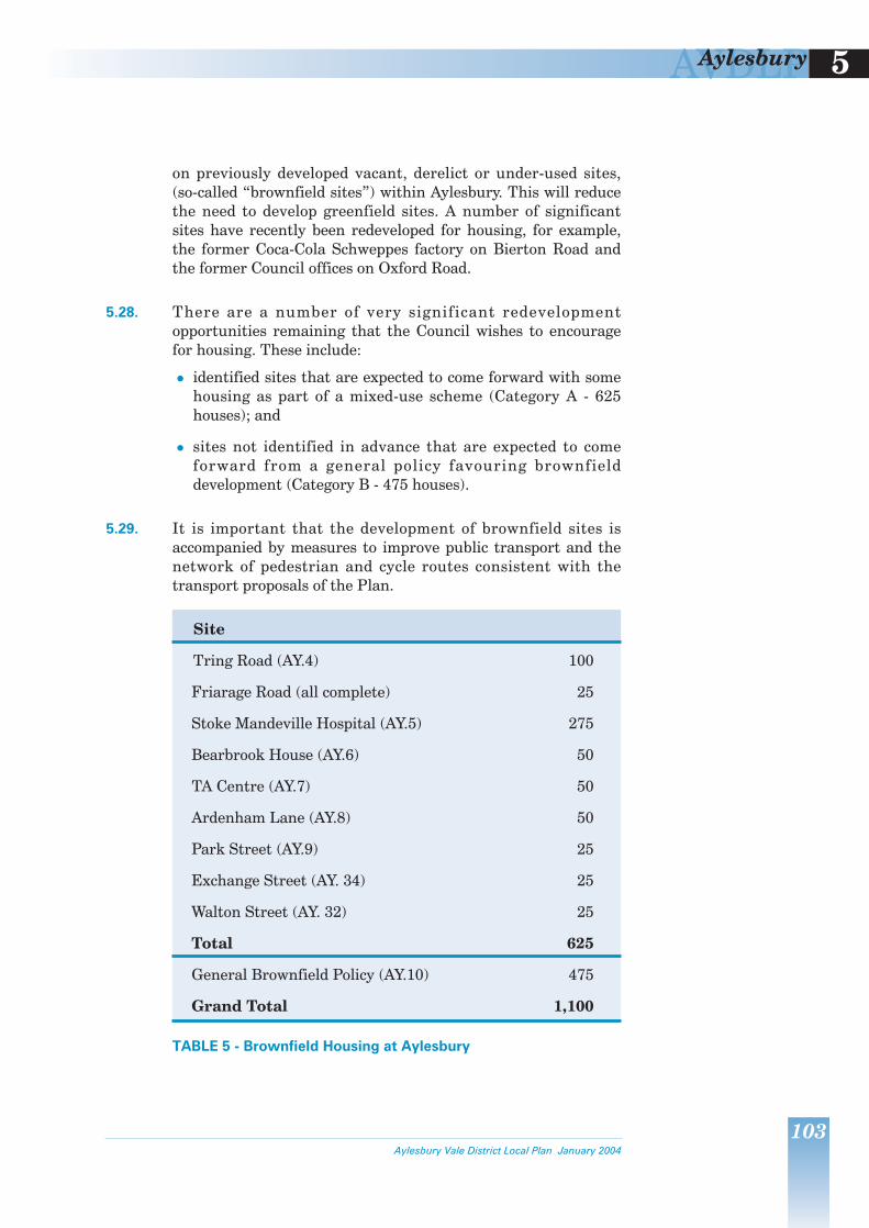
AVDLP 5Aylesbury
on previously developed vacant derelict or under-used sites (so-called ldquobrownfield sitesrdquo) within Aylesbury This will reduce the need to develop greenfield sites A number of significant sites have recently been redeveloped for housing for example the former Coca-Cola Schweppes factory on Bierton Road and the former Council offices on Oxford Road
528 There are a number of very significant redevelopment opportunities remaining that the Council wishes to encourage for housing These include
z identified sites that are expected to come forward with some housing as part of a mixed-use scheme (Category A - 625 houses) and
z sites not identified in advance that are expected to come forward from a general policy favouring brownfield development (Category B - 475 houses)
529 It is important that the development of brownfield sites is accompanied by measures to improve public transport and the network of pedestrian and cycle routes consistent with the transport proposals of the Plan
Site
Tring Road (AY4) 100
Friarage Road (all complete) 25
Stoke Mandeville Hospital (AY5) 275
Bearbrook House (AY6) 50
TA Centre (AY7) 50
Ardenham Lane (AY8) 50
Park Street (AY9) 25
Exchange Street (AY 34) 25
Walton Street (AY 32) 25
Total 625
General Brownfield Policy (AY10) 475
Grand Total 1100
TABLE 5 - Brownfield Housing at Aylesbury
Aylesbury Vale District Local Plan January 2004
103
AVDLP 5 Aylesbury
Mixed Use Schemes (Category A)
530 There are six brownfield sites where although housing is not appropriate for the entire site the opportunity exists for some housing within them These are Tring Road (former BPCC factory) Stoke Mandeville Hospital Bearbrook House (following public consultation and the adoption by the Council of a Planning Brief for the site in July 2003 employment is no longer considered appropriate for this site) the TA Centre Ardenham Lane and Park Street
Tring Road (former BPCC factory)
531 This site is occupied by the former BPCC (Hazellrsquos) printing works It immediately adjoins the Tring Road Tesco food superstore It is adjacent to the Aylesbury Arm of the Grand Union Canal To the south it is bounded by existing housing
532 In part the site could accommodate an expansion of the foodstore in accordance with the Planrsquos food retail strategy (see Policy AY27)
533 Allowing for the expansion of the foodstore it is estimated that the site could accommodate approximately 100 houses Should the expansion of the foodstore not occur the area allocated for that purpose should instead be developed for housing
534 There is the possibility that employment activity will continue in the industrial unit on the east of the site (this is in separate ownership) If this is the case the Council will need to be satisfied that a satisfactory residential environment can be achieved
AY4 The Council proposes that land at the former BPCC factory Tring Road Aylesbury (as defined on the Proposals Map) be developed for housing and a food retail extension to the existing food superstore subject to
a) the development being in accordance with a comprehensive plan to be prepared for the whole of the site (to include the housing site and the site for the expanded foodstore)
b) an equitable contribution being made to the category 2 transport infrastructure improvements to public transport and facilities for walking and cycling
c) satisfactory vehicular access
d) enhancement of the setting and environment of the canal to provide for direct pedestriancycle links from the site and enhance the setting and environment of the towpath and canal
104 Aylesbury Vale District Local Plan January 2004
AVDLP 5Aylesbury
e) protecting the amenity of the residents of the new housing from the foodstore to the east and the industrial area to the north of the canal and if retained the employment activity to the east
f) providing for a mix of housing types and sizes including in particular at least 10 as low cost market housing and providing for a minimum of 20 and up to 30 as affordable housing The Council will assess the circumstances of the site and of the particular proposed development taking into account the considerations set out in GP2 The Council will also wish to ensure that the affordable dwellings are occupied initially by qualifying persons and are retained for successive qualifying persons
g) protecting the amenity of residents of existing adjoining houses and
h) provision of public open space and associated equipment at the equivalent of 243 hectares per thousand people
Stoke Mandeville Hospital
535 Stoke Mandeville Hospital NHS Trust is redeveloping the hospital to improve patient facilities Part of the hospital site will be available for redevelopment as a result This will involve land controlled by the National Health Service Executive and currently leased to the Trust
536 Because of its proximity to adjacent housing areas and its immediate access to public transport the site is considered appropriate for housing and local neighbourhood shopping including a community hall at a scale appropriate to the overall number of dwellings The requirement to safeguard existing trees within the site will be based upon an agreed or joint tree survey
537 The Council supports the creation of a new railway halt to serve the Hospital the Guttmann Sports Centre and surrounding housing A site is reserved adjacent to the existing pedestrian underpass for a railway halt (See Policy AY18)
538 The site at Stoke Mandeville Hospital could accommodate approximately 275 houses and a neighbourhood retail store There are a number of existing houses and flats on the site which accommodate hospital staff (approximately 80 units) It is expected that these will be replaced within that part of the site that is retained as a hospital If they are not the net gain of houses from the identified site will be reduced
Aylesbury Vale District Local Plan January 2004
105
AVDLP 5 Aylesbury
AY5 The Council proposes that land at Stoke Mandeville Hospital Aylesbury (as defined on the Proposals Map) be developed for community uses and housing subject to
a) the development being in accordance with a comprehensive plan to be prepared for the whole of the existing hospital site (to include the housing site the neighbourhood centre site and the site for the new hospital development)
b) an equitable contribution being made to the category 2 transport infrastructure improvements to public transport and facilities for walking and cycling
c) provision of segregated pedestrian and cycle links within the site and to the existing and planned local network including the Stoke Mandeville Hospital to Aylesbury route the underpass to Elm Farm Park and onto Lower Road Mandeville Road
d) satisfactory vehicular accesses
e) providing for a mix of housing types and sizes including in particular at least 10 as low cost market housing and providing for a minimum of 20 and up to 30 as affordable housing The Council will assess the circumstances of the site and of the particular proposed development taking into account the considerations set out in GP2 The Council will also wish to ensure that the affordable dwellings are occupied initially by qualifying persons and are retained for successive qualifying persons
f) protecting the amenity of residents of adjoining houses
g) protecting the amenity of the residents of the new housing from the new hospital buildings to be constructed to the south
h) retaining existing suitable trees within the site
i) provision of public open space at the equivalent of 243 hectares per thousand people and
j) provision of appropriate community facilities including providing for local neighbourhood shopping (up to 1000 sq m of net retail floorspace)
Bearbrook House Oxford Road
539 The site is made up of the former District Councilrsquos offices and a factory to the rear (both now demolished) Comprehensive development of the whole site could include an element of housing probably on the frontage of Oxford Road
106 Aylesbury Vale District Local Plan January 2004
AVDLP 5Aylesbury
540 In terms of vehicular access to Oxford Road this site should be considered together with the TA Centre (see over) in order that the means of access to the two sites can be rationalised As part of the redevelopment of the sites the number of access points from Oxford Road should be reduced to two Emergency access from Gatehouse Close and to Oxford Road will be required A Traffic Impact Assessment will be required in order to establish the form of the junction
541 It is estimated that the site could accommodate approximately 50 houses
AY6 The Council proposes the development of Bearbrook House and surrounding land at Oxford Road Aylesbury (as defined on the Proposals Map) for housing and employment subject to the following
a) the development being in accordance with a comprehensive plan to be prepared for the whole of the site
b) an equitable contribution being made to the category 2 transport infrastructure improvements to public transport and facilities for walking and cycling
c) improvements to the existing cycle and pedestrian network beyond the site including the provision of new or enhancement of existing crossing facilities across the Oxford Road
d) vehicular access being from Oxford Road serving this site and the TA Centre site to allow rationalisation of existing access points
e) providing for a mix of housing types and sizes and providing for a minimum of 15 (or other appropriate figure determined by a housing needs survey) as affordable housing including in particular at least 10 as low cost market housing and providing for a minimum of 20 and up to 30 as affordable housing The Council will assess the circumstances of the site and of the particular proposed development taking into account the considerations set out in GP2 The Council will also wish to ensure that the affordable dwellings are occupied initially by qualifying persons and are retained for successive qualifying persons
f) protecting the amenity of residents of existing adjoining houses
g) retaining trees on the Oxford Road frontage and utilising the stream as a feature
Aylesbury Vale District Local Plan January 2004
107
AVDLP 5 Aylesbury
h) provision of public open space at the equivalent of 243 hectares per thousand people and
i) an appropriate archaeological evaluation shall be made of the entire site prior to the submission of any proposals which should secure mitigation of the impact of development on archaeological remains
Territorial Army Centre Oxford Road
542 The Territorial Army (TA) occupies and owns a large site off Oxford Road The TA site is also used by cadet units and the Army Careers Office An adjacent site owned by the TA is occupied by the Red Cross Development of this site for housing would consolidate an existing residential area
543 The TA may rationalise its Aylesbury site as a result of the defence review to be completed in 1998 The Red Cross is considering options for improving their accommodation at Aylesbury The entire site has a capacity of approximately 50 houses
544 Access to the site should be provided from Oxford Road (see AY6 above) A Traffic Impact Assessment will be required to establish the form of the junction
AY7 The Council proposes that land at the Territorial Army Centre on Oxford Road Aylesbury (as defined on the Proposals Map) be developed for housing subject to the following
a) the development should be in accordance with a comprehensive plan to be prepared for the site
b) an equitable contribution to the category 2 transport infrastructure improvements to public transport and facilities for walking and cycling
c) vehicular access from Oxford Road serving this site and the Bearbrook House site to allow rationalisation of existing points of access
d) providing for a mix of housing types and sizes including in particular at least 10 as low cost market housing and providing for a minimum of 20 and up to 30 as affordable housing The Council will assess the circumstances of the site and of the particular proposed development taking into account the considerations set out in GP2 The Council will also wish to ensure that the affordable dwellings are occupied initially by qualifying persons and are retained for successive qualifying persons
108 Aylesbury Vale District Local Plan January 2004
AVDLP 5Aylesbury
e) protecting the amenity of residents of existing adjoining houses
f) provision of public open space and associated equipment at the equivalent of 243 hectares per thousand people and
g) an appropriate archaeological evaluation shall be made of the entire site prior to the submission of any proposals which should secure mitigation of the impact of development on archaeological remains
Ardenham Lane
545 The site includes Ardenham House previously occupied by the Health Authority allotments which are not fully utilised an unused car park and a number of offices on Oxford Road some of which are substantially vacant It is in a variety of ownerships It is estimated that the site could accommodate approximately 50 houses even though the main area with potential on the site Ardenham House has been granted planning permission for sheltered accommodation There may be some opportunity for housing development on the unused car park or with the consolidation of the allotments (if alternative provision can be provided elsewhere) There may be additional scope for conversion of offices on the Oxford Road frontage (one of these has been granted planning permission for conversion to flats)
AY8 The Council proposes the development of land andor the conversion of existing offices at Ardenham Lane Aylesbury (as defined of the Proposals Map) for housing subject to
a) the development being in accordance with a comprehensive plan to be prepared for the whole of the site or where part is the subject of development a plan which shall describe the proposals in the context of and relate them to other uses of the remainder of the site
b) an equitable contribution being made to the category 2 transport infrastructure improvements to public transport and facilities for walking and cycling
c) vehicular access from Ardenham Lane
d) providing for a mix of housing types and sizes including in particular at least 10 as low cost market housing and providing for a minimum of 20 and up to 30 as affordable housing The Council will assess the circumstances of the site and of the particular proposed development taking into account the considerations set out in GP2 The Council will also wish to ensure that the affordable dwellings are occupied initially by qualifying persons and are retained for successive qualifying persons
Aylesbury Vale District Local Plan January 2004
109
AVDLP 5 Aylesbury
e) protecting the amenity of residents of existing adjoining houses
f) provision of public open space at the equivalent of 243 hectares per thousand people
g) retention of trees on the site
h) the retention and appropriate re-use of the listed building Ardenham House
i) an appropriate archaeological evaluation shall be made of the entire site prior to the submission of any proposals which should secure mitigation of the impact of development on archaeological remains
j) provide for the retention and upgrading to cycleway of the pedestrian route from the end of Mount Pleasant to Whitehill Surgery and
k) development of the site should retain a minimum of 50 of the existing allotments and secure the enhancement of that remaining allotment land
Car Showroom Park Street
546 This site includes a car showroom garage and various open uses to the north The site was included in the Aylesbury Local Plan as a housing allocation although land availability assessments have acknowledged that it would not come forward until after 2001 It is estimated that the site could accommodate approximately 25 houses together with businessoffice uses
AY9 The Council proposes the redevelopment of the site at Park Street Aylesbury (as defined on the Proposals Map) for residential and businessoffice use subject to
a) an equitable contribution being made to the category 2 transport infrastructure improvements to public transport and facilities for walking and cycling
b) vehicular access from Park Street
c) providing for a mix of housing types and sizes including in particular at least 10 as low cost market housing and providing for a minimum of 20 and up to 30 as affordable housing The Council will assess the circumstances of the site and of the particular proposed development taking into account the considerations set out in GP2 above The Council will also wish to ensure that the affordable dwellings are occupied initially by qualifying persons and are retained for successive qualifying persons
110 Aylesbury Vale District Local Plan January 2004
AVDLP 5Aylesbury
d) protecting the amenity of residents of existing adjoining houses and the residents of new houses from adjacent roads and commercial uses
e) provision of public open space at the equivalent of 24 hectares per thousand people and
f) the development shall be in accordance with a comprehensive plan to be prepared for the site
General Brownfield Policy (Category B)
547 The Council considers that there are a number of sites within Aylesbury which offer potential for housing development but are not capable of specific identification in advance because of uncertainties over ownership andor redevelopment capability These include outworn employment sites and vacant and under-used areas of land consistent with national and regional policy It is important to maximise the housing potential of such sites so minimising the need to develop greenfield sites
548 In encouraging such redevelopment for housing it is also important not to lose viable employment sites which would undermine the objective of matching housing growth with job growth at Aylesbury It is only those outworn sites not readily capable of re-use for employment andor sites that cause unacceptable impact on adjacent residential areas that are potentially suitable Other areas of land may perform an important open space function and should not be developed for that reason
549 It will be important to ensure that a satisfactory environment can be achieved for the residents of the new houses on these sites This will be a particular issue with sites that border or contain non-residential uses Development of brownfield sites should contribute to the achievement of improved public transport and facilities for walking and cycling at Aylesbury
AY10 Within the built-up area of Aylesbury consent for the redevelopment for housing of vacant derelict or under-used land will be subject to
a) avoiding the loss of valuable open space
b) avoiding the loss of viable employment sites
c) an equitable contribution being made to the category 2 transport infrastructure improvements to public transport and facilities for walking and cycling
Aylesbury Vale District Local Plan January 2004
111
AVDLP 5 Aylesbury
d) achievement of a satisfactory residential environment
e) compliance with other policies of the plan and
f) provision of public open space at the equivalent of 24 hectares per thousand people
550 It is estimated that some 475 houses will be brought forward through the application of this policy
Reallocated Sites
551 The Council proposes to modify the allocation made in the 1991 Aylesbury Local Plan on land east of Oakfield Road known as Circus Fields from development for general industrial andor business use to a mixed-use development based around a new canal-basin and associated uses and which may include residential leisure andor commercial uses
552 The provision of a new canal basin on the Aylesbury Arm of the Grand Union Canal is an essential element of the regeneration proposals for Aylesbury Town Centre set out in policy AY34 The former Circus Fields employment allocation provides the best available site as it is adjacent to the Canal and has good road and footpath connections to the town centre and to destinations outside the town but does not visually intrude into the countryside
553 Surrounding fields and the Canal support some protected animal and plant species and a full ecological survey will be required to determine necessary on- and off-site mitigation The Council aspires to the provision of a country park around Aylesbury and it is important therefore that pedestrian and cycle linkages are made into the countryside making use of the towpath canal bridges and rights of way network
AY11 The Council proposes the development of 298 hectares of land at Circus Fields Aylesbury (as shown on the Proposals Map) for mixed-use development including a canal-basin with associated uses A comprehensive plan should be prepared for the site which takes account of an ecological assessment and includes appropriate ecological mitigation measures
112 Aylesbury Vale District Local Plan January 2004
AVDLP 5Aylesbury
MAJOR DEVELOPMENT AREAS
INTRODUCTION
554 The proposals for the MDAs at the mixed development sites at Berryfields and Weedon Hill and the employment park at Aston Clinton Road provide the opportunity for creating a sustainable and attractive form of development for Aylesbury The scale of these developments at such concentrated locations is unprecedented for the town Each MDA will involve creating substantial new satellite communities in greenfields on the edge of but linked to Aylesbury When complete the largest of these at Berryfields involves creating a community three-quarters the size of Buckingham
555 This scale of development provides important opportunities that can be exploited to benefit the whole town The Council is keen to explore and apply with developers best practice in planning for attractive safe sustainable communities
556 A primary objective will be to create new vibrant communities (what are commonly known as lsquourban villagesrsquo) on the edge of but with strong links to the existing built-up area of Aylesbury Each community should clearly be a different place with its own identity
557 The MDAs should create a human-scale environment with a rich and varying townscape complemented by a sensitive imaginative relationship with the surrounding countryside and a design that incorporates elements of the countryside and historic landscape within and through each development area Within each MDA there should be a strong sense of differing but related neighbourhoods that offer security and close and easy access on foot to shops schools jobs open spaces and leisure facilities
558 The important and wide ranging implications of developing these sites will require comprehensive consideration of each site as a whole
559 A standard blueprint is not proposed for the MDAs The Council will work with the developers involved to jointly prepare planning briefs for each MDA These planning briefs will develop the principles and details highlighted above Each will be separately consulted upon and the approved briefs will be adopted as Supplementary Planning Guidance
Aylesbury Vale District Local Plan January 2004
113
AVDLP 5 Aylesbury
AY12 Planning briefs are to be prepared for each of the MDAs These will be the subject of public consultation and adopted by the Council as Supplementary Planning Guidance Applications for planning permission for the development of all or part of any MDA will be determined having regard to the provisions of relevant policies in this plan and adopted Supplementary Planning Guidance Adherence to their principles shall be secured by means of planning conditions andor planning obligation agreements made pursuant to section 106 of the Town and Country Planning Act 1990
560 The earliest sections of this chapter detailing the ALUT Strategy highlight the need for development funding for key parts of the transport proposals Additionally all surface and foul water drainage elements all services and necessary community facilities such as schools sports fields play areas other leisure facilities and landscaped amenity space will have to be provided by the development In seeking these services and facilities the Council will apply the appropriate standards
561 The local education authority calculates that three new combined schools will be required to meet the needs generated by the new development Two will be required at Berryfields and one at Weedon Hill
562 The education authority has also calculated that the scale of new development proposed at Aylesbury will be sufficient to generate the equivalent of half of one new 1500 place secondary school As insufficient capacity is available to expand existing facilities a new secondary school is proposed at Berryfields (the largest of the MDAs) The education authority have indicated the need to re-organise secondary school provision in the northern part of the town re-locating the existing Quarrendon School to the new site at Berryfields This will result in a full-sized 1500 place secondary school being built at Berryfields
563 On the basis that future playing field provision in the MDAs and those associated with the schools could be shared facilities the education authority advises that a 65ha site would be required to accommodate a secondary school and 165ha would be required for a combined school
564 The amount of housing on the Berryfields and to a slightly lesser degree Weedon Hill sites will generate a requirement to provide indoor sports facilities (see GP90) Indoor sports facilities to a standard and design to be agreed with the Council should be provided by way of an enhanced community facility This should include a multi-sportscommunity uses hall
114 Aylesbury Vale District Local Plan January 2004
AVDLP 5Aylesbury
changing rooms and an outdoors multi-purpose area immediately adjacent the hall
565 The MDAs are required to fund the whole of the transport infrastructure costs identified as category 1 works (see paragraphs 513-514) Each MDA will be required to make an equitable and proportional contribution to this total cost based on the total trip movements likely to be generated by that development (the secondary school at Berryfields will be excluded from this calculation)
BERRYFIELDS
566 The Berryfields site which comprises almost 200 hectares is proposed for a mixed development comprising housing employment and a full range of community facilities The development has the potential to accommodate 3000 houses on some 85 hectares of land Of this 3000 no more than 1850 are to be built within the Plan period and the remainder proposed after 2011 There is potential therefore for this site to meet future County Structure Plan requirements with the likelihood of further growth being promoted at Aylesbury beyond 2011
567 The local education authority requires the provision of a secondary school within the Berryfields MDA This requirement is explained in more detail in paragraphs 562-563
AY13 Proposals for development at Berryfields (as defined on the Proposals Map) will only be permitted where that development comprises a comprehensive scheme for the site in accordance with AY12 No development shall extend beyond the MDA boundary The Council proposes that development of the site shall include
a) provision of a single carriageway distributor road (the Western Link Road) from a junction on the A41 Bicester Road near the Berryfields junction (that also provides access to land on the southern side of the A41) to the eastern edge of the development site and with further junctions on the distributor road providing access into the development area north of Bicester Road
b) provision of an additional junction onto the A41 Bicester Road near the existing Berryfields Farm access serving land on both sides of the A41
c) a 100 contribution to the A41 Bicester Road Primary Public Transport Corridor and a proportional contribution to Primary Public Transport Corridor linkages around the town centre (as described in paragraphs 513-517 522-523
Aylesbury Vale District Local Plan January 2004
115
AVDLP 5 Aylesbury
and proposal AY3) and the revenue costs during the first three years after occupation of the first dwelling of public transport bus improvements along that corridor and a proportional contribution towards the provision of the category 1 funded sections of the Western Link Road between the Berryfields and Weedon Hill MDA boundaries
d) the establishment and safeguarding of a suitable network of segregated cycleways footpaths and bridleways within the site and alongside the River Thame with crossing(s) of the river the Western Link Road and A41 and with connections to the existing network and town centre
a) provision of land (not more than 85ha) for 3000 new houses of which not more than 1850 houses shall be built in the period to 2011
f) prov i s ion o f l and (approx imate ly 10ha) f or employment purposes
g) provision of land buildings and car parking sufficient for two separate combined schools (with associated playing field) the size to be determined by generated pupil numbers
h) provision of land for a new 1500 place secondary school inclusive of associated playing field and a proportional contribution based on generated pupil numbers for the buildings and ancillary facilities
i) provision of land buildings and car parking sufficient for a neighbourhood centre including community hall indoor sports facilities local shops including 1400 sq m net food retail floorspace and other community facilities
j) provision of land (17ha) for a Park-and-Ride facility adjacent to the railway line and the A41 Bicester Road (land is additionally reserved for a rail halt - see AY18)
k) provision of land in accordance with NPFA standards for the laying out of and the maintenance of sports pitches and associated changing rooms
l) provision of land in accordance with NPFA standards for childrens play areas and the provision of equipment including their maintenance
m) the provision and safeguarding of land within and around the periphery of the developed area of the site (all within the extent of the MDA boundary) for open amenity land
n) the safeguarding as far as possible of important natural features such as trees hedges and streams particularly those that could form the basis of strong axis links through the site
116 Aylesbury Vale District Local Plan January 2004
AVDLP 5Aylesbury
o) the provision of all necessary supporting infrastructure any surface water balancing shall be fully integrated into the landscaping scheme
p) providing for a mix of housing types and sizes including in particular at least 10 as low cost market housing and providing for a minimum of 20 and up to 30 as affordable housing The Council will assess the circumstances of the site and of the particular proposed development taking into account the considerations set out in GP2 above and also the local need for low cost housing The Council will also wish to ensure that the affordable dwellings are occupied initially by qualifying persons and are retained for successive qualifying persons
q) an appropriate archaeological evaluation shall be made of the site as part of the preparation of the planning brief in order to assess potential archaeological importance or features The development shall take account of this evaluation and
r) the development shall take account of the importance of the scheduled ancient monument at Quarrendon and the protection of its setting
568 The Council wishes to encourage the reopening of the railway line to passenger traffic to meet as varied travel needs as possible Therefore any development of this site should not prejudice this possibility and not miss opportunities for operating an enhanced service along the line in particular serving the site The 17ha site safeguarded at Berryfields for a Park-and-Ride facility should be located to enable it to serve both bus and rail services from any future rail halt
WEEDON HILL
569 The Weedon Hill site extends to about 50 hectares It is proposed for a mixed development comprising 850 houses and a full range of community facilities
AY14 Proposals for the development at Weedon Hill (as defined on the Proposals Map) will only be permitted where it comprises a comprehensive scheme for the site in accordance with AY12 No
development should extend beyond the MDA boundary The Council proposes that the development of the site shall include a) provision of a section of single carriageway distributor road
from a new junction on the A413 to the northern edge of the development site and a junction on the link road providing access into the site
Aylesbury Vale District Local Plan January 2004
117
AVDLP 5 Aylesbury
b) provision of a new junction connection to the site from the A413 Buckingham Road at the Watermead roundabout and the signalisation of the whole of that junction
c) a 100 contribution to the A413 Buckingham Road Primary Public Transport Corridor and a proportional contribution to Primary Public Transport Corridor linkages around the town centre (as described in paragraphs 513-517 522-523 and proposal AY3) and the revenue costs during the first three years after occupation of the first dwelling of public transport bus improvements along that corridor and a proportional contribution towards the provision of the category 1 funded sections of the Western Link Road between the Berryfields and Weedon Hill MDA boundaries
d) the establishment and safeguarding of a suitable network of segregated cycleways footpaths and bridleways within the site and alongside the River Thame with crossing(s) of the river the A413 and with connections to the existing network and town centre
e) a proportional contribution based on generated pupil numbers toward providing a new secondary school at Berryfields
f) provision of land (not more than 22ha) for housing development
g) provision of land buildings and ancillary facilities sufficient for a combined school (with associated playing field) the size to be determined by generated pupil numbers
h) provision of land buildings and car parking sufficient for a neighbourhood centre including community hall indoor sports facilities local shops and other community facilities
i) provision of land (17ha) for a Park-and-Ride facility adjacent the A413Western Link Road junction
j) provision of land for the laying out of and the maintenance of sports pitches and associated changing rooms upon that land
k) provision of land in accordance with NPFA standards for childrens play areas and the provision of equipment including their maintenance
l) the provision and safeguarding of land within and around the periphery of the developed area of the site (all within the extent of the MDA boundary) for open amenity land
m) providing for a mix of housing types and sizes including in particular at least 10 as low cost market housing and providing for a minimum of 20 and up to 30 as affordable housing The Council will assess the circumstances of the site and of the particular proposed
118 Aylesbury Vale District Local Plan January 2004
AVDLP 5Aylesbury
development taking into account the considerations set out in GP2 and also the local need for low cost housing The Council will also wish to ensure that the affordable dwellings are occupied initially by qualifying persons and are retained for successive qualifying persons
n) the safeguarding as far as possible of important natural features such as trees hedges and streams particularly those that could form the basis of strong axis links through the site
o) the provision of all necessary infrastructure any surface water balancing shall be fully integrated into the landscaping scheme
p) an appropriate archaeological evaluation shall be made of the site as part of the preparation of the planning brief in order to assess potential archaeological importance or features The development shall take account of this evaluation and
q) the development shall take account of the importance of the scheduled ancient monument at Quarrendon and the protection of its setting
ASTON CLINTON ROAD
570 The Aston Clinton Road site which comprises 26 hectares is proposed for a business park set in amenity parkland and a Park-and-Ride site
AY15 Proposals for development at Aston Clinton Road (as defined on the Proposals Map) will only be permitted where it conforms with a comprehensive scheme for the site as required in AY12 No development should extend beyond the MDA boundary The Council proposes that the development of the site shall include
a) any development being against the background of a comprehensive plan for the whole of the site
b) a proportional contribution (see paragraphs 513-517 522shy523 and proposal AY3) towards the Tring Road Primary Public Transport Corridor and the revenue costs during the first three years after occupation of the first employment user of public transport bus improvements along those corridors
c) the establishment and safeguarding of a suitable network of segregated cycleways footpaths and bridleways within the site and with crossings of the A41 Aston Clinton Road and Broughton Lane to the existing and proposed network and town centre
d) provision of land buildings and car parking for a business park
Aylesbury Vale District Local Plan January 2004
119
AVDLP 5 Aylesbury
e) provision of land (17ha) for a Park-and-Ride facility adjacent the A41 Aston Clinton Road
f) the provision and safeguarding of open amenity land within the comprehensive development site the location of which will be determined in the planning brief
g) the provision of all necessary infrastructure any surface water balancing shall be fully integrated into the landscaping scheme
h) the protection of and addition to existing trees and hedgerows particularly where they screen the site (save where the retention of existing trees and hedgerows would prevent the most satisfactory comprehensive scheme being achieved) and
i) an archaeological evaluation shall be made of the entire site prior to the submission of any proposals which should secure mitigation of the impact of development on archaeological remains
EMPLOYMENT
571 Aylesbury provides employment for about 32000 people about half of whom live in the town the remainder commute from elsewhere in the District and beyond Its location on the A41 with easy access to London the Midlands Heathrow and the M1 M25 and M40 motorways makes it an attractive employment location
The Town and Country Planning (Use Classes) Order 1987 as amended gives detailed guidance on uses which fall within each class of development though in general
B1 = Business B2 = General Industrial B8 = Storage or distribution
572 Aylesbury is identified as a sub-regional growth centre in the adopted County Structure Plan In order to meet its growth requirement and continue to successfully attract new employment investment and reinvestment substantial new land allocations must be made to supplement that which exists already Accordingly a further 250ha of land is proposed for (B1 B2 and B8) office industrial and distribution uses around the periphery of the town Additionally land is proposed for retail warehouse uses hotel and conference accommodation and a number of sites in and around the town centre are proposed for retail and leisure purposes Provision is also made as necessary to accommodate employment uses displaced from brownfield sites within the existing urban area
573 According to the Councilrsquos own advisers the local Chambers of Commerce other business support agencies and local business representatives the main employment allocation should be
120 Aylesbury Vale District Local Plan January 2004
AVDLP 5Aylesbury
made at Aston Clinton Road That location is considered most marketable and most accessible to major markets ie London Heathrow and the Thames Valley
574 A part of the Berryfields site next to the A41 and proposed Western Link Road is expected to provide opportunities for existing businesses in the town who wish to expand much as Brunel Road and the new Coldharbour FarmFairford Leys developments do at present The employment needs of the Weedon Hill area are provided for at Berryfields and along the Bicester Road employment area
OTHER EMPLOYMENT SITES
575 Two sites at Stocklake with a cumulative area of 28 ha and 07 ha off Telford Close (originally proposed for employment purposes in the Aylesbury Local Plan) remain available for development
AY16 The Council proposes that the three sites listed below be developed for employment uses
a) Stocklake (west) 20 ha
b) Stocklake (east) 08 ha and
c) Telford Close 07 ha
TRANSPORT
576 Aylesbury is both a significant generator and attractor of transport movements In 1994 there were nearly 238000 person trips by all modes made on a typical weekday Almost 90 of these trips have an origin or destination or both in the Aylesbury area Only 11 of the daily trips are traffic passing through the town and this figure is nearly halved for the morning peak period With car ownership levels expected to continue to grow in line with increased wealth a major objective of the Plan is to manage in a more sustainable manner the transport demands of the town
577 The ALUT Strategy which has been devised jointly with BCC is contained at the beginning of this chapter This strategy is divided into its component parts and detailed over
PUBLIC TRANSPORT
578 Improved public transport provision is a key requirement in providing alternatives to journeys made by car Public transport
Aylesbury Vale District Local Plan January 2004
Facts and figures on transport in Aylesbury can be found in the Aylesbury Land UseTransport Strategy Background Paper
121
AVDLP 5 Aylesbury
has a number of social economic and environmental advantages over the car
z it is more cost effective
z it makes better use of road space
z it produces lower levels of pollution per passengermile
z it limits parking problems and
z it has a better safety record
579 At present public transport in Aylesbury is relatively poorly used The 1991 Census identified that fewer than 4 of journeys to work in the town were made by bus A study carried out in 1997 indicated that patronage was rising but only very slowly
580 Passenger rail services extend southwards on two routes to London The line to the north has no passenger service Rail at present caters more for longer distance journeys to and from the town rather than for local travel
581 Bus transport often has advantages over rail for local journeys especially in that
z it has lower costs of provision
z it has lower costs of operation and
z it provides far greater flexibility and accessibility to more closely match the large number of diverse trip origins and destinations prevalent in Aylesbury
Buses
582 The key to the success of an enhanced bus network will be its quality It is vital that the quality of the whole public transport network is improved This will include introducing newer cleaner quieter buses that run frequently and reliably The supporting network of bus stops information on timetables the bus station and general marketing will all need improvement Much of this improvement will only be achieved through joint working between the two Councils and the bus companies
583 It is proposed to develop a range of preference measures along the main radial roads serving the town to assist bus access and services These include bus lanes bus priority measures vehicle activated initiatives improved bus stops shelters and
122 Aylesbury Vale District Local Plan January 2004
AVDLP 5Aylesbury
information facilities and ensuring that new developments make appropriate provision for bus services and access
584 The creation of Primary Public Transport Corridors linking the MDAs north-west north and east of the town via the town centre is the first priority for implementation in the overall strategy for bus improvements Bus priority improvements are proposed along Bicester Road linking the Berryfields MDA to the town centre in and around the town centre along the Buckingham Road linking the Weedon Hill MDA to the town centre and in the Tring Road Corridor linking Aston Clinton Road MDA to the town centre
585 Within the Primary Public Transport Corridors (as defined on the Proposals Map) and other priority bus corridors measures to improve and enhance bus operation and access will be developed Measures will include as appropriate
a) bus lanes bus operated traffic signals and other innovative priority measures introduced on a comprehensive basis along each corridor
b) additional bus stops at appropriate locations with better shelters improved information facilities and other amenities and
c) co-ordinated up-to-date timetable information at the main bus station the main shopping centres and other major public transport nodes
586 Improvements to assist bus priority will be implemented on the other main radials in the town A418 Oxford Road A41 Tring Road A413 Wendover Road and B4443 Lower Road Mandeville Road
AY17 Proposals for residential and employment development on sites in Aylesbury should make appropriate provision for integration of the uses with the public transport system In deciding applications the Council will have regard to the need for development layouts to incorporate routes and accesses suitable for buses
Rail
587 Rail services in Aylesbury are important for travel to and from London but do little for more local travel A study looking at the possibilities of rail accommodating local journeys was commissioned as part of the background work to the Local Plan
Aylesbury Vale District Local Plan January 2004
123
AVDLP 5 Aylesbury
The study looked at the potential of both existing rail and light rapid transit (LRT) proposals for Aylesbury
588 The study showed that there is no viable case for an LRT system to serve Aylesbury On existing rail the study concluded that while there is no firm case for new stations at the moment there may be cause over the Plan period to review the situation with regard to station stops at Stoke Mandeville Hospital and as part of the Berryfields MDA because of this land for station stops at both sites will be safeguarded in the Plan
AY18 The Proposals Map indicates the preferred position of new rail station stops at Berryfields and Stoke Mandeville
Planning proposals that would prejudice the development of such facilities will not be permitted
589 For some time the Council has been concerned to exploit all opportunities to diversify and expand Aylesburyrsquos local economy This includes improving the townrsquos overall accessibility A key element in this is to improve rail services and links both north and south of the town
590 The District and County Councils are members of a consortium looking to encourage the development of an improved East West rail link from the South Midlands to East Anglia The re-opening to passenger and freight services of the Bicester to Bletchley line including a link from Aylesbury to Bletchley is an integral part of the proposal This has the support of both Councils
591 In the late 1980s a rail proposal was put forward to link areas east and west of London via new tunnels under the centre of the city This is known as CrossRail and involves the linking of Aylesbury and Reading in the west via the City of London to Stratford and Shenfield Essex in the east
592 Development likely to prejudice the implementation of Crossrail or the re-opening of the line running northwards from Aylesbury Station to passenger and freight services will be refused
AY19 The Council will resist proposals for development that would prejudice the re-opening of the railway line north of Aylesbury for passenger and freight traffic or the Crossrail proposal linking Aylesbury to central London
124 Aylesbury Vale District Local Plan January 2004
AVDLP 5Aylesbury
CYCLING
593 The benefits of cycling are well known It is an efficient cheap and healthy means of transport and has environmental benefits The Government is actively promoting the potential of the bicycle In 1991 some 4 of journeys to work in Aylesbury were by cycle By 1994 a travel survey indicated that this had dropped to about 25 BCCrsquos ITS looks to raise this to 5 by 2011 Countywide
594 The topography of Aylesbury and the surrounding Vale lends itself to cycling The ALUT Strategy includes a Cycle Network (ALUT Strategy Background Papers) designed in conjunction with local user groups Suitable routes have been identified using
z minor low trafficked roads
z modified road layouts giving advantages to cyclists
z special cycle facilities including dedicated cycle lanes or routes and advanced stop lines at appropriate junctions and
z where appropriate shared use of footways or footpaths
595 The Council in conjunction with the County Council intends to produce Supplementary Planning Guidance to define the Cycle Network The Cycle Network has been designed to cater for the multiplicity of trip origins and destinations in Aylesbury such as journeys to work shop school and leisure facilities An overall aim is to provide a safe continuous convenient and direct cycle network throughout the town along with adequate storage and parking facilities
596 The Cycle Network relates to the existing developed urban area but is designed to link in to new routes within the approved and proposed development areas and to surrounding villages Work on developing the network has begun in various parts of the town including
z WendoverHalton via the A413 to Aylesbury town centre
z A41 Bicester Road
z Stone via the A418 to Aylesbury town centre and
z within the Coldharbour FarmFairford Leys development
Aylesbury Vale District Local Plan January 2004
125
AVDLP 5 Aylesbury
AY20 The Aylesbury Cycle Network is defined in Supplementary Planning Guidance The Council will resist development that compromises the convenience or safety of cyclists on this network When considering development proposals the Council will seek in conjunction with the proposed scheme to extend the Cycle Network with dedicated cycle lanes or shared cyclepedestrian routes and to provide secure cycle parking for its users
WALKING
597 In the travel survey conducted in 1994 walking at 18 of all trips was second only to the car as a choice of transport mode during the morning peak period The development of a quality cycle network will also provide benefits to pedestrians and wheelchair users in providing safe attractive and direct routes and safe and easy crossing points of main roads A complementary pedestrian network has been drawn up with BCC
PARKING
598 Car parking is a key factor that can influence transport demand and choice of transport for making journeys In Aylesbury some 60 of people travelling to work in the town centre have free parking and at out of centre employment leisure and shopping locations this is nearer 100 Local authority control over this parking is limited This situation common to much of the country has arisen through attempts to accommodate massive growth in car traffic and a relatively unrestrained parking policy operated over the last two to three decades Free and readily available parking while currently the expected norm generates traffic and contributes to congestion
599 The ability or scope for an authority to promote speedy radical changes to the existing parking regimes is limited Any highly restrictive policy arrived at unilaterally may have a detrimental impact on the town by deterring existing and potential investors in the town by driving them away to nearby settlements with a more lax policy towards the car
5100 In the light of this the Local Plan is looking to adopt a strategy based on the advice in PPG13 and PPG6 which recognises that this is the beginning of an incremental change in policy over the Local Plan period to 2011 The principles of this approach are included in GP24
5101 The parking strategy is to allow adequate short stay parking close to the town centre and limited long stay parking in and
126 Aylesbury Vale District Local Plan January 2004
AVDLP 5Aylesbury
around the town centre complemented by the introduction of Park-and-Ride facilities at the edge of the town The Parking Guidelines will be subject to regular review to accommodate changing circumstances and policy changes
5102 In looking to begin reducing town centre long stay private nonshyresidential parking (PNR) it is proposed that an ldquooperational parking onlyrdquo zone be designated in the town centre within and adjacent the area bounded by the Inner Relief Road (IRR) The only developments for which more than operational parking would be allowed are residential and major foodbulky goods retail warehousing development This will lead to a reduction in unnecessary car access into the heart of the town much of which is a designated Conservation Area and subject to pedestrian priority proposals
5103 ldquoOperational needrdquo is that parking required for cars and other vehicles that are regularly and necessarily involved in the operation of the business or land use This will include collecting and delivering goods and the setting down of passengers The storing or servicing of vehicles where this is an integral part of the business or use is not precluded
5104 Restricting on-site car parking provision will provide greater potential for maximising development on a site and will lead to additional demands being made on the transport network Therefore in addition to the developer contribution referred to in paragraphs 513-520 developments except for residential and major foodbulky goods retail warehousing within the ldquooperational parking onlyrdquo zone will be required to provide additional contributions to the ALUT Strategy These will be based on a sum equivalent to the cost of providing surface level car parking which would otherwise have been required in accordance with the Parking Guidelines This sum will be payable to the Council and used for the provision of alternative transport choices as developed in the ALUT Strategy This will include the provision of bus cycle walking facilities and public car parking provision including Park-and-Ride sites facilities and bus services
5105 There are and will be large areas which lie outside the IRR but which are well served by public transport for example sites just outside the IRR the neighbourhood centres in the MDAs and sites adjacent to the public transport corridors Proposals for development that can be shown to be well served by public transport including residential should be considered as in the above paragraph
Aylesbury Vale District Local Plan January 2004
127
AVDLP 5 Aylesbury
AY21 Within the urban area of Aylesbury special parking principles will apply
Inside the Inner Relief Road on-site parking provision associated with all development proposals other than food superstores (and bulky goods retail warehousing) will be restricted to that required for the operational needs of the business or land use
For other parts of the urban area well served by public transport planning proposals will not be required to provide the maximum parking levels set out in the Councils parking guidelines In considering these applications the Council will apply a reduced parking standard consistent with the accessibility of the site to public transport options and the essential needs of the development
5106 There will remain a need to control the demand for car parking to prevent it merely being displaced into surrounding residential and other areas Problems usually result where long-stay parking demand conflicts with residents and other users in these areas In conjunction with BCC it is therefore intended to introduce a Special Parking Area (SPA) to cover the town centre and surrounding areas in order to control on-street parking and prevent the displacement of long-stay parking into unsuitable areas To be effective charges will be required within the SPA to fund the necessary enforcement Any proposals would accommodate the needs of residents and other essential users although charges may be levied for permits to help cover the cost of enforcement and administration
Park-and-Ride
5107 Proposals for Park-and-Ride generally involve the relocation of long-stay parking from the town centre into new car parks towards the edge of the urban area and provide dedicated passenger transport services into the centre or to other employment areas
5108 The Council proposes to safeguard land for possible future Park-and-Ride sites within the MDAs on the periphery of the town Some 2ha of land are required to provide sites for parking up to 600 cars and associated Park-and-Ride facilities The locations of the safeguarded areas are shown on the Proposals Map
128 Aylesbury Vale District Local Plan January 2004
AVDLP 5Aylesbury
5109 The safeguarded Park-and-Ride site at Berryfields is located to take advantage of either bus or rail initiatives if they become viable
5110 The Council will keep under review the need and requirements for Park-and-Ride sites to serve the radial corridors of Oxford Road (A418) and Wendover Road (A413)
HIGHWAY NETWORK AND PROPOSALS
5111 The ALUT Strategy provides for the minimum amount of new road building This is defined as
z that which is required to directly access the MDAs and provide essential links between one another and the existing urban area and
z that which is required to serve the general needs of the town and accordingly would be designed to a sufficient standard to meet local travel needs without attracting long distance through traffic nor generating undue levels of additional trips
5112 To directly access the MDAs a new road is proposed linking Berryfields and Weedon Hill MDAs (as defined on the Proposals Map)
AY22 The following road is proposed (as defined on the Proposals Map) - Western Link (connecting Berryfields and Weedon Hill MDAs)
TOWN CENTRE
INTRODUCTION
5113 Aylesbury is fortunate in having successfully retained its historic centre in recognisable form whilst accommodating significant modern developments A major part of its attraction is the proximity of the ldquoOld Townrdquo centred around St Maryrsquos Church to the main shopping area and that within the shopping area there is a miscellany of attractive and interesting old buildings and frontages
5114 Recent years have seen significant investment in the town with the major redevelopment of the Friars Square Centre and refurbishment and redevelopment of other shopping areas The town is well represented by the national multiples and has two department stores
Aylesbury Vale District Local Plan January 2004
129
AVDLP 5 Aylesbury
5115 The success of the High Street and Market Square pedestrianisation schemes is to be enhanced by further restrictions of traffic in these areas and the extension of the pedestrian priority zone to include Kingsbury and adjoining streets These works were programmed to commence early in 1999
5116 In seeking to enhance Aylesburyrsquos role as county town and subshyregional shopping centre the Council has approved the Vision Statement for the Development of Aylesbury Town Centre (May 1998) which includes the following principle
To provide for all possible dimensions of town centre activity whilst always seeking to make the centre of the County Town safer more prosperous more vibrant and more attractive
5117 This statement highlights the fact that there are a number of uses and activities that have to be accommodated in the town centre including shopping leisure employment housing worship and tourism It is one of the main purposes of this Plan to accommodate these sometimes competing uses in a way which most benefits the whole of the town centre
5118 The Council has embarked on a programme of measures to improve security and safety in the town centre These measures and the policy related to them are included in paragraphs 4139-4141 and GP45
A PLACE TO SHOP
5119 In accordance with the general shopping strategy outlined earlier in Chapter 4 a main objective of the Plan is to concentrate new shopping development at Aylesbury and that this development should be concentrated within or on the edge of Aylesburyrsquos town centre Aylesburyrsquos town centre embraces a multitude of uses and activities including shops homes jobs pubs and clubs restaurants leisure sports and community facilities that are mainly concentrated within the Inner Relief Road For the purpose of implementing PPG6 the town centre should be defined so as to embrace this multiplicity of purpose
AY23 The town centre is defined as that area within the Inner Relief Road as shown on the Proposals Map Proposals for development within this area will be considered having regard to their town centre location
130 Aylesbury Vale District Local Plan January 2004
AVDLP 5Aylesbury
New Floorspace Requirements
5120 As the population grows with the expansion of the town there is a need for the townrsquos shopping facilities to expand and improve in order to maintain Aylesburyrsquos role as the main retail focus in Aylesbury Vale and as a sub-regional centre in the County Substantial requirements for additional provision of comparison food and retail warehouse floorspace during the Plan period have been identified (see Shopping Background Paper) The scope for accommodating this on town centre and edge of centre sites has been examined (see Development Sites Appraisal Background Paper)
Town Centre Comparison Goods
5121 To maintain Aylesburyrsquos existing share and role in the comparison goods sector about 19000 sq m net sales area of additional floorspace will be required This is not seen as a prescriptive target rather as a reasonable guide To accord with the principles of sustainable development and to seek enhanced prosperity for the town additional development may be sought to reduce outflow of expenditure from Aylesburyrsquos catchment area The potential to increase Aylesburyrsquos market share through development opportunities that arise in accordance with the general shopping strategy will be carefully considered
5122 It is essential to locate comparison shopping in such a way as extends range and choice and allows shoppers to be able readily to compare between competing traders The first priority is therefore to accommodate the additional floorspace within the retail core of the town centre in locations that best satisfy these criteria
5123 The availability of appropriate town centre sites that meet the strict location criteria and which can accommodate the scale of development required is severely limited The Aylesbury Local Plan (1991) identified the Upper Hundreds site for town centre comparison goods This site has been redeveloped for almost 3900 sq m net sales area (which contributes towards the 19000 sq m floorspace requirement) Another edge of centre site the former Cattle Market has been redeveloped as a multiplex cinema and other leisure uses
5124 The only remaining significant available and appropriate site which adjoins the Central Shopping Area is Exchange Street (N) currently occupied by the Civic Centre former Maxwell pool the Civic Centre car park and the open space between the car park and Exchange Street The proposed relocation of the Civic Centre to the southern side of Exchange Street and the
Aylesbury Vale District Local Plan January 2004
The Shopping Background Paper and Development Sites Appraisal Background Paper contain relevant information identified floorspace and examination of edge of centre sites
131
AVDLP 5 Aylesbury
relocation of the former pool to an enhanced facility on Vale Park provides an opportunity for re-developing this area It is well related to the existing shopping centre and provides the opportunity for strong linkages to the Hale Leys Centre and potentially by including additional properties through to the High Street
5125 The primary purpose of the Exchange Street (N) site would be for approximately 16000 sq m net sales area of town centre comparison goods shopping The physical characteristics of the site and the scale and height of surrounding buildings provide the opportunity of also accommodating other uses including a public space replacement car parking offices and leisure uses
AY24 The Proposals Map defines a site north of Exchange Street for comprehensive mixed-use redevelopment based principally on retail uses
In considering proposals for the redevelopment of this area the Council will have regard to the results of public consultation on any preferred schemes
5126 Two smaller sites previously identified in the Aylesbury Local Plan (1991) at Exchange StreetCanal Basin and immediately north of Marks amp Spencer remain available for development appropriate to a town centre setting (including retail uses) The Exchange StreetCanal Basin site is considered suitable for a mixture of uses including retail but also including arts and leisure residential hotel and cafeacuterestaurant uses (see AY34) The land north of Marks amp Spencer was identified in the Aylesbury Local Plan as a part of the Upper Hundreds redevelopment site It remains available for retail development purposes
5127 Other proposals for town centre comparison goods shopping will be judged against policies AY25 and AY28-AY30 In particular the development or redevelopment of smaller sites can lead to qualitative improvements in shopping facilities and can readily be accommodated within and enhance the town centre
AY25 Within the Central Shopping Area proposals for infill retail developments that enhance the shopping environment will be permitted
132 Aylesbury Vale District Local Plan January 2004
AVDLP 5Aylesbury
Retail Warehousing
5128 The Shopping Background Paper (1996) identified a need for further bulky goods retail warehouse floorspace emerging towards the year 2000 Beyond that the potential for a further substantial retail warehouse park was identified by about the middle of the Plan period Recent work undertaken for the Council has revealed that the timing of capacity for further floorspace has receded and will not now be required until the end of the Plan period Any such requirements will be considered in a review of the Local Plan
5129 Sites for new retail warehousing in or on the edge of the town centre are severely limited Current edge-of-centre provision is concentrated at Cambridge Close which suffers compared to modern retail parks because of its poor layout and ageing structures The Council has long recognised the important contribution retail warehousing plays in supporting the town centre and has sought to strengthen this role by encouraging the redevelopment and modernisation of Cambridge Close
5130 It is therefore proposed to redevelop and extend Cambridge Close Retail Park to include the sites of the existing fire station and former Council depot This would allow for the floorspace to be redeveloped and extended to meet modern requirements and bring the site closer to the town centre so strengthening its supportive role bolstering the town centre
5131 Cambridge Close is restricted to the sale of retail bulky goods only (with Argos trading on a personal permission to their name) It remains appropriate to restrict the sale of goods to prevent inappropriate competition with the town centre and to maximise development prospects of the Exchange Street (N) site
5132 At Cambridge Close the Council may exceptionally approve proposals for non-bulky goods outlets which require large premises that cannot readily be accommodated on town centre sites provided such proposals would not harm the vitality and viability of the town centre Under no circumstances will such exceptions be made for outlets normally found in town centres such as those selling fashion goods clothes or shoes
AY26 The Proposals Map defines a site adjacent to the Cambridge Close retail park for mixed-use development based principally on the retail sales of bulky goods Such development should respect the residential amenities of nearby households
Aylesbury Vale District Local Plan January 2004
133
AVDLP 5 Aylesbury
In granting permission for retail warehousing the Council will impose conditions or seek planning obligations intended to restrict the range and type of goods sold and regulate the size of the retail outlets Proposals for changes of use to comparison or convenience shops will be resisted
Food Retailing
5133 Aylesbury is well served by food superstores at Broadfields Tring Road and within and on the edge of the town centre Growth of the town and consumer spending will generate a need for approximately 6000 sq m - 8000 sq m of additional floorspace during the Plan period
5134 Application of the shopping strategy (set out in GP31) directs that to accommodate the new floorspace requirement first preference should be for town centre sites followed by edge-ofshycentre sites district and local centres and only then by out-ofshycentre sites in locations that are or can be accessible by a choice of means of transport
5135 Given the restricted nature and number of available sites (see Retail Background Paper and Aylesbury Development Sites Background Paper) and the need to accommodate other appropriate town centre uses the only appropriate opportunity for major food floorspace is on land adjoining the Buckingham Street store (Sainsburyrsquos) occupied by the former Odeon cinema
5136 The former Odeon site adjoining Sainsburyrsquos car park became available with the development of a multiplex cinema on the Cattle Market This provides the opportunity for a major extension to the Sainsbury store increasing its sales area from 1500 sq m to approximately 2400 sq m so providing an enlarged food store on this side of the town centre
5137 Planning permission has been granted on the edge of the town centre for a modest extension to the Safeway store in Friarage Road In the absence of any other town centre or edge of centre sites and applying the sequential approach to the selection of sites elsewhere the major influencing factors are the need to provide a balanced distribution of food-store floorspace across the town (including the MDAs) and the need to locate this floorspace on sites accessible by a choice of means of transport This entails in the first instance being well related to the Primary Public Transport Corridor
134 Aylesbury Vale District Local Plan January 2004
AVDLP 5Aylesbury
5138 To meet the recognised floorspace deficiency in the south-east of the town there is an opportunity to extend the Tesco Tring Road store with the closure of the adjoining printing works This is likely to provide approximately 1400 sq m of additional food-sales floorspace The redevelopment of Stoke Mandeville Hospital releases land that is proposed for housing development A local centre-sized food store of some 900 sq m should be provided as part of this redevelopment which would also serve local food shopping needs in this part of the town
5139 Finally development of the Berryfields MDA will include a significant local centre This will act as a focus for the new community The site will be well served by public transport and footpathcycle links Taking into account the proximity of the Tesco store at Broadfields the local centre at Berryfields should include a food store of between 1000-1400 sq m The final size of the store will be dependent on the design and facilities to be accommodated at the local centre and on any revisions agreed to the total floorspace requirements
5140 Taking into account the development of these sites and the most recent retail advice (G L Hearn Aylesbury Vale Convenience Capacity Update 2002) it is likely there will remain a food retailing deficit of 1600 - 2000 sq m emerging post-2006 This issue should be addressed in a review of the Plan However in the meantime other opportunities may arise in appropriate locations which accord with the food retail strategy and may meet some or all of this deficit
AY27 The Proposals Map defines the following sites for food retailing
a) Buckingham StreetOdeon
b) High Street and
c) Tring Road (shown on the Proposals Map - see policy AY4)
The Council will resist development that prejudices the use of these sites for that purpose
Primary Shopping Frontages and Central Shopping Area
5141 The part of the town centre devoted mainly to shopping is defined on the Proposals Map as the Central Shopping Area There are primary frontages within the Central Shopping Area where premises are wholly or mainly used for retail purposes that the Council wishes to maintain in that use To ensure the various parts of the centre form a cohesive whole it is essential to maintain important shopping frontages on primary
Aylesbury Vale District Local Plan January 2004
135
AVDLP 5 Aylesbury
pedestrian routes and key sites along those routes in predominantly shopping use
5142 The Primary Shopping Frontages where the Council wishes to maintain and strengthen the shopping function and character are shown on the Proposals Map
AY28 The Proposals Map defines Primary Shopping Frontages within the Central Shopping Area
Within these primary frontages the Council will not permit changes of use to non-retail uses that weaken the shopping strength and interest of the area
Redevelopment that incorporates ground floor shopping uses and enhances the trading characteristics and liveliness of the central area will be permitted
5143 During the last ten years a considerable number of premises outside the Primary Shopping Frontages have been converted to non-shop uses particularly for financial and personal services (A2 use) The diversity of small independent retailers a characteristic of Aylesbury town centre has been diluted Therefore the further conversion of shops outside the Primary Shopping Frontages and within the Central Shopping Area to non-shop uses will be permitted only exceptionally
AY29 Outside the Primary Shopping Frontages of the Central Shopping Area preference will be given to retail uses Non-shop uses that complement the diversity of uses in these parts of the town centre may be permitted between retail premises where the attractiveness and interest of the street scene is maintained but adjacent non-shop uses will be resisted
5144 Throughout the town centre and on some of the radial approaches to it there are a great many food take-away uses However the town is relatively poorly served by cafeacuterestaurants Such uses add significantly to the attractiveness of the centre They help add vitality during both the daytime and the evening and thus contribute to a safer and generally more pleasant environment
5145 The Council will actively favour the development of new cafeacuterestaurants and the conversion of premises outside the Primary Shopping Frontages to cafeacuterestaurant use Areas
136 Aylesbury Vale District Local Plan January 2004
AVDLP 5Aylesbury
particularly well suited for such development will be the squares and streets immediately adjacent the Primary Shopping Frontages especially Kingsbury Temple Square Temple Street Bourbon Street Buckingham Street Cambridge Street and the lower part of High Street between Britannia Street and Railway Street
5146 The Town and Country Planning (Use Classes) Order 1987 as amended permits conversion from cafeacute or restaurant to takeshyaway without the need for planning consent since all are defined as Class A3 The Council is anxious to ensure that new cafeacute and restaurant facilities are provided but does not wish to encourage takeaway uses which are already well provided for
AY30 Within the Central Shopping Area proposals for cafeacutes and restaurants that harmonise with the character and appearance of the town centre without adversely affecting its shopping function or relevant residential interests will be permitted where permission is granted conditions will be imposed to regulate the operation of the business and subsequent changes of use
A PLACE TO LIVE AND WORK
5147 Residential uses in Aylesbury town centre are mainly concentrated in the lsquoOld Townrsquo area around St Maryrsquos Church extending along Church Street and Parsons Fee to Castle Street and Rickfords Hill and north from the church along Nelson Terrace Granville Street and Ripon Street
5148 It is important to ensure that the residential role of the town centre is not lost in the pressure to reinforce Aylesburyrsquos retail leisure and employment roles Existing residential properties will therefore be protected (see GP5)
5149 Providing more housing within and close to the town centre is a prime objective of the Plan More housing in the town centre is sustainable it will provide greater choice a better balance of uses accommodation for those who wish to be less reliant on the motor car and increased activity outside peak periods It will help provide a more attractive and safer town centre environment and add positively to the quality of the centrersquos urban fabric The redevelopment of the Exchange StreetCanal Basin site will include residential uses (see AY34)
5150 Considerable scope exists not only for the re-use of vacant office and retail premises but also older office buildings and the
Aylesbury Vale District Local Plan January 2004
137
AVDLP 5 Aylesbury
upper floors above shops the latter being particularly suitable for conversion to flats
AY31 The Council will seek provision of additional housing within Aylesbury town centre as follows
a) upper floors above shops
b) conversion of older offices or
c) as subsidiary parts of (re)development and larger development subject to compliance with other policies in this Plan
5151 Aylesbury town centre is not only a place to shop and live it is also a place of work Many major employment uses are concentrated on the approaches to the town centre
5152 The town centre provides a convenient and largely attractive working environment with a wide choice of office accommodation The range of support services for employers and employees within the centre plays an important part in this
5153 Maintaining and improving the centrersquos attractiveness and ambience and the range of facilities it has to offer are key factors in securing the vitality and viability of the centre
AY32 The Proposals Map identifies land reserved for urban uses including residential employment or leisure purposes at Old Brewery CloseWalton St and the former Council offices and adjoining car park at Walton Street
Development likely to prejudice such uses will not be permitted in considering proposals for these sites the Council will have regard to the need to include public car parking and may impose conditions on planning permissions or seek obligations for that purpose
The Council endorses the redevelopment of employment sites in the town centre and its environs for urban uses that do not otherwise conflict with policies of the Local Plan
138 Aylesbury Vale District Local Plan January 2004
AVDLP 5Aylesbury
A PLACE OF LEISURE
5154 Aylesbury town centre and the adjoining areas of Vale Park and the Canal Basin provides the focus for much of the townrsquos and a significant proportion of the Districtrsquos leisure needs The town centre already provides such facilities as the Civic Centre a bowling alley swimming pools gymnasia a cinema a park restaurants bars and nightclubs
5155 However existing facilities fail to provide the range or quality of entertainment offered by other towns within easy reach of Aylesbury and the District Consequently people travel some distance out of the District for many of their leisure and recreation pursuits
5156 A major leisure development on the Cattle Market car park has been completed comprising a 6-screen cinema two restaurantbars a nightclub and a new shop unit
5157 The former Vale Park open-air swimming pool has been redeveloped for a new much larger swimming and gymnasium complex comprising three separate pools and the Council has plans to enhance the remainder of the Park
AY33 The Council will retain and enhance the balance of Vale Park as a formally landscaped recreational area following the development of the swimming pool complex
5158 A 25ha site in Exchange Street beside the Canal Basin and opposite the Cattle Market site is proposed for a mixed development comprising residential arts and leisure uses including a hotelconference centre and cafeacutebarrestaurant(s) The intention of this redevelopment is to provide an artsleisure axis extending from the town centre through the Cattle Market site and on to Vale Park
AY34 The Proposals Map identifies a site between Exchange Street and the Canal Basin reserved for mixed-use redevelopment based principally on residential and leisure uses Development that jeopardises these objectives will not be permitted
The range of uses planned should include an hotel and conference centre cafeacute-bars and restaurants and other compatible uses taking advantage of the waterside setting and facilities for the arts
Aylesbury Vale District Local Plan January 2004
139
AVDLP 5 Aylesbury
The Council will have regard to the results of public consultation on any preferred schemes
TOWNSCAPE DESIGN AND ENVIRONMENT
5159 In order to improve the environmental quality of the town centre and in so doing make it more attractive to those living working shopping or otherwise enjoying its facilities the Council has embarked upon a programme of environmental enhancement
5160 The first phases of creating pedestrian priority areas were based on the upper part of High Street and Market Square areas Together with a revision of the traffic management regime the pedestrian priority areas are to be extended into Kingsbury and adjoining streets This work was programmed to commence in early 1999 An initial phase of work was carried out in 2000 Subsequent phases including introduction of new traffic orders for Kingsbury will be implemented in accordance with the recommendations of the Inspectorrsquos Report following the Public Inquiry held in November 1997
5161 No further pedestrian priority areas are proposed for the town centre The Council does propose however to continue the programme of enhancement schemes within the Inner Relief Road This will take the form of general traffic calming outside pedestrian priority areas and other enhancement schemes based on improving the environment generally and giving less space to vehicles and more space to pedestrians particularly in the Old Town part of the town centre Any such schemes will take into account local access and local residents parking requirements and will be subject to public consultation with all interested parties
AYLESBURY COUNTRY PARK
5162 The large scale development of the MDAs around Aylesbury with their associated areas of amenity open space and parkland provide the opportunity to create a comprehensive series of linked informal country parkland areas around the town The Council will seek to exploit this potential and will negotiate with other landowners to provide additional areas of land and footpath links to enhance this facility
140 Aylesbury Vale District Local Plan January 2004
AVDLP 5 Aylesbury
Mixed Use Schemes (Category A)
530 There are six brownfield sites where although housing is not appropriate for the entire site the opportunity exists for some housing within them These are Tring Road (former BPCC factory) Stoke Mandeville Hospital Bearbrook House (following public consultation and the adoption by the Council of a Planning Brief for the site in July 2003 employment is no longer considered appropriate for this site) the TA Centre Ardenham Lane and Park Street
Tring Road (former BPCC factory)
531 This site is occupied by the former BPCC (Hazellrsquos) printing works It immediately adjoins the Tring Road Tesco food superstore It is adjacent to the Aylesbury Arm of the Grand Union Canal To the south it is bounded by existing housing
532 In part the site could accommodate an expansion of the foodstore in accordance with the Planrsquos food retail strategy (see Policy AY27)
533 Allowing for the expansion of the foodstore it is estimated that the site could accommodate approximately 100 houses Should the expansion of the foodstore not occur the area allocated for that purpose should instead be developed for housing
534 There is the possibility that employment activity will continue in the industrial unit on the east of the site (this is in separate ownership) If this is the case the Council will need to be satisfied that a satisfactory residential environment can be achieved
AY4 The Council proposes that land at the former BPCC factory Tring Road Aylesbury (as defined on the Proposals Map) be developed for housing and a food retail extension to the existing food superstore subject to
a) the development being in accordance with a comprehensive plan to be prepared for the whole of the site (to include the housing site and the site for the expanded foodstore)
b) an equitable contribution being made to the category 2 transport infrastructure improvements to public transport and facilities for walking and cycling
c) satisfactory vehicular access
d) enhancement of the setting and environment of the canal to provide for direct pedestriancycle links from the site and enhance the setting and environment of the towpath and canal
104 Aylesbury Vale District Local Plan January 2004
AVDLP 5Aylesbury
e) protecting the amenity of the residents of the new housing from the foodstore to the east and the industrial area to the north of the canal and if retained the employment activity to the east
f) providing for a mix of housing types and sizes including in particular at least 10 as low cost market housing and providing for a minimum of 20 and up to 30 as affordable housing The Council will assess the circumstances of the site and of the particular proposed development taking into account the considerations set out in GP2 The Council will also wish to ensure that the affordable dwellings are occupied initially by qualifying persons and are retained for successive qualifying persons
g) protecting the amenity of residents of existing adjoining houses and
h) provision of public open space and associated equipment at the equivalent of 243 hectares per thousand people
Stoke Mandeville Hospital
535 Stoke Mandeville Hospital NHS Trust is redeveloping the hospital to improve patient facilities Part of the hospital site will be available for redevelopment as a result This will involve land controlled by the National Health Service Executive and currently leased to the Trust
536 Because of its proximity to adjacent housing areas and its immediate access to public transport the site is considered appropriate for housing and local neighbourhood shopping including a community hall at a scale appropriate to the overall number of dwellings The requirement to safeguard existing trees within the site will be based upon an agreed or joint tree survey
537 The Council supports the creation of a new railway halt to serve the Hospital the Guttmann Sports Centre and surrounding housing A site is reserved adjacent to the existing pedestrian underpass for a railway halt (See Policy AY18)
538 The site at Stoke Mandeville Hospital could accommodate approximately 275 houses and a neighbourhood retail store There are a number of existing houses and flats on the site which accommodate hospital staff (approximately 80 units) It is expected that these will be replaced within that part of the site that is retained as a hospital If they are not the net gain of houses from the identified site will be reduced
Aylesbury Vale District Local Plan January 2004
105
AVDLP 5 Aylesbury
AY5 The Council proposes that land at Stoke Mandeville Hospital Aylesbury (as defined on the Proposals Map) be developed for community uses and housing subject to
a) the development being in accordance with a comprehensive plan to be prepared for the whole of the existing hospital site (to include the housing site the neighbourhood centre site and the site for the new hospital development)
b) an equitable contribution being made to the category 2 transport infrastructure improvements to public transport and facilities for walking and cycling
c) provision of segregated pedestrian and cycle links within the site and to the existing and planned local network including the Stoke Mandeville Hospital to Aylesbury route the underpass to Elm Farm Park and onto Lower Road Mandeville Road
d) satisfactory vehicular accesses
e) providing for a mix of housing types and sizes including in particular at least 10 as low cost market housing and providing for a minimum of 20 and up to 30 as affordable housing The Council will assess the circumstances of the site and of the particular proposed development taking into account the considerations set out in GP2 The Council will also wish to ensure that the affordable dwellings are occupied initially by qualifying persons and are retained for successive qualifying persons
f) protecting the amenity of residents of adjoining houses
g) protecting the amenity of the residents of the new housing from the new hospital buildings to be constructed to the south
h) retaining existing suitable trees within the site
i) provision of public open space at the equivalent of 243 hectares per thousand people and
j) provision of appropriate community facilities including providing for local neighbourhood shopping (up to 1000 sq m of net retail floorspace)
Bearbrook House Oxford Road
539 The site is made up of the former District Councilrsquos offices and a factory to the rear (both now demolished) Comprehensive development of the whole site could include an element of housing probably on the frontage of Oxford Road
106 Aylesbury Vale District Local Plan January 2004
AVDLP 5Aylesbury
540 In terms of vehicular access to Oxford Road this site should be considered together with the TA Centre (see over) in order that the means of access to the two sites can be rationalised As part of the redevelopment of the sites the number of access points from Oxford Road should be reduced to two Emergency access from Gatehouse Close and to Oxford Road will be required A Traffic Impact Assessment will be required in order to establish the form of the junction
541 It is estimated that the site could accommodate approximately 50 houses
AY6 The Council proposes the development of Bearbrook House and surrounding land at Oxford Road Aylesbury (as defined on the Proposals Map) for housing and employment subject to the following
a) the development being in accordance with a comprehensive plan to be prepared for the whole of the site
b) an equitable contribution being made to the category 2 transport infrastructure improvements to public transport and facilities for walking and cycling
c) improvements to the existing cycle and pedestrian network beyond the site including the provision of new or enhancement of existing crossing facilities across the Oxford Road
d) vehicular access being from Oxford Road serving this site and the TA Centre site to allow rationalisation of existing access points
e) providing for a mix of housing types and sizes and providing for a minimum of 15 (or other appropriate figure determined by a housing needs survey) as affordable housing including in particular at least 10 as low cost market housing and providing for a minimum of 20 and up to 30 as affordable housing The Council will assess the circumstances of the site and of the particular proposed development taking into account the considerations set out in GP2 The Council will also wish to ensure that the affordable dwellings are occupied initially by qualifying persons and are retained for successive qualifying persons
f) protecting the amenity of residents of existing adjoining houses
g) retaining trees on the Oxford Road frontage and utilising the stream as a feature
Aylesbury Vale District Local Plan January 2004
107
AVDLP 5 Aylesbury
h) provision of public open space at the equivalent of 243 hectares per thousand people and
i) an appropriate archaeological evaluation shall be made of the entire site prior to the submission of any proposals which should secure mitigation of the impact of development on archaeological remains
Territorial Army Centre Oxford Road
542 The Territorial Army (TA) occupies and owns a large site off Oxford Road The TA site is also used by cadet units and the Army Careers Office An adjacent site owned by the TA is occupied by the Red Cross Development of this site for housing would consolidate an existing residential area
543 The TA may rationalise its Aylesbury site as a result of the defence review to be completed in 1998 The Red Cross is considering options for improving their accommodation at Aylesbury The entire site has a capacity of approximately 50 houses
544 Access to the site should be provided from Oxford Road (see AY6 above) A Traffic Impact Assessment will be required to establish the form of the junction
AY7 The Council proposes that land at the Territorial Army Centre on Oxford Road Aylesbury (as defined on the Proposals Map) be developed for housing subject to the following
a) the development should be in accordance with a comprehensive plan to be prepared for the site
b) an equitable contribution to the category 2 transport infrastructure improvements to public transport and facilities for walking and cycling
c) vehicular access from Oxford Road serving this site and the Bearbrook House site to allow rationalisation of existing points of access
d) providing for a mix of housing types and sizes including in particular at least 10 as low cost market housing and providing for a minimum of 20 and up to 30 as affordable housing The Council will assess the circumstances of the site and of the particular proposed development taking into account the considerations set out in GP2 The Council will also wish to ensure that the affordable dwellings are occupied initially by qualifying persons and are retained for successive qualifying persons
108 Aylesbury Vale District Local Plan January 2004
AVDLP 5Aylesbury
e) protecting the amenity of residents of existing adjoining houses
f) provision of public open space and associated equipment at the equivalent of 243 hectares per thousand people and
g) an appropriate archaeological evaluation shall be made of the entire site prior to the submission of any proposals which should secure mitigation of the impact of development on archaeological remains
Ardenham Lane
545 The site includes Ardenham House previously occupied by the Health Authority allotments which are not fully utilised an unused car park and a number of offices on Oxford Road some of which are substantially vacant It is in a variety of ownerships It is estimated that the site could accommodate approximately 50 houses even though the main area with potential on the site Ardenham House has been granted planning permission for sheltered accommodation There may be some opportunity for housing development on the unused car park or with the consolidation of the allotments (if alternative provision can be provided elsewhere) There may be additional scope for conversion of offices on the Oxford Road frontage (one of these has been granted planning permission for conversion to flats)
AY8 The Council proposes the development of land andor the conversion of existing offices at Ardenham Lane Aylesbury (as defined of the Proposals Map) for housing subject to
a) the development being in accordance with a comprehensive plan to be prepared for the whole of the site or where part is the subject of development a plan which shall describe the proposals in the context of and relate them to other uses of the remainder of the site
b) an equitable contribution being made to the category 2 transport infrastructure improvements to public transport and facilities for walking and cycling
c) vehicular access from Ardenham Lane
d) providing for a mix of housing types and sizes including in particular at least 10 as low cost market housing and providing for a minimum of 20 and up to 30 as affordable housing The Council will assess the circumstances of the site and of the particular proposed development taking into account the considerations set out in GP2 The Council will also wish to ensure that the affordable dwellings are occupied initially by qualifying persons and are retained for successive qualifying persons
Aylesbury Vale District Local Plan January 2004
109
AVDLP 5 Aylesbury
e) protecting the amenity of residents of existing adjoining houses
f) provision of public open space at the equivalent of 243 hectares per thousand people
g) retention of trees on the site
h) the retention and appropriate re-use of the listed building Ardenham House
i) an appropriate archaeological evaluation shall be made of the entire site prior to the submission of any proposals which should secure mitigation of the impact of development on archaeological remains
j) provide for the retention and upgrading to cycleway of the pedestrian route from the end of Mount Pleasant to Whitehill Surgery and
k) development of the site should retain a minimum of 50 of the existing allotments and secure the enhancement of that remaining allotment land
Car Showroom Park Street
546 This site includes a car showroom garage and various open uses to the north The site was included in the Aylesbury Local Plan as a housing allocation although land availability assessments have acknowledged that it would not come forward until after 2001 It is estimated that the site could accommodate approximately 25 houses together with businessoffice uses
AY9 The Council proposes the redevelopment of the site at Park Street Aylesbury (as defined on the Proposals Map) for residential and businessoffice use subject to
a) an equitable contribution being made to the category 2 transport infrastructure improvements to public transport and facilities for walking and cycling
b) vehicular access from Park Street
c) providing for a mix of housing types and sizes including in particular at least 10 as low cost market housing and providing for a minimum of 20 and up to 30 as affordable housing The Council will assess the circumstances of the site and of the particular proposed development taking into account the considerations set out in GP2 above The Council will also wish to ensure that the affordable dwellings are occupied initially by qualifying persons and are retained for successive qualifying persons
110 Aylesbury Vale District Local Plan January 2004
AVDLP 5Aylesbury
d) protecting the amenity of residents of existing adjoining houses and the residents of new houses from adjacent roads and commercial uses
e) provision of public open space at the equivalent of 24 hectares per thousand people and
f) the development shall be in accordance with a comprehensive plan to be prepared for the site
General Brownfield Policy (Category B)
547 The Council considers that there are a number of sites within Aylesbury which offer potential for housing development but are not capable of specific identification in advance because of uncertainties over ownership andor redevelopment capability These include outworn employment sites and vacant and under-used areas of land consistent with national and regional policy It is important to maximise the housing potential of such sites so minimising the need to develop greenfield sites
548 In encouraging such redevelopment for housing it is also important not to lose viable employment sites which would undermine the objective of matching housing growth with job growth at Aylesbury It is only those outworn sites not readily capable of re-use for employment andor sites that cause unacceptable impact on adjacent residential areas that are potentially suitable Other areas of land may perform an important open space function and should not be developed for that reason
549 It will be important to ensure that a satisfactory environment can be achieved for the residents of the new houses on these sites This will be a particular issue with sites that border or contain non-residential uses Development of brownfield sites should contribute to the achievement of improved public transport and facilities for walking and cycling at Aylesbury
AY10 Within the built-up area of Aylesbury consent for the redevelopment for housing of vacant derelict or under-used land will be subject to
a) avoiding the loss of valuable open space
b) avoiding the loss of viable employment sites
c) an equitable contribution being made to the category 2 transport infrastructure improvements to public transport and facilities for walking and cycling
Aylesbury Vale District Local Plan January 2004
111
AVDLP 5 Aylesbury
d) achievement of a satisfactory residential environment
e) compliance with other policies of the plan and
f) provision of public open space at the equivalent of 24 hectares per thousand people
550 It is estimated that some 475 houses will be brought forward through the application of this policy
Reallocated Sites
551 The Council proposes to modify the allocation made in the 1991 Aylesbury Local Plan on land east of Oakfield Road known as Circus Fields from development for general industrial andor business use to a mixed-use development based around a new canal-basin and associated uses and which may include residential leisure andor commercial uses
552 The provision of a new canal basin on the Aylesbury Arm of the Grand Union Canal is an essential element of the regeneration proposals for Aylesbury Town Centre set out in policy AY34 The former Circus Fields employment allocation provides the best available site as it is adjacent to the Canal and has good road and footpath connections to the town centre and to destinations outside the town but does not visually intrude into the countryside
553 Surrounding fields and the Canal support some protected animal and plant species and a full ecological survey will be required to determine necessary on- and off-site mitigation The Council aspires to the provision of a country park around Aylesbury and it is important therefore that pedestrian and cycle linkages are made into the countryside making use of the towpath canal bridges and rights of way network
AY11 The Council proposes the development of 298 hectares of land at Circus Fields Aylesbury (as shown on the Proposals Map) for mixed-use development including a canal-basin with associated uses A comprehensive plan should be prepared for the site which takes account of an ecological assessment and includes appropriate ecological mitigation measures
112 Aylesbury Vale District Local Plan January 2004
AVDLP 5Aylesbury
MAJOR DEVELOPMENT AREAS
INTRODUCTION
554 The proposals for the MDAs at the mixed development sites at Berryfields and Weedon Hill and the employment park at Aston Clinton Road provide the opportunity for creating a sustainable and attractive form of development for Aylesbury The scale of these developments at such concentrated locations is unprecedented for the town Each MDA will involve creating substantial new satellite communities in greenfields on the edge of but linked to Aylesbury When complete the largest of these at Berryfields involves creating a community three-quarters the size of Buckingham
555 This scale of development provides important opportunities that can be exploited to benefit the whole town The Council is keen to explore and apply with developers best practice in planning for attractive safe sustainable communities
556 A primary objective will be to create new vibrant communities (what are commonly known as lsquourban villagesrsquo) on the edge of but with strong links to the existing built-up area of Aylesbury Each community should clearly be a different place with its own identity
557 The MDAs should create a human-scale environment with a rich and varying townscape complemented by a sensitive imaginative relationship with the surrounding countryside and a design that incorporates elements of the countryside and historic landscape within and through each development area Within each MDA there should be a strong sense of differing but related neighbourhoods that offer security and close and easy access on foot to shops schools jobs open spaces and leisure facilities
558 The important and wide ranging implications of developing these sites will require comprehensive consideration of each site as a whole
559 A standard blueprint is not proposed for the MDAs The Council will work with the developers involved to jointly prepare planning briefs for each MDA These planning briefs will develop the principles and details highlighted above Each will be separately consulted upon and the approved briefs will be adopted as Supplementary Planning Guidance
Aylesbury Vale District Local Plan January 2004
113
AVDLP 5 Aylesbury
AY12 Planning briefs are to be prepared for each of the MDAs These will be the subject of public consultation and adopted by the Council as Supplementary Planning Guidance Applications for planning permission for the development of all or part of any MDA will be determined having regard to the provisions of relevant policies in this plan and adopted Supplementary Planning Guidance Adherence to their principles shall be secured by means of planning conditions andor planning obligation agreements made pursuant to section 106 of the Town and Country Planning Act 1990
560 The earliest sections of this chapter detailing the ALUT Strategy highlight the need for development funding for key parts of the transport proposals Additionally all surface and foul water drainage elements all services and necessary community facilities such as schools sports fields play areas other leisure facilities and landscaped amenity space will have to be provided by the development In seeking these services and facilities the Council will apply the appropriate standards
561 The local education authority calculates that three new combined schools will be required to meet the needs generated by the new development Two will be required at Berryfields and one at Weedon Hill
562 The education authority has also calculated that the scale of new development proposed at Aylesbury will be sufficient to generate the equivalent of half of one new 1500 place secondary school As insufficient capacity is available to expand existing facilities a new secondary school is proposed at Berryfields (the largest of the MDAs) The education authority have indicated the need to re-organise secondary school provision in the northern part of the town re-locating the existing Quarrendon School to the new site at Berryfields This will result in a full-sized 1500 place secondary school being built at Berryfields
563 On the basis that future playing field provision in the MDAs and those associated with the schools could be shared facilities the education authority advises that a 65ha site would be required to accommodate a secondary school and 165ha would be required for a combined school
564 The amount of housing on the Berryfields and to a slightly lesser degree Weedon Hill sites will generate a requirement to provide indoor sports facilities (see GP90) Indoor sports facilities to a standard and design to be agreed with the Council should be provided by way of an enhanced community facility This should include a multi-sportscommunity uses hall
114 Aylesbury Vale District Local Plan January 2004
AVDLP 5Aylesbury
changing rooms and an outdoors multi-purpose area immediately adjacent the hall
565 The MDAs are required to fund the whole of the transport infrastructure costs identified as category 1 works (see paragraphs 513-514) Each MDA will be required to make an equitable and proportional contribution to this total cost based on the total trip movements likely to be generated by that development (the secondary school at Berryfields will be excluded from this calculation)
BERRYFIELDS
566 The Berryfields site which comprises almost 200 hectares is proposed for a mixed development comprising housing employment and a full range of community facilities The development has the potential to accommodate 3000 houses on some 85 hectares of land Of this 3000 no more than 1850 are to be built within the Plan period and the remainder proposed after 2011 There is potential therefore for this site to meet future County Structure Plan requirements with the likelihood of further growth being promoted at Aylesbury beyond 2011
567 The local education authority requires the provision of a secondary school within the Berryfields MDA This requirement is explained in more detail in paragraphs 562-563
AY13 Proposals for development at Berryfields (as defined on the Proposals Map) will only be permitted where that development comprises a comprehensive scheme for the site in accordance with AY12 No development shall extend beyond the MDA boundary The Council proposes that development of the site shall include
a) provision of a single carriageway distributor road (the Western Link Road) from a junction on the A41 Bicester Road near the Berryfields junction (that also provides access to land on the southern side of the A41) to the eastern edge of the development site and with further junctions on the distributor road providing access into the development area north of Bicester Road
b) provision of an additional junction onto the A41 Bicester Road near the existing Berryfields Farm access serving land on both sides of the A41
c) a 100 contribution to the A41 Bicester Road Primary Public Transport Corridor and a proportional contribution to Primary Public Transport Corridor linkages around the town centre (as described in paragraphs 513-517 522-523
Aylesbury Vale District Local Plan January 2004
115
AVDLP 5 Aylesbury
and proposal AY3) and the revenue costs during the first three years after occupation of the first dwelling of public transport bus improvements along that corridor and a proportional contribution towards the provision of the category 1 funded sections of the Western Link Road between the Berryfields and Weedon Hill MDA boundaries
d) the establishment and safeguarding of a suitable network of segregated cycleways footpaths and bridleways within the site and alongside the River Thame with crossing(s) of the river the Western Link Road and A41 and with connections to the existing network and town centre
a) provision of land (not more than 85ha) for 3000 new houses of which not more than 1850 houses shall be built in the period to 2011
f) prov i s ion o f l and (approx imate ly 10ha) f or employment purposes
g) provision of land buildings and car parking sufficient for two separate combined schools (with associated playing field) the size to be determined by generated pupil numbers
h) provision of land for a new 1500 place secondary school inclusive of associated playing field and a proportional contribution based on generated pupil numbers for the buildings and ancillary facilities
i) provision of land buildings and car parking sufficient for a neighbourhood centre including community hall indoor sports facilities local shops including 1400 sq m net food retail floorspace and other community facilities
j) provision of land (17ha) for a Park-and-Ride facility adjacent to the railway line and the A41 Bicester Road (land is additionally reserved for a rail halt - see AY18)
k) provision of land in accordance with NPFA standards for the laying out of and the maintenance of sports pitches and associated changing rooms
l) provision of land in accordance with NPFA standards for childrens play areas and the provision of equipment including their maintenance
m) the provision and safeguarding of land within and around the periphery of the developed area of the site (all within the extent of the MDA boundary) for open amenity land
n) the safeguarding as far as possible of important natural features such as trees hedges and streams particularly those that could form the basis of strong axis links through the site
116 Aylesbury Vale District Local Plan January 2004
AVDLP 5Aylesbury
o) the provision of all necessary supporting infrastructure any surface water balancing shall be fully integrated into the landscaping scheme
p) providing for a mix of housing types and sizes including in particular at least 10 as low cost market housing and providing for a minimum of 20 and up to 30 as affordable housing The Council will assess the circumstances of the site and of the particular proposed development taking into account the considerations set out in GP2 above and also the local need for low cost housing The Council will also wish to ensure that the affordable dwellings are occupied initially by qualifying persons and are retained for successive qualifying persons
q) an appropriate archaeological evaluation shall be made of the site as part of the preparation of the planning brief in order to assess potential archaeological importance or features The development shall take account of this evaluation and
r) the development shall take account of the importance of the scheduled ancient monument at Quarrendon and the protection of its setting
568 The Council wishes to encourage the reopening of the railway line to passenger traffic to meet as varied travel needs as possible Therefore any development of this site should not prejudice this possibility and not miss opportunities for operating an enhanced service along the line in particular serving the site The 17ha site safeguarded at Berryfields for a Park-and-Ride facility should be located to enable it to serve both bus and rail services from any future rail halt
WEEDON HILL
569 The Weedon Hill site extends to about 50 hectares It is proposed for a mixed development comprising 850 houses and a full range of community facilities
AY14 Proposals for the development at Weedon Hill (as defined on the Proposals Map) will only be permitted where it comprises a comprehensive scheme for the site in accordance with AY12 No
development should extend beyond the MDA boundary The Council proposes that the development of the site shall include a) provision of a section of single carriageway distributor road
from a new junction on the A413 to the northern edge of the development site and a junction on the link road providing access into the site
Aylesbury Vale District Local Plan January 2004
117
AVDLP 5 Aylesbury
b) provision of a new junction connection to the site from the A413 Buckingham Road at the Watermead roundabout and the signalisation of the whole of that junction
c) a 100 contribution to the A413 Buckingham Road Primary Public Transport Corridor and a proportional contribution to Primary Public Transport Corridor linkages around the town centre (as described in paragraphs 513-517 522-523 and proposal AY3) and the revenue costs during the first three years after occupation of the first dwelling of public transport bus improvements along that corridor and a proportional contribution towards the provision of the category 1 funded sections of the Western Link Road between the Berryfields and Weedon Hill MDA boundaries
d) the establishment and safeguarding of a suitable network of segregated cycleways footpaths and bridleways within the site and alongside the River Thame with crossing(s) of the river the A413 and with connections to the existing network and town centre
e) a proportional contribution based on generated pupil numbers toward providing a new secondary school at Berryfields
f) provision of land (not more than 22ha) for housing development
g) provision of land buildings and ancillary facilities sufficient for a combined school (with associated playing field) the size to be determined by generated pupil numbers
h) provision of land buildings and car parking sufficient for a neighbourhood centre including community hall indoor sports facilities local shops and other community facilities
i) provision of land (17ha) for a Park-and-Ride facility adjacent the A413Western Link Road junction
j) provision of land for the laying out of and the maintenance of sports pitches and associated changing rooms upon that land
k) provision of land in accordance with NPFA standards for childrens play areas and the provision of equipment including their maintenance
l) the provision and safeguarding of land within and around the periphery of the developed area of the site (all within the extent of the MDA boundary) for open amenity land
m) providing for a mix of housing types and sizes including in particular at least 10 as low cost market housing and providing for a minimum of 20 and up to 30 as affordable housing The Council will assess the circumstances of the site and of the particular proposed
118 Aylesbury Vale District Local Plan January 2004
AVDLP 5Aylesbury
development taking into account the considerations set out in GP2 and also the local need for low cost housing The Council will also wish to ensure that the affordable dwellings are occupied initially by qualifying persons and are retained for successive qualifying persons
n) the safeguarding as far as possible of important natural features such as trees hedges and streams particularly those that could form the basis of strong axis links through the site
o) the provision of all necessary infrastructure any surface water balancing shall be fully integrated into the landscaping scheme
p) an appropriate archaeological evaluation shall be made of the site as part of the preparation of the planning brief in order to assess potential archaeological importance or features The development shall take account of this evaluation and
q) the development shall take account of the importance of the scheduled ancient monument at Quarrendon and the protection of its setting
ASTON CLINTON ROAD
570 The Aston Clinton Road site which comprises 26 hectares is proposed for a business park set in amenity parkland and a Park-and-Ride site
AY15 Proposals for development at Aston Clinton Road (as defined on the Proposals Map) will only be permitted where it conforms with a comprehensive scheme for the site as required in AY12 No development should extend beyond the MDA boundary The Council proposes that the development of the site shall include
a) any development being against the background of a comprehensive plan for the whole of the site
b) a proportional contribution (see paragraphs 513-517 522shy523 and proposal AY3) towards the Tring Road Primary Public Transport Corridor and the revenue costs during the first three years after occupation of the first employment user of public transport bus improvements along those corridors
c) the establishment and safeguarding of a suitable network of segregated cycleways footpaths and bridleways within the site and with crossings of the A41 Aston Clinton Road and Broughton Lane to the existing and proposed network and town centre
d) provision of land buildings and car parking for a business park
Aylesbury Vale District Local Plan January 2004
119
AVDLP 5 Aylesbury
e) provision of land (17ha) for a Park-and-Ride facility adjacent the A41 Aston Clinton Road
f) the provision and safeguarding of open amenity land within the comprehensive development site the location of which will be determined in the planning brief
g) the provision of all necessary infrastructure any surface water balancing shall be fully integrated into the landscaping scheme
h) the protection of and addition to existing trees and hedgerows particularly where they screen the site (save where the retention of existing trees and hedgerows would prevent the most satisfactory comprehensive scheme being achieved) and
i) an archaeological evaluation shall be made of the entire site prior to the submission of any proposals which should secure mitigation of the impact of development on archaeological remains
EMPLOYMENT
571 Aylesbury provides employment for about 32000 people about half of whom live in the town the remainder commute from elsewhere in the District and beyond Its location on the A41 with easy access to London the Midlands Heathrow and the M1 M25 and M40 motorways makes it an attractive employment location
The Town and Country Planning (Use Classes) Order 1987 as amended gives detailed guidance on uses which fall within each class of development though in general
B1 = Business B2 = General Industrial B8 = Storage or distribution
572 Aylesbury is identified as a sub-regional growth centre in the adopted County Structure Plan In order to meet its growth requirement and continue to successfully attract new employment investment and reinvestment substantial new land allocations must be made to supplement that which exists already Accordingly a further 250ha of land is proposed for (B1 B2 and B8) office industrial and distribution uses around the periphery of the town Additionally land is proposed for retail warehouse uses hotel and conference accommodation and a number of sites in and around the town centre are proposed for retail and leisure purposes Provision is also made as necessary to accommodate employment uses displaced from brownfield sites within the existing urban area
573 According to the Councilrsquos own advisers the local Chambers of Commerce other business support agencies and local business representatives the main employment allocation should be
120 Aylesbury Vale District Local Plan January 2004
AVDLP 5Aylesbury
made at Aston Clinton Road That location is considered most marketable and most accessible to major markets ie London Heathrow and the Thames Valley
574 A part of the Berryfields site next to the A41 and proposed Western Link Road is expected to provide opportunities for existing businesses in the town who wish to expand much as Brunel Road and the new Coldharbour FarmFairford Leys developments do at present The employment needs of the Weedon Hill area are provided for at Berryfields and along the Bicester Road employment area
OTHER EMPLOYMENT SITES
575 Two sites at Stocklake with a cumulative area of 28 ha and 07 ha off Telford Close (originally proposed for employment purposes in the Aylesbury Local Plan) remain available for development
AY16 The Council proposes that the three sites listed below be developed for employment uses
a) Stocklake (west) 20 ha
b) Stocklake (east) 08 ha and
c) Telford Close 07 ha
TRANSPORT
576 Aylesbury is both a significant generator and attractor of transport movements In 1994 there were nearly 238000 person trips by all modes made on a typical weekday Almost 90 of these trips have an origin or destination or both in the Aylesbury area Only 11 of the daily trips are traffic passing through the town and this figure is nearly halved for the morning peak period With car ownership levels expected to continue to grow in line with increased wealth a major objective of the Plan is to manage in a more sustainable manner the transport demands of the town
577 The ALUT Strategy which has been devised jointly with BCC is contained at the beginning of this chapter This strategy is divided into its component parts and detailed over
PUBLIC TRANSPORT
578 Improved public transport provision is a key requirement in providing alternatives to journeys made by car Public transport
Aylesbury Vale District Local Plan January 2004
Facts and figures on transport in Aylesbury can be found in the Aylesbury Land UseTransport Strategy Background Paper
121
AVDLP 5 Aylesbury
has a number of social economic and environmental advantages over the car
z it is more cost effective
z it makes better use of road space
z it produces lower levels of pollution per passengermile
z it limits parking problems and
z it has a better safety record
579 At present public transport in Aylesbury is relatively poorly used The 1991 Census identified that fewer than 4 of journeys to work in the town were made by bus A study carried out in 1997 indicated that patronage was rising but only very slowly
580 Passenger rail services extend southwards on two routes to London The line to the north has no passenger service Rail at present caters more for longer distance journeys to and from the town rather than for local travel
581 Bus transport often has advantages over rail for local journeys especially in that
z it has lower costs of provision
z it has lower costs of operation and
z it provides far greater flexibility and accessibility to more closely match the large number of diverse trip origins and destinations prevalent in Aylesbury
Buses
582 The key to the success of an enhanced bus network will be its quality It is vital that the quality of the whole public transport network is improved This will include introducing newer cleaner quieter buses that run frequently and reliably The supporting network of bus stops information on timetables the bus station and general marketing will all need improvement Much of this improvement will only be achieved through joint working between the two Councils and the bus companies
583 It is proposed to develop a range of preference measures along the main radial roads serving the town to assist bus access and services These include bus lanes bus priority measures vehicle activated initiatives improved bus stops shelters and
122 Aylesbury Vale District Local Plan January 2004
AVDLP 5Aylesbury
information facilities and ensuring that new developments make appropriate provision for bus services and access
584 The creation of Primary Public Transport Corridors linking the MDAs north-west north and east of the town via the town centre is the first priority for implementation in the overall strategy for bus improvements Bus priority improvements are proposed along Bicester Road linking the Berryfields MDA to the town centre in and around the town centre along the Buckingham Road linking the Weedon Hill MDA to the town centre and in the Tring Road Corridor linking Aston Clinton Road MDA to the town centre
585 Within the Primary Public Transport Corridors (as defined on the Proposals Map) and other priority bus corridors measures to improve and enhance bus operation and access will be developed Measures will include as appropriate
a) bus lanes bus operated traffic signals and other innovative priority measures introduced on a comprehensive basis along each corridor
b) additional bus stops at appropriate locations with better shelters improved information facilities and other amenities and
c) co-ordinated up-to-date timetable information at the main bus station the main shopping centres and other major public transport nodes
586 Improvements to assist bus priority will be implemented on the other main radials in the town A418 Oxford Road A41 Tring Road A413 Wendover Road and B4443 Lower Road Mandeville Road
AY17 Proposals for residential and employment development on sites in Aylesbury should make appropriate provision for integration of the uses with the public transport system In deciding applications the Council will have regard to the need for development layouts to incorporate routes and accesses suitable for buses
Rail
587 Rail services in Aylesbury are important for travel to and from London but do little for more local travel A study looking at the possibilities of rail accommodating local journeys was commissioned as part of the background work to the Local Plan
Aylesbury Vale District Local Plan January 2004
123
AVDLP 5 Aylesbury
The study looked at the potential of both existing rail and light rapid transit (LRT) proposals for Aylesbury
588 The study showed that there is no viable case for an LRT system to serve Aylesbury On existing rail the study concluded that while there is no firm case for new stations at the moment there may be cause over the Plan period to review the situation with regard to station stops at Stoke Mandeville Hospital and as part of the Berryfields MDA because of this land for station stops at both sites will be safeguarded in the Plan
AY18 The Proposals Map indicates the preferred position of new rail station stops at Berryfields and Stoke Mandeville
Planning proposals that would prejudice the development of such facilities will not be permitted
589 For some time the Council has been concerned to exploit all opportunities to diversify and expand Aylesburyrsquos local economy This includes improving the townrsquos overall accessibility A key element in this is to improve rail services and links both north and south of the town
590 The District and County Councils are members of a consortium looking to encourage the development of an improved East West rail link from the South Midlands to East Anglia The re-opening to passenger and freight services of the Bicester to Bletchley line including a link from Aylesbury to Bletchley is an integral part of the proposal This has the support of both Councils
591 In the late 1980s a rail proposal was put forward to link areas east and west of London via new tunnels under the centre of the city This is known as CrossRail and involves the linking of Aylesbury and Reading in the west via the City of London to Stratford and Shenfield Essex in the east
592 Development likely to prejudice the implementation of Crossrail or the re-opening of the line running northwards from Aylesbury Station to passenger and freight services will be refused
AY19 The Council will resist proposals for development that would prejudice the re-opening of the railway line north of Aylesbury for passenger and freight traffic or the Crossrail proposal linking Aylesbury to central London
124 Aylesbury Vale District Local Plan January 2004
AVDLP 5Aylesbury
CYCLING
593 The benefits of cycling are well known It is an efficient cheap and healthy means of transport and has environmental benefits The Government is actively promoting the potential of the bicycle In 1991 some 4 of journeys to work in Aylesbury were by cycle By 1994 a travel survey indicated that this had dropped to about 25 BCCrsquos ITS looks to raise this to 5 by 2011 Countywide
594 The topography of Aylesbury and the surrounding Vale lends itself to cycling The ALUT Strategy includes a Cycle Network (ALUT Strategy Background Papers) designed in conjunction with local user groups Suitable routes have been identified using
z minor low trafficked roads
z modified road layouts giving advantages to cyclists
z special cycle facilities including dedicated cycle lanes or routes and advanced stop lines at appropriate junctions and
z where appropriate shared use of footways or footpaths
595 The Council in conjunction with the County Council intends to produce Supplementary Planning Guidance to define the Cycle Network The Cycle Network has been designed to cater for the multiplicity of trip origins and destinations in Aylesbury such as journeys to work shop school and leisure facilities An overall aim is to provide a safe continuous convenient and direct cycle network throughout the town along with adequate storage and parking facilities
596 The Cycle Network relates to the existing developed urban area but is designed to link in to new routes within the approved and proposed development areas and to surrounding villages Work on developing the network has begun in various parts of the town including
z WendoverHalton via the A413 to Aylesbury town centre
z A41 Bicester Road
z Stone via the A418 to Aylesbury town centre and
z within the Coldharbour FarmFairford Leys development
Aylesbury Vale District Local Plan January 2004
125
AVDLP 5 Aylesbury
AY20 The Aylesbury Cycle Network is defined in Supplementary Planning Guidance The Council will resist development that compromises the convenience or safety of cyclists on this network When considering development proposals the Council will seek in conjunction with the proposed scheme to extend the Cycle Network with dedicated cycle lanes or shared cyclepedestrian routes and to provide secure cycle parking for its users
WALKING
597 In the travel survey conducted in 1994 walking at 18 of all trips was second only to the car as a choice of transport mode during the morning peak period The development of a quality cycle network will also provide benefits to pedestrians and wheelchair users in providing safe attractive and direct routes and safe and easy crossing points of main roads A complementary pedestrian network has been drawn up with BCC
PARKING
598 Car parking is a key factor that can influence transport demand and choice of transport for making journeys In Aylesbury some 60 of people travelling to work in the town centre have free parking and at out of centre employment leisure and shopping locations this is nearer 100 Local authority control over this parking is limited This situation common to much of the country has arisen through attempts to accommodate massive growth in car traffic and a relatively unrestrained parking policy operated over the last two to three decades Free and readily available parking while currently the expected norm generates traffic and contributes to congestion
599 The ability or scope for an authority to promote speedy radical changes to the existing parking regimes is limited Any highly restrictive policy arrived at unilaterally may have a detrimental impact on the town by deterring existing and potential investors in the town by driving them away to nearby settlements with a more lax policy towards the car
5100 In the light of this the Local Plan is looking to adopt a strategy based on the advice in PPG13 and PPG6 which recognises that this is the beginning of an incremental change in policy over the Local Plan period to 2011 The principles of this approach are included in GP24
5101 The parking strategy is to allow adequate short stay parking close to the town centre and limited long stay parking in and
126 Aylesbury Vale District Local Plan January 2004
AVDLP 5Aylesbury
around the town centre complemented by the introduction of Park-and-Ride facilities at the edge of the town The Parking Guidelines will be subject to regular review to accommodate changing circumstances and policy changes
5102 In looking to begin reducing town centre long stay private nonshyresidential parking (PNR) it is proposed that an ldquooperational parking onlyrdquo zone be designated in the town centre within and adjacent the area bounded by the Inner Relief Road (IRR) The only developments for which more than operational parking would be allowed are residential and major foodbulky goods retail warehousing development This will lead to a reduction in unnecessary car access into the heart of the town much of which is a designated Conservation Area and subject to pedestrian priority proposals
5103 ldquoOperational needrdquo is that parking required for cars and other vehicles that are regularly and necessarily involved in the operation of the business or land use This will include collecting and delivering goods and the setting down of passengers The storing or servicing of vehicles where this is an integral part of the business or use is not precluded
5104 Restricting on-site car parking provision will provide greater potential for maximising development on a site and will lead to additional demands being made on the transport network Therefore in addition to the developer contribution referred to in paragraphs 513-520 developments except for residential and major foodbulky goods retail warehousing within the ldquooperational parking onlyrdquo zone will be required to provide additional contributions to the ALUT Strategy These will be based on a sum equivalent to the cost of providing surface level car parking which would otherwise have been required in accordance with the Parking Guidelines This sum will be payable to the Council and used for the provision of alternative transport choices as developed in the ALUT Strategy This will include the provision of bus cycle walking facilities and public car parking provision including Park-and-Ride sites facilities and bus services
5105 There are and will be large areas which lie outside the IRR but which are well served by public transport for example sites just outside the IRR the neighbourhood centres in the MDAs and sites adjacent to the public transport corridors Proposals for development that can be shown to be well served by public transport including residential should be considered as in the above paragraph
Aylesbury Vale District Local Plan January 2004
127
AVDLP 5 Aylesbury
AY21 Within the urban area of Aylesbury special parking principles will apply
Inside the Inner Relief Road on-site parking provision associated with all development proposals other than food superstores (and bulky goods retail warehousing) will be restricted to that required for the operational needs of the business or land use
For other parts of the urban area well served by public transport planning proposals will not be required to provide the maximum parking levels set out in the Councils parking guidelines In considering these applications the Council will apply a reduced parking standard consistent with the accessibility of the site to public transport options and the essential needs of the development
5106 There will remain a need to control the demand for car parking to prevent it merely being displaced into surrounding residential and other areas Problems usually result where long-stay parking demand conflicts with residents and other users in these areas In conjunction with BCC it is therefore intended to introduce a Special Parking Area (SPA) to cover the town centre and surrounding areas in order to control on-street parking and prevent the displacement of long-stay parking into unsuitable areas To be effective charges will be required within the SPA to fund the necessary enforcement Any proposals would accommodate the needs of residents and other essential users although charges may be levied for permits to help cover the cost of enforcement and administration
Park-and-Ride
5107 Proposals for Park-and-Ride generally involve the relocation of long-stay parking from the town centre into new car parks towards the edge of the urban area and provide dedicated passenger transport services into the centre or to other employment areas
5108 The Council proposes to safeguard land for possible future Park-and-Ride sites within the MDAs on the periphery of the town Some 2ha of land are required to provide sites for parking up to 600 cars and associated Park-and-Ride facilities The locations of the safeguarded areas are shown on the Proposals Map
128 Aylesbury Vale District Local Plan January 2004
AVDLP 5Aylesbury
5109 The safeguarded Park-and-Ride site at Berryfields is located to take advantage of either bus or rail initiatives if they become viable
5110 The Council will keep under review the need and requirements for Park-and-Ride sites to serve the radial corridors of Oxford Road (A418) and Wendover Road (A413)
HIGHWAY NETWORK AND PROPOSALS
5111 The ALUT Strategy provides for the minimum amount of new road building This is defined as
z that which is required to directly access the MDAs and provide essential links between one another and the existing urban area and
z that which is required to serve the general needs of the town and accordingly would be designed to a sufficient standard to meet local travel needs without attracting long distance through traffic nor generating undue levels of additional trips
5112 To directly access the MDAs a new road is proposed linking Berryfields and Weedon Hill MDAs (as defined on the Proposals Map)
AY22 The following road is proposed (as defined on the Proposals Map) - Western Link (connecting Berryfields and Weedon Hill MDAs)
TOWN CENTRE
INTRODUCTION
5113 Aylesbury is fortunate in having successfully retained its historic centre in recognisable form whilst accommodating significant modern developments A major part of its attraction is the proximity of the ldquoOld Townrdquo centred around St Maryrsquos Church to the main shopping area and that within the shopping area there is a miscellany of attractive and interesting old buildings and frontages
5114 Recent years have seen significant investment in the town with the major redevelopment of the Friars Square Centre and refurbishment and redevelopment of other shopping areas The town is well represented by the national multiples and has two department stores
Aylesbury Vale District Local Plan January 2004
129
AVDLP 5 Aylesbury
5115 The success of the High Street and Market Square pedestrianisation schemes is to be enhanced by further restrictions of traffic in these areas and the extension of the pedestrian priority zone to include Kingsbury and adjoining streets These works were programmed to commence early in 1999
5116 In seeking to enhance Aylesburyrsquos role as county town and subshyregional shopping centre the Council has approved the Vision Statement for the Development of Aylesbury Town Centre (May 1998) which includes the following principle
To provide for all possible dimensions of town centre activity whilst always seeking to make the centre of the County Town safer more prosperous more vibrant and more attractive
5117 This statement highlights the fact that there are a number of uses and activities that have to be accommodated in the town centre including shopping leisure employment housing worship and tourism It is one of the main purposes of this Plan to accommodate these sometimes competing uses in a way which most benefits the whole of the town centre
5118 The Council has embarked on a programme of measures to improve security and safety in the town centre These measures and the policy related to them are included in paragraphs 4139-4141 and GP45
A PLACE TO SHOP
5119 In accordance with the general shopping strategy outlined earlier in Chapter 4 a main objective of the Plan is to concentrate new shopping development at Aylesbury and that this development should be concentrated within or on the edge of Aylesburyrsquos town centre Aylesburyrsquos town centre embraces a multitude of uses and activities including shops homes jobs pubs and clubs restaurants leisure sports and community facilities that are mainly concentrated within the Inner Relief Road For the purpose of implementing PPG6 the town centre should be defined so as to embrace this multiplicity of purpose
AY23 The town centre is defined as that area within the Inner Relief Road as shown on the Proposals Map Proposals for development within this area will be considered having regard to their town centre location
130 Aylesbury Vale District Local Plan January 2004
AVDLP 5Aylesbury
New Floorspace Requirements
5120 As the population grows with the expansion of the town there is a need for the townrsquos shopping facilities to expand and improve in order to maintain Aylesburyrsquos role as the main retail focus in Aylesbury Vale and as a sub-regional centre in the County Substantial requirements for additional provision of comparison food and retail warehouse floorspace during the Plan period have been identified (see Shopping Background Paper) The scope for accommodating this on town centre and edge of centre sites has been examined (see Development Sites Appraisal Background Paper)
Town Centre Comparison Goods
5121 To maintain Aylesburyrsquos existing share and role in the comparison goods sector about 19000 sq m net sales area of additional floorspace will be required This is not seen as a prescriptive target rather as a reasonable guide To accord with the principles of sustainable development and to seek enhanced prosperity for the town additional development may be sought to reduce outflow of expenditure from Aylesburyrsquos catchment area The potential to increase Aylesburyrsquos market share through development opportunities that arise in accordance with the general shopping strategy will be carefully considered
5122 It is essential to locate comparison shopping in such a way as extends range and choice and allows shoppers to be able readily to compare between competing traders The first priority is therefore to accommodate the additional floorspace within the retail core of the town centre in locations that best satisfy these criteria
5123 The availability of appropriate town centre sites that meet the strict location criteria and which can accommodate the scale of development required is severely limited The Aylesbury Local Plan (1991) identified the Upper Hundreds site for town centre comparison goods This site has been redeveloped for almost 3900 sq m net sales area (which contributes towards the 19000 sq m floorspace requirement) Another edge of centre site the former Cattle Market has been redeveloped as a multiplex cinema and other leisure uses
5124 The only remaining significant available and appropriate site which adjoins the Central Shopping Area is Exchange Street (N) currently occupied by the Civic Centre former Maxwell pool the Civic Centre car park and the open space between the car park and Exchange Street The proposed relocation of the Civic Centre to the southern side of Exchange Street and the
Aylesbury Vale District Local Plan January 2004
The Shopping Background Paper and Development Sites Appraisal Background Paper contain relevant information identified floorspace and examination of edge of centre sites
131
AVDLP 5 Aylesbury
relocation of the former pool to an enhanced facility on Vale Park provides an opportunity for re-developing this area It is well related to the existing shopping centre and provides the opportunity for strong linkages to the Hale Leys Centre and potentially by including additional properties through to the High Street
5125 The primary purpose of the Exchange Street (N) site would be for approximately 16000 sq m net sales area of town centre comparison goods shopping The physical characteristics of the site and the scale and height of surrounding buildings provide the opportunity of also accommodating other uses including a public space replacement car parking offices and leisure uses
AY24 The Proposals Map defines a site north of Exchange Street for comprehensive mixed-use redevelopment based principally on retail uses
In considering proposals for the redevelopment of this area the Council will have regard to the results of public consultation on any preferred schemes
5126 Two smaller sites previously identified in the Aylesbury Local Plan (1991) at Exchange StreetCanal Basin and immediately north of Marks amp Spencer remain available for development appropriate to a town centre setting (including retail uses) The Exchange StreetCanal Basin site is considered suitable for a mixture of uses including retail but also including arts and leisure residential hotel and cafeacuterestaurant uses (see AY34) The land north of Marks amp Spencer was identified in the Aylesbury Local Plan as a part of the Upper Hundreds redevelopment site It remains available for retail development purposes
5127 Other proposals for town centre comparison goods shopping will be judged against policies AY25 and AY28-AY30 In particular the development or redevelopment of smaller sites can lead to qualitative improvements in shopping facilities and can readily be accommodated within and enhance the town centre
AY25 Within the Central Shopping Area proposals for infill retail developments that enhance the shopping environment will be permitted
132 Aylesbury Vale District Local Plan January 2004
AVDLP 5Aylesbury
Retail Warehousing
5128 The Shopping Background Paper (1996) identified a need for further bulky goods retail warehouse floorspace emerging towards the year 2000 Beyond that the potential for a further substantial retail warehouse park was identified by about the middle of the Plan period Recent work undertaken for the Council has revealed that the timing of capacity for further floorspace has receded and will not now be required until the end of the Plan period Any such requirements will be considered in a review of the Local Plan
5129 Sites for new retail warehousing in or on the edge of the town centre are severely limited Current edge-of-centre provision is concentrated at Cambridge Close which suffers compared to modern retail parks because of its poor layout and ageing structures The Council has long recognised the important contribution retail warehousing plays in supporting the town centre and has sought to strengthen this role by encouraging the redevelopment and modernisation of Cambridge Close
5130 It is therefore proposed to redevelop and extend Cambridge Close Retail Park to include the sites of the existing fire station and former Council depot This would allow for the floorspace to be redeveloped and extended to meet modern requirements and bring the site closer to the town centre so strengthening its supportive role bolstering the town centre
5131 Cambridge Close is restricted to the sale of retail bulky goods only (with Argos trading on a personal permission to their name) It remains appropriate to restrict the sale of goods to prevent inappropriate competition with the town centre and to maximise development prospects of the Exchange Street (N) site
5132 At Cambridge Close the Council may exceptionally approve proposals for non-bulky goods outlets which require large premises that cannot readily be accommodated on town centre sites provided such proposals would not harm the vitality and viability of the town centre Under no circumstances will such exceptions be made for outlets normally found in town centres such as those selling fashion goods clothes or shoes
AY26 The Proposals Map defines a site adjacent to the Cambridge Close retail park for mixed-use development based principally on the retail sales of bulky goods Such development should respect the residential amenities of nearby households
Aylesbury Vale District Local Plan January 2004
133
AVDLP 5 Aylesbury
In granting permission for retail warehousing the Council will impose conditions or seek planning obligations intended to restrict the range and type of goods sold and regulate the size of the retail outlets Proposals for changes of use to comparison or convenience shops will be resisted
Food Retailing
5133 Aylesbury is well served by food superstores at Broadfields Tring Road and within and on the edge of the town centre Growth of the town and consumer spending will generate a need for approximately 6000 sq m - 8000 sq m of additional floorspace during the Plan period
5134 Application of the shopping strategy (set out in GP31) directs that to accommodate the new floorspace requirement first preference should be for town centre sites followed by edge-ofshycentre sites district and local centres and only then by out-ofshycentre sites in locations that are or can be accessible by a choice of means of transport
5135 Given the restricted nature and number of available sites (see Retail Background Paper and Aylesbury Development Sites Background Paper) and the need to accommodate other appropriate town centre uses the only appropriate opportunity for major food floorspace is on land adjoining the Buckingham Street store (Sainsburyrsquos) occupied by the former Odeon cinema
5136 The former Odeon site adjoining Sainsburyrsquos car park became available with the development of a multiplex cinema on the Cattle Market This provides the opportunity for a major extension to the Sainsbury store increasing its sales area from 1500 sq m to approximately 2400 sq m so providing an enlarged food store on this side of the town centre
5137 Planning permission has been granted on the edge of the town centre for a modest extension to the Safeway store in Friarage Road In the absence of any other town centre or edge of centre sites and applying the sequential approach to the selection of sites elsewhere the major influencing factors are the need to provide a balanced distribution of food-store floorspace across the town (including the MDAs) and the need to locate this floorspace on sites accessible by a choice of means of transport This entails in the first instance being well related to the Primary Public Transport Corridor
134 Aylesbury Vale District Local Plan January 2004
AVDLP 5Aylesbury
5138 To meet the recognised floorspace deficiency in the south-east of the town there is an opportunity to extend the Tesco Tring Road store with the closure of the adjoining printing works This is likely to provide approximately 1400 sq m of additional food-sales floorspace The redevelopment of Stoke Mandeville Hospital releases land that is proposed for housing development A local centre-sized food store of some 900 sq m should be provided as part of this redevelopment which would also serve local food shopping needs in this part of the town
5139 Finally development of the Berryfields MDA will include a significant local centre This will act as a focus for the new community The site will be well served by public transport and footpathcycle links Taking into account the proximity of the Tesco store at Broadfields the local centre at Berryfields should include a food store of between 1000-1400 sq m The final size of the store will be dependent on the design and facilities to be accommodated at the local centre and on any revisions agreed to the total floorspace requirements
5140 Taking into account the development of these sites and the most recent retail advice (G L Hearn Aylesbury Vale Convenience Capacity Update 2002) it is likely there will remain a food retailing deficit of 1600 - 2000 sq m emerging post-2006 This issue should be addressed in a review of the Plan However in the meantime other opportunities may arise in appropriate locations which accord with the food retail strategy and may meet some or all of this deficit
AY27 The Proposals Map defines the following sites for food retailing
a) Buckingham StreetOdeon
b) High Street and
c) Tring Road (shown on the Proposals Map - see policy AY4)
The Council will resist development that prejudices the use of these sites for that purpose
Primary Shopping Frontages and Central Shopping Area
5141 The part of the town centre devoted mainly to shopping is defined on the Proposals Map as the Central Shopping Area There are primary frontages within the Central Shopping Area where premises are wholly or mainly used for retail purposes that the Council wishes to maintain in that use To ensure the various parts of the centre form a cohesive whole it is essential to maintain important shopping frontages on primary
Aylesbury Vale District Local Plan January 2004
135
AVDLP 5 Aylesbury
pedestrian routes and key sites along those routes in predominantly shopping use
5142 The Primary Shopping Frontages where the Council wishes to maintain and strengthen the shopping function and character are shown on the Proposals Map
AY28 The Proposals Map defines Primary Shopping Frontages within the Central Shopping Area
Within these primary frontages the Council will not permit changes of use to non-retail uses that weaken the shopping strength and interest of the area
Redevelopment that incorporates ground floor shopping uses and enhances the trading characteristics and liveliness of the central area will be permitted
5143 During the last ten years a considerable number of premises outside the Primary Shopping Frontages have been converted to non-shop uses particularly for financial and personal services (A2 use) The diversity of small independent retailers a characteristic of Aylesbury town centre has been diluted Therefore the further conversion of shops outside the Primary Shopping Frontages and within the Central Shopping Area to non-shop uses will be permitted only exceptionally
AY29 Outside the Primary Shopping Frontages of the Central Shopping Area preference will be given to retail uses Non-shop uses that complement the diversity of uses in these parts of the town centre may be permitted between retail premises where the attractiveness and interest of the street scene is maintained but adjacent non-shop uses will be resisted
5144 Throughout the town centre and on some of the radial approaches to it there are a great many food take-away uses However the town is relatively poorly served by cafeacuterestaurants Such uses add significantly to the attractiveness of the centre They help add vitality during both the daytime and the evening and thus contribute to a safer and generally more pleasant environment
5145 The Council will actively favour the development of new cafeacuterestaurants and the conversion of premises outside the Primary Shopping Frontages to cafeacuterestaurant use Areas
136 Aylesbury Vale District Local Plan January 2004
AVDLP 5Aylesbury
particularly well suited for such development will be the squares and streets immediately adjacent the Primary Shopping Frontages especially Kingsbury Temple Square Temple Street Bourbon Street Buckingham Street Cambridge Street and the lower part of High Street between Britannia Street and Railway Street
5146 The Town and Country Planning (Use Classes) Order 1987 as amended permits conversion from cafeacute or restaurant to takeshyaway without the need for planning consent since all are defined as Class A3 The Council is anxious to ensure that new cafeacute and restaurant facilities are provided but does not wish to encourage takeaway uses which are already well provided for
AY30 Within the Central Shopping Area proposals for cafeacutes and restaurants that harmonise with the character and appearance of the town centre without adversely affecting its shopping function or relevant residential interests will be permitted where permission is granted conditions will be imposed to regulate the operation of the business and subsequent changes of use
A PLACE TO LIVE AND WORK
5147 Residential uses in Aylesbury town centre are mainly concentrated in the lsquoOld Townrsquo area around St Maryrsquos Church extending along Church Street and Parsons Fee to Castle Street and Rickfords Hill and north from the church along Nelson Terrace Granville Street and Ripon Street
5148 It is important to ensure that the residential role of the town centre is not lost in the pressure to reinforce Aylesburyrsquos retail leisure and employment roles Existing residential properties will therefore be protected (see GP5)
5149 Providing more housing within and close to the town centre is a prime objective of the Plan More housing in the town centre is sustainable it will provide greater choice a better balance of uses accommodation for those who wish to be less reliant on the motor car and increased activity outside peak periods It will help provide a more attractive and safer town centre environment and add positively to the quality of the centrersquos urban fabric The redevelopment of the Exchange StreetCanal Basin site will include residential uses (see AY34)
5150 Considerable scope exists not only for the re-use of vacant office and retail premises but also older office buildings and the
Aylesbury Vale District Local Plan January 2004
137
AVDLP 5 Aylesbury
upper floors above shops the latter being particularly suitable for conversion to flats
AY31 The Council will seek provision of additional housing within Aylesbury town centre as follows
a) upper floors above shops
b) conversion of older offices or
c) as subsidiary parts of (re)development and larger development subject to compliance with other policies in this Plan
5151 Aylesbury town centre is not only a place to shop and live it is also a place of work Many major employment uses are concentrated on the approaches to the town centre
5152 The town centre provides a convenient and largely attractive working environment with a wide choice of office accommodation The range of support services for employers and employees within the centre plays an important part in this
5153 Maintaining and improving the centrersquos attractiveness and ambience and the range of facilities it has to offer are key factors in securing the vitality and viability of the centre
AY32 The Proposals Map identifies land reserved for urban uses including residential employment or leisure purposes at Old Brewery CloseWalton St and the former Council offices and adjoining car park at Walton Street
Development likely to prejudice such uses will not be permitted in considering proposals for these sites the Council will have regard to the need to include public car parking and may impose conditions on planning permissions or seek obligations for that purpose
The Council endorses the redevelopment of employment sites in the town centre and its environs for urban uses that do not otherwise conflict with policies of the Local Plan
138 Aylesbury Vale District Local Plan January 2004
AVDLP 5Aylesbury
A PLACE OF LEISURE
5154 Aylesbury town centre and the adjoining areas of Vale Park and the Canal Basin provides the focus for much of the townrsquos and a significant proportion of the Districtrsquos leisure needs The town centre already provides such facilities as the Civic Centre a bowling alley swimming pools gymnasia a cinema a park restaurants bars and nightclubs
5155 However existing facilities fail to provide the range or quality of entertainment offered by other towns within easy reach of Aylesbury and the District Consequently people travel some distance out of the District for many of their leisure and recreation pursuits
5156 A major leisure development on the Cattle Market car park has been completed comprising a 6-screen cinema two restaurantbars a nightclub and a new shop unit
5157 The former Vale Park open-air swimming pool has been redeveloped for a new much larger swimming and gymnasium complex comprising three separate pools and the Council has plans to enhance the remainder of the Park
AY33 The Council will retain and enhance the balance of Vale Park as a formally landscaped recreational area following the development of the swimming pool complex
5158 A 25ha site in Exchange Street beside the Canal Basin and opposite the Cattle Market site is proposed for a mixed development comprising residential arts and leisure uses including a hotelconference centre and cafeacutebarrestaurant(s) The intention of this redevelopment is to provide an artsleisure axis extending from the town centre through the Cattle Market site and on to Vale Park
AY34 The Proposals Map identifies a site between Exchange Street and the Canal Basin reserved for mixed-use redevelopment based principally on residential and leisure uses Development that jeopardises these objectives will not be permitted
The range of uses planned should include an hotel and conference centre cafeacute-bars and restaurants and other compatible uses taking advantage of the waterside setting and facilities for the arts
Aylesbury Vale District Local Plan January 2004
139
AVDLP 5 Aylesbury
The Council will have regard to the results of public consultation on any preferred schemes
TOWNSCAPE DESIGN AND ENVIRONMENT
5159 In order to improve the environmental quality of the town centre and in so doing make it more attractive to those living working shopping or otherwise enjoying its facilities the Council has embarked upon a programme of environmental enhancement
5160 The first phases of creating pedestrian priority areas were based on the upper part of High Street and Market Square areas Together with a revision of the traffic management regime the pedestrian priority areas are to be extended into Kingsbury and adjoining streets This work was programmed to commence in early 1999 An initial phase of work was carried out in 2000 Subsequent phases including introduction of new traffic orders for Kingsbury will be implemented in accordance with the recommendations of the Inspectorrsquos Report following the Public Inquiry held in November 1997
5161 No further pedestrian priority areas are proposed for the town centre The Council does propose however to continue the programme of enhancement schemes within the Inner Relief Road This will take the form of general traffic calming outside pedestrian priority areas and other enhancement schemes based on improving the environment generally and giving less space to vehicles and more space to pedestrians particularly in the Old Town part of the town centre Any such schemes will take into account local access and local residents parking requirements and will be subject to public consultation with all interested parties
AYLESBURY COUNTRY PARK
5162 The large scale development of the MDAs around Aylesbury with their associated areas of amenity open space and parkland provide the opportunity to create a comprehensive series of linked informal country parkland areas around the town The Council will seek to exploit this potential and will negotiate with other landowners to provide additional areas of land and footpath links to enhance this facility
140 Aylesbury Vale District Local Plan January 2004

AVDLP 5Aylesbury
e) protecting the amenity of the residents of the new housing from the foodstore to the east and the industrial area to the north of the canal and if retained the employment activity to the east
f) providing for a mix of housing types and sizes including in particular at least 10 as low cost market housing and providing for a minimum of 20 and up to 30 as affordable housing The Council will assess the circumstances of the site and of the particular proposed development taking into account the considerations set out in GP2 The Council will also wish to ensure that the affordable dwellings are occupied initially by qualifying persons and are retained for successive qualifying persons
g) protecting the amenity of residents of existing adjoining houses and
h) provision of public open space and associated equipment at the equivalent of 243 hectares per thousand people
Stoke Mandeville Hospital
535 Stoke Mandeville Hospital NHS Trust is redeveloping the hospital to improve patient facilities Part of the hospital site will be available for redevelopment as a result This will involve land controlled by the National Health Service Executive and currently leased to the Trust
536 Because of its proximity to adjacent housing areas and its immediate access to public transport the site is considered appropriate for housing and local neighbourhood shopping including a community hall at a scale appropriate to the overall number of dwellings The requirement to safeguard existing trees within the site will be based upon an agreed or joint tree survey
537 The Council supports the creation of a new railway halt to serve the Hospital the Guttmann Sports Centre and surrounding housing A site is reserved adjacent to the existing pedestrian underpass for a railway halt (See Policy AY18)
538 The site at Stoke Mandeville Hospital could accommodate approximately 275 houses and a neighbourhood retail store There are a number of existing houses and flats on the site which accommodate hospital staff (approximately 80 units) It is expected that these will be replaced within that part of the site that is retained as a hospital If they are not the net gain of houses from the identified site will be reduced
Aylesbury Vale District Local Plan January 2004
105
AVDLP 5 Aylesbury
AY5 The Council proposes that land at Stoke Mandeville Hospital Aylesbury (as defined on the Proposals Map) be developed for community uses and housing subject to
a) the development being in accordance with a comprehensive plan to be prepared for the whole of the existing hospital site (to include the housing site the neighbourhood centre site and the site for the new hospital development)
b) an equitable contribution being made to the category 2 transport infrastructure improvements to public transport and facilities for walking and cycling
c) provision of segregated pedestrian and cycle links within the site and to the existing and planned local network including the Stoke Mandeville Hospital to Aylesbury route the underpass to Elm Farm Park and onto Lower Road Mandeville Road
d) satisfactory vehicular accesses
e) providing for a mix of housing types and sizes including in particular at least 10 as low cost market housing and providing for a minimum of 20 and up to 30 as affordable housing The Council will assess the circumstances of the site and of the particular proposed development taking into account the considerations set out in GP2 The Council will also wish to ensure that the affordable dwellings are occupied initially by qualifying persons and are retained for successive qualifying persons
f) protecting the amenity of residents of adjoining houses
g) protecting the amenity of the residents of the new housing from the new hospital buildings to be constructed to the south
h) retaining existing suitable trees within the site
i) provision of public open space at the equivalent of 243 hectares per thousand people and
j) provision of appropriate community facilities including providing for local neighbourhood shopping (up to 1000 sq m of net retail floorspace)
Bearbrook House Oxford Road
539 The site is made up of the former District Councilrsquos offices and a factory to the rear (both now demolished) Comprehensive development of the whole site could include an element of housing probably on the frontage of Oxford Road
106 Aylesbury Vale District Local Plan January 2004
AVDLP 5Aylesbury
540 In terms of vehicular access to Oxford Road this site should be considered together with the TA Centre (see over) in order that the means of access to the two sites can be rationalised As part of the redevelopment of the sites the number of access points from Oxford Road should be reduced to two Emergency access from Gatehouse Close and to Oxford Road will be required A Traffic Impact Assessment will be required in order to establish the form of the junction
541 It is estimated that the site could accommodate approximately 50 houses
AY6 The Council proposes the development of Bearbrook House and surrounding land at Oxford Road Aylesbury (as defined on the Proposals Map) for housing and employment subject to the following
a) the development being in accordance with a comprehensive plan to be prepared for the whole of the site
b) an equitable contribution being made to the category 2 transport infrastructure improvements to public transport and facilities for walking and cycling
c) improvements to the existing cycle and pedestrian network beyond the site including the provision of new or enhancement of existing crossing facilities across the Oxford Road
d) vehicular access being from Oxford Road serving this site and the TA Centre site to allow rationalisation of existing access points
e) providing for a mix of housing types and sizes and providing for a minimum of 15 (or other appropriate figure determined by a housing needs survey) as affordable housing including in particular at least 10 as low cost market housing and providing for a minimum of 20 and up to 30 as affordable housing The Council will assess the circumstances of the site and of the particular proposed development taking into account the considerations set out in GP2 The Council will also wish to ensure that the affordable dwellings are occupied initially by qualifying persons and are retained for successive qualifying persons
f) protecting the amenity of residents of existing adjoining houses
g) retaining trees on the Oxford Road frontage and utilising the stream as a feature
Aylesbury Vale District Local Plan January 2004
107
AVDLP 5 Aylesbury
h) provision of public open space at the equivalent of 243 hectares per thousand people and
i) an appropriate archaeological evaluation shall be made of the entire site prior to the submission of any proposals which should secure mitigation of the impact of development on archaeological remains
Territorial Army Centre Oxford Road
542 The Territorial Army (TA) occupies and owns a large site off Oxford Road The TA site is also used by cadet units and the Army Careers Office An adjacent site owned by the TA is occupied by the Red Cross Development of this site for housing would consolidate an existing residential area
543 The TA may rationalise its Aylesbury site as a result of the defence review to be completed in 1998 The Red Cross is considering options for improving their accommodation at Aylesbury The entire site has a capacity of approximately 50 houses
544 Access to the site should be provided from Oxford Road (see AY6 above) A Traffic Impact Assessment will be required to establish the form of the junction
AY7 The Council proposes that land at the Territorial Army Centre on Oxford Road Aylesbury (as defined on the Proposals Map) be developed for housing subject to the following
a) the development should be in accordance with a comprehensive plan to be prepared for the site
b) an equitable contribution to the category 2 transport infrastructure improvements to public transport and facilities for walking and cycling
c) vehicular access from Oxford Road serving this site and the Bearbrook House site to allow rationalisation of existing points of access
d) providing for a mix of housing types and sizes including in particular at least 10 as low cost market housing and providing for a minimum of 20 and up to 30 as affordable housing The Council will assess the circumstances of the site and of the particular proposed development taking into account the considerations set out in GP2 The Council will also wish to ensure that the affordable dwellings are occupied initially by qualifying persons and are retained for successive qualifying persons
108 Aylesbury Vale District Local Plan January 2004
AVDLP 5Aylesbury
e) protecting the amenity of residents of existing adjoining houses
f) provision of public open space and associated equipment at the equivalent of 243 hectares per thousand people and
g) an appropriate archaeological evaluation shall be made of the entire site prior to the submission of any proposals which should secure mitigation of the impact of development on archaeological remains
Ardenham Lane
545 The site includes Ardenham House previously occupied by the Health Authority allotments which are not fully utilised an unused car park and a number of offices on Oxford Road some of which are substantially vacant It is in a variety of ownerships It is estimated that the site could accommodate approximately 50 houses even though the main area with potential on the site Ardenham House has been granted planning permission for sheltered accommodation There may be some opportunity for housing development on the unused car park or with the consolidation of the allotments (if alternative provision can be provided elsewhere) There may be additional scope for conversion of offices on the Oxford Road frontage (one of these has been granted planning permission for conversion to flats)
AY8 The Council proposes the development of land andor the conversion of existing offices at Ardenham Lane Aylesbury (as defined of the Proposals Map) for housing subject to
a) the development being in accordance with a comprehensive plan to be prepared for the whole of the site or where part is the subject of development a plan which shall describe the proposals in the context of and relate them to other uses of the remainder of the site
b) an equitable contribution being made to the category 2 transport infrastructure improvements to public transport and facilities for walking and cycling
c) vehicular access from Ardenham Lane
d) providing for a mix of housing types and sizes including in particular at least 10 as low cost market housing and providing for a minimum of 20 and up to 30 as affordable housing The Council will assess the circumstances of the site and of the particular proposed development taking into account the considerations set out in GP2 The Council will also wish to ensure that the affordable dwellings are occupied initially by qualifying persons and are retained for successive qualifying persons
Aylesbury Vale District Local Plan January 2004
109
AVDLP 5 Aylesbury
e) protecting the amenity of residents of existing adjoining houses
f) provision of public open space at the equivalent of 243 hectares per thousand people
g) retention of trees on the site
h) the retention and appropriate re-use of the listed building Ardenham House
i) an appropriate archaeological evaluation shall be made of the entire site prior to the submission of any proposals which should secure mitigation of the impact of development on archaeological remains
j) provide for the retention and upgrading to cycleway of the pedestrian route from the end of Mount Pleasant to Whitehill Surgery and
k) development of the site should retain a minimum of 50 of the existing allotments and secure the enhancement of that remaining allotment land
Car Showroom Park Street
546 This site includes a car showroom garage and various open uses to the north The site was included in the Aylesbury Local Plan as a housing allocation although land availability assessments have acknowledged that it would not come forward until after 2001 It is estimated that the site could accommodate approximately 25 houses together with businessoffice uses
AY9 The Council proposes the redevelopment of the site at Park Street Aylesbury (as defined on the Proposals Map) for residential and businessoffice use subject to
a) an equitable contribution being made to the category 2 transport infrastructure improvements to public transport and facilities for walking and cycling
b) vehicular access from Park Street
c) providing for a mix of housing types and sizes including in particular at least 10 as low cost market housing and providing for a minimum of 20 and up to 30 as affordable housing The Council will assess the circumstances of the site and of the particular proposed development taking into account the considerations set out in GP2 above The Council will also wish to ensure that the affordable dwellings are occupied initially by qualifying persons and are retained for successive qualifying persons
110 Aylesbury Vale District Local Plan January 2004
AVDLP 5Aylesbury
d) protecting the amenity of residents of existing adjoining houses and the residents of new houses from adjacent roads and commercial uses
e) provision of public open space at the equivalent of 24 hectares per thousand people and
f) the development shall be in accordance with a comprehensive plan to be prepared for the site
General Brownfield Policy (Category B)
547 The Council considers that there are a number of sites within Aylesbury which offer potential for housing development but are not capable of specific identification in advance because of uncertainties over ownership andor redevelopment capability These include outworn employment sites and vacant and under-used areas of land consistent with national and regional policy It is important to maximise the housing potential of such sites so minimising the need to develop greenfield sites
548 In encouraging such redevelopment for housing it is also important not to lose viable employment sites which would undermine the objective of matching housing growth with job growth at Aylesbury It is only those outworn sites not readily capable of re-use for employment andor sites that cause unacceptable impact on adjacent residential areas that are potentially suitable Other areas of land may perform an important open space function and should not be developed for that reason
549 It will be important to ensure that a satisfactory environment can be achieved for the residents of the new houses on these sites This will be a particular issue with sites that border or contain non-residential uses Development of brownfield sites should contribute to the achievement of improved public transport and facilities for walking and cycling at Aylesbury
AY10 Within the built-up area of Aylesbury consent for the redevelopment for housing of vacant derelict or under-used land will be subject to
a) avoiding the loss of valuable open space
b) avoiding the loss of viable employment sites
c) an equitable contribution being made to the category 2 transport infrastructure improvements to public transport and facilities for walking and cycling
Aylesbury Vale District Local Plan January 2004
111
AVDLP 5 Aylesbury
d) achievement of a satisfactory residential environment
e) compliance with other policies of the plan and
f) provision of public open space at the equivalent of 24 hectares per thousand people
550 It is estimated that some 475 houses will be brought forward through the application of this policy
Reallocated Sites
551 The Council proposes to modify the allocation made in the 1991 Aylesbury Local Plan on land east of Oakfield Road known as Circus Fields from development for general industrial andor business use to a mixed-use development based around a new canal-basin and associated uses and which may include residential leisure andor commercial uses
552 The provision of a new canal basin on the Aylesbury Arm of the Grand Union Canal is an essential element of the regeneration proposals for Aylesbury Town Centre set out in policy AY34 The former Circus Fields employment allocation provides the best available site as it is adjacent to the Canal and has good road and footpath connections to the town centre and to destinations outside the town but does not visually intrude into the countryside
553 Surrounding fields and the Canal support some protected animal and plant species and a full ecological survey will be required to determine necessary on- and off-site mitigation The Council aspires to the provision of a country park around Aylesbury and it is important therefore that pedestrian and cycle linkages are made into the countryside making use of the towpath canal bridges and rights of way network
AY11 The Council proposes the development of 298 hectares of land at Circus Fields Aylesbury (as shown on the Proposals Map) for mixed-use development including a canal-basin with associated uses A comprehensive plan should be prepared for the site which takes account of an ecological assessment and includes appropriate ecological mitigation measures
112 Aylesbury Vale District Local Plan January 2004
AVDLP 5Aylesbury
MAJOR DEVELOPMENT AREAS
INTRODUCTION
554 The proposals for the MDAs at the mixed development sites at Berryfields and Weedon Hill and the employment park at Aston Clinton Road provide the opportunity for creating a sustainable and attractive form of development for Aylesbury The scale of these developments at such concentrated locations is unprecedented for the town Each MDA will involve creating substantial new satellite communities in greenfields on the edge of but linked to Aylesbury When complete the largest of these at Berryfields involves creating a community three-quarters the size of Buckingham
555 This scale of development provides important opportunities that can be exploited to benefit the whole town The Council is keen to explore and apply with developers best practice in planning for attractive safe sustainable communities
556 A primary objective will be to create new vibrant communities (what are commonly known as lsquourban villagesrsquo) on the edge of but with strong links to the existing built-up area of Aylesbury Each community should clearly be a different place with its own identity
557 The MDAs should create a human-scale environment with a rich and varying townscape complemented by a sensitive imaginative relationship with the surrounding countryside and a design that incorporates elements of the countryside and historic landscape within and through each development area Within each MDA there should be a strong sense of differing but related neighbourhoods that offer security and close and easy access on foot to shops schools jobs open spaces and leisure facilities
558 The important and wide ranging implications of developing these sites will require comprehensive consideration of each site as a whole
559 A standard blueprint is not proposed for the MDAs The Council will work with the developers involved to jointly prepare planning briefs for each MDA These planning briefs will develop the principles and details highlighted above Each will be separately consulted upon and the approved briefs will be adopted as Supplementary Planning Guidance
Aylesbury Vale District Local Plan January 2004
113
AVDLP 5 Aylesbury
AY12 Planning briefs are to be prepared for each of the MDAs These will be the subject of public consultation and adopted by the Council as Supplementary Planning Guidance Applications for planning permission for the development of all or part of any MDA will be determined having regard to the provisions of relevant policies in this plan and adopted Supplementary Planning Guidance Adherence to their principles shall be secured by means of planning conditions andor planning obligation agreements made pursuant to section 106 of the Town and Country Planning Act 1990
560 The earliest sections of this chapter detailing the ALUT Strategy highlight the need for development funding for key parts of the transport proposals Additionally all surface and foul water drainage elements all services and necessary community facilities such as schools sports fields play areas other leisure facilities and landscaped amenity space will have to be provided by the development In seeking these services and facilities the Council will apply the appropriate standards
561 The local education authority calculates that three new combined schools will be required to meet the needs generated by the new development Two will be required at Berryfields and one at Weedon Hill
562 The education authority has also calculated that the scale of new development proposed at Aylesbury will be sufficient to generate the equivalent of half of one new 1500 place secondary school As insufficient capacity is available to expand existing facilities a new secondary school is proposed at Berryfields (the largest of the MDAs) The education authority have indicated the need to re-organise secondary school provision in the northern part of the town re-locating the existing Quarrendon School to the new site at Berryfields This will result in a full-sized 1500 place secondary school being built at Berryfields
563 On the basis that future playing field provision in the MDAs and those associated with the schools could be shared facilities the education authority advises that a 65ha site would be required to accommodate a secondary school and 165ha would be required for a combined school
564 The amount of housing on the Berryfields and to a slightly lesser degree Weedon Hill sites will generate a requirement to provide indoor sports facilities (see GP90) Indoor sports facilities to a standard and design to be agreed with the Council should be provided by way of an enhanced community facility This should include a multi-sportscommunity uses hall
114 Aylesbury Vale District Local Plan January 2004
AVDLP 5Aylesbury
changing rooms and an outdoors multi-purpose area immediately adjacent the hall
565 The MDAs are required to fund the whole of the transport infrastructure costs identified as category 1 works (see paragraphs 513-514) Each MDA will be required to make an equitable and proportional contribution to this total cost based on the total trip movements likely to be generated by that development (the secondary school at Berryfields will be excluded from this calculation)
BERRYFIELDS
566 The Berryfields site which comprises almost 200 hectares is proposed for a mixed development comprising housing employment and a full range of community facilities The development has the potential to accommodate 3000 houses on some 85 hectares of land Of this 3000 no more than 1850 are to be built within the Plan period and the remainder proposed after 2011 There is potential therefore for this site to meet future County Structure Plan requirements with the likelihood of further growth being promoted at Aylesbury beyond 2011
567 The local education authority requires the provision of a secondary school within the Berryfields MDA This requirement is explained in more detail in paragraphs 562-563
AY13 Proposals for development at Berryfields (as defined on the Proposals Map) will only be permitted where that development comprises a comprehensive scheme for the site in accordance with AY12 No development shall extend beyond the MDA boundary The Council proposes that development of the site shall include
a) provision of a single carriageway distributor road (the Western Link Road) from a junction on the A41 Bicester Road near the Berryfields junction (that also provides access to land on the southern side of the A41) to the eastern edge of the development site and with further junctions on the distributor road providing access into the development area north of Bicester Road
b) provision of an additional junction onto the A41 Bicester Road near the existing Berryfields Farm access serving land on both sides of the A41
c) a 100 contribution to the A41 Bicester Road Primary Public Transport Corridor and a proportional contribution to Primary Public Transport Corridor linkages around the town centre (as described in paragraphs 513-517 522-523
Aylesbury Vale District Local Plan January 2004
115
AVDLP 5 Aylesbury
and proposal AY3) and the revenue costs during the first three years after occupation of the first dwelling of public transport bus improvements along that corridor and a proportional contribution towards the provision of the category 1 funded sections of the Western Link Road between the Berryfields and Weedon Hill MDA boundaries
d) the establishment and safeguarding of a suitable network of segregated cycleways footpaths and bridleways within the site and alongside the River Thame with crossing(s) of the river the Western Link Road and A41 and with connections to the existing network and town centre
a) provision of land (not more than 85ha) for 3000 new houses of which not more than 1850 houses shall be built in the period to 2011
f) prov i s ion o f l and (approx imate ly 10ha) f or employment purposes
g) provision of land buildings and car parking sufficient for two separate combined schools (with associated playing field) the size to be determined by generated pupil numbers
h) provision of land for a new 1500 place secondary school inclusive of associated playing field and a proportional contribution based on generated pupil numbers for the buildings and ancillary facilities
i) provision of land buildings and car parking sufficient for a neighbourhood centre including community hall indoor sports facilities local shops including 1400 sq m net food retail floorspace and other community facilities
j) provision of land (17ha) for a Park-and-Ride facility adjacent to the railway line and the A41 Bicester Road (land is additionally reserved for a rail halt - see AY18)
k) provision of land in accordance with NPFA standards for the laying out of and the maintenance of sports pitches and associated changing rooms
l) provision of land in accordance with NPFA standards for childrens play areas and the provision of equipment including their maintenance
m) the provision and safeguarding of land within and around the periphery of the developed area of the site (all within the extent of the MDA boundary) for open amenity land
n) the safeguarding as far as possible of important natural features such as trees hedges and streams particularly those that could form the basis of strong axis links through the site
116 Aylesbury Vale District Local Plan January 2004
AVDLP 5Aylesbury
o) the provision of all necessary supporting infrastructure any surface water balancing shall be fully integrated into the landscaping scheme
p) providing for a mix of housing types and sizes including in particular at least 10 as low cost market housing and providing for a minimum of 20 and up to 30 as affordable housing The Council will assess the circumstances of the site and of the particular proposed development taking into account the considerations set out in GP2 above and also the local need for low cost housing The Council will also wish to ensure that the affordable dwellings are occupied initially by qualifying persons and are retained for successive qualifying persons
q) an appropriate archaeological evaluation shall be made of the site as part of the preparation of the planning brief in order to assess potential archaeological importance or features The development shall take account of this evaluation and
r) the development shall take account of the importance of the scheduled ancient monument at Quarrendon and the protection of its setting
568 The Council wishes to encourage the reopening of the railway line to passenger traffic to meet as varied travel needs as possible Therefore any development of this site should not prejudice this possibility and not miss opportunities for operating an enhanced service along the line in particular serving the site The 17ha site safeguarded at Berryfields for a Park-and-Ride facility should be located to enable it to serve both bus and rail services from any future rail halt
WEEDON HILL
569 The Weedon Hill site extends to about 50 hectares It is proposed for a mixed development comprising 850 houses and a full range of community facilities
AY14 Proposals for the development at Weedon Hill (as defined on the Proposals Map) will only be permitted where it comprises a comprehensive scheme for the site in accordance with AY12 No
development should extend beyond the MDA boundary The Council proposes that the development of the site shall include a) provision of a section of single carriageway distributor road
from a new junction on the A413 to the northern edge of the development site and a junction on the link road providing access into the site
Aylesbury Vale District Local Plan January 2004
117
AVDLP 5 Aylesbury
b) provision of a new junction connection to the site from the A413 Buckingham Road at the Watermead roundabout and the signalisation of the whole of that junction
c) a 100 contribution to the A413 Buckingham Road Primary Public Transport Corridor and a proportional contribution to Primary Public Transport Corridor linkages around the town centre (as described in paragraphs 513-517 522-523 and proposal AY3) and the revenue costs during the first three years after occupation of the first dwelling of public transport bus improvements along that corridor and a proportional contribution towards the provision of the category 1 funded sections of the Western Link Road between the Berryfields and Weedon Hill MDA boundaries
d) the establishment and safeguarding of a suitable network of segregated cycleways footpaths and bridleways within the site and alongside the River Thame with crossing(s) of the river the A413 and with connections to the existing network and town centre
e) a proportional contribution based on generated pupil numbers toward providing a new secondary school at Berryfields
f) provision of land (not more than 22ha) for housing development
g) provision of land buildings and ancillary facilities sufficient for a combined school (with associated playing field) the size to be determined by generated pupil numbers
h) provision of land buildings and car parking sufficient for a neighbourhood centre including community hall indoor sports facilities local shops and other community facilities
i) provision of land (17ha) for a Park-and-Ride facility adjacent the A413Western Link Road junction
j) provision of land for the laying out of and the maintenance of sports pitches and associated changing rooms upon that land
k) provision of land in accordance with NPFA standards for childrens play areas and the provision of equipment including their maintenance
l) the provision and safeguarding of land within and around the periphery of the developed area of the site (all within the extent of the MDA boundary) for open amenity land
m) providing for a mix of housing types and sizes including in particular at least 10 as low cost market housing and providing for a minimum of 20 and up to 30 as affordable housing The Council will assess the circumstances of the site and of the particular proposed
118 Aylesbury Vale District Local Plan January 2004
AVDLP 5Aylesbury
development taking into account the considerations set out in GP2 and also the local need for low cost housing The Council will also wish to ensure that the affordable dwellings are occupied initially by qualifying persons and are retained for successive qualifying persons
n) the safeguarding as far as possible of important natural features such as trees hedges and streams particularly those that could form the basis of strong axis links through the site
o) the provision of all necessary infrastructure any surface water balancing shall be fully integrated into the landscaping scheme
p) an appropriate archaeological evaluation shall be made of the site as part of the preparation of the planning brief in order to assess potential archaeological importance or features The development shall take account of this evaluation and
q) the development shall take account of the importance of the scheduled ancient monument at Quarrendon and the protection of its setting
ASTON CLINTON ROAD
570 The Aston Clinton Road site which comprises 26 hectares is proposed for a business park set in amenity parkland and a Park-and-Ride site
AY15 Proposals for development at Aston Clinton Road (as defined on the Proposals Map) will only be permitted where it conforms with a comprehensive scheme for the site as required in AY12 No development should extend beyond the MDA boundary The Council proposes that the development of the site shall include
a) any development being against the background of a comprehensive plan for the whole of the site
b) a proportional contribution (see paragraphs 513-517 522shy523 and proposal AY3) towards the Tring Road Primary Public Transport Corridor and the revenue costs during the first three years after occupation of the first employment user of public transport bus improvements along those corridors
c) the establishment and safeguarding of a suitable network of segregated cycleways footpaths and bridleways within the site and with crossings of the A41 Aston Clinton Road and Broughton Lane to the existing and proposed network and town centre
d) provision of land buildings and car parking for a business park
Aylesbury Vale District Local Plan January 2004
119
AVDLP 5 Aylesbury
e) provision of land (17ha) for a Park-and-Ride facility adjacent the A41 Aston Clinton Road
f) the provision and safeguarding of open amenity land within the comprehensive development site the location of which will be determined in the planning brief
g) the provision of all necessary infrastructure any surface water balancing shall be fully integrated into the landscaping scheme
h) the protection of and addition to existing trees and hedgerows particularly where they screen the site (save where the retention of existing trees and hedgerows would prevent the most satisfactory comprehensive scheme being achieved) and
i) an archaeological evaluation shall be made of the entire site prior to the submission of any proposals which should secure mitigation of the impact of development on archaeological remains
EMPLOYMENT
571 Aylesbury provides employment for about 32000 people about half of whom live in the town the remainder commute from elsewhere in the District and beyond Its location on the A41 with easy access to London the Midlands Heathrow and the M1 M25 and M40 motorways makes it an attractive employment location
The Town and Country Planning (Use Classes) Order 1987 as amended gives detailed guidance on uses which fall within each class of development though in general
B1 = Business B2 = General Industrial B8 = Storage or distribution
572 Aylesbury is identified as a sub-regional growth centre in the adopted County Structure Plan In order to meet its growth requirement and continue to successfully attract new employment investment and reinvestment substantial new land allocations must be made to supplement that which exists already Accordingly a further 250ha of land is proposed for (B1 B2 and B8) office industrial and distribution uses around the periphery of the town Additionally land is proposed for retail warehouse uses hotel and conference accommodation and a number of sites in and around the town centre are proposed for retail and leisure purposes Provision is also made as necessary to accommodate employment uses displaced from brownfield sites within the existing urban area
573 According to the Councilrsquos own advisers the local Chambers of Commerce other business support agencies and local business representatives the main employment allocation should be
120 Aylesbury Vale District Local Plan January 2004
AVDLP 5Aylesbury
made at Aston Clinton Road That location is considered most marketable and most accessible to major markets ie London Heathrow and the Thames Valley
574 A part of the Berryfields site next to the A41 and proposed Western Link Road is expected to provide opportunities for existing businesses in the town who wish to expand much as Brunel Road and the new Coldharbour FarmFairford Leys developments do at present The employment needs of the Weedon Hill area are provided for at Berryfields and along the Bicester Road employment area
OTHER EMPLOYMENT SITES
575 Two sites at Stocklake with a cumulative area of 28 ha and 07 ha off Telford Close (originally proposed for employment purposes in the Aylesbury Local Plan) remain available for development
AY16 The Council proposes that the three sites listed below be developed for employment uses
a) Stocklake (west) 20 ha
b) Stocklake (east) 08 ha and
c) Telford Close 07 ha
TRANSPORT
576 Aylesbury is both a significant generator and attractor of transport movements In 1994 there were nearly 238000 person trips by all modes made on a typical weekday Almost 90 of these trips have an origin or destination or both in the Aylesbury area Only 11 of the daily trips are traffic passing through the town and this figure is nearly halved for the morning peak period With car ownership levels expected to continue to grow in line with increased wealth a major objective of the Plan is to manage in a more sustainable manner the transport demands of the town
577 The ALUT Strategy which has been devised jointly with BCC is contained at the beginning of this chapter This strategy is divided into its component parts and detailed over
PUBLIC TRANSPORT
578 Improved public transport provision is a key requirement in providing alternatives to journeys made by car Public transport
Aylesbury Vale District Local Plan January 2004
Facts and figures on transport in Aylesbury can be found in the Aylesbury Land UseTransport Strategy Background Paper
121
AVDLP 5 Aylesbury
has a number of social economic and environmental advantages over the car
z it is more cost effective
z it makes better use of road space
z it produces lower levels of pollution per passengermile
z it limits parking problems and
z it has a better safety record
579 At present public transport in Aylesbury is relatively poorly used The 1991 Census identified that fewer than 4 of journeys to work in the town were made by bus A study carried out in 1997 indicated that patronage was rising but only very slowly
580 Passenger rail services extend southwards on two routes to London The line to the north has no passenger service Rail at present caters more for longer distance journeys to and from the town rather than for local travel
581 Bus transport often has advantages over rail for local journeys especially in that
z it has lower costs of provision
z it has lower costs of operation and
z it provides far greater flexibility and accessibility to more closely match the large number of diverse trip origins and destinations prevalent in Aylesbury
Buses
582 The key to the success of an enhanced bus network will be its quality It is vital that the quality of the whole public transport network is improved This will include introducing newer cleaner quieter buses that run frequently and reliably The supporting network of bus stops information on timetables the bus station and general marketing will all need improvement Much of this improvement will only be achieved through joint working between the two Councils and the bus companies
583 It is proposed to develop a range of preference measures along the main radial roads serving the town to assist bus access and services These include bus lanes bus priority measures vehicle activated initiatives improved bus stops shelters and
122 Aylesbury Vale District Local Plan January 2004
AVDLP 5Aylesbury
information facilities and ensuring that new developments make appropriate provision for bus services and access
584 The creation of Primary Public Transport Corridors linking the MDAs north-west north and east of the town via the town centre is the first priority for implementation in the overall strategy for bus improvements Bus priority improvements are proposed along Bicester Road linking the Berryfields MDA to the town centre in and around the town centre along the Buckingham Road linking the Weedon Hill MDA to the town centre and in the Tring Road Corridor linking Aston Clinton Road MDA to the town centre
585 Within the Primary Public Transport Corridors (as defined on the Proposals Map) and other priority bus corridors measures to improve and enhance bus operation and access will be developed Measures will include as appropriate
a) bus lanes bus operated traffic signals and other innovative priority measures introduced on a comprehensive basis along each corridor
b) additional bus stops at appropriate locations with better shelters improved information facilities and other amenities and
c) co-ordinated up-to-date timetable information at the main bus station the main shopping centres and other major public transport nodes
586 Improvements to assist bus priority will be implemented on the other main radials in the town A418 Oxford Road A41 Tring Road A413 Wendover Road and B4443 Lower Road Mandeville Road
AY17 Proposals for residential and employment development on sites in Aylesbury should make appropriate provision for integration of the uses with the public transport system In deciding applications the Council will have regard to the need for development layouts to incorporate routes and accesses suitable for buses
Rail
587 Rail services in Aylesbury are important for travel to and from London but do little for more local travel A study looking at the possibilities of rail accommodating local journeys was commissioned as part of the background work to the Local Plan
Aylesbury Vale District Local Plan January 2004
123
AVDLP 5 Aylesbury
The study looked at the potential of both existing rail and light rapid transit (LRT) proposals for Aylesbury
588 The study showed that there is no viable case for an LRT system to serve Aylesbury On existing rail the study concluded that while there is no firm case for new stations at the moment there may be cause over the Plan period to review the situation with regard to station stops at Stoke Mandeville Hospital and as part of the Berryfields MDA because of this land for station stops at both sites will be safeguarded in the Plan
AY18 The Proposals Map indicates the preferred position of new rail station stops at Berryfields and Stoke Mandeville
Planning proposals that would prejudice the development of such facilities will not be permitted
589 For some time the Council has been concerned to exploit all opportunities to diversify and expand Aylesburyrsquos local economy This includes improving the townrsquos overall accessibility A key element in this is to improve rail services and links both north and south of the town
590 The District and County Councils are members of a consortium looking to encourage the development of an improved East West rail link from the South Midlands to East Anglia The re-opening to passenger and freight services of the Bicester to Bletchley line including a link from Aylesbury to Bletchley is an integral part of the proposal This has the support of both Councils
591 In the late 1980s a rail proposal was put forward to link areas east and west of London via new tunnels under the centre of the city This is known as CrossRail and involves the linking of Aylesbury and Reading in the west via the City of London to Stratford and Shenfield Essex in the east
592 Development likely to prejudice the implementation of Crossrail or the re-opening of the line running northwards from Aylesbury Station to passenger and freight services will be refused
AY19 The Council will resist proposals for development that would prejudice the re-opening of the railway line north of Aylesbury for passenger and freight traffic or the Crossrail proposal linking Aylesbury to central London
124 Aylesbury Vale District Local Plan January 2004
AVDLP 5Aylesbury
CYCLING
593 The benefits of cycling are well known It is an efficient cheap and healthy means of transport and has environmental benefits The Government is actively promoting the potential of the bicycle In 1991 some 4 of journeys to work in Aylesbury were by cycle By 1994 a travel survey indicated that this had dropped to about 25 BCCrsquos ITS looks to raise this to 5 by 2011 Countywide
594 The topography of Aylesbury and the surrounding Vale lends itself to cycling The ALUT Strategy includes a Cycle Network (ALUT Strategy Background Papers) designed in conjunction with local user groups Suitable routes have been identified using
z minor low trafficked roads
z modified road layouts giving advantages to cyclists
z special cycle facilities including dedicated cycle lanes or routes and advanced stop lines at appropriate junctions and
z where appropriate shared use of footways or footpaths
595 The Council in conjunction with the County Council intends to produce Supplementary Planning Guidance to define the Cycle Network The Cycle Network has been designed to cater for the multiplicity of trip origins and destinations in Aylesbury such as journeys to work shop school and leisure facilities An overall aim is to provide a safe continuous convenient and direct cycle network throughout the town along with adequate storage and parking facilities
596 The Cycle Network relates to the existing developed urban area but is designed to link in to new routes within the approved and proposed development areas and to surrounding villages Work on developing the network has begun in various parts of the town including
z WendoverHalton via the A413 to Aylesbury town centre
z A41 Bicester Road
z Stone via the A418 to Aylesbury town centre and
z within the Coldharbour FarmFairford Leys development
Aylesbury Vale District Local Plan January 2004
125
AVDLP 5 Aylesbury
AY20 The Aylesbury Cycle Network is defined in Supplementary Planning Guidance The Council will resist development that compromises the convenience or safety of cyclists on this network When considering development proposals the Council will seek in conjunction with the proposed scheme to extend the Cycle Network with dedicated cycle lanes or shared cyclepedestrian routes and to provide secure cycle parking for its users
WALKING
597 In the travel survey conducted in 1994 walking at 18 of all trips was second only to the car as a choice of transport mode during the morning peak period The development of a quality cycle network will also provide benefits to pedestrians and wheelchair users in providing safe attractive and direct routes and safe and easy crossing points of main roads A complementary pedestrian network has been drawn up with BCC
PARKING
598 Car parking is a key factor that can influence transport demand and choice of transport for making journeys In Aylesbury some 60 of people travelling to work in the town centre have free parking and at out of centre employment leisure and shopping locations this is nearer 100 Local authority control over this parking is limited This situation common to much of the country has arisen through attempts to accommodate massive growth in car traffic and a relatively unrestrained parking policy operated over the last two to three decades Free and readily available parking while currently the expected norm generates traffic and contributes to congestion
599 The ability or scope for an authority to promote speedy radical changes to the existing parking regimes is limited Any highly restrictive policy arrived at unilaterally may have a detrimental impact on the town by deterring existing and potential investors in the town by driving them away to nearby settlements with a more lax policy towards the car
5100 In the light of this the Local Plan is looking to adopt a strategy based on the advice in PPG13 and PPG6 which recognises that this is the beginning of an incremental change in policy over the Local Plan period to 2011 The principles of this approach are included in GP24
5101 The parking strategy is to allow adequate short stay parking close to the town centre and limited long stay parking in and
126 Aylesbury Vale District Local Plan January 2004
AVDLP 5Aylesbury
around the town centre complemented by the introduction of Park-and-Ride facilities at the edge of the town The Parking Guidelines will be subject to regular review to accommodate changing circumstances and policy changes
5102 In looking to begin reducing town centre long stay private nonshyresidential parking (PNR) it is proposed that an ldquooperational parking onlyrdquo zone be designated in the town centre within and adjacent the area bounded by the Inner Relief Road (IRR) The only developments for which more than operational parking would be allowed are residential and major foodbulky goods retail warehousing development This will lead to a reduction in unnecessary car access into the heart of the town much of which is a designated Conservation Area and subject to pedestrian priority proposals
5103 ldquoOperational needrdquo is that parking required for cars and other vehicles that are regularly and necessarily involved in the operation of the business or land use This will include collecting and delivering goods and the setting down of passengers The storing or servicing of vehicles where this is an integral part of the business or use is not precluded
5104 Restricting on-site car parking provision will provide greater potential for maximising development on a site and will lead to additional demands being made on the transport network Therefore in addition to the developer contribution referred to in paragraphs 513-520 developments except for residential and major foodbulky goods retail warehousing within the ldquooperational parking onlyrdquo zone will be required to provide additional contributions to the ALUT Strategy These will be based on a sum equivalent to the cost of providing surface level car parking which would otherwise have been required in accordance with the Parking Guidelines This sum will be payable to the Council and used for the provision of alternative transport choices as developed in the ALUT Strategy This will include the provision of bus cycle walking facilities and public car parking provision including Park-and-Ride sites facilities and bus services
5105 There are and will be large areas which lie outside the IRR but which are well served by public transport for example sites just outside the IRR the neighbourhood centres in the MDAs and sites adjacent to the public transport corridors Proposals for development that can be shown to be well served by public transport including residential should be considered as in the above paragraph
Aylesbury Vale District Local Plan January 2004
127
AVDLP 5 Aylesbury
AY21 Within the urban area of Aylesbury special parking principles will apply
Inside the Inner Relief Road on-site parking provision associated with all development proposals other than food superstores (and bulky goods retail warehousing) will be restricted to that required for the operational needs of the business or land use
For other parts of the urban area well served by public transport planning proposals will not be required to provide the maximum parking levels set out in the Councils parking guidelines In considering these applications the Council will apply a reduced parking standard consistent with the accessibility of the site to public transport options and the essential needs of the development
5106 There will remain a need to control the demand for car parking to prevent it merely being displaced into surrounding residential and other areas Problems usually result where long-stay parking demand conflicts with residents and other users in these areas In conjunction with BCC it is therefore intended to introduce a Special Parking Area (SPA) to cover the town centre and surrounding areas in order to control on-street parking and prevent the displacement of long-stay parking into unsuitable areas To be effective charges will be required within the SPA to fund the necessary enforcement Any proposals would accommodate the needs of residents and other essential users although charges may be levied for permits to help cover the cost of enforcement and administration
Park-and-Ride
5107 Proposals for Park-and-Ride generally involve the relocation of long-stay parking from the town centre into new car parks towards the edge of the urban area and provide dedicated passenger transport services into the centre or to other employment areas
5108 The Council proposes to safeguard land for possible future Park-and-Ride sites within the MDAs on the periphery of the town Some 2ha of land are required to provide sites for parking up to 600 cars and associated Park-and-Ride facilities The locations of the safeguarded areas are shown on the Proposals Map
128 Aylesbury Vale District Local Plan January 2004
AVDLP 5Aylesbury
5109 The safeguarded Park-and-Ride site at Berryfields is located to take advantage of either bus or rail initiatives if they become viable
5110 The Council will keep under review the need and requirements for Park-and-Ride sites to serve the radial corridors of Oxford Road (A418) and Wendover Road (A413)
HIGHWAY NETWORK AND PROPOSALS
5111 The ALUT Strategy provides for the minimum amount of new road building This is defined as
z that which is required to directly access the MDAs and provide essential links between one another and the existing urban area and
z that which is required to serve the general needs of the town and accordingly would be designed to a sufficient standard to meet local travel needs without attracting long distance through traffic nor generating undue levels of additional trips
5112 To directly access the MDAs a new road is proposed linking Berryfields and Weedon Hill MDAs (as defined on the Proposals Map)
AY22 The following road is proposed (as defined on the Proposals Map) - Western Link (connecting Berryfields and Weedon Hill MDAs)
TOWN CENTRE
INTRODUCTION
5113 Aylesbury is fortunate in having successfully retained its historic centre in recognisable form whilst accommodating significant modern developments A major part of its attraction is the proximity of the ldquoOld Townrdquo centred around St Maryrsquos Church to the main shopping area and that within the shopping area there is a miscellany of attractive and interesting old buildings and frontages
5114 Recent years have seen significant investment in the town with the major redevelopment of the Friars Square Centre and refurbishment and redevelopment of other shopping areas The town is well represented by the national multiples and has two department stores
Aylesbury Vale District Local Plan January 2004
129
AVDLP 5 Aylesbury
5115 The success of the High Street and Market Square pedestrianisation schemes is to be enhanced by further restrictions of traffic in these areas and the extension of the pedestrian priority zone to include Kingsbury and adjoining streets These works were programmed to commence early in 1999
5116 In seeking to enhance Aylesburyrsquos role as county town and subshyregional shopping centre the Council has approved the Vision Statement for the Development of Aylesbury Town Centre (May 1998) which includes the following principle
To provide for all possible dimensions of town centre activity whilst always seeking to make the centre of the County Town safer more prosperous more vibrant and more attractive
5117 This statement highlights the fact that there are a number of uses and activities that have to be accommodated in the town centre including shopping leisure employment housing worship and tourism It is one of the main purposes of this Plan to accommodate these sometimes competing uses in a way which most benefits the whole of the town centre
5118 The Council has embarked on a programme of measures to improve security and safety in the town centre These measures and the policy related to them are included in paragraphs 4139-4141 and GP45
A PLACE TO SHOP
5119 In accordance with the general shopping strategy outlined earlier in Chapter 4 a main objective of the Plan is to concentrate new shopping development at Aylesbury and that this development should be concentrated within or on the edge of Aylesburyrsquos town centre Aylesburyrsquos town centre embraces a multitude of uses and activities including shops homes jobs pubs and clubs restaurants leisure sports and community facilities that are mainly concentrated within the Inner Relief Road For the purpose of implementing PPG6 the town centre should be defined so as to embrace this multiplicity of purpose
AY23 The town centre is defined as that area within the Inner Relief Road as shown on the Proposals Map Proposals for development within this area will be considered having regard to their town centre location
130 Aylesbury Vale District Local Plan January 2004
AVDLP 5Aylesbury
New Floorspace Requirements
5120 As the population grows with the expansion of the town there is a need for the townrsquos shopping facilities to expand and improve in order to maintain Aylesburyrsquos role as the main retail focus in Aylesbury Vale and as a sub-regional centre in the County Substantial requirements for additional provision of comparison food and retail warehouse floorspace during the Plan period have been identified (see Shopping Background Paper) The scope for accommodating this on town centre and edge of centre sites has been examined (see Development Sites Appraisal Background Paper)
Town Centre Comparison Goods
5121 To maintain Aylesburyrsquos existing share and role in the comparison goods sector about 19000 sq m net sales area of additional floorspace will be required This is not seen as a prescriptive target rather as a reasonable guide To accord with the principles of sustainable development and to seek enhanced prosperity for the town additional development may be sought to reduce outflow of expenditure from Aylesburyrsquos catchment area The potential to increase Aylesburyrsquos market share through development opportunities that arise in accordance with the general shopping strategy will be carefully considered
5122 It is essential to locate comparison shopping in such a way as extends range and choice and allows shoppers to be able readily to compare between competing traders The first priority is therefore to accommodate the additional floorspace within the retail core of the town centre in locations that best satisfy these criteria
5123 The availability of appropriate town centre sites that meet the strict location criteria and which can accommodate the scale of development required is severely limited The Aylesbury Local Plan (1991) identified the Upper Hundreds site for town centre comparison goods This site has been redeveloped for almost 3900 sq m net sales area (which contributes towards the 19000 sq m floorspace requirement) Another edge of centre site the former Cattle Market has been redeveloped as a multiplex cinema and other leisure uses
5124 The only remaining significant available and appropriate site which adjoins the Central Shopping Area is Exchange Street (N) currently occupied by the Civic Centre former Maxwell pool the Civic Centre car park and the open space between the car park and Exchange Street The proposed relocation of the Civic Centre to the southern side of Exchange Street and the
Aylesbury Vale District Local Plan January 2004
The Shopping Background Paper and Development Sites Appraisal Background Paper contain relevant information identified floorspace and examination of edge of centre sites
131
AVDLP 5 Aylesbury
relocation of the former pool to an enhanced facility on Vale Park provides an opportunity for re-developing this area It is well related to the existing shopping centre and provides the opportunity for strong linkages to the Hale Leys Centre and potentially by including additional properties through to the High Street
5125 The primary purpose of the Exchange Street (N) site would be for approximately 16000 sq m net sales area of town centre comparison goods shopping The physical characteristics of the site and the scale and height of surrounding buildings provide the opportunity of also accommodating other uses including a public space replacement car parking offices and leisure uses
AY24 The Proposals Map defines a site north of Exchange Street for comprehensive mixed-use redevelopment based principally on retail uses
In considering proposals for the redevelopment of this area the Council will have regard to the results of public consultation on any preferred schemes
5126 Two smaller sites previously identified in the Aylesbury Local Plan (1991) at Exchange StreetCanal Basin and immediately north of Marks amp Spencer remain available for development appropriate to a town centre setting (including retail uses) The Exchange StreetCanal Basin site is considered suitable for a mixture of uses including retail but also including arts and leisure residential hotel and cafeacuterestaurant uses (see AY34) The land north of Marks amp Spencer was identified in the Aylesbury Local Plan as a part of the Upper Hundreds redevelopment site It remains available for retail development purposes
5127 Other proposals for town centre comparison goods shopping will be judged against policies AY25 and AY28-AY30 In particular the development or redevelopment of smaller sites can lead to qualitative improvements in shopping facilities and can readily be accommodated within and enhance the town centre
AY25 Within the Central Shopping Area proposals for infill retail developments that enhance the shopping environment will be permitted
132 Aylesbury Vale District Local Plan January 2004
AVDLP 5Aylesbury
Retail Warehousing
5128 The Shopping Background Paper (1996) identified a need for further bulky goods retail warehouse floorspace emerging towards the year 2000 Beyond that the potential for a further substantial retail warehouse park was identified by about the middle of the Plan period Recent work undertaken for the Council has revealed that the timing of capacity for further floorspace has receded and will not now be required until the end of the Plan period Any such requirements will be considered in a review of the Local Plan
5129 Sites for new retail warehousing in or on the edge of the town centre are severely limited Current edge-of-centre provision is concentrated at Cambridge Close which suffers compared to modern retail parks because of its poor layout and ageing structures The Council has long recognised the important contribution retail warehousing plays in supporting the town centre and has sought to strengthen this role by encouraging the redevelopment and modernisation of Cambridge Close
5130 It is therefore proposed to redevelop and extend Cambridge Close Retail Park to include the sites of the existing fire station and former Council depot This would allow for the floorspace to be redeveloped and extended to meet modern requirements and bring the site closer to the town centre so strengthening its supportive role bolstering the town centre
5131 Cambridge Close is restricted to the sale of retail bulky goods only (with Argos trading on a personal permission to their name) It remains appropriate to restrict the sale of goods to prevent inappropriate competition with the town centre and to maximise development prospects of the Exchange Street (N) site
5132 At Cambridge Close the Council may exceptionally approve proposals for non-bulky goods outlets which require large premises that cannot readily be accommodated on town centre sites provided such proposals would not harm the vitality and viability of the town centre Under no circumstances will such exceptions be made for outlets normally found in town centres such as those selling fashion goods clothes or shoes
AY26 The Proposals Map defines a site adjacent to the Cambridge Close retail park for mixed-use development based principally on the retail sales of bulky goods Such development should respect the residential amenities of nearby households
Aylesbury Vale District Local Plan January 2004
133
AVDLP 5 Aylesbury
In granting permission for retail warehousing the Council will impose conditions or seek planning obligations intended to restrict the range and type of goods sold and regulate the size of the retail outlets Proposals for changes of use to comparison or convenience shops will be resisted
Food Retailing
5133 Aylesbury is well served by food superstores at Broadfields Tring Road and within and on the edge of the town centre Growth of the town and consumer spending will generate a need for approximately 6000 sq m - 8000 sq m of additional floorspace during the Plan period
5134 Application of the shopping strategy (set out in GP31) directs that to accommodate the new floorspace requirement first preference should be for town centre sites followed by edge-ofshycentre sites district and local centres and only then by out-ofshycentre sites in locations that are or can be accessible by a choice of means of transport
5135 Given the restricted nature and number of available sites (see Retail Background Paper and Aylesbury Development Sites Background Paper) and the need to accommodate other appropriate town centre uses the only appropriate opportunity for major food floorspace is on land adjoining the Buckingham Street store (Sainsburyrsquos) occupied by the former Odeon cinema
5136 The former Odeon site adjoining Sainsburyrsquos car park became available with the development of a multiplex cinema on the Cattle Market This provides the opportunity for a major extension to the Sainsbury store increasing its sales area from 1500 sq m to approximately 2400 sq m so providing an enlarged food store on this side of the town centre
5137 Planning permission has been granted on the edge of the town centre for a modest extension to the Safeway store in Friarage Road In the absence of any other town centre or edge of centre sites and applying the sequential approach to the selection of sites elsewhere the major influencing factors are the need to provide a balanced distribution of food-store floorspace across the town (including the MDAs) and the need to locate this floorspace on sites accessible by a choice of means of transport This entails in the first instance being well related to the Primary Public Transport Corridor
134 Aylesbury Vale District Local Plan January 2004
AVDLP 5Aylesbury
5138 To meet the recognised floorspace deficiency in the south-east of the town there is an opportunity to extend the Tesco Tring Road store with the closure of the adjoining printing works This is likely to provide approximately 1400 sq m of additional food-sales floorspace The redevelopment of Stoke Mandeville Hospital releases land that is proposed for housing development A local centre-sized food store of some 900 sq m should be provided as part of this redevelopment which would also serve local food shopping needs in this part of the town
5139 Finally development of the Berryfields MDA will include a significant local centre This will act as a focus for the new community The site will be well served by public transport and footpathcycle links Taking into account the proximity of the Tesco store at Broadfields the local centre at Berryfields should include a food store of between 1000-1400 sq m The final size of the store will be dependent on the design and facilities to be accommodated at the local centre and on any revisions agreed to the total floorspace requirements
5140 Taking into account the development of these sites and the most recent retail advice (G L Hearn Aylesbury Vale Convenience Capacity Update 2002) it is likely there will remain a food retailing deficit of 1600 - 2000 sq m emerging post-2006 This issue should be addressed in a review of the Plan However in the meantime other opportunities may arise in appropriate locations which accord with the food retail strategy and may meet some or all of this deficit
AY27 The Proposals Map defines the following sites for food retailing
a) Buckingham StreetOdeon
b) High Street and
c) Tring Road (shown on the Proposals Map - see policy AY4)
The Council will resist development that prejudices the use of these sites for that purpose
Primary Shopping Frontages and Central Shopping Area
5141 The part of the town centre devoted mainly to shopping is defined on the Proposals Map as the Central Shopping Area There are primary frontages within the Central Shopping Area where premises are wholly or mainly used for retail purposes that the Council wishes to maintain in that use To ensure the various parts of the centre form a cohesive whole it is essential to maintain important shopping frontages on primary
Aylesbury Vale District Local Plan January 2004
135
AVDLP 5 Aylesbury
pedestrian routes and key sites along those routes in predominantly shopping use
5142 The Primary Shopping Frontages where the Council wishes to maintain and strengthen the shopping function and character are shown on the Proposals Map
AY28 The Proposals Map defines Primary Shopping Frontages within the Central Shopping Area
Within these primary frontages the Council will not permit changes of use to non-retail uses that weaken the shopping strength and interest of the area
Redevelopment that incorporates ground floor shopping uses and enhances the trading characteristics and liveliness of the central area will be permitted
5143 During the last ten years a considerable number of premises outside the Primary Shopping Frontages have been converted to non-shop uses particularly for financial and personal services (A2 use) The diversity of small independent retailers a characteristic of Aylesbury town centre has been diluted Therefore the further conversion of shops outside the Primary Shopping Frontages and within the Central Shopping Area to non-shop uses will be permitted only exceptionally
AY29 Outside the Primary Shopping Frontages of the Central Shopping Area preference will be given to retail uses Non-shop uses that complement the diversity of uses in these parts of the town centre may be permitted between retail premises where the attractiveness and interest of the street scene is maintained but adjacent non-shop uses will be resisted
5144 Throughout the town centre and on some of the radial approaches to it there are a great many food take-away uses However the town is relatively poorly served by cafeacuterestaurants Such uses add significantly to the attractiveness of the centre They help add vitality during both the daytime and the evening and thus contribute to a safer and generally more pleasant environment
5145 The Council will actively favour the development of new cafeacuterestaurants and the conversion of premises outside the Primary Shopping Frontages to cafeacuterestaurant use Areas
136 Aylesbury Vale District Local Plan January 2004
AVDLP 5Aylesbury
particularly well suited for such development will be the squares and streets immediately adjacent the Primary Shopping Frontages especially Kingsbury Temple Square Temple Street Bourbon Street Buckingham Street Cambridge Street and the lower part of High Street between Britannia Street and Railway Street
5146 The Town and Country Planning (Use Classes) Order 1987 as amended permits conversion from cafeacute or restaurant to takeshyaway without the need for planning consent since all are defined as Class A3 The Council is anxious to ensure that new cafeacute and restaurant facilities are provided but does not wish to encourage takeaway uses which are already well provided for
AY30 Within the Central Shopping Area proposals for cafeacutes and restaurants that harmonise with the character and appearance of the town centre without adversely affecting its shopping function or relevant residential interests will be permitted where permission is granted conditions will be imposed to regulate the operation of the business and subsequent changes of use
A PLACE TO LIVE AND WORK
5147 Residential uses in Aylesbury town centre are mainly concentrated in the lsquoOld Townrsquo area around St Maryrsquos Church extending along Church Street and Parsons Fee to Castle Street and Rickfords Hill and north from the church along Nelson Terrace Granville Street and Ripon Street
5148 It is important to ensure that the residential role of the town centre is not lost in the pressure to reinforce Aylesburyrsquos retail leisure and employment roles Existing residential properties will therefore be protected (see GP5)
5149 Providing more housing within and close to the town centre is a prime objective of the Plan More housing in the town centre is sustainable it will provide greater choice a better balance of uses accommodation for those who wish to be less reliant on the motor car and increased activity outside peak periods It will help provide a more attractive and safer town centre environment and add positively to the quality of the centrersquos urban fabric The redevelopment of the Exchange StreetCanal Basin site will include residential uses (see AY34)
5150 Considerable scope exists not only for the re-use of vacant office and retail premises but also older office buildings and the
Aylesbury Vale District Local Plan January 2004
137
AVDLP 5 Aylesbury
upper floors above shops the latter being particularly suitable for conversion to flats
AY31 The Council will seek provision of additional housing within Aylesbury town centre as follows
a) upper floors above shops
b) conversion of older offices or
c) as subsidiary parts of (re)development and larger development subject to compliance with other policies in this Plan
5151 Aylesbury town centre is not only a place to shop and live it is also a place of work Many major employment uses are concentrated on the approaches to the town centre
5152 The town centre provides a convenient and largely attractive working environment with a wide choice of office accommodation The range of support services for employers and employees within the centre plays an important part in this
5153 Maintaining and improving the centrersquos attractiveness and ambience and the range of facilities it has to offer are key factors in securing the vitality and viability of the centre
AY32 The Proposals Map identifies land reserved for urban uses including residential employment or leisure purposes at Old Brewery CloseWalton St and the former Council offices and adjoining car park at Walton Street
Development likely to prejudice such uses will not be permitted in considering proposals for these sites the Council will have regard to the need to include public car parking and may impose conditions on planning permissions or seek obligations for that purpose
The Council endorses the redevelopment of employment sites in the town centre and its environs for urban uses that do not otherwise conflict with policies of the Local Plan
138 Aylesbury Vale District Local Plan January 2004
AVDLP 5Aylesbury
A PLACE OF LEISURE
5154 Aylesbury town centre and the adjoining areas of Vale Park and the Canal Basin provides the focus for much of the townrsquos and a significant proportion of the Districtrsquos leisure needs The town centre already provides such facilities as the Civic Centre a bowling alley swimming pools gymnasia a cinema a park restaurants bars and nightclubs
5155 However existing facilities fail to provide the range or quality of entertainment offered by other towns within easy reach of Aylesbury and the District Consequently people travel some distance out of the District for many of their leisure and recreation pursuits
5156 A major leisure development on the Cattle Market car park has been completed comprising a 6-screen cinema two restaurantbars a nightclub and a new shop unit
5157 The former Vale Park open-air swimming pool has been redeveloped for a new much larger swimming and gymnasium complex comprising three separate pools and the Council has plans to enhance the remainder of the Park
AY33 The Council will retain and enhance the balance of Vale Park as a formally landscaped recreational area following the development of the swimming pool complex
5158 A 25ha site in Exchange Street beside the Canal Basin and opposite the Cattle Market site is proposed for a mixed development comprising residential arts and leisure uses including a hotelconference centre and cafeacutebarrestaurant(s) The intention of this redevelopment is to provide an artsleisure axis extending from the town centre through the Cattle Market site and on to Vale Park
AY34 The Proposals Map identifies a site between Exchange Street and the Canal Basin reserved for mixed-use redevelopment based principally on residential and leisure uses Development that jeopardises these objectives will not be permitted
The range of uses planned should include an hotel and conference centre cafeacute-bars and restaurants and other compatible uses taking advantage of the waterside setting and facilities for the arts
Aylesbury Vale District Local Plan January 2004
139
AVDLP 5 Aylesbury
The Council will have regard to the results of public consultation on any preferred schemes
TOWNSCAPE DESIGN AND ENVIRONMENT
5159 In order to improve the environmental quality of the town centre and in so doing make it more attractive to those living working shopping or otherwise enjoying its facilities the Council has embarked upon a programme of environmental enhancement
5160 The first phases of creating pedestrian priority areas were based on the upper part of High Street and Market Square areas Together with a revision of the traffic management regime the pedestrian priority areas are to be extended into Kingsbury and adjoining streets This work was programmed to commence in early 1999 An initial phase of work was carried out in 2000 Subsequent phases including introduction of new traffic orders for Kingsbury will be implemented in accordance with the recommendations of the Inspectorrsquos Report following the Public Inquiry held in November 1997
5161 No further pedestrian priority areas are proposed for the town centre The Council does propose however to continue the programme of enhancement schemes within the Inner Relief Road This will take the form of general traffic calming outside pedestrian priority areas and other enhancement schemes based on improving the environment generally and giving less space to vehicles and more space to pedestrians particularly in the Old Town part of the town centre Any such schemes will take into account local access and local residents parking requirements and will be subject to public consultation with all interested parties
AYLESBURY COUNTRY PARK
5162 The large scale development of the MDAs around Aylesbury with their associated areas of amenity open space and parkland provide the opportunity to create a comprehensive series of linked informal country parkland areas around the town The Council will seek to exploit this potential and will negotiate with other landowners to provide additional areas of land and footpath links to enhance this facility
140 Aylesbury Vale District Local Plan January 2004
AVDLP 5 Aylesbury
AY5 The Council proposes that land at Stoke Mandeville Hospital Aylesbury (as defined on the Proposals Map) be developed for community uses and housing subject to
a) the development being in accordance with a comprehensive plan to be prepared for the whole of the existing hospital site (to include the housing site the neighbourhood centre site and the site for the new hospital development)
b) an equitable contribution being made to the category 2 transport infrastructure improvements to public transport and facilities for walking and cycling
c) provision of segregated pedestrian and cycle links within the site and to the existing and planned local network including the Stoke Mandeville Hospital to Aylesbury route the underpass to Elm Farm Park and onto Lower Road Mandeville Road
d) satisfactory vehicular accesses
e) providing for a mix of housing types and sizes including in particular at least 10 as low cost market housing and providing for a minimum of 20 and up to 30 as affordable housing The Council will assess the circumstances of the site and of the particular proposed development taking into account the considerations set out in GP2 The Council will also wish to ensure that the affordable dwellings are occupied initially by qualifying persons and are retained for successive qualifying persons
f) protecting the amenity of residents of adjoining houses
g) protecting the amenity of the residents of the new housing from the new hospital buildings to be constructed to the south
h) retaining existing suitable trees within the site
i) provision of public open space at the equivalent of 243 hectares per thousand people and
j) provision of appropriate community facilities including providing for local neighbourhood shopping (up to 1000 sq m of net retail floorspace)
Bearbrook House Oxford Road
539 The site is made up of the former District Councilrsquos offices and a factory to the rear (both now demolished) Comprehensive development of the whole site could include an element of housing probably on the frontage of Oxford Road
106 Aylesbury Vale District Local Plan January 2004
AVDLP 5Aylesbury
540 In terms of vehicular access to Oxford Road this site should be considered together with the TA Centre (see over) in order that the means of access to the two sites can be rationalised As part of the redevelopment of the sites the number of access points from Oxford Road should be reduced to two Emergency access from Gatehouse Close and to Oxford Road will be required A Traffic Impact Assessment will be required in order to establish the form of the junction
541 It is estimated that the site could accommodate approximately 50 houses
AY6 The Council proposes the development of Bearbrook House and surrounding land at Oxford Road Aylesbury (as defined on the Proposals Map) for housing and employment subject to the following
a) the development being in accordance with a comprehensive plan to be prepared for the whole of the site
b) an equitable contribution being made to the category 2 transport infrastructure improvements to public transport and facilities for walking and cycling
c) improvements to the existing cycle and pedestrian network beyond the site including the provision of new or enhancement of existing crossing facilities across the Oxford Road
d) vehicular access being from Oxford Road serving this site and the TA Centre site to allow rationalisation of existing access points
e) providing for a mix of housing types and sizes and providing for a minimum of 15 (or other appropriate figure determined by a housing needs survey) as affordable housing including in particular at least 10 as low cost market housing and providing for a minimum of 20 and up to 30 as affordable housing The Council will assess the circumstances of the site and of the particular proposed development taking into account the considerations set out in GP2 The Council will also wish to ensure that the affordable dwellings are occupied initially by qualifying persons and are retained for successive qualifying persons
f) protecting the amenity of residents of existing adjoining houses
g) retaining trees on the Oxford Road frontage and utilising the stream as a feature
Aylesbury Vale District Local Plan January 2004
107
AVDLP 5 Aylesbury
h) provision of public open space at the equivalent of 243 hectares per thousand people and
i) an appropriate archaeological evaluation shall be made of the entire site prior to the submission of any proposals which should secure mitigation of the impact of development on archaeological remains
Territorial Army Centre Oxford Road
542 The Territorial Army (TA) occupies and owns a large site off Oxford Road The TA site is also used by cadet units and the Army Careers Office An adjacent site owned by the TA is occupied by the Red Cross Development of this site for housing would consolidate an existing residential area
543 The TA may rationalise its Aylesbury site as a result of the defence review to be completed in 1998 The Red Cross is considering options for improving their accommodation at Aylesbury The entire site has a capacity of approximately 50 houses
544 Access to the site should be provided from Oxford Road (see AY6 above) A Traffic Impact Assessment will be required to establish the form of the junction
AY7 The Council proposes that land at the Territorial Army Centre on Oxford Road Aylesbury (as defined on the Proposals Map) be developed for housing subject to the following
a) the development should be in accordance with a comprehensive plan to be prepared for the site
b) an equitable contribution to the category 2 transport infrastructure improvements to public transport and facilities for walking and cycling
c) vehicular access from Oxford Road serving this site and the Bearbrook House site to allow rationalisation of existing points of access
d) providing for a mix of housing types and sizes including in particular at least 10 as low cost market housing and providing for a minimum of 20 and up to 30 as affordable housing The Council will assess the circumstances of the site and of the particular proposed development taking into account the considerations set out in GP2 The Council will also wish to ensure that the affordable dwellings are occupied initially by qualifying persons and are retained for successive qualifying persons
108 Aylesbury Vale District Local Plan January 2004
AVDLP 5Aylesbury
e) protecting the amenity of residents of existing adjoining houses
f) provision of public open space and associated equipment at the equivalent of 243 hectares per thousand people and
g) an appropriate archaeological evaluation shall be made of the entire site prior to the submission of any proposals which should secure mitigation of the impact of development on archaeological remains
Ardenham Lane
545 The site includes Ardenham House previously occupied by the Health Authority allotments which are not fully utilised an unused car park and a number of offices on Oxford Road some of which are substantially vacant It is in a variety of ownerships It is estimated that the site could accommodate approximately 50 houses even though the main area with potential on the site Ardenham House has been granted planning permission for sheltered accommodation There may be some opportunity for housing development on the unused car park or with the consolidation of the allotments (if alternative provision can be provided elsewhere) There may be additional scope for conversion of offices on the Oxford Road frontage (one of these has been granted planning permission for conversion to flats)
AY8 The Council proposes the development of land andor the conversion of existing offices at Ardenham Lane Aylesbury (as defined of the Proposals Map) for housing subject to
a) the development being in accordance with a comprehensive plan to be prepared for the whole of the site or where part is the subject of development a plan which shall describe the proposals in the context of and relate them to other uses of the remainder of the site
b) an equitable contribution being made to the category 2 transport infrastructure improvements to public transport and facilities for walking and cycling
c) vehicular access from Ardenham Lane
d) providing for a mix of housing types and sizes including in particular at least 10 as low cost market housing and providing for a minimum of 20 and up to 30 as affordable housing The Council will assess the circumstances of the site and of the particular proposed development taking into account the considerations set out in GP2 The Council will also wish to ensure that the affordable dwellings are occupied initially by qualifying persons and are retained for successive qualifying persons
Aylesbury Vale District Local Plan January 2004
109
AVDLP 5 Aylesbury
e) protecting the amenity of residents of existing adjoining houses
f) provision of public open space at the equivalent of 243 hectares per thousand people
g) retention of trees on the site
h) the retention and appropriate re-use of the listed building Ardenham House
i) an appropriate archaeological evaluation shall be made of the entire site prior to the submission of any proposals which should secure mitigation of the impact of development on archaeological remains
j) provide for the retention and upgrading to cycleway of the pedestrian route from the end of Mount Pleasant to Whitehill Surgery and
k) development of the site should retain a minimum of 50 of the existing allotments and secure the enhancement of that remaining allotment land
Car Showroom Park Street
546 This site includes a car showroom garage and various open uses to the north The site was included in the Aylesbury Local Plan as a housing allocation although land availability assessments have acknowledged that it would not come forward until after 2001 It is estimated that the site could accommodate approximately 25 houses together with businessoffice uses
AY9 The Council proposes the redevelopment of the site at Park Street Aylesbury (as defined on the Proposals Map) for residential and businessoffice use subject to
a) an equitable contribution being made to the category 2 transport infrastructure improvements to public transport and facilities for walking and cycling
b) vehicular access from Park Street
c) providing for a mix of housing types and sizes including in particular at least 10 as low cost market housing and providing for a minimum of 20 and up to 30 as affordable housing The Council will assess the circumstances of the site and of the particular proposed development taking into account the considerations set out in GP2 above The Council will also wish to ensure that the affordable dwellings are occupied initially by qualifying persons and are retained for successive qualifying persons
110 Aylesbury Vale District Local Plan January 2004
AVDLP 5Aylesbury
d) protecting the amenity of residents of existing adjoining houses and the residents of new houses from adjacent roads and commercial uses
e) provision of public open space at the equivalent of 24 hectares per thousand people and
f) the development shall be in accordance with a comprehensive plan to be prepared for the site
General Brownfield Policy (Category B)
547 The Council considers that there are a number of sites within Aylesbury which offer potential for housing development but are not capable of specific identification in advance because of uncertainties over ownership andor redevelopment capability These include outworn employment sites and vacant and under-used areas of land consistent with national and regional policy It is important to maximise the housing potential of such sites so minimising the need to develop greenfield sites
548 In encouraging such redevelopment for housing it is also important not to lose viable employment sites which would undermine the objective of matching housing growth with job growth at Aylesbury It is only those outworn sites not readily capable of re-use for employment andor sites that cause unacceptable impact on adjacent residential areas that are potentially suitable Other areas of land may perform an important open space function and should not be developed for that reason
549 It will be important to ensure that a satisfactory environment can be achieved for the residents of the new houses on these sites This will be a particular issue with sites that border or contain non-residential uses Development of brownfield sites should contribute to the achievement of improved public transport and facilities for walking and cycling at Aylesbury
AY10 Within the built-up area of Aylesbury consent for the redevelopment for housing of vacant derelict or under-used land will be subject to
a) avoiding the loss of valuable open space
b) avoiding the loss of viable employment sites
c) an equitable contribution being made to the category 2 transport infrastructure improvements to public transport and facilities for walking and cycling
Aylesbury Vale District Local Plan January 2004
111
AVDLP 5 Aylesbury
d) achievement of a satisfactory residential environment
e) compliance with other policies of the plan and
f) provision of public open space at the equivalent of 24 hectares per thousand people
550 It is estimated that some 475 houses will be brought forward through the application of this policy
Reallocated Sites
551 The Council proposes to modify the allocation made in the 1991 Aylesbury Local Plan on land east of Oakfield Road known as Circus Fields from development for general industrial andor business use to a mixed-use development based around a new canal-basin and associated uses and which may include residential leisure andor commercial uses
552 The provision of a new canal basin on the Aylesbury Arm of the Grand Union Canal is an essential element of the regeneration proposals for Aylesbury Town Centre set out in policy AY34 The former Circus Fields employment allocation provides the best available site as it is adjacent to the Canal and has good road and footpath connections to the town centre and to destinations outside the town but does not visually intrude into the countryside
553 Surrounding fields and the Canal support some protected animal and plant species and a full ecological survey will be required to determine necessary on- and off-site mitigation The Council aspires to the provision of a country park around Aylesbury and it is important therefore that pedestrian and cycle linkages are made into the countryside making use of the towpath canal bridges and rights of way network
AY11 The Council proposes the development of 298 hectares of land at Circus Fields Aylesbury (as shown on the Proposals Map) for mixed-use development including a canal-basin with associated uses A comprehensive plan should be prepared for the site which takes account of an ecological assessment and includes appropriate ecological mitigation measures
112 Aylesbury Vale District Local Plan January 2004
AVDLP 5Aylesbury
MAJOR DEVELOPMENT AREAS
INTRODUCTION
554 The proposals for the MDAs at the mixed development sites at Berryfields and Weedon Hill and the employment park at Aston Clinton Road provide the opportunity for creating a sustainable and attractive form of development for Aylesbury The scale of these developments at such concentrated locations is unprecedented for the town Each MDA will involve creating substantial new satellite communities in greenfields on the edge of but linked to Aylesbury When complete the largest of these at Berryfields involves creating a community three-quarters the size of Buckingham
555 This scale of development provides important opportunities that can be exploited to benefit the whole town The Council is keen to explore and apply with developers best practice in planning for attractive safe sustainable communities
556 A primary objective will be to create new vibrant communities (what are commonly known as lsquourban villagesrsquo) on the edge of but with strong links to the existing built-up area of Aylesbury Each community should clearly be a different place with its own identity
557 The MDAs should create a human-scale environment with a rich and varying townscape complemented by a sensitive imaginative relationship with the surrounding countryside and a design that incorporates elements of the countryside and historic landscape within and through each development area Within each MDA there should be a strong sense of differing but related neighbourhoods that offer security and close and easy access on foot to shops schools jobs open spaces and leisure facilities
558 The important and wide ranging implications of developing these sites will require comprehensive consideration of each site as a whole
559 A standard blueprint is not proposed for the MDAs The Council will work with the developers involved to jointly prepare planning briefs for each MDA These planning briefs will develop the principles and details highlighted above Each will be separately consulted upon and the approved briefs will be adopted as Supplementary Planning Guidance
Aylesbury Vale District Local Plan January 2004
113
AVDLP 5 Aylesbury
AY12 Planning briefs are to be prepared for each of the MDAs These will be the subject of public consultation and adopted by the Council as Supplementary Planning Guidance Applications for planning permission for the development of all or part of any MDA will be determined having regard to the provisions of relevant policies in this plan and adopted Supplementary Planning Guidance Adherence to their principles shall be secured by means of planning conditions andor planning obligation agreements made pursuant to section 106 of the Town and Country Planning Act 1990
560 The earliest sections of this chapter detailing the ALUT Strategy highlight the need for development funding for key parts of the transport proposals Additionally all surface and foul water drainage elements all services and necessary community facilities such as schools sports fields play areas other leisure facilities and landscaped amenity space will have to be provided by the development In seeking these services and facilities the Council will apply the appropriate standards
561 The local education authority calculates that three new combined schools will be required to meet the needs generated by the new development Two will be required at Berryfields and one at Weedon Hill
562 The education authority has also calculated that the scale of new development proposed at Aylesbury will be sufficient to generate the equivalent of half of one new 1500 place secondary school As insufficient capacity is available to expand existing facilities a new secondary school is proposed at Berryfields (the largest of the MDAs) The education authority have indicated the need to re-organise secondary school provision in the northern part of the town re-locating the existing Quarrendon School to the new site at Berryfields This will result in a full-sized 1500 place secondary school being built at Berryfields
563 On the basis that future playing field provision in the MDAs and those associated with the schools could be shared facilities the education authority advises that a 65ha site would be required to accommodate a secondary school and 165ha would be required for a combined school
564 The amount of housing on the Berryfields and to a slightly lesser degree Weedon Hill sites will generate a requirement to provide indoor sports facilities (see GP90) Indoor sports facilities to a standard and design to be agreed with the Council should be provided by way of an enhanced community facility This should include a multi-sportscommunity uses hall
114 Aylesbury Vale District Local Plan January 2004
AVDLP 5Aylesbury
changing rooms and an outdoors multi-purpose area immediately adjacent the hall
565 The MDAs are required to fund the whole of the transport infrastructure costs identified as category 1 works (see paragraphs 513-514) Each MDA will be required to make an equitable and proportional contribution to this total cost based on the total trip movements likely to be generated by that development (the secondary school at Berryfields will be excluded from this calculation)
BERRYFIELDS
566 The Berryfields site which comprises almost 200 hectares is proposed for a mixed development comprising housing employment and a full range of community facilities The development has the potential to accommodate 3000 houses on some 85 hectares of land Of this 3000 no more than 1850 are to be built within the Plan period and the remainder proposed after 2011 There is potential therefore for this site to meet future County Structure Plan requirements with the likelihood of further growth being promoted at Aylesbury beyond 2011
567 The local education authority requires the provision of a secondary school within the Berryfields MDA This requirement is explained in more detail in paragraphs 562-563
AY13 Proposals for development at Berryfields (as defined on the Proposals Map) will only be permitted where that development comprises a comprehensive scheme for the site in accordance with AY12 No development shall extend beyond the MDA boundary The Council proposes that development of the site shall include
a) provision of a single carriageway distributor road (the Western Link Road) from a junction on the A41 Bicester Road near the Berryfields junction (that also provides access to land on the southern side of the A41) to the eastern edge of the development site and with further junctions on the distributor road providing access into the development area north of Bicester Road
b) provision of an additional junction onto the A41 Bicester Road near the existing Berryfields Farm access serving land on both sides of the A41
c) a 100 contribution to the A41 Bicester Road Primary Public Transport Corridor and a proportional contribution to Primary Public Transport Corridor linkages around the town centre (as described in paragraphs 513-517 522-523
Aylesbury Vale District Local Plan January 2004
115
AVDLP 5 Aylesbury
and proposal AY3) and the revenue costs during the first three years after occupation of the first dwelling of public transport bus improvements along that corridor and a proportional contribution towards the provision of the category 1 funded sections of the Western Link Road between the Berryfields and Weedon Hill MDA boundaries
d) the establishment and safeguarding of a suitable network of segregated cycleways footpaths and bridleways within the site and alongside the River Thame with crossing(s) of the river the Western Link Road and A41 and with connections to the existing network and town centre
a) provision of land (not more than 85ha) for 3000 new houses of which not more than 1850 houses shall be built in the period to 2011
f) prov i s ion o f l and (approx imate ly 10ha) f or employment purposes
g) provision of land buildings and car parking sufficient for two separate combined schools (with associated playing field) the size to be determined by generated pupil numbers
h) provision of land for a new 1500 place secondary school inclusive of associated playing field and a proportional contribution based on generated pupil numbers for the buildings and ancillary facilities
i) provision of land buildings and car parking sufficient for a neighbourhood centre including community hall indoor sports facilities local shops including 1400 sq m net food retail floorspace and other community facilities
j) provision of land (17ha) for a Park-and-Ride facility adjacent to the railway line and the A41 Bicester Road (land is additionally reserved for a rail halt - see AY18)
k) provision of land in accordance with NPFA standards for the laying out of and the maintenance of sports pitches and associated changing rooms
l) provision of land in accordance with NPFA standards for childrens play areas and the provision of equipment including their maintenance
m) the provision and safeguarding of land within and around the periphery of the developed area of the site (all within the extent of the MDA boundary) for open amenity land
n) the safeguarding as far as possible of important natural features such as trees hedges and streams particularly those that could form the basis of strong axis links through the site
116 Aylesbury Vale District Local Plan January 2004
AVDLP 5Aylesbury
o) the provision of all necessary supporting infrastructure any surface water balancing shall be fully integrated into the landscaping scheme
p) providing for a mix of housing types and sizes including in particular at least 10 as low cost market housing and providing for a minimum of 20 and up to 30 as affordable housing The Council will assess the circumstances of the site and of the particular proposed development taking into account the considerations set out in GP2 above and also the local need for low cost housing The Council will also wish to ensure that the affordable dwellings are occupied initially by qualifying persons and are retained for successive qualifying persons
q) an appropriate archaeological evaluation shall be made of the site as part of the preparation of the planning brief in order to assess potential archaeological importance or features The development shall take account of this evaluation and
r) the development shall take account of the importance of the scheduled ancient monument at Quarrendon and the protection of its setting
568 The Council wishes to encourage the reopening of the railway line to passenger traffic to meet as varied travel needs as possible Therefore any development of this site should not prejudice this possibility and not miss opportunities for operating an enhanced service along the line in particular serving the site The 17ha site safeguarded at Berryfields for a Park-and-Ride facility should be located to enable it to serve both bus and rail services from any future rail halt
WEEDON HILL
569 The Weedon Hill site extends to about 50 hectares It is proposed for a mixed development comprising 850 houses and a full range of community facilities
AY14 Proposals for the development at Weedon Hill (as defined on the Proposals Map) will only be permitted where it comprises a comprehensive scheme for the site in accordance with AY12 No
development should extend beyond the MDA boundary The Council proposes that the development of the site shall include a) provision of a section of single carriageway distributor road
from a new junction on the A413 to the northern edge of the development site and a junction on the link road providing access into the site
Aylesbury Vale District Local Plan January 2004
117
AVDLP 5 Aylesbury
b) provision of a new junction connection to the site from the A413 Buckingham Road at the Watermead roundabout and the signalisation of the whole of that junction
c) a 100 contribution to the A413 Buckingham Road Primary Public Transport Corridor and a proportional contribution to Primary Public Transport Corridor linkages around the town centre (as described in paragraphs 513-517 522-523 and proposal AY3) and the revenue costs during the first three years after occupation of the first dwelling of public transport bus improvements along that corridor and a proportional contribution towards the provision of the category 1 funded sections of the Western Link Road between the Berryfields and Weedon Hill MDA boundaries
d) the establishment and safeguarding of a suitable network of segregated cycleways footpaths and bridleways within the site and alongside the River Thame with crossing(s) of the river the A413 and with connections to the existing network and town centre
e) a proportional contribution based on generated pupil numbers toward providing a new secondary school at Berryfields
f) provision of land (not more than 22ha) for housing development
g) provision of land buildings and ancillary facilities sufficient for a combined school (with associated playing field) the size to be determined by generated pupil numbers
h) provision of land buildings and car parking sufficient for a neighbourhood centre including community hall indoor sports facilities local shops and other community facilities
i) provision of land (17ha) for a Park-and-Ride facility adjacent the A413Western Link Road junction
j) provision of land for the laying out of and the maintenance of sports pitches and associated changing rooms upon that land
k) provision of land in accordance with NPFA standards for childrens play areas and the provision of equipment including their maintenance
l) the provision and safeguarding of land within and around the periphery of the developed area of the site (all within the extent of the MDA boundary) for open amenity land
m) providing for a mix of housing types and sizes including in particular at least 10 as low cost market housing and providing for a minimum of 20 and up to 30 as affordable housing The Council will assess the circumstances of the site and of the particular proposed
118 Aylesbury Vale District Local Plan January 2004
AVDLP 5Aylesbury
development taking into account the considerations set out in GP2 and also the local need for low cost housing The Council will also wish to ensure that the affordable dwellings are occupied initially by qualifying persons and are retained for successive qualifying persons
n) the safeguarding as far as possible of important natural features such as trees hedges and streams particularly those that could form the basis of strong axis links through the site
o) the provision of all necessary infrastructure any surface water balancing shall be fully integrated into the landscaping scheme
p) an appropriate archaeological evaluation shall be made of the site as part of the preparation of the planning brief in order to assess potential archaeological importance or features The development shall take account of this evaluation and
q) the development shall take account of the importance of the scheduled ancient monument at Quarrendon and the protection of its setting
ASTON CLINTON ROAD
570 The Aston Clinton Road site which comprises 26 hectares is proposed for a business park set in amenity parkland and a Park-and-Ride site
AY15 Proposals for development at Aston Clinton Road (as defined on the Proposals Map) will only be permitted where it conforms with a comprehensive scheme for the site as required in AY12 No development should extend beyond the MDA boundary The Council proposes that the development of the site shall include
a) any development being against the background of a comprehensive plan for the whole of the site
b) a proportional contribution (see paragraphs 513-517 522shy523 and proposal AY3) towards the Tring Road Primary Public Transport Corridor and the revenue costs during the first three years after occupation of the first employment user of public transport bus improvements along those corridors
c) the establishment and safeguarding of a suitable network of segregated cycleways footpaths and bridleways within the site and with crossings of the A41 Aston Clinton Road and Broughton Lane to the existing and proposed network and town centre
d) provision of land buildings and car parking for a business park
Aylesbury Vale District Local Plan January 2004
119
AVDLP 5 Aylesbury
e) provision of land (17ha) for a Park-and-Ride facility adjacent the A41 Aston Clinton Road
f) the provision and safeguarding of open amenity land within the comprehensive development site the location of which will be determined in the planning brief
g) the provision of all necessary infrastructure any surface water balancing shall be fully integrated into the landscaping scheme
h) the protection of and addition to existing trees and hedgerows particularly where they screen the site (save where the retention of existing trees and hedgerows would prevent the most satisfactory comprehensive scheme being achieved) and
i) an archaeological evaluation shall be made of the entire site prior to the submission of any proposals which should secure mitigation of the impact of development on archaeological remains
EMPLOYMENT
571 Aylesbury provides employment for about 32000 people about half of whom live in the town the remainder commute from elsewhere in the District and beyond Its location on the A41 with easy access to London the Midlands Heathrow and the M1 M25 and M40 motorways makes it an attractive employment location
The Town and Country Planning (Use Classes) Order 1987 as amended gives detailed guidance on uses which fall within each class of development though in general
B1 = Business B2 = General Industrial B8 = Storage or distribution
572 Aylesbury is identified as a sub-regional growth centre in the adopted County Structure Plan In order to meet its growth requirement and continue to successfully attract new employment investment and reinvestment substantial new land allocations must be made to supplement that which exists already Accordingly a further 250ha of land is proposed for (B1 B2 and B8) office industrial and distribution uses around the periphery of the town Additionally land is proposed for retail warehouse uses hotel and conference accommodation and a number of sites in and around the town centre are proposed for retail and leisure purposes Provision is also made as necessary to accommodate employment uses displaced from brownfield sites within the existing urban area
573 According to the Councilrsquos own advisers the local Chambers of Commerce other business support agencies and local business representatives the main employment allocation should be
120 Aylesbury Vale District Local Plan January 2004
AVDLP 5Aylesbury
made at Aston Clinton Road That location is considered most marketable and most accessible to major markets ie London Heathrow and the Thames Valley
574 A part of the Berryfields site next to the A41 and proposed Western Link Road is expected to provide opportunities for existing businesses in the town who wish to expand much as Brunel Road and the new Coldharbour FarmFairford Leys developments do at present The employment needs of the Weedon Hill area are provided for at Berryfields and along the Bicester Road employment area
OTHER EMPLOYMENT SITES
575 Two sites at Stocklake with a cumulative area of 28 ha and 07 ha off Telford Close (originally proposed for employment purposes in the Aylesbury Local Plan) remain available for development
AY16 The Council proposes that the three sites listed below be developed for employment uses
a) Stocklake (west) 20 ha
b) Stocklake (east) 08 ha and
c) Telford Close 07 ha
TRANSPORT
576 Aylesbury is both a significant generator and attractor of transport movements In 1994 there were nearly 238000 person trips by all modes made on a typical weekday Almost 90 of these trips have an origin or destination or both in the Aylesbury area Only 11 of the daily trips are traffic passing through the town and this figure is nearly halved for the morning peak period With car ownership levels expected to continue to grow in line with increased wealth a major objective of the Plan is to manage in a more sustainable manner the transport demands of the town
577 The ALUT Strategy which has been devised jointly with BCC is contained at the beginning of this chapter This strategy is divided into its component parts and detailed over
PUBLIC TRANSPORT
578 Improved public transport provision is a key requirement in providing alternatives to journeys made by car Public transport
Aylesbury Vale District Local Plan January 2004
Facts and figures on transport in Aylesbury can be found in the Aylesbury Land UseTransport Strategy Background Paper
121
AVDLP 5 Aylesbury
has a number of social economic and environmental advantages over the car
z it is more cost effective
z it makes better use of road space
z it produces lower levels of pollution per passengermile
z it limits parking problems and
z it has a better safety record
579 At present public transport in Aylesbury is relatively poorly used The 1991 Census identified that fewer than 4 of journeys to work in the town were made by bus A study carried out in 1997 indicated that patronage was rising but only very slowly
580 Passenger rail services extend southwards on two routes to London The line to the north has no passenger service Rail at present caters more for longer distance journeys to and from the town rather than for local travel
581 Bus transport often has advantages over rail for local journeys especially in that
z it has lower costs of provision
z it has lower costs of operation and
z it provides far greater flexibility and accessibility to more closely match the large number of diverse trip origins and destinations prevalent in Aylesbury
Buses
582 The key to the success of an enhanced bus network will be its quality It is vital that the quality of the whole public transport network is improved This will include introducing newer cleaner quieter buses that run frequently and reliably The supporting network of bus stops information on timetables the bus station and general marketing will all need improvement Much of this improvement will only be achieved through joint working between the two Councils and the bus companies
583 It is proposed to develop a range of preference measures along the main radial roads serving the town to assist bus access and services These include bus lanes bus priority measures vehicle activated initiatives improved bus stops shelters and
122 Aylesbury Vale District Local Plan January 2004
AVDLP 5Aylesbury
information facilities and ensuring that new developments make appropriate provision for bus services and access
584 The creation of Primary Public Transport Corridors linking the MDAs north-west north and east of the town via the town centre is the first priority for implementation in the overall strategy for bus improvements Bus priority improvements are proposed along Bicester Road linking the Berryfields MDA to the town centre in and around the town centre along the Buckingham Road linking the Weedon Hill MDA to the town centre and in the Tring Road Corridor linking Aston Clinton Road MDA to the town centre
585 Within the Primary Public Transport Corridors (as defined on the Proposals Map) and other priority bus corridors measures to improve and enhance bus operation and access will be developed Measures will include as appropriate
a) bus lanes bus operated traffic signals and other innovative priority measures introduced on a comprehensive basis along each corridor
b) additional bus stops at appropriate locations with better shelters improved information facilities and other amenities and
c) co-ordinated up-to-date timetable information at the main bus station the main shopping centres and other major public transport nodes
586 Improvements to assist bus priority will be implemented on the other main radials in the town A418 Oxford Road A41 Tring Road A413 Wendover Road and B4443 Lower Road Mandeville Road
AY17 Proposals for residential and employment development on sites in Aylesbury should make appropriate provision for integration of the uses with the public transport system In deciding applications the Council will have regard to the need for development layouts to incorporate routes and accesses suitable for buses
Rail
587 Rail services in Aylesbury are important for travel to and from London but do little for more local travel A study looking at the possibilities of rail accommodating local journeys was commissioned as part of the background work to the Local Plan
Aylesbury Vale District Local Plan January 2004
123
AVDLP 5 Aylesbury
The study looked at the potential of both existing rail and light rapid transit (LRT) proposals for Aylesbury
588 The study showed that there is no viable case for an LRT system to serve Aylesbury On existing rail the study concluded that while there is no firm case for new stations at the moment there may be cause over the Plan period to review the situation with regard to station stops at Stoke Mandeville Hospital and as part of the Berryfields MDA because of this land for station stops at both sites will be safeguarded in the Plan
AY18 The Proposals Map indicates the preferred position of new rail station stops at Berryfields and Stoke Mandeville
Planning proposals that would prejudice the development of such facilities will not be permitted
589 For some time the Council has been concerned to exploit all opportunities to diversify and expand Aylesburyrsquos local economy This includes improving the townrsquos overall accessibility A key element in this is to improve rail services and links both north and south of the town
590 The District and County Councils are members of a consortium looking to encourage the development of an improved East West rail link from the South Midlands to East Anglia The re-opening to passenger and freight services of the Bicester to Bletchley line including a link from Aylesbury to Bletchley is an integral part of the proposal This has the support of both Councils
591 In the late 1980s a rail proposal was put forward to link areas east and west of London via new tunnels under the centre of the city This is known as CrossRail and involves the linking of Aylesbury and Reading in the west via the City of London to Stratford and Shenfield Essex in the east
592 Development likely to prejudice the implementation of Crossrail or the re-opening of the line running northwards from Aylesbury Station to passenger and freight services will be refused
AY19 The Council will resist proposals for development that would prejudice the re-opening of the railway line north of Aylesbury for passenger and freight traffic or the Crossrail proposal linking Aylesbury to central London
124 Aylesbury Vale District Local Plan January 2004
AVDLP 5Aylesbury
CYCLING
593 The benefits of cycling are well known It is an efficient cheap and healthy means of transport and has environmental benefits The Government is actively promoting the potential of the bicycle In 1991 some 4 of journeys to work in Aylesbury were by cycle By 1994 a travel survey indicated that this had dropped to about 25 BCCrsquos ITS looks to raise this to 5 by 2011 Countywide
594 The topography of Aylesbury and the surrounding Vale lends itself to cycling The ALUT Strategy includes a Cycle Network (ALUT Strategy Background Papers) designed in conjunction with local user groups Suitable routes have been identified using
z minor low trafficked roads
z modified road layouts giving advantages to cyclists
z special cycle facilities including dedicated cycle lanes or routes and advanced stop lines at appropriate junctions and
z where appropriate shared use of footways or footpaths
595 The Council in conjunction with the County Council intends to produce Supplementary Planning Guidance to define the Cycle Network The Cycle Network has been designed to cater for the multiplicity of trip origins and destinations in Aylesbury such as journeys to work shop school and leisure facilities An overall aim is to provide a safe continuous convenient and direct cycle network throughout the town along with adequate storage and parking facilities
596 The Cycle Network relates to the existing developed urban area but is designed to link in to new routes within the approved and proposed development areas and to surrounding villages Work on developing the network has begun in various parts of the town including
z WendoverHalton via the A413 to Aylesbury town centre
z A41 Bicester Road
z Stone via the A418 to Aylesbury town centre and
z within the Coldharbour FarmFairford Leys development
Aylesbury Vale District Local Plan January 2004
125
AVDLP 5 Aylesbury
AY20 The Aylesbury Cycle Network is defined in Supplementary Planning Guidance The Council will resist development that compromises the convenience or safety of cyclists on this network When considering development proposals the Council will seek in conjunction with the proposed scheme to extend the Cycle Network with dedicated cycle lanes or shared cyclepedestrian routes and to provide secure cycle parking for its users
WALKING
597 In the travel survey conducted in 1994 walking at 18 of all trips was second only to the car as a choice of transport mode during the morning peak period The development of a quality cycle network will also provide benefits to pedestrians and wheelchair users in providing safe attractive and direct routes and safe and easy crossing points of main roads A complementary pedestrian network has been drawn up with BCC
PARKING
598 Car parking is a key factor that can influence transport demand and choice of transport for making journeys In Aylesbury some 60 of people travelling to work in the town centre have free parking and at out of centre employment leisure and shopping locations this is nearer 100 Local authority control over this parking is limited This situation common to much of the country has arisen through attempts to accommodate massive growth in car traffic and a relatively unrestrained parking policy operated over the last two to three decades Free and readily available parking while currently the expected norm generates traffic and contributes to congestion
599 The ability or scope for an authority to promote speedy radical changes to the existing parking regimes is limited Any highly restrictive policy arrived at unilaterally may have a detrimental impact on the town by deterring existing and potential investors in the town by driving them away to nearby settlements with a more lax policy towards the car
5100 In the light of this the Local Plan is looking to adopt a strategy based on the advice in PPG13 and PPG6 which recognises that this is the beginning of an incremental change in policy over the Local Plan period to 2011 The principles of this approach are included in GP24
5101 The parking strategy is to allow adequate short stay parking close to the town centre and limited long stay parking in and
126 Aylesbury Vale District Local Plan January 2004
AVDLP 5Aylesbury
around the town centre complemented by the introduction of Park-and-Ride facilities at the edge of the town The Parking Guidelines will be subject to regular review to accommodate changing circumstances and policy changes
5102 In looking to begin reducing town centre long stay private nonshyresidential parking (PNR) it is proposed that an ldquooperational parking onlyrdquo zone be designated in the town centre within and adjacent the area bounded by the Inner Relief Road (IRR) The only developments for which more than operational parking would be allowed are residential and major foodbulky goods retail warehousing development This will lead to a reduction in unnecessary car access into the heart of the town much of which is a designated Conservation Area and subject to pedestrian priority proposals
5103 ldquoOperational needrdquo is that parking required for cars and other vehicles that are regularly and necessarily involved in the operation of the business or land use This will include collecting and delivering goods and the setting down of passengers The storing or servicing of vehicles where this is an integral part of the business or use is not precluded
5104 Restricting on-site car parking provision will provide greater potential for maximising development on a site and will lead to additional demands being made on the transport network Therefore in addition to the developer contribution referred to in paragraphs 513-520 developments except for residential and major foodbulky goods retail warehousing within the ldquooperational parking onlyrdquo zone will be required to provide additional contributions to the ALUT Strategy These will be based on a sum equivalent to the cost of providing surface level car parking which would otherwise have been required in accordance with the Parking Guidelines This sum will be payable to the Council and used for the provision of alternative transport choices as developed in the ALUT Strategy This will include the provision of bus cycle walking facilities and public car parking provision including Park-and-Ride sites facilities and bus services
5105 There are and will be large areas which lie outside the IRR but which are well served by public transport for example sites just outside the IRR the neighbourhood centres in the MDAs and sites adjacent to the public transport corridors Proposals for development that can be shown to be well served by public transport including residential should be considered as in the above paragraph
Aylesbury Vale District Local Plan January 2004
127
AVDLP 5 Aylesbury
AY21 Within the urban area of Aylesbury special parking principles will apply
Inside the Inner Relief Road on-site parking provision associated with all development proposals other than food superstores (and bulky goods retail warehousing) will be restricted to that required for the operational needs of the business or land use
For other parts of the urban area well served by public transport planning proposals will not be required to provide the maximum parking levels set out in the Councils parking guidelines In considering these applications the Council will apply a reduced parking standard consistent with the accessibility of the site to public transport options and the essential needs of the development
5106 There will remain a need to control the demand for car parking to prevent it merely being displaced into surrounding residential and other areas Problems usually result where long-stay parking demand conflicts with residents and other users in these areas In conjunction with BCC it is therefore intended to introduce a Special Parking Area (SPA) to cover the town centre and surrounding areas in order to control on-street parking and prevent the displacement of long-stay parking into unsuitable areas To be effective charges will be required within the SPA to fund the necessary enforcement Any proposals would accommodate the needs of residents and other essential users although charges may be levied for permits to help cover the cost of enforcement and administration
Park-and-Ride
5107 Proposals for Park-and-Ride generally involve the relocation of long-stay parking from the town centre into new car parks towards the edge of the urban area and provide dedicated passenger transport services into the centre or to other employment areas
5108 The Council proposes to safeguard land for possible future Park-and-Ride sites within the MDAs on the periphery of the town Some 2ha of land are required to provide sites for parking up to 600 cars and associated Park-and-Ride facilities The locations of the safeguarded areas are shown on the Proposals Map
128 Aylesbury Vale District Local Plan January 2004
AVDLP 5Aylesbury
5109 The safeguarded Park-and-Ride site at Berryfields is located to take advantage of either bus or rail initiatives if they become viable
5110 The Council will keep under review the need and requirements for Park-and-Ride sites to serve the radial corridors of Oxford Road (A418) and Wendover Road (A413)
HIGHWAY NETWORK AND PROPOSALS
5111 The ALUT Strategy provides for the minimum amount of new road building This is defined as
z that which is required to directly access the MDAs and provide essential links between one another and the existing urban area and
z that which is required to serve the general needs of the town and accordingly would be designed to a sufficient standard to meet local travel needs without attracting long distance through traffic nor generating undue levels of additional trips
5112 To directly access the MDAs a new road is proposed linking Berryfields and Weedon Hill MDAs (as defined on the Proposals Map)
AY22 The following road is proposed (as defined on the Proposals Map) - Western Link (connecting Berryfields and Weedon Hill MDAs)
TOWN CENTRE
INTRODUCTION
5113 Aylesbury is fortunate in having successfully retained its historic centre in recognisable form whilst accommodating significant modern developments A major part of its attraction is the proximity of the ldquoOld Townrdquo centred around St Maryrsquos Church to the main shopping area and that within the shopping area there is a miscellany of attractive and interesting old buildings and frontages
5114 Recent years have seen significant investment in the town with the major redevelopment of the Friars Square Centre and refurbishment and redevelopment of other shopping areas The town is well represented by the national multiples and has two department stores
Aylesbury Vale District Local Plan January 2004
129
AVDLP 5 Aylesbury
5115 The success of the High Street and Market Square pedestrianisation schemes is to be enhanced by further restrictions of traffic in these areas and the extension of the pedestrian priority zone to include Kingsbury and adjoining streets These works were programmed to commence early in 1999
5116 In seeking to enhance Aylesburyrsquos role as county town and subshyregional shopping centre the Council has approved the Vision Statement for the Development of Aylesbury Town Centre (May 1998) which includes the following principle
To provide for all possible dimensions of town centre activity whilst always seeking to make the centre of the County Town safer more prosperous more vibrant and more attractive
5117 This statement highlights the fact that there are a number of uses and activities that have to be accommodated in the town centre including shopping leisure employment housing worship and tourism It is one of the main purposes of this Plan to accommodate these sometimes competing uses in a way which most benefits the whole of the town centre
5118 The Council has embarked on a programme of measures to improve security and safety in the town centre These measures and the policy related to them are included in paragraphs 4139-4141 and GP45
A PLACE TO SHOP
5119 In accordance with the general shopping strategy outlined earlier in Chapter 4 a main objective of the Plan is to concentrate new shopping development at Aylesbury and that this development should be concentrated within or on the edge of Aylesburyrsquos town centre Aylesburyrsquos town centre embraces a multitude of uses and activities including shops homes jobs pubs and clubs restaurants leisure sports and community facilities that are mainly concentrated within the Inner Relief Road For the purpose of implementing PPG6 the town centre should be defined so as to embrace this multiplicity of purpose
AY23 The town centre is defined as that area within the Inner Relief Road as shown on the Proposals Map Proposals for development within this area will be considered having regard to their town centre location
130 Aylesbury Vale District Local Plan January 2004
AVDLP 5Aylesbury
New Floorspace Requirements
5120 As the population grows with the expansion of the town there is a need for the townrsquos shopping facilities to expand and improve in order to maintain Aylesburyrsquos role as the main retail focus in Aylesbury Vale and as a sub-regional centre in the County Substantial requirements for additional provision of comparison food and retail warehouse floorspace during the Plan period have been identified (see Shopping Background Paper) The scope for accommodating this on town centre and edge of centre sites has been examined (see Development Sites Appraisal Background Paper)
Town Centre Comparison Goods
5121 To maintain Aylesburyrsquos existing share and role in the comparison goods sector about 19000 sq m net sales area of additional floorspace will be required This is not seen as a prescriptive target rather as a reasonable guide To accord with the principles of sustainable development and to seek enhanced prosperity for the town additional development may be sought to reduce outflow of expenditure from Aylesburyrsquos catchment area The potential to increase Aylesburyrsquos market share through development opportunities that arise in accordance with the general shopping strategy will be carefully considered
5122 It is essential to locate comparison shopping in such a way as extends range and choice and allows shoppers to be able readily to compare between competing traders The first priority is therefore to accommodate the additional floorspace within the retail core of the town centre in locations that best satisfy these criteria
5123 The availability of appropriate town centre sites that meet the strict location criteria and which can accommodate the scale of development required is severely limited The Aylesbury Local Plan (1991) identified the Upper Hundreds site for town centre comparison goods This site has been redeveloped for almost 3900 sq m net sales area (which contributes towards the 19000 sq m floorspace requirement) Another edge of centre site the former Cattle Market has been redeveloped as a multiplex cinema and other leisure uses
5124 The only remaining significant available and appropriate site which adjoins the Central Shopping Area is Exchange Street (N) currently occupied by the Civic Centre former Maxwell pool the Civic Centre car park and the open space between the car park and Exchange Street The proposed relocation of the Civic Centre to the southern side of Exchange Street and the
Aylesbury Vale District Local Plan January 2004
The Shopping Background Paper and Development Sites Appraisal Background Paper contain relevant information identified floorspace and examination of edge of centre sites
131
AVDLP 5 Aylesbury
relocation of the former pool to an enhanced facility on Vale Park provides an opportunity for re-developing this area It is well related to the existing shopping centre and provides the opportunity for strong linkages to the Hale Leys Centre and potentially by including additional properties through to the High Street
5125 The primary purpose of the Exchange Street (N) site would be for approximately 16000 sq m net sales area of town centre comparison goods shopping The physical characteristics of the site and the scale and height of surrounding buildings provide the opportunity of also accommodating other uses including a public space replacement car parking offices and leisure uses
AY24 The Proposals Map defines a site north of Exchange Street for comprehensive mixed-use redevelopment based principally on retail uses
In considering proposals for the redevelopment of this area the Council will have regard to the results of public consultation on any preferred schemes
5126 Two smaller sites previously identified in the Aylesbury Local Plan (1991) at Exchange StreetCanal Basin and immediately north of Marks amp Spencer remain available for development appropriate to a town centre setting (including retail uses) The Exchange StreetCanal Basin site is considered suitable for a mixture of uses including retail but also including arts and leisure residential hotel and cafeacuterestaurant uses (see AY34) The land north of Marks amp Spencer was identified in the Aylesbury Local Plan as a part of the Upper Hundreds redevelopment site It remains available for retail development purposes
5127 Other proposals for town centre comparison goods shopping will be judged against policies AY25 and AY28-AY30 In particular the development or redevelopment of smaller sites can lead to qualitative improvements in shopping facilities and can readily be accommodated within and enhance the town centre
AY25 Within the Central Shopping Area proposals for infill retail developments that enhance the shopping environment will be permitted
132 Aylesbury Vale District Local Plan January 2004
AVDLP 5Aylesbury
Retail Warehousing
5128 The Shopping Background Paper (1996) identified a need for further bulky goods retail warehouse floorspace emerging towards the year 2000 Beyond that the potential for a further substantial retail warehouse park was identified by about the middle of the Plan period Recent work undertaken for the Council has revealed that the timing of capacity for further floorspace has receded and will not now be required until the end of the Plan period Any such requirements will be considered in a review of the Local Plan
5129 Sites for new retail warehousing in or on the edge of the town centre are severely limited Current edge-of-centre provision is concentrated at Cambridge Close which suffers compared to modern retail parks because of its poor layout and ageing structures The Council has long recognised the important contribution retail warehousing plays in supporting the town centre and has sought to strengthen this role by encouraging the redevelopment and modernisation of Cambridge Close
5130 It is therefore proposed to redevelop and extend Cambridge Close Retail Park to include the sites of the existing fire station and former Council depot This would allow for the floorspace to be redeveloped and extended to meet modern requirements and bring the site closer to the town centre so strengthening its supportive role bolstering the town centre
5131 Cambridge Close is restricted to the sale of retail bulky goods only (with Argos trading on a personal permission to their name) It remains appropriate to restrict the sale of goods to prevent inappropriate competition with the town centre and to maximise development prospects of the Exchange Street (N) site
5132 At Cambridge Close the Council may exceptionally approve proposals for non-bulky goods outlets which require large premises that cannot readily be accommodated on town centre sites provided such proposals would not harm the vitality and viability of the town centre Under no circumstances will such exceptions be made for outlets normally found in town centres such as those selling fashion goods clothes or shoes
AY26 The Proposals Map defines a site adjacent to the Cambridge Close retail park for mixed-use development based principally on the retail sales of bulky goods Such development should respect the residential amenities of nearby households
Aylesbury Vale District Local Plan January 2004
133
AVDLP 5 Aylesbury
In granting permission for retail warehousing the Council will impose conditions or seek planning obligations intended to restrict the range and type of goods sold and regulate the size of the retail outlets Proposals for changes of use to comparison or convenience shops will be resisted
Food Retailing
5133 Aylesbury is well served by food superstores at Broadfields Tring Road and within and on the edge of the town centre Growth of the town and consumer spending will generate a need for approximately 6000 sq m - 8000 sq m of additional floorspace during the Plan period
5134 Application of the shopping strategy (set out in GP31) directs that to accommodate the new floorspace requirement first preference should be for town centre sites followed by edge-ofshycentre sites district and local centres and only then by out-ofshycentre sites in locations that are or can be accessible by a choice of means of transport
5135 Given the restricted nature and number of available sites (see Retail Background Paper and Aylesbury Development Sites Background Paper) and the need to accommodate other appropriate town centre uses the only appropriate opportunity for major food floorspace is on land adjoining the Buckingham Street store (Sainsburyrsquos) occupied by the former Odeon cinema
5136 The former Odeon site adjoining Sainsburyrsquos car park became available with the development of a multiplex cinema on the Cattle Market This provides the opportunity for a major extension to the Sainsbury store increasing its sales area from 1500 sq m to approximately 2400 sq m so providing an enlarged food store on this side of the town centre
5137 Planning permission has been granted on the edge of the town centre for a modest extension to the Safeway store in Friarage Road In the absence of any other town centre or edge of centre sites and applying the sequential approach to the selection of sites elsewhere the major influencing factors are the need to provide a balanced distribution of food-store floorspace across the town (including the MDAs) and the need to locate this floorspace on sites accessible by a choice of means of transport This entails in the first instance being well related to the Primary Public Transport Corridor
134 Aylesbury Vale District Local Plan January 2004
AVDLP 5Aylesbury
5138 To meet the recognised floorspace deficiency in the south-east of the town there is an opportunity to extend the Tesco Tring Road store with the closure of the adjoining printing works This is likely to provide approximately 1400 sq m of additional food-sales floorspace The redevelopment of Stoke Mandeville Hospital releases land that is proposed for housing development A local centre-sized food store of some 900 sq m should be provided as part of this redevelopment which would also serve local food shopping needs in this part of the town
5139 Finally development of the Berryfields MDA will include a significant local centre This will act as a focus for the new community The site will be well served by public transport and footpathcycle links Taking into account the proximity of the Tesco store at Broadfields the local centre at Berryfields should include a food store of between 1000-1400 sq m The final size of the store will be dependent on the design and facilities to be accommodated at the local centre and on any revisions agreed to the total floorspace requirements
5140 Taking into account the development of these sites and the most recent retail advice (G L Hearn Aylesbury Vale Convenience Capacity Update 2002) it is likely there will remain a food retailing deficit of 1600 - 2000 sq m emerging post-2006 This issue should be addressed in a review of the Plan However in the meantime other opportunities may arise in appropriate locations which accord with the food retail strategy and may meet some or all of this deficit
AY27 The Proposals Map defines the following sites for food retailing
a) Buckingham StreetOdeon
b) High Street and
c) Tring Road (shown on the Proposals Map - see policy AY4)
The Council will resist development that prejudices the use of these sites for that purpose
Primary Shopping Frontages and Central Shopping Area
5141 The part of the town centre devoted mainly to shopping is defined on the Proposals Map as the Central Shopping Area There are primary frontages within the Central Shopping Area where premises are wholly or mainly used for retail purposes that the Council wishes to maintain in that use To ensure the various parts of the centre form a cohesive whole it is essential to maintain important shopping frontages on primary
Aylesbury Vale District Local Plan January 2004
135
AVDLP 5 Aylesbury
pedestrian routes and key sites along those routes in predominantly shopping use
5142 The Primary Shopping Frontages where the Council wishes to maintain and strengthen the shopping function and character are shown on the Proposals Map
AY28 The Proposals Map defines Primary Shopping Frontages within the Central Shopping Area
Within these primary frontages the Council will not permit changes of use to non-retail uses that weaken the shopping strength and interest of the area
Redevelopment that incorporates ground floor shopping uses and enhances the trading characteristics and liveliness of the central area will be permitted
5143 During the last ten years a considerable number of premises outside the Primary Shopping Frontages have been converted to non-shop uses particularly for financial and personal services (A2 use) The diversity of small independent retailers a characteristic of Aylesbury town centre has been diluted Therefore the further conversion of shops outside the Primary Shopping Frontages and within the Central Shopping Area to non-shop uses will be permitted only exceptionally
AY29 Outside the Primary Shopping Frontages of the Central Shopping Area preference will be given to retail uses Non-shop uses that complement the diversity of uses in these parts of the town centre may be permitted between retail premises where the attractiveness and interest of the street scene is maintained but adjacent non-shop uses will be resisted
5144 Throughout the town centre and on some of the radial approaches to it there are a great many food take-away uses However the town is relatively poorly served by cafeacuterestaurants Such uses add significantly to the attractiveness of the centre They help add vitality during both the daytime and the evening and thus contribute to a safer and generally more pleasant environment
5145 The Council will actively favour the development of new cafeacuterestaurants and the conversion of premises outside the Primary Shopping Frontages to cafeacuterestaurant use Areas
136 Aylesbury Vale District Local Plan January 2004
AVDLP 5Aylesbury
particularly well suited for such development will be the squares and streets immediately adjacent the Primary Shopping Frontages especially Kingsbury Temple Square Temple Street Bourbon Street Buckingham Street Cambridge Street and the lower part of High Street between Britannia Street and Railway Street
5146 The Town and Country Planning (Use Classes) Order 1987 as amended permits conversion from cafeacute or restaurant to takeshyaway without the need for planning consent since all are defined as Class A3 The Council is anxious to ensure that new cafeacute and restaurant facilities are provided but does not wish to encourage takeaway uses which are already well provided for
AY30 Within the Central Shopping Area proposals for cafeacutes and restaurants that harmonise with the character and appearance of the town centre without adversely affecting its shopping function or relevant residential interests will be permitted where permission is granted conditions will be imposed to regulate the operation of the business and subsequent changes of use
A PLACE TO LIVE AND WORK
5147 Residential uses in Aylesbury town centre are mainly concentrated in the lsquoOld Townrsquo area around St Maryrsquos Church extending along Church Street and Parsons Fee to Castle Street and Rickfords Hill and north from the church along Nelson Terrace Granville Street and Ripon Street
5148 It is important to ensure that the residential role of the town centre is not lost in the pressure to reinforce Aylesburyrsquos retail leisure and employment roles Existing residential properties will therefore be protected (see GP5)
5149 Providing more housing within and close to the town centre is a prime objective of the Plan More housing in the town centre is sustainable it will provide greater choice a better balance of uses accommodation for those who wish to be less reliant on the motor car and increased activity outside peak periods It will help provide a more attractive and safer town centre environment and add positively to the quality of the centrersquos urban fabric The redevelopment of the Exchange StreetCanal Basin site will include residential uses (see AY34)
5150 Considerable scope exists not only for the re-use of vacant office and retail premises but also older office buildings and the
Aylesbury Vale District Local Plan January 2004
137
AVDLP 5 Aylesbury
upper floors above shops the latter being particularly suitable for conversion to flats
AY31 The Council will seek provision of additional housing within Aylesbury town centre as follows
a) upper floors above shops
b) conversion of older offices or
c) as subsidiary parts of (re)development and larger development subject to compliance with other policies in this Plan
5151 Aylesbury town centre is not only a place to shop and live it is also a place of work Many major employment uses are concentrated on the approaches to the town centre
5152 The town centre provides a convenient and largely attractive working environment with a wide choice of office accommodation The range of support services for employers and employees within the centre plays an important part in this
5153 Maintaining and improving the centrersquos attractiveness and ambience and the range of facilities it has to offer are key factors in securing the vitality and viability of the centre
AY32 The Proposals Map identifies land reserved for urban uses including residential employment or leisure purposes at Old Brewery CloseWalton St and the former Council offices and adjoining car park at Walton Street
Development likely to prejudice such uses will not be permitted in considering proposals for these sites the Council will have regard to the need to include public car parking and may impose conditions on planning permissions or seek obligations for that purpose
The Council endorses the redevelopment of employment sites in the town centre and its environs for urban uses that do not otherwise conflict with policies of the Local Plan
138 Aylesbury Vale District Local Plan January 2004
AVDLP 5Aylesbury
A PLACE OF LEISURE
5154 Aylesbury town centre and the adjoining areas of Vale Park and the Canal Basin provides the focus for much of the townrsquos and a significant proportion of the Districtrsquos leisure needs The town centre already provides such facilities as the Civic Centre a bowling alley swimming pools gymnasia a cinema a park restaurants bars and nightclubs
5155 However existing facilities fail to provide the range or quality of entertainment offered by other towns within easy reach of Aylesbury and the District Consequently people travel some distance out of the District for many of their leisure and recreation pursuits
5156 A major leisure development on the Cattle Market car park has been completed comprising a 6-screen cinema two restaurantbars a nightclub and a new shop unit
5157 The former Vale Park open-air swimming pool has been redeveloped for a new much larger swimming and gymnasium complex comprising three separate pools and the Council has plans to enhance the remainder of the Park
AY33 The Council will retain and enhance the balance of Vale Park as a formally landscaped recreational area following the development of the swimming pool complex
5158 A 25ha site in Exchange Street beside the Canal Basin and opposite the Cattle Market site is proposed for a mixed development comprising residential arts and leisure uses including a hotelconference centre and cafeacutebarrestaurant(s) The intention of this redevelopment is to provide an artsleisure axis extending from the town centre through the Cattle Market site and on to Vale Park
AY34 The Proposals Map identifies a site between Exchange Street and the Canal Basin reserved for mixed-use redevelopment based principally on residential and leisure uses Development that jeopardises these objectives will not be permitted
The range of uses planned should include an hotel and conference centre cafeacute-bars and restaurants and other compatible uses taking advantage of the waterside setting and facilities for the arts
Aylesbury Vale District Local Plan January 2004
139
AVDLP 5 Aylesbury
The Council will have regard to the results of public consultation on any preferred schemes
TOWNSCAPE DESIGN AND ENVIRONMENT
5159 In order to improve the environmental quality of the town centre and in so doing make it more attractive to those living working shopping or otherwise enjoying its facilities the Council has embarked upon a programme of environmental enhancement
5160 The first phases of creating pedestrian priority areas were based on the upper part of High Street and Market Square areas Together with a revision of the traffic management regime the pedestrian priority areas are to be extended into Kingsbury and adjoining streets This work was programmed to commence in early 1999 An initial phase of work was carried out in 2000 Subsequent phases including introduction of new traffic orders for Kingsbury will be implemented in accordance with the recommendations of the Inspectorrsquos Report following the Public Inquiry held in November 1997
5161 No further pedestrian priority areas are proposed for the town centre The Council does propose however to continue the programme of enhancement schemes within the Inner Relief Road This will take the form of general traffic calming outside pedestrian priority areas and other enhancement schemes based on improving the environment generally and giving less space to vehicles and more space to pedestrians particularly in the Old Town part of the town centre Any such schemes will take into account local access and local residents parking requirements and will be subject to public consultation with all interested parties
AYLESBURY COUNTRY PARK
5162 The large scale development of the MDAs around Aylesbury with their associated areas of amenity open space and parkland provide the opportunity to create a comprehensive series of linked informal country parkland areas around the town The Council will seek to exploit this potential and will negotiate with other landowners to provide additional areas of land and footpath links to enhance this facility
140 Aylesbury Vale District Local Plan January 2004

AVDLP 5Aylesbury
540 In terms of vehicular access to Oxford Road this site should be considered together with the TA Centre (see over) in order that the means of access to the two sites can be rationalised As part of the redevelopment of the sites the number of access points from Oxford Road should be reduced to two Emergency access from Gatehouse Close and to Oxford Road will be required A Traffic Impact Assessment will be required in order to establish the form of the junction
541 It is estimated that the site could accommodate approximately 50 houses
AY6 The Council proposes the development of Bearbrook House and surrounding land at Oxford Road Aylesbury (as defined on the Proposals Map) for housing and employment subject to the following
a) the development being in accordance with a comprehensive plan to be prepared for the whole of the site
b) an equitable contribution being made to the category 2 transport infrastructure improvements to public transport and facilities for walking and cycling
c) improvements to the existing cycle and pedestrian network beyond the site including the provision of new or enhancement of existing crossing facilities across the Oxford Road
d) vehicular access being from Oxford Road serving this site and the TA Centre site to allow rationalisation of existing access points
e) providing for a mix of housing types and sizes and providing for a minimum of 15 (or other appropriate figure determined by a housing needs survey) as affordable housing including in particular at least 10 as low cost market housing and providing for a minimum of 20 and up to 30 as affordable housing The Council will assess the circumstances of the site and of the particular proposed development taking into account the considerations set out in GP2 The Council will also wish to ensure that the affordable dwellings are occupied initially by qualifying persons and are retained for successive qualifying persons
f) protecting the amenity of residents of existing adjoining houses
g) retaining trees on the Oxford Road frontage and utilising the stream as a feature
Aylesbury Vale District Local Plan January 2004
107
AVDLP 5 Aylesbury
h) provision of public open space at the equivalent of 243 hectares per thousand people and
i) an appropriate archaeological evaluation shall be made of the entire site prior to the submission of any proposals which should secure mitigation of the impact of development on archaeological remains
Territorial Army Centre Oxford Road
542 The Territorial Army (TA) occupies and owns a large site off Oxford Road The TA site is also used by cadet units and the Army Careers Office An adjacent site owned by the TA is occupied by the Red Cross Development of this site for housing would consolidate an existing residential area
543 The TA may rationalise its Aylesbury site as a result of the defence review to be completed in 1998 The Red Cross is considering options for improving their accommodation at Aylesbury The entire site has a capacity of approximately 50 houses
544 Access to the site should be provided from Oxford Road (see AY6 above) A Traffic Impact Assessment will be required to establish the form of the junction
AY7 The Council proposes that land at the Territorial Army Centre on Oxford Road Aylesbury (as defined on the Proposals Map) be developed for housing subject to the following
a) the development should be in accordance with a comprehensive plan to be prepared for the site
b) an equitable contribution to the category 2 transport infrastructure improvements to public transport and facilities for walking and cycling
c) vehicular access from Oxford Road serving this site and the Bearbrook House site to allow rationalisation of existing points of access
d) providing for a mix of housing types and sizes including in particular at least 10 as low cost market housing and providing for a minimum of 20 and up to 30 as affordable housing The Council will assess the circumstances of the site and of the particular proposed development taking into account the considerations set out in GP2 The Council will also wish to ensure that the affordable dwellings are occupied initially by qualifying persons and are retained for successive qualifying persons
108 Aylesbury Vale District Local Plan January 2004
AVDLP 5Aylesbury
e) protecting the amenity of residents of existing adjoining houses
f) provision of public open space and associated equipment at the equivalent of 243 hectares per thousand people and
g) an appropriate archaeological evaluation shall be made of the entire site prior to the submission of any proposals which should secure mitigation of the impact of development on archaeological remains
Ardenham Lane
545 The site includes Ardenham House previously occupied by the Health Authority allotments which are not fully utilised an unused car park and a number of offices on Oxford Road some of which are substantially vacant It is in a variety of ownerships It is estimated that the site could accommodate approximately 50 houses even though the main area with potential on the site Ardenham House has been granted planning permission for sheltered accommodation There may be some opportunity for housing development on the unused car park or with the consolidation of the allotments (if alternative provision can be provided elsewhere) There may be additional scope for conversion of offices on the Oxford Road frontage (one of these has been granted planning permission for conversion to flats)
AY8 The Council proposes the development of land andor the conversion of existing offices at Ardenham Lane Aylesbury (as defined of the Proposals Map) for housing subject to
a) the development being in accordance with a comprehensive plan to be prepared for the whole of the site or where part is the subject of development a plan which shall describe the proposals in the context of and relate them to other uses of the remainder of the site
b) an equitable contribution being made to the category 2 transport infrastructure improvements to public transport and facilities for walking and cycling
c) vehicular access from Ardenham Lane
d) providing for a mix of housing types and sizes including in particular at least 10 as low cost market housing and providing for a minimum of 20 and up to 30 as affordable housing The Council will assess the circumstances of the site and of the particular proposed development taking into account the considerations set out in GP2 The Council will also wish to ensure that the affordable dwellings are occupied initially by qualifying persons and are retained for successive qualifying persons
Aylesbury Vale District Local Plan January 2004
109
AVDLP 5 Aylesbury
e) protecting the amenity of residents of existing adjoining houses
f) provision of public open space at the equivalent of 243 hectares per thousand people
g) retention of trees on the site
h) the retention and appropriate re-use of the listed building Ardenham House
i) an appropriate archaeological evaluation shall be made of the entire site prior to the submission of any proposals which should secure mitigation of the impact of development on archaeological remains
j) provide for the retention and upgrading to cycleway of the pedestrian route from the end of Mount Pleasant to Whitehill Surgery and
k) development of the site should retain a minimum of 50 of the existing allotments and secure the enhancement of that remaining allotment land
Car Showroom Park Street
546 This site includes a car showroom garage and various open uses to the north The site was included in the Aylesbury Local Plan as a housing allocation although land availability assessments have acknowledged that it would not come forward until after 2001 It is estimated that the site could accommodate approximately 25 houses together with businessoffice uses
AY9 The Council proposes the redevelopment of the site at Park Street Aylesbury (as defined on the Proposals Map) for residential and businessoffice use subject to
a) an equitable contribution being made to the category 2 transport infrastructure improvements to public transport and facilities for walking and cycling
b) vehicular access from Park Street
c) providing for a mix of housing types and sizes including in particular at least 10 as low cost market housing and providing for a minimum of 20 and up to 30 as affordable housing The Council will assess the circumstances of the site and of the particular proposed development taking into account the considerations set out in GP2 above The Council will also wish to ensure that the affordable dwellings are occupied initially by qualifying persons and are retained for successive qualifying persons
110 Aylesbury Vale District Local Plan January 2004
AVDLP 5Aylesbury
d) protecting the amenity of residents of existing adjoining houses and the residents of new houses from adjacent roads and commercial uses
e) provision of public open space at the equivalent of 24 hectares per thousand people and
f) the development shall be in accordance with a comprehensive plan to be prepared for the site
General Brownfield Policy (Category B)
547 The Council considers that there are a number of sites within Aylesbury which offer potential for housing development but are not capable of specific identification in advance because of uncertainties over ownership andor redevelopment capability These include outworn employment sites and vacant and under-used areas of land consistent with national and regional policy It is important to maximise the housing potential of such sites so minimising the need to develop greenfield sites
548 In encouraging such redevelopment for housing it is also important not to lose viable employment sites which would undermine the objective of matching housing growth with job growth at Aylesbury It is only those outworn sites not readily capable of re-use for employment andor sites that cause unacceptable impact on adjacent residential areas that are potentially suitable Other areas of land may perform an important open space function and should not be developed for that reason
549 It will be important to ensure that a satisfactory environment can be achieved for the residents of the new houses on these sites This will be a particular issue with sites that border or contain non-residential uses Development of brownfield sites should contribute to the achievement of improved public transport and facilities for walking and cycling at Aylesbury
AY10 Within the built-up area of Aylesbury consent for the redevelopment for housing of vacant derelict or under-used land will be subject to
a) avoiding the loss of valuable open space
b) avoiding the loss of viable employment sites
c) an equitable contribution being made to the category 2 transport infrastructure improvements to public transport and facilities for walking and cycling
Aylesbury Vale District Local Plan January 2004
111
AVDLP 5 Aylesbury
d) achievement of a satisfactory residential environment
e) compliance with other policies of the plan and
f) provision of public open space at the equivalent of 24 hectares per thousand people
550 It is estimated that some 475 houses will be brought forward through the application of this policy
Reallocated Sites
551 The Council proposes to modify the allocation made in the 1991 Aylesbury Local Plan on land east of Oakfield Road known as Circus Fields from development for general industrial andor business use to a mixed-use development based around a new canal-basin and associated uses and which may include residential leisure andor commercial uses
552 The provision of a new canal basin on the Aylesbury Arm of the Grand Union Canal is an essential element of the regeneration proposals for Aylesbury Town Centre set out in policy AY34 The former Circus Fields employment allocation provides the best available site as it is adjacent to the Canal and has good road and footpath connections to the town centre and to destinations outside the town but does not visually intrude into the countryside
553 Surrounding fields and the Canal support some protected animal and plant species and a full ecological survey will be required to determine necessary on- and off-site mitigation The Council aspires to the provision of a country park around Aylesbury and it is important therefore that pedestrian and cycle linkages are made into the countryside making use of the towpath canal bridges and rights of way network
AY11 The Council proposes the development of 298 hectares of land at Circus Fields Aylesbury (as shown on the Proposals Map) for mixed-use development including a canal-basin with associated uses A comprehensive plan should be prepared for the site which takes account of an ecological assessment and includes appropriate ecological mitigation measures
112 Aylesbury Vale District Local Plan January 2004
AVDLP 5Aylesbury
MAJOR DEVELOPMENT AREAS
INTRODUCTION
554 The proposals for the MDAs at the mixed development sites at Berryfields and Weedon Hill and the employment park at Aston Clinton Road provide the opportunity for creating a sustainable and attractive form of development for Aylesbury The scale of these developments at such concentrated locations is unprecedented for the town Each MDA will involve creating substantial new satellite communities in greenfields on the edge of but linked to Aylesbury When complete the largest of these at Berryfields involves creating a community three-quarters the size of Buckingham
555 This scale of development provides important opportunities that can be exploited to benefit the whole town The Council is keen to explore and apply with developers best practice in planning for attractive safe sustainable communities
556 A primary objective will be to create new vibrant communities (what are commonly known as lsquourban villagesrsquo) on the edge of but with strong links to the existing built-up area of Aylesbury Each community should clearly be a different place with its own identity
557 The MDAs should create a human-scale environment with a rich and varying townscape complemented by a sensitive imaginative relationship with the surrounding countryside and a design that incorporates elements of the countryside and historic landscape within and through each development area Within each MDA there should be a strong sense of differing but related neighbourhoods that offer security and close and easy access on foot to shops schools jobs open spaces and leisure facilities
558 The important and wide ranging implications of developing these sites will require comprehensive consideration of each site as a whole
559 A standard blueprint is not proposed for the MDAs The Council will work with the developers involved to jointly prepare planning briefs for each MDA These planning briefs will develop the principles and details highlighted above Each will be separately consulted upon and the approved briefs will be adopted as Supplementary Planning Guidance
Aylesbury Vale District Local Plan January 2004
113
AVDLP 5 Aylesbury
AY12 Planning briefs are to be prepared for each of the MDAs These will be the subject of public consultation and adopted by the Council as Supplementary Planning Guidance Applications for planning permission for the development of all or part of any MDA will be determined having regard to the provisions of relevant policies in this plan and adopted Supplementary Planning Guidance Adherence to their principles shall be secured by means of planning conditions andor planning obligation agreements made pursuant to section 106 of the Town and Country Planning Act 1990
560 The earliest sections of this chapter detailing the ALUT Strategy highlight the need for development funding for key parts of the transport proposals Additionally all surface and foul water drainage elements all services and necessary community facilities such as schools sports fields play areas other leisure facilities and landscaped amenity space will have to be provided by the development In seeking these services and facilities the Council will apply the appropriate standards
561 The local education authority calculates that three new combined schools will be required to meet the needs generated by the new development Two will be required at Berryfields and one at Weedon Hill
562 The education authority has also calculated that the scale of new development proposed at Aylesbury will be sufficient to generate the equivalent of half of one new 1500 place secondary school As insufficient capacity is available to expand existing facilities a new secondary school is proposed at Berryfields (the largest of the MDAs) The education authority have indicated the need to re-organise secondary school provision in the northern part of the town re-locating the existing Quarrendon School to the new site at Berryfields This will result in a full-sized 1500 place secondary school being built at Berryfields
563 On the basis that future playing field provision in the MDAs and those associated with the schools could be shared facilities the education authority advises that a 65ha site would be required to accommodate a secondary school and 165ha would be required for a combined school
564 The amount of housing on the Berryfields and to a slightly lesser degree Weedon Hill sites will generate a requirement to provide indoor sports facilities (see GP90) Indoor sports facilities to a standard and design to be agreed with the Council should be provided by way of an enhanced community facility This should include a multi-sportscommunity uses hall
114 Aylesbury Vale District Local Plan January 2004
AVDLP 5Aylesbury
changing rooms and an outdoors multi-purpose area immediately adjacent the hall
565 The MDAs are required to fund the whole of the transport infrastructure costs identified as category 1 works (see paragraphs 513-514) Each MDA will be required to make an equitable and proportional contribution to this total cost based on the total trip movements likely to be generated by that development (the secondary school at Berryfields will be excluded from this calculation)
BERRYFIELDS
566 The Berryfields site which comprises almost 200 hectares is proposed for a mixed development comprising housing employment and a full range of community facilities The development has the potential to accommodate 3000 houses on some 85 hectares of land Of this 3000 no more than 1850 are to be built within the Plan period and the remainder proposed after 2011 There is potential therefore for this site to meet future County Structure Plan requirements with the likelihood of further growth being promoted at Aylesbury beyond 2011
567 The local education authority requires the provision of a secondary school within the Berryfields MDA This requirement is explained in more detail in paragraphs 562-563
AY13 Proposals for development at Berryfields (as defined on the Proposals Map) will only be permitted where that development comprises a comprehensive scheme for the site in accordance with AY12 No development shall extend beyond the MDA boundary The Council proposes that development of the site shall include
a) provision of a single carriageway distributor road (the Western Link Road) from a junction on the A41 Bicester Road near the Berryfields junction (that also provides access to land on the southern side of the A41) to the eastern edge of the development site and with further junctions on the distributor road providing access into the development area north of Bicester Road
b) provision of an additional junction onto the A41 Bicester Road near the existing Berryfields Farm access serving land on both sides of the A41
c) a 100 contribution to the A41 Bicester Road Primary Public Transport Corridor and a proportional contribution to Primary Public Transport Corridor linkages around the town centre (as described in paragraphs 513-517 522-523
Aylesbury Vale District Local Plan January 2004
115
AVDLP 5 Aylesbury
and proposal AY3) and the revenue costs during the first three years after occupation of the first dwelling of public transport bus improvements along that corridor and a proportional contribution towards the provision of the category 1 funded sections of the Western Link Road between the Berryfields and Weedon Hill MDA boundaries
d) the establishment and safeguarding of a suitable network of segregated cycleways footpaths and bridleways within the site and alongside the River Thame with crossing(s) of the river the Western Link Road and A41 and with connections to the existing network and town centre
a) provision of land (not more than 85ha) for 3000 new houses of which not more than 1850 houses shall be built in the period to 2011
f) prov i s ion o f l and (approx imate ly 10ha) f or employment purposes
g) provision of land buildings and car parking sufficient for two separate combined schools (with associated playing field) the size to be determined by generated pupil numbers
h) provision of land for a new 1500 place secondary school inclusive of associated playing field and a proportional contribution based on generated pupil numbers for the buildings and ancillary facilities
i) provision of land buildings and car parking sufficient for a neighbourhood centre including community hall indoor sports facilities local shops including 1400 sq m net food retail floorspace and other community facilities
j) provision of land (17ha) for a Park-and-Ride facility adjacent to the railway line and the A41 Bicester Road (land is additionally reserved for a rail halt - see AY18)
k) provision of land in accordance with NPFA standards for the laying out of and the maintenance of sports pitches and associated changing rooms
l) provision of land in accordance with NPFA standards for childrens play areas and the provision of equipment including their maintenance
m) the provision and safeguarding of land within and around the periphery of the developed area of the site (all within the extent of the MDA boundary) for open amenity land
n) the safeguarding as far as possible of important natural features such as trees hedges and streams particularly those that could form the basis of strong axis links through the site
116 Aylesbury Vale District Local Plan January 2004
AVDLP 5Aylesbury
o) the provision of all necessary supporting infrastructure any surface water balancing shall be fully integrated into the landscaping scheme
p) providing for a mix of housing types and sizes including in particular at least 10 as low cost market housing and providing for a minimum of 20 and up to 30 as affordable housing The Council will assess the circumstances of the site and of the particular proposed development taking into account the considerations set out in GP2 above and also the local need for low cost housing The Council will also wish to ensure that the affordable dwellings are occupied initially by qualifying persons and are retained for successive qualifying persons
q) an appropriate archaeological evaluation shall be made of the site as part of the preparation of the planning brief in order to assess potential archaeological importance or features The development shall take account of this evaluation and
r) the development shall take account of the importance of the scheduled ancient monument at Quarrendon and the protection of its setting
568 The Council wishes to encourage the reopening of the railway line to passenger traffic to meet as varied travel needs as possible Therefore any development of this site should not prejudice this possibility and not miss opportunities for operating an enhanced service along the line in particular serving the site The 17ha site safeguarded at Berryfields for a Park-and-Ride facility should be located to enable it to serve both bus and rail services from any future rail halt
WEEDON HILL
569 The Weedon Hill site extends to about 50 hectares It is proposed for a mixed development comprising 850 houses and a full range of community facilities
AY14 Proposals for the development at Weedon Hill (as defined on the Proposals Map) will only be permitted where it comprises a comprehensive scheme for the site in accordance with AY12 No
development should extend beyond the MDA boundary The Council proposes that the development of the site shall include a) provision of a section of single carriageway distributor road
from a new junction on the A413 to the northern edge of the development site and a junction on the link road providing access into the site
Aylesbury Vale District Local Plan January 2004
117
AVDLP 5 Aylesbury
b) provision of a new junction connection to the site from the A413 Buckingham Road at the Watermead roundabout and the signalisation of the whole of that junction
c) a 100 contribution to the A413 Buckingham Road Primary Public Transport Corridor and a proportional contribution to Primary Public Transport Corridor linkages around the town centre (as described in paragraphs 513-517 522-523 and proposal AY3) and the revenue costs during the first three years after occupation of the first dwelling of public transport bus improvements along that corridor and a proportional contribution towards the provision of the category 1 funded sections of the Western Link Road between the Berryfields and Weedon Hill MDA boundaries
d) the establishment and safeguarding of a suitable network of segregated cycleways footpaths and bridleways within the site and alongside the River Thame with crossing(s) of the river the A413 and with connections to the existing network and town centre
e) a proportional contribution based on generated pupil numbers toward providing a new secondary school at Berryfields
f) provision of land (not more than 22ha) for housing development
g) provision of land buildings and ancillary facilities sufficient for a combined school (with associated playing field) the size to be determined by generated pupil numbers
h) provision of land buildings and car parking sufficient for a neighbourhood centre including community hall indoor sports facilities local shops and other community facilities
i) provision of land (17ha) for a Park-and-Ride facility adjacent the A413Western Link Road junction
j) provision of land for the laying out of and the maintenance of sports pitches and associated changing rooms upon that land
k) provision of land in accordance with NPFA standards for childrens play areas and the provision of equipment including their maintenance
l) the provision and safeguarding of land within and around the periphery of the developed area of the site (all within the extent of the MDA boundary) for open amenity land
m) providing for a mix of housing types and sizes including in particular at least 10 as low cost market housing and providing for a minimum of 20 and up to 30 as affordable housing The Council will assess the circumstances of the site and of the particular proposed
118 Aylesbury Vale District Local Plan January 2004
AVDLP 5Aylesbury
development taking into account the considerations set out in GP2 and also the local need for low cost housing The Council will also wish to ensure that the affordable dwellings are occupied initially by qualifying persons and are retained for successive qualifying persons
n) the safeguarding as far as possible of important natural features such as trees hedges and streams particularly those that could form the basis of strong axis links through the site
o) the provision of all necessary infrastructure any surface water balancing shall be fully integrated into the landscaping scheme
p) an appropriate archaeological evaluation shall be made of the site as part of the preparation of the planning brief in order to assess potential archaeological importance or features The development shall take account of this evaluation and
q) the development shall take account of the importance of the scheduled ancient monument at Quarrendon and the protection of its setting
ASTON CLINTON ROAD
570 The Aston Clinton Road site which comprises 26 hectares is proposed for a business park set in amenity parkland and a Park-and-Ride site
AY15 Proposals for development at Aston Clinton Road (as defined on the Proposals Map) will only be permitted where it conforms with a comprehensive scheme for the site as required in AY12 No development should extend beyond the MDA boundary The Council proposes that the development of the site shall include
a) any development being against the background of a comprehensive plan for the whole of the site
b) a proportional contribution (see paragraphs 513-517 522shy523 and proposal AY3) towards the Tring Road Primary Public Transport Corridor and the revenue costs during the first three years after occupation of the first employment user of public transport bus improvements along those corridors
c) the establishment and safeguarding of a suitable network of segregated cycleways footpaths and bridleways within the site and with crossings of the A41 Aston Clinton Road and Broughton Lane to the existing and proposed network and town centre
d) provision of land buildings and car parking for a business park
Aylesbury Vale District Local Plan January 2004
119
AVDLP 5 Aylesbury
e) provision of land (17ha) for a Park-and-Ride facility adjacent the A41 Aston Clinton Road
f) the provision and safeguarding of open amenity land within the comprehensive development site the location of which will be determined in the planning brief
g) the provision of all necessary infrastructure any surface water balancing shall be fully integrated into the landscaping scheme
h) the protection of and addition to existing trees and hedgerows particularly where they screen the site (save where the retention of existing trees and hedgerows would prevent the most satisfactory comprehensive scheme being achieved) and
i) an archaeological evaluation shall be made of the entire site prior to the submission of any proposals which should secure mitigation of the impact of development on archaeological remains
EMPLOYMENT
571 Aylesbury provides employment for about 32000 people about half of whom live in the town the remainder commute from elsewhere in the District and beyond Its location on the A41 with easy access to London the Midlands Heathrow and the M1 M25 and M40 motorways makes it an attractive employment location
The Town and Country Planning (Use Classes) Order 1987 as amended gives detailed guidance on uses which fall within each class of development though in general
B1 = Business B2 = General Industrial B8 = Storage or distribution
572 Aylesbury is identified as a sub-regional growth centre in the adopted County Structure Plan In order to meet its growth requirement and continue to successfully attract new employment investment and reinvestment substantial new land allocations must be made to supplement that which exists already Accordingly a further 250ha of land is proposed for (B1 B2 and B8) office industrial and distribution uses around the periphery of the town Additionally land is proposed for retail warehouse uses hotel and conference accommodation and a number of sites in and around the town centre are proposed for retail and leisure purposes Provision is also made as necessary to accommodate employment uses displaced from brownfield sites within the existing urban area
573 According to the Councilrsquos own advisers the local Chambers of Commerce other business support agencies and local business representatives the main employment allocation should be
120 Aylesbury Vale District Local Plan January 2004
AVDLP 5Aylesbury
made at Aston Clinton Road That location is considered most marketable and most accessible to major markets ie London Heathrow and the Thames Valley
574 A part of the Berryfields site next to the A41 and proposed Western Link Road is expected to provide opportunities for existing businesses in the town who wish to expand much as Brunel Road and the new Coldharbour FarmFairford Leys developments do at present The employment needs of the Weedon Hill area are provided for at Berryfields and along the Bicester Road employment area
OTHER EMPLOYMENT SITES
575 Two sites at Stocklake with a cumulative area of 28 ha and 07 ha off Telford Close (originally proposed for employment purposes in the Aylesbury Local Plan) remain available for development
AY16 The Council proposes that the three sites listed below be developed for employment uses
a) Stocklake (west) 20 ha
b) Stocklake (east) 08 ha and
c) Telford Close 07 ha
TRANSPORT
576 Aylesbury is both a significant generator and attractor of transport movements In 1994 there were nearly 238000 person trips by all modes made on a typical weekday Almost 90 of these trips have an origin or destination or both in the Aylesbury area Only 11 of the daily trips are traffic passing through the town and this figure is nearly halved for the morning peak period With car ownership levels expected to continue to grow in line with increased wealth a major objective of the Plan is to manage in a more sustainable manner the transport demands of the town
577 The ALUT Strategy which has been devised jointly with BCC is contained at the beginning of this chapter This strategy is divided into its component parts and detailed over
PUBLIC TRANSPORT
578 Improved public transport provision is a key requirement in providing alternatives to journeys made by car Public transport
Aylesbury Vale District Local Plan January 2004
Facts and figures on transport in Aylesbury can be found in the Aylesbury Land UseTransport Strategy Background Paper
121
AVDLP 5 Aylesbury
has a number of social economic and environmental advantages over the car
z it is more cost effective
z it makes better use of road space
z it produces lower levels of pollution per passengermile
z it limits parking problems and
z it has a better safety record
579 At present public transport in Aylesbury is relatively poorly used The 1991 Census identified that fewer than 4 of journeys to work in the town were made by bus A study carried out in 1997 indicated that patronage was rising but only very slowly
580 Passenger rail services extend southwards on two routes to London The line to the north has no passenger service Rail at present caters more for longer distance journeys to and from the town rather than for local travel
581 Bus transport often has advantages over rail for local journeys especially in that
z it has lower costs of provision
z it has lower costs of operation and
z it provides far greater flexibility and accessibility to more closely match the large number of diverse trip origins and destinations prevalent in Aylesbury
Buses
582 The key to the success of an enhanced bus network will be its quality It is vital that the quality of the whole public transport network is improved This will include introducing newer cleaner quieter buses that run frequently and reliably The supporting network of bus stops information on timetables the bus station and general marketing will all need improvement Much of this improvement will only be achieved through joint working between the two Councils and the bus companies
583 It is proposed to develop a range of preference measures along the main radial roads serving the town to assist bus access and services These include bus lanes bus priority measures vehicle activated initiatives improved bus stops shelters and
122 Aylesbury Vale District Local Plan January 2004
AVDLP 5Aylesbury
information facilities and ensuring that new developments make appropriate provision for bus services and access
584 The creation of Primary Public Transport Corridors linking the MDAs north-west north and east of the town via the town centre is the first priority for implementation in the overall strategy for bus improvements Bus priority improvements are proposed along Bicester Road linking the Berryfields MDA to the town centre in and around the town centre along the Buckingham Road linking the Weedon Hill MDA to the town centre and in the Tring Road Corridor linking Aston Clinton Road MDA to the town centre
585 Within the Primary Public Transport Corridors (as defined on the Proposals Map) and other priority bus corridors measures to improve and enhance bus operation and access will be developed Measures will include as appropriate
a) bus lanes bus operated traffic signals and other innovative priority measures introduced on a comprehensive basis along each corridor
b) additional bus stops at appropriate locations with better shelters improved information facilities and other amenities and
c) co-ordinated up-to-date timetable information at the main bus station the main shopping centres and other major public transport nodes
586 Improvements to assist bus priority will be implemented on the other main radials in the town A418 Oxford Road A41 Tring Road A413 Wendover Road and B4443 Lower Road Mandeville Road
AY17 Proposals for residential and employment development on sites in Aylesbury should make appropriate provision for integration of the uses with the public transport system In deciding applications the Council will have regard to the need for development layouts to incorporate routes and accesses suitable for buses
Rail
587 Rail services in Aylesbury are important for travel to and from London but do little for more local travel A study looking at the possibilities of rail accommodating local journeys was commissioned as part of the background work to the Local Plan
Aylesbury Vale District Local Plan January 2004
123
AVDLP 5 Aylesbury
The study looked at the potential of both existing rail and light rapid transit (LRT) proposals for Aylesbury
588 The study showed that there is no viable case for an LRT system to serve Aylesbury On existing rail the study concluded that while there is no firm case for new stations at the moment there may be cause over the Plan period to review the situation with regard to station stops at Stoke Mandeville Hospital and as part of the Berryfields MDA because of this land for station stops at both sites will be safeguarded in the Plan
AY18 The Proposals Map indicates the preferred position of new rail station stops at Berryfields and Stoke Mandeville
Planning proposals that would prejudice the development of such facilities will not be permitted
589 For some time the Council has been concerned to exploit all opportunities to diversify and expand Aylesburyrsquos local economy This includes improving the townrsquos overall accessibility A key element in this is to improve rail services and links both north and south of the town
590 The District and County Councils are members of a consortium looking to encourage the development of an improved East West rail link from the South Midlands to East Anglia The re-opening to passenger and freight services of the Bicester to Bletchley line including a link from Aylesbury to Bletchley is an integral part of the proposal This has the support of both Councils
591 In the late 1980s a rail proposal was put forward to link areas east and west of London via new tunnels under the centre of the city This is known as CrossRail and involves the linking of Aylesbury and Reading in the west via the City of London to Stratford and Shenfield Essex in the east
592 Development likely to prejudice the implementation of Crossrail or the re-opening of the line running northwards from Aylesbury Station to passenger and freight services will be refused
AY19 The Council will resist proposals for development that would prejudice the re-opening of the railway line north of Aylesbury for passenger and freight traffic or the Crossrail proposal linking Aylesbury to central London
124 Aylesbury Vale District Local Plan January 2004
AVDLP 5Aylesbury
CYCLING
593 The benefits of cycling are well known It is an efficient cheap and healthy means of transport and has environmental benefits The Government is actively promoting the potential of the bicycle In 1991 some 4 of journeys to work in Aylesbury were by cycle By 1994 a travel survey indicated that this had dropped to about 25 BCCrsquos ITS looks to raise this to 5 by 2011 Countywide
594 The topography of Aylesbury and the surrounding Vale lends itself to cycling The ALUT Strategy includes a Cycle Network (ALUT Strategy Background Papers) designed in conjunction with local user groups Suitable routes have been identified using
z minor low trafficked roads
z modified road layouts giving advantages to cyclists
z special cycle facilities including dedicated cycle lanes or routes and advanced stop lines at appropriate junctions and
z where appropriate shared use of footways or footpaths
595 The Council in conjunction with the County Council intends to produce Supplementary Planning Guidance to define the Cycle Network The Cycle Network has been designed to cater for the multiplicity of trip origins and destinations in Aylesbury such as journeys to work shop school and leisure facilities An overall aim is to provide a safe continuous convenient and direct cycle network throughout the town along with adequate storage and parking facilities
596 The Cycle Network relates to the existing developed urban area but is designed to link in to new routes within the approved and proposed development areas and to surrounding villages Work on developing the network has begun in various parts of the town including
z WendoverHalton via the A413 to Aylesbury town centre
z A41 Bicester Road
z Stone via the A418 to Aylesbury town centre and
z within the Coldharbour FarmFairford Leys development
Aylesbury Vale District Local Plan January 2004
125
AVDLP 5 Aylesbury
AY20 The Aylesbury Cycle Network is defined in Supplementary Planning Guidance The Council will resist development that compromises the convenience or safety of cyclists on this network When considering development proposals the Council will seek in conjunction with the proposed scheme to extend the Cycle Network with dedicated cycle lanes or shared cyclepedestrian routes and to provide secure cycle parking for its users
WALKING
597 In the travel survey conducted in 1994 walking at 18 of all trips was second only to the car as a choice of transport mode during the morning peak period The development of a quality cycle network will also provide benefits to pedestrians and wheelchair users in providing safe attractive and direct routes and safe and easy crossing points of main roads A complementary pedestrian network has been drawn up with BCC
PARKING
598 Car parking is a key factor that can influence transport demand and choice of transport for making journeys In Aylesbury some 60 of people travelling to work in the town centre have free parking and at out of centre employment leisure and shopping locations this is nearer 100 Local authority control over this parking is limited This situation common to much of the country has arisen through attempts to accommodate massive growth in car traffic and a relatively unrestrained parking policy operated over the last two to three decades Free and readily available parking while currently the expected norm generates traffic and contributes to congestion
599 The ability or scope for an authority to promote speedy radical changes to the existing parking regimes is limited Any highly restrictive policy arrived at unilaterally may have a detrimental impact on the town by deterring existing and potential investors in the town by driving them away to nearby settlements with a more lax policy towards the car
5100 In the light of this the Local Plan is looking to adopt a strategy based on the advice in PPG13 and PPG6 which recognises that this is the beginning of an incremental change in policy over the Local Plan period to 2011 The principles of this approach are included in GP24
5101 The parking strategy is to allow adequate short stay parking close to the town centre and limited long stay parking in and
126 Aylesbury Vale District Local Plan January 2004
AVDLP 5Aylesbury
around the town centre complemented by the introduction of Park-and-Ride facilities at the edge of the town The Parking Guidelines will be subject to regular review to accommodate changing circumstances and policy changes
5102 In looking to begin reducing town centre long stay private nonshyresidential parking (PNR) it is proposed that an ldquooperational parking onlyrdquo zone be designated in the town centre within and adjacent the area bounded by the Inner Relief Road (IRR) The only developments for which more than operational parking would be allowed are residential and major foodbulky goods retail warehousing development This will lead to a reduction in unnecessary car access into the heart of the town much of which is a designated Conservation Area and subject to pedestrian priority proposals
5103 ldquoOperational needrdquo is that parking required for cars and other vehicles that are regularly and necessarily involved in the operation of the business or land use This will include collecting and delivering goods and the setting down of passengers The storing or servicing of vehicles where this is an integral part of the business or use is not precluded
5104 Restricting on-site car parking provision will provide greater potential for maximising development on a site and will lead to additional demands being made on the transport network Therefore in addition to the developer contribution referred to in paragraphs 513-520 developments except for residential and major foodbulky goods retail warehousing within the ldquooperational parking onlyrdquo zone will be required to provide additional contributions to the ALUT Strategy These will be based on a sum equivalent to the cost of providing surface level car parking which would otherwise have been required in accordance with the Parking Guidelines This sum will be payable to the Council and used for the provision of alternative transport choices as developed in the ALUT Strategy This will include the provision of bus cycle walking facilities and public car parking provision including Park-and-Ride sites facilities and bus services
5105 There are and will be large areas which lie outside the IRR but which are well served by public transport for example sites just outside the IRR the neighbourhood centres in the MDAs and sites adjacent to the public transport corridors Proposals for development that can be shown to be well served by public transport including residential should be considered as in the above paragraph
Aylesbury Vale District Local Plan January 2004
127
AVDLP 5 Aylesbury
AY21 Within the urban area of Aylesbury special parking principles will apply
Inside the Inner Relief Road on-site parking provision associated with all development proposals other than food superstores (and bulky goods retail warehousing) will be restricted to that required for the operational needs of the business or land use
For other parts of the urban area well served by public transport planning proposals will not be required to provide the maximum parking levels set out in the Councils parking guidelines In considering these applications the Council will apply a reduced parking standard consistent with the accessibility of the site to public transport options and the essential needs of the development
5106 There will remain a need to control the demand for car parking to prevent it merely being displaced into surrounding residential and other areas Problems usually result where long-stay parking demand conflicts with residents and other users in these areas In conjunction with BCC it is therefore intended to introduce a Special Parking Area (SPA) to cover the town centre and surrounding areas in order to control on-street parking and prevent the displacement of long-stay parking into unsuitable areas To be effective charges will be required within the SPA to fund the necessary enforcement Any proposals would accommodate the needs of residents and other essential users although charges may be levied for permits to help cover the cost of enforcement and administration
Park-and-Ride
5107 Proposals for Park-and-Ride generally involve the relocation of long-stay parking from the town centre into new car parks towards the edge of the urban area and provide dedicated passenger transport services into the centre or to other employment areas
5108 The Council proposes to safeguard land for possible future Park-and-Ride sites within the MDAs on the periphery of the town Some 2ha of land are required to provide sites for parking up to 600 cars and associated Park-and-Ride facilities The locations of the safeguarded areas are shown on the Proposals Map
128 Aylesbury Vale District Local Plan January 2004
AVDLP 5Aylesbury
5109 The safeguarded Park-and-Ride site at Berryfields is located to take advantage of either bus or rail initiatives if they become viable
5110 The Council will keep under review the need and requirements for Park-and-Ride sites to serve the radial corridors of Oxford Road (A418) and Wendover Road (A413)
HIGHWAY NETWORK AND PROPOSALS
5111 The ALUT Strategy provides for the minimum amount of new road building This is defined as
z that which is required to directly access the MDAs and provide essential links between one another and the existing urban area and
z that which is required to serve the general needs of the town and accordingly would be designed to a sufficient standard to meet local travel needs without attracting long distance through traffic nor generating undue levels of additional trips
5112 To directly access the MDAs a new road is proposed linking Berryfields and Weedon Hill MDAs (as defined on the Proposals Map)
AY22 The following road is proposed (as defined on the Proposals Map) - Western Link (connecting Berryfields and Weedon Hill MDAs)
TOWN CENTRE
INTRODUCTION
5113 Aylesbury is fortunate in having successfully retained its historic centre in recognisable form whilst accommodating significant modern developments A major part of its attraction is the proximity of the ldquoOld Townrdquo centred around St Maryrsquos Church to the main shopping area and that within the shopping area there is a miscellany of attractive and interesting old buildings and frontages
5114 Recent years have seen significant investment in the town with the major redevelopment of the Friars Square Centre and refurbishment and redevelopment of other shopping areas The town is well represented by the national multiples and has two department stores
Aylesbury Vale District Local Plan January 2004
129
AVDLP 5 Aylesbury
5115 The success of the High Street and Market Square pedestrianisation schemes is to be enhanced by further restrictions of traffic in these areas and the extension of the pedestrian priority zone to include Kingsbury and adjoining streets These works were programmed to commence early in 1999
5116 In seeking to enhance Aylesburyrsquos role as county town and subshyregional shopping centre the Council has approved the Vision Statement for the Development of Aylesbury Town Centre (May 1998) which includes the following principle
To provide for all possible dimensions of town centre activity whilst always seeking to make the centre of the County Town safer more prosperous more vibrant and more attractive
5117 This statement highlights the fact that there are a number of uses and activities that have to be accommodated in the town centre including shopping leisure employment housing worship and tourism It is one of the main purposes of this Plan to accommodate these sometimes competing uses in a way which most benefits the whole of the town centre
5118 The Council has embarked on a programme of measures to improve security and safety in the town centre These measures and the policy related to them are included in paragraphs 4139-4141 and GP45
A PLACE TO SHOP
5119 In accordance with the general shopping strategy outlined earlier in Chapter 4 a main objective of the Plan is to concentrate new shopping development at Aylesbury and that this development should be concentrated within or on the edge of Aylesburyrsquos town centre Aylesburyrsquos town centre embraces a multitude of uses and activities including shops homes jobs pubs and clubs restaurants leisure sports and community facilities that are mainly concentrated within the Inner Relief Road For the purpose of implementing PPG6 the town centre should be defined so as to embrace this multiplicity of purpose
AY23 The town centre is defined as that area within the Inner Relief Road as shown on the Proposals Map Proposals for development within this area will be considered having regard to their town centre location
130 Aylesbury Vale District Local Plan January 2004
AVDLP 5Aylesbury
New Floorspace Requirements
5120 As the population grows with the expansion of the town there is a need for the townrsquos shopping facilities to expand and improve in order to maintain Aylesburyrsquos role as the main retail focus in Aylesbury Vale and as a sub-regional centre in the County Substantial requirements for additional provision of comparison food and retail warehouse floorspace during the Plan period have been identified (see Shopping Background Paper) The scope for accommodating this on town centre and edge of centre sites has been examined (see Development Sites Appraisal Background Paper)
Town Centre Comparison Goods
5121 To maintain Aylesburyrsquos existing share and role in the comparison goods sector about 19000 sq m net sales area of additional floorspace will be required This is not seen as a prescriptive target rather as a reasonable guide To accord with the principles of sustainable development and to seek enhanced prosperity for the town additional development may be sought to reduce outflow of expenditure from Aylesburyrsquos catchment area The potential to increase Aylesburyrsquos market share through development opportunities that arise in accordance with the general shopping strategy will be carefully considered
5122 It is essential to locate comparison shopping in such a way as extends range and choice and allows shoppers to be able readily to compare between competing traders The first priority is therefore to accommodate the additional floorspace within the retail core of the town centre in locations that best satisfy these criteria
5123 The availability of appropriate town centre sites that meet the strict location criteria and which can accommodate the scale of development required is severely limited The Aylesbury Local Plan (1991) identified the Upper Hundreds site for town centre comparison goods This site has been redeveloped for almost 3900 sq m net sales area (which contributes towards the 19000 sq m floorspace requirement) Another edge of centre site the former Cattle Market has been redeveloped as a multiplex cinema and other leisure uses
5124 The only remaining significant available and appropriate site which adjoins the Central Shopping Area is Exchange Street (N) currently occupied by the Civic Centre former Maxwell pool the Civic Centre car park and the open space between the car park and Exchange Street The proposed relocation of the Civic Centre to the southern side of Exchange Street and the
Aylesbury Vale District Local Plan January 2004
The Shopping Background Paper and Development Sites Appraisal Background Paper contain relevant information identified floorspace and examination of edge of centre sites
131
AVDLP 5 Aylesbury
relocation of the former pool to an enhanced facility on Vale Park provides an opportunity for re-developing this area It is well related to the existing shopping centre and provides the opportunity for strong linkages to the Hale Leys Centre and potentially by including additional properties through to the High Street
5125 The primary purpose of the Exchange Street (N) site would be for approximately 16000 sq m net sales area of town centre comparison goods shopping The physical characteristics of the site and the scale and height of surrounding buildings provide the opportunity of also accommodating other uses including a public space replacement car parking offices and leisure uses
AY24 The Proposals Map defines a site north of Exchange Street for comprehensive mixed-use redevelopment based principally on retail uses
In considering proposals for the redevelopment of this area the Council will have regard to the results of public consultation on any preferred schemes
5126 Two smaller sites previously identified in the Aylesbury Local Plan (1991) at Exchange StreetCanal Basin and immediately north of Marks amp Spencer remain available for development appropriate to a town centre setting (including retail uses) The Exchange StreetCanal Basin site is considered suitable for a mixture of uses including retail but also including arts and leisure residential hotel and cafeacuterestaurant uses (see AY34) The land north of Marks amp Spencer was identified in the Aylesbury Local Plan as a part of the Upper Hundreds redevelopment site It remains available for retail development purposes
5127 Other proposals for town centre comparison goods shopping will be judged against policies AY25 and AY28-AY30 In particular the development or redevelopment of smaller sites can lead to qualitative improvements in shopping facilities and can readily be accommodated within and enhance the town centre
AY25 Within the Central Shopping Area proposals for infill retail developments that enhance the shopping environment will be permitted
132 Aylesbury Vale District Local Plan January 2004
AVDLP 5Aylesbury
Retail Warehousing
5128 The Shopping Background Paper (1996) identified a need for further bulky goods retail warehouse floorspace emerging towards the year 2000 Beyond that the potential for a further substantial retail warehouse park was identified by about the middle of the Plan period Recent work undertaken for the Council has revealed that the timing of capacity for further floorspace has receded and will not now be required until the end of the Plan period Any such requirements will be considered in a review of the Local Plan
5129 Sites for new retail warehousing in or on the edge of the town centre are severely limited Current edge-of-centre provision is concentrated at Cambridge Close which suffers compared to modern retail parks because of its poor layout and ageing structures The Council has long recognised the important contribution retail warehousing plays in supporting the town centre and has sought to strengthen this role by encouraging the redevelopment and modernisation of Cambridge Close
5130 It is therefore proposed to redevelop and extend Cambridge Close Retail Park to include the sites of the existing fire station and former Council depot This would allow for the floorspace to be redeveloped and extended to meet modern requirements and bring the site closer to the town centre so strengthening its supportive role bolstering the town centre
5131 Cambridge Close is restricted to the sale of retail bulky goods only (with Argos trading on a personal permission to their name) It remains appropriate to restrict the sale of goods to prevent inappropriate competition with the town centre and to maximise development prospects of the Exchange Street (N) site
5132 At Cambridge Close the Council may exceptionally approve proposals for non-bulky goods outlets which require large premises that cannot readily be accommodated on town centre sites provided such proposals would not harm the vitality and viability of the town centre Under no circumstances will such exceptions be made for outlets normally found in town centres such as those selling fashion goods clothes or shoes
AY26 The Proposals Map defines a site adjacent to the Cambridge Close retail park for mixed-use development based principally on the retail sales of bulky goods Such development should respect the residential amenities of nearby households
Aylesbury Vale District Local Plan January 2004
133
AVDLP 5 Aylesbury
In granting permission for retail warehousing the Council will impose conditions or seek planning obligations intended to restrict the range and type of goods sold and regulate the size of the retail outlets Proposals for changes of use to comparison or convenience shops will be resisted
Food Retailing
5133 Aylesbury is well served by food superstores at Broadfields Tring Road and within and on the edge of the town centre Growth of the town and consumer spending will generate a need for approximately 6000 sq m - 8000 sq m of additional floorspace during the Plan period
5134 Application of the shopping strategy (set out in GP31) directs that to accommodate the new floorspace requirement first preference should be for town centre sites followed by edge-ofshycentre sites district and local centres and only then by out-ofshycentre sites in locations that are or can be accessible by a choice of means of transport
5135 Given the restricted nature and number of available sites (see Retail Background Paper and Aylesbury Development Sites Background Paper) and the need to accommodate other appropriate town centre uses the only appropriate opportunity for major food floorspace is on land adjoining the Buckingham Street store (Sainsburyrsquos) occupied by the former Odeon cinema
5136 The former Odeon site adjoining Sainsburyrsquos car park became available with the development of a multiplex cinema on the Cattle Market This provides the opportunity for a major extension to the Sainsbury store increasing its sales area from 1500 sq m to approximately 2400 sq m so providing an enlarged food store on this side of the town centre
5137 Planning permission has been granted on the edge of the town centre for a modest extension to the Safeway store in Friarage Road In the absence of any other town centre or edge of centre sites and applying the sequential approach to the selection of sites elsewhere the major influencing factors are the need to provide a balanced distribution of food-store floorspace across the town (including the MDAs) and the need to locate this floorspace on sites accessible by a choice of means of transport This entails in the first instance being well related to the Primary Public Transport Corridor
134 Aylesbury Vale District Local Plan January 2004
AVDLP 5Aylesbury
5138 To meet the recognised floorspace deficiency in the south-east of the town there is an opportunity to extend the Tesco Tring Road store with the closure of the adjoining printing works This is likely to provide approximately 1400 sq m of additional food-sales floorspace The redevelopment of Stoke Mandeville Hospital releases land that is proposed for housing development A local centre-sized food store of some 900 sq m should be provided as part of this redevelopment which would also serve local food shopping needs in this part of the town
5139 Finally development of the Berryfields MDA will include a significant local centre This will act as a focus for the new community The site will be well served by public transport and footpathcycle links Taking into account the proximity of the Tesco store at Broadfields the local centre at Berryfields should include a food store of between 1000-1400 sq m The final size of the store will be dependent on the design and facilities to be accommodated at the local centre and on any revisions agreed to the total floorspace requirements
5140 Taking into account the development of these sites and the most recent retail advice (G L Hearn Aylesbury Vale Convenience Capacity Update 2002) it is likely there will remain a food retailing deficit of 1600 - 2000 sq m emerging post-2006 This issue should be addressed in a review of the Plan However in the meantime other opportunities may arise in appropriate locations which accord with the food retail strategy and may meet some or all of this deficit
AY27 The Proposals Map defines the following sites for food retailing
a) Buckingham StreetOdeon
b) High Street and
c) Tring Road (shown on the Proposals Map - see policy AY4)
The Council will resist development that prejudices the use of these sites for that purpose
Primary Shopping Frontages and Central Shopping Area
5141 The part of the town centre devoted mainly to shopping is defined on the Proposals Map as the Central Shopping Area There are primary frontages within the Central Shopping Area where premises are wholly or mainly used for retail purposes that the Council wishes to maintain in that use To ensure the various parts of the centre form a cohesive whole it is essential to maintain important shopping frontages on primary
Aylesbury Vale District Local Plan January 2004
135
AVDLP 5 Aylesbury
pedestrian routes and key sites along those routes in predominantly shopping use
5142 The Primary Shopping Frontages where the Council wishes to maintain and strengthen the shopping function and character are shown on the Proposals Map
AY28 The Proposals Map defines Primary Shopping Frontages within the Central Shopping Area
Within these primary frontages the Council will not permit changes of use to non-retail uses that weaken the shopping strength and interest of the area
Redevelopment that incorporates ground floor shopping uses and enhances the trading characteristics and liveliness of the central area will be permitted
5143 During the last ten years a considerable number of premises outside the Primary Shopping Frontages have been converted to non-shop uses particularly for financial and personal services (A2 use) The diversity of small independent retailers a characteristic of Aylesbury town centre has been diluted Therefore the further conversion of shops outside the Primary Shopping Frontages and within the Central Shopping Area to non-shop uses will be permitted only exceptionally
AY29 Outside the Primary Shopping Frontages of the Central Shopping Area preference will be given to retail uses Non-shop uses that complement the diversity of uses in these parts of the town centre may be permitted between retail premises where the attractiveness and interest of the street scene is maintained but adjacent non-shop uses will be resisted
5144 Throughout the town centre and on some of the radial approaches to it there are a great many food take-away uses However the town is relatively poorly served by cafeacuterestaurants Such uses add significantly to the attractiveness of the centre They help add vitality during both the daytime and the evening and thus contribute to a safer and generally more pleasant environment
5145 The Council will actively favour the development of new cafeacuterestaurants and the conversion of premises outside the Primary Shopping Frontages to cafeacuterestaurant use Areas
136 Aylesbury Vale District Local Plan January 2004
AVDLP 5Aylesbury
particularly well suited for such development will be the squares and streets immediately adjacent the Primary Shopping Frontages especially Kingsbury Temple Square Temple Street Bourbon Street Buckingham Street Cambridge Street and the lower part of High Street between Britannia Street and Railway Street
5146 The Town and Country Planning (Use Classes) Order 1987 as amended permits conversion from cafeacute or restaurant to takeshyaway without the need for planning consent since all are defined as Class A3 The Council is anxious to ensure that new cafeacute and restaurant facilities are provided but does not wish to encourage takeaway uses which are already well provided for
AY30 Within the Central Shopping Area proposals for cafeacutes and restaurants that harmonise with the character and appearance of the town centre without adversely affecting its shopping function or relevant residential interests will be permitted where permission is granted conditions will be imposed to regulate the operation of the business and subsequent changes of use
A PLACE TO LIVE AND WORK
5147 Residential uses in Aylesbury town centre are mainly concentrated in the lsquoOld Townrsquo area around St Maryrsquos Church extending along Church Street and Parsons Fee to Castle Street and Rickfords Hill and north from the church along Nelson Terrace Granville Street and Ripon Street
5148 It is important to ensure that the residential role of the town centre is not lost in the pressure to reinforce Aylesburyrsquos retail leisure and employment roles Existing residential properties will therefore be protected (see GP5)
5149 Providing more housing within and close to the town centre is a prime objective of the Plan More housing in the town centre is sustainable it will provide greater choice a better balance of uses accommodation for those who wish to be less reliant on the motor car and increased activity outside peak periods It will help provide a more attractive and safer town centre environment and add positively to the quality of the centrersquos urban fabric The redevelopment of the Exchange StreetCanal Basin site will include residential uses (see AY34)
5150 Considerable scope exists not only for the re-use of vacant office and retail premises but also older office buildings and the
Aylesbury Vale District Local Plan January 2004
137
AVDLP 5 Aylesbury
upper floors above shops the latter being particularly suitable for conversion to flats
AY31 The Council will seek provision of additional housing within Aylesbury town centre as follows
a) upper floors above shops
b) conversion of older offices or
c) as subsidiary parts of (re)development and larger development subject to compliance with other policies in this Plan
5151 Aylesbury town centre is not only a place to shop and live it is also a place of work Many major employment uses are concentrated on the approaches to the town centre
5152 The town centre provides a convenient and largely attractive working environment with a wide choice of office accommodation The range of support services for employers and employees within the centre plays an important part in this
5153 Maintaining and improving the centrersquos attractiveness and ambience and the range of facilities it has to offer are key factors in securing the vitality and viability of the centre
AY32 The Proposals Map identifies land reserved for urban uses including residential employment or leisure purposes at Old Brewery CloseWalton St and the former Council offices and adjoining car park at Walton Street
Development likely to prejudice such uses will not be permitted in considering proposals for these sites the Council will have regard to the need to include public car parking and may impose conditions on planning permissions or seek obligations for that purpose
The Council endorses the redevelopment of employment sites in the town centre and its environs for urban uses that do not otherwise conflict with policies of the Local Plan
138 Aylesbury Vale District Local Plan January 2004
AVDLP 5Aylesbury
A PLACE OF LEISURE
5154 Aylesbury town centre and the adjoining areas of Vale Park and the Canal Basin provides the focus for much of the townrsquos and a significant proportion of the Districtrsquos leisure needs The town centre already provides such facilities as the Civic Centre a bowling alley swimming pools gymnasia a cinema a park restaurants bars and nightclubs
5155 However existing facilities fail to provide the range or quality of entertainment offered by other towns within easy reach of Aylesbury and the District Consequently people travel some distance out of the District for many of their leisure and recreation pursuits
5156 A major leisure development on the Cattle Market car park has been completed comprising a 6-screen cinema two restaurantbars a nightclub and a new shop unit
5157 The former Vale Park open-air swimming pool has been redeveloped for a new much larger swimming and gymnasium complex comprising three separate pools and the Council has plans to enhance the remainder of the Park
AY33 The Council will retain and enhance the balance of Vale Park as a formally landscaped recreational area following the development of the swimming pool complex
5158 A 25ha site in Exchange Street beside the Canal Basin and opposite the Cattle Market site is proposed for a mixed development comprising residential arts and leisure uses including a hotelconference centre and cafeacutebarrestaurant(s) The intention of this redevelopment is to provide an artsleisure axis extending from the town centre through the Cattle Market site and on to Vale Park
AY34 The Proposals Map identifies a site between Exchange Street and the Canal Basin reserved for mixed-use redevelopment based principally on residential and leisure uses Development that jeopardises these objectives will not be permitted
The range of uses planned should include an hotel and conference centre cafeacute-bars and restaurants and other compatible uses taking advantage of the waterside setting and facilities for the arts
Aylesbury Vale District Local Plan January 2004
139
AVDLP 5 Aylesbury
The Council will have regard to the results of public consultation on any preferred schemes
TOWNSCAPE DESIGN AND ENVIRONMENT
5159 In order to improve the environmental quality of the town centre and in so doing make it more attractive to those living working shopping or otherwise enjoying its facilities the Council has embarked upon a programme of environmental enhancement
5160 The first phases of creating pedestrian priority areas were based on the upper part of High Street and Market Square areas Together with a revision of the traffic management regime the pedestrian priority areas are to be extended into Kingsbury and adjoining streets This work was programmed to commence in early 1999 An initial phase of work was carried out in 2000 Subsequent phases including introduction of new traffic orders for Kingsbury will be implemented in accordance with the recommendations of the Inspectorrsquos Report following the Public Inquiry held in November 1997
5161 No further pedestrian priority areas are proposed for the town centre The Council does propose however to continue the programme of enhancement schemes within the Inner Relief Road This will take the form of general traffic calming outside pedestrian priority areas and other enhancement schemes based on improving the environment generally and giving less space to vehicles and more space to pedestrians particularly in the Old Town part of the town centre Any such schemes will take into account local access and local residents parking requirements and will be subject to public consultation with all interested parties
AYLESBURY COUNTRY PARK
5162 The large scale development of the MDAs around Aylesbury with their associated areas of amenity open space and parkland provide the opportunity to create a comprehensive series of linked informal country parkland areas around the town The Council will seek to exploit this potential and will negotiate with other landowners to provide additional areas of land and footpath links to enhance this facility
140 Aylesbury Vale District Local Plan January 2004
AVDLP 5 Aylesbury
h) provision of public open space at the equivalent of 243 hectares per thousand people and
i) an appropriate archaeological evaluation shall be made of the entire site prior to the submission of any proposals which should secure mitigation of the impact of development on archaeological remains
Territorial Army Centre Oxford Road
542 The Territorial Army (TA) occupies and owns a large site off Oxford Road The TA site is also used by cadet units and the Army Careers Office An adjacent site owned by the TA is occupied by the Red Cross Development of this site for housing would consolidate an existing residential area
543 The TA may rationalise its Aylesbury site as a result of the defence review to be completed in 1998 The Red Cross is considering options for improving their accommodation at Aylesbury The entire site has a capacity of approximately 50 houses
544 Access to the site should be provided from Oxford Road (see AY6 above) A Traffic Impact Assessment will be required to establish the form of the junction
AY7 The Council proposes that land at the Territorial Army Centre on Oxford Road Aylesbury (as defined on the Proposals Map) be developed for housing subject to the following
a) the development should be in accordance with a comprehensive plan to be prepared for the site
b) an equitable contribution to the category 2 transport infrastructure improvements to public transport and facilities for walking and cycling
c) vehicular access from Oxford Road serving this site and the Bearbrook House site to allow rationalisation of existing points of access
d) providing for a mix of housing types and sizes including in particular at least 10 as low cost market housing and providing for a minimum of 20 and up to 30 as affordable housing The Council will assess the circumstances of the site and of the particular proposed development taking into account the considerations set out in GP2 The Council will also wish to ensure that the affordable dwellings are occupied initially by qualifying persons and are retained for successive qualifying persons
108 Aylesbury Vale District Local Plan January 2004
AVDLP 5Aylesbury
e) protecting the amenity of residents of existing adjoining houses
f) provision of public open space and associated equipment at the equivalent of 243 hectares per thousand people and
g) an appropriate archaeological evaluation shall be made of the entire site prior to the submission of any proposals which should secure mitigation of the impact of development on archaeological remains
Ardenham Lane
545 The site includes Ardenham House previously occupied by the Health Authority allotments which are not fully utilised an unused car park and a number of offices on Oxford Road some of which are substantially vacant It is in a variety of ownerships It is estimated that the site could accommodate approximately 50 houses even though the main area with potential on the site Ardenham House has been granted planning permission for sheltered accommodation There may be some opportunity for housing development on the unused car park or with the consolidation of the allotments (if alternative provision can be provided elsewhere) There may be additional scope for conversion of offices on the Oxford Road frontage (one of these has been granted planning permission for conversion to flats)
AY8 The Council proposes the development of land andor the conversion of existing offices at Ardenham Lane Aylesbury (as defined of the Proposals Map) for housing subject to
a) the development being in accordance with a comprehensive plan to be prepared for the whole of the site or where part is the subject of development a plan which shall describe the proposals in the context of and relate them to other uses of the remainder of the site
b) an equitable contribution being made to the category 2 transport infrastructure improvements to public transport and facilities for walking and cycling
c) vehicular access from Ardenham Lane
d) providing for a mix of housing types and sizes including in particular at least 10 as low cost market housing and providing for a minimum of 20 and up to 30 as affordable housing The Council will assess the circumstances of the site and of the particular proposed development taking into account the considerations set out in GP2 The Council will also wish to ensure that the affordable dwellings are occupied initially by qualifying persons and are retained for successive qualifying persons
Aylesbury Vale District Local Plan January 2004
109
AVDLP 5 Aylesbury
e) protecting the amenity of residents of existing adjoining houses
f) provision of public open space at the equivalent of 243 hectares per thousand people
g) retention of trees on the site
h) the retention and appropriate re-use of the listed building Ardenham House
i) an appropriate archaeological evaluation shall be made of the entire site prior to the submission of any proposals which should secure mitigation of the impact of development on archaeological remains
j) provide for the retention and upgrading to cycleway of the pedestrian route from the end of Mount Pleasant to Whitehill Surgery and
k) development of the site should retain a minimum of 50 of the existing allotments and secure the enhancement of that remaining allotment land
Car Showroom Park Street
546 This site includes a car showroom garage and various open uses to the north The site was included in the Aylesbury Local Plan as a housing allocation although land availability assessments have acknowledged that it would not come forward until after 2001 It is estimated that the site could accommodate approximately 25 houses together with businessoffice uses
AY9 The Council proposes the redevelopment of the site at Park Street Aylesbury (as defined on the Proposals Map) for residential and businessoffice use subject to
a) an equitable contribution being made to the category 2 transport infrastructure improvements to public transport and facilities for walking and cycling
b) vehicular access from Park Street
c) providing for a mix of housing types and sizes including in particular at least 10 as low cost market housing and providing for a minimum of 20 and up to 30 as affordable housing The Council will assess the circumstances of the site and of the particular proposed development taking into account the considerations set out in GP2 above The Council will also wish to ensure that the affordable dwellings are occupied initially by qualifying persons and are retained for successive qualifying persons
110 Aylesbury Vale District Local Plan January 2004
AVDLP 5Aylesbury
d) protecting the amenity of residents of existing adjoining houses and the residents of new houses from adjacent roads and commercial uses
e) provision of public open space at the equivalent of 24 hectares per thousand people and
f) the development shall be in accordance with a comprehensive plan to be prepared for the site
General Brownfield Policy (Category B)
547 The Council considers that there are a number of sites within Aylesbury which offer potential for housing development but are not capable of specific identification in advance because of uncertainties over ownership andor redevelopment capability These include outworn employment sites and vacant and under-used areas of land consistent with national and regional policy It is important to maximise the housing potential of such sites so minimising the need to develop greenfield sites
548 In encouraging such redevelopment for housing it is also important not to lose viable employment sites which would undermine the objective of matching housing growth with job growth at Aylesbury It is only those outworn sites not readily capable of re-use for employment andor sites that cause unacceptable impact on adjacent residential areas that are potentially suitable Other areas of land may perform an important open space function and should not be developed for that reason
549 It will be important to ensure that a satisfactory environment can be achieved for the residents of the new houses on these sites This will be a particular issue with sites that border or contain non-residential uses Development of brownfield sites should contribute to the achievement of improved public transport and facilities for walking and cycling at Aylesbury
AY10 Within the built-up area of Aylesbury consent for the redevelopment for housing of vacant derelict or under-used land will be subject to
a) avoiding the loss of valuable open space
b) avoiding the loss of viable employment sites
c) an equitable contribution being made to the category 2 transport infrastructure improvements to public transport and facilities for walking and cycling
Aylesbury Vale District Local Plan January 2004
111
AVDLP 5 Aylesbury
d) achievement of a satisfactory residential environment
e) compliance with other policies of the plan and
f) provision of public open space at the equivalent of 24 hectares per thousand people
550 It is estimated that some 475 houses will be brought forward through the application of this policy
Reallocated Sites
551 The Council proposes to modify the allocation made in the 1991 Aylesbury Local Plan on land east of Oakfield Road known as Circus Fields from development for general industrial andor business use to a mixed-use development based around a new canal-basin and associated uses and which may include residential leisure andor commercial uses
552 The provision of a new canal basin on the Aylesbury Arm of the Grand Union Canal is an essential element of the regeneration proposals for Aylesbury Town Centre set out in policy AY34 The former Circus Fields employment allocation provides the best available site as it is adjacent to the Canal and has good road and footpath connections to the town centre and to destinations outside the town but does not visually intrude into the countryside
553 Surrounding fields and the Canal support some protected animal and plant species and a full ecological survey will be required to determine necessary on- and off-site mitigation The Council aspires to the provision of a country park around Aylesbury and it is important therefore that pedestrian and cycle linkages are made into the countryside making use of the towpath canal bridges and rights of way network
AY11 The Council proposes the development of 298 hectares of land at Circus Fields Aylesbury (as shown on the Proposals Map) for mixed-use development including a canal-basin with associated uses A comprehensive plan should be prepared for the site which takes account of an ecological assessment and includes appropriate ecological mitigation measures
112 Aylesbury Vale District Local Plan January 2004
AVDLP 5Aylesbury
MAJOR DEVELOPMENT AREAS
INTRODUCTION
554 The proposals for the MDAs at the mixed development sites at Berryfields and Weedon Hill and the employment park at Aston Clinton Road provide the opportunity for creating a sustainable and attractive form of development for Aylesbury The scale of these developments at such concentrated locations is unprecedented for the town Each MDA will involve creating substantial new satellite communities in greenfields on the edge of but linked to Aylesbury When complete the largest of these at Berryfields involves creating a community three-quarters the size of Buckingham
555 This scale of development provides important opportunities that can be exploited to benefit the whole town The Council is keen to explore and apply with developers best practice in planning for attractive safe sustainable communities
556 A primary objective will be to create new vibrant communities (what are commonly known as lsquourban villagesrsquo) on the edge of but with strong links to the existing built-up area of Aylesbury Each community should clearly be a different place with its own identity
557 The MDAs should create a human-scale environment with a rich and varying townscape complemented by a sensitive imaginative relationship with the surrounding countryside and a design that incorporates elements of the countryside and historic landscape within and through each development area Within each MDA there should be a strong sense of differing but related neighbourhoods that offer security and close and easy access on foot to shops schools jobs open spaces and leisure facilities
558 The important and wide ranging implications of developing these sites will require comprehensive consideration of each site as a whole
559 A standard blueprint is not proposed for the MDAs The Council will work with the developers involved to jointly prepare planning briefs for each MDA These planning briefs will develop the principles and details highlighted above Each will be separately consulted upon and the approved briefs will be adopted as Supplementary Planning Guidance
Aylesbury Vale District Local Plan January 2004
113
AVDLP 5 Aylesbury
AY12 Planning briefs are to be prepared for each of the MDAs These will be the subject of public consultation and adopted by the Council as Supplementary Planning Guidance Applications for planning permission for the development of all or part of any MDA will be determined having regard to the provisions of relevant policies in this plan and adopted Supplementary Planning Guidance Adherence to their principles shall be secured by means of planning conditions andor planning obligation agreements made pursuant to section 106 of the Town and Country Planning Act 1990
560 The earliest sections of this chapter detailing the ALUT Strategy highlight the need for development funding for key parts of the transport proposals Additionally all surface and foul water drainage elements all services and necessary community facilities such as schools sports fields play areas other leisure facilities and landscaped amenity space will have to be provided by the development In seeking these services and facilities the Council will apply the appropriate standards
561 The local education authority calculates that three new combined schools will be required to meet the needs generated by the new development Two will be required at Berryfields and one at Weedon Hill
562 The education authority has also calculated that the scale of new development proposed at Aylesbury will be sufficient to generate the equivalent of half of one new 1500 place secondary school As insufficient capacity is available to expand existing facilities a new secondary school is proposed at Berryfields (the largest of the MDAs) The education authority have indicated the need to re-organise secondary school provision in the northern part of the town re-locating the existing Quarrendon School to the new site at Berryfields This will result in a full-sized 1500 place secondary school being built at Berryfields
563 On the basis that future playing field provision in the MDAs and those associated with the schools could be shared facilities the education authority advises that a 65ha site would be required to accommodate a secondary school and 165ha would be required for a combined school
564 The amount of housing on the Berryfields and to a slightly lesser degree Weedon Hill sites will generate a requirement to provide indoor sports facilities (see GP90) Indoor sports facilities to a standard and design to be agreed with the Council should be provided by way of an enhanced community facility This should include a multi-sportscommunity uses hall
114 Aylesbury Vale District Local Plan January 2004
AVDLP 5Aylesbury
changing rooms and an outdoors multi-purpose area immediately adjacent the hall
565 The MDAs are required to fund the whole of the transport infrastructure costs identified as category 1 works (see paragraphs 513-514) Each MDA will be required to make an equitable and proportional contribution to this total cost based on the total trip movements likely to be generated by that development (the secondary school at Berryfields will be excluded from this calculation)
BERRYFIELDS
566 The Berryfields site which comprises almost 200 hectares is proposed for a mixed development comprising housing employment and a full range of community facilities The development has the potential to accommodate 3000 houses on some 85 hectares of land Of this 3000 no more than 1850 are to be built within the Plan period and the remainder proposed after 2011 There is potential therefore for this site to meet future County Structure Plan requirements with the likelihood of further growth being promoted at Aylesbury beyond 2011
567 The local education authority requires the provision of a secondary school within the Berryfields MDA This requirement is explained in more detail in paragraphs 562-563
AY13 Proposals for development at Berryfields (as defined on the Proposals Map) will only be permitted where that development comprises a comprehensive scheme for the site in accordance with AY12 No development shall extend beyond the MDA boundary The Council proposes that development of the site shall include
a) provision of a single carriageway distributor road (the Western Link Road) from a junction on the A41 Bicester Road near the Berryfields junction (that also provides access to land on the southern side of the A41) to the eastern edge of the development site and with further junctions on the distributor road providing access into the development area north of Bicester Road
b) provision of an additional junction onto the A41 Bicester Road near the existing Berryfields Farm access serving land on both sides of the A41
c) a 100 contribution to the A41 Bicester Road Primary Public Transport Corridor and a proportional contribution to Primary Public Transport Corridor linkages around the town centre (as described in paragraphs 513-517 522-523
Aylesbury Vale District Local Plan January 2004
115
AVDLP 5 Aylesbury
and proposal AY3) and the revenue costs during the first three years after occupation of the first dwelling of public transport bus improvements along that corridor and a proportional contribution towards the provision of the category 1 funded sections of the Western Link Road between the Berryfields and Weedon Hill MDA boundaries
d) the establishment and safeguarding of a suitable network of segregated cycleways footpaths and bridleways within the site and alongside the River Thame with crossing(s) of the river the Western Link Road and A41 and with connections to the existing network and town centre
a) provision of land (not more than 85ha) for 3000 new houses of which not more than 1850 houses shall be built in the period to 2011
f) prov i s ion o f l and (approx imate ly 10ha) f or employment purposes
g) provision of land buildings and car parking sufficient for two separate combined schools (with associated playing field) the size to be determined by generated pupil numbers
h) provision of land for a new 1500 place secondary school inclusive of associated playing field and a proportional contribution based on generated pupil numbers for the buildings and ancillary facilities
i) provision of land buildings and car parking sufficient for a neighbourhood centre including community hall indoor sports facilities local shops including 1400 sq m net food retail floorspace and other community facilities
j) provision of land (17ha) for a Park-and-Ride facility adjacent to the railway line and the A41 Bicester Road (land is additionally reserved for a rail halt - see AY18)
k) provision of land in accordance with NPFA standards for the laying out of and the maintenance of sports pitches and associated changing rooms
l) provision of land in accordance with NPFA standards for childrens play areas and the provision of equipment including their maintenance
m) the provision and safeguarding of land within and around the periphery of the developed area of the site (all within the extent of the MDA boundary) for open amenity land
n) the safeguarding as far as possible of important natural features such as trees hedges and streams particularly those that could form the basis of strong axis links through the site
116 Aylesbury Vale District Local Plan January 2004
AVDLP 5Aylesbury
o) the provision of all necessary supporting infrastructure any surface water balancing shall be fully integrated into the landscaping scheme
p) providing for a mix of housing types and sizes including in particular at least 10 as low cost market housing and providing for a minimum of 20 and up to 30 as affordable housing The Council will assess the circumstances of the site and of the particular proposed development taking into account the considerations set out in GP2 above and also the local need for low cost housing The Council will also wish to ensure that the affordable dwellings are occupied initially by qualifying persons and are retained for successive qualifying persons
q) an appropriate archaeological evaluation shall be made of the site as part of the preparation of the planning brief in order to assess potential archaeological importance or features The development shall take account of this evaluation and
r) the development shall take account of the importance of the scheduled ancient monument at Quarrendon and the protection of its setting
568 The Council wishes to encourage the reopening of the railway line to passenger traffic to meet as varied travel needs as possible Therefore any development of this site should not prejudice this possibility and not miss opportunities for operating an enhanced service along the line in particular serving the site The 17ha site safeguarded at Berryfields for a Park-and-Ride facility should be located to enable it to serve both bus and rail services from any future rail halt
WEEDON HILL
569 The Weedon Hill site extends to about 50 hectares It is proposed for a mixed development comprising 850 houses and a full range of community facilities
AY14 Proposals for the development at Weedon Hill (as defined on the Proposals Map) will only be permitted where it comprises a comprehensive scheme for the site in accordance with AY12 No
development should extend beyond the MDA boundary The Council proposes that the development of the site shall include a) provision of a section of single carriageway distributor road
from a new junction on the A413 to the northern edge of the development site and a junction on the link road providing access into the site
Aylesbury Vale District Local Plan January 2004
117
AVDLP 5 Aylesbury
b) provision of a new junction connection to the site from the A413 Buckingham Road at the Watermead roundabout and the signalisation of the whole of that junction
c) a 100 contribution to the A413 Buckingham Road Primary Public Transport Corridor and a proportional contribution to Primary Public Transport Corridor linkages around the town centre (as described in paragraphs 513-517 522-523 and proposal AY3) and the revenue costs during the first three years after occupation of the first dwelling of public transport bus improvements along that corridor and a proportional contribution towards the provision of the category 1 funded sections of the Western Link Road between the Berryfields and Weedon Hill MDA boundaries
d) the establishment and safeguarding of a suitable network of segregated cycleways footpaths and bridleways within the site and alongside the River Thame with crossing(s) of the river the A413 and with connections to the existing network and town centre
e) a proportional contribution based on generated pupil numbers toward providing a new secondary school at Berryfields
f) provision of land (not more than 22ha) for housing development
g) provision of land buildings and ancillary facilities sufficient for a combined school (with associated playing field) the size to be determined by generated pupil numbers
h) provision of land buildings and car parking sufficient for a neighbourhood centre including community hall indoor sports facilities local shops and other community facilities
i) provision of land (17ha) for a Park-and-Ride facility adjacent the A413Western Link Road junction
j) provision of land for the laying out of and the maintenance of sports pitches and associated changing rooms upon that land
k) provision of land in accordance with NPFA standards for childrens play areas and the provision of equipment including their maintenance
l) the provision and safeguarding of land within and around the periphery of the developed area of the site (all within the extent of the MDA boundary) for open amenity land
m) providing for a mix of housing types and sizes including in particular at least 10 as low cost market housing and providing for a minimum of 20 and up to 30 as affordable housing The Council will assess the circumstances of the site and of the particular proposed
118 Aylesbury Vale District Local Plan January 2004
AVDLP 5Aylesbury
development taking into account the considerations set out in GP2 and also the local need for low cost housing The Council will also wish to ensure that the affordable dwellings are occupied initially by qualifying persons and are retained for successive qualifying persons
n) the safeguarding as far as possible of important natural features such as trees hedges and streams particularly those that could form the basis of strong axis links through the site
o) the provision of all necessary infrastructure any surface water balancing shall be fully integrated into the landscaping scheme
p) an appropriate archaeological evaluation shall be made of the site as part of the preparation of the planning brief in order to assess potential archaeological importance or features The development shall take account of this evaluation and
q) the development shall take account of the importance of the scheduled ancient monument at Quarrendon and the protection of its setting
ASTON CLINTON ROAD
570 The Aston Clinton Road site which comprises 26 hectares is proposed for a business park set in amenity parkland and a Park-and-Ride site
AY15 Proposals for development at Aston Clinton Road (as defined on the Proposals Map) will only be permitted where it conforms with a comprehensive scheme for the site as required in AY12 No development should extend beyond the MDA boundary The Council proposes that the development of the site shall include
a) any development being against the background of a comprehensive plan for the whole of the site
b) a proportional contribution (see paragraphs 513-517 522shy523 and proposal AY3) towards the Tring Road Primary Public Transport Corridor and the revenue costs during the first three years after occupation of the first employment user of public transport bus improvements along those corridors
c) the establishment and safeguarding of a suitable network of segregated cycleways footpaths and bridleways within the site and with crossings of the A41 Aston Clinton Road and Broughton Lane to the existing and proposed network and town centre
d) provision of land buildings and car parking for a business park
Aylesbury Vale District Local Plan January 2004
119
AVDLP 5 Aylesbury
e) provision of land (17ha) for a Park-and-Ride facility adjacent the A41 Aston Clinton Road
f) the provision and safeguarding of open amenity land within the comprehensive development site the location of which will be determined in the planning brief
g) the provision of all necessary infrastructure any surface water balancing shall be fully integrated into the landscaping scheme
h) the protection of and addition to existing trees and hedgerows particularly where they screen the site (save where the retention of existing trees and hedgerows would prevent the most satisfactory comprehensive scheme being achieved) and
i) an archaeological evaluation shall be made of the entire site prior to the submission of any proposals which should secure mitigation of the impact of development on archaeological remains
EMPLOYMENT
571 Aylesbury provides employment for about 32000 people about half of whom live in the town the remainder commute from elsewhere in the District and beyond Its location on the A41 with easy access to London the Midlands Heathrow and the M1 M25 and M40 motorways makes it an attractive employment location
The Town and Country Planning (Use Classes) Order 1987 as amended gives detailed guidance on uses which fall within each class of development though in general
B1 = Business B2 = General Industrial B8 = Storage or distribution
572 Aylesbury is identified as a sub-regional growth centre in the adopted County Structure Plan In order to meet its growth requirement and continue to successfully attract new employment investment and reinvestment substantial new land allocations must be made to supplement that which exists already Accordingly a further 250ha of land is proposed for (B1 B2 and B8) office industrial and distribution uses around the periphery of the town Additionally land is proposed for retail warehouse uses hotel and conference accommodation and a number of sites in and around the town centre are proposed for retail and leisure purposes Provision is also made as necessary to accommodate employment uses displaced from brownfield sites within the existing urban area
573 According to the Councilrsquos own advisers the local Chambers of Commerce other business support agencies and local business representatives the main employment allocation should be
120 Aylesbury Vale District Local Plan January 2004
AVDLP 5Aylesbury
made at Aston Clinton Road That location is considered most marketable and most accessible to major markets ie London Heathrow and the Thames Valley
574 A part of the Berryfields site next to the A41 and proposed Western Link Road is expected to provide opportunities for existing businesses in the town who wish to expand much as Brunel Road and the new Coldharbour FarmFairford Leys developments do at present The employment needs of the Weedon Hill area are provided for at Berryfields and along the Bicester Road employment area
OTHER EMPLOYMENT SITES
575 Two sites at Stocklake with a cumulative area of 28 ha and 07 ha off Telford Close (originally proposed for employment purposes in the Aylesbury Local Plan) remain available for development
AY16 The Council proposes that the three sites listed below be developed for employment uses
a) Stocklake (west) 20 ha
b) Stocklake (east) 08 ha and
c) Telford Close 07 ha
TRANSPORT
576 Aylesbury is both a significant generator and attractor of transport movements In 1994 there were nearly 238000 person trips by all modes made on a typical weekday Almost 90 of these trips have an origin or destination or both in the Aylesbury area Only 11 of the daily trips are traffic passing through the town and this figure is nearly halved for the morning peak period With car ownership levels expected to continue to grow in line with increased wealth a major objective of the Plan is to manage in a more sustainable manner the transport demands of the town
577 The ALUT Strategy which has been devised jointly with BCC is contained at the beginning of this chapter This strategy is divided into its component parts and detailed over
PUBLIC TRANSPORT
578 Improved public transport provision is a key requirement in providing alternatives to journeys made by car Public transport
Aylesbury Vale District Local Plan January 2004
Facts and figures on transport in Aylesbury can be found in the Aylesbury Land UseTransport Strategy Background Paper
121
AVDLP 5 Aylesbury
has a number of social economic and environmental advantages over the car
z it is more cost effective
z it makes better use of road space
z it produces lower levels of pollution per passengermile
z it limits parking problems and
z it has a better safety record
579 At present public transport in Aylesbury is relatively poorly used The 1991 Census identified that fewer than 4 of journeys to work in the town were made by bus A study carried out in 1997 indicated that patronage was rising but only very slowly
580 Passenger rail services extend southwards on two routes to London The line to the north has no passenger service Rail at present caters more for longer distance journeys to and from the town rather than for local travel
581 Bus transport often has advantages over rail for local journeys especially in that
z it has lower costs of provision
z it has lower costs of operation and
z it provides far greater flexibility and accessibility to more closely match the large number of diverse trip origins and destinations prevalent in Aylesbury
Buses
582 The key to the success of an enhanced bus network will be its quality It is vital that the quality of the whole public transport network is improved This will include introducing newer cleaner quieter buses that run frequently and reliably The supporting network of bus stops information on timetables the bus station and general marketing will all need improvement Much of this improvement will only be achieved through joint working between the two Councils and the bus companies
583 It is proposed to develop a range of preference measures along the main radial roads serving the town to assist bus access and services These include bus lanes bus priority measures vehicle activated initiatives improved bus stops shelters and
122 Aylesbury Vale District Local Plan January 2004
AVDLP 5Aylesbury
information facilities and ensuring that new developments make appropriate provision for bus services and access
584 The creation of Primary Public Transport Corridors linking the MDAs north-west north and east of the town via the town centre is the first priority for implementation in the overall strategy for bus improvements Bus priority improvements are proposed along Bicester Road linking the Berryfields MDA to the town centre in and around the town centre along the Buckingham Road linking the Weedon Hill MDA to the town centre and in the Tring Road Corridor linking Aston Clinton Road MDA to the town centre
585 Within the Primary Public Transport Corridors (as defined on the Proposals Map) and other priority bus corridors measures to improve and enhance bus operation and access will be developed Measures will include as appropriate
a) bus lanes bus operated traffic signals and other innovative priority measures introduced on a comprehensive basis along each corridor
b) additional bus stops at appropriate locations with better shelters improved information facilities and other amenities and
c) co-ordinated up-to-date timetable information at the main bus station the main shopping centres and other major public transport nodes
586 Improvements to assist bus priority will be implemented on the other main radials in the town A418 Oxford Road A41 Tring Road A413 Wendover Road and B4443 Lower Road Mandeville Road
AY17 Proposals for residential and employment development on sites in Aylesbury should make appropriate provision for integration of the uses with the public transport system In deciding applications the Council will have regard to the need for development layouts to incorporate routes and accesses suitable for buses
Rail
587 Rail services in Aylesbury are important for travel to and from London but do little for more local travel A study looking at the possibilities of rail accommodating local journeys was commissioned as part of the background work to the Local Plan
Aylesbury Vale District Local Plan January 2004
123
AVDLP 5 Aylesbury
The study looked at the potential of both existing rail and light rapid transit (LRT) proposals for Aylesbury
588 The study showed that there is no viable case for an LRT system to serve Aylesbury On existing rail the study concluded that while there is no firm case for new stations at the moment there may be cause over the Plan period to review the situation with regard to station stops at Stoke Mandeville Hospital and as part of the Berryfields MDA because of this land for station stops at both sites will be safeguarded in the Plan
AY18 The Proposals Map indicates the preferred position of new rail station stops at Berryfields and Stoke Mandeville
Planning proposals that would prejudice the development of such facilities will not be permitted
589 For some time the Council has been concerned to exploit all opportunities to diversify and expand Aylesburyrsquos local economy This includes improving the townrsquos overall accessibility A key element in this is to improve rail services and links both north and south of the town
590 The District and County Councils are members of a consortium looking to encourage the development of an improved East West rail link from the South Midlands to East Anglia The re-opening to passenger and freight services of the Bicester to Bletchley line including a link from Aylesbury to Bletchley is an integral part of the proposal This has the support of both Councils
591 In the late 1980s a rail proposal was put forward to link areas east and west of London via new tunnels under the centre of the city This is known as CrossRail and involves the linking of Aylesbury and Reading in the west via the City of London to Stratford and Shenfield Essex in the east
592 Development likely to prejudice the implementation of Crossrail or the re-opening of the line running northwards from Aylesbury Station to passenger and freight services will be refused
AY19 The Council will resist proposals for development that would prejudice the re-opening of the railway line north of Aylesbury for passenger and freight traffic or the Crossrail proposal linking Aylesbury to central London
124 Aylesbury Vale District Local Plan January 2004
AVDLP 5Aylesbury
CYCLING
593 The benefits of cycling are well known It is an efficient cheap and healthy means of transport and has environmental benefits The Government is actively promoting the potential of the bicycle In 1991 some 4 of journeys to work in Aylesbury were by cycle By 1994 a travel survey indicated that this had dropped to about 25 BCCrsquos ITS looks to raise this to 5 by 2011 Countywide
594 The topography of Aylesbury and the surrounding Vale lends itself to cycling The ALUT Strategy includes a Cycle Network (ALUT Strategy Background Papers) designed in conjunction with local user groups Suitable routes have been identified using
z minor low trafficked roads
z modified road layouts giving advantages to cyclists
z special cycle facilities including dedicated cycle lanes or routes and advanced stop lines at appropriate junctions and
z where appropriate shared use of footways or footpaths
595 The Council in conjunction with the County Council intends to produce Supplementary Planning Guidance to define the Cycle Network The Cycle Network has been designed to cater for the multiplicity of trip origins and destinations in Aylesbury such as journeys to work shop school and leisure facilities An overall aim is to provide a safe continuous convenient and direct cycle network throughout the town along with adequate storage and parking facilities
596 The Cycle Network relates to the existing developed urban area but is designed to link in to new routes within the approved and proposed development areas and to surrounding villages Work on developing the network has begun in various parts of the town including
z WendoverHalton via the A413 to Aylesbury town centre
z A41 Bicester Road
z Stone via the A418 to Aylesbury town centre and
z within the Coldharbour FarmFairford Leys development
Aylesbury Vale District Local Plan January 2004
125
AVDLP 5 Aylesbury
AY20 The Aylesbury Cycle Network is defined in Supplementary Planning Guidance The Council will resist development that compromises the convenience or safety of cyclists on this network When considering development proposals the Council will seek in conjunction with the proposed scheme to extend the Cycle Network with dedicated cycle lanes or shared cyclepedestrian routes and to provide secure cycle parking for its users
WALKING
597 In the travel survey conducted in 1994 walking at 18 of all trips was second only to the car as a choice of transport mode during the morning peak period The development of a quality cycle network will also provide benefits to pedestrians and wheelchair users in providing safe attractive and direct routes and safe and easy crossing points of main roads A complementary pedestrian network has been drawn up with BCC
PARKING
598 Car parking is a key factor that can influence transport demand and choice of transport for making journeys In Aylesbury some 60 of people travelling to work in the town centre have free parking and at out of centre employment leisure and shopping locations this is nearer 100 Local authority control over this parking is limited This situation common to much of the country has arisen through attempts to accommodate massive growth in car traffic and a relatively unrestrained parking policy operated over the last two to three decades Free and readily available parking while currently the expected norm generates traffic and contributes to congestion
599 The ability or scope for an authority to promote speedy radical changes to the existing parking regimes is limited Any highly restrictive policy arrived at unilaterally may have a detrimental impact on the town by deterring existing and potential investors in the town by driving them away to nearby settlements with a more lax policy towards the car
5100 In the light of this the Local Plan is looking to adopt a strategy based on the advice in PPG13 and PPG6 which recognises that this is the beginning of an incremental change in policy over the Local Plan period to 2011 The principles of this approach are included in GP24
5101 The parking strategy is to allow adequate short stay parking close to the town centre and limited long stay parking in and
126 Aylesbury Vale District Local Plan January 2004
AVDLP 5Aylesbury
around the town centre complemented by the introduction of Park-and-Ride facilities at the edge of the town The Parking Guidelines will be subject to regular review to accommodate changing circumstances and policy changes
5102 In looking to begin reducing town centre long stay private nonshyresidential parking (PNR) it is proposed that an ldquooperational parking onlyrdquo zone be designated in the town centre within and adjacent the area bounded by the Inner Relief Road (IRR) The only developments for which more than operational parking would be allowed are residential and major foodbulky goods retail warehousing development This will lead to a reduction in unnecessary car access into the heart of the town much of which is a designated Conservation Area and subject to pedestrian priority proposals
5103 ldquoOperational needrdquo is that parking required for cars and other vehicles that are regularly and necessarily involved in the operation of the business or land use This will include collecting and delivering goods and the setting down of passengers The storing or servicing of vehicles where this is an integral part of the business or use is not precluded
5104 Restricting on-site car parking provision will provide greater potential for maximising development on a site and will lead to additional demands being made on the transport network Therefore in addition to the developer contribution referred to in paragraphs 513-520 developments except for residential and major foodbulky goods retail warehousing within the ldquooperational parking onlyrdquo zone will be required to provide additional contributions to the ALUT Strategy These will be based on a sum equivalent to the cost of providing surface level car parking which would otherwise have been required in accordance with the Parking Guidelines This sum will be payable to the Council and used for the provision of alternative transport choices as developed in the ALUT Strategy This will include the provision of bus cycle walking facilities and public car parking provision including Park-and-Ride sites facilities and bus services
5105 There are and will be large areas which lie outside the IRR but which are well served by public transport for example sites just outside the IRR the neighbourhood centres in the MDAs and sites adjacent to the public transport corridors Proposals for development that can be shown to be well served by public transport including residential should be considered as in the above paragraph
Aylesbury Vale District Local Plan January 2004
127
AVDLP 5 Aylesbury
AY21 Within the urban area of Aylesbury special parking principles will apply
Inside the Inner Relief Road on-site parking provision associated with all development proposals other than food superstores (and bulky goods retail warehousing) will be restricted to that required for the operational needs of the business or land use
For other parts of the urban area well served by public transport planning proposals will not be required to provide the maximum parking levels set out in the Councils parking guidelines In considering these applications the Council will apply a reduced parking standard consistent with the accessibility of the site to public transport options and the essential needs of the development
5106 There will remain a need to control the demand for car parking to prevent it merely being displaced into surrounding residential and other areas Problems usually result where long-stay parking demand conflicts with residents and other users in these areas In conjunction with BCC it is therefore intended to introduce a Special Parking Area (SPA) to cover the town centre and surrounding areas in order to control on-street parking and prevent the displacement of long-stay parking into unsuitable areas To be effective charges will be required within the SPA to fund the necessary enforcement Any proposals would accommodate the needs of residents and other essential users although charges may be levied for permits to help cover the cost of enforcement and administration
Park-and-Ride
5107 Proposals for Park-and-Ride generally involve the relocation of long-stay parking from the town centre into new car parks towards the edge of the urban area and provide dedicated passenger transport services into the centre or to other employment areas
5108 The Council proposes to safeguard land for possible future Park-and-Ride sites within the MDAs on the periphery of the town Some 2ha of land are required to provide sites for parking up to 600 cars and associated Park-and-Ride facilities The locations of the safeguarded areas are shown on the Proposals Map
128 Aylesbury Vale District Local Plan January 2004
AVDLP 5Aylesbury
5109 The safeguarded Park-and-Ride site at Berryfields is located to take advantage of either bus or rail initiatives if they become viable
5110 The Council will keep under review the need and requirements for Park-and-Ride sites to serve the radial corridors of Oxford Road (A418) and Wendover Road (A413)
HIGHWAY NETWORK AND PROPOSALS
5111 The ALUT Strategy provides for the minimum amount of new road building This is defined as
z that which is required to directly access the MDAs and provide essential links between one another and the existing urban area and
z that which is required to serve the general needs of the town and accordingly would be designed to a sufficient standard to meet local travel needs without attracting long distance through traffic nor generating undue levels of additional trips
5112 To directly access the MDAs a new road is proposed linking Berryfields and Weedon Hill MDAs (as defined on the Proposals Map)
AY22 The following road is proposed (as defined on the Proposals Map) - Western Link (connecting Berryfields and Weedon Hill MDAs)
TOWN CENTRE
INTRODUCTION
5113 Aylesbury is fortunate in having successfully retained its historic centre in recognisable form whilst accommodating significant modern developments A major part of its attraction is the proximity of the ldquoOld Townrdquo centred around St Maryrsquos Church to the main shopping area and that within the shopping area there is a miscellany of attractive and interesting old buildings and frontages
5114 Recent years have seen significant investment in the town with the major redevelopment of the Friars Square Centre and refurbishment and redevelopment of other shopping areas The town is well represented by the national multiples and has two department stores
Aylesbury Vale District Local Plan January 2004
129
AVDLP 5 Aylesbury
5115 The success of the High Street and Market Square pedestrianisation schemes is to be enhanced by further restrictions of traffic in these areas and the extension of the pedestrian priority zone to include Kingsbury and adjoining streets These works were programmed to commence early in 1999
5116 In seeking to enhance Aylesburyrsquos role as county town and subshyregional shopping centre the Council has approved the Vision Statement for the Development of Aylesbury Town Centre (May 1998) which includes the following principle
To provide for all possible dimensions of town centre activity whilst always seeking to make the centre of the County Town safer more prosperous more vibrant and more attractive
5117 This statement highlights the fact that there are a number of uses and activities that have to be accommodated in the town centre including shopping leisure employment housing worship and tourism It is one of the main purposes of this Plan to accommodate these sometimes competing uses in a way which most benefits the whole of the town centre
5118 The Council has embarked on a programme of measures to improve security and safety in the town centre These measures and the policy related to them are included in paragraphs 4139-4141 and GP45
A PLACE TO SHOP
5119 In accordance with the general shopping strategy outlined earlier in Chapter 4 a main objective of the Plan is to concentrate new shopping development at Aylesbury and that this development should be concentrated within or on the edge of Aylesburyrsquos town centre Aylesburyrsquos town centre embraces a multitude of uses and activities including shops homes jobs pubs and clubs restaurants leisure sports and community facilities that are mainly concentrated within the Inner Relief Road For the purpose of implementing PPG6 the town centre should be defined so as to embrace this multiplicity of purpose
AY23 The town centre is defined as that area within the Inner Relief Road as shown on the Proposals Map Proposals for development within this area will be considered having regard to their town centre location
130 Aylesbury Vale District Local Plan January 2004
AVDLP 5Aylesbury
New Floorspace Requirements
5120 As the population grows with the expansion of the town there is a need for the townrsquos shopping facilities to expand and improve in order to maintain Aylesburyrsquos role as the main retail focus in Aylesbury Vale and as a sub-regional centre in the County Substantial requirements for additional provision of comparison food and retail warehouse floorspace during the Plan period have been identified (see Shopping Background Paper) The scope for accommodating this on town centre and edge of centre sites has been examined (see Development Sites Appraisal Background Paper)
Town Centre Comparison Goods
5121 To maintain Aylesburyrsquos existing share and role in the comparison goods sector about 19000 sq m net sales area of additional floorspace will be required This is not seen as a prescriptive target rather as a reasonable guide To accord with the principles of sustainable development and to seek enhanced prosperity for the town additional development may be sought to reduce outflow of expenditure from Aylesburyrsquos catchment area The potential to increase Aylesburyrsquos market share through development opportunities that arise in accordance with the general shopping strategy will be carefully considered
5122 It is essential to locate comparison shopping in such a way as extends range and choice and allows shoppers to be able readily to compare between competing traders The first priority is therefore to accommodate the additional floorspace within the retail core of the town centre in locations that best satisfy these criteria
5123 The availability of appropriate town centre sites that meet the strict location criteria and which can accommodate the scale of development required is severely limited The Aylesbury Local Plan (1991) identified the Upper Hundreds site for town centre comparison goods This site has been redeveloped for almost 3900 sq m net sales area (which contributes towards the 19000 sq m floorspace requirement) Another edge of centre site the former Cattle Market has been redeveloped as a multiplex cinema and other leisure uses
5124 The only remaining significant available and appropriate site which adjoins the Central Shopping Area is Exchange Street (N) currently occupied by the Civic Centre former Maxwell pool the Civic Centre car park and the open space between the car park and Exchange Street The proposed relocation of the Civic Centre to the southern side of Exchange Street and the
Aylesbury Vale District Local Plan January 2004
The Shopping Background Paper and Development Sites Appraisal Background Paper contain relevant information identified floorspace and examination of edge of centre sites
131
AVDLP 5 Aylesbury
relocation of the former pool to an enhanced facility on Vale Park provides an opportunity for re-developing this area It is well related to the existing shopping centre and provides the opportunity for strong linkages to the Hale Leys Centre and potentially by including additional properties through to the High Street
5125 The primary purpose of the Exchange Street (N) site would be for approximately 16000 sq m net sales area of town centre comparison goods shopping The physical characteristics of the site and the scale and height of surrounding buildings provide the opportunity of also accommodating other uses including a public space replacement car parking offices and leisure uses
AY24 The Proposals Map defines a site north of Exchange Street for comprehensive mixed-use redevelopment based principally on retail uses
In considering proposals for the redevelopment of this area the Council will have regard to the results of public consultation on any preferred schemes
5126 Two smaller sites previously identified in the Aylesbury Local Plan (1991) at Exchange StreetCanal Basin and immediately north of Marks amp Spencer remain available for development appropriate to a town centre setting (including retail uses) The Exchange StreetCanal Basin site is considered suitable for a mixture of uses including retail but also including arts and leisure residential hotel and cafeacuterestaurant uses (see AY34) The land north of Marks amp Spencer was identified in the Aylesbury Local Plan as a part of the Upper Hundreds redevelopment site It remains available for retail development purposes
5127 Other proposals for town centre comparison goods shopping will be judged against policies AY25 and AY28-AY30 In particular the development or redevelopment of smaller sites can lead to qualitative improvements in shopping facilities and can readily be accommodated within and enhance the town centre
AY25 Within the Central Shopping Area proposals for infill retail developments that enhance the shopping environment will be permitted
132 Aylesbury Vale District Local Plan January 2004
AVDLP 5Aylesbury
Retail Warehousing
5128 The Shopping Background Paper (1996) identified a need for further bulky goods retail warehouse floorspace emerging towards the year 2000 Beyond that the potential for a further substantial retail warehouse park was identified by about the middle of the Plan period Recent work undertaken for the Council has revealed that the timing of capacity for further floorspace has receded and will not now be required until the end of the Plan period Any such requirements will be considered in a review of the Local Plan
5129 Sites for new retail warehousing in or on the edge of the town centre are severely limited Current edge-of-centre provision is concentrated at Cambridge Close which suffers compared to modern retail parks because of its poor layout and ageing structures The Council has long recognised the important contribution retail warehousing plays in supporting the town centre and has sought to strengthen this role by encouraging the redevelopment and modernisation of Cambridge Close
5130 It is therefore proposed to redevelop and extend Cambridge Close Retail Park to include the sites of the existing fire station and former Council depot This would allow for the floorspace to be redeveloped and extended to meet modern requirements and bring the site closer to the town centre so strengthening its supportive role bolstering the town centre
5131 Cambridge Close is restricted to the sale of retail bulky goods only (with Argos trading on a personal permission to their name) It remains appropriate to restrict the sale of goods to prevent inappropriate competition with the town centre and to maximise development prospects of the Exchange Street (N) site
5132 At Cambridge Close the Council may exceptionally approve proposals for non-bulky goods outlets which require large premises that cannot readily be accommodated on town centre sites provided such proposals would not harm the vitality and viability of the town centre Under no circumstances will such exceptions be made for outlets normally found in town centres such as those selling fashion goods clothes or shoes
AY26 The Proposals Map defines a site adjacent to the Cambridge Close retail park for mixed-use development based principally on the retail sales of bulky goods Such development should respect the residential amenities of nearby households
Aylesbury Vale District Local Plan January 2004
133
AVDLP 5 Aylesbury
In granting permission for retail warehousing the Council will impose conditions or seek planning obligations intended to restrict the range and type of goods sold and regulate the size of the retail outlets Proposals for changes of use to comparison or convenience shops will be resisted
Food Retailing
5133 Aylesbury is well served by food superstores at Broadfields Tring Road and within and on the edge of the town centre Growth of the town and consumer spending will generate a need for approximately 6000 sq m - 8000 sq m of additional floorspace during the Plan period
5134 Application of the shopping strategy (set out in GP31) directs that to accommodate the new floorspace requirement first preference should be for town centre sites followed by edge-ofshycentre sites district and local centres and only then by out-ofshycentre sites in locations that are or can be accessible by a choice of means of transport
5135 Given the restricted nature and number of available sites (see Retail Background Paper and Aylesbury Development Sites Background Paper) and the need to accommodate other appropriate town centre uses the only appropriate opportunity for major food floorspace is on land adjoining the Buckingham Street store (Sainsburyrsquos) occupied by the former Odeon cinema
5136 The former Odeon site adjoining Sainsburyrsquos car park became available with the development of a multiplex cinema on the Cattle Market This provides the opportunity for a major extension to the Sainsbury store increasing its sales area from 1500 sq m to approximately 2400 sq m so providing an enlarged food store on this side of the town centre
5137 Planning permission has been granted on the edge of the town centre for a modest extension to the Safeway store in Friarage Road In the absence of any other town centre or edge of centre sites and applying the sequential approach to the selection of sites elsewhere the major influencing factors are the need to provide a balanced distribution of food-store floorspace across the town (including the MDAs) and the need to locate this floorspace on sites accessible by a choice of means of transport This entails in the first instance being well related to the Primary Public Transport Corridor
134 Aylesbury Vale District Local Plan January 2004
AVDLP 5Aylesbury
5138 To meet the recognised floorspace deficiency in the south-east of the town there is an opportunity to extend the Tesco Tring Road store with the closure of the adjoining printing works This is likely to provide approximately 1400 sq m of additional food-sales floorspace The redevelopment of Stoke Mandeville Hospital releases land that is proposed for housing development A local centre-sized food store of some 900 sq m should be provided as part of this redevelopment which would also serve local food shopping needs in this part of the town
5139 Finally development of the Berryfields MDA will include a significant local centre This will act as a focus for the new community The site will be well served by public transport and footpathcycle links Taking into account the proximity of the Tesco store at Broadfields the local centre at Berryfields should include a food store of between 1000-1400 sq m The final size of the store will be dependent on the design and facilities to be accommodated at the local centre and on any revisions agreed to the total floorspace requirements
5140 Taking into account the development of these sites and the most recent retail advice (G L Hearn Aylesbury Vale Convenience Capacity Update 2002) it is likely there will remain a food retailing deficit of 1600 - 2000 sq m emerging post-2006 This issue should be addressed in a review of the Plan However in the meantime other opportunities may arise in appropriate locations which accord with the food retail strategy and may meet some or all of this deficit
AY27 The Proposals Map defines the following sites for food retailing
a) Buckingham StreetOdeon
b) High Street and
c) Tring Road (shown on the Proposals Map - see policy AY4)
The Council will resist development that prejudices the use of these sites for that purpose
Primary Shopping Frontages and Central Shopping Area
5141 The part of the town centre devoted mainly to shopping is defined on the Proposals Map as the Central Shopping Area There are primary frontages within the Central Shopping Area where premises are wholly or mainly used for retail purposes that the Council wishes to maintain in that use To ensure the various parts of the centre form a cohesive whole it is essential to maintain important shopping frontages on primary
Aylesbury Vale District Local Plan January 2004
135
AVDLP 5 Aylesbury
pedestrian routes and key sites along those routes in predominantly shopping use
5142 The Primary Shopping Frontages where the Council wishes to maintain and strengthen the shopping function and character are shown on the Proposals Map
AY28 The Proposals Map defines Primary Shopping Frontages within the Central Shopping Area
Within these primary frontages the Council will not permit changes of use to non-retail uses that weaken the shopping strength and interest of the area
Redevelopment that incorporates ground floor shopping uses and enhances the trading characteristics and liveliness of the central area will be permitted
5143 During the last ten years a considerable number of premises outside the Primary Shopping Frontages have been converted to non-shop uses particularly for financial and personal services (A2 use) The diversity of small independent retailers a characteristic of Aylesbury town centre has been diluted Therefore the further conversion of shops outside the Primary Shopping Frontages and within the Central Shopping Area to non-shop uses will be permitted only exceptionally
AY29 Outside the Primary Shopping Frontages of the Central Shopping Area preference will be given to retail uses Non-shop uses that complement the diversity of uses in these parts of the town centre may be permitted between retail premises where the attractiveness and interest of the street scene is maintained but adjacent non-shop uses will be resisted
5144 Throughout the town centre and on some of the radial approaches to it there are a great many food take-away uses However the town is relatively poorly served by cafeacuterestaurants Such uses add significantly to the attractiveness of the centre They help add vitality during both the daytime and the evening and thus contribute to a safer and generally more pleasant environment
5145 The Council will actively favour the development of new cafeacuterestaurants and the conversion of premises outside the Primary Shopping Frontages to cafeacuterestaurant use Areas
136 Aylesbury Vale District Local Plan January 2004
AVDLP 5Aylesbury
particularly well suited for such development will be the squares and streets immediately adjacent the Primary Shopping Frontages especially Kingsbury Temple Square Temple Street Bourbon Street Buckingham Street Cambridge Street and the lower part of High Street between Britannia Street and Railway Street
5146 The Town and Country Planning (Use Classes) Order 1987 as amended permits conversion from cafeacute or restaurant to takeshyaway without the need for planning consent since all are defined as Class A3 The Council is anxious to ensure that new cafeacute and restaurant facilities are provided but does not wish to encourage takeaway uses which are already well provided for
AY30 Within the Central Shopping Area proposals for cafeacutes and restaurants that harmonise with the character and appearance of the town centre without adversely affecting its shopping function or relevant residential interests will be permitted where permission is granted conditions will be imposed to regulate the operation of the business and subsequent changes of use
A PLACE TO LIVE AND WORK
5147 Residential uses in Aylesbury town centre are mainly concentrated in the lsquoOld Townrsquo area around St Maryrsquos Church extending along Church Street and Parsons Fee to Castle Street and Rickfords Hill and north from the church along Nelson Terrace Granville Street and Ripon Street
5148 It is important to ensure that the residential role of the town centre is not lost in the pressure to reinforce Aylesburyrsquos retail leisure and employment roles Existing residential properties will therefore be protected (see GP5)
5149 Providing more housing within and close to the town centre is a prime objective of the Plan More housing in the town centre is sustainable it will provide greater choice a better balance of uses accommodation for those who wish to be less reliant on the motor car and increased activity outside peak periods It will help provide a more attractive and safer town centre environment and add positively to the quality of the centrersquos urban fabric The redevelopment of the Exchange StreetCanal Basin site will include residential uses (see AY34)
5150 Considerable scope exists not only for the re-use of vacant office and retail premises but also older office buildings and the
Aylesbury Vale District Local Plan January 2004
137
AVDLP 5 Aylesbury
upper floors above shops the latter being particularly suitable for conversion to flats
AY31 The Council will seek provision of additional housing within Aylesbury town centre as follows
a) upper floors above shops
b) conversion of older offices or
c) as subsidiary parts of (re)development and larger development subject to compliance with other policies in this Plan
5151 Aylesbury town centre is not only a place to shop and live it is also a place of work Many major employment uses are concentrated on the approaches to the town centre
5152 The town centre provides a convenient and largely attractive working environment with a wide choice of office accommodation The range of support services for employers and employees within the centre plays an important part in this
5153 Maintaining and improving the centrersquos attractiveness and ambience and the range of facilities it has to offer are key factors in securing the vitality and viability of the centre
AY32 The Proposals Map identifies land reserved for urban uses including residential employment or leisure purposes at Old Brewery CloseWalton St and the former Council offices and adjoining car park at Walton Street
Development likely to prejudice such uses will not be permitted in considering proposals for these sites the Council will have regard to the need to include public car parking and may impose conditions on planning permissions or seek obligations for that purpose
The Council endorses the redevelopment of employment sites in the town centre and its environs for urban uses that do not otherwise conflict with policies of the Local Plan
138 Aylesbury Vale District Local Plan January 2004
AVDLP 5Aylesbury
A PLACE OF LEISURE
5154 Aylesbury town centre and the adjoining areas of Vale Park and the Canal Basin provides the focus for much of the townrsquos and a significant proportion of the Districtrsquos leisure needs The town centre already provides such facilities as the Civic Centre a bowling alley swimming pools gymnasia a cinema a park restaurants bars and nightclubs
5155 However existing facilities fail to provide the range or quality of entertainment offered by other towns within easy reach of Aylesbury and the District Consequently people travel some distance out of the District for many of their leisure and recreation pursuits
5156 A major leisure development on the Cattle Market car park has been completed comprising a 6-screen cinema two restaurantbars a nightclub and a new shop unit
5157 The former Vale Park open-air swimming pool has been redeveloped for a new much larger swimming and gymnasium complex comprising three separate pools and the Council has plans to enhance the remainder of the Park
AY33 The Council will retain and enhance the balance of Vale Park as a formally landscaped recreational area following the development of the swimming pool complex
5158 A 25ha site in Exchange Street beside the Canal Basin and opposite the Cattle Market site is proposed for a mixed development comprising residential arts and leisure uses including a hotelconference centre and cafeacutebarrestaurant(s) The intention of this redevelopment is to provide an artsleisure axis extending from the town centre through the Cattle Market site and on to Vale Park
AY34 The Proposals Map identifies a site between Exchange Street and the Canal Basin reserved for mixed-use redevelopment based principally on residential and leisure uses Development that jeopardises these objectives will not be permitted
The range of uses planned should include an hotel and conference centre cafeacute-bars and restaurants and other compatible uses taking advantage of the waterside setting and facilities for the arts
Aylesbury Vale District Local Plan January 2004
139
AVDLP 5 Aylesbury
The Council will have regard to the results of public consultation on any preferred schemes
TOWNSCAPE DESIGN AND ENVIRONMENT
5159 In order to improve the environmental quality of the town centre and in so doing make it more attractive to those living working shopping or otherwise enjoying its facilities the Council has embarked upon a programme of environmental enhancement
5160 The first phases of creating pedestrian priority areas were based on the upper part of High Street and Market Square areas Together with a revision of the traffic management regime the pedestrian priority areas are to be extended into Kingsbury and adjoining streets This work was programmed to commence in early 1999 An initial phase of work was carried out in 2000 Subsequent phases including introduction of new traffic orders for Kingsbury will be implemented in accordance with the recommendations of the Inspectorrsquos Report following the Public Inquiry held in November 1997
5161 No further pedestrian priority areas are proposed for the town centre The Council does propose however to continue the programme of enhancement schemes within the Inner Relief Road This will take the form of general traffic calming outside pedestrian priority areas and other enhancement schemes based on improving the environment generally and giving less space to vehicles and more space to pedestrians particularly in the Old Town part of the town centre Any such schemes will take into account local access and local residents parking requirements and will be subject to public consultation with all interested parties
AYLESBURY COUNTRY PARK
5162 The large scale development of the MDAs around Aylesbury with their associated areas of amenity open space and parkland provide the opportunity to create a comprehensive series of linked informal country parkland areas around the town The Council will seek to exploit this potential and will negotiate with other landowners to provide additional areas of land and footpath links to enhance this facility
140 Aylesbury Vale District Local Plan January 2004
AVDLP 5Aylesbury
e) protecting the amenity of residents of existing adjoining houses
f) provision of public open space and associated equipment at the equivalent of 243 hectares per thousand people and
g) an appropriate archaeological evaluation shall be made of the entire site prior to the submission of any proposals which should secure mitigation of the impact of development on archaeological remains
Ardenham Lane
545 The site includes Ardenham House previously occupied by the Health Authority allotments which are not fully utilised an unused car park and a number of offices on Oxford Road some of which are substantially vacant It is in a variety of ownerships It is estimated that the site could accommodate approximately 50 houses even though the main area with potential on the site Ardenham House has been granted planning permission for sheltered accommodation There may be some opportunity for housing development on the unused car park or with the consolidation of the allotments (if alternative provision can be provided elsewhere) There may be additional scope for conversion of offices on the Oxford Road frontage (one of these has been granted planning permission for conversion to flats)
AY8 The Council proposes the development of land andor the conversion of existing offices at Ardenham Lane Aylesbury (as defined of the Proposals Map) for housing subject to
a) the development being in accordance with a comprehensive plan to be prepared for the whole of the site or where part is the subject of development a plan which shall describe the proposals in the context of and relate them to other uses of the remainder of the site
b) an equitable contribution being made to the category 2 transport infrastructure improvements to public transport and facilities for walking and cycling
c) vehicular access from Ardenham Lane
d) providing for a mix of housing types and sizes including in particular at least 10 as low cost market housing and providing for a minimum of 20 and up to 30 as affordable housing The Council will assess the circumstances of the site and of the particular proposed development taking into account the considerations set out in GP2 The Council will also wish to ensure that the affordable dwellings are occupied initially by qualifying persons and are retained for successive qualifying persons
Aylesbury Vale District Local Plan January 2004
109
AVDLP 5 Aylesbury
e) protecting the amenity of residents of existing adjoining houses
f) provision of public open space at the equivalent of 243 hectares per thousand people
g) retention of trees on the site
h) the retention and appropriate re-use of the listed building Ardenham House
i) an appropriate archaeological evaluation shall be made of the entire site prior to the submission of any proposals which should secure mitigation of the impact of development on archaeological remains
j) provide for the retention and upgrading to cycleway of the pedestrian route from the end of Mount Pleasant to Whitehill Surgery and
k) development of the site should retain a minimum of 50 of the existing allotments and secure the enhancement of that remaining allotment land
Car Showroom Park Street
546 This site includes a car showroom garage and various open uses to the north The site was included in the Aylesbury Local Plan as a housing allocation although land availability assessments have acknowledged that it would not come forward until after 2001 It is estimated that the site could accommodate approximately 25 houses together with businessoffice uses
AY9 The Council proposes the redevelopment of the site at Park Street Aylesbury (as defined on the Proposals Map) for residential and businessoffice use subject to
a) an equitable contribution being made to the category 2 transport infrastructure improvements to public transport and facilities for walking and cycling
b) vehicular access from Park Street
c) providing for a mix of housing types and sizes including in particular at least 10 as low cost market housing and providing for a minimum of 20 and up to 30 as affordable housing The Council will assess the circumstances of the site and of the particular proposed development taking into account the considerations set out in GP2 above The Council will also wish to ensure that the affordable dwellings are occupied initially by qualifying persons and are retained for successive qualifying persons
110 Aylesbury Vale District Local Plan January 2004
AVDLP 5Aylesbury
d) protecting the amenity of residents of existing adjoining houses and the residents of new houses from adjacent roads and commercial uses
e) provision of public open space at the equivalent of 24 hectares per thousand people and
f) the development shall be in accordance with a comprehensive plan to be prepared for the site
General Brownfield Policy (Category B)
547 The Council considers that there are a number of sites within Aylesbury which offer potential for housing development but are not capable of specific identification in advance because of uncertainties over ownership andor redevelopment capability These include outworn employment sites and vacant and under-used areas of land consistent with national and regional policy It is important to maximise the housing potential of such sites so minimising the need to develop greenfield sites
548 In encouraging such redevelopment for housing it is also important not to lose viable employment sites which would undermine the objective of matching housing growth with job growth at Aylesbury It is only those outworn sites not readily capable of re-use for employment andor sites that cause unacceptable impact on adjacent residential areas that are potentially suitable Other areas of land may perform an important open space function and should not be developed for that reason
549 It will be important to ensure that a satisfactory environment can be achieved for the residents of the new houses on these sites This will be a particular issue with sites that border or contain non-residential uses Development of brownfield sites should contribute to the achievement of improved public transport and facilities for walking and cycling at Aylesbury
AY10 Within the built-up area of Aylesbury consent for the redevelopment for housing of vacant derelict or under-used land will be subject to
a) avoiding the loss of valuable open space
b) avoiding the loss of viable employment sites
c) an equitable contribution being made to the category 2 transport infrastructure improvements to public transport and facilities for walking and cycling
Aylesbury Vale District Local Plan January 2004
111
AVDLP 5 Aylesbury
d) achievement of a satisfactory residential environment
e) compliance with other policies of the plan and
f) provision of public open space at the equivalent of 24 hectares per thousand people
550 It is estimated that some 475 houses will be brought forward through the application of this policy
Reallocated Sites
551 The Council proposes to modify the allocation made in the 1991 Aylesbury Local Plan on land east of Oakfield Road known as Circus Fields from development for general industrial andor business use to a mixed-use development based around a new canal-basin and associated uses and which may include residential leisure andor commercial uses
552 The provision of a new canal basin on the Aylesbury Arm of the Grand Union Canal is an essential element of the regeneration proposals for Aylesbury Town Centre set out in policy AY34 The former Circus Fields employment allocation provides the best available site as it is adjacent to the Canal and has good road and footpath connections to the town centre and to destinations outside the town but does not visually intrude into the countryside
553 Surrounding fields and the Canal support some protected animal and plant species and a full ecological survey will be required to determine necessary on- and off-site mitigation The Council aspires to the provision of a country park around Aylesbury and it is important therefore that pedestrian and cycle linkages are made into the countryside making use of the towpath canal bridges and rights of way network
AY11 The Council proposes the development of 298 hectares of land at Circus Fields Aylesbury (as shown on the Proposals Map) for mixed-use development including a canal-basin with associated uses A comprehensive plan should be prepared for the site which takes account of an ecological assessment and includes appropriate ecological mitigation measures
112 Aylesbury Vale District Local Plan January 2004
AVDLP 5Aylesbury
MAJOR DEVELOPMENT AREAS
INTRODUCTION
554 The proposals for the MDAs at the mixed development sites at Berryfields and Weedon Hill and the employment park at Aston Clinton Road provide the opportunity for creating a sustainable and attractive form of development for Aylesbury The scale of these developments at such concentrated locations is unprecedented for the town Each MDA will involve creating substantial new satellite communities in greenfields on the edge of but linked to Aylesbury When complete the largest of these at Berryfields involves creating a community three-quarters the size of Buckingham
555 This scale of development provides important opportunities that can be exploited to benefit the whole town The Council is keen to explore and apply with developers best practice in planning for attractive safe sustainable communities
556 A primary objective will be to create new vibrant communities (what are commonly known as lsquourban villagesrsquo) on the edge of but with strong links to the existing built-up area of Aylesbury Each community should clearly be a different place with its own identity
557 The MDAs should create a human-scale environment with a rich and varying townscape complemented by a sensitive imaginative relationship with the surrounding countryside and a design that incorporates elements of the countryside and historic landscape within and through each development area Within each MDA there should be a strong sense of differing but related neighbourhoods that offer security and close and easy access on foot to shops schools jobs open spaces and leisure facilities
558 The important and wide ranging implications of developing these sites will require comprehensive consideration of each site as a whole
559 A standard blueprint is not proposed for the MDAs The Council will work with the developers involved to jointly prepare planning briefs for each MDA These planning briefs will develop the principles and details highlighted above Each will be separately consulted upon and the approved briefs will be adopted as Supplementary Planning Guidance
Aylesbury Vale District Local Plan January 2004
113
AVDLP 5 Aylesbury
AY12 Planning briefs are to be prepared for each of the MDAs These will be the subject of public consultation and adopted by the Council as Supplementary Planning Guidance Applications for planning permission for the development of all or part of any MDA will be determined having regard to the provisions of relevant policies in this plan and adopted Supplementary Planning Guidance Adherence to their principles shall be secured by means of planning conditions andor planning obligation agreements made pursuant to section 106 of the Town and Country Planning Act 1990
560 The earliest sections of this chapter detailing the ALUT Strategy highlight the need for development funding for key parts of the transport proposals Additionally all surface and foul water drainage elements all services and necessary community facilities such as schools sports fields play areas other leisure facilities and landscaped amenity space will have to be provided by the development In seeking these services and facilities the Council will apply the appropriate standards
561 The local education authority calculates that three new combined schools will be required to meet the needs generated by the new development Two will be required at Berryfields and one at Weedon Hill
562 The education authority has also calculated that the scale of new development proposed at Aylesbury will be sufficient to generate the equivalent of half of one new 1500 place secondary school As insufficient capacity is available to expand existing facilities a new secondary school is proposed at Berryfields (the largest of the MDAs) The education authority have indicated the need to re-organise secondary school provision in the northern part of the town re-locating the existing Quarrendon School to the new site at Berryfields This will result in a full-sized 1500 place secondary school being built at Berryfields
563 On the basis that future playing field provision in the MDAs and those associated with the schools could be shared facilities the education authority advises that a 65ha site would be required to accommodate a secondary school and 165ha would be required for a combined school
564 The amount of housing on the Berryfields and to a slightly lesser degree Weedon Hill sites will generate a requirement to provide indoor sports facilities (see GP90) Indoor sports facilities to a standard and design to be agreed with the Council should be provided by way of an enhanced community facility This should include a multi-sportscommunity uses hall
114 Aylesbury Vale District Local Plan January 2004
AVDLP 5Aylesbury
changing rooms and an outdoors multi-purpose area immediately adjacent the hall
565 The MDAs are required to fund the whole of the transport infrastructure costs identified as category 1 works (see paragraphs 513-514) Each MDA will be required to make an equitable and proportional contribution to this total cost based on the total trip movements likely to be generated by that development (the secondary school at Berryfields will be excluded from this calculation)
BERRYFIELDS
566 The Berryfields site which comprises almost 200 hectares is proposed for a mixed development comprising housing employment and a full range of community facilities The development has the potential to accommodate 3000 houses on some 85 hectares of land Of this 3000 no more than 1850 are to be built within the Plan period and the remainder proposed after 2011 There is potential therefore for this site to meet future County Structure Plan requirements with the likelihood of further growth being promoted at Aylesbury beyond 2011
567 The local education authority requires the provision of a secondary school within the Berryfields MDA This requirement is explained in more detail in paragraphs 562-563
AY13 Proposals for development at Berryfields (as defined on the Proposals Map) will only be permitted where that development comprises a comprehensive scheme for the site in accordance with AY12 No development shall extend beyond the MDA boundary The Council proposes that development of the site shall include
a) provision of a single carriageway distributor road (the Western Link Road) from a junction on the A41 Bicester Road near the Berryfields junction (that also provides access to land on the southern side of the A41) to the eastern edge of the development site and with further junctions on the distributor road providing access into the development area north of Bicester Road
b) provision of an additional junction onto the A41 Bicester Road near the existing Berryfields Farm access serving land on both sides of the A41
c) a 100 contribution to the A41 Bicester Road Primary Public Transport Corridor and a proportional contribution to Primary Public Transport Corridor linkages around the town centre (as described in paragraphs 513-517 522-523
Aylesbury Vale District Local Plan January 2004
115
AVDLP 5 Aylesbury
and proposal AY3) and the revenue costs during the first three years after occupation of the first dwelling of public transport bus improvements along that corridor and a proportional contribution towards the provision of the category 1 funded sections of the Western Link Road between the Berryfields and Weedon Hill MDA boundaries
d) the establishment and safeguarding of a suitable network of segregated cycleways footpaths and bridleways within the site and alongside the River Thame with crossing(s) of the river the Western Link Road and A41 and with connections to the existing network and town centre
a) provision of land (not more than 85ha) for 3000 new houses of which not more than 1850 houses shall be built in the period to 2011
f) prov i s ion o f l and (approx imate ly 10ha) f or employment purposes
g) provision of land buildings and car parking sufficient for two separate combined schools (with associated playing field) the size to be determined by generated pupil numbers
h) provision of land for a new 1500 place secondary school inclusive of associated playing field and a proportional contribution based on generated pupil numbers for the buildings and ancillary facilities
i) provision of land buildings and car parking sufficient for a neighbourhood centre including community hall indoor sports facilities local shops including 1400 sq m net food retail floorspace and other community facilities
j) provision of land (17ha) for a Park-and-Ride facility adjacent to the railway line and the A41 Bicester Road (land is additionally reserved for a rail halt - see AY18)
k) provision of land in accordance with NPFA standards for the laying out of and the maintenance of sports pitches and associated changing rooms
l) provision of land in accordance with NPFA standards for childrens play areas and the provision of equipment including their maintenance
m) the provision and safeguarding of land within and around the periphery of the developed area of the site (all within the extent of the MDA boundary) for open amenity land
n) the safeguarding as far as possible of important natural features such as trees hedges and streams particularly those that could form the basis of strong axis links through the site
116 Aylesbury Vale District Local Plan January 2004
AVDLP 5Aylesbury
o) the provision of all necessary supporting infrastructure any surface water balancing shall be fully integrated into the landscaping scheme
p) providing for a mix of housing types and sizes including in particular at least 10 as low cost market housing and providing for a minimum of 20 and up to 30 as affordable housing The Council will assess the circumstances of the site and of the particular proposed development taking into account the considerations set out in GP2 above and also the local need for low cost housing The Council will also wish to ensure that the affordable dwellings are occupied initially by qualifying persons and are retained for successive qualifying persons
q) an appropriate archaeological evaluation shall be made of the site as part of the preparation of the planning brief in order to assess potential archaeological importance or features The development shall take account of this evaluation and
r) the development shall take account of the importance of the scheduled ancient monument at Quarrendon and the protection of its setting
568 The Council wishes to encourage the reopening of the railway line to passenger traffic to meet as varied travel needs as possible Therefore any development of this site should not prejudice this possibility and not miss opportunities for operating an enhanced service along the line in particular serving the site The 17ha site safeguarded at Berryfields for a Park-and-Ride facility should be located to enable it to serve both bus and rail services from any future rail halt
WEEDON HILL
569 The Weedon Hill site extends to about 50 hectares It is proposed for a mixed development comprising 850 houses and a full range of community facilities
AY14 Proposals for the development at Weedon Hill (as defined on the Proposals Map) will only be permitted where it comprises a comprehensive scheme for the site in accordance with AY12 No
development should extend beyond the MDA boundary The Council proposes that the development of the site shall include a) provision of a section of single carriageway distributor road
from a new junction on the A413 to the northern edge of the development site and a junction on the link road providing access into the site
Aylesbury Vale District Local Plan January 2004
117
AVDLP 5 Aylesbury
b) provision of a new junction connection to the site from the A413 Buckingham Road at the Watermead roundabout and the signalisation of the whole of that junction
c) a 100 contribution to the A413 Buckingham Road Primary Public Transport Corridor and a proportional contribution to Primary Public Transport Corridor linkages around the town centre (as described in paragraphs 513-517 522-523 and proposal AY3) and the revenue costs during the first three years after occupation of the first dwelling of public transport bus improvements along that corridor and a proportional contribution towards the provision of the category 1 funded sections of the Western Link Road between the Berryfields and Weedon Hill MDA boundaries
d) the establishment and safeguarding of a suitable network of segregated cycleways footpaths and bridleways within the site and alongside the River Thame with crossing(s) of the river the A413 and with connections to the existing network and town centre
e) a proportional contribution based on generated pupil numbers toward providing a new secondary school at Berryfields
f) provision of land (not more than 22ha) for housing development
g) provision of land buildings and ancillary facilities sufficient for a combined school (with associated playing field) the size to be determined by generated pupil numbers
h) provision of land buildings and car parking sufficient for a neighbourhood centre including community hall indoor sports facilities local shops and other community facilities
i) provision of land (17ha) for a Park-and-Ride facility adjacent the A413Western Link Road junction
j) provision of land for the laying out of and the maintenance of sports pitches and associated changing rooms upon that land
k) provision of land in accordance with NPFA standards for childrens play areas and the provision of equipment including their maintenance
l) the provision and safeguarding of land within and around the periphery of the developed area of the site (all within the extent of the MDA boundary) for open amenity land
m) providing for a mix of housing types and sizes including in particular at least 10 as low cost market housing and providing for a minimum of 20 and up to 30 as affordable housing The Council will assess the circumstances of the site and of the particular proposed
118 Aylesbury Vale District Local Plan January 2004
AVDLP 5Aylesbury
development taking into account the considerations set out in GP2 and also the local need for low cost housing The Council will also wish to ensure that the affordable dwellings are occupied initially by qualifying persons and are retained for successive qualifying persons
n) the safeguarding as far as possible of important natural features such as trees hedges and streams particularly those that could form the basis of strong axis links through the site
o) the provision of all necessary infrastructure any surface water balancing shall be fully integrated into the landscaping scheme
p) an appropriate archaeological evaluation shall be made of the site as part of the preparation of the planning brief in order to assess potential archaeological importance or features The development shall take account of this evaluation and
q) the development shall take account of the importance of the scheduled ancient monument at Quarrendon and the protection of its setting
ASTON CLINTON ROAD
570 The Aston Clinton Road site which comprises 26 hectares is proposed for a business park set in amenity parkland and a Park-and-Ride site
AY15 Proposals for development at Aston Clinton Road (as defined on the Proposals Map) will only be permitted where it conforms with a comprehensive scheme for the site as required in AY12 No development should extend beyond the MDA boundary The Council proposes that the development of the site shall include
a) any development being against the background of a comprehensive plan for the whole of the site
b) a proportional contribution (see paragraphs 513-517 522shy523 and proposal AY3) towards the Tring Road Primary Public Transport Corridor and the revenue costs during the first three years after occupation of the first employment user of public transport bus improvements along those corridors
c) the establishment and safeguarding of a suitable network of segregated cycleways footpaths and bridleways within the site and with crossings of the A41 Aston Clinton Road and Broughton Lane to the existing and proposed network and town centre
d) provision of land buildings and car parking for a business park
Aylesbury Vale District Local Plan January 2004
119
AVDLP 5 Aylesbury
e) provision of land (17ha) for a Park-and-Ride facility adjacent the A41 Aston Clinton Road
f) the provision and safeguarding of open amenity land within the comprehensive development site the location of which will be determined in the planning brief
g) the provision of all necessary infrastructure any surface water balancing shall be fully integrated into the landscaping scheme
h) the protection of and addition to existing trees and hedgerows particularly where they screen the site (save where the retention of existing trees and hedgerows would prevent the most satisfactory comprehensive scheme being achieved) and
i) an archaeological evaluation shall be made of the entire site prior to the submission of any proposals which should secure mitigation of the impact of development on archaeological remains
EMPLOYMENT
571 Aylesbury provides employment for about 32000 people about half of whom live in the town the remainder commute from elsewhere in the District and beyond Its location on the A41 with easy access to London the Midlands Heathrow and the M1 M25 and M40 motorways makes it an attractive employment location
The Town and Country Planning (Use Classes) Order 1987 as amended gives detailed guidance on uses which fall within each class of development though in general
B1 = Business B2 = General Industrial B8 = Storage or distribution
572 Aylesbury is identified as a sub-regional growth centre in the adopted County Structure Plan In order to meet its growth requirement and continue to successfully attract new employment investment and reinvestment substantial new land allocations must be made to supplement that which exists already Accordingly a further 250ha of land is proposed for (B1 B2 and B8) office industrial and distribution uses around the periphery of the town Additionally land is proposed for retail warehouse uses hotel and conference accommodation and a number of sites in and around the town centre are proposed for retail and leisure purposes Provision is also made as necessary to accommodate employment uses displaced from brownfield sites within the existing urban area
573 According to the Councilrsquos own advisers the local Chambers of Commerce other business support agencies and local business representatives the main employment allocation should be
120 Aylesbury Vale District Local Plan January 2004
AVDLP 5Aylesbury
made at Aston Clinton Road That location is considered most marketable and most accessible to major markets ie London Heathrow and the Thames Valley
574 A part of the Berryfields site next to the A41 and proposed Western Link Road is expected to provide opportunities for existing businesses in the town who wish to expand much as Brunel Road and the new Coldharbour FarmFairford Leys developments do at present The employment needs of the Weedon Hill area are provided for at Berryfields and along the Bicester Road employment area
OTHER EMPLOYMENT SITES
575 Two sites at Stocklake with a cumulative area of 28 ha and 07 ha off Telford Close (originally proposed for employment purposes in the Aylesbury Local Plan) remain available for development
AY16 The Council proposes that the three sites listed below be developed for employment uses
a) Stocklake (west) 20 ha
b) Stocklake (east) 08 ha and
c) Telford Close 07 ha
TRANSPORT
576 Aylesbury is both a significant generator and attractor of transport movements In 1994 there were nearly 238000 person trips by all modes made on a typical weekday Almost 90 of these trips have an origin or destination or both in the Aylesbury area Only 11 of the daily trips are traffic passing through the town and this figure is nearly halved for the morning peak period With car ownership levels expected to continue to grow in line with increased wealth a major objective of the Plan is to manage in a more sustainable manner the transport demands of the town
577 The ALUT Strategy which has been devised jointly with BCC is contained at the beginning of this chapter This strategy is divided into its component parts and detailed over
PUBLIC TRANSPORT
578 Improved public transport provision is a key requirement in providing alternatives to journeys made by car Public transport
Aylesbury Vale District Local Plan January 2004
Facts and figures on transport in Aylesbury can be found in the Aylesbury Land UseTransport Strategy Background Paper
121
AVDLP 5 Aylesbury
has a number of social economic and environmental advantages over the car
z it is more cost effective
z it makes better use of road space
z it produces lower levels of pollution per passengermile
z it limits parking problems and
z it has a better safety record
579 At present public transport in Aylesbury is relatively poorly used The 1991 Census identified that fewer than 4 of journeys to work in the town were made by bus A study carried out in 1997 indicated that patronage was rising but only very slowly
580 Passenger rail services extend southwards on two routes to London The line to the north has no passenger service Rail at present caters more for longer distance journeys to and from the town rather than for local travel
581 Bus transport often has advantages over rail for local journeys especially in that
z it has lower costs of provision
z it has lower costs of operation and
z it provides far greater flexibility and accessibility to more closely match the large number of diverse trip origins and destinations prevalent in Aylesbury
Buses
582 The key to the success of an enhanced bus network will be its quality It is vital that the quality of the whole public transport network is improved This will include introducing newer cleaner quieter buses that run frequently and reliably The supporting network of bus stops information on timetables the bus station and general marketing will all need improvement Much of this improvement will only be achieved through joint working between the two Councils and the bus companies
583 It is proposed to develop a range of preference measures along the main radial roads serving the town to assist bus access and services These include bus lanes bus priority measures vehicle activated initiatives improved bus stops shelters and
122 Aylesbury Vale District Local Plan January 2004
AVDLP 5Aylesbury
information facilities and ensuring that new developments make appropriate provision for bus services and access
584 The creation of Primary Public Transport Corridors linking the MDAs north-west north and east of the town via the town centre is the first priority for implementation in the overall strategy for bus improvements Bus priority improvements are proposed along Bicester Road linking the Berryfields MDA to the town centre in and around the town centre along the Buckingham Road linking the Weedon Hill MDA to the town centre and in the Tring Road Corridor linking Aston Clinton Road MDA to the town centre
585 Within the Primary Public Transport Corridors (as defined on the Proposals Map) and other priority bus corridors measures to improve and enhance bus operation and access will be developed Measures will include as appropriate
a) bus lanes bus operated traffic signals and other innovative priority measures introduced on a comprehensive basis along each corridor
b) additional bus stops at appropriate locations with better shelters improved information facilities and other amenities and
c) co-ordinated up-to-date timetable information at the main bus station the main shopping centres and other major public transport nodes
586 Improvements to assist bus priority will be implemented on the other main radials in the town A418 Oxford Road A41 Tring Road A413 Wendover Road and B4443 Lower Road Mandeville Road
AY17 Proposals for residential and employment development on sites in Aylesbury should make appropriate provision for integration of the uses with the public transport system In deciding applications the Council will have regard to the need for development layouts to incorporate routes and accesses suitable for buses
Rail
587 Rail services in Aylesbury are important for travel to and from London but do little for more local travel A study looking at the possibilities of rail accommodating local journeys was commissioned as part of the background work to the Local Plan
Aylesbury Vale District Local Plan January 2004
123
AVDLP 5 Aylesbury
The study looked at the potential of both existing rail and light rapid transit (LRT) proposals for Aylesbury
588 The study showed that there is no viable case for an LRT system to serve Aylesbury On existing rail the study concluded that while there is no firm case for new stations at the moment there may be cause over the Plan period to review the situation with regard to station stops at Stoke Mandeville Hospital and as part of the Berryfields MDA because of this land for station stops at both sites will be safeguarded in the Plan
AY18 The Proposals Map indicates the preferred position of new rail station stops at Berryfields and Stoke Mandeville
Planning proposals that would prejudice the development of such facilities will not be permitted
589 For some time the Council has been concerned to exploit all opportunities to diversify and expand Aylesburyrsquos local economy This includes improving the townrsquos overall accessibility A key element in this is to improve rail services and links both north and south of the town
590 The District and County Councils are members of a consortium looking to encourage the development of an improved East West rail link from the South Midlands to East Anglia The re-opening to passenger and freight services of the Bicester to Bletchley line including a link from Aylesbury to Bletchley is an integral part of the proposal This has the support of both Councils
591 In the late 1980s a rail proposal was put forward to link areas east and west of London via new tunnels under the centre of the city This is known as CrossRail and involves the linking of Aylesbury and Reading in the west via the City of London to Stratford and Shenfield Essex in the east
592 Development likely to prejudice the implementation of Crossrail or the re-opening of the line running northwards from Aylesbury Station to passenger and freight services will be refused
AY19 The Council will resist proposals for development that would prejudice the re-opening of the railway line north of Aylesbury for passenger and freight traffic or the Crossrail proposal linking Aylesbury to central London
124 Aylesbury Vale District Local Plan January 2004
AVDLP 5Aylesbury
CYCLING
593 The benefits of cycling are well known It is an efficient cheap and healthy means of transport and has environmental benefits The Government is actively promoting the potential of the bicycle In 1991 some 4 of journeys to work in Aylesbury were by cycle By 1994 a travel survey indicated that this had dropped to about 25 BCCrsquos ITS looks to raise this to 5 by 2011 Countywide
594 The topography of Aylesbury and the surrounding Vale lends itself to cycling The ALUT Strategy includes a Cycle Network (ALUT Strategy Background Papers) designed in conjunction with local user groups Suitable routes have been identified using
z minor low trafficked roads
z modified road layouts giving advantages to cyclists
z special cycle facilities including dedicated cycle lanes or routes and advanced stop lines at appropriate junctions and
z where appropriate shared use of footways or footpaths
595 The Council in conjunction with the County Council intends to produce Supplementary Planning Guidance to define the Cycle Network The Cycle Network has been designed to cater for the multiplicity of trip origins and destinations in Aylesbury such as journeys to work shop school and leisure facilities An overall aim is to provide a safe continuous convenient and direct cycle network throughout the town along with adequate storage and parking facilities
596 The Cycle Network relates to the existing developed urban area but is designed to link in to new routes within the approved and proposed development areas and to surrounding villages Work on developing the network has begun in various parts of the town including
z WendoverHalton via the A413 to Aylesbury town centre
z A41 Bicester Road
z Stone via the A418 to Aylesbury town centre and
z within the Coldharbour FarmFairford Leys development
Aylesbury Vale District Local Plan January 2004
125
AVDLP 5 Aylesbury
AY20 The Aylesbury Cycle Network is defined in Supplementary Planning Guidance The Council will resist development that compromises the convenience or safety of cyclists on this network When considering development proposals the Council will seek in conjunction with the proposed scheme to extend the Cycle Network with dedicated cycle lanes or shared cyclepedestrian routes and to provide secure cycle parking for its users
WALKING
597 In the travel survey conducted in 1994 walking at 18 of all trips was second only to the car as a choice of transport mode during the morning peak period The development of a quality cycle network will also provide benefits to pedestrians and wheelchair users in providing safe attractive and direct routes and safe and easy crossing points of main roads A complementary pedestrian network has been drawn up with BCC
PARKING
598 Car parking is a key factor that can influence transport demand and choice of transport for making journeys In Aylesbury some 60 of people travelling to work in the town centre have free parking and at out of centre employment leisure and shopping locations this is nearer 100 Local authority control over this parking is limited This situation common to much of the country has arisen through attempts to accommodate massive growth in car traffic and a relatively unrestrained parking policy operated over the last two to three decades Free and readily available parking while currently the expected norm generates traffic and contributes to congestion
599 The ability or scope for an authority to promote speedy radical changes to the existing parking regimes is limited Any highly restrictive policy arrived at unilaterally may have a detrimental impact on the town by deterring existing and potential investors in the town by driving them away to nearby settlements with a more lax policy towards the car
5100 In the light of this the Local Plan is looking to adopt a strategy based on the advice in PPG13 and PPG6 which recognises that this is the beginning of an incremental change in policy over the Local Plan period to 2011 The principles of this approach are included in GP24
5101 The parking strategy is to allow adequate short stay parking close to the town centre and limited long stay parking in and
126 Aylesbury Vale District Local Plan January 2004
AVDLP 5Aylesbury
around the town centre complemented by the introduction of Park-and-Ride facilities at the edge of the town The Parking Guidelines will be subject to regular review to accommodate changing circumstances and policy changes
5102 In looking to begin reducing town centre long stay private nonshyresidential parking (PNR) it is proposed that an ldquooperational parking onlyrdquo zone be designated in the town centre within and adjacent the area bounded by the Inner Relief Road (IRR) The only developments for which more than operational parking would be allowed are residential and major foodbulky goods retail warehousing development This will lead to a reduction in unnecessary car access into the heart of the town much of which is a designated Conservation Area and subject to pedestrian priority proposals
5103 ldquoOperational needrdquo is that parking required for cars and other vehicles that are regularly and necessarily involved in the operation of the business or land use This will include collecting and delivering goods and the setting down of passengers The storing or servicing of vehicles where this is an integral part of the business or use is not precluded
5104 Restricting on-site car parking provision will provide greater potential for maximising development on a site and will lead to additional demands being made on the transport network Therefore in addition to the developer contribution referred to in paragraphs 513-520 developments except for residential and major foodbulky goods retail warehousing within the ldquooperational parking onlyrdquo zone will be required to provide additional contributions to the ALUT Strategy These will be based on a sum equivalent to the cost of providing surface level car parking which would otherwise have been required in accordance with the Parking Guidelines This sum will be payable to the Council and used for the provision of alternative transport choices as developed in the ALUT Strategy This will include the provision of bus cycle walking facilities and public car parking provision including Park-and-Ride sites facilities and bus services
5105 There are and will be large areas which lie outside the IRR but which are well served by public transport for example sites just outside the IRR the neighbourhood centres in the MDAs and sites adjacent to the public transport corridors Proposals for development that can be shown to be well served by public transport including residential should be considered as in the above paragraph
Aylesbury Vale District Local Plan January 2004
127
AVDLP 5 Aylesbury
AY21 Within the urban area of Aylesbury special parking principles will apply
Inside the Inner Relief Road on-site parking provision associated with all development proposals other than food superstores (and bulky goods retail warehousing) will be restricted to that required for the operational needs of the business or land use
For other parts of the urban area well served by public transport planning proposals will not be required to provide the maximum parking levels set out in the Councils parking guidelines In considering these applications the Council will apply a reduced parking standard consistent with the accessibility of the site to public transport options and the essential needs of the development
5106 There will remain a need to control the demand for car parking to prevent it merely being displaced into surrounding residential and other areas Problems usually result where long-stay parking demand conflicts with residents and other users in these areas In conjunction with BCC it is therefore intended to introduce a Special Parking Area (SPA) to cover the town centre and surrounding areas in order to control on-street parking and prevent the displacement of long-stay parking into unsuitable areas To be effective charges will be required within the SPA to fund the necessary enforcement Any proposals would accommodate the needs of residents and other essential users although charges may be levied for permits to help cover the cost of enforcement and administration
Park-and-Ride
5107 Proposals for Park-and-Ride generally involve the relocation of long-stay parking from the town centre into new car parks towards the edge of the urban area and provide dedicated passenger transport services into the centre or to other employment areas
5108 The Council proposes to safeguard land for possible future Park-and-Ride sites within the MDAs on the periphery of the town Some 2ha of land are required to provide sites for parking up to 600 cars and associated Park-and-Ride facilities The locations of the safeguarded areas are shown on the Proposals Map
128 Aylesbury Vale District Local Plan January 2004
AVDLP 5Aylesbury
5109 The safeguarded Park-and-Ride site at Berryfields is located to take advantage of either bus or rail initiatives if they become viable
5110 The Council will keep under review the need and requirements for Park-and-Ride sites to serve the radial corridors of Oxford Road (A418) and Wendover Road (A413)
HIGHWAY NETWORK AND PROPOSALS
5111 The ALUT Strategy provides for the minimum amount of new road building This is defined as
z that which is required to directly access the MDAs and provide essential links between one another and the existing urban area and
z that which is required to serve the general needs of the town and accordingly would be designed to a sufficient standard to meet local travel needs without attracting long distance through traffic nor generating undue levels of additional trips
5112 To directly access the MDAs a new road is proposed linking Berryfields and Weedon Hill MDAs (as defined on the Proposals Map)
AY22 The following road is proposed (as defined on the Proposals Map) - Western Link (connecting Berryfields and Weedon Hill MDAs)
TOWN CENTRE
INTRODUCTION
5113 Aylesbury is fortunate in having successfully retained its historic centre in recognisable form whilst accommodating significant modern developments A major part of its attraction is the proximity of the ldquoOld Townrdquo centred around St Maryrsquos Church to the main shopping area and that within the shopping area there is a miscellany of attractive and interesting old buildings and frontages
5114 Recent years have seen significant investment in the town with the major redevelopment of the Friars Square Centre and refurbishment and redevelopment of other shopping areas The town is well represented by the national multiples and has two department stores
Aylesbury Vale District Local Plan January 2004
129
AVDLP 5 Aylesbury
5115 The success of the High Street and Market Square pedestrianisation schemes is to be enhanced by further restrictions of traffic in these areas and the extension of the pedestrian priority zone to include Kingsbury and adjoining streets These works were programmed to commence early in 1999
5116 In seeking to enhance Aylesburyrsquos role as county town and subshyregional shopping centre the Council has approved the Vision Statement for the Development of Aylesbury Town Centre (May 1998) which includes the following principle
To provide for all possible dimensions of town centre activity whilst always seeking to make the centre of the County Town safer more prosperous more vibrant and more attractive
5117 This statement highlights the fact that there are a number of uses and activities that have to be accommodated in the town centre including shopping leisure employment housing worship and tourism It is one of the main purposes of this Plan to accommodate these sometimes competing uses in a way which most benefits the whole of the town centre
5118 The Council has embarked on a programme of measures to improve security and safety in the town centre These measures and the policy related to them are included in paragraphs 4139-4141 and GP45
A PLACE TO SHOP
5119 In accordance with the general shopping strategy outlined earlier in Chapter 4 a main objective of the Plan is to concentrate new shopping development at Aylesbury and that this development should be concentrated within or on the edge of Aylesburyrsquos town centre Aylesburyrsquos town centre embraces a multitude of uses and activities including shops homes jobs pubs and clubs restaurants leisure sports and community facilities that are mainly concentrated within the Inner Relief Road For the purpose of implementing PPG6 the town centre should be defined so as to embrace this multiplicity of purpose
AY23 The town centre is defined as that area within the Inner Relief Road as shown on the Proposals Map Proposals for development within this area will be considered having regard to their town centre location
130 Aylesbury Vale District Local Plan January 2004
AVDLP 5Aylesbury
New Floorspace Requirements
5120 As the population grows with the expansion of the town there is a need for the townrsquos shopping facilities to expand and improve in order to maintain Aylesburyrsquos role as the main retail focus in Aylesbury Vale and as a sub-regional centre in the County Substantial requirements for additional provision of comparison food and retail warehouse floorspace during the Plan period have been identified (see Shopping Background Paper) The scope for accommodating this on town centre and edge of centre sites has been examined (see Development Sites Appraisal Background Paper)
Town Centre Comparison Goods
5121 To maintain Aylesburyrsquos existing share and role in the comparison goods sector about 19000 sq m net sales area of additional floorspace will be required This is not seen as a prescriptive target rather as a reasonable guide To accord with the principles of sustainable development and to seek enhanced prosperity for the town additional development may be sought to reduce outflow of expenditure from Aylesburyrsquos catchment area The potential to increase Aylesburyrsquos market share through development opportunities that arise in accordance with the general shopping strategy will be carefully considered
5122 It is essential to locate comparison shopping in such a way as extends range and choice and allows shoppers to be able readily to compare between competing traders The first priority is therefore to accommodate the additional floorspace within the retail core of the town centre in locations that best satisfy these criteria
5123 The availability of appropriate town centre sites that meet the strict location criteria and which can accommodate the scale of development required is severely limited The Aylesbury Local Plan (1991) identified the Upper Hundreds site for town centre comparison goods This site has been redeveloped for almost 3900 sq m net sales area (which contributes towards the 19000 sq m floorspace requirement) Another edge of centre site the former Cattle Market has been redeveloped as a multiplex cinema and other leisure uses
5124 The only remaining significant available and appropriate site which adjoins the Central Shopping Area is Exchange Street (N) currently occupied by the Civic Centre former Maxwell pool the Civic Centre car park and the open space between the car park and Exchange Street The proposed relocation of the Civic Centre to the southern side of Exchange Street and the
Aylesbury Vale District Local Plan January 2004
The Shopping Background Paper and Development Sites Appraisal Background Paper contain relevant information identified floorspace and examination of edge of centre sites
131
AVDLP 5 Aylesbury
relocation of the former pool to an enhanced facility on Vale Park provides an opportunity for re-developing this area It is well related to the existing shopping centre and provides the opportunity for strong linkages to the Hale Leys Centre and potentially by including additional properties through to the High Street
5125 The primary purpose of the Exchange Street (N) site would be for approximately 16000 sq m net sales area of town centre comparison goods shopping The physical characteristics of the site and the scale and height of surrounding buildings provide the opportunity of also accommodating other uses including a public space replacement car parking offices and leisure uses
AY24 The Proposals Map defines a site north of Exchange Street for comprehensive mixed-use redevelopment based principally on retail uses
In considering proposals for the redevelopment of this area the Council will have regard to the results of public consultation on any preferred schemes
5126 Two smaller sites previously identified in the Aylesbury Local Plan (1991) at Exchange StreetCanal Basin and immediately north of Marks amp Spencer remain available for development appropriate to a town centre setting (including retail uses) The Exchange StreetCanal Basin site is considered suitable for a mixture of uses including retail but also including arts and leisure residential hotel and cafeacuterestaurant uses (see AY34) The land north of Marks amp Spencer was identified in the Aylesbury Local Plan as a part of the Upper Hundreds redevelopment site It remains available for retail development purposes
5127 Other proposals for town centre comparison goods shopping will be judged against policies AY25 and AY28-AY30 In particular the development or redevelopment of smaller sites can lead to qualitative improvements in shopping facilities and can readily be accommodated within and enhance the town centre
AY25 Within the Central Shopping Area proposals for infill retail developments that enhance the shopping environment will be permitted
132 Aylesbury Vale District Local Plan January 2004
AVDLP 5Aylesbury
Retail Warehousing
5128 The Shopping Background Paper (1996) identified a need for further bulky goods retail warehouse floorspace emerging towards the year 2000 Beyond that the potential for a further substantial retail warehouse park was identified by about the middle of the Plan period Recent work undertaken for the Council has revealed that the timing of capacity for further floorspace has receded and will not now be required until the end of the Plan period Any such requirements will be considered in a review of the Local Plan
5129 Sites for new retail warehousing in or on the edge of the town centre are severely limited Current edge-of-centre provision is concentrated at Cambridge Close which suffers compared to modern retail parks because of its poor layout and ageing structures The Council has long recognised the important contribution retail warehousing plays in supporting the town centre and has sought to strengthen this role by encouraging the redevelopment and modernisation of Cambridge Close
5130 It is therefore proposed to redevelop and extend Cambridge Close Retail Park to include the sites of the existing fire station and former Council depot This would allow for the floorspace to be redeveloped and extended to meet modern requirements and bring the site closer to the town centre so strengthening its supportive role bolstering the town centre
5131 Cambridge Close is restricted to the sale of retail bulky goods only (with Argos trading on a personal permission to their name) It remains appropriate to restrict the sale of goods to prevent inappropriate competition with the town centre and to maximise development prospects of the Exchange Street (N) site
5132 At Cambridge Close the Council may exceptionally approve proposals for non-bulky goods outlets which require large premises that cannot readily be accommodated on town centre sites provided such proposals would not harm the vitality and viability of the town centre Under no circumstances will such exceptions be made for outlets normally found in town centres such as those selling fashion goods clothes or shoes
AY26 The Proposals Map defines a site adjacent to the Cambridge Close retail park for mixed-use development based principally on the retail sales of bulky goods Such development should respect the residential amenities of nearby households
Aylesbury Vale District Local Plan January 2004
133
AVDLP 5 Aylesbury
In granting permission for retail warehousing the Council will impose conditions or seek planning obligations intended to restrict the range and type of goods sold and regulate the size of the retail outlets Proposals for changes of use to comparison or convenience shops will be resisted
Food Retailing
5133 Aylesbury is well served by food superstores at Broadfields Tring Road and within and on the edge of the town centre Growth of the town and consumer spending will generate a need for approximately 6000 sq m - 8000 sq m of additional floorspace during the Plan period
5134 Application of the shopping strategy (set out in GP31) directs that to accommodate the new floorspace requirement first preference should be for town centre sites followed by edge-ofshycentre sites district and local centres and only then by out-ofshycentre sites in locations that are or can be accessible by a choice of means of transport
5135 Given the restricted nature and number of available sites (see Retail Background Paper and Aylesbury Development Sites Background Paper) and the need to accommodate other appropriate town centre uses the only appropriate opportunity for major food floorspace is on land adjoining the Buckingham Street store (Sainsburyrsquos) occupied by the former Odeon cinema
5136 The former Odeon site adjoining Sainsburyrsquos car park became available with the development of a multiplex cinema on the Cattle Market This provides the opportunity for a major extension to the Sainsbury store increasing its sales area from 1500 sq m to approximately 2400 sq m so providing an enlarged food store on this side of the town centre
5137 Planning permission has been granted on the edge of the town centre for a modest extension to the Safeway store in Friarage Road In the absence of any other town centre or edge of centre sites and applying the sequential approach to the selection of sites elsewhere the major influencing factors are the need to provide a balanced distribution of food-store floorspace across the town (including the MDAs) and the need to locate this floorspace on sites accessible by a choice of means of transport This entails in the first instance being well related to the Primary Public Transport Corridor
134 Aylesbury Vale District Local Plan January 2004
AVDLP 5Aylesbury
5138 To meet the recognised floorspace deficiency in the south-east of the town there is an opportunity to extend the Tesco Tring Road store with the closure of the adjoining printing works This is likely to provide approximately 1400 sq m of additional food-sales floorspace The redevelopment of Stoke Mandeville Hospital releases land that is proposed for housing development A local centre-sized food store of some 900 sq m should be provided as part of this redevelopment which would also serve local food shopping needs in this part of the town
5139 Finally development of the Berryfields MDA will include a significant local centre This will act as a focus for the new community The site will be well served by public transport and footpathcycle links Taking into account the proximity of the Tesco store at Broadfields the local centre at Berryfields should include a food store of between 1000-1400 sq m The final size of the store will be dependent on the design and facilities to be accommodated at the local centre and on any revisions agreed to the total floorspace requirements
5140 Taking into account the development of these sites and the most recent retail advice (G L Hearn Aylesbury Vale Convenience Capacity Update 2002) it is likely there will remain a food retailing deficit of 1600 - 2000 sq m emerging post-2006 This issue should be addressed in a review of the Plan However in the meantime other opportunities may arise in appropriate locations which accord with the food retail strategy and may meet some or all of this deficit
AY27 The Proposals Map defines the following sites for food retailing
a) Buckingham StreetOdeon
b) High Street and
c) Tring Road (shown on the Proposals Map - see policy AY4)
The Council will resist development that prejudices the use of these sites for that purpose
Primary Shopping Frontages and Central Shopping Area
5141 The part of the town centre devoted mainly to shopping is defined on the Proposals Map as the Central Shopping Area There are primary frontages within the Central Shopping Area where premises are wholly or mainly used for retail purposes that the Council wishes to maintain in that use To ensure the various parts of the centre form a cohesive whole it is essential to maintain important shopping frontages on primary
Aylesbury Vale District Local Plan January 2004
135
AVDLP 5 Aylesbury
pedestrian routes and key sites along those routes in predominantly shopping use
5142 The Primary Shopping Frontages where the Council wishes to maintain and strengthen the shopping function and character are shown on the Proposals Map
AY28 The Proposals Map defines Primary Shopping Frontages within the Central Shopping Area
Within these primary frontages the Council will not permit changes of use to non-retail uses that weaken the shopping strength and interest of the area
Redevelopment that incorporates ground floor shopping uses and enhances the trading characteristics and liveliness of the central area will be permitted
5143 During the last ten years a considerable number of premises outside the Primary Shopping Frontages have been converted to non-shop uses particularly for financial and personal services (A2 use) The diversity of small independent retailers a characteristic of Aylesbury town centre has been diluted Therefore the further conversion of shops outside the Primary Shopping Frontages and within the Central Shopping Area to non-shop uses will be permitted only exceptionally
AY29 Outside the Primary Shopping Frontages of the Central Shopping Area preference will be given to retail uses Non-shop uses that complement the diversity of uses in these parts of the town centre may be permitted between retail premises where the attractiveness and interest of the street scene is maintained but adjacent non-shop uses will be resisted
5144 Throughout the town centre and on some of the radial approaches to it there are a great many food take-away uses However the town is relatively poorly served by cafeacuterestaurants Such uses add significantly to the attractiveness of the centre They help add vitality during both the daytime and the evening and thus contribute to a safer and generally more pleasant environment
5145 The Council will actively favour the development of new cafeacuterestaurants and the conversion of premises outside the Primary Shopping Frontages to cafeacuterestaurant use Areas
136 Aylesbury Vale District Local Plan January 2004
AVDLP 5Aylesbury
particularly well suited for such development will be the squares and streets immediately adjacent the Primary Shopping Frontages especially Kingsbury Temple Square Temple Street Bourbon Street Buckingham Street Cambridge Street and the lower part of High Street between Britannia Street and Railway Street
5146 The Town and Country Planning (Use Classes) Order 1987 as amended permits conversion from cafeacute or restaurant to takeshyaway without the need for planning consent since all are defined as Class A3 The Council is anxious to ensure that new cafeacute and restaurant facilities are provided but does not wish to encourage takeaway uses which are already well provided for
AY30 Within the Central Shopping Area proposals for cafeacutes and restaurants that harmonise with the character and appearance of the town centre without adversely affecting its shopping function or relevant residential interests will be permitted where permission is granted conditions will be imposed to regulate the operation of the business and subsequent changes of use
A PLACE TO LIVE AND WORK
5147 Residential uses in Aylesbury town centre are mainly concentrated in the lsquoOld Townrsquo area around St Maryrsquos Church extending along Church Street and Parsons Fee to Castle Street and Rickfords Hill and north from the church along Nelson Terrace Granville Street and Ripon Street
5148 It is important to ensure that the residential role of the town centre is not lost in the pressure to reinforce Aylesburyrsquos retail leisure and employment roles Existing residential properties will therefore be protected (see GP5)
5149 Providing more housing within and close to the town centre is a prime objective of the Plan More housing in the town centre is sustainable it will provide greater choice a better balance of uses accommodation for those who wish to be less reliant on the motor car and increased activity outside peak periods It will help provide a more attractive and safer town centre environment and add positively to the quality of the centrersquos urban fabric The redevelopment of the Exchange StreetCanal Basin site will include residential uses (see AY34)
5150 Considerable scope exists not only for the re-use of vacant office and retail premises but also older office buildings and the
Aylesbury Vale District Local Plan January 2004
137
AVDLP 5 Aylesbury
upper floors above shops the latter being particularly suitable for conversion to flats
AY31 The Council will seek provision of additional housing within Aylesbury town centre as follows
a) upper floors above shops
b) conversion of older offices or
c) as subsidiary parts of (re)development and larger development subject to compliance with other policies in this Plan
5151 Aylesbury town centre is not only a place to shop and live it is also a place of work Many major employment uses are concentrated on the approaches to the town centre
5152 The town centre provides a convenient and largely attractive working environment with a wide choice of office accommodation The range of support services for employers and employees within the centre plays an important part in this
5153 Maintaining and improving the centrersquos attractiveness and ambience and the range of facilities it has to offer are key factors in securing the vitality and viability of the centre
AY32 The Proposals Map identifies land reserved for urban uses including residential employment or leisure purposes at Old Brewery CloseWalton St and the former Council offices and adjoining car park at Walton Street
Development likely to prejudice such uses will not be permitted in considering proposals for these sites the Council will have regard to the need to include public car parking and may impose conditions on planning permissions or seek obligations for that purpose
The Council endorses the redevelopment of employment sites in the town centre and its environs for urban uses that do not otherwise conflict with policies of the Local Plan
138 Aylesbury Vale District Local Plan January 2004
AVDLP 5Aylesbury
A PLACE OF LEISURE
5154 Aylesbury town centre and the adjoining areas of Vale Park and the Canal Basin provides the focus for much of the townrsquos and a significant proportion of the Districtrsquos leisure needs The town centre already provides such facilities as the Civic Centre a bowling alley swimming pools gymnasia a cinema a park restaurants bars and nightclubs
5155 However existing facilities fail to provide the range or quality of entertainment offered by other towns within easy reach of Aylesbury and the District Consequently people travel some distance out of the District for many of their leisure and recreation pursuits
5156 A major leisure development on the Cattle Market car park has been completed comprising a 6-screen cinema two restaurantbars a nightclub and a new shop unit
5157 The former Vale Park open-air swimming pool has been redeveloped for a new much larger swimming and gymnasium complex comprising three separate pools and the Council has plans to enhance the remainder of the Park
AY33 The Council will retain and enhance the balance of Vale Park as a formally landscaped recreational area following the development of the swimming pool complex
5158 A 25ha site in Exchange Street beside the Canal Basin and opposite the Cattle Market site is proposed for a mixed development comprising residential arts and leisure uses including a hotelconference centre and cafeacutebarrestaurant(s) The intention of this redevelopment is to provide an artsleisure axis extending from the town centre through the Cattle Market site and on to Vale Park
AY34 The Proposals Map identifies a site between Exchange Street and the Canal Basin reserved for mixed-use redevelopment based principally on residential and leisure uses Development that jeopardises these objectives will not be permitted
The range of uses planned should include an hotel and conference centre cafeacute-bars and restaurants and other compatible uses taking advantage of the waterside setting and facilities for the arts
Aylesbury Vale District Local Plan January 2004
139
AVDLP 5 Aylesbury
The Council will have regard to the results of public consultation on any preferred schemes
TOWNSCAPE DESIGN AND ENVIRONMENT
5159 In order to improve the environmental quality of the town centre and in so doing make it more attractive to those living working shopping or otherwise enjoying its facilities the Council has embarked upon a programme of environmental enhancement
5160 The first phases of creating pedestrian priority areas were based on the upper part of High Street and Market Square areas Together with a revision of the traffic management regime the pedestrian priority areas are to be extended into Kingsbury and adjoining streets This work was programmed to commence in early 1999 An initial phase of work was carried out in 2000 Subsequent phases including introduction of new traffic orders for Kingsbury will be implemented in accordance with the recommendations of the Inspectorrsquos Report following the Public Inquiry held in November 1997
5161 No further pedestrian priority areas are proposed for the town centre The Council does propose however to continue the programme of enhancement schemes within the Inner Relief Road This will take the form of general traffic calming outside pedestrian priority areas and other enhancement schemes based on improving the environment generally and giving less space to vehicles and more space to pedestrians particularly in the Old Town part of the town centre Any such schemes will take into account local access and local residents parking requirements and will be subject to public consultation with all interested parties
AYLESBURY COUNTRY PARK
5162 The large scale development of the MDAs around Aylesbury with their associated areas of amenity open space and parkland provide the opportunity to create a comprehensive series of linked informal country parkland areas around the town The Council will seek to exploit this potential and will negotiate with other landowners to provide additional areas of land and footpath links to enhance this facility
140 Aylesbury Vale District Local Plan January 2004
AVDLP 5 Aylesbury
e) protecting the amenity of residents of existing adjoining houses
f) provision of public open space at the equivalent of 243 hectares per thousand people
g) retention of trees on the site
h) the retention and appropriate re-use of the listed building Ardenham House
i) an appropriate archaeological evaluation shall be made of the entire site prior to the submission of any proposals which should secure mitigation of the impact of development on archaeological remains
j) provide for the retention and upgrading to cycleway of the pedestrian route from the end of Mount Pleasant to Whitehill Surgery and
k) development of the site should retain a minimum of 50 of the existing allotments and secure the enhancement of that remaining allotment land
Car Showroom Park Street
546 This site includes a car showroom garage and various open uses to the north The site was included in the Aylesbury Local Plan as a housing allocation although land availability assessments have acknowledged that it would not come forward until after 2001 It is estimated that the site could accommodate approximately 25 houses together with businessoffice uses
AY9 The Council proposes the redevelopment of the site at Park Street Aylesbury (as defined on the Proposals Map) for residential and businessoffice use subject to
a) an equitable contribution being made to the category 2 transport infrastructure improvements to public transport and facilities for walking and cycling
b) vehicular access from Park Street
c) providing for a mix of housing types and sizes including in particular at least 10 as low cost market housing and providing for a minimum of 20 and up to 30 as affordable housing The Council will assess the circumstances of the site and of the particular proposed development taking into account the considerations set out in GP2 above The Council will also wish to ensure that the affordable dwellings are occupied initially by qualifying persons and are retained for successive qualifying persons
110 Aylesbury Vale District Local Plan January 2004
AVDLP 5Aylesbury
d) protecting the amenity of residents of existing adjoining houses and the residents of new houses from adjacent roads and commercial uses
e) provision of public open space at the equivalent of 24 hectares per thousand people and
f) the development shall be in accordance with a comprehensive plan to be prepared for the site
General Brownfield Policy (Category B)
547 The Council considers that there are a number of sites within Aylesbury which offer potential for housing development but are not capable of specific identification in advance because of uncertainties over ownership andor redevelopment capability These include outworn employment sites and vacant and under-used areas of land consistent with national and regional policy It is important to maximise the housing potential of such sites so minimising the need to develop greenfield sites
548 In encouraging such redevelopment for housing it is also important not to lose viable employment sites which would undermine the objective of matching housing growth with job growth at Aylesbury It is only those outworn sites not readily capable of re-use for employment andor sites that cause unacceptable impact on adjacent residential areas that are potentially suitable Other areas of land may perform an important open space function and should not be developed for that reason
549 It will be important to ensure that a satisfactory environment can be achieved for the residents of the new houses on these sites This will be a particular issue with sites that border or contain non-residential uses Development of brownfield sites should contribute to the achievement of improved public transport and facilities for walking and cycling at Aylesbury
AY10 Within the built-up area of Aylesbury consent for the redevelopment for housing of vacant derelict or under-used land will be subject to
a) avoiding the loss of valuable open space
b) avoiding the loss of viable employment sites
c) an equitable contribution being made to the category 2 transport infrastructure improvements to public transport and facilities for walking and cycling
Aylesbury Vale District Local Plan January 2004
111
AVDLP 5 Aylesbury
d) achievement of a satisfactory residential environment
e) compliance with other policies of the plan and
f) provision of public open space at the equivalent of 24 hectares per thousand people
550 It is estimated that some 475 houses will be brought forward through the application of this policy
Reallocated Sites
551 The Council proposes to modify the allocation made in the 1991 Aylesbury Local Plan on land east of Oakfield Road known as Circus Fields from development for general industrial andor business use to a mixed-use development based around a new canal-basin and associated uses and which may include residential leisure andor commercial uses
552 The provision of a new canal basin on the Aylesbury Arm of the Grand Union Canal is an essential element of the regeneration proposals for Aylesbury Town Centre set out in policy AY34 The former Circus Fields employment allocation provides the best available site as it is adjacent to the Canal and has good road and footpath connections to the town centre and to destinations outside the town but does not visually intrude into the countryside
553 Surrounding fields and the Canal support some protected animal and plant species and a full ecological survey will be required to determine necessary on- and off-site mitigation The Council aspires to the provision of a country park around Aylesbury and it is important therefore that pedestrian and cycle linkages are made into the countryside making use of the towpath canal bridges and rights of way network
AY11 The Council proposes the development of 298 hectares of land at Circus Fields Aylesbury (as shown on the Proposals Map) for mixed-use development including a canal-basin with associated uses A comprehensive plan should be prepared for the site which takes account of an ecological assessment and includes appropriate ecological mitigation measures
112 Aylesbury Vale District Local Plan January 2004
AVDLP 5Aylesbury
MAJOR DEVELOPMENT AREAS
INTRODUCTION
554 The proposals for the MDAs at the mixed development sites at Berryfields and Weedon Hill and the employment park at Aston Clinton Road provide the opportunity for creating a sustainable and attractive form of development for Aylesbury The scale of these developments at such concentrated locations is unprecedented for the town Each MDA will involve creating substantial new satellite communities in greenfields on the edge of but linked to Aylesbury When complete the largest of these at Berryfields involves creating a community three-quarters the size of Buckingham
555 This scale of development provides important opportunities that can be exploited to benefit the whole town The Council is keen to explore and apply with developers best practice in planning for attractive safe sustainable communities
556 A primary objective will be to create new vibrant communities (what are commonly known as lsquourban villagesrsquo) on the edge of but with strong links to the existing built-up area of Aylesbury Each community should clearly be a different place with its own identity
557 The MDAs should create a human-scale environment with a rich and varying townscape complemented by a sensitive imaginative relationship with the surrounding countryside and a design that incorporates elements of the countryside and historic landscape within and through each development area Within each MDA there should be a strong sense of differing but related neighbourhoods that offer security and close and easy access on foot to shops schools jobs open spaces and leisure facilities
558 The important and wide ranging implications of developing these sites will require comprehensive consideration of each site as a whole
559 A standard blueprint is not proposed for the MDAs The Council will work with the developers involved to jointly prepare planning briefs for each MDA These planning briefs will develop the principles and details highlighted above Each will be separately consulted upon and the approved briefs will be adopted as Supplementary Planning Guidance
Aylesbury Vale District Local Plan January 2004
113
AVDLP 5 Aylesbury
AY12 Planning briefs are to be prepared for each of the MDAs These will be the subject of public consultation and adopted by the Council as Supplementary Planning Guidance Applications for planning permission for the development of all or part of any MDA will be determined having regard to the provisions of relevant policies in this plan and adopted Supplementary Planning Guidance Adherence to their principles shall be secured by means of planning conditions andor planning obligation agreements made pursuant to section 106 of the Town and Country Planning Act 1990
560 The earliest sections of this chapter detailing the ALUT Strategy highlight the need for development funding for key parts of the transport proposals Additionally all surface and foul water drainage elements all services and necessary community facilities such as schools sports fields play areas other leisure facilities and landscaped amenity space will have to be provided by the development In seeking these services and facilities the Council will apply the appropriate standards
561 The local education authority calculates that three new combined schools will be required to meet the needs generated by the new development Two will be required at Berryfields and one at Weedon Hill
562 The education authority has also calculated that the scale of new development proposed at Aylesbury will be sufficient to generate the equivalent of half of one new 1500 place secondary school As insufficient capacity is available to expand existing facilities a new secondary school is proposed at Berryfields (the largest of the MDAs) The education authority have indicated the need to re-organise secondary school provision in the northern part of the town re-locating the existing Quarrendon School to the new site at Berryfields This will result in a full-sized 1500 place secondary school being built at Berryfields
563 On the basis that future playing field provision in the MDAs and those associated with the schools could be shared facilities the education authority advises that a 65ha site would be required to accommodate a secondary school and 165ha would be required for a combined school
564 The amount of housing on the Berryfields and to a slightly lesser degree Weedon Hill sites will generate a requirement to provide indoor sports facilities (see GP90) Indoor sports facilities to a standard and design to be agreed with the Council should be provided by way of an enhanced community facility This should include a multi-sportscommunity uses hall
114 Aylesbury Vale District Local Plan January 2004
AVDLP 5Aylesbury
changing rooms and an outdoors multi-purpose area immediately adjacent the hall
565 The MDAs are required to fund the whole of the transport infrastructure costs identified as category 1 works (see paragraphs 513-514) Each MDA will be required to make an equitable and proportional contribution to this total cost based on the total trip movements likely to be generated by that development (the secondary school at Berryfields will be excluded from this calculation)
BERRYFIELDS
566 The Berryfields site which comprises almost 200 hectares is proposed for a mixed development comprising housing employment and a full range of community facilities The development has the potential to accommodate 3000 houses on some 85 hectares of land Of this 3000 no more than 1850 are to be built within the Plan period and the remainder proposed after 2011 There is potential therefore for this site to meet future County Structure Plan requirements with the likelihood of further growth being promoted at Aylesbury beyond 2011
567 The local education authority requires the provision of a secondary school within the Berryfields MDA This requirement is explained in more detail in paragraphs 562-563
AY13 Proposals for development at Berryfields (as defined on the Proposals Map) will only be permitted where that development comprises a comprehensive scheme for the site in accordance with AY12 No development shall extend beyond the MDA boundary The Council proposes that development of the site shall include
a) provision of a single carriageway distributor road (the Western Link Road) from a junction on the A41 Bicester Road near the Berryfields junction (that also provides access to land on the southern side of the A41) to the eastern edge of the development site and with further junctions on the distributor road providing access into the development area north of Bicester Road
b) provision of an additional junction onto the A41 Bicester Road near the existing Berryfields Farm access serving land on both sides of the A41
c) a 100 contribution to the A41 Bicester Road Primary Public Transport Corridor and a proportional contribution to Primary Public Transport Corridor linkages around the town centre (as described in paragraphs 513-517 522-523
Aylesbury Vale District Local Plan January 2004
115
AVDLP 5 Aylesbury
and proposal AY3) and the revenue costs during the first three years after occupation of the first dwelling of public transport bus improvements along that corridor and a proportional contribution towards the provision of the category 1 funded sections of the Western Link Road between the Berryfields and Weedon Hill MDA boundaries
d) the establishment and safeguarding of a suitable network of segregated cycleways footpaths and bridleways within the site and alongside the River Thame with crossing(s) of the river the Western Link Road and A41 and with connections to the existing network and town centre
a) provision of land (not more than 85ha) for 3000 new houses of which not more than 1850 houses shall be built in the period to 2011
f) prov i s ion o f l and (approx imate ly 10ha) f or employment purposes
g) provision of land buildings and car parking sufficient for two separate combined schools (with associated playing field) the size to be determined by generated pupil numbers
h) provision of land for a new 1500 place secondary school inclusive of associated playing field and a proportional contribution based on generated pupil numbers for the buildings and ancillary facilities
i) provision of land buildings and car parking sufficient for a neighbourhood centre including community hall indoor sports facilities local shops including 1400 sq m net food retail floorspace and other community facilities
j) provision of land (17ha) for a Park-and-Ride facility adjacent to the railway line and the A41 Bicester Road (land is additionally reserved for a rail halt - see AY18)
k) provision of land in accordance with NPFA standards for the laying out of and the maintenance of sports pitches and associated changing rooms
l) provision of land in accordance with NPFA standards for childrens play areas and the provision of equipment including their maintenance
m) the provision and safeguarding of land within and around the periphery of the developed area of the site (all within the extent of the MDA boundary) for open amenity land
n) the safeguarding as far as possible of important natural features such as trees hedges and streams particularly those that could form the basis of strong axis links through the site
116 Aylesbury Vale District Local Plan January 2004
AVDLP 5Aylesbury
o) the provision of all necessary supporting infrastructure any surface water balancing shall be fully integrated into the landscaping scheme
p) providing for a mix of housing types and sizes including in particular at least 10 as low cost market housing and providing for a minimum of 20 and up to 30 as affordable housing The Council will assess the circumstances of the site and of the particular proposed development taking into account the considerations set out in GP2 above and also the local need for low cost housing The Council will also wish to ensure that the affordable dwellings are occupied initially by qualifying persons and are retained for successive qualifying persons
q) an appropriate archaeological evaluation shall be made of the site as part of the preparation of the planning brief in order to assess potential archaeological importance or features The development shall take account of this evaluation and
r) the development shall take account of the importance of the scheduled ancient monument at Quarrendon and the protection of its setting
568 The Council wishes to encourage the reopening of the railway line to passenger traffic to meet as varied travel needs as possible Therefore any development of this site should not prejudice this possibility and not miss opportunities for operating an enhanced service along the line in particular serving the site The 17ha site safeguarded at Berryfields for a Park-and-Ride facility should be located to enable it to serve both bus and rail services from any future rail halt
WEEDON HILL
569 The Weedon Hill site extends to about 50 hectares It is proposed for a mixed development comprising 850 houses and a full range of community facilities
AY14 Proposals for the development at Weedon Hill (as defined on the Proposals Map) will only be permitted where it comprises a comprehensive scheme for the site in accordance with AY12 No
development should extend beyond the MDA boundary The Council proposes that the development of the site shall include a) provision of a section of single carriageway distributor road
from a new junction on the A413 to the northern edge of the development site and a junction on the link road providing access into the site
Aylesbury Vale District Local Plan January 2004
117
AVDLP 5 Aylesbury
b) provision of a new junction connection to the site from the A413 Buckingham Road at the Watermead roundabout and the signalisation of the whole of that junction
c) a 100 contribution to the A413 Buckingham Road Primary Public Transport Corridor and a proportional contribution to Primary Public Transport Corridor linkages around the town centre (as described in paragraphs 513-517 522-523 and proposal AY3) and the revenue costs during the first three years after occupation of the first dwelling of public transport bus improvements along that corridor and a proportional contribution towards the provision of the category 1 funded sections of the Western Link Road between the Berryfields and Weedon Hill MDA boundaries
d) the establishment and safeguarding of a suitable network of segregated cycleways footpaths and bridleways within the site and alongside the River Thame with crossing(s) of the river the A413 and with connections to the existing network and town centre
e) a proportional contribution based on generated pupil numbers toward providing a new secondary school at Berryfields
f) provision of land (not more than 22ha) for housing development
g) provision of land buildings and ancillary facilities sufficient for a combined school (with associated playing field) the size to be determined by generated pupil numbers
h) provision of land buildings and car parking sufficient for a neighbourhood centre including community hall indoor sports facilities local shops and other community facilities
i) provision of land (17ha) for a Park-and-Ride facility adjacent the A413Western Link Road junction
j) provision of land for the laying out of and the maintenance of sports pitches and associated changing rooms upon that land
k) provision of land in accordance with NPFA standards for childrens play areas and the provision of equipment including their maintenance
l) the provision and safeguarding of land within and around the periphery of the developed area of the site (all within the extent of the MDA boundary) for open amenity land
m) providing for a mix of housing types and sizes including in particular at least 10 as low cost market housing and providing for a minimum of 20 and up to 30 as affordable housing The Council will assess the circumstances of the site and of the particular proposed
118 Aylesbury Vale District Local Plan January 2004
AVDLP 5Aylesbury
development taking into account the considerations set out in GP2 and also the local need for low cost housing The Council will also wish to ensure that the affordable dwellings are occupied initially by qualifying persons and are retained for successive qualifying persons
n) the safeguarding as far as possible of important natural features such as trees hedges and streams particularly those that could form the basis of strong axis links through the site
o) the provision of all necessary infrastructure any surface water balancing shall be fully integrated into the landscaping scheme
p) an appropriate archaeological evaluation shall be made of the site as part of the preparation of the planning brief in order to assess potential archaeological importance or features The development shall take account of this evaluation and
q) the development shall take account of the importance of the scheduled ancient monument at Quarrendon and the protection of its setting
ASTON CLINTON ROAD
570 The Aston Clinton Road site which comprises 26 hectares is proposed for a business park set in amenity parkland and a Park-and-Ride site
AY15 Proposals for development at Aston Clinton Road (as defined on the Proposals Map) will only be permitted where it conforms with a comprehensive scheme for the site as required in AY12 No development should extend beyond the MDA boundary The Council proposes that the development of the site shall include
a) any development being against the background of a comprehensive plan for the whole of the site
b) a proportional contribution (see paragraphs 513-517 522shy523 and proposal AY3) towards the Tring Road Primary Public Transport Corridor and the revenue costs during the first three years after occupation of the first employment user of public transport bus improvements along those corridors
c) the establishment and safeguarding of a suitable network of segregated cycleways footpaths and bridleways within the site and with crossings of the A41 Aston Clinton Road and Broughton Lane to the existing and proposed network and town centre
d) provision of land buildings and car parking for a business park
Aylesbury Vale District Local Plan January 2004
119
AVDLP 5 Aylesbury
e) provision of land (17ha) for a Park-and-Ride facility adjacent the A41 Aston Clinton Road
f) the provision and safeguarding of open amenity land within the comprehensive development site the location of which will be determined in the planning brief
g) the provision of all necessary infrastructure any surface water balancing shall be fully integrated into the landscaping scheme
h) the protection of and addition to existing trees and hedgerows particularly where they screen the site (save where the retention of existing trees and hedgerows would prevent the most satisfactory comprehensive scheme being achieved) and
i) an archaeological evaluation shall be made of the entire site prior to the submission of any proposals which should secure mitigation of the impact of development on archaeological remains
EMPLOYMENT
571 Aylesbury provides employment for about 32000 people about half of whom live in the town the remainder commute from elsewhere in the District and beyond Its location on the A41 with easy access to London the Midlands Heathrow and the M1 M25 and M40 motorways makes it an attractive employment location
The Town and Country Planning (Use Classes) Order 1987 as amended gives detailed guidance on uses which fall within each class of development though in general
B1 = Business B2 = General Industrial B8 = Storage or distribution
572 Aylesbury is identified as a sub-regional growth centre in the adopted County Structure Plan In order to meet its growth requirement and continue to successfully attract new employment investment and reinvestment substantial new land allocations must be made to supplement that which exists already Accordingly a further 250ha of land is proposed for (B1 B2 and B8) office industrial and distribution uses around the periphery of the town Additionally land is proposed for retail warehouse uses hotel and conference accommodation and a number of sites in and around the town centre are proposed for retail and leisure purposes Provision is also made as necessary to accommodate employment uses displaced from brownfield sites within the existing urban area
573 According to the Councilrsquos own advisers the local Chambers of Commerce other business support agencies and local business representatives the main employment allocation should be
120 Aylesbury Vale District Local Plan January 2004
AVDLP 5Aylesbury
made at Aston Clinton Road That location is considered most marketable and most accessible to major markets ie London Heathrow and the Thames Valley
574 A part of the Berryfields site next to the A41 and proposed Western Link Road is expected to provide opportunities for existing businesses in the town who wish to expand much as Brunel Road and the new Coldharbour FarmFairford Leys developments do at present The employment needs of the Weedon Hill area are provided for at Berryfields and along the Bicester Road employment area
OTHER EMPLOYMENT SITES
575 Two sites at Stocklake with a cumulative area of 28 ha and 07 ha off Telford Close (originally proposed for employment purposes in the Aylesbury Local Plan) remain available for development
AY16 The Council proposes that the three sites listed below be developed for employment uses
a) Stocklake (west) 20 ha
b) Stocklake (east) 08 ha and
c) Telford Close 07 ha
TRANSPORT
576 Aylesbury is both a significant generator and attractor of transport movements In 1994 there were nearly 238000 person trips by all modes made on a typical weekday Almost 90 of these trips have an origin or destination or both in the Aylesbury area Only 11 of the daily trips are traffic passing through the town and this figure is nearly halved for the morning peak period With car ownership levels expected to continue to grow in line with increased wealth a major objective of the Plan is to manage in a more sustainable manner the transport demands of the town
577 The ALUT Strategy which has been devised jointly with BCC is contained at the beginning of this chapter This strategy is divided into its component parts and detailed over
PUBLIC TRANSPORT
578 Improved public transport provision is a key requirement in providing alternatives to journeys made by car Public transport
Aylesbury Vale District Local Plan January 2004
Facts and figures on transport in Aylesbury can be found in the Aylesbury Land UseTransport Strategy Background Paper
121
AVDLP 5 Aylesbury
has a number of social economic and environmental advantages over the car
z it is more cost effective
z it makes better use of road space
z it produces lower levels of pollution per passengermile
z it limits parking problems and
z it has a better safety record
579 At present public transport in Aylesbury is relatively poorly used The 1991 Census identified that fewer than 4 of journeys to work in the town were made by bus A study carried out in 1997 indicated that patronage was rising but only very slowly
580 Passenger rail services extend southwards on two routes to London The line to the north has no passenger service Rail at present caters more for longer distance journeys to and from the town rather than for local travel
581 Bus transport often has advantages over rail for local journeys especially in that
z it has lower costs of provision
z it has lower costs of operation and
z it provides far greater flexibility and accessibility to more closely match the large number of diverse trip origins and destinations prevalent in Aylesbury
Buses
582 The key to the success of an enhanced bus network will be its quality It is vital that the quality of the whole public transport network is improved This will include introducing newer cleaner quieter buses that run frequently and reliably The supporting network of bus stops information on timetables the bus station and general marketing will all need improvement Much of this improvement will only be achieved through joint working between the two Councils and the bus companies
583 It is proposed to develop a range of preference measures along the main radial roads serving the town to assist bus access and services These include bus lanes bus priority measures vehicle activated initiatives improved bus stops shelters and
122 Aylesbury Vale District Local Plan January 2004
AVDLP 5Aylesbury
information facilities and ensuring that new developments make appropriate provision for bus services and access
584 The creation of Primary Public Transport Corridors linking the MDAs north-west north and east of the town via the town centre is the first priority for implementation in the overall strategy for bus improvements Bus priority improvements are proposed along Bicester Road linking the Berryfields MDA to the town centre in and around the town centre along the Buckingham Road linking the Weedon Hill MDA to the town centre and in the Tring Road Corridor linking Aston Clinton Road MDA to the town centre
585 Within the Primary Public Transport Corridors (as defined on the Proposals Map) and other priority bus corridors measures to improve and enhance bus operation and access will be developed Measures will include as appropriate
a) bus lanes bus operated traffic signals and other innovative priority measures introduced on a comprehensive basis along each corridor
b) additional bus stops at appropriate locations with better shelters improved information facilities and other amenities and
c) co-ordinated up-to-date timetable information at the main bus station the main shopping centres and other major public transport nodes
586 Improvements to assist bus priority will be implemented on the other main radials in the town A418 Oxford Road A41 Tring Road A413 Wendover Road and B4443 Lower Road Mandeville Road
AY17 Proposals for residential and employment development on sites in Aylesbury should make appropriate provision for integration of the uses with the public transport system In deciding applications the Council will have regard to the need for development layouts to incorporate routes and accesses suitable for buses
Rail
587 Rail services in Aylesbury are important for travel to and from London but do little for more local travel A study looking at the possibilities of rail accommodating local journeys was commissioned as part of the background work to the Local Plan
Aylesbury Vale District Local Plan January 2004
123
AVDLP 5 Aylesbury
The study looked at the potential of both existing rail and light rapid transit (LRT) proposals for Aylesbury
588 The study showed that there is no viable case for an LRT system to serve Aylesbury On existing rail the study concluded that while there is no firm case for new stations at the moment there may be cause over the Plan period to review the situation with regard to station stops at Stoke Mandeville Hospital and as part of the Berryfields MDA because of this land for station stops at both sites will be safeguarded in the Plan
AY18 The Proposals Map indicates the preferred position of new rail station stops at Berryfields and Stoke Mandeville
Planning proposals that would prejudice the development of such facilities will not be permitted
589 For some time the Council has been concerned to exploit all opportunities to diversify and expand Aylesburyrsquos local economy This includes improving the townrsquos overall accessibility A key element in this is to improve rail services and links both north and south of the town
590 The District and County Councils are members of a consortium looking to encourage the development of an improved East West rail link from the South Midlands to East Anglia The re-opening to passenger and freight services of the Bicester to Bletchley line including a link from Aylesbury to Bletchley is an integral part of the proposal This has the support of both Councils
591 In the late 1980s a rail proposal was put forward to link areas east and west of London via new tunnels under the centre of the city This is known as CrossRail and involves the linking of Aylesbury and Reading in the west via the City of London to Stratford and Shenfield Essex in the east
592 Development likely to prejudice the implementation of Crossrail or the re-opening of the line running northwards from Aylesbury Station to passenger and freight services will be refused
AY19 The Council will resist proposals for development that would prejudice the re-opening of the railway line north of Aylesbury for passenger and freight traffic or the Crossrail proposal linking Aylesbury to central London
124 Aylesbury Vale District Local Plan January 2004
AVDLP 5Aylesbury
CYCLING
593 The benefits of cycling are well known It is an efficient cheap and healthy means of transport and has environmental benefits The Government is actively promoting the potential of the bicycle In 1991 some 4 of journeys to work in Aylesbury were by cycle By 1994 a travel survey indicated that this had dropped to about 25 BCCrsquos ITS looks to raise this to 5 by 2011 Countywide
594 The topography of Aylesbury and the surrounding Vale lends itself to cycling The ALUT Strategy includes a Cycle Network (ALUT Strategy Background Papers) designed in conjunction with local user groups Suitable routes have been identified using
z minor low trafficked roads
z modified road layouts giving advantages to cyclists
z special cycle facilities including dedicated cycle lanes or routes and advanced stop lines at appropriate junctions and
z where appropriate shared use of footways or footpaths
595 The Council in conjunction with the County Council intends to produce Supplementary Planning Guidance to define the Cycle Network The Cycle Network has been designed to cater for the multiplicity of trip origins and destinations in Aylesbury such as journeys to work shop school and leisure facilities An overall aim is to provide a safe continuous convenient and direct cycle network throughout the town along with adequate storage and parking facilities
596 The Cycle Network relates to the existing developed urban area but is designed to link in to new routes within the approved and proposed development areas and to surrounding villages Work on developing the network has begun in various parts of the town including
z WendoverHalton via the A413 to Aylesbury town centre
z A41 Bicester Road
z Stone via the A418 to Aylesbury town centre and
z within the Coldharbour FarmFairford Leys development
Aylesbury Vale District Local Plan January 2004
125
AVDLP 5 Aylesbury
AY20 The Aylesbury Cycle Network is defined in Supplementary Planning Guidance The Council will resist development that compromises the convenience or safety of cyclists on this network When considering development proposals the Council will seek in conjunction with the proposed scheme to extend the Cycle Network with dedicated cycle lanes or shared cyclepedestrian routes and to provide secure cycle parking for its users
WALKING
597 In the travel survey conducted in 1994 walking at 18 of all trips was second only to the car as a choice of transport mode during the morning peak period The development of a quality cycle network will also provide benefits to pedestrians and wheelchair users in providing safe attractive and direct routes and safe and easy crossing points of main roads A complementary pedestrian network has been drawn up with BCC
PARKING
598 Car parking is a key factor that can influence transport demand and choice of transport for making journeys In Aylesbury some 60 of people travelling to work in the town centre have free parking and at out of centre employment leisure and shopping locations this is nearer 100 Local authority control over this parking is limited This situation common to much of the country has arisen through attempts to accommodate massive growth in car traffic and a relatively unrestrained parking policy operated over the last two to three decades Free and readily available parking while currently the expected norm generates traffic and contributes to congestion
599 The ability or scope for an authority to promote speedy radical changes to the existing parking regimes is limited Any highly restrictive policy arrived at unilaterally may have a detrimental impact on the town by deterring existing and potential investors in the town by driving them away to nearby settlements with a more lax policy towards the car
5100 In the light of this the Local Plan is looking to adopt a strategy based on the advice in PPG13 and PPG6 which recognises that this is the beginning of an incremental change in policy over the Local Plan period to 2011 The principles of this approach are included in GP24
5101 The parking strategy is to allow adequate short stay parking close to the town centre and limited long stay parking in and
126 Aylesbury Vale District Local Plan January 2004
AVDLP 5Aylesbury
around the town centre complemented by the introduction of Park-and-Ride facilities at the edge of the town The Parking Guidelines will be subject to regular review to accommodate changing circumstances and policy changes
5102 In looking to begin reducing town centre long stay private nonshyresidential parking (PNR) it is proposed that an ldquooperational parking onlyrdquo zone be designated in the town centre within and adjacent the area bounded by the Inner Relief Road (IRR) The only developments for which more than operational parking would be allowed are residential and major foodbulky goods retail warehousing development This will lead to a reduction in unnecessary car access into the heart of the town much of which is a designated Conservation Area and subject to pedestrian priority proposals
5103 ldquoOperational needrdquo is that parking required for cars and other vehicles that are regularly and necessarily involved in the operation of the business or land use This will include collecting and delivering goods and the setting down of passengers The storing or servicing of vehicles where this is an integral part of the business or use is not precluded
5104 Restricting on-site car parking provision will provide greater potential for maximising development on a site and will lead to additional demands being made on the transport network Therefore in addition to the developer contribution referred to in paragraphs 513-520 developments except for residential and major foodbulky goods retail warehousing within the ldquooperational parking onlyrdquo zone will be required to provide additional contributions to the ALUT Strategy These will be based on a sum equivalent to the cost of providing surface level car parking which would otherwise have been required in accordance with the Parking Guidelines This sum will be payable to the Council and used for the provision of alternative transport choices as developed in the ALUT Strategy This will include the provision of bus cycle walking facilities and public car parking provision including Park-and-Ride sites facilities and bus services
5105 There are and will be large areas which lie outside the IRR but which are well served by public transport for example sites just outside the IRR the neighbourhood centres in the MDAs and sites adjacent to the public transport corridors Proposals for development that can be shown to be well served by public transport including residential should be considered as in the above paragraph
Aylesbury Vale District Local Plan January 2004
127
AVDLP 5 Aylesbury
AY21 Within the urban area of Aylesbury special parking principles will apply
Inside the Inner Relief Road on-site parking provision associated with all development proposals other than food superstores (and bulky goods retail warehousing) will be restricted to that required for the operational needs of the business or land use
For other parts of the urban area well served by public transport planning proposals will not be required to provide the maximum parking levels set out in the Councils parking guidelines In considering these applications the Council will apply a reduced parking standard consistent with the accessibility of the site to public transport options and the essential needs of the development
5106 There will remain a need to control the demand for car parking to prevent it merely being displaced into surrounding residential and other areas Problems usually result where long-stay parking demand conflicts with residents and other users in these areas In conjunction with BCC it is therefore intended to introduce a Special Parking Area (SPA) to cover the town centre and surrounding areas in order to control on-street parking and prevent the displacement of long-stay parking into unsuitable areas To be effective charges will be required within the SPA to fund the necessary enforcement Any proposals would accommodate the needs of residents and other essential users although charges may be levied for permits to help cover the cost of enforcement and administration
Park-and-Ride
5107 Proposals for Park-and-Ride generally involve the relocation of long-stay parking from the town centre into new car parks towards the edge of the urban area and provide dedicated passenger transport services into the centre or to other employment areas
5108 The Council proposes to safeguard land for possible future Park-and-Ride sites within the MDAs on the periphery of the town Some 2ha of land are required to provide sites for parking up to 600 cars and associated Park-and-Ride facilities The locations of the safeguarded areas are shown on the Proposals Map
128 Aylesbury Vale District Local Plan January 2004
AVDLP 5Aylesbury
5109 The safeguarded Park-and-Ride site at Berryfields is located to take advantage of either bus or rail initiatives if they become viable
5110 The Council will keep under review the need and requirements for Park-and-Ride sites to serve the radial corridors of Oxford Road (A418) and Wendover Road (A413)
HIGHWAY NETWORK AND PROPOSALS
5111 The ALUT Strategy provides for the minimum amount of new road building This is defined as
z that which is required to directly access the MDAs and provide essential links between one another and the existing urban area and
z that which is required to serve the general needs of the town and accordingly would be designed to a sufficient standard to meet local travel needs without attracting long distance through traffic nor generating undue levels of additional trips
5112 To directly access the MDAs a new road is proposed linking Berryfields and Weedon Hill MDAs (as defined on the Proposals Map)
AY22 The following road is proposed (as defined on the Proposals Map) - Western Link (connecting Berryfields and Weedon Hill MDAs)
TOWN CENTRE
INTRODUCTION
5113 Aylesbury is fortunate in having successfully retained its historic centre in recognisable form whilst accommodating significant modern developments A major part of its attraction is the proximity of the ldquoOld Townrdquo centred around St Maryrsquos Church to the main shopping area and that within the shopping area there is a miscellany of attractive and interesting old buildings and frontages
5114 Recent years have seen significant investment in the town with the major redevelopment of the Friars Square Centre and refurbishment and redevelopment of other shopping areas The town is well represented by the national multiples and has two department stores
Aylesbury Vale District Local Plan January 2004
129
AVDLP 5 Aylesbury
5115 The success of the High Street and Market Square pedestrianisation schemes is to be enhanced by further restrictions of traffic in these areas and the extension of the pedestrian priority zone to include Kingsbury and adjoining streets These works were programmed to commence early in 1999
5116 In seeking to enhance Aylesburyrsquos role as county town and subshyregional shopping centre the Council has approved the Vision Statement for the Development of Aylesbury Town Centre (May 1998) which includes the following principle
To provide for all possible dimensions of town centre activity whilst always seeking to make the centre of the County Town safer more prosperous more vibrant and more attractive
5117 This statement highlights the fact that there are a number of uses and activities that have to be accommodated in the town centre including shopping leisure employment housing worship and tourism It is one of the main purposes of this Plan to accommodate these sometimes competing uses in a way which most benefits the whole of the town centre
5118 The Council has embarked on a programme of measures to improve security and safety in the town centre These measures and the policy related to them are included in paragraphs 4139-4141 and GP45
A PLACE TO SHOP
5119 In accordance with the general shopping strategy outlined earlier in Chapter 4 a main objective of the Plan is to concentrate new shopping development at Aylesbury and that this development should be concentrated within or on the edge of Aylesburyrsquos town centre Aylesburyrsquos town centre embraces a multitude of uses and activities including shops homes jobs pubs and clubs restaurants leisure sports and community facilities that are mainly concentrated within the Inner Relief Road For the purpose of implementing PPG6 the town centre should be defined so as to embrace this multiplicity of purpose
AY23 The town centre is defined as that area within the Inner Relief Road as shown on the Proposals Map Proposals for development within this area will be considered having regard to their town centre location
130 Aylesbury Vale District Local Plan January 2004
AVDLP 5Aylesbury
New Floorspace Requirements
5120 As the population grows with the expansion of the town there is a need for the townrsquos shopping facilities to expand and improve in order to maintain Aylesburyrsquos role as the main retail focus in Aylesbury Vale and as a sub-regional centre in the County Substantial requirements for additional provision of comparison food and retail warehouse floorspace during the Plan period have been identified (see Shopping Background Paper) The scope for accommodating this on town centre and edge of centre sites has been examined (see Development Sites Appraisal Background Paper)
Town Centre Comparison Goods
5121 To maintain Aylesburyrsquos existing share and role in the comparison goods sector about 19000 sq m net sales area of additional floorspace will be required This is not seen as a prescriptive target rather as a reasonable guide To accord with the principles of sustainable development and to seek enhanced prosperity for the town additional development may be sought to reduce outflow of expenditure from Aylesburyrsquos catchment area The potential to increase Aylesburyrsquos market share through development opportunities that arise in accordance with the general shopping strategy will be carefully considered
5122 It is essential to locate comparison shopping in such a way as extends range and choice and allows shoppers to be able readily to compare between competing traders The first priority is therefore to accommodate the additional floorspace within the retail core of the town centre in locations that best satisfy these criteria
5123 The availability of appropriate town centre sites that meet the strict location criteria and which can accommodate the scale of development required is severely limited The Aylesbury Local Plan (1991) identified the Upper Hundreds site for town centre comparison goods This site has been redeveloped for almost 3900 sq m net sales area (which contributes towards the 19000 sq m floorspace requirement) Another edge of centre site the former Cattle Market has been redeveloped as a multiplex cinema and other leisure uses
5124 The only remaining significant available and appropriate site which adjoins the Central Shopping Area is Exchange Street (N) currently occupied by the Civic Centre former Maxwell pool the Civic Centre car park and the open space between the car park and Exchange Street The proposed relocation of the Civic Centre to the southern side of Exchange Street and the
Aylesbury Vale District Local Plan January 2004
The Shopping Background Paper and Development Sites Appraisal Background Paper contain relevant information identified floorspace and examination of edge of centre sites
131
AVDLP 5 Aylesbury
relocation of the former pool to an enhanced facility on Vale Park provides an opportunity for re-developing this area It is well related to the existing shopping centre and provides the opportunity for strong linkages to the Hale Leys Centre and potentially by including additional properties through to the High Street
5125 The primary purpose of the Exchange Street (N) site would be for approximately 16000 sq m net sales area of town centre comparison goods shopping The physical characteristics of the site and the scale and height of surrounding buildings provide the opportunity of also accommodating other uses including a public space replacement car parking offices and leisure uses
AY24 The Proposals Map defines a site north of Exchange Street for comprehensive mixed-use redevelopment based principally on retail uses
In considering proposals for the redevelopment of this area the Council will have regard to the results of public consultation on any preferred schemes
5126 Two smaller sites previously identified in the Aylesbury Local Plan (1991) at Exchange StreetCanal Basin and immediately north of Marks amp Spencer remain available for development appropriate to a town centre setting (including retail uses) The Exchange StreetCanal Basin site is considered suitable for a mixture of uses including retail but also including arts and leisure residential hotel and cafeacuterestaurant uses (see AY34) The land north of Marks amp Spencer was identified in the Aylesbury Local Plan as a part of the Upper Hundreds redevelopment site It remains available for retail development purposes
5127 Other proposals for town centre comparison goods shopping will be judged against policies AY25 and AY28-AY30 In particular the development or redevelopment of smaller sites can lead to qualitative improvements in shopping facilities and can readily be accommodated within and enhance the town centre
AY25 Within the Central Shopping Area proposals for infill retail developments that enhance the shopping environment will be permitted
132 Aylesbury Vale District Local Plan January 2004
AVDLP 5Aylesbury
Retail Warehousing
5128 The Shopping Background Paper (1996) identified a need for further bulky goods retail warehouse floorspace emerging towards the year 2000 Beyond that the potential for a further substantial retail warehouse park was identified by about the middle of the Plan period Recent work undertaken for the Council has revealed that the timing of capacity for further floorspace has receded and will not now be required until the end of the Plan period Any such requirements will be considered in a review of the Local Plan
5129 Sites for new retail warehousing in or on the edge of the town centre are severely limited Current edge-of-centre provision is concentrated at Cambridge Close which suffers compared to modern retail parks because of its poor layout and ageing structures The Council has long recognised the important contribution retail warehousing plays in supporting the town centre and has sought to strengthen this role by encouraging the redevelopment and modernisation of Cambridge Close
5130 It is therefore proposed to redevelop and extend Cambridge Close Retail Park to include the sites of the existing fire station and former Council depot This would allow for the floorspace to be redeveloped and extended to meet modern requirements and bring the site closer to the town centre so strengthening its supportive role bolstering the town centre
5131 Cambridge Close is restricted to the sale of retail bulky goods only (with Argos trading on a personal permission to their name) It remains appropriate to restrict the sale of goods to prevent inappropriate competition with the town centre and to maximise development prospects of the Exchange Street (N) site
5132 At Cambridge Close the Council may exceptionally approve proposals for non-bulky goods outlets which require large premises that cannot readily be accommodated on town centre sites provided such proposals would not harm the vitality and viability of the town centre Under no circumstances will such exceptions be made for outlets normally found in town centres such as those selling fashion goods clothes or shoes
AY26 The Proposals Map defines a site adjacent to the Cambridge Close retail park for mixed-use development based principally on the retail sales of bulky goods Such development should respect the residential amenities of nearby households
Aylesbury Vale District Local Plan January 2004
133
AVDLP 5 Aylesbury
In granting permission for retail warehousing the Council will impose conditions or seek planning obligations intended to restrict the range and type of goods sold and regulate the size of the retail outlets Proposals for changes of use to comparison or convenience shops will be resisted
Food Retailing
5133 Aylesbury is well served by food superstores at Broadfields Tring Road and within and on the edge of the town centre Growth of the town and consumer spending will generate a need for approximately 6000 sq m - 8000 sq m of additional floorspace during the Plan period
5134 Application of the shopping strategy (set out in GP31) directs that to accommodate the new floorspace requirement first preference should be for town centre sites followed by edge-ofshycentre sites district and local centres and only then by out-ofshycentre sites in locations that are or can be accessible by a choice of means of transport
5135 Given the restricted nature and number of available sites (see Retail Background Paper and Aylesbury Development Sites Background Paper) and the need to accommodate other appropriate town centre uses the only appropriate opportunity for major food floorspace is on land adjoining the Buckingham Street store (Sainsburyrsquos) occupied by the former Odeon cinema
5136 The former Odeon site adjoining Sainsburyrsquos car park became available with the development of a multiplex cinema on the Cattle Market This provides the opportunity for a major extension to the Sainsbury store increasing its sales area from 1500 sq m to approximately 2400 sq m so providing an enlarged food store on this side of the town centre
5137 Planning permission has been granted on the edge of the town centre for a modest extension to the Safeway store in Friarage Road In the absence of any other town centre or edge of centre sites and applying the sequential approach to the selection of sites elsewhere the major influencing factors are the need to provide a balanced distribution of food-store floorspace across the town (including the MDAs) and the need to locate this floorspace on sites accessible by a choice of means of transport This entails in the first instance being well related to the Primary Public Transport Corridor
134 Aylesbury Vale District Local Plan January 2004
AVDLP 5Aylesbury
5138 To meet the recognised floorspace deficiency in the south-east of the town there is an opportunity to extend the Tesco Tring Road store with the closure of the adjoining printing works This is likely to provide approximately 1400 sq m of additional food-sales floorspace The redevelopment of Stoke Mandeville Hospital releases land that is proposed for housing development A local centre-sized food store of some 900 sq m should be provided as part of this redevelopment which would also serve local food shopping needs in this part of the town
5139 Finally development of the Berryfields MDA will include a significant local centre This will act as a focus for the new community The site will be well served by public transport and footpathcycle links Taking into account the proximity of the Tesco store at Broadfields the local centre at Berryfields should include a food store of between 1000-1400 sq m The final size of the store will be dependent on the design and facilities to be accommodated at the local centre and on any revisions agreed to the total floorspace requirements
5140 Taking into account the development of these sites and the most recent retail advice (G L Hearn Aylesbury Vale Convenience Capacity Update 2002) it is likely there will remain a food retailing deficit of 1600 - 2000 sq m emerging post-2006 This issue should be addressed in a review of the Plan However in the meantime other opportunities may arise in appropriate locations which accord with the food retail strategy and may meet some or all of this deficit
AY27 The Proposals Map defines the following sites for food retailing
a) Buckingham StreetOdeon
b) High Street and
c) Tring Road (shown on the Proposals Map - see policy AY4)
The Council will resist development that prejudices the use of these sites for that purpose
Primary Shopping Frontages and Central Shopping Area
5141 The part of the town centre devoted mainly to shopping is defined on the Proposals Map as the Central Shopping Area There are primary frontages within the Central Shopping Area where premises are wholly or mainly used for retail purposes that the Council wishes to maintain in that use To ensure the various parts of the centre form a cohesive whole it is essential to maintain important shopping frontages on primary
Aylesbury Vale District Local Plan January 2004
135
AVDLP 5 Aylesbury
pedestrian routes and key sites along those routes in predominantly shopping use
5142 The Primary Shopping Frontages where the Council wishes to maintain and strengthen the shopping function and character are shown on the Proposals Map
AY28 The Proposals Map defines Primary Shopping Frontages within the Central Shopping Area
Within these primary frontages the Council will not permit changes of use to non-retail uses that weaken the shopping strength and interest of the area
Redevelopment that incorporates ground floor shopping uses and enhances the trading characteristics and liveliness of the central area will be permitted
5143 During the last ten years a considerable number of premises outside the Primary Shopping Frontages have been converted to non-shop uses particularly for financial and personal services (A2 use) The diversity of small independent retailers a characteristic of Aylesbury town centre has been diluted Therefore the further conversion of shops outside the Primary Shopping Frontages and within the Central Shopping Area to non-shop uses will be permitted only exceptionally
AY29 Outside the Primary Shopping Frontages of the Central Shopping Area preference will be given to retail uses Non-shop uses that complement the diversity of uses in these parts of the town centre may be permitted between retail premises where the attractiveness and interest of the street scene is maintained but adjacent non-shop uses will be resisted
5144 Throughout the town centre and on some of the radial approaches to it there are a great many food take-away uses However the town is relatively poorly served by cafeacuterestaurants Such uses add significantly to the attractiveness of the centre They help add vitality during both the daytime and the evening and thus contribute to a safer and generally more pleasant environment
5145 The Council will actively favour the development of new cafeacuterestaurants and the conversion of premises outside the Primary Shopping Frontages to cafeacuterestaurant use Areas
136 Aylesbury Vale District Local Plan January 2004
AVDLP 5Aylesbury
particularly well suited for such development will be the squares and streets immediately adjacent the Primary Shopping Frontages especially Kingsbury Temple Square Temple Street Bourbon Street Buckingham Street Cambridge Street and the lower part of High Street between Britannia Street and Railway Street
5146 The Town and Country Planning (Use Classes) Order 1987 as amended permits conversion from cafeacute or restaurant to takeshyaway without the need for planning consent since all are defined as Class A3 The Council is anxious to ensure that new cafeacute and restaurant facilities are provided but does not wish to encourage takeaway uses which are already well provided for
AY30 Within the Central Shopping Area proposals for cafeacutes and restaurants that harmonise with the character and appearance of the town centre without adversely affecting its shopping function or relevant residential interests will be permitted where permission is granted conditions will be imposed to regulate the operation of the business and subsequent changes of use
A PLACE TO LIVE AND WORK
5147 Residential uses in Aylesbury town centre are mainly concentrated in the lsquoOld Townrsquo area around St Maryrsquos Church extending along Church Street and Parsons Fee to Castle Street and Rickfords Hill and north from the church along Nelson Terrace Granville Street and Ripon Street
5148 It is important to ensure that the residential role of the town centre is not lost in the pressure to reinforce Aylesburyrsquos retail leisure and employment roles Existing residential properties will therefore be protected (see GP5)
5149 Providing more housing within and close to the town centre is a prime objective of the Plan More housing in the town centre is sustainable it will provide greater choice a better balance of uses accommodation for those who wish to be less reliant on the motor car and increased activity outside peak periods It will help provide a more attractive and safer town centre environment and add positively to the quality of the centrersquos urban fabric The redevelopment of the Exchange StreetCanal Basin site will include residential uses (see AY34)
5150 Considerable scope exists not only for the re-use of vacant office and retail premises but also older office buildings and the
Aylesbury Vale District Local Plan January 2004
137
AVDLP 5 Aylesbury
upper floors above shops the latter being particularly suitable for conversion to flats
AY31 The Council will seek provision of additional housing within Aylesbury town centre as follows
a) upper floors above shops
b) conversion of older offices or
c) as subsidiary parts of (re)development and larger development subject to compliance with other policies in this Plan
5151 Aylesbury town centre is not only a place to shop and live it is also a place of work Many major employment uses are concentrated on the approaches to the town centre
5152 The town centre provides a convenient and largely attractive working environment with a wide choice of office accommodation The range of support services for employers and employees within the centre plays an important part in this
5153 Maintaining and improving the centrersquos attractiveness and ambience and the range of facilities it has to offer are key factors in securing the vitality and viability of the centre
AY32 The Proposals Map identifies land reserved for urban uses including residential employment or leisure purposes at Old Brewery CloseWalton St and the former Council offices and adjoining car park at Walton Street
Development likely to prejudice such uses will not be permitted in considering proposals for these sites the Council will have regard to the need to include public car parking and may impose conditions on planning permissions or seek obligations for that purpose
The Council endorses the redevelopment of employment sites in the town centre and its environs for urban uses that do not otherwise conflict with policies of the Local Plan
138 Aylesbury Vale District Local Plan January 2004
AVDLP 5Aylesbury
A PLACE OF LEISURE
5154 Aylesbury town centre and the adjoining areas of Vale Park and the Canal Basin provides the focus for much of the townrsquos and a significant proportion of the Districtrsquos leisure needs The town centre already provides such facilities as the Civic Centre a bowling alley swimming pools gymnasia a cinema a park restaurants bars and nightclubs
5155 However existing facilities fail to provide the range or quality of entertainment offered by other towns within easy reach of Aylesbury and the District Consequently people travel some distance out of the District for many of their leisure and recreation pursuits
5156 A major leisure development on the Cattle Market car park has been completed comprising a 6-screen cinema two restaurantbars a nightclub and a new shop unit
5157 The former Vale Park open-air swimming pool has been redeveloped for a new much larger swimming and gymnasium complex comprising three separate pools and the Council has plans to enhance the remainder of the Park
AY33 The Council will retain and enhance the balance of Vale Park as a formally landscaped recreational area following the development of the swimming pool complex
5158 A 25ha site in Exchange Street beside the Canal Basin and opposite the Cattle Market site is proposed for a mixed development comprising residential arts and leisure uses including a hotelconference centre and cafeacutebarrestaurant(s) The intention of this redevelopment is to provide an artsleisure axis extending from the town centre through the Cattle Market site and on to Vale Park
AY34 The Proposals Map identifies a site between Exchange Street and the Canal Basin reserved for mixed-use redevelopment based principally on residential and leisure uses Development that jeopardises these objectives will not be permitted
The range of uses planned should include an hotel and conference centre cafeacute-bars and restaurants and other compatible uses taking advantage of the waterside setting and facilities for the arts
Aylesbury Vale District Local Plan January 2004
139
AVDLP 5 Aylesbury
The Council will have regard to the results of public consultation on any preferred schemes
TOWNSCAPE DESIGN AND ENVIRONMENT
5159 In order to improve the environmental quality of the town centre and in so doing make it more attractive to those living working shopping or otherwise enjoying its facilities the Council has embarked upon a programme of environmental enhancement
5160 The first phases of creating pedestrian priority areas were based on the upper part of High Street and Market Square areas Together with a revision of the traffic management regime the pedestrian priority areas are to be extended into Kingsbury and adjoining streets This work was programmed to commence in early 1999 An initial phase of work was carried out in 2000 Subsequent phases including introduction of new traffic orders for Kingsbury will be implemented in accordance with the recommendations of the Inspectorrsquos Report following the Public Inquiry held in November 1997
5161 No further pedestrian priority areas are proposed for the town centre The Council does propose however to continue the programme of enhancement schemes within the Inner Relief Road This will take the form of general traffic calming outside pedestrian priority areas and other enhancement schemes based on improving the environment generally and giving less space to vehicles and more space to pedestrians particularly in the Old Town part of the town centre Any such schemes will take into account local access and local residents parking requirements and will be subject to public consultation with all interested parties
AYLESBURY COUNTRY PARK
5162 The large scale development of the MDAs around Aylesbury with their associated areas of amenity open space and parkland provide the opportunity to create a comprehensive series of linked informal country parkland areas around the town The Council will seek to exploit this potential and will negotiate with other landowners to provide additional areas of land and footpath links to enhance this facility
140 Aylesbury Vale District Local Plan January 2004

AVDLP 5Aylesbury
d) protecting the amenity of residents of existing adjoining houses and the residents of new houses from adjacent roads and commercial uses
e) provision of public open space at the equivalent of 24 hectares per thousand people and
f) the development shall be in accordance with a comprehensive plan to be prepared for the site
General Brownfield Policy (Category B)
547 The Council considers that there are a number of sites within Aylesbury which offer potential for housing development but are not capable of specific identification in advance because of uncertainties over ownership andor redevelopment capability These include outworn employment sites and vacant and under-used areas of land consistent with national and regional policy It is important to maximise the housing potential of such sites so minimising the need to develop greenfield sites
548 In encouraging such redevelopment for housing it is also important not to lose viable employment sites which would undermine the objective of matching housing growth with job growth at Aylesbury It is only those outworn sites not readily capable of re-use for employment andor sites that cause unacceptable impact on adjacent residential areas that are potentially suitable Other areas of land may perform an important open space function and should not be developed for that reason
549 It will be important to ensure that a satisfactory environment can be achieved for the residents of the new houses on these sites This will be a particular issue with sites that border or contain non-residential uses Development of brownfield sites should contribute to the achievement of improved public transport and facilities for walking and cycling at Aylesbury
AY10 Within the built-up area of Aylesbury consent for the redevelopment for housing of vacant derelict or under-used land will be subject to
a) avoiding the loss of valuable open space
b) avoiding the loss of viable employment sites
c) an equitable contribution being made to the category 2 transport infrastructure improvements to public transport and facilities for walking and cycling
Aylesbury Vale District Local Plan January 2004
111
AVDLP 5 Aylesbury
d) achievement of a satisfactory residential environment
e) compliance with other policies of the plan and
f) provision of public open space at the equivalent of 24 hectares per thousand people
550 It is estimated that some 475 houses will be brought forward through the application of this policy
Reallocated Sites
551 The Council proposes to modify the allocation made in the 1991 Aylesbury Local Plan on land east of Oakfield Road known as Circus Fields from development for general industrial andor business use to a mixed-use development based around a new canal-basin and associated uses and which may include residential leisure andor commercial uses
552 The provision of a new canal basin on the Aylesbury Arm of the Grand Union Canal is an essential element of the regeneration proposals for Aylesbury Town Centre set out in policy AY34 The former Circus Fields employment allocation provides the best available site as it is adjacent to the Canal and has good road and footpath connections to the town centre and to destinations outside the town but does not visually intrude into the countryside
553 Surrounding fields and the Canal support some protected animal and plant species and a full ecological survey will be required to determine necessary on- and off-site mitigation The Council aspires to the provision of a country park around Aylesbury and it is important therefore that pedestrian and cycle linkages are made into the countryside making use of the towpath canal bridges and rights of way network
AY11 The Council proposes the development of 298 hectares of land at Circus Fields Aylesbury (as shown on the Proposals Map) for mixed-use development including a canal-basin with associated uses A comprehensive plan should be prepared for the site which takes account of an ecological assessment and includes appropriate ecological mitigation measures
112 Aylesbury Vale District Local Plan January 2004
AVDLP 5Aylesbury
MAJOR DEVELOPMENT AREAS
INTRODUCTION
554 The proposals for the MDAs at the mixed development sites at Berryfields and Weedon Hill and the employment park at Aston Clinton Road provide the opportunity for creating a sustainable and attractive form of development for Aylesbury The scale of these developments at such concentrated locations is unprecedented for the town Each MDA will involve creating substantial new satellite communities in greenfields on the edge of but linked to Aylesbury When complete the largest of these at Berryfields involves creating a community three-quarters the size of Buckingham
555 This scale of development provides important opportunities that can be exploited to benefit the whole town The Council is keen to explore and apply with developers best practice in planning for attractive safe sustainable communities
556 A primary objective will be to create new vibrant communities (what are commonly known as lsquourban villagesrsquo) on the edge of but with strong links to the existing built-up area of Aylesbury Each community should clearly be a different place with its own identity
557 The MDAs should create a human-scale environment with a rich and varying townscape complemented by a sensitive imaginative relationship with the surrounding countryside and a design that incorporates elements of the countryside and historic landscape within and through each development area Within each MDA there should be a strong sense of differing but related neighbourhoods that offer security and close and easy access on foot to shops schools jobs open spaces and leisure facilities
558 The important and wide ranging implications of developing these sites will require comprehensive consideration of each site as a whole
559 A standard blueprint is not proposed for the MDAs The Council will work with the developers involved to jointly prepare planning briefs for each MDA These planning briefs will develop the principles and details highlighted above Each will be separately consulted upon and the approved briefs will be adopted as Supplementary Planning Guidance
Aylesbury Vale District Local Plan January 2004
113
AVDLP 5 Aylesbury
AY12 Planning briefs are to be prepared for each of the MDAs These will be the subject of public consultation and adopted by the Council as Supplementary Planning Guidance Applications for planning permission for the development of all or part of any MDA will be determined having regard to the provisions of relevant policies in this plan and adopted Supplementary Planning Guidance Adherence to their principles shall be secured by means of planning conditions andor planning obligation agreements made pursuant to section 106 of the Town and Country Planning Act 1990
560 The earliest sections of this chapter detailing the ALUT Strategy highlight the need for development funding for key parts of the transport proposals Additionally all surface and foul water drainage elements all services and necessary community facilities such as schools sports fields play areas other leisure facilities and landscaped amenity space will have to be provided by the development In seeking these services and facilities the Council will apply the appropriate standards
561 The local education authority calculates that three new combined schools will be required to meet the needs generated by the new development Two will be required at Berryfields and one at Weedon Hill
562 The education authority has also calculated that the scale of new development proposed at Aylesbury will be sufficient to generate the equivalent of half of one new 1500 place secondary school As insufficient capacity is available to expand existing facilities a new secondary school is proposed at Berryfields (the largest of the MDAs) The education authority have indicated the need to re-organise secondary school provision in the northern part of the town re-locating the existing Quarrendon School to the new site at Berryfields This will result in a full-sized 1500 place secondary school being built at Berryfields
563 On the basis that future playing field provision in the MDAs and those associated with the schools could be shared facilities the education authority advises that a 65ha site would be required to accommodate a secondary school and 165ha would be required for a combined school
564 The amount of housing on the Berryfields and to a slightly lesser degree Weedon Hill sites will generate a requirement to provide indoor sports facilities (see GP90) Indoor sports facilities to a standard and design to be agreed with the Council should be provided by way of an enhanced community facility This should include a multi-sportscommunity uses hall
114 Aylesbury Vale District Local Plan January 2004
AVDLP 5Aylesbury
changing rooms and an outdoors multi-purpose area immediately adjacent the hall
565 The MDAs are required to fund the whole of the transport infrastructure costs identified as category 1 works (see paragraphs 513-514) Each MDA will be required to make an equitable and proportional contribution to this total cost based on the total trip movements likely to be generated by that development (the secondary school at Berryfields will be excluded from this calculation)
BERRYFIELDS
566 The Berryfields site which comprises almost 200 hectares is proposed for a mixed development comprising housing employment and a full range of community facilities The development has the potential to accommodate 3000 houses on some 85 hectares of land Of this 3000 no more than 1850 are to be built within the Plan period and the remainder proposed after 2011 There is potential therefore for this site to meet future County Structure Plan requirements with the likelihood of further growth being promoted at Aylesbury beyond 2011
567 The local education authority requires the provision of a secondary school within the Berryfields MDA This requirement is explained in more detail in paragraphs 562-563
AY13 Proposals for development at Berryfields (as defined on the Proposals Map) will only be permitted where that development comprises a comprehensive scheme for the site in accordance with AY12 No development shall extend beyond the MDA boundary The Council proposes that development of the site shall include
a) provision of a single carriageway distributor road (the Western Link Road) from a junction on the A41 Bicester Road near the Berryfields junction (that also provides access to land on the southern side of the A41) to the eastern edge of the development site and with further junctions on the distributor road providing access into the development area north of Bicester Road
b) provision of an additional junction onto the A41 Bicester Road near the existing Berryfields Farm access serving land on both sides of the A41
c) a 100 contribution to the A41 Bicester Road Primary Public Transport Corridor and a proportional contribution to Primary Public Transport Corridor linkages around the town centre (as described in paragraphs 513-517 522-523
Aylesbury Vale District Local Plan January 2004
115
AVDLP 5 Aylesbury
and proposal AY3) and the revenue costs during the first three years after occupation of the first dwelling of public transport bus improvements along that corridor and a proportional contribution towards the provision of the category 1 funded sections of the Western Link Road between the Berryfields and Weedon Hill MDA boundaries
d) the establishment and safeguarding of a suitable network of segregated cycleways footpaths and bridleways within the site and alongside the River Thame with crossing(s) of the river the Western Link Road and A41 and with connections to the existing network and town centre
a) provision of land (not more than 85ha) for 3000 new houses of which not more than 1850 houses shall be built in the period to 2011
f) prov i s ion o f l and (approx imate ly 10ha) f or employment purposes
g) provision of land buildings and car parking sufficient for two separate combined schools (with associated playing field) the size to be determined by generated pupil numbers
h) provision of land for a new 1500 place secondary school inclusive of associated playing field and a proportional contribution based on generated pupil numbers for the buildings and ancillary facilities
i) provision of land buildings and car parking sufficient for a neighbourhood centre including community hall indoor sports facilities local shops including 1400 sq m net food retail floorspace and other community facilities
j) provision of land (17ha) for a Park-and-Ride facility adjacent to the railway line and the A41 Bicester Road (land is additionally reserved for a rail halt - see AY18)
k) provision of land in accordance with NPFA standards for the laying out of and the maintenance of sports pitches and associated changing rooms
l) provision of land in accordance with NPFA standards for childrens play areas and the provision of equipment including their maintenance
m) the provision and safeguarding of land within and around the periphery of the developed area of the site (all within the extent of the MDA boundary) for open amenity land
n) the safeguarding as far as possible of important natural features such as trees hedges and streams particularly those that could form the basis of strong axis links through the site
116 Aylesbury Vale District Local Plan January 2004
AVDLP 5Aylesbury
o) the provision of all necessary supporting infrastructure any surface water balancing shall be fully integrated into the landscaping scheme
p) providing for a mix of housing types and sizes including in particular at least 10 as low cost market housing and providing for a minimum of 20 and up to 30 as affordable housing The Council will assess the circumstances of the site and of the particular proposed development taking into account the considerations set out in GP2 above and also the local need for low cost housing The Council will also wish to ensure that the affordable dwellings are occupied initially by qualifying persons and are retained for successive qualifying persons
q) an appropriate archaeological evaluation shall be made of the site as part of the preparation of the planning brief in order to assess potential archaeological importance or features The development shall take account of this evaluation and
r) the development shall take account of the importance of the scheduled ancient monument at Quarrendon and the protection of its setting
568 The Council wishes to encourage the reopening of the railway line to passenger traffic to meet as varied travel needs as possible Therefore any development of this site should not prejudice this possibility and not miss opportunities for operating an enhanced service along the line in particular serving the site The 17ha site safeguarded at Berryfields for a Park-and-Ride facility should be located to enable it to serve both bus and rail services from any future rail halt
WEEDON HILL
569 The Weedon Hill site extends to about 50 hectares It is proposed for a mixed development comprising 850 houses and a full range of community facilities
AY14 Proposals for the development at Weedon Hill (as defined on the Proposals Map) will only be permitted where it comprises a comprehensive scheme for the site in accordance with AY12 No
development should extend beyond the MDA boundary The Council proposes that the development of the site shall include a) provision of a section of single carriageway distributor road
from a new junction on the A413 to the northern edge of the development site and a junction on the link road providing access into the site
Aylesbury Vale District Local Plan January 2004
117
AVDLP 5 Aylesbury
b) provision of a new junction connection to the site from the A413 Buckingham Road at the Watermead roundabout and the signalisation of the whole of that junction
c) a 100 contribution to the A413 Buckingham Road Primary Public Transport Corridor and a proportional contribution to Primary Public Transport Corridor linkages around the town centre (as described in paragraphs 513-517 522-523 and proposal AY3) and the revenue costs during the first three years after occupation of the first dwelling of public transport bus improvements along that corridor and a proportional contribution towards the provision of the category 1 funded sections of the Western Link Road between the Berryfields and Weedon Hill MDA boundaries
d) the establishment and safeguarding of a suitable network of segregated cycleways footpaths and bridleways within the site and alongside the River Thame with crossing(s) of the river the A413 and with connections to the existing network and town centre
e) a proportional contribution based on generated pupil numbers toward providing a new secondary school at Berryfields
f) provision of land (not more than 22ha) for housing development
g) provision of land buildings and ancillary facilities sufficient for a combined school (with associated playing field) the size to be determined by generated pupil numbers
h) provision of land buildings and car parking sufficient for a neighbourhood centre including community hall indoor sports facilities local shops and other community facilities
i) provision of land (17ha) for a Park-and-Ride facility adjacent the A413Western Link Road junction
j) provision of land for the laying out of and the maintenance of sports pitches and associated changing rooms upon that land
k) provision of land in accordance with NPFA standards for childrens play areas and the provision of equipment including their maintenance
l) the provision and safeguarding of land within and around the periphery of the developed area of the site (all within the extent of the MDA boundary) for open amenity land
m) providing for a mix of housing types and sizes including in particular at least 10 as low cost market housing and providing for a minimum of 20 and up to 30 as affordable housing The Council will assess the circumstances of the site and of the particular proposed
118 Aylesbury Vale District Local Plan January 2004
AVDLP 5Aylesbury
development taking into account the considerations set out in GP2 and also the local need for low cost housing The Council will also wish to ensure that the affordable dwellings are occupied initially by qualifying persons and are retained for successive qualifying persons
n) the safeguarding as far as possible of important natural features such as trees hedges and streams particularly those that could form the basis of strong axis links through the site
o) the provision of all necessary infrastructure any surface water balancing shall be fully integrated into the landscaping scheme
p) an appropriate archaeological evaluation shall be made of the site as part of the preparation of the planning brief in order to assess potential archaeological importance or features The development shall take account of this evaluation and
q) the development shall take account of the importance of the scheduled ancient monument at Quarrendon and the protection of its setting
ASTON CLINTON ROAD
570 The Aston Clinton Road site which comprises 26 hectares is proposed for a business park set in amenity parkland and a Park-and-Ride site
AY15 Proposals for development at Aston Clinton Road (as defined on the Proposals Map) will only be permitted where it conforms with a comprehensive scheme for the site as required in AY12 No development should extend beyond the MDA boundary The Council proposes that the development of the site shall include
a) any development being against the background of a comprehensive plan for the whole of the site
b) a proportional contribution (see paragraphs 513-517 522shy523 and proposal AY3) towards the Tring Road Primary Public Transport Corridor and the revenue costs during the first three years after occupation of the first employment user of public transport bus improvements along those corridors
c) the establishment and safeguarding of a suitable network of segregated cycleways footpaths and bridleways within the site and with crossings of the A41 Aston Clinton Road and Broughton Lane to the existing and proposed network and town centre
d) provision of land buildings and car parking for a business park
Aylesbury Vale District Local Plan January 2004
119
AVDLP 5 Aylesbury
e) provision of land (17ha) for a Park-and-Ride facility adjacent the A41 Aston Clinton Road
f) the provision and safeguarding of open amenity land within the comprehensive development site the location of which will be determined in the planning brief
g) the provision of all necessary infrastructure any surface water balancing shall be fully integrated into the landscaping scheme
h) the protection of and addition to existing trees and hedgerows particularly where they screen the site (save where the retention of existing trees and hedgerows would prevent the most satisfactory comprehensive scheme being achieved) and
i) an archaeological evaluation shall be made of the entire site prior to the submission of any proposals which should secure mitigation of the impact of development on archaeological remains
EMPLOYMENT
571 Aylesbury provides employment for about 32000 people about half of whom live in the town the remainder commute from elsewhere in the District and beyond Its location on the A41 with easy access to London the Midlands Heathrow and the M1 M25 and M40 motorways makes it an attractive employment location
The Town and Country Planning (Use Classes) Order 1987 as amended gives detailed guidance on uses which fall within each class of development though in general
B1 = Business B2 = General Industrial B8 = Storage or distribution
572 Aylesbury is identified as a sub-regional growth centre in the adopted County Structure Plan In order to meet its growth requirement and continue to successfully attract new employment investment and reinvestment substantial new land allocations must be made to supplement that which exists already Accordingly a further 250ha of land is proposed for (B1 B2 and B8) office industrial and distribution uses around the periphery of the town Additionally land is proposed for retail warehouse uses hotel and conference accommodation and a number of sites in and around the town centre are proposed for retail and leisure purposes Provision is also made as necessary to accommodate employment uses displaced from brownfield sites within the existing urban area
573 According to the Councilrsquos own advisers the local Chambers of Commerce other business support agencies and local business representatives the main employment allocation should be
120 Aylesbury Vale District Local Plan January 2004
AVDLP 5Aylesbury
made at Aston Clinton Road That location is considered most marketable and most accessible to major markets ie London Heathrow and the Thames Valley
574 A part of the Berryfields site next to the A41 and proposed Western Link Road is expected to provide opportunities for existing businesses in the town who wish to expand much as Brunel Road and the new Coldharbour FarmFairford Leys developments do at present The employment needs of the Weedon Hill area are provided for at Berryfields and along the Bicester Road employment area
OTHER EMPLOYMENT SITES
575 Two sites at Stocklake with a cumulative area of 28 ha and 07 ha off Telford Close (originally proposed for employment purposes in the Aylesbury Local Plan) remain available for development
AY16 The Council proposes that the three sites listed below be developed for employment uses
a) Stocklake (west) 20 ha
b) Stocklake (east) 08 ha and
c) Telford Close 07 ha
TRANSPORT
576 Aylesbury is both a significant generator and attractor of transport movements In 1994 there were nearly 238000 person trips by all modes made on a typical weekday Almost 90 of these trips have an origin or destination or both in the Aylesbury area Only 11 of the daily trips are traffic passing through the town and this figure is nearly halved for the morning peak period With car ownership levels expected to continue to grow in line with increased wealth a major objective of the Plan is to manage in a more sustainable manner the transport demands of the town
577 The ALUT Strategy which has been devised jointly with BCC is contained at the beginning of this chapter This strategy is divided into its component parts and detailed over
PUBLIC TRANSPORT
578 Improved public transport provision is a key requirement in providing alternatives to journeys made by car Public transport
Aylesbury Vale District Local Plan January 2004
Facts and figures on transport in Aylesbury can be found in the Aylesbury Land UseTransport Strategy Background Paper
121
AVDLP 5 Aylesbury
has a number of social economic and environmental advantages over the car
z it is more cost effective
z it makes better use of road space
z it produces lower levels of pollution per passengermile
z it limits parking problems and
z it has a better safety record
579 At present public transport in Aylesbury is relatively poorly used The 1991 Census identified that fewer than 4 of journeys to work in the town were made by bus A study carried out in 1997 indicated that patronage was rising but only very slowly
580 Passenger rail services extend southwards on two routes to London The line to the north has no passenger service Rail at present caters more for longer distance journeys to and from the town rather than for local travel
581 Bus transport often has advantages over rail for local journeys especially in that
z it has lower costs of provision
z it has lower costs of operation and
z it provides far greater flexibility and accessibility to more closely match the large number of diverse trip origins and destinations prevalent in Aylesbury
Buses
582 The key to the success of an enhanced bus network will be its quality It is vital that the quality of the whole public transport network is improved This will include introducing newer cleaner quieter buses that run frequently and reliably The supporting network of bus stops information on timetables the bus station and general marketing will all need improvement Much of this improvement will only be achieved through joint working between the two Councils and the bus companies
583 It is proposed to develop a range of preference measures along the main radial roads serving the town to assist bus access and services These include bus lanes bus priority measures vehicle activated initiatives improved bus stops shelters and
122 Aylesbury Vale District Local Plan January 2004
AVDLP 5Aylesbury
information facilities and ensuring that new developments make appropriate provision for bus services and access
584 The creation of Primary Public Transport Corridors linking the MDAs north-west north and east of the town via the town centre is the first priority for implementation in the overall strategy for bus improvements Bus priority improvements are proposed along Bicester Road linking the Berryfields MDA to the town centre in and around the town centre along the Buckingham Road linking the Weedon Hill MDA to the town centre and in the Tring Road Corridor linking Aston Clinton Road MDA to the town centre
585 Within the Primary Public Transport Corridors (as defined on the Proposals Map) and other priority bus corridors measures to improve and enhance bus operation and access will be developed Measures will include as appropriate
a) bus lanes bus operated traffic signals and other innovative priority measures introduced on a comprehensive basis along each corridor
b) additional bus stops at appropriate locations with better shelters improved information facilities and other amenities and
c) co-ordinated up-to-date timetable information at the main bus station the main shopping centres and other major public transport nodes
586 Improvements to assist bus priority will be implemented on the other main radials in the town A418 Oxford Road A41 Tring Road A413 Wendover Road and B4443 Lower Road Mandeville Road
AY17 Proposals for residential and employment development on sites in Aylesbury should make appropriate provision for integration of the uses with the public transport system In deciding applications the Council will have regard to the need for development layouts to incorporate routes and accesses suitable for buses
Rail
587 Rail services in Aylesbury are important for travel to and from London but do little for more local travel A study looking at the possibilities of rail accommodating local journeys was commissioned as part of the background work to the Local Plan
Aylesbury Vale District Local Plan January 2004
123
AVDLP 5 Aylesbury
The study looked at the potential of both existing rail and light rapid transit (LRT) proposals for Aylesbury
588 The study showed that there is no viable case for an LRT system to serve Aylesbury On existing rail the study concluded that while there is no firm case for new stations at the moment there may be cause over the Plan period to review the situation with regard to station stops at Stoke Mandeville Hospital and as part of the Berryfields MDA because of this land for station stops at both sites will be safeguarded in the Plan
AY18 The Proposals Map indicates the preferred position of new rail station stops at Berryfields and Stoke Mandeville
Planning proposals that would prejudice the development of such facilities will not be permitted
589 For some time the Council has been concerned to exploit all opportunities to diversify and expand Aylesburyrsquos local economy This includes improving the townrsquos overall accessibility A key element in this is to improve rail services and links both north and south of the town
590 The District and County Councils are members of a consortium looking to encourage the development of an improved East West rail link from the South Midlands to East Anglia The re-opening to passenger and freight services of the Bicester to Bletchley line including a link from Aylesbury to Bletchley is an integral part of the proposal This has the support of both Councils
591 In the late 1980s a rail proposal was put forward to link areas east and west of London via new tunnels under the centre of the city This is known as CrossRail and involves the linking of Aylesbury and Reading in the west via the City of London to Stratford and Shenfield Essex in the east
592 Development likely to prejudice the implementation of Crossrail or the re-opening of the line running northwards from Aylesbury Station to passenger and freight services will be refused
AY19 The Council will resist proposals for development that would prejudice the re-opening of the railway line north of Aylesbury for passenger and freight traffic or the Crossrail proposal linking Aylesbury to central London
124 Aylesbury Vale District Local Plan January 2004
AVDLP 5Aylesbury
CYCLING
593 The benefits of cycling are well known It is an efficient cheap and healthy means of transport and has environmental benefits The Government is actively promoting the potential of the bicycle In 1991 some 4 of journeys to work in Aylesbury were by cycle By 1994 a travel survey indicated that this had dropped to about 25 BCCrsquos ITS looks to raise this to 5 by 2011 Countywide
594 The topography of Aylesbury and the surrounding Vale lends itself to cycling The ALUT Strategy includes a Cycle Network (ALUT Strategy Background Papers) designed in conjunction with local user groups Suitable routes have been identified using
z minor low trafficked roads
z modified road layouts giving advantages to cyclists
z special cycle facilities including dedicated cycle lanes or routes and advanced stop lines at appropriate junctions and
z where appropriate shared use of footways or footpaths
595 The Council in conjunction with the County Council intends to produce Supplementary Planning Guidance to define the Cycle Network The Cycle Network has been designed to cater for the multiplicity of trip origins and destinations in Aylesbury such as journeys to work shop school and leisure facilities An overall aim is to provide a safe continuous convenient and direct cycle network throughout the town along with adequate storage and parking facilities
596 The Cycle Network relates to the existing developed urban area but is designed to link in to new routes within the approved and proposed development areas and to surrounding villages Work on developing the network has begun in various parts of the town including
z WendoverHalton via the A413 to Aylesbury town centre
z A41 Bicester Road
z Stone via the A418 to Aylesbury town centre and
z within the Coldharbour FarmFairford Leys development
Aylesbury Vale District Local Plan January 2004
125
AVDLP 5 Aylesbury
AY20 The Aylesbury Cycle Network is defined in Supplementary Planning Guidance The Council will resist development that compromises the convenience or safety of cyclists on this network When considering development proposals the Council will seek in conjunction with the proposed scheme to extend the Cycle Network with dedicated cycle lanes or shared cyclepedestrian routes and to provide secure cycle parking for its users
WALKING
597 In the travel survey conducted in 1994 walking at 18 of all trips was second only to the car as a choice of transport mode during the morning peak period The development of a quality cycle network will also provide benefits to pedestrians and wheelchair users in providing safe attractive and direct routes and safe and easy crossing points of main roads A complementary pedestrian network has been drawn up with BCC
PARKING
598 Car parking is a key factor that can influence transport demand and choice of transport for making journeys In Aylesbury some 60 of people travelling to work in the town centre have free parking and at out of centre employment leisure and shopping locations this is nearer 100 Local authority control over this parking is limited This situation common to much of the country has arisen through attempts to accommodate massive growth in car traffic and a relatively unrestrained parking policy operated over the last two to three decades Free and readily available parking while currently the expected norm generates traffic and contributes to congestion
599 The ability or scope for an authority to promote speedy radical changes to the existing parking regimes is limited Any highly restrictive policy arrived at unilaterally may have a detrimental impact on the town by deterring existing and potential investors in the town by driving them away to nearby settlements with a more lax policy towards the car
5100 In the light of this the Local Plan is looking to adopt a strategy based on the advice in PPG13 and PPG6 which recognises that this is the beginning of an incremental change in policy over the Local Plan period to 2011 The principles of this approach are included in GP24
5101 The parking strategy is to allow adequate short stay parking close to the town centre and limited long stay parking in and
126 Aylesbury Vale District Local Plan January 2004
AVDLP 5Aylesbury
around the town centre complemented by the introduction of Park-and-Ride facilities at the edge of the town The Parking Guidelines will be subject to regular review to accommodate changing circumstances and policy changes
5102 In looking to begin reducing town centre long stay private nonshyresidential parking (PNR) it is proposed that an ldquooperational parking onlyrdquo zone be designated in the town centre within and adjacent the area bounded by the Inner Relief Road (IRR) The only developments for which more than operational parking would be allowed are residential and major foodbulky goods retail warehousing development This will lead to a reduction in unnecessary car access into the heart of the town much of which is a designated Conservation Area and subject to pedestrian priority proposals
5103 ldquoOperational needrdquo is that parking required for cars and other vehicles that are regularly and necessarily involved in the operation of the business or land use This will include collecting and delivering goods and the setting down of passengers The storing or servicing of vehicles where this is an integral part of the business or use is not precluded
5104 Restricting on-site car parking provision will provide greater potential for maximising development on a site and will lead to additional demands being made on the transport network Therefore in addition to the developer contribution referred to in paragraphs 513-520 developments except for residential and major foodbulky goods retail warehousing within the ldquooperational parking onlyrdquo zone will be required to provide additional contributions to the ALUT Strategy These will be based on a sum equivalent to the cost of providing surface level car parking which would otherwise have been required in accordance with the Parking Guidelines This sum will be payable to the Council and used for the provision of alternative transport choices as developed in the ALUT Strategy This will include the provision of bus cycle walking facilities and public car parking provision including Park-and-Ride sites facilities and bus services
5105 There are and will be large areas which lie outside the IRR but which are well served by public transport for example sites just outside the IRR the neighbourhood centres in the MDAs and sites adjacent to the public transport corridors Proposals for development that can be shown to be well served by public transport including residential should be considered as in the above paragraph
Aylesbury Vale District Local Plan January 2004
127
AVDLP 5 Aylesbury
AY21 Within the urban area of Aylesbury special parking principles will apply
Inside the Inner Relief Road on-site parking provision associated with all development proposals other than food superstores (and bulky goods retail warehousing) will be restricted to that required for the operational needs of the business or land use
For other parts of the urban area well served by public transport planning proposals will not be required to provide the maximum parking levels set out in the Councils parking guidelines In considering these applications the Council will apply a reduced parking standard consistent with the accessibility of the site to public transport options and the essential needs of the development
5106 There will remain a need to control the demand for car parking to prevent it merely being displaced into surrounding residential and other areas Problems usually result where long-stay parking demand conflicts with residents and other users in these areas In conjunction with BCC it is therefore intended to introduce a Special Parking Area (SPA) to cover the town centre and surrounding areas in order to control on-street parking and prevent the displacement of long-stay parking into unsuitable areas To be effective charges will be required within the SPA to fund the necessary enforcement Any proposals would accommodate the needs of residents and other essential users although charges may be levied for permits to help cover the cost of enforcement and administration
Park-and-Ride
5107 Proposals for Park-and-Ride generally involve the relocation of long-stay parking from the town centre into new car parks towards the edge of the urban area and provide dedicated passenger transport services into the centre or to other employment areas
5108 The Council proposes to safeguard land for possible future Park-and-Ride sites within the MDAs on the periphery of the town Some 2ha of land are required to provide sites for parking up to 600 cars and associated Park-and-Ride facilities The locations of the safeguarded areas are shown on the Proposals Map
128 Aylesbury Vale District Local Plan January 2004
AVDLP 5Aylesbury
5109 The safeguarded Park-and-Ride site at Berryfields is located to take advantage of either bus or rail initiatives if they become viable
5110 The Council will keep under review the need and requirements for Park-and-Ride sites to serve the radial corridors of Oxford Road (A418) and Wendover Road (A413)
HIGHWAY NETWORK AND PROPOSALS
5111 The ALUT Strategy provides for the minimum amount of new road building This is defined as
z that which is required to directly access the MDAs and provide essential links between one another and the existing urban area and
z that which is required to serve the general needs of the town and accordingly would be designed to a sufficient standard to meet local travel needs without attracting long distance through traffic nor generating undue levels of additional trips
5112 To directly access the MDAs a new road is proposed linking Berryfields and Weedon Hill MDAs (as defined on the Proposals Map)
AY22 The following road is proposed (as defined on the Proposals Map) - Western Link (connecting Berryfields and Weedon Hill MDAs)
TOWN CENTRE
INTRODUCTION
5113 Aylesbury is fortunate in having successfully retained its historic centre in recognisable form whilst accommodating significant modern developments A major part of its attraction is the proximity of the ldquoOld Townrdquo centred around St Maryrsquos Church to the main shopping area and that within the shopping area there is a miscellany of attractive and interesting old buildings and frontages
5114 Recent years have seen significant investment in the town with the major redevelopment of the Friars Square Centre and refurbishment and redevelopment of other shopping areas The town is well represented by the national multiples and has two department stores
Aylesbury Vale District Local Plan January 2004
129
AVDLP 5 Aylesbury
5115 The success of the High Street and Market Square pedestrianisation schemes is to be enhanced by further restrictions of traffic in these areas and the extension of the pedestrian priority zone to include Kingsbury and adjoining streets These works were programmed to commence early in 1999
5116 In seeking to enhance Aylesburyrsquos role as county town and subshyregional shopping centre the Council has approved the Vision Statement for the Development of Aylesbury Town Centre (May 1998) which includes the following principle
To provide for all possible dimensions of town centre activity whilst always seeking to make the centre of the County Town safer more prosperous more vibrant and more attractive
5117 This statement highlights the fact that there are a number of uses and activities that have to be accommodated in the town centre including shopping leisure employment housing worship and tourism It is one of the main purposes of this Plan to accommodate these sometimes competing uses in a way which most benefits the whole of the town centre
5118 The Council has embarked on a programme of measures to improve security and safety in the town centre These measures and the policy related to them are included in paragraphs 4139-4141 and GP45
A PLACE TO SHOP
5119 In accordance with the general shopping strategy outlined earlier in Chapter 4 a main objective of the Plan is to concentrate new shopping development at Aylesbury and that this development should be concentrated within or on the edge of Aylesburyrsquos town centre Aylesburyrsquos town centre embraces a multitude of uses and activities including shops homes jobs pubs and clubs restaurants leisure sports and community facilities that are mainly concentrated within the Inner Relief Road For the purpose of implementing PPG6 the town centre should be defined so as to embrace this multiplicity of purpose
AY23 The town centre is defined as that area within the Inner Relief Road as shown on the Proposals Map Proposals for development within this area will be considered having regard to their town centre location
130 Aylesbury Vale District Local Plan January 2004
AVDLP 5Aylesbury
New Floorspace Requirements
5120 As the population grows with the expansion of the town there is a need for the townrsquos shopping facilities to expand and improve in order to maintain Aylesburyrsquos role as the main retail focus in Aylesbury Vale and as a sub-regional centre in the County Substantial requirements for additional provision of comparison food and retail warehouse floorspace during the Plan period have been identified (see Shopping Background Paper) The scope for accommodating this on town centre and edge of centre sites has been examined (see Development Sites Appraisal Background Paper)
Town Centre Comparison Goods
5121 To maintain Aylesburyrsquos existing share and role in the comparison goods sector about 19000 sq m net sales area of additional floorspace will be required This is not seen as a prescriptive target rather as a reasonable guide To accord with the principles of sustainable development and to seek enhanced prosperity for the town additional development may be sought to reduce outflow of expenditure from Aylesburyrsquos catchment area The potential to increase Aylesburyrsquos market share through development opportunities that arise in accordance with the general shopping strategy will be carefully considered
5122 It is essential to locate comparison shopping in such a way as extends range and choice and allows shoppers to be able readily to compare between competing traders The first priority is therefore to accommodate the additional floorspace within the retail core of the town centre in locations that best satisfy these criteria
5123 The availability of appropriate town centre sites that meet the strict location criteria and which can accommodate the scale of development required is severely limited The Aylesbury Local Plan (1991) identified the Upper Hundreds site for town centre comparison goods This site has been redeveloped for almost 3900 sq m net sales area (which contributes towards the 19000 sq m floorspace requirement) Another edge of centre site the former Cattle Market has been redeveloped as a multiplex cinema and other leisure uses
5124 The only remaining significant available and appropriate site which adjoins the Central Shopping Area is Exchange Street (N) currently occupied by the Civic Centre former Maxwell pool the Civic Centre car park and the open space between the car park and Exchange Street The proposed relocation of the Civic Centre to the southern side of Exchange Street and the
Aylesbury Vale District Local Plan January 2004
The Shopping Background Paper and Development Sites Appraisal Background Paper contain relevant information identified floorspace and examination of edge of centre sites
131
AVDLP 5 Aylesbury
relocation of the former pool to an enhanced facility on Vale Park provides an opportunity for re-developing this area It is well related to the existing shopping centre and provides the opportunity for strong linkages to the Hale Leys Centre and potentially by including additional properties through to the High Street
5125 The primary purpose of the Exchange Street (N) site would be for approximately 16000 sq m net sales area of town centre comparison goods shopping The physical characteristics of the site and the scale and height of surrounding buildings provide the opportunity of also accommodating other uses including a public space replacement car parking offices and leisure uses
AY24 The Proposals Map defines a site north of Exchange Street for comprehensive mixed-use redevelopment based principally on retail uses
In considering proposals for the redevelopment of this area the Council will have regard to the results of public consultation on any preferred schemes
5126 Two smaller sites previously identified in the Aylesbury Local Plan (1991) at Exchange StreetCanal Basin and immediately north of Marks amp Spencer remain available for development appropriate to a town centre setting (including retail uses) The Exchange StreetCanal Basin site is considered suitable for a mixture of uses including retail but also including arts and leisure residential hotel and cafeacuterestaurant uses (see AY34) The land north of Marks amp Spencer was identified in the Aylesbury Local Plan as a part of the Upper Hundreds redevelopment site It remains available for retail development purposes
5127 Other proposals for town centre comparison goods shopping will be judged against policies AY25 and AY28-AY30 In particular the development or redevelopment of smaller sites can lead to qualitative improvements in shopping facilities and can readily be accommodated within and enhance the town centre
AY25 Within the Central Shopping Area proposals for infill retail developments that enhance the shopping environment will be permitted
132 Aylesbury Vale District Local Plan January 2004
AVDLP 5Aylesbury
Retail Warehousing
5128 The Shopping Background Paper (1996) identified a need for further bulky goods retail warehouse floorspace emerging towards the year 2000 Beyond that the potential for a further substantial retail warehouse park was identified by about the middle of the Plan period Recent work undertaken for the Council has revealed that the timing of capacity for further floorspace has receded and will not now be required until the end of the Plan period Any such requirements will be considered in a review of the Local Plan
5129 Sites for new retail warehousing in or on the edge of the town centre are severely limited Current edge-of-centre provision is concentrated at Cambridge Close which suffers compared to modern retail parks because of its poor layout and ageing structures The Council has long recognised the important contribution retail warehousing plays in supporting the town centre and has sought to strengthen this role by encouraging the redevelopment and modernisation of Cambridge Close
5130 It is therefore proposed to redevelop and extend Cambridge Close Retail Park to include the sites of the existing fire station and former Council depot This would allow for the floorspace to be redeveloped and extended to meet modern requirements and bring the site closer to the town centre so strengthening its supportive role bolstering the town centre
5131 Cambridge Close is restricted to the sale of retail bulky goods only (with Argos trading on a personal permission to their name) It remains appropriate to restrict the sale of goods to prevent inappropriate competition with the town centre and to maximise development prospects of the Exchange Street (N) site
5132 At Cambridge Close the Council may exceptionally approve proposals for non-bulky goods outlets which require large premises that cannot readily be accommodated on town centre sites provided such proposals would not harm the vitality and viability of the town centre Under no circumstances will such exceptions be made for outlets normally found in town centres such as those selling fashion goods clothes or shoes
AY26 The Proposals Map defines a site adjacent to the Cambridge Close retail park for mixed-use development based principally on the retail sales of bulky goods Such development should respect the residential amenities of nearby households
Aylesbury Vale District Local Plan January 2004
133
AVDLP 5 Aylesbury
In granting permission for retail warehousing the Council will impose conditions or seek planning obligations intended to restrict the range and type of goods sold and regulate the size of the retail outlets Proposals for changes of use to comparison or convenience shops will be resisted
Food Retailing
5133 Aylesbury is well served by food superstores at Broadfields Tring Road and within and on the edge of the town centre Growth of the town and consumer spending will generate a need for approximately 6000 sq m - 8000 sq m of additional floorspace during the Plan period
5134 Application of the shopping strategy (set out in GP31) directs that to accommodate the new floorspace requirement first preference should be for town centre sites followed by edge-ofshycentre sites district and local centres and only then by out-ofshycentre sites in locations that are or can be accessible by a choice of means of transport
5135 Given the restricted nature and number of available sites (see Retail Background Paper and Aylesbury Development Sites Background Paper) and the need to accommodate other appropriate town centre uses the only appropriate opportunity for major food floorspace is on land adjoining the Buckingham Street store (Sainsburyrsquos) occupied by the former Odeon cinema
5136 The former Odeon site adjoining Sainsburyrsquos car park became available with the development of a multiplex cinema on the Cattle Market This provides the opportunity for a major extension to the Sainsbury store increasing its sales area from 1500 sq m to approximately 2400 sq m so providing an enlarged food store on this side of the town centre
5137 Planning permission has been granted on the edge of the town centre for a modest extension to the Safeway store in Friarage Road In the absence of any other town centre or edge of centre sites and applying the sequential approach to the selection of sites elsewhere the major influencing factors are the need to provide a balanced distribution of food-store floorspace across the town (including the MDAs) and the need to locate this floorspace on sites accessible by a choice of means of transport This entails in the first instance being well related to the Primary Public Transport Corridor
134 Aylesbury Vale District Local Plan January 2004
AVDLP 5Aylesbury
5138 To meet the recognised floorspace deficiency in the south-east of the town there is an opportunity to extend the Tesco Tring Road store with the closure of the adjoining printing works This is likely to provide approximately 1400 sq m of additional food-sales floorspace The redevelopment of Stoke Mandeville Hospital releases land that is proposed for housing development A local centre-sized food store of some 900 sq m should be provided as part of this redevelopment which would also serve local food shopping needs in this part of the town
5139 Finally development of the Berryfields MDA will include a significant local centre This will act as a focus for the new community The site will be well served by public transport and footpathcycle links Taking into account the proximity of the Tesco store at Broadfields the local centre at Berryfields should include a food store of between 1000-1400 sq m The final size of the store will be dependent on the design and facilities to be accommodated at the local centre and on any revisions agreed to the total floorspace requirements
5140 Taking into account the development of these sites and the most recent retail advice (G L Hearn Aylesbury Vale Convenience Capacity Update 2002) it is likely there will remain a food retailing deficit of 1600 - 2000 sq m emerging post-2006 This issue should be addressed in a review of the Plan However in the meantime other opportunities may arise in appropriate locations which accord with the food retail strategy and may meet some or all of this deficit
AY27 The Proposals Map defines the following sites for food retailing
a) Buckingham StreetOdeon
b) High Street and
c) Tring Road (shown on the Proposals Map - see policy AY4)
The Council will resist development that prejudices the use of these sites for that purpose
Primary Shopping Frontages and Central Shopping Area
5141 The part of the town centre devoted mainly to shopping is defined on the Proposals Map as the Central Shopping Area There are primary frontages within the Central Shopping Area where premises are wholly or mainly used for retail purposes that the Council wishes to maintain in that use To ensure the various parts of the centre form a cohesive whole it is essential to maintain important shopping frontages on primary
Aylesbury Vale District Local Plan January 2004
135
AVDLP 5 Aylesbury
pedestrian routes and key sites along those routes in predominantly shopping use
5142 The Primary Shopping Frontages where the Council wishes to maintain and strengthen the shopping function and character are shown on the Proposals Map
AY28 The Proposals Map defines Primary Shopping Frontages within the Central Shopping Area
Within these primary frontages the Council will not permit changes of use to non-retail uses that weaken the shopping strength and interest of the area
Redevelopment that incorporates ground floor shopping uses and enhances the trading characteristics and liveliness of the central area will be permitted
5143 During the last ten years a considerable number of premises outside the Primary Shopping Frontages have been converted to non-shop uses particularly for financial and personal services (A2 use) The diversity of small independent retailers a characteristic of Aylesbury town centre has been diluted Therefore the further conversion of shops outside the Primary Shopping Frontages and within the Central Shopping Area to non-shop uses will be permitted only exceptionally
AY29 Outside the Primary Shopping Frontages of the Central Shopping Area preference will be given to retail uses Non-shop uses that complement the diversity of uses in these parts of the town centre may be permitted between retail premises where the attractiveness and interest of the street scene is maintained but adjacent non-shop uses will be resisted
5144 Throughout the town centre and on some of the radial approaches to it there are a great many food take-away uses However the town is relatively poorly served by cafeacuterestaurants Such uses add significantly to the attractiveness of the centre They help add vitality during both the daytime and the evening and thus contribute to a safer and generally more pleasant environment
5145 The Council will actively favour the development of new cafeacuterestaurants and the conversion of premises outside the Primary Shopping Frontages to cafeacuterestaurant use Areas
136 Aylesbury Vale District Local Plan January 2004
AVDLP 5Aylesbury
particularly well suited for such development will be the squares and streets immediately adjacent the Primary Shopping Frontages especially Kingsbury Temple Square Temple Street Bourbon Street Buckingham Street Cambridge Street and the lower part of High Street between Britannia Street and Railway Street
5146 The Town and Country Planning (Use Classes) Order 1987 as amended permits conversion from cafeacute or restaurant to takeshyaway without the need for planning consent since all are defined as Class A3 The Council is anxious to ensure that new cafeacute and restaurant facilities are provided but does not wish to encourage takeaway uses which are already well provided for
AY30 Within the Central Shopping Area proposals for cafeacutes and restaurants that harmonise with the character and appearance of the town centre without adversely affecting its shopping function or relevant residential interests will be permitted where permission is granted conditions will be imposed to regulate the operation of the business and subsequent changes of use
A PLACE TO LIVE AND WORK
5147 Residential uses in Aylesbury town centre are mainly concentrated in the lsquoOld Townrsquo area around St Maryrsquos Church extending along Church Street and Parsons Fee to Castle Street and Rickfords Hill and north from the church along Nelson Terrace Granville Street and Ripon Street
5148 It is important to ensure that the residential role of the town centre is not lost in the pressure to reinforce Aylesburyrsquos retail leisure and employment roles Existing residential properties will therefore be protected (see GP5)
5149 Providing more housing within and close to the town centre is a prime objective of the Plan More housing in the town centre is sustainable it will provide greater choice a better balance of uses accommodation for those who wish to be less reliant on the motor car and increased activity outside peak periods It will help provide a more attractive and safer town centre environment and add positively to the quality of the centrersquos urban fabric The redevelopment of the Exchange StreetCanal Basin site will include residential uses (see AY34)
5150 Considerable scope exists not only for the re-use of vacant office and retail premises but also older office buildings and the
Aylesbury Vale District Local Plan January 2004
137
AVDLP 5 Aylesbury
upper floors above shops the latter being particularly suitable for conversion to flats
AY31 The Council will seek provision of additional housing within Aylesbury town centre as follows
a) upper floors above shops
b) conversion of older offices or
c) as subsidiary parts of (re)development and larger development subject to compliance with other policies in this Plan
5151 Aylesbury town centre is not only a place to shop and live it is also a place of work Many major employment uses are concentrated on the approaches to the town centre
5152 The town centre provides a convenient and largely attractive working environment with a wide choice of office accommodation The range of support services for employers and employees within the centre plays an important part in this
5153 Maintaining and improving the centrersquos attractiveness and ambience and the range of facilities it has to offer are key factors in securing the vitality and viability of the centre
AY32 The Proposals Map identifies land reserved for urban uses including residential employment or leisure purposes at Old Brewery CloseWalton St and the former Council offices and adjoining car park at Walton Street
Development likely to prejudice such uses will not be permitted in considering proposals for these sites the Council will have regard to the need to include public car parking and may impose conditions on planning permissions or seek obligations for that purpose
The Council endorses the redevelopment of employment sites in the town centre and its environs for urban uses that do not otherwise conflict with policies of the Local Plan
138 Aylesbury Vale District Local Plan January 2004
AVDLP 5Aylesbury
A PLACE OF LEISURE
5154 Aylesbury town centre and the adjoining areas of Vale Park and the Canal Basin provides the focus for much of the townrsquos and a significant proportion of the Districtrsquos leisure needs The town centre already provides such facilities as the Civic Centre a bowling alley swimming pools gymnasia a cinema a park restaurants bars and nightclubs
5155 However existing facilities fail to provide the range or quality of entertainment offered by other towns within easy reach of Aylesbury and the District Consequently people travel some distance out of the District for many of their leisure and recreation pursuits
5156 A major leisure development on the Cattle Market car park has been completed comprising a 6-screen cinema two restaurantbars a nightclub and a new shop unit
5157 The former Vale Park open-air swimming pool has been redeveloped for a new much larger swimming and gymnasium complex comprising three separate pools and the Council has plans to enhance the remainder of the Park
AY33 The Council will retain and enhance the balance of Vale Park as a formally landscaped recreational area following the development of the swimming pool complex
5158 A 25ha site in Exchange Street beside the Canal Basin and opposite the Cattle Market site is proposed for a mixed development comprising residential arts and leisure uses including a hotelconference centre and cafeacutebarrestaurant(s) The intention of this redevelopment is to provide an artsleisure axis extending from the town centre through the Cattle Market site and on to Vale Park
AY34 The Proposals Map identifies a site between Exchange Street and the Canal Basin reserved for mixed-use redevelopment based principally on residential and leisure uses Development that jeopardises these objectives will not be permitted
The range of uses planned should include an hotel and conference centre cafeacute-bars and restaurants and other compatible uses taking advantage of the waterside setting and facilities for the arts
Aylesbury Vale District Local Plan January 2004
139
AVDLP 5 Aylesbury
The Council will have regard to the results of public consultation on any preferred schemes
TOWNSCAPE DESIGN AND ENVIRONMENT
5159 In order to improve the environmental quality of the town centre and in so doing make it more attractive to those living working shopping or otherwise enjoying its facilities the Council has embarked upon a programme of environmental enhancement
5160 The first phases of creating pedestrian priority areas were based on the upper part of High Street and Market Square areas Together with a revision of the traffic management regime the pedestrian priority areas are to be extended into Kingsbury and adjoining streets This work was programmed to commence in early 1999 An initial phase of work was carried out in 2000 Subsequent phases including introduction of new traffic orders for Kingsbury will be implemented in accordance with the recommendations of the Inspectorrsquos Report following the Public Inquiry held in November 1997
5161 No further pedestrian priority areas are proposed for the town centre The Council does propose however to continue the programme of enhancement schemes within the Inner Relief Road This will take the form of general traffic calming outside pedestrian priority areas and other enhancement schemes based on improving the environment generally and giving less space to vehicles and more space to pedestrians particularly in the Old Town part of the town centre Any such schemes will take into account local access and local residents parking requirements and will be subject to public consultation with all interested parties
AYLESBURY COUNTRY PARK
5162 The large scale development of the MDAs around Aylesbury with their associated areas of amenity open space and parkland provide the opportunity to create a comprehensive series of linked informal country parkland areas around the town The Council will seek to exploit this potential and will negotiate with other landowners to provide additional areas of land and footpath links to enhance this facility
140 Aylesbury Vale District Local Plan January 2004
AVDLP 5 Aylesbury
d) achievement of a satisfactory residential environment
e) compliance with other policies of the plan and
f) provision of public open space at the equivalent of 24 hectares per thousand people
550 It is estimated that some 475 houses will be brought forward through the application of this policy
Reallocated Sites
551 The Council proposes to modify the allocation made in the 1991 Aylesbury Local Plan on land east of Oakfield Road known as Circus Fields from development for general industrial andor business use to a mixed-use development based around a new canal-basin and associated uses and which may include residential leisure andor commercial uses
552 The provision of a new canal basin on the Aylesbury Arm of the Grand Union Canal is an essential element of the regeneration proposals for Aylesbury Town Centre set out in policy AY34 The former Circus Fields employment allocation provides the best available site as it is adjacent to the Canal and has good road and footpath connections to the town centre and to destinations outside the town but does not visually intrude into the countryside
553 Surrounding fields and the Canal support some protected animal and plant species and a full ecological survey will be required to determine necessary on- and off-site mitigation The Council aspires to the provision of a country park around Aylesbury and it is important therefore that pedestrian and cycle linkages are made into the countryside making use of the towpath canal bridges and rights of way network
AY11 The Council proposes the development of 298 hectares of land at Circus Fields Aylesbury (as shown on the Proposals Map) for mixed-use development including a canal-basin with associated uses A comprehensive plan should be prepared for the site which takes account of an ecological assessment and includes appropriate ecological mitigation measures
112 Aylesbury Vale District Local Plan January 2004
AVDLP 5Aylesbury
MAJOR DEVELOPMENT AREAS
INTRODUCTION
554 The proposals for the MDAs at the mixed development sites at Berryfields and Weedon Hill and the employment park at Aston Clinton Road provide the opportunity for creating a sustainable and attractive form of development for Aylesbury The scale of these developments at such concentrated locations is unprecedented for the town Each MDA will involve creating substantial new satellite communities in greenfields on the edge of but linked to Aylesbury When complete the largest of these at Berryfields involves creating a community three-quarters the size of Buckingham
555 This scale of development provides important opportunities that can be exploited to benefit the whole town The Council is keen to explore and apply with developers best practice in planning for attractive safe sustainable communities
556 A primary objective will be to create new vibrant communities (what are commonly known as lsquourban villagesrsquo) on the edge of but with strong links to the existing built-up area of Aylesbury Each community should clearly be a different place with its own identity
557 The MDAs should create a human-scale environment with a rich and varying townscape complemented by a sensitive imaginative relationship with the surrounding countryside and a design that incorporates elements of the countryside and historic landscape within and through each development area Within each MDA there should be a strong sense of differing but related neighbourhoods that offer security and close and easy access on foot to shops schools jobs open spaces and leisure facilities
558 The important and wide ranging implications of developing these sites will require comprehensive consideration of each site as a whole
559 A standard blueprint is not proposed for the MDAs The Council will work with the developers involved to jointly prepare planning briefs for each MDA These planning briefs will develop the principles and details highlighted above Each will be separately consulted upon and the approved briefs will be adopted as Supplementary Planning Guidance
Aylesbury Vale District Local Plan January 2004
113
AVDLP 5 Aylesbury
AY12 Planning briefs are to be prepared for each of the MDAs These will be the subject of public consultation and adopted by the Council as Supplementary Planning Guidance Applications for planning permission for the development of all or part of any MDA will be determined having regard to the provisions of relevant policies in this plan and adopted Supplementary Planning Guidance Adherence to their principles shall be secured by means of planning conditions andor planning obligation agreements made pursuant to section 106 of the Town and Country Planning Act 1990
560 The earliest sections of this chapter detailing the ALUT Strategy highlight the need for development funding for key parts of the transport proposals Additionally all surface and foul water drainage elements all services and necessary community facilities such as schools sports fields play areas other leisure facilities and landscaped amenity space will have to be provided by the development In seeking these services and facilities the Council will apply the appropriate standards
561 The local education authority calculates that three new combined schools will be required to meet the needs generated by the new development Two will be required at Berryfields and one at Weedon Hill
562 The education authority has also calculated that the scale of new development proposed at Aylesbury will be sufficient to generate the equivalent of half of one new 1500 place secondary school As insufficient capacity is available to expand existing facilities a new secondary school is proposed at Berryfields (the largest of the MDAs) The education authority have indicated the need to re-organise secondary school provision in the northern part of the town re-locating the existing Quarrendon School to the new site at Berryfields This will result in a full-sized 1500 place secondary school being built at Berryfields
563 On the basis that future playing field provision in the MDAs and those associated with the schools could be shared facilities the education authority advises that a 65ha site would be required to accommodate a secondary school and 165ha would be required for a combined school
564 The amount of housing on the Berryfields and to a slightly lesser degree Weedon Hill sites will generate a requirement to provide indoor sports facilities (see GP90) Indoor sports facilities to a standard and design to be agreed with the Council should be provided by way of an enhanced community facility This should include a multi-sportscommunity uses hall
114 Aylesbury Vale District Local Plan January 2004
AVDLP 5Aylesbury
changing rooms and an outdoors multi-purpose area immediately adjacent the hall
565 The MDAs are required to fund the whole of the transport infrastructure costs identified as category 1 works (see paragraphs 513-514) Each MDA will be required to make an equitable and proportional contribution to this total cost based on the total trip movements likely to be generated by that development (the secondary school at Berryfields will be excluded from this calculation)
BERRYFIELDS
566 The Berryfields site which comprises almost 200 hectares is proposed for a mixed development comprising housing employment and a full range of community facilities The development has the potential to accommodate 3000 houses on some 85 hectares of land Of this 3000 no more than 1850 are to be built within the Plan period and the remainder proposed after 2011 There is potential therefore for this site to meet future County Structure Plan requirements with the likelihood of further growth being promoted at Aylesbury beyond 2011
567 The local education authority requires the provision of a secondary school within the Berryfields MDA This requirement is explained in more detail in paragraphs 562-563
AY13 Proposals for development at Berryfields (as defined on the Proposals Map) will only be permitted where that development comprises a comprehensive scheme for the site in accordance with AY12 No development shall extend beyond the MDA boundary The Council proposes that development of the site shall include
a) provision of a single carriageway distributor road (the Western Link Road) from a junction on the A41 Bicester Road near the Berryfields junction (that also provides access to land on the southern side of the A41) to the eastern edge of the development site and with further junctions on the distributor road providing access into the development area north of Bicester Road
b) provision of an additional junction onto the A41 Bicester Road near the existing Berryfields Farm access serving land on both sides of the A41
c) a 100 contribution to the A41 Bicester Road Primary Public Transport Corridor and a proportional contribution to Primary Public Transport Corridor linkages around the town centre (as described in paragraphs 513-517 522-523
Aylesbury Vale District Local Plan January 2004
115
AVDLP 5 Aylesbury
and proposal AY3) and the revenue costs during the first three years after occupation of the first dwelling of public transport bus improvements along that corridor and a proportional contribution towards the provision of the category 1 funded sections of the Western Link Road between the Berryfields and Weedon Hill MDA boundaries
d) the establishment and safeguarding of a suitable network of segregated cycleways footpaths and bridleways within the site and alongside the River Thame with crossing(s) of the river the Western Link Road and A41 and with connections to the existing network and town centre
a) provision of land (not more than 85ha) for 3000 new houses of which not more than 1850 houses shall be built in the period to 2011
f) prov i s ion o f l and (approx imate ly 10ha) f or employment purposes
g) provision of land buildings and car parking sufficient for two separate combined schools (with associated playing field) the size to be determined by generated pupil numbers
h) provision of land for a new 1500 place secondary school inclusive of associated playing field and a proportional contribution based on generated pupil numbers for the buildings and ancillary facilities
i) provision of land buildings and car parking sufficient for a neighbourhood centre including community hall indoor sports facilities local shops including 1400 sq m net food retail floorspace and other community facilities
j) provision of land (17ha) for a Park-and-Ride facility adjacent to the railway line and the A41 Bicester Road (land is additionally reserved for a rail halt - see AY18)
k) provision of land in accordance with NPFA standards for the laying out of and the maintenance of sports pitches and associated changing rooms
l) provision of land in accordance with NPFA standards for childrens play areas and the provision of equipment including their maintenance
m) the provision and safeguarding of land within and around the periphery of the developed area of the site (all within the extent of the MDA boundary) for open amenity land
n) the safeguarding as far as possible of important natural features such as trees hedges and streams particularly those that could form the basis of strong axis links through the site
116 Aylesbury Vale District Local Plan January 2004
AVDLP 5Aylesbury
o) the provision of all necessary supporting infrastructure any surface water balancing shall be fully integrated into the landscaping scheme
p) providing for a mix of housing types and sizes including in particular at least 10 as low cost market housing and providing for a minimum of 20 and up to 30 as affordable housing The Council will assess the circumstances of the site and of the particular proposed development taking into account the considerations set out in GP2 above and also the local need for low cost housing The Council will also wish to ensure that the affordable dwellings are occupied initially by qualifying persons and are retained for successive qualifying persons
q) an appropriate archaeological evaluation shall be made of the site as part of the preparation of the planning brief in order to assess potential archaeological importance or features The development shall take account of this evaluation and
r) the development shall take account of the importance of the scheduled ancient monument at Quarrendon and the protection of its setting
568 The Council wishes to encourage the reopening of the railway line to passenger traffic to meet as varied travel needs as possible Therefore any development of this site should not prejudice this possibility and not miss opportunities for operating an enhanced service along the line in particular serving the site The 17ha site safeguarded at Berryfields for a Park-and-Ride facility should be located to enable it to serve both bus and rail services from any future rail halt
WEEDON HILL
569 The Weedon Hill site extends to about 50 hectares It is proposed for a mixed development comprising 850 houses and a full range of community facilities
AY14 Proposals for the development at Weedon Hill (as defined on the Proposals Map) will only be permitted where it comprises a comprehensive scheme for the site in accordance with AY12 No
development should extend beyond the MDA boundary The Council proposes that the development of the site shall include a) provision of a section of single carriageway distributor road
from a new junction on the A413 to the northern edge of the development site and a junction on the link road providing access into the site
Aylesbury Vale District Local Plan January 2004
117
AVDLP 5 Aylesbury
b) provision of a new junction connection to the site from the A413 Buckingham Road at the Watermead roundabout and the signalisation of the whole of that junction
c) a 100 contribution to the A413 Buckingham Road Primary Public Transport Corridor and a proportional contribution to Primary Public Transport Corridor linkages around the town centre (as described in paragraphs 513-517 522-523 and proposal AY3) and the revenue costs during the first three years after occupation of the first dwelling of public transport bus improvements along that corridor and a proportional contribution towards the provision of the category 1 funded sections of the Western Link Road between the Berryfields and Weedon Hill MDA boundaries
d) the establishment and safeguarding of a suitable network of segregated cycleways footpaths and bridleways within the site and alongside the River Thame with crossing(s) of the river the A413 and with connections to the existing network and town centre
e) a proportional contribution based on generated pupil numbers toward providing a new secondary school at Berryfields
f) provision of land (not more than 22ha) for housing development
g) provision of land buildings and ancillary facilities sufficient for a combined school (with associated playing field) the size to be determined by generated pupil numbers
h) provision of land buildings and car parking sufficient for a neighbourhood centre including community hall indoor sports facilities local shops and other community facilities
i) provision of land (17ha) for a Park-and-Ride facility adjacent the A413Western Link Road junction
j) provision of land for the laying out of and the maintenance of sports pitches and associated changing rooms upon that land
k) provision of land in accordance with NPFA standards for childrens play areas and the provision of equipment including their maintenance
l) the provision and safeguarding of land within and around the periphery of the developed area of the site (all within the extent of the MDA boundary) for open amenity land
m) providing for a mix of housing types and sizes including in particular at least 10 as low cost market housing and providing for a minimum of 20 and up to 30 as affordable housing The Council will assess the circumstances of the site and of the particular proposed
118 Aylesbury Vale District Local Plan January 2004
AVDLP 5Aylesbury
development taking into account the considerations set out in GP2 and also the local need for low cost housing The Council will also wish to ensure that the affordable dwellings are occupied initially by qualifying persons and are retained for successive qualifying persons
n) the safeguarding as far as possible of important natural features such as trees hedges and streams particularly those that could form the basis of strong axis links through the site
o) the provision of all necessary infrastructure any surface water balancing shall be fully integrated into the landscaping scheme
p) an appropriate archaeological evaluation shall be made of the site as part of the preparation of the planning brief in order to assess potential archaeological importance or features The development shall take account of this evaluation and
q) the development shall take account of the importance of the scheduled ancient monument at Quarrendon and the protection of its setting
ASTON CLINTON ROAD
570 The Aston Clinton Road site which comprises 26 hectares is proposed for a business park set in amenity parkland and a Park-and-Ride site
AY15 Proposals for development at Aston Clinton Road (as defined on the Proposals Map) will only be permitted where it conforms with a comprehensive scheme for the site as required in AY12 No development should extend beyond the MDA boundary The Council proposes that the development of the site shall include
a) any development being against the background of a comprehensive plan for the whole of the site
b) a proportional contribution (see paragraphs 513-517 522shy523 and proposal AY3) towards the Tring Road Primary Public Transport Corridor and the revenue costs during the first three years after occupation of the first employment user of public transport bus improvements along those corridors
c) the establishment and safeguarding of a suitable network of segregated cycleways footpaths and bridleways within the site and with crossings of the A41 Aston Clinton Road and Broughton Lane to the existing and proposed network and town centre
d) provision of land buildings and car parking for a business park
Aylesbury Vale District Local Plan January 2004
119
AVDLP 5 Aylesbury
e) provision of land (17ha) for a Park-and-Ride facility adjacent the A41 Aston Clinton Road
f) the provision and safeguarding of open amenity land within the comprehensive development site the location of which will be determined in the planning brief
g) the provision of all necessary infrastructure any surface water balancing shall be fully integrated into the landscaping scheme
h) the protection of and addition to existing trees and hedgerows particularly where they screen the site (save where the retention of existing trees and hedgerows would prevent the most satisfactory comprehensive scheme being achieved) and
i) an archaeological evaluation shall be made of the entire site prior to the submission of any proposals which should secure mitigation of the impact of development on archaeological remains
EMPLOYMENT
571 Aylesbury provides employment for about 32000 people about half of whom live in the town the remainder commute from elsewhere in the District and beyond Its location on the A41 with easy access to London the Midlands Heathrow and the M1 M25 and M40 motorways makes it an attractive employment location
The Town and Country Planning (Use Classes) Order 1987 as amended gives detailed guidance on uses which fall within each class of development though in general
B1 = Business B2 = General Industrial B8 = Storage or distribution
572 Aylesbury is identified as a sub-regional growth centre in the adopted County Structure Plan In order to meet its growth requirement and continue to successfully attract new employment investment and reinvestment substantial new land allocations must be made to supplement that which exists already Accordingly a further 250ha of land is proposed for (B1 B2 and B8) office industrial and distribution uses around the periphery of the town Additionally land is proposed for retail warehouse uses hotel and conference accommodation and a number of sites in and around the town centre are proposed for retail and leisure purposes Provision is also made as necessary to accommodate employment uses displaced from brownfield sites within the existing urban area
573 According to the Councilrsquos own advisers the local Chambers of Commerce other business support agencies and local business representatives the main employment allocation should be
120 Aylesbury Vale District Local Plan January 2004
AVDLP 5Aylesbury
made at Aston Clinton Road That location is considered most marketable and most accessible to major markets ie London Heathrow and the Thames Valley
574 A part of the Berryfields site next to the A41 and proposed Western Link Road is expected to provide opportunities for existing businesses in the town who wish to expand much as Brunel Road and the new Coldharbour FarmFairford Leys developments do at present The employment needs of the Weedon Hill area are provided for at Berryfields and along the Bicester Road employment area
OTHER EMPLOYMENT SITES
575 Two sites at Stocklake with a cumulative area of 28 ha and 07 ha off Telford Close (originally proposed for employment purposes in the Aylesbury Local Plan) remain available for development
AY16 The Council proposes that the three sites listed below be developed for employment uses
a) Stocklake (west) 20 ha
b) Stocklake (east) 08 ha and
c) Telford Close 07 ha
TRANSPORT
576 Aylesbury is both a significant generator and attractor of transport movements In 1994 there were nearly 238000 person trips by all modes made on a typical weekday Almost 90 of these trips have an origin or destination or both in the Aylesbury area Only 11 of the daily trips are traffic passing through the town and this figure is nearly halved for the morning peak period With car ownership levels expected to continue to grow in line with increased wealth a major objective of the Plan is to manage in a more sustainable manner the transport demands of the town
577 The ALUT Strategy which has been devised jointly with BCC is contained at the beginning of this chapter This strategy is divided into its component parts and detailed over
PUBLIC TRANSPORT
578 Improved public transport provision is a key requirement in providing alternatives to journeys made by car Public transport
Aylesbury Vale District Local Plan January 2004
Facts and figures on transport in Aylesbury can be found in the Aylesbury Land UseTransport Strategy Background Paper
121
AVDLP 5 Aylesbury
has a number of social economic and environmental advantages over the car
z it is more cost effective
z it makes better use of road space
z it produces lower levels of pollution per passengermile
z it limits parking problems and
z it has a better safety record
579 At present public transport in Aylesbury is relatively poorly used The 1991 Census identified that fewer than 4 of journeys to work in the town were made by bus A study carried out in 1997 indicated that patronage was rising but only very slowly
580 Passenger rail services extend southwards on two routes to London The line to the north has no passenger service Rail at present caters more for longer distance journeys to and from the town rather than for local travel
581 Bus transport often has advantages over rail for local journeys especially in that
z it has lower costs of provision
z it has lower costs of operation and
z it provides far greater flexibility and accessibility to more closely match the large number of diverse trip origins and destinations prevalent in Aylesbury
Buses
582 The key to the success of an enhanced bus network will be its quality It is vital that the quality of the whole public transport network is improved This will include introducing newer cleaner quieter buses that run frequently and reliably The supporting network of bus stops information on timetables the bus station and general marketing will all need improvement Much of this improvement will only be achieved through joint working between the two Councils and the bus companies
583 It is proposed to develop a range of preference measures along the main radial roads serving the town to assist bus access and services These include bus lanes bus priority measures vehicle activated initiatives improved bus stops shelters and
122 Aylesbury Vale District Local Plan January 2004
AVDLP 5Aylesbury
information facilities and ensuring that new developments make appropriate provision for bus services and access
584 The creation of Primary Public Transport Corridors linking the MDAs north-west north and east of the town via the town centre is the first priority for implementation in the overall strategy for bus improvements Bus priority improvements are proposed along Bicester Road linking the Berryfields MDA to the town centre in and around the town centre along the Buckingham Road linking the Weedon Hill MDA to the town centre and in the Tring Road Corridor linking Aston Clinton Road MDA to the town centre
585 Within the Primary Public Transport Corridors (as defined on the Proposals Map) and other priority bus corridors measures to improve and enhance bus operation and access will be developed Measures will include as appropriate
a) bus lanes bus operated traffic signals and other innovative priority measures introduced on a comprehensive basis along each corridor
b) additional bus stops at appropriate locations with better shelters improved information facilities and other amenities and
c) co-ordinated up-to-date timetable information at the main bus station the main shopping centres and other major public transport nodes
586 Improvements to assist bus priority will be implemented on the other main radials in the town A418 Oxford Road A41 Tring Road A413 Wendover Road and B4443 Lower Road Mandeville Road
AY17 Proposals for residential and employment development on sites in Aylesbury should make appropriate provision for integration of the uses with the public transport system In deciding applications the Council will have regard to the need for development layouts to incorporate routes and accesses suitable for buses
Rail
587 Rail services in Aylesbury are important for travel to and from London but do little for more local travel A study looking at the possibilities of rail accommodating local journeys was commissioned as part of the background work to the Local Plan
Aylesbury Vale District Local Plan January 2004
123
AVDLP 5 Aylesbury
The study looked at the potential of both existing rail and light rapid transit (LRT) proposals for Aylesbury
588 The study showed that there is no viable case for an LRT system to serve Aylesbury On existing rail the study concluded that while there is no firm case for new stations at the moment there may be cause over the Plan period to review the situation with regard to station stops at Stoke Mandeville Hospital and as part of the Berryfields MDA because of this land for station stops at both sites will be safeguarded in the Plan
AY18 The Proposals Map indicates the preferred position of new rail station stops at Berryfields and Stoke Mandeville
Planning proposals that would prejudice the development of such facilities will not be permitted
589 For some time the Council has been concerned to exploit all opportunities to diversify and expand Aylesburyrsquos local economy This includes improving the townrsquos overall accessibility A key element in this is to improve rail services and links both north and south of the town
590 The District and County Councils are members of a consortium looking to encourage the development of an improved East West rail link from the South Midlands to East Anglia The re-opening to passenger and freight services of the Bicester to Bletchley line including a link from Aylesbury to Bletchley is an integral part of the proposal This has the support of both Councils
591 In the late 1980s a rail proposal was put forward to link areas east and west of London via new tunnels under the centre of the city This is known as CrossRail and involves the linking of Aylesbury and Reading in the west via the City of London to Stratford and Shenfield Essex in the east
592 Development likely to prejudice the implementation of Crossrail or the re-opening of the line running northwards from Aylesbury Station to passenger and freight services will be refused
AY19 The Council will resist proposals for development that would prejudice the re-opening of the railway line north of Aylesbury for passenger and freight traffic or the Crossrail proposal linking Aylesbury to central London
124 Aylesbury Vale District Local Plan January 2004
AVDLP 5Aylesbury
CYCLING
593 The benefits of cycling are well known It is an efficient cheap and healthy means of transport and has environmental benefits The Government is actively promoting the potential of the bicycle In 1991 some 4 of journeys to work in Aylesbury were by cycle By 1994 a travel survey indicated that this had dropped to about 25 BCCrsquos ITS looks to raise this to 5 by 2011 Countywide
594 The topography of Aylesbury and the surrounding Vale lends itself to cycling The ALUT Strategy includes a Cycle Network (ALUT Strategy Background Papers) designed in conjunction with local user groups Suitable routes have been identified using
z minor low trafficked roads
z modified road layouts giving advantages to cyclists
z special cycle facilities including dedicated cycle lanes or routes and advanced stop lines at appropriate junctions and
z where appropriate shared use of footways or footpaths
595 The Council in conjunction with the County Council intends to produce Supplementary Planning Guidance to define the Cycle Network The Cycle Network has been designed to cater for the multiplicity of trip origins and destinations in Aylesbury such as journeys to work shop school and leisure facilities An overall aim is to provide a safe continuous convenient and direct cycle network throughout the town along with adequate storage and parking facilities
596 The Cycle Network relates to the existing developed urban area but is designed to link in to new routes within the approved and proposed development areas and to surrounding villages Work on developing the network has begun in various parts of the town including
z WendoverHalton via the A413 to Aylesbury town centre
z A41 Bicester Road
z Stone via the A418 to Aylesbury town centre and
z within the Coldharbour FarmFairford Leys development
Aylesbury Vale District Local Plan January 2004
125
AVDLP 5 Aylesbury
AY20 The Aylesbury Cycle Network is defined in Supplementary Planning Guidance The Council will resist development that compromises the convenience or safety of cyclists on this network When considering development proposals the Council will seek in conjunction with the proposed scheme to extend the Cycle Network with dedicated cycle lanes or shared cyclepedestrian routes and to provide secure cycle parking for its users
WALKING
597 In the travel survey conducted in 1994 walking at 18 of all trips was second only to the car as a choice of transport mode during the morning peak period The development of a quality cycle network will also provide benefits to pedestrians and wheelchair users in providing safe attractive and direct routes and safe and easy crossing points of main roads A complementary pedestrian network has been drawn up with BCC
PARKING
598 Car parking is a key factor that can influence transport demand and choice of transport for making journeys In Aylesbury some 60 of people travelling to work in the town centre have free parking and at out of centre employment leisure and shopping locations this is nearer 100 Local authority control over this parking is limited This situation common to much of the country has arisen through attempts to accommodate massive growth in car traffic and a relatively unrestrained parking policy operated over the last two to three decades Free and readily available parking while currently the expected norm generates traffic and contributes to congestion
599 The ability or scope for an authority to promote speedy radical changes to the existing parking regimes is limited Any highly restrictive policy arrived at unilaterally may have a detrimental impact on the town by deterring existing and potential investors in the town by driving them away to nearby settlements with a more lax policy towards the car
5100 In the light of this the Local Plan is looking to adopt a strategy based on the advice in PPG13 and PPG6 which recognises that this is the beginning of an incremental change in policy over the Local Plan period to 2011 The principles of this approach are included in GP24
5101 The parking strategy is to allow adequate short stay parking close to the town centre and limited long stay parking in and
126 Aylesbury Vale District Local Plan January 2004
AVDLP 5Aylesbury
around the town centre complemented by the introduction of Park-and-Ride facilities at the edge of the town The Parking Guidelines will be subject to regular review to accommodate changing circumstances and policy changes
5102 In looking to begin reducing town centre long stay private nonshyresidential parking (PNR) it is proposed that an ldquooperational parking onlyrdquo zone be designated in the town centre within and adjacent the area bounded by the Inner Relief Road (IRR) The only developments for which more than operational parking would be allowed are residential and major foodbulky goods retail warehousing development This will lead to a reduction in unnecessary car access into the heart of the town much of which is a designated Conservation Area and subject to pedestrian priority proposals
5103 ldquoOperational needrdquo is that parking required for cars and other vehicles that are regularly and necessarily involved in the operation of the business or land use This will include collecting and delivering goods and the setting down of passengers The storing or servicing of vehicles where this is an integral part of the business or use is not precluded
5104 Restricting on-site car parking provision will provide greater potential for maximising development on a site and will lead to additional demands being made on the transport network Therefore in addition to the developer contribution referred to in paragraphs 513-520 developments except for residential and major foodbulky goods retail warehousing within the ldquooperational parking onlyrdquo zone will be required to provide additional contributions to the ALUT Strategy These will be based on a sum equivalent to the cost of providing surface level car parking which would otherwise have been required in accordance with the Parking Guidelines This sum will be payable to the Council and used for the provision of alternative transport choices as developed in the ALUT Strategy This will include the provision of bus cycle walking facilities and public car parking provision including Park-and-Ride sites facilities and bus services
5105 There are and will be large areas which lie outside the IRR but which are well served by public transport for example sites just outside the IRR the neighbourhood centres in the MDAs and sites adjacent to the public transport corridors Proposals for development that can be shown to be well served by public transport including residential should be considered as in the above paragraph
Aylesbury Vale District Local Plan January 2004
127
AVDLP 5 Aylesbury
AY21 Within the urban area of Aylesbury special parking principles will apply
Inside the Inner Relief Road on-site parking provision associated with all development proposals other than food superstores (and bulky goods retail warehousing) will be restricted to that required for the operational needs of the business or land use
For other parts of the urban area well served by public transport planning proposals will not be required to provide the maximum parking levels set out in the Councils parking guidelines In considering these applications the Council will apply a reduced parking standard consistent with the accessibility of the site to public transport options and the essential needs of the development
5106 There will remain a need to control the demand for car parking to prevent it merely being displaced into surrounding residential and other areas Problems usually result where long-stay parking demand conflicts with residents and other users in these areas In conjunction with BCC it is therefore intended to introduce a Special Parking Area (SPA) to cover the town centre and surrounding areas in order to control on-street parking and prevent the displacement of long-stay parking into unsuitable areas To be effective charges will be required within the SPA to fund the necessary enforcement Any proposals would accommodate the needs of residents and other essential users although charges may be levied for permits to help cover the cost of enforcement and administration
Park-and-Ride
5107 Proposals for Park-and-Ride generally involve the relocation of long-stay parking from the town centre into new car parks towards the edge of the urban area and provide dedicated passenger transport services into the centre or to other employment areas
5108 The Council proposes to safeguard land for possible future Park-and-Ride sites within the MDAs on the periphery of the town Some 2ha of land are required to provide sites for parking up to 600 cars and associated Park-and-Ride facilities The locations of the safeguarded areas are shown on the Proposals Map
128 Aylesbury Vale District Local Plan January 2004
AVDLP 5Aylesbury
5109 The safeguarded Park-and-Ride site at Berryfields is located to take advantage of either bus or rail initiatives if they become viable
5110 The Council will keep under review the need and requirements for Park-and-Ride sites to serve the radial corridors of Oxford Road (A418) and Wendover Road (A413)
HIGHWAY NETWORK AND PROPOSALS
5111 The ALUT Strategy provides for the minimum amount of new road building This is defined as
z that which is required to directly access the MDAs and provide essential links between one another and the existing urban area and
z that which is required to serve the general needs of the town and accordingly would be designed to a sufficient standard to meet local travel needs without attracting long distance through traffic nor generating undue levels of additional trips
5112 To directly access the MDAs a new road is proposed linking Berryfields and Weedon Hill MDAs (as defined on the Proposals Map)
AY22 The following road is proposed (as defined on the Proposals Map) - Western Link (connecting Berryfields and Weedon Hill MDAs)
TOWN CENTRE
INTRODUCTION
5113 Aylesbury is fortunate in having successfully retained its historic centre in recognisable form whilst accommodating significant modern developments A major part of its attraction is the proximity of the ldquoOld Townrdquo centred around St Maryrsquos Church to the main shopping area and that within the shopping area there is a miscellany of attractive and interesting old buildings and frontages
5114 Recent years have seen significant investment in the town with the major redevelopment of the Friars Square Centre and refurbishment and redevelopment of other shopping areas The town is well represented by the national multiples and has two department stores
Aylesbury Vale District Local Plan January 2004
129
AVDLP 5 Aylesbury
5115 The success of the High Street and Market Square pedestrianisation schemes is to be enhanced by further restrictions of traffic in these areas and the extension of the pedestrian priority zone to include Kingsbury and adjoining streets These works were programmed to commence early in 1999
5116 In seeking to enhance Aylesburyrsquos role as county town and subshyregional shopping centre the Council has approved the Vision Statement for the Development of Aylesbury Town Centre (May 1998) which includes the following principle
To provide for all possible dimensions of town centre activity whilst always seeking to make the centre of the County Town safer more prosperous more vibrant and more attractive
5117 This statement highlights the fact that there are a number of uses and activities that have to be accommodated in the town centre including shopping leisure employment housing worship and tourism It is one of the main purposes of this Plan to accommodate these sometimes competing uses in a way which most benefits the whole of the town centre
5118 The Council has embarked on a programme of measures to improve security and safety in the town centre These measures and the policy related to them are included in paragraphs 4139-4141 and GP45
A PLACE TO SHOP
5119 In accordance with the general shopping strategy outlined earlier in Chapter 4 a main objective of the Plan is to concentrate new shopping development at Aylesbury and that this development should be concentrated within or on the edge of Aylesburyrsquos town centre Aylesburyrsquos town centre embraces a multitude of uses and activities including shops homes jobs pubs and clubs restaurants leisure sports and community facilities that are mainly concentrated within the Inner Relief Road For the purpose of implementing PPG6 the town centre should be defined so as to embrace this multiplicity of purpose
AY23 The town centre is defined as that area within the Inner Relief Road as shown on the Proposals Map Proposals for development within this area will be considered having regard to their town centre location
130 Aylesbury Vale District Local Plan January 2004
AVDLP 5Aylesbury
New Floorspace Requirements
5120 As the population grows with the expansion of the town there is a need for the townrsquos shopping facilities to expand and improve in order to maintain Aylesburyrsquos role as the main retail focus in Aylesbury Vale and as a sub-regional centre in the County Substantial requirements for additional provision of comparison food and retail warehouse floorspace during the Plan period have been identified (see Shopping Background Paper) The scope for accommodating this on town centre and edge of centre sites has been examined (see Development Sites Appraisal Background Paper)
Town Centre Comparison Goods
5121 To maintain Aylesburyrsquos existing share and role in the comparison goods sector about 19000 sq m net sales area of additional floorspace will be required This is not seen as a prescriptive target rather as a reasonable guide To accord with the principles of sustainable development and to seek enhanced prosperity for the town additional development may be sought to reduce outflow of expenditure from Aylesburyrsquos catchment area The potential to increase Aylesburyrsquos market share through development opportunities that arise in accordance with the general shopping strategy will be carefully considered
5122 It is essential to locate comparison shopping in such a way as extends range and choice and allows shoppers to be able readily to compare between competing traders The first priority is therefore to accommodate the additional floorspace within the retail core of the town centre in locations that best satisfy these criteria
5123 The availability of appropriate town centre sites that meet the strict location criteria and which can accommodate the scale of development required is severely limited The Aylesbury Local Plan (1991) identified the Upper Hundreds site for town centre comparison goods This site has been redeveloped for almost 3900 sq m net sales area (which contributes towards the 19000 sq m floorspace requirement) Another edge of centre site the former Cattle Market has been redeveloped as a multiplex cinema and other leisure uses
5124 The only remaining significant available and appropriate site which adjoins the Central Shopping Area is Exchange Street (N) currently occupied by the Civic Centre former Maxwell pool the Civic Centre car park and the open space between the car park and Exchange Street The proposed relocation of the Civic Centre to the southern side of Exchange Street and the
Aylesbury Vale District Local Plan January 2004
The Shopping Background Paper and Development Sites Appraisal Background Paper contain relevant information identified floorspace and examination of edge of centre sites
131
AVDLP 5 Aylesbury
relocation of the former pool to an enhanced facility on Vale Park provides an opportunity for re-developing this area It is well related to the existing shopping centre and provides the opportunity for strong linkages to the Hale Leys Centre and potentially by including additional properties through to the High Street
5125 The primary purpose of the Exchange Street (N) site would be for approximately 16000 sq m net sales area of town centre comparison goods shopping The physical characteristics of the site and the scale and height of surrounding buildings provide the opportunity of also accommodating other uses including a public space replacement car parking offices and leisure uses
AY24 The Proposals Map defines a site north of Exchange Street for comprehensive mixed-use redevelopment based principally on retail uses
In considering proposals for the redevelopment of this area the Council will have regard to the results of public consultation on any preferred schemes
5126 Two smaller sites previously identified in the Aylesbury Local Plan (1991) at Exchange StreetCanal Basin and immediately north of Marks amp Spencer remain available for development appropriate to a town centre setting (including retail uses) The Exchange StreetCanal Basin site is considered suitable for a mixture of uses including retail but also including arts and leisure residential hotel and cafeacuterestaurant uses (see AY34) The land north of Marks amp Spencer was identified in the Aylesbury Local Plan as a part of the Upper Hundreds redevelopment site It remains available for retail development purposes
5127 Other proposals for town centre comparison goods shopping will be judged against policies AY25 and AY28-AY30 In particular the development or redevelopment of smaller sites can lead to qualitative improvements in shopping facilities and can readily be accommodated within and enhance the town centre
AY25 Within the Central Shopping Area proposals for infill retail developments that enhance the shopping environment will be permitted
132 Aylesbury Vale District Local Plan January 2004
AVDLP 5Aylesbury
Retail Warehousing
5128 The Shopping Background Paper (1996) identified a need for further bulky goods retail warehouse floorspace emerging towards the year 2000 Beyond that the potential for a further substantial retail warehouse park was identified by about the middle of the Plan period Recent work undertaken for the Council has revealed that the timing of capacity for further floorspace has receded and will not now be required until the end of the Plan period Any such requirements will be considered in a review of the Local Plan
5129 Sites for new retail warehousing in or on the edge of the town centre are severely limited Current edge-of-centre provision is concentrated at Cambridge Close which suffers compared to modern retail parks because of its poor layout and ageing structures The Council has long recognised the important contribution retail warehousing plays in supporting the town centre and has sought to strengthen this role by encouraging the redevelopment and modernisation of Cambridge Close
5130 It is therefore proposed to redevelop and extend Cambridge Close Retail Park to include the sites of the existing fire station and former Council depot This would allow for the floorspace to be redeveloped and extended to meet modern requirements and bring the site closer to the town centre so strengthening its supportive role bolstering the town centre
5131 Cambridge Close is restricted to the sale of retail bulky goods only (with Argos trading on a personal permission to their name) It remains appropriate to restrict the sale of goods to prevent inappropriate competition with the town centre and to maximise development prospects of the Exchange Street (N) site
5132 At Cambridge Close the Council may exceptionally approve proposals for non-bulky goods outlets which require large premises that cannot readily be accommodated on town centre sites provided such proposals would not harm the vitality and viability of the town centre Under no circumstances will such exceptions be made for outlets normally found in town centres such as those selling fashion goods clothes or shoes
AY26 The Proposals Map defines a site adjacent to the Cambridge Close retail park for mixed-use development based principally on the retail sales of bulky goods Such development should respect the residential amenities of nearby households
Aylesbury Vale District Local Plan January 2004
133
AVDLP 5 Aylesbury
In granting permission for retail warehousing the Council will impose conditions or seek planning obligations intended to restrict the range and type of goods sold and regulate the size of the retail outlets Proposals for changes of use to comparison or convenience shops will be resisted
Food Retailing
5133 Aylesbury is well served by food superstores at Broadfields Tring Road and within and on the edge of the town centre Growth of the town and consumer spending will generate a need for approximately 6000 sq m - 8000 sq m of additional floorspace during the Plan period
5134 Application of the shopping strategy (set out in GP31) directs that to accommodate the new floorspace requirement first preference should be for town centre sites followed by edge-ofshycentre sites district and local centres and only then by out-ofshycentre sites in locations that are or can be accessible by a choice of means of transport
5135 Given the restricted nature and number of available sites (see Retail Background Paper and Aylesbury Development Sites Background Paper) and the need to accommodate other appropriate town centre uses the only appropriate opportunity for major food floorspace is on land adjoining the Buckingham Street store (Sainsburyrsquos) occupied by the former Odeon cinema
5136 The former Odeon site adjoining Sainsburyrsquos car park became available with the development of a multiplex cinema on the Cattle Market This provides the opportunity for a major extension to the Sainsbury store increasing its sales area from 1500 sq m to approximately 2400 sq m so providing an enlarged food store on this side of the town centre
5137 Planning permission has been granted on the edge of the town centre for a modest extension to the Safeway store in Friarage Road In the absence of any other town centre or edge of centre sites and applying the sequential approach to the selection of sites elsewhere the major influencing factors are the need to provide a balanced distribution of food-store floorspace across the town (including the MDAs) and the need to locate this floorspace on sites accessible by a choice of means of transport This entails in the first instance being well related to the Primary Public Transport Corridor
134 Aylesbury Vale District Local Plan January 2004
AVDLP 5Aylesbury
5138 To meet the recognised floorspace deficiency in the south-east of the town there is an opportunity to extend the Tesco Tring Road store with the closure of the adjoining printing works This is likely to provide approximately 1400 sq m of additional food-sales floorspace The redevelopment of Stoke Mandeville Hospital releases land that is proposed for housing development A local centre-sized food store of some 900 sq m should be provided as part of this redevelopment which would also serve local food shopping needs in this part of the town
5139 Finally development of the Berryfields MDA will include a significant local centre This will act as a focus for the new community The site will be well served by public transport and footpathcycle links Taking into account the proximity of the Tesco store at Broadfields the local centre at Berryfields should include a food store of between 1000-1400 sq m The final size of the store will be dependent on the design and facilities to be accommodated at the local centre and on any revisions agreed to the total floorspace requirements
5140 Taking into account the development of these sites and the most recent retail advice (G L Hearn Aylesbury Vale Convenience Capacity Update 2002) it is likely there will remain a food retailing deficit of 1600 - 2000 sq m emerging post-2006 This issue should be addressed in a review of the Plan However in the meantime other opportunities may arise in appropriate locations which accord with the food retail strategy and may meet some or all of this deficit
AY27 The Proposals Map defines the following sites for food retailing
a) Buckingham StreetOdeon
b) High Street and
c) Tring Road (shown on the Proposals Map - see policy AY4)
The Council will resist development that prejudices the use of these sites for that purpose
Primary Shopping Frontages and Central Shopping Area
5141 The part of the town centre devoted mainly to shopping is defined on the Proposals Map as the Central Shopping Area There are primary frontages within the Central Shopping Area where premises are wholly or mainly used for retail purposes that the Council wishes to maintain in that use To ensure the various parts of the centre form a cohesive whole it is essential to maintain important shopping frontages on primary
Aylesbury Vale District Local Plan January 2004
135
AVDLP 5 Aylesbury
pedestrian routes and key sites along those routes in predominantly shopping use
5142 The Primary Shopping Frontages where the Council wishes to maintain and strengthen the shopping function and character are shown on the Proposals Map
AY28 The Proposals Map defines Primary Shopping Frontages within the Central Shopping Area
Within these primary frontages the Council will not permit changes of use to non-retail uses that weaken the shopping strength and interest of the area
Redevelopment that incorporates ground floor shopping uses and enhances the trading characteristics and liveliness of the central area will be permitted
5143 During the last ten years a considerable number of premises outside the Primary Shopping Frontages have been converted to non-shop uses particularly for financial and personal services (A2 use) The diversity of small independent retailers a characteristic of Aylesbury town centre has been diluted Therefore the further conversion of shops outside the Primary Shopping Frontages and within the Central Shopping Area to non-shop uses will be permitted only exceptionally
AY29 Outside the Primary Shopping Frontages of the Central Shopping Area preference will be given to retail uses Non-shop uses that complement the diversity of uses in these parts of the town centre may be permitted between retail premises where the attractiveness and interest of the street scene is maintained but adjacent non-shop uses will be resisted
5144 Throughout the town centre and on some of the radial approaches to it there are a great many food take-away uses However the town is relatively poorly served by cafeacuterestaurants Such uses add significantly to the attractiveness of the centre They help add vitality during both the daytime and the evening and thus contribute to a safer and generally more pleasant environment
5145 The Council will actively favour the development of new cafeacuterestaurants and the conversion of premises outside the Primary Shopping Frontages to cafeacuterestaurant use Areas
136 Aylesbury Vale District Local Plan January 2004
AVDLP 5Aylesbury
particularly well suited for such development will be the squares and streets immediately adjacent the Primary Shopping Frontages especially Kingsbury Temple Square Temple Street Bourbon Street Buckingham Street Cambridge Street and the lower part of High Street between Britannia Street and Railway Street
5146 The Town and Country Planning (Use Classes) Order 1987 as amended permits conversion from cafeacute or restaurant to takeshyaway without the need for planning consent since all are defined as Class A3 The Council is anxious to ensure that new cafeacute and restaurant facilities are provided but does not wish to encourage takeaway uses which are already well provided for
AY30 Within the Central Shopping Area proposals for cafeacutes and restaurants that harmonise with the character and appearance of the town centre without adversely affecting its shopping function or relevant residential interests will be permitted where permission is granted conditions will be imposed to regulate the operation of the business and subsequent changes of use
A PLACE TO LIVE AND WORK
5147 Residential uses in Aylesbury town centre are mainly concentrated in the lsquoOld Townrsquo area around St Maryrsquos Church extending along Church Street and Parsons Fee to Castle Street and Rickfords Hill and north from the church along Nelson Terrace Granville Street and Ripon Street
5148 It is important to ensure that the residential role of the town centre is not lost in the pressure to reinforce Aylesburyrsquos retail leisure and employment roles Existing residential properties will therefore be protected (see GP5)
5149 Providing more housing within and close to the town centre is a prime objective of the Plan More housing in the town centre is sustainable it will provide greater choice a better balance of uses accommodation for those who wish to be less reliant on the motor car and increased activity outside peak periods It will help provide a more attractive and safer town centre environment and add positively to the quality of the centrersquos urban fabric The redevelopment of the Exchange StreetCanal Basin site will include residential uses (see AY34)
5150 Considerable scope exists not only for the re-use of vacant office and retail premises but also older office buildings and the
Aylesbury Vale District Local Plan January 2004
137
AVDLP 5 Aylesbury
upper floors above shops the latter being particularly suitable for conversion to flats
AY31 The Council will seek provision of additional housing within Aylesbury town centre as follows
a) upper floors above shops
b) conversion of older offices or
c) as subsidiary parts of (re)development and larger development subject to compliance with other policies in this Plan
5151 Aylesbury town centre is not only a place to shop and live it is also a place of work Many major employment uses are concentrated on the approaches to the town centre
5152 The town centre provides a convenient and largely attractive working environment with a wide choice of office accommodation The range of support services for employers and employees within the centre plays an important part in this
5153 Maintaining and improving the centrersquos attractiveness and ambience and the range of facilities it has to offer are key factors in securing the vitality and viability of the centre
AY32 The Proposals Map identifies land reserved for urban uses including residential employment or leisure purposes at Old Brewery CloseWalton St and the former Council offices and adjoining car park at Walton Street
Development likely to prejudice such uses will not be permitted in considering proposals for these sites the Council will have regard to the need to include public car parking and may impose conditions on planning permissions or seek obligations for that purpose
The Council endorses the redevelopment of employment sites in the town centre and its environs for urban uses that do not otherwise conflict with policies of the Local Plan
138 Aylesbury Vale District Local Plan January 2004
AVDLP 5Aylesbury
A PLACE OF LEISURE
5154 Aylesbury town centre and the adjoining areas of Vale Park and the Canal Basin provides the focus for much of the townrsquos and a significant proportion of the Districtrsquos leisure needs The town centre already provides such facilities as the Civic Centre a bowling alley swimming pools gymnasia a cinema a park restaurants bars and nightclubs
5155 However existing facilities fail to provide the range or quality of entertainment offered by other towns within easy reach of Aylesbury and the District Consequently people travel some distance out of the District for many of their leisure and recreation pursuits
5156 A major leisure development on the Cattle Market car park has been completed comprising a 6-screen cinema two restaurantbars a nightclub and a new shop unit
5157 The former Vale Park open-air swimming pool has been redeveloped for a new much larger swimming and gymnasium complex comprising three separate pools and the Council has plans to enhance the remainder of the Park
AY33 The Council will retain and enhance the balance of Vale Park as a formally landscaped recreational area following the development of the swimming pool complex
5158 A 25ha site in Exchange Street beside the Canal Basin and opposite the Cattle Market site is proposed for a mixed development comprising residential arts and leisure uses including a hotelconference centre and cafeacutebarrestaurant(s) The intention of this redevelopment is to provide an artsleisure axis extending from the town centre through the Cattle Market site and on to Vale Park
AY34 The Proposals Map identifies a site between Exchange Street and the Canal Basin reserved for mixed-use redevelopment based principally on residential and leisure uses Development that jeopardises these objectives will not be permitted
The range of uses planned should include an hotel and conference centre cafeacute-bars and restaurants and other compatible uses taking advantage of the waterside setting and facilities for the arts
Aylesbury Vale District Local Plan January 2004
139
AVDLP 5 Aylesbury
The Council will have regard to the results of public consultation on any preferred schemes
TOWNSCAPE DESIGN AND ENVIRONMENT
5159 In order to improve the environmental quality of the town centre and in so doing make it more attractive to those living working shopping or otherwise enjoying its facilities the Council has embarked upon a programme of environmental enhancement
5160 The first phases of creating pedestrian priority areas were based on the upper part of High Street and Market Square areas Together with a revision of the traffic management regime the pedestrian priority areas are to be extended into Kingsbury and adjoining streets This work was programmed to commence in early 1999 An initial phase of work was carried out in 2000 Subsequent phases including introduction of new traffic orders for Kingsbury will be implemented in accordance with the recommendations of the Inspectorrsquos Report following the Public Inquiry held in November 1997
5161 No further pedestrian priority areas are proposed for the town centre The Council does propose however to continue the programme of enhancement schemes within the Inner Relief Road This will take the form of general traffic calming outside pedestrian priority areas and other enhancement schemes based on improving the environment generally and giving less space to vehicles and more space to pedestrians particularly in the Old Town part of the town centre Any such schemes will take into account local access and local residents parking requirements and will be subject to public consultation with all interested parties
AYLESBURY COUNTRY PARK
5162 The large scale development of the MDAs around Aylesbury with their associated areas of amenity open space and parkland provide the opportunity to create a comprehensive series of linked informal country parkland areas around the town The Council will seek to exploit this potential and will negotiate with other landowners to provide additional areas of land and footpath links to enhance this facility
140 Aylesbury Vale District Local Plan January 2004
AVDLP 5Aylesbury
MAJOR DEVELOPMENT AREAS
INTRODUCTION
554 The proposals for the MDAs at the mixed development sites at Berryfields and Weedon Hill and the employment park at Aston Clinton Road provide the opportunity for creating a sustainable and attractive form of development for Aylesbury The scale of these developments at such concentrated locations is unprecedented for the town Each MDA will involve creating substantial new satellite communities in greenfields on the edge of but linked to Aylesbury When complete the largest of these at Berryfields involves creating a community three-quarters the size of Buckingham
555 This scale of development provides important opportunities that can be exploited to benefit the whole town The Council is keen to explore and apply with developers best practice in planning for attractive safe sustainable communities
556 A primary objective will be to create new vibrant communities (what are commonly known as lsquourban villagesrsquo) on the edge of but with strong links to the existing built-up area of Aylesbury Each community should clearly be a different place with its own identity
557 The MDAs should create a human-scale environment with a rich and varying townscape complemented by a sensitive imaginative relationship with the surrounding countryside and a design that incorporates elements of the countryside and historic landscape within and through each development area Within each MDA there should be a strong sense of differing but related neighbourhoods that offer security and close and easy access on foot to shops schools jobs open spaces and leisure facilities
558 The important and wide ranging implications of developing these sites will require comprehensive consideration of each site as a whole
559 A standard blueprint is not proposed for the MDAs The Council will work with the developers involved to jointly prepare planning briefs for each MDA These planning briefs will develop the principles and details highlighted above Each will be separately consulted upon and the approved briefs will be adopted as Supplementary Planning Guidance
Aylesbury Vale District Local Plan January 2004
113
AVDLP 5 Aylesbury
AY12 Planning briefs are to be prepared for each of the MDAs These will be the subject of public consultation and adopted by the Council as Supplementary Planning Guidance Applications for planning permission for the development of all or part of any MDA will be determined having regard to the provisions of relevant policies in this plan and adopted Supplementary Planning Guidance Adherence to their principles shall be secured by means of planning conditions andor planning obligation agreements made pursuant to section 106 of the Town and Country Planning Act 1990
560 The earliest sections of this chapter detailing the ALUT Strategy highlight the need for development funding for key parts of the transport proposals Additionally all surface and foul water drainage elements all services and necessary community facilities such as schools sports fields play areas other leisure facilities and landscaped amenity space will have to be provided by the development In seeking these services and facilities the Council will apply the appropriate standards
561 The local education authority calculates that three new combined schools will be required to meet the needs generated by the new development Two will be required at Berryfields and one at Weedon Hill
562 The education authority has also calculated that the scale of new development proposed at Aylesbury will be sufficient to generate the equivalent of half of one new 1500 place secondary school As insufficient capacity is available to expand existing facilities a new secondary school is proposed at Berryfields (the largest of the MDAs) The education authority have indicated the need to re-organise secondary school provision in the northern part of the town re-locating the existing Quarrendon School to the new site at Berryfields This will result in a full-sized 1500 place secondary school being built at Berryfields
563 On the basis that future playing field provision in the MDAs and those associated with the schools could be shared facilities the education authority advises that a 65ha site would be required to accommodate a secondary school and 165ha would be required for a combined school
564 The amount of housing on the Berryfields and to a slightly lesser degree Weedon Hill sites will generate a requirement to provide indoor sports facilities (see GP90) Indoor sports facilities to a standard and design to be agreed with the Council should be provided by way of an enhanced community facility This should include a multi-sportscommunity uses hall
114 Aylesbury Vale District Local Plan January 2004
AVDLP 5Aylesbury
changing rooms and an outdoors multi-purpose area immediately adjacent the hall
565 The MDAs are required to fund the whole of the transport infrastructure costs identified as category 1 works (see paragraphs 513-514) Each MDA will be required to make an equitable and proportional contribution to this total cost based on the total trip movements likely to be generated by that development (the secondary school at Berryfields will be excluded from this calculation)
BERRYFIELDS
566 The Berryfields site which comprises almost 200 hectares is proposed for a mixed development comprising housing employment and a full range of community facilities The development has the potential to accommodate 3000 houses on some 85 hectares of land Of this 3000 no more than 1850 are to be built within the Plan period and the remainder proposed after 2011 There is potential therefore for this site to meet future County Structure Plan requirements with the likelihood of further growth being promoted at Aylesbury beyond 2011
567 The local education authority requires the provision of a secondary school within the Berryfields MDA This requirement is explained in more detail in paragraphs 562-563
AY13 Proposals for development at Berryfields (as defined on the Proposals Map) will only be permitted where that development comprises a comprehensive scheme for the site in accordance with AY12 No development shall extend beyond the MDA boundary The Council proposes that development of the site shall include
a) provision of a single carriageway distributor road (the Western Link Road) from a junction on the A41 Bicester Road near the Berryfields junction (that also provides access to land on the southern side of the A41) to the eastern edge of the development site and with further junctions on the distributor road providing access into the development area north of Bicester Road
b) provision of an additional junction onto the A41 Bicester Road near the existing Berryfields Farm access serving land on both sides of the A41
c) a 100 contribution to the A41 Bicester Road Primary Public Transport Corridor and a proportional contribution to Primary Public Transport Corridor linkages around the town centre (as described in paragraphs 513-517 522-523
Aylesbury Vale District Local Plan January 2004
115
AVDLP 5 Aylesbury
and proposal AY3) and the revenue costs during the first three years after occupation of the first dwelling of public transport bus improvements along that corridor and a proportional contribution towards the provision of the category 1 funded sections of the Western Link Road between the Berryfields and Weedon Hill MDA boundaries
d) the establishment and safeguarding of a suitable network of segregated cycleways footpaths and bridleways within the site and alongside the River Thame with crossing(s) of the river the Western Link Road and A41 and with connections to the existing network and town centre
a) provision of land (not more than 85ha) for 3000 new houses of which not more than 1850 houses shall be built in the period to 2011
f) prov i s ion o f l and (approx imate ly 10ha) f or employment purposes
g) provision of land buildings and car parking sufficient for two separate combined schools (with associated playing field) the size to be determined by generated pupil numbers
h) provision of land for a new 1500 place secondary school inclusive of associated playing field and a proportional contribution based on generated pupil numbers for the buildings and ancillary facilities
i) provision of land buildings and car parking sufficient for a neighbourhood centre including community hall indoor sports facilities local shops including 1400 sq m net food retail floorspace and other community facilities
j) provision of land (17ha) for a Park-and-Ride facility adjacent to the railway line and the A41 Bicester Road (land is additionally reserved for a rail halt - see AY18)
k) provision of land in accordance with NPFA standards for the laying out of and the maintenance of sports pitches and associated changing rooms
l) provision of land in accordance with NPFA standards for childrens play areas and the provision of equipment including their maintenance
m) the provision and safeguarding of land within and around the periphery of the developed area of the site (all within the extent of the MDA boundary) for open amenity land
n) the safeguarding as far as possible of important natural features such as trees hedges and streams particularly those that could form the basis of strong axis links through the site
116 Aylesbury Vale District Local Plan January 2004
AVDLP 5Aylesbury
o) the provision of all necessary supporting infrastructure any surface water balancing shall be fully integrated into the landscaping scheme
p) providing for a mix of housing types and sizes including in particular at least 10 as low cost market housing and providing for a minimum of 20 and up to 30 as affordable housing The Council will assess the circumstances of the site and of the particular proposed development taking into account the considerations set out in GP2 above and also the local need for low cost housing The Council will also wish to ensure that the affordable dwellings are occupied initially by qualifying persons and are retained for successive qualifying persons
q) an appropriate archaeological evaluation shall be made of the site as part of the preparation of the planning brief in order to assess potential archaeological importance or features The development shall take account of this evaluation and
r) the development shall take account of the importance of the scheduled ancient monument at Quarrendon and the protection of its setting
568 The Council wishes to encourage the reopening of the railway line to passenger traffic to meet as varied travel needs as possible Therefore any development of this site should not prejudice this possibility and not miss opportunities for operating an enhanced service along the line in particular serving the site The 17ha site safeguarded at Berryfields for a Park-and-Ride facility should be located to enable it to serve both bus and rail services from any future rail halt
WEEDON HILL
569 The Weedon Hill site extends to about 50 hectares It is proposed for a mixed development comprising 850 houses and a full range of community facilities
AY14 Proposals for the development at Weedon Hill (as defined on the Proposals Map) will only be permitted where it comprises a comprehensive scheme for the site in accordance with AY12 No
development should extend beyond the MDA boundary The Council proposes that the development of the site shall include a) provision of a section of single carriageway distributor road
from a new junction on the A413 to the northern edge of the development site and a junction on the link road providing access into the site
Aylesbury Vale District Local Plan January 2004
117
AVDLP 5 Aylesbury
b) provision of a new junction connection to the site from the A413 Buckingham Road at the Watermead roundabout and the signalisation of the whole of that junction
c) a 100 contribution to the A413 Buckingham Road Primary Public Transport Corridor and a proportional contribution to Primary Public Transport Corridor linkages around the town centre (as described in paragraphs 513-517 522-523 and proposal AY3) and the revenue costs during the first three years after occupation of the first dwelling of public transport bus improvements along that corridor and a proportional contribution towards the provision of the category 1 funded sections of the Western Link Road between the Berryfields and Weedon Hill MDA boundaries
d) the establishment and safeguarding of a suitable network of segregated cycleways footpaths and bridleways within the site and alongside the River Thame with crossing(s) of the river the A413 and with connections to the existing network and town centre
e) a proportional contribution based on generated pupil numbers toward providing a new secondary school at Berryfields
f) provision of land (not more than 22ha) for housing development
g) provision of land buildings and ancillary facilities sufficient for a combined school (with associated playing field) the size to be determined by generated pupil numbers
h) provision of land buildings and car parking sufficient for a neighbourhood centre including community hall indoor sports facilities local shops and other community facilities
i) provision of land (17ha) for a Park-and-Ride facility adjacent the A413Western Link Road junction
j) provision of land for the laying out of and the maintenance of sports pitches and associated changing rooms upon that land
k) provision of land in accordance with NPFA standards for childrens play areas and the provision of equipment including their maintenance
l) the provision and safeguarding of land within and around the periphery of the developed area of the site (all within the extent of the MDA boundary) for open amenity land
m) providing for a mix of housing types and sizes including in particular at least 10 as low cost market housing and providing for a minimum of 20 and up to 30 as affordable housing The Council will assess the circumstances of the site and of the particular proposed
118 Aylesbury Vale District Local Plan January 2004
AVDLP 5Aylesbury
development taking into account the considerations set out in GP2 and also the local need for low cost housing The Council will also wish to ensure that the affordable dwellings are occupied initially by qualifying persons and are retained for successive qualifying persons
n) the safeguarding as far as possible of important natural features such as trees hedges and streams particularly those that could form the basis of strong axis links through the site
o) the provision of all necessary infrastructure any surface water balancing shall be fully integrated into the landscaping scheme
p) an appropriate archaeological evaluation shall be made of the site as part of the preparation of the planning brief in order to assess potential archaeological importance or features The development shall take account of this evaluation and
q) the development shall take account of the importance of the scheduled ancient monument at Quarrendon and the protection of its setting
ASTON CLINTON ROAD
570 The Aston Clinton Road site which comprises 26 hectares is proposed for a business park set in amenity parkland and a Park-and-Ride site
AY15 Proposals for development at Aston Clinton Road (as defined on the Proposals Map) will only be permitted where it conforms with a comprehensive scheme for the site as required in AY12 No development should extend beyond the MDA boundary The Council proposes that the development of the site shall include
a) any development being against the background of a comprehensive plan for the whole of the site
b) a proportional contribution (see paragraphs 513-517 522shy523 and proposal AY3) towards the Tring Road Primary Public Transport Corridor and the revenue costs during the first three years after occupation of the first employment user of public transport bus improvements along those corridors
c) the establishment and safeguarding of a suitable network of segregated cycleways footpaths and bridleways within the site and with crossings of the A41 Aston Clinton Road and Broughton Lane to the existing and proposed network and town centre
d) provision of land buildings and car parking for a business park
Aylesbury Vale District Local Plan January 2004
119
AVDLP 5 Aylesbury
e) provision of land (17ha) for a Park-and-Ride facility adjacent the A41 Aston Clinton Road
f) the provision and safeguarding of open amenity land within the comprehensive development site the location of which will be determined in the planning brief
g) the provision of all necessary infrastructure any surface water balancing shall be fully integrated into the landscaping scheme
h) the protection of and addition to existing trees and hedgerows particularly where they screen the site (save where the retention of existing trees and hedgerows would prevent the most satisfactory comprehensive scheme being achieved) and
i) an archaeological evaluation shall be made of the entire site prior to the submission of any proposals which should secure mitigation of the impact of development on archaeological remains
EMPLOYMENT
571 Aylesbury provides employment for about 32000 people about half of whom live in the town the remainder commute from elsewhere in the District and beyond Its location on the A41 with easy access to London the Midlands Heathrow and the M1 M25 and M40 motorways makes it an attractive employment location
The Town and Country Planning (Use Classes) Order 1987 as amended gives detailed guidance on uses which fall within each class of development though in general
B1 = Business B2 = General Industrial B8 = Storage or distribution
572 Aylesbury is identified as a sub-regional growth centre in the adopted County Structure Plan In order to meet its growth requirement and continue to successfully attract new employment investment and reinvestment substantial new land allocations must be made to supplement that which exists already Accordingly a further 250ha of land is proposed for (B1 B2 and B8) office industrial and distribution uses around the periphery of the town Additionally land is proposed for retail warehouse uses hotel and conference accommodation and a number of sites in and around the town centre are proposed for retail and leisure purposes Provision is also made as necessary to accommodate employment uses displaced from brownfield sites within the existing urban area
573 According to the Councilrsquos own advisers the local Chambers of Commerce other business support agencies and local business representatives the main employment allocation should be
120 Aylesbury Vale District Local Plan January 2004
AVDLP 5Aylesbury
made at Aston Clinton Road That location is considered most marketable and most accessible to major markets ie London Heathrow and the Thames Valley
574 A part of the Berryfields site next to the A41 and proposed Western Link Road is expected to provide opportunities for existing businesses in the town who wish to expand much as Brunel Road and the new Coldharbour FarmFairford Leys developments do at present The employment needs of the Weedon Hill area are provided for at Berryfields and along the Bicester Road employment area
OTHER EMPLOYMENT SITES
575 Two sites at Stocklake with a cumulative area of 28 ha and 07 ha off Telford Close (originally proposed for employment purposes in the Aylesbury Local Plan) remain available for development
AY16 The Council proposes that the three sites listed below be developed for employment uses
a) Stocklake (west) 20 ha
b) Stocklake (east) 08 ha and
c) Telford Close 07 ha
TRANSPORT
576 Aylesbury is both a significant generator and attractor of transport movements In 1994 there were nearly 238000 person trips by all modes made on a typical weekday Almost 90 of these trips have an origin or destination or both in the Aylesbury area Only 11 of the daily trips are traffic passing through the town and this figure is nearly halved for the morning peak period With car ownership levels expected to continue to grow in line with increased wealth a major objective of the Plan is to manage in a more sustainable manner the transport demands of the town
577 The ALUT Strategy which has been devised jointly with BCC is contained at the beginning of this chapter This strategy is divided into its component parts and detailed over
PUBLIC TRANSPORT
578 Improved public transport provision is a key requirement in providing alternatives to journeys made by car Public transport
Aylesbury Vale District Local Plan January 2004
Facts and figures on transport in Aylesbury can be found in the Aylesbury Land UseTransport Strategy Background Paper
121
AVDLP 5 Aylesbury
has a number of social economic and environmental advantages over the car
z it is more cost effective
z it makes better use of road space
z it produces lower levels of pollution per passengermile
z it limits parking problems and
z it has a better safety record
579 At present public transport in Aylesbury is relatively poorly used The 1991 Census identified that fewer than 4 of journeys to work in the town were made by bus A study carried out in 1997 indicated that patronage was rising but only very slowly
580 Passenger rail services extend southwards on two routes to London The line to the north has no passenger service Rail at present caters more for longer distance journeys to and from the town rather than for local travel
581 Bus transport often has advantages over rail for local journeys especially in that
z it has lower costs of provision
z it has lower costs of operation and
z it provides far greater flexibility and accessibility to more closely match the large number of diverse trip origins and destinations prevalent in Aylesbury
Buses
582 The key to the success of an enhanced bus network will be its quality It is vital that the quality of the whole public transport network is improved This will include introducing newer cleaner quieter buses that run frequently and reliably The supporting network of bus stops information on timetables the bus station and general marketing will all need improvement Much of this improvement will only be achieved through joint working between the two Councils and the bus companies
583 It is proposed to develop a range of preference measures along the main radial roads serving the town to assist bus access and services These include bus lanes bus priority measures vehicle activated initiatives improved bus stops shelters and
122 Aylesbury Vale District Local Plan January 2004
AVDLP 5Aylesbury
information facilities and ensuring that new developments make appropriate provision for bus services and access
584 The creation of Primary Public Transport Corridors linking the MDAs north-west north and east of the town via the town centre is the first priority for implementation in the overall strategy for bus improvements Bus priority improvements are proposed along Bicester Road linking the Berryfields MDA to the town centre in and around the town centre along the Buckingham Road linking the Weedon Hill MDA to the town centre and in the Tring Road Corridor linking Aston Clinton Road MDA to the town centre
585 Within the Primary Public Transport Corridors (as defined on the Proposals Map) and other priority bus corridors measures to improve and enhance bus operation and access will be developed Measures will include as appropriate
a) bus lanes bus operated traffic signals and other innovative priority measures introduced on a comprehensive basis along each corridor
b) additional bus stops at appropriate locations with better shelters improved information facilities and other amenities and
c) co-ordinated up-to-date timetable information at the main bus station the main shopping centres and other major public transport nodes
586 Improvements to assist bus priority will be implemented on the other main radials in the town A418 Oxford Road A41 Tring Road A413 Wendover Road and B4443 Lower Road Mandeville Road
AY17 Proposals for residential and employment development on sites in Aylesbury should make appropriate provision for integration of the uses with the public transport system In deciding applications the Council will have regard to the need for development layouts to incorporate routes and accesses suitable for buses
Rail
587 Rail services in Aylesbury are important for travel to and from London but do little for more local travel A study looking at the possibilities of rail accommodating local journeys was commissioned as part of the background work to the Local Plan
Aylesbury Vale District Local Plan January 2004
123
AVDLP 5 Aylesbury
The study looked at the potential of both existing rail and light rapid transit (LRT) proposals for Aylesbury
588 The study showed that there is no viable case for an LRT system to serve Aylesbury On existing rail the study concluded that while there is no firm case for new stations at the moment there may be cause over the Plan period to review the situation with regard to station stops at Stoke Mandeville Hospital and as part of the Berryfields MDA because of this land for station stops at both sites will be safeguarded in the Plan
AY18 The Proposals Map indicates the preferred position of new rail station stops at Berryfields and Stoke Mandeville
Planning proposals that would prejudice the development of such facilities will not be permitted
589 For some time the Council has been concerned to exploit all opportunities to diversify and expand Aylesburyrsquos local economy This includes improving the townrsquos overall accessibility A key element in this is to improve rail services and links both north and south of the town
590 The District and County Councils are members of a consortium looking to encourage the development of an improved East West rail link from the South Midlands to East Anglia The re-opening to passenger and freight services of the Bicester to Bletchley line including a link from Aylesbury to Bletchley is an integral part of the proposal This has the support of both Councils
591 In the late 1980s a rail proposal was put forward to link areas east and west of London via new tunnels under the centre of the city This is known as CrossRail and involves the linking of Aylesbury and Reading in the west via the City of London to Stratford and Shenfield Essex in the east
592 Development likely to prejudice the implementation of Crossrail or the re-opening of the line running northwards from Aylesbury Station to passenger and freight services will be refused
AY19 The Council will resist proposals for development that would prejudice the re-opening of the railway line north of Aylesbury for passenger and freight traffic or the Crossrail proposal linking Aylesbury to central London
124 Aylesbury Vale District Local Plan January 2004
AVDLP 5Aylesbury
CYCLING
593 The benefits of cycling are well known It is an efficient cheap and healthy means of transport and has environmental benefits The Government is actively promoting the potential of the bicycle In 1991 some 4 of journeys to work in Aylesbury were by cycle By 1994 a travel survey indicated that this had dropped to about 25 BCCrsquos ITS looks to raise this to 5 by 2011 Countywide
594 The topography of Aylesbury and the surrounding Vale lends itself to cycling The ALUT Strategy includes a Cycle Network (ALUT Strategy Background Papers) designed in conjunction with local user groups Suitable routes have been identified using
z minor low trafficked roads
z modified road layouts giving advantages to cyclists
z special cycle facilities including dedicated cycle lanes or routes and advanced stop lines at appropriate junctions and
z where appropriate shared use of footways or footpaths
595 The Council in conjunction with the County Council intends to produce Supplementary Planning Guidance to define the Cycle Network The Cycle Network has been designed to cater for the multiplicity of trip origins and destinations in Aylesbury such as journeys to work shop school and leisure facilities An overall aim is to provide a safe continuous convenient and direct cycle network throughout the town along with adequate storage and parking facilities
596 The Cycle Network relates to the existing developed urban area but is designed to link in to new routes within the approved and proposed development areas and to surrounding villages Work on developing the network has begun in various parts of the town including
z WendoverHalton via the A413 to Aylesbury town centre
z A41 Bicester Road
z Stone via the A418 to Aylesbury town centre and
z within the Coldharbour FarmFairford Leys development
Aylesbury Vale District Local Plan January 2004
125
AVDLP 5 Aylesbury
AY20 The Aylesbury Cycle Network is defined in Supplementary Planning Guidance The Council will resist development that compromises the convenience or safety of cyclists on this network When considering development proposals the Council will seek in conjunction with the proposed scheme to extend the Cycle Network with dedicated cycle lanes or shared cyclepedestrian routes and to provide secure cycle parking for its users
WALKING
597 In the travel survey conducted in 1994 walking at 18 of all trips was second only to the car as a choice of transport mode during the morning peak period The development of a quality cycle network will also provide benefits to pedestrians and wheelchair users in providing safe attractive and direct routes and safe and easy crossing points of main roads A complementary pedestrian network has been drawn up with BCC
PARKING
598 Car parking is a key factor that can influence transport demand and choice of transport for making journeys In Aylesbury some 60 of people travelling to work in the town centre have free parking and at out of centre employment leisure and shopping locations this is nearer 100 Local authority control over this parking is limited This situation common to much of the country has arisen through attempts to accommodate massive growth in car traffic and a relatively unrestrained parking policy operated over the last two to three decades Free and readily available parking while currently the expected norm generates traffic and contributes to congestion
599 The ability or scope for an authority to promote speedy radical changes to the existing parking regimes is limited Any highly restrictive policy arrived at unilaterally may have a detrimental impact on the town by deterring existing and potential investors in the town by driving them away to nearby settlements with a more lax policy towards the car
5100 In the light of this the Local Plan is looking to adopt a strategy based on the advice in PPG13 and PPG6 which recognises that this is the beginning of an incremental change in policy over the Local Plan period to 2011 The principles of this approach are included in GP24
5101 The parking strategy is to allow adequate short stay parking close to the town centre and limited long stay parking in and
126 Aylesbury Vale District Local Plan January 2004
AVDLP 5Aylesbury
around the town centre complemented by the introduction of Park-and-Ride facilities at the edge of the town The Parking Guidelines will be subject to regular review to accommodate changing circumstances and policy changes
5102 In looking to begin reducing town centre long stay private nonshyresidential parking (PNR) it is proposed that an ldquooperational parking onlyrdquo zone be designated in the town centre within and adjacent the area bounded by the Inner Relief Road (IRR) The only developments for which more than operational parking would be allowed are residential and major foodbulky goods retail warehousing development This will lead to a reduction in unnecessary car access into the heart of the town much of which is a designated Conservation Area and subject to pedestrian priority proposals
5103 ldquoOperational needrdquo is that parking required for cars and other vehicles that are regularly and necessarily involved in the operation of the business or land use This will include collecting and delivering goods and the setting down of passengers The storing or servicing of vehicles where this is an integral part of the business or use is not precluded
5104 Restricting on-site car parking provision will provide greater potential for maximising development on a site and will lead to additional demands being made on the transport network Therefore in addition to the developer contribution referred to in paragraphs 513-520 developments except for residential and major foodbulky goods retail warehousing within the ldquooperational parking onlyrdquo zone will be required to provide additional contributions to the ALUT Strategy These will be based on a sum equivalent to the cost of providing surface level car parking which would otherwise have been required in accordance with the Parking Guidelines This sum will be payable to the Council and used for the provision of alternative transport choices as developed in the ALUT Strategy This will include the provision of bus cycle walking facilities and public car parking provision including Park-and-Ride sites facilities and bus services
5105 There are and will be large areas which lie outside the IRR but which are well served by public transport for example sites just outside the IRR the neighbourhood centres in the MDAs and sites adjacent to the public transport corridors Proposals for development that can be shown to be well served by public transport including residential should be considered as in the above paragraph
Aylesbury Vale District Local Plan January 2004
127
AVDLP 5 Aylesbury
AY21 Within the urban area of Aylesbury special parking principles will apply
Inside the Inner Relief Road on-site parking provision associated with all development proposals other than food superstores (and bulky goods retail warehousing) will be restricted to that required for the operational needs of the business or land use
For other parts of the urban area well served by public transport planning proposals will not be required to provide the maximum parking levels set out in the Councils parking guidelines In considering these applications the Council will apply a reduced parking standard consistent with the accessibility of the site to public transport options and the essential needs of the development
5106 There will remain a need to control the demand for car parking to prevent it merely being displaced into surrounding residential and other areas Problems usually result where long-stay parking demand conflicts with residents and other users in these areas In conjunction with BCC it is therefore intended to introduce a Special Parking Area (SPA) to cover the town centre and surrounding areas in order to control on-street parking and prevent the displacement of long-stay parking into unsuitable areas To be effective charges will be required within the SPA to fund the necessary enforcement Any proposals would accommodate the needs of residents and other essential users although charges may be levied for permits to help cover the cost of enforcement and administration
Park-and-Ride
5107 Proposals for Park-and-Ride generally involve the relocation of long-stay parking from the town centre into new car parks towards the edge of the urban area and provide dedicated passenger transport services into the centre or to other employment areas
5108 The Council proposes to safeguard land for possible future Park-and-Ride sites within the MDAs on the periphery of the town Some 2ha of land are required to provide sites for parking up to 600 cars and associated Park-and-Ride facilities The locations of the safeguarded areas are shown on the Proposals Map
128 Aylesbury Vale District Local Plan January 2004
AVDLP 5Aylesbury
5109 The safeguarded Park-and-Ride site at Berryfields is located to take advantage of either bus or rail initiatives if they become viable
5110 The Council will keep under review the need and requirements for Park-and-Ride sites to serve the radial corridors of Oxford Road (A418) and Wendover Road (A413)
HIGHWAY NETWORK AND PROPOSALS
5111 The ALUT Strategy provides for the minimum amount of new road building This is defined as
z that which is required to directly access the MDAs and provide essential links between one another and the existing urban area and
z that which is required to serve the general needs of the town and accordingly would be designed to a sufficient standard to meet local travel needs without attracting long distance through traffic nor generating undue levels of additional trips
5112 To directly access the MDAs a new road is proposed linking Berryfields and Weedon Hill MDAs (as defined on the Proposals Map)
AY22 The following road is proposed (as defined on the Proposals Map) - Western Link (connecting Berryfields and Weedon Hill MDAs)
TOWN CENTRE
INTRODUCTION
5113 Aylesbury is fortunate in having successfully retained its historic centre in recognisable form whilst accommodating significant modern developments A major part of its attraction is the proximity of the ldquoOld Townrdquo centred around St Maryrsquos Church to the main shopping area and that within the shopping area there is a miscellany of attractive and interesting old buildings and frontages
5114 Recent years have seen significant investment in the town with the major redevelopment of the Friars Square Centre and refurbishment and redevelopment of other shopping areas The town is well represented by the national multiples and has two department stores
Aylesbury Vale District Local Plan January 2004
129
AVDLP 5 Aylesbury
5115 The success of the High Street and Market Square pedestrianisation schemes is to be enhanced by further restrictions of traffic in these areas and the extension of the pedestrian priority zone to include Kingsbury and adjoining streets These works were programmed to commence early in 1999
5116 In seeking to enhance Aylesburyrsquos role as county town and subshyregional shopping centre the Council has approved the Vision Statement for the Development of Aylesbury Town Centre (May 1998) which includes the following principle
To provide for all possible dimensions of town centre activity whilst always seeking to make the centre of the County Town safer more prosperous more vibrant and more attractive
5117 This statement highlights the fact that there are a number of uses and activities that have to be accommodated in the town centre including shopping leisure employment housing worship and tourism It is one of the main purposes of this Plan to accommodate these sometimes competing uses in a way which most benefits the whole of the town centre
5118 The Council has embarked on a programme of measures to improve security and safety in the town centre These measures and the policy related to them are included in paragraphs 4139-4141 and GP45
A PLACE TO SHOP
5119 In accordance with the general shopping strategy outlined earlier in Chapter 4 a main objective of the Plan is to concentrate new shopping development at Aylesbury and that this development should be concentrated within or on the edge of Aylesburyrsquos town centre Aylesburyrsquos town centre embraces a multitude of uses and activities including shops homes jobs pubs and clubs restaurants leisure sports and community facilities that are mainly concentrated within the Inner Relief Road For the purpose of implementing PPG6 the town centre should be defined so as to embrace this multiplicity of purpose
AY23 The town centre is defined as that area within the Inner Relief Road as shown on the Proposals Map Proposals for development within this area will be considered having regard to their town centre location
130 Aylesbury Vale District Local Plan January 2004
AVDLP 5Aylesbury
New Floorspace Requirements
5120 As the population grows with the expansion of the town there is a need for the townrsquos shopping facilities to expand and improve in order to maintain Aylesburyrsquos role as the main retail focus in Aylesbury Vale and as a sub-regional centre in the County Substantial requirements for additional provision of comparison food and retail warehouse floorspace during the Plan period have been identified (see Shopping Background Paper) The scope for accommodating this on town centre and edge of centre sites has been examined (see Development Sites Appraisal Background Paper)
Town Centre Comparison Goods
5121 To maintain Aylesburyrsquos existing share and role in the comparison goods sector about 19000 sq m net sales area of additional floorspace will be required This is not seen as a prescriptive target rather as a reasonable guide To accord with the principles of sustainable development and to seek enhanced prosperity for the town additional development may be sought to reduce outflow of expenditure from Aylesburyrsquos catchment area The potential to increase Aylesburyrsquos market share through development opportunities that arise in accordance with the general shopping strategy will be carefully considered
5122 It is essential to locate comparison shopping in such a way as extends range and choice and allows shoppers to be able readily to compare between competing traders The first priority is therefore to accommodate the additional floorspace within the retail core of the town centre in locations that best satisfy these criteria
5123 The availability of appropriate town centre sites that meet the strict location criteria and which can accommodate the scale of development required is severely limited The Aylesbury Local Plan (1991) identified the Upper Hundreds site for town centre comparison goods This site has been redeveloped for almost 3900 sq m net sales area (which contributes towards the 19000 sq m floorspace requirement) Another edge of centre site the former Cattle Market has been redeveloped as a multiplex cinema and other leisure uses
5124 The only remaining significant available and appropriate site which adjoins the Central Shopping Area is Exchange Street (N) currently occupied by the Civic Centre former Maxwell pool the Civic Centre car park and the open space between the car park and Exchange Street The proposed relocation of the Civic Centre to the southern side of Exchange Street and the
Aylesbury Vale District Local Plan January 2004
The Shopping Background Paper and Development Sites Appraisal Background Paper contain relevant information identified floorspace and examination of edge of centre sites
131
AVDLP 5 Aylesbury
relocation of the former pool to an enhanced facility on Vale Park provides an opportunity for re-developing this area It is well related to the existing shopping centre and provides the opportunity for strong linkages to the Hale Leys Centre and potentially by including additional properties through to the High Street
5125 The primary purpose of the Exchange Street (N) site would be for approximately 16000 sq m net sales area of town centre comparison goods shopping The physical characteristics of the site and the scale and height of surrounding buildings provide the opportunity of also accommodating other uses including a public space replacement car parking offices and leisure uses
AY24 The Proposals Map defines a site north of Exchange Street for comprehensive mixed-use redevelopment based principally on retail uses
In considering proposals for the redevelopment of this area the Council will have regard to the results of public consultation on any preferred schemes
5126 Two smaller sites previously identified in the Aylesbury Local Plan (1991) at Exchange StreetCanal Basin and immediately north of Marks amp Spencer remain available for development appropriate to a town centre setting (including retail uses) The Exchange StreetCanal Basin site is considered suitable for a mixture of uses including retail but also including arts and leisure residential hotel and cafeacuterestaurant uses (see AY34) The land north of Marks amp Spencer was identified in the Aylesbury Local Plan as a part of the Upper Hundreds redevelopment site It remains available for retail development purposes
5127 Other proposals for town centre comparison goods shopping will be judged against policies AY25 and AY28-AY30 In particular the development or redevelopment of smaller sites can lead to qualitative improvements in shopping facilities and can readily be accommodated within and enhance the town centre
AY25 Within the Central Shopping Area proposals for infill retail developments that enhance the shopping environment will be permitted
132 Aylesbury Vale District Local Plan January 2004
AVDLP 5Aylesbury
Retail Warehousing
5128 The Shopping Background Paper (1996) identified a need for further bulky goods retail warehouse floorspace emerging towards the year 2000 Beyond that the potential for a further substantial retail warehouse park was identified by about the middle of the Plan period Recent work undertaken for the Council has revealed that the timing of capacity for further floorspace has receded and will not now be required until the end of the Plan period Any such requirements will be considered in a review of the Local Plan
5129 Sites for new retail warehousing in or on the edge of the town centre are severely limited Current edge-of-centre provision is concentrated at Cambridge Close which suffers compared to modern retail parks because of its poor layout and ageing structures The Council has long recognised the important contribution retail warehousing plays in supporting the town centre and has sought to strengthen this role by encouraging the redevelopment and modernisation of Cambridge Close
5130 It is therefore proposed to redevelop and extend Cambridge Close Retail Park to include the sites of the existing fire station and former Council depot This would allow for the floorspace to be redeveloped and extended to meet modern requirements and bring the site closer to the town centre so strengthening its supportive role bolstering the town centre
5131 Cambridge Close is restricted to the sale of retail bulky goods only (with Argos trading on a personal permission to their name) It remains appropriate to restrict the sale of goods to prevent inappropriate competition with the town centre and to maximise development prospects of the Exchange Street (N) site
5132 At Cambridge Close the Council may exceptionally approve proposals for non-bulky goods outlets which require large premises that cannot readily be accommodated on town centre sites provided such proposals would not harm the vitality and viability of the town centre Under no circumstances will such exceptions be made for outlets normally found in town centres such as those selling fashion goods clothes or shoes
AY26 The Proposals Map defines a site adjacent to the Cambridge Close retail park for mixed-use development based principally on the retail sales of bulky goods Such development should respect the residential amenities of nearby households
Aylesbury Vale District Local Plan January 2004
133
AVDLP 5 Aylesbury
In granting permission for retail warehousing the Council will impose conditions or seek planning obligations intended to restrict the range and type of goods sold and regulate the size of the retail outlets Proposals for changes of use to comparison or convenience shops will be resisted
Food Retailing
5133 Aylesbury is well served by food superstores at Broadfields Tring Road and within and on the edge of the town centre Growth of the town and consumer spending will generate a need for approximately 6000 sq m - 8000 sq m of additional floorspace during the Plan period
5134 Application of the shopping strategy (set out in GP31) directs that to accommodate the new floorspace requirement first preference should be for town centre sites followed by edge-ofshycentre sites district and local centres and only then by out-ofshycentre sites in locations that are or can be accessible by a choice of means of transport
5135 Given the restricted nature and number of available sites (see Retail Background Paper and Aylesbury Development Sites Background Paper) and the need to accommodate other appropriate town centre uses the only appropriate opportunity for major food floorspace is on land adjoining the Buckingham Street store (Sainsburyrsquos) occupied by the former Odeon cinema
5136 The former Odeon site adjoining Sainsburyrsquos car park became available with the development of a multiplex cinema on the Cattle Market This provides the opportunity for a major extension to the Sainsbury store increasing its sales area from 1500 sq m to approximately 2400 sq m so providing an enlarged food store on this side of the town centre
5137 Planning permission has been granted on the edge of the town centre for a modest extension to the Safeway store in Friarage Road In the absence of any other town centre or edge of centre sites and applying the sequential approach to the selection of sites elsewhere the major influencing factors are the need to provide a balanced distribution of food-store floorspace across the town (including the MDAs) and the need to locate this floorspace on sites accessible by a choice of means of transport This entails in the first instance being well related to the Primary Public Transport Corridor
134 Aylesbury Vale District Local Plan January 2004
AVDLP 5Aylesbury
5138 To meet the recognised floorspace deficiency in the south-east of the town there is an opportunity to extend the Tesco Tring Road store with the closure of the adjoining printing works This is likely to provide approximately 1400 sq m of additional food-sales floorspace The redevelopment of Stoke Mandeville Hospital releases land that is proposed for housing development A local centre-sized food store of some 900 sq m should be provided as part of this redevelopment which would also serve local food shopping needs in this part of the town
5139 Finally development of the Berryfields MDA will include a significant local centre This will act as a focus for the new community The site will be well served by public transport and footpathcycle links Taking into account the proximity of the Tesco store at Broadfields the local centre at Berryfields should include a food store of between 1000-1400 sq m The final size of the store will be dependent on the design and facilities to be accommodated at the local centre and on any revisions agreed to the total floorspace requirements
5140 Taking into account the development of these sites and the most recent retail advice (G L Hearn Aylesbury Vale Convenience Capacity Update 2002) it is likely there will remain a food retailing deficit of 1600 - 2000 sq m emerging post-2006 This issue should be addressed in a review of the Plan However in the meantime other opportunities may arise in appropriate locations which accord with the food retail strategy and may meet some or all of this deficit
AY27 The Proposals Map defines the following sites for food retailing
a) Buckingham StreetOdeon
b) High Street and
c) Tring Road (shown on the Proposals Map - see policy AY4)
The Council will resist development that prejudices the use of these sites for that purpose
Primary Shopping Frontages and Central Shopping Area
5141 The part of the town centre devoted mainly to shopping is defined on the Proposals Map as the Central Shopping Area There are primary frontages within the Central Shopping Area where premises are wholly or mainly used for retail purposes that the Council wishes to maintain in that use To ensure the various parts of the centre form a cohesive whole it is essential to maintain important shopping frontages on primary
Aylesbury Vale District Local Plan January 2004
135
AVDLP 5 Aylesbury
pedestrian routes and key sites along those routes in predominantly shopping use
5142 The Primary Shopping Frontages where the Council wishes to maintain and strengthen the shopping function and character are shown on the Proposals Map
AY28 The Proposals Map defines Primary Shopping Frontages within the Central Shopping Area
Within these primary frontages the Council will not permit changes of use to non-retail uses that weaken the shopping strength and interest of the area
Redevelopment that incorporates ground floor shopping uses and enhances the trading characteristics and liveliness of the central area will be permitted
5143 During the last ten years a considerable number of premises outside the Primary Shopping Frontages have been converted to non-shop uses particularly for financial and personal services (A2 use) The diversity of small independent retailers a characteristic of Aylesbury town centre has been diluted Therefore the further conversion of shops outside the Primary Shopping Frontages and within the Central Shopping Area to non-shop uses will be permitted only exceptionally
AY29 Outside the Primary Shopping Frontages of the Central Shopping Area preference will be given to retail uses Non-shop uses that complement the diversity of uses in these parts of the town centre may be permitted between retail premises where the attractiveness and interest of the street scene is maintained but adjacent non-shop uses will be resisted
5144 Throughout the town centre and on some of the radial approaches to it there are a great many food take-away uses However the town is relatively poorly served by cafeacuterestaurants Such uses add significantly to the attractiveness of the centre They help add vitality during both the daytime and the evening and thus contribute to a safer and generally more pleasant environment
5145 The Council will actively favour the development of new cafeacuterestaurants and the conversion of premises outside the Primary Shopping Frontages to cafeacuterestaurant use Areas
136 Aylesbury Vale District Local Plan January 2004
AVDLP 5Aylesbury
particularly well suited for such development will be the squares and streets immediately adjacent the Primary Shopping Frontages especially Kingsbury Temple Square Temple Street Bourbon Street Buckingham Street Cambridge Street and the lower part of High Street between Britannia Street and Railway Street
5146 The Town and Country Planning (Use Classes) Order 1987 as amended permits conversion from cafeacute or restaurant to takeshyaway without the need for planning consent since all are defined as Class A3 The Council is anxious to ensure that new cafeacute and restaurant facilities are provided but does not wish to encourage takeaway uses which are already well provided for
AY30 Within the Central Shopping Area proposals for cafeacutes and restaurants that harmonise with the character and appearance of the town centre without adversely affecting its shopping function or relevant residential interests will be permitted where permission is granted conditions will be imposed to regulate the operation of the business and subsequent changes of use
A PLACE TO LIVE AND WORK
5147 Residential uses in Aylesbury town centre are mainly concentrated in the lsquoOld Townrsquo area around St Maryrsquos Church extending along Church Street and Parsons Fee to Castle Street and Rickfords Hill and north from the church along Nelson Terrace Granville Street and Ripon Street
5148 It is important to ensure that the residential role of the town centre is not lost in the pressure to reinforce Aylesburyrsquos retail leisure and employment roles Existing residential properties will therefore be protected (see GP5)
5149 Providing more housing within and close to the town centre is a prime objective of the Plan More housing in the town centre is sustainable it will provide greater choice a better balance of uses accommodation for those who wish to be less reliant on the motor car and increased activity outside peak periods It will help provide a more attractive and safer town centre environment and add positively to the quality of the centrersquos urban fabric The redevelopment of the Exchange StreetCanal Basin site will include residential uses (see AY34)
5150 Considerable scope exists not only for the re-use of vacant office and retail premises but also older office buildings and the
Aylesbury Vale District Local Plan January 2004
137
AVDLP 5 Aylesbury
upper floors above shops the latter being particularly suitable for conversion to flats
AY31 The Council will seek provision of additional housing within Aylesbury town centre as follows
a) upper floors above shops
b) conversion of older offices or
c) as subsidiary parts of (re)development and larger development subject to compliance with other policies in this Plan
5151 Aylesbury town centre is not only a place to shop and live it is also a place of work Many major employment uses are concentrated on the approaches to the town centre
5152 The town centre provides a convenient and largely attractive working environment with a wide choice of office accommodation The range of support services for employers and employees within the centre plays an important part in this
5153 Maintaining and improving the centrersquos attractiveness and ambience and the range of facilities it has to offer are key factors in securing the vitality and viability of the centre
AY32 The Proposals Map identifies land reserved for urban uses including residential employment or leisure purposes at Old Brewery CloseWalton St and the former Council offices and adjoining car park at Walton Street
Development likely to prejudice such uses will not be permitted in considering proposals for these sites the Council will have regard to the need to include public car parking and may impose conditions on planning permissions or seek obligations for that purpose
The Council endorses the redevelopment of employment sites in the town centre and its environs for urban uses that do not otherwise conflict with policies of the Local Plan
138 Aylesbury Vale District Local Plan January 2004
AVDLP 5Aylesbury
A PLACE OF LEISURE
5154 Aylesbury town centre and the adjoining areas of Vale Park and the Canal Basin provides the focus for much of the townrsquos and a significant proportion of the Districtrsquos leisure needs The town centre already provides such facilities as the Civic Centre a bowling alley swimming pools gymnasia a cinema a park restaurants bars and nightclubs
5155 However existing facilities fail to provide the range or quality of entertainment offered by other towns within easy reach of Aylesbury and the District Consequently people travel some distance out of the District for many of their leisure and recreation pursuits
5156 A major leisure development on the Cattle Market car park has been completed comprising a 6-screen cinema two restaurantbars a nightclub and a new shop unit
5157 The former Vale Park open-air swimming pool has been redeveloped for a new much larger swimming and gymnasium complex comprising three separate pools and the Council has plans to enhance the remainder of the Park
AY33 The Council will retain and enhance the balance of Vale Park as a formally landscaped recreational area following the development of the swimming pool complex
5158 A 25ha site in Exchange Street beside the Canal Basin and opposite the Cattle Market site is proposed for a mixed development comprising residential arts and leisure uses including a hotelconference centre and cafeacutebarrestaurant(s) The intention of this redevelopment is to provide an artsleisure axis extending from the town centre through the Cattle Market site and on to Vale Park
AY34 The Proposals Map identifies a site between Exchange Street and the Canal Basin reserved for mixed-use redevelopment based principally on residential and leisure uses Development that jeopardises these objectives will not be permitted
The range of uses planned should include an hotel and conference centre cafeacute-bars and restaurants and other compatible uses taking advantage of the waterside setting and facilities for the arts
Aylesbury Vale District Local Plan January 2004
139
AVDLP 5 Aylesbury
The Council will have regard to the results of public consultation on any preferred schemes
TOWNSCAPE DESIGN AND ENVIRONMENT
5159 In order to improve the environmental quality of the town centre and in so doing make it more attractive to those living working shopping or otherwise enjoying its facilities the Council has embarked upon a programme of environmental enhancement
5160 The first phases of creating pedestrian priority areas were based on the upper part of High Street and Market Square areas Together with a revision of the traffic management regime the pedestrian priority areas are to be extended into Kingsbury and adjoining streets This work was programmed to commence in early 1999 An initial phase of work was carried out in 2000 Subsequent phases including introduction of new traffic orders for Kingsbury will be implemented in accordance with the recommendations of the Inspectorrsquos Report following the Public Inquiry held in November 1997
5161 No further pedestrian priority areas are proposed for the town centre The Council does propose however to continue the programme of enhancement schemes within the Inner Relief Road This will take the form of general traffic calming outside pedestrian priority areas and other enhancement schemes based on improving the environment generally and giving less space to vehicles and more space to pedestrians particularly in the Old Town part of the town centre Any such schemes will take into account local access and local residents parking requirements and will be subject to public consultation with all interested parties
AYLESBURY COUNTRY PARK
5162 The large scale development of the MDAs around Aylesbury with their associated areas of amenity open space and parkland provide the opportunity to create a comprehensive series of linked informal country parkland areas around the town The Council will seek to exploit this potential and will negotiate with other landowners to provide additional areas of land and footpath links to enhance this facility
140 Aylesbury Vale District Local Plan January 2004
AVDLP 5 Aylesbury
AY12 Planning briefs are to be prepared for each of the MDAs These will be the subject of public consultation and adopted by the Council as Supplementary Planning Guidance Applications for planning permission for the development of all or part of any MDA will be determined having regard to the provisions of relevant policies in this plan and adopted Supplementary Planning Guidance Adherence to their principles shall be secured by means of planning conditions andor planning obligation agreements made pursuant to section 106 of the Town and Country Planning Act 1990
560 The earliest sections of this chapter detailing the ALUT Strategy highlight the need for development funding for key parts of the transport proposals Additionally all surface and foul water drainage elements all services and necessary community facilities such as schools sports fields play areas other leisure facilities and landscaped amenity space will have to be provided by the development In seeking these services and facilities the Council will apply the appropriate standards
561 The local education authority calculates that three new combined schools will be required to meet the needs generated by the new development Two will be required at Berryfields and one at Weedon Hill
562 The education authority has also calculated that the scale of new development proposed at Aylesbury will be sufficient to generate the equivalent of half of one new 1500 place secondary school As insufficient capacity is available to expand existing facilities a new secondary school is proposed at Berryfields (the largest of the MDAs) The education authority have indicated the need to re-organise secondary school provision in the northern part of the town re-locating the existing Quarrendon School to the new site at Berryfields This will result in a full-sized 1500 place secondary school being built at Berryfields
563 On the basis that future playing field provision in the MDAs and those associated with the schools could be shared facilities the education authority advises that a 65ha site would be required to accommodate a secondary school and 165ha would be required for a combined school
564 The amount of housing on the Berryfields and to a slightly lesser degree Weedon Hill sites will generate a requirement to provide indoor sports facilities (see GP90) Indoor sports facilities to a standard and design to be agreed with the Council should be provided by way of an enhanced community facility This should include a multi-sportscommunity uses hall
114 Aylesbury Vale District Local Plan January 2004
AVDLP 5Aylesbury
changing rooms and an outdoors multi-purpose area immediately adjacent the hall
565 The MDAs are required to fund the whole of the transport infrastructure costs identified as category 1 works (see paragraphs 513-514) Each MDA will be required to make an equitable and proportional contribution to this total cost based on the total trip movements likely to be generated by that development (the secondary school at Berryfields will be excluded from this calculation)
BERRYFIELDS
566 The Berryfields site which comprises almost 200 hectares is proposed for a mixed development comprising housing employment and a full range of community facilities The development has the potential to accommodate 3000 houses on some 85 hectares of land Of this 3000 no more than 1850 are to be built within the Plan period and the remainder proposed after 2011 There is potential therefore for this site to meet future County Structure Plan requirements with the likelihood of further growth being promoted at Aylesbury beyond 2011
567 The local education authority requires the provision of a secondary school within the Berryfields MDA This requirement is explained in more detail in paragraphs 562-563
AY13 Proposals for development at Berryfields (as defined on the Proposals Map) will only be permitted where that development comprises a comprehensive scheme for the site in accordance with AY12 No development shall extend beyond the MDA boundary The Council proposes that development of the site shall include
a) provision of a single carriageway distributor road (the Western Link Road) from a junction on the A41 Bicester Road near the Berryfields junction (that also provides access to land on the southern side of the A41) to the eastern edge of the development site and with further junctions on the distributor road providing access into the development area north of Bicester Road
b) provision of an additional junction onto the A41 Bicester Road near the existing Berryfields Farm access serving land on both sides of the A41
c) a 100 contribution to the A41 Bicester Road Primary Public Transport Corridor and a proportional contribution to Primary Public Transport Corridor linkages around the town centre (as described in paragraphs 513-517 522-523
Aylesbury Vale District Local Plan January 2004
115
AVDLP 5 Aylesbury
and proposal AY3) and the revenue costs during the first three years after occupation of the first dwelling of public transport bus improvements along that corridor and a proportional contribution towards the provision of the category 1 funded sections of the Western Link Road between the Berryfields and Weedon Hill MDA boundaries
d) the establishment and safeguarding of a suitable network of segregated cycleways footpaths and bridleways within the site and alongside the River Thame with crossing(s) of the river the Western Link Road and A41 and with connections to the existing network and town centre
a) provision of land (not more than 85ha) for 3000 new houses of which not more than 1850 houses shall be built in the period to 2011
f) prov i s ion o f l and (approx imate ly 10ha) f or employment purposes
g) provision of land buildings and car parking sufficient for two separate combined schools (with associated playing field) the size to be determined by generated pupil numbers
h) provision of land for a new 1500 place secondary school inclusive of associated playing field and a proportional contribution based on generated pupil numbers for the buildings and ancillary facilities
i) provision of land buildings and car parking sufficient for a neighbourhood centre including community hall indoor sports facilities local shops including 1400 sq m net food retail floorspace and other community facilities
j) provision of land (17ha) for a Park-and-Ride facility adjacent to the railway line and the A41 Bicester Road (land is additionally reserved for a rail halt - see AY18)
k) provision of land in accordance with NPFA standards for the laying out of and the maintenance of sports pitches and associated changing rooms
l) provision of land in accordance with NPFA standards for childrens play areas and the provision of equipment including their maintenance
m) the provision and safeguarding of land within and around the periphery of the developed area of the site (all within the extent of the MDA boundary) for open amenity land
n) the safeguarding as far as possible of important natural features such as trees hedges and streams particularly those that could form the basis of strong axis links through the site
116 Aylesbury Vale District Local Plan January 2004
AVDLP 5Aylesbury
o) the provision of all necessary supporting infrastructure any surface water balancing shall be fully integrated into the landscaping scheme
p) providing for a mix of housing types and sizes including in particular at least 10 as low cost market housing and providing for a minimum of 20 and up to 30 as affordable housing The Council will assess the circumstances of the site and of the particular proposed development taking into account the considerations set out in GP2 above and also the local need for low cost housing The Council will also wish to ensure that the affordable dwellings are occupied initially by qualifying persons and are retained for successive qualifying persons
q) an appropriate archaeological evaluation shall be made of the site as part of the preparation of the planning brief in order to assess potential archaeological importance or features The development shall take account of this evaluation and
r) the development shall take account of the importance of the scheduled ancient monument at Quarrendon and the protection of its setting
568 The Council wishes to encourage the reopening of the railway line to passenger traffic to meet as varied travel needs as possible Therefore any development of this site should not prejudice this possibility and not miss opportunities for operating an enhanced service along the line in particular serving the site The 17ha site safeguarded at Berryfields for a Park-and-Ride facility should be located to enable it to serve both bus and rail services from any future rail halt
WEEDON HILL
569 The Weedon Hill site extends to about 50 hectares It is proposed for a mixed development comprising 850 houses and a full range of community facilities
AY14 Proposals for the development at Weedon Hill (as defined on the Proposals Map) will only be permitted where it comprises a comprehensive scheme for the site in accordance with AY12 No
development should extend beyond the MDA boundary The Council proposes that the development of the site shall include a) provision of a section of single carriageway distributor road
from a new junction on the A413 to the northern edge of the development site and a junction on the link road providing access into the site
Aylesbury Vale District Local Plan January 2004
117
AVDLP 5 Aylesbury
b) provision of a new junction connection to the site from the A413 Buckingham Road at the Watermead roundabout and the signalisation of the whole of that junction
c) a 100 contribution to the A413 Buckingham Road Primary Public Transport Corridor and a proportional contribution to Primary Public Transport Corridor linkages around the town centre (as described in paragraphs 513-517 522-523 and proposal AY3) and the revenue costs during the first three years after occupation of the first dwelling of public transport bus improvements along that corridor and a proportional contribution towards the provision of the category 1 funded sections of the Western Link Road between the Berryfields and Weedon Hill MDA boundaries
d) the establishment and safeguarding of a suitable network of segregated cycleways footpaths and bridleways within the site and alongside the River Thame with crossing(s) of the river the A413 and with connections to the existing network and town centre
e) a proportional contribution based on generated pupil numbers toward providing a new secondary school at Berryfields
f) provision of land (not more than 22ha) for housing development
g) provision of land buildings and ancillary facilities sufficient for a combined school (with associated playing field) the size to be determined by generated pupil numbers
h) provision of land buildings and car parking sufficient for a neighbourhood centre including community hall indoor sports facilities local shops and other community facilities
i) provision of land (17ha) for a Park-and-Ride facility adjacent the A413Western Link Road junction
j) provision of land for the laying out of and the maintenance of sports pitches and associated changing rooms upon that land
k) provision of land in accordance with NPFA standards for childrens play areas and the provision of equipment including their maintenance
l) the provision and safeguarding of land within and around the periphery of the developed area of the site (all within the extent of the MDA boundary) for open amenity land
m) providing for a mix of housing types and sizes including in particular at least 10 as low cost market housing and providing for a minimum of 20 and up to 30 as affordable housing The Council will assess the circumstances of the site and of the particular proposed
118 Aylesbury Vale District Local Plan January 2004
AVDLP 5Aylesbury
development taking into account the considerations set out in GP2 and also the local need for low cost housing The Council will also wish to ensure that the affordable dwellings are occupied initially by qualifying persons and are retained for successive qualifying persons
n) the safeguarding as far as possible of important natural features such as trees hedges and streams particularly those that could form the basis of strong axis links through the site
o) the provision of all necessary infrastructure any surface water balancing shall be fully integrated into the landscaping scheme
p) an appropriate archaeological evaluation shall be made of the site as part of the preparation of the planning brief in order to assess potential archaeological importance or features The development shall take account of this evaluation and
q) the development shall take account of the importance of the scheduled ancient monument at Quarrendon and the protection of its setting
ASTON CLINTON ROAD
570 The Aston Clinton Road site which comprises 26 hectares is proposed for a business park set in amenity parkland and a Park-and-Ride site
AY15 Proposals for development at Aston Clinton Road (as defined on the Proposals Map) will only be permitted where it conforms with a comprehensive scheme for the site as required in AY12 No development should extend beyond the MDA boundary The Council proposes that the development of the site shall include
a) any development being against the background of a comprehensive plan for the whole of the site
b) a proportional contribution (see paragraphs 513-517 522shy523 and proposal AY3) towards the Tring Road Primary Public Transport Corridor and the revenue costs during the first three years after occupation of the first employment user of public transport bus improvements along those corridors
c) the establishment and safeguarding of a suitable network of segregated cycleways footpaths and bridleways within the site and with crossings of the A41 Aston Clinton Road and Broughton Lane to the existing and proposed network and town centre
d) provision of land buildings and car parking for a business park
Aylesbury Vale District Local Plan January 2004
119
AVDLP 5 Aylesbury
e) provision of land (17ha) for a Park-and-Ride facility adjacent the A41 Aston Clinton Road
f) the provision and safeguarding of open amenity land within the comprehensive development site the location of which will be determined in the planning brief
g) the provision of all necessary infrastructure any surface water balancing shall be fully integrated into the landscaping scheme
h) the protection of and addition to existing trees and hedgerows particularly where they screen the site (save where the retention of existing trees and hedgerows would prevent the most satisfactory comprehensive scheme being achieved) and
i) an archaeological evaluation shall be made of the entire site prior to the submission of any proposals which should secure mitigation of the impact of development on archaeological remains
EMPLOYMENT
571 Aylesbury provides employment for about 32000 people about half of whom live in the town the remainder commute from elsewhere in the District and beyond Its location on the A41 with easy access to London the Midlands Heathrow and the M1 M25 and M40 motorways makes it an attractive employment location
The Town and Country Planning (Use Classes) Order 1987 as amended gives detailed guidance on uses which fall within each class of development though in general
B1 = Business B2 = General Industrial B8 = Storage or distribution
572 Aylesbury is identified as a sub-regional growth centre in the adopted County Structure Plan In order to meet its growth requirement and continue to successfully attract new employment investment and reinvestment substantial new land allocations must be made to supplement that which exists already Accordingly a further 250ha of land is proposed for (B1 B2 and B8) office industrial and distribution uses around the periphery of the town Additionally land is proposed for retail warehouse uses hotel and conference accommodation and a number of sites in and around the town centre are proposed for retail and leisure purposes Provision is also made as necessary to accommodate employment uses displaced from brownfield sites within the existing urban area
573 According to the Councilrsquos own advisers the local Chambers of Commerce other business support agencies and local business representatives the main employment allocation should be
120 Aylesbury Vale District Local Plan January 2004
AVDLP 5Aylesbury
made at Aston Clinton Road That location is considered most marketable and most accessible to major markets ie London Heathrow and the Thames Valley
574 A part of the Berryfields site next to the A41 and proposed Western Link Road is expected to provide opportunities for existing businesses in the town who wish to expand much as Brunel Road and the new Coldharbour FarmFairford Leys developments do at present The employment needs of the Weedon Hill area are provided for at Berryfields and along the Bicester Road employment area
OTHER EMPLOYMENT SITES
575 Two sites at Stocklake with a cumulative area of 28 ha and 07 ha off Telford Close (originally proposed for employment purposes in the Aylesbury Local Plan) remain available for development
AY16 The Council proposes that the three sites listed below be developed for employment uses
a) Stocklake (west) 20 ha
b) Stocklake (east) 08 ha and
c) Telford Close 07 ha
TRANSPORT
576 Aylesbury is both a significant generator and attractor of transport movements In 1994 there were nearly 238000 person trips by all modes made on a typical weekday Almost 90 of these trips have an origin or destination or both in the Aylesbury area Only 11 of the daily trips are traffic passing through the town and this figure is nearly halved for the morning peak period With car ownership levels expected to continue to grow in line with increased wealth a major objective of the Plan is to manage in a more sustainable manner the transport demands of the town
577 The ALUT Strategy which has been devised jointly with BCC is contained at the beginning of this chapter This strategy is divided into its component parts and detailed over
PUBLIC TRANSPORT
578 Improved public transport provision is a key requirement in providing alternatives to journeys made by car Public transport
Aylesbury Vale District Local Plan January 2004
Facts and figures on transport in Aylesbury can be found in the Aylesbury Land UseTransport Strategy Background Paper
121
AVDLP 5 Aylesbury
has a number of social economic and environmental advantages over the car
z it is more cost effective
z it makes better use of road space
z it produces lower levels of pollution per passengermile
z it limits parking problems and
z it has a better safety record
579 At present public transport in Aylesbury is relatively poorly used The 1991 Census identified that fewer than 4 of journeys to work in the town were made by bus A study carried out in 1997 indicated that patronage was rising but only very slowly
580 Passenger rail services extend southwards on two routes to London The line to the north has no passenger service Rail at present caters more for longer distance journeys to and from the town rather than for local travel
581 Bus transport often has advantages over rail for local journeys especially in that
z it has lower costs of provision
z it has lower costs of operation and
z it provides far greater flexibility and accessibility to more closely match the large number of diverse trip origins and destinations prevalent in Aylesbury
Buses
582 The key to the success of an enhanced bus network will be its quality It is vital that the quality of the whole public transport network is improved This will include introducing newer cleaner quieter buses that run frequently and reliably The supporting network of bus stops information on timetables the bus station and general marketing will all need improvement Much of this improvement will only be achieved through joint working between the two Councils and the bus companies
583 It is proposed to develop a range of preference measures along the main radial roads serving the town to assist bus access and services These include bus lanes bus priority measures vehicle activated initiatives improved bus stops shelters and
122 Aylesbury Vale District Local Plan January 2004
AVDLP 5Aylesbury
information facilities and ensuring that new developments make appropriate provision for bus services and access
584 The creation of Primary Public Transport Corridors linking the MDAs north-west north and east of the town via the town centre is the first priority for implementation in the overall strategy for bus improvements Bus priority improvements are proposed along Bicester Road linking the Berryfields MDA to the town centre in and around the town centre along the Buckingham Road linking the Weedon Hill MDA to the town centre and in the Tring Road Corridor linking Aston Clinton Road MDA to the town centre
585 Within the Primary Public Transport Corridors (as defined on the Proposals Map) and other priority bus corridors measures to improve and enhance bus operation and access will be developed Measures will include as appropriate
a) bus lanes bus operated traffic signals and other innovative priority measures introduced on a comprehensive basis along each corridor
b) additional bus stops at appropriate locations with better shelters improved information facilities and other amenities and
c) co-ordinated up-to-date timetable information at the main bus station the main shopping centres and other major public transport nodes
586 Improvements to assist bus priority will be implemented on the other main radials in the town A418 Oxford Road A41 Tring Road A413 Wendover Road and B4443 Lower Road Mandeville Road
AY17 Proposals for residential and employment development on sites in Aylesbury should make appropriate provision for integration of the uses with the public transport system In deciding applications the Council will have regard to the need for development layouts to incorporate routes and accesses suitable for buses
Rail
587 Rail services in Aylesbury are important for travel to and from London but do little for more local travel A study looking at the possibilities of rail accommodating local journeys was commissioned as part of the background work to the Local Plan
Aylesbury Vale District Local Plan January 2004
123
AVDLP 5 Aylesbury
The study looked at the potential of both existing rail and light rapid transit (LRT) proposals for Aylesbury
588 The study showed that there is no viable case for an LRT system to serve Aylesbury On existing rail the study concluded that while there is no firm case for new stations at the moment there may be cause over the Plan period to review the situation with regard to station stops at Stoke Mandeville Hospital and as part of the Berryfields MDA because of this land for station stops at both sites will be safeguarded in the Plan
AY18 The Proposals Map indicates the preferred position of new rail station stops at Berryfields and Stoke Mandeville
Planning proposals that would prejudice the development of such facilities will not be permitted
589 For some time the Council has been concerned to exploit all opportunities to diversify and expand Aylesburyrsquos local economy This includes improving the townrsquos overall accessibility A key element in this is to improve rail services and links both north and south of the town
590 The District and County Councils are members of a consortium looking to encourage the development of an improved East West rail link from the South Midlands to East Anglia The re-opening to passenger and freight services of the Bicester to Bletchley line including a link from Aylesbury to Bletchley is an integral part of the proposal This has the support of both Councils
591 In the late 1980s a rail proposal was put forward to link areas east and west of London via new tunnels under the centre of the city This is known as CrossRail and involves the linking of Aylesbury and Reading in the west via the City of London to Stratford and Shenfield Essex in the east
592 Development likely to prejudice the implementation of Crossrail or the re-opening of the line running northwards from Aylesbury Station to passenger and freight services will be refused
AY19 The Council will resist proposals for development that would prejudice the re-opening of the railway line north of Aylesbury for passenger and freight traffic or the Crossrail proposal linking Aylesbury to central London
124 Aylesbury Vale District Local Plan January 2004
AVDLP 5Aylesbury
CYCLING
593 The benefits of cycling are well known It is an efficient cheap and healthy means of transport and has environmental benefits The Government is actively promoting the potential of the bicycle In 1991 some 4 of journeys to work in Aylesbury were by cycle By 1994 a travel survey indicated that this had dropped to about 25 BCCrsquos ITS looks to raise this to 5 by 2011 Countywide
594 The topography of Aylesbury and the surrounding Vale lends itself to cycling The ALUT Strategy includes a Cycle Network (ALUT Strategy Background Papers) designed in conjunction with local user groups Suitable routes have been identified using
z minor low trafficked roads
z modified road layouts giving advantages to cyclists
z special cycle facilities including dedicated cycle lanes or routes and advanced stop lines at appropriate junctions and
z where appropriate shared use of footways or footpaths
595 The Council in conjunction with the County Council intends to produce Supplementary Planning Guidance to define the Cycle Network The Cycle Network has been designed to cater for the multiplicity of trip origins and destinations in Aylesbury such as journeys to work shop school and leisure facilities An overall aim is to provide a safe continuous convenient and direct cycle network throughout the town along with adequate storage and parking facilities
596 The Cycle Network relates to the existing developed urban area but is designed to link in to new routes within the approved and proposed development areas and to surrounding villages Work on developing the network has begun in various parts of the town including
z WendoverHalton via the A413 to Aylesbury town centre
z A41 Bicester Road
z Stone via the A418 to Aylesbury town centre and
z within the Coldharbour FarmFairford Leys development
Aylesbury Vale District Local Plan January 2004
125
AVDLP 5 Aylesbury
AY20 The Aylesbury Cycle Network is defined in Supplementary Planning Guidance The Council will resist development that compromises the convenience or safety of cyclists on this network When considering development proposals the Council will seek in conjunction with the proposed scheme to extend the Cycle Network with dedicated cycle lanes or shared cyclepedestrian routes and to provide secure cycle parking for its users
WALKING
597 In the travel survey conducted in 1994 walking at 18 of all trips was second only to the car as a choice of transport mode during the morning peak period The development of a quality cycle network will also provide benefits to pedestrians and wheelchair users in providing safe attractive and direct routes and safe and easy crossing points of main roads A complementary pedestrian network has been drawn up with BCC
PARKING
598 Car parking is a key factor that can influence transport demand and choice of transport for making journeys In Aylesbury some 60 of people travelling to work in the town centre have free parking and at out of centre employment leisure and shopping locations this is nearer 100 Local authority control over this parking is limited This situation common to much of the country has arisen through attempts to accommodate massive growth in car traffic and a relatively unrestrained parking policy operated over the last two to three decades Free and readily available parking while currently the expected norm generates traffic and contributes to congestion
599 The ability or scope for an authority to promote speedy radical changes to the existing parking regimes is limited Any highly restrictive policy arrived at unilaterally may have a detrimental impact on the town by deterring existing and potential investors in the town by driving them away to nearby settlements with a more lax policy towards the car
5100 In the light of this the Local Plan is looking to adopt a strategy based on the advice in PPG13 and PPG6 which recognises that this is the beginning of an incremental change in policy over the Local Plan period to 2011 The principles of this approach are included in GP24
5101 The parking strategy is to allow adequate short stay parking close to the town centre and limited long stay parking in and
126 Aylesbury Vale District Local Plan January 2004
AVDLP 5Aylesbury
around the town centre complemented by the introduction of Park-and-Ride facilities at the edge of the town The Parking Guidelines will be subject to regular review to accommodate changing circumstances and policy changes
5102 In looking to begin reducing town centre long stay private nonshyresidential parking (PNR) it is proposed that an ldquooperational parking onlyrdquo zone be designated in the town centre within and adjacent the area bounded by the Inner Relief Road (IRR) The only developments for which more than operational parking would be allowed are residential and major foodbulky goods retail warehousing development This will lead to a reduction in unnecessary car access into the heart of the town much of which is a designated Conservation Area and subject to pedestrian priority proposals
5103 ldquoOperational needrdquo is that parking required for cars and other vehicles that are regularly and necessarily involved in the operation of the business or land use This will include collecting and delivering goods and the setting down of passengers The storing or servicing of vehicles where this is an integral part of the business or use is not precluded
5104 Restricting on-site car parking provision will provide greater potential for maximising development on a site and will lead to additional demands being made on the transport network Therefore in addition to the developer contribution referred to in paragraphs 513-520 developments except for residential and major foodbulky goods retail warehousing within the ldquooperational parking onlyrdquo zone will be required to provide additional contributions to the ALUT Strategy These will be based on a sum equivalent to the cost of providing surface level car parking which would otherwise have been required in accordance with the Parking Guidelines This sum will be payable to the Council and used for the provision of alternative transport choices as developed in the ALUT Strategy This will include the provision of bus cycle walking facilities and public car parking provision including Park-and-Ride sites facilities and bus services
5105 There are and will be large areas which lie outside the IRR but which are well served by public transport for example sites just outside the IRR the neighbourhood centres in the MDAs and sites adjacent to the public transport corridors Proposals for development that can be shown to be well served by public transport including residential should be considered as in the above paragraph
Aylesbury Vale District Local Plan January 2004
127
AVDLP 5 Aylesbury
AY21 Within the urban area of Aylesbury special parking principles will apply
Inside the Inner Relief Road on-site parking provision associated with all development proposals other than food superstores (and bulky goods retail warehousing) will be restricted to that required for the operational needs of the business or land use
For other parts of the urban area well served by public transport planning proposals will not be required to provide the maximum parking levels set out in the Councils parking guidelines In considering these applications the Council will apply a reduced parking standard consistent with the accessibility of the site to public transport options and the essential needs of the development
5106 There will remain a need to control the demand for car parking to prevent it merely being displaced into surrounding residential and other areas Problems usually result where long-stay parking demand conflicts with residents and other users in these areas In conjunction with BCC it is therefore intended to introduce a Special Parking Area (SPA) to cover the town centre and surrounding areas in order to control on-street parking and prevent the displacement of long-stay parking into unsuitable areas To be effective charges will be required within the SPA to fund the necessary enforcement Any proposals would accommodate the needs of residents and other essential users although charges may be levied for permits to help cover the cost of enforcement and administration
Park-and-Ride
5107 Proposals for Park-and-Ride generally involve the relocation of long-stay parking from the town centre into new car parks towards the edge of the urban area and provide dedicated passenger transport services into the centre or to other employment areas
5108 The Council proposes to safeguard land for possible future Park-and-Ride sites within the MDAs on the periphery of the town Some 2ha of land are required to provide sites for parking up to 600 cars and associated Park-and-Ride facilities The locations of the safeguarded areas are shown on the Proposals Map
128 Aylesbury Vale District Local Plan January 2004
AVDLP 5Aylesbury
5109 The safeguarded Park-and-Ride site at Berryfields is located to take advantage of either bus or rail initiatives if they become viable
5110 The Council will keep under review the need and requirements for Park-and-Ride sites to serve the radial corridors of Oxford Road (A418) and Wendover Road (A413)
HIGHWAY NETWORK AND PROPOSALS
5111 The ALUT Strategy provides for the minimum amount of new road building This is defined as
z that which is required to directly access the MDAs and provide essential links between one another and the existing urban area and
z that which is required to serve the general needs of the town and accordingly would be designed to a sufficient standard to meet local travel needs without attracting long distance through traffic nor generating undue levels of additional trips
5112 To directly access the MDAs a new road is proposed linking Berryfields and Weedon Hill MDAs (as defined on the Proposals Map)
AY22 The following road is proposed (as defined on the Proposals Map) - Western Link (connecting Berryfields and Weedon Hill MDAs)
TOWN CENTRE
INTRODUCTION
5113 Aylesbury is fortunate in having successfully retained its historic centre in recognisable form whilst accommodating significant modern developments A major part of its attraction is the proximity of the ldquoOld Townrdquo centred around St Maryrsquos Church to the main shopping area and that within the shopping area there is a miscellany of attractive and interesting old buildings and frontages
5114 Recent years have seen significant investment in the town with the major redevelopment of the Friars Square Centre and refurbishment and redevelopment of other shopping areas The town is well represented by the national multiples and has two department stores
Aylesbury Vale District Local Plan January 2004
129
AVDLP 5 Aylesbury
5115 The success of the High Street and Market Square pedestrianisation schemes is to be enhanced by further restrictions of traffic in these areas and the extension of the pedestrian priority zone to include Kingsbury and adjoining streets These works were programmed to commence early in 1999
5116 In seeking to enhance Aylesburyrsquos role as county town and subshyregional shopping centre the Council has approved the Vision Statement for the Development of Aylesbury Town Centre (May 1998) which includes the following principle
To provide for all possible dimensions of town centre activity whilst always seeking to make the centre of the County Town safer more prosperous more vibrant and more attractive
5117 This statement highlights the fact that there are a number of uses and activities that have to be accommodated in the town centre including shopping leisure employment housing worship and tourism It is one of the main purposes of this Plan to accommodate these sometimes competing uses in a way which most benefits the whole of the town centre
5118 The Council has embarked on a programme of measures to improve security and safety in the town centre These measures and the policy related to them are included in paragraphs 4139-4141 and GP45
A PLACE TO SHOP
5119 In accordance with the general shopping strategy outlined earlier in Chapter 4 a main objective of the Plan is to concentrate new shopping development at Aylesbury and that this development should be concentrated within or on the edge of Aylesburyrsquos town centre Aylesburyrsquos town centre embraces a multitude of uses and activities including shops homes jobs pubs and clubs restaurants leisure sports and community facilities that are mainly concentrated within the Inner Relief Road For the purpose of implementing PPG6 the town centre should be defined so as to embrace this multiplicity of purpose
AY23 The town centre is defined as that area within the Inner Relief Road as shown on the Proposals Map Proposals for development within this area will be considered having regard to their town centre location
130 Aylesbury Vale District Local Plan January 2004
AVDLP 5Aylesbury
New Floorspace Requirements
5120 As the population grows with the expansion of the town there is a need for the townrsquos shopping facilities to expand and improve in order to maintain Aylesburyrsquos role as the main retail focus in Aylesbury Vale and as a sub-regional centre in the County Substantial requirements for additional provision of comparison food and retail warehouse floorspace during the Plan period have been identified (see Shopping Background Paper) The scope for accommodating this on town centre and edge of centre sites has been examined (see Development Sites Appraisal Background Paper)
Town Centre Comparison Goods
5121 To maintain Aylesburyrsquos existing share and role in the comparison goods sector about 19000 sq m net sales area of additional floorspace will be required This is not seen as a prescriptive target rather as a reasonable guide To accord with the principles of sustainable development and to seek enhanced prosperity for the town additional development may be sought to reduce outflow of expenditure from Aylesburyrsquos catchment area The potential to increase Aylesburyrsquos market share through development opportunities that arise in accordance with the general shopping strategy will be carefully considered
5122 It is essential to locate comparison shopping in such a way as extends range and choice and allows shoppers to be able readily to compare between competing traders The first priority is therefore to accommodate the additional floorspace within the retail core of the town centre in locations that best satisfy these criteria
5123 The availability of appropriate town centre sites that meet the strict location criteria and which can accommodate the scale of development required is severely limited The Aylesbury Local Plan (1991) identified the Upper Hundreds site for town centre comparison goods This site has been redeveloped for almost 3900 sq m net sales area (which contributes towards the 19000 sq m floorspace requirement) Another edge of centre site the former Cattle Market has been redeveloped as a multiplex cinema and other leisure uses
5124 The only remaining significant available and appropriate site which adjoins the Central Shopping Area is Exchange Street (N) currently occupied by the Civic Centre former Maxwell pool the Civic Centre car park and the open space between the car park and Exchange Street The proposed relocation of the Civic Centre to the southern side of Exchange Street and the
Aylesbury Vale District Local Plan January 2004
The Shopping Background Paper and Development Sites Appraisal Background Paper contain relevant information identified floorspace and examination of edge of centre sites
131
AVDLP 5 Aylesbury
relocation of the former pool to an enhanced facility on Vale Park provides an opportunity for re-developing this area It is well related to the existing shopping centre and provides the opportunity for strong linkages to the Hale Leys Centre and potentially by including additional properties through to the High Street
5125 The primary purpose of the Exchange Street (N) site would be for approximately 16000 sq m net sales area of town centre comparison goods shopping The physical characteristics of the site and the scale and height of surrounding buildings provide the opportunity of also accommodating other uses including a public space replacement car parking offices and leisure uses
AY24 The Proposals Map defines a site north of Exchange Street for comprehensive mixed-use redevelopment based principally on retail uses
In considering proposals for the redevelopment of this area the Council will have regard to the results of public consultation on any preferred schemes
5126 Two smaller sites previously identified in the Aylesbury Local Plan (1991) at Exchange StreetCanal Basin and immediately north of Marks amp Spencer remain available for development appropriate to a town centre setting (including retail uses) The Exchange StreetCanal Basin site is considered suitable for a mixture of uses including retail but also including arts and leisure residential hotel and cafeacuterestaurant uses (see AY34) The land north of Marks amp Spencer was identified in the Aylesbury Local Plan as a part of the Upper Hundreds redevelopment site It remains available for retail development purposes
5127 Other proposals for town centre comparison goods shopping will be judged against policies AY25 and AY28-AY30 In particular the development or redevelopment of smaller sites can lead to qualitative improvements in shopping facilities and can readily be accommodated within and enhance the town centre
AY25 Within the Central Shopping Area proposals for infill retail developments that enhance the shopping environment will be permitted
132 Aylesbury Vale District Local Plan January 2004
AVDLP 5Aylesbury
Retail Warehousing
5128 The Shopping Background Paper (1996) identified a need for further bulky goods retail warehouse floorspace emerging towards the year 2000 Beyond that the potential for a further substantial retail warehouse park was identified by about the middle of the Plan period Recent work undertaken for the Council has revealed that the timing of capacity for further floorspace has receded and will not now be required until the end of the Plan period Any such requirements will be considered in a review of the Local Plan
5129 Sites for new retail warehousing in or on the edge of the town centre are severely limited Current edge-of-centre provision is concentrated at Cambridge Close which suffers compared to modern retail parks because of its poor layout and ageing structures The Council has long recognised the important contribution retail warehousing plays in supporting the town centre and has sought to strengthen this role by encouraging the redevelopment and modernisation of Cambridge Close
5130 It is therefore proposed to redevelop and extend Cambridge Close Retail Park to include the sites of the existing fire station and former Council depot This would allow for the floorspace to be redeveloped and extended to meet modern requirements and bring the site closer to the town centre so strengthening its supportive role bolstering the town centre
5131 Cambridge Close is restricted to the sale of retail bulky goods only (with Argos trading on a personal permission to their name) It remains appropriate to restrict the sale of goods to prevent inappropriate competition with the town centre and to maximise development prospects of the Exchange Street (N) site
5132 At Cambridge Close the Council may exceptionally approve proposals for non-bulky goods outlets which require large premises that cannot readily be accommodated on town centre sites provided such proposals would not harm the vitality and viability of the town centre Under no circumstances will such exceptions be made for outlets normally found in town centres such as those selling fashion goods clothes or shoes
AY26 The Proposals Map defines a site adjacent to the Cambridge Close retail park for mixed-use development based principally on the retail sales of bulky goods Such development should respect the residential amenities of nearby households
Aylesbury Vale District Local Plan January 2004
133
AVDLP 5 Aylesbury
In granting permission for retail warehousing the Council will impose conditions or seek planning obligations intended to restrict the range and type of goods sold and regulate the size of the retail outlets Proposals for changes of use to comparison or convenience shops will be resisted
Food Retailing
5133 Aylesbury is well served by food superstores at Broadfields Tring Road and within and on the edge of the town centre Growth of the town and consumer spending will generate a need for approximately 6000 sq m - 8000 sq m of additional floorspace during the Plan period
5134 Application of the shopping strategy (set out in GP31) directs that to accommodate the new floorspace requirement first preference should be for town centre sites followed by edge-ofshycentre sites district and local centres and only then by out-ofshycentre sites in locations that are or can be accessible by a choice of means of transport
5135 Given the restricted nature and number of available sites (see Retail Background Paper and Aylesbury Development Sites Background Paper) and the need to accommodate other appropriate town centre uses the only appropriate opportunity for major food floorspace is on land adjoining the Buckingham Street store (Sainsburyrsquos) occupied by the former Odeon cinema
5136 The former Odeon site adjoining Sainsburyrsquos car park became available with the development of a multiplex cinema on the Cattle Market This provides the opportunity for a major extension to the Sainsbury store increasing its sales area from 1500 sq m to approximately 2400 sq m so providing an enlarged food store on this side of the town centre
5137 Planning permission has been granted on the edge of the town centre for a modest extension to the Safeway store in Friarage Road In the absence of any other town centre or edge of centre sites and applying the sequential approach to the selection of sites elsewhere the major influencing factors are the need to provide a balanced distribution of food-store floorspace across the town (including the MDAs) and the need to locate this floorspace on sites accessible by a choice of means of transport This entails in the first instance being well related to the Primary Public Transport Corridor
134 Aylesbury Vale District Local Plan January 2004
AVDLP 5Aylesbury
5138 To meet the recognised floorspace deficiency in the south-east of the town there is an opportunity to extend the Tesco Tring Road store with the closure of the adjoining printing works This is likely to provide approximately 1400 sq m of additional food-sales floorspace The redevelopment of Stoke Mandeville Hospital releases land that is proposed for housing development A local centre-sized food store of some 900 sq m should be provided as part of this redevelopment which would also serve local food shopping needs in this part of the town
5139 Finally development of the Berryfields MDA will include a significant local centre This will act as a focus for the new community The site will be well served by public transport and footpathcycle links Taking into account the proximity of the Tesco store at Broadfields the local centre at Berryfields should include a food store of between 1000-1400 sq m The final size of the store will be dependent on the design and facilities to be accommodated at the local centre and on any revisions agreed to the total floorspace requirements
5140 Taking into account the development of these sites and the most recent retail advice (G L Hearn Aylesbury Vale Convenience Capacity Update 2002) it is likely there will remain a food retailing deficit of 1600 - 2000 sq m emerging post-2006 This issue should be addressed in a review of the Plan However in the meantime other opportunities may arise in appropriate locations which accord with the food retail strategy and may meet some or all of this deficit
AY27 The Proposals Map defines the following sites for food retailing
a) Buckingham StreetOdeon
b) High Street and
c) Tring Road (shown on the Proposals Map - see policy AY4)
The Council will resist development that prejudices the use of these sites for that purpose
Primary Shopping Frontages and Central Shopping Area
5141 The part of the town centre devoted mainly to shopping is defined on the Proposals Map as the Central Shopping Area There are primary frontages within the Central Shopping Area where premises are wholly or mainly used for retail purposes that the Council wishes to maintain in that use To ensure the various parts of the centre form a cohesive whole it is essential to maintain important shopping frontages on primary
Aylesbury Vale District Local Plan January 2004
135
AVDLP 5 Aylesbury
pedestrian routes and key sites along those routes in predominantly shopping use
5142 The Primary Shopping Frontages where the Council wishes to maintain and strengthen the shopping function and character are shown on the Proposals Map
AY28 The Proposals Map defines Primary Shopping Frontages within the Central Shopping Area
Within these primary frontages the Council will not permit changes of use to non-retail uses that weaken the shopping strength and interest of the area
Redevelopment that incorporates ground floor shopping uses and enhances the trading characteristics and liveliness of the central area will be permitted
5143 During the last ten years a considerable number of premises outside the Primary Shopping Frontages have been converted to non-shop uses particularly for financial and personal services (A2 use) The diversity of small independent retailers a characteristic of Aylesbury town centre has been diluted Therefore the further conversion of shops outside the Primary Shopping Frontages and within the Central Shopping Area to non-shop uses will be permitted only exceptionally
AY29 Outside the Primary Shopping Frontages of the Central Shopping Area preference will be given to retail uses Non-shop uses that complement the diversity of uses in these parts of the town centre may be permitted between retail premises where the attractiveness and interest of the street scene is maintained but adjacent non-shop uses will be resisted
5144 Throughout the town centre and on some of the radial approaches to it there are a great many food take-away uses However the town is relatively poorly served by cafeacuterestaurants Such uses add significantly to the attractiveness of the centre They help add vitality during both the daytime and the evening and thus contribute to a safer and generally more pleasant environment
5145 The Council will actively favour the development of new cafeacuterestaurants and the conversion of premises outside the Primary Shopping Frontages to cafeacuterestaurant use Areas
136 Aylesbury Vale District Local Plan January 2004
AVDLP 5Aylesbury
particularly well suited for such development will be the squares and streets immediately adjacent the Primary Shopping Frontages especially Kingsbury Temple Square Temple Street Bourbon Street Buckingham Street Cambridge Street and the lower part of High Street between Britannia Street and Railway Street
5146 The Town and Country Planning (Use Classes) Order 1987 as amended permits conversion from cafeacute or restaurant to takeshyaway without the need for planning consent since all are defined as Class A3 The Council is anxious to ensure that new cafeacute and restaurant facilities are provided but does not wish to encourage takeaway uses which are already well provided for
AY30 Within the Central Shopping Area proposals for cafeacutes and restaurants that harmonise with the character and appearance of the town centre without adversely affecting its shopping function or relevant residential interests will be permitted where permission is granted conditions will be imposed to regulate the operation of the business and subsequent changes of use
A PLACE TO LIVE AND WORK
5147 Residential uses in Aylesbury town centre are mainly concentrated in the lsquoOld Townrsquo area around St Maryrsquos Church extending along Church Street and Parsons Fee to Castle Street and Rickfords Hill and north from the church along Nelson Terrace Granville Street and Ripon Street
5148 It is important to ensure that the residential role of the town centre is not lost in the pressure to reinforce Aylesburyrsquos retail leisure and employment roles Existing residential properties will therefore be protected (see GP5)
5149 Providing more housing within and close to the town centre is a prime objective of the Plan More housing in the town centre is sustainable it will provide greater choice a better balance of uses accommodation for those who wish to be less reliant on the motor car and increased activity outside peak periods It will help provide a more attractive and safer town centre environment and add positively to the quality of the centrersquos urban fabric The redevelopment of the Exchange StreetCanal Basin site will include residential uses (see AY34)
5150 Considerable scope exists not only for the re-use of vacant office and retail premises but also older office buildings and the
Aylesbury Vale District Local Plan January 2004
137
AVDLP 5 Aylesbury
upper floors above shops the latter being particularly suitable for conversion to flats
AY31 The Council will seek provision of additional housing within Aylesbury town centre as follows
a) upper floors above shops
b) conversion of older offices or
c) as subsidiary parts of (re)development and larger development subject to compliance with other policies in this Plan
5151 Aylesbury town centre is not only a place to shop and live it is also a place of work Many major employment uses are concentrated on the approaches to the town centre
5152 The town centre provides a convenient and largely attractive working environment with a wide choice of office accommodation The range of support services for employers and employees within the centre plays an important part in this
5153 Maintaining and improving the centrersquos attractiveness and ambience and the range of facilities it has to offer are key factors in securing the vitality and viability of the centre
AY32 The Proposals Map identifies land reserved for urban uses including residential employment or leisure purposes at Old Brewery CloseWalton St and the former Council offices and adjoining car park at Walton Street
Development likely to prejudice such uses will not be permitted in considering proposals for these sites the Council will have regard to the need to include public car parking and may impose conditions on planning permissions or seek obligations for that purpose
The Council endorses the redevelopment of employment sites in the town centre and its environs for urban uses that do not otherwise conflict with policies of the Local Plan
138 Aylesbury Vale District Local Plan January 2004
AVDLP 5Aylesbury
A PLACE OF LEISURE
5154 Aylesbury town centre and the adjoining areas of Vale Park and the Canal Basin provides the focus for much of the townrsquos and a significant proportion of the Districtrsquos leisure needs The town centre already provides such facilities as the Civic Centre a bowling alley swimming pools gymnasia a cinema a park restaurants bars and nightclubs
5155 However existing facilities fail to provide the range or quality of entertainment offered by other towns within easy reach of Aylesbury and the District Consequently people travel some distance out of the District for many of their leisure and recreation pursuits
5156 A major leisure development on the Cattle Market car park has been completed comprising a 6-screen cinema two restaurantbars a nightclub and a new shop unit
5157 The former Vale Park open-air swimming pool has been redeveloped for a new much larger swimming and gymnasium complex comprising three separate pools and the Council has plans to enhance the remainder of the Park
AY33 The Council will retain and enhance the balance of Vale Park as a formally landscaped recreational area following the development of the swimming pool complex
5158 A 25ha site in Exchange Street beside the Canal Basin and opposite the Cattle Market site is proposed for a mixed development comprising residential arts and leisure uses including a hotelconference centre and cafeacutebarrestaurant(s) The intention of this redevelopment is to provide an artsleisure axis extending from the town centre through the Cattle Market site and on to Vale Park
AY34 The Proposals Map identifies a site between Exchange Street and the Canal Basin reserved for mixed-use redevelopment based principally on residential and leisure uses Development that jeopardises these objectives will not be permitted
The range of uses planned should include an hotel and conference centre cafeacute-bars and restaurants and other compatible uses taking advantage of the waterside setting and facilities for the arts
Aylesbury Vale District Local Plan January 2004
139
AVDLP 5 Aylesbury
The Council will have regard to the results of public consultation on any preferred schemes
TOWNSCAPE DESIGN AND ENVIRONMENT
5159 In order to improve the environmental quality of the town centre and in so doing make it more attractive to those living working shopping or otherwise enjoying its facilities the Council has embarked upon a programme of environmental enhancement
5160 The first phases of creating pedestrian priority areas were based on the upper part of High Street and Market Square areas Together with a revision of the traffic management regime the pedestrian priority areas are to be extended into Kingsbury and adjoining streets This work was programmed to commence in early 1999 An initial phase of work was carried out in 2000 Subsequent phases including introduction of new traffic orders for Kingsbury will be implemented in accordance with the recommendations of the Inspectorrsquos Report following the Public Inquiry held in November 1997
5161 No further pedestrian priority areas are proposed for the town centre The Council does propose however to continue the programme of enhancement schemes within the Inner Relief Road This will take the form of general traffic calming outside pedestrian priority areas and other enhancement schemes based on improving the environment generally and giving less space to vehicles and more space to pedestrians particularly in the Old Town part of the town centre Any such schemes will take into account local access and local residents parking requirements and will be subject to public consultation with all interested parties
AYLESBURY COUNTRY PARK
5162 The large scale development of the MDAs around Aylesbury with their associated areas of amenity open space and parkland provide the opportunity to create a comprehensive series of linked informal country parkland areas around the town The Council will seek to exploit this potential and will negotiate with other landowners to provide additional areas of land and footpath links to enhance this facility
140 Aylesbury Vale District Local Plan January 2004
AVDLP 5Aylesbury
changing rooms and an outdoors multi-purpose area immediately adjacent the hall
565 The MDAs are required to fund the whole of the transport infrastructure costs identified as category 1 works (see paragraphs 513-514) Each MDA will be required to make an equitable and proportional contribution to this total cost based on the total trip movements likely to be generated by that development (the secondary school at Berryfields will be excluded from this calculation)
BERRYFIELDS
566 The Berryfields site which comprises almost 200 hectares is proposed for a mixed development comprising housing employment and a full range of community facilities The development has the potential to accommodate 3000 houses on some 85 hectares of land Of this 3000 no more than 1850 are to be built within the Plan period and the remainder proposed after 2011 There is potential therefore for this site to meet future County Structure Plan requirements with the likelihood of further growth being promoted at Aylesbury beyond 2011
567 The local education authority requires the provision of a secondary school within the Berryfields MDA This requirement is explained in more detail in paragraphs 562-563
AY13 Proposals for development at Berryfields (as defined on the Proposals Map) will only be permitted where that development comprises a comprehensive scheme for the site in accordance with AY12 No development shall extend beyond the MDA boundary The Council proposes that development of the site shall include
a) provision of a single carriageway distributor road (the Western Link Road) from a junction on the A41 Bicester Road near the Berryfields junction (that also provides access to land on the southern side of the A41) to the eastern edge of the development site and with further junctions on the distributor road providing access into the development area north of Bicester Road
b) provision of an additional junction onto the A41 Bicester Road near the existing Berryfields Farm access serving land on both sides of the A41
c) a 100 contribution to the A41 Bicester Road Primary Public Transport Corridor and a proportional contribution to Primary Public Transport Corridor linkages around the town centre (as described in paragraphs 513-517 522-523
Aylesbury Vale District Local Plan January 2004
115
AVDLP 5 Aylesbury
and proposal AY3) and the revenue costs during the first three years after occupation of the first dwelling of public transport bus improvements along that corridor and a proportional contribution towards the provision of the category 1 funded sections of the Western Link Road between the Berryfields and Weedon Hill MDA boundaries
d) the establishment and safeguarding of a suitable network of segregated cycleways footpaths and bridleways within the site and alongside the River Thame with crossing(s) of the river the Western Link Road and A41 and with connections to the existing network and town centre
a) provision of land (not more than 85ha) for 3000 new houses of which not more than 1850 houses shall be built in the period to 2011
f) prov i s ion o f l and (approx imate ly 10ha) f or employment purposes
g) provision of land buildings and car parking sufficient for two separate combined schools (with associated playing field) the size to be determined by generated pupil numbers
h) provision of land for a new 1500 place secondary school inclusive of associated playing field and a proportional contribution based on generated pupil numbers for the buildings and ancillary facilities
i) provision of land buildings and car parking sufficient for a neighbourhood centre including community hall indoor sports facilities local shops including 1400 sq m net food retail floorspace and other community facilities
j) provision of land (17ha) for a Park-and-Ride facility adjacent to the railway line and the A41 Bicester Road (land is additionally reserved for a rail halt - see AY18)
k) provision of land in accordance with NPFA standards for the laying out of and the maintenance of sports pitches and associated changing rooms
l) provision of land in accordance with NPFA standards for childrens play areas and the provision of equipment including their maintenance
m) the provision and safeguarding of land within and around the periphery of the developed area of the site (all within the extent of the MDA boundary) for open amenity land
n) the safeguarding as far as possible of important natural features such as trees hedges and streams particularly those that could form the basis of strong axis links through the site
116 Aylesbury Vale District Local Plan January 2004
AVDLP 5Aylesbury
o) the provision of all necessary supporting infrastructure any surface water balancing shall be fully integrated into the landscaping scheme
p) providing for a mix of housing types and sizes including in particular at least 10 as low cost market housing and providing for a minimum of 20 and up to 30 as affordable housing The Council will assess the circumstances of the site and of the particular proposed development taking into account the considerations set out in GP2 above and also the local need for low cost housing The Council will also wish to ensure that the affordable dwellings are occupied initially by qualifying persons and are retained for successive qualifying persons
q) an appropriate archaeological evaluation shall be made of the site as part of the preparation of the planning brief in order to assess potential archaeological importance or features The development shall take account of this evaluation and
r) the development shall take account of the importance of the scheduled ancient monument at Quarrendon and the protection of its setting
568 The Council wishes to encourage the reopening of the railway line to passenger traffic to meet as varied travel needs as possible Therefore any development of this site should not prejudice this possibility and not miss opportunities for operating an enhanced service along the line in particular serving the site The 17ha site safeguarded at Berryfields for a Park-and-Ride facility should be located to enable it to serve both bus and rail services from any future rail halt
WEEDON HILL
569 The Weedon Hill site extends to about 50 hectares It is proposed for a mixed development comprising 850 houses and a full range of community facilities
AY14 Proposals for the development at Weedon Hill (as defined on the Proposals Map) will only be permitted where it comprises a comprehensive scheme for the site in accordance with AY12 No
development should extend beyond the MDA boundary The Council proposes that the development of the site shall include a) provision of a section of single carriageway distributor road
from a new junction on the A413 to the northern edge of the development site and a junction on the link road providing access into the site
Aylesbury Vale District Local Plan January 2004
117
AVDLP 5 Aylesbury
b) provision of a new junction connection to the site from the A413 Buckingham Road at the Watermead roundabout and the signalisation of the whole of that junction
c) a 100 contribution to the A413 Buckingham Road Primary Public Transport Corridor and a proportional contribution to Primary Public Transport Corridor linkages around the town centre (as described in paragraphs 513-517 522-523 and proposal AY3) and the revenue costs during the first three years after occupation of the first dwelling of public transport bus improvements along that corridor and a proportional contribution towards the provision of the category 1 funded sections of the Western Link Road between the Berryfields and Weedon Hill MDA boundaries
d) the establishment and safeguarding of a suitable network of segregated cycleways footpaths and bridleways within the site and alongside the River Thame with crossing(s) of the river the A413 and with connections to the existing network and town centre
e) a proportional contribution based on generated pupil numbers toward providing a new secondary school at Berryfields
f) provision of land (not more than 22ha) for housing development
g) provision of land buildings and ancillary facilities sufficient for a combined school (with associated playing field) the size to be determined by generated pupil numbers
h) provision of land buildings and car parking sufficient for a neighbourhood centre including community hall indoor sports facilities local shops and other community facilities
i) provision of land (17ha) for a Park-and-Ride facility adjacent the A413Western Link Road junction
j) provision of land for the laying out of and the maintenance of sports pitches and associated changing rooms upon that land
k) provision of land in accordance with NPFA standards for childrens play areas and the provision of equipment including their maintenance
l) the provision and safeguarding of land within and around the periphery of the developed area of the site (all within the extent of the MDA boundary) for open amenity land
m) providing for a mix of housing types and sizes including in particular at least 10 as low cost market housing and providing for a minimum of 20 and up to 30 as affordable housing The Council will assess the circumstances of the site and of the particular proposed
118 Aylesbury Vale District Local Plan January 2004
AVDLP 5Aylesbury
development taking into account the considerations set out in GP2 and also the local need for low cost housing The Council will also wish to ensure that the affordable dwellings are occupied initially by qualifying persons and are retained for successive qualifying persons
n) the safeguarding as far as possible of important natural features such as trees hedges and streams particularly those that could form the basis of strong axis links through the site
o) the provision of all necessary infrastructure any surface water balancing shall be fully integrated into the landscaping scheme
p) an appropriate archaeological evaluation shall be made of the site as part of the preparation of the planning brief in order to assess potential archaeological importance or features The development shall take account of this evaluation and
q) the development shall take account of the importance of the scheduled ancient monument at Quarrendon and the protection of its setting
ASTON CLINTON ROAD
570 The Aston Clinton Road site which comprises 26 hectares is proposed for a business park set in amenity parkland and a Park-and-Ride site
AY15 Proposals for development at Aston Clinton Road (as defined on the Proposals Map) will only be permitted where it conforms with a comprehensive scheme for the site as required in AY12 No development should extend beyond the MDA boundary The Council proposes that the development of the site shall include
a) any development being against the background of a comprehensive plan for the whole of the site
b) a proportional contribution (see paragraphs 513-517 522shy523 and proposal AY3) towards the Tring Road Primary Public Transport Corridor and the revenue costs during the first three years after occupation of the first employment user of public transport bus improvements along those corridors
c) the establishment and safeguarding of a suitable network of segregated cycleways footpaths and bridleways within the site and with crossings of the A41 Aston Clinton Road and Broughton Lane to the existing and proposed network and town centre
d) provision of land buildings and car parking for a business park
Aylesbury Vale District Local Plan January 2004
119
AVDLP 5 Aylesbury
e) provision of land (17ha) for a Park-and-Ride facility adjacent the A41 Aston Clinton Road
f) the provision and safeguarding of open amenity land within the comprehensive development site the location of which will be determined in the planning brief
g) the provision of all necessary infrastructure any surface water balancing shall be fully integrated into the landscaping scheme
h) the protection of and addition to existing trees and hedgerows particularly where they screen the site (save where the retention of existing trees and hedgerows would prevent the most satisfactory comprehensive scheme being achieved) and
i) an archaeological evaluation shall be made of the entire site prior to the submission of any proposals which should secure mitigation of the impact of development on archaeological remains
EMPLOYMENT
571 Aylesbury provides employment for about 32000 people about half of whom live in the town the remainder commute from elsewhere in the District and beyond Its location on the A41 with easy access to London the Midlands Heathrow and the M1 M25 and M40 motorways makes it an attractive employment location
The Town and Country Planning (Use Classes) Order 1987 as amended gives detailed guidance on uses which fall within each class of development though in general
B1 = Business B2 = General Industrial B8 = Storage or distribution
572 Aylesbury is identified as a sub-regional growth centre in the adopted County Structure Plan In order to meet its growth requirement and continue to successfully attract new employment investment and reinvestment substantial new land allocations must be made to supplement that which exists already Accordingly a further 250ha of land is proposed for (B1 B2 and B8) office industrial and distribution uses around the periphery of the town Additionally land is proposed for retail warehouse uses hotel and conference accommodation and a number of sites in and around the town centre are proposed for retail and leisure purposes Provision is also made as necessary to accommodate employment uses displaced from brownfield sites within the existing urban area
573 According to the Councilrsquos own advisers the local Chambers of Commerce other business support agencies and local business representatives the main employment allocation should be
120 Aylesbury Vale District Local Plan January 2004
AVDLP 5Aylesbury
made at Aston Clinton Road That location is considered most marketable and most accessible to major markets ie London Heathrow and the Thames Valley
574 A part of the Berryfields site next to the A41 and proposed Western Link Road is expected to provide opportunities for existing businesses in the town who wish to expand much as Brunel Road and the new Coldharbour FarmFairford Leys developments do at present The employment needs of the Weedon Hill area are provided for at Berryfields and along the Bicester Road employment area
OTHER EMPLOYMENT SITES
575 Two sites at Stocklake with a cumulative area of 28 ha and 07 ha off Telford Close (originally proposed for employment purposes in the Aylesbury Local Plan) remain available for development
AY16 The Council proposes that the three sites listed below be developed for employment uses
a) Stocklake (west) 20 ha
b) Stocklake (east) 08 ha and
c) Telford Close 07 ha
TRANSPORT
576 Aylesbury is both a significant generator and attractor of transport movements In 1994 there were nearly 238000 person trips by all modes made on a typical weekday Almost 90 of these trips have an origin or destination or both in the Aylesbury area Only 11 of the daily trips are traffic passing through the town and this figure is nearly halved for the morning peak period With car ownership levels expected to continue to grow in line with increased wealth a major objective of the Plan is to manage in a more sustainable manner the transport demands of the town
577 The ALUT Strategy which has been devised jointly with BCC is contained at the beginning of this chapter This strategy is divided into its component parts and detailed over
PUBLIC TRANSPORT
578 Improved public transport provision is a key requirement in providing alternatives to journeys made by car Public transport
Aylesbury Vale District Local Plan January 2004
Facts and figures on transport in Aylesbury can be found in the Aylesbury Land UseTransport Strategy Background Paper
121
AVDLP 5 Aylesbury
has a number of social economic and environmental advantages over the car
z it is more cost effective
z it makes better use of road space
z it produces lower levels of pollution per passengermile
z it limits parking problems and
z it has a better safety record
579 At present public transport in Aylesbury is relatively poorly used The 1991 Census identified that fewer than 4 of journeys to work in the town were made by bus A study carried out in 1997 indicated that patronage was rising but only very slowly
580 Passenger rail services extend southwards on two routes to London The line to the north has no passenger service Rail at present caters more for longer distance journeys to and from the town rather than for local travel
581 Bus transport often has advantages over rail for local journeys especially in that
z it has lower costs of provision
z it has lower costs of operation and
z it provides far greater flexibility and accessibility to more closely match the large number of diverse trip origins and destinations prevalent in Aylesbury
Buses
582 The key to the success of an enhanced bus network will be its quality It is vital that the quality of the whole public transport network is improved This will include introducing newer cleaner quieter buses that run frequently and reliably The supporting network of bus stops information on timetables the bus station and general marketing will all need improvement Much of this improvement will only be achieved through joint working between the two Councils and the bus companies
583 It is proposed to develop a range of preference measures along the main radial roads serving the town to assist bus access and services These include bus lanes bus priority measures vehicle activated initiatives improved bus stops shelters and
122 Aylesbury Vale District Local Plan January 2004
AVDLP 5Aylesbury
information facilities and ensuring that new developments make appropriate provision for bus services and access
584 The creation of Primary Public Transport Corridors linking the MDAs north-west north and east of the town via the town centre is the first priority for implementation in the overall strategy for bus improvements Bus priority improvements are proposed along Bicester Road linking the Berryfields MDA to the town centre in and around the town centre along the Buckingham Road linking the Weedon Hill MDA to the town centre and in the Tring Road Corridor linking Aston Clinton Road MDA to the town centre
585 Within the Primary Public Transport Corridors (as defined on the Proposals Map) and other priority bus corridors measures to improve and enhance bus operation and access will be developed Measures will include as appropriate
a) bus lanes bus operated traffic signals and other innovative priority measures introduced on a comprehensive basis along each corridor
b) additional bus stops at appropriate locations with better shelters improved information facilities and other amenities and
c) co-ordinated up-to-date timetable information at the main bus station the main shopping centres and other major public transport nodes
586 Improvements to assist bus priority will be implemented on the other main radials in the town A418 Oxford Road A41 Tring Road A413 Wendover Road and B4443 Lower Road Mandeville Road
AY17 Proposals for residential and employment development on sites in Aylesbury should make appropriate provision for integration of the uses with the public transport system In deciding applications the Council will have regard to the need for development layouts to incorporate routes and accesses suitable for buses
Rail
587 Rail services in Aylesbury are important for travel to and from London but do little for more local travel A study looking at the possibilities of rail accommodating local journeys was commissioned as part of the background work to the Local Plan
Aylesbury Vale District Local Plan January 2004
123
AVDLP 5 Aylesbury
The study looked at the potential of both existing rail and light rapid transit (LRT) proposals for Aylesbury
588 The study showed that there is no viable case for an LRT system to serve Aylesbury On existing rail the study concluded that while there is no firm case for new stations at the moment there may be cause over the Plan period to review the situation with regard to station stops at Stoke Mandeville Hospital and as part of the Berryfields MDA because of this land for station stops at both sites will be safeguarded in the Plan
AY18 The Proposals Map indicates the preferred position of new rail station stops at Berryfields and Stoke Mandeville
Planning proposals that would prejudice the development of such facilities will not be permitted
589 For some time the Council has been concerned to exploit all opportunities to diversify and expand Aylesburyrsquos local economy This includes improving the townrsquos overall accessibility A key element in this is to improve rail services and links both north and south of the town
590 The District and County Councils are members of a consortium looking to encourage the development of an improved East West rail link from the South Midlands to East Anglia The re-opening to passenger and freight services of the Bicester to Bletchley line including a link from Aylesbury to Bletchley is an integral part of the proposal This has the support of both Councils
591 In the late 1980s a rail proposal was put forward to link areas east and west of London via new tunnels under the centre of the city This is known as CrossRail and involves the linking of Aylesbury and Reading in the west via the City of London to Stratford and Shenfield Essex in the east
592 Development likely to prejudice the implementation of Crossrail or the re-opening of the line running northwards from Aylesbury Station to passenger and freight services will be refused
AY19 The Council will resist proposals for development that would prejudice the re-opening of the railway line north of Aylesbury for passenger and freight traffic or the Crossrail proposal linking Aylesbury to central London
124 Aylesbury Vale District Local Plan January 2004
AVDLP 5Aylesbury
CYCLING
593 The benefits of cycling are well known It is an efficient cheap and healthy means of transport and has environmental benefits The Government is actively promoting the potential of the bicycle In 1991 some 4 of journeys to work in Aylesbury were by cycle By 1994 a travel survey indicated that this had dropped to about 25 BCCrsquos ITS looks to raise this to 5 by 2011 Countywide
594 The topography of Aylesbury and the surrounding Vale lends itself to cycling The ALUT Strategy includes a Cycle Network (ALUT Strategy Background Papers) designed in conjunction with local user groups Suitable routes have been identified using
z minor low trafficked roads
z modified road layouts giving advantages to cyclists
z special cycle facilities including dedicated cycle lanes or routes and advanced stop lines at appropriate junctions and
z where appropriate shared use of footways or footpaths
595 The Council in conjunction with the County Council intends to produce Supplementary Planning Guidance to define the Cycle Network The Cycle Network has been designed to cater for the multiplicity of trip origins and destinations in Aylesbury such as journeys to work shop school and leisure facilities An overall aim is to provide a safe continuous convenient and direct cycle network throughout the town along with adequate storage and parking facilities
596 The Cycle Network relates to the existing developed urban area but is designed to link in to new routes within the approved and proposed development areas and to surrounding villages Work on developing the network has begun in various parts of the town including
z WendoverHalton via the A413 to Aylesbury town centre
z A41 Bicester Road
z Stone via the A418 to Aylesbury town centre and
z within the Coldharbour FarmFairford Leys development
Aylesbury Vale District Local Plan January 2004
125
AVDLP 5 Aylesbury
AY20 The Aylesbury Cycle Network is defined in Supplementary Planning Guidance The Council will resist development that compromises the convenience or safety of cyclists on this network When considering development proposals the Council will seek in conjunction with the proposed scheme to extend the Cycle Network with dedicated cycle lanes or shared cyclepedestrian routes and to provide secure cycle parking for its users
WALKING
597 In the travel survey conducted in 1994 walking at 18 of all trips was second only to the car as a choice of transport mode during the morning peak period The development of a quality cycle network will also provide benefits to pedestrians and wheelchair users in providing safe attractive and direct routes and safe and easy crossing points of main roads A complementary pedestrian network has been drawn up with BCC
PARKING
598 Car parking is a key factor that can influence transport demand and choice of transport for making journeys In Aylesbury some 60 of people travelling to work in the town centre have free parking and at out of centre employment leisure and shopping locations this is nearer 100 Local authority control over this parking is limited This situation common to much of the country has arisen through attempts to accommodate massive growth in car traffic and a relatively unrestrained parking policy operated over the last two to three decades Free and readily available parking while currently the expected norm generates traffic and contributes to congestion
599 The ability or scope for an authority to promote speedy radical changes to the existing parking regimes is limited Any highly restrictive policy arrived at unilaterally may have a detrimental impact on the town by deterring existing and potential investors in the town by driving them away to nearby settlements with a more lax policy towards the car
5100 In the light of this the Local Plan is looking to adopt a strategy based on the advice in PPG13 and PPG6 which recognises that this is the beginning of an incremental change in policy over the Local Plan period to 2011 The principles of this approach are included in GP24
5101 The parking strategy is to allow adequate short stay parking close to the town centre and limited long stay parking in and
126 Aylesbury Vale District Local Plan January 2004
AVDLP 5Aylesbury
around the town centre complemented by the introduction of Park-and-Ride facilities at the edge of the town The Parking Guidelines will be subject to regular review to accommodate changing circumstances and policy changes
5102 In looking to begin reducing town centre long stay private nonshyresidential parking (PNR) it is proposed that an ldquooperational parking onlyrdquo zone be designated in the town centre within and adjacent the area bounded by the Inner Relief Road (IRR) The only developments for which more than operational parking would be allowed are residential and major foodbulky goods retail warehousing development This will lead to a reduction in unnecessary car access into the heart of the town much of which is a designated Conservation Area and subject to pedestrian priority proposals
5103 ldquoOperational needrdquo is that parking required for cars and other vehicles that are regularly and necessarily involved in the operation of the business or land use This will include collecting and delivering goods and the setting down of passengers The storing or servicing of vehicles where this is an integral part of the business or use is not precluded
5104 Restricting on-site car parking provision will provide greater potential for maximising development on a site and will lead to additional demands being made on the transport network Therefore in addition to the developer contribution referred to in paragraphs 513-520 developments except for residential and major foodbulky goods retail warehousing within the ldquooperational parking onlyrdquo zone will be required to provide additional contributions to the ALUT Strategy These will be based on a sum equivalent to the cost of providing surface level car parking which would otherwise have been required in accordance with the Parking Guidelines This sum will be payable to the Council and used for the provision of alternative transport choices as developed in the ALUT Strategy This will include the provision of bus cycle walking facilities and public car parking provision including Park-and-Ride sites facilities and bus services
5105 There are and will be large areas which lie outside the IRR but which are well served by public transport for example sites just outside the IRR the neighbourhood centres in the MDAs and sites adjacent to the public transport corridors Proposals for development that can be shown to be well served by public transport including residential should be considered as in the above paragraph
Aylesbury Vale District Local Plan January 2004
127
AVDLP 5 Aylesbury
AY21 Within the urban area of Aylesbury special parking principles will apply
Inside the Inner Relief Road on-site parking provision associated with all development proposals other than food superstores (and bulky goods retail warehousing) will be restricted to that required for the operational needs of the business or land use
For other parts of the urban area well served by public transport planning proposals will not be required to provide the maximum parking levels set out in the Councils parking guidelines In considering these applications the Council will apply a reduced parking standard consistent with the accessibility of the site to public transport options and the essential needs of the development
5106 There will remain a need to control the demand for car parking to prevent it merely being displaced into surrounding residential and other areas Problems usually result where long-stay parking demand conflicts with residents and other users in these areas In conjunction with BCC it is therefore intended to introduce a Special Parking Area (SPA) to cover the town centre and surrounding areas in order to control on-street parking and prevent the displacement of long-stay parking into unsuitable areas To be effective charges will be required within the SPA to fund the necessary enforcement Any proposals would accommodate the needs of residents and other essential users although charges may be levied for permits to help cover the cost of enforcement and administration
Park-and-Ride
5107 Proposals for Park-and-Ride generally involve the relocation of long-stay parking from the town centre into new car parks towards the edge of the urban area and provide dedicated passenger transport services into the centre or to other employment areas
5108 The Council proposes to safeguard land for possible future Park-and-Ride sites within the MDAs on the periphery of the town Some 2ha of land are required to provide sites for parking up to 600 cars and associated Park-and-Ride facilities The locations of the safeguarded areas are shown on the Proposals Map
128 Aylesbury Vale District Local Plan January 2004
AVDLP 5Aylesbury
5109 The safeguarded Park-and-Ride site at Berryfields is located to take advantage of either bus or rail initiatives if they become viable
5110 The Council will keep under review the need and requirements for Park-and-Ride sites to serve the radial corridors of Oxford Road (A418) and Wendover Road (A413)
HIGHWAY NETWORK AND PROPOSALS
5111 The ALUT Strategy provides for the minimum amount of new road building This is defined as
z that which is required to directly access the MDAs and provide essential links between one another and the existing urban area and
z that which is required to serve the general needs of the town and accordingly would be designed to a sufficient standard to meet local travel needs without attracting long distance through traffic nor generating undue levels of additional trips
5112 To directly access the MDAs a new road is proposed linking Berryfields and Weedon Hill MDAs (as defined on the Proposals Map)
AY22 The following road is proposed (as defined on the Proposals Map) - Western Link (connecting Berryfields and Weedon Hill MDAs)
TOWN CENTRE
INTRODUCTION
5113 Aylesbury is fortunate in having successfully retained its historic centre in recognisable form whilst accommodating significant modern developments A major part of its attraction is the proximity of the ldquoOld Townrdquo centred around St Maryrsquos Church to the main shopping area and that within the shopping area there is a miscellany of attractive and interesting old buildings and frontages
5114 Recent years have seen significant investment in the town with the major redevelopment of the Friars Square Centre and refurbishment and redevelopment of other shopping areas The town is well represented by the national multiples and has two department stores
Aylesbury Vale District Local Plan January 2004
129
AVDLP 5 Aylesbury
5115 The success of the High Street and Market Square pedestrianisation schemes is to be enhanced by further restrictions of traffic in these areas and the extension of the pedestrian priority zone to include Kingsbury and adjoining streets These works were programmed to commence early in 1999
5116 In seeking to enhance Aylesburyrsquos role as county town and subshyregional shopping centre the Council has approved the Vision Statement for the Development of Aylesbury Town Centre (May 1998) which includes the following principle
To provide for all possible dimensions of town centre activity whilst always seeking to make the centre of the County Town safer more prosperous more vibrant and more attractive
5117 This statement highlights the fact that there are a number of uses and activities that have to be accommodated in the town centre including shopping leisure employment housing worship and tourism It is one of the main purposes of this Plan to accommodate these sometimes competing uses in a way which most benefits the whole of the town centre
5118 The Council has embarked on a programme of measures to improve security and safety in the town centre These measures and the policy related to them are included in paragraphs 4139-4141 and GP45
A PLACE TO SHOP
5119 In accordance with the general shopping strategy outlined earlier in Chapter 4 a main objective of the Plan is to concentrate new shopping development at Aylesbury and that this development should be concentrated within or on the edge of Aylesburyrsquos town centre Aylesburyrsquos town centre embraces a multitude of uses and activities including shops homes jobs pubs and clubs restaurants leisure sports and community facilities that are mainly concentrated within the Inner Relief Road For the purpose of implementing PPG6 the town centre should be defined so as to embrace this multiplicity of purpose
AY23 The town centre is defined as that area within the Inner Relief Road as shown on the Proposals Map Proposals for development within this area will be considered having regard to their town centre location
130 Aylesbury Vale District Local Plan January 2004
AVDLP 5Aylesbury
New Floorspace Requirements
5120 As the population grows with the expansion of the town there is a need for the townrsquos shopping facilities to expand and improve in order to maintain Aylesburyrsquos role as the main retail focus in Aylesbury Vale and as a sub-regional centre in the County Substantial requirements for additional provision of comparison food and retail warehouse floorspace during the Plan period have been identified (see Shopping Background Paper) The scope for accommodating this on town centre and edge of centre sites has been examined (see Development Sites Appraisal Background Paper)
Town Centre Comparison Goods
5121 To maintain Aylesburyrsquos existing share and role in the comparison goods sector about 19000 sq m net sales area of additional floorspace will be required This is not seen as a prescriptive target rather as a reasonable guide To accord with the principles of sustainable development and to seek enhanced prosperity for the town additional development may be sought to reduce outflow of expenditure from Aylesburyrsquos catchment area The potential to increase Aylesburyrsquos market share through development opportunities that arise in accordance with the general shopping strategy will be carefully considered
5122 It is essential to locate comparison shopping in such a way as extends range and choice and allows shoppers to be able readily to compare between competing traders The first priority is therefore to accommodate the additional floorspace within the retail core of the town centre in locations that best satisfy these criteria
5123 The availability of appropriate town centre sites that meet the strict location criteria and which can accommodate the scale of development required is severely limited The Aylesbury Local Plan (1991) identified the Upper Hundreds site for town centre comparison goods This site has been redeveloped for almost 3900 sq m net sales area (which contributes towards the 19000 sq m floorspace requirement) Another edge of centre site the former Cattle Market has been redeveloped as a multiplex cinema and other leisure uses
5124 The only remaining significant available and appropriate site which adjoins the Central Shopping Area is Exchange Street (N) currently occupied by the Civic Centre former Maxwell pool the Civic Centre car park and the open space between the car park and Exchange Street The proposed relocation of the Civic Centre to the southern side of Exchange Street and the
Aylesbury Vale District Local Plan January 2004
The Shopping Background Paper and Development Sites Appraisal Background Paper contain relevant information identified floorspace and examination of edge of centre sites
131
AVDLP 5 Aylesbury
relocation of the former pool to an enhanced facility on Vale Park provides an opportunity for re-developing this area It is well related to the existing shopping centre and provides the opportunity for strong linkages to the Hale Leys Centre and potentially by including additional properties through to the High Street
5125 The primary purpose of the Exchange Street (N) site would be for approximately 16000 sq m net sales area of town centre comparison goods shopping The physical characteristics of the site and the scale and height of surrounding buildings provide the opportunity of also accommodating other uses including a public space replacement car parking offices and leisure uses
AY24 The Proposals Map defines a site north of Exchange Street for comprehensive mixed-use redevelopment based principally on retail uses
In considering proposals for the redevelopment of this area the Council will have regard to the results of public consultation on any preferred schemes
5126 Two smaller sites previously identified in the Aylesbury Local Plan (1991) at Exchange StreetCanal Basin and immediately north of Marks amp Spencer remain available for development appropriate to a town centre setting (including retail uses) The Exchange StreetCanal Basin site is considered suitable for a mixture of uses including retail but also including arts and leisure residential hotel and cafeacuterestaurant uses (see AY34) The land north of Marks amp Spencer was identified in the Aylesbury Local Plan as a part of the Upper Hundreds redevelopment site It remains available for retail development purposes
5127 Other proposals for town centre comparison goods shopping will be judged against policies AY25 and AY28-AY30 In particular the development or redevelopment of smaller sites can lead to qualitative improvements in shopping facilities and can readily be accommodated within and enhance the town centre
AY25 Within the Central Shopping Area proposals for infill retail developments that enhance the shopping environment will be permitted
132 Aylesbury Vale District Local Plan January 2004
AVDLP 5Aylesbury
Retail Warehousing
5128 The Shopping Background Paper (1996) identified a need for further bulky goods retail warehouse floorspace emerging towards the year 2000 Beyond that the potential for a further substantial retail warehouse park was identified by about the middle of the Plan period Recent work undertaken for the Council has revealed that the timing of capacity for further floorspace has receded and will not now be required until the end of the Plan period Any such requirements will be considered in a review of the Local Plan
5129 Sites for new retail warehousing in or on the edge of the town centre are severely limited Current edge-of-centre provision is concentrated at Cambridge Close which suffers compared to modern retail parks because of its poor layout and ageing structures The Council has long recognised the important contribution retail warehousing plays in supporting the town centre and has sought to strengthen this role by encouraging the redevelopment and modernisation of Cambridge Close
5130 It is therefore proposed to redevelop and extend Cambridge Close Retail Park to include the sites of the existing fire station and former Council depot This would allow for the floorspace to be redeveloped and extended to meet modern requirements and bring the site closer to the town centre so strengthening its supportive role bolstering the town centre
5131 Cambridge Close is restricted to the sale of retail bulky goods only (with Argos trading on a personal permission to their name) It remains appropriate to restrict the sale of goods to prevent inappropriate competition with the town centre and to maximise development prospects of the Exchange Street (N) site
5132 At Cambridge Close the Council may exceptionally approve proposals for non-bulky goods outlets which require large premises that cannot readily be accommodated on town centre sites provided such proposals would not harm the vitality and viability of the town centre Under no circumstances will such exceptions be made for outlets normally found in town centres such as those selling fashion goods clothes or shoes
AY26 The Proposals Map defines a site adjacent to the Cambridge Close retail park for mixed-use development based principally on the retail sales of bulky goods Such development should respect the residential amenities of nearby households
Aylesbury Vale District Local Plan January 2004
133
AVDLP 5 Aylesbury
In granting permission for retail warehousing the Council will impose conditions or seek planning obligations intended to restrict the range and type of goods sold and regulate the size of the retail outlets Proposals for changes of use to comparison or convenience shops will be resisted
Food Retailing
5133 Aylesbury is well served by food superstores at Broadfields Tring Road and within and on the edge of the town centre Growth of the town and consumer spending will generate a need for approximately 6000 sq m - 8000 sq m of additional floorspace during the Plan period
5134 Application of the shopping strategy (set out in GP31) directs that to accommodate the new floorspace requirement first preference should be for town centre sites followed by edge-ofshycentre sites district and local centres and only then by out-ofshycentre sites in locations that are or can be accessible by a choice of means of transport
5135 Given the restricted nature and number of available sites (see Retail Background Paper and Aylesbury Development Sites Background Paper) and the need to accommodate other appropriate town centre uses the only appropriate opportunity for major food floorspace is on land adjoining the Buckingham Street store (Sainsburyrsquos) occupied by the former Odeon cinema
5136 The former Odeon site adjoining Sainsburyrsquos car park became available with the development of a multiplex cinema on the Cattle Market This provides the opportunity for a major extension to the Sainsbury store increasing its sales area from 1500 sq m to approximately 2400 sq m so providing an enlarged food store on this side of the town centre
5137 Planning permission has been granted on the edge of the town centre for a modest extension to the Safeway store in Friarage Road In the absence of any other town centre or edge of centre sites and applying the sequential approach to the selection of sites elsewhere the major influencing factors are the need to provide a balanced distribution of food-store floorspace across the town (including the MDAs) and the need to locate this floorspace on sites accessible by a choice of means of transport This entails in the first instance being well related to the Primary Public Transport Corridor
134 Aylesbury Vale District Local Plan January 2004
AVDLP 5Aylesbury
5138 To meet the recognised floorspace deficiency in the south-east of the town there is an opportunity to extend the Tesco Tring Road store with the closure of the adjoining printing works This is likely to provide approximately 1400 sq m of additional food-sales floorspace The redevelopment of Stoke Mandeville Hospital releases land that is proposed for housing development A local centre-sized food store of some 900 sq m should be provided as part of this redevelopment which would also serve local food shopping needs in this part of the town
5139 Finally development of the Berryfields MDA will include a significant local centre This will act as a focus for the new community The site will be well served by public transport and footpathcycle links Taking into account the proximity of the Tesco store at Broadfields the local centre at Berryfields should include a food store of between 1000-1400 sq m The final size of the store will be dependent on the design and facilities to be accommodated at the local centre and on any revisions agreed to the total floorspace requirements
5140 Taking into account the development of these sites and the most recent retail advice (G L Hearn Aylesbury Vale Convenience Capacity Update 2002) it is likely there will remain a food retailing deficit of 1600 - 2000 sq m emerging post-2006 This issue should be addressed in a review of the Plan However in the meantime other opportunities may arise in appropriate locations which accord with the food retail strategy and may meet some or all of this deficit
AY27 The Proposals Map defines the following sites for food retailing
a) Buckingham StreetOdeon
b) High Street and
c) Tring Road (shown on the Proposals Map - see policy AY4)
The Council will resist development that prejudices the use of these sites for that purpose
Primary Shopping Frontages and Central Shopping Area
5141 The part of the town centre devoted mainly to shopping is defined on the Proposals Map as the Central Shopping Area There are primary frontages within the Central Shopping Area where premises are wholly or mainly used for retail purposes that the Council wishes to maintain in that use To ensure the various parts of the centre form a cohesive whole it is essential to maintain important shopping frontages on primary
Aylesbury Vale District Local Plan January 2004
135
AVDLP 5 Aylesbury
pedestrian routes and key sites along those routes in predominantly shopping use
5142 The Primary Shopping Frontages where the Council wishes to maintain and strengthen the shopping function and character are shown on the Proposals Map
AY28 The Proposals Map defines Primary Shopping Frontages within the Central Shopping Area
Within these primary frontages the Council will not permit changes of use to non-retail uses that weaken the shopping strength and interest of the area
Redevelopment that incorporates ground floor shopping uses and enhances the trading characteristics and liveliness of the central area will be permitted
5143 During the last ten years a considerable number of premises outside the Primary Shopping Frontages have been converted to non-shop uses particularly for financial and personal services (A2 use) The diversity of small independent retailers a characteristic of Aylesbury town centre has been diluted Therefore the further conversion of shops outside the Primary Shopping Frontages and within the Central Shopping Area to non-shop uses will be permitted only exceptionally
AY29 Outside the Primary Shopping Frontages of the Central Shopping Area preference will be given to retail uses Non-shop uses that complement the diversity of uses in these parts of the town centre may be permitted between retail premises where the attractiveness and interest of the street scene is maintained but adjacent non-shop uses will be resisted
5144 Throughout the town centre and on some of the radial approaches to it there are a great many food take-away uses However the town is relatively poorly served by cafeacuterestaurants Such uses add significantly to the attractiveness of the centre They help add vitality during both the daytime and the evening and thus contribute to a safer and generally more pleasant environment
5145 The Council will actively favour the development of new cafeacuterestaurants and the conversion of premises outside the Primary Shopping Frontages to cafeacuterestaurant use Areas
136 Aylesbury Vale District Local Plan January 2004
AVDLP 5Aylesbury
particularly well suited for such development will be the squares and streets immediately adjacent the Primary Shopping Frontages especially Kingsbury Temple Square Temple Street Bourbon Street Buckingham Street Cambridge Street and the lower part of High Street between Britannia Street and Railway Street
5146 The Town and Country Planning (Use Classes) Order 1987 as amended permits conversion from cafeacute or restaurant to takeshyaway without the need for planning consent since all are defined as Class A3 The Council is anxious to ensure that new cafeacute and restaurant facilities are provided but does not wish to encourage takeaway uses which are already well provided for
AY30 Within the Central Shopping Area proposals for cafeacutes and restaurants that harmonise with the character and appearance of the town centre without adversely affecting its shopping function or relevant residential interests will be permitted where permission is granted conditions will be imposed to regulate the operation of the business and subsequent changes of use
A PLACE TO LIVE AND WORK
5147 Residential uses in Aylesbury town centre are mainly concentrated in the lsquoOld Townrsquo area around St Maryrsquos Church extending along Church Street and Parsons Fee to Castle Street and Rickfords Hill and north from the church along Nelson Terrace Granville Street and Ripon Street
5148 It is important to ensure that the residential role of the town centre is not lost in the pressure to reinforce Aylesburyrsquos retail leisure and employment roles Existing residential properties will therefore be protected (see GP5)
5149 Providing more housing within and close to the town centre is a prime objective of the Plan More housing in the town centre is sustainable it will provide greater choice a better balance of uses accommodation for those who wish to be less reliant on the motor car and increased activity outside peak periods It will help provide a more attractive and safer town centre environment and add positively to the quality of the centrersquos urban fabric The redevelopment of the Exchange StreetCanal Basin site will include residential uses (see AY34)
5150 Considerable scope exists not only for the re-use of vacant office and retail premises but also older office buildings and the
Aylesbury Vale District Local Plan January 2004
137
AVDLP 5 Aylesbury
upper floors above shops the latter being particularly suitable for conversion to flats
AY31 The Council will seek provision of additional housing within Aylesbury town centre as follows
a) upper floors above shops
b) conversion of older offices or
c) as subsidiary parts of (re)development and larger development subject to compliance with other policies in this Plan
5151 Aylesbury town centre is not only a place to shop and live it is also a place of work Many major employment uses are concentrated on the approaches to the town centre
5152 The town centre provides a convenient and largely attractive working environment with a wide choice of office accommodation The range of support services for employers and employees within the centre plays an important part in this
5153 Maintaining and improving the centrersquos attractiveness and ambience and the range of facilities it has to offer are key factors in securing the vitality and viability of the centre
AY32 The Proposals Map identifies land reserved for urban uses including residential employment or leisure purposes at Old Brewery CloseWalton St and the former Council offices and adjoining car park at Walton Street
Development likely to prejudice such uses will not be permitted in considering proposals for these sites the Council will have regard to the need to include public car parking and may impose conditions on planning permissions or seek obligations for that purpose
The Council endorses the redevelopment of employment sites in the town centre and its environs for urban uses that do not otherwise conflict with policies of the Local Plan
138 Aylesbury Vale District Local Plan January 2004
AVDLP 5Aylesbury
A PLACE OF LEISURE
5154 Aylesbury town centre and the adjoining areas of Vale Park and the Canal Basin provides the focus for much of the townrsquos and a significant proportion of the Districtrsquos leisure needs The town centre already provides such facilities as the Civic Centre a bowling alley swimming pools gymnasia a cinema a park restaurants bars and nightclubs
5155 However existing facilities fail to provide the range or quality of entertainment offered by other towns within easy reach of Aylesbury and the District Consequently people travel some distance out of the District for many of their leisure and recreation pursuits
5156 A major leisure development on the Cattle Market car park has been completed comprising a 6-screen cinema two restaurantbars a nightclub and a new shop unit
5157 The former Vale Park open-air swimming pool has been redeveloped for a new much larger swimming and gymnasium complex comprising three separate pools and the Council has plans to enhance the remainder of the Park
AY33 The Council will retain and enhance the balance of Vale Park as a formally landscaped recreational area following the development of the swimming pool complex
5158 A 25ha site in Exchange Street beside the Canal Basin and opposite the Cattle Market site is proposed for a mixed development comprising residential arts and leisure uses including a hotelconference centre and cafeacutebarrestaurant(s) The intention of this redevelopment is to provide an artsleisure axis extending from the town centre through the Cattle Market site and on to Vale Park
AY34 The Proposals Map identifies a site between Exchange Street and the Canal Basin reserved for mixed-use redevelopment based principally on residential and leisure uses Development that jeopardises these objectives will not be permitted
The range of uses planned should include an hotel and conference centre cafeacute-bars and restaurants and other compatible uses taking advantage of the waterside setting and facilities for the arts
Aylesbury Vale District Local Plan January 2004
139
AVDLP 5 Aylesbury
The Council will have regard to the results of public consultation on any preferred schemes
TOWNSCAPE DESIGN AND ENVIRONMENT
5159 In order to improve the environmental quality of the town centre and in so doing make it more attractive to those living working shopping or otherwise enjoying its facilities the Council has embarked upon a programme of environmental enhancement
5160 The first phases of creating pedestrian priority areas were based on the upper part of High Street and Market Square areas Together with a revision of the traffic management regime the pedestrian priority areas are to be extended into Kingsbury and adjoining streets This work was programmed to commence in early 1999 An initial phase of work was carried out in 2000 Subsequent phases including introduction of new traffic orders for Kingsbury will be implemented in accordance with the recommendations of the Inspectorrsquos Report following the Public Inquiry held in November 1997
5161 No further pedestrian priority areas are proposed for the town centre The Council does propose however to continue the programme of enhancement schemes within the Inner Relief Road This will take the form of general traffic calming outside pedestrian priority areas and other enhancement schemes based on improving the environment generally and giving less space to vehicles and more space to pedestrians particularly in the Old Town part of the town centre Any such schemes will take into account local access and local residents parking requirements and will be subject to public consultation with all interested parties
AYLESBURY COUNTRY PARK
5162 The large scale development of the MDAs around Aylesbury with their associated areas of amenity open space and parkland provide the opportunity to create a comprehensive series of linked informal country parkland areas around the town The Council will seek to exploit this potential and will negotiate with other landowners to provide additional areas of land and footpath links to enhance this facility
140 Aylesbury Vale District Local Plan January 2004
AVDLP 5 Aylesbury
and proposal AY3) and the revenue costs during the first three years after occupation of the first dwelling of public transport bus improvements along that corridor and a proportional contribution towards the provision of the category 1 funded sections of the Western Link Road between the Berryfields and Weedon Hill MDA boundaries
d) the establishment and safeguarding of a suitable network of segregated cycleways footpaths and bridleways within the site and alongside the River Thame with crossing(s) of the river the Western Link Road and A41 and with connections to the existing network and town centre
a) provision of land (not more than 85ha) for 3000 new houses of which not more than 1850 houses shall be built in the period to 2011
f) prov i s ion o f l and (approx imate ly 10ha) f or employment purposes
g) provision of land buildings and car parking sufficient for two separate combined schools (with associated playing field) the size to be determined by generated pupil numbers
h) provision of land for a new 1500 place secondary school inclusive of associated playing field and a proportional contribution based on generated pupil numbers for the buildings and ancillary facilities
i) provision of land buildings and car parking sufficient for a neighbourhood centre including community hall indoor sports facilities local shops including 1400 sq m net food retail floorspace and other community facilities
j) provision of land (17ha) for a Park-and-Ride facility adjacent to the railway line and the A41 Bicester Road (land is additionally reserved for a rail halt - see AY18)
k) provision of land in accordance with NPFA standards for the laying out of and the maintenance of sports pitches and associated changing rooms
l) provision of land in accordance with NPFA standards for childrens play areas and the provision of equipment including their maintenance
m) the provision and safeguarding of land within and around the periphery of the developed area of the site (all within the extent of the MDA boundary) for open amenity land
n) the safeguarding as far as possible of important natural features such as trees hedges and streams particularly those that could form the basis of strong axis links through the site
116 Aylesbury Vale District Local Plan January 2004
AVDLP 5Aylesbury
o) the provision of all necessary supporting infrastructure any surface water balancing shall be fully integrated into the landscaping scheme
p) providing for a mix of housing types and sizes including in particular at least 10 as low cost market housing and providing for a minimum of 20 and up to 30 as affordable housing The Council will assess the circumstances of the site and of the particular proposed development taking into account the considerations set out in GP2 above and also the local need for low cost housing The Council will also wish to ensure that the affordable dwellings are occupied initially by qualifying persons and are retained for successive qualifying persons
q) an appropriate archaeological evaluation shall be made of the site as part of the preparation of the planning brief in order to assess potential archaeological importance or features The development shall take account of this evaluation and
r) the development shall take account of the importance of the scheduled ancient monument at Quarrendon and the protection of its setting
568 The Council wishes to encourage the reopening of the railway line to passenger traffic to meet as varied travel needs as possible Therefore any development of this site should not prejudice this possibility and not miss opportunities for operating an enhanced service along the line in particular serving the site The 17ha site safeguarded at Berryfields for a Park-and-Ride facility should be located to enable it to serve both bus and rail services from any future rail halt
WEEDON HILL
569 The Weedon Hill site extends to about 50 hectares It is proposed for a mixed development comprising 850 houses and a full range of community facilities
AY14 Proposals for the development at Weedon Hill (as defined on the Proposals Map) will only be permitted where it comprises a comprehensive scheme for the site in accordance with AY12 No
development should extend beyond the MDA boundary The Council proposes that the development of the site shall include a) provision of a section of single carriageway distributor road
from a new junction on the A413 to the northern edge of the development site and a junction on the link road providing access into the site
Aylesbury Vale District Local Plan January 2004
117
AVDLP 5 Aylesbury
b) provision of a new junction connection to the site from the A413 Buckingham Road at the Watermead roundabout and the signalisation of the whole of that junction
c) a 100 contribution to the A413 Buckingham Road Primary Public Transport Corridor and a proportional contribution to Primary Public Transport Corridor linkages around the town centre (as described in paragraphs 513-517 522-523 and proposal AY3) and the revenue costs during the first three years after occupation of the first dwelling of public transport bus improvements along that corridor and a proportional contribution towards the provision of the category 1 funded sections of the Western Link Road between the Berryfields and Weedon Hill MDA boundaries
d) the establishment and safeguarding of a suitable network of segregated cycleways footpaths and bridleways within the site and alongside the River Thame with crossing(s) of the river the A413 and with connections to the existing network and town centre
e) a proportional contribution based on generated pupil numbers toward providing a new secondary school at Berryfields
f) provision of land (not more than 22ha) for housing development
g) provision of land buildings and ancillary facilities sufficient for a combined school (with associated playing field) the size to be determined by generated pupil numbers
h) provision of land buildings and car parking sufficient for a neighbourhood centre including community hall indoor sports facilities local shops and other community facilities
i) provision of land (17ha) for a Park-and-Ride facility adjacent the A413Western Link Road junction
j) provision of land for the laying out of and the maintenance of sports pitches and associated changing rooms upon that land
k) provision of land in accordance with NPFA standards for childrens play areas and the provision of equipment including their maintenance
l) the provision and safeguarding of land within and around the periphery of the developed area of the site (all within the extent of the MDA boundary) for open amenity land
m) providing for a mix of housing types and sizes including in particular at least 10 as low cost market housing and providing for a minimum of 20 and up to 30 as affordable housing The Council will assess the circumstances of the site and of the particular proposed
118 Aylesbury Vale District Local Plan January 2004
AVDLP 5Aylesbury
development taking into account the considerations set out in GP2 and also the local need for low cost housing The Council will also wish to ensure that the affordable dwellings are occupied initially by qualifying persons and are retained for successive qualifying persons
n) the safeguarding as far as possible of important natural features such as trees hedges and streams particularly those that could form the basis of strong axis links through the site
o) the provision of all necessary infrastructure any surface water balancing shall be fully integrated into the landscaping scheme
p) an appropriate archaeological evaluation shall be made of the site as part of the preparation of the planning brief in order to assess potential archaeological importance or features The development shall take account of this evaluation and
q) the development shall take account of the importance of the scheduled ancient monument at Quarrendon and the protection of its setting
ASTON CLINTON ROAD
570 The Aston Clinton Road site which comprises 26 hectares is proposed for a business park set in amenity parkland and a Park-and-Ride site
AY15 Proposals for development at Aston Clinton Road (as defined on the Proposals Map) will only be permitted where it conforms with a comprehensive scheme for the site as required in AY12 No development should extend beyond the MDA boundary The Council proposes that the development of the site shall include
a) any development being against the background of a comprehensive plan for the whole of the site
b) a proportional contribution (see paragraphs 513-517 522shy523 and proposal AY3) towards the Tring Road Primary Public Transport Corridor and the revenue costs during the first three years after occupation of the first employment user of public transport bus improvements along those corridors
c) the establishment and safeguarding of a suitable network of segregated cycleways footpaths and bridleways within the site and with crossings of the A41 Aston Clinton Road and Broughton Lane to the existing and proposed network and town centre
d) provision of land buildings and car parking for a business park
Aylesbury Vale District Local Plan January 2004
119
AVDLP 5 Aylesbury
e) provision of land (17ha) for a Park-and-Ride facility adjacent the A41 Aston Clinton Road
f) the provision and safeguarding of open amenity land within the comprehensive development site the location of which will be determined in the planning brief
g) the provision of all necessary infrastructure any surface water balancing shall be fully integrated into the landscaping scheme
h) the protection of and addition to existing trees and hedgerows particularly where they screen the site (save where the retention of existing trees and hedgerows would prevent the most satisfactory comprehensive scheme being achieved) and
i) an archaeological evaluation shall be made of the entire site prior to the submission of any proposals which should secure mitigation of the impact of development on archaeological remains
EMPLOYMENT
571 Aylesbury provides employment for about 32000 people about half of whom live in the town the remainder commute from elsewhere in the District and beyond Its location on the A41 with easy access to London the Midlands Heathrow and the M1 M25 and M40 motorways makes it an attractive employment location
The Town and Country Planning (Use Classes) Order 1987 as amended gives detailed guidance on uses which fall within each class of development though in general
B1 = Business B2 = General Industrial B8 = Storage or distribution
572 Aylesbury is identified as a sub-regional growth centre in the adopted County Structure Plan In order to meet its growth requirement and continue to successfully attract new employment investment and reinvestment substantial new land allocations must be made to supplement that which exists already Accordingly a further 250ha of land is proposed for (B1 B2 and B8) office industrial and distribution uses around the periphery of the town Additionally land is proposed for retail warehouse uses hotel and conference accommodation and a number of sites in and around the town centre are proposed for retail and leisure purposes Provision is also made as necessary to accommodate employment uses displaced from brownfield sites within the existing urban area
573 According to the Councilrsquos own advisers the local Chambers of Commerce other business support agencies and local business representatives the main employment allocation should be
120 Aylesbury Vale District Local Plan January 2004
AVDLP 5Aylesbury
made at Aston Clinton Road That location is considered most marketable and most accessible to major markets ie London Heathrow and the Thames Valley
574 A part of the Berryfields site next to the A41 and proposed Western Link Road is expected to provide opportunities for existing businesses in the town who wish to expand much as Brunel Road and the new Coldharbour FarmFairford Leys developments do at present The employment needs of the Weedon Hill area are provided for at Berryfields and along the Bicester Road employment area
OTHER EMPLOYMENT SITES
575 Two sites at Stocklake with a cumulative area of 28 ha and 07 ha off Telford Close (originally proposed for employment purposes in the Aylesbury Local Plan) remain available for development
AY16 The Council proposes that the three sites listed below be developed for employment uses
a) Stocklake (west) 20 ha
b) Stocklake (east) 08 ha and
c) Telford Close 07 ha
TRANSPORT
576 Aylesbury is both a significant generator and attractor of transport movements In 1994 there were nearly 238000 person trips by all modes made on a typical weekday Almost 90 of these trips have an origin or destination or both in the Aylesbury area Only 11 of the daily trips are traffic passing through the town and this figure is nearly halved for the morning peak period With car ownership levels expected to continue to grow in line with increased wealth a major objective of the Plan is to manage in a more sustainable manner the transport demands of the town
577 The ALUT Strategy which has been devised jointly with BCC is contained at the beginning of this chapter This strategy is divided into its component parts and detailed over
PUBLIC TRANSPORT
578 Improved public transport provision is a key requirement in providing alternatives to journeys made by car Public transport
Aylesbury Vale District Local Plan January 2004
Facts and figures on transport in Aylesbury can be found in the Aylesbury Land UseTransport Strategy Background Paper
121
AVDLP 5 Aylesbury
has a number of social economic and environmental advantages over the car
z it is more cost effective
z it makes better use of road space
z it produces lower levels of pollution per passengermile
z it limits parking problems and
z it has a better safety record
579 At present public transport in Aylesbury is relatively poorly used The 1991 Census identified that fewer than 4 of journeys to work in the town were made by bus A study carried out in 1997 indicated that patronage was rising but only very slowly
580 Passenger rail services extend southwards on two routes to London The line to the north has no passenger service Rail at present caters more for longer distance journeys to and from the town rather than for local travel
581 Bus transport often has advantages over rail for local journeys especially in that
z it has lower costs of provision
z it has lower costs of operation and
z it provides far greater flexibility and accessibility to more closely match the large number of diverse trip origins and destinations prevalent in Aylesbury
Buses
582 The key to the success of an enhanced bus network will be its quality It is vital that the quality of the whole public transport network is improved This will include introducing newer cleaner quieter buses that run frequently and reliably The supporting network of bus stops information on timetables the bus station and general marketing will all need improvement Much of this improvement will only be achieved through joint working between the two Councils and the bus companies
583 It is proposed to develop a range of preference measures along the main radial roads serving the town to assist bus access and services These include bus lanes bus priority measures vehicle activated initiatives improved bus stops shelters and
122 Aylesbury Vale District Local Plan January 2004
AVDLP 5Aylesbury
information facilities and ensuring that new developments make appropriate provision for bus services and access
584 The creation of Primary Public Transport Corridors linking the MDAs north-west north and east of the town via the town centre is the first priority for implementation in the overall strategy for bus improvements Bus priority improvements are proposed along Bicester Road linking the Berryfields MDA to the town centre in and around the town centre along the Buckingham Road linking the Weedon Hill MDA to the town centre and in the Tring Road Corridor linking Aston Clinton Road MDA to the town centre
585 Within the Primary Public Transport Corridors (as defined on the Proposals Map) and other priority bus corridors measures to improve and enhance bus operation and access will be developed Measures will include as appropriate
a) bus lanes bus operated traffic signals and other innovative priority measures introduced on a comprehensive basis along each corridor
b) additional bus stops at appropriate locations with better shelters improved information facilities and other amenities and
c) co-ordinated up-to-date timetable information at the main bus station the main shopping centres and other major public transport nodes
586 Improvements to assist bus priority will be implemented on the other main radials in the town A418 Oxford Road A41 Tring Road A413 Wendover Road and B4443 Lower Road Mandeville Road
AY17 Proposals for residential and employment development on sites in Aylesbury should make appropriate provision for integration of the uses with the public transport system In deciding applications the Council will have regard to the need for development layouts to incorporate routes and accesses suitable for buses
Rail
587 Rail services in Aylesbury are important for travel to and from London but do little for more local travel A study looking at the possibilities of rail accommodating local journeys was commissioned as part of the background work to the Local Plan
Aylesbury Vale District Local Plan January 2004
123
AVDLP 5 Aylesbury
The study looked at the potential of both existing rail and light rapid transit (LRT) proposals for Aylesbury
588 The study showed that there is no viable case for an LRT system to serve Aylesbury On existing rail the study concluded that while there is no firm case for new stations at the moment there may be cause over the Plan period to review the situation with regard to station stops at Stoke Mandeville Hospital and as part of the Berryfields MDA because of this land for station stops at both sites will be safeguarded in the Plan
AY18 The Proposals Map indicates the preferred position of new rail station stops at Berryfields and Stoke Mandeville
Planning proposals that would prejudice the development of such facilities will not be permitted
589 For some time the Council has been concerned to exploit all opportunities to diversify and expand Aylesburyrsquos local economy This includes improving the townrsquos overall accessibility A key element in this is to improve rail services and links both north and south of the town
590 The District and County Councils are members of a consortium looking to encourage the development of an improved East West rail link from the South Midlands to East Anglia The re-opening to passenger and freight services of the Bicester to Bletchley line including a link from Aylesbury to Bletchley is an integral part of the proposal This has the support of both Councils
591 In the late 1980s a rail proposal was put forward to link areas east and west of London via new tunnels under the centre of the city This is known as CrossRail and involves the linking of Aylesbury and Reading in the west via the City of London to Stratford and Shenfield Essex in the east
592 Development likely to prejudice the implementation of Crossrail or the re-opening of the line running northwards from Aylesbury Station to passenger and freight services will be refused
AY19 The Council will resist proposals for development that would prejudice the re-opening of the railway line north of Aylesbury for passenger and freight traffic or the Crossrail proposal linking Aylesbury to central London
124 Aylesbury Vale District Local Plan January 2004
AVDLP 5Aylesbury
CYCLING
593 The benefits of cycling are well known It is an efficient cheap and healthy means of transport and has environmental benefits The Government is actively promoting the potential of the bicycle In 1991 some 4 of journeys to work in Aylesbury were by cycle By 1994 a travel survey indicated that this had dropped to about 25 BCCrsquos ITS looks to raise this to 5 by 2011 Countywide
594 The topography of Aylesbury and the surrounding Vale lends itself to cycling The ALUT Strategy includes a Cycle Network (ALUT Strategy Background Papers) designed in conjunction with local user groups Suitable routes have been identified using
z minor low trafficked roads
z modified road layouts giving advantages to cyclists
z special cycle facilities including dedicated cycle lanes or routes and advanced stop lines at appropriate junctions and
z where appropriate shared use of footways or footpaths
595 The Council in conjunction with the County Council intends to produce Supplementary Planning Guidance to define the Cycle Network The Cycle Network has been designed to cater for the multiplicity of trip origins and destinations in Aylesbury such as journeys to work shop school and leisure facilities An overall aim is to provide a safe continuous convenient and direct cycle network throughout the town along with adequate storage and parking facilities
596 The Cycle Network relates to the existing developed urban area but is designed to link in to new routes within the approved and proposed development areas and to surrounding villages Work on developing the network has begun in various parts of the town including
z WendoverHalton via the A413 to Aylesbury town centre
z A41 Bicester Road
z Stone via the A418 to Aylesbury town centre and
z within the Coldharbour FarmFairford Leys development
Aylesbury Vale District Local Plan January 2004
125
AVDLP 5 Aylesbury
AY20 The Aylesbury Cycle Network is defined in Supplementary Planning Guidance The Council will resist development that compromises the convenience or safety of cyclists on this network When considering development proposals the Council will seek in conjunction with the proposed scheme to extend the Cycle Network with dedicated cycle lanes or shared cyclepedestrian routes and to provide secure cycle parking for its users
WALKING
597 In the travel survey conducted in 1994 walking at 18 of all trips was second only to the car as a choice of transport mode during the morning peak period The development of a quality cycle network will also provide benefits to pedestrians and wheelchair users in providing safe attractive and direct routes and safe and easy crossing points of main roads A complementary pedestrian network has been drawn up with BCC
PARKING
598 Car parking is a key factor that can influence transport demand and choice of transport for making journeys In Aylesbury some 60 of people travelling to work in the town centre have free parking and at out of centre employment leisure and shopping locations this is nearer 100 Local authority control over this parking is limited This situation common to much of the country has arisen through attempts to accommodate massive growth in car traffic and a relatively unrestrained parking policy operated over the last two to three decades Free and readily available parking while currently the expected norm generates traffic and contributes to congestion
599 The ability or scope for an authority to promote speedy radical changes to the existing parking regimes is limited Any highly restrictive policy arrived at unilaterally may have a detrimental impact on the town by deterring existing and potential investors in the town by driving them away to nearby settlements with a more lax policy towards the car
5100 In the light of this the Local Plan is looking to adopt a strategy based on the advice in PPG13 and PPG6 which recognises that this is the beginning of an incremental change in policy over the Local Plan period to 2011 The principles of this approach are included in GP24
5101 The parking strategy is to allow adequate short stay parking close to the town centre and limited long stay parking in and
126 Aylesbury Vale District Local Plan January 2004
AVDLP 5Aylesbury
around the town centre complemented by the introduction of Park-and-Ride facilities at the edge of the town The Parking Guidelines will be subject to regular review to accommodate changing circumstances and policy changes
5102 In looking to begin reducing town centre long stay private nonshyresidential parking (PNR) it is proposed that an ldquooperational parking onlyrdquo zone be designated in the town centre within and adjacent the area bounded by the Inner Relief Road (IRR) The only developments for which more than operational parking would be allowed are residential and major foodbulky goods retail warehousing development This will lead to a reduction in unnecessary car access into the heart of the town much of which is a designated Conservation Area and subject to pedestrian priority proposals
5103 ldquoOperational needrdquo is that parking required for cars and other vehicles that are regularly and necessarily involved in the operation of the business or land use This will include collecting and delivering goods and the setting down of passengers The storing or servicing of vehicles where this is an integral part of the business or use is not precluded
5104 Restricting on-site car parking provision will provide greater potential for maximising development on a site and will lead to additional demands being made on the transport network Therefore in addition to the developer contribution referred to in paragraphs 513-520 developments except for residential and major foodbulky goods retail warehousing within the ldquooperational parking onlyrdquo zone will be required to provide additional contributions to the ALUT Strategy These will be based on a sum equivalent to the cost of providing surface level car parking which would otherwise have been required in accordance with the Parking Guidelines This sum will be payable to the Council and used for the provision of alternative transport choices as developed in the ALUT Strategy This will include the provision of bus cycle walking facilities and public car parking provision including Park-and-Ride sites facilities and bus services
5105 There are and will be large areas which lie outside the IRR but which are well served by public transport for example sites just outside the IRR the neighbourhood centres in the MDAs and sites adjacent to the public transport corridors Proposals for development that can be shown to be well served by public transport including residential should be considered as in the above paragraph
Aylesbury Vale District Local Plan January 2004
127
AVDLP 5 Aylesbury
AY21 Within the urban area of Aylesbury special parking principles will apply
Inside the Inner Relief Road on-site parking provision associated with all development proposals other than food superstores (and bulky goods retail warehousing) will be restricted to that required for the operational needs of the business or land use
For other parts of the urban area well served by public transport planning proposals will not be required to provide the maximum parking levels set out in the Councils parking guidelines In considering these applications the Council will apply a reduced parking standard consistent with the accessibility of the site to public transport options and the essential needs of the development
5106 There will remain a need to control the demand for car parking to prevent it merely being displaced into surrounding residential and other areas Problems usually result where long-stay parking demand conflicts with residents and other users in these areas In conjunction with BCC it is therefore intended to introduce a Special Parking Area (SPA) to cover the town centre and surrounding areas in order to control on-street parking and prevent the displacement of long-stay parking into unsuitable areas To be effective charges will be required within the SPA to fund the necessary enforcement Any proposals would accommodate the needs of residents and other essential users although charges may be levied for permits to help cover the cost of enforcement and administration
Park-and-Ride
5107 Proposals for Park-and-Ride generally involve the relocation of long-stay parking from the town centre into new car parks towards the edge of the urban area and provide dedicated passenger transport services into the centre or to other employment areas
5108 The Council proposes to safeguard land for possible future Park-and-Ride sites within the MDAs on the periphery of the town Some 2ha of land are required to provide sites for parking up to 600 cars and associated Park-and-Ride facilities The locations of the safeguarded areas are shown on the Proposals Map
128 Aylesbury Vale District Local Plan January 2004
AVDLP 5Aylesbury
5109 The safeguarded Park-and-Ride site at Berryfields is located to take advantage of either bus or rail initiatives if they become viable
5110 The Council will keep under review the need and requirements for Park-and-Ride sites to serve the radial corridors of Oxford Road (A418) and Wendover Road (A413)
HIGHWAY NETWORK AND PROPOSALS
5111 The ALUT Strategy provides for the minimum amount of new road building This is defined as
z that which is required to directly access the MDAs and provide essential links between one another and the existing urban area and
z that which is required to serve the general needs of the town and accordingly would be designed to a sufficient standard to meet local travel needs without attracting long distance through traffic nor generating undue levels of additional trips
5112 To directly access the MDAs a new road is proposed linking Berryfields and Weedon Hill MDAs (as defined on the Proposals Map)
AY22 The following road is proposed (as defined on the Proposals Map) - Western Link (connecting Berryfields and Weedon Hill MDAs)
TOWN CENTRE
INTRODUCTION
5113 Aylesbury is fortunate in having successfully retained its historic centre in recognisable form whilst accommodating significant modern developments A major part of its attraction is the proximity of the ldquoOld Townrdquo centred around St Maryrsquos Church to the main shopping area and that within the shopping area there is a miscellany of attractive and interesting old buildings and frontages
5114 Recent years have seen significant investment in the town with the major redevelopment of the Friars Square Centre and refurbishment and redevelopment of other shopping areas The town is well represented by the national multiples and has two department stores
Aylesbury Vale District Local Plan January 2004
129
AVDLP 5 Aylesbury
5115 The success of the High Street and Market Square pedestrianisation schemes is to be enhanced by further restrictions of traffic in these areas and the extension of the pedestrian priority zone to include Kingsbury and adjoining streets These works were programmed to commence early in 1999
5116 In seeking to enhance Aylesburyrsquos role as county town and subshyregional shopping centre the Council has approved the Vision Statement for the Development of Aylesbury Town Centre (May 1998) which includes the following principle
To provide for all possible dimensions of town centre activity whilst always seeking to make the centre of the County Town safer more prosperous more vibrant and more attractive
5117 This statement highlights the fact that there are a number of uses and activities that have to be accommodated in the town centre including shopping leisure employment housing worship and tourism It is one of the main purposes of this Plan to accommodate these sometimes competing uses in a way which most benefits the whole of the town centre
5118 The Council has embarked on a programme of measures to improve security and safety in the town centre These measures and the policy related to them are included in paragraphs 4139-4141 and GP45
A PLACE TO SHOP
5119 In accordance with the general shopping strategy outlined earlier in Chapter 4 a main objective of the Plan is to concentrate new shopping development at Aylesbury and that this development should be concentrated within or on the edge of Aylesburyrsquos town centre Aylesburyrsquos town centre embraces a multitude of uses and activities including shops homes jobs pubs and clubs restaurants leisure sports and community facilities that are mainly concentrated within the Inner Relief Road For the purpose of implementing PPG6 the town centre should be defined so as to embrace this multiplicity of purpose
AY23 The town centre is defined as that area within the Inner Relief Road as shown on the Proposals Map Proposals for development within this area will be considered having regard to their town centre location
130 Aylesbury Vale District Local Plan January 2004
AVDLP 5Aylesbury
New Floorspace Requirements
5120 As the population grows with the expansion of the town there is a need for the townrsquos shopping facilities to expand and improve in order to maintain Aylesburyrsquos role as the main retail focus in Aylesbury Vale and as a sub-regional centre in the County Substantial requirements for additional provision of comparison food and retail warehouse floorspace during the Plan period have been identified (see Shopping Background Paper) The scope for accommodating this on town centre and edge of centre sites has been examined (see Development Sites Appraisal Background Paper)
Town Centre Comparison Goods
5121 To maintain Aylesburyrsquos existing share and role in the comparison goods sector about 19000 sq m net sales area of additional floorspace will be required This is not seen as a prescriptive target rather as a reasonable guide To accord with the principles of sustainable development and to seek enhanced prosperity for the town additional development may be sought to reduce outflow of expenditure from Aylesburyrsquos catchment area The potential to increase Aylesburyrsquos market share through development opportunities that arise in accordance with the general shopping strategy will be carefully considered
5122 It is essential to locate comparison shopping in such a way as extends range and choice and allows shoppers to be able readily to compare between competing traders The first priority is therefore to accommodate the additional floorspace within the retail core of the town centre in locations that best satisfy these criteria
5123 The availability of appropriate town centre sites that meet the strict location criteria and which can accommodate the scale of development required is severely limited The Aylesbury Local Plan (1991) identified the Upper Hundreds site for town centre comparison goods This site has been redeveloped for almost 3900 sq m net sales area (which contributes towards the 19000 sq m floorspace requirement) Another edge of centre site the former Cattle Market has been redeveloped as a multiplex cinema and other leisure uses
5124 The only remaining significant available and appropriate site which adjoins the Central Shopping Area is Exchange Street (N) currently occupied by the Civic Centre former Maxwell pool the Civic Centre car park and the open space between the car park and Exchange Street The proposed relocation of the Civic Centre to the southern side of Exchange Street and the
Aylesbury Vale District Local Plan January 2004
The Shopping Background Paper and Development Sites Appraisal Background Paper contain relevant information identified floorspace and examination of edge of centre sites
131
AVDLP 5 Aylesbury
relocation of the former pool to an enhanced facility on Vale Park provides an opportunity for re-developing this area It is well related to the existing shopping centre and provides the opportunity for strong linkages to the Hale Leys Centre and potentially by including additional properties through to the High Street
5125 The primary purpose of the Exchange Street (N) site would be for approximately 16000 sq m net sales area of town centre comparison goods shopping The physical characteristics of the site and the scale and height of surrounding buildings provide the opportunity of also accommodating other uses including a public space replacement car parking offices and leisure uses
AY24 The Proposals Map defines a site north of Exchange Street for comprehensive mixed-use redevelopment based principally on retail uses
In considering proposals for the redevelopment of this area the Council will have regard to the results of public consultation on any preferred schemes
5126 Two smaller sites previously identified in the Aylesbury Local Plan (1991) at Exchange StreetCanal Basin and immediately north of Marks amp Spencer remain available for development appropriate to a town centre setting (including retail uses) The Exchange StreetCanal Basin site is considered suitable for a mixture of uses including retail but also including arts and leisure residential hotel and cafeacuterestaurant uses (see AY34) The land north of Marks amp Spencer was identified in the Aylesbury Local Plan as a part of the Upper Hundreds redevelopment site It remains available for retail development purposes
5127 Other proposals for town centre comparison goods shopping will be judged against policies AY25 and AY28-AY30 In particular the development or redevelopment of smaller sites can lead to qualitative improvements in shopping facilities and can readily be accommodated within and enhance the town centre
AY25 Within the Central Shopping Area proposals for infill retail developments that enhance the shopping environment will be permitted
132 Aylesbury Vale District Local Plan January 2004
AVDLP 5Aylesbury
Retail Warehousing
5128 The Shopping Background Paper (1996) identified a need for further bulky goods retail warehouse floorspace emerging towards the year 2000 Beyond that the potential for a further substantial retail warehouse park was identified by about the middle of the Plan period Recent work undertaken for the Council has revealed that the timing of capacity for further floorspace has receded and will not now be required until the end of the Plan period Any such requirements will be considered in a review of the Local Plan
5129 Sites for new retail warehousing in or on the edge of the town centre are severely limited Current edge-of-centre provision is concentrated at Cambridge Close which suffers compared to modern retail parks because of its poor layout and ageing structures The Council has long recognised the important contribution retail warehousing plays in supporting the town centre and has sought to strengthen this role by encouraging the redevelopment and modernisation of Cambridge Close
5130 It is therefore proposed to redevelop and extend Cambridge Close Retail Park to include the sites of the existing fire station and former Council depot This would allow for the floorspace to be redeveloped and extended to meet modern requirements and bring the site closer to the town centre so strengthening its supportive role bolstering the town centre
5131 Cambridge Close is restricted to the sale of retail bulky goods only (with Argos trading on a personal permission to their name) It remains appropriate to restrict the sale of goods to prevent inappropriate competition with the town centre and to maximise development prospects of the Exchange Street (N) site
5132 At Cambridge Close the Council may exceptionally approve proposals for non-bulky goods outlets which require large premises that cannot readily be accommodated on town centre sites provided such proposals would not harm the vitality and viability of the town centre Under no circumstances will such exceptions be made for outlets normally found in town centres such as those selling fashion goods clothes or shoes
AY26 The Proposals Map defines a site adjacent to the Cambridge Close retail park for mixed-use development based principally on the retail sales of bulky goods Such development should respect the residential amenities of nearby households
Aylesbury Vale District Local Plan January 2004
133
AVDLP 5 Aylesbury
In granting permission for retail warehousing the Council will impose conditions or seek planning obligations intended to restrict the range and type of goods sold and regulate the size of the retail outlets Proposals for changes of use to comparison or convenience shops will be resisted
Food Retailing
5133 Aylesbury is well served by food superstores at Broadfields Tring Road and within and on the edge of the town centre Growth of the town and consumer spending will generate a need for approximately 6000 sq m - 8000 sq m of additional floorspace during the Plan period
5134 Application of the shopping strategy (set out in GP31) directs that to accommodate the new floorspace requirement first preference should be for town centre sites followed by edge-ofshycentre sites district and local centres and only then by out-ofshycentre sites in locations that are or can be accessible by a choice of means of transport
5135 Given the restricted nature and number of available sites (see Retail Background Paper and Aylesbury Development Sites Background Paper) and the need to accommodate other appropriate town centre uses the only appropriate opportunity for major food floorspace is on land adjoining the Buckingham Street store (Sainsburyrsquos) occupied by the former Odeon cinema
5136 The former Odeon site adjoining Sainsburyrsquos car park became available with the development of a multiplex cinema on the Cattle Market This provides the opportunity for a major extension to the Sainsbury store increasing its sales area from 1500 sq m to approximately 2400 sq m so providing an enlarged food store on this side of the town centre
5137 Planning permission has been granted on the edge of the town centre for a modest extension to the Safeway store in Friarage Road In the absence of any other town centre or edge of centre sites and applying the sequential approach to the selection of sites elsewhere the major influencing factors are the need to provide a balanced distribution of food-store floorspace across the town (including the MDAs) and the need to locate this floorspace on sites accessible by a choice of means of transport This entails in the first instance being well related to the Primary Public Transport Corridor
134 Aylesbury Vale District Local Plan January 2004
AVDLP 5Aylesbury
5138 To meet the recognised floorspace deficiency in the south-east of the town there is an opportunity to extend the Tesco Tring Road store with the closure of the adjoining printing works This is likely to provide approximately 1400 sq m of additional food-sales floorspace The redevelopment of Stoke Mandeville Hospital releases land that is proposed for housing development A local centre-sized food store of some 900 sq m should be provided as part of this redevelopment which would also serve local food shopping needs in this part of the town
5139 Finally development of the Berryfields MDA will include a significant local centre This will act as a focus for the new community The site will be well served by public transport and footpathcycle links Taking into account the proximity of the Tesco store at Broadfields the local centre at Berryfields should include a food store of between 1000-1400 sq m The final size of the store will be dependent on the design and facilities to be accommodated at the local centre and on any revisions agreed to the total floorspace requirements
5140 Taking into account the development of these sites and the most recent retail advice (G L Hearn Aylesbury Vale Convenience Capacity Update 2002) it is likely there will remain a food retailing deficit of 1600 - 2000 sq m emerging post-2006 This issue should be addressed in a review of the Plan However in the meantime other opportunities may arise in appropriate locations which accord with the food retail strategy and may meet some or all of this deficit
AY27 The Proposals Map defines the following sites for food retailing
a) Buckingham StreetOdeon
b) High Street and
c) Tring Road (shown on the Proposals Map - see policy AY4)
The Council will resist development that prejudices the use of these sites for that purpose
Primary Shopping Frontages and Central Shopping Area
5141 The part of the town centre devoted mainly to shopping is defined on the Proposals Map as the Central Shopping Area There are primary frontages within the Central Shopping Area where premises are wholly or mainly used for retail purposes that the Council wishes to maintain in that use To ensure the various parts of the centre form a cohesive whole it is essential to maintain important shopping frontages on primary
Aylesbury Vale District Local Plan January 2004
135
AVDLP 5 Aylesbury
pedestrian routes and key sites along those routes in predominantly shopping use
5142 The Primary Shopping Frontages where the Council wishes to maintain and strengthen the shopping function and character are shown on the Proposals Map
AY28 The Proposals Map defines Primary Shopping Frontages within the Central Shopping Area
Within these primary frontages the Council will not permit changes of use to non-retail uses that weaken the shopping strength and interest of the area
Redevelopment that incorporates ground floor shopping uses and enhances the trading characteristics and liveliness of the central area will be permitted
5143 During the last ten years a considerable number of premises outside the Primary Shopping Frontages have been converted to non-shop uses particularly for financial and personal services (A2 use) The diversity of small independent retailers a characteristic of Aylesbury town centre has been diluted Therefore the further conversion of shops outside the Primary Shopping Frontages and within the Central Shopping Area to non-shop uses will be permitted only exceptionally
AY29 Outside the Primary Shopping Frontages of the Central Shopping Area preference will be given to retail uses Non-shop uses that complement the diversity of uses in these parts of the town centre may be permitted between retail premises where the attractiveness and interest of the street scene is maintained but adjacent non-shop uses will be resisted
5144 Throughout the town centre and on some of the radial approaches to it there are a great many food take-away uses However the town is relatively poorly served by cafeacuterestaurants Such uses add significantly to the attractiveness of the centre They help add vitality during both the daytime and the evening and thus contribute to a safer and generally more pleasant environment
5145 The Council will actively favour the development of new cafeacuterestaurants and the conversion of premises outside the Primary Shopping Frontages to cafeacuterestaurant use Areas
136 Aylesbury Vale District Local Plan January 2004
AVDLP 5Aylesbury
particularly well suited for such development will be the squares and streets immediately adjacent the Primary Shopping Frontages especially Kingsbury Temple Square Temple Street Bourbon Street Buckingham Street Cambridge Street and the lower part of High Street between Britannia Street and Railway Street
5146 The Town and Country Planning (Use Classes) Order 1987 as amended permits conversion from cafeacute or restaurant to takeshyaway without the need for planning consent since all are defined as Class A3 The Council is anxious to ensure that new cafeacute and restaurant facilities are provided but does not wish to encourage takeaway uses which are already well provided for
AY30 Within the Central Shopping Area proposals for cafeacutes and restaurants that harmonise with the character and appearance of the town centre without adversely affecting its shopping function or relevant residential interests will be permitted where permission is granted conditions will be imposed to regulate the operation of the business and subsequent changes of use
A PLACE TO LIVE AND WORK
5147 Residential uses in Aylesbury town centre are mainly concentrated in the lsquoOld Townrsquo area around St Maryrsquos Church extending along Church Street and Parsons Fee to Castle Street and Rickfords Hill and north from the church along Nelson Terrace Granville Street and Ripon Street
5148 It is important to ensure that the residential role of the town centre is not lost in the pressure to reinforce Aylesburyrsquos retail leisure and employment roles Existing residential properties will therefore be protected (see GP5)
5149 Providing more housing within and close to the town centre is a prime objective of the Plan More housing in the town centre is sustainable it will provide greater choice a better balance of uses accommodation for those who wish to be less reliant on the motor car and increased activity outside peak periods It will help provide a more attractive and safer town centre environment and add positively to the quality of the centrersquos urban fabric The redevelopment of the Exchange StreetCanal Basin site will include residential uses (see AY34)
5150 Considerable scope exists not only for the re-use of vacant office and retail premises but also older office buildings and the
Aylesbury Vale District Local Plan January 2004
137
AVDLP 5 Aylesbury
upper floors above shops the latter being particularly suitable for conversion to flats
AY31 The Council will seek provision of additional housing within Aylesbury town centre as follows
a) upper floors above shops
b) conversion of older offices or
c) as subsidiary parts of (re)development and larger development subject to compliance with other policies in this Plan
5151 Aylesbury town centre is not only a place to shop and live it is also a place of work Many major employment uses are concentrated on the approaches to the town centre
5152 The town centre provides a convenient and largely attractive working environment with a wide choice of office accommodation The range of support services for employers and employees within the centre plays an important part in this
5153 Maintaining and improving the centrersquos attractiveness and ambience and the range of facilities it has to offer are key factors in securing the vitality and viability of the centre
AY32 The Proposals Map identifies land reserved for urban uses including residential employment or leisure purposes at Old Brewery CloseWalton St and the former Council offices and adjoining car park at Walton Street
Development likely to prejudice such uses will not be permitted in considering proposals for these sites the Council will have regard to the need to include public car parking and may impose conditions on planning permissions or seek obligations for that purpose
The Council endorses the redevelopment of employment sites in the town centre and its environs for urban uses that do not otherwise conflict with policies of the Local Plan
138 Aylesbury Vale District Local Plan January 2004
AVDLP 5Aylesbury
A PLACE OF LEISURE
5154 Aylesbury town centre and the adjoining areas of Vale Park and the Canal Basin provides the focus for much of the townrsquos and a significant proportion of the Districtrsquos leisure needs The town centre already provides such facilities as the Civic Centre a bowling alley swimming pools gymnasia a cinema a park restaurants bars and nightclubs
5155 However existing facilities fail to provide the range or quality of entertainment offered by other towns within easy reach of Aylesbury and the District Consequently people travel some distance out of the District for many of their leisure and recreation pursuits
5156 A major leisure development on the Cattle Market car park has been completed comprising a 6-screen cinema two restaurantbars a nightclub and a new shop unit
5157 The former Vale Park open-air swimming pool has been redeveloped for a new much larger swimming and gymnasium complex comprising three separate pools and the Council has plans to enhance the remainder of the Park
AY33 The Council will retain and enhance the balance of Vale Park as a formally landscaped recreational area following the development of the swimming pool complex
5158 A 25ha site in Exchange Street beside the Canal Basin and opposite the Cattle Market site is proposed for a mixed development comprising residential arts and leisure uses including a hotelconference centre and cafeacutebarrestaurant(s) The intention of this redevelopment is to provide an artsleisure axis extending from the town centre through the Cattle Market site and on to Vale Park
AY34 The Proposals Map identifies a site between Exchange Street and the Canal Basin reserved for mixed-use redevelopment based principally on residential and leisure uses Development that jeopardises these objectives will not be permitted
The range of uses planned should include an hotel and conference centre cafeacute-bars and restaurants and other compatible uses taking advantage of the waterside setting and facilities for the arts
Aylesbury Vale District Local Plan January 2004
139
AVDLP 5 Aylesbury
The Council will have regard to the results of public consultation on any preferred schemes
TOWNSCAPE DESIGN AND ENVIRONMENT
5159 In order to improve the environmental quality of the town centre and in so doing make it more attractive to those living working shopping or otherwise enjoying its facilities the Council has embarked upon a programme of environmental enhancement
5160 The first phases of creating pedestrian priority areas were based on the upper part of High Street and Market Square areas Together with a revision of the traffic management regime the pedestrian priority areas are to be extended into Kingsbury and adjoining streets This work was programmed to commence in early 1999 An initial phase of work was carried out in 2000 Subsequent phases including introduction of new traffic orders for Kingsbury will be implemented in accordance with the recommendations of the Inspectorrsquos Report following the Public Inquiry held in November 1997
5161 No further pedestrian priority areas are proposed for the town centre The Council does propose however to continue the programme of enhancement schemes within the Inner Relief Road This will take the form of general traffic calming outside pedestrian priority areas and other enhancement schemes based on improving the environment generally and giving less space to vehicles and more space to pedestrians particularly in the Old Town part of the town centre Any such schemes will take into account local access and local residents parking requirements and will be subject to public consultation with all interested parties
AYLESBURY COUNTRY PARK
5162 The large scale development of the MDAs around Aylesbury with their associated areas of amenity open space and parkland provide the opportunity to create a comprehensive series of linked informal country parkland areas around the town The Council will seek to exploit this potential and will negotiate with other landowners to provide additional areas of land and footpath links to enhance this facility
140 Aylesbury Vale District Local Plan January 2004
AVDLP 5Aylesbury
o) the provision of all necessary supporting infrastructure any surface water balancing shall be fully integrated into the landscaping scheme
p) providing for a mix of housing types and sizes including in particular at least 10 as low cost market housing and providing for a minimum of 20 and up to 30 as affordable housing The Council will assess the circumstances of the site and of the particular proposed development taking into account the considerations set out in GP2 above and also the local need for low cost housing The Council will also wish to ensure that the affordable dwellings are occupied initially by qualifying persons and are retained for successive qualifying persons
q) an appropriate archaeological evaluation shall be made of the site as part of the preparation of the planning brief in order to assess potential archaeological importance or features The development shall take account of this evaluation and
r) the development shall take account of the importance of the scheduled ancient monument at Quarrendon and the protection of its setting
568 The Council wishes to encourage the reopening of the railway line to passenger traffic to meet as varied travel needs as possible Therefore any development of this site should not prejudice this possibility and not miss opportunities for operating an enhanced service along the line in particular serving the site The 17ha site safeguarded at Berryfields for a Park-and-Ride facility should be located to enable it to serve both bus and rail services from any future rail halt
WEEDON HILL
569 The Weedon Hill site extends to about 50 hectares It is proposed for a mixed development comprising 850 houses and a full range of community facilities
AY14 Proposals for the development at Weedon Hill (as defined on the Proposals Map) will only be permitted where it comprises a comprehensive scheme for the site in accordance with AY12 No
development should extend beyond the MDA boundary The Council proposes that the development of the site shall include a) provision of a section of single carriageway distributor road
from a new junction on the A413 to the northern edge of the development site and a junction on the link road providing access into the site
Aylesbury Vale District Local Plan January 2004
117
AVDLP 5 Aylesbury
b) provision of a new junction connection to the site from the A413 Buckingham Road at the Watermead roundabout and the signalisation of the whole of that junction
c) a 100 contribution to the A413 Buckingham Road Primary Public Transport Corridor and a proportional contribution to Primary Public Transport Corridor linkages around the town centre (as described in paragraphs 513-517 522-523 and proposal AY3) and the revenue costs during the first three years after occupation of the first dwelling of public transport bus improvements along that corridor and a proportional contribution towards the provision of the category 1 funded sections of the Western Link Road between the Berryfields and Weedon Hill MDA boundaries
d) the establishment and safeguarding of a suitable network of segregated cycleways footpaths and bridleways within the site and alongside the River Thame with crossing(s) of the river the A413 and with connections to the existing network and town centre
e) a proportional contribution based on generated pupil numbers toward providing a new secondary school at Berryfields
f) provision of land (not more than 22ha) for housing development
g) provision of land buildings and ancillary facilities sufficient for a combined school (with associated playing field) the size to be determined by generated pupil numbers
h) provision of land buildings and car parking sufficient for a neighbourhood centre including community hall indoor sports facilities local shops and other community facilities
i) provision of land (17ha) for a Park-and-Ride facility adjacent the A413Western Link Road junction
j) provision of land for the laying out of and the maintenance of sports pitches and associated changing rooms upon that land
k) provision of land in accordance with NPFA standards for childrens play areas and the provision of equipment including their maintenance
l) the provision and safeguarding of land within and around the periphery of the developed area of the site (all within the extent of the MDA boundary) for open amenity land
m) providing for a mix of housing types and sizes including in particular at least 10 as low cost market housing and providing for a minimum of 20 and up to 30 as affordable housing The Council will assess the circumstances of the site and of the particular proposed
118 Aylesbury Vale District Local Plan January 2004
AVDLP 5Aylesbury
development taking into account the considerations set out in GP2 and also the local need for low cost housing The Council will also wish to ensure that the affordable dwellings are occupied initially by qualifying persons and are retained for successive qualifying persons
n) the safeguarding as far as possible of important natural features such as trees hedges and streams particularly those that could form the basis of strong axis links through the site
o) the provision of all necessary infrastructure any surface water balancing shall be fully integrated into the landscaping scheme
p) an appropriate archaeological evaluation shall be made of the site as part of the preparation of the planning brief in order to assess potential archaeological importance or features The development shall take account of this evaluation and
q) the development shall take account of the importance of the scheduled ancient monument at Quarrendon and the protection of its setting
ASTON CLINTON ROAD
570 The Aston Clinton Road site which comprises 26 hectares is proposed for a business park set in amenity parkland and a Park-and-Ride site
AY15 Proposals for development at Aston Clinton Road (as defined on the Proposals Map) will only be permitted where it conforms with a comprehensive scheme for the site as required in AY12 No development should extend beyond the MDA boundary The Council proposes that the development of the site shall include
a) any development being against the background of a comprehensive plan for the whole of the site
b) a proportional contribution (see paragraphs 513-517 522shy523 and proposal AY3) towards the Tring Road Primary Public Transport Corridor and the revenue costs during the first three years after occupation of the first employment user of public transport bus improvements along those corridors
c) the establishment and safeguarding of a suitable network of segregated cycleways footpaths and bridleways within the site and with crossings of the A41 Aston Clinton Road and Broughton Lane to the existing and proposed network and town centre
d) provision of land buildings and car parking for a business park
Aylesbury Vale District Local Plan January 2004
119
AVDLP 5 Aylesbury
e) provision of land (17ha) for a Park-and-Ride facility adjacent the A41 Aston Clinton Road
f) the provision and safeguarding of open amenity land within the comprehensive development site the location of which will be determined in the planning brief
g) the provision of all necessary infrastructure any surface water balancing shall be fully integrated into the landscaping scheme
h) the protection of and addition to existing trees and hedgerows particularly where they screen the site (save where the retention of existing trees and hedgerows would prevent the most satisfactory comprehensive scheme being achieved) and
i) an archaeological evaluation shall be made of the entire site prior to the submission of any proposals which should secure mitigation of the impact of development on archaeological remains
EMPLOYMENT
571 Aylesbury provides employment for about 32000 people about half of whom live in the town the remainder commute from elsewhere in the District and beyond Its location on the A41 with easy access to London the Midlands Heathrow and the M1 M25 and M40 motorways makes it an attractive employment location
The Town and Country Planning (Use Classes) Order 1987 as amended gives detailed guidance on uses which fall within each class of development though in general
B1 = Business B2 = General Industrial B8 = Storage or distribution
572 Aylesbury is identified as a sub-regional growth centre in the adopted County Structure Plan In order to meet its growth requirement and continue to successfully attract new employment investment and reinvestment substantial new land allocations must be made to supplement that which exists already Accordingly a further 250ha of land is proposed for (B1 B2 and B8) office industrial and distribution uses around the periphery of the town Additionally land is proposed for retail warehouse uses hotel and conference accommodation and a number of sites in and around the town centre are proposed for retail and leisure purposes Provision is also made as necessary to accommodate employment uses displaced from brownfield sites within the existing urban area
573 According to the Councilrsquos own advisers the local Chambers of Commerce other business support agencies and local business representatives the main employment allocation should be
120 Aylesbury Vale District Local Plan January 2004
AVDLP 5Aylesbury
made at Aston Clinton Road That location is considered most marketable and most accessible to major markets ie London Heathrow and the Thames Valley
574 A part of the Berryfields site next to the A41 and proposed Western Link Road is expected to provide opportunities for existing businesses in the town who wish to expand much as Brunel Road and the new Coldharbour FarmFairford Leys developments do at present The employment needs of the Weedon Hill area are provided for at Berryfields and along the Bicester Road employment area
OTHER EMPLOYMENT SITES
575 Two sites at Stocklake with a cumulative area of 28 ha and 07 ha off Telford Close (originally proposed for employment purposes in the Aylesbury Local Plan) remain available for development
AY16 The Council proposes that the three sites listed below be developed for employment uses
a) Stocklake (west) 20 ha
b) Stocklake (east) 08 ha and
c) Telford Close 07 ha
TRANSPORT
576 Aylesbury is both a significant generator and attractor of transport movements In 1994 there were nearly 238000 person trips by all modes made on a typical weekday Almost 90 of these trips have an origin or destination or both in the Aylesbury area Only 11 of the daily trips are traffic passing through the town and this figure is nearly halved for the morning peak period With car ownership levels expected to continue to grow in line with increased wealth a major objective of the Plan is to manage in a more sustainable manner the transport demands of the town
577 The ALUT Strategy which has been devised jointly with BCC is contained at the beginning of this chapter This strategy is divided into its component parts and detailed over
PUBLIC TRANSPORT
578 Improved public transport provision is a key requirement in providing alternatives to journeys made by car Public transport
Aylesbury Vale District Local Plan January 2004
Facts and figures on transport in Aylesbury can be found in the Aylesbury Land UseTransport Strategy Background Paper
121
AVDLP 5 Aylesbury
has a number of social economic and environmental advantages over the car
z it is more cost effective
z it makes better use of road space
z it produces lower levels of pollution per passengermile
z it limits parking problems and
z it has a better safety record
579 At present public transport in Aylesbury is relatively poorly used The 1991 Census identified that fewer than 4 of journeys to work in the town were made by bus A study carried out in 1997 indicated that patronage was rising but only very slowly
580 Passenger rail services extend southwards on two routes to London The line to the north has no passenger service Rail at present caters more for longer distance journeys to and from the town rather than for local travel
581 Bus transport often has advantages over rail for local journeys especially in that
z it has lower costs of provision
z it has lower costs of operation and
z it provides far greater flexibility and accessibility to more closely match the large number of diverse trip origins and destinations prevalent in Aylesbury
Buses
582 The key to the success of an enhanced bus network will be its quality It is vital that the quality of the whole public transport network is improved This will include introducing newer cleaner quieter buses that run frequently and reliably The supporting network of bus stops information on timetables the bus station and general marketing will all need improvement Much of this improvement will only be achieved through joint working between the two Councils and the bus companies
583 It is proposed to develop a range of preference measures along the main radial roads serving the town to assist bus access and services These include bus lanes bus priority measures vehicle activated initiatives improved bus stops shelters and
122 Aylesbury Vale District Local Plan January 2004
AVDLP 5Aylesbury
information facilities and ensuring that new developments make appropriate provision for bus services and access
584 The creation of Primary Public Transport Corridors linking the MDAs north-west north and east of the town via the town centre is the first priority for implementation in the overall strategy for bus improvements Bus priority improvements are proposed along Bicester Road linking the Berryfields MDA to the town centre in and around the town centre along the Buckingham Road linking the Weedon Hill MDA to the town centre and in the Tring Road Corridor linking Aston Clinton Road MDA to the town centre
585 Within the Primary Public Transport Corridors (as defined on the Proposals Map) and other priority bus corridors measures to improve and enhance bus operation and access will be developed Measures will include as appropriate
a) bus lanes bus operated traffic signals and other innovative priority measures introduced on a comprehensive basis along each corridor
b) additional bus stops at appropriate locations with better shelters improved information facilities and other amenities and
c) co-ordinated up-to-date timetable information at the main bus station the main shopping centres and other major public transport nodes
586 Improvements to assist bus priority will be implemented on the other main radials in the town A418 Oxford Road A41 Tring Road A413 Wendover Road and B4443 Lower Road Mandeville Road
AY17 Proposals for residential and employment development on sites in Aylesbury should make appropriate provision for integration of the uses with the public transport system In deciding applications the Council will have regard to the need for development layouts to incorporate routes and accesses suitable for buses
Rail
587 Rail services in Aylesbury are important for travel to and from London but do little for more local travel A study looking at the possibilities of rail accommodating local journeys was commissioned as part of the background work to the Local Plan
Aylesbury Vale District Local Plan January 2004
123
AVDLP 5 Aylesbury
The study looked at the potential of both existing rail and light rapid transit (LRT) proposals for Aylesbury
588 The study showed that there is no viable case for an LRT system to serve Aylesbury On existing rail the study concluded that while there is no firm case for new stations at the moment there may be cause over the Plan period to review the situation with regard to station stops at Stoke Mandeville Hospital and as part of the Berryfields MDA because of this land for station stops at both sites will be safeguarded in the Plan
AY18 The Proposals Map indicates the preferred position of new rail station stops at Berryfields and Stoke Mandeville
Planning proposals that would prejudice the development of such facilities will not be permitted
589 For some time the Council has been concerned to exploit all opportunities to diversify and expand Aylesburyrsquos local economy This includes improving the townrsquos overall accessibility A key element in this is to improve rail services and links both north and south of the town
590 The District and County Councils are members of a consortium looking to encourage the development of an improved East West rail link from the South Midlands to East Anglia The re-opening to passenger and freight services of the Bicester to Bletchley line including a link from Aylesbury to Bletchley is an integral part of the proposal This has the support of both Councils
591 In the late 1980s a rail proposal was put forward to link areas east and west of London via new tunnels under the centre of the city This is known as CrossRail and involves the linking of Aylesbury and Reading in the west via the City of London to Stratford and Shenfield Essex in the east
592 Development likely to prejudice the implementation of Crossrail or the re-opening of the line running northwards from Aylesbury Station to passenger and freight services will be refused
AY19 The Council will resist proposals for development that would prejudice the re-opening of the railway line north of Aylesbury for passenger and freight traffic or the Crossrail proposal linking Aylesbury to central London
124 Aylesbury Vale District Local Plan January 2004
AVDLP 5Aylesbury
CYCLING
593 The benefits of cycling are well known It is an efficient cheap and healthy means of transport and has environmental benefits The Government is actively promoting the potential of the bicycle In 1991 some 4 of journeys to work in Aylesbury were by cycle By 1994 a travel survey indicated that this had dropped to about 25 BCCrsquos ITS looks to raise this to 5 by 2011 Countywide
594 The topography of Aylesbury and the surrounding Vale lends itself to cycling The ALUT Strategy includes a Cycle Network (ALUT Strategy Background Papers) designed in conjunction with local user groups Suitable routes have been identified using
z minor low trafficked roads
z modified road layouts giving advantages to cyclists
z special cycle facilities including dedicated cycle lanes or routes and advanced stop lines at appropriate junctions and
z where appropriate shared use of footways or footpaths
595 The Council in conjunction with the County Council intends to produce Supplementary Planning Guidance to define the Cycle Network The Cycle Network has been designed to cater for the multiplicity of trip origins and destinations in Aylesbury such as journeys to work shop school and leisure facilities An overall aim is to provide a safe continuous convenient and direct cycle network throughout the town along with adequate storage and parking facilities
596 The Cycle Network relates to the existing developed urban area but is designed to link in to new routes within the approved and proposed development areas and to surrounding villages Work on developing the network has begun in various parts of the town including
z WendoverHalton via the A413 to Aylesbury town centre
z A41 Bicester Road
z Stone via the A418 to Aylesbury town centre and
z within the Coldharbour FarmFairford Leys development
Aylesbury Vale District Local Plan January 2004
125
AVDLP 5 Aylesbury
AY20 The Aylesbury Cycle Network is defined in Supplementary Planning Guidance The Council will resist development that compromises the convenience or safety of cyclists on this network When considering development proposals the Council will seek in conjunction with the proposed scheme to extend the Cycle Network with dedicated cycle lanes or shared cyclepedestrian routes and to provide secure cycle parking for its users
WALKING
597 In the travel survey conducted in 1994 walking at 18 of all trips was second only to the car as a choice of transport mode during the morning peak period The development of a quality cycle network will also provide benefits to pedestrians and wheelchair users in providing safe attractive and direct routes and safe and easy crossing points of main roads A complementary pedestrian network has been drawn up with BCC
PARKING
598 Car parking is a key factor that can influence transport demand and choice of transport for making journeys In Aylesbury some 60 of people travelling to work in the town centre have free parking and at out of centre employment leisure and shopping locations this is nearer 100 Local authority control over this parking is limited This situation common to much of the country has arisen through attempts to accommodate massive growth in car traffic and a relatively unrestrained parking policy operated over the last two to three decades Free and readily available parking while currently the expected norm generates traffic and contributes to congestion
599 The ability or scope for an authority to promote speedy radical changes to the existing parking regimes is limited Any highly restrictive policy arrived at unilaterally may have a detrimental impact on the town by deterring existing and potential investors in the town by driving them away to nearby settlements with a more lax policy towards the car
5100 In the light of this the Local Plan is looking to adopt a strategy based on the advice in PPG13 and PPG6 which recognises that this is the beginning of an incremental change in policy over the Local Plan period to 2011 The principles of this approach are included in GP24
5101 The parking strategy is to allow adequate short stay parking close to the town centre and limited long stay parking in and
126 Aylesbury Vale District Local Plan January 2004
AVDLP 5Aylesbury
around the town centre complemented by the introduction of Park-and-Ride facilities at the edge of the town The Parking Guidelines will be subject to regular review to accommodate changing circumstances and policy changes
5102 In looking to begin reducing town centre long stay private nonshyresidential parking (PNR) it is proposed that an ldquooperational parking onlyrdquo zone be designated in the town centre within and adjacent the area bounded by the Inner Relief Road (IRR) The only developments for which more than operational parking would be allowed are residential and major foodbulky goods retail warehousing development This will lead to a reduction in unnecessary car access into the heart of the town much of which is a designated Conservation Area and subject to pedestrian priority proposals
5103 ldquoOperational needrdquo is that parking required for cars and other vehicles that are regularly and necessarily involved in the operation of the business or land use This will include collecting and delivering goods and the setting down of passengers The storing or servicing of vehicles where this is an integral part of the business or use is not precluded
5104 Restricting on-site car parking provision will provide greater potential for maximising development on a site and will lead to additional demands being made on the transport network Therefore in addition to the developer contribution referred to in paragraphs 513-520 developments except for residential and major foodbulky goods retail warehousing within the ldquooperational parking onlyrdquo zone will be required to provide additional contributions to the ALUT Strategy These will be based on a sum equivalent to the cost of providing surface level car parking which would otherwise have been required in accordance with the Parking Guidelines This sum will be payable to the Council and used for the provision of alternative transport choices as developed in the ALUT Strategy This will include the provision of bus cycle walking facilities and public car parking provision including Park-and-Ride sites facilities and bus services
5105 There are and will be large areas which lie outside the IRR but which are well served by public transport for example sites just outside the IRR the neighbourhood centres in the MDAs and sites adjacent to the public transport corridors Proposals for development that can be shown to be well served by public transport including residential should be considered as in the above paragraph
Aylesbury Vale District Local Plan January 2004
127
AVDLP 5 Aylesbury
AY21 Within the urban area of Aylesbury special parking principles will apply
Inside the Inner Relief Road on-site parking provision associated with all development proposals other than food superstores (and bulky goods retail warehousing) will be restricted to that required for the operational needs of the business or land use
For other parts of the urban area well served by public transport planning proposals will not be required to provide the maximum parking levels set out in the Councils parking guidelines In considering these applications the Council will apply a reduced parking standard consistent with the accessibility of the site to public transport options and the essential needs of the development
5106 There will remain a need to control the demand for car parking to prevent it merely being displaced into surrounding residential and other areas Problems usually result where long-stay parking demand conflicts with residents and other users in these areas In conjunction with BCC it is therefore intended to introduce a Special Parking Area (SPA) to cover the town centre and surrounding areas in order to control on-street parking and prevent the displacement of long-stay parking into unsuitable areas To be effective charges will be required within the SPA to fund the necessary enforcement Any proposals would accommodate the needs of residents and other essential users although charges may be levied for permits to help cover the cost of enforcement and administration
Park-and-Ride
5107 Proposals for Park-and-Ride generally involve the relocation of long-stay parking from the town centre into new car parks towards the edge of the urban area and provide dedicated passenger transport services into the centre or to other employment areas
5108 The Council proposes to safeguard land for possible future Park-and-Ride sites within the MDAs on the periphery of the town Some 2ha of land are required to provide sites for parking up to 600 cars and associated Park-and-Ride facilities The locations of the safeguarded areas are shown on the Proposals Map
128 Aylesbury Vale District Local Plan January 2004
AVDLP 5Aylesbury
5109 The safeguarded Park-and-Ride site at Berryfields is located to take advantage of either bus or rail initiatives if they become viable
5110 The Council will keep under review the need and requirements for Park-and-Ride sites to serve the radial corridors of Oxford Road (A418) and Wendover Road (A413)
HIGHWAY NETWORK AND PROPOSALS
5111 The ALUT Strategy provides for the minimum amount of new road building This is defined as
z that which is required to directly access the MDAs and provide essential links between one another and the existing urban area and
z that which is required to serve the general needs of the town and accordingly would be designed to a sufficient standard to meet local travel needs without attracting long distance through traffic nor generating undue levels of additional trips
5112 To directly access the MDAs a new road is proposed linking Berryfields and Weedon Hill MDAs (as defined on the Proposals Map)
AY22 The following road is proposed (as defined on the Proposals Map) - Western Link (connecting Berryfields and Weedon Hill MDAs)
TOWN CENTRE
INTRODUCTION
5113 Aylesbury is fortunate in having successfully retained its historic centre in recognisable form whilst accommodating significant modern developments A major part of its attraction is the proximity of the ldquoOld Townrdquo centred around St Maryrsquos Church to the main shopping area and that within the shopping area there is a miscellany of attractive and interesting old buildings and frontages
5114 Recent years have seen significant investment in the town with the major redevelopment of the Friars Square Centre and refurbishment and redevelopment of other shopping areas The town is well represented by the national multiples and has two department stores
Aylesbury Vale District Local Plan January 2004
129
AVDLP 5 Aylesbury
5115 The success of the High Street and Market Square pedestrianisation schemes is to be enhanced by further restrictions of traffic in these areas and the extension of the pedestrian priority zone to include Kingsbury and adjoining streets These works were programmed to commence early in 1999
5116 In seeking to enhance Aylesburyrsquos role as county town and subshyregional shopping centre the Council has approved the Vision Statement for the Development of Aylesbury Town Centre (May 1998) which includes the following principle
To provide for all possible dimensions of town centre activity whilst always seeking to make the centre of the County Town safer more prosperous more vibrant and more attractive
5117 This statement highlights the fact that there are a number of uses and activities that have to be accommodated in the town centre including shopping leisure employment housing worship and tourism It is one of the main purposes of this Plan to accommodate these sometimes competing uses in a way which most benefits the whole of the town centre
5118 The Council has embarked on a programme of measures to improve security and safety in the town centre These measures and the policy related to them are included in paragraphs 4139-4141 and GP45
A PLACE TO SHOP
5119 In accordance with the general shopping strategy outlined earlier in Chapter 4 a main objective of the Plan is to concentrate new shopping development at Aylesbury and that this development should be concentrated within or on the edge of Aylesburyrsquos town centre Aylesburyrsquos town centre embraces a multitude of uses and activities including shops homes jobs pubs and clubs restaurants leisure sports and community facilities that are mainly concentrated within the Inner Relief Road For the purpose of implementing PPG6 the town centre should be defined so as to embrace this multiplicity of purpose
AY23 The town centre is defined as that area within the Inner Relief Road as shown on the Proposals Map Proposals for development within this area will be considered having regard to their town centre location
130 Aylesbury Vale District Local Plan January 2004
AVDLP 5Aylesbury
New Floorspace Requirements
5120 As the population grows with the expansion of the town there is a need for the townrsquos shopping facilities to expand and improve in order to maintain Aylesburyrsquos role as the main retail focus in Aylesbury Vale and as a sub-regional centre in the County Substantial requirements for additional provision of comparison food and retail warehouse floorspace during the Plan period have been identified (see Shopping Background Paper) The scope for accommodating this on town centre and edge of centre sites has been examined (see Development Sites Appraisal Background Paper)
Town Centre Comparison Goods
5121 To maintain Aylesburyrsquos existing share and role in the comparison goods sector about 19000 sq m net sales area of additional floorspace will be required This is not seen as a prescriptive target rather as a reasonable guide To accord with the principles of sustainable development and to seek enhanced prosperity for the town additional development may be sought to reduce outflow of expenditure from Aylesburyrsquos catchment area The potential to increase Aylesburyrsquos market share through development opportunities that arise in accordance with the general shopping strategy will be carefully considered
5122 It is essential to locate comparison shopping in such a way as extends range and choice and allows shoppers to be able readily to compare between competing traders The first priority is therefore to accommodate the additional floorspace within the retail core of the town centre in locations that best satisfy these criteria
5123 The availability of appropriate town centre sites that meet the strict location criteria and which can accommodate the scale of development required is severely limited The Aylesbury Local Plan (1991) identified the Upper Hundreds site for town centre comparison goods This site has been redeveloped for almost 3900 sq m net sales area (which contributes towards the 19000 sq m floorspace requirement) Another edge of centre site the former Cattle Market has been redeveloped as a multiplex cinema and other leisure uses
5124 The only remaining significant available and appropriate site which adjoins the Central Shopping Area is Exchange Street (N) currently occupied by the Civic Centre former Maxwell pool the Civic Centre car park and the open space between the car park and Exchange Street The proposed relocation of the Civic Centre to the southern side of Exchange Street and the
Aylesbury Vale District Local Plan January 2004
The Shopping Background Paper and Development Sites Appraisal Background Paper contain relevant information identified floorspace and examination of edge of centre sites
131
AVDLP 5 Aylesbury
relocation of the former pool to an enhanced facility on Vale Park provides an opportunity for re-developing this area It is well related to the existing shopping centre and provides the opportunity for strong linkages to the Hale Leys Centre and potentially by including additional properties through to the High Street
5125 The primary purpose of the Exchange Street (N) site would be for approximately 16000 sq m net sales area of town centre comparison goods shopping The physical characteristics of the site and the scale and height of surrounding buildings provide the opportunity of also accommodating other uses including a public space replacement car parking offices and leisure uses
AY24 The Proposals Map defines a site north of Exchange Street for comprehensive mixed-use redevelopment based principally on retail uses
In considering proposals for the redevelopment of this area the Council will have regard to the results of public consultation on any preferred schemes
5126 Two smaller sites previously identified in the Aylesbury Local Plan (1991) at Exchange StreetCanal Basin and immediately north of Marks amp Spencer remain available for development appropriate to a town centre setting (including retail uses) The Exchange StreetCanal Basin site is considered suitable for a mixture of uses including retail but also including arts and leisure residential hotel and cafeacuterestaurant uses (see AY34) The land north of Marks amp Spencer was identified in the Aylesbury Local Plan as a part of the Upper Hundreds redevelopment site It remains available for retail development purposes
5127 Other proposals for town centre comparison goods shopping will be judged against policies AY25 and AY28-AY30 In particular the development or redevelopment of smaller sites can lead to qualitative improvements in shopping facilities and can readily be accommodated within and enhance the town centre
AY25 Within the Central Shopping Area proposals for infill retail developments that enhance the shopping environment will be permitted
132 Aylesbury Vale District Local Plan January 2004
AVDLP 5Aylesbury
Retail Warehousing
5128 The Shopping Background Paper (1996) identified a need for further bulky goods retail warehouse floorspace emerging towards the year 2000 Beyond that the potential for a further substantial retail warehouse park was identified by about the middle of the Plan period Recent work undertaken for the Council has revealed that the timing of capacity for further floorspace has receded and will not now be required until the end of the Plan period Any such requirements will be considered in a review of the Local Plan
5129 Sites for new retail warehousing in or on the edge of the town centre are severely limited Current edge-of-centre provision is concentrated at Cambridge Close which suffers compared to modern retail parks because of its poor layout and ageing structures The Council has long recognised the important contribution retail warehousing plays in supporting the town centre and has sought to strengthen this role by encouraging the redevelopment and modernisation of Cambridge Close
5130 It is therefore proposed to redevelop and extend Cambridge Close Retail Park to include the sites of the existing fire station and former Council depot This would allow for the floorspace to be redeveloped and extended to meet modern requirements and bring the site closer to the town centre so strengthening its supportive role bolstering the town centre
5131 Cambridge Close is restricted to the sale of retail bulky goods only (with Argos trading on a personal permission to their name) It remains appropriate to restrict the sale of goods to prevent inappropriate competition with the town centre and to maximise development prospects of the Exchange Street (N) site
5132 At Cambridge Close the Council may exceptionally approve proposals for non-bulky goods outlets which require large premises that cannot readily be accommodated on town centre sites provided such proposals would not harm the vitality and viability of the town centre Under no circumstances will such exceptions be made for outlets normally found in town centres such as those selling fashion goods clothes or shoes
AY26 The Proposals Map defines a site adjacent to the Cambridge Close retail park for mixed-use development based principally on the retail sales of bulky goods Such development should respect the residential amenities of nearby households
Aylesbury Vale District Local Plan January 2004
133
AVDLP 5 Aylesbury
In granting permission for retail warehousing the Council will impose conditions or seek planning obligations intended to restrict the range and type of goods sold and regulate the size of the retail outlets Proposals for changes of use to comparison or convenience shops will be resisted
Food Retailing
5133 Aylesbury is well served by food superstores at Broadfields Tring Road and within and on the edge of the town centre Growth of the town and consumer spending will generate a need for approximately 6000 sq m - 8000 sq m of additional floorspace during the Plan period
5134 Application of the shopping strategy (set out in GP31) directs that to accommodate the new floorspace requirement first preference should be for town centre sites followed by edge-ofshycentre sites district and local centres and only then by out-ofshycentre sites in locations that are or can be accessible by a choice of means of transport
5135 Given the restricted nature and number of available sites (see Retail Background Paper and Aylesbury Development Sites Background Paper) and the need to accommodate other appropriate town centre uses the only appropriate opportunity for major food floorspace is on land adjoining the Buckingham Street store (Sainsburyrsquos) occupied by the former Odeon cinema
5136 The former Odeon site adjoining Sainsburyrsquos car park became available with the development of a multiplex cinema on the Cattle Market This provides the opportunity for a major extension to the Sainsbury store increasing its sales area from 1500 sq m to approximately 2400 sq m so providing an enlarged food store on this side of the town centre
5137 Planning permission has been granted on the edge of the town centre for a modest extension to the Safeway store in Friarage Road In the absence of any other town centre or edge of centre sites and applying the sequential approach to the selection of sites elsewhere the major influencing factors are the need to provide a balanced distribution of food-store floorspace across the town (including the MDAs) and the need to locate this floorspace on sites accessible by a choice of means of transport This entails in the first instance being well related to the Primary Public Transport Corridor
134 Aylesbury Vale District Local Plan January 2004
AVDLP 5Aylesbury
5138 To meet the recognised floorspace deficiency in the south-east of the town there is an opportunity to extend the Tesco Tring Road store with the closure of the adjoining printing works This is likely to provide approximately 1400 sq m of additional food-sales floorspace The redevelopment of Stoke Mandeville Hospital releases land that is proposed for housing development A local centre-sized food store of some 900 sq m should be provided as part of this redevelopment which would also serve local food shopping needs in this part of the town
5139 Finally development of the Berryfields MDA will include a significant local centre This will act as a focus for the new community The site will be well served by public transport and footpathcycle links Taking into account the proximity of the Tesco store at Broadfields the local centre at Berryfields should include a food store of between 1000-1400 sq m The final size of the store will be dependent on the design and facilities to be accommodated at the local centre and on any revisions agreed to the total floorspace requirements
5140 Taking into account the development of these sites and the most recent retail advice (G L Hearn Aylesbury Vale Convenience Capacity Update 2002) it is likely there will remain a food retailing deficit of 1600 - 2000 sq m emerging post-2006 This issue should be addressed in a review of the Plan However in the meantime other opportunities may arise in appropriate locations which accord with the food retail strategy and may meet some or all of this deficit
AY27 The Proposals Map defines the following sites for food retailing
a) Buckingham StreetOdeon
b) High Street and
c) Tring Road (shown on the Proposals Map - see policy AY4)
The Council will resist development that prejudices the use of these sites for that purpose
Primary Shopping Frontages and Central Shopping Area
5141 The part of the town centre devoted mainly to shopping is defined on the Proposals Map as the Central Shopping Area There are primary frontages within the Central Shopping Area where premises are wholly or mainly used for retail purposes that the Council wishes to maintain in that use To ensure the various parts of the centre form a cohesive whole it is essential to maintain important shopping frontages on primary
Aylesbury Vale District Local Plan January 2004
135
AVDLP 5 Aylesbury
pedestrian routes and key sites along those routes in predominantly shopping use
5142 The Primary Shopping Frontages where the Council wishes to maintain and strengthen the shopping function and character are shown on the Proposals Map
AY28 The Proposals Map defines Primary Shopping Frontages within the Central Shopping Area
Within these primary frontages the Council will not permit changes of use to non-retail uses that weaken the shopping strength and interest of the area
Redevelopment that incorporates ground floor shopping uses and enhances the trading characteristics and liveliness of the central area will be permitted
5143 During the last ten years a considerable number of premises outside the Primary Shopping Frontages have been converted to non-shop uses particularly for financial and personal services (A2 use) The diversity of small independent retailers a characteristic of Aylesbury town centre has been diluted Therefore the further conversion of shops outside the Primary Shopping Frontages and within the Central Shopping Area to non-shop uses will be permitted only exceptionally
AY29 Outside the Primary Shopping Frontages of the Central Shopping Area preference will be given to retail uses Non-shop uses that complement the diversity of uses in these parts of the town centre may be permitted between retail premises where the attractiveness and interest of the street scene is maintained but adjacent non-shop uses will be resisted
5144 Throughout the town centre and on some of the radial approaches to it there are a great many food take-away uses However the town is relatively poorly served by cafeacuterestaurants Such uses add significantly to the attractiveness of the centre They help add vitality during both the daytime and the evening and thus contribute to a safer and generally more pleasant environment
5145 The Council will actively favour the development of new cafeacuterestaurants and the conversion of premises outside the Primary Shopping Frontages to cafeacuterestaurant use Areas
136 Aylesbury Vale District Local Plan January 2004
AVDLP 5Aylesbury
particularly well suited for such development will be the squares and streets immediately adjacent the Primary Shopping Frontages especially Kingsbury Temple Square Temple Street Bourbon Street Buckingham Street Cambridge Street and the lower part of High Street between Britannia Street and Railway Street
5146 The Town and Country Planning (Use Classes) Order 1987 as amended permits conversion from cafeacute or restaurant to takeshyaway without the need for planning consent since all are defined as Class A3 The Council is anxious to ensure that new cafeacute and restaurant facilities are provided but does not wish to encourage takeaway uses which are already well provided for
AY30 Within the Central Shopping Area proposals for cafeacutes and restaurants that harmonise with the character and appearance of the town centre without adversely affecting its shopping function or relevant residential interests will be permitted where permission is granted conditions will be imposed to regulate the operation of the business and subsequent changes of use
A PLACE TO LIVE AND WORK
5147 Residential uses in Aylesbury town centre are mainly concentrated in the lsquoOld Townrsquo area around St Maryrsquos Church extending along Church Street and Parsons Fee to Castle Street and Rickfords Hill and north from the church along Nelson Terrace Granville Street and Ripon Street
5148 It is important to ensure that the residential role of the town centre is not lost in the pressure to reinforce Aylesburyrsquos retail leisure and employment roles Existing residential properties will therefore be protected (see GP5)
5149 Providing more housing within and close to the town centre is a prime objective of the Plan More housing in the town centre is sustainable it will provide greater choice a better balance of uses accommodation for those who wish to be less reliant on the motor car and increased activity outside peak periods It will help provide a more attractive and safer town centre environment and add positively to the quality of the centrersquos urban fabric The redevelopment of the Exchange StreetCanal Basin site will include residential uses (see AY34)
5150 Considerable scope exists not only for the re-use of vacant office and retail premises but also older office buildings and the
Aylesbury Vale District Local Plan January 2004
137
AVDLP 5 Aylesbury
upper floors above shops the latter being particularly suitable for conversion to flats
AY31 The Council will seek provision of additional housing within Aylesbury town centre as follows
a) upper floors above shops
b) conversion of older offices or
c) as subsidiary parts of (re)development and larger development subject to compliance with other policies in this Plan
5151 Aylesbury town centre is not only a place to shop and live it is also a place of work Many major employment uses are concentrated on the approaches to the town centre
5152 The town centre provides a convenient and largely attractive working environment with a wide choice of office accommodation The range of support services for employers and employees within the centre plays an important part in this
5153 Maintaining and improving the centrersquos attractiveness and ambience and the range of facilities it has to offer are key factors in securing the vitality and viability of the centre
AY32 The Proposals Map identifies land reserved for urban uses including residential employment or leisure purposes at Old Brewery CloseWalton St and the former Council offices and adjoining car park at Walton Street
Development likely to prejudice such uses will not be permitted in considering proposals for these sites the Council will have regard to the need to include public car parking and may impose conditions on planning permissions or seek obligations for that purpose
The Council endorses the redevelopment of employment sites in the town centre and its environs for urban uses that do not otherwise conflict with policies of the Local Plan
138 Aylesbury Vale District Local Plan January 2004
AVDLP 5Aylesbury
A PLACE OF LEISURE
5154 Aylesbury town centre and the adjoining areas of Vale Park and the Canal Basin provides the focus for much of the townrsquos and a significant proportion of the Districtrsquos leisure needs The town centre already provides such facilities as the Civic Centre a bowling alley swimming pools gymnasia a cinema a park restaurants bars and nightclubs
5155 However existing facilities fail to provide the range or quality of entertainment offered by other towns within easy reach of Aylesbury and the District Consequently people travel some distance out of the District for many of their leisure and recreation pursuits
5156 A major leisure development on the Cattle Market car park has been completed comprising a 6-screen cinema two restaurantbars a nightclub and a new shop unit
5157 The former Vale Park open-air swimming pool has been redeveloped for a new much larger swimming and gymnasium complex comprising three separate pools and the Council has plans to enhance the remainder of the Park
AY33 The Council will retain and enhance the balance of Vale Park as a formally landscaped recreational area following the development of the swimming pool complex
5158 A 25ha site in Exchange Street beside the Canal Basin and opposite the Cattle Market site is proposed for a mixed development comprising residential arts and leisure uses including a hotelconference centre and cafeacutebarrestaurant(s) The intention of this redevelopment is to provide an artsleisure axis extending from the town centre through the Cattle Market site and on to Vale Park
AY34 The Proposals Map identifies a site between Exchange Street and the Canal Basin reserved for mixed-use redevelopment based principally on residential and leisure uses Development that jeopardises these objectives will not be permitted
The range of uses planned should include an hotel and conference centre cafeacute-bars and restaurants and other compatible uses taking advantage of the waterside setting and facilities for the arts
Aylesbury Vale District Local Plan January 2004
139
AVDLP 5 Aylesbury
The Council will have regard to the results of public consultation on any preferred schemes
TOWNSCAPE DESIGN AND ENVIRONMENT
5159 In order to improve the environmental quality of the town centre and in so doing make it more attractive to those living working shopping or otherwise enjoying its facilities the Council has embarked upon a programme of environmental enhancement
5160 The first phases of creating pedestrian priority areas were based on the upper part of High Street and Market Square areas Together with a revision of the traffic management regime the pedestrian priority areas are to be extended into Kingsbury and adjoining streets This work was programmed to commence in early 1999 An initial phase of work was carried out in 2000 Subsequent phases including introduction of new traffic orders for Kingsbury will be implemented in accordance with the recommendations of the Inspectorrsquos Report following the Public Inquiry held in November 1997
5161 No further pedestrian priority areas are proposed for the town centre The Council does propose however to continue the programme of enhancement schemes within the Inner Relief Road This will take the form of general traffic calming outside pedestrian priority areas and other enhancement schemes based on improving the environment generally and giving less space to vehicles and more space to pedestrians particularly in the Old Town part of the town centre Any such schemes will take into account local access and local residents parking requirements and will be subject to public consultation with all interested parties
AYLESBURY COUNTRY PARK
5162 The large scale development of the MDAs around Aylesbury with their associated areas of amenity open space and parkland provide the opportunity to create a comprehensive series of linked informal country parkland areas around the town The Council will seek to exploit this potential and will negotiate with other landowners to provide additional areas of land and footpath links to enhance this facility
140 Aylesbury Vale District Local Plan January 2004
AVDLP 5 Aylesbury
b) provision of a new junction connection to the site from the A413 Buckingham Road at the Watermead roundabout and the signalisation of the whole of that junction
c) a 100 contribution to the A413 Buckingham Road Primary Public Transport Corridor and a proportional contribution to Primary Public Transport Corridor linkages around the town centre (as described in paragraphs 513-517 522-523 and proposal AY3) and the revenue costs during the first three years after occupation of the first dwelling of public transport bus improvements along that corridor and a proportional contribution towards the provision of the category 1 funded sections of the Western Link Road between the Berryfields and Weedon Hill MDA boundaries
d) the establishment and safeguarding of a suitable network of segregated cycleways footpaths and bridleways within the site and alongside the River Thame with crossing(s) of the river the A413 and with connections to the existing network and town centre
e) a proportional contribution based on generated pupil numbers toward providing a new secondary school at Berryfields
f) provision of land (not more than 22ha) for housing development
g) provision of land buildings and ancillary facilities sufficient for a combined school (with associated playing field) the size to be determined by generated pupil numbers
h) provision of land buildings and car parking sufficient for a neighbourhood centre including community hall indoor sports facilities local shops and other community facilities
i) provision of land (17ha) for a Park-and-Ride facility adjacent the A413Western Link Road junction
j) provision of land for the laying out of and the maintenance of sports pitches and associated changing rooms upon that land
k) provision of land in accordance with NPFA standards for childrens play areas and the provision of equipment including their maintenance
l) the provision and safeguarding of land within and around the periphery of the developed area of the site (all within the extent of the MDA boundary) for open amenity land
m) providing for a mix of housing types and sizes including in particular at least 10 as low cost market housing and providing for a minimum of 20 and up to 30 as affordable housing The Council will assess the circumstances of the site and of the particular proposed
118 Aylesbury Vale District Local Plan January 2004
AVDLP 5Aylesbury
development taking into account the considerations set out in GP2 and also the local need for low cost housing The Council will also wish to ensure that the affordable dwellings are occupied initially by qualifying persons and are retained for successive qualifying persons
n) the safeguarding as far as possible of important natural features such as trees hedges and streams particularly those that could form the basis of strong axis links through the site
o) the provision of all necessary infrastructure any surface water balancing shall be fully integrated into the landscaping scheme
p) an appropriate archaeological evaluation shall be made of the site as part of the preparation of the planning brief in order to assess potential archaeological importance or features The development shall take account of this evaluation and
q) the development shall take account of the importance of the scheduled ancient monument at Quarrendon and the protection of its setting
ASTON CLINTON ROAD
570 The Aston Clinton Road site which comprises 26 hectares is proposed for a business park set in amenity parkland and a Park-and-Ride site
AY15 Proposals for development at Aston Clinton Road (as defined on the Proposals Map) will only be permitted where it conforms with a comprehensive scheme for the site as required in AY12 No development should extend beyond the MDA boundary The Council proposes that the development of the site shall include
a) any development being against the background of a comprehensive plan for the whole of the site
b) a proportional contribution (see paragraphs 513-517 522shy523 and proposal AY3) towards the Tring Road Primary Public Transport Corridor and the revenue costs during the first three years after occupation of the first employment user of public transport bus improvements along those corridors
c) the establishment and safeguarding of a suitable network of segregated cycleways footpaths and bridleways within the site and with crossings of the A41 Aston Clinton Road and Broughton Lane to the existing and proposed network and town centre
d) provision of land buildings and car parking for a business park
Aylesbury Vale District Local Plan January 2004
119
AVDLP 5 Aylesbury
e) provision of land (17ha) for a Park-and-Ride facility adjacent the A41 Aston Clinton Road
f) the provision and safeguarding of open amenity land within the comprehensive development site the location of which will be determined in the planning brief
g) the provision of all necessary infrastructure any surface water balancing shall be fully integrated into the landscaping scheme
h) the protection of and addition to existing trees and hedgerows particularly where they screen the site (save where the retention of existing trees and hedgerows would prevent the most satisfactory comprehensive scheme being achieved) and
i) an archaeological evaluation shall be made of the entire site prior to the submission of any proposals which should secure mitigation of the impact of development on archaeological remains
EMPLOYMENT
571 Aylesbury provides employment for about 32000 people about half of whom live in the town the remainder commute from elsewhere in the District and beyond Its location on the A41 with easy access to London the Midlands Heathrow and the M1 M25 and M40 motorways makes it an attractive employment location
The Town and Country Planning (Use Classes) Order 1987 as amended gives detailed guidance on uses which fall within each class of development though in general
B1 = Business B2 = General Industrial B8 = Storage or distribution
572 Aylesbury is identified as a sub-regional growth centre in the adopted County Structure Plan In order to meet its growth requirement and continue to successfully attract new employment investment and reinvestment substantial new land allocations must be made to supplement that which exists already Accordingly a further 250ha of land is proposed for (B1 B2 and B8) office industrial and distribution uses around the periphery of the town Additionally land is proposed for retail warehouse uses hotel and conference accommodation and a number of sites in and around the town centre are proposed for retail and leisure purposes Provision is also made as necessary to accommodate employment uses displaced from brownfield sites within the existing urban area
573 According to the Councilrsquos own advisers the local Chambers of Commerce other business support agencies and local business representatives the main employment allocation should be
120 Aylesbury Vale District Local Plan January 2004
AVDLP 5Aylesbury
made at Aston Clinton Road That location is considered most marketable and most accessible to major markets ie London Heathrow and the Thames Valley
574 A part of the Berryfields site next to the A41 and proposed Western Link Road is expected to provide opportunities for existing businesses in the town who wish to expand much as Brunel Road and the new Coldharbour FarmFairford Leys developments do at present The employment needs of the Weedon Hill area are provided for at Berryfields and along the Bicester Road employment area
OTHER EMPLOYMENT SITES
575 Two sites at Stocklake with a cumulative area of 28 ha and 07 ha off Telford Close (originally proposed for employment purposes in the Aylesbury Local Plan) remain available for development
AY16 The Council proposes that the three sites listed below be developed for employment uses
a) Stocklake (west) 20 ha
b) Stocklake (east) 08 ha and
c) Telford Close 07 ha
TRANSPORT
576 Aylesbury is both a significant generator and attractor of transport movements In 1994 there were nearly 238000 person trips by all modes made on a typical weekday Almost 90 of these trips have an origin or destination or both in the Aylesbury area Only 11 of the daily trips are traffic passing through the town and this figure is nearly halved for the morning peak period With car ownership levels expected to continue to grow in line with increased wealth a major objective of the Plan is to manage in a more sustainable manner the transport demands of the town
577 The ALUT Strategy which has been devised jointly with BCC is contained at the beginning of this chapter This strategy is divided into its component parts and detailed over
PUBLIC TRANSPORT
578 Improved public transport provision is a key requirement in providing alternatives to journeys made by car Public transport
Aylesbury Vale District Local Plan January 2004
Facts and figures on transport in Aylesbury can be found in the Aylesbury Land UseTransport Strategy Background Paper
121
AVDLP 5 Aylesbury
has a number of social economic and environmental advantages over the car
z it is more cost effective
z it makes better use of road space
z it produces lower levels of pollution per passengermile
z it limits parking problems and
z it has a better safety record
579 At present public transport in Aylesbury is relatively poorly used The 1991 Census identified that fewer than 4 of journeys to work in the town were made by bus A study carried out in 1997 indicated that patronage was rising but only very slowly
580 Passenger rail services extend southwards on two routes to London The line to the north has no passenger service Rail at present caters more for longer distance journeys to and from the town rather than for local travel
581 Bus transport often has advantages over rail for local journeys especially in that
z it has lower costs of provision
z it has lower costs of operation and
z it provides far greater flexibility and accessibility to more closely match the large number of diverse trip origins and destinations prevalent in Aylesbury
Buses
582 The key to the success of an enhanced bus network will be its quality It is vital that the quality of the whole public transport network is improved This will include introducing newer cleaner quieter buses that run frequently and reliably The supporting network of bus stops information on timetables the bus station and general marketing will all need improvement Much of this improvement will only be achieved through joint working between the two Councils and the bus companies
583 It is proposed to develop a range of preference measures along the main radial roads serving the town to assist bus access and services These include bus lanes bus priority measures vehicle activated initiatives improved bus stops shelters and
122 Aylesbury Vale District Local Plan January 2004
AVDLP 5Aylesbury
information facilities and ensuring that new developments make appropriate provision for bus services and access
584 The creation of Primary Public Transport Corridors linking the MDAs north-west north and east of the town via the town centre is the first priority for implementation in the overall strategy for bus improvements Bus priority improvements are proposed along Bicester Road linking the Berryfields MDA to the town centre in and around the town centre along the Buckingham Road linking the Weedon Hill MDA to the town centre and in the Tring Road Corridor linking Aston Clinton Road MDA to the town centre
585 Within the Primary Public Transport Corridors (as defined on the Proposals Map) and other priority bus corridors measures to improve and enhance bus operation and access will be developed Measures will include as appropriate
a) bus lanes bus operated traffic signals and other innovative priority measures introduced on a comprehensive basis along each corridor
b) additional bus stops at appropriate locations with better shelters improved information facilities and other amenities and
c) co-ordinated up-to-date timetable information at the main bus station the main shopping centres and other major public transport nodes
586 Improvements to assist bus priority will be implemented on the other main radials in the town A418 Oxford Road A41 Tring Road A413 Wendover Road and B4443 Lower Road Mandeville Road
AY17 Proposals for residential and employment development on sites in Aylesbury should make appropriate provision for integration of the uses with the public transport system In deciding applications the Council will have regard to the need for development layouts to incorporate routes and accesses suitable for buses
Rail
587 Rail services in Aylesbury are important for travel to and from London but do little for more local travel A study looking at the possibilities of rail accommodating local journeys was commissioned as part of the background work to the Local Plan
Aylesbury Vale District Local Plan January 2004
123
AVDLP 5 Aylesbury
The study looked at the potential of both existing rail and light rapid transit (LRT) proposals for Aylesbury
588 The study showed that there is no viable case for an LRT system to serve Aylesbury On existing rail the study concluded that while there is no firm case for new stations at the moment there may be cause over the Plan period to review the situation with regard to station stops at Stoke Mandeville Hospital and as part of the Berryfields MDA because of this land for station stops at both sites will be safeguarded in the Plan
AY18 The Proposals Map indicates the preferred position of new rail station stops at Berryfields and Stoke Mandeville
Planning proposals that would prejudice the development of such facilities will not be permitted
589 For some time the Council has been concerned to exploit all opportunities to diversify and expand Aylesburyrsquos local economy This includes improving the townrsquos overall accessibility A key element in this is to improve rail services and links both north and south of the town
590 The District and County Councils are members of a consortium looking to encourage the development of an improved East West rail link from the South Midlands to East Anglia The re-opening to passenger and freight services of the Bicester to Bletchley line including a link from Aylesbury to Bletchley is an integral part of the proposal This has the support of both Councils
591 In the late 1980s a rail proposal was put forward to link areas east and west of London via new tunnels under the centre of the city This is known as CrossRail and involves the linking of Aylesbury and Reading in the west via the City of London to Stratford and Shenfield Essex in the east
592 Development likely to prejudice the implementation of Crossrail or the re-opening of the line running northwards from Aylesbury Station to passenger and freight services will be refused
AY19 The Council will resist proposals for development that would prejudice the re-opening of the railway line north of Aylesbury for passenger and freight traffic or the Crossrail proposal linking Aylesbury to central London
124 Aylesbury Vale District Local Plan January 2004
AVDLP 5Aylesbury
CYCLING
593 The benefits of cycling are well known It is an efficient cheap and healthy means of transport and has environmental benefits The Government is actively promoting the potential of the bicycle In 1991 some 4 of journeys to work in Aylesbury were by cycle By 1994 a travel survey indicated that this had dropped to about 25 BCCrsquos ITS looks to raise this to 5 by 2011 Countywide
594 The topography of Aylesbury and the surrounding Vale lends itself to cycling The ALUT Strategy includes a Cycle Network (ALUT Strategy Background Papers) designed in conjunction with local user groups Suitable routes have been identified using
z minor low trafficked roads
z modified road layouts giving advantages to cyclists
z special cycle facilities including dedicated cycle lanes or routes and advanced stop lines at appropriate junctions and
z where appropriate shared use of footways or footpaths
595 The Council in conjunction with the County Council intends to produce Supplementary Planning Guidance to define the Cycle Network The Cycle Network has been designed to cater for the multiplicity of trip origins and destinations in Aylesbury such as journeys to work shop school and leisure facilities An overall aim is to provide a safe continuous convenient and direct cycle network throughout the town along with adequate storage and parking facilities
596 The Cycle Network relates to the existing developed urban area but is designed to link in to new routes within the approved and proposed development areas and to surrounding villages Work on developing the network has begun in various parts of the town including
z WendoverHalton via the A413 to Aylesbury town centre
z A41 Bicester Road
z Stone via the A418 to Aylesbury town centre and
z within the Coldharbour FarmFairford Leys development
Aylesbury Vale District Local Plan January 2004
125
AVDLP 5 Aylesbury
AY20 The Aylesbury Cycle Network is defined in Supplementary Planning Guidance The Council will resist development that compromises the convenience or safety of cyclists on this network When considering development proposals the Council will seek in conjunction with the proposed scheme to extend the Cycle Network with dedicated cycle lanes or shared cyclepedestrian routes and to provide secure cycle parking for its users
WALKING
597 In the travel survey conducted in 1994 walking at 18 of all trips was second only to the car as a choice of transport mode during the morning peak period The development of a quality cycle network will also provide benefits to pedestrians and wheelchair users in providing safe attractive and direct routes and safe and easy crossing points of main roads A complementary pedestrian network has been drawn up with BCC
PARKING
598 Car parking is a key factor that can influence transport demand and choice of transport for making journeys In Aylesbury some 60 of people travelling to work in the town centre have free parking and at out of centre employment leisure and shopping locations this is nearer 100 Local authority control over this parking is limited This situation common to much of the country has arisen through attempts to accommodate massive growth in car traffic and a relatively unrestrained parking policy operated over the last two to three decades Free and readily available parking while currently the expected norm generates traffic and contributes to congestion
599 The ability or scope for an authority to promote speedy radical changes to the existing parking regimes is limited Any highly restrictive policy arrived at unilaterally may have a detrimental impact on the town by deterring existing and potential investors in the town by driving them away to nearby settlements with a more lax policy towards the car
5100 In the light of this the Local Plan is looking to adopt a strategy based on the advice in PPG13 and PPG6 which recognises that this is the beginning of an incremental change in policy over the Local Plan period to 2011 The principles of this approach are included in GP24
5101 The parking strategy is to allow adequate short stay parking close to the town centre and limited long stay parking in and
126 Aylesbury Vale District Local Plan January 2004
AVDLP 5Aylesbury
around the town centre complemented by the introduction of Park-and-Ride facilities at the edge of the town The Parking Guidelines will be subject to regular review to accommodate changing circumstances and policy changes
5102 In looking to begin reducing town centre long stay private nonshyresidential parking (PNR) it is proposed that an ldquooperational parking onlyrdquo zone be designated in the town centre within and adjacent the area bounded by the Inner Relief Road (IRR) The only developments for which more than operational parking would be allowed are residential and major foodbulky goods retail warehousing development This will lead to a reduction in unnecessary car access into the heart of the town much of which is a designated Conservation Area and subject to pedestrian priority proposals
5103 ldquoOperational needrdquo is that parking required for cars and other vehicles that are regularly and necessarily involved in the operation of the business or land use This will include collecting and delivering goods and the setting down of passengers The storing or servicing of vehicles where this is an integral part of the business or use is not precluded
5104 Restricting on-site car parking provision will provide greater potential for maximising development on a site and will lead to additional demands being made on the transport network Therefore in addition to the developer contribution referred to in paragraphs 513-520 developments except for residential and major foodbulky goods retail warehousing within the ldquooperational parking onlyrdquo zone will be required to provide additional contributions to the ALUT Strategy These will be based on a sum equivalent to the cost of providing surface level car parking which would otherwise have been required in accordance with the Parking Guidelines This sum will be payable to the Council and used for the provision of alternative transport choices as developed in the ALUT Strategy This will include the provision of bus cycle walking facilities and public car parking provision including Park-and-Ride sites facilities and bus services
5105 There are and will be large areas which lie outside the IRR but which are well served by public transport for example sites just outside the IRR the neighbourhood centres in the MDAs and sites adjacent to the public transport corridors Proposals for development that can be shown to be well served by public transport including residential should be considered as in the above paragraph
Aylesbury Vale District Local Plan January 2004
127
AVDLP 5 Aylesbury
AY21 Within the urban area of Aylesbury special parking principles will apply
Inside the Inner Relief Road on-site parking provision associated with all development proposals other than food superstores (and bulky goods retail warehousing) will be restricted to that required for the operational needs of the business or land use
For other parts of the urban area well served by public transport planning proposals will not be required to provide the maximum parking levels set out in the Councils parking guidelines In considering these applications the Council will apply a reduced parking standard consistent with the accessibility of the site to public transport options and the essential needs of the development
5106 There will remain a need to control the demand for car parking to prevent it merely being displaced into surrounding residential and other areas Problems usually result where long-stay parking demand conflicts with residents and other users in these areas In conjunction with BCC it is therefore intended to introduce a Special Parking Area (SPA) to cover the town centre and surrounding areas in order to control on-street parking and prevent the displacement of long-stay parking into unsuitable areas To be effective charges will be required within the SPA to fund the necessary enforcement Any proposals would accommodate the needs of residents and other essential users although charges may be levied for permits to help cover the cost of enforcement and administration
Park-and-Ride
5107 Proposals for Park-and-Ride generally involve the relocation of long-stay parking from the town centre into new car parks towards the edge of the urban area and provide dedicated passenger transport services into the centre or to other employment areas
5108 The Council proposes to safeguard land for possible future Park-and-Ride sites within the MDAs on the periphery of the town Some 2ha of land are required to provide sites for parking up to 600 cars and associated Park-and-Ride facilities The locations of the safeguarded areas are shown on the Proposals Map
128 Aylesbury Vale District Local Plan January 2004
AVDLP 5Aylesbury
5109 The safeguarded Park-and-Ride site at Berryfields is located to take advantage of either bus or rail initiatives if they become viable
5110 The Council will keep under review the need and requirements for Park-and-Ride sites to serve the radial corridors of Oxford Road (A418) and Wendover Road (A413)
HIGHWAY NETWORK AND PROPOSALS
5111 The ALUT Strategy provides for the minimum amount of new road building This is defined as
z that which is required to directly access the MDAs and provide essential links between one another and the existing urban area and
z that which is required to serve the general needs of the town and accordingly would be designed to a sufficient standard to meet local travel needs without attracting long distance through traffic nor generating undue levels of additional trips
5112 To directly access the MDAs a new road is proposed linking Berryfields and Weedon Hill MDAs (as defined on the Proposals Map)
AY22 The following road is proposed (as defined on the Proposals Map) - Western Link (connecting Berryfields and Weedon Hill MDAs)
TOWN CENTRE
INTRODUCTION
5113 Aylesbury is fortunate in having successfully retained its historic centre in recognisable form whilst accommodating significant modern developments A major part of its attraction is the proximity of the ldquoOld Townrdquo centred around St Maryrsquos Church to the main shopping area and that within the shopping area there is a miscellany of attractive and interesting old buildings and frontages
5114 Recent years have seen significant investment in the town with the major redevelopment of the Friars Square Centre and refurbishment and redevelopment of other shopping areas The town is well represented by the national multiples and has two department stores
Aylesbury Vale District Local Plan January 2004
129
AVDLP 5 Aylesbury
5115 The success of the High Street and Market Square pedestrianisation schemes is to be enhanced by further restrictions of traffic in these areas and the extension of the pedestrian priority zone to include Kingsbury and adjoining streets These works were programmed to commence early in 1999
5116 In seeking to enhance Aylesburyrsquos role as county town and subshyregional shopping centre the Council has approved the Vision Statement for the Development of Aylesbury Town Centre (May 1998) which includes the following principle
To provide for all possible dimensions of town centre activity whilst always seeking to make the centre of the County Town safer more prosperous more vibrant and more attractive
5117 This statement highlights the fact that there are a number of uses and activities that have to be accommodated in the town centre including shopping leisure employment housing worship and tourism It is one of the main purposes of this Plan to accommodate these sometimes competing uses in a way which most benefits the whole of the town centre
5118 The Council has embarked on a programme of measures to improve security and safety in the town centre These measures and the policy related to them are included in paragraphs 4139-4141 and GP45
A PLACE TO SHOP
5119 In accordance with the general shopping strategy outlined earlier in Chapter 4 a main objective of the Plan is to concentrate new shopping development at Aylesbury and that this development should be concentrated within or on the edge of Aylesburyrsquos town centre Aylesburyrsquos town centre embraces a multitude of uses and activities including shops homes jobs pubs and clubs restaurants leisure sports and community facilities that are mainly concentrated within the Inner Relief Road For the purpose of implementing PPG6 the town centre should be defined so as to embrace this multiplicity of purpose
AY23 The town centre is defined as that area within the Inner Relief Road as shown on the Proposals Map Proposals for development within this area will be considered having regard to their town centre location
130 Aylesbury Vale District Local Plan January 2004
AVDLP 5Aylesbury
New Floorspace Requirements
5120 As the population grows with the expansion of the town there is a need for the townrsquos shopping facilities to expand and improve in order to maintain Aylesburyrsquos role as the main retail focus in Aylesbury Vale and as a sub-regional centre in the County Substantial requirements for additional provision of comparison food and retail warehouse floorspace during the Plan period have been identified (see Shopping Background Paper) The scope for accommodating this on town centre and edge of centre sites has been examined (see Development Sites Appraisal Background Paper)
Town Centre Comparison Goods
5121 To maintain Aylesburyrsquos existing share and role in the comparison goods sector about 19000 sq m net sales area of additional floorspace will be required This is not seen as a prescriptive target rather as a reasonable guide To accord with the principles of sustainable development and to seek enhanced prosperity for the town additional development may be sought to reduce outflow of expenditure from Aylesburyrsquos catchment area The potential to increase Aylesburyrsquos market share through development opportunities that arise in accordance with the general shopping strategy will be carefully considered
5122 It is essential to locate comparison shopping in such a way as extends range and choice and allows shoppers to be able readily to compare between competing traders The first priority is therefore to accommodate the additional floorspace within the retail core of the town centre in locations that best satisfy these criteria
5123 The availability of appropriate town centre sites that meet the strict location criteria and which can accommodate the scale of development required is severely limited The Aylesbury Local Plan (1991) identified the Upper Hundreds site for town centre comparison goods This site has been redeveloped for almost 3900 sq m net sales area (which contributes towards the 19000 sq m floorspace requirement) Another edge of centre site the former Cattle Market has been redeveloped as a multiplex cinema and other leisure uses
5124 The only remaining significant available and appropriate site which adjoins the Central Shopping Area is Exchange Street (N) currently occupied by the Civic Centre former Maxwell pool the Civic Centre car park and the open space between the car park and Exchange Street The proposed relocation of the Civic Centre to the southern side of Exchange Street and the
Aylesbury Vale District Local Plan January 2004
The Shopping Background Paper and Development Sites Appraisal Background Paper contain relevant information identified floorspace and examination of edge of centre sites
131
AVDLP 5 Aylesbury
relocation of the former pool to an enhanced facility on Vale Park provides an opportunity for re-developing this area It is well related to the existing shopping centre and provides the opportunity for strong linkages to the Hale Leys Centre and potentially by including additional properties through to the High Street
5125 The primary purpose of the Exchange Street (N) site would be for approximately 16000 sq m net sales area of town centre comparison goods shopping The physical characteristics of the site and the scale and height of surrounding buildings provide the opportunity of also accommodating other uses including a public space replacement car parking offices and leisure uses
AY24 The Proposals Map defines a site north of Exchange Street for comprehensive mixed-use redevelopment based principally on retail uses
In considering proposals for the redevelopment of this area the Council will have regard to the results of public consultation on any preferred schemes
5126 Two smaller sites previously identified in the Aylesbury Local Plan (1991) at Exchange StreetCanal Basin and immediately north of Marks amp Spencer remain available for development appropriate to a town centre setting (including retail uses) The Exchange StreetCanal Basin site is considered suitable for a mixture of uses including retail but also including arts and leisure residential hotel and cafeacuterestaurant uses (see AY34) The land north of Marks amp Spencer was identified in the Aylesbury Local Plan as a part of the Upper Hundreds redevelopment site It remains available for retail development purposes
5127 Other proposals for town centre comparison goods shopping will be judged against policies AY25 and AY28-AY30 In particular the development or redevelopment of smaller sites can lead to qualitative improvements in shopping facilities and can readily be accommodated within and enhance the town centre
AY25 Within the Central Shopping Area proposals for infill retail developments that enhance the shopping environment will be permitted
132 Aylesbury Vale District Local Plan January 2004
AVDLP 5Aylesbury
Retail Warehousing
5128 The Shopping Background Paper (1996) identified a need for further bulky goods retail warehouse floorspace emerging towards the year 2000 Beyond that the potential for a further substantial retail warehouse park was identified by about the middle of the Plan period Recent work undertaken for the Council has revealed that the timing of capacity for further floorspace has receded and will not now be required until the end of the Plan period Any such requirements will be considered in a review of the Local Plan
5129 Sites for new retail warehousing in or on the edge of the town centre are severely limited Current edge-of-centre provision is concentrated at Cambridge Close which suffers compared to modern retail parks because of its poor layout and ageing structures The Council has long recognised the important contribution retail warehousing plays in supporting the town centre and has sought to strengthen this role by encouraging the redevelopment and modernisation of Cambridge Close
5130 It is therefore proposed to redevelop and extend Cambridge Close Retail Park to include the sites of the existing fire station and former Council depot This would allow for the floorspace to be redeveloped and extended to meet modern requirements and bring the site closer to the town centre so strengthening its supportive role bolstering the town centre
5131 Cambridge Close is restricted to the sale of retail bulky goods only (with Argos trading on a personal permission to their name) It remains appropriate to restrict the sale of goods to prevent inappropriate competition with the town centre and to maximise development prospects of the Exchange Street (N) site
5132 At Cambridge Close the Council may exceptionally approve proposals for non-bulky goods outlets which require large premises that cannot readily be accommodated on town centre sites provided such proposals would not harm the vitality and viability of the town centre Under no circumstances will such exceptions be made for outlets normally found in town centres such as those selling fashion goods clothes or shoes
AY26 The Proposals Map defines a site adjacent to the Cambridge Close retail park for mixed-use development based principally on the retail sales of bulky goods Such development should respect the residential amenities of nearby households
Aylesbury Vale District Local Plan January 2004
133
AVDLP 5 Aylesbury
In granting permission for retail warehousing the Council will impose conditions or seek planning obligations intended to restrict the range and type of goods sold and regulate the size of the retail outlets Proposals for changes of use to comparison or convenience shops will be resisted
Food Retailing
5133 Aylesbury is well served by food superstores at Broadfields Tring Road and within and on the edge of the town centre Growth of the town and consumer spending will generate a need for approximately 6000 sq m - 8000 sq m of additional floorspace during the Plan period
5134 Application of the shopping strategy (set out in GP31) directs that to accommodate the new floorspace requirement first preference should be for town centre sites followed by edge-ofshycentre sites district and local centres and only then by out-ofshycentre sites in locations that are or can be accessible by a choice of means of transport
5135 Given the restricted nature and number of available sites (see Retail Background Paper and Aylesbury Development Sites Background Paper) and the need to accommodate other appropriate town centre uses the only appropriate opportunity for major food floorspace is on land adjoining the Buckingham Street store (Sainsburyrsquos) occupied by the former Odeon cinema
5136 The former Odeon site adjoining Sainsburyrsquos car park became available with the development of a multiplex cinema on the Cattle Market This provides the opportunity for a major extension to the Sainsbury store increasing its sales area from 1500 sq m to approximately 2400 sq m so providing an enlarged food store on this side of the town centre
5137 Planning permission has been granted on the edge of the town centre for a modest extension to the Safeway store in Friarage Road In the absence of any other town centre or edge of centre sites and applying the sequential approach to the selection of sites elsewhere the major influencing factors are the need to provide a balanced distribution of food-store floorspace across the town (including the MDAs) and the need to locate this floorspace on sites accessible by a choice of means of transport This entails in the first instance being well related to the Primary Public Transport Corridor
134 Aylesbury Vale District Local Plan January 2004
AVDLP 5Aylesbury
5138 To meet the recognised floorspace deficiency in the south-east of the town there is an opportunity to extend the Tesco Tring Road store with the closure of the adjoining printing works This is likely to provide approximately 1400 sq m of additional food-sales floorspace The redevelopment of Stoke Mandeville Hospital releases land that is proposed for housing development A local centre-sized food store of some 900 sq m should be provided as part of this redevelopment which would also serve local food shopping needs in this part of the town
5139 Finally development of the Berryfields MDA will include a significant local centre This will act as a focus for the new community The site will be well served by public transport and footpathcycle links Taking into account the proximity of the Tesco store at Broadfields the local centre at Berryfields should include a food store of between 1000-1400 sq m The final size of the store will be dependent on the design and facilities to be accommodated at the local centre and on any revisions agreed to the total floorspace requirements
5140 Taking into account the development of these sites and the most recent retail advice (G L Hearn Aylesbury Vale Convenience Capacity Update 2002) it is likely there will remain a food retailing deficit of 1600 - 2000 sq m emerging post-2006 This issue should be addressed in a review of the Plan However in the meantime other opportunities may arise in appropriate locations which accord with the food retail strategy and may meet some or all of this deficit
AY27 The Proposals Map defines the following sites for food retailing
a) Buckingham StreetOdeon
b) High Street and
c) Tring Road (shown on the Proposals Map - see policy AY4)
The Council will resist development that prejudices the use of these sites for that purpose
Primary Shopping Frontages and Central Shopping Area
5141 The part of the town centre devoted mainly to shopping is defined on the Proposals Map as the Central Shopping Area There are primary frontages within the Central Shopping Area where premises are wholly or mainly used for retail purposes that the Council wishes to maintain in that use To ensure the various parts of the centre form a cohesive whole it is essential to maintain important shopping frontages on primary
Aylesbury Vale District Local Plan January 2004
135
AVDLP 5 Aylesbury
pedestrian routes and key sites along those routes in predominantly shopping use
5142 The Primary Shopping Frontages where the Council wishes to maintain and strengthen the shopping function and character are shown on the Proposals Map
AY28 The Proposals Map defines Primary Shopping Frontages within the Central Shopping Area
Within these primary frontages the Council will not permit changes of use to non-retail uses that weaken the shopping strength and interest of the area
Redevelopment that incorporates ground floor shopping uses and enhances the trading characteristics and liveliness of the central area will be permitted
5143 During the last ten years a considerable number of premises outside the Primary Shopping Frontages have been converted to non-shop uses particularly for financial and personal services (A2 use) The diversity of small independent retailers a characteristic of Aylesbury town centre has been diluted Therefore the further conversion of shops outside the Primary Shopping Frontages and within the Central Shopping Area to non-shop uses will be permitted only exceptionally
AY29 Outside the Primary Shopping Frontages of the Central Shopping Area preference will be given to retail uses Non-shop uses that complement the diversity of uses in these parts of the town centre may be permitted between retail premises where the attractiveness and interest of the street scene is maintained but adjacent non-shop uses will be resisted
5144 Throughout the town centre and on some of the radial approaches to it there are a great many food take-away uses However the town is relatively poorly served by cafeacuterestaurants Such uses add significantly to the attractiveness of the centre They help add vitality during both the daytime and the evening and thus contribute to a safer and generally more pleasant environment
5145 The Council will actively favour the development of new cafeacuterestaurants and the conversion of premises outside the Primary Shopping Frontages to cafeacuterestaurant use Areas
136 Aylesbury Vale District Local Plan January 2004
AVDLP 5Aylesbury
particularly well suited for such development will be the squares and streets immediately adjacent the Primary Shopping Frontages especially Kingsbury Temple Square Temple Street Bourbon Street Buckingham Street Cambridge Street and the lower part of High Street between Britannia Street and Railway Street
5146 The Town and Country Planning (Use Classes) Order 1987 as amended permits conversion from cafeacute or restaurant to takeshyaway without the need for planning consent since all are defined as Class A3 The Council is anxious to ensure that new cafeacute and restaurant facilities are provided but does not wish to encourage takeaway uses which are already well provided for
AY30 Within the Central Shopping Area proposals for cafeacutes and restaurants that harmonise with the character and appearance of the town centre without adversely affecting its shopping function or relevant residential interests will be permitted where permission is granted conditions will be imposed to regulate the operation of the business and subsequent changes of use
A PLACE TO LIVE AND WORK
5147 Residential uses in Aylesbury town centre are mainly concentrated in the lsquoOld Townrsquo area around St Maryrsquos Church extending along Church Street and Parsons Fee to Castle Street and Rickfords Hill and north from the church along Nelson Terrace Granville Street and Ripon Street
5148 It is important to ensure that the residential role of the town centre is not lost in the pressure to reinforce Aylesburyrsquos retail leisure and employment roles Existing residential properties will therefore be protected (see GP5)
5149 Providing more housing within and close to the town centre is a prime objective of the Plan More housing in the town centre is sustainable it will provide greater choice a better balance of uses accommodation for those who wish to be less reliant on the motor car and increased activity outside peak periods It will help provide a more attractive and safer town centre environment and add positively to the quality of the centrersquos urban fabric The redevelopment of the Exchange StreetCanal Basin site will include residential uses (see AY34)
5150 Considerable scope exists not only for the re-use of vacant office and retail premises but also older office buildings and the
Aylesbury Vale District Local Plan January 2004
137
AVDLP 5 Aylesbury
upper floors above shops the latter being particularly suitable for conversion to flats
AY31 The Council will seek provision of additional housing within Aylesbury town centre as follows
a) upper floors above shops
b) conversion of older offices or
c) as subsidiary parts of (re)development and larger development subject to compliance with other policies in this Plan
5151 Aylesbury town centre is not only a place to shop and live it is also a place of work Many major employment uses are concentrated on the approaches to the town centre
5152 The town centre provides a convenient and largely attractive working environment with a wide choice of office accommodation The range of support services for employers and employees within the centre plays an important part in this
5153 Maintaining and improving the centrersquos attractiveness and ambience and the range of facilities it has to offer are key factors in securing the vitality and viability of the centre
AY32 The Proposals Map identifies land reserved for urban uses including residential employment or leisure purposes at Old Brewery CloseWalton St and the former Council offices and adjoining car park at Walton Street
Development likely to prejudice such uses will not be permitted in considering proposals for these sites the Council will have regard to the need to include public car parking and may impose conditions on planning permissions or seek obligations for that purpose
The Council endorses the redevelopment of employment sites in the town centre and its environs for urban uses that do not otherwise conflict with policies of the Local Plan
138 Aylesbury Vale District Local Plan January 2004
AVDLP 5Aylesbury
A PLACE OF LEISURE
5154 Aylesbury town centre and the adjoining areas of Vale Park and the Canal Basin provides the focus for much of the townrsquos and a significant proportion of the Districtrsquos leisure needs The town centre already provides such facilities as the Civic Centre a bowling alley swimming pools gymnasia a cinema a park restaurants bars and nightclubs
5155 However existing facilities fail to provide the range or quality of entertainment offered by other towns within easy reach of Aylesbury and the District Consequently people travel some distance out of the District for many of their leisure and recreation pursuits
5156 A major leisure development on the Cattle Market car park has been completed comprising a 6-screen cinema two restaurantbars a nightclub and a new shop unit
5157 The former Vale Park open-air swimming pool has been redeveloped for a new much larger swimming and gymnasium complex comprising three separate pools and the Council has plans to enhance the remainder of the Park
AY33 The Council will retain and enhance the balance of Vale Park as a formally landscaped recreational area following the development of the swimming pool complex
5158 A 25ha site in Exchange Street beside the Canal Basin and opposite the Cattle Market site is proposed for a mixed development comprising residential arts and leisure uses including a hotelconference centre and cafeacutebarrestaurant(s) The intention of this redevelopment is to provide an artsleisure axis extending from the town centre through the Cattle Market site and on to Vale Park
AY34 The Proposals Map identifies a site between Exchange Street and the Canal Basin reserved for mixed-use redevelopment based principally on residential and leisure uses Development that jeopardises these objectives will not be permitted
The range of uses planned should include an hotel and conference centre cafeacute-bars and restaurants and other compatible uses taking advantage of the waterside setting and facilities for the arts
Aylesbury Vale District Local Plan January 2004
139
AVDLP 5 Aylesbury
The Council will have regard to the results of public consultation on any preferred schemes
TOWNSCAPE DESIGN AND ENVIRONMENT
5159 In order to improve the environmental quality of the town centre and in so doing make it more attractive to those living working shopping or otherwise enjoying its facilities the Council has embarked upon a programme of environmental enhancement
5160 The first phases of creating pedestrian priority areas were based on the upper part of High Street and Market Square areas Together with a revision of the traffic management regime the pedestrian priority areas are to be extended into Kingsbury and adjoining streets This work was programmed to commence in early 1999 An initial phase of work was carried out in 2000 Subsequent phases including introduction of new traffic orders for Kingsbury will be implemented in accordance with the recommendations of the Inspectorrsquos Report following the Public Inquiry held in November 1997
5161 No further pedestrian priority areas are proposed for the town centre The Council does propose however to continue the programme of enhancement schemes within the Inner Relief Road This will take the form of general traffic calming outside pedestrian priority areas and other enhancement schemes based on improving the environment generally and giving less space to vehicles and more space to pedestrians particularly in the Old Town part of the town centre Any such schemes will take into account local access and local residents parking requirements and will be subject to public consultation with all interested parties
AYLESBURY COUNTRY PARK
5162 The large scale development of the MDAs around Aylesbury with their associated areas of amenity open space and parkland provide the opportunity to create a comprehensive series of linked informal country parkland areas around the town The Council will seek to exploit this potential and will negotiate with other landowners to provide additional areas of land and footpath links to enhance this facility
140 Aylesbury Vale District Local Plan January 2004
AVDLP 5Aylesbury
development taking into account the considerations set out in GP2 and also the local need for low cost housing The Council will also wish to ensure that the affordable dwellings are occupied initially by qualifying persons and are retained for successive qualifying persons
n) the safeguarding as far as possible of important natural features such as trees hedges and streams particularly those that could form the basis of strong axis links through the site
o) the provision of all necessary infrastructure any surface water balancing shall be fully integrated into the landscaping scheme
p) an appropriate archaeological evaluation shall be made of the site as part of the preparation of the planning brief in order to assess potential archaeological importance or features The development shall take account of this evaluation and
q) the development shall take account of the importance of the scheduled ancient monument at Quarrendon and the protection of its setting
ASTON CLINTON ROAD
570 The Aston Clinton Road site which comprises 26 hectares is proposed for a business park set in amenity parkland and a Park-and-Ride site
AY15 Proposals for development at Aston Clinton Road (as defined on the Proposals Map) will only be permitted where it conforms with a comprehensive scheme for the site as required in AY12 No development should extend beyond the MDA boundary The Council proposes that the development of the site shall include
a) any development being against the background of a comprehensive plan for the whole of the site
b) a proportional contribution (see paragraphs 513-517 522shy523 and proposal AY3) towards the Tring Road Primary Public Transport Corridor and the revenue costs during the first three years after occupation of the first employment user of public transport bus improvements along those corridors
c) the establishment and safeguarding of a suitable network of segregated cycleways footpaths and bridleways within the site and with crossings of the A41 Aston Clinton Road and Broughton Lane to the existing and proposed network and town centre
d) provision of land buildings and car parking for a business park
Aylesbury Vale District Local Plan January 2004
119
AVDLP 5 Aylesbury
e) provision of land (17ha) for a Park-and-Ride facility adjacent the A41 Aston Clinton Road
f) the provision and safeguarding of open amenity land within the comprehensive development site the location of which will be determined in the planning brief
g) the provision of all necessary infrastructure any surface water balancing shall be fully integrated into the landscaping scheme
h) the protection of and addition to existing trees and hedgerows particularly where they screen the site (save where the retention of existing trees and hedgerows would prevent the most satisfactory comprehensive scheme being achieved) and
i) an archaeological evaluation shall be made of the entire site prior to the submission of any proposals which should secure mitigation of the impact of development on archaeological remains
EMPLOYMENT
571 Aylesbury provides employment for about 32000 people about half of whom live in the town the remainder commute from elsewhere in the District and beyond Its location on the A41 with easy access to London the Midlands Heathrow and the M1 M25 and M40 motorways makes it an attractive employment location
The Town and Country Planning (Use Classes) Order 1987 as amended gives detailed guidance on uses which fall within each class of development though in general
B1 = Business B2 = General Industrial B8 = Storage or distribution
572 Aylesbury is identified as a sub-regional growth centre in the adopted County Structure Plan In order to meet its growth requirement and continue to successfully attract new employment investment and reinvestment substantial new land allocations must be made to supplement that which exists already Accordingly a further 250ha of land is proposed for (B1 B2 and B8) office industrial and distribution uses around the periphery of the town Additionally land is proposed for retail warehouse uses hotel and conference accommodation and a number of sites in and around the town centre are proposed for retail and leisure purposes Provision is also made as necessary to accommodate employment uses displaced from brownfield sites within the existing urban area
573 According to the Councilrsquos own advisers the local Chambers of Commerce other business support agencies and local business representatives the main employment allocation should be
120 Aylesbury Vale District Local Plan January 2004
AVDLP 5Aylesbury
made at Aston Clinton Road That location is considered most marketable and most accessible to major markets ie London Heathrow and the Thames Valley
574 A part of the Berryfields site next to the A41 and proposed Western Link Road is expected to provide opportunities for existing businesses in the town who wish to expand much as Brunel Road and the new Coldharbour FarmFairford Leys developments do at present The employment needs of the Weedon Hill area are provided for at Berryfields and along the Bicester Road employment area
OTHER EMPLOYMENT SITES
575 Two sites at Stocklake with a cumulative area of 28 ha and 07 ha off Telford Close (originally proposed for employment purposes in the Aylesbury Local Plan) remain available for development
AY16 The Council proposes that the three sites listed below be developed for employment uses
a) Stocklake (west) 20 ha
b) Stocklake (east) 08 ha and
c) Telford Close 07 ha
TRANSPORT
576 Aylesbury is both a significant generator and attractor of transport movements In 1994 there were nearly 238000 person trips by all modes made on a typical weekday Almost 90 of these trips have an origin or destination or both in the Aylesbury area Only 11 of the daily trips are traffic passing through the town and this figure is nearly halved for the morning peak period With car ownership levels expected to continue to grow in line with increased wealth a major objective of the Plan is to manage in a more sustainable manner the transport demands of the town
577 The ALUT Strategy which has been devised jointly with BCC is contained at the beginning of this chapter This strategy is divided into its component parts and detailed over
PUBLIC TRANSPORT
578 Improved public transport provision is a key requirement in providing alternatives to journeys made by car Public transport
Aylesbury Vale District Local Plan January 2004
Facts and figures on transport in Aylesbury can be found in the Aylesbury Land UseTransport Strategy Background Paper
121
AVDLP 5 Aylesbury
has a number of social economic and environmental advantages over the car
z it is more cost effective
z it makes better use of road space
z it produces lower levels of pollution per passengermile
z it limits parking problems and
z it has a better safety record
579 At present public transport in Aylesbury is relatively poorly used The 1991 Census identified that fewer than 4 of journeys to work in the town were made by bus A study carried out in 1997 indicated that patronage was rising but only very slowly
580 Passenger rail services extend southwards on two routes to London The line to the north has no passenger service Rail at present caters more for longer distance journeys to and from the town rather than for local travel
581 Bus transport often has advantages over rail for local journeys especially in that
z it has lower costs of provision
z it has lower costs of operation and
z it provides far greater flexibility and accessibility to more closely match the large number of diverse trip origins and destinations prevalent in Aylesbury
Buses
582 The key to the success of an enhanced bus network will be its quality It is vital that the quality of the whole public transport network is improved This will include introducing newer cleaner quieter buses that run frequently and reliably The supporting network of bus stops information on timetables the bus station and general marketing will all need improvement Much of this improvement will only be achieved through joint working between the two Councils and the bus companies
583 It is proposed to develop a range of preference measures along the main radial roads serving the town to assist bus access and services These include bus lanes bus priority measures vehicle activated initiatives improved bus stops shelters and
122 Aylesbury Vale District Local Plan January 2004
AVDLP 5Aylesbury
information facilities and ensuring that new developments make appropriate provision for bus services and access
584 The creation of Primary Public Transport Corridors linking the MDAs north-west north and east of the town via the town centre is the first priority for implementation in the overall strategy for bus improvements Bus priority improvements are proposed along Bicester Road linking the Berryfields MDA to the town centre in and around the town centre along the Buckingham Road linking the Weedon Hill MDA to the town centre and in the Tring Road Corridor linking Aston Clinton Road MDA to the town centre
585 Within the Primary Public Transport Corridors (as defined on the Proposals Map) and other priority bus corridors measures to improve and enhance bus operation and access will be developed Measures will include as appropriate
a) bus lanes bus operated traffic signals and other innovative priority measures introduced on a comprehensive basis along each corridor
b) additional bus stops at appropriate locations with better shelters improved information facilities and other amenities and
c) co-ordinated up-to-date timetable information at the main bus station the main shopping centres and other major public transport nodes
586 Improvements to assist bus priority will be implemented on the other main radials in the town A418 Oxford Road A41 Tring Road A413 Wendover Road and B4443 Lower Road Mandeville Road
AY17 Proposals for residential and employment development on sites in Aylesbury should make appropriate provision for integration of the uses with the public transport system In deciding applications the Council will have regard to the need for development layouts to incorporate routes and accesses suitable for buses
Rail
587 Rail services in Aylesbury are important for travel to and from London but do little for more local travel A study looking at the possibilities of rail accommodating local journeys was commissioned as part of the background work to the Local Plan
Aylesbury Vale District Local Plan January 2004
123
AVDLP 5 Aylesbury
The study looked at the potential of both existing rail and light rapid transit (LRT) proposals for Aylesbury
588 The study showed that there is no viable case for an LRT system to serve Aylesbury On existing rail the study concluded that while there is no firm case for new stations at the moment there may be cause over the Plan period to review the situation with regard to station stops at Stoke Mandeville Hospital and as part of the Berryfields MDA because of this land for station stops at both sites will be safeguarded in the Plan
AY18 The Proposals Map indicates the preferred position of new rail station stops at Berryfields and Stoke Mandeville
Planning proposals that would prejudice the development of such facilities will not be permitted
589 For some time the Council has been concerned to exploit all opportunities to diversify and expand Aylesburyrsquos local economy This includes improving the townrsquos overall accessibility A key element in this is to improve rail services and links both north and south of the town
590 The District and County Councils are members of a consortium looking to encourage the development of an improved East West rail link from the South Midlands to East Anglia The re-opening to passenger and freight services of the Bicester to Bletchley line including a link from Aylesbury to Bletchley is an integral part of the proposal This has the support of both Councils
591 In the late 1980s a rail proposal was put forward to link areas east and west of London via new tunnels under the centre of the city This is known as CrossRail and involves the linking of Aylesbury and Reading in the west via the City of London to Stratford and Shenfield Essex in the east
592 Development likely to prejudice the implementation of Crossrail or the re-opening of the line running northwards from Aylesbury Station to passenger and freight services will be refused
AY19 The Council will resist proposals for development that would prejudice the re-opening of the railway line north of Aylesbury for passenger and freight traffic or the Crossrail proposal linking Aylesbury to central London
124 Aylesbury Vale District Local Plan January 2004
AVDLP 5Aylesbury
CYCLING
593 The benefits of cycling are well known It is an efficient cheap and healthy means of transport and has environmental benefits The Government is actively promoting the potential of the bicycle In 1991 some 4 of journeys to work in Aylesbury were by cycle By 1994 a travel survey indicated that this had dropped to about 25 BCCrsquos ITS looks to raise this to 5 by 2011 Countywide
594 The topography of Aylesbury and the surrounding Vale lends itself to cycling The ALUT Strategy includes a Cycle Network (ALUT Strategy Background Papers) designed in conjunction with local user groups Suitable routes have been identified using
z minor low trafficked roads
z modified road layouts giving advantages to cyclists
z special cycle facilities including dedicated cycle lanes or routes and advanced stop lines at appropriate junctions and
z where appropriate shared use of footways or footpaths
595 The Council in conjunction with the County Council intends to produce Supplementary Planning Guidance to define the Cycle Network The Cycle Network has been designed to cater for the multiplicity of trip origins and destinations in Aylesbury such as journeys to work shop school and leisure facilities An overall aim is to provide a safe continuous convenient and direct cycle network throughout the town along with adequate storage and parking facilities
596 The Cycle Network relates to the existing developed urban area but is designed to link in to new routes within the approved and proposed development areas and to surrounding villages Work on developing the network has begun in various parts of the town including
z WendoverHalton via the A413 to Aylesbury town centre
z A41 Bicester Road
z Stone via the A418 to Aylesbury town centre and
z within the Coldharbour FarmFairford Leys development
Aylesbury Vale District Local Plan January 2004
125
AVDLP 5 Aylesbury
AY20 The Aylesbury Cycle Network is defined in Supplementary Planning Guidance The Council will resist development that compromises the convenience or safety of cyclists on this network When considering development proposals the Council will seek in conjunction with the proposed scheme to extend the Cycle Network with dedicated cycle lanes or shared cyclepedestrian routes and to provide secure cycle parking for its users
WALKING
597 In the travel survey conducted in 1994 walking at 18 of all trips was second only to the car as a choice of transport mode during the morning peak period The development of a quality cycle network will also provide benefits to pedestrians and wheelchair users in providing safe attractive and direct routes and safe and easy crossing points of main roads A complementary pedestrian network has been drawn up with BCC
PARKING
598 Car parking is a key factor that can influence transport demand and choice of transport for making journeys In Aylesbury some 60 of people travelling to work in the town centre have free parking and at out of centre employment leisure and shopping locations this is nearer 100 Local authority control over this parking is limited This situation common to much of the country has arisen through attempts to accommodate massive growth in car traffic and a relatively unrestrained parking policy operated over the last two to three decades Free and readily available parking while currently the expected norm generates traffic and contributes to congestion
599 The ability or scope for an authority to promote speedy radical changes to the existing parking regimes is limited Any highly restrictive policy arrived at unilaterally may have a detrimental impact on the town by deterring existing and potential investors in the town by driving them away to nearby settlements with a more lax policy towards the car
5100 In the light of this the Local Plan is looking to adopt a strategy based on the advice in PPG13 and PPG6 which recognises that this is the beginning of an incremental change in policy over the Local Plan period to 2011 The principles of this approach are included in GP24
5101 The parking strategy is to allow adequate short stay parking close to the town centre and limited long stay parking in and
126 Aylesbury Vale District Local Plan January 2004
AVDLP 5Aylesbury
around the town centre complemented by the introduction of Park-and-Ride facilities at the edge of the town The Parking Guidelines will be subject to regular review to accommodate changing circumstances and policy changes
5102 In looking to begin reducing town centre long stay private nonshyresidential parking (PNR) it is proposed that an ldquooperational parking onlyrdquo zone be designated in the town centre within and adjacent the area bounded by the Inner Relief Road (IRR) The only developments for which more than operational parking would be allowed are residential and major foodbulky goods retail warehousing development This will lead to a reduction in unnecessary car access into the heart of the town much of which is a designated Conservation Area and subject to pedestrian priority proposals
5103 ldquoOperational needrdquo is that parking required for cars and other vehicles that are regularly and necessarily involved in the operation of the business or land use This will include collecting and delivering goods and the setting down of passengers The storing or servicing of vehicles where this is an integral part of the business or use is not precluded
5104 Restricting on-site car parking provision will provide greater potential for maximising development on a site and will lead to additional demands being made on the transport network Therefore in addition to the developer contribution referred to in paragraphs 513-520 developments except for residential and major foodbulky goods retail warehousing within the ldquooperational parking onlyrdquo zone will be required to provide additional contributions to the ALUT Strategy These will be based on a sum equivalent to the cost of providing surface level car parking which would otherwise have been required in accordance with the Parking Guidelines This sum will be payable to the Council and used for the provision of alternative transport choices as developed in the ALUT Strategy This will include the provision of bus cycle walking facilities and public car parking provision including Park-and-Ride sites facilities and bus services
5105 There are and will be large areas which lie outside the IRR but which are well served by public transport for example sites just outside the IRR the neighbourhood centres in the MDAs and sites adjacent to the public transport corridors Proposals for development that can be shown to be well served by public transport including residential should be considered as in the above paragraph
Aylesbury Vale District Local Plan January 2004
127
AVDLP 5 Aylesbury
AY21 Within the urban area of Aylesbury special parking principles will apply
Inside the Inner Relief Road on-site parking provision associated with all development proposals other than food superstores (and bulky goods retail warehousing) will be restricted to that required for the operational needs of the business or land use
For other parts of the urban area well served by public transport planning proposals will not be required to provide the maximum parking levels set out in the Councils parking guidelines In considering these applications the Council will apply a reduced parking standard consistent with the accessibility of the site to public transport options and the essential needs of the development
5106 There will remain a need to control the demand for car parking to prevent it merely being displaced into surrounding residential and other areas Problems usually result where long-stay parking demand conflicts with residents and other users in these areas In conjunction with BCC it is therefore intended to introduce a Special Parking Area (SPA) to cover the town centre and surrounding areas in order to control on-street parking and prevent the displacement of long-stay parking into unsuitable areas To be effective charges will be required within the SPA to fund the necessary enforcement Any proposals would accommodate the needs of residents and other essential users although charges may be levied for permits to help cover the cost of enforcement and administration
Park-and-Ride
5107 Proposals for Park-and-Ride generally involve the relocation of long-stay parking from the town centre into new car parks towards the edge of the urban area and provide dedicated passenger transport services into the centre or to other employment areas
5108 The Council proposes to safeguard land for possible future Park-and-Ride sites within the MDAs on the periphery of the town Some 2ha of land are required to provide sites for parking up to 600 cars and associated Park-and-Ride facilities The locations of the safeguarded areas are shown on the Proposals Map
128 Aylesbury Vale District Local Plan January 2004
AVDLP 5Aylesbury
5109 The safeguarded Park-and-Ride site at Berryfields is located to take advantage of either bus or rail initiatives if they become viable
5110 The Council will keep under review the need and requirements for Park-and-Ride sites to serve the radial corridors of Oxford Road (A418) and Wendover Road (A413)
HIGHWAY NETWORK AND PROPOSALS
5111 The ALUT Strategy provides for the minimum amount of new road building This is defined as
z that which is required to directly access the MDAs and provide essential links between one another and the existing urban area and
z that which is required to serve the general needs of the town and accordingly would be designed to a sufficient standard to meet local travel needs without attracting long distance through traffic nor generating undue levels of additional trips
5112 To directly access the MDAs a new road is proposed linking Berryfields and Weedon Hill MDAs (as defined on the Proposals Map)
AY22 The following road is proposed (as defined on the Proposals Map) - Western Link (connecting Berryfields and Weedon Hill MDAs)
TOWN CENTRE
INTRODUCTION
5113 Aylesbury is fortunate in having successfully retained its historic centre in recognisable form whilst accommodating significant modern developments A major part of its attraction is the proximity of the ldquoOld Townrdquo centred around St Maryrsquos Church to the main shopping area and that within the shopping area there is a miscellany of attractive and interesting old buildings and frontages
5114 Recent years have seen significant investment in the town with the major redevelopment of the Friars Square Centre and refurbishment and redevelopment of other shopping areas The town is well represented by the national multiples and has two department stores
Aylesbury Vale District Local Plan January 2004
129
AVDLP 5 Aylesbury
5115 The success of the High Street and Market Square pedestrianisation schemes is to be enhanced by further restrictions of traffic in these areas and the extension of the pedestrian priority zone to include Kingsbury and adjoining streets These works were programmed to commence early in 1999
5116 In seeking to enhance Aylesburyrsquos role as county town and subshyregional shopping centre the Council has approved the Vision Statement for the Development of Aylesbury Town Centre (May 1998) which includes the following principle
To provide for all possible dimensions of town centre activity whilst always seeking to make the centre of the County Town safer more prosperous more vibrant and more attractive
5117 This statement highlights the fact that there are a number of uses and activities that have to be accommodated in the town centre including shopping leisure employment housing worship and tourism It is one of the main purposes of this Plan to accommodate these sometimes competing uses in a way which most benefits the whole of the town centre
5118 The Council has embarked on a programme of measures to improve security and safety in the town centre These measures and the policy related to them are included in paragraphs 4139-4141 and GP45
A PLACE TO SHOP
5119 In accordance with the general shopping strategy outlined earlier in Chapter 4 a main objective of the Plan is to concentrate new shopping development at Aylesbury and that this development should be concentrated within or on the edge of Aylesburyrsquos town centre Aylesburyrsquos town centre embraces a multitude of uses and activities including shops homes jobs pubs and clubs restaurants leisure sports and community facilities that are mainly concentrated within the Inner Relief Road For the purpose of implementing PPG6 the town centre should be defined so as to embrace this multiplicity of purpose
AY23 The town centre is defined as that area within the Inner Relief Road as shown on the Proposals Map Proposals for development within this area will be considered having regard to their town centre location
130 Aylesbury Vale District Local Plan January 2004
AVDLP 5Aylesbury
New Floorspace Requirements
5120 As the population grows with the expansion of the town there is a need for the townrsquos shopping facilities to expand and improve in order to maintain Aylesburyrsquos role as the main retail focus in Aylesbury Vale and as a sub-regional centre in the County Substantial requirements for additional provision of comparison food and retail warehouse floorspace during the Plan period have been identified (see Shopping Background Paper) The scope for accommodating this on town centre and edge of centre sites has been examined (see Development Sites Appraisal Background Paper)
Town Centre Comparison Goods
5121 To maintain Aylesburyrsquos existing share and role in the comparison goods sector about 19000 sq m net sales area of additional floorspace will be required This is not seen as a prescriptive target rather as a reasonable guide To accord with the principles of sustainable development and to seek enhanced prosperity for the town additional development may be sought to reduce outflow of expenditure from Aylesburyrsquos catchment area The potential to increase Aylesburyrsquos market share through development opportunities that arise in accordance with the general shopping strategy will be carefully considered
5122 It is essential to locate comparison shopping in such a way as extends range and choice and allows shoppers to be able readily to compare between competing traders The first priority is therefore to accommodate the additional floorspace within the retail core of the town centre in locations that best satisfy these criteria
5123 The availability of appropriate town centre sites that meet the strict location criteria and which can accommodate the scale of development required is severely limited The Aylesbury Local Plan (1991) identified the Upper Hundreds site for town centre comparison goods This site has been redeveloped for almost 3900 sq m net sales area (which contributes towards the 19000 sq m floorspace requirement) Another edge of centre site the former Cattle Market has been redeveloped as a multiplex cinema and other leisure uses
5124 The only remaining significant available and appropriate site which adjoins the Central Shopping Area is Exchange Street (N) currently occupied by the Civic Centre former Maxwell pool the Civic Centre car park and the open space between the car park and Exchange Street The proposed relocation of the Civic Centre to the southern side of Exchange Street and the
Aylesbury Vale District Local Plan January 2004
The Shopping Background Paper and Development Sites Appraisal Background Paper contain relevant information identified floorspace and examination of edge of centre sites
131
AVDLP 5 Aylesbury
relocation of the former pool to an enhanced facility on Vale Park provides an opportunity for re-developing this area It is well related to the existing shopping centre and provides the opportunity for strong linkages to the Hale Leys Centre and potentially by including additional properties through to the High Street
5125 The primary purpose of the Exchange Street (N) site would be for approximately 16000 sq m net sales area of town centre comparison goods shopping The physical characteristics of the site and the scale and height of surrounding buildings provide the opportunity of also accommodating other uses including a public space replacement car parking offices and leisure uses
AY24 The Proposals Map defines a site north of Exchange Street for comprehensive mixed-use redevelopment based principally on retail uses
In considering proposals for the redevelopment of this area the Council will have regard to the results of public consultation on any preferred schemes
5126 Two smaller sites previously identified in the Aylesbury Local Plan (1991) at Exchange StreetCanal Basin and immediately north of Marks amp Spencer remain available for development appropriate to a town centre setting (including retail uses) The Exchange StreetCanal Basin site is considered suitable for a mixture of uses including retail but also including arts and leisure residential hotel and cafeacuterestaurant uses (see AY34) The land north of Marks amp Spencer was identified in the Aylesbury Local Plan as a part of the Upper Hundreds redevelopment site It remains available for retail development purposes
5127 Other proposals for town centre comparison goods shopping will be judged against policies AY25 and AY28-AY30 In particular the development or redevelopment of smaller sites can lead to qualitative improvements in shopping facilities and can readily be accommodated within and enhance the town centre
AY25 Within the Central Shopping Area proposals for infill retail developments that enhance the shopping environment will be permitted
132 Aylesbury Vale District Local Plan January 2004
AVDLP 5Aylesbury
Retail Warehousing
5128 The Shopping Background Paper (1996) identified a need for further bulky goods retail warehouse floorspace emerging towards the year 2000 Beyond that the potential for a further substantial retail warehouse park was identified by about the middle of the Plan period Recent work undertaken for the Council has revealed that the timing of capacity for further floorspace has receded and will not now be required until the end of the Plan period Any such requirements will be considered in a review of the Local Plan
5129 Sites for new retail warehousing in or on the edge of the town centre are severely limited Current edge-of-centre provision is concentrated at Cambridge Close which suffers compared to modern retail parks because of its poor layout and ageing structures The Council has long recognised the important contribution retail warehousing plays in supporting the town centre and has sought to strengthen this role by encouraging the redevelopment and modernisation of Cambridge Close
5130 It is therefore proposed to redevelop and extend Cambridge Close Retail Park to include the sites of the existing fire station and former Council depot This would allow for the floorspace to be redeveloped and extended to meet modern requirements and bring the site closer to the town centre so strengthening its supportive role bolstering the town centre
5131 Cambridge Close is restricted to the sale of retail bulky goods only (with Argos trading on a personal permission to their name) It remains appropriate to restrict the sale of goods to prevent inappropriate competition with the town centre and to maximise development prospects of the Exchange Street (N) site
5132 At Cambridge Close the Council may exceptionally approve proposals for non-bulky goods outlets which require large premises that cannot readily be accommodated on town centre sites provided such proposals would not harm the vitality and viability of the town centre Under no circumstances will such exceptions be made for outlets normally found in town centres such as those selling fashion goods clothes or shoes
AY26 The Proposals Map defines a site adjacent to the Cambridge Close retail park for mixed-use development based principally on the retail sales of bulky goods Such development should respect the residential amenities of nearby households
Aylesbury Vale District Local Plan January 2004
133
AVDLP 5 Aylesbury
In granting permission for retail warehousing the Council will impose conditions or seek planning obligations intended to restrict the range and type of goods sold and regulate the size of the retail outlets Proposals for changes of use to comparison or convenience shops will be resisted
Food Retailing
5133 Aylesbury is well served by food superstores at Broadfields Tring Road and within and on the edge of the town centre Growth of the town and consumer spending will generate a need for approximately 6000 sq m - 8000 sq m of additional floorspace during the Plan period
5134 Application of the shopping strategy (set out in GP31) directs that to accommodate the new floorspace requirement first preference should be for town centre sites followed by edge-ofshycentre sites district and local centres and only then by out-ofshycentre sites in locations that are or can be accessible by a choice of means of transport
5135 Given the restricted nature and number of available sites (see Retail Background Paper and Aylesbury Development Sites Background Paper) and the need to accommodate other appropriate town centre uses the only appropriate opportunity for major food floorspace is on land adjoining the Buckingham Street store (Sainsburyrsquos) occupied by the former Odeon cinema
5136 The former Odeon site adjoining Sainsburyrsquos car park became available with the development of a multiplex cinema on the Cattle Market This provides the opportunity for a major extension to the Sainsbury store increasing its sales area from 1500 sq m to approximately 2400 sq m so providing an enlarged food store on this side of the town centre
5137 Planning permission has been granted on the edge of the town centre for a modest extension to the Safeway store in Friarage Road In the absence of any other town centre or edge of centre sites and applying the sequential approach to the selection of sites elsewhere the major influencing factors are the need to provide a balanced distribution of food-store floorspace across the town (including the MDAs) and the need to locate this floorspace on sites accessible by a choice of means of transport This entails in the first instance being well related to the Primary Public Transport Corridor
134 Aylesbury Vale District Local Plan January 2004
AVDLP 5Aylesbury
5138 To meet the recognised floorspace deficiency in the south-east of the town there is an opportunity to extend the Tesco Tring Road store with the closure of the adjoining printing works This is likely to provide approximately 1400 sq m of additional food-sales floorspace The redevelopment of Stoke Mandeville Hospital releases land that is proposed for housing development A local centre-sized food store of some 900 sq m should be provided as part of this redevelopment which would also serve local food shopping needs in this part of the town
5139 Finally development of the Berryfields MDA will include a significant local centre This will act as a focus for the new community The site will be well served by public transport and footpathcycle links Taking into account the proximity of the Tesco store at Broadfields the local centre at Berryfields should include a food store of between 1000-1400 sq m The final size of the store will be dependent on the design and facilities to be accommodated at the local centre and on any revisions agreed to the total floorspace requirements
5140 Taking into account the development of these sites and the most recent retail advice (G L Hearn Aylesbury Vale Convenience Capacity Update 2002) it is likely there will remain a food retailing deficit of 1600 - 2000 sq m emerging post-2006 This issue should be addressed in a review of the Plan However in the meantime other opportunities may arise in appropriate locations which accord with the food retail strategy and may meet some or all of this deficit
AY27 The Proposals Map defines the following sites for food retailing
a) Buckingham StreetOdeon
b) High Street and
c) Tring Road (shown on the Proposals Map - see policy AY4)
The Council will resist development that prejudices the use of these sites for that purpose
Primary Shopping Frontages and Central Shopping Area
5141 The part of the town centre devoted mainly to shopping is defined on the Proposals Map as the Central Shopping Area There are primary frontages within the Central Shopping Area where premises are wholly or mainly used for retail purposes that the Council wishes to maintain in that use To ensure the various parts of the centre form a cohesive whole it is essential to maintain important shopping frontages on primary
Aylesbury Vale District Local Plan January 2004
135
AVDLP 5 Aylesbury
pedestrian routes and key sites along those routes in predominantly shopping use
5142 The Primary Shopping Frontages where the Council wishes to maintain and strengthen the shopping function and character are shown on the Proposals Map
AY28 The Proposals Map defines Primary Shopping Frontages within the Central Shopping Area
Within these primary frontages the Council will not permit changes of use to non-retail uses that weaken the shopping strength and interest of the area
Redevelopment that incorporates ground floor shopping uses and enhances the trading characteristics and liveliness of the central area will be permitted
5143 During the last ten years a considerable number of premises outside the Primary Shopping Frontages have been converted to non-shop uses particularly for financial and personal services (A2 use) The diversity of small independent retailers a characteristic of Aylesbury town centre has been diluted Therefore the further conversion of shops outside the Primary Shopping Frontages and within the Central Shopping Area to non-shop uses will be permitted only exceptionally
AY29 Outside the Primary Shopping Frontages of the Central Shopping Area preference will be given to retail uses Non-shop uses that complement the diversity of uses in these parts of the town centre may be permitted between retail premises where the attractiveness and interest of the street scene is maintained but adjacent non-shop uses will be resisted
5144 Throughout the town centre and on some of the radial approaches to it there are a great many food take-away uses However the town is relatively poorly served by cafeacuterestaurants Such uses add significantly to the attractiveness of the centre They help add vitality during both the daytime and the evening and thus contribute to a safer and generally more pleasant environment
5145 The Council will actively favour the development of new cafeacuterestaurants and the conversion of premises outside the Primary Shopping Frontages to cafeacuterestaurant use Areas
136 Aylesbury Vale District Local Plan January 2004
AVDLP 5Aylesbury
particularly well suited for such development will be the squares and streets immediately adjacent the Primary Shopping Frontages especially Kingsbury Temple Square Temple Street Bourbon Street Buckingham Street Cambridge Street and the lower part of High Street between Britannia Street and Railway Street
5146 The Town and Country Planning (Use Classes) Order 1987 as amended permits conversion from cafeacute or restaurant to takeshyaway without the need for planning consent since all are defined as Class A3 The Council is anxious to ensure that new cafeacute and restaurant facilities are provided but does not wish to encourage takeaway uses which are already well provided for
AY30 Within the Central Shopping Area proposals for cafeacutes and restaurants that harmonise with the character and appearance of the town centre without adversely affecting its shopping function or relevant residential interests will be permitted where permission is granted conditions will be imposed to regulate the operation of the business and subsequent changes of use
A PLACE TO LIVE AND WORK
5147 Residential uses in Aylesbury town centre are mainly concentrated in the lsquoOld Townrsquo area around St Maryrsquos Church extending along Church Street and Parsons Fee to Castle Street and Rickfords Hill and north from the church along Nelson Terrace Granville Street and Ripon Street
5148 It is important to ensure that the residential role of the town centre is not lost in the pressure to reinforce Aylesburyrsquos retail leisure and employment roles Existing residential properties will therefore be protected (see GP5)
5149 Providing more housing within and close to the town centre is a prime objective of the Plan More housing in the town centre is sustainable it will provide greater choice a better balance of uses accommodation for those who wish to be less reliant on the motor car and increased activity outside peak periods It will help provide a more attractive and safer town centre environment and add positively to the quality of the centrersquos urban fabric The redevelopment of the Exchange StreetCanal Basin site will include residential uses (see AY34)
5150 Considerable scope exists not only for the re-use of vacant office and retail premises but also older office buildings and the
Aylesbury Vale District Local Plan January 2004
137
AVDLP 5 Aylesbury
upper floors above shops the latter being particularly suitable for conversion to flats
AY31 The Council will seek provision of additional housing within Aylesbury town centre as follows
a) upper floors above shops
b) conversion of older offices or
c) as subsidiary parts of (re)development and larger development subject to compliance with other policies in this Plan
5151 Aylesbury town centre is not only a place to shop and live it is also a place of work Many major employment uses are concentrated on the approaches to the town centre
5152 The town centre provides a convenient and largely attractive working environment with a wide choice of office accommodation The range of support services for employers and employees within the centre plays an important part in this
5153 Maintaining and improving the centrersquos attractiveness and ambience and the range of facilities it has to offer are key factors in securing the vitality and viability of the centre
AY32 The Proposals Map identifies land reserved for urban uses including residential employment or leisure purposes at Old Brewery CloseWalton St and the former Council offices and adjoining car park at Walton Street
Development likely to prejudice such uses will not be permitted in considering proposals for these sites the Council will have regard to the need to include public car parking and may impose conditions on planning permissions or seek obligations for that purpose
The Council endorses the redevelopment of employment sites in the town centre and its environs for urban uses that do not otherwise conflict with policies of the Local Plan
138 Aylesbury Vale District Local Plan January 2004
AVDLP 5Aylesbury
A PLACE OF LEISURE
5154 Aylesbury town centre and the adjoining areas of Vale Park and the Canal Basin provides the focus for much of the townrsquos and a significant proportion of the Districtrsquos leisure needs The town centre already provides such facilities as the Civic Centre a bowling alley swimming pools gymnasia a cinema a park restaurants bars and nightclubs
5155 However existing facilities fail to provide the range or quality of entertainment offered by other towns within easy reach of Aylesbury and the District Consequently people travel some distance out of the District for many of their leisure and recreation pursuits
5156 A major leisure development on the Cattle Market car park has been completed comprising a 6-screen cinema two restaurantbars a nightclub and a new shop unit
5157 The former Vale Park open-air swimming pool has been redeveloped for a new much larger swimming and gymnasium complex comprising three separate pools and the Council has plans to enhance the remainder of the Park
AY33 The Council will retain and enhance the balance of Vale Park as a formally landscaped recreational area following the development of the swimming pool complex
5158 A 25ha site in Exchange Street beside the Canal Basin and opposite the Cattle Market site is proposed for a mixed development comprising residential arts and leisure uses including a hotelconference centre and cafeacutebarrestaurant(s) The intention of this redevelopment is to provide an artsleisure axis extending from the town centre through the Cattle Market site and on to Vale Park
AY34 The Proposals Map identifies a site between Exchange Street and the Canal Basin reserved for mixed-use redevelopment based principally on residential and leisure uses Development that jeopardises these objectives will not be permitted
The range of uses planned should include an hotel and conference centre cafeacute-bars and restaurants and other compatible uses taking advantage of the waterside setting and facilities for the arts
Aylesbury Vale District Local Plan January 2004
139
AVDLP 5 Aylesbury
The Council will have regard to the results of public consultation on any preferred schemes
TOWNSCAPE DESIGN AND ENVIRONMENT
5159 In order to improve the environmental quality of the town centre and in so doing make it more attractive to those living working shopping or otherwise enjoying its facilities the Council has embarked upon a programme of environmental enhancement
5160 The first phases of creating pedestrian priority areas were based on the upper part of High Street and Market Square areas Together with a revision of the traffic management regime the pedestrian priority areas are to be extended into Kingsbury and adjoining streets This work was programmed to commence in early 1999 An initial phase of work was carried out in 2000 Subsequent phases including introduction of new traffic orders for Kingsbury will be implemented in accordance with the recommendations of the Inspectorrsquos Report following the Public Inquiry held in November 1997
5161 No further pedestrian priority areas are proposed for the town centre The Council does propose however to continue the programme of enhancement schemes within the Inner Relief Road This will take the form of general traffic calming outside pedestrian priority areas and other enhancement schemes based on improving the environment generally and giving less space to vehicles and more space to pedestrians particularly in the Old Town part of the town centre Any such schemes will take into account local access and local residents parking requirements and will be subject to public consultation with all interested parties
AYLESBURY COUNTRY PARK
5162 The large scale development of the MDAs around Aylesbury with their associated areas of amenity open space and parkland provide the opportunity to create a comprehensive series of linked informal country parkland areas around the town The Council will seek to exploit this potential and will negotiate with other landowners to provide additional areas of land and footpath links to enhance this facility
140 Aylesbury Vale District Local Plan January 2004
AVDLP 5 Aylesbury
e) provision of land (17ha) for a Park-and-Ride facility adjacent the A41 Aston Clinton Road
f) the provision and safeguarding of open amenity land within the comprehensive development site the location of which will be determined in the planning brief
g) the provision of all necessary infrastructure any surface water balancing shall be fully integrated into the landscaping scheme
h) the protection of and addition to existing trees and hedgerows particularly where they screen the site (save where the retention of existing trees and hedgerows would prevent the most satisfactory comprehensive scheme being achieved) and
i) an archaeological evaluation shall be made of the entire site prior to the submission of any proposals which should secure mitigation of the impact of development on archaeological remains
EMPLOYMENT
571 Aylesbury provides employment for about 32000 people about half of whom live in the town the remainder commute from elsewhere in the District and beyond Its location on the A41 with easy access to London the Midlands Heathrow and the M1 M25 and M40 motorways makes it an attractive employment location
The Town and Country Planning (Use Classes) Order 1987 as amended gives detailed guidance on uses which fall within each class of development though in general
B1 = Business B2 = General Industrial B8 = Storage or distribution
572 Aylesbury is identified as a sub-regional growth centre in the adopted County Structure Plan In order to meet its growth requirement and continue to successfully attract new employment investment and reinvestment substantial new land allocations must be made to supplement that which exists already Accordingly a further 250ha of land is proposed for (B1 B2 and B8) office industrial and distribution uses around the periphery of the town Additionally land is proposed for retail warehouse uses hotel and conference accommodation and a number of sites in and around the town centre are proposed for retail and leisure purposes Provision is also made as necessary to accommodate employment uses displaced from brownfield sites within the existing urban area
573 According to the Councilrsquos own advisers the local Chambers of Commerce other business support agencies and local business representatives the main employment allocation should be
120 Aylesbury Vale District Local Plan January 2004
AVDLP 5Aylesbury
made at Aston Clinton Road That location is considered most marketable and most accessible to major markets ie London Heathrow and the Thames Valley
574 A part of the Berryfields site next to the A41 and proposed Western Link Road is expected to provide opportunities for existing businesses in the town who wish to expand much as Brunel Road and the new Coldharbour FarmFairford Leys developments do at present The employment needs of the Weedon Hill area are provided for at Berryfields and along the Bicester Road employment area
OTHER EMPLOYMENT SITES
575 Two sites at Stocklake with a cumulative area of 28 ha and 07 ha off Telford Close (originally proposed for employment purposes in the Aylesbury Local Plan) remain available for development
AY16 The Council proposes that the three sites listed below be developed for employment uses
a) Stocklake (west) 20 ha
b) Stocklake (east) 08 ha and
c) Telford Close 07 ha
TRANSPORT
576 Aylesbury is both a significant generator and attractor of transport movements In 1994 there were nearly 238000 person trips by all modes made on a typical weekday Almost 90 of these trips have an origin or destination or both in the Aylesbury area Only 11 of the daily trips are traffic passing through the town and this figure is nearly halved for the morning peak period With car ownership levels expected to continue to grow in line with increased wealth a major objective of the Plan is to manage in a more sustainable manner the transport demands of the town
577 The ALUT Strategy which has been devised jointly with BCC is contained at the beginning of this chapter This strategy is divided into its component parts and detailed over
PUBLIC TRANSPORT
578 Improved public transport provision is a key requirement in providing alternatives to journeys made by car Public transport
Aylesbury Vale District Local Plan January 2004
Facts and figures on transport in Aylesbury can be found in the Aylesbury Land UseTransport Strategy Background Paper
121
AVDLP 5 Aylesbury
has a number of social economic and environmental advantages over the car
z it is more cost effective
z it makes better use of road space
z it produces lower levels of pollution per passengermile
z it limits parking problems and
z it has a better safety record
579 At present public transport in Aylesbury is relatively poorly used The 1991 Census identified that fewer than 4 of journeys to work in the town were made by bus A study carried out in 1997 indicated that patronage was rising but only very slowly
580 Passenger rail services extend southwards on two routes to London The line to the north has no passenger service Rail at present caters more for longer distance journeys to and from the town rather than for local travel
581 Bus transport often has advantages over rail for local journeys especially in that
z it has lower costs of provision
z it has lower costs of operation and
z it provides far greater flexibility and accessibility to more closely match the large number of diverse trip origins and destinations prevalent in Aylesbury
Buses
582 The key to the success of an enhanced bus network will be its quality It is vital that the quality of the whole public transport network is improved This will include introducing newer cleaner quieter buses that run frequently and reliably The supporting network of bus stops information on timetables the bus station and general marketing will all need improvement Much of this improvement will only be achieved through joint working between the two Councils and the bus companies
583 It is proposed to develop a range of preference measures along the main radial roads serving the town to assist bus access and services These include bus lanes bus priority measures vehicle activated initiatives improved bus stops shelters and
122 Aylesbury Vale District Local Plan January 2004
AVDLP 5Aylesbury
information facilities and ensuring that new developments make appropriate provision for bus services and access
584 The creation of Primary Public Transport Corridors linking the MDAs north-west north and east of the town via the town centre is the first priority for implementation in the overall strategy for bus improvements Bus priority improvements are proposed along Bicester Road linking the Berryfields MDA to the town centre in and around the town centre along the Buckingham Road linking the Weedon Hill MDA to the town centre and in the Tring Road Corridor linking Aston Clinton Road MDA to the town centre
585 Within the Primary Public Transport Corridors (as defined on the Proposals Map) and other priority bus corridors measures to improve and enhance bus operation and access will be developed Measures will include as appropriate
a) bus lanes bus operated traffic signals and other innovative priority measures introduced on a comprehensive basis along each corridor
b) additional bus stops at appropriate locations with better shelters improved information facilities and other amenities and
c) co-ordinated up-to-date timetable information at the main bus station the main shopping centres and other major public transport nodes
586 Improvements to assist bus priority will be implemented on the other main radials in the town A418 Oxford Road A41 Tring Road A413 Wendover Road and B4443 Lower Road Mandeville Road
AY17 Proposals for residential and employment development on sites in Aylesbury should make appropriate provision for integration of the uses with the public transport system In deciding applications the Council will have regard to the need for development layouts to incorporate routes and accesses suitable for buses
Rail
587 Rail services in Aylesbury are important for travel to and from London but do little for more local travel A study looking at the possibilities of rail accommodating local journeys was commissioned as part of the background work to the Local Plan
Aylesbury Vale District Local Plan January 2004
123
AVDLP 5 Aylesbury
The study looked at the potential of both existing rail and light rapid transit (LRT) proposals for Aylesbury
588 The study showed that there is no viable case for an LRT system to serve Aylesbury On existing rail the study concluded that while there is no firm case for new stations at the moment there may be cause over the Plan period to review the situation with regard to station stops at Stoke Mandeville Hospital and as part of the Berryfields MDA because of this land for station stops at both sites will be safeguarded in the Plan
AY18 The Proposals Map indicates the preferred position of new rail station stops at Berryfields and Stoke Mandeville
Planning proposals that would prejudice the development of such facilities will not be permitted
589 For some time the Council has been concerned to exploit all opportunities to diversify and expand Aylesburyrsquos local economy This includes improving the townrsquos overall accessibility A key element in this is to improve rail services and links both north and south of the town
590 The District and County Councils are members of a consortium looking to encourage the development of an improved East West rail link from the South Midlands to East Anglia The re-opening to passenger and freight services of the Bicester to Bletchley line including a link from Aylesbury to Bletchley is an integral part of the proposal This has the support of both Councils
591 In the late 1980s a rail proposal was put forward to link areas east and west of London via new tunnels under the centre of the city This is known as CrossRail and involves the linking of Aylesbury and Reading in the west via the City of London to Stratford and Shenfield Essex in the east
592 Development likely to prejudice the implementation of Crossrail or the re-opening of the line running northwards from Aylesbury Station to passenger and freight services will be refused
AY19 The Council will resist proposals for development that would prejudice the re-opening of the railway line north of Aylesbury for passenger and freight traffic or the Crossrail proposal linking Aylesbury to central London
124 Aylesbury Vale District Local Plan January 2004
AVDLP 5Aylesbury
CYCLING
593 The benefits of cycling are well known It is an efficient cheap and healthy means of transport and has environmental benefits The Government is actively promoting the potential of the bicycle In 1991 some 4 of journeys to work in Aylesbury were by cycle By 1994 a travel survey indicated that this had dropped to about 25 BCCrsquos ITS looks to raise this to 5 by 2011 Countywide
594 The topography of Aylesbury and the surrounding Vale lends itself to cycling The ALUT Strategy includes a Cycle Network (ALUT Strategy Background Papers) designed in conjunction with local user groups Suitable routes have been identified using
z minor low trafficked roads
z modified road layouts giving advantages to cyclists
z special cycle facilities including dedicated cycle lanes or routes and advanced stop lines at appropriate junctions and
z where appropriate shared use of footways or footpaths
595 The Council in conjunction with the County Council intends to produce Supplementary Planning Guidance to define the Cycle Network The Cycle Network has been designed to cater for the multiplicity of trip origins and destinations in Aylesbury such as journeys to work shop school and leisure facilities An overall aim is to provide a safe continuous convenient and direct cycle network throughout the town along with adequate storage and parking facilities
596 The Cycle Network relates to the existing developed urban area but is designed to link in to new routes within the approved and proposed development areas and to surrounding villages Work on developing the network has begun in various parts of the town including
z WendoverHalton via the A413 to Aylesbury town centre
z A41 Bicester Road
z Stone via the A418 to Aylesbury town centre and
z within the Coldharbour FarmFairford Leys development
Aylesbury Vale District Local Plan January 2004
125
AVDLP 5 Aylesbury
AY20 The Aylesbury Cycle Network is defined in Supplementary Planning Guidance The Council will resist development that compromises the convenience or safety of cyclists on this network When considering development proposals the Council will seek in conjunction with the proposed scheme to extend the Cycle Network with dedicated cycle lanes or shared cyclepedestrian routes and to provide secure cycle parking for its users
WALKING
597 In the travel survey conducted in 1994 walking at 18 of all trips was second only to the car as a choice of transport mode during the morning peak period The development of a quality cycle network will also provide benefits to pedestrians and wheelchair users in providing safe attractive and direct routes and safe and easy crossing points of main roads A complementary pedestrian network has been drawn up with BCC
PARKING
598 Car parking is a key factor that can influence transport demand and choice of transport for making journeys In Aylesbury some 60 of people travelling to work in the town centre have free parking and at out of centre employment leisure and shopping locations this is nearer 100 Local authority control over this parking is limited This situation common to much of the country has arisen through attempts to accommodate massive growth in car traffic and a relatively unrestrained parking policy operated over the last two to three decades Free and readily available parking while currently the expected norm generates traffic and contributes to congestion
599 The ability or scope for an authority to promote speedy radical changes to the existing parking regimes is limited Any highly restrictive policy arrived at unilaterally may have a detrimental impact on the town by deterring existing and potential investors in the town by driving them away to nearby settlements with a more lax policy towards the car
5100 In the light of this the Local Plan is looking to adopt a strategy based on the advice in PPG13 and PPG6 which recognises that this is the beginning of an incremental change in policy over the Local Plan period to 2011 The principles of this approach are included in GP24
5101 The parking strategy is to allow adequate short stay parking close to the town centre and limited long stay parking in and
126 Aylesbury Vale District Local Plan January 2004
AVDLP 5Aylesbury
around the town centre complemented by the introduction of Park-and-Ride facilities at the edge of the town The Parking Guidelines will be subject to regular review to accommodate changing circumstances and policy changes
5102 In looking to begin reducing town centre long stay private nonshyresidential parking (PNR) it is proposed that an ldquooperational parking onlyrdquo zone be designated in the town centre within and adjacent the area bounded by the Inner Relief Road (IRR) The only developments for which more than operational parking would be allowed are residential and major foodbulky goods retail warehousing development This will lead to a reduction in unnecessary car access into the heart of the town much of which is a designated Conservation Area and subject to pedestrian priority proposals
5103 ldquoOperational needrdquo is that parking required for cars and other vehicles that are regularly and necessarily involved in the operation of the business or land use This will include collecting and delivering goods and the setting down of passengers The storing or servicing of vehicles where this is an integral part of the business or use is not precluded
5104 Restricting on-site car parking provision will provide greater potential for maximising development on a site and will lead to additional demands being made on the transport network Therefore in addition to the developer contribution referred to in paragraphs 513-520 developments except for residential and major foodbulky goods retail warehousing within the ldquooperational parking onlyrdquo zone will be required to provide additional contributions to the ALUT Strategy These will be based on a sum equivalent to the cost of providing surface level car parking which would otherwise have been required in accordance with the Parking Guidelines This sum will be payable to the Council and used for the provision of alternative transport choices as developed in the ALUT Strategy This will include the provision of bus cycle walking facilities and public car parking provision including Park-and-Ride sites facilities and bus services
5105 There are and will be large areas which lie outside the IRR but which are well served by public transport for example sites just outside the IRR the neighbourhood centres in the MDAs and sites adjacent to the public transport corridors Proposals for development that can be shown to be well served by public transport including residential should be considered as in the above paragraph
Aylesbury Vale District Local Plan January 2004
127
AVDLP 5 Aylesbury
AY21 Within the urban area of Aylesbury special parking principles will apply
Inside the Inner Relief Road on-site parking provision associated with all development proposals other than food superstores (and bulky goods retail warehousing) will be restricted to that required for the operational needs of the business or land use
For other parts of the urban area well served by public transport planning proposals will not be required to provide the maximum parking levels set out in the Councils parking guidelines In considering these applications the Council will apply a reduced parking standard consistent with the accessibility of the site to public transport options and the essential needs of the development
5106 There will remain a need to control the demand for car parking to prevent it merely being displaced into surrounding residential and other areas Problems usually result where long-stay parking demand conflicts with residents and other users in these areas In conjunction with BCC it is therefore intended to introduce a Special Parking Area (SPA) to cover the town centre and surrounding areas in order to control on-street parking and prevent the displacement of long-stay parking into unsuitable areas To be effective charges will be required within the SPA to fund the necessary enforcement Any proposals would accommodate the needs of residents and other essential users although charges may be levied for permits to help cover the cost of enforcement and administration
Park-and-Ride
5107 Proposals for Park-and-Ride generally involve the relocation of long-stay parking from the town centre into new car parks towards the edge of the urban area and provide dedicated passenger transport services into the centre or to other employment areas
5108 The Council proposes to safeguard land for possible future Park-and-Ride sites within the MDAs on the periphery of the town Some 2ha of land are required to provide sites for parking up to 600 cars and associated Park-and-Ride facilities The locations of the safeguarded areas are shown on the Proposals Map
128 Aylesbury Vale District Local Plan January 2004
AVDLP 5Aylesbury
5109 The safeguarded Park-and-Ride site at Berryfields is located to take advantage of either bus or rail initiatives if they become viable
5110 The Council will keep under review the need and requirements for Park-and-Ride sites to serve the radial corridors of Oxford Road (A418) and Wendover Road (A413)
HIGHWAY NETWORK AND PROPOSALS
5111 The ALUT Strategy provides for the minimum amount of new road building This is defined as
z that which is required to directly access the MDAs and provide essential links between one another and the existing urban area and
z that which is required to serve the general needs of the town and accordingly would be designed to a sufficient standard to meet local travel needs without attracting long distance through traffic nor generating undue levels of additional trips
5112 To directly access the MDAs a new road is proposed linking Berryfields and Weedon Hill MDAs (as defined on the Proposals Map)
AY22 The following road is proposed (as defined on the Proposals Map) - Western Link (connecting Berryfields and Weedon Hill MDAs)
TOWN CENTRE
INTRODUCTION
5113 Aylesbury is fortunate in having successfully retained its historic centre in recognisable form whilst accommodating significant modern developments A major part of its attraction is the proximity of the ldquoOld Townrdquo centred around St Maryrsquos Church to the main shopping area and that within the shopping area there is a miscellany of attractive and interesting old buildings and frontages
5114 Recent years have seen significant investment in the town with the major redevelopment of the Friars Square Centre and refurbishment and redevelopment of other shopping areas The town is well represented by the national multiples and has two department stores
Aylesbury Vale District Local Plan January 2004
129
AVDLP 5 Aylesbury
5115 The success of the High Street and Market Square pedestrianisation schemes is to be enhanced by further restrictions of traffic in these areas and the extension of the pedestrian priority zone to include Kingsbury and adjoining streets These works were programmed to commence early in 1999
5116 In seeking to enhance Aylesburyrsquos role as county town and subshyregional shopping centre the Council has approved the Vision Statement for the Development of Aylesbury Town Centre (May 1998) which includes the following principle
To provide for all possible dimensions of town centre activity whilst always seeking to make the centre of the County Town safer more prosperous more vibrant and more attractive
5117 This statement highlights the fact that there are a number of uses and activities that have to be accommodated in the town centre including shopping leisure employment housing worship and tourism It is one of the main purposes of this Plan to accommodate these sometimes competing uses in a way which most benefits the whole of the town centre
5118 The Council has embarked on a programme of measures to improve security and safety in the town centre These measures and the policy related to them are included in paragraphs 4139-4141 and GP45
A PLACE TO SHOP
5119 In accordance with the general shopping strategy outlined earlier in Chapter 4 a main objective of the Plan is to concentrate new shopping development at Aylesbury and that this development should be concentrated within or on the edge of Aylesburyrsquos town centre Aylesburyrsquos town centre embraces a multitude of uses and activities including shops homes jobs pubs and clubs restaurants leisure sports and community facilities that are mainly concentrated within the Inner Relief Road For the purpose of implementing PPG6 the town centre should be defined so as to embrace this multiplicity of purpose
AY23 The town centre is defined as that area within the Inner Relief Road as shown on the Proposals Map Proposals for development within this area will be considered having regard to their town centre location
130 Aylesbury Vale District Local Plan January 2004
AVDLP 5Aylesbury
New Floorspace Requirements
5120 As the population grows with the expansion of the town there is a need for the townrsquos shopping facilities to expand and improve in order to maintain Aylesburyrsquos role as the main retail focus in Aylesbury Vale and as a sub-regional centre in the County Substantial requirements for additional provision of comparison food and retail warehouse floorspace during the Plan period have been identified (see Shopping Background Paper) The scope for accommodating this on town centre and edge of centre sites has been examined (see Development Sites Appraisal Background Paper)
Town Centre Comparison Goods
5121 To maintain Aylesburyrsquos existing share and role in the comparison goods sector about 19000 sq m net sales area of additional floorspace will be required This is not seen as a prescriptive target rather as a reasonable guide To accord with the principles of sustainable development and to seek enhanced prosperity for the town additional development may be sought to reduce outflow of expenditure from Aylesburyrsquos catchment area The potential to increase Aylesburyrsquos market share through development opportunities that arise in accordance with the general shopping strategy will be carefully considered
5122 It is essential to locate comparison shopping in such a way as extends range and choice and allows shoppers to be able readily to compare between competing traders The first priority is therefore to accommodate the additional floorspace within the retail core of the town centre in locations that best satisfy these criteria
5123 The availability of appropriate town centre sites that meet the strict location criteria and which can accommodate the scale of development required is severely limited The Aylesbury Local Plan (1991) identified the Upper Hundreds site for town centre comparison goods This site has been redeveloped for almost 3900 sq m net sales area (which contributes towards the 19000 sq m floorspace requirement) Another edge of centre site the former Cattle Market has been redeveloped as a multiplex cinema and other leisure uses
5124 The only remaining significant available and appropriate site which adjoins the Central Shopping Area is Exchange Street (N) currently occupied by the Civic Centre former Maxwell pool the Civic Centre car park and the open space between the car park and Exchange Street The proposed relocation of the Civic Centre to the southern side of Exchange Street and the
Aylesbury Vale District Local Plan January 2004
The Shopping Background Paper and Development Sites Appraisal Background Paper contain relevant information identified floorspace and examination of edge of centre sites
131
AVDLP 5 Aylesbury
relocation of the former pool to an enhanced facility on Vale Park provides an opportunity for re-developing this area It is well related to the existing shopping centre and provides the opportunity for strong linkages to the Hale Leys Centre and potentially by including additional properties through to the High Street
5125 The primary purpose of the Exchange Street (N) site would be for approximately 16000 sq m net sales area of town centre comparison goods shopping The physical characteristics of the site and the scale and height of surrounding buildings provide the opportunity of also accommodating other uses including a public space replacement car parking offices and leisure uses
AY24 The Proposals Map defines a site north of Exchange Street for comprehensive mixed-use redevelopment based principally on retail uses
In considering proposals for the redevelopment of this area the Council will have regard to the results of public consultation on any preferred schemes
5126 Two smaller sites previously identified in the Aylesbury Local Plan (1991) at Exchange StreetCanal Basin and immediately north of Marks amp Spencer remain available for development appropriate to a town centre setting (including retail uses) The Exchange StreetCanal Basin site is considered suitable for a mixture of uses including retail but also including arts and leisure residential hotel and cafeacuterestaurant uses (see AY34) The land north of Marks amp Spencer was identified in the Aylesbury Local Plan as a part of the Upper Hundreds redevelopment site It remains available for retail development purposes
5127 Other proposals for town centre comparison goods shopping will be judged against policies AY25 and AY28-AY30 In particular the development or redevelopment of smaller sites can lead to qualitative improvements in shopping facilities and can readily be accommodated within and enhance the town centre
AY25 Within the Central Shopping Area proposals for infill retail developments that enhance the shopping environment will be permitted
132 Aylesbury Vale District Local Plan January 2004
AVDLP 5Aylesbury
Retail Warehousing
5128 The Shopping Background Paper (1996) identified a need for further bulky goods retail warehouse floorspace emerging towards the year 2000 Beyond that the potential for a further substantial retail warehouse park was identified by about the middle of the Plan period Recent work undertaken for the Council has revealed that the timing of capacity for further floorspace has receded and will not now be required until the end of the Plan period Any such requirements will be considered in a review of the Local Plan
5129 Sites for new retail warehousing in or on the edge of the town centre are severely limited Current edge-of-centre provision is concentrated at Cambridge Close which suffers compared to modern retail parks because of its poor layout and ageing structures The Council has long recognised the important contribution retail warehousing plays in supporting the town centre and has sought to strengthen this role by encouraging the redevelopment and modernisation of Cambridge Close
5130 It is therefore proposed to redevelop and extend Cambridge Close Retail Park to include the sites of the existing fire station and former Council depot This would allow for the floorspace to be redeveloped and extended to meet modern requirements and bring the site closer to the town centre so strengthening its supportive role bolstering the town centre
5131 Cambridge Close is restricted to the sale of retail bulky goods only (with Argos trading on a personal permission to their name) It remains appropriate to restrict the sale of goods to prevent inappropriate competition with the town centre and to maximise development prospects of the Exchange Street (N) site
5132 At Cambridge Close the Council may exceptionally approve proposals for non-bulky goods outlets which require large premises that cannot readily be accommodated on town centre sites provided such proposals would not harm the vitality and viability of the town centre Under no circumstances will such exceptions be made for outlets normally found in town centres such as those selling fashion goods clothes or shoes
AY26 The Proposals Map defines a site adjacent to the Cambridge Close retail park for mixed-use development based principally on the retail sales of bulky goods Such development should respect the residential amenities of nearby households
Aylesbury Vale District Local Plan January 2004
133
AVDLP 5 Aylesbury
In granting permission for retail warehousing the Council will impose conditions or seek planning obligations intended to restrict the range and type of goods sold and regulate the size of the retail outlets Proposals for changes of use to comparison or convenience shops will be resisted
Food Retailing
5133 Aylesbury is well served by food superstores at Broadfields Tring Road and within and on the edge of the town centre Growth of the town and consumer spending will generate a need for approximately 6000 sq m - 8000 sq m of additional floorspace during the Plan period
5134 Application of the shopping strategy (set out in GP31) directs that to accommodate the new floorspace requirement first preference should be for town centre sites followed by edge-ofshycentre sites district and local centres and only then by out-ofshycentre sites in locations that are or can be accessible by a choice of means of transport
5135 Given the restricted nature and number of available sites (see Retail Background Paper and Aylesbury Development Sites Background Paper) and the need to accommodate other appropriate town centre uses the only appropriate opportunity for major food floorspace is on land adjoining the Buckingham Street store (Sainsburyrsquos) occupied by the former Odeon cinema
5136 The former Odeon site adjoining Sainsburyrsquos car park became available with the development of a multiplex cinema on the Cattle Market This provides the opportunity for a major extension to the Sainsbury store increasing its sales area from 1500 sq m to approximately 2400 sq m so providing an enlarged food store on this side of the town centre
5137 Planning permission has been granted on the edge of the town centre for a modest extension to the Safeway store in Friarage Road In the absence of any other town centre or edge of centre sites and applying the sequential approach to the selection of sites elsewhere the major influencing factors are the need to provide a balanced distribution of food-store floorspace across the town (including the MDAs) and the need to locate this floorspace on sites accessible by a choice of means of transport This entails in the first instance being well related to the Primary Public Transport Corridor
134 Aylesbury Vale District Local Plan January 2004
AVDLP 5Aylesbury
5138 To meet the recognised floorspace deficiency in the south-east of the town there is an opportunity to extend the Tesco Tring Road store with the closure of the adjoining printing works This is likely to provide approximately 1400 sq m of additional food-sales floorspace The redevelopment of Stoke Mandeville Hospital releases land that is proposed for housing development A local centre-sized food store of some 900 sq m should be provided as part of this redevelopment which would also serve local food shopping needs in this part of the town
5139 Finally development of the Berryfields MDA will include a significant local centre This will act as a focus for the new community The site will be well served by public transport and footpathcycle links Taking into account the proximity of the Tesco store at Broadfields the local centre at Berryfields should include a food store of between 1000-1400 sq m The final size of the store will be dependent on the design and facilities to be accommodated at the local centre and on any revisions agreed to the total floorspace requirements
5140 Taking into account the development of these sites and the most recent retail advice (G L Hearn Aylesbury Vale Convenience Capacity Update 2002) it is likely there will remain a food retailing deficit of 1600 - 2000 sq m emerging post-2006 This issue should be addressed in a review of the Plan However in the meantime other opportunities may arise in appropriate locations which accord with the food retail strategy and may meet some or all of this deficit
AY27 The Proposals Map defines the following sites for food retailing
a) Buckingham StreetOdeon
b) High Street and
c) Tring Road (shown on the Proposals Map - see policy AY4)
The Council will resist development that prejudices the use of these sites for that purpose
Primary Shopping Frontages and Central Shopping Area
5141 The part of the town centre devoted mainly to shopping is defined on the Proposals Map as the Central Shopping Area There are primary frontages within the Central Shopping Area where premises are wholly or mainly used for retail purposes that the Council wishes to maintain in that use To ensure the various parts of the centre form a cohesive whole it is essential to maintain important shopping frontages on primary
Aylesbury Vale District Local Plan January 2004
135
AVDLP 5 Aylesbury
pedestrian routes and key sites along those routes in predominantly shopping use
5142 The Primary Shopping Frontages where the Council wishes to maintain and strengthen the shopping function and character are shown on the Proposals Map
AY28 The Proposals Map defines Primary Shopping Frontages within the Central Shopping Area
Within these primary frontages the Council will not permit changes of use to non-retail uses that weaken the shopping strength and interest of the area
Redevelopment that incorporates ground floor shopping uses and enhances the trading characteristics and liveliness of the central area will be permitted
5143 During the last ten years a considerable number of premises outside the Primary Shopping Frontages have been converted to non-shop uses particularly for financial and personal services (A2 use) The diversity of small independent retailers a characteristic of Aylesbury town centre has been diluted Therefore the further conversion of shops outside the Primary Shopping Frontages and within the Central Shopping Area to non-shop uses will be permitted only exceptionally
AY29 Outside the Primary Shopping Frontages of the Central Shopping Area preference will be given to retail uses Non-shop uses that complement the diversity of uses in these parts of the town centre may be permitted between retail premises where the attractiveness and interest of the street scene is maintained but adjacent non-shop uses will be resisted
5144 Throughout the town centre and on some of the radial approaches to it there are a great many food take-away uses However the town is relatively poorly served by cafeacuterestaurants Such uses add significantly to the attractiveness of the centre They help add vitality during both the daytime and the evening and thus contribute to a safer and generally more pleasant environment
5145 The Council will actively favour the development of new cafeacuterestaurants and the conversion of premises outside the Primary Shopping Frontages to cafeacuterestaurant use Areas
136 Aylesbury Vale District Local Plan January 2004
AVDLP 5Aylesbury
particularly well suited for such development will be the squares and streets immediately adjacent the Primary Shopping Frontages especially Kingsbury Temple Square Temple Street Bourbon Street Buckingham Street Cambridge Street and the lower part of High Street between Britannia Street and Railway Street
5146 The Town and Country Planning (Use Classes) Order 1987 as amended permits conversion from cafeacute or restaurant to takeshyaway without the need for planning consent since all are defined as Class A3 The Council is anxious to ensure that new cafeacute and restaurant facilities are provided but does not wish to encourage takeaway uses which are already well provided for
AY30 Within the Central Shopping Area proposals for cafeacutes and restaurants that harmonise with the character and appearance of the town centre without adversely affecting its shopping function or relevant residential interests will be permitted where permission is granted conditions will be imposed to regulate the operation of the business and subsequent changes of use
A PLACE TO LIVE AND WORK
5147 Residential uses in Aylesbury town centre are mainly concentrated in the lsquoOld Townrsquo area around St Maryrsquos Church extending along Church Street and Parsons Fee to Castle Street and Rickfords Hill and north from the church along Nelson Terrace Granville Street and Ripon Street
5148 It is important to ensure that the residential role of the town centre is not lost in the pressure to reinforce Aylesburyrsquos retail leisure and employment roles Existing residential properties will therefore be protected (see GP5)
5149 Providing more housing within and close to the town centre is a prime objective of the Plan More housing in the town centre is sustainable it will provide greater choice a better balance of uses accommodation for those who wish to be less reliant on the motor car and increased activity outside peak periods It will help provide a more attractive and safer town centre environment and add positively to the quality of the centrersquos urban fabric The redevelopment of the Exchange StreetCanal Basin site will include residential uses (see AY34)
5150 Considerable scope exists not only for the re-use of vacant office and retail premises but also older office buildings and the
Aylesbury Vale District Local Plan January 2004
137
AVDLP 5 Aylesbury
upper floors above shops the latter being particularly suitable for conversion to flats
AY31 The Council will seek provision of additional housing within Aylesbury town centre as follows
a) upper floors above shops
b) conversion of older offices or
c) as subsidiary parts of (re)development and larger development subject to compliance with other policies in this Plan
5151 Aylesbury town centre is not only a place to shop and live it is also a place of work Many major employment uses are concentrated on the approaches to the town centre
5152 The town centre provides a convenient and largely attractive working environment with a wide choice of office accommodation The range of support services for employers and employees within the centre plays an important part in this
5153 Maintaining and improving the centrersquos attractiveness and ambience and the range of facilities it has to offer are key factors in securing the vitality and viability of the centre
AY32 The Proposals Map identifies land reserved for urban uses including residential employment or leisure purposes at Old Brewery CloseWalton St and the former Council offices and adjoining car park at Walton Street
Development likely to prejudice such uses will not be permitted in considering proposals for these sites the Council will have regard to the need to include public car parking and may impose conditions on planning permissions or seek obligations for that purpose
The Council endorses the redevelopment of employment sites in the town centre and its environs for urban uses that do not otherwise conflict with policies of the Local Plan
138 Aylesbury Vale District Local Plan January 2004
AVDLP 5Aylesbury
A PLACE OF LEISURE
5154 Aylesbury town centre and the adjoining areas of Vale Park and the Canal Basin provides the focus for much of the townrsquos and a significant proportion of the Districtrsquos leisure needs The town centre already provides such facilities as the Civic Centre a bowling alley swimming pools gymnasia a cinema a park restaurants bars and nightclubs
5155 However existing facilities fail to provide the range or quality of entertainment offered by other towns within easy reach of Aylesbury and the District Consequently people travel some distance out of the District for many of their leisure and recreation pursuits
5156 A major leisure development on the Cattle Market car park has been completed comprising a 6-screen cinema two restaurantbars a nightclub and a new shop unit
5157 The former Vale Park open-air swimming pool has been redeveloped for a new much larger swimming and gymnasium complex comprising three separate pools and the Council has plans to enhance the remainder of the Park
AY33 The Council will retain and enhance the balance of Vale Park as a formally landscaped recreational area following the development of the swimming pool complex
5158 A 25ha site in Exchange Street beside the Canal Basin and opposite the Cattle Market site is proposed for a mixed development comprising residential arts and leisure uses including a hotelconference centre and cafeacutebarrestaurant(s) The intention of this redevelopment is to provide an artsleisure axis extending from the town centre through the Cattle Market site and on to Vale Park
AY34 The Proposals Map identifies a site between Exchange Street and the Canal Basin reserved for mixed-use redevelopment based principally on residential and leisure uses Development that jeopardises these objectives will not be permitted
The range of uses planned should include an hotel and conference centre cafeacute-bars and restaurants and other compatible uses taking advantage of the waterside setting and facilities for the arts
Aylesbury Vale District Local Plan January 2004
139
AVDLP 5 Aylesbury
The Council will have regard to the results of public consultation on any preferred schemes
TOWNSCAPE DESIGN AND ENVIRONMENT
5159 In order to improve the environmental quality of the town centre and in so doing make it more attractive to those living working shopping or otherwise enjoying its facilities the Council has embarked upon a programme of environmental enhancement
5160 The first phases of creating pedestrian priority areas were based on the upper part of High Street and Market Square areas Together with a revision of the traffic management regime the pedestrian priority areas are to be extended into Kingsbury and adjoining streets This work was programmed to commence in early 1999 An initial phase of work was carried out in 2000 Subsequent phases including introduction of new traffic orders for Kingsbury will be implemented in accordance with the recommendations of the Inspectorrsquos Report following the Public Inquiry held in November 1997
5161 No further pedestrian priority areas are proposed for the town centre The Council does propose however to continue the programme of enhancement schemes within the Inner Relief Road This will take the form of general traffic calming outside pedestrian priority areas and other enhancement schemes based on improving the environment generally and giving less space to vehicles and more space to pedestrians particularly in the Old Town part of the town centre Any such schemes will take into account local access and local residents parking requirements and will be subject to public consultation with all interested parties
AYLESBURY COUNTRY PARK
5162 The large scale development of the MDAs around Aylesbury with their associated areas of amenity open space and parkland provide the opportunity to create a comprehensive series of linked informal country parkland areas around the town The Council will seek to exploit this potential and will negotiate with other landowners to provide additional areas of land and footpath links to enhance this facility
140 Aylesbury Vale District Local Plan January 2004

AVDLP 5Aylesbury
made at Aston Clinton Road That location is considered most marketable and most accessible to major markets ie London Heathrow and the Thames Valley
574 A part of the Berryfields site next to the A41 and proposed Western Link Road is expected to provide opportunities for existing businesses in the town who wish to expand much as Brunel Road and the new Coldharbour FarmFairford Leys developments do at present The employment needs of the Weedon Hill area are provided for at Berryfields and along the Bicester Road employment area
OTHER EMPLOYMENT SITES
575 Two sites at Stocklake with a cumulative area of 28 ha and 07 ha off Telford Close (originally proposed for employment purposes in the Aylesbury Local Plan) remain available for development
AY16 The Council proposes that the three sites listed below be developed for employment uses
a) Stocklake (west) 20 ha
b) Stocklake (east) 08 ha and
c) Telford Close 07 ha
TRANSPORT
576 Aylesbury is both a significant generator and attractor of transport movements In 1994 there were nearly 238000 person trips by all modes made on a typical weekday Almost 90 of these trips have an origin or destination or both in the Aylesbury area Only 11 of the daily trips are traffic passing through the town and this figure is nearly halved for the morning peak period With car ownership levels expected to continue to grow in line with increased wealth a major objective of the Plan is to manage in a more sustainable manner the transport demands of the town
577 The ALUT Strategy which has been devised jointly with BCC is contained at the beginning of this chapter This strategy is divided into its component parts and detailed over
PUBLIC TRANSPORT
578 Improved public transport provision is a key requirement in providing alternatives to journeys made by car Public transport
Aylesbury Vale District Local Plan January 2004
Facts and figures on transport in Aylesbury can be found in the Aylesbury Land UseTransport Strategy Background Paper
121
AVDLP 5 Aylesbury
has a number of social economic and environmental advantages over the car
z it is more cost effective
z it makes better use of road space
z it produces lower levels of pollution per passengermile
z it limits parking problems and
z it has a better safety record
579 At present public transport in Aylesbury is relatively poorly used The 1991 Census identified that fewer than 4 of journeys to work in the town were made by bus A study carried out in 1997 indicated that patronage was rising but only very slowly
580 Passenger rail services extend southwards on two routes to London The line to the north has no passenger service Rail at present caters more for longer distance journeys to and from the town rather than for local travel
581 Bus transport often has advantages over rail for local journeys especially in that
z it has lower costs of provision
z it has lower costs of operation and
z it provides far greater flexibility and accessibility to more closely match the large number of diverse trip origins and destinations prevalent in Aylesbury
Buses
582 The key to the success of an enhanced bus network will be its quality It is vital that the quality of the whole public transport network is improved This will include introducing newer cleaner quieter buses that run frequently and reliably The supporting network of bus stops information on timetables the bus station and general marketing will all need improvement Much of this improvement will only be achieved through joint working between the two Councils and the bus companies
583 It is proposed to develop a range of preference measures along the main radial roads serving the town to assist bus access and services These include bus lanes bus priority measures vehicle activated initiatives improved bus stops shelters and
122 Aylesbury Vale District Local Plan January 2004
AVDLP 5Aylesbury
information facilities and ensuring that new developments make appropriate provision for bus services and access
584 The creation of Primary Public Transport Corridors linking the MDAs north-west north and east of the town via the town centre is the first priority for implementation in the overall strategy for bus improvements Bus priority improvements are proposed along Bicester Road linking the Berryfields MDA to the town centre in and around the town centre along the Buckingham Road linking the Weedon Hill MDA to the town centre and in the Tring Road Corridor linking Aston Clinton Road MDA to the town centre
585 Within the Primary Public Transport Corridors (as defined on the Proposals Map) and other priority bus corridors measures to improve and enhance bus operation and access will be developed Measures will include as appropriate
a) bus lanes bus operated traffic signals and other innovative priority measures introduced on a comprehensive basis along each corridor
b) additional bus stops at appropriate locations with better shelters improved information facilities and other amenities and
c) co-ordinated up-to-date timetable information at the main bus station the main shopping centres and other major public transport nodes
586 Improvements to assist bus priority will be implemented on the other main radials in the town A418 Oxford Road A41 Tring Road A413 Wendover Road and B4443 Lower Road Mandeville Road
AY17 Proposals for residential and employment development on sites in Aylesbury should make appropriate provision for integration of the uses with the public transport system In deciding applications the Council will have regard to the need for development layouts to incorporate routes and accesses suitable for buses
Rail
587 Rail services in Aylesbury are important for travel to and from London but do little for more local travel A study looking at the possibilities of rail accommodating local journeys was commissioned as part of the background work to the Local Plan
Aylesbury Vale District Local Plan January 2004
123
AVDLP 5 Aylesbury
The study looked at the potential of both existing rail and light rapid transit (LRT) proposals for Aylesbury
588 The study showed that there is no viable case for an LRT system to serve Aylesbury On existing rail the study concluded that while there is no firm case for new stations at the moment there may be cause over the Plan period to review the situation with regard to station stops at Stoke Mandeville Hospital and as part of the Berryfields MDA because of this land for station stops at both sites will be safeguarded in the Plan
AY18 The Proposals Map indicates the preferred position of new rail station stops at Berryfields and Stoke Mandeville
Planning proposals that would prejudice the development of such facilities will not be permitted
589 For some time the Council has been concerned to exploit all opportunities to diversify and expand Aylesburyrsquos local economy This includes improving the townrsquos overall accessibility A key element in this is to improve rail services and links both north and south of the town
590 The District and County Councils are members of a consortium looking to encourage the development of an improved East West rail link from the South Midlands to East Anglia The re-opening to passenger and freight services of the Bicester to Bletchley line including a link from Aylesbury to Bletchley is an integral part of the proposal This has the support of both Councils
591 In the late 1980s a rail proposal was put forward to link areas east and west of London via new tunnels under the centre of the city This is known as CrossRail and involves the linking of Aylesbury and Reading in the west via the City of London to Stratford and Shenfield Essex in the east
592 Development likely to prejudice the implementation of Crossrail or the re-opening of the line running northwards from Aylesbury Station to passenger and freight services will be refused
AY19 The Council will resist proposals for development that would prejudice the re-opening of the railway line north of Aylesbury for passenger and freight traffic or the Crossrail proposal linking Aylesbury to central London
124 Aylesbury Vale District Local Plan January 2004
AVDLP 5Aylesbury
CYCLING
593 The benefits of cycling are well known It is an efficient cheap and healthy means of transport and has environmental benefits The Government is actively promoting the potential of the bicycle In 1991 some 4 of journeys to work in Aylesbury were by cycle By 1994 a travel survey indicated that this had dropped to about 25 BCCrsquos ITS looks to raise this to 5 by 2011 Countywide
594 The topography of Aylesbury and the surrounding Vale lends itself to cycling The ALUT Strategy includes a Cycle Network (ALUT Strategy Background Papers) designed in conjunction with local user groups Suitable routes have been identified using
z minor low trafficked roads
z modified road layouts giving advantages to cyclists
z special cycle facilities including dedicated cycle lanes or routes and advanced stop lines at appropriate junctions and
z where appropriate shared use of footways or footpaths
595 The Council in conjunction with the County Council intends to produce Supplementary Planning Guidance to define the Cycle Network The Cycle Network has been designed to cater for the multiplicity of trip origins and destinations in Aylesbury such as journeys to work shop school and leisure facilities An overall aim is to provide a safe continuous convenient and direct cycle network throughout the town along with adequate storage and parking facilities
596 The Cycle Network relates to the existing developed urban area but is designed to link in to new routes within the approved and proposed development areas and to surrounding villages Work on developing the network has begun in various parts of the town including
z WendoverHalton via the A413 to Aylesbury town centre
z A41 Bicester Road
z Stone via the A418 to Aylesbury town centre and
z within the Coldharbour FarmFairford Leys development
Aylesbury Vale District Local Plan January 2004
125
AVDLP 5 Aylesbury
AY20 The Aylesbury Cycle Network is defined in Supplementary Planning Guidance The Council will resist development that compromises the convenience or safety of cyclists on this network When considering development proposals the Council will seek in conjunction with the proposed scheme to extend the Cycle Network with dedicated cycle lanes or shared cyclepedestrian routes and to provide secure cycle parking for its users
WALKING
597 In the travel survey conducted in 1994 walking at 18 of all trips was second only to the car as a choice of transport mode during the morning peak period The development of a quality cycle network will also provide benefits to pedestrians and wheelchair users in providing safe attractive and direct routes and safe and easy crossing points of main roads A complementary pedestrian network has been drawn up with BCC
PARKING
598 Car parking is a key factor that can influence transport demand and choice of transport for making journeys In Aylesbury some 60 of people travelling to work in the town centre have free parking and at out of centre employment leisure and shopping locations this is nearer 100 Local authority control over this parking is limited This situation common to much of the country has arisen through attempts to accommodate massive growth in car traffic and a relatively unrestrained parking policy operated over the last two to three decades Free and readily available parking while currently the expected norm generates traffic and contributes to congestion
599 The ability or scope for an authority to promote speedy radical changes to the existing parking regimes is limited Any highly restrictive policy arrived at unilaterally may have a detrimental impact on the town by deterring existing and potential investors in the town by driving them away to nearby settlements with a more lax policy towards the car
5100 In the light of this the Local Plan is looking to adopt a strategy based on the advice in PPG13 and PPG6 which recognises that this is the beginning of an incremental change in policy over the Local Plan period to 2011 The principles of this approach are included in GP24
5101 The parking strategy is to allow adequate short stay parking close to the town centre and limited long stay parking in and
126 Aylesbury Vale District Local Plan January 2004
AVDLP 5Aylesbury
around the town centre complemented by the introduction of Park-and-Ride facilities at the edge of the town The Parking Guidelines will be subject to regular review to accommodate changing circumstances and policy changes
5102 In looking to begin reducing town centre long stay private nonshyresidential parking (PNR) it is proposed that an ldquooperational parking onlyrdquo zone be designated in the town centre within and adjacent the area bounded by the Inner Relief Road (IRR) The only developments for which more than operational parking would be allowed are residential and major foodbulky goods retail warehousing development This will lead to a reduction in unnecessary car access into the heart of the town much of which is a designated Conservation Area and subject to pedestrian priority proposals
5103 ldquoOperational needrdquo is that parking required for cars and other vehicles that are regularly and necessarily involved in the operation of the business or land use This will include collecting and delivering goods and the setting down of passengers The storing or servicing of vehicles where this is an integral part of the business or use is not precluded
5104 Restricting on-site car parking provision will provide greater potential for maximising development on a site and will lead to additional demands being made on the transport network Therefore in addition to the developer contribution referred to in paragraphs 513-520 developments except for residential and major foodbulky goods retail warehousing within the ldquooperational parking onlyrdquo zone will be required to provide additional contributions to the ALUT Strategy These will be based on a sum equivalent to the cost of providing surface level car parking which would otherwise have been required in accordance with the Parking Guidelines This sum will be payable to the Council and used for the provision of alternative transport choices as developed in the ALUT Strategy This will include the provision of bus cycle walking facilities and public car parking provision including Park-and-Ride sites facilities and bus services
5105 There are and will be large areas which lie outside the IRR but which are well served by public transport for example sites just outside the IRR the neighbourhood centres in the MDAs and sites adjacent to the public transport corridors Proposals for development that can be shown to be well served by public transport including residential should be considered as in the above paragraph
Aylesbury Vale District Local Plan January 2004
127
AVDLP 5 Aylesbury
AY21 Within the urban area of Aylesbury special parking principles will apply
Inside the Inner Relief Road on-site parking provision associated with all development proposals other than food superstores (and bulky goods retail warehousing) will be restricted to that required for the operational needs of the business or land use
For other parts of the urban area well served by public transport planning proposals will not be required to provide the maximum parking levels set out in the Councils parking guidelines In considering these applications the Council will apply a reduced parking standard consistent with the accessibility of the site to public transport options and the essential needs of the development
5106 There will remain a need to control the demand for car parking to prevent it merely being displaced into surrounding residential and other areas Problems usually result where long-stay parking demand conflicts with residents and other users in these areas In conjunction with BCC it is therefore intended to introduce a Special Parking Area (SPA) to cover the town centre and surrounding areas in order to control on-street parking and prevent the displacement of long-stay parking into unsuitable areas To be effective charges will be required within the SPA to fund the necessary enforcement Any proposals would accommodate the needs of residents and other essential users although charges may be levied for permits to help cover the cost of enforcement and administration
Park-and-Ride
5107 Proposals for Park-and-Ride generally involve the relocation of long-stay parking from the town centre into new car parks towards the edge of the urban area and provide dedicated passenger transport services into the centre or to other employment areas
5108 The Council proposes to safeguard land for possible future Park-and-Ride sites within the MDAs on the periphery of the town Some 2ha of land are required to provide sites for parking up to 600 cars and associated Park-and-Ride facilities The locations of the safeguarded areas are shown on the Proposals Map
128 Aylesbury Vale District Local Plan January 2004
AVDLP 5Aylesbury
5109 The safeguarded Park-and-Ride site at Berryfields is located to take advantage of either bus or rail initiatives if they become viable
5110 The Council will keep under review the need and requirements for Park-and-Ride sites to serve the radial corridors of Oxford Road (A418) and Wendover Road (A413)
HIGHWAY NETWORK AND PROPOSALS
5111 The ALUT Strategy provides for the minimum amount of new road building This is defined as
z that which is required to directly access the MDAs and provide essential links between one another and the existing urban area and
z that which is required to serve the general needs of the town and accordingly would be designed to a sufficient standard to meet local travel needs without attracting long distance through traffic nor generating undue levels of additional trips
5112 To directly access the MDAs a new road is proposed linking Berryfields and Weedon Hill MDAs (as defined on the Proposals Map)
AY22 The following road is proposed (as defined on the Proposals Map) - Western Link (connecting Berryfields and Weedon Hill MDAs)
TOWN CENTRE
INTRODUCTION
5113 Aylesbury is fortunate in having successfully retained its historic centre in recognisable form whilst accommodating significant modern developments A major part of its attraction is the proximity of the ldquoOld Townrdquo centred around St Maryrsquos Church to the main shopping area and that within the shopping area there is a miscellany of attractive and interesting old buildings and frontages
5114 Recent years have seen significant investment in the town with the major redevelopment of the Friars Square Centre and refurbishment and redevelopment of other shopping areas The town is well represented by the national multiples and has two department stores
Aylesbury Vale District Local Plan January 2004
129
AVDLP 5 Aylesbury
5115 The success of the High Street and Market Square pedestrianisation schemes is to be enhanced by further restrictions of traffic in these areas and the extension of the pedestrian priority zone to include Kingsbury and adjoining streets These works were programmed to commence early in 1999
5116 In seeking to enhance Aylesburyrsquos role as county town and subshyregional shopping centre the Council has approved the Vision Statement for the Development of Aylesbury Town Centre (May 1998) which includes the following principle
To provide for all possible dimensions of town centre activity whilst always seeking to make the centre of the County Town safer more prosperous more vibrant and more attractive
5117 This statement highlights the fact that there are a number of uses and activities that have to be accommodated in the town centre including shopping leisure employment housing worship and tourism It is one of the main purposes of this Plan to accommodate these sometimes competing uses in a way which most benefits the whole of the town centre
5118 The Council has embarked on a programme of measures to improve security and safety in the town centre These measures and the policy related to them are included in paragraphs 4139-4141 and GP45
A PLACE TO SHOP
5119 In accordance with the general shopping strategy outlined earlier in Chapter 4 a main objective of the Plan is to concentrate new shopping development at Aylesbury and that this development should be concentrated within or on the edge of Aylesburyrsquos town centre Aylesburyrsquos town centre embraces a multitude of uses and activities including shops homes jobs pubs and clubs restaurants leisure sports and community facilities that are mainly concentrated within the Inner Relief Road For the purpose of implementing PPG6 the town centre should be defined so as to embrace this multiplicity of purpose
AY23 The town centre is defined as that area within the Inner Relief Road as shown on the Proposals Map Proposals for development within this area will be considered having regard to their town centre location
130 Aylesbury Vale District Local Plan January 2004
AVDLP 5Aylesbury
New Floorspace Requirements
5120 As the population grows with the expansion of the town there is a need for the townrsquos shopping facilities to expand and improve in order to maintain Aylesburyrsquos role as the main retail focus in Aylesbury Vale and as a sub-regional centre in the County Substantial requirements for additional provision of comparison food and retail warehouse floorspace during the Plan period have been identified (see Shopping Background Paper) The scope for accommodating this on town centre and edge of centre sites has been examined (see Development Sites Appraisal Background Paper)
Town Centre Comparison Goods
5121 To maintain Aylesburyrsquos existing share and role in the comparison goods sector about 19000 sq m net sales area of additional floorspace will be required This is not seen as a prescriptive target rather as a reasonable guide To accord with the principles of sustainable development and to seek enhanced prosperity for the town additional development may be sought to reduce outflow of expenditure from Aylesburyrsquos catchment area The potential to increase Aylesburyrsquos market share through development opportunities that arise in accordance with the general shopping strategy will be carefully considered
5122 It is essential to locate comparison shopping in such a way as extends range and choice and allows shoppers to be able readily to compare between competing traders The first priority is therefore to accommodate the additional floorspace within the retail core of the town centre in locations that best satisfy these criteria
5123 The availability of appropriate town centre sites that meet the strict location criteria and which can accommodate the scale of development required is severely limited The Aylesbury Local Plan (1991) identified the Upper Hundreds site for town centre comparison goods This site has been redeveloped for almost 3900 sq m net sales area (which contributes towards the 19000 sq m floorspace requirement) Another edge of centre site the former Cattle Market has been redeveloped as a multiplex cinema and other leisure uses
5124 The only remaining significant available and appropriate site which adjoins the Central Shopping Area is Exchange Street (N) currently occupied by the Civic Centre former Maxwell pool the Civic Centre car park and the open space between the car park and Exchange Street The proposed relocation of the Civic Centre to the southern side of Exchange Street and the
Aylesbury Vale District Local Plan January 2004
The Shopping Background Paper and Development Sites Appraisal Background Paper contain relevant information identified floorspace and examination of edge of centre sites
131
AVDLP 5 Aylesbury
relocation of the former pool to an enhanced facility on Vale Park provides an opportunity for re-developing this area It is well related to the existing shopping centre and provides the opportunity for strong linkages to the Hale Leys Centre and potentially by including additional properties through to the High Street
5125 The primary purpose of the Exchange Street (N) site would be for approximately 16000 sq m net sales area of town centre comparison goods shopping The physical characteristics of the site and the scale and height of surrounding buildings provide the opportunity of also accommodating other uses including a public space replacement car parking offices and leisure uses
AY24 The Proposals Map defines a site north of Exchange Street for comprehensive mixed-use redevelopment based principally on retail uses
In considering proposals for the redevelopment of this area the Council will have regard to the results of public consultation on any preferred schemes
5126 Two smaller sites previously identified in the Aylesbury Local Plan (1991) at Exchange StreetCanal Basin and immediately north of Marks amp Spencer remain available for development appropriate to a town centre setting (including retail uses) The Exchange StreetCanal Basin site is considered suitable for a mixture of uses including retail but also including arts and leisure residential hotel and cafeacuterestaurant uses (see AY34) The land north of Marks amp Spencer was identified in the Aylesbury Local Plan as a part of the Upper Hundreds redevelopment site It remains available for retail development purposes
5127 Other proposals for town centre comparison goods shopping will be judged against policies AY25 and AY28-AY30 In particular the development or redevelopment of smaller sites can lead to qualitative improvements in shopping facilities and can readily be accommodated within and enhance the town centre
AY25 Within the Central Shopping Area proposals for infill retail developments that enhance the shopping environment will be permitted
132 Aylesbury Vale District Local Plan January 2004
AVDLP 5Aylesbury
Retail Warehousing
5128 The Shopping Background Paper (1996) identified a need for further bulky goods retail warehouse floorspace emerging towards the year 2000 Beyond that the potential for a further substantial retail warehouse park was identified by about the middle of the Plan period Recent work undertaken for the Council has revealed that the timing of capacity for further floorspace has receded and will not now be required until the end of the Plan period Any such requirements will be considered in a review of the Local Plan
5129 Sites for new retail warehousing in or on the edge of the town centre are severely limited Current edge-of-centre provision is concentrated at Cambridge Close which suffers compared to modern retail parks because of its poor layout and ageing structures The Council has long recognised the important contribution retail warehousing plays in supporting the town centre and has sought to strengthen this role by encouraging the redevelopment and modernisation of Cambridge Close
5130 It is therefore proposed to redevelop and extend Cambridge Close Retail Park to include the sites of the existing fire station and former Council depot This would allow for the floorspace to be redeveloped and extended to meet modern requirements and bring the site closer to the town centre so strengthening its supportive role bolstering the town centre
5131 Cambridge Close is restricted to the sale of retail bulky goods only (with Argos trading on a personal permission to their name) It remains appropriate to restrict the sale of goods to prevent inappropriate competition with the town centre and to maximise development prospects of the Exchange Street (N) site
5132 At Cambridge Close the Council may exceptionally approve proposals for non-bulky goods outlets which require large premises that cannot readily be accommodated on town centre sites provided such proposals would not harm the vitality and viability of the town centre Under no circumstances will such exceptions be made for outlets normally found in town centres such as those selling fashion goods clothes or shoes
AY26 The Proposals Map defines a site adjacent to the Cambridge Close retail park for mixed-use development based principally on the retail sales of bulky goods Such development should respect the residential amenities of nearby households
Aylesbury Vale District Local Plan January 2004
133
AVDLP 5 Aylesbury
In granting permission for retail warehousing the Council will impose conditions or seek planning obligations intended to restrict the range and type of goods sold and regulate the size of the retail outlets Proposals for changes of use to comparison or convenience shops will be resisted
Food Retailing
5133 Aylesbury is well served by food superstores at Broadfields Tring Road and within and on the edge of the town centre Growth of the town and consumer spending will generate a need for approximately 6000 sq m - 8000 sq m of additional floorspace during the Plan period
5134 Application of the shopping strategy (set out in GP31) directs that to accommodate the new floorspace requirement first preference should be for town centre sites followed by edge-ofshycentre sites district and local centres and only then by out-ofshycentre sites in locations that are or can be accessible by a choice of means of transport
5135 Given the restricted nature and number of available sites (see Retail Background Paper and Aylesbury Development Sites Background Paper) and the need to accommodate other appropriate town centre uses the only appropriate opportunity for major food floorspace is on land adjoining the Buckingham Street store (Sainsburyrsquos) occupied by the former Odeon cinema
5136 The former Odeon site adjoining Sainsburyrsquos car park became available with the development of a multiplex cinema on the Cattle Market This provides the opportunity for a major extension to the Sainsbury store increasing its sales area from 1500 sq m to approximately 2400 sq m so providing an enlarged food store on this side of the town centre
5137 Planning permission has been granted on the edge of the town centre for a modest extension to the Safeway store in Friarage Road In the absence of any other town centre or edge of centre sites and applying the sequential approach to the selection of sites elsewhere the major influencing factors are the need to provide a balanced distribution of food-store floorspace across the town (including the MDAs) and the need to locate this floorspace on sites accessible by a choice of means of transport This entails in the first instance being well related to the Primary Public Transport Corridor
134 Aylesbury Vale District Local Plan January 2004
AVDLP 5Aylesbury
5138 To meet the recognised floorspace deficiency in the south-east of the town there is an opportunity to extend the Tesco Tring Road store with the closure of the adjoining printing works This is likely to provide approximately 1400 sq m of additional food-sales floorspace The redevelopment of Stoke Mandeville Hospital releases land that is proposed for housing development A local centre-sized food store of some 900 sq m should be provided as part of this redevelopment which would also serve local food shopping needs in this part of the town
5139 Finally development of the Berryfields MDA will include a significant local centre This will act as a focus for the new community The site will be well served by public transport and footpathcycle links Taking into account the proximity of the Tesco store at Broadfields the local centre at Berryfields should include a food store of between 1000-1400 sq m The final size of the store will be dependent on the design and facilities to be accommodated at the local centre and on any revisions agreed to the total floorspace requirements
5140 Taking into account the development of these sites and the most recent retail advice (G L Hearn Aylesbury Vale Convenience Capacity Update 2002) it is likely there will remain a food retailing deficit of 1600 - 2000 sq m emerging post-2006 This issue should be addressed in a review of the Plan However in the meantime other opportunities may arise in appropriate locations which accord with the food retail strategy and may meet some or all of this deficit
AY27 The Proposals Map defines the following sites for food retailing
a) Buckingham StreetOdeon
b) High Street and
c) Tring Road (shown on the Proposals Map - see policy AY4)
The Council will resist development that prejudices the use of these sites for that purpose
Primary Shopping Frontages and Central Shopping Area
5141 The part of the town centre devoted mainly to shopping is defined on the Proposals Map as the Central Shopping Area There are primary frontages within the Central Shopping Area where premises are wholly or mainly used for retail purposes that the Council wishes to maintain in that use To ensure the various parts of the centre form a cohesive whole it is essential to maintain important shopping frontages on primary
Aylesbury Vale District Local Plan January 2004
135
AVDLP 5 Aylesbury
pedestrian routes and key sites along those routes in predominantly shopping use
5142 The Primary Shopping Frontages where the Council wishes to maintain and strengthen the shopping function and character are shown on the Proposals Map
AY28 The Proposals Map defines Primary Shopping Frontages within the Central Shopping Area
Within these primary frontages the Council will not permit changes of use to non-retail uses that weaken the shopping strength and interest of the area
Redevelopment that incorporates ground floor shopping uses and enhances the trading characteristics and liveliness of the central area will be permitted
5143 During the last ten years a considerable number of premises outside the Primary Shopping Frontages have been converted to non-shop uses particularly for financial and personal services (A2 use) The diversity of small independent retailers a characteristic of Aylesbury town centre has been diluted Therefore the further conversion of shops outside the Primary Shopping Frontages and within the Central Shopping Area to non-shop uses will be permitted only exceptionally
AY29 Outside the Primary Shopping Frontages of the Central Shopping Area preference will be given to retail uses Non-shop uses that complement the diversity of uses in these parts of the town centre may be permitted between retail premises where the attractiveness and interest of the street scene is maintained but adjacent non-shop uses will be resisted
5144 Throughout the town centre and on some of the radial approaches to it there are a great many food take-away uses However the town is relatively poorly served by cafeacuterestaurants Such uses add significantly to the attractiveness of the centre They help add vitality during both the daytime and the evening and thus contribute to a safer and generally more pleasant environment
5145 The Council will actively favour the development of new cafeacuterestaurants and the conversion of premises outside the Primary Shopping Frontages to cafeacuterestaurant use Areas
136 Aylesbury Vale District Local Plan January 2004
AVDLP 5Aylesbury
particularly well suited for such development will be the squares and streets immediately adjacent the Primary Shopping Frontages especially Kingsbury Temple Square Temple Street Bourbon Street Buckingham Street Cambridge Street and the lower part of High Street between Britannia Street and Railway Street
5146 The Town and Country Planning (Use Classes) Order 1987 as amended permits conversion from cafeacute or restaurant to takeshyaway without the need for planning consent since all are defined as Class A3 The Council is anxious to ensure that new cafeacute and restaurant facilities are provided but does not wish to encourage takeaway uses which are already well provided for
AY30 Within the Central Shopping Area proposals for cafeacutes and restaurants that harmonise with the character and appearance of the town centre without adversely affecting its shopping function or relevant residential interests will be permitted where permission is granted conditions will be imposed to regulate the operation of the business and subsequent changes of use
A PLACE TO LIVE AND WORK
5147 Residential uses in Aylesbury town centre are mainly concentrated in the lsquoOld Townrsquo area around St Maryrsquos Church extending along Church Street and Parsons Fee to Castle Street and Rickfords Hill and north from the church along Nelson Terrace Granville Street and Ripon Street
5148 It is important to ensure that the residential role of the town centre is not lost in the pressure to reinforce Aylesburyrsquos retail leisure and employment roles Existing residential properties will therefore be protected (see GP5)
5149 Providing more housing within and close to the town centre is a prime objective of the Plan More housing in the town centre is sustainable it will provide greater choice a better balance of uses accommodation for those who wish to be less reliant on the motor car and increased activity outside peak periods It will help provide a more attractive and safer town centre environment and add positively to the quality of the centrersquos urban fabric The redevelopment of the Exchange StreetCanal Basin site will include residential uses (see AY34)
5150 Considerable scope exists not only for the re-use of vacant office and retail premises but also older office buildings and the
Aylesbury Vale District Local Plan January 2004
137
AVDLP 5 Aylesbury
upper floors above shops the latter being particularly suitable for conversion to flats
AY31 The Council will seek provision of additional housing within Aylesbury town centre as follows
a) upper floors above shops
b) conversion of older offices or
c) as subsidiary parts of (re)development and larger development subject to compliance with other policies in this Plan
5151 Aylesbury town centre is not only a place to shop and live it is also a place of work Many major employment uses are concentrated on the approaches to the town centre
5152 The town centre provides a convenient and largely attractive working environment with a wide choice of office accommodation The range of support services for employers and employees within the centre plays an important part in this
5153 Maintaining and improving the centrersquos attractiveness and ambience and the range of facilities it has to offer are key factors in securing the vitality and viability of the centre
AY32 The Proposals Map identifies land reserved for urban uses including residential employment or leisure purposes at Old Brewery CloseWalton St and the former Council offices and adjoining car park at Walton Street
Development likely to prejudice such uses will not be permitted in considering proposals for these sites the Council will have regard to the need to include public car parking and may impose conditions on planning permissions or seek obligations for that purpose
The Council endorses the redevelopment of employment sites in the town centre and its environs for urban uses that do not otherwise conflict with policies of the Local Plan
138 Aylesbury Vale District Local Plan January 2004
AVDLP 5Aylesbury
A PLACE OF LEISURE
5154 Aylesbury town centre and the adjoining areas of Vale Park and the Canal Basin provides the focus for much of the townrsquos and a significant proportion of the Districtrsquos leisure needs The town centre already provides such facilities as the Civic Centre a bowling alley swimming pools gymnasia a cinema a park restaurants bars and nightclubs
5155 However existing facilities fail to provide the range or quality of entertainment offered by other towns within easy reach of Aylesbury and the District Consequently people travel some distance out of the District for many of their leisure and recreation pursuits
5156 A major leisure development on the Cattle Market car park has been completed comprising a 6-screen cinema two restaurantbars a nightclub and a new shop unit
5157 The former Vale Park open-air swimming pool has been redeveloped for a new much larger swimming and gymnasium complex comprising three separate pools and the Council has plans to enhance the remainder of the Park
AY33 The Council will retain and enhance the balance of Vale Park as a formally landscaped recreational area following the development of the swimming pool complex
5158 A 25ha site in Exchange Street beside the Canal Basin and opposite the Cattle Market site is proposed for a mixed development comprising residential arts and leisure uses including a hotelconference centre and cafeacutebarrestaurant(s) The intention of this redevelopment is to provide an artsleisure axis extending from the town centre through the Cattle Market site and on to Vale Park
AY34 The Proposals Map identifies a site between Exchange Street and the Canal Basin reserved for mixed-use redevelopment based principally on residential and leisure uses Development that jeopardises these objectives will not be permitted
The range of uses planned should include an hotel and conference centre cafeacute-bars and restaurants and other compatible uses taking advantage of the waterside setting and facilities for the arts
Aylesbury Vale District Local Plan January 2004
139
AVDLP 5 Aylesbury
The Council will have regard to the results of public consultation on any preferred schemes
TOWNSCAPE DESIGN AND ENVIRONMENT
5159 In order to improve the environmental quality of the town centre and in so doing make it more attractive to those living working shopping or otherwise enjoying its facilities the Council has embarked upon a programme of environmental enhancement
5160 The first phases of creating pedestrian priority areas were based on the upper part of High Street and Market Square areas Together with a revision of the traffic management regime the pedestrian priority areas are to be extended into Kingsbury and adjoining streets This work was programmed to commence in early 1999 An initial phase of work was carried out in 2000 Subsequent phases including introduction of new traffic orders for Kingsbury will be implemented in accordance with the recommendations of the Inspectorrsquos Report following the Public Inquiry held in November 1997
5161 No further pedestrian priority areas are proposed for the town centre The Council does propose however to continue the programme of enhancement schemes within the Inner Relief Road This will take the form of general traffic calming outside pedestrian priority areas and other enhancement schemes based on improving the environment generally and giving less space to vehicles and more space to pedestrians particularly in the Old Town part of the town centre Any such schemes will take into account local access and local residents parking requirements and will be subject to public consultation with all interested parties
AYLESBURY COUNTRY PARK
5162 The large scale development of the MDAs around Aylesbury with their associated areas of amenity open space and parkland provide the opportunity to create a comprehensive series of linked informal country parkland areas around the town The Council will seek to exploit this potential and will negotiate with other landowners to provide additional areas of land and footpath links to enhance this facility
140 Aylesbury Vale District Local Plan January 2004

AVDLP 5 Aylesbury
has a number of social economic and environmental advantages over the car
z it is more cost effective
z it makes better use of road space
z it produces lower levels of pollution per passengermile
z it limits parking problems and
z it has a better safety record
579 At present public transport in Aylesbury is relatively poorly used The 1991 Census identified that fewer than 4 of journeys to work in the town were made by bus A study carried out in 1997 indicated that patronage was rising but only very slowly
580 Passenger rail services extend southwards on two routes to London The line to the north has no passenger service Rail at present caters more for longer distance journeys to and from the town rather than for local travel
581 Bus transport often has advantages over rail for local journeys especially in that
z it has lower costs of provision
z it has lower costs of operation and
z it provides far greater flexibility and accessibility to more closely match the large number of diverse trip origins and destinations prevalent in Aylesbury
Buses
582 The key to the success of an enhanced bus network will be its quality It is vital that the quality of the whole public transport network is improved This will include introducing newer cleaner quieter buses that run frequently and reliably The supporting network of bus stops information on timetables the bus station and general marketing will all need improvement Much of this improvement will only be achieved through joint working between the two Councils and the bus companies
583 It is proposed to develop a range of preference measures along the main radial roads serving the town to assist bus access and services These include bus lanes bus priority measures vehicle activated initiatives improved bus stops shelters and
122 Aylesbury Vale District Local Plan January 2004
AVDLP 5Aylesbury
information facilities and ensuring that new developments make appropriate provision for bus services and access
584 The creation of Primary Public Transport Corridors linking the MDAs north-west north and east of the town via the town centre is the first priority for implementation in the overall strategy for bus improvements Bus priority improvements are proposed along Bicester Road linking the Berryfields MDA to the town centre in and around the town centre along the Buckingham Road linking the Weedon Hill MDA to the town centre and in the Tring Road Corridor linking Aston Clinton Road MDA to the town centre
585 Within the Primary Public Transport Corridors (as defined on the Proposals Map) and other priority bus corridors measures to improve and enhance bus operation and access will be developed Measures will include as appropriate
a) bus lanes bus operated traffic signals and other innovative priority measures introduced on a comprehensive basis along each corridor
b) additional bus stops at appropriate locations with better shelters improved information facilities and other amenities and
c) co-ordinated up-to-date timetable information at the main bus station the main shopping centres and other major public transport nodes
586 Improvements to assist bus priority will be implemented on the other main radials in the town A418 Oxford Road A41 Tring Road A413 Wendover Road and B4443 Lower Road Mandeville Road
AY17 Proposals for residential and employment development on sites in Aylesbury should make appropriate provision for integration of the uses with the public transport system In deciding applications the Council will have regard to the need for development layouts to incorporate routes and accesses suitable for buses
Rail
587 Rail services in Aylesbury are important for travel to and from London but do little for more local travel A study looking at the possibilities of rail accommodating local journeys was commissioned as part of the background work to the Local Plan
Aylesbury Vale District Local Plan January 2004
123
AVDLP 5 Aylesbury
The study looked at the potential of both existing rail and light rapid transit (LRT) proposals for Aylesbury
588 The study showed that there is no viable case for an LRT system to serve Aylesbury On existing rail the study concluded that while there is no firm case for new stations at the moment there may be cause over the Plan period to review the situation with regard to station stops at Stoke Mandeville Hospital and as part of the Berryfields MDA because of this land for station stops at both sites will be safeguarded in the Plan
AY18 The Proposals Map indicates the preferred position of new rail station stops at Berryfields and Stoke Mandeville
Planning proposals that would prejudice the development of such facilities will not be permitted
589 For some time the Council has been concerned to exploit all opportunities to diversify and expand Aylesburyrsquos local economy This includes improving the townrsquos overall accessibility A key element in this is to improve rail services and links both north and south of the town
590 The District and County Councils are members of a consortium looking to encourage the development of an improved East West rail link from the South Midlands to East Anglia The re-opening to passenger and freight services of the Bicester to Bletchley line including a link from Aylesbury to Bletchley is an integral part of the proposal This has the support of both Councils
591 In the late 1980s a rail proposal was put forward to link areas east and west of London via new tunnels under the centre of the city This is known as CrossRail and involves the linking of Aylesbury and Reading in the west via the City of London to Stratford and Shenfield Essex in the east
592 Development likely to prejudice the implementation of Crossrail or the re-opening of the line running northwards from Aylesbury Station to passenger and freight services will be refused
AY19 The Council will resist proposals for development that would prejudice the re-opening of the railway line north of Aylesbury for passenger and freight traffic or the Crossrail proposal linking Aylesbury to central London
124 Aylesbury Vale District Local Plan January 2004
AVDLP 5Aylesbury
CYCLING
593 The benefits of cycling are well known It is an efficient cheap and healthy means of transport and has environmental benefits The Government is actively promoting the potential of the bicycle In 1991 some 4 of journeys to work in Aylesbury were by cycle By 1994 a travel survey indicated that this had dropped to about 25 BCCrsquos ITS looks to raise this to 5 by 2011 Countywide
594 The topography of Aylesbury and the surrounding Vale lends itself to cycling The ALUT Strategy includes a Cycle Network (ALUT Strategy Background Papers) designed in conjunction with local user groups Suitable routes have been identified using
z minor low trafficked roads
z modified road layouts giving advantages to cyclists
z special cycle facilities including dedicated cycle lanes or routes and advanced stop lines at appropriate junctions and
z where appropriate shared use of footways or footpaths
595 The Council in conjunction with the County Council intends to produce Supplementary Planning Guidance to define the Cycle Network The Cycle Network has been designed to cater for the multiplicity of trip origins and destinations in Aylesbury such as journeys to work shop school and leisure facilities An overall aim is to provide a safe continuous convenient and direct cycle network throughout the town along with adequate storage and parking facilities
596 The Cycle Network relates to the existing developed urban area but is designed to link in to new routes within the approved and proposed development areas and to surrounding villages Work on developing the network has begun in various parts of the town including
z WendoverHalton via the A413 to Aylesbury town centre
z A41 Bicester Road
z Stone via the A418 to Aylesbury town centre and
z within the Coldharbour FarmFairford Leys development
Aylesbury Vale District Local Plan January 2004
125
AVDLP 5 Aylesbury
AY20 The Aylesbury Cycle Network is defined in Supplementary Planning Guidance The Council will resist development that compromises the convenience or safety of cyclists on this network When considering development proposals the Council will seek in conjunction with the proposed scheme to extend the Cycle Network with dedicated cycle lanes or shared cyclepedestrian routes and to provide secure cycle parking for its users
WALKING
597 In the travel survey conducted in 1994 walking at 18 of all trips was second only to the car as a choice of transport mode during the morning peak period The development of a quality cycle network will also provide benefits to pedestrians and wheelchair users in providing safe attractive and direct routes and safe and easy crossing points of main roads A complementary pedestrian network has been drawn up with BCC
PARKING
598 Car parking is a key factor that can influence transport demand and choice of transport for making journeys In Aylesbury some 60 of people travelling to work in the town centre have free parking and at out of centre employment leisure and shopping locations this is nearer 100 Local authority control over this parking is limited This situation common to much of the country has arisen through attempts to accommodate massive growth in car traffic and a relatively unrestrained parking policy operated over the last two to three decades Free and readily available parking while currently the expected norm generates traffic and contributes to congestion
599 The ability or scope for an authority to promote speedy radical changes to the existing parking regimes is limited Any highly restrictive policy arrived at unilaterally may have a detrimental impact on the town by deterring existing and potential investors in the town by driving them away to nearby settlements with a more lax policy towards the car
5100 In the light of this the Local Plan is looking to adopt a strategy based on the advice in PPG13 and PPG6 which recognises that this is the beginning of an incremental change in policy over the Local Plan period to 2011 The principles of this approach are included in GP24
5101 The parking strategy is to allow adequate short stay parking close to the town centre and limited long stay parking in and
126 Aylesbury Vale District Local Plan January 2004
AVDLP 5Aylesbury
around the town centre complemented by the introduction of Park-and-Ride facilities at the edge of the town The Parking Guidelines will be subject to regular review to accommodate changing circumstances and policy changes
5102 In looking to begin reducing town centre long stay private nonshyresidential parking (PNR) it is proposed that an ldquooperational parking onlyrdquo zone be designated in the town centre within and adjacent the area bounded by the Inner Relief Road (IRR) The only developments for which more than operational parking would be allowed are residential and major foodbulky goods retail warehousing development This will lead to a reduction in unnecessary car access into the heart of the town much of which is a designated Conservation Area and subject to pedestrian priority proposals
5103 ldquoOperational needrdquo is that parking required for cars and other vehicles that are regularly and necessarily involved in the operation of the business or land use This will include collecting and delivering goods and the setting down of passengers The storing or servicing of vehicles where this is an integral part of the business or use is not precluded
5104 Restricting on-site car parking provision will provide greater potential for maximising development on a site and will lead to additional demands being made on the transport network Therefore in addition to the developer contribution referred to in paragraphs 513-520 developments except for residential and major foodbulky goods retail warehousing within the ldquooperational parking onlyrdquo zone will be required to provide additional contributions to the ALUT Strategy These will be based on a sum equivalent to the cost of providing surface level car parking which would otherwise have been required in accordance with the Parking Guidelines This sum will be payable to the Council and used for the provision of alternative transport choices as developed in the ALUT Strategy This will include the provision of bus cycle walking facilities and public car parking provision including Park-and-Ride sites facilities and bus services
5105 There are and will be large areas which lie outside the IRR but which are well served by public transport for example sites just outside the IRR the neighbourhood centres in the MDAs and sites adjacent to the public transport corridors Proposals for development that can be shown to be well served by public transport including residential should be considered as in the above paragraph
Aylesbury Vale District Local Plan January 2004
127
AVDLP 5 Aylesbury
AY21 Within the urban area of Aylesbury special parking principles will apply
Inside the Inner Relief Road on-site parking provision associated with all development proposals other than food superstores (and bulky goods retail warehousing) will be restricted to that required for the operational needs of the business or land use
For other parts of the urban area well served by public transport planning proposals will not be required to provide the maximum parking levels set out in the Councils parking guidelines In considering these applications the Council will apply a reduced parking standard consistent with the accessibility of the site to public transport options and the essential needs of the development
5106 There will remain a need to control the demand for car parking to prevent it merely being displaced into surrounding residential and other areas Problems usually result where long-stay parking demand conflicts with residents and other users in these areas In conjunction with BCC it is therefore intended to introduce a Special Parking Area (SPA) to cover the town centre and surrounding areas in order to control on-street parking and prevent the displacement of long-stay parking into unsuitable areas To be effective charges will be required within the SPA to fund the necessary enforcement Any proposals would accommodate the needs of residents and other essential users although charges may be levied for permits to help cover the cost of enforcement and administration
Park-and-Ride
5107 Proposals for Park-and-Ride generally involve the relocation of long-stay parking from the town centre into new car parks towards the edge of the urban area and provide dedicated passenger transport services into the centre or to other employment areas
5108 The Council proposes to safeguard land for possible future Park-and-Ride sites within the MDAs on the periphery of the town Some 2ha of land are required to provide sites for parking up to 600 cars and associated Park-and-Ride facilities The locations of the safeguarded areas are shown on the Proposals Map
128 Aylesbury Vale District Local Plan January 2004
AVDLP 5Aylesbury
5109 The safeguarded Park-and-Ride site at Berryfields is located to take advantage of either bus or rail initiatives if they become viable
5110 The Council will keep under review the need and requirements for Park-and-Ride sites to serve the radial corridors of Oxford Road (A418) and Wendover Road (A413)
HIGHWAY NETWORK AND PROPOSALS
5111 The ALUT Strategy provides for the minimum amount of new road building This is defined as
z that which is required to directly access the MDAs and provide essential links between one another and the existing urban area and
z that which is required to serve the general needs of the town and accordingly would be designed to a sufficient standard to meet local travel needs without attracting long distance through traffic nor generating undue levels of additional trips
5112 To directly access the MDAs a new road is proposed linking Berryfields and Weedon Hill MDAs (as defined on the Proposals Map)
AY22 The following road is proposed (as defined on the Proposals Map) - Western Link (connecting Berryfields and Weedon Hill MDAs)
TOWN CENTRE
INTRODUCTION
5113 Aylesbury is fortunate in having successfully retained its historic centre in recognisable form whilst accommodating significant modern developments A major part of its attraction is the proximity of the ldquoOld Townrdquo centred around St Maryrsquos Church to the main shopping area and that within the shopping area there is a miscellany of attractive and interesting old buildings and frontages
5114 Recent years have seen significant investment in the town with the major redevelopment of the Friars Square Centre and refurbishment and redevelopment of other shopping areas The town is well represented by the national multiples and has two department stores
Aylesbury Vale District Local Plan January 2004
129
AVDLP 5 Aylesbury
5115 The success of the High Street and Market Square pedestrianisation schemes is to be enhanced by further restrictions of traffic in these areas and the extension of the pedestrian priority zone to include Kingsbury and adjoining streets These works were programmed to commence early in 1999
5116 In seeking to enhance Aylesburyrsquos role as county town and subshyregional shopping centre the Council has approved the Vision Statement for the Development of Aylesbury Town Centre (May 1998) which includes the following principle
To provide for all possible dimensions of town centre activity whilst always seeking to make the centre of the County Town safer more prosperous more vibrant and more attractive
5117 This statement highlights the fact that there are a number of uses and activities that have to be accommodated in the town centre including shopping leisure employment housing worship and tourism It is one of the main purposes of this Plan to accommodate these sometimes competing uses in a way which most benefits the whole of the town centre
5118 The Council has embarked on a programme of measures to improve security and safety in the town centre These measures and the policy related to them are included in paragraphs 4139-4141 and GP45
A PLACE TO SHOP
5119 In accordance with the general shopping strategy outlined earlier in Chapter 4 a main objective of the Plan is to concentrate new shopping development at Aylesbury and that this development should be concentrated within or on the edge of Aylesburyrsquos town centre Aylesburyrsquos town centre embraces a multitude of uses and activities including shops homes jobs pubs and clubs restaurants leisure sports and community facilities that are mainly concentrated within the Inner Relief Road For the purpose of implementing PPG6 the town centre should be defined so as to embrace this multiplicity of purpose
AY23 The town centre is defined as that area within the Inner Relief Road as shown on the Proposals Map Proposals for development within this area will be considered having regard to their town centre location
130 Aylesbury Vale District Local Plan January 2004
AVDLP 5Aylesbury
New Floorspace Requirements
5120 As the population grows with the expansion of the town there is a need for the townrsquos shopping facilities to expand and improve in order to maintain Aylesburyrsquos role as the main retail focus in Aylesbury Vale and as a sub-regional centre in the County Substantial requirements for additional provision of comparison food and retail warehouse floorspace during the Plan period have been identified (see Shopping Background Paper) The scope for accommodating this on town centre and edge of centre sites has been examined (see Development Sites Appraisal Background Paper)
Town Centre Comparison Goods
5121 To maintain Aylesburyrsquos existing share and role in the comparison goods sector about 19000 sq m net sales area of additional floorspace will be required This is not seen as a prescriptive target rather as a reasonable guide To accord with the principles of sustainable development and to seek enhanced prosperity for the town additional development may be sought to reduce outflow of expenditure from Aylesburyrsquos catchment area The potential to increase Aylesburyrsquos market share through development opportunities that arise in accordance with the general shopping strategy will be carefully considered
5122 It is essential to locate comparison shopping in such a way as extends range and choice and allows shoppers to be able readily to compare between competing traders The first priority is therefore to accommodate the additional floorspace within the retail core of the town centre in locations that best satisfy these criteria
5123 The availability of appropriate town centre sites that meet the strict location criteria and which can accommodate the scale of development required is severely limited The Aylesbury Local Plan (1991) identified the Upper Hundreds site for town centre comparison goods This site has been redeveloped for almost 3900 sq m net sales area (which contributes towards the 19000 sq m floorspace requirement) Another edge of centre site the former Cattle Market has been redeveloped as a multiplex cinema and other leisure uses
5124 The only remaining significant available and appropriate site which adjoins the Central Shopping Area is Exchange Street (N) currently occupied by the Civic Centre former Maxwell pool the Civic Centre car park and the open space between the car park and Exchange Street The proposed relocation of the Civic Centre to the southern side of Exchange Street and the
Aylesbury Vale District Local Plan January 2004
The Shopping Background Paper and Development Sites Appraisal Background Paper contain relevant information identified floorspace and examination of edge of centre sites
131
AVDLP 5 Aylesbury
relocation of the former pool to an enhanced facility on Vale Park provides an opportunity for re-developing this area It is well related to the existing shopping centre and provides the opportunity for strong linkages to the Hale Leys Centre and potentially by including additional properties through to the High Street
5125 The primary purpose of the Exchange Street (N) site would be for approximately 16000 sq m net sales area of town centre comparison goods shopping The physical characteristics of the site and the scale and height of surrounding buildings provide the opportunity of also accommodating other uses including a public space replacement car parking offices and leisure uses
AY24 The Proposals Map defines a site north of Exchange Street for comprehensive mixed-use redevelopment based principally on retail uses
In considering proposals for the redevelopment of this area the Council will have regard to the results of public consultation on any preferred schemes
5126 Two smaller sites previously identified in the Aylesbury Local Plan (1991) at Exchange StreetCanal Basin and immediately north of Marks amp Spencer remain available for development appropriate to a town centre setting (including retail uses) The Exchange StreetCanal Basin site is considered suitable for a mixture of uses including retail but also including arts and leisure residential hotel and cafeacuterestaurant uses (see AY34) The land north of Marks amp Spencer was identified in the Aylesbury Local Plan as a part of the Upper Hundreds redevelopment site It remains available for retail development purposes
5127 Other proposals for town centre comparison goods shopping will be judged against policies AY25 and AY28-AY30 In particular the development or redevelopment of smaller sites can lead to qualitative improvements in shopping facilities and can readily be accommodated within and enhance the town centre
AY25 Within the Central Shopping Area proposals for infill retail developments that enhance the shopping environment will be permitted
132 Aylesbury Vale District Local Plan January 2004
AVDLP 5Aylesbury
Retail Warehousing
5128 The Shopping Background Paper (1996) identified a need for further bulky goods retail warehouse floorspace emerging towards the year 2000 Beyond that the potential for a further substantial retail warehouse park was identified by about the middle of the Plan period Recent work undertaken for the Council has revealed that the timing of capacity for further floorspace has receded and will not now be required until the end of the Plan period Any such requirements will be considered in a review of the Local Plan
5129 Sites for new retail warehousing in or on the edge of the town centre are severely limited Current edge-of-centre provision is concentrated at Cambridge Close which suffers compared to modern retail parks because of its poor layout and ageing structures The Council has long recognised the important contribution retail warehousing plays in supporting the town centre and has sought to strengthen this role by encouraging the redevelopment and modernisation of Cambridge Close
5130 It is therefore proposed to redevelop and extend Cambridge Close Retail Park to include the sites of the existing fire station and former Council depot This would allow for the floorspace to be redeveloped and extended to meet modern requirements and bring the site closer to the town centre so strengthening its supportive role bolstering the town centre
5131 Cambridge Close is restricted to the sale of retail bulky goods only (with Argos trading on a personal permission to their name) It remains appropriate to restrict the sale of goods to prevent inappropriate competition with the town centre and to maximise development prospects of the Exchange Street (N) site
5132 At Cambridge Close the Council may exceptionally approve proposals for non-bulky goods outlets which require large premises that cannot readily be accommodated on town centre sites provided such proposals would not harm the vitality and viability of the town centre Under no circumstances will such exceptions be made for outlets normally found in town centres such as those selling fashion goods clothes or shoes
AY26 The Proposals Map defines a site adjacent to the Cambridge Close retail park for mixed-use development based principally on the retail sales of bulky goods Such development should respect the residential amenities of nearby households
Aylesbury Vale District Local Plan January 2004
133
AVDLP 5 Aylesbury
In granting permission for retail warehousing the Council will impose conditions or seek planning obligations intended to restrict the range and type of goods sold and regulate the size of the retail outlets Proposals for changes of use to comparison or convenience shops will be resisted
Food Retailing
5133 Aylesbury is well served by food superstores at Broadfields Tring Road and within and on the edge of the town centre Growth of the town and consumer spending will generate a need for approximately 6000 sq m - 8000 sq m of additional floorspace during the Plan period
5134 Application of the shopping strategy (set out in GP31) directs that to accommodate the new floorspace requirement first preference should be for town centre sites followed by edge-ofshycentre sites district and local centres and only then by out-ofshycentre sites in locations that are or can be accessible by a choice of means of transport
5135 Given the restricted nature and number of available sites (see Retail Background Paper and Aylesbury Development Sites Background Paper) and the need to accommodate other appropriate town centre uses the only appropriate opportunity for major food floorspace is on land adjoining the Buckingham Street store (Sainsburyrsquos) occupied by the former Odeon cinema
5136 The former Odeon site adjoining Sainsburyrsquos car park became available with the development of a multiplex cinema on the Cattle Market This provides the opportunity for a major extension to the Sainsbury store increasing its sales area from 1500 sq m to approximately 2400 sq m so providing an enlarged food store on this side of the town centre
5137 Planning permission has been granted on the edge of the town centre for a modest extension to the Safeway store in Friarage Road In the absence of any other town centre or edge of centre sites and applying the sequential approach to the selection of sites elsewhere the major influencing factors are the need to provide a balanced distribution of food-store floorspace across the town (including the MDAs) and the need to locate this floorspace on sites accessible by a choice of means of transport This entails in the first instance being well related to the Primary Public Transport Corridor
134 Aylesbury Vale District Local Plan January 2004
AVDLP 5Aylesbury
5138 To meet the recognised floorspace deficiency in the south-east of the town there is an opportunity to extend the Tesco Tring Road store with the closure of the adjoining printing works This is likely to provide approximately 1400 sq m of additional food-sales floorspace The redevelopment of Stoke Mandeville Hospital releases land that is proposed for housing development A local centre-sized food store of some 900 sq m should be provided as part of this redevelopment which would also serve local food shopping needs in this part of the town
5139 Finally development of the Berryfields MDA will include a significant local centre This will act as a focus for the new community The site will be well served by public transport and footpathcycle links Taking into account the proximity of the Tesco store at Broadfields the local centre at Berryfields should include a food store of between 1000-1400 sq m The final size of the store will be dependent on the design and facilities to be accommodated at the local centre and on any revisions agreed to the total floorspace requirements
5140 Taking into account the development of these sites and the most recent retail advice (G L Hearn Aylesbury Vale Convenience Capacity Update 2002) it is likely there will remain a food retailing deficit of 1600 - 2000 sq m emerging post-2006 This issue should be addressed in a review of the Plan However in the meantime other opportunities may arise in appropriate locations which accord with the food retail strategy and may meet some or all of this deficit
AY27 The Proposals Map defines the following sites for food retailing
a) Buckingham StreetOdeon
b) High Street and
c) Tring Road (shown on the Proposals Map - see policy AY4)
The Council will resist development that prejudices the use of these sites for that purpose
Primary Shopping Frontages and Central Shopping Area
5141 The part of the town centre devoted mainly to shopping is defined on the Proposals Map as the Central Shopping Area There are primary frontages within the Central Shopping Area where premises are wholly or mainly used for retail purposes that the Council wishes to maintain in that use To ensure the various parts of the centre form a cohesive whole it is essential to maintain important shopping frontages on primary
Aylesbury Vale District Local Plan January 2004
135
AVDLP 5 Aylesbury
pedestrian routes and key sites along those routes in predominantly shopping use
5142 The Primary Shopping Frontages where the Council wishes to maintain and strengthen the shopping function and character are shown on the Proposals Map
AY28 The Proposals Map defines Primary Shopping Frontages within the Central Shopping Area
Within these primary frontages the Council will not permit changes of use to non-retail uses that weaken the shopping strength and interest of the area
Redevelopment that incorporates ground floor shopping uses and enhances the trading characteristics and liveliness of the central area will be permitted
5143 During the last ten years a considerable number of premises outside the Primary Shopping Frontages have been converted to non-shop uses particularly for financial and personal services (A2 use) The diversity of small independent retailers a characteristic of Aylesbury town centre has been diluted Therefore the further conversion of shops outside the Primary Shopping Frontages and within the Central Shopping Area to non-shop uses will be permitted only exceptionally
AY29 Outside the Primary Shopping Frontages of the Central Shopping Area preference will be given to retail uses Non-shop uses that complement the diversity of uses in these parts of the town centre may be permitted between retail premises where the attractiveness and interest of the street scene is maintained but adjacent non-shop uses will be resisted
5144 Throughout the town centre and on some of the radial approaches to it there are a great many food take-away uses However the town is relatively poorly served by cafeacuterestaurants Such uses add significantly to the attractiveness of the centre They help add vitality during both the daytime and the evening and thus contribute to a safer and generally more pleasant environment
5145 The Council will actively favour the development of new cafeacuterestaurants and the conversion of premises outside the Primary Shopping Frontages to cafeacuterestaurant use Areas
136 Aylesbury Vale District Local Plan January 2004
AVDLP 5Aylesbury
particularly well suited for such development will be the squares and streets immediately adjacent the Primary Shopping Frontages especially Kingsbury Temple Square Temple Street Bourbon Street Buckingham Street Cambridge Street and the lower part of High Street between Britannia Street and Railway Street
5146 The Town and Country Planning (Use Classes) Order 1987 as amended permits conversion from cafeacute or restaurant to takeshyaway without the need for planning consent since all are defined as Class A3 The Council is anxious to ensure that new cafeacute and restaurant facilities are provided but does not wish to encourage takeaway uses which are already well provided for
AY30 Within the Central Shopping Area proposals for cafeacutes and restaurants that harmonise with the character and appearance of the town centre without adversely affecting its shopping function or relevant residential interests will be permitted where permission is granted conditions will be imposed to regulate the operation of the business and subsequent changes of use
A PLACE TO LIVE AND WORK
5147 Residential uses in Aylesbury town centre are mainly concentrated in the lsquoOld Townrsquo area around St Maryrsquos Church extending along Church Street and Parsons Fee to Castle Street and Rickfords Hill and north from the church along Nelson Terrace Granville Street and Ripon Street
5148 It is important to ensure that the residential role of the town centre is not lost in the pressure to reinforce Aylesburyrsquos retail leisure and employment roles Existing residential properties will therefore be protected (see GP5)
5149 Providing more housing within and close to the town centre is a prime objective of the Plan More housing in the town centre is sustainable it will provide greater choice a better balance of uses accommodation for those who wish to be less reliant on the motor car and increased activity outside peak periods It will help provide a more attractive and safer town centre environment and add positively to the quality of the centrersquos urban fabric The redevelopment of the Exchange StreetCanal Basin site will include residential uses (see AY34)
5150 Considerable scope exists not only for the re-use of vacant office and retail premises but also older office buildings and the
Aylesbury Vale District Local Plan January 2004
137
AVDLP 5 Aylesbury
upper floors above shops the latter being particularly suitable for conversion to flats
AY31 The Council will seek provision of additional housing within Aylesbury town centre as follows
a) upper floors above shops
b) conversion of older offices or
c) as subsidiary parts of (re)development and larger development subject to compliance with other policies in this Plan
5151 Aylesbury town centre is not only a place to shop and live it is also a place of work Many major employment uses are concentrated on the approaches to the town centre
5152 The town centre provides a convenient and largely attractive working environment with a wide choice of office accommodation The range of support services for employers and employees within the centre plays an important part in this
5153 Maintaining and improving the centrersquos attractiveness and ambience and the range of facilities it has to offer are key factors in securing the vitality and viability of the centre
AY32 The Proposals Map identifies land reserved for urban uses including residential employment or leisure purposes at Old Brewery CloseWalton St and the former Council offices and adjoining car park at Walton Street
Development likely to prejudice such uses will not be permitted in considering proposals for these sites the Council will have regard to the need to include public car parking and may impose conditions on planning permissions or seek obligations for that purpose
The Council endorses the redevelopment of employment sites in the town centre and its environs for urban uses that do not otherwise conflict with policies of the Local Plan
138 Aylesbury Vale District Local Plan January 2004
AVDLP 5Aylesbury
A PLACE OF LEISURE
5154 Aylesbury town centre and the adjoining areas of Vale Park and the Canal Basin provides the focus for much of the townrsquos and a significant proportion of the Districtrsquos leisure needs The town centre already provides such facilities as the Civic Centre a bowling alley swimming pools gymnasia a cinema a park restaurants bars and nightclubs
5155 However existing facilities fail to provide the range or quality of entertainment offered by other towns within easy reach of Aylesbury and the District Consequently people travel some distance out of the District for many of their leisure and recreation pursuits
5156 A major leisure development on the Cattle Market car park has been completed comprising a 6-screen cinema two restaurantbars a nightclub and a new shop unit
5157 The former Vale Park open-air swimming pool has been redeveloped for a new much larger swimming and gymnasium complex comprising three separate pools and the Council has plans to enhance the remainder of the Park
AY33 The Council will retain and enhance the balance of Vale Park as a formally landscaped recreational area following the development of the swimming pool complex
5158 A 25ha site in Exchange Street beside the Canal Basin and opposite the Cattle Market site is proposed for a mixed development comprising residential arts and leisure uses including a hotelconference centre and cafeacutebarrestaurant(s) The intention of this redevelopment is to provide an artsleisure axis extending from the town centre through the Cattle Market site and on to Vale Park
AY34 The Proposals Map identifies a site between Exchange Street and the Canal Basin reserved for mixed-use redevelopment based principally on residential and leisure uses Development that jeopardises these objectives will not be permitted
The range of uses planned should include an hotel and conference centre cafeacute-bars and restaurants and other compatible uses taking advantage of the waterside setting and facilities for the arts
Aylesbury Vale District Local Plan January 2004
139
AVDLP 5 Aylesbury
The Council will have regard to the results of public consultation on any preferred schemes
TOWNSCAPE DESIGN AND ENVIRONMENT
5159 In order to improve the environmental quality of the town centre and in so doing make it more attractive to those living working shopping or otherwise enjoying its facilities the Council has embarked upon a programme of environmental enhancement
5160 The first phases of creating pedestrian priority areas were based on the upper part of High Street and Market Square areas Together with a revision of the traffic management regime the pedestrian priority areas are to be extended into Kingsbury and adjoining streets This work was programmed to commence in early 1999 An initial phase of work was carried out in 2000 Subsequent phases including introduction of new traffic orders for Kingsbury will be implemented in accordance with the recommendations of the Inspectorrsquos Report following the Public Inquiry held in November 1997
5161 No further pedestrian priority areas are proposed for the town centre The Council does propose however to continue the programme of enhancement schemes within the Inner Relief Road This will take the form of general traffic calming outside pedestrian priority areas and other enhancement schemes based on improving the environment generally and giving less space to vehicles and more space to pedestrians particularly in the Old Town part of the town centre Any such schemes will take into account local access and local residents parking requirements and will be subject to public consultation with all interested parties
AYLESBURY COUNTRY PARK
5162 The large scale development of the MDAs around Aylesbury with their associated areas of amenity open space and parkland provide the opportunity to create a comprehensive series of linked informal country parkland areas around the town The Council will seek to exploit this potential and will negotiate with other landowners to provide additional areas of land and footpath links to enhance this facility
140 Aylesbury Vale District Local Plan January 2004
AVDLP 5Aylesbury
information facilities and ensuring that new developments make appropriate provision for bus services and access
584 The creation of Primary Public Transport Corridors linking the MDAs north-west north and east of the town via the town centre is the first priority for implementation in the overall strategy for bus improvements Bus priority improvements are proposed along Bicester Road linking the Berryfields MDA to the town centre in and around the town centre along the Buckingham Road linking the Weedon Hill MDA to the town centre and in the Tring Road Corridor linking Aston Clinton Road MDA to the town centre
585 Within the Primary Public Transport Corridors (as defined on the Proposals Map) and other priority bus corridors measures to improve and enhance bus operation and access will be developed Measures will include as appropriate
a) bus lanes bus operated traffic signals and other innovative priority measures introduced on a comprehensive basis along each corridor
b) additional bus stops at appropriate locations with better shelters improved information facilities and other amenities and
c) co-ordinated up-to-date timetable information at the main bus station the main shopping centres and other major public transport nodes
586 Improvements to assist bus priority will be implemented on the other main radials in the town A418 Oxford Road A41 Tring Road A413 Wendover Road and B4443 Lower Road Mandeville Road
AY17 Proposals for residential and employment development on sites in Aylesbury should make appropriate provision for integration of the uses with the public transport system In deciding applications the Council will have regard to the need for development layouts to incorporate routes and accesses suitable for buses
Rail
587 Rail services in Aylesbury are important for travel to and from London but do little for more local travel A study looking at the possibilities of rail accommodating local journeys was commissioned as part of the background work to the Local Plan
Aylesbury Vale District Local Plan January 2004
123
AVDLP 5 Aylesbury
The study looked at the potential of both existing rail and light rapid transit (LRT) proposals for Aylesbury
588 The study showed that there is no viable case for an LRT system to serve Aylesbury On existing rail the study concluded that while there is no firm case for new stations at the moment there may be cause over the Plan period to review the situation with regard to station stops at Stoke Mandeville Hospital and as part of the Berryfields MDA because of this land for station stops at both sites will be safeguarded in the Plan
AY18 The Proposals Map indicates the preferred position of new rail station stops at Berryfields and Stoke Mandeville
Planning proposals that would prejudice the development of such facilities will not be permitted
589 For some time the Council has been concerned to exploit all opportunities to diversify and expand Aylesburyrsquos local economy This includes improving the townrsquos overall accessibility A key element in this is to improve rail services and links both north and south of the town
590 The District and County Councils are members of a consortium looking to encourage the development of an improved East West rail link from the South Midlands to East Anglia The re-opening to passenger and freight services of the Bicester to Bletchley line including a link from Aylesbury to Bletchley is an integral part of the proposal This has the support of both Councils
591 In the late 1980s a rail proposal was put forward to link areas east and west of London via new tunnels under the centre of the city This is known as CrossRail and involves the linking of Aylesbury and Reading in the west via the City of London to Stratford and Shenfield Essex in the east
592 Development likely to prejudice the implementation of Crossrail or the re-opening of the line running northwards from Aylesbury Station to passenger and freight services will be refused
AY19 The Council will resist proposals for development that would prejudice the re-opening of the railway line north of Aylesbury for passenger and freight traffic or the Crossrail proposal linking Aylesbury to central London
124 Aylesbury Vale District Local Plan January 2004
AVDLP 5Aylesbury
CYCLING
593 The benefits of cycling are well known It is an efficient cheap and healthy means of transport and has environmental benefits The Government is actively promoting the potential of the bicycle In 1991 some 4 of journeys to work in Aylesbury were by cycle By 1994 a travel survey indicated that this had dropped to about 25 BCCrsquos ITS looks to raise this to 5 by 2011 Countywide
594 The topography of Aylesbury and the surrounding Vale lends itself to cycling The ALUT Strategy includes a Cycle Network (ALUT Strategy Background Papers) designed in conjunction with local user groups Suitable routes have been identified using
z minor low trafficked roads
z modified road layouts giving advantages to cyclists
z special cycle facilities including dedicated cycle lanes or routes and advanced stop lines at appropriate junctions and
z where appropriate shared use of footways or footpaths
595 The Council in conjunction with the County Council intends to produce Supplementary Planning Guidance to define the Cycle Network The Cycle Network has been designed to cater for the multiplicity of trip origins and destinations in Aylesbury such as journeys to work shop school and leisure facilities An overall aim is to provide a safe continuous convenient and direct cycle network throughout the town along with adequate storage and parking facilities
596 The Cycle Network relates to the existing developed urban area but is designed to link in to new routes within the approved and proposed development areas and to surrounding villages Work on developing the network has begun in various parts of the town including
z WendoverHalton via the A413 to Aylesbury town centre
z A41 Bicester Road
z Stone via the A418 to Aylesbury town centre and
z within the Coldharbour FarmFairford Leys development
Aylesbury Vale District Local Plan January 2004
125
AVDLP 5 Aylesbury
AY20 The Aylesbury Cycle Network is defined in Supplementary Planning Guidance The Council will resist development that compromises the convenience or safety of cyclists on this network When considering development proposals the Council will seek in conjunction with the proposed scheme to extend the Cycle Network with dedicated cycle lanes or shared cyclepedestrian routes and to provide secure cycle parking for its users
WALKING
597 In the travel survey conducted in 1994 walking at 18 of all trips was second only to the car as a choice of transport mode during the morning peak period The development of a quality cycle network will also provide benefits to pedestrians and wheelchair users in providing safe attractive and direct routes and safe and easy crossing points of main roads A complementary pedestrian network has been drawn up with BCC
PARKING
598 Car parking is a key factor that can influence transport demand and choice of transport for making journeys In Aylesbury some 60 of people travelling to work in the town centre have free parking and at out of centre employment leisure and shopping locations this is nearer 100 Local authority control over this parking is limited This situation common to much of the country has arisen through attempts to accommodate massive growth in car traffic and a relatively unrestrained parking policy operated over the last two to three decades Free and readily available parking while currently the expected norm generates traffic and contributes to congestion
599 The ability or scope for an authority to promote speedy radical changes to the existing parking regimes is limited Any highly restrictive policy arrived at unilaterally may have a detrimental impact on the town by deterring existing and potential investors in the town by driving them away to nearby settlements with a more lax policy towards the car
5100 In the light of this the Local Plan is looking to adopt a strategy based on the advice in PPG13 and PPG6 which recognises that this is the beginning of an incremental change in policy over the Local Plan period to 2011 The principles of this approach are included in GP24
5101 The parking strategy is to allow adequate short stay parking close to the town centre and limited long stay parking in and
126 Aylesbury Vale District Local Plan January 2004
AVDLP 5Aylesbury
around the town centre complemented by the introduction of Park-and-Ride facilities at the edge of the town The Parking Guidelines will be subject to regular review to accommodate changing circumstances and policy changes
5102 In looking to begin reducing town centre long stay private nonshyresidential parking (PNR) it is proposed that an ldquooperational parking onlyrdquo zone be designated in the town centre within and adjacent the area bounded by the Inner Relief Road (IRR) The only developments for which more than operational parking would be allowed are residential and major foodbulky goods retail warehousing development This will lead to a reduction in unnecessary car access into the heart of the town much of which is a designated Conservation Area and subject to pedestrian priority proposals
5103 ldquoOperational needrdquo is that parking required for cars and other vehicles that are regularly and necessarily involved in the operation of the business or land use This will include collecting and delivering goods and the setting down of passengers The storing or servicing of vehicles where this is an integral part of the business or use is not precluded
5104 Restricting on-site car parking provision will provide greater potential for maximising development on a site and will lead to additional demands being made on the transport network Therefore in addition to the developer contribution referred to in paragraphs 513-520 developments except for residential and major foodbulky goods retail warehousing within the ldquooperational parking onlyrdquo zone will be required to provide additional contributions to the ALUT Strategy These will be based on a sum equivalent to the cost of providing surface level car parking which would otherwise have been required in accordance with the Parking Guidelines This sum will be payable to the Council and used for the provision of alternative transport choices as developed in the ALUT Strategy This will include the provision of bus cycle walking facilities and public car parking provision including Park-and-Ride sites facilities and bus services
5105 There are and will be large areas which lie outside the IRR but which are well served by public transport for example sites just outside the IRR the neighbourhood centres in the MDAs and sites adjacent to the public transport corridors Proposals for development that can be shown to be well served by public transport including residential should be considered as in the above paragraph
Aylesbury Vale District Local Plan January 2004
127
AVDLP 5 Aylesbury
AY21 Within the urban area of Aylesbury special parking principles will apply
Inside the Inner Relief Road on-site parking provision associated with all development proposals other than food superstores (and bulky goods retail warehousing) will be restricted to that required for the operational needs of the business or land use
For other parts of the urban area well served by public transport planning proposals will not be required to provide the maximum parking levels set out in the Councils parking guidelines In considering these applications the Council will apply a reduced parking standard consistent with the accessibility of the site to public transport options and the essential needs of the development
5106 There will remain a need to control the demand for car parking to prevent it merely being displaced into surrounding residential and other areas Problems usually result where long-stay parking demand conflicts with residents and other users in these areas In conjunction with BCC it is therefore intended to introduce a Special Parking Area (SPA) to cover the town centre and surrounding areas in order to control on-street parking and prevent the displacement of long-stay parking into unsuitable areas To be effective charges will be required within the SPA to fund the necessary enforcement Any proposals would accommodate the needs of residents and other essential users although charges may be levied for permits to help cover the cost of enforcement and administration
Park-and-Ride
5107 Proposals for Park-and-Ride generally involve the relocation of long-stay parking from the town centre into new car parks towards the edge of the urban area and provide dedicated passenger transport services into the centre or to other employment areas
5108 The Council proposes to safeguard land for possible future Park-and-Ride sites within the MDAs on the periphery of the town Some 2ha of land are required to provide sites for parking up to 600 cars and associated Park-and-Ride facilities The locations of the safeguarded areas are shown on the Proposals Map
128 Aylesbury Vale District Local Plan January 2004
AVDLP 5Aylesbury
5109 The safeguarded Park-and-Ride site at Berryfields is located to take advantage of either bus or rail initiatives if they become viable
5110 The Council will keep under review the need and requirements for Park-and-Ride sites to serve the radial corridors of Oxford Road (A418) and Wendover Road (A413)
HIGHWAY NETWORK AND PROPOSALS
5111 The ALUT Strategy provides for the minimum amount of new road building This is defined as
z that which is required to directly access the MDAs and provide essential links between one another and the existing urban area and
z that which is required to serve the general needs of the town and accordingly would be designed to a sufficient standard to meet local travel needs without attracting long distance through traffic nor generating undue levels of additional trips
5112 To directly access the MDAs a new road is proposed linking Berryfields and Weedon Hill MDAs (as defined on the Proposals Map)
AY22 The following road is proposed (as defined on the Proposals Map) - Western Link (connecting Berryfields and Weedon Hill MDAs)
TOWN CENTRE
INTRODUCTION
5113 Aylesbury is fortunate in having successfully retained its historic centre in recognisable form whilst accommodating significant modern developments A major part of its attraction is the proximity of the ldquoOld Townrdquo centred around St Maryrsquos Church to the main shopping area and that within the shopping area there is a miscellany of attractive and interesting old buildings and frontages
5114 Recent years have seen significant investment in the town with the major redevelopment of the Friars Square Centre and refurbishment and redevelopment of other shopping areas The town is well represented by the national multiples and has two department stores
Aylesbury Vale District Local Plan January 2004
129
AVDLP 5 Aylesbury
5115 The success of the High Street and Market Square pedestrianisation schemes is to be enhanced by further restrictions of traffic in these areas and the extension of the pedestrian priority zone to include Kingsbury and adjoining streets These works were programmed to commence early in 1999
5116 In seeking to enhance Aylesburyrsquos role as county town and subshyregional shopping centre the Council has approved the Vision Statement for the Development of Aylesbury Town Centre (May 1998) which includes the following principle
To provide for all possible dimensions of town centre activity whilst always seeking to make the centre of the County Town safer more prosperous more vibrant and more attractive
5117 This statement highlights the fact that there are a number of uses and activities that have to be accommodated in the town centre including shopping leisure employment housing worship and tourism It is one of the main purposes of this Plan to accommodate these sometimes competing uses in a way which most benefits the whole of the town centre
5118 The Council has embarked on a programme of measures to improve security and safety in the town centre These measures and the policy related to them are included in paragraphs 4139-4141 and GP45
A PLACE TO SHOP
5119 In accordance with the general shopping strategy outlined earlier in Chapter 4 a main objective of the Plan is to concentrate new shopping development at Aylesbury and that this development should be concentrated within or on the edge of Aylesburyrsquos town centre Aylesburyrsquos town centre embraces a multitude of uses and activities including shops homes jobs pubs and clubs restaurants leisure sports and community facilities that are mainly concentrated within the Inner Relief Road For the purpose of implementing PPG6 the town centre should be defined so as to embrace this multiplicity of purpose
AY23 The town centre is defined as that area within the Inner Relief Road as shown on the Proposals Map Proposals for development within this area will be considered having regard to their town centre location
130 Aylesbury Vale District Local Plan January 2004
AVDLP 5Aylesbury
New Floorspace Requirements
5120 As the population grows with the expansion of the town there is a need for the townrsquos shopping facilities to expand and improve in order to maintain Aylesburyrsquos role as the main retail focus in Aylesbury Vale and as a sub-regional centre in the County Substantial requirements for additional provision of comparison food and retail warehouse floorspace during the Plan period have been identified (see Shopping Background Paper) The scope for accommodating this on town centre and edge of centre sites has been examined (see Development Sites Appraisal Background Paper)
Town Centre Comparison Goods
5121 To maintain Aylesburyrsquos existing share and role in the comparison goods sector about 19000 sq m net sales area of additional floorspace will be required This is not seen as a prescriptive target rather as a reasonable guide To accord with the principles of sustainable development and to seek enhanced prosperity for the town additional development may be sought to reduce outflow of expenditure from Aylesburyrsquos catchment area The potential to increase Aylesburyrsquos market share through development opportunities that arise in accordance with the general shopping strategy will be carefully considered
5122 It is essential to locate comparison shopping in such a way as extends range and choice and allows shoppers to be able readily to compare between competing traders The first priority is therefore to accommodate the additional floorspace within the retail core of the town centre in locations that best satisfy these criteria
5123 The availability of appropriate town centre sites that meet the strict location criteria and which can accommodate the scale of development required is severely limited The Aylesbury Local Plan (1991) identified the Upper Hundreds site for town centre comparison goods This site has been redeveloped for almost 3900 sq m net sales area (which contributes towards the 19000 sq m floorspace requirement) Another edge of centre site the former Cattle Market has been redeveloped as a multiplex cinema and other leisure uses
5124 The only remaining significant available and appropriate site which adjoins the Central Shopping Area is Exchange Street (N) currently occupied by the Civic Centre former Maxwell pool the Civic Centre car park and the open space between the car park and Exchange Street The proposed relocation of the Civic Centre to the southern side of Exchange Street and the
Aylesbury Vale District Local Plan January 2004
The Shopping Background Paper and Development Sites Appraisal Background Paper contain relevant information identified floorspace and examination of edge of centre sites
131
AVDLP 5 Aylesbury
relocation of the former pool to an enhanced facility on Vale Park provides an opportunity for re-developing this area It is well related to the existing shopping centre and provides the opportunity for strong linkages to the Hale Leys Centre and potentially by including additional properties through to the High Street
5125 The primary purpose of the Exchange Street (N) site would be for approximately 16000 sq m net sales area of town centre comparison goods shopping The physical characteristics of the site and the scale and height of surrounding buildings provide the opportunity of also accommodating other uses including a public space replacement car parking offices and leisure uses
AY24 The Proposals Map defines a site north of Exchange Street for comprehensive mixed-use redevelopment based principally on retail uses
In considering proposals for the redevelopment of this area the Council will have regard to the results of public consultation on any preferred schemes
5126 Two smaller sites previously identified in the Aylesbury Local Plan (1991) at Exchange StreetCanal Basin and immediately north of Marks amp Spencer remain available for development appropriate to a town centre setting (including retail uses) The Exchange StreetCanal Basin site is considered suitable for a mixture of uses including retail but also including arts and leisure residential hotel and cafeacuterestaurant uses (see AY34) The land north of Marks amp Spencer was identified in the Aylesbury Local Plan as a part of the Upper Hundreds redevelopment site It remains available for retail development purposes
5127 Other proposals for town centre comparison goods shopping will be judged against policies AY25 and AY28-AY30 In particular the development or redevelopment of smaller sites can lead to qualitative improvements in shopping facilities and can readily be accommodated within and enhance the town centre
AY25 Within the Central Shopping Area proposals for infill retail developments that enhance the shopping environment will be permitted
132 Aylesbury Vale District Local Plan January 2004
AVDLP 5Aylesbury
Retail Warehousing
5128 The Shopping Background Paper (1996) identified a need for further bulky goods retail warehouse floorspace emerging towards the year 2000 Beyond that the potential for a further substantial retail warehouse park was identified by about the middle of the Plan period Recent work undertaken for the Council has revealed that the timing of capacity for further floorspace has receded and will not now be required until the end of the Plan period Any such requirements will be considered in a review of the Local Plan
5129 Sites for new retail warehousing in or on the edge of the town centre are severely limited Current edge-of-centre provision is concentrated at Cambridge Close which suffers compared to modern retail parks because of its poor layout and ageing structures The Council has long recognised the important contribution retail warehousing plays in supporting the town centre and has sought to strengthen this role by encouraging the redevelopment and modernisation of Cambridge Close
5130 It is therefore proposed to redevelop and extend Cambridge Close Retail Park to include the sites of the existing fire station and former Council depot This would allow for the floorspace to be redeveloped and extended to meet modern requirements and bring the site closer to the town centre so strengthening its supportive role bolstering the town centre
5131 Cambridge Close is restricted to the sale of retail bulky goods only (with Argos trading on a personal permission to their name) It remains appropriate to restrict the sale of goods to prevent inappropriate competition with the town centre and to maximise development prospects of the Exchange Street (N) site
5132 At Cambridge Close the Council may exceptionally approve proposals for non-bulky goods outlets which require large premises that cannot readily be accommodated on town centre sites provided such proposals would not harm the vitality and viability of the town centre Under no circumstances will such exceptions be made for outlets normally found in town centres such as those selling fashion goods clothes or shoes
AY26 The Proposals Map defines a site adjacent to the Cambridge Close retail park for mixed-use development based principally on the retail sales of bulky goods Such development should respect the residential amenities of nearby households
Aylesbury Vale District Local Plan January 2004
133
AVDLP 5 Aylesbury
In granting permission for retail warehousing the Council will impose conditions or seek planning obligations intended to restrict the range and type of goods sold and regulate the size of the retail outlets Proposals for changes of use to comparison or convenience shops will be resisted
Food Retailing
5133 Aylesbury is well served by food superstores at Broadfields Tring Road and within and on the edge of the town centre Growth of the town and consumer spending will generate a need for approximately 6000 sq m - 8000 sq m of additional floorspace during the Plan period
5134 Application of the shopping strategy (set out in GP31) directs that to accommodate the new floorspace requirement first preference should be for town centre sites followed by edge-ofshycentre sites district and local centres and only then by out-ofshycentre sites in locations that are or can be accessible by a choice of means of transport
5135 Given the restricted nature and number of available sites (see Retail Background Paper and Aylesbury Development Sites Background Paper) and the need to accommodate other appropriate town centre uses the only appropriate opportunity for major food floorspace is on land adjoining the Buckingham Street store (Sainsburyrsquos) occupied by the former Odeon cinema
5136 The former Odeon site adjoining Sainsburyrsquos car park became available with the development of a multiplex cinema on the Cattle Market This provides the opportunity for a major extension to the Sainsbury store increasing its sales area from 1500 sq m to approximately 2400 sq m so providing an enlarged food store on this side of the town centre
5137 Planning permission has been granted on the edge of the town centre for a modest extension to the Safeway store in Friarage Road In the absence of any other town centre or edge of centre sites and applying the sequential approach to the selection of sites elsewhere the major influencing factors are the need to provide a balanced distribution of food-store floorspace across the town (including the MDAs) and the need to locate this floorspace on sites accessible by a choice of means of transport This entails in the first instance being well related to the Primary Public Transport Corridor
134 Aylesbury Vale District Local Plan January 2004
AVDLP 5Aylesbury
5138 To meet the recognised floorspace deficiency in the south-east of the town there is an opportunity to extend the Tesco Tring Road store with the closure of the adjoining printing works This is likely to provide approximately 1400 sq m of additional food-sales floorspace The redevelopment of Stoke Mandeville Hospital releases land that is proposed for housing development A local centre-sized food store of some 900 sq m should be provided as part of this redevelopment which would also serve local food shopping needs in this part of the town
5139 Finally development of the Berryfields MDA will include a significant local centre This will act as a focus for the new community The site will be well served by public transport and footpathcycle links Taking into account the proximity of the Tesco store at Broadfields the local centre at Berryfields should include a food store of between 1000-1400 sq m The final size of the store will be dependent on the design and facilities to be accommodated at the local centre and on any revisions agreed to the total floorspace requirements
5140 Taking into account the development of these sites and the most recent retail advice (G L Hearn Aylesbury Vale Convenience Capacity Update 2002) it is likely there will remain a food retailing deficit of 1600 - 2000 sq m emerging post-2006 This issue should be addressed in a review of the Plan However in the meantime other opportunities may arise in appropriate locations which accord with the food retail strategy and may meet some or all of this deficit
AY27 The Proposals Map defines the following sites for food retailing
a) Buckingham StreetOdeon
b) High Street and
c) Tring Road (shown on the Proposals Map - see policy AY4)
The Council will resist development that prejudices the use of these sites for that purpose
Primary Shopping Frontages and Central Shopping Area
5141 The part of the town centre devoted mainly to shopping is defined on the Proposals Map as the Central Shopping Area There are primary frontages within the Central Shopping Area where premises are wholly or mainly used for retail purposes that the Council wishes to maintain in that use To ensure the various parts of the centre form a cohesive whole it is essential to maintain important shopping frontages on primary
Aylesbury Vale District Local Plan January 2004
135
AVDLP 5 Aylesbury
pedestrian routes and key sites along those routes in predominantly shopping use
5142 The Primary Shopping Frontages where the Council wishes to maintain and strengthen the shopping function and character are shown on the Proposals Map
AY28 The Proposals Map defines Primary Shopping Frontages within the Central Shopping Area
Within these primary frontages the Council will not permit changes of use to non-retail uses that weaken the shopping strength and interest of the area
Redevelopment that incorporates ground floor shopping uses and enhances the trading characteristics and liveliness of the central area will be permitted
5143 During the last ten years a considerable number of premises outside the Primary Shopping Frontages have been converted to non-shop uses particularly for financial and personal services (A2 use) The diversity of small independent retailers a characteristic of Aylesbury town centre has been diluted Therefore the further conversion of shops outside the Primary Shopping Frontages and within the Central Shopping Area to non-shop uses will be permitted only exceptionally
AY29 Outside the Primary Shopping Frontages of the Central Shopping Area preference will be given to retail uses Non-shop uses that complement the diversity of uses in these parts of the town centre may be permitted between retail premises where the attractiveness and interest of the street scene is maintained but adjacent non-shop uses will be resisted
5144 Throughout the town centre and on some of the radial approaches to it there are a great many food take-away uses However the town is relatively poorly served by cafeacuterestaurants Such uses add significantly to the attractiveness of the centre They help add vitality during both the daytime and the evening and thus contribute to a safer and generally more pleasant environment
5145 The Council will actively favour the development of new cafeacuterestaurants and the conversion of premises outside the Primary Shopping Frontages to cafeacuterestaurant use Areas
136 Aylesbury Vale District Local Plan January 2004
AVDLP 5Aylesbury
particularly well suited for such development will be the squares and streets immediately adjacent the Primary Shopping Frontages especially Kingsbury Temple Square Temple Street Bourbon Street Buckingham Street Cambridge Street and the lower part of High Street between Britannia Street and Railway Street
5146 The Town and Country Planning (Use Classes) Order 1987 as amended permits conversion from cafeacute or restaurant to takeshyaway without the need for planning consent since all are defined as Class A3 The Council is anxious to ensure that new cafeacute and restaurant facilities are provided but does not wish to encourage takeaway uses which are already well provided for
AY30 Within the Central Shopping Area proposals for cafeacutes and restaurants that harmonise with the character and appearance of the town centre without adversely affecting its shopping function or relevant residential interests will be permitted where permission is granted conditions will be imposed to regulate the operation of the business and subsequent changes of use
A PLACE TO LIVE AND WORK
5147 Residential uses in Aylesbury town centre are mainly concentrated in the lsquoOld Townrsquo area around St Maryrsquos Church extending along Church Street and Parsons Fee to Castle Street and Rickfords Hill and north from the church along Nelson Terrace Granville Street and Ripon Street
5148 It is important to ensure that the residential role of the town centre is not lost in the pressure to reinforce Aylesburyrsquos retail leisure and employment roles Existing residential properties will therefore be protected (see GP5)
5149 Providing more housing within and close to the town centre is a prime objective of the Plan More housing in the town centre is sustainable it will provide greater choice a better balance of uses accommodation for those who wish to be less reliant on the motor car and increased activity outside peak periods It will help provide a more attractive and safer town centre environment and add positively to the quality of the centrersquos urban fabric The redevelopment of the Exchange StreetCanal Basin site will include residential uses (see AY34)
5150 Considerable scope exists not only for the re-use of vacant office and retail premises but also older office buildings and the
Aylesbury Vale District Local Plan January 2004
137
AVDLP 5 Aylesbury
upper floors above shops the latter being particularly suitable for conversion to flats
AY31 The Council will seek provision of additional housing within Aylesbury town centre as follows
a) upper floors above shops
b) conversion of older offices or
c) as subsidiary parts of (re)development and larger development subject to compliance with other policies in this Plan
5151 Aylesbury town centre is not only a place to shop and live it is also a place of work Many major employment uses are concentrated on the approaches to the town centre
5152 The town centre provides a convenient and largely attractive working environment with a wide choice of office accommodation The range of support services for employers and employees within the centre plays an important part in this
5153 Maintaining and improving the centrersquos attractiveness and ambience and the range of facilities it has to offer are key factors in securing the vitality and viability of the centre
AY32 The Proposals Map identifies land reserved for urban uses including residential employment or leisure purposes at Old Brewery CloseWalton St and the former Council offices and adjoining car park at Walton Street
Development likely to prejudice such uses will not be permitted in considering proposals for these sites the Council will have regard to the need to include public car parking and may impose conditions on planning permissions or seek obligations for that purpose
The Council endorses the redevelopment of employment sites in the town centre and its environs for urban uses that do not otherwise conflict with policies of the Local Plan
138 Aylesbury Vale District Local Plan January 2004
AVDLP 5Aylesbury
A PLACE OF LEISURE
5154 Aylesbury town centre and the adjoining areas of Vale Park and the Canal Basin provides the focus for much of the townrsquos and a significant proportion of the Districtrsquos leisure needs The town centre already provides such facilities as the Civic Centre a bowling alley swimming pools gymnasia a cinema a park restaurants bars and nightclubs
5155 However existing facilities fail to provide the range or quality of entertainment offered by other towns within easy reach of Aylesbury and the District Consequently people travel some distance out of the District for many of their leisure and recreation pursuits
5156 A major leisure development on the Cattle Market car park has been completed comprising a 6-screen cinema two restaurantbars a nightclub and a new shop unit
5157 The former Vale Park open-air swimming pool has been redeveloped for a new much larger swimming and gymnasium complex comprising three separate pools and the Council has plans to enhance the remainder of the Park
AY33 The Council will retain and enhance the balance of Vale Park as a formally landscaped recreational area following the development of the swimming pool complex
5158 A 25ha site in Exchange Street beside the Canal Basin and opposite the Cattle Market site is proposed for a mixed development comprising residential arts and leisure uses including a hotelconference centre and cafeacutebarrestaurant(s) The intention of this redevelopment is to provide an artsleisure axis extending from the town centre through the Cattle Market site and on to Vale Park
AY34 The Proposals Map identifies a site between Exchange Street and the Canal Basin reserved for mixed-use redevelopment based principally on residential and leisure uses Development that jeopardises these objectives will not be permitted
The range of uses planned should include an hotel and conference centre cafeacute-bars and restaurants and other compatible uses taking advantage of the waterside setting and facilities for the arts
Aylesbury Vale District Local Plan January 2004
139
AVDLP 5 Aylesbury
The Council will have regard to the results of public consultation on any preferred schemes
TOWNSCAPE DESIGN AND ENVIRONMENT
5159 In order to improve the environmental quality of the town centre and in so doing make it more attractive to those living working shopping or otherwise enjoying its facilities the Council has embarked upon a programme of environmental enhancement
5160 The first phases of creating pedestrian priority areas were based on the upper part of High Street and Market Square areas Together with a revision of the traffic management regime the pedestrian priority areas are to be extended into Kingsbury and adjoining streets This work was programmed to commence in early 1999 An initial phase of work was carried out in 2000 Subsequent phases including introduction of new traffic orders for Kingsbury will be implemented in accordance with the recommendations of the Inspectorrsquos Report following the Public Inquiry held in November 1997
5161 No further pedestrian priority areas are proposed for the town centre The Council does propose however to continue the programme of enhancement schemes within the Inner Relief Road This will take the form of general traffic calming outside pedestrian priority areas and other enhancement schemes based on improving the environment generally and giving less space to vehicles and more space to pedestrians particularly in the Old Town part of the town centre Any such schemes will take into account local access and local residents parking requirements and will be subject to public consultation with all interested parties
AYLESBURY COUNTRY PARK
5162 The large scale development of the MDAs around Aylesbury with their associated areas of amenity open space and parkland provide the opportunity to create a comprehensive series of linked informal country parkland areas around the town The Council will seek to exploit this potential and will negotiate with other landowners to provide additional areas of land and footpath links to enhance this facility
140 Aylesbury Vale District Local Plan January 2004
AVDLP 5 Aylesbury
The study looked at the potential of both existing rail and light rapid transit (LRT) proposals for Aylesbury
588 The study showed that there is no viable case for an LRT system to serve Aylesbury On existing rail the study concluded that while there is no firm case for new stations at the moment there may be cause over the Plan period to review the situation with regard to station stops at Stoke Mandeville Hospital and as part of the Berryfields MDA because of this land for station stops at both sites will be safeguarded in the Plan
AY18 The Proposals Map indicates the preferred position of new rail station stops at Berryfields and Stoke Mandeville
Planning proposals that would prejudice the development of such facilities will not be permitted
589 For some time the Council has been concerned to exploit all opportunities to diversify and expand Aylesburyrsquos local economy This includes improving the townrsquos overall accessibility A key element in this is to improve rail services and links both north and south of the town
590 The District and County Councils are members of a consortium looking to encourage the development of an improved East West rail link from the South Midlands to East Anglia The re-opening to passenger and freight services of the Bicester to Bletchley line including a link from Aylesbury to Bletchley is an integral part of the proposal This has the support of both Councils
591 In the late 1980s a rail proposal was put forward to link areas east and west of London via new tunnels under the centre of the city This is known as CrossRail and involves the linking of Aylesbury and Reading in the west via the City of London to Stratford and Shenfield Essex in the east
592 Development likely to prejudice the implementation of Crossrail or the re-opening of the line running northwards from Aylesbury Station to passenger and freight services will be refused
AY19 The Council will resist proposals for development that would prejudice the re-opening of the railway line north of Aylesbury for passenger and freight traffic or the Crossrail proposal linking Aylesbury to central London
124 Aylesbury Vale District Local Plan January 2004
AVDLP 5Aylesbury
CYCLING
593 The benefits of cycling are well known It is an efficient cheap and healthy means of transport and has environmental benefits The Government is actively promoting the potential of the bicycle In 1991 some 4 of journeys to work in Aylesbury were by cycle By 1994 a travel survey indicated that this had dropped to about 25 BCCrsquos ITS looks to raise this to 5 by 2011 Countywide
594 The topography of Aylesbury and the surrounding Vale lends itself to cycling The ALUT Strategy includes a Cycle Network (ALUT Strategy Background Papers) designed in conjunction with local user groups Suitable routes have been identified using
z minor low trafficked roads
z modified road layouts giving advantages to cyclists
z special cycle facilities including dedicated cycle lanes or routes and advanced stop lines at appropriate junctions and
z where appropriate shared use of footways or footpaths
595 The Council in conjunction with the County Council intends to produce Supplementary Planning Guidance to define the Cycle Network The Cycle Network has been designed to cater for the multiplicity of trip origins and destinations in Aylesbury such as journeys to work shop school and leisure facilities An overall aim is to provide a safe continuous convenient and direct cycle network throughout the town along with adequate storage and parking facilities
596 The Cycle Network relates to the existing developed urban area but is designed to link in to new routes within the approved and proposed development areas and to surrounding villages Work on developing the network has begun in various parts of the town including
z WendoverHalton via the A413 to Aylesbury town centre
z A41 Bicester Road
z Stone via the A418 to Aylesbury town centre and
z within the Coldharbour FarmFairford Leys development
Aylesbury Vale District Local Plan January 2004
125
AVDLP 5 Aylesbury
AY20 The Aylesbury Cycle Network is defined in Supplementary Planning Guidance The Council will resist development that compromises the convenience or safety of cyclists on this network When considering development proposals the Council will seek in conjunction with the proposed scheme to extend the Cycle Network with dedicated cycle lanes or shared cyclepedestrian routes and to provide secure cycle parking for its users
WALKING
597 In the travel survey conducted in 1994 walking at 18 of all trips was second only to the car as a choice of transport mode during the morning peak period The development of a quality cycle network will also provide benefits to pedestrians and wheelchair users in providing safe attractive and direct routes and safe and easy crossing points of main roads A complementary pedestrian network has been drawn up with BCC
PARKING
598 Car parking is a key factor that can influence transport demand and choice of transport for making journeys In Aylesbury some 60 of people travelling to work in the town centre have free parking and at out of centre employment leisure and shopping locations this is nearer 100 Local authority control over this parking is limited This situation common to much of the country has arisen through attempts to accommodate massive growth in car traffic and a relatively unrestrained parking policy operated over the last two to three decades Free and readily available parking while currently the expected norm generates traffic and contributes to congestion
599 The ability or scope for an authority to promote speedy radical changes to the existing parking regimes is limited Any highly restrictive policy arrived at unilaterally may have a detrimental impact on the town by deterring existing and potential investors in the town by driving them away to nearby settlements with a more lax policy towards the car
5100 In the light of this the Local Plan is looking to adopt a strategy based on the advice in PPG13 and PPG6 which recognises that this is the beginning of an incremental change in policy over the Local Plan period to 2011 The principles of this approach are included in GP24
5101 The parking strategy is to allow adequate short stay parking close to the town centre and limited long stay parking in and
126 Aylesbury Vale District Local Plan January 2004
AVDLP 5Aylesbury
around the town centre complemented by the introduction of Park-and-Ride facilities at the edge of the town The Parking Guidelines will be subject to regular review to accommodate changing circumstances and policy changes
5102 In looking to begin reducing town centre long stay private nonshyresidential parking (PNR) it is proposed that an ldquooperational parking onlyrdquo zone be designated in the town centre within and adjacent the area bounded by the Inner Relief Road (IRR) The only developments for which more than operational parking would be allowed are residential and major foodbulky goods retail warehousing development This will lead to a reduction in unnecessary car access into the heart of the town much of which is a designated Conservation Area and subject to pedestrian priority proposals
5103 ldquoOperational needrdquo is that parking required for cars and other vehicles that are regularly and necessarily involved in the operation of the business or land use This will include collecting and delivering goods and the setting down of passengers The storing or servicing of vehicles where this is an integral part of the business or use is not precluded
5104 Restricting on-site car parking provision will provide greater potential for maximising development on a site and will lead to additional demands being made on the transport network Therefore in addition to the developer contribution referred to in paragraphs 513-520 developments except for residential and major foodbulky goods retail warehousing within the ldquooperational parking onlyrdquo zone will be required to provide additional contributions to the ALUT Strategy These will be based on a sum equivalent to the cost of providing surface level car parking which would otherwise have been required in accordance with the Parking Guidelines This sum will be payable to the Council and used for the provision of alternative transport choices as developed in the ALUT Strategy This will include the provision of bus cycle walking facilities and public car parking provision including Park-and-Ride sites facilities and bus services
5105 There are and will be large areas which lie outside the IRR but which are well served by public transport for example sites just outside the IRR the neighbourhood centres in the MDAs and sites adjacent to the public transport corridors Proposals for development that can be shown to be well served by public transport including residential should be considered as in the above paragraph
Aylesbury Vale District Local Plan January 2004
127
AVDLP 5 Aylesbury
AY21 Within the urban area of Aylesbury special parking principles will apply
Inside the Inner Relief Road on-site parking provision associated with all development proposals other than food superstores (and bulky goods retail warehousing) will be restricted to that required for the operational needs of the business or land use
For other parts of the urban area well served by public transport planning proposals will not be required to provide the maximum parking levels set out in the Councils parking guidelines In considering these applications the Council will apply a reduced parking standard consistent with the accessibility of the site to public transport options and the essential needs of the development
5106 There will remain a need to control the demand for car parking to prevent it merely being displaced into surrounding residential and other areas Problems usually result where long-stay parking demand conflicts with residents and other users in these areas In conjunction with BCC it is therefore intended to introduce a Special Parking Area (SPA) to cover the town centre and surrounding areas in order to control on-street parking and prevent the displacement of long-stay parking into unsuitable areas To be effective charges will be required within the SPA to fund the necessary enforcement Any proposals would accommodate the needs of residents and other essential users although charges may be levied for permits to help cover the cost of enforcement and administration
Park-and-Ride
5107 Proposals for Park-and-Ride generally involve the relocation of long-stay parking from the town centre into new car parks towards the edge of the urban area and provide dedicated passenger transport services into the centre or to other employment areas
5108 The Council proposes to safeguard land for possible future Park-and-Ride sites within the MDAs on the periphery of the town Some 2ha of land are required to provide sites for parking up to 600 cars and associated Park-and-Ride facilities The locations of the safeguarded areas are shown on the Proposals Map
128 Aylesbury Vale District Local Plan January 2004
AVDLP 5Aylesbury
5109 The safeguarded Park-and-Ride site at Berryfields is located to take advantage of either bus or rail initiatives if they become viable
5110 The Council will keep under review the need and requirements for Park-and-Ride sites to serve the radial corridors of Oxford Road (A418) and Wendover Road (A413)
HIGHWAY NETWORK AND PROPOSALS
5111 The ALUT Strategy provides for the minimum amount of new road building This is defined as
z that which is required to directly access the MDAs and provide essential links between one another and the existing urban area and
z that which is required to serve the general needs of the town and accordingly would be designed to a sufficient standard to meet local travel needs without attracting long distance through traffic nor generating undue levels of additional trips
5112 To directly access the MDAs a new road is proposed linking Berryfields and Weedon Hill MDAs (as defined on the Proposals Map)
AY22 The following road is proposed (as defined on the Proposals Map) - Western Link (connecting Berryfields and Weedon Hill MDAs)
TOWN CENTRE
INTRODUCTION
5113 Aylesbury is fortunate in having successfully retained its historic centre in recognisable form whilst accommodating significant modern developments A major part of its attraction is the proximity of the ldquoOld Townrdquo centred around St Maryrsquos Church to the main shopping area and that within the shopping area there is a miscellany of attractive and interesting old buildings and frontages
5114 Recent years have seen significant investment in the town with the major redevelopment of the Friars Square Centre and refurbishment and redevelopment of other shopping areas The town is well represented by the national multiples and has two department stores
Aylesbury Vale District Local Plan January 2004
129
AVDLP 5 Aylesbury
5115 The success of the High Street and Market Square pedestrianisation schemes is to be enhanced by further restrictions of traffic in these areas and the extension of the pedestrian priority zone to include Kingsbury and adjoining streets These works were programmed to commence early in 1999
5116 In seeking to enhance Aylesburyrsquos role as county town and subshyregional shopping centre the Council has approved the Vision Statement for the Development of Aylesbury Town Centre (May 1998) which includes the following principle
To provide for all possible dimensions of town centre activity whilst always seeking to make the centre of the County Town safer more prosperous more vibrant and more attractive
5117 This statement highlights the fact that there are a number of uses and activities that have to be accommodated in the town centre including shopping leisure employment housing worship and tourism It is one of the main purposes of this Plan to accommodate these sometimes competing uses in a way which most benefits the whole of the town centre
5118 The Council has embarked on a programme of measures to improve security and safety in the town centre These measures and the policy related to them are included in paragraphs 4139-4141 and GP45
A PLACE TO SHOP
5119 In accordance with the general shopping strategy outlined earlier in Chapter 4 a main objective of the Plan is to concentrate new shopping development at Aylesbury and that this development should be concentrated within or on the edge of Aylesburyrsquos town centre Aylesburyrsquos town centre embraces a multitude of uses and activities including shops homes jobs pubs and clubs restaurants leisure sports and community facilities that are mainly concentrated within the Inner Relief Road For the purpose of implementing PPG6 the town centre should be defined so as to embrace this multiplicity of purpose
AY23 The town centre is defined as that area within the Inner Relief Road as shown on the Proposals Map Proposals for development within this area will be considered having regard to their town centre location
130 Aylesbury Vale District Local Plan January 2004
AVDLP 5Aylesbury
New Floorspace Requirements
5120 As the population grows with the expansion of the town there is a need for the townrsquos shopping facilities to expand and improve in order to maintain Aylesburyrsquos role as the main retail focus in Aylesbury Vale and as a sub-regional centre in the County Substantial requirements for additional provision of comparison food and retail warehouse floorspace during the Plan period have been identified (see Shopping Background Paper) The scope for accommodating this on town centre and edge of centre sites has been examined (see Development Sites Appraisal Background Paper)
Town Centre Comparison Goods
5121 To maintain Aylesburyrsquos existing share and role in the comparison goods sector about 19000 sq m net sales area of additional floorspace will be required This is not seen as a prescriptive target rather as a reasonable guide To accord with the principles of sustainable development and to seek enhanced prosperity for the town additional development may be sought to reduce outflow of expenditure from Aylesburyrsquos catchment area The potential to increase Aylesburyrsquos market share through development opportunities that arise in accordance with the general shopping strategy will be carefully considered
5122 It is essential to locate comparison shopping in such a way as extends range and choice and allows shoppers to be able readily to compare between competing traders The first priority is therefore to accommodate the additional floorspace within the retail core of the town centre in locations that best satisfy these criteria
5123 The availability of appropriate town centre sites that meet the strict location criteria and which can accommodate the scale of development required is severely limited The Aylesbury Local Plan (1991) identified the Upper Hundreds site for town centre comparison goods This site has been redeveloped for almost 3900 sq m net sales area (which contributes towards the 19000 sq m floorspace requirement) Another edge of centre site the former Cattle Market has been redeveloped as a multiplex cinema and other leisure uses
5124 The only remaining significant available and appropriate site which adjoins the Central Shopping Area is Exchange Street (N) currently occupied by the Civic Centre former Maxwell pool the Civic Centre car park and the open space between the car park and Exchange Street The proposed relocation of the Civic Centre to the southern side of Exchange Street and the
Aylesbury Vale District Local Plan January 2004
The Shopping Background Paper and Development Sites Appraisal Background Paper contain relevant information identified floorspace and examination of edge of centre sites
131
AVDLP 5 Aylesbury
relocation of the former pool to an enhanced facility on Vale Park provides an opportunity for re-developing this area It is well related to the existing shopping centre and provides the opportunity for strong linkages to the Hale Leys Centre and potentially by including additional properties through to the High Street
5125 The primary purpose of the Exchange Street (N) site would be for approximately 16000 sq m net sales area of town centre comparison goods shopping The physical characteristics of the site and the scale and height of surrounding buildings provide the opportunity of also accommodating other uses including a public space replacement car parking offices and leisure uses
AY24 The Proposals Map defines a site north of Exchange Street for comprehensive mixed-use redevelopment based principally on retail uses
In considering proposals for the redevelopment of this area the Council will have regard to the results of public consultation on any preferred schemes
5126 Two smaller sites previously identified in the Aylesbury Local Plan (1991) at Exchange StreetCanal Basin and immediately north of Marks amp Spencer remain available for development appropriate to a town centre setting (including retail uses) The Exchange StreetCanal Basin site is considered suitable for a mixture of uses including retail but also including arts and leisure residential hotel and cafeacuterestaurant uses (see AY34) The land north of Marks amp Spencer was identified in the Aylesbury Local Plan as a part of the Upper Hundreds redevelopment site It remains available for retail development purposes
5127 Other proposals for town centre comparison goods shopping will be judged against policies AY25 and AY28-AY30 In particular the development or redevelopment of smaller sites can lead to qualitative improvements in shopping facilities and can readily be accommodated within and enhance the town centre
AY25 Within the Central Shopping Area proposals for infill retail developments that enhance the shopping environment will be permitted
132 Aylesbury Vale District Local Plan January 2004
AVDLP 5Aylesbury
Retail Warehousing
5128 The Shopping Background Paper (1996) identified a need for further bulky goods retail warehouse floorspace emerging towards the year 2000 Beyond that the potential for a further substantial retail warehouse park was identified by about the middle of the Plan period Recent work undertaken for the Council has revealed that the timing of capacity for further floorspace has receded and will not now be required until the end of the Plan period Any such requirements will be considered in a review of the Local Plan
5129 Sites for new retail warehousing in or on the edge of the town centre are severely limited Current edge-of-centre provision is concentrated at Cambridge Close which suffers compared to modern retail parks because of its poor layout and ageing structures The Council has long recognised the important contribution retail warehousing plays in supporting the town centre and has sought to strengthen this role by encouraging the redevelopment and modernisation of Cambridge Close
5130 It is therefore proposed to redevelop and extend Cambridge Close Retail Park to include the sites of the existing fire station and former Council depot This would allow for the floorspace to be redeveloped and extended to meet modern requirements and bring the site closer to the town centre so strengthening its supportive role bolstering the town centre
5131 Cambridge Close is restricted to the sale of retail bulky goods only (with Argos trading on a personal permission to their name) It remains appropriate to restrict the sale of goods to prevent inappropriate competition with the town centre and to maximise development prospects of the Exchange Street (N) site
5132 At Cambridge Close the Council may exceptionally approve proposals for non-bulky goods outlets which require large premises that cannot readily be accommodated on town centre sites provided such proposals would not harm the vitality and viability of the town centre Under no circumstances will such exceptions be made for outlets normally found in town centres such as those selling fashion goods clothes or shoes
AY26 The Proposals Map defines a site adjacent to the Cambridge Close retail park for mixed-use development based principally on the retail sales of bulky goods Such development should respect the residential amenities of nearby households
Aylesbury Vale District Local Plan January 2004
133
AVDLP 5 Aylesbury
In granting permission for retail warehousing the Council will impose conditions or seek planning obligations intended to restrict the range and type of goods sold and regulate the size of the retail outlets Proposals for changes of use to comparison or convenience shops will be resisted
Food Retailing
5133 Aylesbury is well served by food superstores at Broadfields Tring Road and within and on the edge of the town centre Growth of the town and consumer spending will generate a need for approximately 6000 sq m - 8000 sq m of additional floorspace during the Plan period
5134 Application of the shopping strategy (set out in GP31) directs that to accommodate the new floorspace requirement first preference should be for town centre sites followed by edge-ofshycentre sites district and local centres and only then by out-ofshycentre sites in locations that are or can be accessible by a choice of means of transport
5135 Given the restricted nature and number of available sites (see Retail Background Paper and Aylesbury Development Sites Background Paper) and the need to accommodate other appropriate town centre uses the only appropriate opportunity for major food floorspace is on land adjoining the Buckingham Street store (Sainsburyrsquos) occupied by the former Odeon cinema
5136 The former Odeon site adjoining Sainsburyrsquos car park became available with the development of a multiplex cinema on the Cattle Market This provides the opportunity for a major extension to the Sainsbury store increasing its sales area from 1500 sq m to approximately 2400 sq m so providing an enlarged food store on this side of the town centre
5137 Planning permission has been granted on the edge of the town centre for a modest extension to the Safeway store in Friarage Road In the absence of any other town centre or edge of centre sites and applying the sequential approach to the selection of sites elsewhere the major influencing factors are the need to provide a balanced distribution of food-store floorspace across the town (including the MDAs) and the need to locate this floorspace on sites accessible by a choice of means of transport This entails in the first instance being well related to the Primary Public Transport Corridor
134 Aylesbury Vale District Local Plan January 2004
AVDLP 5Aylesbury
5138 To meet the recognised floorspace deficiency in the south-east of the town there is an opportunity to extend the Tesco Tring Road store with the closure of the adjoining printing works This is likely to provide approximately 1400 sq m of additional food-sales floorspace The redevelopment of Stoke Mandeville Hospital releases land that is proposed for housing development A local centre-sized food store of some 900 sq m should be provided as part of this redevelopment which would also serve local food shopping needs in this part of the town
5139 Finally development of the Berryfields MDA will include a significant local centre This will act as a focus for the new community The site will be well served by public transport and footpathcycle links Taking into account the proximity of the Tesco store at Broadfields the local centre at Berryfields should include a food store of between 1000-1400 sq m The final size of the store will be dependent on the design and facilities to be accommodated at the local centre and on any revisions agreed to the total floorspace requirements
5140 Taking into account the development of these sites and the most recent retail advice (G L Hearn Aylesbury Vale Convenience Capacity Update 2002) it is likely there will remain a food retailing deficit of 1600 - 2000 sq m emerging post-2006 This issue should be addressed in a review of the Plan However in the meantime other opportunities may arise in appropriate locations which accord with the food retail strategy and may meet some or all of this deficit
AY27 The Proposals Map defines the following sites for food retailing
a) Buckingham StreetOdeon
b) High Street and
c) Tring Road (shown on the Proposals Map - see policy AY4)
The Council will resist development that prejudices the use of these sites for that purpose
Primary Shopping Frontages and Central Shopping Area
5141 The part of the town centre devoted mainly to shopping is defined on the Proposals Map as the Central Shopping Area There are primary frontages within the Central Shopping Area where premises are wholly or mainly used for retail purposes that the Council wishes to maintain in that use To ensure the various parts of the centre form a cohesive whole it is essential to maintain important shopping frontages on primary
Aylesbury Vale District Local Plan January 2004
135
AVDLP 5 Aylesbury
pedestrian routes and key sites along those routes in predominantly shopping use
5142 The Primary Shopping Frontages where the Council wishes to maintain and strengthen the shopping function and character are shown on the Proposals Map
AY28 The Proposals Map defines Primary Shopping Frontages within the Central Shopping Area
Within these primary frontages the Council will not permit changes of use to non-retail uses that weaken the shopping strength and interest of the area
Redevelopment that incorporates ground floor shopping uses and enhances the trading characteristics and liveliness of the central area will be permitted
5143 During the last ten years a considerable number of premises outside the Primary Shopping Frontages have been converted to non-shop uses particularly for financial and personal services (A2 use) The diversity of small independent retailers a characteristic of Aylesbury town centre has been diluted Therefore the further conversion of shops outside the Primary Shopping Frontages and within the Central Shopping Area to non-shop uses will be permitted only exceptionally
AY29 Outside the Primary Shopping Frontages of the Central Shopping Area preference will be given to retail uses Non-shop uses that complement the diversity of uses in these parts of the town centre may be permitted between retail premises where the attractiveness and interest of the street scene is maintained but adjacent non-shop uses will be resisted
5144 Throughout the town centre and on some of the radial approaches to it there are a great many food take-away uses However the town is relatively poorly served by cafeacuterestaurants Such uses add significantly to the attractiveness of the centre They help add vitality during both the daytime and the evening and thus contribute to a safer and generally more pleasant environment
5145 The Council will actively favour the development of new cafeacuterestaurants and the conversion of premises outside the Primary Shopping Frontages to cafeacuterestaurant use Areas
136 Aylesbury Vale District Local Plan January 2004
AVDLP 5Aylesbury
particularly well suited for such development will be the squares and streets immediately adjacent the Primary Shopping Frontages especially Kingsbury Temple Square Temple Street Bourbon Street Buckingham Street Cambridge Street and the lower part of High Street between Britannia Street and Railway Street
5146 The Town and Country Planning (Use Classes) Order 1987 as amended permits conversion from cafeacute or restaurant to takeshyaway without the need for planning consent since all are defined as Class A3 The Council is anxious to ensure that new cafeacute and restaurant facilities are provided but does not wish to encourage takeaway uses which are already well provided for
AY30 Within the Central Shopping Area proposals for cafeacutes and restaurants that harmonise with the character and appearance of the town centre without adversely affecting its shopping function or relevant residential interests will be permitted where permission is granted conditions will be imposed to regulate the operation of the business and subsequent changes of use
A PLACE TO LIVE AND WORK
5147 Residential uses in Aylesbury town centre are mainly concentrated in the lsquoOld Townrsquo area around St Maryrsquos Church extending along Church Street and Parsons Fee to Castle Street and Rickfords Hill and north from the church along Nelson Terrace Granville Street and Ripon Street
5148 It is important to ensure that the residential role of the town centre is not lost in the pressure to reinforce Aylesburyrsquos retail leisure and employment roles Existing residential properties will therefore be protected (see GP5)
5149 Providing more housing within and close to the town centre is a prime objective of the Plan More housing in the town centre is sustainable it will provide greater choice a better balance of uses accommodation for those who wish to be less reliant on the motor car and increased activity outside peak periods It will help provide a more attractive and safer town centre environment and add positively to the quality of the centrersquos urban fabric The redevelopment of the Exchange StreetCanal Basin site will include residential uses (see AY34)
5150 Considerable scope exists not only for the re-use of vacant office and retail premises but also older office buildings and the
Aylesbury Vale District Local Plan January 2004
137
AVDLP 5 Aylesbury
upper floors above shops the latter being particularly suitable for conversion to flats
AY31 The Council will seek provision of additional housing within Aylesbury town centre as follows
a) upper floors above shops
b) conversion of older offices or
c) as subsidiary parts of (re)development and larger development subject to compliance with other policies in this Plan
5151 Aylesbury town centre is not only a place to shop and live it is also a place of work Many major employment uses are concentrated on the approaches to the town centre
5152 The town centre provides a convenient and largely attractive working environment with a wide choice of office accommodation The range of support services for employers and employees within the centre plays an important part in this
5153 Maintaining and improving the centrersquos attractiveness and ambience and the range of facilities it has to offer are key factors in securing the vitality and viability of the centre
AY32 The Proposals Map identifies land reserved for urban uses including residential employment or leisure purposes at Old Brewery CloseWalton St and the former Council offices and adjoining car park at Walton Street
Development likely to prejudice such uses will not be permitted in considering proposals for these sites the Council will have regard to the need to include public car parking and may impose conditions on planning permissions or seek obligations for that purpose
The Council endorses the redevelopment of employment sites in the town centre and its environs for urban uses that do not otherwise conflict with policies of the Local Plan
138 Aylesbury Vale District Local Plan January 2004
AVDLP 5Aylesbury
A PLACE OF LEISURE
5154 Aylesbury town centre and the adjoining areas of Vale Park and the Canal Basin provides the focus for much of the townrsquos and a significant proportion of the Districtrsquos leisure needs The town centre already provides such facilities as the Civic Centre a bowling alley swimming pools gymnasia a cinema a park restaurants bars and nightclubs
5155 However existing facilities fail to provide the range or quality of entertainment offered by other towns within easy reach of Aylesbury and the District Consequently people travel some distance out of the District for many of their leisure and recreation pursuits
5156 A major leisure development on the Cattle Market car park has been completed comprising a 6-screen cinema two restaurantbars a nightclub and a new shop unit
5157 The former Vale Park open-air swimming pool has been redeveloped for a new much larger swimming and gymnasium complex comprising three separate pools and the Council has plans to enhance the remainder of the Park
AY33 The Council will retain and enhance the balance of Vale Park as a formally landscaped recreational area following the development of the swimming pool complex
5158 A 25ha site in Exchange Street beside the Canal Basin and opposite the Cattle Market site is proposed for a mixed development comprising residential arts and leisure uses including a hotelconference centre and cafeacutebarrestaurant(s) The intention of this redevelopment is to provide an artsleisure axis extending from the town centre through the Cattle Market site and on to Vale Park
AY34 The Proposals Map identifies a site between Exchange Street and the Canal Basin reserved for mixed-use redevelopment based principally on residential and leisure uses Development that jeopardises these objectives will not be permitted
The range of uses planned should include an hotel and conference centre cafeacute-bars and restaurants and other compatible uses taking advantage of the waterside setting and facilities for the arts
Aylesbury Vale District Local Plan January 2004
139
AVDLP 5 Aylesbury
The Council will have regard to the results of public consultation on any preferred schemes
TOWNSCAPE DESIGN AND ENVIRONMENT
5159 In order to improve the environmental quality of the town centre and in so doing make it more attractive to those living working shopping or otherwise enjoying its facilities the Council has embarked upon a programme of environmental enhancement
5160 The first phases of creating pedestrian priority areas were based on the upper part of High Street and Market Square areas Together with a revision of the traffic management regime the pedestrian priority areas are to be extended into Kingsbury and adjoining streets This work was programmed to commence in early 1999 An initial phase of work was carried out in 2000 Subsequent phases including introduction of new traffic orders for Kingsbury will be implemented in accordance with the recommendations of the Inspectorrsquos Report following the Public Inquiry held in November 1997
5161 No further pedestrian priority areas are proposed for the town centre The Council does propose however to continue the programme of enhancement schemes within the Inner Relief Road This will take the form of general traffic calming outside pedestrian priority areas and other enhancement schemes based on improving the environment generally and giving less space to vehicles and more space to pedestrians particularly in the Old Town part of the town centre Any such schemes will take into account local access and local residents parking requirements and will be subject to public consultation with all interested parties
AYLESBURY COUNTRY PARK
5162 The large scale development of the MDAs around Aylesbury with their associated areas of amenity open space and parkland provide the opportunity to create a comprehensive series of linked informal country parkland areas around the town The Council will seek to exploit this potential and will negotiate with other landowners to provide additional areas of land and footpath links to enhance this facility
140 Aylesbury Vale District Local Plan January 2004
AVDLP 5Aylesbury
CYCLING
593 The benefits of cycling are well known It is an efficient cheap and healthy means of transport and has environmental benefits The Government is actively promoting the potential of the bicycle In 1991 some 4 of journeys to work in Aylesbury were by cycle By 1994 a travel survey indicated that this had dropped to about 25 BCCrsquos ITS looks to raise this to 5 by 2011 Countywide
594 The topography of Aylesbury and the surrounding Vale lends itself to cycling The ALUT Strategy includes a Cycle Network (ALUT Strategy Background Papers) designed in conjunction with local user groups Suitable routes have been identified using
z minor low trafficked roads
z modified road layouts giving advantages to cyclists
z special cycle facilities including dedicated cycle lanes or routes and advanced stop lines at appropriate junctions and
z where appropriate shared use of footways or footpaths
595 The Council in conjunction with the County Council intends to produce Supplementary Planning Guidance to define the Cycle Network The Cycle Network has been designed to cater for the multiplicity of trip origins and destinations in Aylesbury such as journeys to work shop school and leisure facilities An overall aim is to provide a safe continuous convenient and direct cycle network throughout the town along with adequate storage and parking facilities
596 The Cycle Network relates to the existing developed urban area but is designed to link in to new routes within the approved and proposed development areas and to surrounding villages Work on developing the network has begun in various parts of the town including
z WendoverHalton via the A413 to Aylesbury town centre
z A41 Bicester Road
z Stone via the A418 to Aylesbury town centre and
z within the Coldharbour FarmFairford Leys development
Aylesbury Vale District Local Plan January 2004
125
AVDLP 5 Aylesbury
AY20 The Aylesbury Cycle Network is defined in Supplementary Planning Guidance The Council will resist development that compromises the convenience or safety of cyclists on this network When considering development proposals the Council will seek in conjunction with the proposed scheme to extend the Cycle Network with dedicated cycle lanes or shared cyclepedestrian routes and to provide secure cycle parking for its users
WALKING
597 In the travel survey conducted in 1994 walking at 18 of all trips was second only to the car as a choice of transport mode during the morning peak period The development of a quality cycle network will also provide benefits to pedestrians and wheelchair users in providing safe attractive and direct routes and safe and easy crossing points of main roads A complementary pedestrian network has been drawn up with BCC
PARKING
598 Car parking is a key factor that can influence transport demand and choice of transport for making journeys In Aylesbury some 60 of people travelling to work in the town centre have free parking and at out of centre employment leisure and shopping locations this is nearer 100 Local authority control over this parking is limited This situation common to much of the country has arisen through attempts to accommodate massive growth in car traffic and a relatively unrestrained parking policy operated over the last two to three decades Free and readily available parking while currently the expected norm generates traffic and contributes to congestion
599 The ability or scope for an authority to promote speedy radical changes to the existing parking regimes is limited Any highly restrictive policy arrived at unilaterally may have a detrimental impact on the town by deterring existing and potential investors in the town by driving them away to nearby settlements with a more lax policy towards the car
5100 In the light of this the Local Plan is looking to adopt a strategy based on the advice in PPG13 and PPG6 which recognises that this is the beginning of an incremental change in policy over the Local Plan period to 2011 The principles of this approach are included in GP24
5101 The parking strategy is to allow adequate short stay parking close to the town centre and limited long stay parking in and
126 Aylesbury Vale District Local Plan January 2004
AVDLP 5Aylesbury
around the town centre complemented by the introduction of Park-and-Ride facilities at the edge of the town The Parking Guidelines will be subject to regular review to accommodate changing circumstances and policy changes
5102 In looking to begin reducing town centre long stay private nonshyresidential parking (PNR) it is proposed that an ldquooperational parking onlyrdquo zone be designated in the town centre within and adjacent the area bounded by the Inner Relief Road (IRR) The only developments for which more than operational parking would be allowed are residential and major foodbulky goods retail warehousing development This will lead to a reduction in unnecessary car access into the heart of the town much of which is a designated Conservation Area and subject to pedestrian priority proposals
5103 ldquoOperational needrdquo is that parking required for cars and other vehicles that are regularly and necessarily involved in the operation of the business or land use This will include collecting and delivering goods and the setting down of passengers The storing or servicing of vehicles where this is an integral part of the business or use is not precluded
5104 Restricting on-site car parking provision will provide greater potential for maximising development on a site and will lead to additional demands being made on the transport network Therefore in addition to the developer contribution referred to in paragraphs 513-520 developments except for residential and major foodbulky goods retail warehousing within the ldquooperational parking onlyrdquo zone will be required to provide additional contributions to the ALUT Strategy These will be based on a sum equivalent to the cost of providing surface level car parking which would otherwise have been required in accordance with the Parking Guidelines This sum will be payable to the Council and used for the provision of alternative transport choices as developed in the ALUT Strategy This will include the provision of bus cycle walking facilities and public car parking provision including Park-and-Ride sites facilities and bus services
5105 There are and will be large areas which lie outside the IRR but which are well served by public transport for example sites just outside the IRR the neighbourhood centres in the MDAs and sites adjacent to the public transport corridors Proposals for development that can be shown to be well served by public transport including residential should be considered as in the above paragraph
Aylesbury Vale District Local Plan January 2004
127
AVDLP 5 Aylesbury
AY21 Within the urban area of Aylesbury special parking principles will apply
Inside the Inner Relief Road on-site parking provision associated with all development proposals other than food superstores (and bulky goods retail warehousing) will be restricted to that required for the operational needs of the business or land use
For other parts of the urban area well served by public transport planning proposals will not be required to provide the maximum parking levels set out in the Councils parking guidelines In considering these applications the Council will apply a reduced parking standard consistent with the accessibility of the site to public transport options and the essential needs of the development
5106 There will remain a need to control the demand for car parking to prevent it merely being displaced into surrounding residential and other areas Problems usually result where long-stay parking demand conflicts with residents and other users in these areas In conjunction with BCC it is therefore intended to introduce a Special Parking Area (SPA) to cover the town centre and surrounding areas in order to control on-street parking and prevent the displacement of long-stay parking into unsuitable areas To be effective charges will be required within the SPA to fund the necessary enforcement Any proposals would accommodate the needs of residents and other essential users although charges may be levied for permits to help cover the cost of enforcement and administration
Park-and-Ride
5107 Proposals for Park-and-Ride generally involve the relocation of long-stay parking from the town centre into new car parks towards the edge of the urban area and provide dedicated passenger transport services into the centre or to other employment areas
5108 The Council proposes to safeguard land for possible future Park-and-Ride sites within the MDAs on the periphery of the town Some 2ha of land are required to provide sites for parking up to 600 cars and associated Park-and-Ride facilities The locations of the safeguarded areas are shown on the Proposals Map
128 Aylesbury Vale District Local Plan January 2004
AVDLP 5Aylesbury
5109 The safeguarded Park-and-Ride site at Berryfields is located to take advantage of either bus or rail initiatives if they become viable
5110 The Council will keep under review the need and requirements for Park-and-Ride sites to serve the radial corridors of Oxford Road (A418) and Wendover Road (A413)
HIGHWAY NETWORK AND PROPOSALS
5111 The ALUT Strategy provides for the minimum amount of new road building This is defined as
z that which is required to directly access the MDAs and provide essential links between one another and the existing urban area and
z that which is required to serve the general needs of the town and accordingly would be designed to a sufficient standard to meet local travel needs without attracting long distance through traffic nor generating undue levels of additional trips
5112 To directly access the MDAs a new road is proposed linking Berryfields and Weedon Hill MDAs (as defined on the Proposals Map)
AY22 The following road is proposed (as defined on the Proposals Map) - Western Link (connecting Berryfields and Weedon Hill MDAs)
TOWN CENTRE
INTRODUCTION
5113 Aylesbury is fortunate in having successfully retained its historic centre in recognisable form whilst accommodating significant modern developments A major part of its attraction is the proximity of the ldquoOld Townrdquo centred around St Maryrsquos Church to the main shopping area and that within the shopping area there is a miscellany of attractive and interesting old buildings and frontages
5114 Recent years have seen significant investment in the town with the major redevelopment of the Friars Square Centre and refurbishment and redevelopment of other shopping areas The town is well represented by the national multiples and has two department stores
Aylesbury Vale District Local Plan January 2004
129
AVDLP 5 Aylesbury
5115 The success of the High Street and Market Square pedestrianisation schemes is to be enhanced by further restrictions of traffic in these areas and the extension of the pedestrian priority zone to include Kingsbury and adjoining streets These works were programmed to commence early in 1999
5116 In seeking to enhance Aylesburyrsquos role as county town and subshyregional shopping centre the Council has approved the Vision Statement for the Development of Aylesbury Town Centre (May 1998) which includes the following principle
To provide for all possible dimensions of town centre activity whilst always seeking to make the centre of the County Town safer more prosperous more vibrant and more attractive
5117 This statement highlights the fact that there are a number of uses and activities that have to be accommodated in the town centre including shopping leisure employment housing worship and tourism It is one of the main purposes of this Plan to accommodate these sometimes competing uses in a way which most benefits the whole of the town centre
5118 The Council has embarked on a programme of measures to improve security and safety in the town centre These measures and the policy related to them are included in paragraphs 4139-4141 and GP45
A PLACE TO SHOP
5119 In accordance with the general shopping strategy outlined earlier in Chapter 4 a main objective of the Plan is to concentrate new shopping development at Aylesbury and that this development should be concentrated within or on the edge of Aylesburyrsquos town centre Aylesburyrsquos town centre embraces a multitude of uses and activities including shops homes jobs pubs and clubs restaurants leisure sports and community facilities that are mainly concentrated within the Inner Relief Road For the purpose of implementing PPG6 the town centre should be defined so as to embrace this multiplicity of purpose
AY23 The town centre is defined as that area within the Inner Relief Road as shown on the Proposals Map Proposals for development within this area will be considered having regard to their town centre location
130 Aylesbury Vale District Local Plan January 2004
AVDLP 5Aylesbury
New Floorspace Requirements
5120 As the population grows with the expansion of the town there is a need for the townrsquos shopping facilities to expand and improve in order to maintain Aylesburyrsquos role as the main retail focus in Aylesbury Vale and as a sub-regional centre in the County Substantial requirements for additional provision of comparison food and retail warehouse floorspace during the Plan period have been identified (see Shopping Background Paper) The scope for accommodating this on town centre and edge of centre sites has been examined (see Development Sites Appraisal Background Paper)
Town Centre Comparison Goods
5121 To maintain Aylesburyrsquos existing share and role in the comparison goods sector about 19000 sq m net sales area of additional floorspace will be required This is not seen as a prescriptive target rather as a reasonable guide To accord with the principles of sustainable development and to seek enhanced prosperity for the town additional development may be sought to reduce outflow of expenditure from Aylesburyrsquos catchment area The potential to increase Aylesburyrsquos market share through development opportunities that arise in accordance with the general shopping strategy will be carefully considered
5122 It is essential to locate comparison shopping in such a way as extends range and choice and allows shoppers to be able readily to compare between competing traders The first priority is therefore to accommodate the additional floorspace within the retail core of the town centre in locations that best satisfy these criteria
5123 The availability of appropriate town centre sites that meet the strict location criteria and which can accommodate the scale of development required is severely limited The Aylesbury Local Plan (1991) identified the Upper Hundreds site for town centre comparison goods This site has been redeveloped for almost 3900 sq m net sales area (which contributes towards the 19000 sq m floorspace requirement) Another edge of centre site the former Cattle Market has been redeveloped as a multiplex cinema and other leisure uses
5124 The only remaining significant available and appropriate site which adjoins the Central Shopping Area is Exchange Street (N) currently occupied by the Civic Centre former Maxwell pool the Civic Centre car park and the open space between the car park and Exchange Street The proposed relocation of the Civic Centre to the southern side of Exchange Street and the
Aylesbury Vale District Local Plan January 2004
The Shopping Background Paper and Development Sites Appraisal Background Paper contain relevant information identified floorspace and examination of edge of centre sites
131
AVDLP 5 Aylesbury
relocation of the former pool to an enhanced facility on Vale Park provides an opportunity for re-developing this area It is well related to the existing shopping centre and provides the opportunity for strong linkages to the Hale Leys Centre and potentially by including additional properties through to the High Street
5125 The primary purpose of the Exchange Street (N) site would be for approximately 16000 sq m net sales area of town centre comparison goods shopping The physical characteristics of the site and the scale and height of surrounding buildings provide the opportunity of also accommodating other uses including a public space replacement car parking offices and leisure uses
AY24 The Proposals Map defines a site north of Exchange Street for comprehensive mixed-use redevelopment based principally on retail uses
In considering proposals for the redevelopment of this area the Council will have regard to the results of public consultation on any preferred schemes
5126 Two smaller sites previously identified in the Aylesbury Local Plan (1991) at Exchange StreetCanal Basin and immediately north of Marks amp Spencer remain available for development appropriate to a town centre setting (including retail uses) The Exchange StreetCanal Basin site is considered suitable for a mixture of uses including retail but also including arts and leisure residential hotel and cafeacuterestaurant uses (see AY34) The land north of Marks amp Spencer was identified in the Aylesbury Local Plan as a part of the Upper Hundreds redevelopment site It remains available for retail development purposes
5127 Other proposals for town centre comparison goods shopping will be judged against policies AY25 and AY28-AY30 In particular the development or redevelopment of smaller sites can lead to qualitative improvements in shopping facilities and can readily be accommodated within and enhance the town centre
AY25 Within the Central Shopping Area proposals for infill retail developments that enhance the shopping environment will be permitted
132 Aylesbury Vale District Local Plan January 2004
AVDLP 5Aylesbury
Retail Warehousing
5128 The Shopping Background Paper (1996) identified a need for further bulky goods retail warehouse floorspace emerging towards the year 2000 Beyond that the potential for a further substantial retail warehouse park was identified by about the middle of the Plan period Recent work undertaken for the Council has revealed that the timing of capacity for further floorspace has receded and will not now be required until the end of the Plan period Any such requirements will be considered in a review of the Local Plan
5129 Sites for new retail warehousing in or on the edge of the town centre are severely limited Current edge-of-centre provision is concentrated at Cambridge Close which suffers compared to modern retail parks because of its poor layout and ageing structures The Council has long recognised the important contribution retail warehousing plays in supporting the town centre and has sought to strengthen this role by encouraging the redevelopment and modernisation of Cambridge Close
5130 It is therefore proposed to redevelop and extend Cambridge Close Retail Park to include the sites of the existing fire station and former Council depot This would allow for the floorspace to be redeveloped and extended to meet modern requirements and bring the site closer to the town centre so strengthening its supportive role bolstering the town centre
5131 Cambridge Close is restricted to the sale of retail bulky goods only (with Argos trading on a personal permission to their name) It remains appropriate to restrict the sale of goods to prevent inappropriate competition with the town centre and to maximise development prospects of the Exchange Street (N) site
5132 At Cambridge Close the Council may exceptionally approve proposals for non-bulky goods outlets which require large premises that cannot readily be accommodated on town centre sites provided such proposals would not harm the vitality and viability of the town centre Under no circumstances will such exceptions be made for outlets normally found in town centres such as those selling fashion goods clothes or shoes
AY26 The Proposals Map defines a site adjacent to the Cambridge Close retail park for mixed-use development based principally on the retail sales of bulky goods Such development should respect the residential amenities of nearby households
Aylesbury Vale District Local Plan January 2004
133
AVDLP 5 Aylesbury
In granting permission for retail warehousing the Council will impose conditions or seek planning obligations intended to restrict the range and type of goods sold and regulate the size of the retail outlets Proposals for changes of use to comparison or convenience shops will be resisted
Food Retailing
5133 Aylesbury is well served by food superstores at Broadfields Tring Road and within and on the edge of the town centre Growth of the town and consumer spending will generate a need for approximately 6000 sq m - 8000 sq m of additional floorspace during the Plan period
5134 Application of the shopping strategy (set out in GP31) directs that to accommodate the new floorspace requirement first preference should be for town centre sites followed by edge-ofshycentre sites district and local centres and only then by out-ofshycentre sites in locations that are or can be accessible by a choice of means of transport
5135 Given the restricted nature and number of available sites (see Retail Background Paper and Aylesbury Development Sites Background Paper) and the need to accommodate other appropriate town centre uses the only appropriate opportunity for major food floorspace is on land adjoining the Buckingham Street store (Sainsburyrsquos) occupied by the former Odeon cinema
5136 The former Odeon site adjoining Sainsburyrsquos car park became available with the development of a multiplex cinema on the Cattle Market This provides the opportunity for a major extension to the Sainsbury store increasing its sales area from 1500 sq m to approximately 2400 sq m so providing an enlarged food store on this side of the town centre
5137 Planning permission has been granted on the edge of the town centre for a modest extension to the Safeway store in Friarage Road In the absence of any other town centre or edge of centre sites and applying the sequential approach to the selection of sites elsewhere the major influencing factors are the need to provide a balanced distribution of food-store floorspace across the town (including the MDAs) and the need to locate this floorspace on sites accessible by a choice of means of transport This entails in the first instance being well related to the Primary Public Transport Corridor
134 Aylesbury Vale District Local Plan January 2004
AVDLP 5Aylesbury
5138 To meet the recognised floorspace deficiency in the south-east of the town there is an opportunity to extend the Tesco Tring Road store with the closure of the adjoining printing works This is likely to provide approximately 1400 sq m of additional food-sales floorspace The redevelopment of Stoke Mandeville Hospital releases land that is proposed for housing development A local centre-sized food store of some 900 sq m should be provided as part of this redevelopment which would also serve local food shopping needs in this part of the town
5139 Finally development of the Berryfields MDA will include a significant local centre This will act as a focus for the new community The site will be well served by public transport and footpathcycle links Taking into account the proximity of the Tesco store at Broadfields the local centre at Berryfields should include a food store of between 1000-1400 sq m The final size of the store will be dependent on the design and facilities to be accommodated at the local centre and on any revisions agreed to the total floorspace requirements
5140 Taking into account the development of these sites and the most recent retail advice (G L Hearn Aylesbury Vale Convenience Capacity Update 2002) it is likely there will remain a food retailing deficit of 1600 - 2000 sq m emerging post-2006 This issue should be addressed in a review of the Plan However in the meantime other opportunities may arise in appropriate locations which accord with the food retail strategy and may meet some or all of this deficit
AY27 The Proposals Map defines the following sites for food retailing
a) Buckingham StreetOdeon
b) High Street and
c) Tring Road (shown on the Proposals Map - see policy AY4)
The Council will resist development that prejudices the use of these sites for that purpose
Primary Shopping Frontages and Central Shopping Area
5141 The part of the town centre devoted mainly to shopping is defined on the Proposals Map as the Central Shopping Area There are primary frontages within the Central Shopping Area where premises are wholly or mainly used for retail purposes that the Council wishes to maintain in that use To ensure the various parts of the centre form a cohesive whole it is essential to maintain important shopping frontages on primary
Aylesbury Vale District Local Plan January 2004
135
AVDLP 5 Aylesbury
pedestrian routes and key sites along those routes in predominantly shopping use
5142 The Primary Shopping Frontages where the Council wishes to maintain and strengthen the shopping function and character are shown on the Proposals Map
AY28 The Proposals Map defines Primary Shopping Frontages within the Central Shopping Area
Within these primary frontages the Council will not permit changes of use to non-retail uses that weaken the shopping strength and interest of the area
Redevelopment that incorporates ground floor shopping uses and enhances the trading characteristics and liveliness of the central area will be permitted
5143 During the last ten years a considerable number of premises outside the Primary Shopping Frontages have been converted to non-shop uses particularly for financial and personal services (A2 use) The diversity of small independent retailers a characteristic of Aylesbury town centre has been diluted Therefore the further conversion of shops outside the Primary Shopping Frontages and within the Central Shopping Area to non-shop uses will be permitted only exceptionally
AY29 Outside the Primary Shopping Frontages of the Central Shopping Area preference will be given to retail uses Non-shop uses that complement the diversity of uses in these parts of the town centre may be permitted between retail premises where the attractiveness and interest of the street scene is maintained but adjacent non-shop uses will be resisted
5144 Throughout the town centre and on some of the radial approaches to it there are a great many food take-away uses However the town is relatively poorly served by cafeacuterestaurants Such uses add significantly to the attractiveness of the centre They help add vitality during both the daytime and the evening and thus contribute to a safer and generally more pleasant environment
5145 The Council will actively favour the development of new cafeacuterestaurants and the conversion of premises outside the Primary Shopping Frontages to cafeacuterestaurant use Areas
136 Aylesbury Vale District Local Plan January 2004
AVDLP 5Aylesbury
particularly well suited for such development will be the squares and streets immediately adjacent the Primary Shopping Frontages especially Kingsbury Temple Square Temple Street Bourbon Street Buckingham Street Cambridge Street and the lower part of High Street between Britannia Street and Railway Street
5146 The Town and Country Planning (Use Classes) Order 1987 as amended permits conversion from cafeacute or restaurant to takeshyaway without the need for planning consent since all are defined as Class A3 The Council is anxious to ensure that new cafeacute and restaurant facilities are provided but does not wish to encourage takeaway uses which are already well provided for
AY30 Within the Central Shopping Area proposals for cafeacutes and restaurants that harmonise with the character and appearance of the town centre without adversely affecting its shopping function or relevant residential interests will be permitted where permission is granted conditions will be imposed to regulate the operation of the business and subsequent changes of use
A PLACE TO LIVE AND WORK
5147 Residential uses in Aylesbury town centre are mainly concentrated in the lsquoOld Townrsquo area around St Maryrsquos Church extending along Church Street and Parsons Fee to Castle Street and Rickfords Hill and north from the church along Nelson Terrace Granville Street and Ripon Street
5148 It is important to ensure that the residential role of the town centre is not lost in the pressure to reinforce Aylesburyrsquos retail leisure and employment roles Existing residential properties will therefore be protected (see GP5)
5149 Providing more housing within and close to the town centre is a prime objective of the Plan More housing in the town centre is sustainable it will provide greater choice a better balance of uses accommodation for those who wish to be less reliant on the motor car and increased activity outside peak periods It will help provide a more attractive and safer town centre environment and add positively to the quality of the centrersquos urban fabric The redevelopment of the Exchange StreetCanal Basin site will include residential uses (see AY34)
5150 Considerable scope exists not only for the re-use of vacant office and retail premises but also older office buildings and the
Aylesbury Vale District Local Plan January 2004
137
AVDLP 5 Aylesbury
upper floors above shops the latter being particularly suitable for conversion to flats
AY31 The Council will seek provision of additional housing within Aylesbury town centre as follows
a) upper floors above shops
b) conversion of older offices or
c) as subsidiary parts of (re)development and larger development subject to compliance with other policies in this Plan
5151 Aylesbury town centre is not only a place to shop and live it is also a place of work Many major employment uses are concentrated on the approaches to the town centre
5152 The town centre provides a convenient and largely attractive working environment with a wide choice of office accommodation The range of support services for employers and employees within the centre plays an important part in this
5153 Maintaining and improving the centrersquos attractiveness and ambience and the range of facilities it has to offer are key factors in securing the vitality and viability of the centre
AY32 The Proposals Map identifies land reserved for urban uses including residential employment or leisure purposes at Old Brewery CloseWalton St and the former Council offices and adjoining car park at Walton Street
Development likely to prejudice such uses will not be permitted in considering proposals for these sites the Council will have regard to the need to include public car parking and may impose conditions on planning permissions or seek obligations for that purpose
The Council endorses the redevelopment of employment sites in the town centre and its environs for urban uses that do not otherwise conflict with policies of the Local Plan
138 Aylesbury Vale District Local Plan January 2004
AVDLP 5Aylesbury
A PLACE OF LEISURE
5154 Aylesbury town centre and the adjoining areas of Vale Park and the Canal Basin provides the focus for much of the townrsquos and a significant proportion of the Districtrsquos leisure needs The town centre already provides such facilities as the Civic Centre a bowling alley swimming pools gymnasia a cinema a park restaurants bars and nightclubs
5155 However existing facilities fail to provide the range or quality of entertainment offered by other towns within easy reach of Aylesbury and the District Consequently people travel some distance out of the District for many of their leisure and recreation pursuits
5156 A major leisure development on the Cattle Market car park has been completed comprising a 6-screen cinema two restaurantbars a nightclub and a new shop unit
5157 The former Vale Park open-air swimming pool has been redeveloped for a new much larger swimming and gymnasium complex comprising three separate pools and the Council has plans to enhance the remainder of the Park
AY33 The Council will retain and enhance the balance of Vale Park as a formally landscaped recreational area following the development of the swimming pool complex
5158 A 25ha site in Exchange Street beside the Canal Basin and opposite the Cattle Market site is proposed for a mixed development comprising residential arts and leisure uses including a hotelconference centre and cafeacutebarrestaurant(s) The intention of this redevelopment is to provide an artsleisure axis extending from the town centre through the Cattle Market site and on to Vale Park
AY34 The Proposals Map identifies a site between Exchange Street and the Canal Basin reserved for mixed-use redevelopment based principally on residential and leisure uses Development that jeopardises these objectives will not be permitted
The range of uses planned should include an hotel and conference centre cafeacute-bars and restaurants and other compatible uses taking advantage of the waterside setting and facilities for the arts
Aylesbury Vale District Local Plan January 2004
139
AVDLP 5 Aylesbury
The Council will have regard to the results of public consultation on any preferred schemes
TOWNSCAPE DESIGN AND ENVIRONMENT
5159 In order to improve the environmental quality of the town centre and in so doing make it more attractive to those living working shopping or otherwise enjoying its facilities the Council has embarked upon a programme of environmental enhancement
5160 The first phases of creating pedestrian priority areas were based on the upper part of High Street and Market Square areas Together with a revision of the traffic management regime the pedestrian priority areas are to be extended into Kingsbury and adjoining streets This work was programmed to commence in early 1999 An initial phase of work was carried out in 2000 Subsequent phases including introduction of new traffic orders for Kingsbury will be implemented in accordance with the recommendations of the Inspectorrsquos Report following the Public Inquiry held in November 1997
5161 No further pedestrian priority areas are proposed for the town centre The Council does propose however to continue the programme of enhancement schemes within the Inner Relief Road This will take the form of general traffic calming outside pedestrian priority areas and other enhancement schemes based on improving the environment generally and giving less space to vehicles and more space to pedestrians particularly in the Old Town part of the town centre Any such schemes will take into account local access and local residents parking requirements and will be subject to public consultation with all interested parties
AYLESBURY COUNTRY PARK
5162 The large scale development of the MDAs around Aylesbury with their associated areas of amenity open space and parkland provide the opportunity to create a comprehensive series of linked informal country parkland areas around the town The Council will seek to exploit this potential and will negotiate with other landowners to provide additional areas of land and footpath links to enhance this facility
140 Aylesbury Vale District Local Plan January 2004
AVDLP 5 Aylesbury
AY20 The Aylesbury Cycle Network is defined in Supplementary Planning Guidance The Council will resist development that compromises the convenience or safety of cyclists on this network When considering development proposals the Council will seek in conjunction with the proposed scheme to extend the Cycle Network with dedicated cycle lanes or shared cyclepedestrian routes and to provide secure cycle parking for its users
WALKING
597 In the travel survey conducted in 1994 walking at 18 of all trips was second only to the car as a choice of transport mode during the morning peak period The development of a quality cycle network will also provide benefits to pedestrians and wheelchair users in providing safe attractive and direct routes and safe and easy crossing points of main roads A complementary pedestrian network has been drawn up with BCC
PARKING
598 Car parking is a key factor that can influence transport demand and choice of transport for making journeys In Aylesbury some 60 of people travelling to work in the town centre have free parking and at out of centre employment leisure and shopping locations this is nearer 100 Local authority control over this parking is limited This situation common to much of the country has arisen through attempts to accommodate massive growth in car traffic and a relatively unrestrained parking policy operated over the last two to three decades Free and readily available parking while currently the expected norm generates traffic and contributes to congestion
599 The ability or scope for an authority to promote speedy radical changes to the existing parking regimes is limited Any highly restrictive policy arrived at unilaterally may have a detrimental impact on the town by deterring existing and potential investors in the town by driving them away to nearby settlements with a more lax policy towards the car
5100 In the light of this the Local Plan is looking to adopt a strategy based on the advice in PPG13 and PPG6 which recognises that this is the beginning of an incremental change in policy over the Local Plan period to 2011 The principles of this approach are included in GP24
5101 The parking strategy is to allow adequate short stay parking close to the town centre and limited long stay parking in and
126 Aylesbury Vale District Local Plan January 2004
AVDLP 5Aylesbury
around the town centre complemented by the introduction of Park-and-Ride facilities at the edge of the town The Parking Guidelines will be subject to regular review to accommodate changing circumstances and policy changes
5102 In looking to begin reducing town centre long stay private nonshyresidential parking (PNR) it is proposed that an ldquooperational parking onlyrdquo zone be designated in the town centre within and adjacent the area bounded by the Inner Relief Road (IRR) The only developments for which more than operational parking would be allowed are residential and major foodbulky goods retail warehousing development This will lead to a reduction in unnecessary car access into the heart of the town much of which is a designated Conservation Area and subject to pedestrian priority proposals
5103 ldquoOperational needrdquo is that parking required for cars and other vehicles that are regularly and necessarily involved in the operation of the business or land use This will include collecting and delivering goods and the setting down of passengers The storing or servicing of vehicles where this is an integral part of the business or use is not precluded
5104 Restricting on-site car parking provision will provide greater potential for maximising development on a site and will lead to additional demands being made on the transport network Therefore in addition to the developer contribution referred to in paragraphs 513-520 developments except for residential and major foodbulky goods retail warehousing within the ldquooperational parking onlyrdquo zone will be required to provide additional contributions to the ALUT Strategy These will be based on a sum equivalent to the cost of providing surface level car parking which would otherwise have been required in accordance with the Parking Guidelines This sum will be payable to the Council and used for the provision of alternative transport choices as developed in the ALUT Strategy This will include the provision of bus cycle walking facilities and public car parking provision including Park-and-Ride sites facilities and bus services
5105 There are and will be large areas which lie outside the IRR but which are well served by public transport for example sites just outside the IRR the neighbourhood centres in the MDAs and sites adjacent to the public transport corridors Proposals for development that can be shown to be well served by public transport including residential should be considered as in the above paragraph
Aylesbury Vale District Local Plan January 2004
127
AVDLP 5 Aylesbury
AY21 Within the urban area of Aylesbury special parking principles will apply
Inside the Inner Relief Road on-site parking provision associated with all development proposals other than food superstores (and bulky goods retail warehousing) will be restricted to that required for the operational needs of the business or land use
For other parts of the urban area well served by public transport planning proposals will not be required to provide the maximum parking levels set out in the Councils parking guidelines In considering these applications the Council will apply a reduced parking standard consistent with the accessibility of the site to public transport options and the essential needs of the development
5106 There will remain a need to control the demand for car parking to prevent it merely being displaced into surrounding residential and other areas Problems usually result where long-stay parking demand conflicts with residents and other users in these areas In conjunction with BCC it is therefore intended to introduce a Special Parking Area (SPA) to cover the town centre and surrounding areas in order to control on-street parking and prevent the displacement of long-stay parking into unsuitable areas To be effective charges will be required within the SPA to fund the necessary enforcement Any proposals would accommodate the needs of residents and other essential users although charges may be levied for permits to help cover the cost of enforcement and administration
Park-and-Ride
5107 Proposals for Park-and-Ride generally involve the relocation of long-stay parking from the town centre into new car parks towards the edge of the urban area and provide dedicated passenger transport services into the centre or to other employment areas
5108 The Council proposes to safeguard land for possible future Park-and-Ride sites within the MDAs on the periphery of the town Some 2ha of land are required to provide sites for parking up to 600 cars and associated Park-and-Ride facilities The locations of the safeguarded areas are shown on the Proposals Map
128 Aylesbury Vale District Local Plan January 2004
AVDLP 5Aylesbury
5109 The safeguarded Park-and-Ride site at Berryfields is located to take advantage of either bus or rail initiatives if they become viable
5110 The Council will keep under review the need and requirements for Park-and-Ride sites to serve the radial corridors of Oxford Road (A418) and Wendover Road (A413)
HIGHWAY NETWORK AND PROPOSALS
5111 The ALUT Strategy provides for the minimum amount of new road building This is defined as
z that which is required to directly access the MDAs and provide essential links between one another and the existing urban area and
z that which is required to serve the general needs of the town and accordingly would be designed to a sufficient standard to meet local travel needs without attracting long distance through traffic nor generating undue levels of additional trips
5112 To directly access the MDAs a new road is proposed linking Berryfields and Weedon Hill MDAs (as defined on the Proposals Map)
AY22 The following road is proposed (as defined on the Proposals Map) - Western Link (connecting Berryfields and Weedon Hill MDAs)
TOWN CENTRE
INTRODUCTION
5113 Aylesbury is fortunate in having successfully retained its historic centre in recognisable form whilst accommodating significant modern developments A major part of its attraction is the proximity of the ldquoOld Townrdquo centred around St Maryrsquos Church to the main shopping area and that within the shopping area there is a miscellany of attractive and interesting old buildings and frontages
5114 Recent years have seen significant investment in the town with the major redevelopment of the Friars Square Centre and refurbishment and redevelopment of other shopping areas The town is well represented by the national multiples and has two department stores
Aylesbury Vale District Local Plan January 2004
129
AVDLP 5 Aylesbury
5115 The success of the High Street and Market Square pedestrianisation schemes is to be enhanced by further restrictions of traffic in these areas and the extension of the pedestrian priority zone to include Kingsbury and adjoining streets These works were programmed to commence early in 1999
5116 In seeking to enhance Aylesburyrsquos role as county town and subshyregional shopping centre the Council has approved the Vision Statement for the Development of Aylesbury Town Centre (May 1998) which includes the following principle
To provide for all possible dimensions of town centre activity whilst always seeking to make the centre of the County Town safer more prosperous more vibrant and more attractive
5117 This statement highlights the fact that there are a number of uses and activities that have to be accommodated in the town centre including shopping leisure employment housing worship and tourism It is one of the main purposes of this Plan to accommodate these sometimes competing uses in a way which most benefits the whole of the town centre
5118 The Council has embarked on a programme of measures to improve security and safety in the town centre These measures and the policy related to them are included in paragraphs 4139-4141 and GP45
A PLACE TO SHOP
5119 In accordance with the general shopping strategy outlined earlier in Chapter 4 a main objective of the Plan is to concentrate new shopping development at Aylesbury and that this development should be concentrated within or on the edge of Aylesburyrsquos town centre Aylesburyrsquos town centre embraces a multitude of uses and activities including shops homes jobs pubs and clubs restaurants leisure sports and community facilities that are mainly concentrated within the Inner Relief Road For the purpose of implementing PPG6 the town centre should be defined so as to embrace this multiplicity of purpose
AY23 The town centre is defined as that area within the Inner Relief Road as shown on the Proposals Map Proposals for development within this area will be considered having regard to their town centre location
130 Aylesbury Vale District Local Plan January 2004
AVDLP 5Aylesbury
New Floorspace Requirements
5120 As the population grows with the expansion of the town there is a need for the townrsquos shopping facilities to expand and improve in order to maintain Aylesburyrsquos role as the main retail focus in Aylesbury Vale and as a sub-regional centre in the County Substantial requirements for additional provision of comparison food and retail warehouse floorspace during the Plan period have been identified (see Shopping Background Paper) The scope for accommodating this on town centre and edge of centre sites has been examined (see Development Sites Appraisal Background Paper)
Town Centre Comparison Goods
5121 To maintain Aylesburyrsquos existing share and role in the comparison goods sector about 19000 sq m net sales area of additional floorspace will be required This is not seen as a prescriptive target rather as a reasonable guide To accord with the principles of sustainable development and to seek enhanced prosperity for the town additional development may be sought to reduce outflow of expenditure from Aylesburyrsquos catchment area The potential to increase Aylesburyrsquos market share through development opportunities that arise in accordance with the general shopping strategy will be carefully considered
5122 It is essential to locate comparison shopping in such a way as extends range and choice and allows shoppers to be able readily to compare between competing traders The first priority is therefore to accommodate the additional floorspace within the retail core of the town centre in locations that best satisfy these criteria
5123 The availability of appropriate town centre sites that meet the strict location criteria and which can accommodate the scale of development required is severely limited The Aylesbury Local Plan (1991) identified the Upper Hundreds site for town centre comparison goods This site has been redeveloped for almost 3900 sq m net sales area (which contributes towards the 19000 sq m floorspace requirement) Another edge of centre site the former Cattle Market has been redeveloped as a multiplex cinema and other leisure uses
5124 The only remaining significant available and appropriate site which adjoins the Central Shopping Area is Exchange Street (N) currently occupied by the Civic Centre former Maxwell pool the Civic Centre car park and the open space between the car park and Exchange Street The proposed relocation of the Civic Centre to the southern side of Exchange Street and the
Aylesbury Vale District Local Plan January 2004
The Shopping Background Paper and Development Sites Appraisal Background Paper contain relevant information identified floorspace and examination of edge of centre sites
131
AVDLP 5 Aylesbury
relocation of the former pool to an enhanced facility on Vale Park provides an opportunity for re-developing this area It is well related to the existing shopping centre and provides the opportunity for strong linkages to the Hale Leys Centre and potentially by including additional properties through to the High Street
5125 The primary purpose of the Exchange Street (N) site would be for approximately 16000 sq m net sales area of town centre comparison goods shopping The physical characteristics of the site and the scale and height of surrounding buildings provide the opportunity of also accommodating other uses including a public space replacement car parking offices and leisure uses
AY24 The Proposals Map defines a site north of Exchange Street for comprehensive mixed-use redevelopment based principally on retail uses
In considering proposals for the redevelopment of this area the Council will have regard to the results of public consultation on any preferred schemes
5126 Two smaller sites previously identified in the Aylesbury Local Plan (1991) at Exchange StreetCanal Basin and immediately north of Marks amp Spencer remain available for development appropriate to a town centre setting (including retail uses) The Exchange StreetCanal Basin site is considered suitable for a mixture of uses including retail but also including arts and leisure residential hotel and cafeacuterestaurant uses (see AY34) The land north of Marks amp Spencer was identified in the Aylesbury Local Plan as a part of the Upper Hundreds redevelopment site It remains available for retail development purposes
5127 Other proposals for town centre comparison goods shopping will be judged against policies AY25 and AY28-AY30 In particular the development or redevelopment of smaller sites can lead to qualitative improvements in shopping facilities and can readily be accommodated within and enhance the town centre
AY25 Within the Central Shopping Area proposals for infill retail developments that enhance the shopping environment will be permitted
132 Aylesbury Vale District Local Plan January 2004
AVDLP 5Aylesbury
Retail Warehousing
5128 The Shopping Background Paper (1996) identified a need for further bulky goods retail warehouse floorspace emerging towards the year 2000 Beyond that the potential for a further substantial retail warehouse park was identified by about the middle of the Plan period Recent work undertaken for the Council has revealed that the timing of capacity for further floorspace has receded and will not now be required until the end of the Plan period Any such requirements will be considered in a review of the Local Plan
5129 Sites for new retail warehousing in or on the edge of the town centre are severely limited Current edge-of-centre provision is concentrated at Cambridge Close which suffers compared to modern retail parks because of its poor layout and ageing structures The Council has long recognised the important contribution retail warehousing plays in supporting the town centre and has sought to strengthen this role by encouraging the redevelopment and modernisation of Cambridge Close
5130 It is therefore proposed to redevelop and extend Cambridge Close Retail Park to include the sites of the existing fire station and former Council depot This would allow for the floorspace to be redeveloped and extended to meet modern requirements and bring the site closer to the town centre so strengthening its supportive role bolstering the town centre
5131 Cambridge Close is restricted to the sale of retail bulky goods only (with Argos trading on a personal permission to their name) It remains appropriate to restrict the sale of goods to prevent inappropriate competition with the town centre and to maximise development prospects of the Exchange Street (N) site
5132 At Cambridge Close the Council may exceptionally approve proposals for non-bulky goods outlets which require large premises that cannot readily be accommodated on town centre sites provided such proposals would not harm the vitality and viability of the town centre Under no circumstances will such exceptions be made for outlets normally found in town centres such as those selling fashion goods clothes or shoes
AY26 The Proposals Map defines a site adjacent to the Cambridge Close retail park for mixed-use development based principally on the retail sales of bulky goods Such development should respect the residential amenities of nearby households
Aylesbury Vale District Local Plan January 2004
133
AVDLP 5 Aylesbury
In granting permission for retail warehousing the Council will impose conditions or seek planning obligations intended to restrict the range and type of goods sold and regulate the size of the retail outlets Proposals for changes of use to comparison or convenience shops will be resisted
Food Retailing
5133 Aylesbury is well served by food superstores at Broadfields Tring Road and within and on the edge of the town centre Growth of the town and consumer spending will generate a need for approximately 6000 sq m - 8000 sq m of additional floorspace during the Plan period
5134 Application of the shopping strategy (set out in GP31) directs that to accommodate the new floorspace requirement first preference should be for town centre sites followed by edge-ofshycentre sites district and local centres and only then by out-ofshycentre sites in locations that are or can be accessible by a choice of means of transport
5135 Given the restricted nature and number of available sites (see Retail Background Paper and Aylesbury Development Sites Background Paper) and the need to accommodate other appropriate town centre uses the only appropriate opportunity for major food floorspace is on land adjoining the Buckingham Street store (Sainsburyrsquos) occupied by the former Odeon cinema
5136 The former Odeon site adjoining Sainsburyrsquos car park became available with the development of a multiplex cinema on the Cattle Market This provides the opportunity for a major extension to the Sainsbury store increasing its sales area from 1500 sq m to approximately 2400 sq m so providing an enlarged food store on this side of the town centre
5137 Planning permission has been granted on the edge of the town centre for a modest extension to the Safeway store in Friarage Road In the absence of any other town centre or edge of centre sites and applying the sequential approach to the selection of sites elsewhere the major influencing factors are the need to provide a balanced distribution of food-store floorspace across the town (including the MDAs) and the need to locate this floorspace on sites accessible by a choice of means of transport This entails in the first instance being well related to the Primary Public Transport Corridor
134 Aylesbury Vale District Local Plan January 2004
AVDLP 5Aylesbury
5138 To meet the recognised floorspace deficiency in the south-east of the town there is an opportunity to extend the Tesco Tring Road store with the closure of the adjoining printing works This is likely to provide approximately 1400 sq m of additional food-sales floorspace The redevelopment of Stoke Mandeville Hospital releases land that is proposed for housing development A local centre-sized food store of some 900 sq m should be provided as part of this redevelopment which would also serve local food shopping needs in this part of the town
5139 Finally development of the Berryfields MDA will include a significant local centre This will act as a focus for the new community The site will be well served by public transport and footpathcycle links Taking into account the proximity of the Tesco store at Broadfields the local centre at Berryfields should include a food store of between 1000-1400 sq m The final size of the store will be dependent on the design and facilities to be accommodated at the local centre and on any revisions agreed to the total floorspace requirements
5140 Taking into account the development of these sites and the most recent retail advice (G L Hearn Aylesbury Vale Convenience Capacity Update 2002) it is likely there will remain a food retailing deficit of 1600 - 2000 sq m emerging post-2006 This issue should be addressed in a review of the Plan However in the meantime other opportunities may arise in appropriate locations which accord with the food retail strategy and may meet some or all of this deficit
AY27 The Proposals Map defines the following sites for food retailing
a) Buckingham StreetOdeon
b) High Street and
c) Tring Road (shown on the Proposals Map - see policy AY4)
The Council will resist development that prejudices the use of these sites for that purpose
Primary Shopping Frontages and Central Shopping Area
5141 The part of the town centre devoted mainly to shopping is defined on the Proposals Map as the Central Shopping Area There are primary frontages within the Central Shopping Area where premises are wholly or mainly used for retail purposes that the Council wishes to maintain in that use To ensure the various parts of the centre form a cohesive whole it is essential to maintain important shopping frontages on primary
Aylesbury Vale District Local Plan January 2004
135
AVDLP 5 Aylesbury
pedestrian routes and key sites along those routes in predominantly shopping use
5142 The Primary Shopping Frontages where the Council wishes to maintain and strengthen the shopping function and character are shown on the Proposals Map
AY28 The Proposals Map defines Primary Shopping Frontages within the Central Shopping Area
Within these primary frontages the Council will not permit changes of use to non-retail uses that weaken the shopping strength and interest of the area
Redevelopment that incorporates ground floor shopping uses and enhances the trading characteristics and liveliness of the central area will be permitted
5143 During the last ten years a considerable number of premises outside the Primary Shopping Frontages have been converted to non-shop uses particularly for financial and personal services (A2 use) The diversity of small independent retailers a characteristic of Aylesbury town centre has been diluted Therefore the further conversion of shops outside the Primary Shopping Frontages and within the Central Shopping Area to non-shop uses will be permitted only exceptionally
AY29 Outside the Primary Shopping Frontages of the Central Shopping Area preference will be given to retail uses Non-shop uses that complement the diversity of uses in these parts of the town centre may be permitted between retail premises where the attractiveness and interest of the street scene is maintained but adjacent non-shop uses will be resisted
5144 Throughout the town centre and on some of the radial approaches to it there are a great many food take-away uses However the town is relatively poorly served by cafeacuterestaurants Such uses add significantly to the attractiveness of the centre They help add vitality during both the daytime and the evening and thus contribute to a safer and generally more pleasant environment
5145 The Council will actively favour the development of new cafeacuterestaurants and the conversion of premises outside the Primary Shopping Frontages to cafeacuterestaurant use Areas
136 Aylesbury Vale District Local Plan January 2004
AVDLP 5Aylesbury
particularly well suited for such development will be the squares and streets immediately adjacent the Primary Shopping Frontages especially Kingsbury Temple Square Temple Street Bourbon Street Buckingham Street Cambridge Street and the lower part of High Street between Britannia Street and Railway Street
5146 The Town and Country Planning (Use Classes) Order 1987 as amended permits conversion from cafeacute or restaurant to takeshyaway without the need for planning consent since all are defined as Class A3 The Council is anxious to ensure that new cafeacute and restaurant facilities are provided but does not wish to encourage takeaway uses which are already well provided for
AY30 Within the Central Shopping Area proposals for cafeacutes and restaurants that harmonise with the character and appearance of the town centre without adversely affecting its shopping function or relevant residential interests will be permitted where permission is granted conditions will be imposed to regulate the operation of the business and subsequent changes of use
A PLACE TO LIVE AND WORK
5147 Residential uses in Aylesbury town centre are mainly concentrated in the lsquoOld Townrsquo area around St Maryrsquos Church extending along Church Street and Parsons Fee to Castle Street and Rickfords Hill and north from the church along Nelson Terrace Granville Street and Ripon Street
5148 It is important to ensure that the residential role of the town centre is not lost in the pressure to reinforce Aylesburyrsquos retail leisure and employment roles Existing residential properties will therefore be protected (see GP5)
5149 Providing more housing within and close to the town centre is a prime objective of the Plan More housing in the town centre is sustainable it will provide greater choice a better balance of uses accommodation for those who wish to be less reliant on the motor car and increased activity outside peak periods It will help provide a more attractive and safer town centre environment and add positively to the quality of the centrersquos urban fabric The redevelopment of the Exchange StreetCanal Basin site will include residential uses (see AY34)
5150 Considerable scope exists not only for the re-use of vacant office and retail premises but also older office buildings and the
Aylesbury Vale District Local Plan January 2004
137
AVDLP 5 Aylesbury
upper floors above shops the latter being particularly suitable for conversion to flats
AY31 The Council will seek provision of additional housing within Aylesbury town centre as follows
a) upper floors above shops
b) conversion of older offices or
c) as subsidiary parts of (re)development and larger development subject to compliance with other policies in this Plan
5151 Aylesbury town centre is not only a place to shop and live it is also a place of work Many major employment uses are concentrated on the approaches to the town centre
5152 The town centre provides a convenient and largely attractive working environment with a wide choice of office accommodation The range of support services for employers and employees within the centre plays an important part in this
5153 Maintaining and improving the centrersquos attractiveness and ambience and the range of facilities it has to offer are key factors in securing the vitality and viability of the centre
AY32 The Proposals Map identifies land reserved for urban uses including residential employment or leisure purposes at Old Brewery CloseWalton St and the former Council offices and adjoining car park at Walton Street
Development likely to prejudice such uses will not be permitted in considering proposals for these sites the Council will have regard to the need to include public car parking and may impose conditions on planning permissions or seek obligations for that purpose
The Council endorses the redevelopment of employment sites in the town centre and its environs for urban uses that do not otherwise conflict with policies of the Local Plan
138 Aylesbury Vale District Local Plan January 2004
AVDLP 5Aylesbury
A PLACE OF LEISURE
5154 Aylesbury town centre and the adjoining areas of Vale Park and the Canal Basin provides the focus for much of the townrsquos and a significant proportion of the Districtrsquos leisure needs The town centre already provides such facilities as the Civic Centre a bowling alley swimming pools gymnasia a cinema a park restaurants bars and nightclubs
5155 However existing facilities fail to provide the range or quality of entertainment offered by other towns within easy reach of Aylesbury and the District Consequently people travel some distance out of the District for many of their leisure and recreation pursuits
5156 A major leisure development on the Cattle Market car park has been completed comprising a 6-screen cinema two restaurantbars a nightclub and a new shop unit
5157 The former Vale Park open-air swimming pool has been redeveloped for a new much larger swimming and gymnasium complex comprising three separate pools and the Council has plans to enhance the remainder of the Park
AY33 The Council will retain and enhance the balance of Vale Park as a formally landscaped recreational area following the development of the swimming pool complex
5158 A 25ha site in Exchange Street beside the Canal Basin and opposite the Cattle Market site is proposed for a mixed development comprising residential arts and leisure uses including a hotelconference centre and cafeacutebarrestaurant(s) The intention of this redevelopment is to provide an artsleisure axis extending from the town centre through the Cattle Market site and on to Vale Park
AY34 The Proposals Map identifies a site between Exchange Street and the Canal Basin reserved for mixed-use redevelopment based principally on residential and leisure uses Development that jeopardises these objectives will not be permitted
The range of uses planned should include an hotel and conference centre cafeacute-bars and restaurants and other compatible uses taking advantage of the waterside setting and facilities for the arts
Aylesbury Vale District Local Plan January 2004
139
AVDLP 5 Aylesbury
The Council will have regard to the results of public consultation on any preferred schemes
TOWNSCAPE DESIGN AND ENVIRONMENT
5159 In order to improve the environmental quality of the town centre and in so doing make it more attractive to those living working shopping or otherwise enjoying its facilities the Council has embarked upon a programme of environmental enhancement
5160 The first phases of creating pedestrian priority areas were based on the upper part of High Street and Market Square areas Together with a revision of the traffic management regime the pedestrian priority areas are to be extended into Kingsbury and adjoining streets This work was programmed to commence in early 1999 An initial phase of work was carried out in 2000 Subsequent phases including introduction of new traffic orders for Kingsbury will be implemented in accordance with the recommendations of the Inspectorrsquos Report following the Public Inquiry held in November 1997
5161 No further pedestrian priority areas are proposed for the town centre The Council does propose however to continue the programme of enhancement schemes within the Inner Relief Road This will take the form of general traffic calming outside pedestrian priority areas and other enhancement schemes based on improving the environment generally and giving less space to vehicles and more space to pedestrians particularly in the Old Town part of the town centre Any such schemes will take into account local access and local residents parking requirements and will be subject to public consultation with all interested parties
AYLESBURY COUNTRY PARK
5162 The large scale development of the MDAs around Aylesbury with their associated areas of amenity open space and parkland provide the opportunity to create a comprehensive series of linked informal country parkland areas around the town The Council will seek to exploit this potential and will negotiate with other landowners to provide additional areas of land and footpath links to enhance this facility
140 Aylesbury Vale District Local Plan January 2004
AVDLP 5Aylesbury
around the town centre complemented by the introduction of Park-and-Ride facilities at the edge of the town The Parking Guidelines will be subject to regular review to accommodate changing circumstances and policy changes
5102 In looking to begin reducing town centre long stay private nonshyresidential parking (PNR) it is proposed that an ldquooperational parking onlyrdquo zone be designated in the town centre within and adjacent the area bounded by the Inner Relief Road (IRR) The only developments for which more than operational parking would be allowed are residential and major foodbulky goods retail warehousing development This will lead to a reduction in unnecessary car access into the heart of the town much of which is a designated Conservation Area and subject to pedestrian priority proposals
5103 ldquoOperational needrdquo is that parking required for cars and other vehicles that are regularly and necessarily involved in the operation of the business or land use This will include collecting and delivering goods and the setting down of passengers The storing or servicing of vehicles where this is an integral part of the business or use is not precluded
5104 Restricting on-site car parking provision will provide greater potential for maximising development on a site and will lead to additional demands being made on the transport network Therefore in addition to the developer contribution referred to in paragraphs 513-520 developments except for residential and major foodbulky goods retail warehousing within the ldquooperational parking onlyrdquo zone will be required to provide additional contributions to the ALUT Strategy These will be based on a sum equivalent to the cost of providing surface level car parking which would otherwise have been required in accordance with the Parking Guidelines This sum will be payable to the Council and used for the provision of alternative transport choices as developed in the ALUT Strategy This will include the provision of bus cycle walking facilities and public car parking provision including Park-and-Ride sites facilities and bus services
5105 There are and will be large areas which lie outside the IRR but which are well served by public transport for example sites just outside the IRR the neighbourhood centres in the MDAs and sites adjacent to the public transport corridors Proposals for development that can be shown to be well served by public transport including residential should be considered as in the above paragraph
Aylesbury Vale District Local Plan January 2004
127
AVDLP 5 Aylesbury
AY21 Within the urban area of Aylesbury special parking principles will apply
Inside the Inner Relief Road on-site parking provision associated with all development proposals other than food superstores (and bulky goods retail warehousing) will be restricted to that required for the operational needs of the business or land use
For other parts of the urban area well served by public transport planning proposals will not be required to provide the maximum parking levels set out in the Councils parking guidelines In considering these applications the Council will apply a reduced parking standard consistent with the accessibility of the site to public transport options and the essential needs of the development
5106 There will remain a need to control the demand for car parking to prevent it merely being displaced into surrounding residential and other areas Problems usually result where long-stay parking demand conflicts with residents and other users in these areas In conjunction with BCC it is therefore intended to introduce a Special Parking Area (SPA) to cover the town centre and surrounding areas in order to control on-street parking and prevent the displacement of long-stay parking into unsuitable areas To be effective charges will be required within the SPA to fund the necessary enforcement Any proposals would accommodate the needs of residents and other essential users although charges may be levied for permits to help cover the cost of enforcement and administration
Park-and-Ride
5107 Proposals for Park-and-Ride generally involve the relocation of long-stay parking from the town centre into new car parks towards the edge of the urban area and provide dedicated passenger transport services into the centre or to other employment areas
5108 The Council proposes to safeguard land for possible future Park-and-Ride sites within the MDAs on the periphery of the town Some 2ha of land are required to provide sites for parking up to 600 cars and associated Park-and-Ride facilities The locations of the safeguarded areas are shown on the Proposals Map
128 Aylesbury Vale District Local Plan January 2004
AVDLP 5Aylesbury
5109 The safeguarded Park-and-Ride site at Berryfields is located to take advantage of either bus or rail initiatives if they become viable
5110 The Council will keep under review the need and requirements for Park-and-Ride sites to serve the radial corridors of Oxford Road (A418) and Wendover Road (A413)
HIGHWAY NETWORK AND PROPOSALS
5111 The ALUT Strategy provides for the minimum amount of new road building This is defined as
z that which is required to directly access the MDAs and provide essential links between one another and the existing urban area and
z that which is required to serve the general needs of the town and accordingly would be designed to a sufficient standard to meet local travel needs without attracting long distance through traffic nor generating undue levels of additional trips
5112 To directly access the MDAs a new road is proposed linking Berryfields and Weedon Hill MDAs (as defined on the Proposals Map)
AY22 The following road is proposed (as defined on the Proposals Map) - Western Link (connecting Berryfields and Weedon Hill MDAs)
TOWN CENTRE
INTRODUCTION
5113 Aylesbury is fortunate in having successfully retained its historic centre in recognisable form whilst accommodating significant modern developments A major part of its attraction is the proximity of the ldquoOld Townrdquo centred around St Maryrsquos Church to the main shopping area and that within the shopping area there is a miscellany of attractive and interesting old buildings and frontages
5114 Recent years have seen significant investment in the town with the major redevelopment of the Friars Square Centre and refurbishment and redevelopment of other shopping areas The town is well represented by the national multiples and has two department stores
Aylesbury Vale District Local Plan January 2004
129
AVDLP 5 Aylesbury
5115 The success of the High Street and Market Square pedestrianisation schemes is to be enhanced by further restrictions of traffic in these areas and the extension of the pedestrian priority zone to include Kingsbury and adjoining streets These works were programmed to commence early in 1999
5116 In seeking to enhance Aylesburyrsquos role as county town and subshyregional shopping centre the Council has approved the Vision Statement for the Development of Aylesbury Town Centre (May 1998) which includes the following principle
To provide for all possible dimensions of town centre activity whilst always seeking to make the centre of the County Town safer more prosperous more vibrant and more attractive
5117 This statement highlights the fact that there are a number of uses and activities that have to be accommodated in the town centre including shopping leisure employment housing worship and tourism It is one of the main purposes of this Plan to accommodate these sometimes competing uses in a way which most benefits the whole of the town centre
5118 The Council has embarked on a programme of measures to improve security and safety in the town centre These measures and the policy related to them are included in paragraphs 4139-4141 and GP45
A PLACE TO SHOP
5119 In accordance with the general shopping strategy outlined earlier in Chapter 4 a main objective of the Plan is to concentrate new shopping development at Aylesbury and that this development should be concentrated within or on the edge of Aylesburyrsquos town centre Aylesburyrsquos town centre embraces a multitude of uses and activities including shops homes jobs pubs and clubs restaurants leisure sports and community facilities that are mainly concentrated within the Inner Relief Road For the purpose of implementing PPG6 the town centre should be defined so as to embrace this multiplicity of purpose
AY23 The town centre is defined as that area within the Inner Relief Road as shown on the Proposals Map Proposals for development within this area will be considered having regard to their town centre location
130 Aylesbury Vale District Local Plan January 2004
AVDLP 5Aylesbury
New Floorspace Requirements
5120 As the population grows with the expansion of the town there is a need for the townrsquos shopping facilities to expand and improve in order to maintain Aylesburyrsquos role as the main retail focus in Aylesbury Vale and as a sub-regional centre in the County Substantial requirements for additional provision of comparison food and retail warehouse floorspace during the Plan period have been identified (see Shopping Background Paper) The scope for accommodating this on town centre and edge of centre sites has been examined (see Development Sites Appraisal Background Paper)
Town Centre Comparison Goods
5121 To maintain Aylesburyrsquos existing share and role in the comparison goods sector about 19000 sq m net sales area of additional floorspace will be required This is not seen as a prescriptive target rather as a reasonable guide To accord with the principles of sustainable development and to seek enhanced prosperity for the town additional development may be sought to reduce outflow of expenditure from Aylesburyrsquos catchment area The potential to increase Aylesburyrsquos market share through development opportunities that arise in accordance with the general shopping strategy will be carefully considered
5122 It is essential to locate comparison shopping in such a way as extends range and choice and allows shoppers to be able readily to compare between competing traders The first priority is therefore to accommodate the additional floorspace within the retail core of the town centre in locations that best satisfy these criteria
5123 The availability of appropriate town centre sites that meet the strict location criteria and which can accommodate the scale of development required is severely limited The Aylesbury Local Plan (1991) identified the Upper Hundreds site for town centre comparison goods This site has been redeveloped for almost 3900 sq m net sales area (which contributes towards the 19000 sq m floorspace requirement) Another edge of centre site the former Cattle Market has been redeveloped as a multiplex cinema and other leisure uses
5124 The only remaining significant available and appropriate site which adjoins the Central Shopping Area is Exchange Street (N) currently occupied by the Civic Centre former Maxwell pool the Civic Centre car park and the open space between the car park and Exchange Street The proposed relocation of the Civic Centre to the southern side of Exchange Street and the
Aylesbury Vale District Local Plan January 2004
The Shopping Background Paper and Development Sites Appraisal Background Paper contain relevant information identified floorspace and examination of edge of centre sites
131
AVDLP 5 Aylesbury
relocation of the former pool to an enhanced facility on Vale Park provides an opportunity for re-developing this area It is well related to the existing shopping centre and provides the opportunity for strong linkages to the Hale Leys Centre and potentially by including additional properties through to the High Street
5125 The primary purpose of the Exchange Street (N) site would be for approximately 16000 sq m net sales area of town centre comparison goods shopping The physical characteristics of the site and the scale and height of surrounding buildings provide the opportunity of also accommodating other uses including a public space replacement car parking offices and leisure uses
AY24 The Proposals Map defines a site north of Exchange Street for comprehensive mixed-use redevelopment based principally on retail uses
In considering proposals for the redevelopment of this area the Council will have regard to the results of public consultation on any preferred schemes
5126 Two smaller sites previously identified in the Aylesbury Local Plan (1991) at Exchange StreetCanal Basin and immediately north of Marks amp Spencer remain available for development appropriate to a town centre setting (including retail uses) The Exchange StreetCanal Basin site is considered suitable for a mixture of uses including retail but also including arts and leisure residential hotel and cafeacuterestaurant uses (see AY34) The land north of Marks amp Spencer was identified in the Aylesbury Local Plan as a part of the Upper Hundreds redevelopment site It remains available for retail development purposes
5127 Other proposals for town centre comparison goods shopping will be judged against policies AY25 and AY28-AY30 In particular the development or redevelopment of smaller sites can lead to qualitative improvements in shopping facilities and can readily be accommodated within and enhance the town centre
AY25 Within the Central Shopping Area proposals for infill retail developments that enhance the shopping environment will be permitted
132 Aylesbury Vale District Local Plan January 2004
AVDLP 5Aylesbury
Retail Warehousing
5128 The Shopping Background Paper (1996) identified a need for further bulky goods retail warehouse floorspace emerging towards the year 2000 Beyond that the potential for a further substantial retail warehouse park was identified by about the middle of the Plan period Recent work undertaken for the Council has revealed that the timing of capacity for further floorspace has receded and will not now be required until the end of the Plan period Any such requirements will be considered in a review of the Local Plan
5129 Sites for new retail warehousing in or on the edge of the town centre are severely limited Current edge-of-centre provision is concentrated at Cambridge Close which suffers compared to modern retail parks because of its poor layout and ageing structures The Council has long recognised the important contribution retail warehousing plays in supporting the town centre and has sought to strengthen this role by encouraging the redevelopment and modernisation of Cambridge Close
5130 It is therefore proposed to redevelop and extend Cambridge Close Retail Park to include the sites of the existing fire station and former Council depot This would allow for the floorspace to be redeveloped and extended to meet modern requirements and bring the site closer to the town centre so strengthening its supportive role bolstering the town centre
5131 Cambridge Close is restricted to the sale of retail bulky goods only (with Argos trading on a personal permission to their name) It remains appropriate to restrict the sale of goods to prevent inappropriate competition with the town centre and to maximise development prospects of the Exchange Street (N) site
5132 At Cambridge Close the Council may exceptionally approve proposals for non-bulky goods outlets which require large premises that cannot readily be accommodated on town centre sites provided such proposals would not harm the vitality and viability of the town centre Under no circumstances will such exceptions be made for outlets normally found in town centres such as those selling fashion goods clothes or shoes
AY26 The Proposals Map defines a site adjacent to the Cambridge Close retail park for mixed-use development based principally on the retail sales of bulky goods Such development should respect the residential amenities of nearby households
Aylesbury Vale District Local Plan January 2004
133
AVDLP 5 Aylesbury
In granting permission for retail warehousing the Council will impose conditions or seek planning obligations intended to restrict the range and type of goods sold and regulate the size of the retail outlets Proposals for changes of use to comparison or convenience shops will be resisted
Food Retailing
5133 Aylesbury is well served by food superstores at Broadfields Tring Road and within and on the edge of the town centre Growth of the town and consumer spending will generate a need for approximately 6000 sq m - 8000 sq m of additional floorspace during the Plan period
5134 Application of the shopping strategy (set out in GP31) directs that to accommodate the new floorspace requirement first preference should be for town centre sites followed by edge-ofshycentre sites district and local centres and only then by out-ofshycentre sites in locations that are or can be accessible by a choice of means of transport
5135 Given the restricted nature and number of available sites (see Retail Background Paper and Aylesbury Development Sites Background Paper) and the need to accommodate other appropriate town centre uses the only appropriate opportunity for major food floorspace is on land adjoining the Buckingham Street store (Sainsburyrsquos) occupied by the former Odeon cinema
5136 The former Odeon site adjoining Sainsburyrsquos car park became available with the development of a multiplex cinema on the Cattle Market This provides the opportunity for a major extension to the Sainsbury store increasing its sales area from 1500 sq m to approximately 2400 sq m so providing an enlarged food store on this side of the town centre
5137 Planning permission has been granted on the edge of the town centre for a modest extension to the Safeway store in Friarage Road In the absence of any other town centre or edge of centre sites and applying the sequential approach to the selection of sites elsewhere the major influencing factors are the need to provide a balanced distribution of food-store floorspace across the town (including the MDAs) and the need to locate this floorspace on sites accessible by a choice of means of transport This entails in the first instance being well related to the Primary Public Transport Corridor
134 Aylesbury Vale District Local Plan January 2004
AVDLP 5Aylesbury
5138 To meet the recognised floorspace deficiency in the south-east of the town there is an opportunity to extend the Tesco Tring Road store with the closure of the adjoining printing works This is likely to provide approximately 1400 sq m of additional food-sales floorspace The redevelopment of Stoke Mandeville Hospital releases land that is proposed for housing development A local centre-sized food store of some 900 sq m should be provided as part of this redevelopment which would also serve local food shopping needs in this part of the town
5139 Finally development of the Berryfields MDA will include a significant local centre This will act as a focus for the new community The site will be well served by public transport and footpathcycle links Taking into account the proximity of the Tesco store at Broadfields the local centre at Berryfields should include a food store of between 1000-1400 sq m The final size of the store will be dependent on the design and facilities to be accommodated at the local centre and on any revisions agreed to the total floorspace requirements
5140 Taking into account the development of these sites and the most recent retail advice (G L Hearn Aylesbury Vale Convenience Capacity Update 2002) it is likely there will remain a food retailing deficit of 1600 - 2000 sq m emerging post-2006 This issue should be addressed in a review of the Plan However in the meantime other opportunities may arise in appropriate locations which accord with the food retail strategy and may meet some or all of this deficit
AY27 The Proposals Map defines the following sites for food retailing
a) Buckingham StreetOdeon
b) High Street and
c) Tring Road (shown on the Proposals Map - see policy AY4)
The Council will resist development that prejudices the use of these sites for that purpose
Primary Shopping Frontages and Central Shopping Area
5141 The part of the town centre devoted mainly to shopping is defined on the Proposals Map as the Central Shopping Area There are primary frontages within the Central Shopping Area where premises are wholly or mainly used for retail purposes that the Council wishes to maintain in that use To ensure the various parts of the centre form a cohesive whole it is essential to maintain important shopping frontages on primary
Aylesbury Vale District Local Plan January 2004
135
AVDLP 5 Aylesbury
pedestrian routes and key sites along those routes in predominantly shopping use
5142 The Primary Shopping Frontages where the Council wishes to maintain and strengthen the shopping function and character are shown on the Proposals Map
AY28 The Proposals Map defines Primary Shopping Frontages within the Central Shopping Area
Within these primary frontages the Council will not permit changes of use to non-retail uses that weaken the shopping strength and interest of the area
Redevelopment that incorporates ground floor shopping uses and enhances the trading characteristics and liveliness of the central area will be permitted
5143 During the last ten years a considerable number of premises outside the Primary Shopping Frontages have been converted to non-shop uses particularly for financial and personal services (A2 use) The diversity of small independent retailers a characteristic of Aylesbury town centre has been diluted Therefore the further conversion of shops outside the Primary Shopping Frontages and within the Central Shopping Area to non-shop uses will be permitted only exceptionally
AY29 Outside the Primary Shopping Frontages of the Central Shopping Area preference will be given to retail uses Non-shop uses that complement the diversity of uses in these parts of the town centre may be permitted between retail premises where the attractiveness and interest of the street scene is maintained but adjacent non-shop uses will be resisted
5144 Throughout the town centre and on some of the radial approaches to it there are a great many food take-away uses However the town is relatively poorly served by cafeacuterestaurants Such uses add significantly to the attractiveness of the centre They help add vitality during both the daytime and the evening and thus contribute to a safer and generally more pleasant environment
5145 The Council will actively favour the development of new cafeacuterestaurants and the conversion of premises outside the Primary Shopping Frontages to cafeacuterestaurant use Areas
136 Aylesbury Vale District Local Plan January 2004
AVDLP 5Aylesbury
particularly well suited for such development will be the squares and streets immediately adjacent the Primary Shopping Frontages especially Kingsbury Temple Square Temple Street Bourbon Street Buckingham Street Cambridge Street and the lower part of High Street between Britannia Street and Railway Street
5146 The Town and Country Planning (Use Classes) Order 1987 as amended permits conversion from cafeacute or restaurant to takeshyaway without the need for planning consent since all are defined as Class A3 The Council is anxious to ensure that new cafeacute and restaurant facilities are provided but does not wish to encourage takeaway uses which are already well provided for
AY30 Within the Central Shopping Area proposals for cafeacutes and restaurants that harmonise with the character and appearance of the town centre without adversely affecting its shopping function or relevant residential interests will be permitted where permission is granted conditions will be imposed to regulate the operation of the business and subsequent changes of use
A PLACE TO LIVE AND WORK
5147 Residential uses in Aylesbury town centre are mainly concentrated in the lsquoOld Townrsquo area around St Maryrsquos Church extending along Church Street and Parsons Fee to Castle Street and Rickfords Hill and north from the church along Nelson Terrace Granville Street and Ripon Street
5148 It is important to ensure that the residential role of the town centre is not lost in the pressure to reinforce Aylesburyrsquos retail leisure and employment roles Existing residential properties will therefore be protected (see GP5)
5149 Providing more housing within and close to the town centre is a prime objective of the Plan More housing in the town centre is sustainable it will provide greater choice a better balance of uses accommodation for those who wish to be less reliant on the motor car and increased activity outside peak periods It will help provide a more attractive and safer town centre environment and add positively to the quality of the centrersquos urban fabric The redevelopment of the Exchange StreetCanal Basin site will include residential uses (see AY34)
5150 Considerable scope exists not only for the re-use of vacant office and retail premises but also older office buildings and the
Aylesbury Vale District Local Plan January 2004
137
AVDLP 5 Aylesbury
upper floors above shops the latter being particularly suitable for conversion to flats
AY31 The Council will seek provision of additional housing within Aylesbury town centre as follows
a) upper floors above shops
b) conversion of older offices or
c) as subsidiary parts of (re)development and larger development subject to compliance with other policies in this Plan
5151 Aylesbury town centre is not only a place to shop and live it is also a place of work Many major employment uses are concentrated on the approaches to the town centre
5152 The town centre provides a convenient and largely attractive working environment with a wide choice of office accommodation The range of support services for employers and employees within the centre plays an important part in this
5153 Maintaining and improving the centrersquos attractiveness and ambience and the range of facilities it has to offer are key factors in securing the vitality and viability of the centre
AY32 The Proposals Map identifies land reserved for urban uses including residential employment or leisure purposes at Old Brewery CloseWalton St and the former Council offices and adjoining car park at Walton Street
Development likely to prejudice such uses will not be permitted in considering proposals for these sites the Council will have regard to the need to include public car parking and may impose conditions on planning permissions or seek obligations for that purpose
The Council endorses the redevelopment of employment sites in the town centre and its environs for urban uses that do not otherwise conflict with policies of the Local Plan
138 Aylesbury Vale District Local Plan January 2004
AVDLP 5Aylesbury
A PLACE OF LEISURE
5154 Aylesbury town centre and the adjoining areas of Vale Park and the Canal Basin provides the focus for much of the townrsquos and a significant proportion of the Districtrsquos leisure needs The town centre already provides such facilities as the Civic Centre a bowling alley swimming pools gymnasia a cinema a park restaurants bars and nightclubs
5155 However existing facilities fail to provide the range or quality of entertainment offered by other towns within easy reach of Aylesbury and the District Consequently people travel some distance out of the District for many of their leisure and recreation pursuits
5156 A major leisure development on the Cattle Market car park has been completed comprising a 6-screen cinema two restaurantbars a nightclub and a new shop unit
5157 The former Vale Park open-air swimming pool has been redeveloped for a new much larger swimming and gymnasium complex comprising three separate pools and the Council has plans to enhance the remainder of the Park
AY33 The Council will retain and enhance the balance of Vale Park as a formally landscaped recreational area following the development of the swimming pool complex
5158 A 25ha site in Exchange Street beside the Canal Basin and opposite the Cattle Market site is proposed for a mixed development comprising residential arts and leisure uses including a hotelconference centre and cafeacutebarrestaurant(s) The intention of this redevelopment is to provide an artsleisure axis extending from the town centre through the Cattle Market site and on to Vale Park
AY34 The Proposals Map identifies a site between Exchange Street and the Canal Basin reserved for mixed-use redevelopment based principally on residential and leisure uses Development that jeopardises these objectives will not be permitted
The range of uses planned should include an hotel and conference centre cafeacute-bars and restaurants and other compatible uses taking advantage of the waterside setting and facilities for the arts
Aylesbury Vale District Local Plan January 2004
139
AVDLP 5 Aylesbury
The Council will have regard to the results of public consultation on any preferred schemes
TOWNSCAPE DESIGN AND ENVIRONMENT
5159 In order to improve the environmental quality of the town centre and in so doing make it more attractive to those living working shopping or otherwise enjoying its facilities the Council has embarked upon a programme of environmental enhancement
5160 The first phases of creating pedestrian priority areas were based on the upper part of High Street and Market Square areas Together with a revision of the traffic management regime the pedestrian priority areas are to be extended into Kingsbury and adjoining streets This work was programmed to commence in early 1999 An initial phase of work was carried out in 2000 Subsequent phases including introduction of new traffic orders for Kingsbury will be implemented in accordance with the recommendations of the Inspectorrsquos Report following the Public Inquiry held in November 1997
5161 No further pedestrian priority areas are proposed for the town centre The Council does propose however to continue the programme of enhancement schemes within the Inner Relief Road This will take the form of general traffic calming outside pedestrian priority areas and other enhancement schemes based on improving the environment generally and giving less space to vehicles and more space to pedestrians particularly in the Old Town part of the town centre Any such schemes will take into account local access and local residents parking requirements and will be subject to public consultation with all interested parties
AYLESBURY COUNTRY PARK
5162 The large scale development of the MDAs around Aylesbury with their associated areas of amenity open space and parkland provide the opportunity to create a comprehensive series of linked informal country parkland areas around the town The Council will seek to exploit this potential and will negotiate with other landowners to provide additional areas of land and footpath links to enhance this facility
140 Aylesbury Vale District Local Plan January 2004
AVDLP 5 Aylesbury
AY21 Within the urban area of Aylesbury special parking principles will apply
Inside the Inner Relief Road on-site parking provision associated with all development proposals other than food superstores (and bulky goods retail warehousing) will be restricted to that required for the operational needs of the business or land use
For other parts of the urban area well served by public transport planning proposals will not be required to provide the maximum parking levels set out in the Councils parking guidelines In considering these applications the Council will apply a reduced parking standard consistent with the accessibility of the site to public transport options and the essential needs of the development
5106 There will remain a need to control the demand for car parking to prevent it merely being displaced into surrounding residential and other areas Problems usually result where long-stay parking demand conflicts with residents and other users in these areas In conjunction with BCC it is therefore intended to introduce a Special Parking Area (SPA) to cover the town centre and surrounding areas in order to control on-street parking and prevent the displacement of long-stay parking into unsuitable areas To be effective charges will be required within the SPA to fund the necessary enforcement Any proposals would accommodate the needs of residents and other essential users although charges may be levied for permits to help cover the cost of enforcement and administration
Park-and-Ride
5107 Proposals for Park-and-Ride generally involve the relocation of long-stay parking from the town centre into new car parks towards the edge of the urban area and provide dedicated passenger transport services into the centre or to other employment areas
5108 The Council proposes to safeguard land for possible future Park-and-Ride sites within the MDAs on the periphery of the town Some 2ha of land are required to provide sites for parking up to 600 cars and associated Park-and-Ride facilities The locations of the safeguarded areas are shown on the Proposals Map
128 Aylesbury Vale District Local Plan January 2004
AVDLP 5Aylesbury
5109 The safeguarded Park-and-Ride site at Berryfields is located to take advantage of either bus or rail initiatives if they become viable
5110 The Council will keep under review the need and requirements for Park-and-Ride sites to serve the radial corridors of Oxford Road (A418) and Wendover Road (A413)
HIGHWAY NETWORK AND PROPOSALS
5111 The ALUT Strategy provides for the minimum amount of new road building This is defined as
z that which is required to directly access the MDAs and provide essential links between one another and the existing urban area and
z that which is required to serve the general needs of the town and accordingly would be designed to a sufficient standard to meet local travel needs without attracting long distance through traffic nor generating undue levels of additional trips
5112 To directly access the MDAs a new road is proposed linking Berryfields and Weedon Hill MDAs (as defined on the Proposals Map)
AY22 The following road is proposed (as defined on the Proposals Map) - Western Link (connecting Berryfields and Weedon Hill MDAs)
TOWN CENTRE
INTRODUCTION
5113 Aylesbury is fortunate in having successfully retained its historic centre in recognisable form whilst accommodating significant modern developments A major part of its attraction is the proximity of the ldquoOld Townrdquo centred around St Maryrsquos Church to the main shopping area and that within the shopping area there is a miscellany of attractive and interesting old buildings and frontages
5114 Recent years have seen significant investment in the town with the major redevelopment of the Friars Square Centre and refurbishment and redevelopment of other shopping areas The town is well represented by the national multiples and has two department stores
Aylesbury Vale District Local Plan January 2004
129
AVDLP 5 Aylesbury
5115 The success of the High Street and Market Square pedestrianisation schemes is to be enhanced by further restrictions of traffic in these areas and the extension of the pedestrian priority zone to include Kingsbury and adjoining streets These works were programmed to commence early in 1999
5116 In seeking to enhance Aylesburyrsquos role as county town and subshyregional shopping centre the Council has approved the Vision Statement for the Development of Aylesbury Town Centre (May 1998) which includes the following principle
To provide for all possible dimensions of town centre activity whilst always seeking to make the centre of the County Town safer more prosperous more vibrant and more attractive
5117 This statement highlights the fact that there are a number of uses and activities that have to be accommodated in the town centre including shopping leisure employment housing worship and tourism It is one of the main purposes of this Plan to accommodate these sometimes competing uses in a way which most benefits the whole of the town centre
5118 The Council has embarked on a programme of measures to improve security and safety in the town centre These measures and the policy related to them are included in paragraphs 4139-4141 and GP45
A PLACE TO SHOP
5119 In accordance with the general shopping strategy outlined earlier in Chapter 4 a main objective of the Plan is to concentrate new shopping development at Aylesbury and that this development should be concentrated within or on the edge of Aylesburyrsquos town centre Aylesburyrsquos town centre embraces a multitude of uses and activities including shops homes jobs pubs and clubs restaurants leisure sports and community facilities that are mainly concentrated within the Inner Relief Road For the purpose of implementing PPG6 the town centre should be defined so as to embrace this multiplicity of purpose
AY23 The town centre is defined as that area within the Inner Relief Road as shown on the Proposals Map Proposals for development within this area will be considered having regard to their town centre location
130 Aylesbury Vale District Local Plan January 2004
AVDLP 5Aylesbury
New Floorspace Requirements
5120 As the population grows with the expansion of the town there is a need for the townrsquos shopping facilities to expand and improve in order to maintain Aylesburyrsquos role as the main retail focus in Aylesbury Vale and as a sub-regional centre in the County Substantial requirements for additional provision of comparison food and retail warehouse floorspace during the Plan period have been identified (see Shopping Background Paper) The scope for accommodating this on town centre and edge of centre sites has been examined (see Development Sites Appraisal Background Paper)
Town Centre Comparison Goods
5121 To maintain Aylesburyrsquos existing share and role in the comparison goods sector about 19000 sq m net sales area of additional floorspace will be required This is not seen as a prescriptive target rather as a reasonable guide To accord with the principles of sustainable development and to seek enhanced prosperity for the town additional development may be sought to reduce outflow of expenditure from Aylesburyrsquos catchment area The potential to increase Aylesburyrsquos market share through development opportunities that arise in accordance with the general shopping strategy will be carefully considered
5122 It is essential to locate comparison shopping in such a way as extends range and choice and allows shoppers to be able readily to compare between competing traders The first priority is therefore to accommodate the additional floorspace within the retail core of the town centre in locations that best satisfy these criteria
5123 The availability of appropriate town centre sites that meet the strict location criteria and which can accommodate the scale of development required is severely limited The Aylesbury Local Plan (1991) identified the Upper Hundreds site for town centre comparison goods This site has been redeveloped for almost 3900 sq m net sales area (which contributes towards the 19000 sq m floorspace requirement) Another edge of centre site the former Cattle Market has been redeveloped as a multiplex cinema and other leisure uses
5124 The only remaining significant available and appropriate site which adjoins the Central Shopping Area is Exchange Street (N) currently occupied by the Civic Centre former Maxwell pool the Civic Centre car park and the open space between the car park and Exchange Street The proposed relocation of the Civic Centre to the southern side of Exchange Street and the
Aylesbury Vale District Local Plan January 2004
The Shopping Background Paper and Development Sites Appraisal Background Paper contain relevant information identified floorspace and examination of edge of centre sites
131
AVDLP 5 Aylesbury
relocation of the former pool to an enhanced facility on Vale Park provides an opportunity for re-developing this area It is well related to the existing shopping centre and provides the opportunity for strong linkages to the Hale Leys Centre and potentially by including additional properties through to the High Street
5125 The primary purpose of the Exchange Street (N) site would be for approximately 16000 sq m net sales area of town centre comparison goods shopping The physical characteristics of the site and the scale and height of surrounding buildings provide the opportunity of also accommodating other uses including a public space replacement car parking offices and leisure uses
AY24 The Proposals Map defines a site north of Exchange Street for comprehensive mixed-use redevelopment based principally on retail uses
In considering proposals for the redevelopment of this area the Council will have regard to the results of public consultation on any preferred schemes
5126 Two smaller sites previously identified in the Aylesbury Local Plan (1991) at Exchange StreetCanal Basin and immediately north of Marks amp Spencer remain available for development appropriate to a town centre setting (including retail uses) The Exchange StreetCanal Basin site is considered suitable for a mixture of uses including retail but also including arts and leisure residential hotel and cafeacuterestaurant uses (see AY34) The land north of Marks amp Spencer was identified in the Aylesbury Local Plan as a part of the Upper Hundreds redevelopment site It remains available for retail development purposes
5127 Other proposals for town centre comparison goods shopping will be judged against policies AY25 and AY28-AY30 In particular the development or redevelopment of smaller sites can lead to qualitative improvements in shopping facilities and can readily be accommodated within and enhance the town centre
AY25 Within the Central Shopping Area proposals for infill retail developments that enhance the shopping environment will be permitted
132 Aylesbury Vale District Local Plan January 2004
AVDLP 5Aylesbury
Retail Warehousing
5128 The Shopping Background Paper (1996) identified a need for further bulky goods retail warehouse floorspace emerging towards the year 2000 Beyond that the potential for a further substantial retail warehouse park was identified by about the middle of the Plan period Recent work undertaken for the Council has revealed that the timing of capacity for further floorspace has receded and will not now be required until the end of the Plan period Any such requirements will be considered in a review of the Local Plan
5129 Sites for new retail warehousing in or on the edge of the town centre are severely limited Current edge-of-centre provision is concentrated at Cambridge Close which suffers compared to modern retail parks because of its poor layout and ageing structures The Council has long recognised the important contribution retail warehousing plays in supporting the town centre and has sought to strengthen this role by encouraging the redevelopment and modernisation of Cambridge Close
5130 It is therefore proposed to redevelop and extend Cambridge Close Retail Park to include the sites of the existing fire station and former Council depot This would allow for the floorspace to be redeveloped and extended to meet modern requirements and bring the site closer to the town centre so strengthening its supportive role bolstering the town centre
5131 Cambridge Close is restricted to the sale of retail bulky goods only (with Argos trading on a personal permission to their name) It remains appropriate to restrict the sale of goods to prevent inappropriate competition with the town centre and to maximise development prospects of the Exchange Street (N) site
5132 At Cambridge Close the Council may exceptionally approve proposals for non-bulky goods outlets which require large premises that cannot readily be accommodated on town centre sites provided such proposals would not harm the vitality and viability of the town centre Under no circumstances will such exceptions be made for outlets normally found in town centres such as those selling fashion goods clothes or shoes
AY26 The Proposals Map defines a site adjacent to the Cambridge Close retail park for mixed-use development based principally on the retail sales of bulky goods Such development should respect the residential amenities of nearby households
Aylesbury Vale District Local Plan January 2004
133
AVDLP 5 Aylesbury
In granting permission for retail warehousing the Council will impose conditions or seek planning obligations intended to restrict the range and type of goods sold and regulate the size of the retail outlets Proposals for changes of use to comparison or convenience shops will be resisted
Food Retailing
5133 Aylesbury is well served by food superstores at Broadfields Tring Road and within and on the edge of the town centre Growth of the town and consumer spending will generate a need for approximately 6000 sq m - 8000 sq m of additional floorspace during the Plan period
5134 Application of the shopping strategy (set out in GP31) directs that to accommodate the new floorspace requirement first preference should be for town centre sites followed by edge-ofshycentre sites district and local centres and only then by out-ofshycentre sites in locations that are or can be accessible by a choice of means of transport
5135 Given the restricted nature and number of available sites (see Retail Background Paper and Aylesbury Development Sites Background Paper) and the need to accommodate other appropriate town centre uses the only appropriate opportunity for major food floorspace is on land adjoining the Buckingham Street store (Sainsburyrsquos) occupied by the former Odeon cinema
5136 The former Odeon site adjoining Sainsburyrsquos car park became available with the development of a multiplex cinema on the Cattle Market This provides the opportunity for a major extension to the Sainsbury store increasing its sales area from 1500 sq m to approximately 2400 sq m so providing an enlarged food store on this side of the town centre
5137 Planning permission has been granted on the edge of the town centre for a modest extension to the Safeway store in Friarage Road In the absence of any other town centre or edge of centre sites and applying the sequential approach to the selection of sites elsewhere the major influencing factors are the need to provide a balanced distribution of food-store floorspace across the town (including the MDAs) and the need to locate this floorspace on sites accessible by a choice of means of transport This entails in the first instance being well related to the Primary Public Transport Corridor
134 Aylesbury Vale District Local Plan January 2004
AVDLP 5Aylesbury
5138 To meet the recognised floorspace deficiency in the south-east of the town there is an opportunity to extend the Tesco Tring Road store with the closure of the adjoining printing works This is likely to provide approximately 1400 sq m of additional food-sales floorspace The redevelopment of Stoke Mandeville Hospital releases land that is proposed for housing development A local centre-sized food store of some 900 sq m should be provided as part of this redevelopment which would also serve local food shopping needs in this part of the town
5139 Finally development of the Berryfields MDA will include a significant local centre This will act as a focus for the new community The site will be well served by public transport and footpathcycle links Taking into account the proximity of the Tesco store at Broadfields the local centre at Berryfields should include a food store of between 1000-1400 sq m The final size of the store will be dependent on the design and facilities to be accommodated at the local centre and on any revisions agreed to the total floorspace requirements
5140 Taking into account the development of these sites and the most recent retail advice (G L Hearn Aylesbury Vale Convenience Capacity Update 2002) it is likely there will remain a food retailing deficit of 1600 - 2000 sq m emerging post-2006 This issue should be addressed in a review of the Plan However in the meantime other opportunities may arise in appropriate locations which accord with the food retail strategy and may meet some or all of this deficit
AY27 The Proposals Map defines the following sites for food retailing
a) Buckingham StreetOdeon
b) High Street and
c) Tring Road (shown on the Proposals Map - see policy AY4)
The Council will resist development that prejudices the use of these sites for that purpose
Primary Shopping Frontages and Central Shopping Area
5141 The part of the town centre devoted mainly to shopping is defined on the Proposals Map as the Central Shopping Area There are primary frontages within the Central Shopping Area where premises are wholly or mainly used for retail purposes that the Council wishes to maintain in that use To ensure the various parts of the centre form a cohesive whole it is essential to maintain important shopping frontages on primary
Aylesbury Vale District Local Plan January 2004
135
AVDLP 5 Aylesbury
pedestrian routes and key sites along those routes in predominantly shopping use
5142 The Primary Shopping Frontages where the Council wishes to maintain and strengthen the shopping function and character are shown on the Proposals Map
AY28 The Proposals Map defines Primary Shopping Frontages within the Central Shopping Area
Within these primary frontages the Council will not permit changes of use to non-retail uses that weaken the shopping strength and interest of the area
Redevelopment that incorporates ground floor shopping uses and enhances the trading characteristics and liveliness of the central area will be permitted
5143 During the last ten years a considerable number of premises outside the Primary Shopping Frontages have been converted to non-shop uses particularly for financial and personal services (A2 use) The diversity of small independent retailers a characteristic of Aylesbury town centre has been diluted Therefore the further conversion of shops outside the Primary Shopping Frontages and within the Central Shopping Area to non-shop uses will be permitted only exceptionally
AY29 Outside the Primary Shopping Frontages of the Central Shopping Area preference will be given to retail uses Non-shop uses that complement the diversity of uses in these parts of the town centre may be permitted between retail premises where the attractiveness and interest of the street scene is maintained but adjacent non-shop uses will be resisted
5144 Throughout the town centre and on some of the radial approaches to it there are a great many food take-away uses However the town is relatively poorly served by cafeacuterestaurants Such uses add significantly to the attractiveness of the centre They help add vitality during both the daytime and the evening and thus contribute to a safer and generally more pleasant environment
5145 The Council will actively favour the development of new cafeacuterestaurants and the conversion of premises outside the Primary Shopping Frontages to cafeacuterestaurant use Areas
136 Aylesbury Vale District Local Plan January 2004
AVDLP 5Aylesbury
particularly well suited for such development will be the squares and streets immediately adjacent the Primary Shopping Frontages especially Kingsbury Temple Square Temple Street Bourbon Street Buckingham Street Cambridge Street and the lower part of High Street between Britannia Street and Railway Street
5146 The Town and Country Planning (Use Classes) Order 1987 as amended permits conversion from cafeacute or restaurant to takeshyaway without the need for planning consent since all are defined as Class A3 The Council is anxious to ensure that new cafeacute and restaurant facilities are provided but does not wish to encourage takeaway uses which are already well provided for
AY30 Within the Central Shopping Area proposals for cafeacutes and restaurants that harmonise with the character and appearance of the town centre without adversely affecting its shopping function or relevant residential interests will be permitted where permission is granted conditions will be imposed to regulate the operation of the business and subsequent changes of use
A PLACE TO LIVE AND WORK
5147 Residential uses in Aylesbury town centre are mainly concentrated in the lsquoOld Townrsquo area around St Maryrsquos Church extending along Church Street and Parsons Fee to Castle Street and Rickfords Hill and north from the church along Nelson Terrace Granville Street and Ripon Street
5148 It is important to ensure that the residential role of the town centre is not lost in the pressure to reinforce Aylesburyrsquos retail leisure and employment roles Existing residential properties will therefore be protected (see GP5)
5149 Providing more housing within and close to the town centre is a prime objective of the Plan More housing in the town centre is sustainable it will provide greater choice a better balance of uses accommodation for those who wish to be less reliant on the motor car and increased activity outside peak periods It will help provide a more attractive and safer town centre environment and add positively to the quality of the centrersquos urban fabric The redevelopment of the Exchange StreetCanal Basin site will include residential uses (see AY34)
5150 Considerable scope exists not only for the re-use of vacant office and retail premises but also older office buildings and the
Aylesbury Vale District Local Plan January 2004
137
AVDLP 5 Aylesbury
upper floors above shops the latter being particularly suitable for conversion to flats
AY31 The Council will seek provision of additional housing within Aylesbury town centre as follows
a) upper floors above shops
b) conversion of older offices or
c) as subsidiary parts of (re)development and larger development subject to compliance with other policies in this Plan
5151 Aylesbury town centre is not only a place to shop and live it is also a place of work Many major employment uses are concentrated on the approaches to the town centre
5152 The town centre provides a convenient and largely attractive working environment with a wide choice of office accommodation The range of support services for employers and employees within the centre plays an important part in this
5153 Maintaining and improving the centrersquos attractiveness and ambience and the range of facilities it has to offer are key factors in securing the vitality and viability of the centre
AY32 The Proposals Map identifies land reserved for urban uses including residential employment or leisure purposes at Old Brewery CloseWalton St and the former Council offices and adjoining car park at Walton Street
Development likely to prejudice such uses will not be permitted in considering proposals for these sites the Council will have regard to the need to include public car parking and may impose conditions on planning permissions or seek obligations for that purpose
The Council endorses the redevelopment of employment sites in the town centre and its environs for urban uses that do not otherwise conflict with policies of the Local Plan
138 Aylesbury Vale District Local Plan January 2004
AVDLP 5Aylesbury
A PLACE OF LEISURE
5154 Aylesbury town centre and the adjoining areas of Vale Park and the Canal Basin provides the focus for much of the townrsquos and a significant proportion of the Districtrsquos leisure needs The town centre already provides such facilities as the Civic Centre a bowling alley swimming pools gymnasia a cinema a park restaurants bars and nightclubs
5155 However existing facilities fail to provide the range or quality of entertainment offered by other towns within easy reach of Aylesbury and the District Consequently people travel some distance out of the District for many of their leisure and recreation pursuits
5156 A major leisure development on the Cattle Market car park has been completed comprising a 6-screen cinema two restaurantbars a nightclub and a new shop unit
5157 The former Vale Park open-air swimming pool has been redeveloped for a new much larger swimming and gymnasium complex comprising three separate pools and the Council has plans to enhance the remainder of the Park
AY33 The Council will retain and enhance the balance of Vale Park as a formally landscaped recreational area following the development of the swimming pool complex
5158 A 25ha site in Exchange Street beside the Canal Basin and opposite the Cattle Market site is proposed for a mixed development comprising residential arts and leisure uses including a hotelconference centre and cafeacutebarrestaurant(s) The intention of this redevelopment is to provide an artsleisure axis extending from the town centre through the Cattle Market site and on to Vale Park
AY34 The Proposals Map identifies a site between Exchange Street and the Canal Basin reserved for mixed-use redevelopment based principally on residential and leisure uses Development that jeopardises these objectives will not be permitted
The range of uses planned should include an hotel and conference centre cafeacute-bars and restaurants and other compatible uses taking advantage of the waterside setting and facilities for the arts
Aylesbury Vale District Local Plan January 2004
139
AVDLP 5 Aylesbury
The Council will have regard to the results of public consultation on any preferred schemes
TOWNSCAPE DESIGN AND ENVIRONMENT
5159 In order to improve the environmental quality of the town centre and in so doing make it more attractive to those living working shopping or otherwise enjoying its facilities the Council has embarked upon a programme of environmental enhancement
5160 The first phases of creating pedestrian priority areas were based on the upper part of High Street and Market Square areas Together with a revision of the traffic management regime the pedestrian priority areas are to be extended into Kingsbury and adjoining streets This work was programmed to commence in early 1999 An initial phase of work was carried out in 2000 Subsequent phases including introduction of new traffic orders for Kingsbury will be implemented in accordance with the recommendations of the Inspectorrsquos Report following the Public Inquiry held in November 1997
5161 No further pedestrian priority areas are proposed for the town centre The Council does propose however to continue the programme of enhancement schemes within the Inner Relief Road This will take the form of general traffic calming outside pedestrian priority areas and other enhancement schemes based on improving the environment generally and giving less space to vehicles and more space to pedestrians particularly in the Old Town part of the town centre Any such schemes will take into account local access and local residents parking requirements and will be subject to public consultation with all interested parties
AYLESBURY COUNTRY PARK
5162 The large scale development of the MDAs around Aylesbury with their associated areas of amenity open space and parkland provide the opportunity to create a comprehensive series of linked informal country parkland areas around the town The Council will seek to exploit this potential and will negotiate with other landowners to provide additional areas of land and footpath links to enhance this facility
140 Aylesbury Vale District Local Plan January 2004
AVDLP 5Aylesbury
5109 The safeguarded Park-and-Ride site at Berryfields is located to take advantage of either bus or rail initiatives if they become viable
5110 The Council will keep under review the need and requirements for Park-and-Ride sites to serve the radial corridors of Oxford Road (A418) and Wendover Road (A413)
HIGHWAY NETWORK AND PROPOSALS
5111 The ALUT Strategy provides for the minimum amount of new road building This is defined as
z that which is required to directly access the MDAs and provide essential links between one another and the existing urban area and
z that which is required to serve the general needs of the town and accordingly would be designed to a sufficient standard to meet local travel needs without attracting long distance through traffic nor generating undue levels of additional trips
5112 To directly access the MDAs a new road is proposed linking Berryfields and Weedon Hill MDAs (as defined on the Proposals Map)
AY22 The following road is proposed (as defined on the Proposals Map) - Western Link (connecting Berryfields and Weedon Hill MDAs)
TOWN CENTRE
INTRODUCTION
5113 Aylesbury is fortunate in having successfully retained its historic centre in recognisable form whilst accommodating significant modern developments A major part of its attraction is the proximity of the ldquoOld Townrdquo centred around St Maryrsquos Church to the main shopping area and that within the shopping area there is a miscellany of attractive and interesting old buildings and frontages
5114 Recent years have seen significant investment in the town with the major redevelopment of the Friars Square Centre and refurbishment and redevelopment of other shopping areas The town is well represented by the national multiples and has two department stores
Aylesbury Vale District Local Plan January 2004
129
AVDLP 5 Aylesbury
5115 The success of the High Street and Market Square pedestrianisation schemes is to be enhanced by further restrictions of traffic in these areas and the extension of the pedestrian priority zone to include Kingsbury and adjoining streets These works were programmed to commence early in 1999
5116 In seeking to enhance Aylesburyrsquos role as county town and subshyregional shopping centre the Council has approved the Vision Statement for the Development of Aylesbury Town Centre (May 1998) which includes the following principle
To provide for all possible dimensions of town centre activity whilst always seeking to make the centre of the County Town safer more prosperous more vibrant and more attractive
5117 This statement highlights the fact that there are a number of uses and activities that have to be accommodated in the town centre including shopping leisure employment housing worship and tourism It is one of the main purposes of this Plan to accommodate these sometimes competing uses in a way which most benefits the whole of the town centre
5118 The Council has embarked on a programme of measures to improve security and safety in the town centre These measures and the policy related to them are included in paragraphs 4139-4141 and GP45
A PLACE TO SHOP
5119 In accordance with the general shopping strategy outlined earlier in Chapter 4 a main objective of the Plan is to concentrate new shopping development at Aylesbury and that this development should be concentrated within or on the edge of Aylesburyrsquos town centre Aylesburyrsquos town centre embraces a multitude of uses and activities including shops homes jobs pubs and clubs restaurants leisure sports and community facilities that are mainly concentrated within the Inner Relief Road For the purpose of implementing PPG6 the town centre should be defined so as to embrace this multiplicity of purpose
AY23 The town centre is defined as that area within the Inner Relief Road as shown on the Proposals Map Proposals for development within this area will be considered having regard to their town centre location
130 Aylesbury Vale District Local Plan January 2004
AVDLP 5Aylesbury
New Floorspace Requirements
5120 As the population grows with the expansion of the town there is a need for the townrsquos shopping facilities to expand and improve in order to maintain Aylesburyrsquos role as the main retail focus in Aylesbury Vale and as a sub-regional centre in the County Substantial requirements for additional provision of comparison food and retail warehouse floorspace during the Plan period have been identified (see Shopping Background Paper) The scope for accommodating this on town centre and edge of centre sites has been examined (see Development Sites Appraisal Background Paper)
Town Centre Comparison Goods
5121 To maintain Aylesburyrsquos existing share and role in the comparison goods sector about 19000 sq m net sales area of additional floorspace will be required This is not seen as a prescriptive target rather as a reasonable guide To accord with the principles of sustainable development and to seek enhanced prosperity for the town additional development may be sought to reduce outflow of expenditure from Aylesburyrsquos catchment area The potential to increase Aylesburyrsquos market share through development opportunities that arise in accordance with the general shopping strategy will be carefully considered
5122 It is essential to locate comparison shopping in such a way as extends range and choice and allows shoppers to be able readily to compare between competing traders The first priority is therefore to accommodate the additional floorspace within the retail core of the town centre in locations that best satisfy these criteria
5123 The availability of appropriate town centre sites that meet the strict location criteria and which can accommodate the scale of development required is severely limited The Aylesbury Local Plan (1991) identified the Upper Hundreds site for town centre comparison goods This site has been redeveloped for almost 3900 sq m net sales area (which contributes towards the 19000 sq m floorspace requirement) Another edge of centre site the former Cattle Market has been redeveloped as a multiplex cinema and other leisure uses
5124 The only remaining significant available and appropriate site which adjoins the Central Shopping Area is Exchange Street (N) currently occupied by the Civic Centre former Maxwell pool the Civic Centre car park and the open space between the car park and Exchange Street The proposed relocation of the Civic Centre to the southern side of Exchange Street and the
Aylesbury Vale District Local Plan January 2004
The Shopping Background Paper and Development Sites Appraisal Background Paper contain relevant information identified floorspace and examination of edge of centre sites
131
AVDLP 5 Aylesbury
relocation of the former pool to an enhanced facility on Vale Park provides an opportunity for re-developing this area It is well related to the existing shopping centre and provides the opportunity for strong linkages to the Hale Leys Centre and potentially by including additional properties through to the High Street
5125 The primary purpose of the Exchange Street (N) site would be for approximately 16000 sq m net sales area of town centre comparison goods shopping The physical characteristics of the site and the scale and height of surrounding buildings provide the opportunity of also accommodating other uses including a public space replacement car parking offices and leisure uses
AY24 The Proposals Map defines a site north of Exchange Street for comprehensive mixed-use redevelopment based principally on retail uses
In considering proposals for the redevelopment of this area the Council will have regard to the results of public consultation on any preferred schemes
5126 Two smaller sites previously identified in the Aylesbury Local Plan (1991) at Exchange StreetCanal Basin and immediately north of Marks amp Spencer remain available for development appropriate to a town centre setting (including retail uses) The Exchange StreetCanal Basin site is considered suitable for a mixture of uses including retail but also including arts and leisure residential hotel and cafeacuterestaurant uses (see AY34) The land north of Marks amp Spencer was identified in the Aylesbury Local Plan as a part of the Upper Hundreds redevelopment site It remains available for retail development purposes
5127 Other proposals for town centre comparison goods shopping will be judged against policies AY25 and AY28-AY30 In particular the development or redevelopment of smaller sites can lead to qualitative improvements in shopping facilities and can readily be accommodated within and enhance the town centre
AY25 Within the Central Shopping Area proposals for infill retail developments that enhance the shopping environment will be permitted
132 Aylesbury Vale District Local Plan January 2004
AVDLP 5Aylesbury
Retail Warehousing
5128 The Shopping Background Paper (1996) identified a need for further bulky goods retail warehouse floorspace emerging towards the year 2000 Beyond that the potential for a further substantial retail warehouse park was identified by about the middle of the Plan period Recent work undertaken for the Council has revealed that the timing of capacity for further floorspace has receded and will not now be required until the end of the Plan period Any such requirements will be considered in a review of the Local Plan
5129 Sites for new retail warehousing in or on the edge of the town centre are severely limited Current edge-of-centre provision is concentrated at Cambridge Close which suffers compared to modern retail parks because of its poor layout and ageing structures The Council has long recognised the important contribution retail warehousing plays in supporting the town centre and has sought to strengthen this role by encouraging the redevelopment and modernisation of Cambridge Close
5130 It is therefore proposed to redevelop and extend Cambridge Close Retail Park to include the sites of the existing fire station and former Council depot This would allow for the floorspace to be redeveloped and extended to meet modern requirements and bring the site closer to the town centre so strengthening its supportive role bolstering the town centre
5131 Cambridge Close is restricted to the sale of retail bulky goods only (with Argos trading on a personal permission to their name) It remains appropriate to restrict the sale of goods to prevent inappropriate competition with the town centre and to maximise development prospects of the Exchange Street (N) site
5132 At Cambridge Close the Council may exceptionally approve proposals for non-bulky goods outlets which require large premises that cannot readily be accommodated on town centre sites provided such proposals would not harm the vitality and viability of the town centre Under no circumstances will such exceptions be made for outlets normally found in town centres such as those selling fashion goods clothes or shoes
AY26 The Proposals Map defines a site adjacent to the Cambridge Close retail park for mixed-use development based principally on the retail sales of bulky goods Such development should respect the residential amenities of nearby households
Aylesbury Vale District Local Plan January 2004
133
AVDLP 5 Aylesbury
In granting permission for retail warehousing the Council will impose conditions or seek planning obligations intended to restrict the range and type of goods sold and regulate the size of the retail outlets Proposals for changes of use to comparison or convenience shops will be resisted
Food Retailing
5133 Aylesbury is well served by food superstores at Broadfields Tring Road and within and on the edge of the town centre Growth of the town and consumer spending will generate a need for approximately 6000 sq m - 8000 sq m of additional floorspace during the Plan period
5134 Application of the shopping strategy (set out in GP31) directs that to accommodate the new floorspace requirement first preference should be for town centre sites followed by edge-ofshycentre sites district and local centres and only then by out-ofshycentre sites in locations that are or can be accessible by a choice of means of transport
5135 Given the restricted nature and number of available sites (see Retail Background Paper and Aylesbury Development Sites Background Paper) and the need to accommodate other appropriate town centre uses the only appropriate opportunity for major food floorspace is on land adjoining the Buckingham Street store (Sainsburyrsquos) occupied by the former Odeon cinema
5136 The former Odeon site adjoining Sainsburyrsquos car park became available with the development of a multiplex cinema on the Cattle Market This provides the opportunity for a major extension to the Sainsbury store increasing its sales area from 1500 sq m to approximately 2400 sq m so providing an enlarged food store on this side of the town centre
5137 Planning permission has been granted on the edge of the town centre for a modest extension to the Safeway store in Friarage Road In the absence of any other town centre or edge of centre sites and applying the sequential approach to the selection of sites elsewhere the major influencing factors are the need to provide a balanced distribution of food-store floorspace across the town (including the MDAs) and the need to locate this floorspace on sites accessible by a choice of means of transport This entails in the first instance being well related to the Primary Public Transport Corridor
134 Aylesbury Vale District Local Plan January 2004
AVDLP 5Aylesbury
5138 To meet the recognised floorspace deficiency in the south-east of the town there is an opportunity to extend the Tesco Tring Road store with the closure of the adjoining printing works This is likely to provide approximately 1400 sq m of additional food-sales floorspace The redevelopment of Stoke Mandeville Hospital releases land that is proposed for housing development A local centre-sized food store of some 900 sq m should be provided as part of this redevelopment which would also serve local food shopping needs in this part of the town
5139 Finally development of the Berryfields MDA will include a significant local centre This will act as a focus for the new community The site will be well served by public transport and footpathcycle links Taking into account the proximity of the Tesco store at Broadfields the local centre at Berryfields should include a food store of between 1000-1400 sq m The final size of the store will be dependent on the design and facilities to be accommodated at the local centre and on any revisions agreed to the total floorspace requirements
5140 Taking into account the development of these sites and the most recent retail advice (G L Hearn Aylesbury Vale Convenience Capacity Update 2002) it is likely there will remain a food retailing deficit of 1600 - 2000 sq m emerging post-2006 This issue should be addressed in a review of the Plan However in the meantime other opportunities may arise in appropriate locations which accord with the food retail strategy and may meet some or all of this deficit
AY27 The Proposals Map defines the following sites for food retailing
a) Buckingham StreetOdeon
b) High Street and
c) Tring Road (shown on the Proposals Map - see policy AY4)
The Council will resist development that prejudices the use of these sites for that purpose
Primary Shopping Frontages and Central Shopping Area
5141 The part of the town centre devoted mainly to shopping is defined on the Proposals Map as the Central Shopping Area There are primary frontages within the Central Shopping Area where premises are wholly or mainly used for retail purposes that the Council wishes to maintain in that use To ensure the various parts of the centre form a cohesive whole it is essential to maintain important shopping frontages on primary
Aylesbury Vale District Local Plan January 2004
135
AVDLP 5 Aylesbury
pedestrian routes and key sites along those routes in predominantly shopping use
5142 The Primary Shopping Frontages where the Council wishes to maintain and strengthen the shopping function and character are shown on the Proposals Map
AY28 The Proposals Map defines Primary Shopping Frontages within the Central Shopping Area
Within these primary frontages the Council will not permit changes of use to non-retail uses that weaken the shopping strength and interest of the area
Redevelopment that incorporates ground floor shopping uses and enhances the trading characteristics and liveliness of the central area will be permitted
5143 During the last ten years a considerable number of premises outside the Primary Shopping Frontages have been converted to non-shop uses particularly for financial and personal services (A2 use) The diversity of small independent retailers a characteristic of Aylesbury town centre has been diluted Therefore the further conversion of shops outside the Primary Shopping Frontages and within the Central Shopping Area to non-shop uses will be permitted only exceptionally
AY29 Outside the Primary Shopping Frontages of the Central Shopping Area preference will be given to retail uses Non-shop uses that complement the diversity of uses in these parts of the town centre may be permitted between retail premises where the attractiveness and interest of the street scene is maintained but adjacent non-shop uses will be resisted
5144 Throughout the town centre and on some of the radial approaches to it there are a great many food take-away uses However the town is relatively poorly served by cafeacuterestaurants Such uses add significantly to the attractiveness of the centre They help add vitality during both the daytime and the evening and thus contribute to a safer and generally more pleasant environment
5145 The Council will actively favour the development of new cafeacuterestaurants and the conversion of premises outside the Primary Shopping Frontages to cafeacuterestaurant use Areas
136 Aylesbury Vale District Local Plan January 2004
AVDLP 5Aylesbury
particularly well suited for such development will be the squares and streets immediately adjacent the Primary Shopping Frontages especially Kingsbury Temple Square Temple Street Bourbon Street Buckingham Street Cambridge Street and the lower part of High Street between Britannia Street and Railway Street
5146 The Town and Country Planning (Use Classes) Order 1987 as amended permits conversion from cafeacute or restaurant to takeshyaway without the need for planning consent since all are defined as Class A3 The Council is anxious to ensure that new cafeacute and restaurant facilities are provided but does not wish to encourage takeaway uses which are already well provided for
AY30 Within the Central Shopping Area proposals for cafeacutes and restaurants that harmonise with the character and appearance of the town centre without adversely affecting its shopping function or relevant residential interests will be permitted where permission is granted conditions will be imposed to regulate the operation of the business and subsequent changes of use
A PLACE TO LIVE AND WORK
5147 Residential uses in Aylesbury town centre are mainly concentrated in the lsquoOld Townrsquo area around St Maryrsquos Church extending along Church Street and Parsons Fee to Castle Street and Rickfords Hill and north from the church along Nelson Terrace Granville Street and Ripon Street
5148 It is important to ensure that the residential role of the town centre is not lost in the pressure to reinforce Aylesburyrsquos retail leisure and employment roles Existing residential properties will therefore be protected (see GP5)
5149 Providing more housing within and close to the town centre is a prime objective of the Plan More housing in the town centre is sustainable it will provide greater choice a better balance of uses accommodation for those who wish to be less reliant on the motor car and increased activity outside peak periods It will help provide a more attractive and safer town centre environment and add positively to the quality of the centrersquos urban fabric The redevelopment of the Exchange StreetCanal Basin site will include residential uses (see AY34)
5150 Considerable scope exists not only for the re-use of vacant office and retail premises but also older office buildings and the
Aylesbury Vale District Local Plan January 2004
137
AVDLP 5 Aylesbury
upper floors above shops the latter being particularly suitable for conversion to flats
AY31 The Council will seek provision of additional housing within Aylesbury town centre as follows
a) upper floors above shops
b) conversion of older offices or
c) as subsidiary parts of (re)development and larger development subject to compliance with other policies in this Plan
5151 Aylesbury town centre is not only a place to shop and live it is also a place of work Many major employment uses are concentrated on the approaches to the town centre
5152 The town centre provides a convenient and largely attractive working environment with a wide choice of office accommodation The range of support services for employers and employees within the centre plays an important part in this
5153 Maintaining and improving the centrersquos attractiveness and ambience and the range of facilities it has to offer are key factors in securing the vitality and viability of the centre
AY32 The Proposals Map identifies land reserved for urban uses including residential employment or leisure purposes at Old Brewery CloseWalton St and the former Council offices and adjoining car park at Walton Street
Development likely to prejudice such uses will not be permitted in considering proposals for these sites the Council will have regard to the need to include public car parking and may impose conditions on planning permissions or seek obligations for that purpose
The Council endorses the redevelopment of employment sites in the town centre and its environs for urban uses that do not otherwise conflict with policies of the Local Plan
138 Aylesbury Vale District Local Plan January 2004
AVDLP 5Aylesbury
A PLACE OF LEISURE
5154 Aylesbury town centre and the adjoining areas of Vale Park and the Canal Basin provides the focus for much of the townrsquos and a significant proportion of the Districtrsquos leisure needs The town centre already provides such facilities as the Civic Centre a bowling alley swimming pools gymnasia a cinema a park restaurants bars and nightclubs
5155 However existing facilities fail to provide the range or quality of entertainment offered by other towns within easy reach of Aylesbury and the District Consequently people travel some distance out of the District for many of their leisure and recreation pursuits
5156 A major leisure development on the Cattle Market car park has been completed comprising a 6-screen cinema two restaurantbars a nightclub and a new shop unit
5157 The former Vale Park open-air swimming pool has been redeveloped for a new much larger swimming and gymnasium complex comprising three separate pools and the Council has plans to enhance the remainder of the Park
AY33 The Council will retain and enhance the balance of Vale Park as a formally landscaped recreational area following the development of the swimming pool complex
5158 A 25ha site in Exchange Street beside the Canal Basin and opposite the Cattle Market site is proposed for a mixed development comprising residential arts and leisure uses including a hotelconference centre and cafeacutebarrestaurant(s) The intention of this redevelopment is to provide an artsleisure axis extending from the town centre through the Cattle Market site and on to Vale Park
AY34 The Proposals Map identifies a site between Exchange Street and the Canal Basin reserved for mixed-use redevelopment based principally on residential and leisure uses Development that jeopardises these objectives will not be permitted
The range of uses planned should include an hotel and conference centre cafeacute-bars and restaurants and other compatible uses taking advantage of the waterside setting and facilities for the arts
Aylesbury Vale District Local Plan January 2004
139
AVDLP 5 Aylesbury
The Council will have regard to the results of public consultation on any preferred schemes
TOWNSCAPE DESIGN AND ENVIRONMENT
5159 In order to improve the environmental quality of the town centre and in so doing make it more attractive to those living working shopping or otherwise enjoying its facilities the Council has embarked upon a programme of environmental enhancement
5160 The first phases of creating pedestrian priority areas were based on the upper part of High Street and Market Square areas Together with a revision of the traffic management regime the pedestrian priority areas are to be extended into Kingsbury and adjoining streets This work was programmed to commence in early 1999 An initial phase of work was carried out in 2000 Subsequent phases including introduction of new traffic orders for Kingsbury will be implemented in accordance with the recommendations of the Inspectorrsquos Report following the Public Inquiry held in November 1997
5161 No further pedestrian priority areas are proposed for the town centre The Council does propose however to continue the programme of enhancement schemes within the Inner Relief Road This will take the form of general traffic calming outside pedestrian priority areas and other enhancement schemes based on improving the environment generally and giving less space to vehicles and more space to pedestrians particularly in the Old Town part of the town centre Any such schemes will take into account local access and local residents parking requirements and will be subject to public consultation with all interested parties
AYLESBURY COUNTRY PARK
5162 The large scale development of the MDAs around Aylesbury with their associated areas of amenity open space and parkland provide the opportunity to create a comprehensive series of linked informal country parkland areas around the town The Council will seek to exploit this potential and will negotiate with other landowners to provide additional areas of land and footpath links to enhance this facility
140 Aylesbury Vale District Local Plan January 2004
AVDLP 5 Aylesbury
5115 The success of the High Street and Market Square pedestrianisation schemes is to be enhanced by further restrictions of traffic in these areas and the extension of the pedestrian priority zone to include Kingsbury and adjoining streets These works were programmed to commence early in 1999
5116 In seeking to enhance Aylesburyrsquos role as county town and subshyregional shopping centre the Council has approved the Vision Statement for the Development of Aylesbury Town Centre (May 1998) which includes the following principle
To provide for all possible dimensions of town centre activity whilst always seeking to make the centre of the County Town safer more prosperous more vibrant and more attractive
5117 This statement highlights the fact that there are a number of uses and activities that have to be accommodated in the town centre including shopping leisure employment housing worship and tourism It is one of the main purposes of this Plan to accommodate these sometimes competing uses in a way which most benefits the whole of the town centre
5118 The Council has embarked on a programme of measures to improve security and safety in the town centre These measures and the policy related to them are included in paragraphs 4139-4141 and GP45
A PLACE TO SHOP
5119 In accordance with the general shopping strategy outlined earlier in Chapter 4 a main objective of the Plan is to concentrate new shopping development at Aylesbury and that this development should be concentrated within or on the edge of Aylesburyrsquos town centre Aylesburyrsquos town centre embraces a multitude of uses and activities including shops homes jobs pubs and clubs restaurants leisure sports and community facilities that are mainly concentrated within the Inner Relief Road For the purpose of implementing PPG6 the town centre should be defined so as to embrace this multiplicity of purpose
AY23 The town centre is defined as that area within the Inner Relief Road as shown on the Proposals Map Proposals for development within this area will be considered having regard to their town centre location
130 Aylesbury Vale District Local Plan January 2004
AVDLP 5Aylesbury
New Floorspace Requirements
5120 As the population grows with the expansion of the town there is a need for the townrsquos shopping facilities to expand and improve in order to maintain Aylesburyrsquos role as the main retail focus in Aylesbury Vale and as a sub-regional centre in the County Substantial requirements for additional provision of comparison food and retail warehouse floorspace during the Plan period have been identified (see Shopping Background Paper) The scope for accommodating this on town centre and edge of centre sites has been examined (see Development Sites Appraisal Background Paper)
Town Centre Comparison Goods
5121 To maintain Aylesburyrsquos existing share and role in the comparison goods sector about 19000 sq m net sales area of additional floorspace will be required This is not seen as a prescriptive target rather as a reasonable guide To accord with the principles of sustainable development and to seek enhanced prosperity for the town additional development may be sought to reduce outflow of expenditure from Aylesburyrsquos catchment area The potential to increase Aylesburyrsquos market share through development opportunities that arise in accordance with the general shopping strategy will be carefully considered
5122 It is essential to locate comparison shopping in such a way as extends range and choice and allows shoppers to be able readily to compare between competing traders The first priority is therefore to accommodate the additional floorspace within the retail core of the town centre in locations that best satisfy these criteria
5123 The availability of appropriate town centre sites that meet the strict location criteria and which can accommodate the scale of development required is severely limited The Aylesbury Local Plan (1991) identified the Upper Hundreds site for town centre comparison goods This site has been redeveloped for almost 3900 sq m net sales area (which contributes towards the 19000 sq m floorspace requirement) Another edge of centre site the former Cattle Market has been redeveloped as a multiplex cinema and other leisure uses
5124 The only remaining significant available and appropriate site which adjoins the Central Shopping Area is Exchange Street (N) currently occupied by the Civic Centre former Maxwell pool the Civic Centre car park and the open space between the car park and Exchange Street The proposed relocation of the Civic Centre to the southern side of Exchange Street and the
Aylesbury Vale District Local Plan January 2004
The Shopping Background Paper and Development Sites Appraisal Background Paper contain relevant information identified floorspace and examination of edge of centre sites
131
AVDLP 5 Aylesbury
relocation of the former pool to an enhanced facility on Vale Park provides an opportunity for re-developing this area It is well related to the existing shopping centre and provides the opportunity for strong linkages to the Hale Leys Centre and potentially by including additional properties through to the High Street
5125 The primary purpose of the Exchange Street (N) site would be for approximately 16000 sq m net sales area of town centre comparison goods shopping The physical characteristics of the site and the scale and height of surrounding buildings provide the opportunity of also accommodating other uses including a public space replacement car parking offices and leisure uses
AY24 The Proposals Map defines a site north of Exchange Street for comprehensive mixed-use redevelopment based principally on retail uses
In considering proposals for the redevelopment of this area the Council will have regard to the results of public consultation on any preferred schemes
5126 Two smaller sites previously identified in the Aylesbury Local Plan (1991) at Exchange StreetCanal Basin and immediately north of Marks amp Spencer remain available for development appropriate to a town centre setting (including retail uses) The Exchange StreetCanal Basin site is considered suitable for a mixture of uses including retail but also including arts and leisure residential hotel and cafeacuterestaurant uses (see AY34) The land north of Marks amp Spencer was identified in the Aylesbury Local Plan as a part of the Upper Hundreds redevelopment site It remains available for retail development purposes
5127 Other proposals for town centre comparison goods shopping will be judged against policies AY25 and AY28-AY30 In particular the development or redevelopment of smaller sites can lead to qualitative improvements in shopping facilities and can readily be accommodated within and enhance the town centre
AY25 Within the Central Shopping Area proposals for infill retail developments that enhance the shopping environment will be permitted
132 Aylesbury Vale District Local Plan January 2004
AVDLP 5Aylesbury
Retail Warehousing
5128 The Shopping Background Paper (1996) identified a need for further bulky goods retail warehouse floorspace emerging towards the year 2000 Beyond that the potential for a further substantial retail warehouse park was identified by about the middle of the Plan period Recent work undertaken for the Council has revealed that the timing of capacity for further floorspace has receded and will not now be required until the end of the Plan period Any such requirements will be considered in a review of the Local Plan
5129 Sites for new retail warehousing in or on the edge of the town centre are severely limited Current edge-of-centre provision is concentrated at Cambridge Close which suffers compared to modern retail parks because of its poor layout and ageing structures The Council has long recognised the important contribution retail warehousing plays in supporting the town centre and has sought to strengthen this role by encouraging the redevelopment and modernisation of Cambridge Close
5130 It is therefore proposed to redevelop and extend Cambridge Close Retail Park to include the sites of the existing fire station and former Council depot This would allow for the floorspace to be redeveloped and extended to meet modern requirements and bring the site closer to the town centre so strengthening its supportive role bolstering the town centre
5131 Cambridge Close is restricted to the sale of retail bulky goods only (with Argos trading on a personal permission to their name) It remains appropriate to restrict the sale of goods to prevent inappropriate competition with the town centre and to maximise development prospects of the Exchange Street (N) site
5132 At Cambridge Close the Council may exceptionally approve proposals for non-bulky goods outlets which require large premises that cannot readily be accommodated on town centre sites provided such proposals would not harm the vitality and viability of the town centre Under no circumstances will such exceptions be made for outlets normally found in town centres such as those selling fashion goods clothes or shoes
AY26 The Proposals Map defines a site adjacent to the Cambridge Close retail park for mixed-use development based principally on the retail sales of bulky goods Such development should respect the residential amenities of nearby households
Aylesbury Vale District Local Plan January 2004
133
AVDLP 5 Aylesbury
In granting permission for retail warehousing the Council will impose conditions or seek planning obligations intended to restrict the range and type of goods sold and regulate the size of the retail outlets Proposals for changes of use to comparison or convenience shops will be resisted
Food Retailing
5133 Aylesbury is well served by food superstores at Broadfields Tring Road and within and on the edge of the town centre Growth of the town and consumer spending will generate a need for approximately 6000 sq m - 8000 sq m of additional floorspace during the Plan period
5134 Application of the shopping strategy (set out in GP31) directs that to accommodate the new floorspace requirement first preference should be for town centre sites followed by edge-ofshycentre sites district and local centres and only then by out-ofshycentre sites in locations that are or can be accessible by a choice of means of transport
5135 Given the restricted nature and number of available sites (see Retail Background Paper and Aylesbury Development Sites Background Paper) and the need to accommodate other appropriate town centre uses the only appropriate opportunity for major food floorspace is on land adjoining the Buckingham Street store (Sainsburyrsquos) occupied by the former Odeon cinema
5136 The former Odeon site adjoining Sainsburyrsquos car park became available with the development of a multiplex cinema on the Cattle Market This provides the opportunity for a major extension to the Sainsbury store increasing its sales area from 1500 sq m to approximately 2400 sq m so providing an enlarged food store on this side of the town centre
5137 Planning permission has been granted on the edge of the town centre for a modest extension to the Safeway store in Friarage Road In the absence of any other town centre or edge of centre sites and applying the sequential approach to the selection of sites elsewhere the major influencing factors are the need to provide a balanced distribution of food-store floorspace across the town (including the MDAs) and the need to locate this floorspace on sites accessible by a choice of means of transport This entails in the first instance being well related to the Primary Public Transport Corridor
134 Aylesbury Vale District Local Plan January 2004
AVDLP 5Aylesbury
5138 To meet the recognised floorspace deficiency in the south-east of the town there is an opportunity to extend the Tesco Tring Road store with the closure of the adjoining printing works This is likely to provide approximately 1400 sq m of additional food-sales floorspace The redevelopment of Stoke Mandeville Hospital releases land that is proposed for housing development A local centre-sized food store of some 900 sq m should be provided as part of this redevelopment which would also serve local food shopping needs in this part of the town
5139 Finally development of the Berryfields MDA will include a significant local centre This will act as a focus for the new community The site will be well served by public transport and footpathcycle links Taking into account the proximity of the Tesco store at Broadfields the local centre at Berryfields should include a food store of between 1000-1400 sq m The final size of the store will be dependent on the design and facilities to be accommodated at the local centre and on any revisions agreed to the total floorspace requirements
5140 Taking into account the development of these sites and the most recent retail advice (G L Hearn Aylesbury Vale Convenience Capacity Update 2002) it is likely there will remain a food retailing deficit of 1600 - 2000 sq m emerging post-2006 This issue should be addressed in a review of the Plan However in the meantime other opportunities may arise in appropriate locations which accord with the food retail strategy and may meet some or all of this deficit
AY27 The Proposals Map defines the following sites for food retailing
a) Buckingham StreetOdeon
b) High Street and
c) Tring Road (shown on the Proposals Map - see policy AY4)
The Council will resist development that prejudices the use of these sites for that purpose
Primary Shopping Frontages and Central Shopping Area
5141 The part of the town centre devoted mainly to shopping is defined on the Proposals Map as the Central Shopping Area There are primary frontages within the Central Shopping Area where premises are wholly or mainly used for retail purposes that the Council wishes to maintain in that use To ensure the various parts of the centre form a cohesive whole it is essential to maintain important shopping frontages on primary
Aylesbury Vale District Local Plan January 2004
135
AVDLP 5 Aylesbury
pedestrian routes and key sites along those routes in predominantly shopping use
5142 The Primary Shopping Frontages where the Council wishes to maintain and strengthen the shopping function and character are shown on the Proposals Map
AY28 The Proposals Map defines Primary Shopping Frontages within the Central Shopping Area
Within these primary frontages the Council will not permit changes of use to non-retail uses that weaken the shopping strength and interest of the area
Redevelopment that incorporates ground floor shopping uses and enhances the trading characteristics and liveliness of the central area will be permitted
5143 During the last ten years a considerable number of premises outside the Primary Shopping Frontages have been converted to non-shop uses particularly for financial and personal services (A2 use) The diversity of small independent retailers a characteristic of Aylesbury town centre has been diluted Therefore the further conversion of shops outside the Primary Shopping Frontages and within the Central Shopping Area to non-shop uses will be permitted only exceptionally
AY29 Outside the Primary Shopping Frontages of the Central Shopping Area preference will be given to retail uses Non-shop uses that complement the diversity of uses in these parts of the town centre may be permitted between retail premises where the attractiveness and interest of the street scene is maintained but adjacent non-shop uses will be resisted
5144 Throughout the town centre and on some of the radial approaches to it there are a great many food take-away uses However the town is relatively poorly served by cafeacuterestaurants Such uses add significantly to the attractiveness of the centre They help add vitality during both the daytime and the evening and thus contribute to a safer and generally more pleasant environment
5145 The Council will actively favour the development of new cafeacuterestaurants and the conversion of premises outside the Primary Shopping Frontages to cafeacuterestaurant use Areas
136 Aylesbury Vale District Local Plan January 2004
AVDLP 5Aylesbury
particularly well suited for such development will be the squares and streets immediately adjacent the Primary Shopping Frontages especially Kingsbury Temple Square Temple Street Bourbon Street Buckingham Street Cambridge Street and the lower part of High Street between Britannia Street and Railway Street
5146 The Town and Country Planning (Use Classes) Order 1987 as amended permits conversion from cafeacute or restaurant to takeshyaway without the need for planning consent since all are defined as Class A3 The Council is anxious to ensure that new cafeacute and restaurant facilities are provided but does not wish to encourage takeaway uses which are already well provided for
AY30 Within the Central Shopping Area proposals for cafeacutes and restaurants that harmonise with the character and appearance of the town centre without adversely affecting its shopping function or relevant residential interests will be permitted where permission is granted conditions will be imposed to regulate the operation of the business and subsequent changes of use
A PLACE TO LIVE AND WORK
5147 Residential uses in Aylesbury town centre are mainly concentrated in the lsquoOld Townrsquo area around St Maryrsquos Church extending along Church Street and Parsons Fee to Castle Street and Rickfords Hill and north from the church along Nelson Terrace Granville Street and Ripon Street
5148 It is important to ensure that the residential role of the town centre is not lost in the pressure to reinforce Aylesburyrsquos retail leisure and employment roles Existing residential properties will therefore be protected (see GP5)
5149 Providing more housing within and close to the town centre is a prime objective of the Plan More housing in the town centre is sustainable it will provide greater choice a better balance of uses accommodation for those who wish to be less reliant on the motor car and increased activity outside peak periods It will help provide a more attractive and safer town centre environment and add positively to the quality of the centrersquos urban fabric The redevelopment of the Exchange StreetCanal Basin site will include residential uses (see AY34)
5150 Considerable scope exists not only for the re-use of vacant office and retail premises but also older office buildings and the
Aylesbury Vale District Local Plan January 2004
137
AVDLP 5 Aylesbury
upper floors above shops the latter being particularly suitable for conversion to flats
AY31 The Council will seek provision of additional housing within Aylesbury town centre as follows
a) upper floors above shops
b) conversion of older offices or
c) as subsidiary parts of (re)development and larger development subject to compliance with other policies in this Plan
5151 Aylesbury town centre is not only a place to shop and live it is also a place of work Many major employment uses are concentrated on the approaches to the town centre
5152 The town centre provides a convenient and largely attractive working environment with a wide choice of office accommodation The range of support services for employers and employees within the centre plays an important part in this
5153 Maintaining and improving the centrersquos attractiveness and ambience and the range of facilities it has to offer are key factors in securing the vitality and viability of the centre
AY32 The Proposals Map identifies land reserved for urban uses including residential employment or leisure purposes at Old Brewery CloseWalton St and the former Council offices and adjoining car park at Walton Street
Development likely to prejudice such uses will not be permitted in considering proposals for these sites the Council will have regard to the need to include public car parking and may impose conditions on planning permissions or seek obligations for that purpose
The Council endorses the redevelopment of employment sites in the town centre and its environs for urban uses that do not otherwise conflict with policies of the Local Plan
138 Aylesbury Vale District Local Plan January 2004
AVDLP 5Aylesbury
A PLACE OF LEISURE
5154 Aylesbury town centre and the adjoining areas of Vale Park and the Canal Basin provides the focus for much of the townrsquos and a significant proportion of the Districtrsquos leisure needs The town centre already provides such facilities as the Civic Centre a bowling alley swimming pools gymnasia a cinema a park restaurants bars and nightclubs
5155 However existing facilities fail to provide the range or quality of entertainment offered by other towns within easy reach of Aylesbury and the District Consequently people travel some distance out of the District for many of their leisure and recreation pursuits
5156 A major leisure development on the Cattle Market car park has been completed comprising a 6-screen cinema two restaurantbars a nightclub and a new shop unit
5157 The former Vale Park open-air swimming pool has been redeveloped for a new much larger swimming and gymnasium complex comprising three separate pools and the Council has plans to enhance the remainder of the Park
AY33 The Council will retain and enhance the balance of Vale Park as a formally landscaped recreational area following the development of the swimming pool complex
5158 A 25ha site in Exchange Street beside the Canal Basin and opposite the Cattle Market site is proposed for a mixed development comprising residential arts and leisure uses including a hotelconference centre and cafeacutebarrestaurant(s) The intention of this redevelopment is to provide an artsleisure axis extending from the town centre through the Cattle Market site and on to Vale Park
AY34 The Proposals Map identifies a site between Exchange Street and the Canal Basin reserved for mixed-use redevelopment based principally on residential and leisure uses Development that jeopardises these objectives will not be permitted
The range of uses planned should include an hotel and conference centre cafeacute-bars and restaurants and other compatible uses taking advantage of the waterside setting and facilities for the arts
Aylesbury Vale District Local Plan January 2004
139
AVDLP 5 Aylesbury
The Council will have regard to the results of public consultation on any preferred schemes
TOWNSCAPE DESIGN AND ENVIRONMENT
5159 In order to improve the environmental quality of the town centre and in so doing make it more attractive to those living working shopping or otherwise enjoying its facilities the Council has embarked upon a programme of environmental enhancement
5160 The first phases of creating pedestrian priority areas were based on the upper part of High Street and Market Square areas Together with a revision of the traffic management regime the pedestrian priority areas are to be extended into Kingsbury and adjoining streets This work was programmed to commence in early 1999 An initial phase of work was carried out in 2000 Subsequent phases including introduction of new traffic orders for Kingsbury will be implemented in accordance with the recommendations of the Inspectorrsquos Report following the Public Inquiry held in November 1997
5161 No further pedestrian priority areas are proposed for the town centre The Council does propose however to continue the programme of enhancement schemes within the Inner Relief Road This will take the form of general traffic calming outside pedestrian priority areas and other enhancement schemes based on improving the environment generally and giving less space to vehicles and more space to pedestrians particularly in the Old Town part of the town centre Any such schemes will take into account local access and local residents parking requirements and will be subject to public consultation with all interested parties
AYLESBURY COUNTRY PARK
5162 The large scale development of the MDAs around Aylesbury with their associated areas of amenity open space and parkland provide the opportunity to create a comprehensive series of linked informal country parkland areas around the town The Council will seek to exploit this potential and will negotiate with other landowners to provide additional areas of land and footpath links to enhance this facility
140 Aylesbury Vale District Local Plan January 2004
AVDLP 5Aylesbury
New Floorspace Requirements
5120 As the population grows with the expansion of the town there is a need for the townrsquos shopping facilities to expand and improve in order to maintain Aylesburyrsquos role as the main retail focus in Aylesbury Vale and as a sub-regional centre in the County Substantial requirements for additional provision of comparison food and retail warehouse floorspace during the Plan period have been identified (see Shopping Background Paper) The scope for accommodating this on town centre and edge of centre sites has been examined (see Development Sites Appraisal Background Paper)
Town Centre Comparison Goods
5121 To maintain Aylesburyrsquos existing share and role in the comparison goods sector about 19000 sq m net sales area of additional floorspace will be required This is not seen as a prescriptive target rather as a reasonable guide To accord with the principles of sustainable development and to seek enhanced prosperity for the town additional development may be sought to reduce outflow of expenditure from Aylesburyrsquos catchment area The potential to increase Aylesburyrsquos market share through development opportunities that arise in accordance with the general shopping strategy will be carefully considered
5122 It is essential to locate comparison shopping in such a way as extends range and choice and allows shoppers to be able readily to compare between competing traders The first priority is therefore to accommodate the additional floorspace within the retail core of the town centre in locations that best satisfy these criteria
5123 The availability of appropriate town centre sites that meet the strict location criteria and which can accommodate the scale of development required is severely limited The Aylesbury Local Plan (1991) identified the Upper Hundreds site for town centre comparison goods This site has been redeveloped for almost 3900 sq m net sales area (which contributes towards the 19000 sq m floorspace requirement) Another edge of centre site the former Cattle Market has been redeveloped as a multiplex cinema and other leisure uses
5124 The only remaining significant available and appropriate site which adjoins the Central Shopping Area is Exchange Street (N) currently occupied by the Civic Centre former Maxwell pool the Civic Centre car park and the open space between the car park and Exchange Street The proposed relocation of the Civic Centre to the southern side of Exchange Street and the
Aylesbury Vale District Local Plan January 2004
The Shopping Background Paper and Development Sites Appraisal Background Paper contain relevant information identified floorspace and examination of edge of centre sites
131
AVDLP 5 Aylesbury
relocation of the former pool to an enhanced facility on Vale Park provides an opportunity for re-developing this area It is well related to the existing shopping centre and provides the opportunity for strong linkages to the Hale Leys Centre and potentially by including additional properties through to the High Street
5125 The primary purpose of the Exchange Street (N) site would be for approximately 16000 sq m net sales area of town centre comparison goods shopping The physical characteristics of the site and the scale and height of surrounding buildings provide the opportunity of also accommodating other uses including a public space replacement car parking offices and leisure uses
AY24 The Proposals Map defines a site north of Exchange Street for comprehensive mixed-use redevelopment based principally on retail uses
In considering proposals for the redevelopment of this area the Council will have regard to the results of public consultation on any preferred schemes
5126 Two smaller sites previously identified in the Aylesbury Local Plan (1991) at Exchange StreetCanal Basin and immediately north of Marks amp Spencer remain available for development appropriate to a town centre setting (including retail uses) The Exchange StreetCanal Basin site is considered suitable for a mixture of uses including retail but also including arts and leisure residential hotel and cafeacuterestaurant uses (see AY34) The land north of Marks amp Spencer was identified in the Aylesbury Local Plan as a part of the Upper Hundreds redevelopment site It remains available for retail development purposes
5127 Other proposals for town centre comparison goods shopping will be judged against policies AY25 and AY28-AY30 In particular the development or redevelopment of smaller sites can lead to qualitative improvements in shopping facilities and can readily be accommodated within and enhance the town centre
AY25 Within the Central Shopping Area proposals for infill retail developments that enhance the shopping environment will be permitted
132 Aylesbury Vale District Local Plan January 2004
AVDLP 5Aylesbury
Retail Warehousing
5128 The Shopping Background Paper (1996) identified a need for further bulky goods retail warehouse floorspace emerging towards the year 2000 Beyond that the potential for a further substantial retail warehouse park was identified by about the middle of the Plan period Recent work undertaken for the Council has revealed that the timing of capacity for further floorspace has receded and will not now be required until the end of the Plan period Any such requirements will be considered in a review of the Local Plan
5129 Sites for new retail warehousing in or on the edge of the town centre are severely limited Current edge-of-centre provision is concentrated at Cambridge Close which suffers compared to modern retail parks because of its poor layout and ageing structures The Council has long recognised the important contribution retail warehousing plays in supporting the town centre and has sought to strengthen this role by encouraging the redevelopment and modernisation of Cambridge Close
5130 It is therefore proposed to redevelop and extend Cambridge Close Retail Park to include the sites of the existing fire station and former Council depot This would allow for the floorspace to be redeveloped and extended to meet modern requirements and bring the site closer to the town centre so strengthening its supportive role bolstering the town centre
5131 Cambridge Close is restricted to the sale of retail bulky goods only (with Argos trading on a personal permission to their name) It remains appropriate to restrict the sale of goods to prevent inappropriate competition with the town centre and to maximise development prospects of the Exchange Street (N) site
5132 At Cambridge Close the Council may exceptionally approve proposals for non-bulky goods outlets which require large premises that cannot readily be accommodated on town centre sites provided such proposals would not harm the vitality and viability of the town centre Under no circumstances will such exceptions be made for outlets normally found in town centres such as those selling fashion goods clothes or shoes
AY26 The Proposals Map defines a site adjacent to the Cambridge Close retail park for mixed-use development based principally on the retail sales of bulky goods Such development should respect the residential amenities of nearby households
Aylesbury Vale District Local Plan January 2004
133
AVDLP 5 Aylesbury
In granting permission for retail warehousing the Council will impose conditions or seek planning obligations intended to restrict the range and type of goods sold and regulate the size of the retail outlets Proposals for changes of use to comparison or convenience shops will be resisted
Food Retailing
5133 Aylesbury is well served by food superstores at Broadfields Tring Road and within and on the edge of the town centre Growth of the town and consumer spending will generate a need for approximately 6000 sq m - 8000 sq m of additional floorspace during the Plan period
5134 Application of the shopping strategy (set out in GP31) directs that to accommodate the new floorspace requirement first preference should be for town centre sites followed by edge-ofshycentre sites district and local centres and only then by out-ofshycentre sites in locations that are or can be accessible by a choice of means of transport
5135 Given the restricted nature and number of available sites (see Retail Background Paper and Aylesbury Development Sites Background Paper) and the need to accommodate other appropriate town centre uses the only appropriate opportunity for major food floorspace is on land adjoining the Buckingham Street store (Sainsburyrsquos) occupied by the former Odeon cinema
5136 The former Odeon site adjoining Sainsburyrsquos car park became available with the development of a multiplex cinema on the Cattle Market This provides the opportunity for a major extension to the Sainsbury store increasing its sales area from 1500 sq m to approximately 2400 sq m so providing an enlarged food store on this side of the town centre
5137 Planning permission has been granted on the edge of the town centre for a modest extension to the Safeway store in Friarage Road In the absence of any other town centre or edge of centre sites and applying the sequential approach to the selection of sites elsewhere the major influencing factors are the need to provide a balanced distribution of food-store floorspace across the town (including the MDAs) and the need to locate this floorspace on sites accessible by a choice of means of transport This entails in the first instance being well related to the Primary Public Transport Corridor
134 Aylesbury Vale District Local Plan January 2004
AVDLP 5Aylesbury
5138 To meet the recognised floorspace deficiency in the south-east of the town there is an opportunity to extend the Tesco Tring Road store with the closure of the adjoining printing works This is likely to provide approximately 1400 sq m of additional food-sales floorspace The redevelopment of Stoke Mandeville Hospital releases land that is proposed for housing development A local centre-sized food store of some 900 sq m should be provided as part of this redevelopment which would also serve local food shopping needs in this part of the town
5139 Finally development of the Berryfields MDA will include a significant local centre This will act as a focus for the new community The site will be well served by public transport and footpathcycle links Taking into account the proximity of the Tesco store at Broadfields the local centre at Berryfields should include a food store of between 1000-1400 sq m The final size of the store will be dependent on the design and facilities to be accommodated at the local centre and on any revisions agreed to the total floorspace requirements
5140 Taking into account the development of these sites and the most recent retail advice (G L Hearn Aylesbury Vale Convenience Capacity Update 2002) it is likely there will remain a food retailing deficit of 1600 - 2000 sq m emerging post-2006 This issue should be addressed in a review of the Plan However in the meantime other opportunities may arise in appropriate locations which accord with the food retail strategy and may meet some or all of this deficit
AY27 The Proposals Map defines the following sites for food retailing
a) Buckingham StreetOdeon
b) High Street and
c) Tring Road (shown on the Proposals Map - see policy AY4)
The Council will resist development that prejudices the use of these sites for that purpose
Primary Shopping Frontages and Central Shopping Area
5141 The part of the town centre devoted mainly to shopping is defined on the Proposals Map as the Central Shopping Area There are primary frontages within the Central Shopping Area where premises are wholly or mainly used for retail purposes that the Council wishes to maintain in that use To ensure the various parts of the centre form a cohesive whole it is essential to maintain important shopping frontages on primary
Aylesbury Vale District Local Plan January 2004
135
AVDLP 5 Aylesbury
pedestrian routes and key sites along those routes in predominantly shopping use
5142 The Primary Shopping Frontages where the Council wishes to maintain and strengthen the shopping function and character are shown on the Proposals Map
AY28 The Proposals Map defines Primary Shopping Frontages within the Central Shopping Area
Within these primary frontages the Council will not permit changes of use to non-retail uses that weaken the shopping strength and interest of the area
Redevelopment that incorporates ground floor shopping uses and enhances the trading characteristics and liveliness of the central area will be permitted
5143 During the last ten years a considerable number of premises outside the Primary Shopping Frontages have been converted to non-shop uses particularly for financial and personal services (A2 use) The diversity of small independent retailers a characteristic of Aylesbury town centre has been diluted Therefore the further conversion of shops outside the Primary Shopping Frontages and within the Central Shopping Area to non-shop uses will be permitted only exceptionally
AY29 Outside the Primary Shopping Frontages of the Central Shopping Area preference will be given to retail uses Non-shop uses that complement the diversity of uses in these parts of the town centre may be permitted between retail premises where the attractiveness and interest of the street scene is maintained but adjacent non-shop uses will be resisted
5144 Throughout the town centre and on some of the radial approaches to it there are a great many food take-away uses However the town is relatively poorly served by cafeacuterestaurants Such uses add significantly to the attractiveness of the centre They help add vitality during both the daytime and the evening and thus contribute to a safer and generally more pleasant environment
5145 The Council will actively favour the development of new cafeacuterestaurants and the conversion of premises outside the Primary Shopping Frontages to cafeacuterestaurant use Areas
136 Aylesbury Vale District Local Plan January 2004
AVDLP 5Aylesbury
particularly well suited for such development will be the squares and streets immediately adjacent the Primary Shopping Frontages especially Kingsbury Temple Square Temple Street Bourbon Street Buckingham Street Cambridge Street and the lower part of High Street between Britannia Street and Railway Street
5146 The Town and Country Planning (Use Classes) Order 1987 as amended permits conversion from cafeacute or restaurant to takeshyaway without the need for planning consent since all are defined as Class A3 The Council is anxious to ensure that new cafeacute and restaurant facilities are provided but does not wish to encourage takeaway uses which are already well provided for
AY30 Within the Central Shopping Area proposals for cafeacutes and restaurants that harmonise with the character and appearance of the town centre without adversely affecting its shopping function or relevant residential interests will be permitted where permission is granted conditions will be imposed to regulate the operation of the business and subsequent changes of use
A PLACE TO LIVE AND WORK
5147 Residential uses in Aylesbury town centre are mainly concentrated in the lsquoOld Townrsquo area around St Maryrsquos Church extending along Church Street and Parsons Fee to Castle Street and Rickfords Hill and north from the church along Nelson Terrace Granville Street and Ripon Street
5148 It is important to ensure that the residential role of the town centre is not lost in the pressure to reinforce Aylesburyrsquos retail leisure and employment roles Existing residential properties will therefore be protected (see GP5)
5149 Providing more housing within and close to the town centre is a prime objective of the Plan More housing in the town centre is sustainable it will provide greater choice a better balance of uses accommodation for those who wish to be less reliant on the motor car and increased activity outside peak periods It will help provide a more attractive and safer town centre environment and add positively to the quality of the centrersquos urban fabric The redevelopment of the Exchange StreetCanal Basin site will include residential uses (see AY34)
5150 Considerable scope exists not only for the re-use of vacant office and retail premises but also older office buildings and the
Aylesbury Vale District Local Plan January 2004
137
AVDLP 5 Aylesbury
upper floors above shops the latter being particularly suitable for conversion to flats
AY31 The Council will seek provision of additional housing within Aylesbury town centre as follows
a) upper floors above shops
b) conversion of older offices or
c) as subsidiary parts of (re)development and larger development subject to compliance with other policies in this Plan
5151 Aylesbury town centre is not only a place to shop and live it is also a place of work Many major employment uses are concentrated on the approaches to the town centre
5152 The town centre provides a convenient and largely attractive working environment with a wide choice of office accommodation The range of support services for employers and employees within the centre plays an important part in this
5153 Maintaining and improving the centrersquos attractiveness and ambience and the range of facilities it has to offer are key factors in securing the vitality and viability of the centre
AY32 The Proposals Map identifies land reserved for urban uses including residential employment or leisure purposes at Old Brewery CloseWalton St and the former Council offices and adjoining car park at Walton Street
Development likely to prejudice such uses will not be permitted in considering proposals for these sites the Council will have regard to the need to include public car parking and may impose conditions on planning permissions or seek obligations for that purpose
The Council endorses the redevelopment of employment sites in the town centre and its environs for urban uses that do not otherwise conflict with policies of the Local Plan
138 Aylesbury Vale District Local Plan January 2004
AVDLP 5Aylesbury
A PLACE OF LEISURE
5154 Aylesbury town centre and the adjoining areas of Vale Park and the Canal Basin provides the focus for much of the townrsquos and a significant proportion of the Districtrsquos leisure needs The town centre already provides such facilities as the Civic Centre a bowling alley swimming pools gymnasia a cinema a park restaurants bars and nightclubs
5155 However existing facilities fail to provide the range or quality of entertainment offered by other towns within easy reach of Aylesbury and the District Consequently people travel some distance out of the District for many of their leisure and recreation pursuits
5156 A major leisure development on the Cattle Market car park has been completed comprising a 6-screen cinema two restaurantbars a nightclub and a new shop unit
5157 The former Vale Park open-air swimming pool has been redeveloped for a new much larger swimming and gymnasium complex comprising three separate pools and the Council has plans to enhance the remainder of the Park
AY33 The Council will retain and enhance the balance of Vale Park as a formally landscaped recreational area following the development of the swimming pool complex
5158 A 25ha site in Exchange Street beside the Canal Basin and opposite the Cattle Market site is proposed for a mixed development comprising residential arts and leisure uses including a hotelconference centre and cafeacutebarrestaurant(s) The intention of this redevelopment is to provide an artsleisure axis extending from the town centre through the Cattle Market site and on to Vale Park
AY34 The Proposals Map identifies a site between Exchange Street and the Canal Basin reserved for mixed-use redevelopment based principally on residential and leisure uses Development that jeopardises these objectives will not be permitted
The range of uses planned should include an hotel and conference centre cafeacute-bars and restaurants and other compatible uses taking advantage of the waterside setting and facilities for the arts
Aylesbury Vale District Local Plan January 2004
139
AVDLP 5 Aylesbury
The Council will have regard to the results of public consultation on any preferred schemes
TOWNSCAPE DESIGN AND ENVIRONMENT
5159 In order to improve the environmental quality of the town centre and in so doing make it more attractive to those living working shopping or otherwise enjoying its facilities the Council has embarked upon a programme of environmental enhancement
5160 The first phases of creating pedestrian priority areas were based on the upper part of High Street and Market Square areas Together with a revision of the traffic management regime the pedestrian priority areas are to be extended into Kingsbury and adjoining streets This work was programmed to commence in early 1999 An initial phase of work was carried out in 2000 Subsequent phases including introduction of new traffic orders for Kingsbury will be implemented in accordance with the recommendations of the Inspectorrsquos Report following the Public Inquiry held in November 1997
5161 No further pedestrian priority areas are proposed for the town centre The Council does propose however to continue the programme of enhancement schemes within the Inner Relief Road This will take the form of general traffic calming outside pedestrian priority areas and other enhancement schemes based on improving the environment generally and giving less space to vehicles and more space to pedestrians particularly in the Old Town part of the town centre Any such schemes will take into account local access and local residents parking requirements and will be subject to public consultation with all interested parties
AYLESBURY COUNTRY PARK
5162 The large scale development of the MDAs around Aylesbury with their associated areas of amenity open space and parkland provide the opportunity to create a comprehensive series of linked informal country parkland areas around the town The Council will seek to exploit this potential and will negotiate with other landowners to provide additional areas of land and footpath links to enhance this facility
140 Aylesbury Vale District Local Plan January 2004
AVDLP 5 Aylesbury
relocation of the former pool to an enhanced facility on Vale Park provides an opportunity for re-developing this area It is well related to the existing shopping centre and provides the opportunity for strong linkages to the Hale Leys Centre and potentially by including additional properties through to the High Street
5125 The primary purpose of the Exchange Street (N) site would be for approximately 16000 sq m net sales area of town centre comparison goods shopping The physical characteristics of the site and the scale and height of surrounding buildings provide the opportunity of also accommodating other uses including a public space replacement car parking offices and leisure uses
AY24 The Proposals Map defines a site north of Exchange Street for comprehensive mixed-use redevelopment based principally on retail uses
In considering proposals for the redevelopment of this area the Council will have regard to the results of public consultation on any preferred schemes
5126 Two smaller sites previously identified in the Aylesbury Local Plan (1991) at Exchange StreetCanal Basin and immediately north of Marks amp Spencer remain available for development appropriate to a town centre setting (including retail uses) The Exchange StreetCanal Basin site is considered suitable for a mixture of uses including retail but also including arts and leisure residential hotel and cafeacuterestaurant uses (see AY34) The land north of Marks amp Spencer was identified in the Aylesbury Local Plan as a part of the Upper Hundreds redevelopment site It remains available for retail development purposes
5127 Other proposals for town centre comparison goods shopping will be judged against policies AY25 and AY28-AY30 In particular the development or redevelopment of smaller sites can lead to qualitative improvements in shopping facilities and can readily be accommodated within and enhance the town centre
AY25 Within the Central Shopping Area proposals for infill retail developments that enhance the shopping environment will be permitted
132 Aylesbury Vale District Local Plan January 2004
AVDLP 5Aylesbury
Retail Warehousing
5128 The Shopping Background Paper (1996) identified a need for further bulky goods retail warehouse floorspace emerging towards the year 2000 Beyond that the potential for a further substantial retail warehouse park was identified by about the middle of the Plan period Recent work undertaken for the Council has revealed that the timing of capacity for further floorspace has receded and will not now be required until the end of the Plan period Any such requirements will be considered in a review of the Local Plan
5129 Sites for new retail warehousing in or on the edge of the town centre are severely limited Current edge-of-centre provision is concentrated at Cambridge Close which suffers compared to modern retail parks because of its poor layout and ageing structures The Council has long recognised the important contribution retail warehousing plays in supporting the town centre and has sought to strengthen this role by encouraging the redevelopment and modernisation of Cambridge Close
5130 It is therefore proposed to redevelop and extend Cambridge Close Retail Park to include the sites of the existing fire station and former Council depot This would allow for the floorspace to be redeveloped and extended to meet modern requirements and bring the site closer to the town centre so strengthening its supportive role bolstering the town centre
5131 Cambridge Close is restricted to the sale of retail bulky goods only (with Argos trading on a personal permission to their name) It remains appropriate to restrict the sale of goods to prevent inappropriate competition with the town centre and to maximise development prospects of the Exchange Street (N) site
5132 At Cambridge Close the Council may exceptionally approve proposals for non-bulky goods outlets which require large premises that cannot readily be accommodated on town centre sites provided such proposals would not harm the vitality and viability of the town centre Under no circumstances will such exceptions be made for outlets normally found in town centres such as those selling fashion goods clothes or shoes
AY26 The Proposals Map defines a site adjacent to the Cambridge Close retail park for mixed-use development based principally on the retail sales of bulky goods Such development should respect the residential amenities of nearby households
Aylesbury Vale District Local Plan January 2004
133
AVDLP 5 Aylesbury
In granting permission for retail warehousing the Council will impose conditions or seek planning obligations intended to restrict the range and type of goods sold and regulate the size of the retail outlets Proposals for changes of use to comparison or convenience shops will be resisted
Food Retailing
5133 Aylesbury is well served by food superstores at Broadfields Tring Road and within and on the edge of the town centre Growth of the town and consumer spending will generate a need for approximately 6000 sq m - 8000 sq m of additional floorspace during the Plan period
5134 Application of the shopping strategy (set out in GP31) directs that to accommodate the new floorspace requirement first preference should be for town centre sites followed by edge-ofshycentre sites district and local centres and only then by out-ofshycentre sites in locations that are or can be accessible by a choice of means of transport
5135 Given the restricted nature and number of available sites (see Retail Background Paper and Aylesbury Development Sites Background Paper) and the need to accommodate other appropriate town centre uses the only appropriate opportunity for major food floorspace is on land adjoining the Buckingham Street store (Sainsburyrsquos) occupied by the former Odeon cinema
5136 The former Odeon site adjoining Sainsburyrsquos car park became available with the development of a multiplex cinema on the Cattle Market This provides the opportunity for a major extension to the Sainsbury store increasing its sales area from 1500 sq m to approximately 2400 sq m so providing an enlarged food store on this side of the town centre
5137 Planning permission has been granted on the edge of the town centre for a modest extension to the Safeway store in Friarage Road In the absence of any other town centre or edge of centre sites and applying the sequential approach to the selection of sites elsewhere the major influencing factors are the need to provide a balanced distribution of food-store floorspace across the town (including the MDAs) and the need to locate this floorspace on sites accessible by a choice of means of transport This entails in the first instance being well related to the Primary Public Transport Corridor
134 Aylesbury Vale District Local Plan January 2004
AVDLP 5Aylesbury
5138 To meet the recognised floorspace deficiency in the south-east of the town there is an opportunity to extend the Tesco Tring Road store with the closure of the adjoining printing works This is likely to provide approximately 1400 sq m of additional food-sales floorspace The redevelopment of Stoke Mandeville Hospital releases land that is proposed for housing development A local centre-sized food store of some 900 sq m should be provided as part of this redevelopment which would also serve local food shopping needs in this part of the town
5139 Finally development of the Berryfields MDA will include a significant local centre This will act as a focus for the new community The site will be well served by public transport and footpathcycle links Taking into account the proximity of the Tesco store at Broadfields the local centre at Berryfields should include a food store of between 1000-1400 sq m The final size of the store will be dependent on the design and facilities to be accommodated at the local centre and on any revisions agreed to the total floorspace requirements
5140 Taking into account the development of these sites and the most recent retail advice (G L Hearn Aylesbury Vale Convenience Capacity Update 2002) it is likely there will remain a food retailing deficit of 1600 - 2000 sq m emerging post-2006 This issue should be addressed in a review of the Plan However in the meantime other opportunities may arise in appropriate locations which accord with the food retail strategy and may meet some or all of this deficit
AY27 The Proposals Map defines the following sites for food retailing
a) Buckingham StreetOdeon
b) High Street and
c) Tring Road (shown on the Proposals Map - see policy AY4)
The Council will resist development that prejudices the use of these sites for that purpose
Primary Shopping Frontages and Central Shopping Area
5141 The part of the town centre devoted mainly to shopping is defined on the Proposals Map as the Central Shopping Area There are primary frontages within the Central Shopping Area where premises are wholly or mainly used for retail purposes that the Council wishes to maintain in that use To ensure the various parts of the centre form a cohesive whole it is essential to maintain important shopping frontages on primary
Aylesbury Vale District Local Plan January 2004
135
AVDLP 5 Aylesbury
pedestrian routes and key sites along those routes in predominantly shopping use
5142 The Primary Shopping Frontages where the Council wishes to maintain and strengthen the shopping function and character are shown on the Proposals Map
AY28 The Proposals Map defines Primary Shopping Frontages within the Central Shopping Area
Within these primary frontages the Council will not permit changes of use to non-retail uses that weaken the shopping strength and interest of the area
Redevelopment that incorporates ground floor shopping uses and enhances the trading characteristics and liveliness of the central area will be permitted
5143 During the last ten years a considerable number of premises outside the Primary Shopping Frontages have been converted to non-shop uses particularly for financial and personal services (A2 use) The diversity of small independent retailers a characteristic of Aylesbury town centre has been diluted Therefore the further conversion of shops outside the Primary Shopping Frontages and within the Central Shopping Area to non-shop uses will be permitted only exceptionally
AY29 Outside the Primary Shopping Frontages of the Central Shopping Area preference will be given to retail uses Non-shop uses that complement the diversity of uses in these parts of the town centre may be permitted between retail premises where the attractiveness and interest of the street scene is maintained but adjacent non-shop uses will be resisted
5144 Throughout the town centre and on some of the radial approaches to it there are a great many food take-away uses However the town is relatively poorly served by cafeacuterestaurants Such uses add significantly to the attractiveness of the centre They help add vitality during both the daytime and the evening and thus contribute to a safer and generally more pleasant environment
5145 The Council will actively favour the development of new cafeacuterestaurants and the conversion of premises outside the Primary Shopping Frontages to cafeacuterestaurant use Areas
136 Aylesbury Vale District Local Plan January 2004
AVDLP 5Aylesbury
particularly well suited for such development will be the squares and streets immediately adjacent the Primary Shopping Frontages especially Kingsbury Temple Square Temple Street Bourbon Street Buckingham Street Cambridge Street and the lower part of High Street between Britannia Street and Railway Street
5146 The Town and Country Planning (Use Classes) Order 1987 as amended permits conversion from cafeacute or restaurant to takeshyaway without the need for planning consent since all are defined as Class A3 The Council is anxious to ensure that new cafeacute and restaurant facilities are provided but does not wish to encourage takeaway uses which are already well provided for
AY30 Within the Central Shopping Area proposals for cafeacutes and restaurants that harmonise with the character and appearance of the town centre without adversely affecting its shopping function or relevant residential interests will be permitted where permission is granted conditions will be imposed to regulate the operation of the business and subsequent changes of use
A PLACE TO LIVE AND WORK
5147 Residential uses in Aylesbury town centre are mainly concentrated in the lsquoOld Townrsquo area around St Maryrsquos Church extending along Church Street and Parsons Fee to Castle Street and Rickfords Hill and north from the church along Nelson Terrace Granville Street and Ripon Street
5148 It is important to ensure that the residential role of the town centre is not lost in the pressure to reinforce Aylesburyrsquos retail leisure and employment roles Existing residential properties will therefore be protected (see GP5)
5149 Providing more housing within and close to the town centre is a prime objective of the Plan More housing in the town centre is sustainable it will provide greater choice a better balance of uses accommodation for those who wish to be less reliant on the motor car and increased activity outside peak periods It will help provide a more attractive and safer town centre environment and add positively to the quality of the centrersquos urban fabric The redevelopment of the Exchange StreetCanal Basin site will include residential uses (see AY34)
5150 Considerable scope exists not only for the re-use of vacant office and retail premises but also older office buildings and the
Aylesbury Vale District Local Plan January 2004
137
AVDLP 5 Aylesbury
upper floors above shops the latter being particularly suitable for conversion to flats
AY31 The Council will seek provision of additional housing within Aylesbury town centre as follows
a) upper floors above shops
b) conversion of older offices or
c) as subsidiary parts of (re)development and larger development subject to compliance with other policies in this Plan
5151 Aylesbury town centre is not only a place to shop and live it is also a place of work Many major employment uses are concentrated on the approaches to the town centre
5152 The town centre provides a convenient and largely attractive working environment with a wide choice of office accommodation The range of support services for employers and employees within the centre plays an important part in this
5153 Maintaining and improving the centrersquos attractiveness and ambience and the range of facilities it has to offer are key factors in securing the vitality and viability of the centre
AY32 The Proposals Map identifies land reserved for urban uses including residential employment or leisure purposes at Old Brewery CloseWalton St and the former Council offices and adjoining car park at Walton Street
Development likely to prejudice such uses will not be permitted in considering proposals for these sites the Council will have regard to the need to include public car parking and may impose conditions on planning permissions or seek obligations for that purpose
The Council endorses the redevelopment of employment sites in the town centre and its environs for urban uses that do not otherwise conflict with policies of the Local Plan
138 Aylesbury Vale District Local Plan January 2004
AVDLP 5Aylesbury
A PLACE OF LEISURE
5154 Aylesbury town centre and the adjoining areas of Vale Park and the Canal Basin provides the focus for much of the townrsquos and a significant proportion of the Districtrsquos leisure needs The town centre already provides such facilities as the Civic Centre a bowling alley swimming pools gymnasia a cinema a park restaurants bars and nightclubs
5155 However existing facilities fail to provide the range or quality of entertainment offered by other towns within easy reach of Aylesbury and the District Consequently people travel some distance out of the District for many of their leisure and recreation pursuits
5156 A major leisure development on the Cattle Market car park has been completed comprising a 6-screen cinema two restaurantbars a nightclub and a new shop unit
5157 The former Vale Park open-air swimming pool has been redeveloped for a new much larger swimming and gymnasium complex comprising three separate pools and the Council has plans to enhance the remainder of the Park
AY33 The Council will retain and enhance the balance of Vale Park as a formally landscaped recreational area following the development of the swimming pool complex
5158 A 25ha site in Exchange Street beside the Canal Basin and opposite the Cattle Market site is proposed for a mixed development comprising residential arts and leisure uses including a hotelconference centre and cafeacutebarrestaurant(s) The intention of this redevelopment is to provide an artsleisure axis extending from the town centre through the Cattle Market site and on to Vale Park
AY34 The Proposals Map identifies a site between Exchange Street and the Canal Basin reserved for mixed-use redevelopment based principally on residential and leisure uses Development that jeopardises these objectives will not be permitted
The range of uses planned should include an hotel and conference centre cafeacute-bars and restaurants and other compatible uses taking advantage of the waterside setting and facilities for the arts
Aylesbury Vale District Local Plan January 2004
139
AVDLP 5 Aylesbury
The Council will have regard to the results of public consultation on any preferred schemes
TOWNSCAPE DESIGN AND ENVIRONMENT
5159 In order to improve the environmental quality of the town centre and in so doing make it more attractive to those living working shopping or otherwise enjoying its facilities the Council has embarked upon a programme of environmental enhancement
5160 The first phases of creating pedestrian priority areas were based on the upper part of High Street and Market Square areas Together with a revision of the traffic management regime the pedestrian priority areas are to be extended into Kingsbury and adjoining streets This work was programmed to commence in early 1999 An initial phase of work was carried out in 2000 Subsequent phases including introduction of new traffic orders for Kingsbury will be implemented in accordance with the recommendations of the Inspectorrsquos Report following the Public Inquiry held in November 1997
5161 No further pedestrian priority areas are proposed for the town centre The Council does propose however to continue the programme of enhancement schemes within the Inner Relief Road This will take the form of general traffic calming outside pedestrian priority areas and other enhancement schemes based on improving the environment generally and giving less space to vehicles and more space to pedestrians particularly in the Old Town part of the town centre Any such schemes will take into account local access and local residents parking requirements and will be subject to public consultation with all interested parties
AYLESBURY COUNTRY PARK
5162 The large scale development of the MDAs around Aylesbury with their associated areas of amenity open space and parkland provide the opportunity to create a comprehensive series of linked informal country parkland areas around the town The Council will seek to exploit this potential and will negotiate with other landowners to provide additional areas of land and footpath links to enhance this facility
140 Aylesbury Vale District Local Plan January 2004
AVDLP 5Aylesbury
Retail Warehousing
5128 The Shopping Background Paper (1996) identified a need for further bulky goods retail warehouse floorspace emerging towards the year 2000 Beyond that the potential for a further substantial retail warehouse park was identified by about the middle of the Plan period Recent work undertaken for the Council has revealed that the timing of capacity for further floorspace has receded and will not now be required until the end of the Plan period Any such requirements will be considered in a review of the Local Plan
5129 Sites for new retail warehousing in or on the edge of the town centre are severely limited Current edge-of-centre provision is concentrated at Cambridge Close which suffers compared to modern retail parks because of its poor layout and ageing structures The Council has long recognised the important contribution retail warehousing plays in supporting the town centre and has sought to strengthen this role by encouraging the redevelopment and modernisation of Cambridge Close
5130 It is therefore proposed to redevelop and extend Cambridge Close Retail Park to include the sites of the existing fire station and former Council depot This would allow for the floorspace to be redeveloped and extended to meet modern requirements and bring the site closer to the town centre so strengthening its supportive role bolstering the town centre
5131 Cambridge Close is restricted to the sale of retail bulky goods only (with Argos trading on a personal permission to their name) It remains appropriate to restrict the sale of goods to prevent inappropriate competition with the town centre and to maximise development prospects of the Exchange Street (N) site
5132 At Cambridge Close the Council may exceptionally approve proposals for non-bulky goods outlets which require large premises that cannot readily be accommodated on town centre sites provided such proposals would not harm the vitality and viability of the town centre Under no circumstances will such exceptions be made for outlets normally found in town centres such as those selling fashion goods clothes or shoes
AY26 The Proposals Map defines a site adjacent to the Cambridge Close retail park for mixed-use development based principally on the retail sales of bulky goods Such development should respect the residential amenities of nearby households
Aylesbury Vale District Local Plan January 2004
133
AVDLP 5 Aylesbury
In granting permission for retail warehousing the Council will impose conditions or seek planning obligations intended to restrict the range and type of goods sold and regulate the size of the retail outlets Proposals for changes of use to comparison or convenience shops will be resisted
Food Retailing
5133 Aylesbury is well served by food superstores at Broadfields Tring Road and within and on the edge of the town centre Growth of the town and consumer spending will generate a need for approximately 6000 sq m - 8000 sq m of additional floorspace during the Plan period
5134 Application of the shopping strategy (set out in GP31) directs that to accommodate the new floorspace requirement first preference should be for town centre sites followed by edge-ofshycentre sites district and local centres and only then by out-ofshycentre sites in locations that are or can be accessible by a choice of means of transport
5135 Given the restricted nature and number of available sites (see Retail Background Paper and Aylesbury Development Sites Background Paper) and the need to accommodate other appropriate town centre uses the only appropriate opportunity for major food floorspace is on land adjoining the Buckingham Street store (Sainsburyrsquos) occupied by the former Odeon cinema
5136 The former Odeon site adjoining Sainsburyrsquos car park became available with the development of a multiplex cinema on the Cattle Market This provides the opportunity for a major extension to the Sainsbury store increasing its sales area from 1500 sq m to approximately 2400 sq m so providing an enlarged food store on this side of the town centre
5137 Planning permission has been granted on the edge of the town centre for a modest extension to the Safeway store in Friarage Road In the absence of any other town centre or edge of centre sites and applying the sequential approach to the selection of sites elsewhere the major influencing factors are the need to provide a balanced distribution of food-store floorspace across the town (including the MDAs) and the need to locate this floorspace on sites accessible by a choice of means of transport This entails in the first instance being well related to the Primary Public Transport Corridor
134 Aylesbury Vale District Local Plan January 2004
AVDLP 5Aylesbury
5138 To meet the recognised floorspace deficiency in the south-east of the town there is an opportunity to extend the Tesco Tring Road store with the closure of the adjoining printing works This is likely to provide approximately 1400 sq m of additional food-sales floorspace The redevelopment of Stoke Mandeville Hospital releases land that is proposed for housing development A local centre-sized food store of some 900 sq m should be provided as part of this redevelopment which would also serve local food shopping needs in this part of the town
5139 Finally development of the Berryfields MDA will include a significant local centre This will act as a focus for the new community The site will be well served by public transport and footpathcycle links Taking into account the proximity of the Tesco store at Broadfields the local centre at Berryfields should include a food store of between 1000-1400 sq m The final size of the store will be dependent on the design and facilities to be accommodated at the local centre and on any revisions agreed to the total floorspace requirements
5140 Taking into account the development of these sites and the most recent retail advice (G L Hearn Aylesbury Vale Convenience Capacity Update 2002) it is likely there will remain a food retailing deficit of 1600 - 2000 sq m emerging post-2006 This issue should be addressed in a review of the Plan However in the meantime other opportunities may arise in appropriate locations which accord with the food retail strategy and may meet some or all of this deficit
AY27 The Proposals Map defines the following sites for food retailing
a) Buckingham StreetOdeon
b) High Street and
c) Tring Road (shown on the Proposals Map - see policy AY4)
The Council will resist development that prejudices the use of these sites for that purpose
Primary Shopping Frontages and Central Shopping Area
5141 The part of the town centre devoted mainly to shopping is defined on the Proposals Map as the Central Shopping Area There are primary frontages within the Central Shopping Area where premises are wholly or mainly used for retail purposes that the Council wishes to maintain in that use To ensure the various parts of the centre form a cohesive whole it is essential to maintain important shopping frontages on primary
Aylesbury Vale District Local Plan January 2004
135
AVDLP 5 Aylesbury
pedestrian routes and key sites along those routes in predominantly shopping use
5142 The Primary Shopping Frontages where the Council wishes to maintain and strengthen the shopping function and character are shown on the Proposals Map
AY28 The Proposals Map defines Primary Shopping Frontages within the Central Shopping Area
Within these primary frontages the Council will not permit changes of use to non-retail uses that weaken the shopping strength and interest of the area
Redevelopment that incorporates ground floor shopping uses and enhances the trading characteristics and liveliness of the central area will be permitted
5143 During the last ten years a considerable number of premises outside the Primary Shopping Frontages have been converted to non-shop uses particularly for financial and personal services (A2 use) The diversity of small independent retailers a characteristic of Aylesbury town centre has been diluted Therefore the further conversion of shops outside the Primary Shopping Frontages and within the Central Shopping Area to non-shop uses will be permitted only exceptionally
AY29 Outside the Primary Shopping Frontages of the Central Shopping Area preference will be given to retail uses Non-shop uses that complement the diversity of uses in these parts of the town centre may be permitted between retail premises where the attractiveness and interest of the street scene is maintained but adjacent non-shop uses will be resisted
5144 Throughout the town centre and on some of the radial approaches to it there are a great many food take-away uses However the town is relatively poorly served by cafeacuterestaurants Such uses add significantly to the attractiveness of the centre They help add vitality during both the daytime and the evening and thus contribute to a safer and generally more pleasant environment
5145 The Council will actively favour the development of new cafeacuterestaurants and the conversion of premises outside the Primary Shopping Frontages to cafeacuterestaurant use Areas
136 Aylesbury Vale District Local Plan January 2004
AVDLP 5Aylesbury
particularly well suited for such development will be the squares and streets immediately adjacent the Primary Shopping Frontages especially Kingsbury Temple Square Temple Street Bourbon Street Buckingham Street Cambridge Street and the lower part of High Street between Britannia Street and Railway Street
5146 The Town and Country Planning (Use Classes) Order 1987 as amended permits conversion from cafeacute or restaurant to takeshyaway without the need for planning consent since all are defined as Class A3 The Council is anxious to ensure that new cafeacute and restaurant facilities are provided but does not wish to encourage takeaway uses which are already well provided for
AY30 Within the Central Shopping Area proposals for cafeacutes and restaurants that harmonise with the character and appearance of the town centre without adversely affecting its shopping function or relevant residential interests will be permitted where permission is granted conditions will be imposed to regulate the operation of the business and subsequent changes of use
A PLACE TO LIVE AND WORK
5147 Residential uses in Aylesbury town centre are mainly concentrated in the lsquoOld Townrsquo area around St Maryrsquos Church extending along Church Street and Parsons Fee to Castle Street and Rickfords Hill and north from the church along Nelson Terrace Granville Street and Ripon Street
5148 It is important to ensure that the residential role of the town centre is not lost in the pressure to reinforce Aylesburyrsquos retail leisure and employment roles Existing residential properties will therefore be protected (see GP5)
5149 Providing more housing within and close to the town centre is a prime objective of the Plan More housing in the town centre is sustainable it will provide greater choice a better balance of uses accommodation for those who wish to be less reliant on the motor car and increased activity outside peak periods It will help provide a more attractive and safer town centre environment and add positively to the quality of the centrersquos urban fabric The redevelopment of the Exchange StreetCanal Basin site will include residential uses (see AY34)
5150 Considerable scope exists not only for the re-use of vacant office and retail premises but also older office buildings and the
Aylesbury Vale District Local Plan January 2004
137
AVDLP 5 Aylesbury
upper floors above shops the latter being particularly suitable for conversion to flats
AY31 The Council will seek provision of additional housing within Aylesbury town centre as follows
a) upper floors above shops
b) conversion of older offices or
c) as subsidiary parts of (re)development and larger development subject to compliance with other policies in this Plan
5151 Aylesbury town centre is not only a place to shop and live it is also a place of work Many major employment uses are concentrated on the approaches to the town centre
5152 The town centre provides a convenient and largely attractive working environment with a wide choice of office accommodation The range of support services for employers and employees within the centre plays an important part in this
5153 Maintaining and improving the centrersquos attractiveness and ambience and the range of facilities it has to offer are key factors in securing the vitality and viability of the centre
AY32 The Proposals Map identifies land reserved for urban uses including residential employment or leisure purposes at Old Brewery CloseWalton St and the former Council offices and adjoining car park at Walton Street
Development likely to prejudice such uses will not be permitted in considering proposals for these sites the Council will have regard to the need to include public car parking and may impose conditions on planning permissions or seek obligations for that purpose
The Council endorses the redevelopment of employment sites in the town centre and its environs for urban uses that do not otherwise conflict with policies of the Local Plan
138 Aylesbury Vale District Local Plan January 2004
AVDLP 5Aylesbury
A PLACE OF LEISURE
5154 Aylesbury town centre and the adjoining areas of Vale Park and the Canal Basin provides the focus for much of the townrsquos and a significant proportion of the Districtrsquos leisure needs The town centre already provides such facilities as the Civic Centre a bowling alley swimming pools gymnasia a cinema a park restaurants bars and nightclubs
5155 However existing facilities fail to provide the range or quality of entertainment offered by other towns within easy reach of Aylesbury and the District Consequently people travel some distance out of the District for many of their leisure and recreation pursuits
5156 A major leisure development on the Cattle Market car park has been completed comprising a 6-screen cinema two restaurantbars a nightclub and a new shop unit
5157 The former Vale Park open-air swimming pool has been redeveloped for a new much larger swimming and gymnasium complex comprising three separate pools and the Council has plans to enhance the remainder of the Park
AY33 The Council will retain and enhance the balance of Vale Park as a formally landscaped recreational area following the development of the swimming pool complex
5158 A 25ha site in Exchange Street beside the Canal Basin and opposite the Cattle Market site is proposed for a mixed development comprising residential arts and leisure uses including a hotelconference centre and cafeacutebarrestaurant(s) The intention of this redevelopment is to provide an artsleisure axis extending from the town centre through the Cattle Market site and on to Vale Park
AY34 The Proposals Map identifies a site between Exchange Street and the Canal Basin reserved for mixed-use redevelopment based principally on residential and leisure uses Development that jeopardises these objectives will not be permitted
The range of uses planned should include an hotel and conference centre cafeacute-bars and restaurants and other compatible uses taking advantage of the waterside setting and facilities for the arts
Aylesbury Vale District Local Plan January 2004
139
AVDLP 5 Aylesbury
The Council will have regard to the results of public consultation on any preferred schemes
TOWNSCAPE DESIGN AND ENVIRONMENT
5159 In order to improve the environmental quality of the town centre and in so doing make it more attractive to those living working shopping or otherwise enjoying its facilities the Council has embarked upon a programme of environmental enhancement
5160 The first phases of creating pedestrian priority areas were based on the upper part of High Street and Market Square areas Together with a revision of the traffic management regime the pedestrian priority areas are to be extended into Kingsbury and adjoining streets This work was programmed to commence in early 1999 An initial phase of work was carried out in 2000 Subsequent phases including introduction of new traffic orders for Kingsbury will be implemented in accordance with the recommendations of the Inspectorrsquos Report following the Public Inquiry held in November 1997
5161 No further pedestrian priority areas are proposed for the town centre The Council does propose however to continue the programme of enhancement schemes within the Inner Relief Road This will take the form of general traffic calming outside pedestrian priority areas and other enhancement schemes based on improving the environment generally and giving less space to vehicles and more space to pedestrians particularly in the Old Town part of the town centre Any such schemes will take into account local access and local residents parking requirements and will be subject to public consultation with all interested parties
AYLESBURY COUNTRY PARK
5162 The large scale development of the MDAs around Aylesbury with their associated areas of amenity open space and parkland provide the opportunity to create a comprehensive series of linked informal country parkland areas around the town The Council will seek to exploit this potential and will negotiate with other landowners to provide additional areas of land and footpath links to enhance this facility
140 Aylesbury Vale District Local Plan January 2004

AVDLP 5 Aylesbury
In granting permission for retail warehousing the Council will impose conditions or seek planning obligations intended to restrict the range and type of goods sold and regulate the size of the retail outlets Proposals for changes of use to comparison or convenience shops will be resisted
Food Retailing
5133 Aylesbury is well served by food superstores at Broadfields Tring Road and within and on the edge of the town centre Growth of the town and consumer spending will generate a need for approximately 6000 sq m - 8000 sq m of additional floorspace during the Plan period
5134 Application of the shopping strategy (set out in GP31) directs that to accommodate the new floorspace requirement first preference should be for town centre sites followed by edge-ofshycentre sites district and local centres and only then by out-ofshycentre sites in locations that are or can be accessible by a choice of means of transport
5135 Given the restricted nature and number of available sites (see Retail Background Paper and Aylesbury Development Sites Background Paper) and the need to accommodate other appropriate town centre uses the only appropriate opportunity for major food floorspace is on land adjoining the Buckingham Street store (Sainsburyrsquos) occupied by the former Odeon cinema
5136 The former Odeon site adjoining Sainsburyrsquos car park became available with the development of a multiplex cinema on the Cattle Market This provides the opportunity for a major extension to the Sainsbury store increasing its sales area from 1500 sq m to approximately 2400 sq m so providing an enlarged food store on this side of the town centre
5137 Planning permission has been granted on the edge of the town centre for a modest extension to the Safeway store in Friarage Road In the absence of any other town centre or edge of centre sites and applying the sequential approach to the selection of sites elsewhere the major influencing factors are the need to provide a balanced distribution of food-store floorspace across the town (including the MDAs) and the need to locate this floorspace on sites accessible by a choice of means of transport This entails in the first instance being well related to the Primary Public Transport Corridor
134 Aylesbury Vale District Local Plan January 2004
AVDLP 5Aylesbury
5138 To meet the recognised floorspace deficiency in the south-east of the town there is an opportunity to extend the Tesco Tring Road store with the closure of the adjoining printing works This is likely to provide approximately 1400 sq m of additional food-sales floorspace The redevelopment of Stoke Mandeville Hospital releases land that is proposed for housing development A local centre-sized food store of some 900 sq m should be provided as part of this redevelopment which would also serve local food shopping needs in this part of the town
5139 Finally development of the Berryfields MDA will include a significant local centre This will act as a focus for the new community The site will be well served by public transport and footpathcycle links Taking into account the proximity of the Tesco store at Broadfields the local centre at Berryfields should include a food store of between 1000-1400 sq m The final size of the store will be dependent on the design and facilities to be accommodated at the local centre and on any revisions agreed to the total floorspace requirements
5140 Taking into account the development of these sites and the most recent retail advice (G L Hearn Aylesbury Vale Convenience Capacity Update 2002) it is likely there will remain a food retailing deficit of 1600 - 2000 sq m emerging post-2006 This issue should be addressed in a review of the Plan However in the meantime other opportunities may arise in appropriate locations which accord with the food retail strategy and may meet some or all of this deficit
AY27 The Proposals Map defines the following sites for food retailing
a) Buckingham StreetOdeon
b) High Street and
c) Tring Road (shown on the Proposals Map - see policy AY4)
The Council will resist development that prejudices the use of these sites for that purpose
Primary Shopping Frontages and Central Shopping Area
5141 The part of the town centre devoted mainly to shopping is defined on the Proposals Map as the Central Shopping Area There are primary frontages within the Central Shopping Area where premises are wholly or mainly used for retail purposes that the Council wishes to maintain in that use To ensure the various parts of the centre form a cohesive whole it is essential to maintain important shopping frontages on primary
Aylesbury Vale District Local Plan January 2004
135
AVDLP 5 Aylesbury
pedestrian routes and key sites along those routes in predominantly shopping use
5142 The Primary Shopping Frontages where the Council wishes to maintain and strengthen the shopping function and character are shown on the Proposals Map
AY28 The Proposals Map defines Primary Shopping Frontages within the Central Shopping Area
Within these primary frontages the Council will not permit changes of use to non-retail uses that weaken the shopping strength and interest of the area
Redevelopment that incorporates ground floor shopping uses and enhances the trading characteristics and liveliness of the central area will be permitted
5143 During the last ten years a considerable number of premises outside the Primary Shopping Frontages have been converted to non-shop uses particularly for financial and personal services (A2 use) The diversity of small independent retailers a characteristic of Aylesbury town centre has been diluted Therefore the further conversion of shops outside the Primary Shopping Frontages and within the Central Shopping Area to non-shop uses will be permitted only exceptionally
AY29 Outside the Primary Shopping Frontages of the Central Shopping Area preference will be given to retail uses Non-shop uses that complement the diversity of uses in these parts of the town centre may be permitted between retail premises where the attractiveness and interest of the street scene is maintained but adjacent non-shop uses will be resisted
5144 Throughout the town centre and on some of the radial approaches to it there are a great many food take-away uses However the town is relatively poorly served by cafeacuterestaurants Such uses add significantly to the attractiveness of the centre They help add vitality during both the daytime and the evening and thus contribute to a safer and generally more pleasant environment
5145 The Council will actively favour the development of new cafeacuterestaurants and the conversion of premises outside the Primary Shopping Frontages to cafeacuterestaurant use Areas
136 Aylesbury Vale District Local Plan January 2004
AVDLP 5Aylesbury
particularly well suited for such development will be the squares and streets immediately adjacent the Primary Shopping Frontages especially Kingsbury Temple Square Temple Street Bourbon Street Buckingham Street Cambridge Street and the lower part of High Street between Britannia Street and Railway Street
5146 The Town and Country Planning (Use Classes) Order 1987 as amended permits conversion from cafeacute or restaurant to takeshyaway without the need for planning consent since all are defined as Class A3 The Council is anxious to ensure that new cafeacute and restaurant facilities are provided but does not wish to encourage takeaway uses which are already well provided for
AY30 Within the Central Shopping Area proposals for cafeacutes and restaurants that harmonise with the character and appearance of the town centre without adversely affecting its shopping function or relevant residential interests will be permitted where permission is granted conditions will be imposed to regulate the operation of the business and subsequent changes of use
A PLACE TO LIVE AND WORK
5147 Residential uses in Aylesbury town centre are mainly concentrated in the lsquoOld Townrsquo area around St Maryrsquos Church extending along Church Street and Parsons Fee to Castle Street and Rickfords Hill and north from the church along Nelson Terrace Granville Street and Ripon Street
5148 It is important to ensure that the residential role of the town centre is not lost in the pressure to reinforce Aylesburyrsquos retail leisure and employment roles Existing residential properties will therefore be protected (see GP5)
5149 Providing more housing within and close to the town centre is a prime objective of the Plan More housing in the town centre is sustainable it will provide greater choice a better balance of uses accommodation for those who wish to be less reliant on the motor car and increased activity outside peak periods It will help provide a more attractive and safer town centre environment and add positively to the quality of the centrersquos urban fabric The redevelopment of the Exchange StreetCanal Basin site will include residential uses (see AY34)
5150 Considerable scope exists not only for the re-use of vacant office and retail premises but also older office buildings and the
Aylesbury Vale District Local Plan January 2004
137
AVDLP 5 Aylesbury
upper floors above shops the latter being particularly suitable for conversion to flats
AY31 The Council will seek provision of additional housing within Aylesbury town centre as follows
a) upper floors above shops
b) conversion of older offices or
c) as subsidiary parts of (re)development and larger development subject to compliance with other policies in this Plan
5151 Aylesbury town centre is not only a place to shop and live it is also a place of work Many major employment uses are concentrated on the approaches to the town centre
5152 The town centre provides a convenient and largely attractive working environment with a wide choice of office accommodation The range of support services for employers and employees within the centre plays an important part in this
5153 Maintaining and improving the centrersquos attractiveness and ambience and the range of facilities it has to offer are key factors in securing the vitality and viability of the centre
AY32 The Proposals Map identifies land reserved for urban uses including residential employment or leisure purposes at Old Brewery CloseWalton St and the former Council offices and adjoining car park at Walton Street
Development likely to prejudice such uses will not be permitted in considering proposals for these sites the Council will have regard to the need to include public car parking and may impose conditions on planning permissions or seek obligations for that purpose
The Council endorses the redevelopment of employment sites in the town centre and its environs for urban uses that do not otherwise conflict with policies of the Local Plan
138 Aylesbury Vale District Local Plan January 2004
AVDLP 5Aylesbury
A PLACE OF LEISURE
5154 Aylesbury town centre and the adjoining areas of Vale Park and the Canal Basin provides the focus for much of the townrsquos and a significant proportion of the Districtrsquos leisure needs The town centre already provides such facilities as the Civic Centre a bowling alley swimming pools gymnasia a cinema a park restaurants bars and nightclubs
5155 However existing facilities fail to provide the range or quality of entertainment offered by other towns within easy reach of Aylesbury and the District Consequently people travel some distance out of the District for many of their leisure and recreation pursuits
5156 A major leisure development on the Cattle Market car park has been completed comprising a 6-screen cinema two restaurantbars a nightclub and a new shop unit
5157 The former Vale Park open-air swimming pool has been redeveloped for a new much larger swimming and gymnasium complex comprising three separate pools and the Council has plans to enhance the remainder of the Park
AY33 The Council will retain and enhance the balance of Vale Park as a formally landscaped recreational area following the development of the swimming pool complex
5158 A 25ha site in Exchange Street beside the Canal Basin and opposite the Cattle Market site is proposed for a mixed development comprising residential arts and leisure uses including a hotelconference centre and cafeacutebarrestaurant(s) The intention of this redevelopment is to provide an artsleisure axis extending from the town centre through the Cattle Market site and on to Vale Park
AY34 The Proposals Map identifies a site between Exchange Street and the Canal Basin reserved for mixed-use redevelopment based principally on residential and leisure uses Development that jeopardises these objectives will not be permitted
The range of uses planned should include an hotel and conference centre cafeacute-bars and restaurants and other compatible uses taking advantage of the waterside setting and facilities for the arts
Aylesbury Vale District Local Plan January 2004
139
AVDLP 5 Aylesbury
The Council will have regard to the results of public consultation on any preferred schemes
TOWNSCAPE DESIGN AND ENVIRONMENT
5159 In order to improve the environmental quality of the town centre and in so doing make it more attractive to those living working shopping or otherwise enjoying its facilities the Council has embarked upon a programme of environmental enhancement
5160 The first phases of creating pedestrian priority areas were based on the upper part of High Street and Market Square areas Together with a revision of the traffic management regime the pedestrian priority areas are to be extended into Kingsbury and adjoining streets This work was programmed to commence in early 1999 An initial phase of work was carried out in 2000 Subsequent phases including introduction of new traffic orders for Kingsbury will be implemented in accordance with the recommendations of the Inspectorrsquos Report following the Public Inquiry held in November 1997
5161 No further pedestrian priority areas are proposed for the town centre The Council does propose however to continue the programme of enhancement schemes within the Inner Relief Road This will take the form of general traffic calming outside pedestrian priority areas and other enhancement schemes based on improving the environment generally and giving less space to vehicles and more space to pedestrians particularly in the Old Town part of the town centre Any such schemes will take into account local access and local residents parking requirements and will be subject to public consultation with all interested parties
AYLESBURY COUNTRY PARK
5162 The large scale development of the MDAs around Aylesbury with their associated areas of amenity open space and parkland provide the opportunity to create a comprehensive series of linked informal country parkland areas around the town The Council will seek to exploit this potential and will negotiate with other landowners to provide additional areas of land and footpath links to enhance this facility
140 Aylesbury Vale District Local Plan January 2004
AVDLP 5Aylesbury
5138 To meet the recognised floorspace deficiency in the south-east of the town there is an opportunity to extend the Tesco Tring Road store with the closure of the adjoining printing works This is likely to provide approximately 1400 sq m of additional food-sales floorspace The redevelopment of Stoke Mandeville Hospital releases land that is proposed for housing development A local centre-sized food store of some 900 sq m should be provided as part of this redevelopment which would also serve local food shopping needs in this part of the town
5139 Finally development of the Berryfields MDA will include a significant local centre This will act as a focus for the new community The site will be well served by public transport and footpathcycle links Taking into account the proximity of the Tesco store at Broadfields the local centre at Berryfields should include a food store of between 1000-1400 sq m The final size of the store will be dependent on the design and facilities to be accommodated at the local centre and on any revisions agreed to the total floorspace requirements
5140 Taking into account the development of these sites and the most recent retail advice (G L Hearn Aylesbury Vale Convenience Capacity Update 2002) it is likely there will remain a food retailing deficit of 1600 - 2000 sq m emerging post-2006 This issue should be addressed in a review of the Plan However in the meantime other opportunities may arise in appropriate locations which accord with the food retail strategy and may meet some or all of this deficit
AY27 The Proposals Map defines the following sites for food retailing
a) Buckingham StreetOdeon
b) High Street and
c) Tring Road (shown on the Proposals Map - see policy AY4)
The Council will resist development that prejudices the use of these sites for that purpose
Primary Shopping Frontages and Central Shopping Area
5141 The part of the town centre devoted mainly to shopping is defined on the Proposals Map as the Central Shopping Area There are primary frontages within the Central Shopping Area where premises are wholly or mainly used for retail purposes that the Council wishes to maintain in that use To ensure the various parts of the centre form a cohesive whole it is essential to maintain important shopping frontages on primary
Aylesbury Vale District Local Plan January 2004
135
AVDLP 5 Aylesbury
pedestrian routes and key sites along those routes in predominantly shopping use
5142 The Primary Shopping Frontages where the Council wishes to maintain and strengthen the shopping function and character are shown on the Proposals Map
AY28 The Proposals Map defines Primary Shopping Frontages within the Central Shopping Area
Within these primary frontages the Council will not permit changes of use to non-retail uses that weaken the shopping strength and interest of the area
Redevelopment that incorporates ground floor shopping uses and enhances the trading characteristics and liveliness of the central area will be permitted
5143 During the last ten years a considerable number of premises outside the Primary Shopping Frontages have been converted to non-shop uses particularly for financial and personal services (A2 use) The diversity of small independent retailers a characteristic of Aylesbury town centre has been diluted Therefore the further conversion of shops outside the Primary Shopping Frontages and within the Central Shopping Area to non-shop uses will be permitted only exceptionally
AY29 Outside the Primary Shopping Frontages of the Central Shopping Area preference will be given to retail uses Non-shop uses that complement the diversity of uses in these parts of the town centre may be permitted between retail premises where the attractiveness and interest of the street scene is maintained but adjacent non-shop uses will be resisted
5144 Throughout the town centre and on some of the radial approaches to it there are a great many food take-away uses However the town is relatively poorly served by cafeacuterestaurants Such uses add significantly to the attractiveness of the centre They help add vitality during both the daytime and the evening and thus contribute to a safer and generally more pleasant environment
5145 The Council will actively favour the development of new cafeacuterestaurants and the conversion of premises outside the Primary Shopping Frontages to cafeacuterestaurant use Areas
136 Aylesbury Vale District Local Plan January 2004
AVDLP 5Aylesbury
particularly well suited for such development will be the squares and streets immediately adjacent the Primary Shopping Frontages especially Kingsbury Temple Square Temple Street Bourbon Street Buckingham Street Cambridge Street and the lower part of High Street between Britannia Street and Railway Street
5146 The Town and Country Planning (Use Classes) Order 1987 as amended permits conversion from cafeacute or restaurant to takeshyaway without the need for planning consent since all are defined as Class A3 The Council is anxious to ensure that new cafeacute and restaurant facilities are provided but does not wish to encourage takeaway uses which are already well provided for
AY30 Within the Central Shopping Area proposals for cafeacutes and restaurants that harmonise with the character and appearance of the town centre without adversely affecting its shopping function or relevant residential interests will be permitted where permission is granted conditions will be imposed to regulate the operation of the business and subsequent changes of use
A PLACE TO LIVE AND WORK
5147 Residential uses in Aylesbury town centre are mainly concentrated in the lsquoOld Townrsquo area around St Maryrsquos Church extending along Church Street and Parsons Fee to Castle Street and Rickfords Hill and north from the church along Nelson Terrace Granville Street and Ripon Street
5148 It is important to ensure that the residential role of the town centre is not lost in the pressure to reinforce Aylesburyrsquos retail leisure and employment roles Existing residential properties will therefore be protected (see GP5)
5149 Providing more housing within and close to the town centre is a prime objective of the Plan More housing in the town centre is sustainable it will provide greater choice a better balance of uses accommodation for those who wish to be less reliant on the motor car and increased activity outside peak periods It will help provide a more attractive and safer town centre environment and add positively to the quality of the centrersquos urban fabric The redevelopment of the Exchange StreetCanal Basin site will include residential uses (see AY34)
5150 Considerable scope exists not only for the re-use of vacant office and retail premises but also older office buildings and the
Aylesbury Vale District Local Plan January 2004
137
AVDLP 5 Aylesbury
upper floors above shops the latter being particularly suitable for conversion to flats
AY31 The Council will seek provision of additional housing within Aylesbury town centre as follows
a) upper floors above shops
b) conversion of older offices or
c) as subsidiary parts of (re)development and larger development subject to compliance with other policies in this Plan
5151 Aylesbury town centre is not only a place to shop and live it is also a place of work Many major employment uses are concentrated on the approaches to the town centre
5152 The town centre provides a convenient and largely attractive working environment with a wide choice of office accommodation The range of support services for employers and employees within the centre plays an important part in this
5153 Maintaining and improving the centrersquos attractiveness and ambience and the range of facilities it has to offer are key factors in securing the vitality and viability of the centre
AY32 The Proposals Map identifies land reserved for urban uses including residential employment or leisure purposes at Old Brewery CloseWalton St and the former Council offices and adjoining car park at Walton Street
Development likely to prejudice such uses will not be permitted in considering proposals for these sites the Council will have regard to the need to include public car parking and may impose conditions on planning permissions or seek obligations for that purpose
The Council endorses the redevelopment of employment sites in the town centre and its environs for urban uses that do not otherwise conflict with policies of the Local Plan
138 Aylesbury Vale District Local Plan January 2004
AVDLP 5Aylesbury
A PLACE OF LEISURE
5154 Aylesbury town centre and the adjoining areas of Vale Park and the Canal Basin provides the focus for much of the townrsquos and a significant proportion of the Districtrsquos leisure needs The town centre already provides such facilities as the Civic Centre a bowling alley swimming pools gymnasia a cinema a park restaurants bars and nightclubs
5155 However existing facilities fail to provide the range or quality of entertainment offered by other towns within easy reach of Aylesbury and the District Consequently people travel some distance out of the District for many of their leisure and recreation pursuits
5156 A major leisure development on the Cattle Market car park has been completed comprising a 6-screen cinema two restaurantbars a nightclub and a new shop unit
5157 The former Vale Park open-air swimming pool has been redeveloped for a new much larger swimming and gymnasium complex comprising three separate pools and the Council has plans to enhance the remainder of the Park
AY33 The Council will retain and enhance the balance of Vale Park as a formally landscaped recreational area following the development of the swimming pool complex
5158 A 25ha site in Exchange Street beside the Canal Basin and opposite the Cattle Market site is proposed for a mixed development comprising residential arts and leisure uses including a hotelconference centre and cafeacutebarrestaurant(s) The intention of this redevelopment is to provide an artsleisure axis extending from the town centre through the Cattle Market site and on to Vale Park
AY34 The Proposals Map identifies a site between Exchange Street and the Canal Basin reserved for mixed-use redevelopment based principally on residential and leisure uses Development that jeopardises these objectives will not be permitted
The range of uses planned should include an hotel and conference centre cafeacute-bars and restaurants and other compatible uses taking advantage of the waterside setting and facilities for the arts
Aylesbury Vale District Local Plan January 2004
139
AVDLP 5 Aylesbury
The Council will have regard to the results of public consultation on any preferred schemes
TOWNSCAPE DESIGN AND ENVIRONMENT
5159 In order to improve the environmental quality of the town centre and in so doing make it more attractive to those living working shopping or otherwise enjoying its facilities the Council has embarked upon a programme of environmental enhancement
5160 The first phases of creating pedestrian priority areas were based on the upper part of High Street and Market Square areas Together with a revision of the traffic management regime the pedestrian priority areas are to be extended into Kingsbury and adjoining streets This work was programmed to commence in early 1999 An initial phase of work was carried out in 2000 Subsequent phases including introduction of new traffic orders for Kingsbury will be implemented in accordance with the recommendations of the Inspectorrsquos Report following the Public Inquiry held in November 1997
5161 No further pedestrian priority areas are proposed for the town centre The Council does propose however to continue the programme of enhancement schemes within the Inner Relief Road This will take the form of general traffic calming outside pedestrian priority areas and other enhancement schemes based on improving the environment generally and giving less space to vehicles and more space to pedestrians particularly in the Old Town part of the town centre Any such schemes will take into account local access and local residents parking requirements and will be subject to public consultation with all interested parties
AYLESBURY COUNTRY PARK
5162 The large scale development of the MDAs around Aylesbury with their associated areas of amenity open space and parkland provide the opportunity to create a comprehensive series of linked informal country parkland areas around the town The Council will seek to exploit this potential and will negotiate with other landowners to provide additional areas of land and footpath links to enhance this facility
140 Aylesbury Vale District Local Plan January 2004

AVDLP 5 Aylesbury
pedestrian routes and key sites along those routes in predominantly shopping use
5142 The Primary Shopping Frontages where the Council wishes to maintain and strengthen the shopping function and character are shown on the Proposals Map
AY28 The Proposals Map defines Primary Shopping Frontages within the Central Shopping Area
Within these primary frontages the Council will not permit changes of use to non-retail uses that weaken the shopping strength and interest of the area
Redevelopment that incorporates ground floor shopping uses and enhances the trading characteristics and liveliness of the central area will be permitted
5143 During the last ten years a considerable number of premises outside the Primary Shopping Frontages have been converted to non-shop uses particularly for financial and personal services (A2 use) The diversity of small independent retailers a characteristic of Aylesbury town centre has been diluted Therefore the further conversion of shops outside the Primary Shopping Frontages and within the Central Shopping Area to non-shop uses will be permitted only exceptionally
AY29 Outside the Primary Shopping Frontages of the Central Shopping Area preference will be given to retail uses Non-shop uses that complement the diversity of uses in these parts of the town centre may be permitted between retail premises where the attractiveness and interest of the street scene is maintained but adjacent non-shop uses will be resisted
5144 Throughout the town centre and on some of the radial approaches to it there are a great many food take-away uses However the town is relatively poorly served by cafeacuterestaurants Such uses add significantly to the attractiveness of the centre They help add vitality during both the daytime and the evening and thus contribute to a safer and generally more pleasant environment
5145 The Council will actively favour the development of new cafeacuterestaurants and the conversion of premises outside the Primary Shopping Frontages to cafeacuterestaurant use Areas
136 Aylesbury Vale District Local Plan January 2004
AVDLP 5Aylesbury
particularly well suited for such development will be the squares and streets immediately adjacent the Primary Shopping Frontages especially Kingsbury Temple Square Temple Street Bourbon Street Buckingham Street Cambridge Street and the lower part of High Street between Britannia Street and Railway Street
5146 The Town and Country Planning (Use Classes) Order 1987 as amended permits conversion from cafeacute or restaurant to takeshyaway without the need for planning consent since all are defined as Class A3 The Council is anxious to ensure that new cafeacute and restaurant facilities are provided but does not wish to encourage takeaway uses which are already well provided for
AY30 Within the Central Shopping Area proposals for cafeacutes and restaurants that harmonise with the character and appearance of the town centre without adversely affecting its shopping function or relevant residential interests will be permitted where permission is granted conditions will be imposed to regulate the operation of the business and subsequent changes of use
A PLACE TO LIVE AND WORK
5147 Residential uses in Aylesbury town centre are mainly concentrated in the lsquoOld Townrsquo area around St Maryrsquos Church extending along Church Street and Parsons Fee to Castle Street and Rickfords Hill and north from the church along Nelson Terrace Granville Street and Ripon Street
5148 It is important to ensure that the residential role of the town centre is not lost in the pressure to reinforce Aylesburyrsquos retail leisure and employment roles Existing residential properties will therefore be protected (see GP5)
5149 Providing more housing within and close to the town centre is a prime objective of the Plan More housing in the town centre is sustainable it will provide greater choice a better balance of uses accommodation for those who wish to be less reliant on the motor car and increased activity outside peak periods It will help provide a more attractive and safer town centre environment and add positively to the quality of the centrersquos urban fabric The redevelopment of the Exchange StreetCanal Basin site will include residential uses (see AY34)
5150 Considerable scope exists not only for the re-use of vacant office and retail premises but also older office buildings and the
Aylesbury Vale District Local Plan January 2004
137
AVDLP 5 Aylesbury
upper floors above shops the latter being particularly suitable for conversion to flats
AY31 The Council will seek provision of additional housing within Aylesbury town centre as follows
a) upper floors above shops
b) conversion of older offices or
c) as subsidiary parts of (re)development and larger development subject to compliance with other policies in this Plan
5151 Aylesbury town centre is not only a place to shop and live it is also a place of work Many major employment uses are concentrated on the approaches to the town centre
5152 The town centre provides a convenient and largely attractive working environment with a wide choice of office accommodation The range of support services for employers and employees within the centre plays an important part in this
5153 Maintaining and improving the centrersquos attractiveness and ambience and the range of facilities it has to offer are key factors in securing the vitality and viability of the centre
AY32 The Proposals Map identifies land reserved for urban uses including residential employment or leisure purposes at Old Brewery CloseWalton St and the former Council offices and adjoining car park at Walton Street
Development likely to prejudice such uses will not be permitted in considering proposals for these sites the Council will have regard to the need to include public car parking and may impose conditions on planning permissions or seek obligations for that purpose
The Council endorses the redevelopment of employment sites in the town centre and its environs for urban uses that do not otherwise conflict with policies of the Local Plan
138 Aylesbury Vale District Local Plan January 2004
AVDLP 5Aylesbury
A PLACE OF LEISURE
5154 Aylesbury town centre and the adjoining areas of Vale Park and the Canal Basin provides the focus for much of the townrsquos and a significant proportion of the Districtrsquos leisure needs The town centre already provides such facilities as the Civic Centre a bowling alley swimming pools gymnasia a cinema a park restaurants bars and nightclubs
5155 However existing facilities fail to provide the range or quality of entertainment offered by other towns within easy reach of Aylesbury and the District Consequently people travel some distance out of the District for many of their leisure and recreation pursuits
5156 A major leisure development on the Cattle Market car park has been completed comprising a 6-screen cinema two restaurantbars a nightclub and a new shop unit
5157 The former Vale Park open-air swimming pool has been redeveloped for a new much larger swimming and gymnasium complex comprising three separate pools and the Council has plans to enhance the remainder of the Park
AY33 The Council will retain and enhance the balance of Vale Park as a formally landscaped recreational area following the development of the swimming pool complex
5158 A 25ha site in Exchange Street beside the Canal Basin and opposite the Cattle Market site is proposed for a mixed development comprising residential arts and leisure uses including a hotelconference centre and cafeacutebarrestaurant(s) The intention of this redevelopment is to provide an artsleisure axis extending from the town centre through the Cattle Market site and on to Vale Park
AY34 The Proposals Map identifies a site between Exchange Street and the Canal Basin reserved for mixed-use redevelopment based principally on residential and leisure uses Development that jeopardises these objectives will not be permitted
The range of uses planned should include an hotel and conference centre cafeacute-bars and restaurants and other compatible uses taking advantage of the waterside setting and facilities for the arts
Aylesbury Vale District Local Plan January 2004
139
AVDLP 5 Aylesbury
The Council will have regard to the results of public consultation on any preferred schemes
TOWNSCAPE DESIGN AND ENVIRONMENT
5159 In order to improve the environmental quality of the town centre and in so doing make it more attractive to those living working shopping or otherwise enjoying its facilities the Council has embarked upon a programme of environmental enhancement
5160 The first phases of creating pedestrian priority areas were based on the upper part of High Street and Market Square areas Together with a revision of the traffic management regime the pedestrian priority areas are to be extended into Kingsbury and adjoining streets This work was programmed to commence in early 1999 An initial phase of work was carried out in 2000 Subsequent phases including introduction of new traffic orders for Kingsbury will be implemented in accordance with the recommendations of the Inspectorrsquos Report following the Public Inquiry held in November 1997
5161 No further pedestrian priority areas are proposed for the town centre The Council does propose however to continue the programme of enhancement schemes within the Inner Relief Road This will take the form of general traffic calming outside pedestrian priority areas and other enhancement schemes based on improving the environment generally and giving less space to vehicles and more space to pedestrians particularly in the Old Town part of the town centre Any such schemes will take into account local access and local residents parking requirements and will be subject to public consultation with all interested parties
AYLESBURY COUNTRY PARK
5162 The large scale development of the MDAs around Aylesbury with their associated areas of amenity open space and parkland provide the opportunity to create a comprehensive series of linked informal country parkland areas around the town The Council will seek to exploit this potential and will negotiate with other landowners to provide additional areas of land and footpath links to enhance this facility
140 Aylesbury Vale District Local Plan January 2004
AVDLP 5Aylesbury
particularly well suited for such development will be the squares and streets immediately adjacent the Primary Shopping Frontages especially Kingsbury Temple Square Temple Street Bourbon Street Buckingham Street Cambridge Street and the lower part of High Street between Britannia Street and Railway Street
5146 The Town and Country Planning (Use Classes) Order 1987 as amended permits conversion from cafeacute or restaurant to takeshyaway without the need for planning consent since all are defined as Class A3 The Council is anxious to ensure that new cafeacute and restaurant facilities are provided but does not wish to encourage takeaway uses which are already well provided for
AY30 Within the Central Shopping Area proposals for cafeacutes and restaurants that harmonise with the character and appearance of the town centre without adversely affecting its shopping function or relevant residential interests will be permitted where permission is granted conditions will be imposed to regulate the operation of the business and subsequent changes of use
A PLACE TO LIVE AND WORK
5147 Residential uses in Aylesbury town centre are mainly concentrated in the lsquoOld Townrsquo area around St Maryrsquos Church extending along Church Street and Parsons Fee to Castle Street and Rickfords Hill and north from the church along Nelson Terrace Granville Street and Ripon Street
5148 It is important to ensure that the residential role of the town centre is not lost in the pressure to reinforce Aylesburyrsquos retail leisure and employment roles Existing residential properties will therefore be protected (see GP5)
5149 Providing more housing within and close to the town centre is a prime objective of the Plan More housing in the town centre is sustainable it will provide greater choice a better balance of uses accommodation for those who wish to be less reliant on the motor car and increased activity outside peak periods It will help provide a more attractive and safer town centre environment and add positively to the quality of the centrersquos urban fabric The redevelopment of the Exchange StreetCanal Basin site will include residential uses (see AY34)
5150 Considerable scope exists not only for the re-use of vacant office and retail premises but also older office buildings and the
Aylesbury Vale District Local Plan January 2004
137
AVDLP 5 Aylesbury
upper floors above shops the latter being particularly suitable for conversion to flats
AY31 The Council will seek provision of additional housing within Aylesbury town centre as follows
a) upper floors above shops
b) conversion of older offices or
c) as subsidiary parts of (re)development and larger development subject to compliance with other policies in this Plan
5151 Aylesbury town centre is not only a place to shop and live it is also a place of work Many major employment uses are concentrated on the approaches to the town centre
5152 The town centre provides a convenient and largely attractive working environment with a wide choice of office accommodation The range of support services for employers and employees within the centre plays an important part in this
5153 Maintaining and improving the centrersquos attractiveness and ambience and the range of facilities it has to offer are key factors in securing the vitality and viability of the centre
AY32 The Proposals Map identifies land reserved for urban uses including residential employment or leisure purposes at Old Brewery CloseWalton St and the former Council offices and adjoining car park at Walton Street
Development likely to prejudice such uses will not be permitted in considering proposals for these sites the Council will have regard to the need to include public car parking and may impose conditions on planning permissions or seek obligations for that purpose
The Council endorses the redevelopment of employment sites in the town centre and its environs for urban uses that do not otherwise conflict with policies of the Local Plan
138 Aylesbury Vale District Local Plan January 2004
AVDLP 5Aylesbury
A PLACE OF LEISURE
5154 Aylesbury town centre and the adjoining areas of Vale Park and the Canal Basin provides the focus for much of the townrsquos and a significant proportion of the Districtrsquos leisure needs The town centre already provides such facilities as the Civic Centre a bowling alley swimming pools gymnasia a cinema a park restaurants bars and nightclubs
5155 However existing facilities fail to provide the range or quality of entertainment offered by other towns within easy reach of Aylesbury and the District Consequently people travel some distance out of the District for many of their leisure and recreation pursuits
5156 A major leisure development on the Cattle Market car park has been completed comprising a 6-screen cinema two restaurantbars a nightclub and a new shop unit
5157 The former Vale Park open-air swimming pool has been redeveloped for a new much larger swimming and gymnasium complex comprising three separate pools and the Council has plans to enhance the remainder of the Park
AY33 The Council will retain and enhance the balance of Vale Park as a formally landscaped recreational area following the development of the swimming pool complex
5158 A 25ha site in Exchange Street beside the Canal Basin and opposite the Cattle Market site is proposed for a mixed development comprising residential arts and leisure uses including a hotelconference centre and cafeacutebarrestaurant(s) The intention of this redevelopment is to provide an artsleisure axis extending from the town centre through the Cattle Market site and on to Vale Park
AY34 The Proposals Map identifies a site between Exchange Street and the Canal Basin reserved for mixed-use redevelopment based principally on residential and leisure uses Development that jeopardises these objectives will not be permitted
The range of uses planned should include an hotel and conference centre cafeacute-bars and restaurants and other compatible uses taking advantage of the waterside setting and facilities for the arts
Aylesbury Vale District Local Plan January 2004
139
AVDLP 5 Aylesbury
The Council will have regard to the results of public consultation on any preferred schemes
TOWNSCAPE DESIGN AND ENVIRONMENT
5159 In order to improve the environmental quality of the town centre and in so doing make it more attractive to those living working shopping or otherwise enjoying its facilities the Council has embarked upon a programme of environmental enhancement
5160 The first phases of creating pedestrian priority areas were based on the upper part of High Street and Market Square areas Together with a revision of the traffic management regime the pedestrian priority areas are to be extended into Kingsbury and adjoining streets This work was programmed to commence in early 1999 An initial phase of work was carried out in 2000 Subsequent phases including introduction of new traffic orders for Kingsbury will be implemented in accordance with the recommendations of the Inspectorrsquos Report following the Public Inquiry held in November 1997
5161 No further pedestrian priority areas are proposed for the town centre The Council does propose however to continue the programme of enhancement schemes within the Inner Relief Road This will take the form of general traffic calming outside pedestrian priority areas and other enhancement schemes based on improving the environment generally and giving less space to vehicles and more space to pedestrians particularly in the Old Town part of the town centre Any such schemes will take into account local access and local residents parking requirements and will be subject to public consultation with all interested parties
AYLESBURY COUNTRY PARK
5162 The large scale development of the MDAs around Aylesbury with their associated areas of amenity open space and parkland provide the opportunity to create a comprehensive series of linked informal country parkland areas around the town The Council will seek to exploit this potential and will negotiate with other landowners to provide additional areas of land and footpath links to enhance this facility
140 Aylesbury Vale District Local Plan January 2004
AVDLP 5 Aylesbury
upper floors above shops the latter being particularly suitable for conversion to flats
AY31 The Council will seek provision of additional housing within Aylesbury town centre as follows
a) upper floors above shops
b) conversion of older offices or
c) as subsidiary parts of (re)development and larger development subject to compliance with other policies in this Plan
5151 Aylesbury town centre is not only a place to shop and live it is also a place of work Many major employment uses are concentrated on the approaches to the town centre
5152 The town centre provides a convenient and largely attractive working environment with a wide choice of office accommodation The range of support services for employers and employees within the centre plays an important part in this
5153 Maintaining and improving the centrersquos attractiveness and ambience and the range of facilities it has to offer are key factors in securing the vitality and viability of the centre
AY32 The Proposals Map identifies land reserved for urban uses including residential employment or leisure purposes at Old Brewery CloseWalton St and the former Council offices and adjoining car park at Walton Street
Development likely to prejudice such uses will not be permitted in considering proposals for these sites the Council will have regard to the need to include public car parking and may impose conditions on planning permissions or seek obligations for that purpose
The Council endorses the redevelopment of employment sites in the town centre and its environs for urban uses that do not otherwise conflict with policies of the Local Plan
138 Aylesbury Vale District Local Plan January 2004
AVDLP 5Aylesbury
A PLACE OF LEISURE
5154 Aylesbury town centre and the adjoining areas of Vale Park and the Canal Basin provides the focus for much of the townrsquos and a significant proportion of the Districtrsquos leisure needs The town centre already provides such facilities as the Civic Centre a bowling alley swimming pools gymnasia a cinema a park restaurants bars and nightclubs
5155 However existing facilities fail to provide the range or quality of entertainment offered by other towns within easy reach of Aylesbury and the District Consequently people travel some distance out of the District for many of their leisure and recreation pursuits
5156 A major leisure development on the Cattle Market car park has been completed comprising a 6-screen cinema two restaurantbars a nightclub and a new shop unit
5157 The former Vale Park open-air swimming pool has been redeveloped for a new much larger swimming and gymnasium complex comprising three separate pools and the Council has plans to enhance the remainder of the Park
AY33 The Council will retain and enhance the balance of Vale Park as a formally landscaped recreational area following the development of the swimming pool complex
5158 A 25ha site in Exchange Street beside the Canal Basin and opposite the Cattle Market site is proposed for a mixed development comprising residential arts and leisure uses including a hotelconference centre and cafeacutebarrestaurant(s) The intention of this redevelopment is to provide an artsleisure axis extending from the town centre through the Cattle Market site and on to Vale Park
AY34 The Proposals Map identifies a site between Exchange Street and the Canal Basin reserved for mixed-use redevelopment based principally on residential and leisure uses Development that jeopardises these objectives will not be permitted
The range of uses planned should include an hotel and conference centre cafeacute-bars and restaurants and other compatible uses taking advantage of the waterside setting and facilities for the arts
Aylesbury Vale District Local Plan January 2004
139
AVDLP 5 Aylesbury
The Council will have regard to the results of public consultation on any preferred schemes
TOWNSCAPE DESIGN AND ENVIRONMENT
5159 In order to improve the environmental quality of the town centre and in so doing make it more attractive to those living working shopping or otherwise enjoying its facilities the Council has embarked upon a programme of environmental enhancement
5160 The first phases of creating pedestrian priority areas were based on the upper part of High Street and Market Square areas Together with a revision of the traffic management regime the pedestrian priority areas are to be extended into Kingsbury and adjoining streets This work was programmed to commence in early 1999 An initial phase of work was carried out in 2000 Subsequent phases including introduction of new traffic orders for Kingsbury will be implemented in accordance with the recommendations of the Inspectorrsquos Report following the Public Inquiry held in November 1997
5161 No further pedestrian priority areas are proposed for the town centre The Council does propose however to continue the programme of enhancement schemes within the Inner Relief Road This will take the form of general traffic calming outside pedestrian priority areas and other enhancement schemes based on improving the environment generally and giving less space to vehicles and more space to pedestrians particularly in the Old Town part of the town centre Any such schemes will take into account local access and local residents parking requirements and will be subject to public consultation with all interested parties
AYLESBURY COUNTRY PARK
5162 The large scale development of the MDAs around Aylesbury with their associated areas of amenity open space and parkland provide the opportunity to create a comprehensive series of linked informal country parkland areas around the town The Council will seek to exploit this potential and will negotiate with other landowners to provide additional areas of land and footpath links to enhance this facility
140 Aylesbury Vale District Local Plan January 2004