Embed Size (px)
Citation preview

California Coastal Commission Sea Level Rise Policy Guidance Final Adopted Science Update | November 7, 2018
Chapter 5: Addressing Sea Level Rise in LCPs 67
Chapter 5
Addressing Sea Level Rise in Local Coastal Programs

California Coastal Commission Sea Level Rise Policy Guidance Final Adopted Science Update | November 7, 2018
Chapter 5: Addressing Sea Level Rise in LCPs 68
T he Coastal Act requires that the 61 cities and 15 counties in coastal California prepare
Local Coastal Programs (LCPs) to govern land use and development in the coastal zone
inland of the mean high tide. LCPs become effective only after the Commission certifies
their conformity with the policies of Chapter 3 of the Coastal Act.
LCPs contain the ground rules for future development and protection of resources in the coastal
zone. Each LCP includes a Land Use Plan (LUP) and an Implementation Plan (IP). The LUP
specifies the kinds, locations, and intensity of uses, and contains a required Public Access
Component to ensure that maximum recreational opportunities and public access to the coast is
provided. The IP includes measures to implement the LUP, such as zoning ordinances. LCPs are
prepared by local governments and submitted to the Coastal Commission for review for
consistency with Coastal Act requirements.24
Once an LCP’s certification becomes effective, the local government becomes responsible for
reviewing most Coastal Development Permit (CDP) applications. However, the Commission
retains continuing permit authority over some lands (for example, over tidelands, submerged
lands, and public trust lands) and authority to act on appeals for certain categories of local CDP
decisions.
To be consistent with the Coastal Act hazard avoidance and resource protection policies, it is
critical that local governments with coastal resources at risk from sea level rise certify or update
Local Coastal Programs that provide a means to prepare for and mitigate these impacts. The
overall LCP update and certification process has not changed. Now, however, the impacts of
accelerated sea level rise should be addressed in the hazard and coastal resource analyses,
alternatives analyses, community outreach, public involvement, and regional coordination. This
Guidance is designed to complement and enhance the existing LCP certification and update
steps. Although the existing LCP certification and update processes are still the same, sea level
rise calls for new regional planning approaches, new strategies, and enhanced community
participation.
LCPs are essential tools to fully implementing sea level rise adaptation efforts. Since many
existing LCPs were certified in the 1980s and 1990s, it is important that future amendments of
the LCPs consider sea level rise and adaptation planning at the project and community level, as
appropriate. The California Climate Adaptation Strategy (CNRA 2009) and Safeguarding
California (CNRA 2014) specifically identify LCPs as a mechanism for adaptation planning
along the California coast. For general guidance on updating LCPs, see the LCP Update Guide,
available here: https://www.coastal.ca.gov/rflg/.
24
In addition there are other areas of the coast where other plans may be certified by the Commission, including Port
Master Plans for ports governed by Chapter 8 of the Coastal Act, Long Range Development Plans for state
universities or colleges, and Public Works Plans for public infrastructure and facilities. Following certification of
these types of plans by the Commission, some permitting may be delegated pursuant to the Coastal Act provisions
governing the specific type of plan.
California Coastal Commission Sea Level Rise Policy Guidance Final Adopted Science Update | November 7, 2018
Chapter 5: Addressing Sea Level Rise in LCPs 69
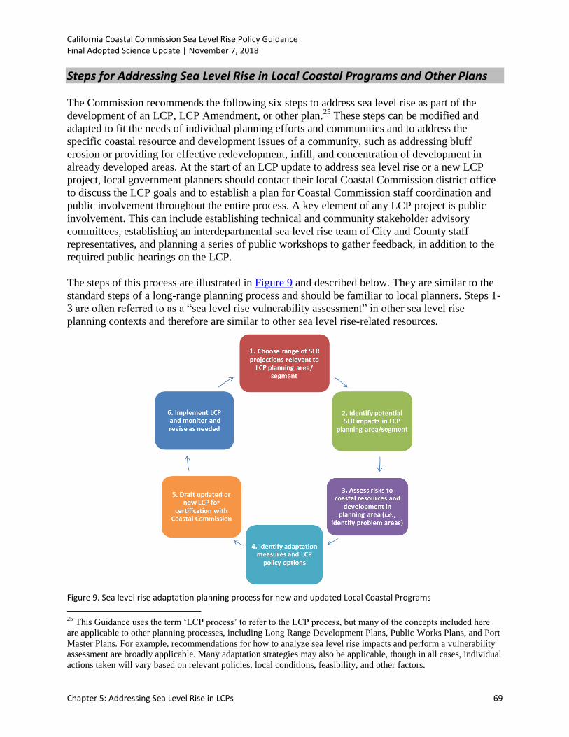
Steps for Addressing Sea Level Rise in Local Coastal Programs and Other Plans
The Commission recommends the following six steps to address sea level rise as part of the
development of an LCP, LCP Amendment, or other plan.25
These steps can be modified and
adapted to fit the needs of individual planning efforts and communities and to address the
specific coastal resource and development issues of a community, such as addressing bluff
erosion or providing for effective redevelopment, infill, and concentration of development in
already developed areas. At the start of an LCP update to address sea level rise or a new LCP
project, local government planners should contact their local Coastal Commission district office
to discuss the LCP goals and to establish a plan for Coastal Commission staff coordination and
public involvement throughout the entire process. A key element of any LCP project is public
involvement. This can include establishing technical and community stakeholder advisory
committees, establishing an interdepartmental sea level rise team of City and County staff
representatives, and planning a series of public workshops to gather feedback, in addition to the
required public hearings on the LCP.
The steps of this process are illustrated in Figure 9 and described below. They are similar to the
standard steps of a long-range planning process and should be familiar to local planners. Steps 1-
3 are often referred to as a “sea level rise vulnerability assessment” in other sea level rise
planning contexts and therefore are similar to other sea level rise-related resources.
Figure 9. Sea level rise adaptation planning process for new and updated Local Coastal Programs
25
This Guidance uses the term ‘LCP process’ to refer to the LCP process, but many of the concepts included here
are applicable to other planning processes, including Long Range Development Plans, Public Works Plans, and Port
Master Plans. For example, recommendations for how to analyze sea level rise impacts and perform a vulnerability
assessment are broadly applicable. Many adaptation strategies may also be applicable, though in all cases, individual
actions taken will vary based on relevant policies, local conditions, feasibility, and other factors.

California Coastal Commission Sea Level Rise Policy Guidance Final Adopted Science Update | November 7, 2018
Chapter 5: Addressing Sea Level Rise in LCPs 70
The Coastal Commission also offers a Local Coastal Program (LCP) Update Guide (2013b) that
outlines the broad process for amending or certifying an LCP, and there is naturally some
overlap between the content of that document and this Sea Level Rise Policy Guidance
document. The general LCP amendment steps are outlined below, in a flow chart (see Appendix
D), and in the LCP Tips/Best Practices document (2013c), which is available in the Resources
for Local Governments section of the Commission’s website. Local governments should contact
the Coastal Commission planner for their area when pursuing a new LCP or LCP amendment.
1. Initial Amendment scoping and development: Conduct issues assessment, identify
need for amendment, prepare preliminary draft, coordinate with Commission staff, and
share early drafts
2. Local Amendment process: Notify public, conduct local outreach and hearings, meet
with Commission staff to discuss any issues, and adopt LCP at the local level
3. Prepare Submittal: assemble LCP materials, discuss with Commission staff prior to
submittal, transmit to Coastal Commission, and make available to public
4. Process Amendment at Coastal Commission: Commission staff will review submittal
within 10 working days for completeness; will address outstanding information needs;
will prepare and write staff report; hold public hearing and vote; and transmit action to
local government
5. Effectuate Amendment: Local acceptance of any modifications or resubmittal within 6
months, finalize local approval, and complete Coastal Commission Executive Director
check-off
6. Implement LCP Amendment, monitor and revise as necessary.
The step-by-step process for incorporating sea level rise into LCPs outlined in the rest of this
chapter fits into these broader LCP amendment steps. Local government planners should use the
LCP Update Guide in conjunction with the Sea Level Rise Policy Guidance to inform the LCP.
Use scenario-based analysis
The Guidance recommends using a method called “scenario-based analysis” (described in
Chapter 3 of this Guidance). Since sea level rise projections are not exact, but rather presented in
ranges, scenario-based planning includes examining the consequences of multiple sea level rise
amounts, plus extreme water levels from storms and El Niño events. The goal of scenario-based
analysis for sea level rise is to understand where and at what point sea level rise, and the
combination of sea level rise and storms, pose risks to coastal resources or threaten the health
and safety of a developed area. This approach allows planners to understand the full range of
possible impacts that can be reasonably expected based on the best available science, and build
an understanding of the overall risk posed by potential future sea level rise. For example, if there
are large changes in the hazard zones between two sea level rise amounts, additional analyses
may help determine the tipping points when viable land uses will change. In general, scenario-
based analyses can help determine the long-term compatibility of certain areas with certain land
uses. For further description of this method, see Chapter 3.

California Coastal Commission Sea Level Rise Policy Guidance Final Adopted Science Update | November 7, 2018
Chapter 5: Addressing Sea Level Rise in LCPs 71
Include other topics as applicable or desired
This Guidance recommends a number of analyses that will generate useful information related to
sea level rise and other environmental vulnerabilities. Performing these analyses (and the overall
planning process) may provide a useful opportunity to include other studies that will complement
the goals of Local Coastal Programs and provide valuable insights for community concerns. For
example, planners should expand the Coastal Act consideration of lower cost visitor serving
facilities to include considerations of social equity and environmental justice in the analyses by
determining how climate hazards or the adaptation measures might differentially impact various
demographics. Additionally, planners may want to incorporate analysis of the economic
implications of various options for adaptation. Important topics such as these should be
incorporated into the analyses already underway for the sake of efficiency.
Leverage analyses and share information with other planning-related processes and
documents
Sea level rise is addressed in many other planning-related documents and by many other
agencies and organizations. Planners should be aware of these documents and the on-going work
of state and federal agencies and make an effort to share information in cases where analyses
required for some of these documents may overlap with the studies appropriate for sea level rise
planning in LCPs. Additionally, these agencies, organizations, and planning efforts may be good
resources from which to gather information when performing these analyses for LCP updates.
For example, there is overlap between the required elements of a Local Hazard Mitigation Plan
(LHMP) and Local Coastal Programs, and the Commission recommends coordinating an LHMP
update with an LCP update if possible. As part of an LHMP, local governments identify the
natural hazards that impact their community, identify actions to reduce the losses from those
hazards, and establish a coordinated process to implement the plan.26
In order to be eligible for
certain types of non-emergency disaster assistance, including funding for hazard mitigation
projects, local governments are required by FEMA to complete an LHMP27
and to update the
plan every 5 years. Any sea level rise hazard avoidance strategies included in an LCP
certification or update, such as relocation of critical facilities must be included in the LHMP
narrative to be eligible for funding from FEMA to implement future projects. If a local
government has recently updated their LHMP, the city or county can add narrative information
on sea level rise strategies through an addendum to the plan, referred to by FEMA as an annex.28
In many cases, the analyses and adaptation options identified in this Guidance could be used for
hazard mitigation plans or vice versa, as the goal of each of these planning processes is to
26
http://www.fema.gov/media-library-data/20130726-1524-20490-5927/67fr8844.pdf
27 Note that recent revisions to the State Mitigation Plan Review Guide, set to go into effect in March 2016, will
require states to analyze the probability and possible impacts due to future hazard events in a way that includes the
projected changes in natural hazards resulting from climate change. Failure to include such considerations may
result in a state’s ineligibility for certain non-emergency mitigation grants.
28 For more information on how to complete or update an LHMP, visit http://hazardmitigation.calema.ca.gov/ or
contact the Cal OES office and a hazard mitigation technical expert can assist local governments with the planning
process. For contact information, visit http://www.caloes.ca.gov/cal-oes-divisions/hazard-mitigation/contacts.

California Coastal Commission Sea Level Rise Policy Guidance Final Adopted Science Update | November 7, 2018
Chapter 5: Addressing Sea Level Rise in LCPs 72
minimize or avoid impacts from coastal hazards. As a result, there may be opportunities to
leverage funding and share work efforts.
A number of other similar planning processes, projects, and documents are listed in Figure 10,
and planners may be able to use these studies in the LCP planning process, or, alternatively,
share analyses and information performed for LCP planning with the groups working on related
projects. Additionally, the forthcoming State of California Planning for Sea Level Rise Database
(established by Assembly Bill 2516 and pursuant to Public Resources Code Sections 30961-
30968) may become an important tool for identifying past and/or ongoing actions that
stakeholders have implemented to address sea level rise. In any case, information sharing is
highly recommended to promote efficiency.
Coordinate regionally as appropriate
Many impacts of sea level rise will transcend jurisdictional boundaries. Similarly, the adaptation
decisions made by coastal communities could themselves have consequences that affect areas
outside the local jurisdiction. For these reasons, regional coordination will often enhance the
effectiveness of local adaptation decisions. Indeed, many of the projects identified in Figure 10
have taken this regional approach. Planners should keep this concept in mind as they work
through these steps and coordinate regionally where appropriate and possible.

California Coastal Commission Sea Level Rise Policy Guidance Final Adopted Science Update | November 7, 2018
Chapter 5: Addressing Sea Level Rise in LCPs 73
Representative Adaptation Planning Stakeholders
Figure 10. Agencies, organizations, and planning efforts related to sea level rise adaptation

California Coastal Commission Sea Level Rise Policy Guidance Final Adopted Science Update | November 7, 2018
Chapter 5: Addressing Sea Level Rise in LCPs 74
Step 1 – Determine range of sea level rise projections relevant to LCP planning area/segment
The first step in incorporating sea level rise into the LCP planning process is to identify locally
relevant sea level rise scenarios that may occur at given time steps into the future. These
scenarios will be carried through the rest of the steps in the sea level rise LCP planning process.
Follow these steps to determine the locally relevant sea level rise projections to use in the
subsequent steps:
o Determine planning horizons of concern: The Coastal Commission recommends taking
a long-term view when analyzing sea level rise impacts because the land use decisions
made today will affect what happens over the long-term. For example, development
constructed today is likely to remain in place over the next 75-100 years, or longer. In
practice, many jurisdictions have completed assessments that look at sea level rise
vulnerabilities through approximately 2100. Understanding short-term vulnerabilities is
also important, and the Coastal Commission recommends assessing vulnerabilities in
intermediate planning horizons. For example, many jurisdictions have assessed sea level
rise scenarios that correspond to years 2030 and 2050, in line with information provided
in the 2012 National Research Council (NRC) report. These time periods may be used,
or local governments may identify other relevant planning horizons for their plans and
development scenarios, as long as the projections for those time frames are based on the
best available and relevant scientific projections.
o Determine the full range of sea level rise projections from the best available science:
Using best available science, currently the 2018 OPC SLR Guidance (or other
comparable study, provided that it is peer reviewed, widely accepted within the scientific
community, and locally relevant), determine the range of sea level rise for the planning
horizons of concern. The sea level rise projections for the San Francisco tide gauge from
the 2018 OPC SLR Guidance are presented in Table 4 below (projection tables for all 12
California tide gauges are presented in Appendix G)29
. See below for a discussion of
scenario-based planning in the LCP context. The LCP should include a policy to use the
best available science about sea level rise.
29
More detailed refinement of sea level rise projections is not considered necessary at this time, as variations from
the nearby tide gauges will often be quite small, and may be insignificant compared to other sources of uncertainty.
However, the Coastal Commission recognizes that other studies exist with localized data, for example those
completed in the Humboldt Bay region, which may also be appropriate for use.

California Coastal Commission Sea Level Rise Policy Guidance Final Adopted Science Update | November 7, 2018
Chapter 5: Addressing Sea Level Rise in LCPs 75
Table 4. Sea Level Rise Projections for the San Francisco Tide Gauge30 (OPC 2018)
*Most of the available climate model experiments do not extend beyond 2100. The resulting reduction in model availability causes a small dip in projections between 2100 and 2110, as well as a shift in uncertainty estimates (see Kopp et al., 2014). Use of 2110 projections should be done with caution and acknowledgement of increased uncertainty around these projections.
30
Probabilistic projections for the height of sea level rise and the H++ scenario are presented. The H++ projection is
a single scenario and does not have an associated likelihood of occurrence. Projections are with respect to a baseline
year of 2000 (or more specifically, the average relative sea level over 1991-2009). Table is adapted from the 2018
OPC SLR Guidance to present only the three scenarios OPC recommends evaluating. Additionally, while the OPC
tables include low emissions scenarios, only high emissions scenarios, which represent RCP 8.5, are included here
because global greenhouse gas emissions are currently tracking along this trajectory. The Coastal Commission will
continue to update best available science as necessary, including if emissions trajectories change.
H++ Scenario
(Sweet et al. 2017)
Low Risk AversionMedium-High
Risk AversionExtreme Risk Aversion
Upper limit of "likely range"
(~17% probability SLR exceeds...)
1-in-200 chance
(0.5% probability SLR exceeds…)
Single scenario
(no associated probability)
2030 0.5 0.8 1.0
2040 0.8 1.3 1.8
2050 1.1 1.9 2.7
2060 1.5 2.6 3.9
2070 1.9 3.5 5.2
2080 2.4 4.5 6.6
2090 2.9 5.6 8.3
2100 3.4 6.9 10.2
2110* 3.5 7.3 11.9
2120 4.1 8.6 14.2
2130 4.6 10.0 16.6
2140 5.2 11.4 19.1
2150 5.8 13.0 21.9
Projected Sea Level Rise (in feet): San Francisco
Probabilistic Projections (in feet)
(based on Kopp et al. 2014)

California Coastal Commission Sea Level Rise Policy Guidance Final Adopted Science Update | November 7, 2018
Chapter 5: Addressing Sea Level Rise in LCPs 76
o Choose multiple sea level rise scenarios based on range of sea level rise projections.
The Coastal Commission recommends that all communities evaluate the impacts from the
“medium-high risk aversion” scenario. Local governments should also include the
“extreme risk aversion” scenario to evaluate the vulnerability of planned or existing
assets that have little to no adaptive capacity, that would be irreversibly destroyed or
significantly costly to repair, and/or would have considerable public health, public safety,
or environmental impacts should that level of sea level rise occur. Planners may also
consider evaluating the lower projections (those with a higher probability) to gain an
understanding on what is likely to be vulnerable regardless of modeling uncertainty and
future greenhouse gas emissions.
In addition to evaluating the worst-case scenario, planners need to understand the
minimum amount of sea level rise that will cause impacts for their community, and how
these impacts will change over time, with different amounts of sea level rise. Planners
should evaluate enough scenarios to be able to answer the following:
What are the impacts from the worst-case scenario of the highest possible sea
level rise plus elevated water levels from high tide, El Niño and a 100-year storm?
What is the minimum amount of sea level rise that causes inundation, flooding, or
erosion concerns?
How do inundation, flooding, and erosion concerns change with different amounts
of sea level rise?
Are there any tipping points where sea level rise impacts become more severe?
(For example, is there a point at which seawalls or levees are overtopped?)
There are two main ways to choose scenarios from which to evaluate sea level rise: by
sea level rise amount or by time-period. Tools that provide maps by sea level rise amount
can then be linked to the relevant time period, as shown below in the Our Coast Our
Future example. There is no single accepted sea level rise mapping methodology for the
state of California. Local governments can choose whether to use existing sea level rise
tools or to develop their own scenarios and maps. See below for information on scenarios
and modeling outputs generated by existing sea level rise modeling tools.

California Coastal Commission Sea Level Rise Policy Guidance Final Adopted Science Update | November 7, 2018
Chapter 5: Addressing Sea Level Rise in LCPs 77
Examples of Choosing Scenarios with Existing Sea Level Rise Modeling Tools
For California, there are two primary methods for identifying sea level rise scenarios, based on two of the currently available SLR mapping tools: CoSMoS (Our Coast Our Future) and Coastal Resilience Ventura (The Nature Conservancy). The type of tool available for sea level rise mapping in a planning area can be a deciding factor for which scenarios to use in the analysis. The Coastal Commission recommends using as many scenarios as necessary to fully analyze the potential impacts to coastal resources, human health, and safety rather than a specific tool or number of scenarios. Examples for choosing scenarios based on the tools available are described below.
Example 1: Identify SLR amounts, then relate to likely time period(s) of occurrence
This method involves first examining different amounts of sea level rise and storm events, and second, looking at the 2018 OPC SLR Guidance projections to determine the range of years during which those impacts could potentially occur. For example, the Our Coast Our Future CoSMoS-based tool provides sea level rise maps for 9 different amounts in 25 cm (0.8 ft) intervals, three different storm scenarios (annual, 20-year, and 100-year), and a king tide scenario. With this tool, users can first evaluate different amounts of sea level rise and storms, determine how different amounts of sea level rise and storm situations affect the planning area, and then determine when the increased water level is likely to occur based on the OPC Guidance projections. The CosMoS tool is currently available from Point Arena (in Mendocino County) through the Mexico border, and an expansion throughout the rest of the state is planned for 2018/2019. The NOAA Sea Level Rise and Coastal Flooding Impacts viewer similarly provides maps for different amounts of sea level rise (in this case, in 1-ft increments), but does not include impacts from storms, erosion or waves. A methodology for adding in these additional impacts is described in Appendix B.
Example 2: Choose applicable years, then identify high, intermediate, and low scenarios
For this method, planners pick specific years, determine the range of sea level rise amounts that could occur by that year, and examine the consequences of three or more sea level rise amounts within that range. For example, the Coastal Resilience Ventura Tool (The Nature Conservancy) provides maps showing inundation, flooding, wave impact zone, and erosion risk zones with low, medium, and high sea level rise scenarios for the years 2030, 2060, and 2100. For local governments within Ventura County, planners may choose to evaluate scenarios according to the 2030, 2060, and 2100 time periods. The model provides maps for both flooding and erosion.
Expected outcomes from Step 1: Upon completing this step, a range of regionally- or locally-
relevant sea level rise projections for the time periods of concern should be established. Based
on the range of projections, planners will have identified a low, high, and one or more
intermediate projections. These projections are the sea level rise scenarios that will be carried
through the rest of the planning process.

California Coastal Commission Sea Level Rise Policy Guidance Final Adopted Science Update | November 7, 2018
Chapter 5: Addressing Sea Level Rise in LCPs 78
Step 2 – Identify potential physical sea level rise impacts in LCP planning area/segment
The next step is to identify the physical hazards and impacts (referred to comprehensively as sea
level rise impacts) associated with current and future sea level. As described in Section C of
Chapter 3 of this Guidance, broad categories of sea level rise impacts may include inundation,
flooding, wave impacts, erosion, and saltwater intrusion. In this step, planners should analyze
these physical impacts and their various sub-components in order to understand current and
future local hazard conditions. The analysis should answer the following basic questions:
o What are the existing hazard conditions that threaten the planning area?
o What is the projected change in hazard conditions due to locally appropriate sea level rise
projections and planning horizons of concern?
This analysis should include the following topics, as applicable:
o Local Water Conditions (See Appendix B for a detailed methodology)
Current tidal datum31
and future inundation
Water level changes from storm surge, atmospheric pressure, the Pacific Decadal
Oscillation (PDO), the El Niño Southern Oscillation (ENSO), and/or other basin-
wide phenomena
Wave impacts and wave runup, including wave runup from a 100-year storm, and
based on tides, other water level changes, and future beach and bluff erosion
Flooding from extreme events such as storms with intervals greater than 100
years, tsunamis, etc.
o Shoreline change (See Appendix B for more information)
Current shoreline erosion rates. For future cliff and dune erosion rates, modify
historic erosion rates, to account for the influence of sea level rise (e.g., work by
the Pacific Institute – Heberger et al. 2009; Revell et al. 2011). If possible,
modify long-term beach erosion rates to account for changes in El Niño
frequency, storm intensity, sediment supply or changing transport conditions.
Analyzing wetland responses to sea level rise may require site-specific analyses
of various physical and biological factors as described in Heberger et al. 2009.
Sedimentation rates
o Water quality
Current and future saltwater intrusion areas
31 Tidal datums are based on the latest National Tidal Datum Epoch (NTDE) published by NOAA and are the mean
of the observed sea levels over a 19-year period. The latest published epoch is 1983-2001. This tidal epoch can be
considered equivalent to the year 2000 baseline for the OPC projections.

California Coastal Commission Sea Level Rise Policy Guidance Final Adopted Science Update | November 7, 2018
Chapter 5: Addressing Sea Level Rise in LCPs 79
Current and potential future coastal water pollution issues due to inundation of
toxic soils, rising water tables, and increases in nonpoint source pollution
Use existing models, tools, reports, historic records, and other materials (Table 5) to develop or
double check the identified hazard areas. Document the current and future hazard areas in the
Land Use Plan using maps, GIS products, graphics, tables, charts, figures, descriptions, or other
means. This process should be repeated for each planning horizon and/or sea level rise scenario
defined in Step 1.
Expected outcomes from Step 2: Upon completing this step, the potential current and future
impacts to the planning area from sea level rise hazards should be identified based on sea level
rise projections. These should include impacts from the high, low, and intermediate sea level rise
scenarios for the planning horizon(s) of concern. Maps, GIS layers, graphics, figures, charts,
tables, descriptions, or another system should be developed to communicate the impacts of
current and future hazards.
Figure 11. Example of analysis of SLR impacts. Flooding hazards predicted from the CoSMoS hindcast of the January 2010 storm, with and without sea level rise (SLR) scenarios, in the region of Venice and Marina del Rey, CA. (Source: Barnard et al. 2014).

California Coastal Commission Sea Level Rise Policy Guidance Final Adopted Science Update | November 7, 2018
Chapter 5: Addressing Sea Level Rise in LCPs 80
Resources for Sea Level Rise Mapping
Table 5 includes a list of sea level rise mapping tools. The tools vary in their complexity: some
are considered “bathtub models,” because they show future inundation with simple rise in sea
level (and no changes to the shoreline caused by other forces). Others include factors like
erosion, storms, and fluvial inputs. These tools provide a useful first look at possible sea level
rise impacts, but may need to be supplemented with additional, site- or topic-specific analyses,
depending on the region. See Appendix B for additional information on determining hazard
impacts and tools for mapping sea level rise.
Table 5. Sea Level Rise Mapping Tools
Tool Description Link
Statewide
NOAA Sea Level Rise and Coastal Flooding Impacts Viewer
Displays potential future sea levels with a slider bar. Communicates spatial uncertainty of mapped sea level rise, overlays social and economic data onto sea level rise maps, and models potential marsh migration due to sea level rise. Maps do not include any influence of beach or dune erosion.
NOAA Office for Coastal Management, http://coast.noaa.gov/digitalcoast/tools/slr
Cal-Adapt – Exploring California’s Climate
Represents inundation location and depth for the San Francisco Bay, the Sacramento-San Joaquin River Delta and California coast resulting from different increments of sea level rise coupled with extreme storm events. Incorporates real, time series water level data from past (near 100 year) storm events to capture the dynamic effect of storm surges in modeling inundation using a three dimensional hydrodynamic model (per Radke, 2017).
http://cal-adapt.org/tools/slr-calflod-3d/
Pacific Institute Sea Level Rise Maps
Downloadable PDF maps showing the coastal flood and erosion hazard zones from the 2009 study. Data are overlaid on aerial photographs and show major roads. Also available are an interactive online map and downloadable maps showing sea level rise, population and property at risk, miles of vulnerable roads and railroads, vulnerable power plants and wastewater treatment plants, and wetland migration potential.
http://www.pacinst.org/reports/sea_level_rise/maps/
For the 2009 report The Impacts of Sea-Level Rise on the California Coast visit: http://pacinst.org/publication/the-impacts-of-sea-level-rise-on-the-california-coast/

California Coastal Commission Sea Level Rise Policy Guidance Final Adopted Science Update | November 7, 2018
Chapter 5: Addressing Sea Level Rise in LCPs 81
Climate Central Surging Seas
Overlays sea level rise data with socio-economic information and ability to analyze property values, population, socio-economic status, ethnicity, and income or areas at risk. Can compare exposure across the state or a county.
http://sealevel.climatecentral.org/ssrf/california
Coastal Storm Modeling System (CoSMoS); tool hosted by Our Coast Our Future
Currently available for Point Arena to the Mexico border, with a statewide expansion anticipated in 2018/2019. The Coastal Storm Modeling System (CoSMoS) is a dynamic modeling approach that allows detailed predictions of coastal flooding due to both future sea level rise and storms, and integrated with long-term coastal evolution (i.e., beach changes and cliff/bluff retreat)
https://walrus.wr.usgs.gov/coastal_processes/cosmos/
http://data.pointblue.org/apps/ocof/cms/
TNC Coastal Resilience
An online mapping tool showing potential impacts from sea level rise and coastal hazards designed to help communities develop and implement solutions that incorporate ecosystem-based adaptation approaches. Available statewide with more detailed modelling for Monterey Bay, Santa Barbara, Ventura, and Santa Monica.
http://maps.coastalresilience.org/california/
Humboldt Bay Sea Level Rise Adaptation Project
This project is a multi-phased, regional collaboration. Phase I produced the Humboldt Bay Shoreline Inventory, Mapping, and Sea Level Rise Vulnerability Assessment which describes current shoreline conditions and vulnerabilities under the current tidal regime. Phase II included hydrodynamic modeling to develop vulnerability maps of areas surrounding Humboldt Bay vulnerable to inundation from existing and future sea levels. Phase II produced the Humboldt Bay Sea Level Rise Modeling Inundation Mapping Report and the Humboldt Bay Sea Level Rise Conceptual Groundwater Model.
All reports are available at:
http://humboldtbay.org/humboldt-bay-sea-level-rise-adaptation-planning-project
California Coastal Commission Sea Level Rise Policy Guidance Final Adopted Science Update | November 7, 2018
Chapter 5: Addressing Sea Level Rise in LCPs 82
Step 3 – Assess potential risks from sea level rise to coastal resources and development in LCP planning area/segment
After sea level rise impacts are identified and mapped in Step 2, the next Step is to determine
whether sea level rise poses any risks, or potential problems, for coastal resources and
development in the LCP planning area (refer to Chapter 4 for a description of the potential
consequences of sea level rise for coastal resources). Next, assess whether the LCP planning
area’s current and planned land uses are appropriate or consistent with Coastal Act or LCP
policies given those impacts, or if those land uses should be revised. This step requires an
understanding of several characteristics of the coastal resources and development typically found
within various land use types. (Much of this information can be produced in a vulnerability
assessment, an analysis that is commonly conducted in the planning and climate change
adaptation field. See Appendix C for a list of recent sea level rise vulnerability assessments.)
Account for potential impacts to vulnerable, low-income communities and consider coastal
development and resources, including but not limited to:
Existing and planned development
Coastal-dependent development and uses such as harbors, wharfs, ports, marinas, and
commercial and recreational fishing areas and facilities
Critical infrastructure32
such as wastewater treatment plants, transportation infrastructure,
and some power plants and energy transmission infrastructure
Public accessways, beaches and other recreation areas, and the California Coastal Trail
State Highway 1, 101, and other state and local roads that provide access to the coast
Wetlands, environmentally sensitive habitat area (ESHA), and other coastal habitats and
sensitive species
Agricultural areas
Cultural sites and archaeological or paleontological resources
Visitor-serving development and uses
Conduct the following tasks for each planning horizon (e.g., the years 2030, 2050, and 2100, or
other planning horizons):
1. For the planning horizon of interest, determine what development and coastal resources
may be subjected to the sea level rise impacts expected for that time period. Map the
coastal resources and development that lie within the sea level rise impact areas for the
given time period. (Remember to address the wide range of resources listed above,
including both natural resources and development.)
32
Critical infrastructure can vary widely from community to community, and may also include fire stations, police
stations, and hospitals. For planning purposes, a jurisdiction should determine criticality based on the relative
importance of its various assets for the delivery of vital services, the protection of special populations, and other
important functions, as well as the social, environmental, and economic risks associated with loss of or damage to
such assets.

California Coastal Commission Sea Level Rise Policy Guidance Final Adopted Science Update | November 7, 2018
Chapter 5: Addressing Sea Level Rise in LCPs 83
2. Determine if sea level rise impacts are a problem or benefit for each resource, and if so,
when and to what degree the resource will be impacted. In some instances, sea level rise
may result in the creation of new habitat areas that could help to alleviate impacts from
the loss of similar habitat in other locations. However, it is more likely, especially in
heavily urbanized areas, that sea level rise will result in a net loss of habitat unless steps
are taken to preserve these systems.
To accomplish this, consider a wide range of characteristics of each resource, including
the following. The questions listed under each characteristic might help guide the
consideration of each of these characteristics. These questions are meant to be
suggestions rather than a standardized approach, and planners may use scientific
literature, best professional judgment, or a variety of other resources to gain a conceptual
understanding of the important resources and vulnerabilities in their jurisdictions.
a. Exposure. Will sea level rise impacts affect the resource/development at all?
i. Are coastal resources and community assets exposed to sea level rise
impacts?
ii. Is the resource already exposed to hazards such as waves, flooding,
erosion, or saltwater intrusion? If it is, will sea level rise increase hazard
exposure?
b. Sensitivity. If resources are exposed, to what degree will coastal
resources/development be affected by sea level rise impacts? A simple way to
think about this concept is to consider how easily affected the resource or
development is in regard to sea level rise impacts.
i. How quickly will the resource respond to the impact from sea level rise?
ii. Will the resource/development be harmed if environmental conditions
change just a small amount? What are the physical characteristics of
resource/asset (e.g., geology, soil characteristics, hydrology, coastal
geomorphology, topography, bathymetry, land cover, land use)? Do any of
those characteristics make the resource especially sensitive?
iii. Are there thresholds or tipping points beyond which sensitivity to sea level
rise increases?
c. Adaptive Capacity. How easily can the resource successfully adapt to sea level
rise impacts?
i. How well can the resource/development accommodate changes in sea
level?
ii. Is rate of change faster than the ability of the resource/development to
adapt?
iii. How easily can development be modified to cope with flooding,
inundation, and/or erosion? Can structures be elevated or relocated?

California Coastal Commission Sea Level Rise Policy Guidance Final Adopted Science Update | November 7, 2018
Chapter 5: Addressing Sea Level Rise in LCPs 84
iv. Are there adaptation efforts already underway? Are there any factors
that limit the success of adaptation efforts?
v. Do beaches, wetlands and other coastal habitats have room to migrate
inland? What is the overall health of existing wetlands and coastal
habitats?
vi. Are there any other climate change-related impacts to consider? Are
there any non-climate stressors that could impair ability to adapt to sea
level rise?
vii. Is there potential for habitat creation as a result of sea level rise?
viii. What are the options to protect, redesign (e.g., elevate), or relocate
inland any existing public accessways, recreational beaches, and
segments of the Coastal Trail to cope with rising sea levels? Is lateral
access compromised with sea level rise?
d. Consequences. When sea level rise and/or sea level rise adaptation measures
have impact(s) upon a resource, what are the economic, ecological, social,
cultural, and legal consequences?
i. How severely could each resource be affected? At what scale?
ii. Are there cumulative consequences?
iii. Are there ripple effects, or secondary consequences to consider?
iv. Will human responses cause further adverse impacts?
e. Land Use Constraints. Given the location of sea level rise impacts and the
resources currently located in those areas, should the types and intensities of land
use be altered to minimize hazards and protect coastal resources?
i. What is the current pattern of development? Is the area largely developed
or does it have significant areas of undeveloped land?
ii. Is the area served by infrastructure that is vulnerable to sea level rise
impacts?
iii. Are large areas of land under common ownership or is land mostly
subdivided into smaller lots in separate ownership?
iv. What conditions does the land use type, development, or resource require
to either exist or fulfill its intended purpose?
v. Is it a coastal-dependent use? What is its ideal proximity to the coast?
vi. For new development, what is the expected lifespan? Is it economically
feasible to locate it in a sea level rise impact area for a certain period of
time before it is removed or relocated?
vii. For existing development, what are the options available to minimize
hazards to the development and protect coastal resources? Note that in

California Coastal Commission Sea Level Rise Policy Guidance Final Adopted Science Update | November 7, 2018
Chapter 5: Addressing Sea Level Rise in LCPs 85
certain situations, the Coastal Act allows existing structures to be
protected (Coastal Act Section 30235). What are the coastal resource
impacts of such protection, and are there feasible alternatives that avoid
shoreline armoring, such as options to provide incentives to property
owners to relocate or remove at-risk structures?
viii. For a natural resource or habitat, what conditions does it require to persist?
ix. Where would resources/development ideally be located after sea level rise
causes environmental conditions to shift?
x. What changes to existing LCP requirements or other land use restrictions
are necessary to maximize opportunities for avoiding hazards or relocating
threatened existing development?
After going through the questions listed above, and others that may be relevant to the planning
exercise, synthesize the information and determine where sea level rise impacts currently pose
problems for coastal resources, what problems may develop over time as sea level rises, and how
urgent the problems are. Create maps illustrating the location and extent of vulnerable land uses,
such as critical facilities, wastewater infrastructure, and State Highway 1 and other coastal access
roadways. This information can also be summarized in narrative form. The analysis should
identify resources and development likely to be impacted by sea level rise at various periods in
the future, and thus the issues that need to be resolved in the LCP planning process.
Remember that these assessments are not static; existing risks will change and new risks will
arise with changes in a community, the emergence of new threats, new information, and the
implementation of adaptation actions. For this reason, the analysis should be updated as needed
to reflect changes in sea level rise projections, changes in land use patterns, or new threats.
Expected outcomes from Step 3: Descriptions of the characteristics that influence risk,
including exposure, sensitivity, and adaptive capacity of each coastal resource to sea level rise
impacts under each sea level rise scenario identified in Step 1 at the selected planning horizons,
along with the expected consequences of those impacts for the resource and broader community.
Maps of resources and/or land uses at risk could be produced.
California Coastal Commission Sea Level Rise Policy Guidance Final Adopted Science Update | November 7, 2018
Chapter 5: Addressing Sea Level Rise in LCPs 86
Example for Step 3
To illustrate the process described in Step 3, consider a hypothetical planning area that includes multiple coastal resources and land use types, including a coastal wetland, bluff-top residential development with a fronting beach, and a wastewater treatment facility, that need to be addressed in the planning process. After Steps 1 and 2, portions of the planning area are found to be subject to current and future sea level rise impacts.
Step 3.1: Map the coastal resources (in this case the wetland, development, and wastewater treatment facility) for the range of time periods and sea level rise projections.
Step 3.2 a. Exposure
Wetland: The wetland is highly exposed to flooding and inundation from sea level rise. By the year 2030, portions of the wetland will trap sediment at a rate such that the elevation keeps pace with sea level rise. By 2050, a portion of the wetland will become inundated and converted to open water, and by 2100 the entire area will be converted to open water. The wetland will be completely lost by this time period if it is not able to move inland.
Bluff-top Residential Development: Houses in the residential development are not exposed to sea level rise impacts in 2030. However, a high rate of retreat along the fronting beach and bluff will put front-line houses in danger of being undermined by the year 2050, and the entire development may be lost by 2100.
Wastewater Treatment Facility: Given that the wastewater treatment plant is set back somewhat from the water, it will not be exposed to impacts from sea level rise until 2050. By 2050, however, portions of the infrastructure will be exposed to impacts from elevated water levels due to 100-year storm events and El Niño occurrences. By 2100, significant portions of the facility will be exposed to flooding as the surrounding area is eroded and inundated.
b. Sensitivity
Wetland: The wetland has high sensitivity to changes in sea level because its functioning is highly-dependent on local physical parameters such as water flow, tidal fluctuation, sediment supply, and water quality. Although it currently has good sediment supply, good water quality, and a number of other characteristics, small changes in sea level rise by 2050 may alter the function of the wetland. In addition, there are concerns that beyond 2050 the wetland will not be able to keep up with accelerated sea level rise, thus increasing sensitivity to further changes in sea level.
Bluff-top Residential Development: The residential development has moderate to high sensitivity to longer-term sea level rise changes. By 2050, the front-line houses will no longer be safe enough for occupancy. Moreover, infrastructure such as roads, sewage systems, and power networks may be damaged as the bluff-face erodes.
Wastewater Treatment Facility: The facility is moderately sensitive to sea level rise. Flooding and erosion from sea level rise could cause damage of the facility, pumps and

California Coastal Commission Sea Level Rise Policy Guidance Final Adopted Science Update | November 7, 2018
Chapter 5: Addressing Sea Level Rise in LCPs 87
other equipment, but the facility was initially built to withstand a high degree of storm and related impacts.
c. Adaptive Capacity
Wetland: Unlike many wetlands in the State of California, this particular wetland has a moderate-high adaptive capacity because it has the ability to both accumulate sediment and grow upwards, and, given that the land upland of the wetland is preserved as open space, it can migrate inland. However, by 2050, a part or all of the existing wetland area could be converted to open water if the wetland is not able to migrate inland or accumulate sediment at a rate that keeps pace with sea level rise. In this case, for example, a public trail will need to be relocated to allow inland migration of the new intertidal zone. Additionally, adaptive capacity may be reduced if pollution increases (e.g., as a result of damage to adjacent development) and disrupts the normal functioning of the wetland.
Bluff-top Residential Development: The residential development has a moderate adaptive capacity. As houses become threatened over time, a scenario of managed retreat would allow houses to be removed incrementally and eventually be relocated to safer areas. The feasibility of managed retreat can depend upon lot sizes, ownership patterns, land use restrictions in the safer areas, and the availability of public or private financing. In addition, a protective structure such as a seawall would minimize threats to the residence due to erosion, though if the development is protected by shoreline structures, the fronting beach will eventually be lost.
Wastewater Treatment Facility: The wastewater treatment facility has a very low adaptive capacity. It is large and has expensive infrastructure so it cannot be elevated, and relocation is costly and difficult. In order to be protected in its current location, new structures will need to be built.
d. Consequences
Wetland: In many situations, the loss of wetland area is a high risk since wetlands provide flood protection, water quality enhancement, and essential habitat for fish and bird species. However, in this case, wetland migration is not restricted by inland development, so the risks for this wetland are slight to moderate, depending upon the suitability of the inland area for establishment of wetland plants and potential changes in water temperature and water quality. In the short term, the wetland will likely continue to function at normal levels. However, if it eventually can’t keep up with sea level rise or if there are barriers to migration, loss of the habitat will result in a loss of important ecosystem services.
Bluff-top Residential Development: The housing development has medium to high risk through 2100. The option to either relocate houses or protect them with a seawall means that they could continue to exist. Importantly, a system of managed retreat will allow for the continued existence of the fronting beach and all of its social, economic, and environmental benefits, whereas the construction of a seawall will result in the loss of the beach and these benefits.

California Coastal Commission Sea Level Rise Policy Guidance Final Adopted Science Update | November 7, 2018
Chapter 5: Addressing Sea Level Rise in LCPs 88
Wastewater Treatment Facility: Given its low adaptive capacity and high sensitivity to higher levels of sea level rise, the wastewater treatment facility is at high risk. Loss or damage to the facility could result in serious social, economic, and environmental consequences. Flooding of the facility and surrounding areas will cause damage to infrastructure and loss of facility function. This could lead to discharge of untreated sewage, which would have adverse impacts to water quality and could impair the health of nearshore ecosystems. Sea level rise could also cause outflow pipes to back up with seawater, leading to inland flooding and additional water quality problems. However, efforts to protect the structure may have unintended consequences including loss of surrounding habitat areas.
e. Land Use Constraints (discussed further in Step 4)
Wetland: The high adaptive capacity of the wetland means that minimizing risk to this resource may be accomplished by ensuring that there is space available for it to move into. Land use policies designed to protect areas inland of the current wetland area will be necessary.
Bluff-top Residential Development: The area in question will eventually become incompatible with the current use. Development will not begin to be exposed to sea level rise impacts until 2050, but it is important to start planning now about how best to address the risks to the houses. Managed retreat would necessitate identifying feasible locations into which houses could be moved or a plan to abandon and remove houses. Such a plan might include a Transfer of Development Rights program in which homes are encouraged in less hazardous areas. If a managed retreat strategy is not in place, existing structures may qualify for shoreline protection. Shoreline protection would likely exacerbate beach erosion, degrade public access, impair shoreline habitat, and alter visual character.
Wastewater Treatment Facility: The biggest risk in this scenario is to the wastewater treatment facility. It should be determined how likely it is that the facility will be able to be protected throughout the rest of its expected lifespan under even the highest sea level rise scenarios. It may be that the wastewater treatment facility becomes an incompatible use under future conditions. If so, plans should be made to relocate at-risk portions of the facility, as feasible, or to phase out the facility.
Note that this is a simplified example used to demonstrate the process described in Step 3. Decisions about how to address various challenges presented by sea level rise will be more complex than those illustrated above and may require prioritizing the different resources based on Coastal Act requirements taking into account the goals and circumstances of the community and the various characteristics of each resource. An understanding of the exposure, sensitivity, adaptive capacity, consequences, and land use constraints for the particular resources and scenarios will need to be kept in mind as planners move into Step 4 to identify possible adaptation strategies. Updated LCP policies and ordinances should be considered to support strategy implementation over the long term.

California Coastal Commission Sea Level Rise Policy Guidance Final Adopted Science Update | November 7, 2018
Chapter 5: Addressing Sea Level Rise in LCPs 89
Step 4 – Identify LCP adaptation strategies to minimize risks
Whether as part of a new LCP or as part of an amendment to update an existing LCP, coastal
planners should work with the Coastal Commission and relevant stakeholders at all steps, but
particularly to evaluate potential options and adaptation strategies to address the sea level rise
impacts identified in Step 2 and the risks to coastal resources identified in Step 3. Planners will
then develop new or revised land use designations, policies, standards, or ordinances to
implement the adaptation strategies in the LCP.
An LCP as certified by the Commission should already have land use policies, standards, and
ordinances to implement Coastal Act Chapter 3 policies, including policies to avoid and mitigate
hazards, and to protect coastal resources. However, in older LCPs, many of these policies may
not address changing conditions adequately enough to protect coastal resources over time as sea
level rises. Similarly, policies to protect resources and address coastal hazards may not reflect
new techniques that can be utilized to adaptively manage coastal resources in a dynamic
environment. As such, the LCP should be evaluated to identify the land use designations,
policies, or ordinances that need to be amended. An LCP update may need to include a variety of
adaptation measures depending on the nature and location of the vulnerability. In addition, local
governments may need to add new “programmatic” changes to address sea level rise, such as
transfer of development credit programs, regional sediment management programs, or a land
acquisition program.
In Steps 1-3, planners will have analyzed several possible sea level rise scenarios, and this
analysis will have revealed valuable information about areas and specific coastal resources that
are especially vulnerable to sea level rise hazards under possible scenarios. The results should
show areas that are particularly resilient to future change and trigger points at which sea level
hazards will become particularly relevant to certain areas. Step 3d (identifying the Consequences
of sea level rise impacts) and Step 3e (considering the Land use constraints) will be particularly
useful in thinking through what resources are particularly vulnerable and what the local priorities
may be.
In Step 4, planners should weigh information from the previous steps, keeping in mind the
hazard avoidance and resource protection policies of the Coastal Act, and begin identifying,
choosing, and/or developing adaptation strategies to be included in a new or updated LCP. The
options available to minimize risks from sea level rise are dependent upon the specifics of the
local community, and will vary widely depending on whether the area is an urban, fully-
developed waterfront, or a rural, undeveloped coastline. In undeveloped areas, the options may
be clear: strictly limit new development in sea level rise hazard zones.
However, in urban areas, sea level rise can present unprecedented challenges, and the options are
less clear. The Coastal Act allows for protection of certain existing structures. However,
armoring can pose significant impacts to coastal resources. To minimize impacts, innovative,
cutting-edge solutions will be needed, such as the use of living shorelines to protect existing
infrastructure, restrictions on redevelopment of properties in hazardous areas, managed retreat,
partnerships with land trust organizations to convert at risk areas to open space, or transfer of
development rights programs. Strategies will need to be tailored to the specific needs of each

California Coastal Commission Sea Level Rise Policy Guidance Final Adopted Science Update | November 7, 2018
Chapter 5: Addressing Sea Level Rise in LCPs 90
community based on the resources at risk, should be evaluated for resulting impacts to coastal
resources, and should be developed through a public process, in close consultation with the
Coastal Commission and in line with the Coastal Act.
Adaptation strategies should be selected based upon the local conditions, the results of the
scenario-based analysis, and Coastal Act requirements, taking into account the particular goals of
the local community. If certain adaptation strategies should be implemented when conditions
reach pre-identified trigger points, those caveats should be included in the LCP. Similarly, LCP
adaptation policies should be developed and implemented in such a way as to be flexible and
adaptive enough that they can be changed or updated as conditions change or if sea level rise
impacts are significantly different than anticipated. Additionally, many adaptation strategies
should be implemented in a coordinated way through both the LCP and individual CDPs. For
example, current land uses that will conflict with future conditions may be amended through
updated zoning designations in an LCP. In turn, zoning designations could carry out specific
policies or requirements regarding new development or redevelopment that need to be addressed
in a CDP to ensure that projects are resilient over time. Planners are encouraged to work with
Coastal Commission staff to ensure compliance with the Coastal Act and to coordinate and share
information with other local partners including those in charge of emergency management, law
enforcement, and related services, and those identified in Figure 10 as applicable and feasible.
A key issue that should be addressed in the LCP is the evaluation of strategies to minimize
hazards related to existing development. Under the Coastal Act, certain improvements and
repairs to existing development are exempt from CDP requirements. Non-exempt improvements
and any repairs that involve the replacement of 50% or more of a structure, however, generally
require a CDP and must conform to the standards of the relevant Local Coastal Program or
Coastal Act.33
Redevelopment, therefore, should minimize hazards from sea level rise. For
existing structures currently sited in at-risk locations, the process of redeveloping the structure
may require the structure to be moved or modified to ensure that the structure and coastal
resources are not at risk due to impacts from sea level rise. As described in Guiding Principle 6,
sequential renovation or replacement of small portions of existing development should be
considered in total. LCPs should include policies that specify that multiple smaller renovations
that amount to alteration of 50% or more of the original structure should require a Coastal
Development Permit, and require that the entire structure to be brought into conformance with
the standards of the Local Coastal Program or Coastal Act.34
33
Section § 13252(b) of the Commission’s regulations states that “unless destroyed by natural disaster, the
replacement of 50 percent or more of a single family residence, seawall, revetment, bluff retaining wall, breakwater,
groin or any other structure is not repair and maintenance under Coastal Act Section 30610(d) but instead constitutes
a replacement structure requiring a Coastal Development Permit.”
34 In addition, for existing structures located between the first public road and the sea or within 300 feet of the inland
extent of a beach, improvements that increase the height or internal floor area by more than 10% normally require a
CDP. (Cal. Code Regs., tit. 14, §§13250(b)(4), 13253(b)(4).) Depending upon the location of the structure, smaller
improvements may also require a CDP. (Cal. Code Regs., tit. 14, §§ 13250(b), 13253(b).)
California Coastal Commission Sea Level Rise Policy Guidance Final Adopted Science Update | November 7, 2018
Chapter 5: Addressing Sea Level Rise in LCPs 91
General Adaptation Strategies:
Chapter 7 describes a number of adaptation policies and strategies and is organized by resource
type to allow users to easily identify the types of policies that may be relevant to local resource
vulnerabilities. However, there are a number of adaption strategies or related actions that apply
to a variety of resources or that may be generally useful when adopting or updating an LCP.
Some of these adaptation strategies and actions are broadly described below.
o Update resource inventory and maps: An important first step for addressing sea level
rise hazards and vulnerabilities in a new or updated LCP will be to compile a set of maps
that clearly show the current locations of the range of coastal resources present in an LCP
jurisdiction (e.g., beaches and public accessways; agricultural land, wetlands, ESHA, and
other coastal habitats; energy, wastewater, transportation, and other critical infrastructure;
and archaeological and paleontological resources), as well as existing land use
designations, and hazard areas. It may also be helpful to map possible future conditions
based on the analysis done in Steps 1-3. Doing so will help planners begin to identify
possible land use and zoning changes and other adaptation strategies that will be
necessary to meet hazard avoidance and resource protection goals.
o Update land use designations and zoning ordinances: One of the most common
methods of regulating land use is through zoning designations and ordinances, and
updating these policies is one of the most fundamental ways of responding to sea level
rise impacts. Planners may address particular vulnerabilities and local priorities by
updating land use designations and zoning ordinances to protect specific areas and/or
resources. For example, areas that are particularly vulnerable to sea level rise impacts can
be designated as hazard zones and specific regulations can be used to limit new
development and/or to encourage removal of existing development in such zones.
Similarly, open areas can be designated as conservation zones in order to protect and
provide upland areas for wetland and habitat migration or for additional agricultural land.
o Update siting and design standards: Updated siting and design standards may go hand
in hand with updated land use designations and zoning ordinances in that specific
standards may be required for development or projects in certain zones. For example,
development in hazard zones may require additional setbacks, limits for first floor
habitable space, innovative stormwater management systems, special flood protection
measures, mitigation measures for unavoidable impacts, relocation and removal triggers
and methodologies, and so on.
o Establish methods to monitor local changes from sea level rise: Add policies that
establish actions to conduct long-term sea level rise monitoring and research on areas of
key uncertainties, areas sensitive to small changes in sea level rise, or areas with high sea
level rise risk.
o Research and data collection: Support research to address key data gaps and better
utilize existing information. Local governments may find it useful to collaborate with
local, regional, and state partners to pursue new research to better understand the factors
controlling sea level rise, baseline shoreline conditions, ecosystem responses to sea level
rise, potential impacts and vulnerabilities, and the efficacy of adaptation tools. Related
efforts may include monitoring programs designed to track trends in local shoreline

California Coastal Commission Sea Level Rise Policy Guidance Final Adopted Science Update | November 7, 2018
Chapter 5: Addressing Sea Level Rise in LCPs 92
change, flooding extent and frequency, or water quality. Monitoring of the results of
various adaptation strategies and protective structures could be included as part of a
Coastal Development Permit for projects in hazard zones.
o Outreach and education: Education and outreach efforts involve formal instruction and
provision of information to stakeholders, and can help generate support for planning and
action implementation. It is important to coordinate with partners and include all relevant
stakeholders in these processes, particularly those that are typically isolated, such as low-
income or underserved communities. For many people, sea level rise is a new issue.
Information on sea level rise science and potential consequences may motivate
stakeholders to take an active role in updating the LCP for sea level rise issues, or in the
vulnerability and risk assessment efforts. Additionally, education efforts regarding the
risks of sea level rise as well as possible adaptation strategies may encourage people to
take proactive steps to retrofit their homes to be more resilient or to choose to build in
less hazardous areas.
As stated above, a more extensive and detailed list of possible adaptation strategies can be found
in Chapter 7. The list should neither be considered a checklist from which all options need to be
added to an LCP, nor is it an exhaustive list of all possible adaptation strategies. Sea level rise
adaptation is still an evolving field and decision makers will need to be innovative and flexible to
respond to changing conditions, new science, and new adaptation opportunities. The important
point is to analyze current and future risks from sea level rise, determine local priorities and
goals for protection of coastal resources and development, and identify what land use
designations, zoning ordinances, and other adaptation strategies can be used to meet those goals
within the context of the Coastal Act.
Expected outcomes from Step 4: Identified sections of the LCP that need to be updated, a list of
adaptation measures applicable to the LCP, and new policies and ordinances to implement the
adaptation measures.
Step 5 – Draft updated or new LCP for certification with the Coastal Commission
Once potential adaptation strategies have been identified, LCP policies that address sea level rise
should be incorporated into a new LCP or LCP amendment. For jurisdictions with a certified
LCP, adaptation measures will be implemented through development of amendments to the
certified LCPs. For jurisdictions that currently do not have a certified LCP, the sea level rise
policies will be part of the development of a new LCP. In areas without a certified LCP, the
Coastal Commission generally retains permitting authority, and the standard of review for
development is generally Chapter 3 of the California Coastal Act.
As noted in Step 4, sea level rise has the potential to affect many types of coastal resources in an
LCP planning area/segment, and it is likely that policies throughout the LCP will need to be
revised or developed to address impacts from sea level rise. Two major types of updates to the
LCP will likely be needed to address sea level rise:

California Coastal Commission Sea Level Rise Policy Guidance Final Adopted Science Update | November 7, 2018
Chapter 5: Addressing Sea Level Rise in LCPs 93
1. New or revised policies/ordinances that apply to all development in the planning area.
For example, policies such as “All new development shall be sited and designed to
minimize risks from sea level rise over the life of the structure.”
2. Updated land use and zoning designations, as well as programs to facilitate adaptive
community responses, to reduce risks to specific coastal resources. For example, the LCP
could modify the zoning of undeveloped land located upland of wetlands from residential
to open space in order to provide the opportunity for wetlands to migrate inland, and
protect wetlands for the future.
Local government staff should work closely with Coastal Commission staff and relevant
stakeholders, including ensuring there is opportunity for public input, to develop the new LCP or
LCP amendments. Once the updates and plans are complete, local governments will submit to
the Commission for certification. The Commission may either certify or deny the LCP or LCP
amendment as submitted, or it may suggest modifications. If the Commission adopts suggested
modifications, the local government may adopt the modifications for certification or refuse the
modifications and resubmit a revised LCP for additional Commission review. For more
information on updating LCPs, see https://www.coastal.ca.gov/rflg/.
Expected outcomes from Step 5: Certified/updated LCP with policies and land use designations
that address sea level rise and related hazards and ensure protection of coastal resources to the
maximum extent feasible.
Step 6 – Implement LCP and monitor and revise as needed
Upon certification of the updated LCP, sea level rise adaptation strategies will be
implemented through the certified implementing ordinances and related processes and
actions (e.g., local review of CDPs, proactive action plans). Additionally, an important
component of successful adaptation is to secure funds for implementation, regularly
monitor progress and results, and update any policies and approaches as needed. Sea
level rise projections should be re-evaluated and updated as necessary.
o Secure resources for implementation: There are a number of different sources of funds
available to help local governments implement adaptation strategies. For example, the
Coastal Commission, the Ocean Protection Council, and the Coastal Conservancy have
grant programs designed to support local adaptation efforts (see Chapter 1 for additional
details on each of these programs).
As described previously there may also be overlap between LCP planning and Local
Hazard Mitigation planning. FEMA’s Hazard Mitigation Assistance (HMA) grant
programs provide significant opportunities to reduce or eliminate potential losses to State,
Indian Tribal government, and local assets through hazard mitigation planning and
project grant funding. Currently, there are three programs: the Hazard Mitigation Grant
Program (HMGP); Pre-Disaster Mitigation (PDM); and Flood Mitigation Assistance

California Coastal Commission Sea Level Rise Policy Guidance Final Adopted Science Update | November 7, 2018
Chapter 5: Addressing Sea Level Rise in LCPs 94
(FMA)35
. Cal OES administers the HMA and FMA programs. More information can be
found at http://www.caloes.ca.gov/cal-oes-divisions/recovery/disaster-mitigation-
technical-support/404-hazard-mitigation-grant-program or the FEMA HMA Web site at
https://www.fema.gov/hazard-mitigation-assistance.
A list compiled by Cal OES of additional funding options for hazard mitigation can be
found in Appendix E. The Commission recognizes that funding opportunities are
constantly evolving, that demand for funding is increasing, and that there is a significant
need for the development of additional funding opportunities.
o Identify key resources to monitor: Certain species can be indicators of whether sea
level rise is affecting an ecosystem. For instance, the presence of certain plant species can
indicate the salinity of soils. Also, monitoring plans should reflect the outcome of the
scenario-based analysis of sea level rise. Some adaptation measures might be earmarked
for implementation when a certain amount of sea level rise (or a particular sea level rise
impact) occurs. Monitoring programs should ensure that these triggers are recognized and
responded to at the appropriate time.
o Periodically Update LCPs: Local governments should try to review their vulnerability
and risk assessments on a regular basis as significant new scientific information becomes
available and propose amendments as appropriate. Given the evolving nature of sea level
rise science, policies may need to be updated as major scientific advancements are made,
changing what is considered the best available science. Modify the current and future
hazard areas on a five to ten year basis or as necessary to allow for the incorporation of
new sea level rise science, monitoring results, and information on coastal conditions.
Regular evaluation of LCPs is important to make sure policies and adaptation strategies
are effective in reducing impacts from sea level rise.
Expected outcomes from Step 6: Plan to monitor the LCP planning area for sea level rise and
other impacts and for effectiveness of various adaptation strategies that are implemented; plan
to revise the LCP when conditions change or science is updated.
This six-step process discussed in this chapter is illustrated in the flowchart below (Figure 12).
Notice that the process is circular. Because sea level rise science will be refined and updated in
the future, planners should periodically repeat this six-step process to update and improve their
LCPs.
For additional resources and examples of ways to incorporate sea level rise into the LCP, see
Appendix C.
35 Each HMA program was authorized by separate legislative action, and as such, each program differs slightly in
scope and intent.

California Coastal Commission Sea Level Rise Policy Guidance Final Adopted Science Update | November 7, 2018
Chapter 5: Addressing Sea Level Rise in LCPs 95
Planning Process for Local Coastal Programs and Other Plans
Figure 12. Flowchart for addressing sea level rise in Local Coastal Programs and other plans


