Embed Size (px)
Citation preview

Adding MIRE Attribution To The Enterprise Network Asset Data Model
Greg CiparelliTransportation Planner – Roadway Information Systems
Connecticut DOT – Bureau of Policy & Planning
Marc KratzschmarSenior Consultant
Bentley Systems
2
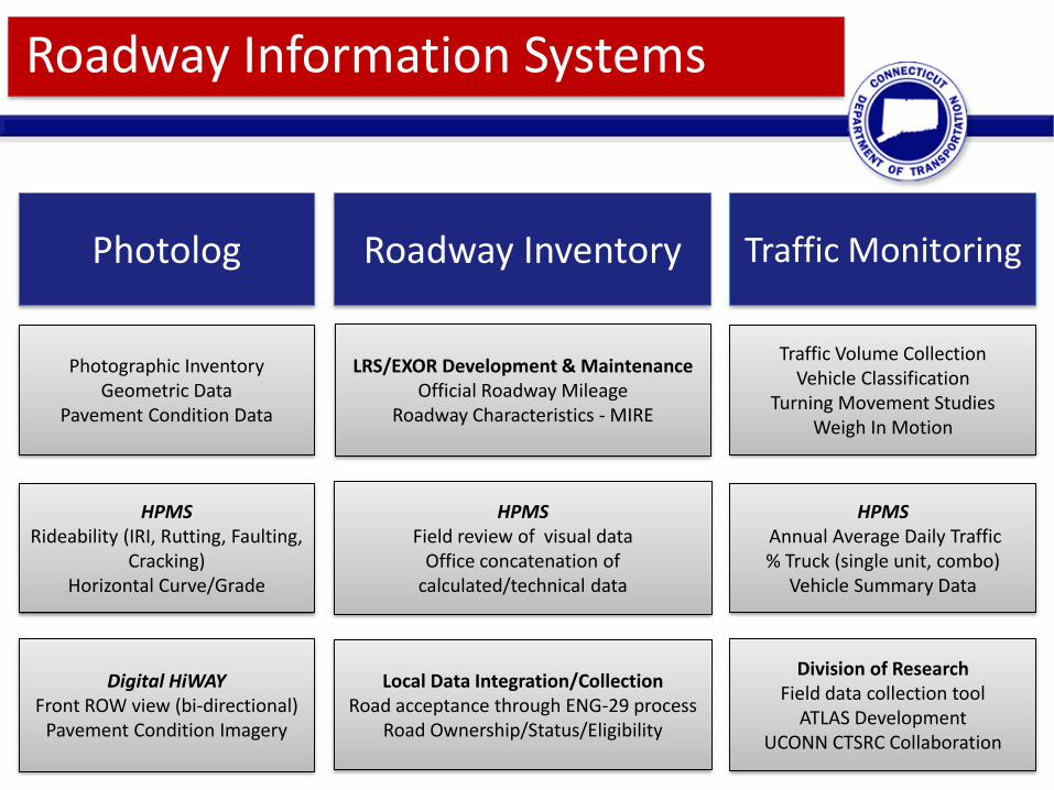
Roadway Information Systems
Roadway InventoryPhotolog Traffic Monitoring
Photographic InventoryGeometric Data
Pavement Condition Data
LRS/EXOR Development & MaintenanceOfficial Roadway Mileage
Roadway Characteristics - MIRE
Traffic Volume CollectionVehicle Classification
Turning Movement StudiesWeigh In Motion
HPMSField review of visual data
Office concatenation of calculated/technical data
HPMSRideability (IRI, Rutting, Faulting,
Cracking)Horizontal Curve/Grade
HPMSAnnual Average Daily Traffic % Truck (single unit, combo)
Vehicle Summary Data
Local Data Integration/CollectionRoad acceptance through ENG-29 process
Road Ownership/Status/Eligibility
Digital HiWAYFront ROW view (bi-directional)
Pavement Condition Imagery
Division of ResearchField data collection tool
ATLAS DevelopmentUCONN CTSRC Collaboration

3
3,733 miles
State Routes/Roads
17,394 miles
Local Roads
423 miles
State Ramps
Linear Referencing System (LRS)
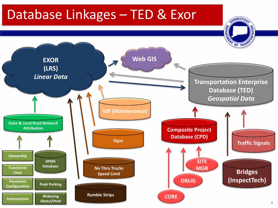
4
Transportation Enterprise Database (TED)Geospatial Data
Composite Project Database (CPD)
CORE
OBLIG
SITE MGR
Traffic Signals
Bridges(InspectTech)
EXOR (LRS)
Linear Data
Web GIS
VIP (Maintenance)
No Thru TrucksSpeed Limit
Rumble Strips
Signs
State & Local Road Network Attribution
Functional Class
Pavement Configuration
Ownership
HPMS Database
Intersections
Peak Parking
Widening Obstcl/Ptntl
Database Linkages – TED & Exor

The MIRE provides a structure for roadway inventory data elements through the use of common consistent definitions and attributes.
August 2007 - FHWA released a report that listed roadway inventory and traffic elements critical to safety management, and proposed standardized coding for each, entitled Model Minimum Inventory of Roadway Elements (MMIRE).
That report has been revised and now includes over 205; becoming more of a comprehensive listing of elements necessary for safety management rather than a minimum listing. Minimum was dropped from the title to remove any implication that all elements were mandatory.
A revised version, MIRE 2.0, was released with a publication date of July 2017 in early 2018.
What Is MIRE?

By comparing the proposed MIRE elements to other databases, safety analysis tools, and guidance documents to identify common
elements and to ensure as much consistency as possible between MIRE and the other datasets.
How Was MIRE Developed?

Categories and Subcategories of MIRE
There are a total of 205 elements that comprise MIRE Version 2.0. The MIRE elements are divided
among three broad categories: roadway segments, roadway alignment, and roadway junctions. Each
category is then broken down further into a subcategory that identifies the associated data item
types.
Elements within MIRE can be concatenated from a variety of sources and databases, but for it to be most effective, adaptation to/utilization of the
prescribed attribution is recommended.
There is leeway for states to determine what data has the most utility and adjust MIRE to best fit their needs.
How Is MIRE Structured?

8
MIRE Requirements of
23 CFR 924.17
3 Tiers Based Upon Functional Classification and
Surface Type
Related to Road Segments and Road Junctions (Intersections &
Interchanges)
Determining Asset/Network Requirements
MIRE FDE

9LRS Node Base – 103,000 Potential Intersections
Creating Intersection & Approach Assets
Adding Structure & Functionality

CTDOT & CTSRC efforts to identify uniform
intersection locations and assign unique IDs
for consistent referencing
Utilizing LRS Structure – Developing Assets

Utilizing LRS Structure – Creating Int & App
Fully Developed
Attributable
Linear
Uniquely Identified
Intersection and
Approach Assets

Able to automate intersection and approach
grouping & creation
Automated script utilized compass bearing to create
Unique Approach ID
Approach ID Bearing can be utilized to create MIRE
attribute of Intersection Angle
All automated off the geometry of the network
Utilizing LRS Structure – Developing Attributes

13
MIRE - 205 Data Elements
Determining Asset/Network Attribution

14
• Fundamental Data Elements are required at different levels depending on functional classification/surface type
• HPMS elements with MIRE counterparts (Sample or Full Extent)
What data in the MIRE is required on a federal or state level?
• Collaborated with UCONN CTSRC to identify data needs/priorities
• Created weighted ranking based upon data necessity, availability, and difficulty of collection/maintenance
What data in the MIRE is required to perform safety analysis consistent with methods outlined in the Highway Safety Manual?
• Identifying data stewards and custodians is a complicated process both internally and externally
• Some roadway characteristic data on local roads has an authoritative review process within the state DOT offices
• Examples include: Functional Classification, Speed Limit, No Thru Trucks, Right Turn On Red Prohibitions
Who stewards the data on a state or local level? Is there state level stewardship of local road attributes?
• Streamlined project tracking will enable data stewards make necessary adjustments as changes occur
• Development of a collaborative process with local agencies is being initiated – stewardship on a local level
How do we capture changes to the road network & attributes that affect the MIRE data items ?
MIRE – Data Item Assessment

15
• Identified roughly half of the recommended elements that were desired and maintainable
Subset of MIRE/HSM Elements that are Needed for Advanced Safety Analysis
•Baseline inventory is the biggest step – maintenance procedures need to be established
Locate Where Data Exists and to What Extent – Develop Collection Methods
MIRE – Filtered/Prioritized Assessment

16
• Multiple assets in parallel – including location collection & attribution of new roads from field
• Support checking in/out of route information
• Required to sunset legacy Roadway Inventory System to keep LRS and Roadway data synchronized
• Resource intensive
• Research Project with UCONN CTSRC and Transcend Spatial Solutions
• Plan to explore other potential applications of collector – maintenance and asset management
• Comprehensive attribution and ease of use will be imperative
Roadway Information – MAVRIC Field Data Collection Tool (in Development)
• Intended as gap filler to start – not system of record – snapshot in time
• Initial effort for Passing/No Passing Zones
• Scalable for Pavement Markings, Guiderail, etc.
Roadway Information - Photolog – Digital HiWAY Data Collection Tool
• Geo-location of Project, Bridges, Signal Location Management
• Civil Integrated Management (CIM) – CADD to GIS, Project Data Capital Asset Capture/Management
Engineering - ATLAS/TED – Connecticut Asset Tracking & Location System
• MIRE – Safety Analyst/HSM Data Collection – filling gaps, establishing base inventories/attribution
UCONN - CTSRC Team – Intersection/Approach Attribution Collection Tool
• Culvert, Rights of Way, ITS / Signal Data
OIT Collection - ESRI Collector
CTDOT Data Collection Efforts & Tools

17
MAVRICMap Based Asset Collection
Allows for road network segment creation
GPS Trace feature to track asset location geospatially
Allows for geospatially accurate collection of off network assets to be referenced back to network location
Attribution is configurable
Field Data Capture Tool Development

18
MAVRIC ApplicationParallel Asset/Attribute Data Collection
Tracks on route with data collector movement
Able to modify multiple assets and/or attributes at once
Contains multiple views of roadway/asset data to best suit collector
Visual component of cross section and positioning assists in QA
Field Data Capture Tool Development

19
SQL Based ApplicationDeveloped by UCONN CTSRC
Intersection/Approach Data Collection

20
CSV LoaderIntersections & Approaches Linearly Represented
Intersection/Approach Data Population
Attributes of Int000001-093
Attributes of IntApp000003-093-200

21
Timeliness How quickly is a change in field conditions or status reflected in the data?
Accuracy How do we ensure that individual populated data fields are error-free?
Completeness How do we minimize the absence of data records & populate all applicable data fields?
Uniformity How do we ensure that all jurisdictions within the state are location referencing in the same manner and using the same definitions for data elements and attributes?
Integration How do we link databases utilizing common or unique identifiers?
Accessibility How do we ensure that the data is available and useable to all appropriate interested parties?
Authority Who programs road network or attribute changes on a state and local level or is responsible for maintaining state or local road data? Stewardship?
Challenges In Collaborative Data Integration

CTDOT LRS/TEDDevelopment &
Maintenance Efforts
CTDOT Assessment of Available State
Data & Desired/Required
Local Data
CTDOT Available & Developing
Data Collection & Maintenance
Tools
Assess Department/
Regional/Local Capabilities &
Resources
Identify Opportunities
for Collaboration & Integration (Internally & Interagency)
22
Recap – Data Collection & Integration

Short TermDepartment review of MIRE v 2.0
Department asset steward identification
Data Governance structure development
Increase use of applications and developing technologies (Imagery, COTS solutions, etc.)
Long TermExplore opportunities for integration and access to local agency supplied roadway attribution
Ability to harvest MIRE relevant asset and roadway information initiatives such as CADD to GIS or Image Feature Auto-Detection
HurdlesElement maintenance – an unmaintained data element quickly becomes unreliable, and eventually unusable
Coordination between responsible and affected parties
Obtaining buy-in & support for the collaborative nature of maintaining a dataset of this size and breadth
Next Steps For MIRE Integration

Roadway Inventory data is a key component of any safety data system and
critical to effective safety management. The use of
uniform elements and consistent nomenclature facilitates system linkages
that enable the use of cutting edge safety analysis tools and
methods.
LRS/MIRE And Additional Data Linkages

25
Thank You
Questions?
Greg CiparelliTransportation Planner – Roadway Information Systems
Connecticut DOT – Bureau of Policy & Planning
Marc KratzschmarSenior Consultant
Bentley Systems


