Embed Size (px)
Citation preview
Addendum to the EIA and EMP for Seismic Acquisition and CAP Drilling in Pande, Temane and Inhassoro Blocks Draft Version 1 December 2015 www.erm.com
ENVIRONMENTAL RESOURCES MANAGEMENT SASOL MOZAMBIQUE
1
Sasol Petroleum Mozambique
Addendum to the EIA and EMP for Seismic Acquisition and CAP Drilling in Pande, Temane and Inhassoro Blocks
For and on behalf of Environmental Resources Management Approved by: __________________________ Signed: ________________________________ Position: _______________________________ Date: __________________________________
This report has been prepared by Environmental Resources Management the trading name of Environmental Resources Management Limited, with all reasonable skill, care and diligence within the terms of the Contract with the client, incorporating our General Terms and Conditions of Business and taking account of the resources devoted to it by agreement with the client. We disclaim any responsibility to the client and others in respect of any matters outside the scope of the above. This report is confidential to the client and we accept no responsibility of whatsoever nature to third parties to whom this report, or any part thereof, is made known. Any such party relies on the report at their own risk.
Draft Version 1
ENVIRONMENTAL RESOURCES MANAGEMENT SASOL MOZAMBIQUE
2
CONTENTS
LIST OF ACRONYMS 5
1 INTRODUCTION 6
1.1 OBJECTIVE OF THE ADDENDUM 6 1.2 SCOPE AND METHODOLOGY OF THE ADDENDUM 7
2 PROJECT DESCRIPTION 8
2.1 SEISMIC ACQUISITION 8 2.2 CAP DRILLING 11 2.3 CLOSURE AND REHABILITATION 12
3 LEGAL REQUIREMENTS 14
3.1 INTRODUCTION 14 3.2 MOZAMBICAN ENVIRONMENTAL LEGISLATION 14 3.3 CONVENTIONS AND RESOLUTIONS 20 3.4 POLICIES, PLANS AND PROGRAMMES 21 3.5 INTERNATIONAL GUIDELINES AND STANDARDS 21
4 DESCRIPTION OF THE AFFECTED ENVIRONMENT 26
4.1 VEGETATION COMMUNITIES – PROPOSED PANDE WELLS 26 4.2 FAUNA 36 4.3 SEISMIC LINES SENSITIVITY 37 4.4 NHANGONZO CRITICAL HABITAT 38 4.5 SOCIOECONOMIC ENVIRONMENT 40
5 IMPACT ASSESSMENT 46
5.1 GENERAL METHODOLOGY 46 5.2 METHODOLOGY FOR THE IMPACT ASSESSMENT 46 5.3 IMPACTS FROM PREVIOUS EIA 48 5.4 IMPACTS OF THE PROPOSED PROJECT 48 5.5 SOCIAL ENVIRONMENT 54
6 ENVIRONMENTAL MANAGEMENT PLAN (EMP) 59
6.1 PURPOSE OF THE ENVIRONMENTAL MANAGEMENT PLAN (EMP) 59 6.2 SCOPE OF THE EMP 59 6.3 SASOL ENVIRONMENTAL POLICY 59 6.4 OBLIGATIONS AND RESPONSIBILITIES 61 6.5 EMP 69 6.6 POST OPERATION EVALUATION 75 6.7 REPORTING AND FOLLOW UP 75
ENVIRONMENTAL RESOURCES MANAGEMENT SASOL MOZAMBIQUE
3
7 CONCLUSION 76
FIGURES
Figure 2.1 SEPI Seismic Acquisition Locations 9 Figure 2.2 Vibroseis 9 Figure 2.3 Explosive Source Seismic Survey Diagram 10 Figure 2.4 CAP Wells in Pande Block 11 Figure 2.5 Existing Drillers Camp 12 Figure 4.1 Primary Vegetation Communities of the Project Areas 27 Figure 4.2 Vegetation Communities of P-G10PXA 28 Figure 4.3 Vegetation Communities of P-G10PXB 29 Figure 4.4 Vegetation Communities of P-G10PXC 30 Figure 4.5 Vegetation Communities of P-G11PXD 32 Figure 4.6 Vegetation Communities of P-G11APXD 34 Figure 4.7 Female plant of Encephalartos ferox subsp. emersus 35 Figure 4.8 Fruiting branch of Croton inhambanensis. ©Tony de Castro 2014 35 Figure 4.9 Flowers and fruit of Dolichandrone alba. © Warren McCleland 2015 36 Figure 4.10 Dark pods and white bark of Xylia mendoncae. 36 Figure 4.11 Sensitivity ratings along seismic lines 38 Figure 4.12 Vegetation Types of the Nhangonzo Critical Habitat 39 Figure 4.13 Representative Habitats of the Nhangonzo Critical Habitat 40 Figure 4.14 Inhambane Province Administrative Structure 41 Figure 4.15 Inhassoro District 42 Figure 4.16 Govuro District 42 Figure 6.1 Reporting Flow Diagram 68
ENVIRONMENTAL RESOURCES MANAGEMENT SASOL MOZAMBIQUE
4
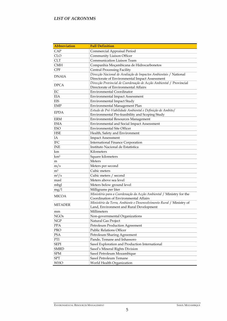
LIST OF ACRONYMS
Abbreviation Full Definition CAP Commercial Appraisal Period CLO Community Liaison Officer CLT Communication Liaison Team CMH Companhia Moçambicana de Hidrocarbonetos CPF Central Processing Facility
DNAIA Direcção Nacional de Avaliação de Impactos Ambientais / National Directorate of Environmental Impact Assessment
DPCA Direcção Provincial de Coordenação de Acção Ambiental / Provincial Directorate of Environmental Affairs
EC Environmental Coordinator EIA Environmental Impact Assessment EIS Environmental Impact Study EMP Environmental Management Plan
EPDA Estudo de Pré-Viabilidade Ambiental e Definição de Ambito/ Environmental Pre-feasibility and Scoping Study
ERM Environmental Resources Management ESIA Environmental and Social Impact Assessment ESO Environmental Site Officer HSE Health, Safety and Environment IA Impact Assessment IFC International Finance Corporation INE Instituto Nacional de Estatística km Kilometers km2 Square kilometers m Meters m/s Meters per second m3 Cubic meters m3/s Cubic meters / second masl Meters above sea level mbgl Meters below ground level mg/l Milligrams per liter
MICOA Ministério para a Coordenação da Acção Ambiental / Ministry for the Coordination of Environmental Affairs
MITADER Ministério da Terra, Ambiente e Desenvolvimento Rural / Ministry of Land, Environment and Rural Development
mm Millimeters NGOs Non-governmental Organizations NGP Natural Gas Project PPA Petroleum Production Agreement PRO Public Relations Officer PSA Petroleum Sharing Agreement PTI Pande, Temane and Inhassoro SEPI Sasol Exploration and Production International SMRD Sasol’s Mineral Rights Division SPM Sasol Petroleum Mozambique SPT Sasol Petroleum Temane WHO World Health Organization
ENVIRONMENTAL RESOURCES MANAGEMENT SASOL MOZAMBIQUE
5
1 INTRODUCTION
Sasol Exploration and Production International (SEPI) (as Sasol Petroleum Mozambique - SPM) has a Petroleum Sharing Agreement (PSA) in Inhambane Province, Mozambique, for exploration, appraisal and development activities in the Pande, Temane and Inhassoro Blocks. In these areas, two EIAs have been commissioned and approved, allowing exploratory and development work to be undertaken, namely: • The Natural Gas Project (NGP) EIA, prepared in 2001. Over the years, this
EIA has been amended for expansions and other projects within the Temane Central Processing Facility (CPF) boundaries, while specific Environmental Management Plans (EMP’s) were updated ahead of seismic and drilling campaigns and reviewed and approved by MICOA (now MITADER formerly the Ministry for the Coordination of Environmental Affairs), prior to the start of activities; and
• The PSA Development and LPG Project EIA, prepared in 2014, and focused
on the liquids plant, oil and gas wells and associated facilities planned for the first phase of the PSA Development in the Temane / Inhassoro fields.
In addition to these, and based on successful results, future exploration and development work in the PPA and PSA areas is likely to be conducted in a phased approach over several years. SEPI therefore is currently conducting an Environmental Impact Assessment for the Exploration and Development activities in the Pande, Inhassoro and Temane Fields that covers the onshore Pande, Temane and Inhassoro (PTI) PPA and PSA geographical areas, in respect of planned oil and gas exploration, appraisal and development activities, within a 10 -year horizon. However SEPI has ongoing requirements to manage seismic and drilling activities in PTI that require to be addressed before the submission of the EIA and in close communication with the environmental authorities, SEPI intends to submit an addendum (the present document) that includes: • The conversion of the 2D Seismic EMP (from March, 2009) into the 3D
Seismic acquisition Environmental Management Plan (EMP) for Pande and Inhassoro;
• An update to the onshore drilling EMP (PSA Development, Oct. 2014).
1.1 OBJECTIVE OF THE ADDENDUM The main objectives of the present addendum are as follows:
ENVIRONMENTAL RESOURCES MANAGEMENT SASOL MOZAMBIQUE
6
• Identify and evaluate the potential specific impacts of the new seismic exploration/development drilling activities;
• Identify mitigation measures for the negative impacts and enhancing measures for the positive impact identified;
• Compilation of an EMP with monitoring measures for the impacts identified.
1.2 SCOPE AND METHODOLOGY OF THE ADDENDUM
The present addendum updates the existent EIAs and EMPs in what comes to specific aspects of the project activities – 3D seismic acquisition and exploration drilling with respect to the following: • Project locations and its specific environmental and social characteristics; • Project description; • Specific impact assessment and management plans. These aspects are a result of the assessment of the Drilling Environmental Management Plan (PSA Development EIA, Oct 2014), as well as on the NGP’s EMP March 2009, related to the proposed activities. It is important to note that only updated information will be part of the present report as other, available in previous studies, still apply to the activities.
ENVIRONMENTAL RESOURCES MANAGEMENT SASOL MOZAMBIQUE
7
2 PROJECT DESCRIPTION
The seismic acquisition and the exploration drilling programme will comprise the following stages:
Table 2.1 Project Stages and Activities
Project Stages Activities
Mobilization Material and equipment mobilization Demining and bush clearance
Operation 3D Seismic acquisition and Exploration Drilling operations
Closure / Rehabilitation Closure and rehabilitation
The specific description of the stages is provided below:
2.1 SEISMIC ACQUISITION
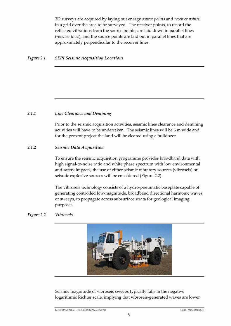
Sasol will acquire data from a fit-for-purpose proprietary 3D onshore seismic survey of about 49 km2 of surface coverage around the Pande-4 well in the Pande PPA license area as shown in Figure 2.1. The 3D seismic survey is designed to provide subsurface images from shallow and deep targets via high-receiver-density coverage to identify potential subsurface hazards around the Pande-4 well location. Results from this 3D seismic survey will support further well control and remediation measures in an attempt to contain an uncontrolled subsurface flow coming to surface near the Pande-4 location and reactivated by unknown causes since early 2014. SEPI will also conduct a proprietary 3D onshore seismic infill survey of about 90 km2 of surface coverage on the northern half of the Inhassoro PSA license area and also 114.6 km2 on the south of Inhassoro to support the development of G10 and G6 oil reservoirs as part of Tranche 2 & 3 well drilling plans. Results from these seismic surveys will provide additional structural control and optimise well infill programme while reducing well failure rate and provide additional subsurface information to expand development plans supported by drilling results. A seismic survey is conducted by creating a shock wave - a seismic wave - on the surface of the ground along a predetermined line, using an energy source. The seismic waves are created either by small explosive charges set off in shallow holes ("shot holes") or by large vehicles equipped with heave plates ("Vibroseis" trucks) that vibrate on the ground. The seismic wave travels into the earth, is reflected by subsurface formations, and returns to the surface where it is recorded by receivers called geophones - similar to microphones.
ENVIRONMENTAL RESOURCES MANAGEMENT SASOL MOZAMBIQUE
8
3D surveys are acquired by laying out energy source points and receiver points in a grid over the area to be surveyed. The receiver points, to record the reflected vibrations from the source points, are laid down in parallel lines (receiver lines), and the source points are laid out in parallel lines that are approximately perpendicular to the receiver lines.
Figure 2.1 SEPI Seismic Acquisition Locations
2.1.1 Line Clearance and Demining
Prior to the seismic acquisition activities, seismic lines clearance and demining activities will have to be undertaken. The seismic lines will be 6 m wide and for the present project the land will be cleared using a bulldozer.
2.1.2 Seismic Data Acquisition
To ensure the seismic acquisition programme provides broadband data with high signal-to-noise ratio and white phase spectrum with low environmental and safety impacts, the use of either seismic vibratory sources (vibroseis) or seismic explosive sources will be considered (Figure 2.2). The vibroseis technology consists of a hydro-pneumatic baseplate capable of generating controlled low-magnitude, broadband directional harmonic waves, or sweeps, to propagate across subsurface strata for geological imaging purposes.
Figure 2.2 Vibroseis
Seismic magnitude of vibroseis sweeps typically falls in the negative logarithmic Richter scale, implying that vibroseis-generated waves are lower
ENVIRONMENTAL RESOURCES MANAGEMENT SASOL MOZAMBIQUE
9
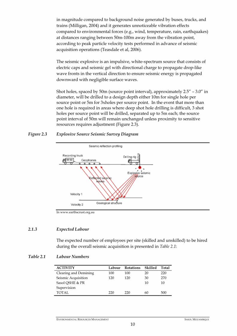
in magnitude compared to background noise generated by buses, trucks, and trains (Milligan, 2004) and it generates unnoticeable vibration effects compared to environmental forces (e.g., wind, temperature, rain, earthquakes) at distances ranging between 50m-100m away from the vibration point, according to peak particle velocity tests performed in advance of seismic acquisition operations (Teasdale et al, 2006). The seismic explosive is an impulsive, white-spectrum source that consists of electric caps and seismic gel with directional charge to propagate drop-like wave fronts in the vertical direction to ensure seismic energy is propagated downward with negligible surface waves. Shot holes, spaced by 50m (source point interval), approximately 2.5” – 3.0” in diameter, will be drilled to a design depth either 10m for single hole per source point or 5m for 3xholes per source point. In the event that more than one hole is required in areas where deep shot hole drilling is difficult, 3 shot holes per source point will be drilled, separated up to 5m each; the source point interval of 50m will remain unchanged unless proximity to sensitive resources requires adjustment (Figure 2.3).
Figure 2.3 Explosive Source Seismic Survey Diagram
In www.earthscrust.org.au
2.1.3 Expected Labour
The expected number of employees per site (skilled and unskilled) to be hired during the overall seismic acquisition is presented in Table 2.1:
Table 2.1 Labour Numbers
ACTIVITY Labour Rotations Skilled Total Clearing and Demining 100 100 20 220 Seismic Acquisition 120 120 30 270 Sasol QSHE & PR Supervision
10 10
TOTAL 220 220 60 500
ENVIRONMENTAL RESOURCES MANAGEMENT SASOL MOZAMBIQUE
10

2.2 CAP DRILLING
Sasol plans to drill 4 CAP wells within the Pande area. The four proposed well sites are located in a cluster in the north-east corner of the Pande Block, approximately 40 km north-west of Inhassoro (Figure 2.4). The closest major access route to the wells is the EN-1 road, which lies to the west. Smaller gravel roads associated with previous Sasol exploration activities and current production wells provide access to the proposed well sites and adjacent areas (Golder, 2015). The prospective 4 CAP wells geographic coordinates are the following:
Table 2.2 CAP Wells Coordinates
CAP Well Coordinates CAP 1 -21.32561ºS 34.85151ºE CAP 2 -21.29722ºS 34.86659º E CAP 3 -21.29389ºS 34.80229ºE CAP 4 -21.26728ºS 34.96446ºE Alternative CAP 4 -21.27887º 34.93996ºE
Drilling activities in Pande Block will require some surface works such as roads, well pads construction. Existing tracks and seismic lines will be utilized where possible to access proposed drill sites, but additional temporary access roads for CAP and development drilling will be required and these will be constructed by means of bush clearing and grading.
Figure 2.4 CAP Wells in Pande Block
Drilling sites of approximately 1ha (100m x 100m) will be established in Pande, and will consist of compacted earthen pads, staging areas for materials and supplies, the drilling rig, earthen pits for muds and drill cuttings and associated equipment. Only one existing base camp will be used to support the operations (Figure 2.5).
ENVIRONMENTAL RESOURCES MANAGEMENT SASOL MOZAMBIQUE
11
Figure 2.5 Existing Drillers Camp
Wells will be drilled to depths of approximately 2 000 m to below the ground surface. Surface conductor steel casings will be pile driven and cemented in place. A separate casing string will be installed to a depth of about 120 m depending on local conditions. This will ensure isolation of all surface aquifers. Further casing strings will be set to ensure isolation of the gas bearing formations from other formations. The upper sections of the well will be drilled with the use of a fresh water bentonite / lime drilling mud. A potassium chloride salt-based polymer mud will be utilized for the deeper sections of the wells. Drilling fluids (muds) will be reused between wells, but when these require disposal, they will either be injected into deep rock strata (if the well is to be abandoned) or buried within the pits using the Mix-Bury-Cover (MBC) method. Flaring may be required to establish the well performance and well characteristics. The most conventional well test method involves flowing the reservoir fluids, up to the drilling unit, where they are flared off through a high efficiency flare. Each appraisal well will be tested giving a total flaring to the atmosphere over a period of 12 days.
2.3 CLOSURE AND REHABILITATION
2.3.1 Seismic Lines
All the seismic lines, opened for the seismic acquisition, will be rehabilitated and closed right after the seismic acquisition programme. The rehabilitation of the seismic lines will include soil ripping, were the soils are compacted, and revegetation of the area with native species or the spread of cut material placed aside the lines.
2.3.2 CAP Drilling
If drilling results show that the CAP wells are not commercially viable, the CAP wells will be decommissioned and abandoned. Reserve and disposal pits will be closed and filled in. The drilling pad area will be ripped and re-vegetated with native species.
ENVIRONMENTAL RESOURCES MANAGEMENT SASOL MOZAMBIQUE
12
Those wells that prove to be economically viable will be temporarily suspended for reappraisal in the future.
ENVIRONMENTAL RESOURCES MANAGEMENT SASOL MOZAMBIQUE
13
3 LEGAL REQUIREMENTS
3.1 INTRODUCTION
The purpose of this chapter is to provide an overview of the relevant legislative requirements and applicable standards according to the proposed project, as well as the best practices that can be adopted in order to achieve sustainability development.
3.2 MOZAMBICAN ENVIRONMENTAL LEGISLATION
3.2.1 The Constitution of Mozambique
The Constitution is the supreme law of the land, and any act or conduct that is inconsistent with the principles enshrined in the Constitution is considered unlawful. The Constitution provides for the protection of the natural environment under the following articles: “Article 27: The state shall promote efforts to guarantee the ecological balance and the conservation and preservation of the environment for the betterment of the quality of life of its citizens.” “Article 72: All citizens shall have the right to live in, and the duty to defend, a balanced natural environment.”
3.2.2 The Environmental Law
The Environmental Law (Decree No 20/1997 of 1 October) was passed by the Mozambican Parliament in July 1997. The aim of this law is to provide a legal framework for the use and correct management of the environment and its components. Core principles for environmental management in Mozambique include: • The improvement of the quality of life of the citizens and the protection of
the countries biodiversity and ecosystems. • Recognise and value local communities’ traditions and knowledge. • Polluters, whose action results in the degradation of the environment, are
held liable to rehabilitate any pollution or to compensate for the resulting damage.
• The law forbids pollution from the discharge of any polluting substances
into the soil, subsoil, water or atmosphere or any other form of degradation of the environment, which falls outside the limits stipulated by the law.
• The law also forbids, explicitly, the importation of dangerous residues or
dangerous waste, except for that laid down in specific legislation.
ENVIRONMENTAL RESOURCES MANAGEMENT SASOL MOZAMBIQUE
14
• Prioritization of preventative systems against environmental degradation. With focus on the ESIA process, Articles 15 to 17 establish that any activity, which by the nature of the location, design or scale that may cause significant environmental impacts, will require an Environmental License from the designated authorities. The authorities will only issue a final decision in terms of the license, based on the findings of an ESIA.
3.2.3 Regulation on the Environmental Impact Assessment Process
The Regulation on the Environmental Impact Assessment Process approved by Decree No 45/2004 of 29 September as amended by Decree No 42/2008 of 4 November, defines the procedures that must be followed in an EIA. Under Article 2, the requirement of this Decree applies to all public or private activities that can, directly or indirectly, influence the environment, in accordance with the terms of Article 3 of the Environmental Law. Under Article 3, the proposed Project must be assessed against category lists (Category A, B and C projects) and additional environmental criteria as defined under Articles 6, 7 and 8 to determine the ESIA process requirements. The three categories are defined expanded below: • Category A: Activities presented in Annex I are considered to have
significant adverse impacts on the environment and are subject to an Environmental Impact Study (EIS).
• Category B: Activities listed in Annex II are those for which potential
environmental impacts are less adverse than those of Category A projects and are subject to a Simplified Environmental Study (SES).
• Category C: Activities listed in Annex III are exempt from an EIS and SES
but still require observance of good management practices.
The Amendments to the Regulations for the Environmental Impact Assessment Process (Decree 42/2008 of 4 November) provide for revisions and changes to certain Articles of Decree No 45/2004. Of note to this ESIA are the following revisions: • Amendment to Article 18 which specifies the timeframes for issuing
decisions including the additional provision of timeframes in the review of EMPs.
• Amendments to Article 20 with respect to validity of environmental
licenses, and specifically the requirements in terms of renewal of licenses. • Amendments to Article 25 with respect to an increase in environmental
licensing taxes, and taxes related to changes in licenses.
ENVIRONMENTAL RESOURCES MANAGEMENT SASOL MOZAMBIQUE
15

3.2.4 General Directive for Environmental Impact Studies
The General Directive for Environmental Impact Studies (Ministerial Diploma 126/2006 of 19 July) establishes the content and information requirements for an Environmental Impact Study Report. The directive also establishes the minimum requirements of the EIA with respect to information and report structure. These requirements include the following: 1. General Format and Structure of the Environmental Impact Study Report 2. Executive Summary 3. Main Report 4. Comparative Analysis of Alternatives 5. Conclusions and Recommendations 6. Limitations and Assumptions 7. Environmental Management Plan 8. Public Participation 9. Annexure Requirements
3.2.5 General Directive for the Public Participation Process in the Environmental Impact Assessment Process
The General Directive for the Public Participation Process in the Environmental Impact Assessment Process (Ministerial Diploma 130/2006 of 19 July) expands on the procedural requirements for the Public Participation Process, as established in the EIA regulations. This directive established the norms and general principles that need to be met in undertaking the public participation process. In addition, the directive expands on the requirements for the Public Consultation Report as established in Decree 45/2004 of 29 September as amended by Decree 42/2008 of 4 November.
3.2.6 Relevant Project Supporting Legislation
3.2.7 Petroleum
• Decree 24/2004 – Regulation of Petroleum Operations - establishes the operational requirements, including aspects related to safety, health and environmental protection and provides a list of environmental issues to consider while conducting oil operations.
• Decree 56/2010 – Environmental regulation of Petroleum Operations - Sets
the EIA process to be implemented for oil operations. Defines the categories of the project and the environmental assessment level required for each project category
• Law 21/2014 – Petroleum Law – Establishes the system of allocation of
rights to conduct petroleum operations in the country and includes aspects
ENVIRONMENTAL RESOURCES MANAGEMENT SASOL MOZAMBIQUE
16
of Safety and Environmental Protection and the discharge of contaminated water and oil residues
3.2.8 Archaeology
All archaeological remains in Mozambique have been protected by the National Heritage Protection Law since 1988 (Law 10/88 of 22 December). The law is intended to protect all national antiquities, historical and cultural heritage. In 1994, the Mozambique Council of Ministers approved regulations under the National Heritage Protection Law pertaining to the protection of Archaeological Heritage in order to research and recover archaeological artefacts and areas that may be impacted by development. Chapter IV article 12 of the Act states that all projects that involve excavation, removal or extension of land, or the removal of submersed or underground objects must include archaeological investigation and recovery in the area affected by the project and must include, to undertake these activities, a donation of no less than 0.5% of the total cost of the project. The regulations make two institutions responsible for the protection of archaeological heritage, namely the Department of Monuments of the Ministry of Culture and ICOMOS – Mozambique Committee.
3.2.9 Wildlife
• Law 10/99 of 7 July - Law of Forestry and Wildlife - Establishes the principles with respect to the formalisation of protected areas and the use and management of forestry and wildlife resources. Of applicability to the proposed Project would be the provisions on Article 13, which establishes the need for protection of places of historical and cultural value to the local communities.
• Decree 12/2002 of 6 June amended by Decree 11 / 2003 of 25 March - Forestry and
Wildlife Regulation - Establishes additional regulations in support of the Forestry and Wildlife Law. This regulation provides the guiding principles associated with the management, protection, use and exploitation of forest and wildlife resources.
3.2.10 Water
• Law 16/1991 of 3 August - the water Law: Establishes the basis for management of water resources, and advocates a “user pays” and “polluter pays” policy. This law stipulates, for cases of private water use, that full priority shall be given to water supply to the population (human consumption and heath care needs). Furthermore, it prohibits the private use of water where the provision of such water use will be to the detriment of the environmental.
ENVIRONMENTAL RESOURCES MANAGEMENT SASOL MOZAMBIQUE
17
3.2.11 Land Rights/Acquisition
• Law 19/1997 of 1 October - The Land Law - Establishes as a general principle that, in Mozambique, land is the property of the state. The Land Law and associated regulations establishes land use rights and the means by which individuals or companies may obtain the rights to use land (referred to as DUAT). In addition, other provisions that merit special attention considering the context of the proposed Project for which this law provides legal guidance includes:
• The impacts of the project on existing DUATs; • Impacts on zoning and land use planning for social and economic
purposes; and • Impacts on agriculture; and • Impacts on public health due to ecological changes.
• Decree 66/98 of 8 December amended by Decree 1/2003 of 18 November – Land
Law Regulation - Provides regulations with respect to the Land Law, 19/1997 of 1 October. The regulation presents a series of provisions related to public owned land, land use rights, land title application process, inspection and taxes. Of relevance to the proposed Project would be the provisions included in Article 17, which determines the liability for damages and / or compensation to the land use holder of land intended for other use by a public or private investor. The land law outlines the procedures to be followed during application and acquisition of land use rights (DUAT) and establishes the obligation for payment of land taxes. Article 22 introduces the procedures for land acquisition and the competent authorities that need to be involved.
• Ministerial Diploma no 29/2000 – A of 17 March - Technical Annex to the
Land Law Regulation - Defines the approach and implementation mechanisms associated with the title application process. Furthermore, the technical annex makes provision concerning the rights and duties of the local communities.
3.2.12 Territorial Planning
• Decree 19 of 2007 of 18 July - Territorial Planning Law - Establishes the principles, objectives and legal framework for land planning in Mozambique. This regulation outlines the measures and regulatory procedures required in improving living standards for the people of Mozambique and to sustainable development.
3.2.13 Resettlement
• Decree 31/2012 of 8 August - Regulations for the Resettlement Process Resulting from Economic Activities - These regulations stipulate the basic rules and principles associated with resettlement, as a result of public or private economic activities, performed by national or foreign, natural or
ENVIRONMENTAL RESOURCES MANAGEMENT SASOL MOZAMBIQUE
18
legal persons, with a view to the promotion of the citizens’ quality of life and the protection of the environment.
3.2.14 Labour
• Law 23/2007 of 1 August - Labour Law - Defines aspects related to the hiring of workers, the rights and responsibilities of workers, including hygiene and health & safety. The law also discusses the labour relations between employers and workers and the laws in terms of national and foreign workers.
3.2.15 Culture
• Law 10/1988 of 22 December - Cultural Protection Law - Establishes the legal protection for material and immaterial assets associated with Mozambican cultural heritage (existing or yet to be discovered). With focus on this proposed Project, Article 13 stipulates the need to communicate any findings of buildings, objects or documents that may potentially be classified as assets of cultural heritage.
• Decree 27/1994 of 20 July - Archaeological Heritage Protection Regulation -
Establishes the rights and protection of resources that have archaeological and historical value. Article 21 of this regulation prohibits the execution of construction and demolition or any other works that may imply physical changes to the protection zones of archaeological property of high scientific value or that are important to preserve for the future generations. This regulation establishes, inter alia that the finding of artefacts shall be reported to the local authorities (District Administration or Municipal Council) within a period of 48 hours.
3.2.16 Waste
• Decree 13/2006 of 15 June - Regulation on Waste Management - Establishes the legal framework for waste management in Mozambique so as to minimise negative impacts on social health and the environment. This regulation sets out rules for classification of solid waste, the forms of waste segregation, waste collection and transport, waste treatment and waste disposal.
3.2.17 Emissions
• Decree 18/2004 of 2 June amended by Decree 67/2010 of 31 December - Regulations on Environmental Quality Standards and Wastewater Emissions - Regulates and ensure effective control and monitoring on the quality of the environment and natural resources. It establishes specific standards and regulations on water quality, atmospheric emissions and noise. These regulations will be of relevance during the mobilization and operation phases of the proposed Projects.
ENVIRONMENTAL RESOURCES MANAGEMENT SASOL MOZAMBIQUE
19

3.2.18 Audits and Inspections
• Decree 32/2003 of 12 August - Regulation on the Process of Environmental Auditing – Establishes the procedures and criteria to carry out environmental audits. Special consideration should be given to Article 4 of this regulation which defines the objects of Environmental Audits and to Article 10 that specifies the contents of the Environmental Audit Report. Furthermore this article specifies that environmental auditors must be registered with MITADER.
• Decree 11/2006 of 15 June - Regulation on Environmental Inspections - Regulates
the activities associated with supervision, control and compliance with environmental protection standards at national level.
3.3 CONVENTIONS AND RESOLUTIONS
Mozambique is signatory to a number of international conventions and agreements relating to climate change and the environment. In certain cases these have influenced the development of policies, guidelines and regulations. This study will need to consider these conventions and agreements and ensure compliance during the planning, mobilization and operation phases of the proposed Project. The following international conventions and protocols, to which Mozambique is a signatory, will be considered:
Table 3.1 List of conventions and resolutions
Resolution Title Resolution 18/81of 30 December African Convention of Nature and Natural Resource
Conservation Resolution 8/93 of 08 December Vienna Convention on Ozone Protection of 22 March
1985 Resolution 1/94 of 24 of August UN Climate Change Convention of June 1992; Resolution 2/94 of 24 August UN Convention on Biological Biodiversity Resolution 17/96 of 26 November East Africa Marine Protection, Management and
Development Convention Resolution 52/2001 of 6 November International Convention and Protocol on Civil
Responsibility for Hydrocarbon Pollution Resolution 5/2003 of 18 February International Convention for the Prevention of Pollution
by Shipping 1973 and Protocol 1978 Resolution 6/2003 of 18 February International Convention on the Preparation, Combat
and Cooperation against Hydrocarbon Pollution, 1990-OPRC 90;
Resolution 45/2003 of 05 November Convention on Tropical Areas of International Importance with serve as Habitats for Aquatic Birds
Resolution 10/2004 of 28 July 2004 Kyoto Protocol on Climate Change Resolution 56/2004 of 31 December Stockholm Convention on Persistent Organic pollutants.
ENVIRONMENTAL RESOURCES MANAGEMENT SASOL MOZAMBIQUE
20
3.4 POLICIES, PLANS AND PROGRAMMES
The assessment associated with the proposed Project will need to take into consideration the following National and Regional Plans:
3.4.1 National Environmental Sector Strategic Plan (2005 to 2015)
This plan promotes the sustainable use of natural resources, economic growth and social equity. This plan focuses on seven priority action environmental aspects, including: • Water supply and sanitation; • Territorial planning; • Land degradation; • Management of natural resources; • Legal and institutional aspects; • Soil; • Air and water pollution; and • Natural disasters. Furthermore this Plan presents the roles of the State, Private Sector, Civil Society and other key role players. The responsibilities set out in the plan for the Private Sector are as follows: • To implement measures to mitigate environmental impacts; • To promote actions to enhance the value of the affected environment; • To allocate resources for the implementation of the environmental actions
identified; • To disclose the Sector Strategic Plan to the Environmental Sector; and • To sponsor the achievement of the Millennium Development Goals.
3.5 INTERNATIONAL GUIDELINES AND STANDARDS
The aim of following international guidelines and standards is to ensure all issues are considered and managed in line with international good practice. This section describes the most relevant international guidelines and standards that aim to ensure that all environmental and social issues are considered and managed in line with international good practice. The ESIA will be undertaken in conformance to these international guidelines and standards.
3.5.1 The Equator principles
The Equator Principles (EPs) are a risk management framework, adopted by financial institutions, for determining, assessing and managing environmental
ENVIRONMENTAL RESOURCES MANAGEMENT SASOL MOZAMBIQUE
21
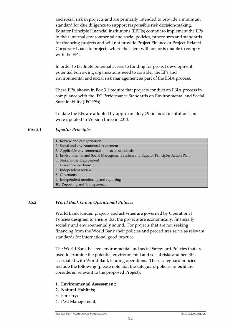
and social risk in projects and are primarily intended to provide a minimum standard for due diligence to support responsible risk decision-making. Equator Principle Financial Institutions (EPFIs) commit to implement the EPs in their internal environmental and social policies, procedures and standards for financing projects and will not provide Project Finance or Project-Related Corporate Loans to projects where the client will not, or is unable to comply with the EPs. In order to facilitate potential access to funding for project development, potential borrowing organisations need to consider the EPs and environmental and social risk management as part of the ESIA process. These EPs, shown in Box 3.1 require that projects conduct an ESIA process in compliance with the IFC Performance Standards on Environmental and Social Sustainability (IFC PSs). To date the EPs are adopted by approximately 79 financial institutions and were updated to Version three in 2013.
Box 3.1 Equator Principles
3.5.2 World Bank Group Operational Policies
World Bank funded projects and activities are governed by Operational Policies designed to ensure that the projects are economically, financially, socially and environmentally sound. For projects that are not seeking financing from the World Bank their policies and procedures serve as relevant standards for international good practice. The World Bank has ten environmental and social Safeguard Policies that are used to examine the potential environmental and social risks and benefits associated with World Bank lending operations. These safeguard policies include the following (please note that the safeguard policies in bold are considered relevant to the proposed Project): 1. Environmental Assessment; 2. Natural Habitats; 3. Forestry; 4. Pest Management;
1. Review and categorisation 2. Social and environmental assessment 3. Applicable environmental and social standards 4. Environmental and Social Management System and Equator Principles Action Plan 5. Stakeholder Engagement 6. Grievance mechanism 7. Independent review 8. Covenants 9. Independent monitoring and reporting 10. Reporting and Transparency
ENVIRONMENTAL RESOURCES MANAGEMENT SASOL MOZAMBIQUE
22
5. Cultural Property; 6. Revised Draft Operational Policy 4.10: Indigenous People (replaces
operational Directive 4.20 on Indigenous Peoples); 7. Involuntary Resettlement; 8. Safety of Dams; 9. Projects in International Waters; and 10. Projects in Disputed Areas.
3.5.3 The International Finance Corporation
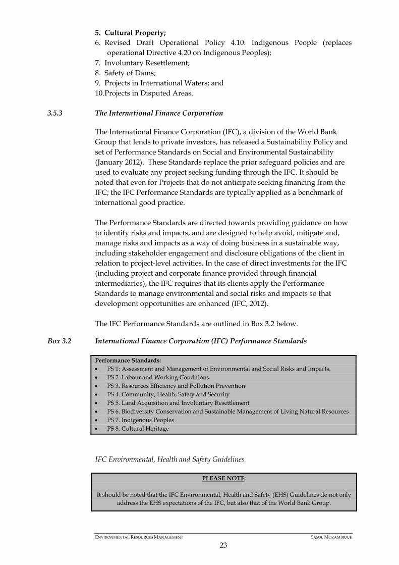
The International Finance Corporation (IFC), a division of the World Bank Group that lends to private investors, has released a Sustainability Policy and set of Performance Standards on Social and Environmental Sustainability (January 2012). These Standards replace the prior safeguard policies and are used to evaluate any project seeking funding through the IFC. It should be noted that even for Projects that do not anticipate seeking financing from the IFC; the IFC Performance Standards are typically applied as a benchmark of international good practice. The Performance Standards are directed towards providing guidance on how to identify risks and impacts, and are designed to help avoid, mitigate and, manage risks and impacts as a way of doing business in a sustainable way, including stakeholder engagement and disclosure obligations of the client in relation to project-level activities. In the case of direct investments for the IFC (including project and corporate finance provided through financial intermediaries), the IFC requires that its clients apply the Performance Standards to manage environmental and social risks and impacts so that development opportunities are enhanced (IFC, 2012). The IFC Performance Standards are outlined in Box 3.2 below.
Box 3.2 International Finance Corporation (IFC) Performance Standards
IFC Environmental, Health and Safety Guidelines
Performance Standards: • PS 1: Assessment and Management of Environmental and Social Risks and Impacts. • PS 2. Labour and Working Conditions • PS 3. Resources Efficiency and Pollution Prevention • PS 4. Community, Health, Safety and Security • PS 5. Land Acquisition and Involuntary Resettlement • PS 6. Biodiversity Conservation and Sustainable Management of Living Natural Resources • PS 7. Indigenous Peoples • PS 8. Cultural Heritage
PLEASE NOTE: It should be noted that the IFC Environmental, Health and Safety (EHS) Guidelines do not only
address the EHS expectations of the IFC, but also that of the World Bank Group.
ENVIRONMENTAL RESOURCES MANAGEMENT SASOL MOZAMBIQUE
23
The Environmental, Health and Safety (EHS) Guidelines are technical reference documents with general and industry-specific examples of Good International Industry Practice. The EHS Guidelines contain the performance levels and measures that are normally acceptable to IFC and World Bank, and that are generally considered to be achievable in new facilities at reasonable costs by existing technology. They are designed to assist managers and decision makers with relevant industry background and technical information. This information supports actions aimed at avoiding, minimising, and controlling EHS impacts during the mobilization, operation, and closure/rehabilitation phase of a project or facility. The EHS Guidelines serve as a technical reference source to support the implementation of the IFC Performance Standards. When host country (Mozambique) regulations differ from the levels and measures presented in the EHS Guidelines, projects will be expected to achieve whichever is more stringent. If less stringent levels or measures are appropriate in view of specific project circumstances, a full and detailed justification for any proposed alternatives is required. General EHS Guidelines exist which contain information on cross-cutting environmental, health, and safety issues potentially applicable to all industry sectors; these are listed in Box 3.3.
ENVIRONMENTAL RESOURCES MANAGEMENT SASOL MOZAMBIQUE
24
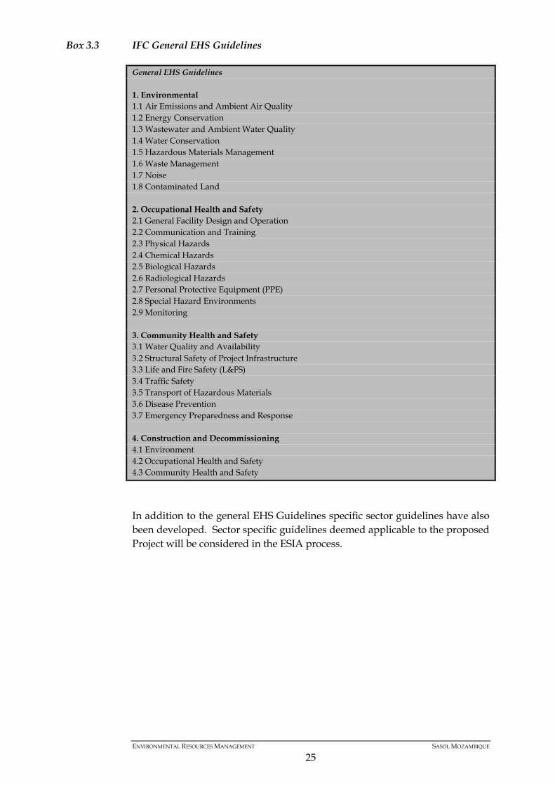
Box 3.3 IFC General EHS Guidelines
In addition to the general EHS Guidelines specific sector guidelines have also been developed. Sector specific guidelines deemed applicable to the proposed Project will be considered in the ESIA process.
General EHS Guidelines 1. Environmental 1.1 Air Emissions and Ambient Air Quality 1.2 Energy Conservation 1.3 Wastewater and Ambient Water Quality 1.4 Water Conservation 1.5 Hazardous Materials Management 1.6 Waste Management 1.7 Noise 1.8 Contaminated Land 2. Occupational Health and Safety 2.1 General Facility Design and Operation 2.2 Communication and Training 2.3 Physical Hazards 2.4 Chemical Hazards 2.5 Biological Hazards 2.6 Radiological Hazards 2.7 Personal Protective Equipment (PPE) 2.8 Special Hazard Environments 2.9 Monitoring 3. Community Health and Safety 3.1 Water Quality and Availability 3.2 Structural Safety of Project Infrastructure 3.3 Life and Fire Safety (L&FS) 3.4 Traffic Safety 3.5 Transport of Hazardous Materials 3.6 Disease Prevention 3.7 Emergency Preparedness and Response 4. Construction and Decommissioning 4.1 Environment 4.2 Occupational Health and Safety 4.3 Community Health and Safety
ENVIRONMENTAL RESOURCES MANAGEMENT SASOL MOZAMBIQUE
25
4 DESCRIPTION OF THE AFFECTED ENVIRONMENT
As stated before, only updated information will be part of the present report as the other, identified and described on previous studies, still apply to the proposed activities. Thus, the present chapter will only provide updated information regarding to the biodiversity assessment studies undertaken in 2015 in the PTI area.
4.1 VEGETATION COMMUNITIES – PROPOSED PANDE WELLS
The description of vegetation communities across the study area has been based on different classification and terminology by various specialists since 2001 when the first surveys for Sasol were undertaken. Eight broad vegetation communities were identified within the Pande and Temane Blocks in 2001 by Telford and de Castro (Mark Wood Consultants 2001): • Hummock dune pioneer communities; • Mangrove swamps; • Closed woodland and hygrophytic grassland mosaic; • Acacia open woodland; • Julbernardia-Brachystegia closed woodland and thicket; • Mixed Brachystegia woodland and deciduous forest mosaic; • Mixed open woodland; and • Carpodiptera-Guibourtia Forest Later vegetation surveys in the Temane Block in the vicinity of the Nhangozo Stream (critical habitat) identified eight vegetation types (Avis et al 2015): • Riparian vegetation/coastal stream; • Short closed miombo woodland and thicket mosaic; • Short open miombo thicket mosaic; • Short closed miombo thicket; • Coastal thicket and dune scrub; • Coastal dune forest; • Mangroves; and • Machamba /disturbed woodland and thicket mosaic. Vegetation mapping based on remote sensing and ground-truthing, undertaken by Golder (2015a) for the PTI field study area, identified 19 broad scale vegetation communities in three structural groups (forest/thicket; woodland and grassland). These are shown in figure 4.1. The broad scale vegetation communities comprise sub-vegetation types which are described in detail in Golder biodiversity Studies (Golder, 2015).
ENVIRONMENTAL RESOURCES MANAGEMENT SASOL MOZAMBIQUE
26
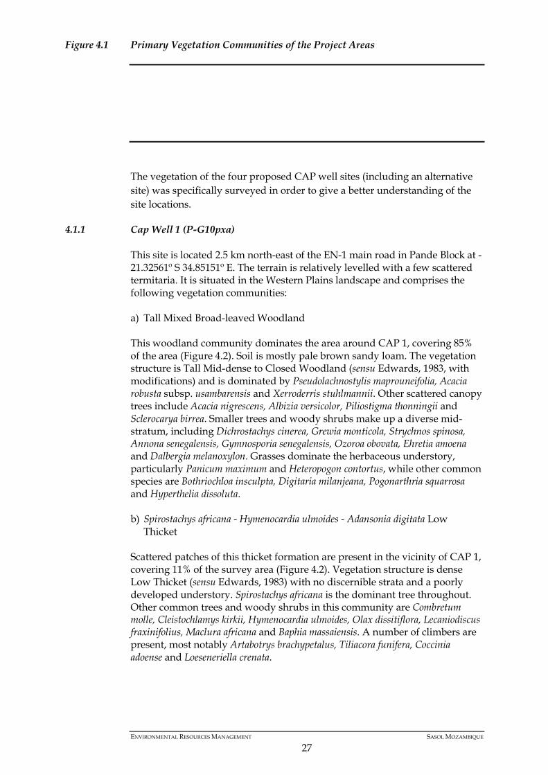
Figure 4.1 Primary Vegetation Communities of the Project Areas
The vegetation of the four proposed CAP well sites (including an alternative site) was specifically surveyed in order to give a better understanding of the site locations.
4.1.1 Cap Well 1 (P-G10pxa)
This site is located 2.5 km north-east of the EN-1 main road in Pande Block at -21.32561º S 34.85151º E. The terrain is relatively levelled with a few scattered termitaria. It is situated in the Western Plains landscape and comprises the following vegetation communities: a) Tall Mixed Broad-leaved Woodland This woodland community dominates the area around CAP 1, covering 85% of the area (Figure 4.2). Soil is mostly pale brown sandy loam. The vegetation structure is Tall Mid-dense to Closed Woodland (sensu Edwards, 1983, with modifications) and is dominated by Pseudolachnostylis maprouneifolia, Acacia robusta subsp. usambarensis and Xerroderris stuhlmannii. Other scattered canopy trees include Acacia nigrescens, Albizia versicolor, Piliostigma thonningii and Sclerocarya birrea. Smaller trees and woody shrubs make up a diverse mid-stratum, including Dichrostachys cinerea, Grewia monticola, Strychnos spinosa, Annona senegalensis, Gymnosporia senegalensis, Ozoroa obovata, Ehretia amoena and Dalbergia melanoxylon. Grasses dominate the herbaceous understory, particularly Panicum maximum and Heteropogon contortus, while other common species are Bothriochloa insculpta, Digitaria milanjeana, Pogonarthria squarrosa and Hyperthelia dissoluta. b) Spirostachys africana - Hymenocardia ulmoides - Adansonia digitata Low
Thicket Scattered patches of this thicket formation are present in the vicinity of CAP 1, covering 11% of the survey area (Figure 4.2). Vegetation structure is dense Low Thicket (sensu Edwards, 1983) with no discernible strata and a poorly developed understory. Spirostachys africana is the dominant tree throughout. Other common trees and woody shrubs in this community are Combretum molle, Cleistochlamys kirkii, Hymenocardia ulmoides, Olax dissitiflora, Lecaniodiscus fraxinifolius, Maclura africana and Baphia massaiensis. A number of climbers are present, most notably Artabotrys brachypetalus, Tiliacora funifera, Coccinia adoense and Loeseneriella crenata.
ENVIRONMENTAL RESOURCES MANAGEMENT SASOL MOZAMBIQUE
27
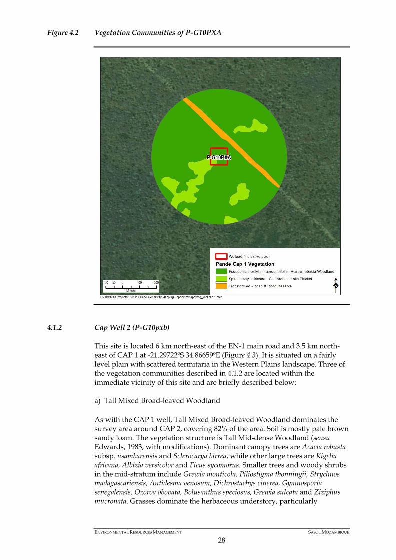
Figure 4.2 Vegetation Communities of P-G10PXA
4.1.2 Cap Well 2 (P-G10pxb)
This site is located 6 km north-east of the EN-1 main road and 3.5 km north-east of CAP 1 at -21.29722ºS 34.86659ºE (Figure 4.3). It is situated on a fairly level plain with scattered termitaria in the Western Plains landscape. Three of the vegetation communities described in 4.1.2 are located within the immediate vicinity of this site and are briefly described below: a) Tall Mixed Broad-leaved Woodland As with the CAP 1 well, Tall Mixed Broad-leaved Woodland dominates the survey area around CAP 2, covering 82% of the area. Soil is mostly pale brown sandy loam. The vegetation structure is Tall Mid-dense Woodland (sensu Edwards, 1983, with modifications). Dominant canopy trees are Acacia robusta subsp. usambarensis and Sclerocarya birrea, while other large trees are Kigelia africana, Albizia versicolor and Ficus sycomorus. Smaller trees and woody shrubs in the mid-stratum include Grewia monticola, Piliostigma thonningii, Strychnos madagascariensis, Antidesma venosum, Dichrostachys cinerea, Gymnosporia senegalensis, Ozoroa obovata, Bolusanthus speciosus, Grewia sulcata and Ziziphus mucronata. Grasses dominate the herbaceous understory, particularly
ENVIRONMENTAL RESOURCES MANAGEMENT SASOL MOZAMBIQUE
28
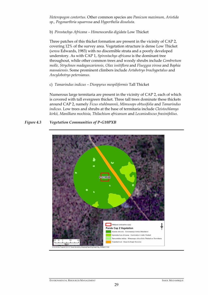
Heteropogon contortus. Other common species are Panicum maximum, Aristida sp., Pogonarthria squarrosa and Hyperthelia dissoluta. b) Pirostachys Africana – Himenocardia digidata Low Thicket Three patches of this thicket formation are present in the vicinity of CAP 2, covering 12% of the survey area. Vegetation structure is dense Low Thicket (sensu Edwards, 1983) with no discernible strata and a poorly developed understory. As with CAP 1, Spirostachys africana is the dominant tree throughout, while other common trees and woody shrubs include Combretum molle, Strychnos madagascariensis, Olax issitiflora and Flueggea virosa and Baphia massaiensis. Some prominent climbers include Artabotrys brachypetalus and Ancylobotrys petersianus. c) Tamarindus indicus – Diospyrus mespiliformis Tall Thicket Numerous large termitaria are present in the vicinity of CAP 2, each of which is covered with tall evergreen thicket. Three tall trees dominate these thickets around CAP 2, namely Ficus stuhlmannii, Mimusops obtusifolia and Tamarindus indicus. Low trees and shrubs at the base of termitaria include Cleistochlamys kirkii, Manilkara mochisia, Thilachium africanum and Lecaniodiscus fraxinifolius.
Figure 4.3 Vegetation Communities of P-G10PXB
ENVIRONMENTAL RESOURCES MANAGEMENT SASOL MOZAMBIQUE
29
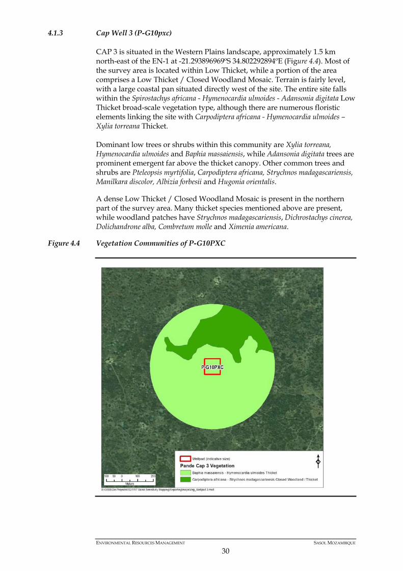
4.1.3 Cap Well 3 (P-G10pxc)
CAP 3 is situated in the Western Plains landscape, approximately 1.5 km north-east of the EN-1 at -21.293896969ºS 34.802292894ºE (Figure 4.4). Most of the survey area is located within Low Thicket, while a portion of the area comprises a Low Thicket / Closed Woodland Mosaic. Terrain is fairly level, with a large coastal pan situated directly west of the site. The entire site falls within the Spirostachys africana - Hymenocardia ulmoides - Adansonia digitata Low Thicket broad-scale vegetation type, although there are numerous floristic elements linking the site with Carpodiptera africana - Hymenocardia ulmoides – Xylia torreana Thicket. Dominant low trees or shrubs within this community are Xylia torreana, Hymenocardia ulmoides and Baphia massaiensis, while Adansonia digitata trees are prominent emergent far above the thicket canopy. Other common trees and shrubs are Pteleopsis myrtifolia, Carpodiptera africana, Strychnos madagascariensis, Manilkara discolor, Albizia forbesii and Hugonia orientalis. A dense Low Thicket / Closed Woodland Mosaic is present in the northern part of the survey area. Many thicket species mentioned above are present, while woodland patches have Strychnos madagascariensis, Dichrostachys cinerea, Dolichandrone alba, Combretum molle and Ximenia americana.
Figure 4.4 Vegetation Communities of P-G10PXC
ENVIRONMENTAL RESOURCES MANAGEMENT SASOL MOZAMBIQUE
30
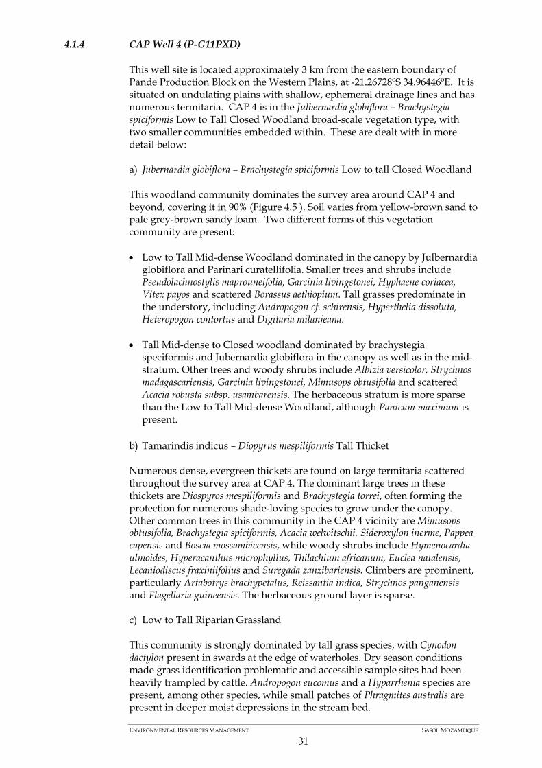
4.1.4 CAP Well 4 (P-G11PXD)
This well site is located approximately 3 km from the eastern boundary of Pande Production Block on the Western Plains, at -21.26728ºS 34.96446ºE. It is situated on undulating plains with shallow, ephemeral drainage lines and has numerous termitaria. CAP 4 is in the Julbernardia globiflora – Brachystegia spiciformis Low to Tall Closed Woodland broad-scale vegetation type, with two smaller communities embedded within. These are dealt with in more detail below: a) Jubernardia globiflora – Brachystegia spiciformis Low to tall Closed Woodland This woodland community dominates the survey area around CAP 4 and beyond, covering it in 90% (Figure 4.5 ). Soil varies from yellow-brown sand to pale grey-brown sandy loam. Two different forms of this vegetation community are present: • Low to Tall Mid-dense Woodland dominated in the canopy by Julbernardia
globiflora and Parinari curatellifolia. Smaller trees and shrubs include Pseudolachnostylis maprouneifolia, Garcinia livingstonei, Hyphaene coriacea, Vitex payos and scattered Borassus aethiopium. Tall grasses predominate in the understory, including Andropogon cf. schirensis, Hyperthelia dissoluta, Heteropogon contortus and Digitaria milanjeana.
• Tall Mid-dense to Closed woodland dominated by brachystegia
speciformis and Jubernardia globiflora in the canopy as well as in the mid-stratum. Other trees and woody shrubs include Albizia versicolor, Strychnos madagascariensis, Garcinia livingstonei, Mimusops obtusifolia and scattered Acacia robusta subsp. usambarensis. The herbaceous stratum is more sparse than the Low to Tall Mid-dense Woodland, although Panicum maximum is present.
b) Tamarindis indicus – Diopyrus mespiliformis Tall Thicket Numerous dense, evergreen thickets are found on large termitaria scattered throughout the survey area at CAP 4. The dominant large trees in these thickets are Diospyros mespiliformis and Brachystegia torrei, often forming the protection for numerous shade-loving species to grow under the canopy. Other common trees in this community in the CAP 4 vicinity are Mimusops obtusifolia, Brachystegia spiciformis, Acacia welwitschii, Sideroxylon inerme, Pappea capensis and Boscia mossambicensis, while woody shrubs include Hymenocardia ulmoides, Hyperacanthus microphyllus, Thilachium africanum, Euclea natalensis, Lecaniodiscus fraxiniifolius and Suregada zanzibariensis. Climbers are prominent, particularly Artabotrys brachypetalus, Reissantia indica, Strychnos panganensis and Flagellaria guineensis. The herbaceous ground layer is sparse. c) Low to Tall Riparian Grassland This community is strongly dominated by tall grass species, with Cynodon dactylon present in swards at the edge of waterholes. Dry season conditions made grass identification problematic and accessible sample sites had been heavily trampled by cattle. Andropogon eucomus and a Hyparrhenia species are present, among other species, while small patches of Phragmites australis are present in deeper moist depressions in the stream bed.
ENVIRONMENTAL RESOURCES MANAGEMENT SASOL MOZAMBIQUE
31
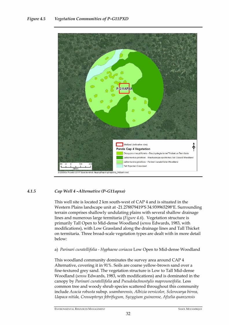
Figure 4.5 Vegetation Communities of P-G11PXD
4.1.5 Cap Well 4 –Alternative (P-G11apxa)
This well site is located 2 km south-west of CAP 4 and is situated in the Western Plains landscape unit at -21.278879419ºS 34.939965298ºE. Surrounding terrain comprises shallowly undulating plains with several shallow drainage lines and numerous large termitaria (Figure 4.6). Vegetation structure is primarily Tall Open to Mid-dense Woodland (sensu Edwards, 1983, with modifications), with Low Grassland along the drainage lines and Tall Thicket on termitaria. Three broad-scale vegetation types are dealt with in more detail below: a) Parinari curatellifolia - Hyphaene coriacea Low Open to Mid-dense Woodland This woodland community dominates the survey area around CAP 4 Alternative, covering it in 91%. Soils are coarse yellow-brown sand over a fine-textured grey sand. The vegetation structure is Low to Tall Mid-dense Woodland (sensu Edwards, 1983, with modifications) and is dominated in the canopy by Parinari curatellifolia and Pseudolachnostylis maprouneifolia. Less common tree and woody shrub species scattered throughout this community include Acacia robusta subsp. usambarensis, Albizia versicolor, Sclerocarya birrea, Uapaca nitida, Crossopteryx febrifugum, Syzygium guineense, Afzelia quanzensis
ENVIRONMENTAL RESOURCES MANAGEMENT SASOL MOZAMBIQUE
32
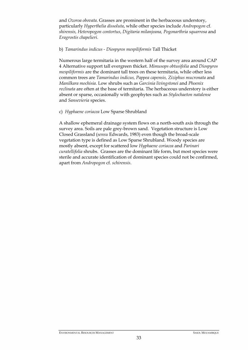
and Ozoroa obovata. Grasses are prominent in the herbaceous understory, particularly Hyperthelia dissoluta, while other species include Andropogon cf. shirensis, Heteropogon contortus, Digitaria milanjeana, Pogonarthria squarrosa and Eragrostis chapelieri. b) Tamarindus indicus - Diospyros mespiliformis Tall Thicket Numerous large termitaria in the western half of the survey area around CAP 4 Alternative support tall evergreen thicket. Mimusops obtusifolia and Diospyros mespiliformis are the dominant tall trees on these termitaria, while other less common trees are Tamarindus indicus, Pappea capensis, Ziziphus mucronata and Manilkara mochisia. Low shrubs such as Garcinia livingstonei and Phoenix reclinata are often at the base of termitaria. The herbaceous understory is either absent or sparse, occasionally with geophytes such as Stylochaeton natalense and Sansevieria species. c) Hyphaene coriacea Low Sparse Shrubland A shallow ephemeral drainage system flows on a north-south axis through the survey area. Soils are pale grey-brown sand. Vegetation structure is Low Closed Grassland (sensu Edwards, 1983) even though the broad-scale vegetation type is defined as Low Sparse Shrubland. Woody species are mostly absent, except for scattered low Hyphaene coriacea and Parinari curatellifolia shrubs. Grasses are the dominant life form, but most species were sterile and accurate identification of dominant species could not be confirmed, apart from Andropogon cf. schirensis.
ENVIRONMENTAL RESOURCES MANAGEMENT SASOL MOZAMBIQUE
33
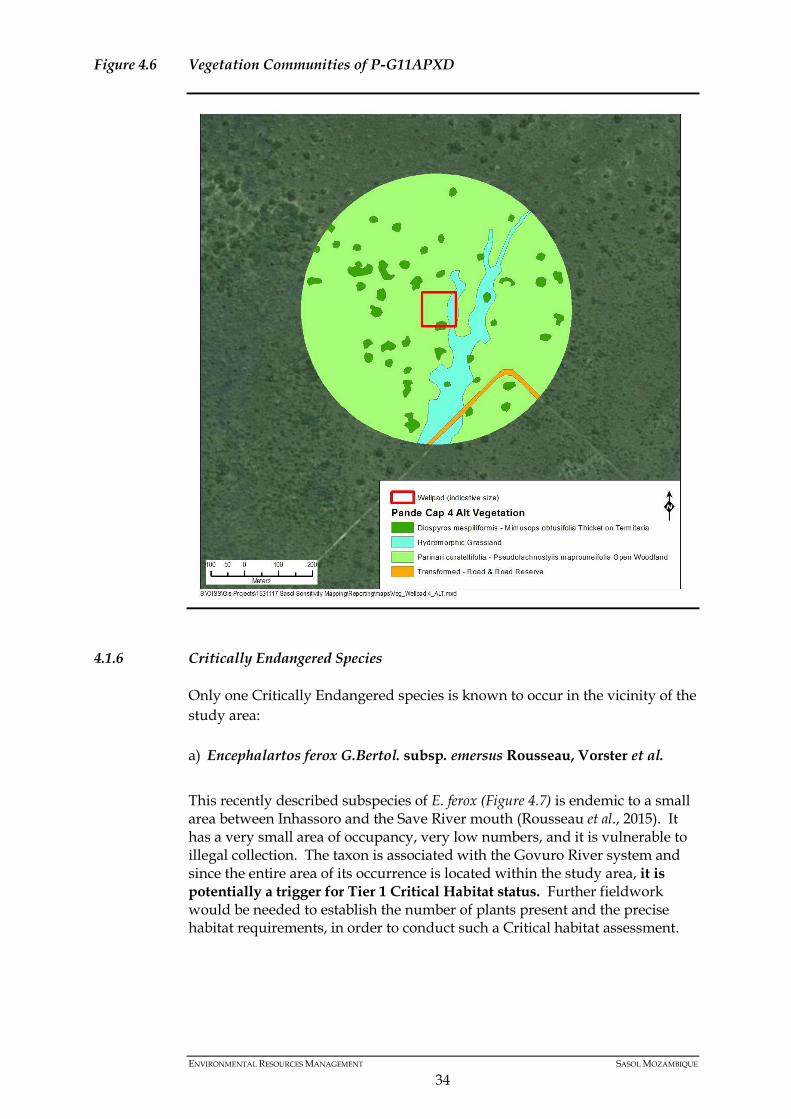
Figure 4.6 Vegetation Communities of P-G11APXD
4.1.6 Critically Endangered Species
Only one Critically Endangered species is known to occur in the vicinity of the study area: a) Encephalartos ferox G.Bertol. subsp. emersus Rousseau, Vorster et al. This recently described subspecies of E. ferox (Figure 4.7) is endemic to a small area between Inhassoro and the Save River mouth (Rousseau et al., 2015). It has a very small area of occupancy, very low numbers, and it is vulnerable to illegal collection. The taxon is associated with the Govuro River system and since the entire area of its occurrence is located within the study area, it is potentially a trigger for Tier 1 Critical Habitat status. Further fieldwork would be needed to establish the number of plants present and the precise habitat requirements, in order to conduct such a Critical habitat assessment.
ENVIRONMENTAL RESOURCES MANAGEMENT SASOL MOZAMBIQUE
34
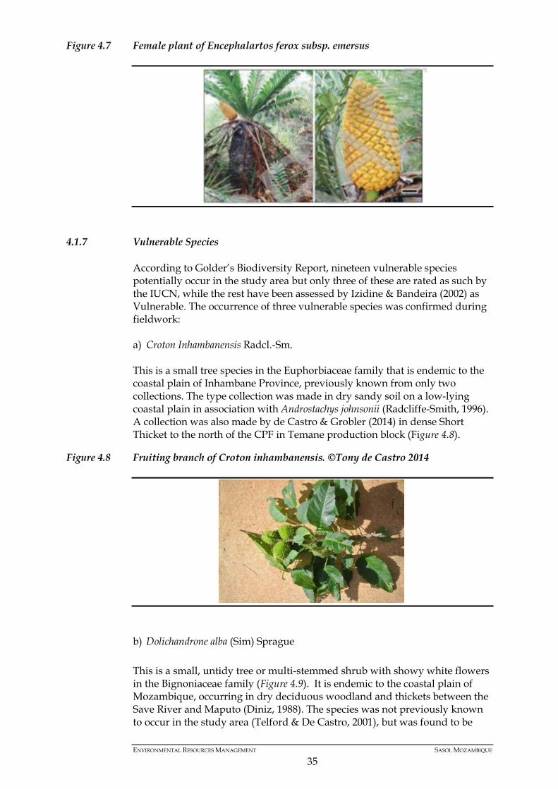
Figure 4.7 Female plant of Encephalartos ferox subsp. emersus
4.1.7 Vulnerable Species
According to Golder’s Biodiversity Report, nineteen vulnerable species potentially occur in the study area but only three of these are rated as such by the IUCN, while the rest have been assessed by Izidine & Bandeira (2002) as Vulnerable. The occurrence of three vulnerable species was confirmed during fieldwork: a) Croton Inhambanensis Radcl.-Sm. This is a small tree species in the Euphorbiaceae family that is endemic to the coastal plain of Inhambane Province, previously known from only two collections. The type collection was made in dry sandy soil on a low-lying coastal plain in association with Androstachys johnsonii (Radcliffe-Smith, 1996). A collection was also made by de Castro & Grobler (2014) in dense Short Thicket to the north of the CPF in Temane production block (Figure 4.8).
Figure 4.8 Fruiting branch of Croton inhambanensis. ©Tony de Castro 2014
b) Dolichandrone alba (Sim) Sprague This is a small, untidy tree or multi-stemmed shrub with showy white flowers in the Bignoniaceae family (Figure 4.9). It is endemic to the coastal plain of Mozambique, occurring in dry deciduous woodland and thickets between the Save River and Maputo (Diniz, 1988). The species was not previously known to occur in the study area (Telford & De Castro, 2001), but was found to be
ENVIRONMENTAL RESOURCES MANAGEMENT SASOL MOZAMBIQUE
35
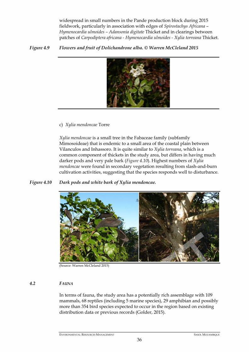
widespread in small numbers in the Pande production block during 2015 fieldwork, particularly in association with edges of Spirostachys Africana – Hymenocardia ulmoides – Adansonia digitate Thicket and in clearings between patches of Carpodiptera africana - Hymenocardia ulmoides - Xylia torreana Thicket.
Figure 4.9 Flowers and fruit of Dolichandrone alba. © Warren McCleland 2015
c) Xylia mendoncae Torre Xylia mendoncae is a small tree in the Fabaceae family (subfamily Mimosoideae) that is endemic to a small area of the coastal plain between Vilanculos and Inhassoro. It is quite similar to Xylia torreana, which is a common component of thickets in the study area, but differs in having much darker pods and very pale bark (Figure 4.10). Highest numbers of Xylia mendoncae were found in secondary vegetation resulting from slash-and-burn cultivation activities, suggesting that the species responds well to disturbance.
Figure 4.10 Dark pods and white bark of Xylia mendoncae.
(Source: Warren McCleland 2015)
4.2 FAUNA
In terms of fauna, the study area has a potentially rich assemblage with 109 mammals, 68 reptiles (including 5 marine species), 29 amphibian and possibly more than 354 bird species expected to occur in the region based on existing distribution data or previous records (Golder, 2015).
ENVIRONMENTAL RESOURCES MANAGEMENT SASOL MOZAMBIQUE
36

Mammals Eighteen mammals were recorded in the study area during the 2015 dry season field programme (Golder, 2015). These comprise mostly small to medium sized taxa. An additional 21 species have been recorded by Deacon (2014) and Branch (2015) in the Temane Block area. Relatively remote portions of the study area, such as the forest / thicket mosaic in the north-western corner and the woodlands and adjacent estuary systems to the west of the EN-1 in the Pande Block are expected to have high mammal abundance and richness. It is also expected that certain fauna occurring in areas close to human habitation have probably altered their foraging/movement habits to avoid detection and hunting – i.e. hiding up in densely vegetated areas during day-light hours, but emerging at night to forage in open woodland and grasslands. As such, in areas of high human activity, many species that normally have wide habitat tolerances and that are diurnal may only be active at night and only in close proximity to forest/thicket patches where they can escape detection. Several species of mammals were recorded in the study area (Annex I). The list includes the following species: Chacma Baboon (Papio ursinus), Samango monkey (Ceropithecus mitis), Greater Cane Rat (Thryonomys swinderianus), Woodland Mouse (Grammomys dolichurus), Pangolin (Manis temminckii), Leopard (Panther pardus), Side-striped Jackal (Canis adustus), Bushbuck (Tragelaphus scriptus), Impala (Aepyceros melampus), etc. Reptiles A review of the distribution maps presented in Branch (1998) suggests that of Mozambique’s reptile assemblage, 63 terrestrial species potentially occur in the study area. In addition, five marine turtle’s species occur off the coast and may nest on adjacent beaches. Despite reduced abundances caused by habitat loss and hunting, reptile richness in rural landscapes, such as the study area, is likely to be high. Thirty three reptile species have been recorded in the study area (Deacon, 2014 & Branch, 2015) and none of these are currently listed as threatened. Recorded reptiles generally favour wooded habitats, where the structural heterogeneity of a combined woody and herbaceous component provides habitat for a variety of potential prey. Although not recorded during the current study, Nile Crocodile (Crocodylus niloticus) have previously been recorded along the San Sebastian Peninsula, adjacent to Vilanculos (Jacobsen, et al., 2010). This species is probably uncommon to very rare in the study area as a result of hunting, but may be present in the Govuro and Save Rivers. Other reptiles that may favour non-marine aquatic habitats include Water Monitors (Varanus niloticus), terrapins and frog-eating snakes.
4.3 SEISMIC LINES SENSITIVITY
The seismic lines have been assessed in terms of the sensitivity so that future surveys and assessment of impacts can be directed to areas where there is the highest potential for negative impacts or degradation of sensitive biodiversity features. Seismic lines were assessed by placing a 15 meter buffer along the
ENVIRONMENTAL RESOURCES MANAGEMENT SASOL MOZAMBIQUE
37
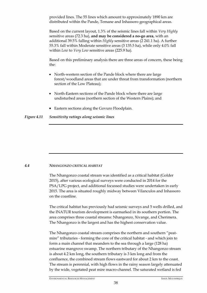
provided lines. The 55 lines which amount to approximately 1890 km are distributed within the Pande, Temane and Inhassoro geographical areas. Based on the current layout, 1.3% of the seismic lines fall within Very Highly sensitive areas (72.3 ha), and may be considered a no-go area, with an additional 39.5% falling within Highly sensitive areas (2 241.1 ha). A further 55.3% fall within Moderate sensitive areas (3 135.5 ha), while only 4.0% fall within Low to Very Low sensitive areas (225.9 ha). Based on this preliminary analysis there are three areas of concern, these being the: • North-western section of the Pande block where there are large
forest/woodland areas that are under threat from transformation (northern section of the Low Plateau);
• North-Eastern sections of the Pande block where there are large undisturbed areas (northern section of the Western Plains); and
• Eastern sections along the Govuro Floodplain.
Figure 4.11 Sensitivity ratings along seismic lines
4.4 NHANGONZO CRITICAL HABITAT
The Nhangonzo coastal stream was identified as a critical habitat (Golder 2015), after various ecological surveys were conducted in 2014 for the PSA/LPG project, and additional focussed studies were undertaken in early 2015. The area is situated roughly midway between Vilanculos and Inhassoro on the coastline. The critical habitat has previously had seismic surveys and 5 wells drilled, and the INATUR tourism development is earmarked in its southern portion. The area comprises three coastal streams: Nhangonzo, Xivange, and Cherimera. The Nhangonzo is the largest and has the highest conservation value. The Nhangonzo coastal stream comprises the northern and southern “peat- mire” tributaries - forming the core of the critical habitat - and which join to form a main channel that meanders to the sea through a large (128 ha) estuarine mangrove swamp. The northern tributary of the Nhangonzo stream is about 4.2 km long, the southern tributary is 3 km long and from the confluence, the combined stream flows eastward for about 2 km to the coast. The stream is perennial, with high flows in the rainy season largely attenuated by the wide, vegetated peat mire macro-channel. The saturated wetland is fed
ENVIRONMENTAL RESOURCES MANAGEMENT SASOL MOZAMBIQUE
38
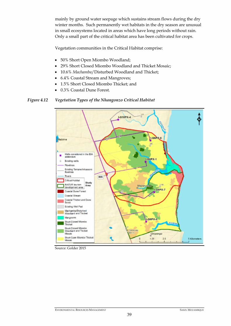
mainly by ground water seepage which sustains stream flows during the dry winter months. Such permanently wet habitats in the dry season are unusual in small ecosystems located in areas which have long periods without rain. Only a small part of the critical habitat area has been cultivated for crops. Vegetation communities in the Critical Habitat comprise: • 50% Short Open Miombo Woodland; • 29% Short Closed Miombo Woodland and Thicket Mosaic; • 10.6% Machamba/Disturbed Woodland and Thicket; • 6.4% Coastal Stream and Mangroves; • 1.5% Short Closed Miombo Thicket; and • 0.3% Coastal Dune Forest.
Figure 4.12 Vegetation Types of the Nhangonzo Critical Habitat
Source: Golder 2015
ENVIRONMENTAL RESOURCES MANAGEMENT SASOL MOZAMBIQUE
39
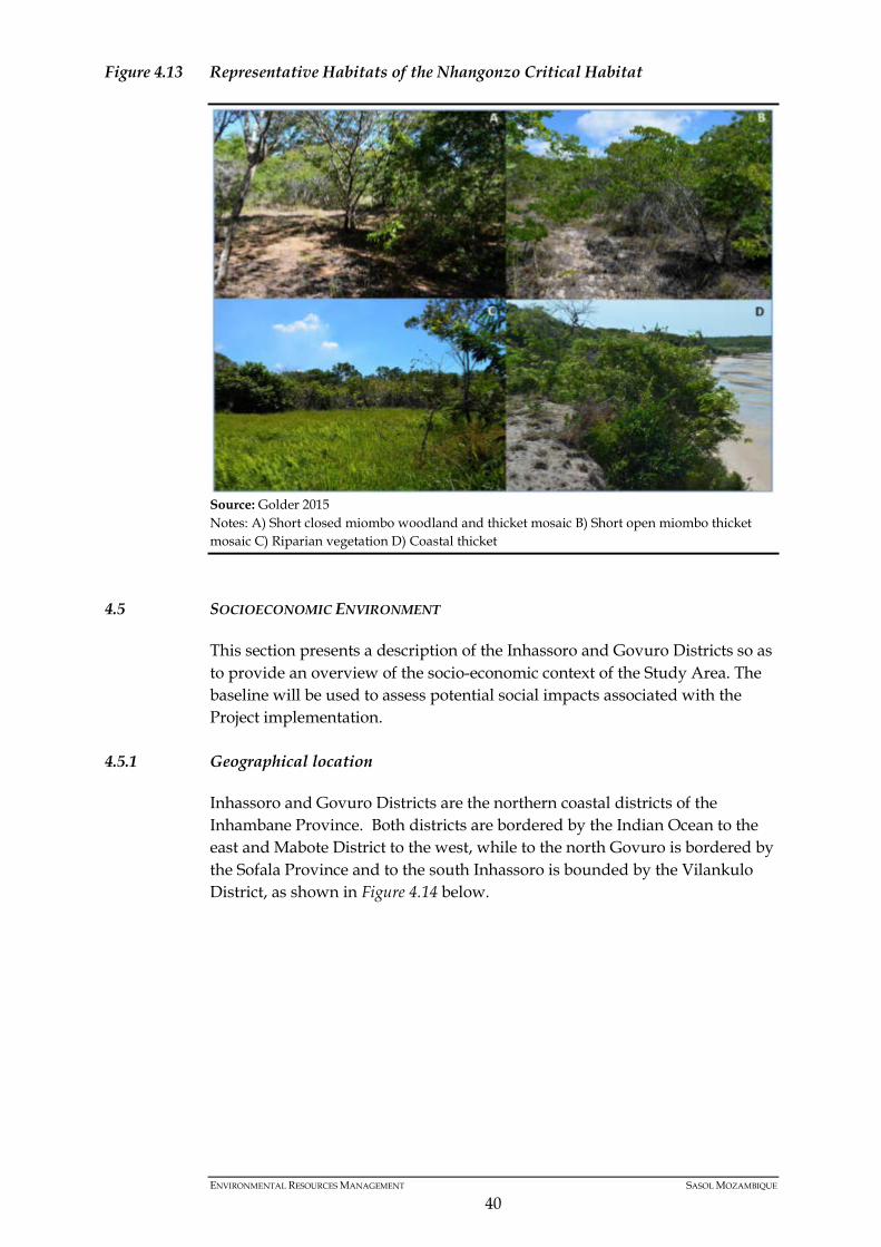
Figure 4.13 Representative Habitats of the Nhangonzo Critical Habitat
4.5 SOCIOECONOMIC ENVIRONMENT
This section presents a description of the Inhassoro and Govuro Districts so as to provide an overview of the socio-economic context of the Study Area. The baseline will be used to assess potential social impacts associated with the Project implementation.
4.5.1 Geographical location
Inhassoro and Govuro Districts are the northern coastal districts of the Inhambane Province. Both districts are bordered by the Indian Ocean to the east and Mabote District to the west, while to the north Govuro is bordered by the Sofala Province and to the south Inhassoro is bounded by the Vilankulo District, as shown in Figure 4.14 below.
Source: Golder 2015 Notes: A) Short closed miombo woodland and thicket mosaic B) Short open miombo thicket mosaic C) Riparian vegetation D) Coastal thicket
ENVIRONMENTAL RESOURCES MANAGEMENT SASOL MOZAMBIQUE
40
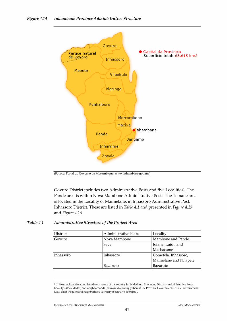
Figure 4.14 Inhambane Province Administrative Structure
(Source: Portal do Governo de Moçambique, www.inhambane.gov.mz)
Govuro District includes two Administrative Posts and five Localities1. The Pande area is within Nova Mambone Administrative Post. The Temane area is located in the Locality of Maimelane, in Inhassoro Administrative Post, Inhassoro District. These are listed in Table 4.1 and presented in Figure 4.15 and Figure 4.16.
Table 4.1 Administrative Structure of the Project Area
District Administrative Posts Locality Govuro Nova Mambone Mambone and Pande
Save Jofane, Luido and Machacame
Inhassoro Inhassoro Cometela, Inhassoro, Maimelane and Nhapele
Bazaruto Bazaruto
1 In Mozambique the administrative structure of the country is divided into Provinces, Districts, Administrative Posts, Locality’s (localidades) and neighborhoods (bairros). Accordingly there is the Province Government, District Government, Local chief (Régulo) and neighborhood secretary (Secretário do bairro).
ENVIRONMENTAL RESOURCES MANAGEMENT SASOL MOZAMBIQUE
41

Figure 4.15 Inhassoro District
(Source; http://www.snipview.com/q/Inhambane%20Province)
Figure 4.16 Govuro District
(Source: http://www.snipview.com/q/Inhambane%20Province)
4.5.2 Demography
Both Districts have a low population density, approximately 10 persons/km2 in Govuro and 12 persons /km2 in Inhassoro. This is significantly lower than
ENVIRONMENTAL RESOURCES MANAGEMENT SASOL MOZAMBIQUE
42
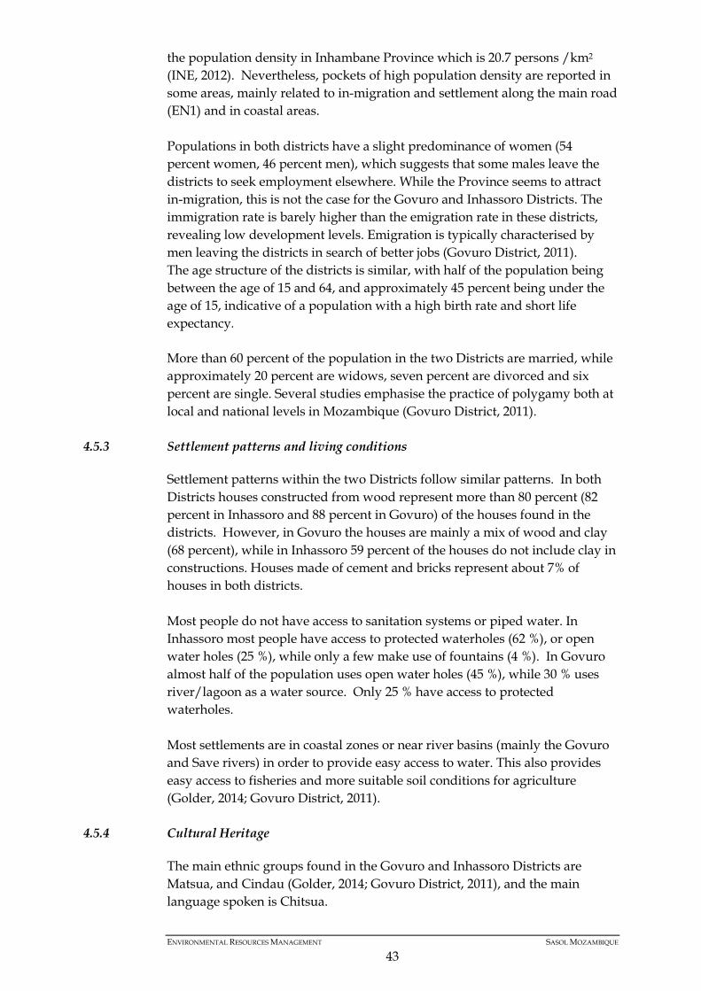
the population density in Inhambane Province which is 20.7 persons /km2 (INE, 2012). Nevertheless, pockets of high population density are reported in some areas, mainly related to in-migration and settlement along the main road (EN1) and in coastal areas. Populations in both districts have a slight predominance of women (54 percent women, 46 percent men), which suggests that some males leave the districts to seek employment elsewhere. While the Province seems to attract in-migration, this is not the case for the Govuro and Inhassoro Districts. The immigration rate is barely higher than the emigration rate in these districts, revealing low development levels. Emigration is typically characterised by men leaving the districts in search of better jobs (Govuro District, 2011). The age structure of the districts is similar, with half of the population being between the age of 15 and 64, and approximately 45 percent being under the age of 15, indicative of a population with a high birth rate and short life expectancy. More than 60 percent of the population in the two Districts are married, while approximately 20 percent are widows, seven percent are divorced and six percent are single. Several studies emphasise the practice of polygamy both at local and national levels in Mozambique (Govuro District, 2011).
4.5.3 Settlement patterns and living conditions
Settlement patterns within the two Districts follow similar patterns. In both Districts houses constructed from wood represent more than 80 percent (82 percent in Inhassoro and 88 percent in Govuro) of the houses found in the districts. However, in Govuro the houses are mainly a mix of wood and clay (68 percent), while in Inhassoro 59 percent of the houses do not include clay in constructions. Houses made of cement and bricks represent about 7% of houses in both districts. Most people do not have access to sanitation systems or piped water. In Inhassoro most people have access to protected waterholes (62 %), or open water holes (25 %), while only a few make use of fountains (4 %). In Govuro almost half of the population uses open water holes (45 %), while 30 % uses river/lagoon as a water source. Only 25 % have access to protected waterholes. Most settlements are in coastal zones or near river basins (mainly the Govuro and Save rivers) in order to provide easy access to water. This also provides easy access to fisheries and more suitable soil conditions for agriculture (Golder, 2014; Govuro District, 2011).
4.5.4 Cultural Heritage
The main ethnic groups found in the Govuro and Inhassoro Districts are Matsua, and Cindau (Golder, 2014; Govuro District, 2011), and the main language spoken is Chitsua.
ENVIRONMENTAL RESOURCES MANAGEMENT SASOL MOZAMBIQUE
43

According to INE (2012) the population is comprised of a wide mix of religions with the most dominant being Catholic, Zionist and Evangelical. Churches, along with NGO’s, are identified as the main providers of social services and support in the districts. Most sacred places identified in the cultural heritage study by Golder (2014) are cemeteries. Local communities in the areas also hold traditional ceremonies, myths, rituals, dances and songs, namely: mapango, mukerelere, muphacho, mbhambha, mandique, mathanga, mahalaba, mbutsa, muthimba, and kuhuchira-nwana (Govuro District, 2011). These traditional practices are often related to the celebration of important family events, such as entering adolescence, birth or death; or economic events such as rain for agriculture, success in fishing or hunting. In Govuro, sport is an active and central part of local culture, as evidenced by the number of schools and communities with sports infrastructure, sporting events and teams and the presence of numerous sports associations.
4.5.5 Employment and Economy
Generally, the districts in the Study Area are characterised by a high poverty index (Govuro District, 2011). Subsistence farming is a key source of livelihood and is often used to supplement a household’s low income. Agricultural activities include growing crops such as maize, sorghum, peanuts, sesame, potato, beans, cassava and vegetables - hence small and medium - sized agricultural fields are predominant in the districts. Livestock rearing includes chicken, ducks, cows, goats, sheep, and pigs. Livestock rearing relies on the availability of and access to water, pastures, fertile soil and forests. Communities in the area are highly dependent on natural resources. Plants are used for food, drink, construction, firewood, charcoal, crafts and medicine. Throughout the Study Area, small scale hunting is also important and even though it is a prohibited activity some reports point to some families depending on it for their subsistence. Most agricultural and hunting activities rely on traditional methods, with no access to technology or sophisticated equipment. Such methods include the use of hoes in agriculture, hand trawling or hook and line fishing; and wire snares in hunting. Hence, production is small scale and mainly for household consumption. In some instances however, some of the goods are sold to supplement household income. Key employers in the districts are associations and NGOs as well as authorities/ government bodies (public administration and education sector). However, in a few sectors, private companies are the main employers including retail, mineral resources, property/accommodation and fisheries, and the catering/restaurant and food industry (mainly in Inhassoro).
ENVIRONMENTAL RESOURCES MANAGEMENT SASOL MOZAMBIQUE
44
Because local people still use manpower for agriculture and livestock and there are only a few industrial activities, there is reduced human impact on district ecosystems.
ENVIRONMENTAL RESOURCES MANAGEMENT SASOL MOZAMBIQUE
45
5 IMPACT ASSESSMENT
5.1 GENERAL METHODOLOGY
The assessment of impacts on the physical, biological and social environment has been undertaken according to the two main project components of the project: (i) seismic survey and (ii) CAP wells drilling. Given the existence of previous EIA and EMP (as stated before in this document), this chapter will focus on the specific impacts of the project since the general and broad aspect were already covered in the previous EIA.
5.2 METHODOLOGY FOR THE IMPACT ASSESSMENT
Impact Magnitude Each potential impact is classified based on established criteria, including the spatial scale, temporal scale, intensity and probability (Table 5.1). The magnitude of the impact is a function of these criteria.
Table 5.1 Classification of Impact
Impact Magnitude – the Degree of Change Brought About in the Environment Extent Onsite: impacts limited to the site boundaries.
Local: impacts that affect an area in a radius of up to 5 km around the site (both seismic lines and wells). Regional: impacts that affect regionally important environmental resources or are experienced at a regional scale or experienced at provincial or regional level. National: impacts that affect nationally important environmental resources, or affect an area that is nationally important, or that have macro-economic consequences. Transboundary/international: impacts that extend beyond the country's borders or affecting important resources internationally.
Duration Temporary: impacts of short duration and intermittent/occasional. Short term: impacts that should last only during the mobilization phase. Long term: impacts that will continue for the project lifetime, but cease when the project is completed or interrupted. Permanent: impacts that cause a permanent change in the affected receptor or resource (e.g. removal or destruction of ecological habitat) that endures substantially beyond the Project lifetime.
Intensity BIOPHYSICAL ENVIRONMENT: Intensity can be considered in terms of the sensitivity of the biodiversity receptor. Negligible: the impact on the environment is not detectable. Low: the impact affects the environment in such a way that natural functions and processes are not materially affected. Medium: where the affected environment is altered but natural functions and processes continue, albeit in a modified way. High: where natural functions or processes are altered to the extent that they will temporarily or permanently cease.
ENVIRONMENTAL RESOURCES MANAGEMENT SASOL MOZAMBIQUE
46

Impact Magnitude – the Degree of Change Brought About in the Environment SOCIO-ECONOMIC ENVIRONMENT: Intensity can be considered in terms of the ability of project-affected people/communities to adapt to changes brought about by the project. Negligible: there is no perceptible change to people’s livelihoods. Low: people/communities are able to adapt with relative ease and maintain pre-impact livelihoods. Medium: people/communities are able to adapt with some difficulty and maintain pre-impact livelihoods, but only with a degree of support. High: affected people/communities will not be able to adapt to changes and continue to maintain pre-impact livelihoods.
Impact Likelihood – the Likelihood that an Impact will Occur Unlikely It is unlikely that the impact occur. Likely It is likely that the impact occurs. Definite The impact will occur.
Impact Significance Once magnitude of impact and sensitivity/vulnerability/importance of resource/receptor have been characterised, the significance can be assigned for each impact according to the following table:
Table 5.2 Impact Significance
SIGNIFICANCE RATING Sensitivity/vulnerability/
importance of resource/ receptor
Low Medium High
MAGNITUDE
Negligible Negligible Negligible Negligible Low Negligible Low Medium Medium Low Medium High High Medium High High
It is noted that an impact can be positive or negative and therefore the benefits of the final relevance classification is colour coded as shown below.
Table 5.3 Colour Scale for Ratings
Negative Ratings Positive Ratings Negligible Negligible Low Low Moderate Moderate High High
Cumulative Impacts Cumulative impacts are defined as impacts that act together with other impacts (including those from concurrent or planned future third party activities) to affect the same resources and/or receptors as the Project.
ENVIRONMENTAL RESOURCES MANAGEMENT SASOL MOZAMBIQUE
47
Residual Impacts Residual impacts are those impacts which remain once the mitigation measures have been designed and applied. Once the mitigation is applied, each impact is re-evaluated (assuming that the mitigation measure is effectively applied) and any remaining impact is rated once again using the process outlined above. The result is a significance rating for the residual impact. The degree of significance attributed to residual impacts is related to the weight given to them in making decisions on the Project and developing conditions. Mitigation Measures Acceptable and cost effective mitigation and enhancement measures will be defined for the respective potential negative and positive impacts.
5.3 IMPACTS FROM PREVIOUS EIA
An impact assessment was undertaken for Temane and Pande Gas Field Exploration EIA and EMP in January 2001, to which the present addendum refers to, and provides substantial information.
Table 5.4 below shows the previous EIA impacts of the seismic survey and exploration drilling which are also applicable for the present proposed project:
Table 5.4 Impacts from the Previous EIA Applicable to the Present Proposed project
Environment Impact Impact Significance
Physical Effects on Soils Low Effects on surface water and geology Low
Biological Effects on habitats Medium - low Impacts on fauna Medium - low
Social
Nuisance and Disturbance Effects Low Effects on settlement and agriculture Low Effects on income and employment Medium Effects on places of cultural importance Low
5.4 IMPACTS OF THE PROPOSED PROJECT
5.4.1 Biological and Physical Environments
Impacts on Habitats
a) Seismic Lines:
The main biological impact related to the seismic activities is the vegetation removal, either by manual or mechanical clearance. The seismic lines will be 6 m wide and vegetation species will be removed. Based on the biodiversity description, 1.3% of the seismic lines fall within Very Highly sensitive areas (72.3 ha), defined in this document as a no-go area, with an additional 39.5% falling within Highly sensitive areas (2 241.1 ha). A further 55.3% fall within
ENVIRONMENTAL RESOURCES MANAGEMENT SASOL MOZAMBIQUE
48
Moderate sensitive areas (3 135.5 ha), while only 4.0% fall within Low to Very Low sensitive areas (225.9 ha). Operations onsite shall be properly managed in order to avoid impacts on the habitats as the seismic line operations such as vegetation clearance, vehicle and equipment circulation, etc. are intrusive and leads to disturbance of the habitats. Therefore, the 1.3% of the seismic lines which fall within Very Highly sensitive areas (72.3 ha) should not be cleared. Considering the sensitiveness of the area, the significance of this impact will be high in very highly sensitive (No-go areas) to highly sensitive areas and moderate to low in moderate/low sensitivity areas, for all the project phases. Mitigation Measures Very high sensitive areas shall be considered No-go areas, therefore the main mitigation measures are as follows: • During seismic line clearance it is important to keep the tree’s canopy
intact, and if the trees need to be removed, ensure they are less than 20 cm of diameter; and
• Cleared vegetation shall be kept aside to be used in the line rehabilitation.
In order to avoid the line clearance effects within highly sensitive habitats, the lines shall be only 3 m wide (lay-bys can be opened for vehicle cross). A Biodiversity Action Plan (BAP) will be developed to manage the habitats correctly and also the workers will be trained regarding the occurrence of important resources in the area and the importance of their protection, vegetation clearance permit shall be obtained from local authorities, specifically for the drilling sites. Existing access roads (cleared areas) and routes shall be improved and used. Reduce habitat disturbance by keeping vehicles on established access roads or well pads and by minimizing foot traffic in undisturbed areas: • Initiate interim site reclamation activities and invasive vegetation
monitoring and control activities as soon as possible after operational activities are completed. All disturbed areas shall be revegetated with plant species appropriate to each site.
ENVIRONMENTAL RESOURCES MANAGEMENT SASOL MOZAMBIQUE
49
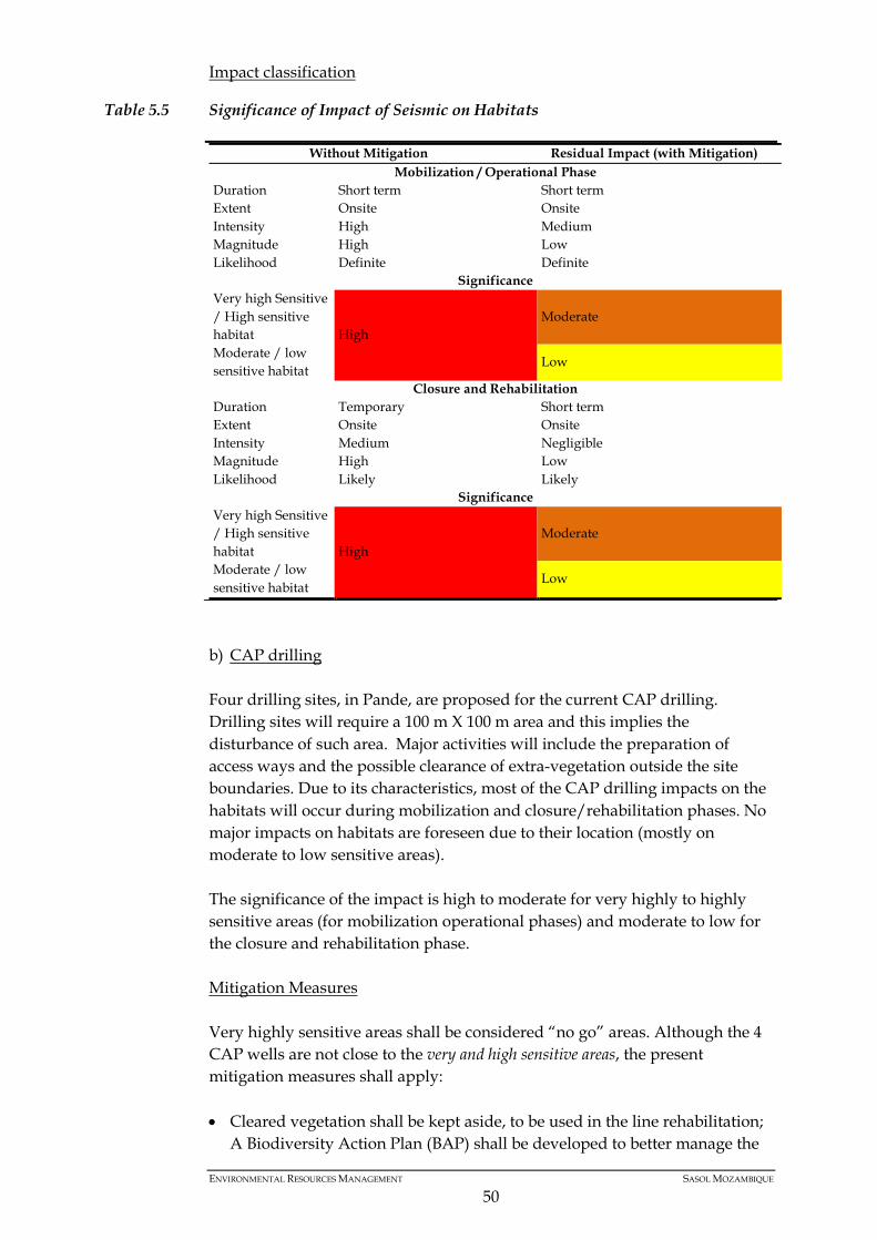
Impact classification
Table 5.5 Significance of Impact of Seismic on Habitats
Without Mitigation Residual Impact (with Mitigation) Mobilization / Operational Phase
Duration Short term Short term Extent Onsite Onsite Intensity High Medium Magnitude High Low Likelihood Definite Definite
Significance Very high Sensitive / High sensitive habitat High
Moderate
Moderate / low sensitive habitat
Low
Closure and Rehabilitation Duration Temporary Short term Extent Onsite Onsite Intensity Medium Negligible Magnitude High Low Likelihood Likely Likely
Significance Very high Sensitive / High sensitive habitat High
Moderate
Moderate / low sensitive habitat
Low
b) CAP drilling Four drilling sites, in Pande, are proposed for the current CAP drilling. Drilling sites will require a 100 m X 100 m area and this implies the disturbance of such area. Major activities will include the preparation of access ways and the possible clearance of extra-vegetation outside the site boundaries. Due to its characteristics, most of the CAP drilling impacts on the habitats will occur during mobilization and closure/rehabilitation phases. No major impacts on habitats are foreseen due to their location (mostly on moderate to low sensitive areas). The significance of the impact is high to moderate for very highly to highly sensitive areas (for mobilization operational phases) and moderate to low for the closure and rehabilitation phase. Mitigation Measures Very highly sensitive areas shall be considered “no go” areas. Although the 4 CAP wells are not close to the very and high sensitive areas, the present mitigation measures shall apply: • Cleared vegetation shall be kept aside, to be used in the line rehabilitation;
A Biodiversity Action Plan (BAP) shall be developed to better manage the
ENVIRONMENTAL RESOURCES MANAGEMENT SASOL MOZAMBIQUE
50

habitats and also the workers shall be educated regarding the occurrence of important resources in the area and the importance of their protection.
• A vegetation clearance permit shall be obtained from local authorities,
specifically for the drilling sites. Existing access roads (cleared areas) and routs shall be improved and used.
• Reduce habitat disturbance by keeping vehicles on established access roads
or well pads and by minimizing foot traffic in undisturbed areas. • Initiate interim site reclamation activities and invasive vegetation
monitoring and control activities as soon as possible after activities are completed. All disturbed areas shall be revegetated with plant species appropriate to each site.
Table 5.6 Significance of Impact of CAP Drilling on Habitats
Without Mitigation Residual Impact (with Mitigation) Mobilization / Operational Phase
Duration Short term Short term Extent Onsite Onsite Intensity High Medium Magnitude High Medium Likelihood Definite Definite
Significance Very high Sensitive / High sensitive habitat
High High
Moderate / low sensitive habitat
Moderate
Closure and Rehabilitation Phase Duration Short term Short term Extent Onsite Onsite Intensity Medium Low Magnitude Medium Low Likelihood Likely Unlikely
Significance Very high Sensitive / High sensitive habitat
High Moderate
Moderate / low sensitive habitat
Moderate Low
5.4.2 Project Impacts on Soils
a) Seismic Lines: The soils can be impacted by unplanned events like accidental spillages from vehicles and equipment or machinery on the seismic lines and also by erosion or compaction. Seismic line clearance in steep slopes has to be undertaken following specific measures to avoid erosion.
ENVIRONMENTAL RESOURCES MANAGEMENT SASOL MOZAMBIQUE
51
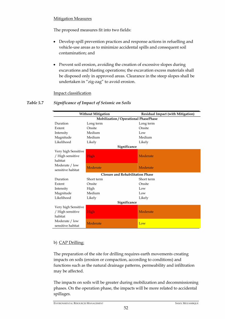
Mitigation Measures The proposed measures fit into two fields: • Develop spill prevention practices and response actions in refuelling and
vehicle-use areas as to minimize accidental spills and consequent soil contamination; and
• Prevent soil erosion, avoiding the creation of excessive slopes during
excavations and blasting operations; the excavation excess materials shall be disposed only in approved areas. Clearance in the steep slopes shall be undertaken in “zig-zag” to avoid erosion.
Impact classification
Table 5.7 Significance of Impact of Seismic on Soils
Without Mitigation Residual Impact (with Mitigation) Mobilization / Operational PhasePhase
Duration Long term Long term Extent Onsite Onsite Intensity Medium Low Magnitude Medium Medium Likelihood Likely Likely
Significance Very high Sensitive / High sensitive habitat
High Moderate
Moderate / low sensitive habitat
Moderate Moderate
Closure and Rehabilitation Phase Duration Short term Short term Extent Onsite Onsite Intensity High Low Magnitude Medium Low Likelihood Likely Likely
Significance Very high Sensitive / High sensitive habitat
High Moderate
Moderate / low sensitive habitat
Moderate Low
b) CAP Drilling: The preparation of the site for drilling requires earth movements creating impacts on soils (erosion or compaction, according to conditions) and functions such as the natural drainage patterns, permeability and infiltration may be affected. The impacts on soils will be greater during mobilization and decommissioning phases. On the operation phase, the impacts will be more related to accidental spillages.
ENVIRONMENTAL RESOURCES MANAGEMENT SASOL MOZAMBIQUE
52
Mitigation Measures: An important aspect is the appliance of spill prevention practices and response actions in refuelling and vehicle-use areas as to minimize accidental spills and consequent soil contamination. Regarding soil erosion measures, it is important to: • Avoid creating excessive slopes during earthworks; • The excavation excess materials shall be disposed only in approved areas. Impact Classification:
Table 5.8 Significance of Impact of CAP Drilling on Soils
Without Mitigation Residual Impact (with Mitigation) Mobilization Phase
Duration Long term Long term Extent Onsite Onsite Intensity High Medium Magnitude High Medium Likelihood Definite Likely
Significance Very high Sensitive / High sensitive habitat High
High
Moderate / low sensitive habitat
Moderate
Operational Phase Duration Long term Long term Extent Onsite Onsite Intensity High Medium Magnitude High Medium Likelihood Definite Likely
Significance Very high Sensitive / High sensitive habitat High
High
Moderate / low sensitive habitat
Moderate
Closure and Rehabilitation Phase Duration Short term Short term Extent Onsite Onsite Intensity Medium Low Magnitude Medium Medium Likelihood Likely Likely
Significance Very high Sensitive / High sensitive habitat
High
Moderate / low sensitive habitat
Moderate
ENVIRONMENTAL RESOURCES MANAGEMENT SASOL MOZAMBIQUE
53
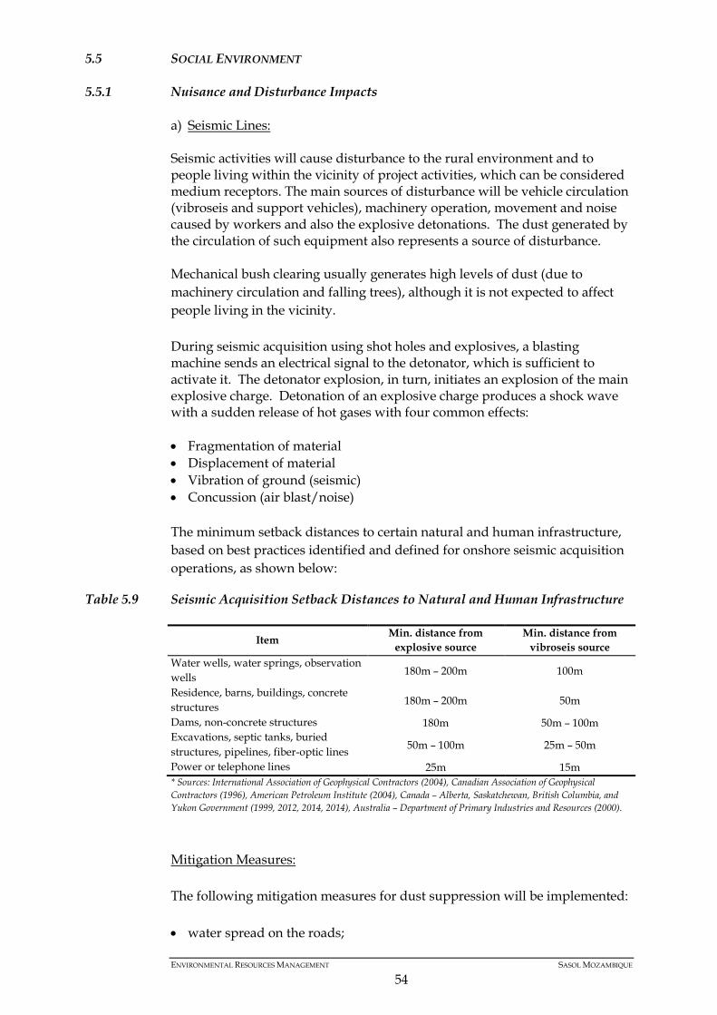
5.5 SOCIAL ENVIRONMENT
5.5.1 Nuisance and Disturbance Impacts
a) Seismic Lines: Seismic activities will cause disturbance to the rural environment and to people living within the vicinity of project activities, which can be considered medium receptors. The main sources of disturbance will be vehicle circulation (vibroseis and support vehicles), machinery operation, movement and noise caused by workers and also the explosive detonations. The dust generated by the circulation of such equipment also represents a source of disturbance. Mechanical bush clearing usually generates high levels of dust (due to machinery circulation and falling trees), although it is not expected to affect people living in the vicinity. During seismic acquisition using shot holes and explosives, a blasting machine sends an electrical signal to the detonator, which is sufficient to activate it. The detonator explosion, in turn, initiates an explosion of the main explosive charge. Detonation of an explosive charge produces a shock wave with a sudden release of hot gases with four common effects: • Fragmentation of material • Displacement of material • Vibration of ground (seismic) • Concussion (air blast/noise) The minimum setback distances to certain natural and human infrastructure, based on best practices identified and defined for onshore seismic acquisition operations, as shown below:
Table 5.9 Seismic Acquisition Setback Distances to Natural and Human Infrastructure
Item Min. distance from explosive source
Min. distance from vibroseis source
Water wells, water springs, observation wells 180m – 200m 100m
Residence, barns, buildings, concrete structures 180m – 200m 50m
Dams, non-concrete structures 180m 50m – 100m Excavations, septic tanks, buried structures, pipelines, fiber-optic lines 50m – 100m 25m – 50m
Power or telephone lines 25m 15m * Sources: International Association of Geophysical Contractors (2004), Canadian Association of Geophysical Contractors (1996), American Petroleum Institute (2004), Canada – Alberta, Saskatchewan, British Columbia, and Yukon Government (1999, 2012, 2014, 2014), Australia – Department of Primary Industries and Resources (2000). Mitigation Measures: The following mitigation measures for dust suppression will be implemented: • water spread on the roads;
ENVIRONMENTAL RESOURCES MANAGEMENT SASOL MOZAMBIQUE
54
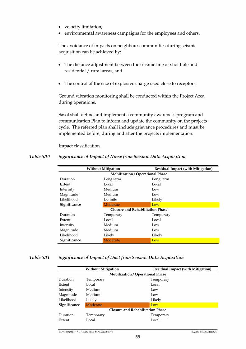
• velocity limitation; • environmental awareness campaigns for the employees and others. The avoidance of impacts on neighbour communities during seismic acquisition can be achieved by: • The distance adjustment between the seismic line or shot hole and
residential / rural areas; and
• The control of the size of explosive charge used close to receptors.
Ground vibration monitoring shall be conducted within the Project Area during operations. Sasol shall define and implement a community awareness program and communication Plan to inform and update the community on the projects cycle. The referred plan shall include grievance procedures and must be implemented before, during and after the projects implementation. Impact classification
Table 5.10 Significance of Impact of Noise from Seismic Data Acquisition
Without Mitigation Residual Impact (with Mitigation) Mobilization / Operational Phase
Duration Long term Long term Extent Local Local Intensity Medium Low Magnitude Medium Low Likelihood Definite Likely Significance Moderate Low
Closure and Rehabilitation Phase Duration Temporary Temporary Extent Local Local Intensity Medium Low Magnitude Medium Low Likelihood Likely Likely Significance Moderate Low
Table 5.11 Significance of Impact of Dust from Seismic Data Acquisition
Without Mitigation Residual Impact (with Mitigation) Mobilization / Operational Phase
Duration Temporary Temporary Extent Local Local Intensity Medium Low Magnitude Medium Low Likelihood Likely Likely Significance Moderate Low
Closure and Rehabilitation Phase Duration Temporary Temporary Extent Local Local
ENVIRONMENTAL RESOURCES MANAGEMENT SASOL MOZAMBIQUE
55
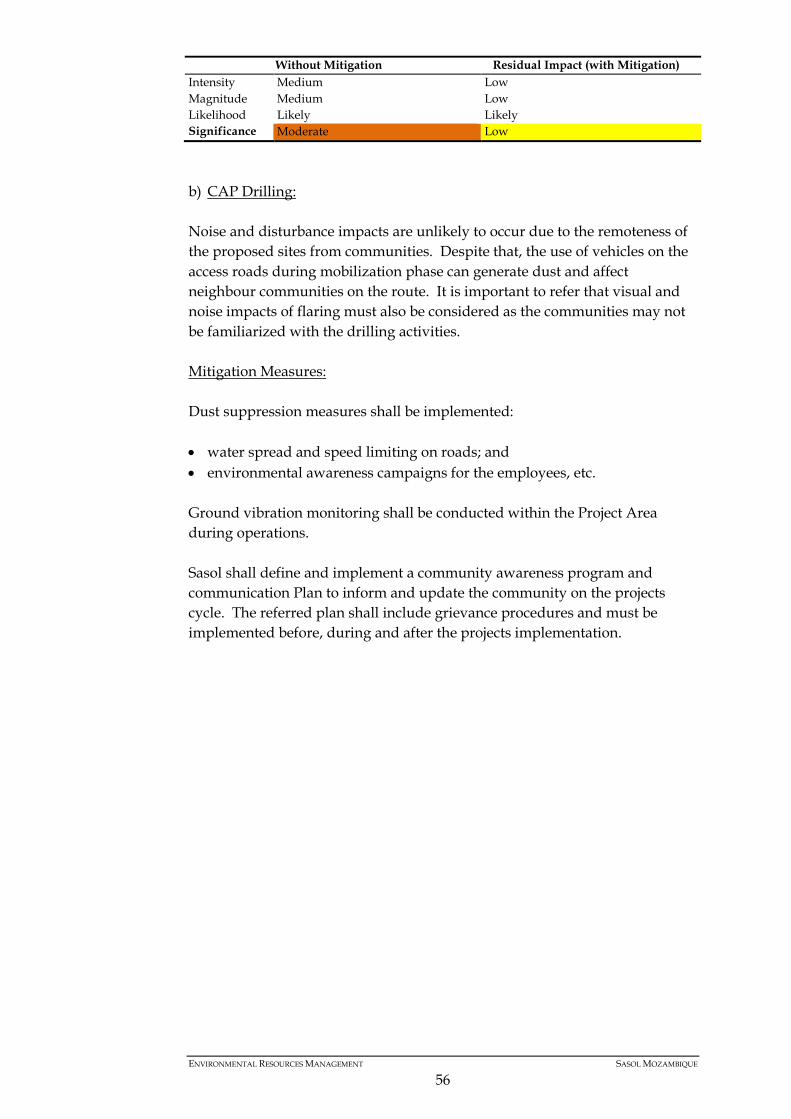
Without Mitigation Residual Impact (with Mitigation) Intensity Medium Low Magnitude Medium Low Likelihood Likely Likely Significance Moderate Low
b) CAP Drilling: Noise and disturbance impacts are unlikely to occur due to the remoteness of the proposed sites from communities. Despite that, the use of vehicles on the access roads during mobilization phase can generate dust and affect neighbour communities on the route. It is important to refer that visual and noise impacts of flaring must also be considered as the communities may not be familiarized with the drilling activities. Mitigation Measures: Dust suppression measures shall be implemented: • water spread and speed limiting on roads; and • environmental awareness campaigns for the employees, etc.
Ground vibration monitoring shall be conducted within the Project Area during operations. Sasol shall define and implement a community awareness program and communication Plan to inform and update the community on the projects cycle. The referred plan shall include grievance procedures and must be implemented before, during and after the projects implementation.
ENVIRONMENTAL RESOURCES MANAGEMENT SASOL MOZAMBIQUE
56
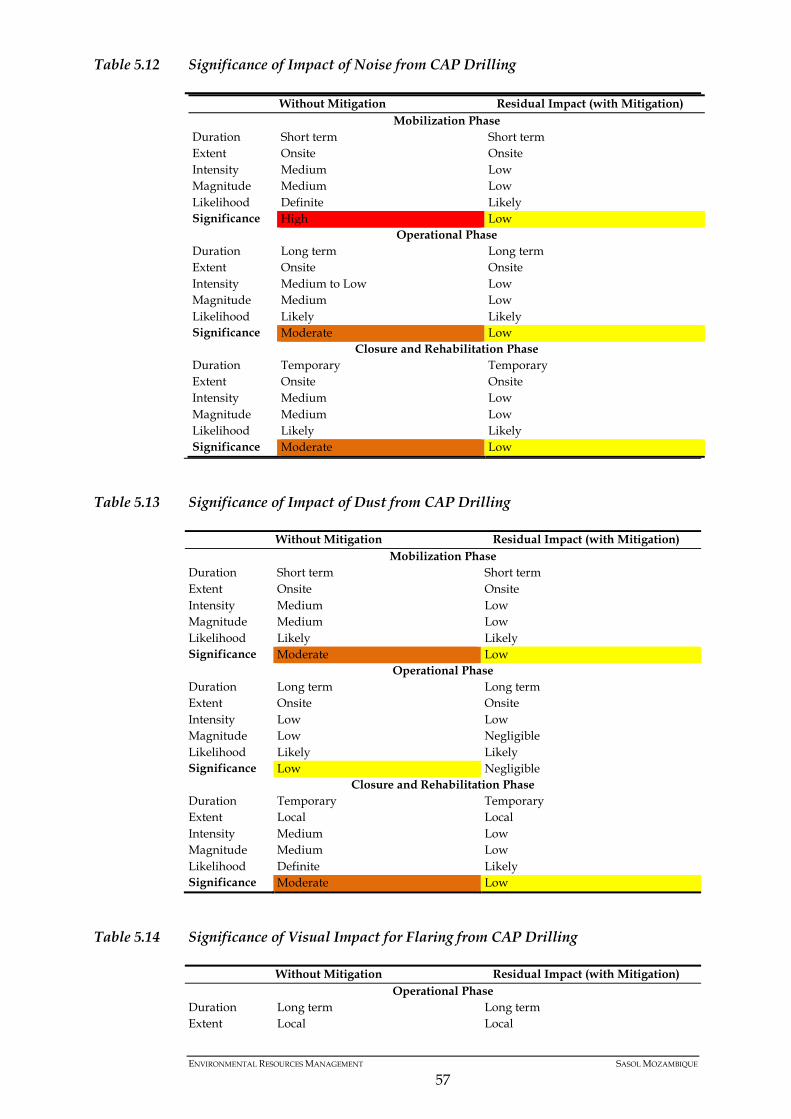
Table 5.12 Significance of Impact of Noise from CAP Drilling
Without Mitigation Residual Impact (with Mitigation) Mobilization Phase
Duration Short term Short term Extent Onsite Onsite Intensity Medium Low Magnitude Medium Low Likelihood Definite Likely Significance High Low
Operational Phase Duration Long term Long term Extent Onsite Onsite Intensity Medium to Low Low Magnitude Medium Low Likelihood Likely Likely Significance Moderate Low
Closure and Rehabilitation Phase Duration Temporary Temporary Extent Onsite Onsite Intensity Medium Low Magnitude Medium Low Likelihood Likely Likely Significance Moderate Low
Table 5.13 Significance of Impact of Dust from CAP Drilling
Without Mitigation Residual Impact (with Mitigation) Mobilization Phase
Duration Short term Short term Extent Onsite Onsite Intensity Medium Low Magnitude Medium Low Likelihood Likely Likely Significance Moderate Low
Operational Phase Duration Long term Long term Extent Onsite Onsite Intensity Low Low Magnitude Low Negligible Likelihood Likely Likely Significance Low Negligible
Closure and Rehabilitation Phase Duration Temporary Temporary Extent Local Local Intensity Medium Low Magnitude Medium Low Likelihood Definite Likely Significance Moderate Low
Table 5.14 Significance of Visual Impact for Flaring from CAP Drilling
Without Mitigation Residual Impact (with Mitigation) Operational Phase
Duration Long term Long term Extent Local Local
ENVIRONMENTAL RESOURCES MANAGEMENT SASOL MOZAMBIQUE
57
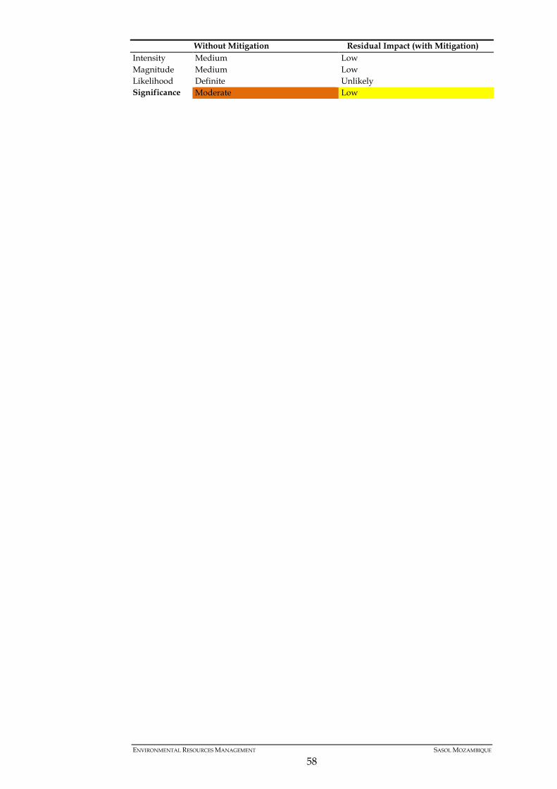
Without Mitigation Residual Impact (with Mitigation) Intensity Medium Low Magnitude Medium Low Likelihood Definite Unlikely Significance Moderate Low
ENVIRONMENTAL RESOURCES MANAGEMENT SASOL MOZAMBIQUE
58
6 ENVIRONMENTAL MANAGEMENT PLAN (EMP)
6.1 PURPOSE OF THE ENVIRONMENTAL MANAGEMENT PLAN (EMP)
The main objective of the present EMP is to present management measures that will eliminate, offset or reduce adverse environmental impacts, as well as to provide a framework for environmental monitoring. The primary purpose of the EMP is to ensure that environmental and social impacts of the project are effectively managed and the positive impacts are enhanced.
6.2 SCOPE OF THE EMP
The present addendum to the EMP includes: • The conversion of the 2D Seismic EMP (from March, 2009) into the 3D
Seismic acquisition Environmental Management Plan (EMP) for Pande and Inhassoro; and
• An update to the onshore drilling EMP (PSA Development, Oct. 2014). The principles expressed in this document should be considered in the contract agreements between Sasol and the contractors that will be hired to carry out the proposed project activities. Revision of and updates to the previous EMPs were made so that it is in line with the updated Project Description, the updated information on the baseline environmental and social features of the project area, as well as with the updated impacts and mitigation measures identified in this document.
6.3 SASOL ENVIRONMENTAL POLICY
As the project owner, Sasol has implemented the following environmental policy that shall set the framework for environmental management for the project. All visitors, Contractors and employees are required to comply with the requirements of the policy. We, the people of Sasol, striving for excellence in all we do, recognise the impact that our activities can have on people and the environment. Safety, health and protection of the environment will form an integral part of our planning and decision-making. We will manage our company, wherever we do business, in an ethical way that strikes an appropriate and well-reasoned balance between economic, social and environmental needs. Sasol is committed to: • Conducting business with respect and care for people and the environment;
ENVIRONMENTAL RESOURCES MANAGEMENT SASOL MOZAMBIQUE
59
• Responsible utilisation of natural resources;
• Implementing responsible care for all Sasol’s chemical and associated businesses. Non-chemical businesses will implement appropriate, recognised codes of practice;
• Continually improving safety, health and environmental performance;
• Complying, as a minimum, with all applicable legal and other agreed requirements; and
• Promoting dialogue with stakeholders about safety, health and environmental performance.
Such commitments will be achieved by the implementation of the following actions: • Implementation of internationally recognised safety, health, environmental and
quality management systems;
• Development and implementation of inherently safer and cleaner technologies;
• A “cradle and grave” approach to the products we develop, manufacture, use distribute and sell;
• Inform and appropriately train all employees and contractors on safety, health and environmental matters;
• Effectively respond to safety, health and environmental emergencies involving our operations and products;
• Engaging with relevant authorities and institutions on the formulation of legislation, standards and the implementation thereof;
• Benchmarking internationally on best safety, health and environmental practices;
• Sharing safety, health and environmental risk reduction best practices throughout Sasol; and
• Providing appropriate resources required to implement the above.
6.3.1 Community Engagement Principles
Sasol’s community engagement principles are centred on: • Community involvement and ownership; • Strengthen community leadership; • Targeted impacts-driven interventions; • Addressing key community priorities; • Strategic research informed interventions; • Monitoring and evaluation; and • Building capacity through partnership.
ENVIRONMENTAL RESOURCES MANAGEMENT SASOL MOZAMBIQUE
60
6.4 OBLIGATIONS AND RESPONSIBILITIES
Sasol is fully responsible for the implementation of the present EMP. However, all the other parties involved in project implementation will be assigned individual responsibilities. This chapter outlines the obligations and responsibilities of the main parties to be involved in the implementation of the EMP, namely Sasol, the demining contractor, the seismic acquisition contractor and the drilling contractor.
6.4.1 Sasol’s General Obligation & Responsibilities
Sasol shall manage the activities of the various phases of the project in such a way that the environment and the health and safety of workers, contractors, local communities and the public in general are protected. To this end, Sasol shall: • Ensure that the provisions of the EMP forms part of the contract agreement
for contractors/subcontractors, supervisors and workers;
• Assume overall responsibility for the implementation of the EMP, in agreement with all legislative and contractual requirements;
• Assume overall responsibility for ensuring that any non-conformance with the EMP is fully corrected through the implementation of corrective measures;
• Wherever necessary, assume overall responsibility for compensation of any households directly affected by the Project;
• Draw the attention of managers, contractors, subcontractors, supervisors and workers to the safety, health and environmental requirements and hold them responsible for their performance;
• Manage the activities so as to minimise the impacts on the environment and on human health and offer workplaces in which the recognised hazards are reduced to the minimum or are controlled;
• Make professional staff available to support the commitments regarding safety, health and protection of the environment;
• Monitor, evaluate and report on the performance in the safety, health and environmental protection areas and communicate these matters to all affected stakeholders;
• When necessary, offer training to protect the human, environmental, cultural and physical resources.
6.4.2 Contractors Responsibilities
The demining contractor shall:
ENVIRONMENTAL RESOURCES MANAGEMENT SASOL MOZAMBIQUE
61
• Assume overall responsibility for the implementation of the EMP in its scope of action, and ensure that its implementation is in agreement with all legislative and contractual requirements;
• Minimize environmental damage controlling waste, preventing pollution, preventing the loss of or damage to natural resources;
• Guarantee the fulfilment of demining standards as well as the quality of
work, in order that the demining operations are conducted in safe conditions and minimize the effects of the demining activity on workers and local communities;
• Start the implementation of minimization measures within a reasonable period after the reception of written instructions from Sasol to do so;
• Guarantee training of the sub-contracted unskilled work force before the start of their activities. In this training the subcontracted workers should be made aware of the environmental aspects, with emphasis on the danger of uncontrolled bushfires and the potential for human-wildlife conflict, amongst other matters;
• Proper equipment of the unskilled work force before the start of their activities;
• Report to Sasol all incidents related to mines or other pieces of ordinance within a period of 24 hours on, so that Sasol can ensure that this information is immediately reported to the competent authorities (i.e. local District Administration and the National Institute for Demining);
• Ensure that the recommendations from the Environmental Site Officer (ESO) are analysed, answered and implemented as appropriate.
The seismic acquisition contractor shall: • Assume overall responsibility for the implementation of the EMP in its
scope of action, and that it is in agreement with all legislative and contractual requirements;
• Fulfil the mitigation and environmental preservation measures defined in this EMP;
• Ensure that the sensitive areas indicated in this EMP are dealt with as such and that the conditions defined for operation of sensitive areas are fully complied with;
• Adopt the plan and the procedures approved by Sasol for labour contracting;
• Guarantee training of the sub-contracted unskilled work force before the start of their activities. In this training the subcontracted workers should be made aware of the environmental aspects, with emphasis on the danger of uncontrolled bushfires and the potential for human-wildlife conflict, amongst other matters;
ENVIRONMENTAL RESOURCES MANAGEMENT SASOL MOZAMBIQUE
62
• Start the implementation of minimization measures within a reasonable period after the reception of written instructions from Sasol to do so;
• Ensure that the recommendations from the Environmental Site Officer (ESO) are analysed, answered and implemented as appropriate;
• Be open to the fulfilment of environmental audits by Sasol (internal audits), the Ministry for the Land, Environmental and Rural Development (MITADER) or any other relevant Government institutions, and provide the necessary information for this purpose.
The drilling contractor shall: • Assume overall responsibility for the implementation of the EMP in its
scope of action, and that it is in agreement with all legislative and contractual requirements;
• Fulfil the mitigation and environmental preservation measures defined in this EMP;
• Adopt the plan and the procedures approved by Sasol for labour contracting;
• Start the implementation of minimization measures within a reasonable period after the reception of written instructions from Sasol to do so;
• Ensure that the recommendations from the Environmental Site Officer (ESO) are analysed, answered and implemented as appropriate;
• Be open to the fulfilment of environmental audits by Sasol (internal audits), the Ministry for the Land, Environmental and Rural Development (MITADER) or any other relevant Government institutions, and provide the necessary information for this purpose.
6.4.3 Environmental and Community liaison Personal Responsibilities
Environmental Coordinator (EC) The EC shall be a full time appointment for the duration of the projects contracts and be based on site. He/she shall have a tertiary education in the natural sciences and a proven track record in environmental contract management on large projects, as well as be either employed by Sasol or be an independent consultant. The EC shall: • Provide support to the ESO by means of regular site visits (preferably
weekly) during the project and by assisting with the formulation of the most effective and structured monitoring and reporting strategy, tailored to the conditions of the contract;
• Prepare monthly monitoring reports in conjunction with the ESO and monthly reports to MITADER;
ENVIRONMENTAL RESOURCES MANAGEMENT SASOL MOZAMBIQUE
63
• Report to and discuss with the Owner’s Representative any significant non-compliance by demining, seismic or Drilling teams and sub-Contractors and the steps to be taken to rectify it;
• Prepare the Rehabilitation Plan, in conjunction with the ESO. The EC shall be responsible for the final sign off on any rehabilitation. A list shall be prepared of any areas where remedial measures are necessary and these measures shall be implemented before a Closure Certificate is issued. The EC shall actively oversee the re-instatement of sites and provide the final sign-off;
• Actively participate in the monthly site meetings;
• Assist with internal and external audits; and
• Prepare a project close-out report.
Environmental Site Officer (ESO) In the course of the implementation of the project activities, there will be a need for making important decisions on how to proceed under specific conditions encountered in the field. The role of the ESO’s is to assist Sasol in ensuring that the workforce understands their duties regarding environmental protection and that the operations are conducted in an environmentally responsible manner. The need to contract Environmental Officers is founded on the limited knowledge about the ecosystems of the study area as well as the dynamic nature of onshore seismic and drilling operations. Therefore, the ESO shall have a good understanding of pollution-related issues and also a tertiary qualification in a natural science discipline. The ESO shall: • Report directly to and liaise closely and regularly with the Environmental
Coordinator on specialist environmental issues (e.g. rehabilitation, graves, etc.), non-compliance, and in relation to the preparation of the monthly environmental reports;
• Liaise, where necessary with specialist consultants;
• Liaise with the Community Liaison Officer (CLO) about environmental issues affecting surrounding communities;
• Be thoroughly familiar with existing information about habitat and social sensitivities;
• Be thoroughly familiar with the project specifications in the EMP with which the Contractors are obliged to comply;
• Perform all day-to-day tasks necessary to monitor the performance of the project activities;
• Report non-compliance by the Contractors to the Owner’s Representative (i.e. The Sasol’s Field Superintendent) and EC, and participate in the actions necessary to ensure that the Contractors rectify any non-compliance
ENVIRONMENTAL RESOURCES MANAGEMENT SASOL MOZAMBIQUE
64
as rapidly and effectively as possible; NOTE: Only the Owner’s Representative (i.e. Sasol’s Field Superintendent) can issue site instructions to rectify non-compliance by Contractors.;
• Keep accurate records of monitoring for the purposes of audit. These records shall provide a systematic account of the Contractors’ performance with regards to environmental management of the sites. As part of standard reporting procedures, the ESO shall utilise weekly and monthly checklists to assist in formalising the approach to the monitoring;
• Assist Sasol’s EC to prepare formal monthly monitoring reports;
• Prepare monthly compliance certificates that shall be discussed with the Owner’s Representative (i.e. The Sasol Field Superintendent) and signed by both, the Owner’s Representative and the ESO. The compliance certificates shall contain a brief description of any areas of non-compliance with the contract specification, the responsible party, the result/consequence, the corrective action taken and any necessary follow up required;
• Prepare, in association with the EC, a checklist that includes a snag list of outstanding items that need to be addressed by the Contractors before all environmental obligations have been met with respect to the contract at its completion. The list shall take into consideration any items that require action to meet the contract specification before the Contractor demobilised. Once these items have been rectified to the satisfaction of the Owner’s Representative, in consultation with the ESO and the Environmental Co-ordinator, sign-off shall occur.
• Prepare the Rehabilitation Plan, together with EC where necessary. The ESO shall be responsible for the implementation of the Plan.
Box 6.1 ESO
During seismic activities, the ESO will be working directly with demining and bush clearance operational teams. During the scouting of the area for sensitive features and sites, the ESO may find community farms, fruit trees or other community assets. In this case, information on the findings shall be channelled to the Community Liaison Officer in a filled form that will be used by the CLO for follow up (i.e. for grievance / compensation issues). The information to be provided to the CLO by the ESO shall include (but not be limited) to the following:
· Date; · ESO identification code; · Locality name; · Seismic line number; · Seismic line width; · Waypoint and coordinates (GPS data register); · Photo number and time; · Type of asset affected (number and type of asset; e.g. farm, fruit tree, etc.); · Total area cleared; · Community representative name
Note: The ESO’s shall always be accompanied by a community representative during the performance of his/her duties.
ENVIRONMENTAL RESOURCES MANAGEMENT SASOL MOZAMBIQUE
65
Community Liaison Officer (CLO) Engagement of the communities from the earlier stages of the project is considered of outmost importance for ensuring the overall success of the project. Cooperation between the project and the communities should be promoted by means of continuous consultation of local communities, in order to avoid disputes. The communities shall be informed about the various activities of the project and, wherever applicable, about how these activities can affect their assets and/or livelihoods. Information shall be communicated mainly through a series of meetings with villagers using verbal explanations and, wherever deemed necessary, handouts (based mainly on drawings rather than text). The key role of the CLO is to assist Sasol in ensuring effective communication with the communities, dealing with compensation issues and monitoring the impact of the project in the community. The CLO should have experience in engagement of local communities and shall report to Sasol Public Relations Officer (PRO) and the Environmental Coordinator (EC). Specifically for the seismic acquisition, the CLO shall: • Based on information provided by the Environmental Site Officer (or
obtained directly from the community members), to prepare a detailed register of the community assets (e.g. farms, fruit trees) that could be affected by the seismic acquisition activities. The register should contain details such as identification of the owner, type of asset affected, location (coordinates), photos, etc.
• To organize a complaints register and coordinate the process of adequately
channelling the grievance and providing response to the complainant; and
• Ensure that the community members are aware of the proposed seismic survey operations prior to the commencement of the project activities in a given area.
For the CAP drilling, the CLO shall: • Keep communities informed about the project activities (mobilization,
operation and closure/rehabilitation);
• To arrange occasional visits to drilling and other sites for District Government, community leaders and other senior community leaders;
• Teach traffic safety to those communities near or on access routes that will be used by construction vehicles;
• Communicate and manage the Sasol Compliments and Complaints Register;
• Communicate and manage the Sasol Grievance Procedure.
ENVIRONMENTAL RESOURCES MANAGEMENT SASOL MOZAMBIQUE
66
• Report any transgressions of foreign construction workers in the communities to Sasol.
The CLOs shall act as guides and advisors to Contractors in respect of the EMP on communication and local community issues during the mobilization phase of the project. This will be achieved by ongoing liaison with and monitoring of relations with communities, identification of problem areas and supporting their resolution. The CLOs shall be hired from Inhassoro and Govuro Districts, shall have knowledge of the proposed project, experience in communication with communities and local and district authorities and shall be able to communicate in local languages. They shall be capable of evaluating the effectiveness of specified social management measures. They shall be able to propose solutions to problems identified as regards the implementation of the plans. Owner’s Representative (OR) The OR, which is the Sasol’s Field Operations Superintendent, shall be the single communication channel for the ESO and Environmental Co-ordinator, whom shall report to him/her on environmental issues relating to the project operations. Any site instructions to rectify non-compliances by the Contractor with respect to environmental management shall be issued by the Owner’s Representative. The Sasol SHEQ Manager shall be informed of the environmental issues relating to the rectification of non-compliance and any other relevant environmental management aspect.
6.4.4 Reporting Between Project Parties
Proposed articulation between the various parties involved in project implementation is shown in the flow diagram below:
ENVIRONMENTAL RESOURCES MANAGEMENT SASOL MOZAMBIQUE
67
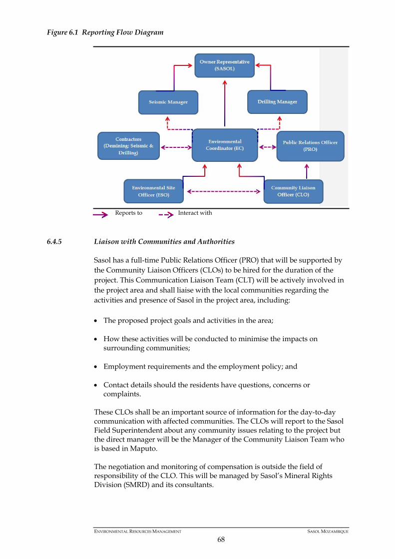
Figure 6.1 Reporting Flow Diagram
Reports to Interact with
6.4.5 Liaison with Communities and Authorities
Sasol has a full-time Public Relations Officer (PRO) that will be supported by the Community Liaison Officers (CLOs) to be hired for the duration of the project. This Communication Liaison Team (CLT) will be actively involved in the project area and shall liaise with the local communities regarding the activities and presence of Sasol in the project area, including: • The proposed project goals and activities in the area;
• How these activities will be conducted to minimise the impacts on
surrounding communities;
• Employment requirements and the employment policy; and
• Contact details should the residents have questions, concerns or complaints.
These CLOs shall be an important source of information for the day-to-day communication with affected communities. The CLOs will report to the Sasol Field Superintendent about any community issues relating to the project but the direct manager will be the Manager of the Community Liaison Team who is based in Maputo. The negotiation and monitoring of compensation is outside the field of responsibility of the CLO. This will be managed by Sasol’s Mineral Rights Division (SMRD) and its consultants.
ENVIRONMENTAL RESOURCES MANAGEMENT SASOL MOZAMBIQUE
68
6.4.6 Coordination and Review of the EMP
The EMP forms the basis for environmental management on site. Based on the results of the performance assessment and review process, the EMP may be modified as the project progresses. Modifications will only be allowed by Sasol’s Environmental Co-ordinator. Changes to the EMP will only be allowed: a) If alternative measures with equal or improved outcomes have been
identified subsequent to the compilation of the report;
b) Prior to non-compliance, therefore requiring pro-active evaluation. All changes shall be made as per SPI’s Document Control Procedure to which all affected parties shall comply. This procedure defines document distribution, retention and management of EMP revisions. All changes shall be tracked, including details of the change, date of the change and name of the reviewer. The Sasol Environmental Co-ordinator shall ensure that any modifications are communicated, explained to and discussed with all affected parties (i.e. the authorities, seismic and drilling contractors, the HS Representative, SHEQ Manager, Sasol’s Field Superintendent, ESO and any directly affected party who requests this information). All changes to the EMP shall be submitted to MITADER for approval.
6.4.7 Reporting
In addition to all reporting requirements identified in the EMP, records shall be kept by the Sasol EC of all monitoring results, monitoring reports, incident records, audit reports and management reviews. Minutes of all environmental project meetings shall be submitted to the Environmental Co-ordinator. All reporting requirements shall be agreed at the beginning of the Project with Contractors but in general shall be as follows: the contractor site supervisor(s) shall report environmental matters to the ESO, who shall report to the Sasol Environmental Co-ordinator and the Field Superintendent.
6.5 EMP
Table 6.1 summarises the key environmental impacts associated with the proposed Project, and the control and/or mitigation measures that will be implemented to prevent unacceptable impacts. For each issue, the control and/or mitigation measures and management and monitoring measures are presented along with specific actions required to implement these measures, their timing, and a means of verification.
ENVIRONMENTAL RESOURCES MANAGEMENT SASOL MOZAMBIQUE
69
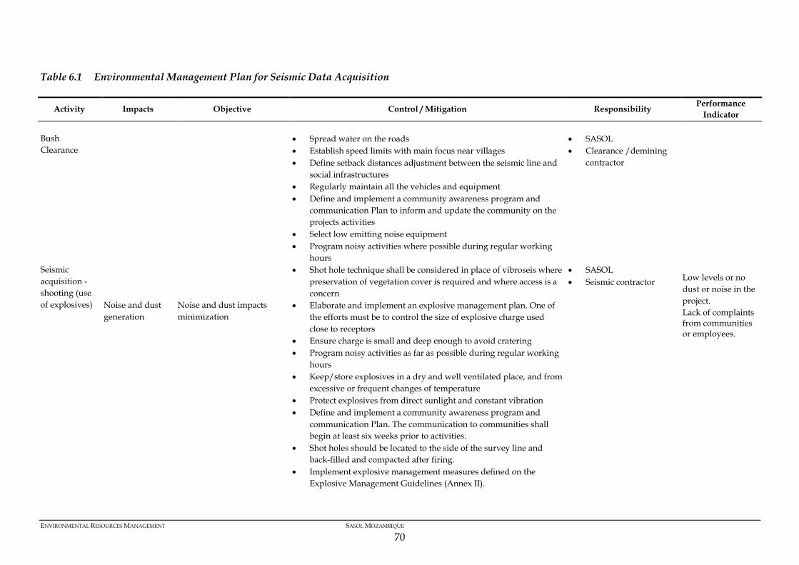
Table 6.1 Environmental Management Plan for Seismic Data Acquisition
Activity Impacts Objective Control / Mitigation Responsibility Performance Indicator
Bush Clearance
Noise and dust generation
Noise and dust impacts minimization
• Spread water on the roads • Establish speed limits with main focus near villages • Define setback distances adjustment between the seismic line and
social infrastructures • Regularly maintain all the vehicles and equipment • Define and implement a community awareness program and
communication Plan to inform and update the community on the projects activities
• Select low emitting noise equipment • Program noisy activities where possible during regular working
hours
• SASOL • Clearance /demining
contractor
Low levels or no dust or noise in the project. Lack of complaints from communities or employees.
Seismic acquisition - shooting (use of explosives)
• Shot hole technique shall be considered in place of vibroseis where preservation of vegetation cover is required and where access is a concern
• Elaborate and implement an explosive management plan. One of the efforts must be to control the size of explosive charge used close to receptors
• Ensure charge is small and deep enough to avoid cratering • Program noisy activities as far as possible during regular working
hours • Keep/store explosives in a dry and well ventilated place, and from
excessive or frequent changes of temperature • Protect explosives from direct sunlight and constant vibration • Define and implement a community awareness program and
communication Plan. The communication to communities shall begin at least six weeks prior to activities.
• Shot holes should be located to the side of the survey line and back-filled and compacted after firing.
• Implement explosive management measures defined on the Explosive Management Guidelines (Annex II).
• SASOL • Seismic contractor
ENVIRONMENTAL RESOURCES MANAGEMENT SASOL MOZAMBIQUE
70
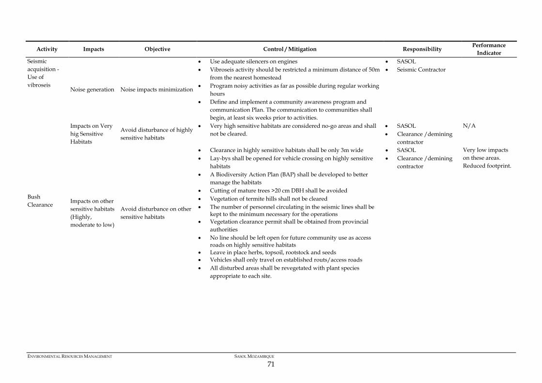
Activity Impacts Objective Control / Mitigation Responsibility Performance Indicator
Seismic acquisition - Use of vibroseis
Noise generation Noise impacts minimization
• Use adequate silencers on engines • Vibroseis activity should be restricted a minimum distance of 50m
from the nearest homestead • Program noisy activities as far as possible during regular working
hours • Define and implement a community awareness program and
communication Plan. The communication to communities shall begin, at least six weeks prior to activities.
• SASOL • Seismic Contractor
Bush Clearance
Impacts on Very hig Sensitive Habitats
Avoid disturbance of highly sensitive habitats
• Very high sensitive habitats are considered no-go areas and shall not be cleared.
• SASOL • Clearance /demining
contractor
N/A
Impacts on other sensitive habitats (Highly, moderate to low)
Avoid disturbance on other sensitive habitats
• Clearance in highly sensitive habitats shall be only 3m wide • Lay-bys shall be opened for vehicle crossing on highly sensitive
habitats • A Biodiversity Action Plan (BAP) shall be developed to better
manage the habitats
• Cutting of mature trees >20 cm DBH shall be avoided • Vegetation of termite hills shall not be cleared • The number of personnel circulating in the seismic lines shall be
kept to the minimum necessary for the operations • Vegetation clearance permit shall be obtained from provincial
authorities • No line should be left open for future community use as access
roads on highly sensitive habitats • Leave in place herbs, topsoil, rootstock and seeds • Vehicles shall only travel on established routs/access roads • All disturbed areas shall be revegetated with plant species
appropriate to each site.
• SASOL • Clearance /demining
contractor
Very low impacts on these areas. Reduced footprint.
ENVIRONMENTAL RESOURCES MANAGEMENT SASOL MOZAMBIQUE
71
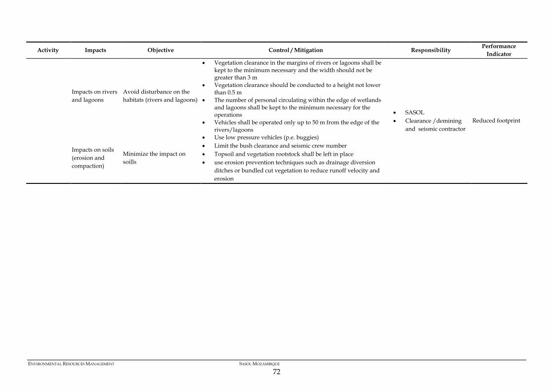
Activity Impacts Objective Control / Mitigation Responsibility Performance Indicator
Impacts on rivers and lagoons
Avoid disturbance on the habitats (rivers and lagoons)
• Vegetation clearance in the margins of rivers or lagoons shall be kept to the minimum necessary and the width should not be greater than 3 m
• Vegetation clearance should be conducted to a height not lower than 0.5 m
• The number of personal circulating within the edge of wetlands and lagoons shall be kept to the minimum necessary for the operations
• Vehicles shall be operated only up to 50 m from the edge of the rivers/lagoons
• SASOL • Clearance /demining
and seismic contractor Reduced footprint
Impacts on soils (erosion and compaction)
Minimize the impact on soills
• Use low pressure vehicles (p.e. buggies) • Limit the bush clearance and seismic crew number • Topsoil and vegetation rootstock shall be left in place • use erosion prevention techniques such as drainage diversion
ditches or bundled cut vegetation to reduce runoff velocity and erosion
ENVIRONMENTAL RESOURCES MANAGEMENT SASOL MOZAMBIQUE
72
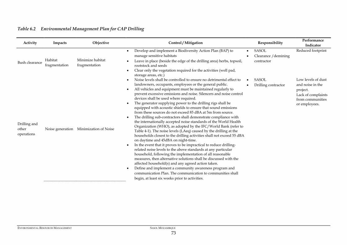
Table 6.2 Environmental Management Plan for CAP Drilling
Activity Impacts Objective Control / Mitigation Responsibility Performance Indicator
Bush clearance Habitat fragmentation
Minimize habitat fragmentation
• Develop and implement a Biodiversity Action Plan (BAP) to manage sensitive habitats
• Leave in place (beside the edge of the drilling area) herbs, topsoil, rootstock and seeds
• Clear only the vegetation required for the activities (well pad, storage areas, etc.)
• SASOL • Clearance /demining
contractor
Reduced footprint
Drilling and other operations
Noise generation Minimization of Noise
• Noise levels shall be controlled to ensure no detrimental effect to landowners, occupants, employees or the general public.
• All vehicles and equipment must be maintained regularly to prevent excessive emissions and noise. Silencers and noise control devices shall be used where required.
• The generator supplying power to the drilling rigs shall be equipped with acoustic shields to ensure that sound emissions from these sources do not exceed 85 dBA at 5m from source.
• The drilling sub-contractors shall demonstrate compliance with the internationally accepted noise standards of the World Health Organization (WHO), as adopted by the IFC/World Bank (refer to Table 4-1). The noise levels (LAeq) caused by the drilling at the households closest to the drilling activities shall not exceed 55 dBA on daytime and 45dBA on night-time.
• In the event that it proves to be impractical to reduce drilling-related noise levels to the above standards at any particular household, following the implementation of all reasonable measures, then alternative solutions shall be discussed with the affected household(s) and any agreed action taken.
• Define and implement a community awareness program and communication Plan. The communication to communities shall begin, at least six weeks prior to activities.
• SASOL • Drilling contractor
Low levels of dust and noise in the project. Lack of complaints from communities or employees.
ENVIRONMENTAL RESOURCES MANAGEMENT SASOL MOZAMBIQUE
73
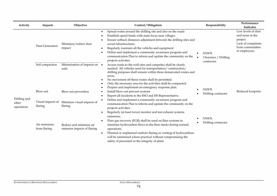
Activity Impacts Objective Control / Mitigation Responsibility Performance Indicator
Dust Generation Minimize/reduce dust impact
• Spread water around the drilling site and also on the roads • Establish speed limits with main focus near villages • Ensure setback distances adjustment between the drilling sites and
social infrastructures • Regularly maintain all the vehicles and equipment • Define and implement a community awareness program and
communication Plan to inform and update the community on the projects activities
• SASOL • Clearance / Drilling
contractor
Low levels of dust and noise in the project. Lack of complaints from communities or employees.
Drilling and other operations
Soil compaction Minimization of impacts on soils
• Access roads to the well sites and campsites shall be clearly marked. All vehicles used for transportation/ construction/ drilling purposes shall remain within these demarcated routes and areas.
• No movement off these routes shall be permitted. • Only the necessary area for the activities shall be compacted.
Blow-out Blow-out prevention • Prepare and implement an emergency response plan. • Install blow-out prevent systems • Report all incidents to the ESO and HS Representative.
• SASOL • Drilling contractor
Reduced footprint
Visual impacts of flaring
Minimize visual impacts of flaring
• Define and implement a community awareness program and communication Plan to inform and update the community on the projects activities
• SASOL • Drilling contractor
Air emissions from flaring
Reduce and minimize air emission impacts of flaring
• Regularly (at least twice) monitor and test exhaust systems emissions.
• Flare gas recovery (FGR) shall be used on flare systems to minimise hydrocarbon flows to the flare stacks during normal operations.
• Planned or unplanned onshore flaring or venting of hydrocarbons will be minimised where practical without compromising the safety of personnel or the integrity of plant.
ENVIRONMENTAL RESOURCES MANAGEMENT SASOL MOZAMBIQUE
74
6.6 POST OPERATION EVALUATION
Following the completion of seismic and drilling activities, a post operation evaluation shall be carried out to determine whether (a) mitigation measures have been properly implemented and (b) any residual Impacts have occurred and can be recorded. This will be carried out by an independent consultant. The post operation evaluation will include both ecological and socioeconomic aspects. It is further recommended that within a 30 day period after completion of the activities, information is gathered on such issues as the following: • Whether the communities were aware of the operations before their
commenced in their area of residence;
• Local overall perceptions regarding the activities;
• Whether the communities experienced any losses or other negative impacts during project implementation.
All the reports produced by the various Officers and Supervisor/Coordinators should be reviewed and a final Post Operation Evaluation shall be compiled that should also include the aspects above.
6.7 REPORTING AND FOLLOW UP
A number of routine internal reporting formats should be used to effectively implement the requirements of the EMP. Routine reporting is likely to include daily, weekly and/or monthly ESH reports for specific scopes of work on the Project. These reports will include information on a number of relevant environmental aspects, such as: • Number of dbh > 20cm trees cut; • Sensitive habitats recording; • Fauna sighting recording; • Records of rivers, lakes and lagoons.
7 CONCLUSION
The EMP is a ‘live’ document and should be subjected to ongoing review and development to ensure that it remains appropriate for all aspects of the Project. There must be a procedure to identify and manage changes to any business processes that may impact on HSE performance. Changes may be: Planned or unplanned; Sudden or gradual; and Temporary or permanent. All audit findings should be reviewed by the HSE Manager, and where corrective actions are deemed necessary, specific plans (with designated responsibility and timing) shall be developed aimed at addressing the specific finding, any underlying issues and ultimately achieving continuous improvement in performance.