Embed Size (px)
Citation preview

Adaptation to Climate Change
In Myanmar
Tin Yi (Assistant Director) DMH, MYANMAR
http://www.moezala.gov.mm
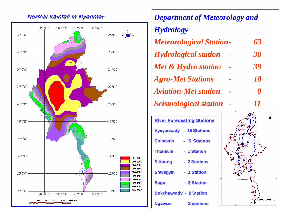
Department of Meteorology and Hydrology Meteorological Station - 63 Hydrological station - 30 Met & Hydro station - 39 Agro-Met Stations - 18 Aviation-Met station - 8 Seismological station - 11
River Forecasting Stations Ayeyarwady - 15 Stations Chindwin - 5 Stations Thanlwin - 1 Station Sittoung - 2 Stations Shwegyin - 1 Station Bago - 2 Station Dokehtawady - 2 Station Ngawun - 2 stations
ANDARMAN SEA
N
10050050100
Myitkyina
Bhamo
Hkamti
Homalin
Katha
KalewaMonywa
Mandalay
Minbu
Pyay Taungoo
Hpa-an
Bago
Magway
ChaukNyaung U
Myitnge
Mawlaik
Hpa-an
Hsipaw
Sagaing
Aunglan
HenzadaMadauk Shwegyin
Zaungtu

Impacts of Climate Change in Myanmar
• Late monsoon onset after 1977 • Early monsoon withdrawal after 1977 • Shorter monsoon duration after 1977 • Retardation of monsoon advancement increased in 1990s • The monsoon strength were weak in 1951, 1953, 1957,
1977,1979,1996 ,1998 and 2003 where the impacts of EL Nino were evident in some years.
• Heat and drought indices increased after 1977 • Annual rain decreased after 1977 • Normal monsoon breaks disappear in 1990s • The Monsoon depressions become less significantly in
1980s and 1990s • The abnormal synoptic situations occurred in 1980s and
1990s. • Sea surface temperatures rise, which is causing storms,
including cyclones and hurricanes, to intensify. • Heaviest rainfalls were recorded during July and Aug
2011 and June and Oct in 2010 and Highest Temps were recorded in March, April and May 2010
•
MALA
AKASH
NARGIS
BIJLI
GIRI

• The trends of annual peaks in Ayeyarwady river are the falling trends except Hinthada station in deltaic area.
• The trends of annual peaks and lowest W.L in Chindwin river are mostly the falling trends and the range of annual peaks are more wide after 1990.
• In other all rivers, the trends of annual peaks and lowest W.L are also the rising trends.
• The trends of annual lowest W.Ls of the rivers in central Myanmar area are showing the falling trends.
• In 2010, the flood only occurred in two rivers and the annual max. and min. water levels were also recorded the lowest in most of the rivers.
• In 2011, the flood recorded the lowest in Ayeyarwady and Chindwin rivers and the highest in Bago and Thanlwin river.
• In 2011, the flash floods occurred in 4 places in June, July and Oct.
Climate Change impacts to Myanmar Rivers
5
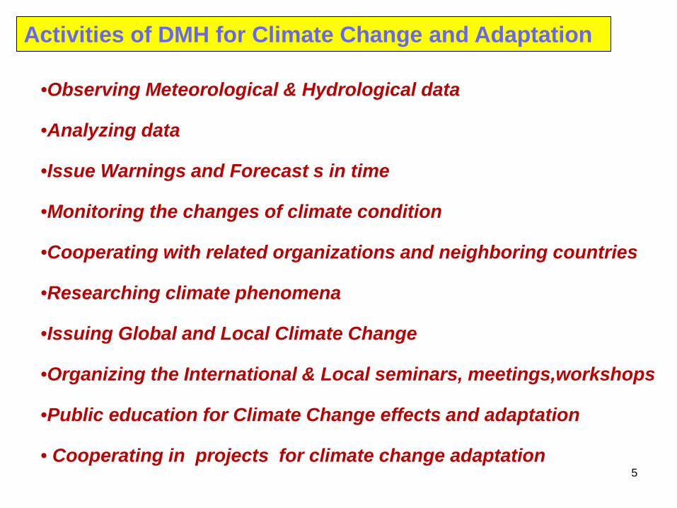
•Observing Meteorological & Hydrological data
•Analyzing data
•Issue Warnings and Forecast s in time
•Monitoring the changes of climate condition
•Cooperating with related organizations and neighboring countries
•Researching climate phenomena
•Issuing Global and Local Climate Change
•Organizing the International & Local seminars, meetings,workshops
•Public education for Climate Change effects and adaptation
• Cooperating in projects for climate change adaptation
Activities of DMH for Climate Change and Adaptation

Climate Change Scenario for Myanmar (2001-2020, 2021-2050, 2051-2100) (by MAGIC
5.3 model)
N
CHINA
INDIA
LAOS
Myitkyina
Mandalay
Sittwe
Yangon
Kengtung
Dawei
Pathein
•The scenario of TEMPERATURE shows slight warming (0.5 C) during June to November in the whole country. In other months warming increases to (0.7-1.2 C) in the country except the delta and southern parts of the country where the warming is (0.6 C)
The scenario of PRECIPITATION shows about 5% increase of rain during March- November through out the country but in the remaining months which constitutes only 5-10 % of the annual value, the deltaic areas and the southern region will receive about normal precipitation and it will be deficit up to 45 % elsewhere
Seasonal Temperature Changes(°C) for 2001-2020 from Model Ensemble Scenerio
0
0.2
0.4
0.6
0.8
1
1.2
1.4
MYK STWE MDLY KTNG PTN MGDN DWI
Tem
p C
hang
e(°C
)
DJF
MAM
JJA
SON
Seasonal Mean Precipitation changes (%) for 2001-2020from Model Ensemble Scenarios
-50
-40
-30
-20
-10
0
10
MYK SITTWE MDY KTN PATHEIN YANGON DAWEI
Precip
itati
on
Ch
an
ges(%
)
DJFMAMJJASON

Results • (Annual,April,May) temperature of Myanmar will be increased
throughout the 21st century. • At the same time, Model projected Rainfall for SW Monsoon
period also expected to increase for Myanmar during 21st Century.
• Late Onset will be at Deltaic area, Central Myanmar and Northern Myanmar and Early withdrawal from Whole country during 21st Century.
• Predicted Length of Rainy Season (L.R.S) showed that the L.R.S will be shorter than Normal(144 Days) during Early 21st Century, Middle 21st Century and End period of 21st Century.
• Monsoon Intensity will be generally moderate along Myanmar coast in 21st Century.
Climate Changes of Myanmar During 21st Century By ECHAM5 Model with Global Warming Experiment
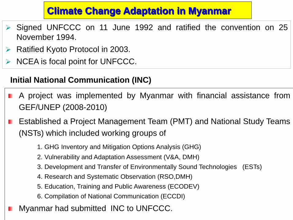
Signed UNFCCC on 11 June 1992 and ratified the convention on 25 November 1994.
Ratified Kyoto Protocol in 2003. NCEA is focal point for UNFCCC.
Climate Change Adaptation in Myanmar
A project was implemented by Myanmar with financial assistance from GEF/UNEP (2008-2010)
Established a Project Management Team (PMT) and National Study Teams (NSTs) which included working groups of
1. GHG Inventory and Mitigation Options Analysis (GHG) 2. Vulnerability and Adaptation Assessment (V&A, DMH) 3. Development and Transfer of Environmentally Sound Technologies (ESTs) 4. Research and Systematic Observation (RSO,DMH) 5. Education, Training and Public Awareness (ECODEV) 6. Compilation of National Communication (ECCDI)
Myanmar had submitted INC to UNFCCC.
Initial National Communication (INC)
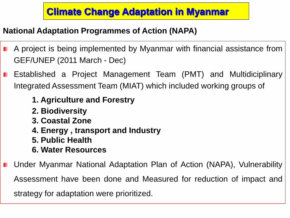
Climate Change Adaptation in Myanmar
A project is being implemented by Myanmar with financial assistance from GEF/UNEP (2011 March - Dec)
Established a Project Management Team (PMT) and Multidiciplinary Integrated Assessment Team (MIAT) which included working groups of
1. Agriculture and Forestry 2. Biodiversity 3. Coastal Zone 4. Energy , transport and Industry 5. Public Health 6. Water Resources
Under Myanmar National Adaptation Plan of Action (NAPA), Vulnerability
Assessment have been done and Measured for reduction of impact and
strategy for adaptation were prioritized.
National Adaptation Programmes of Action (NAPA)
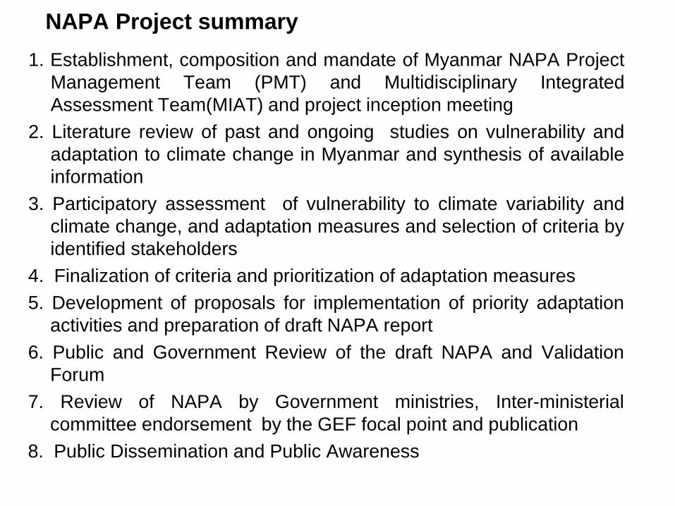
NAPA Project summary 1. Establishment, composition and mandate of Myanmar NAPA Project
Management Team (PMT) and Multidisciplinary Integrated Assessment Team(MIAT) and project inception meeting
2. Literature review of past and ongoing studies on vulnerability and adaptation to climate change in Myanmar and synthesis of available information
3. Participatory assessment of vulnerability to climate variability and climate change, and adaptation measures and selection of criteria by identified stakeholders
4. Finalization of criteria and prioritization of adaptation measures 5. Development of proposals for implementation of priority adaptation
activities and preparation of draft NAPA report 6. Public and Government Review of the draft NAPA and Validation
Forum 7. Review of NAPA by Government ministries, Inter-ministerial
committee endorsement by the GEF focal point and publication 8. Public Dissemination and Public Awareness
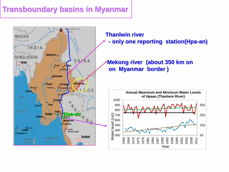
Transboundary basins in Myanmar
Hpa-an
Thanlwin river - only one reporting station(Hpa-an)
Mekong river (about 350 km on on Myanmar border )
50
150
250
350
300400500600700800900
1000
1966
1969
1972
1975
1978
1981
1984
1987
1990
1993
1996
1999
2002
2005
2008
2011W
ater
leve
l (cm
)
Year
Annual Maximum and Minimum Water Levels of Hpaan (Thanlwin River)
Conclusion Myanmar is one of the most vulnerable countries in ASEAN region to various kinds of natural disaster according to the climate changes.
The climate change mainly affects the socio-economic sectors of Myanmar such as agriculture, forest, biodiversity, coastal zone, public health and water resources.
Myanmar is an agricultural country and water and agriculture sectors are very important for Myanmar’s economy.
So the relevant departments and organizations in Myanmar are cooperating in the climate change adaptation activities and also cooperating in the regional and worldwide climate change adaptation.
http://www.moezala.gov.mm


![ADAPTATION CLAMPING DEVICES MANDO Adapt [mandrel adaptation] · PDF fileMANDO Adapt T212 SE. Order overview Suitable for ADAPTATION CLAMPING DEVICES MANDO Adapt [mandrel adaptation]](https://img.dokumen.tips/doc/110x75/5a78bf117f8b9a07028d99a0/adaptation-clamping-devices-mando-adapt-mandrel-adaptation-adapt-t212-se-order.jpg)