Embed Size (px)
Citation preview

Kiduk Moon, Nigel Downes, Hendrik Rujner and Harry Storch 45th ISOCARP Congress 2009 Adaptation of the Urban Structure Type Approach for the Assessment of Climate Change Risks
1
Adaptation of the Urban Structure Type Approach for Vulnerability Assessment of Climate Change Risks in Ho Chi Minh City
1 Introduction
Different discipline-specific methodological approaches to assess the vulnerability of the "urban environment" to climate change risks require a commonly accepted spatial working basis, which can ensure that the resulting heterogeneous investigations can be trans-disciplinarily integrated by using an adequate spatially explicit classification. Therefore an 'urban typology' concept was developed and will be used as a practicable method to structure the spatial order of the sensitivity of settlement areas in HCMC. The Housing-related 'urban typology' provides a uniform methodological and spatial framework for the different tasks within the interdisciplinary network of the research project to aid the development of future climate change resilience- Building and thus resilience- Urban Structure.
The case study is based on initial research experiences of the development of GIS-based vulnerability indicators in the application area of adaptation of a high-risk agglomeration area to the future impacts of Climate Change. Based on the extended ´Urban Structure Type (UST) approach´(HAGGAG & AYAD 2002). The proposed model represents an interpretative method to respond and adapt to the impacts of climate change. It focuses on how to integrate climate change risks and hazards with information and indicators that describe both the exposure and sensitivity of the highly-dense urban areas of Asian megacities such as Ho Chi Minh City (HCMC), Vietnam.
2 The effects of Climate Change at the HCMC Urban Scale
The impacts of climate change our predicted to be unevenly distributed, with many of the greatest challenges to be faced by the mega-urban regions in intra-tropical low elevation coastal areas of Southeast Asia. These regions which have significant climate related hazard exposure are additionally each associated with specific developmental and socio-economic issues that exacerbate this exposure. Concurrently many cities of countries in transition exhibit both a rapid increase in the spatial extend of urbanisation and population density. Vietnam, with more than 3200 km of densely populated lowland coastline, including two major river deltas, the Red River Delta in the north and the Mekong River Delta in the south, upon which the mega-conurbations of Hanoi and HCMC are juxtaposed, is particularly exposed.
HCMC is characterised by urban structures of both planned and informal expansions of the urban morphology, which are both degrading valuable natural areas in the hinterland and increasing the vulnerability of these areas to climate-related environmental changes or hazards. Additionally exposure to and sensitivity for climate change related risks and impacts are a result of physical processes, such as the building construction, urban planning, infrastructure provision or the transportation, which create these hazards, as well as the human processes such as lifestyle choices, that lead to these vulnerabilities (CLARK ET AL. 1998).
Vulnerabilities of lives and livelihood to climate-related environmental processes are primarily the result of inadequate and unsustainable urban planning practices associated with complex natural settings and societal structures. Over the next decades a significant amount of new urban housing developments will be required in Vietnam. These new urban developments will shape the spatial pattern of the urban agglomerations for many decades. It is therefore of highest importance to plan in an integrated manner from the outset, how the spatial development direction in general and how buildings and infrastructure in these highly vulnerable regions can be adapted to cope with the climate change related impacts they are likely to be effected by during their lifetime.
Kiduk Moon, Nigel Downes, Hendrik Rujner and Harry Storch 45th ISOCARP Congress 2009 Adaptation of the Urban Structure Type Approach for the Assessment of Climate Change Risks
2
HCMC´s settlements are integrated in an urban system that is affected by a number of internal and external pressures and resultantly the impacts of climate change on the city, its settlements and infrastructure should be assessed within the context of this complexity. Over the last three decades HCMC, has experienced rapid densification and expansion, with environmental considerations often ignored or neglected, with existing environmental information and its maintenance are often obsolete and outmoded. Within this backdrop, the challenge to adapt to the effects of climate change within the urban-environmental planning arises.
3 Urban Structure Typologies as a Foundation Concept
Vulnerability to climate change varies considerably from settlement to settlement and even within settlements. The location, urban structure, dominant building type, socio-economic characteristics and institutional capacity are key factors that affect vulnerability and adaptive capacity of a settlement in the mega-urban region (STORCH ET AL. 2009).
The main task in downscaling climate change assessments on urban level is that every region has its own urban development issues and possible adaptation options. In general, there is a methodological gap between the regional climate change model and urban development scenarios, which limit effective impact assessment. Knowing future temperature, precipitation and flooding trends without knowing the general urban development path, limits the assessment of vulnerabilities of the future urban structures in relation to the future climate conditions in a regional context.
3.1 Downscaling Climate Change related impacts to the Urban Scale
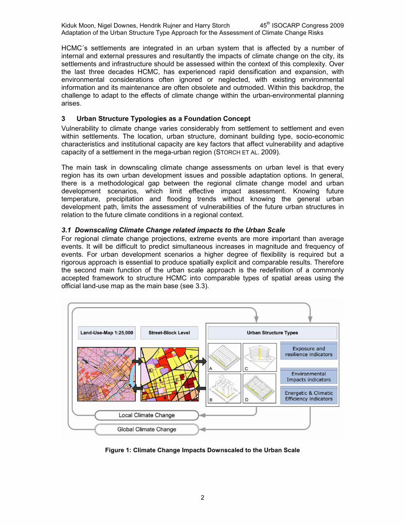
For regional climate change projections, extreme events are more important than average events. It will be difficult to predict simultaneous increases in magnitude and frequency of events. For urban development scenarios a higher degree of flexibility is required but a rigorous approach is essential to produce spatially explicit and comparable results. Therefore the second main function of the urban scale approach is the redefinition of a commonly accepted framework to structure HCMC into comparable types of spatial areas using the official land-use map as the main base (see 3.3).
Figure 1: Climate Change Impacts Downscaled to the Urban Scale

Kiduk Moon, Nigel Downes, Hendrik Rujner and Harry Storch 45th ISOCARP Congress 2009 Adaptation of the Urban Structure Type Approach for the Assessment of Climate Change Risks
3
3.1 Urban Environmental Planning Information System
Climate change-related urban adaptation decisions require a rational characterization of urban structural landscapes according to risk relevant features. The urban structure type approach is furthermore the main supportive module / foundation for an Urban Environmental Planning Information System. A comprehensive analysis of results from previous project phases and additional existent planning tools, methods and processes will be the basis for the coordination and cooperation.
The typology approach ensures that data integration of different sources with their original specific spatial/temporal resolutions and thematic contents can be operationally integrated in the GIS environment of the research-project (STORCH & ECKERT 2007). The concept of urban-typologies promises to deliver an integrated view of climate change-specific problem areas to urban and environmental planners in a form that makes sense to them, because it provides a unit of analysis that is attractive to each of them, because the urban typology creates clusters of residential areas with similar housing structures, service/infrastructure availability, socio-demographic components and climate change related risk and pressures, and makes it possible to analyse commonalities and differences in urban adaptation strategies.
The main function of the urban structure type approach is to spatially link an indicator concept which represents an interpretative method to integrate the biophysical aspect of the ‘Exposure’ to climate change related effects with the socio-economic aspect of assessing the ‘Sensitivity’ of people and places and environmental-related information. The urban structure type approach thus allows a multi-disciplinary identification of core indicators for spatially explicit ’vulnerability assessment´ procedures (FÜSSEL 2007).
3.2 Classification and Subdivisions of Urban Structure Types
The Urban Structure Typology approach originated through the utilisation of remotely sensed imagery to capture the urban physical form and its comprising building structures for the field of urban morphological analysis (RAITH, 2000). It defines primarily an urban block of homogeneous appearance, which may or may not comprise varying building typologies. Through the visual interpretation of remotely sensed images such as aerial photographs or satellite images, the urban structure types can be recognized in the surrounding urban patchwork. Via the utilization of the official land use maps, the structure types themselves can be assigned to the urban block boundaries and spatially redefined.
Figure 2: Examples of HCMC Urban Structure Types

Kiduk Moon, Nigel Downes, Hendrik Rujner and Harry Storch 45th ISOCARP Congress 2009 Adaptation of the Urban Structure Type Approach for the Assessment of Climate Change Risks
4
Urban structure types block size and form are dependent upon the transportation or surface water networks that frame the block, as well as the formal or informal nature of the building typologies their individual forms, their connections as well as their interconnections to adjacent structures. Here the urban infrastructure exerts a dominate role. Other differentiations are made based upon land uses, orientation, structure density and building and sealing material. Furthermore at the street level, via valuable local knowledge, photography and site visits, the climate change relevant indicators and parameters for each urban structure type can be surveyed. This provides on the one hand important the feedback of information for the examining the adaptation capacity of existing developments but also on the other, vital information for the new urban developments. This information can then be used to develop a model of urban development trends and their adaptation capacity.
The urban structure types at the block level comprise of not only single building types but usually out of a combination of several differing building types. Following the visual interpretation and survey of the HCMC urban types, for the residential blocks, four dominate types were identified. The further industrially utilized blocks and the vegetation of the city can be obtained from the LUM when required. The dominate types for residential blocks are Shophouse´s, Villas and High densely Apartments in several variations. The Shophouse building type itself is sub divided based on construction, size and usage into the 5 subdivisions.(Figure 3, A-1 to A-5) Every building type exhibits varying physical characteristics through their construction material, building volume, usage and associated open space and access. Resultantly the same building types can be assigned to varying Urban Structure Types based on these characteristics. Example would be UST 10 and 11, as seen in Figure 2, which consist of the same building types but varying specifications and characteristics.
The urban structure types are coded in ascending fashion for the ease of modification and adaptability of the systems through further findings or for modelling applications i.e. GIS analysis.
Figure 3: HCMC Building Types, an important comprising element of Urban Structure Types

Kiduk Moon, Nigel Downes, Hendrik Rujner and Harry Storch 45th ISOCARP Congress 2009 Adaptation of the Urban Structure Type Approach for the Assessment of Climate Change Risks
5
Since the most significant and fundamental elements of the UST, lie at the building level, the developing dynamic of urban development can be recognised initially by changes in urban structure and building typologies. On the temporal scale, through the merger and amalgamation of existing building typologies within the block, new building typologies result as the manifestation of development pressure and new building codes and/or regulations.
Via the classification of the changing fabric within the block over a certain time interval, meaningful data regarding the current and future development trend can be obtained. Hence the development and alteration of individual block based UST´s is foreseeable, in particular when considering implementation of Transport Master Plans, public investment or changing political will. Thereafter a dynamical UST model, in which future urban development scenarios are combined with future environmental- or adaptation- relevant measures, can be developed.
3.3 Redefining Urban Land Use Pattern
Commencing with the basic housing archetypes in HCMC, each were conceptually divided into subtypes to generate urban structure types that are reflective of different biophysical exposure or impact indicators. The most complicated structure in HCMC is represented by the shophouse structure, which was divided into more specific subtypes to reflect the broad variety of this predominant settlement structure, found often in the inner-districts of HCMC. Examples of the physical building-specific indicators which were used to define the final housing typologies are given in Figure 2. The physical boundaries of the housing typologies are defined by street blocks in Land Use Map. The study site is embedded within the surrounding urban fabric of the neighbourhood pattern.
Figure 4: Comparison of Urban Land Use and Urban Structure Types in the CBD of HCMC

Kiduk Moon, Nigel Downes, Hendrik Rujner and Harry Storch 45th ISOCARP Congress 2009 Adaptation of the Urban Structure Type Approach for the Assessment of Climate Change Risks
6
Data collected from the study sites, representative of each housing typology, will be used to formulate values for physical resilience and exposure of the building structure based on descriptive indicators. The neighbourhood pattern is represented as an urban puzzle within HCMC, in which the separate urban structural units fit together to form the complete picture of settlement developments. Figure 4 shows the differences in spatial and thematic resolution of the structure type approach compared to the traditional urban land use classification.
Clearly, the structure and arrangement of housing areas are factors influencing exposure and resilience to impacts of climate change in an urban spatial context. Recognition of this connection makes it possible to re-evaluate the housing development pattern as one fundamental determinant in the formation of urban vulnerability to climate change. If replicated on multiple sites, the housing development pattern becomes an integral part of the urban fabric of HCMC.
The exposure and resilience pattern for each housing development helps to determine the ultimate vulnerability to climate change risks for the urban region. In the times of climate change urban resilience and exposure are strongly influenced by the choices that are made regarding which housing types to build (STORCH & SCHMIDT 2008).
4 Concluding Remarks
The development and classification of the HCMC Urban Structure Typologies, which are primarily related to Types of Building in the micro level of the urban fabric, offers a central base indicator for different analyses relevant for urban environmental considerations, such as environmental impact assessment, exposure and resilience indicators, and at the same time, an interface for the adaptation strategies to climate change effects for urban development scenarios. The Base indicators, coupled with energy and climate efficiency indicators for each defined typology allow explicit GIS- supported assessment and prioritization of urban planning adaption and mitigation (DEILMANN 2007). At the same time, adaptation strategies to climate change impacts for urban development scenarios can be simulated.
5 Acknowledgements
The research project ‘Integrative Urban and Environmental Planning for Adaptation Ho Chi Minh City to Climate Change - Sustainable Strategies for Climate-Oriented Urban Structures, Energy-Efficient Housing Typologies and Comprehensive Environmental Protection for Megacities of Tomorrow’ is financed as part of the new research programme 'Sustainable Development of the Megacities of Tomorrow’ by the German Federal Ministry of Education and Research (BMBF). Following an evaluation of the preoperational phase of the project 'Sustainable Housing Policies for Megacities of Tomorrow - the Balance of Urban Growth and Redevelopment in Ho Chi Minh City' (2005-2008), the main phase of the BMBF-research programme, now focuses on “energy- and climate-efficient structures in urban growth centres”, initiated mid 2008 and will run up to 2013 (www.emerging-megacities.org). Coordinated by the lead partner Brandenburg University of Technology Cottbus, a multi-disciplinary German, European and Vietnamese team, aims to develop an integrated “Adaptation Planning Framework for Climate Change in the Urban Environment of Ho Chi Minh City” (www.megacity-hcmc.org).

Kiduk Moon, Nigel Downes, Hendrik Rujner and Harry Storch 45th ISOCARP Congress 2009 Adaptation of the Urban Structure Type Approach for the Assessment of Climate Change Risks
7
References Clark, G.E., Moser, S.C., Ratick, S.J., Dow, K., Meyer, W.B., Emani, S. Jin, W., Kasperon, J.X., Kasperon, R.E. and Schwarz, H.E. (1998) Assessing the vulnerability of coastal communities to extreme storms: the case of Revere, MA., USA. Mitigation and Adaptation Strategies for Global Change 3: pp. 59-82.
Deilmann, C. (2007). High-Resolution Damage Simulation Flood Damage to Residential Properties. In J. Schanze (Ed.), Flood Risk Management Research. From Extreme Events to Citizens Involvement. Proceedings European Symposium on Flood Risk Management Research (EFRM 2007), 6th-7th February 2007 (pp. 90-96). Dresden, Germany: Dresden : IÖR.
Füssel, H. M. (2007) Vulnerability: a generally applicable conceptual framework for climate change research. Glob Environ Change 17, pp. 155–167
Haggag M.A. and Ayad H.M. (2002) The urban structural units method: a basis for evaluating environmental prospects for sustainable development, Urban Design International, Volume 7 (12), Number 2, June 2002 , pp. 97-108.
Raith, E. (2000) Stadtmorphologie – Annäherungen, Umsetzungen, Aussichten, Springer, Wien
Storch, H., Downes; N. and Moon, K. (2009) Climate Change and the Resilience of Megacities in South-East-Asia Creating Risk-Based Climate Change Information for Ho Chi Minh City’s Settlements, Proc. REAL CORP 2009 , 22nd-25th April 2009, Wien, Austria. pp. 22-25
Storch, H. and Eckert, R. (2007) GIS-based Urban Sustainability Assessment. In: Kappas, M.; Kleinn, C. and Sloboda, B. (Eds.): Global Change Issues in Developing and Emerging Countries, Proc. 2nd Göttingen GIS & Remote Sensing Days, 4th-6th October 2006, Göttingen, Germany. Göttingen: Universitätsverlag, pp. 17-28.
Storch, H. and Schmidt, M. (2006) Indicator-based Urban Typologies. Sustainability Assessment of Housing Development Strategies in Megacities. In: Tochtermann, K. and Scharl, A. (Eds.): Managing Environmental Knowledge. Proceedings of the 20th International Conference on Informatics for Environmental Protection, EnviroInfo 2006 Graz, Aachen: Shaker, pp. 145-152.
Authors:
Kiduk Moon*, Nigel Downes, Hendrik Rujner and Harry Storch Brandenburg University of Technology Cottbus, Germany Department Environmental Planning *Corresponding author: Kiduk Moon [email protected]