Embed Size (px)
Citation preview

I ' D
^ PRO^"
UNITED STATES ENVIRONMENTAL PROTECTION AGENCY REGION 8
1595 Wynkoop Street DENVER, CO 80202-1129
Phone 800-227-8917 http://www.epa.gov/region08
1289901 -R8SDMS
ACTION MEMORANDUM
SUBJECT:
SEP 2 4 2014
FROM:
Approval and Funding for a Removal Action at the Red and Bonita Mine Site in San Juan County, ApproximatelySpjgfi Miles North of Silverton, Colorado.
Steven Way Federal On-Scene Coordinator
THRU: Laura Williams, Unit Chief Emergency Response
TO: David Ostrander, Director Emergency Response and Preparedness Program
Site ID# 08UP
I. Purpose
The purpose of this memorandum is to request and document approval of the removal actions described herein for the Red and Bonita Mine Site (Site) located in unincorporated San Juan County, Colorado. This time-critical removal action involves installing an engineered reinforced bulkhead (massive plug) to stop the flow of the contaminated water coming out of the mine adit. Conditions existing at the Site present a threat to public health and the environment and meet the criteria for initiating a removal action under 40 CFR §300.415(b)(2) of the National Contingency Plan (NCP).
This removal action involves no nationally-significant or precedent-setting issues. This time-critical removal action will not establish any precedent for how future response actions will be taken and will not commit the US Environmental Protection Agency (EPA) to a course of action that could have a significant impact on future responses or resources.
II. Site Conditions and Background
Site Name: Superfund Site ID (SSID): NRC Case Number: CERCLIS Number: Site Location: Potentially Responsible Party: NPL Status: Removal Start Date: Removal Category:
Red and Bonita Mine Site 08UP
CON000802811 3 7.897236/-107.64382
Not on the NPL 10/1/2014 Time-Critical Removal

A. Site Description
1. Removal Site Evaluation
The Red and Bonita Mine Site is located within the Cement Creek watershed, a component of the upper Animas River watershed in San Juan County, Colorado (see Attachment 1- Figure 1). These watersheds within the volcanic terrain of the San Juan Mountains were the focus of both large and small scale mining operations that flourished between 1871 and 1991. Historic mapping of the Red and Bonita Mine indicates that mining operations began prior to 1899 and lasted for only a short period. No activity occurred after initial operations. The Red and Bonita is one of several mines in the Cement Creek basin that also have draining adits.
Flows from Red and Bonita Mine, Gold King (Level 7) Mine, and Mogul Mine all experienced significant increases following die construction of concrete bulkheads in Sunnyside Mine - American Tunnel between 1996 and 2002. Red and Bonita Mine now has an approximate flow of 300 gallons per minute (gpm). Flow from the American Tunnel was reportedly approximately 1,700 gpm when it was treated prior to the final bulkhead installation. The Red and Bonita Mine was essentially dry with an estimated five gpm flow during the period when the Sunnyside Gold Mine operated. Following installation of the three bulkheads in the Sunnyside Mine system, water treatment of the discharge from the American Tunnel and Cement Creek was discontinued. Water quality in the Animas River has degraded since that time.
The Animas River and many of its tributaries, including Cement Creek, carry high concentrations of hazardous substances (heavy metals) from both acid rock/mine drainage at mine sites and from natural sources not impacted by mining. Water quality studies have indicated that the Red and Bonita Mine is one of the major sources of metals, especially zinc, to the Animas River near Silverton. The EPA, BLM and USGS have undertaken activities to more fully enumerate the various mine sites and to quantify these acid mine drainage sources within the mining district that contribute to metals loading in the Animas River. These actions are intended to contribute to the information needed to identify potential remedies to reduce or prevent the on-going metal (hazardous substance) releases from mine sites.
A USGS evaluation of water quality data indicates that during low flow conditions, mine adit discharges to Cement Creek contribute a large percentage of the metals loading to the Animas River, as measured at the A72 sampling location below Silverton. In October 2012, the sampling results and related modeling showed that the. Red and Bonita Mine discharge accounted for an estimated 18 percent of the zinc load at A72. The relative contribution from the individual mines varies seasonally, depending on flow conditions.
In September/October 2011, the EPA removed blockage in the Red and Bonita Mine opening and constructed a temporary portal for accessing the mine. The mine adit is approximately five feet wide by seven feet high and extends underground for several hundred feet in multiple directions (Attachment 1-Figure 2). Investigations of the mine allowed access to approximately 2,000 feet of workings. Collapsed ground within the tunnels prevented further investigation. However, based on historic
2

information and the estimated waste dump volumes, it is estimated that there are only approximately 3,500 feet of underground workings and that the adit does not connect to other mines (Figure 3). In addition, there is no mapped surface opening to the mine and none were found during Site investigations in September 2014 or previously.
In 2012 and 2013, the EPA and the Division of Reclamation and Mine Safety (DRMS) conducted entries into the mine to determine, if possible, where the mine water flow was originating and what options existed for controlling the flow. During the 2012 entry, it was discovered that the extent and depth of metals precipitate (solids) deposited on the adit floor extended at least 700 feet and was three feet deep in areas. This condition and poor air quality restricted the extent of the assessment. However, a preliminary assessment of the rock and adit conditions indicated that it might be feasible to install a concrete bulkhead. Additional data and investigation of the adit was required to continue beyond 700 feet.
The conditions underground and associated discharge from the mine required that the operations in 2012 be postponed and re-attempted the following year. In August 2013, a second entry operation was performed to complete the investigations of the workings in an attempt to identify sources of water entering the mine and possible connections to other mine workings or significant faults or fracture systems. The results of the investigation revealed that the two primary sources of water include the main cross-cut flow and flow from a drift at 275 feet. Suitable rock for a potential bulkhead construction exists within the mine at approximately 265 feet in from the portal, which is down stream of the two sources of flow. The source of water flow within the mine could not be isolated, and no connections to other mine workings were identified.
In September 2014, additional evaluation was performed in the adit to determine if the proposed bulkhead location is suitable structurally and hydraulically. This assessment included performing pressurized, permeability testing of the fractures within the vicinity of the segment of the adit where a bulkhead could be placed. Packer testing demonstrated that the Red and Bonita adit at the proposed bulkhead location is composed of high-quality rock with very low permeability. Improvement of the rock through formation grouting is unnecessary based on the packer test results.
Solids precipitate from the mine water collected during the operations in 2011 and 2012 was determined not to exhibit a hazardous waste characteristic (URS Field Activities Report, December 2012).
2. Physical Location
The Red and Bonita Mine Site is located in San Juan County, Colorado. The portal is approximately seven miles north of the Town of Silverton, Colorado, at 10,893 feet above mean sea level (AMSL) at 37 degrees 53'49.95"N and 107 degrees 38'38.70"W. Road access is via County Road (CR) 110 from Silverton to CR53 at the abandoned town of Gladstone. CR53 continues northward up the Cement Creek valley to the mine site, approximately 0.5 mile north of Gladstone.
3

3. Site Characteristics
The Red and Bonita Mine Site consists of approximately 1.25 acres of waste rock and suspected tailings material and includes an estimated 3,500 feet of underground workings (Stover 2007). The adit, which drains approximately 300 gpm throughout the year with some fluctuations seasonally, discharges to Cement Creek after crossing through a wetland. Prior to the removal assessment work, the mine water discharged through rock debris, as a result of a tunnel collapse that occurred decades ago..
EPA installed a new portal structure in October 2011 after removing 30 feet of blockage at the adit entrance. Adit discharge flows overland across, and approximately 200 feet down, a mine dump face before being channelized at the toe of the dump. The channel directs flow into an iron bog en route to Cement Creek approximately 500 feet down gradient of the toe of the dump.
The Site lies east of Cement Creek on a west-facing mountainside slope with an average grade of 44 percent. The mine is accessible during non-snow months of the year, typically late June through early October. The mining claims associated with this mine are on steep terrain, approximately 10,800 feet, limiting conditions for operation.
4. Release or Threatened Release into the Environment of a Hazardous Substance, Pollutant or Contaminant
Following the installation of the bulkheads in the American Tunnel, the Red and Bonita Mine adit discharge rates increased to approximately 300 gpm. The pH of discharge water typically ranges from five to six standard units (su). The adit discharge water contains high concentrations of several metals that include (and their approximate concentrations measured over many years): total aluminum (4,000 parts per billion (ppb)), cadmium (35 ppb), iron (90,000 ppb), lead (60 ppb), manganese (34,000 ppb), and zinc (16,000 ppb). The discharge from the adit represents a significant release of heavy metals, including zinc, to the Animas River. The Red and Bonita Mine discharge accounts for approximately 18 percent of the zinc load in the Animas River during low flow periods at a point (sample station A72) one mile below Silverton (USGS presentation, 2013).
The results of a Screening Level Ecological Risk Assessment (February 2013) strongly suggested that the fish community in the Animas River at and below Silverton is experiencing high stress under current conditions. For example, the surface water hazard quotient for zinc in the Animas River below the confluence with Cement Creek is approximately four, which is four times the expected no-effects level. In addition, the study identified aluminum, copper, lead and zinc as major risk drivers to insectivorous birds ingesting surface water, sediment, and aquatic invertebrates from the Animas River at and below Silverton. Also, metal concentrations highly toxic to benthic invertebrates were measured in the substrate of the Animas River at and below Silverton.
Effects on benthic communities are most notable immediately below Cement Creek but are pronounced at least 30 miles downstream. Fish population surveys (2010),
4

conducted by the Colorado Parks and Wildlife (formerly Division of Wildlife), found no fish in the Animas River below Cement Creek for approximately two miles and observed precipitous declines in fish populations as far as 20 miles downstream since 2005.
Surface water toxicity tests were performed by EPA in 2012 and 2013 on Animas River surface water. The tests involved exposing commercially reared juvenile rainbow trout (Oncorhynchus mykiss) to water collected from the Animas River under controlled laboratory conditions. Exposures lasted for 96 hours and in both 2012 and 2013, Animas River water collected one mile below Cement Creek resulted in 100% mortality of fish.
Sediment toxicity tests using the standard test organism Hyalella azteca, a freshwater amphipod, were conducted in 2012. Following a 10 day exposure to Animas River sediments collected downstream of Cement Creek, mortality ranged from 24% at Bakers Bridge (about 30 miles downstream) to 95% at Elk Creek (about 7 miles downstream). Mortality was about 64% 1 mile downstream from Cement Creek at station A72.
5. NPL Status f
This Site is not on the NPL, but the EPA is in discussions with the state, local governments and the community about proposing the Site and other portions of the upper Animas River Basin.
'6. Maps, Pictures, Other Geographic Representation
Site maps are provided as Attachipent 1. Site photos are provided as Attachment 2.
B. Other Actions to Date
1. Previous Actions
No previous actions have been implemented at this Site.
2. Current Actions
There are no current actions.
C. State and Local Authorities' Role
1. State and Local Actions to Date
No state or local government actions are planned for this Site. The Animas River Stakeholders Group (ARSG) is actively involved with work in the watershed.
5

2. Potential for Continued State/Local Response
Neither the State of Colorado nor San Juan County have the resources to conduct this action.
III. Threats to Public Health Welfare or the Environment
Conditions at the Site present a threat to public health and the environment and meet the criteria for initiating a removal action under 40 CFR §300.415(b)(2) of the NCP.
EPA has considered all the factors described in 40 CFR §300.415(b)(2) of the NCP and determined that the following factors apply at the Site at this time.
(i) "Actual or potential exposure to nearby human populations, animals or the food chain from hazardous substances or pollutants or contaminants;"
The results of a Screening Level Ecological Risk Assessment (February 2013) strongly suggest that current fish populations on the Animas River are experiencing high levels of stress. For example, the surface water hazard quotient for zinc in the Animas River below the confluence with Cement Creek is approximately four, which is four times the expected no-effects level. In addition, the study identified aluminum, copper, lead and zinc as the major risk drivers to insectivorous birds ingesting surface water, sediment and aquatic invertebrates from the Animas River at and below Silverton.
(ii) "Actual or potential contamination of drinking water supplies or sensitive ecosystems;"
Metal concentrations measured in the substrate of the Animas River at and below Silverton are highly toxic to benthic invertebrates. Recent fish population studies conducted by the Colorado Division of Wildlife found no fish in the Animas River below Cement Creek for approximately two miles.
(vi) "The availability of other appropriate federal or state response mechanisms to respond to the release;"
No other federal or state response mechanism is available to respond to the releases described above.
IV. Proposed Actions and Estimated Costs
A. Proposed Actions
1. Proposed Action Description
The proposed removal action involves installing an engineered reinforced concrete bulkhead (massive plug) in the mine adit (tunnel) to prevent the ongoing release of contaminated water coming out of the adit. The bulkhead will be placed at an appropriate location in the mine that has been investigated and determined to be sound enough to withstand the hydrostatic pressures anticipated. The proposed
6
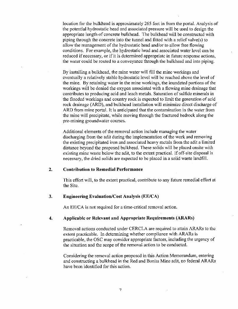
location for the bulkhead is approximately 265 feet in from the portal. Analysis of the potential hydrostatic head and associated pressure will be used to design the appropriate length of concrete bulkhead. The bulkhead will be constructed with piping through the concrete into the tunnel and fitted with a relief valve(s) to allow the management of the hydrostatic head and/or to allow free flowing conditions. For example, the hydrostatic head and associated water level can be reduced if necessary, or if it is determined appropriate in future response actions, the water could be routed to a conveyance through the bulkhead and into piping.
By installing a bulkhead, the mine water will fill the mine workings and eventually a relatively stable hydrostatic level will be reached above the level of the mine. By retaining water in the mine workings, the inundated portions of the workings will be denied the oxygen associated with a flowing mine drainage that contributes to producing acid and leach metals. Saturation of sulfide minerals in the flooded workings and country rock is expected to limit the generation of acid rock drainage (ARD), and bulkhead installation will minimize direct discharge of ARD from mine portal. It is anticipated that the contamination in the water from the mine will precipitate, while moving through the fractured bedrock along the pre-mining groundwater courses.
Additional elements of the removal action include managing the water discharging from the adit during the implementation of the work and removing the existing precipitated iron and associated heavy metals from the adit a limited distance beyond the proposed bulkhead. These solids will be placed onsite with existing mine waste below the adit, to the extent practical. If off-site disposal is necessary, the dried solids are expected to be placed in a solid waste landfill.
2. Contribution to Remedial Performance
This effort will, to the extent practical, contribute to any future remedial effort at the Site.
3. Engineering Evaluation/Cost Analysis (EE/CA)
An EE/CA is not required for a time-critical removal action.
4. Applicable or Relevant and Appropriate Requirements (ARARs)
Removal actions conducted under CERCLA are required to attain ARARs to the extent practicable. In determining whether compliance with ARARs is practicable, the OSC may consider appropriate factors, including the urgency of the situation and the scope of the removal action to be conducted.
Considering the removal action proposed in this Action Memorandum, entering and constructing a bulkhead in the Red and Bonita Mine adit, no federal ARARs have been identified for this action.
7

State ARARs Colorado Regulations Pertaining to Solid Waste Sites and Facilities (CCR 1007-2, pursuant to CRS § 30-20-100.5, et seq) are relevant and appropriate for on-site disposal.
Colorado Mined Land Reclamation Act (CRS 34-43-101 to 125 Rule 3 of Mineral Rules and Regulations) regulates all aspects of mining, including reclamation plans and socioeconomic impacts and is relevant and appropriate
5. Project Schedule
The removal action will start in October 2014 and be completed in September 2015.
B. Estimated Costs*
Contractor costs ERRS $ 1,300,000
START $ 100,000 Other Extramural Costs $ 25,000 Contingency costs (20% of subtotal) $ 285,000 Total Removal Project Ceiling $ 1,710,000
*EPA direct and indirect costs, although cost recoverable, do not count toward the Removal Ceiling for this removal action. Liable parties may be held financially responsible for costs incurred by the EPA as set forth in Section 107 of CERCLA.
V. Expected Change in the Situation Should Action Be Delayed or Not Taken
A delay in action or no action at the Site would increase actual or potential threats to public health and/or the environment.
VI. Outstanding Policy Issues
None.
VII. Enforcement
A separate Enforcement Addendum provides a confidential summary of current and potential future enforcement actions for the Site.
VII. Recommendations
This decision document represents the selected removal action for the Red and Bonita Mine Site in unincorporated San Juan County, CO, developed in accordance with CERCLA as amended and is not inconsistent with the NCP. This decision is based on the administrative record for the Site.
Conditions at the Site meet the NCP section 300.415(b) criteria for a removal action, and I recommend your approval of the proposed removal action. The total project ceiling, if approved,
8
will be $ 1,710,000; this amount will be funded from the Regional removal allowance.
APPROVE:
A/\ ^ ?J-f ZoiL/ David A. Ostrander, Director \ Date Emergency Response and Preparedness Program
DISAPPROVE:
David A. Ostrander, Director Date Emergency Response and Preparedness Program
Attachments:
Attachment 1: Site Maps Attachment 2: Photos
9
Printed on Recycled Paper

Attachment 1; Site Maps

Projection System: Universal Transverse Mercator Zone 13 North North American Datum 1983 NORTH
0 0.5 1 "1 Miles 2
TDD r,tie Summary Report - Upper Cement Creek Watershed
Figure: 1 Figure Title: Site Location Map
TDD County San Juan TDD State: CO
TDD 1008-01 Date 03/2012
URS VBATMSHIWB Sources: Arcservices World Topmap

_ A Piz2r?\*-'A7 {-*<
f cooO-J
L y / y V f c " / ' Mr*}
, 57t f c b * * ^
\ \ ?
i F̂ l. OO/Xi /)
,?M.1iffi'MtP
• •> "TJ £ •' Z&Fl
}7'<tCcO /,'f »*»c..„e, v.=w
34"'tu.fac;' ' -57a/i /3 rh$<jv<L /ifI
z.rruj-640 p
f ft > iO (j O -ooSt: /btK-i'r f
^ /C/
C?//5 v/5: /V 2/-f
4r V AHyct.rr£ a,K<r
fit//2^-J S //>* • /P/JCfur -txf/ybPrKJ~K£
f\££> / 3osJ/~7y) Z*rS
$/\a/Jc.trtfS 0$. L& '^u/xjzofS
r f / L L L * / U /*=fOO~

repared by Kirstin Brown, CDRMS, 1/21/2014 RED AND BONITA MAP Legend N Mine Workings past cave-ins are only projected to line of sight __ _ , _
SUNNYSIDE WORKINGS R & B 'S,0VW)
625 1,250 2,500 3,750 5.000 Most Recent workings, needs more work ^^GowKingithru7 W I Feet GOLD KING WORKINGS ^••SunnyMewtjrWnjjs

Attachment 2: Site Photos
Red and Bonita Mine adit

Attachment 2: Site Photos
Red and Bonita Mine tailings dump view

Attachment 2: Site Photos
Red and Bonita Mine portal