Embed Size (px)
Citation preview

(2007) 37–53www.elsevier.com/locate/margeo
Marine Geology 237
Acoustic structure and recent sediment transport processes on thecontinental slope of Yeşilırmak River fan, Eastern Black Sea
Derman Dondurur ⁎, Günay Çifçi
Dokuz Eylül University, Institute of Marine Sciences and Technology, Bakü Street, No:32, 35340, Inciraltı, Izmir, Turkey
Received 19 June 2006; received in revised form 16 October 2006; accepted 23 October 2006
Abstract
High-resolution acoustic data indicate that sediment erosion is a significant process in the continental slope of Yeşilırmak RiverFan, occurring both related to the submarine canyons and in the open continental slope. The sediment processes observed along theslope consist of sliding and debris flows on the canyon walls together with the recent erosional surfaces at the canyon headswherever the canyons exist, and slides and related scarp features structurally controlled by rotational faults in the central part of theopen continental slope.
Formation of slides both on the open slope and in canyon walls is a multi-phase sliding process, in which successive slidingevents occur at the same location producing a vertically stacked sliding, resulting in several relict slide features deeper parts in thesediments. We conclude that gravitational loading on the steep slope is the main driving force for most of the erosional features,and in place to place, overpressured pore fluids due to gas accumulation can contribute the instability.
Tributary canyon systems are observed on the slope, with slide scars in the proximal part. According to their different erosionalstructure, these canyons can be separated into two groups, as northern and southern sector canyon systems, where the sedimentbypass and hence erosional processes are much more active on the canyon heads in the southern sector than those in the northernpart. Terrigenous sediment load from Yeşilırmak River is transported along downslope by successive hyperpycnal fluxes and theactivity of turbidity currents along the channel axis.
Acoustic data indicate that the continental slope of Yeşilırmak River Fan is a classical deep-sea turbidite system, where weobserve slide scars in proximal part, and channel levee systems with slide and debris flow deposits inside the channels in the distalpart with some small sized gullies.© 2006 Elsevier B.V. All rights reserved.
Keywords: submarine canyons; erosional processes; slope stability; rotational faults
1. Introduction
Continental slopes are regions where sediments areexposed to sediment flows, slumps and slides, in which
⁎ Corresponding author. Tel.: +90 2322785565; fax: +902322785082.E-mail addresses: [email protected] (D. Dondurur),
[email protected] (G. Çifçi).
0025-3227/$ - see front matter © 2006 Elsevier B.V. All rights reserved.doi:10.1016/j.margeo.2006.10.035
the main triggering and driving forces can be seismicactivity, bottom currents or gravitational loading. Massmovements occur in all kinds of continental shelves andslopes with relatively high bathymetric inclination andis an important process controlling the development,morphology and sedimentary structure of the slope(Casas et al., 2003). This process is one of the principalmechanisms that distributes the shelf and upper slopesediments downslope towards the abyssal depths.

38 D. Dondurur, G. Çifçi / Marine Geology 237 (2007) 37–53
Slope stability depends on various parametersincluding seismic activity, existence of growth faults,possible overpressure conditions in pore spaces, grav-itational loading, sea level changes, existence of gashydrates, bottom current activities and storm waves(Hampton et al., 1996; Eschard, 2001). Investigation ofmass movement processes along continental slopes isimportant since they are considered to be main potentialnatural hazard for offshore engineering installations,pipelines and submarine cables on the continental slopes(Okey, 1997; Baraza et al., 1999; Lee et al., 1999; Leeand Baraza, 1999; Lykousis et al., 2002; Casas et al.,2003), and large-scale sliding events can producedestructive tsunamis in near-shore areas (e.g. vonHuene et al., 2004).
Acoustic methods, such as multichannel seismics,Chirp subbottom profiler, side-scan sonar and multi-beam echosounder systems provide significant infor-mation about existence, size and morphology of massmovements, scar faces related to slides and canyons
Fig. 1. Simplified tectonic map showing major tectonic elements of the BlackBlack Sea sub-basins, respectively; RB — Rioni Basin, TF — Tuapse FoArchangelsky Ridge; SB — Sinop Basin and NAF — North Anatolian Fauinterval, locations of seismic and MAK-1 (5 kHz subbottom profiler and sidmap (thick dashed rectangle), side-scan sonar mosaic of northern slope (thicorrespond the data illustrated in figures.
with channel levee systems (e.g. Damuth and Olson,2001; Laursen and Normark, 2002; Thorne and Hanes,2002; Casas et al., 2003; von Huene et al., 2004).
The study area is located in the southeastern marginof the Black Sea (Fig. 1) at the mouth of one of thelargest rivers in Turkey, named Yeşilırmak River, whichtransports large amounts of terrigenous sediment intoshelf and upper continental slope producing an alluvialfan consisted of coastal sediment accumulations. Thecontinental slope of Yeşilırmak River fan is locatedbetween 300 and 1850 m bathymetric contours with amaximum slope angle of 14° and can be defined as amodern continental slope, where downslope sedimenttransport processes are observed. There are alsoextensive accumulations of shallow gas especially inthe shelf and apron regions in the area (Çifçi et al., 2002;Ergün et al., 2002), and Çifçi et al. (2003) reported thatthe continental shelf of the fan is a broad pockmarkplateau, in which large circular and elongated pock-marks are present.
Sea (after Spadini et al., 1996): WBSB, EBSB—Western and Easternredeep, ST — Sorokhin Trough, AnR — Andrussov Ridge; ArR —lt. Close-up shows the bathymetry of study area with 200 m contoure-scan sonar) profiles (solid lines), locations of multibeam bathymetricn dashed rectangle) and core locations. Thick parts of the solid lines
39D. Dondurur, G. Çifçi / Marine Geology 237 (2007) 37–53
The purpose of this study is to present a detaileddescription of the acoustic characteristics of the continen-tal slope of Yeşilırmak River fan with acoustic evidencesfor erosional processes such as recent mass movementsand different types of sediment transport.We integrate datafrom different acoustic systems with different resolutionsto characterize geologic structures and mechanisms of thesediment transports, and to discuss about the mechanismscontrolling different types of mass movement.
2. Regional setting
The Black Sea is originated as a back-arc basin of thenorthwards subducting Tethys Ocean and is located in thenorth of the North Anatolian Fault (NAF) that allows thetectonic escape of Anatolia towards the west due to activeArabia–Eurasia collision (e.g. Rangin et al., 2002).Although it is surrounded by compressive belts, such asGreater Caucasus, Pontides and Balkanides (Fig. 1), it hasan extensional origin (Spadini et al., 1996). The Black Sea
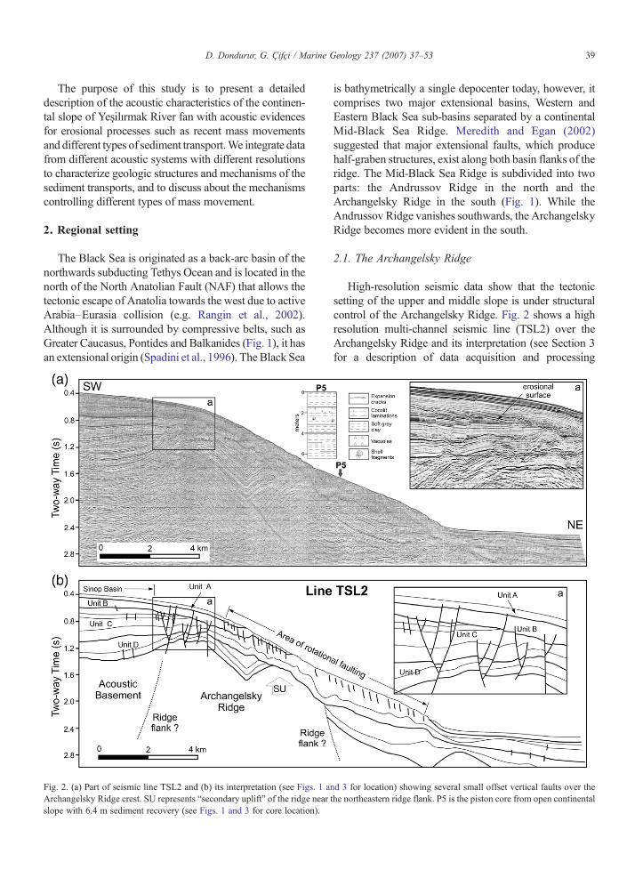
Fig. 2. (a) Part of seismic line TSL2 and (b) its interpretation (see Figs. 1 anArchangelsky Ridge crest. SU represents “secondary uplift” of the ridge nearslope with 6.4 m sediment recovery (see Figs. 1 and 3 for core location).
is bathymetrically a single depocenter today, however, itcomprises two major extensional basins, Western andEastern Black Sea sub-basins separated by a continentalMid-Black Sea Ridge. Meredith and Egan (2002)suggested that major extensional faults, which producehalf-graben structures, exist along both basin flanks of theridge. The Mid-Black Sea Ridge is subdivided into twoparts: the Andrussov Ridge in the north and theArchangelsky Ridge in the south (Fig. 1). While theAndrussov Ridge vanishes southwards, the ArchangelskyRidge becomes more evident in the south.
2.1. The Archangelsky Ridge
High-resolution seismic data show that the tectonicsetting of the upper and middle slope is under structuralcontrol of the Archangelsky Ridge. Fig. 2 shows a highresolution multi-channel seismic line (TSL2) over theArchangelsky Ridge and its interpretation (see Section 3for a description of data acquisition and processing
d 3 for location) showing several small offset vertical faults over thethe northeastern ridge flank. P5 is the piston core from open continental

40 D. Dondurur, G. Çifçi / Marine Geology 237 (2007) 37–53
parameters). Correlating with Badut-1 well data, which islocated approximately 2 km south of the coast line,acoustic basement in the seismic line is attributed toMesozoic basement of the Archangelsky Ridge. The ridgecrest itself and the sedimentary units over the crest areextensively affected by normal faults which producedeformation even in the uppermost sedimentary sequence(see close up in Fig. 2a). Slip rates of these faults increasewith depth and, in place to place, they constitute small-scale graben structures. In the middle slope, however, thesediments undergo rotational fault deformation and exhibitrather chaotic reflection pattern continuous along thedownslope, while the sedimentary units towards the shelfand apron show rather well stratified and parallel bedding.In any other region along the slope, except the ridge crest,the acoustic basement is not affected by faulting.
The Archangelsky Ridge separates Sinop Basin to thesouth and Turkish continental rise or apron to the north(Fig. 2b). According to the sedimentary structures at bothsides, we conclude that the apron side was possiblydeveloped as an open slope since the ridge was relativelyuplifted and the sediments in this area have started slidingdownslope along rotational faults. The Sinop Basin side,on the other hand, exhibits a half-graben shape completelyseparated from continental slope by Archangelsky Ridge.Units A, B and C constitute Quaternary deposits, whichexhibit almost no deformation in the Sinop Basin. Theoldest Quaternary unit, Unit C, has a quite complexinternal structure in the middle slope possibly due to thesmall-scale downslope sliding and mass flows. Pistoncore P5 sampled at the middle slope from Unit C, whichrecovered 6.4 m sediment sample, showed generally verysoft grey clay with some shell fragments and cocolitlaminations in deeper sediments. There were also someexpansional cracks deeper than 5 m which wereinterpreted that they were possibly related to sedimentmovement along rotational faulting (discussed later).
In addition to the Archangelsky main rise, the ridgeexhibits another smaller-scale flanking rise in the middleslope shown as “secondary uplift (SU)” in Fig. 2, whichcauses a localized change in the seabed bathymetry. Theflanking faults of the ridge at both sides are not easilyrecognized on the seismic line, however, the ridge flanksare possibly located along two major normal faults justnorth of the secondary uplift to the north and north of theSinop Basin to the south.
2.2. Seismicity and active tectonics
The main parts of the Black Sea and surrounding areacan be summarized as a low seismicity region. In easternBlack Sea Turkish margin, the maximum seismicity is
not related to the Black Sea itself but to well knownregional fracture: the dextral strike–slip North AnatolianFault (NAF), which extends approximately 1500 kmfrom eastern Turkey to Aegean Sea and separates theNorthern Turkey province and the Black Sea regionsfrom central Anatolian province (Barka et al., 2000).Although the compressional regime is still active in theWestern sub-basin according to the recent seismicactivity data (Barka and Reilinger, 1997), the southernmargin including Yeşilırmak Fan area is nearlycompletely aseismic and seems to act as a passive mar-gin. Indeed all the compressional stresses oriented fromsouth to north are released by the intense seismicactivity of the NAF (Fig. 1). Between 1939 and 1967,the NAF produced a series of six destructive earth-quakes (MN7). Three of them had the epicenters locatedapproximately 80 km south of the study area and dextralmotion reached 7.5 m in places during this largeearthquake sequence (Barka et al., 2000).
3. Materials and methods
In order to identify submarine canyon systems andother large-scale geomorphological elements of the seafloor, SIMRAD EM12S multibeam echosounder systemoperating at 12 kHz frequency has been used. Highresolution MAK-1 acoustic profiling system was used toinvestigate the recent mass movement processes andshallow faulting. MAK-1 is a deep-tow mapping systemdesigned in Russia consisting of dual-frequency (30 and100 kHz) side-scan sonar and a high-resolution (5 kHz)subbottom profiler towed 100 m above the seabed(Limonov et al., 1997). Swath range of the side-scansonar is 1000 and 200 m for low and high frequencies,respectively. High resolution multichannel seismic datawas used to investigate the relatively deeper parts of thestudy area. Seismic data were acquired using 600 m longstreamer with 48-channel recorder, and three sleeveguns (1×20 in.3 and 2×40 in.3) were used as seismicsources. Group, shot and sampling intervals were12.5 m, 6.25 m and 1 ms, respectively. Conventionalseismic data processing steps were applied to seismicdata, such as data editing, CMP sort, true amplituderecovery, velocity analysis (every 1 km), dip moveoutand velocity analysis (every 0.5 km), NMO correction,outer trace mute, CMP stack to 48 fold gathers, waveequation migration and 8–300 Hz bandpass filtering.
4. Results
The mass movements in the continental slope ofYeşilırmak River fan are recognized by their erosional

Fig. 3. (a) Uninterpreted and (b) interpreted multibeam echosounder map of the slope showing tributary canyon systems. Contour values are inmeters. Canyon axes are indicated by plain lines. According to the erosional structures observed on the canyon walls, the canyons are separated intotwo parts, as northern and southern sector (see text for details).
41D. Dondurur, G. Çifçi / Marine Geology 237 (2007) 37–53
surfaces with characteristic reflection patterns on thesubbottom profiler data and by their significant highbackscattering appearance on the side-scan sonarrecords. The acoustic structure of the recent sediments
and the mass movement structures are investigated bytaking into consideration of (a) well-developed canyonsystems which are effective almost everywhere all overthe slope and erosive surfaces related to the canyon

Fig. 4. Subbottom profiler sections crosscutting (a) southern sector, and (b) northern sector canyon heads, and their interpretations. Numbers in the black circles correspond to canyon axes in Fig. 7.
42D.Dondurur,
G.Çifçi
/Marine
Geology
237(2007)
37–53

43D. Dondurur, G. Çifçi / Marine Geology 237 (2007) 37–53
systems, (b) debris flows and slide structures related tothe submarine canyons and steep canyon walls, (c)slides and slide scars controlled by rotational faulting onthe channel banks or open continental slope, and (d)small-scale gullying located on the canyon walls indistal part of the canyons.
4.1. Canyon systems and related erosive surfaces on theslope
Multibeam echosounder map of the Yeşilırmak fanslope shows that several interconnected canyon systemsexist on the slope (Fig. 3). Shelf break is located alongapproximately 300 m depth contour which is actuallymuch deeper than that observed along the southern marginof the Black Sea. Depth of the shelf break in theYeşilırmakFan is controlled byArchangelskyRidgemain uplift whichforms a plateau just south of the shelf break (see Fig. 2).
The canyon systems consist of one or two maincanyons and several secondary smaller-scale canyonsconnecting the main canyon, which produces tributarycanyon systems (Fig. 3b). The V-shaped channelsbroaden downslope and become U-shaped in cross-section near the apron area after they merge with thetributaries. According to the locations of the canyonheads, the multibeam bathymetric map in Fig. 3 can besubdivided into two parts as northern and southernsectors. In the northern sector of the slope, the heads ofthe canyons are located approximately along 750 mcontour line, whereas in the southern sector, the canyonheads seem to incise towards the shelf break extendingup to 500 m contour line. We interpret that thisdifference is directly related to the difference in theerosion intensity between northern and the southernsectors. This interpretation is also supported bysubbottom profiler data in Fig. 4. When comparing theprofiles crosscutting the canyon heads both at southern(Fig. 4a) and northern (Fig. 4b) sectors, the difference inthe amount of erosion can be observed. In Fig. 4a, theline cuts two canyon heads, both of which are observedas small depressions with vertical faults below.Undeformed recent sediments are present at thesouthern part of the line, while low signal penetrationis observed between two canyon heads possibly becauseof an acoustic turbidity zone because of the acousticattenuation by a localized shallow gas accumulation.Channel levees show no recent deposition and appear asvery sharp erosional surfaces outlined by rectangles,indicating a quite active recent erosional truncationprocess. A free-fall gravity core GC29 (see Figs. 1 and 3for location) sampled mainly fine grained sedimentconsisting of laminated and thin-bedded (0.2 to 1 cm
thick) sandy silt layers with clay and some turbidite mudbeds, which are typical for a turbidit–levee system.
In the northern sector, however, an irregular andchaotic sediment accumulation is present below thechannel banks indicating relict slide structures as well asinfilled paleo-channels (Fig. 4b). Although it is not easyto recognize the erosional surfaces along the canyonwalls because of the steep slopes, it can be observed thatan almost completely undeformed recent sedimentarydrape covers almost whole line from north to south,which is especially visible over the channel banks. Onlya few erosional surfaces, outlined by rectangles, over thechannel levee systems can be observed, which are,however, not as sharp as those in the southern sector.Therefore, we conclude that different erosional char-acters of northern and southern sectors are due to the factthat the sediment incision and hence the erosionalprocesses are much more effective in the zones of thecanyon heads in the southern sector than those in thenorthern part. We also conclude that the effectiveerosional processes in the canyon heads of the southernsector erode the upper slope sediments and hence moreintensive retrogressive (headward) erosion occurs atcanyon heads. In the northern sector, on the other hand,where the erosive processes are relatively less effective,the canyon heads are located at deeper waters.
4.2. Debris flows and slides related to the steepchannel walls
Debris flows are commonly observed on the canyonwalls on both northern and southern sector canyons.Debris flows are located on the canyon walls, particularlyclose to the canyon axis, and can be easily recognized onthe subbottom profiler sections by their lens shapedgeometries and transparent to semi-transparent facies. Onthe sonar records they are characterized by medium-to-high backscattering curved features. Side-scan sonarrecords show that these deposits are generally accumu-lated near the canyon axes and the direction of the debrisflows are from canyon wall towards the canyon axis. Thiskind of characteristic appearance of the debris flows canbe seen in Fig. 5, in which the debris flow deposits areevident both in the subbottom profiler and side-scan sonardata. In the sonograph, compressional features correspondto the nose of the debris flow and indicate that the flowdirection is towards the canyon axis (Fig. 5).
The mass movements from levees towards the channelaxes were investigated using MAK-1 lines crosscuttingthe canyon axes (Fig. 6). The canyon axes are seen as veryhigh backscattering lineations on the side-scan sonarrecords, whereas the canyon banks, covered by

Fig. 5. Subbottom profiler record example showing gullies (G) especially on the channel banks, and transparent to semi-transparent debris flow lenses on the canyon walls. Side-scan sonar record fromleftmost canyon wall indicates compressional sediment features at the nose of the debris flow.
44D.Dondurur,
G.Çifçi
/Marine
Geology
237(2007)
37–53

Fig. 6. Side-scan sonar (top) and subbottom profiler (bottom) record example showing gullies and both recent and ancient (relict) slide features. Numbers in the white circles on sonograph correspondto canyon axes in Fig. 7.
45D.Dondurur,
G.Çifçi
/Marine
Geology
237(2007)
37–53

Fig. 7. Side-scan sonar mosaic from northern sector of the slope (see Fig. 1 for location). Tracklines of two subbottom profiler lines are indicated by thick dashed lines. Numbers in the circlescorrespond to canyon axes in Figs. 4b and 6.
46D.Dondurur,
G.Çifçi
/Marine
Geology
237(2007)
37–53

47D. Dondurur, G. Çifçi / Marine Geology 237 (2007) 37–53
undeformed recent sediments completely, exhibit lowbackscattering (LBS). On the walls of the central canyon,there are also several recent slide blocks with typical slidescar features seen as high backscattering linear features onthe sonograph. The slope of the canyon walls is inbetween 6 and 8°, which is suitable for sliding on thecanyon walls (Fig. 6). In addition to the indications ofrecent sliding, numerous folded sedimentary layers existjust below the highly inclined canyon walls between thevertical faults, and interpreted here as relict slide features.
A number of vertical faults with relatively small sliprates are also observed. Conventional seismic lines, on theother hand, do not show any clues of faulting from deeperparts to shallow sediments (see Fig. 2). We conclude thatthese faults are related to localizedmassmovements alongthe walls rather than being shallow extensions of atectonically controlled deeper fault system.
4.3. Small-scale gullies
As a submarine fan having highly dissected canyonsystems, gullying is observed both on the channel banks
Fig. 8. Part of seismic line TSL1, showing chaotic reflection pattern observedshows a part of subbottom profiler data (Line MAK2) showing a detailed vi
and canyon walls of the Yeşilırmak continental slope.Small-scale channel bank gullies, indicated byG in Fig. 5,are also observed in subbottom profiler sections in thesouthern part in varying widths between 60 and 100 m,and depths between 3 and 13 m. These channel bankgullies exist in a limited area on the southern sector of theslope with sharp termination of reflectors against the gullywalls (Fig. 5).
Fig. 7 illustrates the sonar mosaic of northernmostside of the slope. The canyon axes can be easilyrecognized by their high backscattering linear appear-ances extending approximately between 750 and1900 m contour lines. Slide blocks on the mosaiccan be recognized by their medium to high backscat-tering character especially around the proximal part ofthe canyons and channel walls at shallower waterdepths.
Side-scan sonar mosaic in Fig. 7 shows highbackscattering strips lining up approximately perpen-dicular to the thalweg located on the steep canyon wallsat relatively deeper waters (e.g. N1500 m). We interpretthese features as small-scale gullies because of several
on the central part of the slope due to multiple sliding. Close-up viewew of rotational faulting and gas presence.

Fig. 9. Side-scan sonar (top) and subbottom profiler (bottom) record example showing transparent blocky topography of the open continental slopewith rotational faults and associated high backscattering seabed scarps on the sonograph.
48 D. Dondurur, G. Çifçi / Marine Geology 237 (2007) 37–53
reasons: This kind of backscatter pattern exist only on thesteep flanks of the channel walls rather than on the leveesand these high backscattering bands merge down slopetowards the channel as like upper slope tributaries. Thefeatures are perpendicular to both thalweg and bathy-metric contours and they widen nearer the channel axis,sometimes turning downstream when they intersect thechannel. Since the penetration of the profiler signal onsteep channel walls is extremely low (see Fig. 6), theycannot be clearly recognized on subbottom profilerrecords, and therefore, it is not possible to conclude
about the axial depth or the erosional structure of thegully flanks.
4.4. Sliding along rotational faults
Large number of rotational faulting exists along thecentral part of the open continental slope between thewater depths 450 and 1500 m, where no canyons orchannels exist (Figs. 8 and 9). We propose that thesefaults are of primary importance in relation withmultiple rotational sliding and in most places on the

Fig. 10. Schematic illustration (left column, not to scale) and corresponding 5 kHz evidence (right column, see Fig. 1 for locations) for the evolutionof multi-phase sliding observed on open continental slope and canyon heads of upper slope. (a) Recent sliding events occur along the rotational faultsor initial glide planes leaving scarp structures on the upslope side, (b) recent sediments start covering slide blocks and rotational faults, and (c) newsliding occurs in the recent sedimentary unit along secondary glide planes (dashed lines) resulting in new scarps, and previously moved sedimentblocks become relict slides (RS) buried below the recent slide blocks (RSB). The vertical axis in right column is in meters below the sea level.
49D. Dondurur, G. Çifçi / Marine Geology 237 (2007) 37–53
open continental slope, we observe that the fault planesact as glide surfaces for small-scale sliding events (seeDiscussion section).
The seismic data from open continental slope showthat the mass movements, especially sliding, along thecontinental slope generally occur under the structuralcontrol of the rotational faulting. These slides representback-rotated sediment blocks with curved slide plane
surfaces (rotational faults). Average distance betweenrotational faults is about 150 m.
In open continental slope, some small-scale slidingfeatures exist. The scarps located towards the upslopepart of the sliding blocks suggest that the sliding is arecent process. Scarps can also be easily distinguishedon the sonar records by their very high backscatteringcharacteristics with sharp boundaries. In place to place,

50 D. Dondurur, G. Çifçi / Marine Geology 237 (2007) 37–53
buried rotational slides are also identified from 25 to30 m below the seabed. Although it is possible to see theinternal reflections in the slide blocks in shallower waterdepths, the slide blocks become quite transparent astraced deeper waters.
On the smooth seabed slopes, sliding can sometimesbe found together with the debris flows which, at times,extend for considerable distances over the lower conti-nental slope. In the southern sector of the open continentalslope, in place to place, it is possible to observe suchdebris flows together with the slide blocks when the slopeof the seabed is relatively low. We conclude that, in suchcases, the sliding is formed primarily, and then, debrisflow occurs on the slide material.
In deeper sediments, acoustic data indicates strongreflections from folded sediments, which are interpretedas relict slide features located between successiverotational faulting (see Figs. 5 and 6). These relict slidescan be found especially in the upper slope of the northernsector. The rotational faults can sometimes affect therecent sedimentary units and produce small-scale collapsestructures on the seabed. In the deeper water (e.g. deeperthan 1600m), the sliding blocks formpositive relief on thesea floor between rotational faults. These dome-shapedstructures with completely transparent internal facies areinterpreted as recent slide blocks.
There are also some minor gas accumulation zoneson the open continental slope, which produce transpar-ent or semi-transparent acoustically turbid zones both onsubbottom profiler and seismic lines. This kind ofchaotic reflection pattern due to gas accumulation is alsoobserved in the apron region (see Fig. 8), in which thereflections from abyssal plain sediments disappearlocally. Because of the rotational faulting, shallow gasand sliding, the shallow parts of the slope show a quitechaotic reflection pattern (Figs. 2 and 8).
5. Discussion
The analysis of high-resolution acoustic data fromcontinental slope of Yeşilırmak River fan shows that massmovements both in canyons and canyon banks (e.g. opencontinental slope) are recent and ongoing processes. Thecontinental slope is a classical deep-sea turbidite system:slide scars in proximal part, channel levee systems withslide and debris flow deposits inside the channels in distalpart, and small-scale gullies in deeper waters.
Terrigenous sediment movement, which is derivedfrom coastal regions by river erosion and transported toabyssal depths, can occur in a number of ways. Thesedimentary processes in the Yeşilırmak River Faninclude sliding and erosional surfaces in the proximal
area of the canyons, and debris flows/lobes on thecanyon walls towards the canyon axis, slides and slidescars developed under the structural control of rotationalfaults in the channel banks or open continental slope.These mechanisms are responsible for the movement ofvast amounts of land-derived material out of coastalwaters and down the continental shelf to be redistributedin the abyssal depths. Several mechanisms for thistransport are closely linked one with another and operateon varying scales both spatially and in time according tothe topography and inclination of the continental slope.As like our study area, sediment movement occurs moreeasily in the case of a narrow shelf platform with steepslopes in which direct access of the sediments to theshelf edge is easily possible (Eschard, 2001). The wideris the continental shelf the greater will be the tendencyfor land-derived sediments to accumulate and consoli-date on the shelf itself without falling down the shelfedge into the deep water.
Sliding occurs on relatively steep slopes in theYeşilırmak continental slope, such as on canyon wallsand on steep open continental slopes. The open con-tinental slope shows stepped topography between theserotational faults (Fig. 9) sometimes in a stacked form(discussed below). Similar structures have beenobserved in the Eel River slope and interpreted as aslump structure at first (e.g. Gardner et al., 1999).However, later it has been proposed that this steppedseabed topography can also reflect upflow-climbingbedforms produced by turbidity currents (Lee et al.,2002). Although those features are actually not dif-ferent from the stepped structures between therotational faulting shown in Fig. 9, there are someother observations indicating differences between twostructures. For instance, internal structures are verywell defined and seismic lines show sub-parallel orslightly dipping internal reflections of the features ofoffshore California — Eel River slope. According toLee et al. (2002), these internal reflections can betraced across the crests and troughs of each wave andthey indicate that the down- and upslope flanks of thesesuccessive waves coalesce downslope along a sharpand acoustically incoherent surface. There are no faultplanes between these flanks indicating that the featuresare in fact slide blocks. Both indications are commoncharacteristics of the sediment waves (e.g. Lee et al.,2002; Masson et al., 2002; Normark et al., 2002; Ercillaet al., 2002; Cattaneo et al., 2004).
On the other hand, in Yeşilırmak River slope, weobserve slides as blocks with almost no internalreflections. The structures usually appear as transparentto semi-transparent blocks, generally with one strong

51D. Dondurur, G. Çifçi / Marine Geology 237 (2007) 37–53
and deeper reflective surface, which is interpreted asrelict slide (see Fig. 9). Additionally, both multichannelseismic and subbottom profiler data indicate that centralparts of the continental slope are severely affected byrotational faults between these transparent blocks (seeFig. 2). Therefore, we conclude that the blockytopography of the open continental slope is a result ofdownward sliding which is actually controlled byrotational faulting in this area. Here, we propose adifferent model for downslope sliding that the formationof the sliding events on the slope are actually a multi-phase sliding process, in which several sliding eventsoccur successively at the same location producing amulti-phase sliding over long time periods. Such analternation of semi-transparent slide blocks resultedfrom a multi-phase sliding pattern is also observed in theGulf of Cadiz slope (Baraza et al., 1999). Fig. 10illustrates a conceptual model suggested for continentalslope of Yeşilırmak Fan, explaining the phases of thismulti-phase sliding together with real data examplescorresponding to each sliding phases. According to thismodel, the multi-phase sliding process consists of threestages. In the first stage, the slope sediments start slidingdownslope as separate blocks (Fig. 10a) because ofindividual or cooperative operations of several initiationeffects, which are discussed later. Because of this initialsliding, a rotational glide plane (actually a rotationalfaulting) is produced between each individual slideblocks, which allow the block at the downslope side toslide down with respect to the block at the upslope side.These rotational faults also affect the seabed resulting inlow-angle slide scars (or scarps) located just behind theslide blocks (Fig. 10a).
Following the initial sliding event, the slide blocks arecompletely covered by recent sediments in the secondstage because of the continuous sedimentation and lowenergetic sediment transportation, such as gravity anddebris flows (Fig. 10b). The slide blocks and the rotationalfaulting produced in the first stage become buried under a25 to 30 m thick sedimentary cover, and therefore, noindication about sliding is observed on the sea floor.
In the last stage, sediments of the recent sedimentaryunit start sliding again because of the re-activation ofdifferent initiation effects. The sliding is formed as slideblocks along the rotational faults as the case in the firststage. These glide planes are indicated by dashed lines inFig. 10c. The recently formed rotational faults causedeformation on the seabed resulting in new scar faces. Thesediment blocks moved in the first stage become relictslide (RS) structures buried just below the recent slideblocks (RSB). Relict slides appear as high-amplitudereflections (Fig. 10c) on subbottom profiler data.
Sliding processes on the continental slope continuegradually in this way to produce a multi-phase massmovement and sliding mechanism. This kind of slidingprocesses constitutes a sedimentary structure consistedof successively stacked slide blocks, which offers achaotic reflection pattern on the acoustic data.
Several researchers recognize the seismic loading asthe main triggering mechanism for large-scale submarineslope failures (e.g. Evans et al., 1996; Baraza et al., 1999;Lee and Baraza, 1999; Bøe et al., 2000; Cochonat et al.,2002; Casas et al., 2003; von Huene et al., 2004). Thestudy area is located just north of the very active NorthAnatolian strike slip fault (NAF, see Fig. 1 for location).According to Rangin et al. (2002), NAF has aconsiderable effect on the tectonics in ArchangelskyRidge and in the Sinop Basin. Based on their seismic data,they suggested that the fluctuations in the stress regimealong the NAF have also been evidenced offshore.Furthermore, Çifçi et al. (2003) concluded that the NAFcould play an important role on the overpressureconditions present in the pockmark plateau of Yeşilırmakshelf. NAF itself can produce large earthquakes withmagnitudes ofM=6.0 or more, which can act as a triggerfor slumps or slides on the slope and channel borderinglevees. The seismic data, however, do not indicate suchrelatively large slide features along the slope, such asColumbretes in Ebro slope (Casas et al., 2003) orKarmsundet offshore of Norway (Bøe et al., 2000),where the sizes of the slides were larger than 10 and 8 km,respectively, whereas the largest slide zone observed inYeşilırmak Fan was not larger than about 500 m in widthlocalized at the canyon heads (see Fig. 7a). If the maintriggering mechanism for the slides were seismic loadingdue to NAF, wewould observe much larger sliding eventson the seismic data. Therefore, we conclude that NAF hasaminor effect on the triggering of the slides and apart fromthe effect of NAF, several other factors may be consideredas possible triggering mechanisms for small-scale sub-marine slides, such as steep slope and/or gravity loadingas well as excess pore fluid pressures related to shallowgas accumulation which is also observed in several placesin the Yeşilırmak continental slope (Ergün et al., 2002).Although it is also possible that all of the above factors canoperate together, we tentatively suggest that the gravita-tional loading due to continuous sedimentation on thesteep slopes can be responsible for initiation of the mostdownslope mass movement processes, such as gravityflows or small-scale sliding. Taking into consideration ofthe multi-phase sliding character of the open continentalslope, we also conclude that periodically repeated bottomcurrents, especially turbidity flows, can contribute such amultiple sliding. It should also be taken into consideration

52 D. Dondurur, G. Çifçi / Marine Geology 237 (2007) 37–53
that the area is located just north of the compressive zoneof the Pontid orogenic belt, which resulted in a relativelysteep continental slope along the southern Black SeaTurkish margin. It can also be suggested that such steepslope might have a secondary effect on the downslopesediment redistribution particularly for the sedimentmovements due to the gravitational loading.
The canyon systems on the continental slopes formthe most favorable pathways for the sediment transportfrom coastal areas to deep waters, generally via turbiditycurrents flowing along the canyon axes. Well-developedtributary canyon systems exist all over the Yeşilırmakcontinental slope, possibly forming the most suitablepathways for sediment transport from shelf break toabyssal depths (Fig. 3). In the canyon systems of thecontinental slope, the sliding and slide scars generallyoccur near the canyon heads (Fig. 7), e.g. around theshelf/slope limit, where erosive processes are also active(Fig. 4a). The canyon heads are also considered as oneof the major erosional areas where excessive amounts ofsediment evacuation processes occur together withsliding (Okey, 1997 and references therein).
According to Laursen and Normark (2002), localizedslope failures around the canyon heads initiate canyonevolution, and the upslope extending of a canyon issupported by headward erosion. Shanmugam (2000)suggested that the dominant process in the developmentof a canyon is mass movement driven by gravitationalforces. Eschard (2001) proposed that canyon incision isrelated to three different processes, (a) fluvial incisionobserved in the main river mouths, (b) retrogradingsliding, and (c) submarine erosion which suggests high-energy bottom currents, e.g. turbidities. Garcia et al.(2006) proposed that morphological character of thetributary valleys in Alboran Sea changes from gullies inshallower waters to leveed-channels at deeper parts, andthey also suggested that the evaluation of the tributarysystem is controlled by various factors such as turbiditycurrents, hemipelagic sedimentation, sediment failure andhyperpycnal fluxes. For Yeşilırmak River Fan, weconclude that the development of the canyon systems aswell as small-scale gullies is controlled by down-slopeturbidity current activity. Turbidity currents are oftenassociated with submarine canyons since they are capableof eroding channels on the seafloor. For our study area, weconclude that the erosive power of such currents isresponsible for the incision into the continental slope ofthe canyons by headward erosion and also for much of thesediment movement into the canyons. The area is locatedoff the Yeşilırmak River mouth where local currentsystems possibly exist off the river mouth, which causesrepeated failures of the sediment load in the same area of
the seabed. This repetitive action carves steep sidedcanyons into the continental slope through which possiblesuccessive hyperpycnal fluxes and the activity ofunconfined turbidity flows along the channel axistransport the sediment load from Yeşilırmak River todeep water while continually tending to cut back thecanyon head towards the coast.
6. Conclusions
High-resolution acoustic data indicate that down-slope sedimentary processes are predominant along theslope and mass movement is a significant process in thecontinental slope of Yeşilırmak River fan, which occursboth inside of the canyons and in the open continentalslope. The sedimentary structures and erosional pro-cesses include sliding and debris flows on the canyonwalls together with the recent erosional surfaces at thecanyon heads, and slides and scarps structurallycontrolled by rotational faults in the central part of theopen continental slope.
Formation of sliding on the open slope and canyonwalls is a multi-phase sliding process, and severalsliding events occur successively at the same locationproducing a vertically stacked multi-phase sliding, andtherefore several buried relict slide features also exist indeeper parts of the sediments. The rotational faults act asinitial glide planes, along which downslope slidingoccurs. We tentatively conclude that gravitationalloading on the steep slope acts as the main triggeringmechanism for most of these mass movement processesin the area, and in some places, overpressured porefluids due to gas accumulation and seepage can con-tribute the instability.
Well-developed tributary canyon systems exist allover the slope, with sliding and slide scars around thecanyon heads. Large input of terrigenous sediments withthe contribution of local current systems off theYeşilırmak River mouth carves steep sided canyonsinto the continental slope. Sediment load from Yeşilır-mak River is transported to apron and abyssal depths bysuccessive hyperpycnal fluxes and the activity ofunconfined turbidity flows along the channel axis,which also results in the incision of canyon headstowards the shelf break.
We conclude that the continental slope of YeşilırmakRiver fan appears as a classical deep-sea turbiditesystem. In this classical system, we observe slide scarsin proximal part, in distal part, however, channel leveesystems with slide and debris flow deposits inside thechannels and, in place to place, hemipelagic sedimen-tation on the channel banks.

53D. Dondurur, G. Çifçi / Marine Geology 237 (2007) 37–53
References
Baraza, J., Ercilla, G., Nelson, C.H., 1999. Potential geologic hazardson the eastern Gulf of Cadiz slope (SW Spain). Mar. Geol. 155,191–215.
Barka, A., Reilinger, R., 1997. Active tectonics of the EasternMediterranean region: deduced from GPS, neotectonic andseismicity data. Ann. Geofis. XL, 587–610.
Barka, A., Akyüz, H.S., Cohen, H.A., Watchorn, F., 2000. Tectonicevolution of the Niksar and Tasova–Erbaa pull-apart basins, NorthAnatolian Fault Zone: their significance for the motion of theAnatolian block. Tectonophysics 322, 243–264.
Bøe, R., Hovland, M., Instanes, A., Rise, L., Vasshus, S., 2000.Submarine slide scars and mass movements in Karmsundet andSkudenesfjorden, southwestern Norway: morphology and evolu-tion. Mar. Geol. 167, 147–165.
Casas, D., Ercilla, G., Baraza, J., Alonso, B., Maldonado, A., 2003.Recent mass-movement processes on the Ebro continental slope(NW Mediterranean). Mar. Pet. Geol. 20, 445–457.
Cattaneo, A., Correggiari, A., Marsset, T., Thomas, Y., Marsset, B.,Trincardi, F., 2004. Sea flor undulation pattern on the Adriatic shelfand comparison to deep-water sediment waves. Mar. Geol. 213,121–148.
Cochonat, P., Cadet, J.P., Lallemant, S.J., Mazzotti, S., Nouze, H.,Fouchet, C., Foucher, J.P., 2002. Slope instabilities and gravityprocesses in fluid migration and tectonically active environment inthe eastern Nankai accretionary wedge (KAIKO-Tokai’96 cruise).Mar. Geol. 187, 193–202.
Çifçi, G., Dondurur, D., Ergün, M., 2002. Sonar and high resolutionseismic studies in the Eastern Black Sea Basin. Turk. J. Eart. Sci.11, 61–81.
Çifçi, G., Dondurur, D., Ergün, M., 2003. Deep and shallow structuresof large Pockmarks in the Turkish Shelf, Eastern Black Sea. GeoMar. Lett. 23, 311–322.
Damuth, J.E., Olson, H.C., 2001. Neogene–Quaternary contourite andrelated deposition on the West Shetland Slope and Faeroe–Shetland Channel revealed by high-resolution seismic studies.Mar. Geophys. Res. 22, 369–399.
Ercilla, G., Wynn, R.B., Alonso, B., Baraza, J., 2002. Initiation andevolution of turbidity current sediment waves in the Magdalenaturbidite system. Mar. Geol. 192, 153–169.
Ergün, M., Dondurur, D., Çifçi, G., 2002. Acoustic evidence forshallow gas accumulations in the sediments of the Eastern BlackSea. Terra Nova 14, 313–320.
Eschard, R., 2001. Geological factors controlling sediment transportfrom platform to deep basin: a review.Mar. Pet. Geol. 18, 487–490.
Evans, D., King, E.L., Kenyon, N.H., Brett, C., Wallis, D., 1996.Evidence for long-term instability in the Storegga Slide region offwestern Norway. Mar. Geol. 130, 281–292.
Garcia, M., Alonso, B., Ercilla, G., Gracia, E., 2006. The tributaryvalley systems of the Almeria Canyon (Alboran Sea, SWMediterranean): sedimentary architecture. Mar. Geol. 226,207–223.
Gardner, J.V., Prior, D.B., Field, M.E., 1999. Humboldt Slide—a largeshear-dominated retrogressive slope failure. Mar. Geol. 154,323–338.
Hampton, M.A., Lee, H.J., Locat, J., 1996. Submarine landslides. Rev.Geophys. 34, 33–59.
Laursen, J., Normark, W.R., 2002. Late Quaternary evolution of theSan Antonio Submarine Canyon in the central Chile forearc(∼33 °S). Mar. Geol. 188, 365–390.
Lee, H., Baraza, J., 1999. Geotechnical characteristics and slopestability in the Gulf of Cadiz. Mar. Geol. 155, 173–190.
Lee, H., Locat, J., Dartnell, P., Israel, K., Wong, F., 1999. Regionalvariability of slope stability: application to the Eel margin,California. Mar. Geol. 154, 305–321.
Lee, H.J., Syvitski, J.P.M., Parker, G., Orange, D., Locat, J., Hutton,E.W.H., Imran, J., 2002. Distinguishing sediment waves from slopefailure deposits: field examples, including the ‘Humboldtslide’, andmodeling results. Mar. Geol. 192, 79–104.
Limonov, A.F., van Weering, Tj.C.E., Kenyon, N.H., Ivanov, M.K.,Meisner, L.B., 1997. Seabed morphology and gas venting in theBlack Sea mudvolcano area: observations with the MAK-1 deep-tow sidescan sonar and bottom profiler. Mar. Geol. 137, 121–136.
Lykousis, V., Roussakis, G., Alexandri, M., Pavlakis, P., Papoulia, I.,2002. Sliding and regional slope stability in active margins: NorthAegean Trough (Mediterranean). Mar. Geol. 186, 281–298.
Masson, D.G., Howe, J.A., Stoker, M.S., 2002. Bottom-currentsediment waves, sediment drifts and contourites in the northernRockall Trough. Mar. Geol. 192, 215–237.
Meredith, D.J., Egan, S.S., 2002. The geological and geodynamicevolution of the eastern Black Sea basin: insights from 2-D and 3-Dtectonic modeling. Tectonophysics 350, 157–179.
Normark, W.R., Piper, D.J.W., Posamentier, H., Pirmez, C., Migeon,S., 2002. Variability in form and growth of sediment waves onturbidite channel levees. Mar. Geol. 192, 23–58.
Okey, T.A., 1997. Sediment flushing observations, earthquakeslumping, and benthic community changes in Monterey Canyonhead. Cont. Shelf Res. 17, 877–897.
Rangin, C., Bader, A.G., Pascal, G., Ecevitoğlu, B., Görür, N., 2002.Deep structure of the mid black sea high (offshore Turkey) imagedby multi-channel seismic survey (BLACKSIS Cruise). Mar. Geol.182, 265–278.
Shanmugam, G., 2000. 50 years of the turbidite paradigm (1950s–1990s): deep-water processes and facies models—a criticalperspective. Mar. Pet. Geol. 17, 285–342.
Spadini, G., Robinson, A.G., Cloetingh, S.A.P.L., 1996. Westernversus eastern Black Sea tectonic evolution: pre-rift lithosphericcontrols on basin formation. Tectonophysics 266, 139–154.
Thorne, P.D., Hanes, D.M., 2002. A review of acoustic measurementof small-scale sediment processes. Cont. Shelf Res. 22, 603–632.
von Huene, R., Ranero, C.R., Watts, P., 2004. Tsunamigenic slopefailure along the Middle America Trench in two tectonic settings.Mar. Geol. 203, 303–317.