Embed Size (px)
Citation preview

ACLE Acle is identified as a key service centre. Acle has a range of services and facilities, including a secondary school, a primary school, a small range of shops, library and bus/rail links to Norwich and Great Yarmouth. There is also limited local employment and connections to strategic employment options, although the village does have the potential to generate some additional employment by increasing its role as a gateway location to the Broads. Acle Neighbourhood Plan was ‘made’ in February 2015 and covers the period to 2026. The vision for the Acle Neighbourhood Plan is to ensure that Acle continues as a flourishing village and gateway to the Broads that maintains a strong sense of community whilst embracing a sustainable and prosperous future as a place where people choose to live, work and visit. There are two sites identified as preferred options in Acle providing for 200 new homes (100 on each). There are carried forward allocations for a total of 170 homes plus an additional 21 dwellings with planning permission on small sites. This gives a total deliverable housing commitment for Acle of 391 homes between 2018 – 2038.
All new and carried forward allocations are expected to address standard requirements associated with development. These vary from place to place but are likely to include mitigations for flood risk (as well as SUDs), highways improvements, safeguarding of minerals resources, land remediation, measures to protect the environment, biodiversity, and landscape intrusion.
Page 1
Page 2

New allocation proposed POLICY GNLP0378 Land west of Acle/North of Norwich Road (approx. 7.50 ha) is allocated for residential development. This will accommodate at least 100 homes, 33% of which will be affordable, associated open space and community facilities. More homes may be accommodated, subject to an acceptable design and layout, as well as infrastructure constraints. The development will be expected to address the following specific matters:
• Preparation of masterplan to guide the development, submitted as part of the application for planning permission
The masterplan should demonstrate:
• Access (vehicular and pedestrian) provided through allocation ACL1 to the east, and with potential for linking to the South Walsham Road via GNLP2139.
• Off-site requirements may include a footway along the west of Mill Lane and other improvements to the highway network as required by the Highway Authority.
• Mitigation and further investigation with regards to site susceptibility to surface water flooding.
Notes GNLP0378: This site is preferred for allocation on a larger boundary than proposed due to the need to avoid substantial areas of flood risk (approx. 2ha). The allocation of this site subject to access via existing Broadland Local Plan allocation ACL1 and provision of pedestrian, cycle and emergency access via Mill Lane. Works to upgrade the unmade section of Mill Lane will also be required.
Page 3

Page 4

POLICY GNLP2139 Land west of Acle/North of Norwich Road (approx. 7.50 ha) is allocated for residential development. This will accommodate at least 100 homes, 33% of which will be affordable, associated open space and community facilities. More homes may be accommodated, subject to an acceptable design and layout, as well as infrastructure constraints.
The development will be expected to address the following specific matters:
• Preparation of masterplan to guide the development, submitted as part of the application for planning permission.
The masterplan should demonstrate: • Access to the South Walsham Road, and with potential for access
(vehicular and pedestrian) via site GNLP2139 and existing allocation ACL1 to the south.
• Off-site requirements may include a footway along the west of Mill Lane and other improvements to the highway network as required by the Highway Authority.
• Mitigation and further investigation with regards to site susceptibility to surface water flooding.
Notes GNLP2139: This site is preferred for allocation on a smaller boundary than proposed. Developing the whole site would be out of scale with the existing settlement and have a landscape impact but a smaller area of the site near to the school would be more appropriate. There could be potential to provide access through the development from South Walsham Road to Mill Lane where the ACL1 allocation and the other preferred site are located, and this is considered worthy of further investigation as it may present opportunities for re-routing traffic coming into Acle along the South Walsham Road. The site does have flood risk issues associated with the reservoir to the east and this would need further investigation before development could take place.
Page 5

Page 6
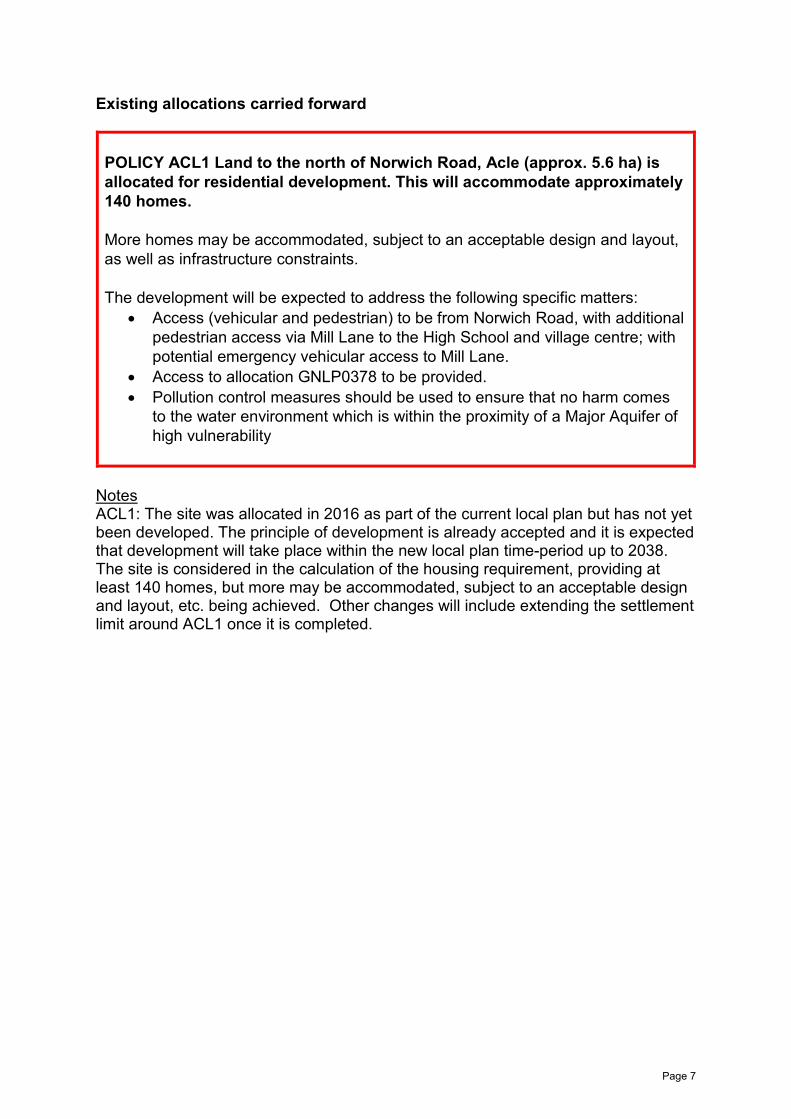
Existing allocations carried forward POLICY ACL1 Land to the north of Norwich Road, Acle (approx. 5.6 ha) is allocated for residential development. This will accommodate approximately 140 homes. More homes may be accommodated, subject to an acceptable design and layout, as well as infrastructure constraints. The development will be expected to address the following specific matters:
• Access (vehicular and pedestrian) to be from Norwich Road, with additional pedestrian access via Mill Lane to the High School and village centre; with potential emergency vehicular access to Mill Lane.
• Access to allocation GNLP0378 to be provided. • Pollution control measures should be used to ensure that no harm comes
to the water environment which is within the proximity of a Major Aquifer of high vulnerability
Notes ACL1: The site was allocated in 2016 as part of the current local plan but has not yet been developed. The principle of development is already accepted and it is expected that development will take place within the new local plan time-period up to 2038. The site is considered in the calculation of the housing requirement, providing at least 140 homes, but more may be accommodated, subject to an acceptable design and layout, etc. being achieved. Other changes will include extending the settlement limit around ACL1 once it is completed.
Page 7
Page 8

POLICY ACL2 Land to the south of Acle station, between Reedham Road and New Reedham Road (approx. 2.0 ha) is allocated for residential and employment development. This will accommodate approximately 30 homes, with the remainder for class B1 employment. The development will be expected to address the following specific matters:
• Access (vehicular and pedestrian) to be from New Reedham Road. • Off-site improvements to the highway network may also be necessary, as
required by the Highway Authority, potentially including pedestrian access to the rail station to the north and to Reedham Road.
• Pollution control measures should be used to ensure that no harm comes to the water environment which is within Source Protection Zone 2.
• Development must ensure no detrimental effect on Broadland SPA, Broadland Ramsar and Broads SAC.
Notes ACL2: The site was allocated in 2016 as part of the current local plan but has not yet been developed. The principle of development is already accepted and it is expected that development will take place within the new local plan time-period up to 2038. The site is considered in the calculation of the housing requirement, providing at least 30 homes, but more may be accommodated, subject to an acceptable design and layout, etc. being achieved. Other changes will include extending the settlement limit around ACL2 once it’s completed.
Page 9

Page 10

POLICY ACL3 Land at the former station yard, west of B1140, Acle (approx. 1 ha) is allocated for small scale employment use. This is likely to be within class B2. The development will be expected to address the following specific matters:
• Access (vehicular and pedestrian) to be from New Reedham Road. • Access is restricted because of the low bridge which crosses the road
which serves the site, limiting the size of vehicles. • There are no main sewers or water mains on site, and it will be necessary
for developers to investigate the possibility of connecting to the public foul sewer or provide other suitable means.
• There is a metered water supply to the existing station buildings and agreement must be reached with British Rail to connect this supply.
• No easily accessible gas main exists which is suitable to serve the site. A gas supply may be able to be made available but offsite costs are likely to be relatively high.
• Pollution control measures should be used to ensure that no harm comes to the water environment which is within the proximity of a Major Aquifer of high vulnerability.
• A study to investigate land contamination may be required.
Notes ACL3: The site was allocated in 2016 as part of the current local plan but has not yet been developed. The principle of development on the site has already been accepted and it is expected that development will take place within the new local plan time-period up to 2038. The site is re-allocated for employment/commercial development. Other changes will include extending the settlement limit around ACL3 once it is completed.
Page 11

Page 12

Reasonable Alternatives
Address Site Reference
Area (ha)
Promoted for Reason for not allocating
Acle NO REASONABLE ALTERNATIVES
Unreasonable Sites - Residential
Address Site Reference
Area (ha)
Promoted for Reason considered to be unreasonable
Acle Borderland Farm, Damgate Lane
GNLP0007 1.07 Up to 12 dwellings
This site is not considered to be suitable for allocation as almost half the site is in flood zones 2 or 3 which would significantly affect the developable area, meaning that the site would be unlikely to meet the minimum requirement for allocation of 12-15 dwellings. There is no safe walking route to the local primary school, the site is in close proximity to the sewage works, the Broads and Damgate Wood County Wildlife Site.
Land at Acle, South Walsham Road
GNLP0384 4.88 145 dwellings This site is not considered to be suitable for allocation on highway and landscape grounds. Development would require a 2m wide footway at the north east side of South Walsham Road and insufficient highway is available to provide this.
Page 13

Address Site Reference
Area (ha)
Promoted for Reason considered to be unreasonable
Land at Beighton Road/ Norwich Road
GNLP0417 9.40 Approx. 204 dwellings, associated access and open space
This site is not considered to be suitable for allocation as it is not particularly well related to services or the character of the town as it is wedged south of the A47 and north of the rail tracks. In addition, there is no safe walking route to the local primary school.
Land at Jolly’s Lane
GNLP0421R 7.00 Approx. 150 dwellings with open space
This site is not considered to be suitable for allocation as it is located to the south of the A47 and the rail tracks and is therefore not particularly well related to services and facilities or the character of the town. In addition, there is no safe walking route to the local primary school.
Page 14

Address Site Reference
Area (ha)
Promoted for Reason considered to be unreasonable
Land at Norwich Road
GNLP0427 2.78 Mixed use residential (unspecified number)
This site is not considered to be suitable for allocation as it is distant from the existing settlement limit and therefore not particularly well related to form and character or the services and facilities in the town. Due to its proximity to the A47 noise and pollution is also likely to be an issue.
Land north of Hillcrest
GNLP1022 2.90 Up to 60 dwellings
This site is not considered to be suitable for allocation as it is distant from the existing settlement limit and therefore not particularly well related to form and character or the services and facilities in the town. Due to its proximity to the A47 noise and pollution is also likely to be an issue.
Page 15

Address Site Reference
Area (ha)
Promoted for Reason considered to be unreasonable
Land north of Charles Close
GNLP1049 5.40 Residential (unspecified number)
This site would need to be developed with GNLP0384 to gain access and is therefore considered to be unreasonable on highway grounds as GNLP0384 requires footway provisions that are not possible within the existing highway. The development of this site would also have landscape issues.
Page 16