Embed Size (px)
DESCRIPTION
This is a portfolio from my first 2 years at the Tulane School of Architecture.
Citation preview

Tulane School of ArchitectureAcademic Portfolioyear I + II
Site as Dwelling
Exquisite Object
Mapping the City Precedent Study
Case Study
Visitors Center
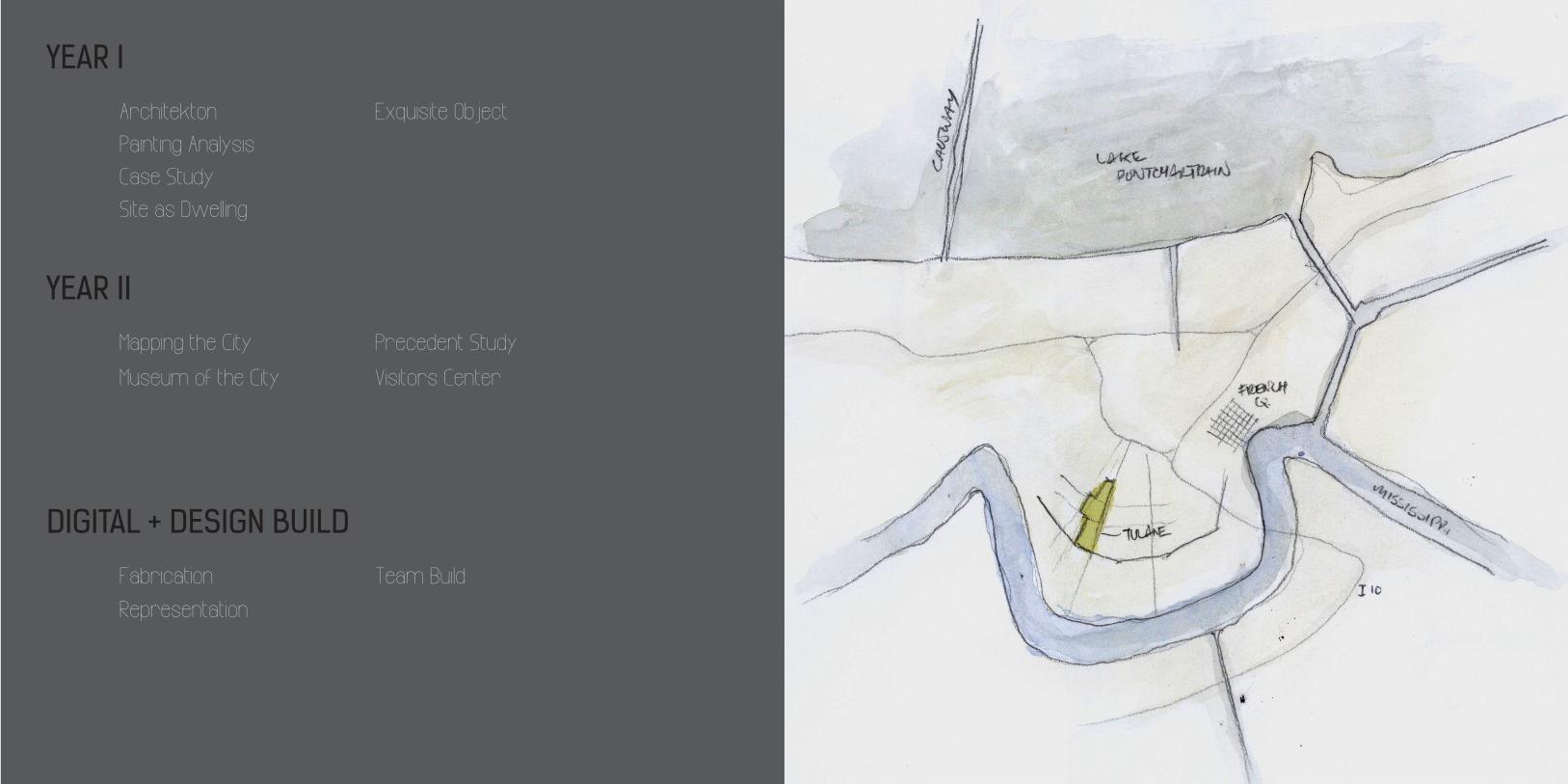
YEAR I
DIGITAL + DESIGN BUILD
YEAR II
Painting Analysis
Team BuildFabrication
Representation
Museum of the City
Architekton

YEAR I
object drawingsobject casepassagewaymuseum
Site as Dwelling
Exquisite Object
Case Study
Painting Analysis
Architektoncollapse
The Music Lesson, vermeer
The Stretto House, steven holl
site as sequence

Painting Analysis
THE MUSIC LESSONThis project focused on analyzing “The Music Lesson” by Vermeer, through diagrams. Both 2d and 3d diagrams helped pare down the scene in the painting.
Architekton
COLLAPSE
This project was an exercise in form making. I chose the word “collapse” to be the idea of my project. The size was constrained by the golden ratio, which I used to generate some of the geometry.
Professor Marilyn Feldmeier :: spring 2012

Case Study
This project was to document and diagram the Stretto House by Steven Holl. Drafting by hand I recreated his sections, plans, and elevations, practicing with line weights. I also diagrammed the house, from structure to geometry.
STRETTO HOUSE
long section
east elevation
west elevation
first floor plan
site plan
front elevation

Site As Dwelling
The project was to create a landscape and home for an artist. My idea was to create moments as you transcend down the landscape, so that in the end the sequence of home pieces is framed in a composition.
SITE AS SEQUENCE

Exquisite Object
RATCHET
To start this project I chose the ratchet as an exquisite object. From basic observation and measurement I was able to hand-draft the ratchet in multiple views.
Next I created a “case” to hold the object and show its movements. From this case I took serial sections and abstracted those drawings, as well as giving them scale through the placement of figures.
Professor Thaddeus Zarse :: spring 2012

The following phase was to take those sections and create a passage from them. The passage is defined as: entry, sequence, gallery.
VIEW
VIEW
SITE
1 LVL
2 LVLS
3 LVLS
TERTIARY ROUTE
TERTIARY ROUTE
In the final phase we were given a site on Freret Street to erect a museum; using the sequence from our passage as well as the motion of our object. From the site visit I was able to make digital diagrams relaying important contextual information.
Iterations in study models led to the final building form.
FRERET STREETSIDEWALK
YARD SPACE
SITE
EAST WEST
Passageway

My museum drew from the nearby grid change of roads to make a composition of two different systems interacting. This play of two grids was revealed at key moments and highlighted by gaps.
DSGN-1200 / ADGM-1200 EXQUISITE OBJECT DIAGRAM SAMUEL NAYLOR
ROTA
TION
C O M P R E S S ION
FRERET STREET ELEVATION 1/8”=1’
FIRST FLOOR PLAN1/8” = 1’-0”
LOBBY
CAFE
GALLERY
OUTDOOR GARDEN
MEETING ROOM
ADMIN OFFICE
BATHROOM
STORAGE
DIAGRAM
SELECTED ARTWORK
SECTION A1/8” = 1’-0”
SECTION C1/8” = 1’-0”
FRERET STREET ELEVATION1/8” = 1’-0”
SECTION B1/8” = 1’-0”
SECOND FLOOR PLAN1/8” = 1’-0”
OUTDOOR EATING
OUTDOOR GARDEN
BATHROOM
A
B
FRANK STELLAODELSK III
GERHARD RICHTERABSTRACT PAINTING
SOL LEWITTOPEN GEOMETRIC STRUCTURE
Museum

Mapping the City new orleanscentral citymuseum of the city
Precedent Studysaynatsalo town hall + okradiagramming saynatsalovisitors center at igualada
year II

Mapping the City
NEW ORLEANS
This project focused on hand drawn diagrams as a method of mapping the city of New Orleans. Through intensive research I was able to collect a series of maps and create many diagrams to start understanding more about the city and its history.
Professor Sarah Howell :: fall 2012

A SINKING CITYWithout water to provide density in the soil the land
started to sink. The diagram below represents where there is the highest velocity of subsidence, as well as
the urban form around those areas. The city was first developed in areas where subsidence occurs at a slow pace. Parallels can be drawn between where
the highest velocity of subsidence occurs and building age and type that rest on that ground. building age and type that rest on that ground.
SECTION OVER TIME At first the city developed along the natural elevations in the river basin, but when the time came to expand, the swamps were drained and the wetland became a popular suburban retreat. On which the ground slowly subsided over time and led to New Orleans having places below sea level particularly where specific building types lie,sea level particularly where specific building types lie,in part because of their foundation systems.
Through looking at the city ground levels over time it is clear that certain areas of the city have sunk more than others. Some of this is due to foundation types, and also in which areas were drained swamps. By looking as subsidence maps and diagramming the occupation of the city over time I was able to merge the information together.
Our city used to be more defined by the river and lake, this diagram hopes to show the lack of current access to the waterways. It is clear in contrast to the linear water model overlaid, that compared to the amount of water present the ability for the public to interact with it is minimal.
CONNECTION TO WATER // PATHWAYS
OLD - CURRENT CANALSBefore the modenization of the New Orelans drainage system
canals used to run alongside every street which gave people moreinteraction with the water every day; whether it was in the form
of an obsticle or observational element. As the city progressedcanals were covered and underground pipes did most of the work.Unfortunatly even in the canals that remain, public access to themUnfortunatly even in the canals that remain, public access to them
became limited. Perhaps this situation, a consequence of industrialization led the people who live here to
neglect the aquatic forcesthat so shape their built enviroment.
To control water flow and drain out the swamps the city originally had to construct many irrigation canals. Over time the city had covered these and converted them to underground pipes. Similarly levees have been raised and thus even the view of water was cut off from most people. Much of this disconnect with water has led to people in the city remaining ignorant of the systems that sustain them.
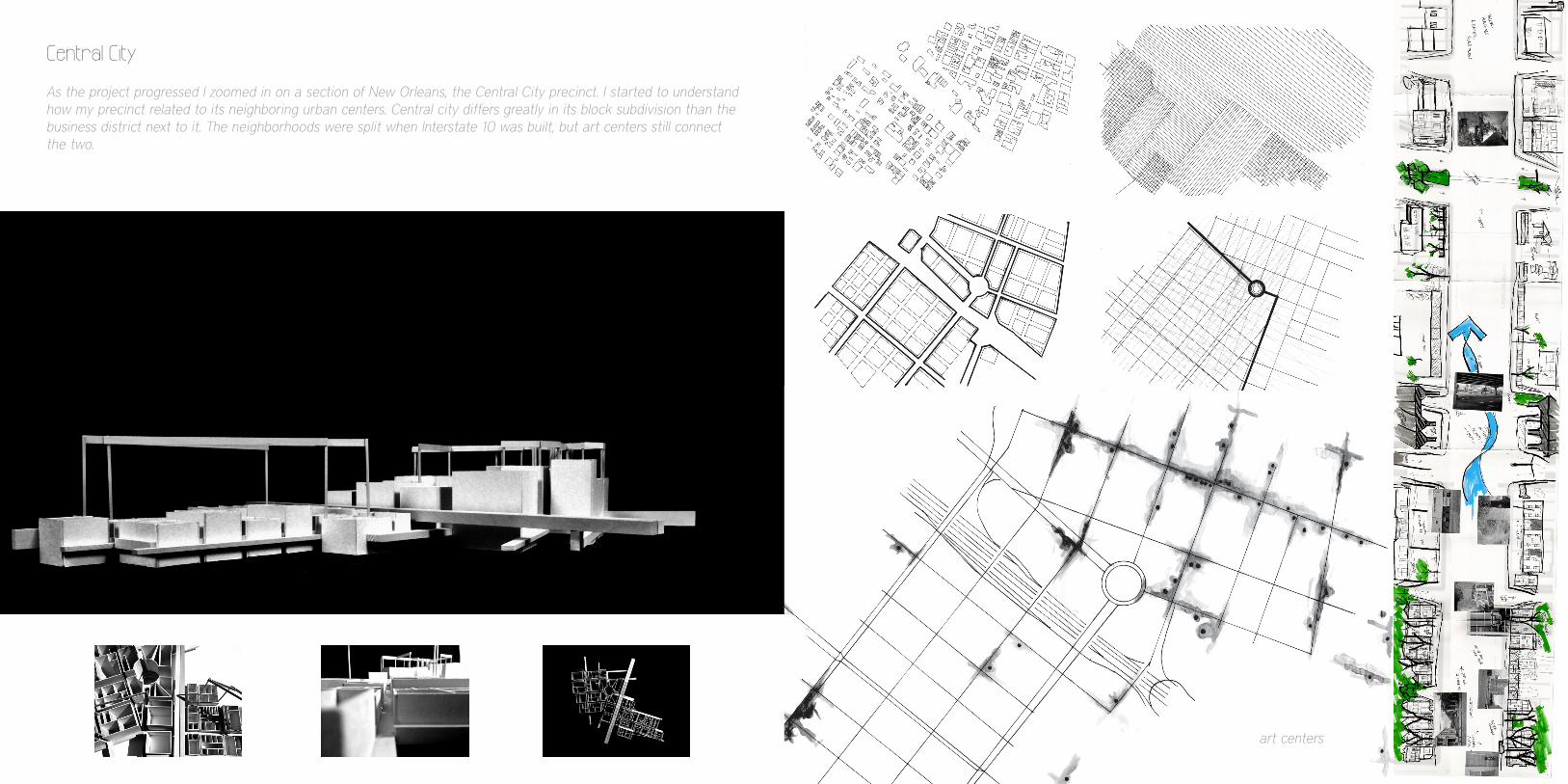
As the project progressed I zoomed in on a section of New Orleans, the Central City precinct. I started to understand how my precinct related to its neighboring urban centers. Central city differs greatly in its block subdivision than the business district next to it. The neighborhoods were split when Interstate 10 was built, but art centers still connect the two.
ART/CULTURE CENTERS1:400
art centers
Central City

Museum of the City
This project was to create a museum of the city. The program was to have 6 different spaces: linear volume, cubic volume, wall of books, wall of light, wall of the surveyor, and wall of the city. The process was focused on site context. For this project I worked with a partner [Alyssa Rogut]; we produced and designed together the work for this building.
SOUTHWEST SECTION

ENTRY // EXIT VOID // SLIDING VOLUMES
ANCHORING THE BLOCK // CONNECTING BACK CAFE RECONCILE
COMPLETING THE PATTERN // VACANT LOTS
We drew from earlier in the “CITY” project to frame our work as a building that respects the decay of the city while still showing a rebirth. Throughout the design we respected site patterns, and conditions. Hand drawn work was a major component of this project.

This project began by diagramming The Saynatsalo Town Hall, by Alvar Aalto, as well as the vegetable okra. I drew connections between their structure, formal relationship, as well as relation to ground. The next phase focused on digitally and physically diagramming the town hall.
SAYNATSALO TOWN HALLPrecedent Study
STRUCTURAL HIERARCHY AXIS TO CELL RELATIONSHIPCONNECTION TO THE GROUND SPATIAL DENSITY NUTRIENT/LIFE FLOW
Professor Scott Ruff :: spring 2013

PROGRAM SITE INTERVENTIONGEOMETRIC TRANSFORMATION CIRCULATION
PUBLIC PRIVATE
SMALL GOVERNMENT
RESIDENTIAL
SERVICE
BUSINESS OFFICES
STORES
SERVICE
RESIDENTIAL
COUNCIL CHAMBER
GOV. OFFICES
PUBLIC LIBRARY
VERTICAL
HORIZONTAL
ENTRY
MEDIUM
LARGE
PERMIABLE
SOLID
SPATIAL DENSITY // TRANSPARENCY STRUCTURE
COMMERCIAL
circulation site intervention spatial density geometric transformation program structure
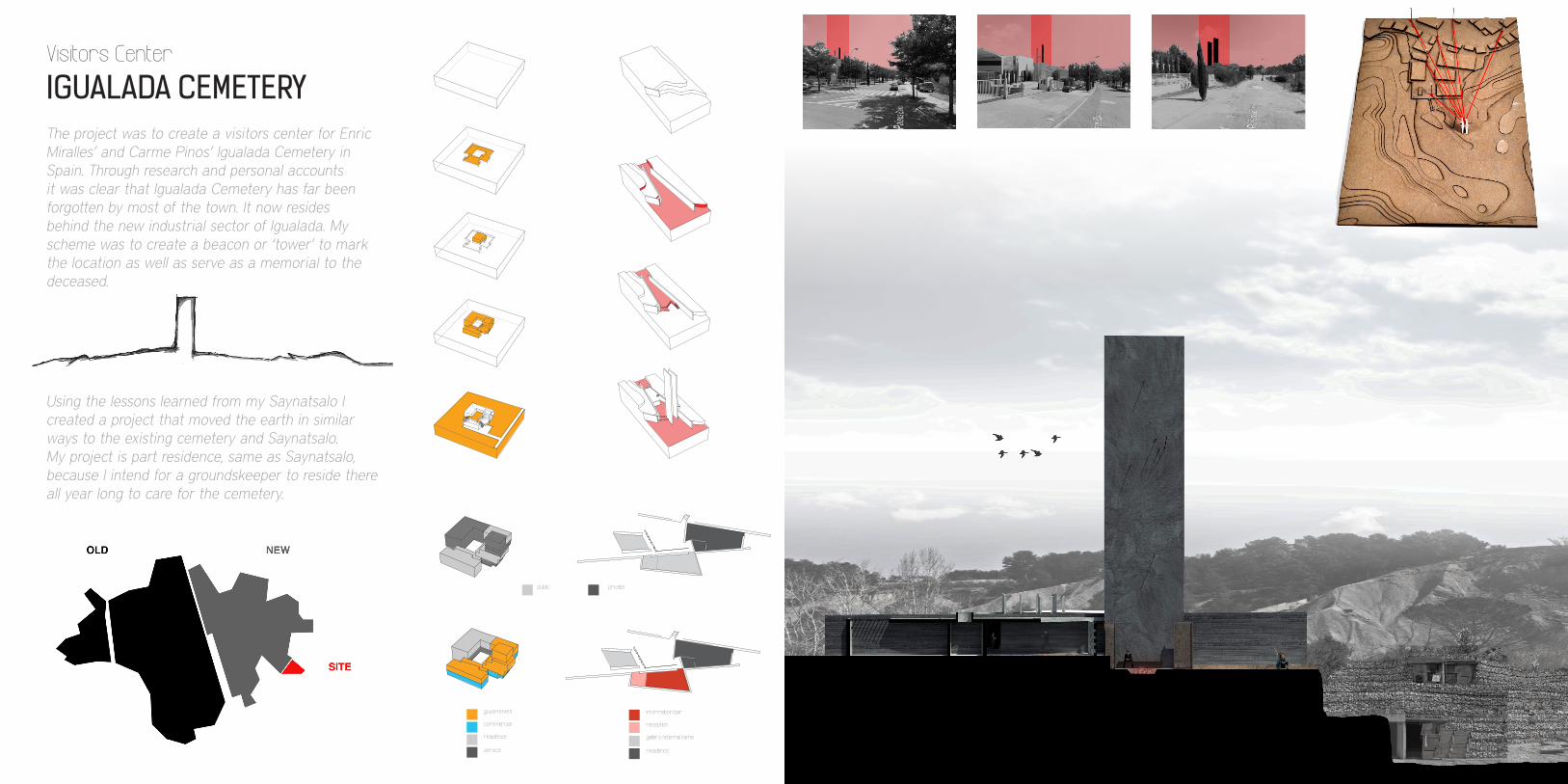
IGUALADA CEMETERYVisitors Center
The project was to create a visitors center for Enric Miralles’ and Carme Pinos’ Igualada Cemetery in Spain. Through research and personal accounts it was clear that Igualada Cemetery has far been forgotten by most of the town. It now resides behind the new industrial sector of Igualada. My scheme was to create a beacon or ‘tower’ to mark the location as well as serve as a memorial to the deceased.
PROGRAM SITE INTERVENTIONGEOMETRIC TRANSFORMATION CIRCULATION
PUBLIC PRIVATE
SMALL GOVERNMENT
RESIDENTIAL
SERVICE
BUSINESS OFFICES
STORES
SERVICE
RESIDENTIAL
COUNCIL CHAMBER
GOV. OFFICES
PUBLIC LIBRARY
VERTICAL
HORIZONTAL
ENTRY
MEDIUM
LARGE
PERMIABLE
SOLID
SPATIAL DENSITY // TRANSPARENCY STRUCTURE
COMMERCIAL government
commercial
residence
service
PROGRAM SITE INTERVENTIONGEOMETRIC TRANSFORMATION CIRCULATION
PUBLIC PRIVATE
SMALL GOVERNMENT
RESIDENTIAL
SERVICE
BUSINESS OFFICES
STORES
SERVICE
RESIDENTIAL
COUNCIL CHAMBER
GOV. OFFICES
PUBLIC LIBRARY
VERTICAL
HORIZONTAL
ENTRY
MEDIUM
LARGE
PERMIABLE
SOLID
SPATIAL DENSITY // TRANSPARENCY STRUCTURE
COMMERCIAL
public private
information bar
reception
gallery/eternal fame
residence
PROGRAM SITE INTERVENTIONGEOMETRIC TRANSFORMATION CIRCULATION
PUBLIC PRIVATE
SMALL GOVERNMENT
RESIDENTIAL
SERVICE
BUSINESS OFFICES
STORES
SERVICE
RESIDENTIAL
COUNCIL CHAMBER
GOV. OFFICES
PUBLIC LIBRARY
VERTICAL
HORIZONTAL
ENTRY
MEDIUM
LARGE
PERMIABLE
SOLID
SPATIAL DENSITY // TRANSPARENCY STRUCTURE
COMMERCIAL
Using the lessons learned from my Saynatsalo I created a project that moved the earth in similar ways to the existing cemetery and Saynatsalo. My project is part residence, same as Saynatsalo, because I intend for a groundskeeper to reside there all year long to care for the cemetery.
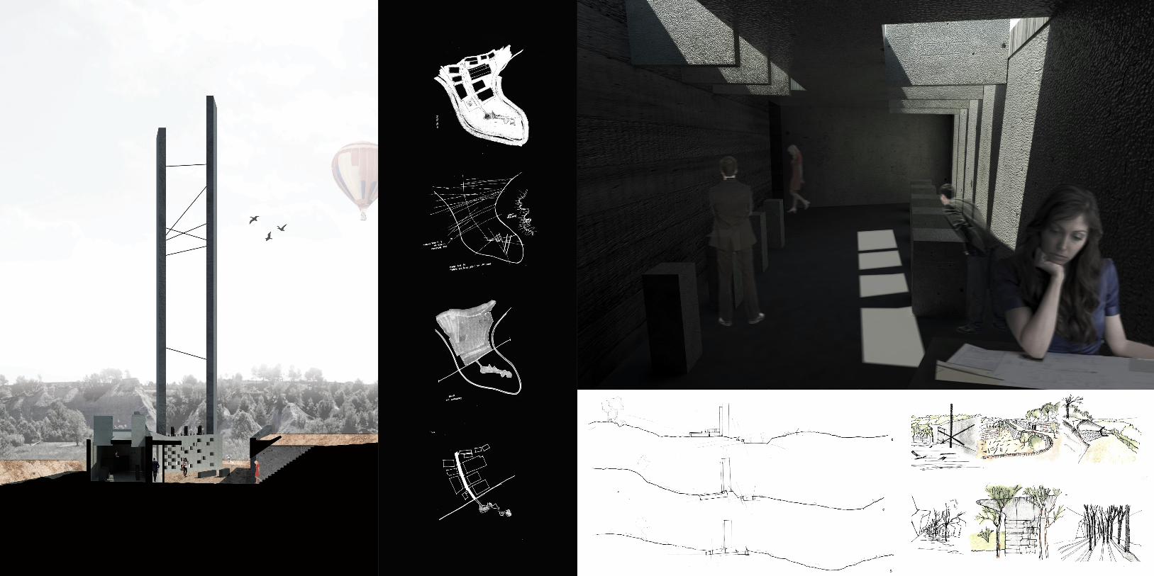

The tower is consists of two planes rising from the landscape. A series of steel rods placed irregularly emphasizes their rigidity. At the human scale an eternal flame is burning in the ground. This space is the most public, where locals visiting their family members can burn the old flowers on their tombs while they replace them with new ones.
site plan

Design Buildsukkota-week 2012a-wknd 2013global brigades
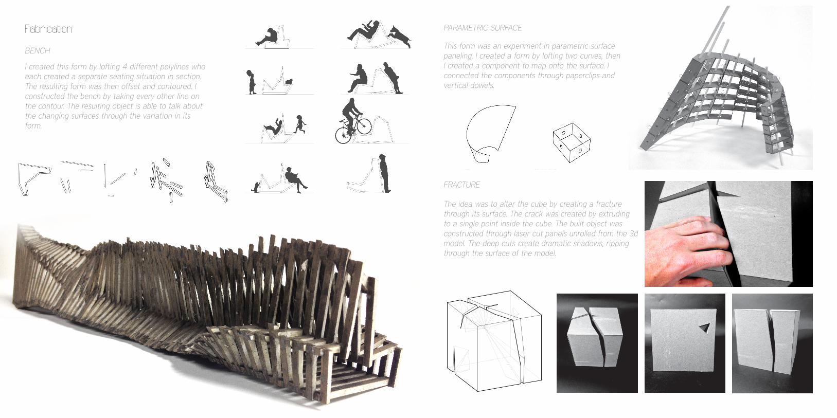
Fabricationfractured cubeparametric surfacebench
DIGITAL + DESIGN BUILD
Representationwatercolorvray for rhinosketches
Fabrication
ADGM 3200-01 Digital Media III: Advanced Computer Modeling Tulane School of Architecture _ Spring 2013
FOLD / UNFOLDAssignment _01
NAME:TA: 1/2
SAM NAYLORGREGORY MATHIEU
AXON
ELEVATIONS
FRACTUREthe idea is to create a central fracture that both highlights the rigidness of the cube, and provide compostional beauty in the loud and quiet facades
// all fractures radiate from a single point within the cube // this con-trast of diagonal slits to the orthagonal mass draws attention to the rigidness of the cube // the main cavern through the volume seper-ates it into multiple parts, however it unites the cube in the way the joints resolve at ends //
I created this form by lofting 4 different polylines who each created a separate seating situation in section. The resulting form was then offset and contoured. I constructed the bench by taking every other line on the contour. The resulting object is able to talk about the changing surfaces through the variation in its form.
This form was an experiment in parametric surface paneling. I created a form by lofting two curves, then I created a component to map onto the surface. I connected the components through paperclips and vertical dowels.
The idea was to alter the cube by creating a fracture through its surface. The crack was created by extruding to a single point inside the cube. The built object was constructed through laser cut panels unrolled from the 3d model. The deep cuts create dramatic shadows, ripping through the surface of the model.
BENCH
PARAMETRIC SURFACE
FRACTURE

Representation
PLANET NABOO _CHOMMELL SECTOR
LBC QUADTULANE UNIVERSITY
sketch in pen and marker
eames house int. eames house ext. bench on lbc quad rendering
bench form as towers in star wars universe

Architects Weekend 2013 Architects Week 2012
This was a one week long team design build project. The idea was to create a “soap box” like structure that inspires people to talk, sing, or perform. Our solution was a transportable and transformable platform for inspiration. It is contructed out of wood, canvas, and LED lights. The structure can be easily packed up and rolled across smooth ground. The project was very successful in inspiring performances across the Tulane campus.
This three day design build project focused on using grasshopper for rhino and other plug-ins to create a 3d surface. Using geodesic curves we were able to contour
the surface into members. Grasshopper programming allowed us to set a confined length for the wood and
bending strength, leading to a close connection between the digital and physical. Andrew Kudless was the faculty
advisor who helped our team learn the advanced technologies and complete the project.
GRIDSHELL LOTUS

Sukkot Design Build
In the Jewish tradition it is customary to build a temporary structure for the holiday of Sukkot.
The project was to build a sukkot structure while staying within the kosher rules. As a team we designed a partially enclosed bench structure.
The form was based on the fibonacci sequence. The structure was built out of wood, with metal bracket connections. This project was especially
difficult because of the five day design period and only a week to build.
Global Brigades Competition Enty + Design Build
Global Brigades is the largest student led international development organization. I have been working with them extensively over the past two years. This project was part of a team design competition to create a health center in rural Honduras. Our project utilized local materials and sustainable building practices. The project also lifted the building off the ground to minimize excavation and flood damage.
The second part of this project was to travel in country and work on the project. Even though our design did not win, we broke ground on a different teams design, as well as working on past ongoing projects.
FIBONACCI SUKKAH HEALTH CENTER