Embed Size (px)
Citation preview

Document 1 - An Introduction to the North Norfolk Coastal Environment The information provided is intended to provide a simple introduction to the cliffed coastline of North Norfolk and consequently some issues are simplified and others ignored. Numerous text books and papers exist on coastal processes and these should be consulted if extra detail or accuracy is desired. A Summary of the Geology of the North Norfolk Coast In order to understand the geology of North Norfolk it is necessary to have a basic knowledge of the geological time scale, which is listed in Figure 1. The Quaternary Period is divided into two Epochs, the Pleistocene (from 2 million to 10,000 years ago) and the Holocene (from 10,000 years ago to the present day). The Quaternary Period has been characterised by a number of glacial and interglacial stages. The glacial stages or ice ages were cold periods of time when the large areas of the globe such as North America, Scandinavia and Britain were covered by large ice sheets. These glacial stages have alternated with warm interglacial stages when the ice was confined to the Arctic and Antarctic regions. The following points are of importance here: • The Holocene Epoch corresponds to the present day interglacial stage (the
Flandrian) in which we live. • The last glacial stage or Ice Age was the Devensian, which lasted from
about 115,000 to 10,000 years ago. • The Anglian glaciation was the 3rd from last glacial stage and occurred
between 400,000 and 500,000 years ago. This stage was the last time the ice sheets reached East Anglia and it resulted in the deposits known as the Corton Formations (see below)
• The Anglian glaciation was preceeded by the Cromerian and Pastonian
interglacial, and Beestonian glacial stages. The Kesgrave Formations are believed to have been deposited at this time.
The North Norfolk coastline is primarily composed of Quaternary deposits underlain by chalk bedrock. The Chalk is composed of calcium carbonate, which comes from the remains of microscopic marine organisms that lived in a warm shallow sea that covered this area during the Cretaceous period, between 62 and 132 million years before present. Chalk is a soft rock but is relatively more resistant to erosion than the other deposits found on the North Norfolk Coast. The chalk is visible in the base of the cliffs at Weybourne, while between Sheringham and West Runton it is exposed as a wave cut platform at low water. From there the chalk falls to below low water (about -2.1 metres Ordnance Datum Newlyn) just west of Cromer Pier while, to the east of Cromer, the chalk bedrock is not exposed on the East Anglian Coast again. Borings at Overstrand have indicated that the chalk is located at around –5 metres O.D. Newlyn.
Peter Frew, Coastal Management Unit NNDC 2009 1
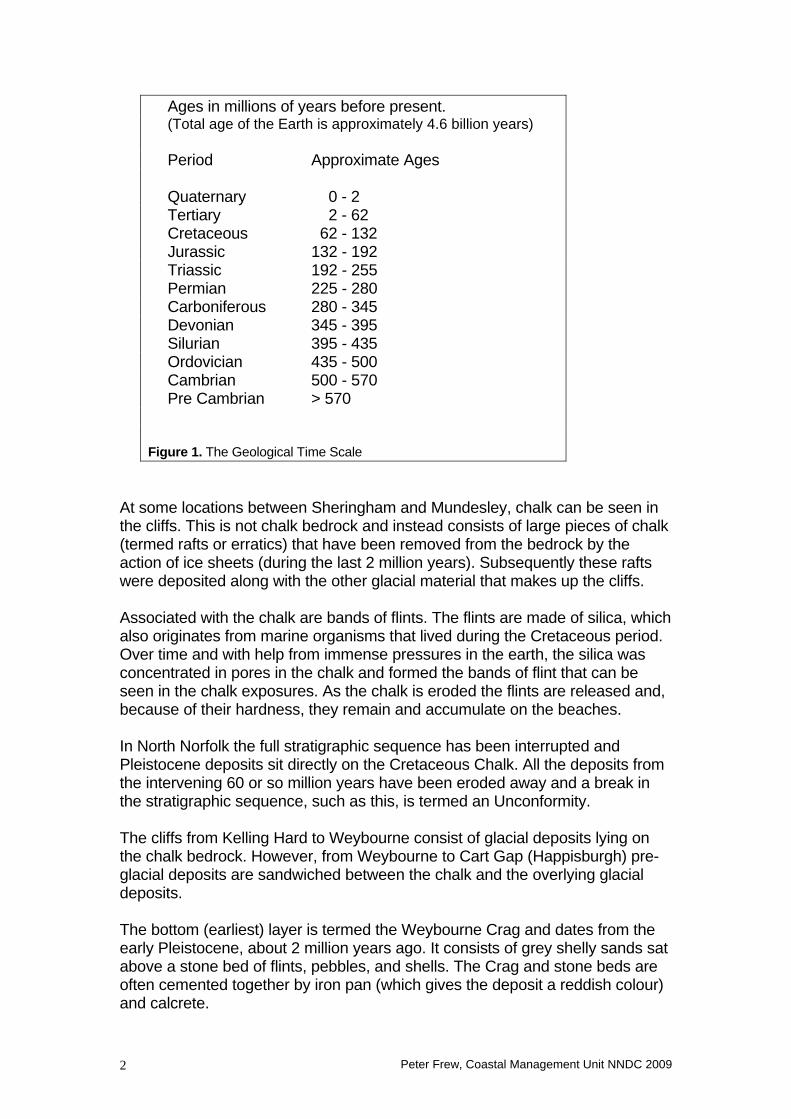
Ages in millions of years before present. (Total age of the Earth is approximately 4.6 billion years) Period Approximate Ages Quaternary 0 - 2 Tertiary 2 - 62 Cretaceous 62 - 132 Jurassic 132 - 192 Triassic 192 - 255 Permian 225 - 280 Carboniferous 280 - 345 Devonian 345 - 395 Silurian 395 - 435 Ordovician 435 - 500 Cambrian 500 - 570 Pre Cambrian > 570 Figure 1. The Geological Time Scale
At some locations between Sheringham and Mundesley, chalk can be seen in the cliffs. This is not chalk bedrock and instead consists of large pieces of chalk (termed rafts or erratics) that have been removed from the bedrock by the action of ice sheets (during the last 2 million years). Subsequently these rafts were deposited along with the other glacial material that makes up the cliffs. Associated with the chalk are bands of flints. The flints are made of silica, which also originates from marine organisms that lived during the Cretaceous period. Over time and with help from immense pressures in the earth, the silica was concentrated in pores in the chalk and formed the bands of flint that can be seen in the chalk exposures. As the chalk is eroded the flints are released and, because of their hardness, they remain and accumulate on the beaches. In North Norfolk the full stratigraphic sequence has been interrupted and Pleistocene deposits sit directly on the Cretaceous Chalk. All the deposits from the intervening 60 or so million years have been eroded away and a break in the stratigraphic sequence, such as this, is termed an Unconformity. The cliffs from Kelling Hard to Weybourne consist of glacial deposits lying on the chalk bedrock. However, from Weybourne to Cart Gap (Happisburgh) pre-glacial deposits are sandwiched between the chalk and the overlying glacial deposits. The bottom (earliest) layer is termed the Weybourne Crag and dates from the early Pleistocene, about 2 million years ago. It consists of grey shelly sands sat above a stone bed of flints, pebbles, and shells. The Crag and stone beds are often cemented together by iron pan (which gives the deposit a reddish colour) and calcrete.
Peter Frew, Coastal Management Unit NNDC 2009 2

The Crag is overlain by a succession of shallow-water deposits known as the Cromer Forest Bed Series (or Kesgrave formation). The Forest Bed series contains various layers of clays and sands deposited under both freshwater and marine conditions. The deposit represents a complicated series of Pleistocene climatic events that terminate at the beginning of the Anglian Glacial stage. The Forest Bed series is particularly well known for its fossils. When, during glacial stages, ice sheets and glaciers spread over the ground they erode, transport and deposit huge quantities of material. However, once the ice melts and retreats this material is left as continuous sheets or mounds of heterogeneous and generally structureless material known as Till or Boulder Clay. Till can be a very variable deposit but it does have certain general properties. There will be a large range of grain sizes, with hard rock fragments up to boulder size surrounded by softer matrix material consisting of sands and clays. The rock fragments themselves may come from distant locations because glaciers have carried them; indeed the North Norfolk cliffs contain rocks from Scandinavia for precisely this reason. Generally, till has no internal structure or layers; however, in some instances the till is sorted by the huge volumes of water produced by the melting ice, and it may then form layers of sand and gravel or deposits of silts and clays. The Anglian glacial stage is believed to be the last time that ice covered North Norfolk and consequently the deposits laid down at this time form the major part of the North Norfolk Cliffs. These superficial glacial deposits overlie the pre-glacial strata described above. The layers of material are clearly exposed at many locations and many scientists have described the series of deposits found. Unfortunately the layers vary considerably along the coast and even at a specific point people may disagree on exactly what is present. The result is that numerous stratigraphic sequences have been proposed for the North Norfolk cliffs, often using different terminology. Even today there are still debates as to when deposits were formed and the events they represent. For this reason it is easiest here to use a very simple system for describing the glacial deposits. If a particular section of coast is being studied then it is advisable to use other sources of information to obtain a more detailed description of the specific local geology. The stratigraphy proposed by Reid in 1882 is most applicable to the Cromer / Overstrand cliffs and identifies two units, the Cromer Till located beneath the Contorted Drift. These two units are sometimes combined and referred to as the Corton formation. The Cromer Till actually consists of two layers of till separated by a stratified deposit of silts and clays that is thought to represent glacial lake sediments. The lower till layer is dark grey in colour and contains pebbles of flint and various igneous rocks. The upper till layer is grey-blue in colour with about 40% of the material consisting of chalk pebbles. The Contorted Drift is comprised of a number of depositional units and is characterised by deformation of the initially layered deposits. This deformation can be clearly seen in sections of recently exposed cliff face and appears as
Peter Frew, Coastal Management Unit NNDC 2009 3
curves and swirls in the cliff material. The lower part of this unit consists of a sand deposit overlain by a layer of till. On top of these sit stratified layers of pale yellow sands and gravels. The top of the cliffs generally has a covering of windblown sand and, on this; a layer of soil has developed which supports the cliff top vegetation. Coastal Processes on the North Norfolk Coast Cliffs and Cliff Failure The North Norfolk cliffs, because of their glacial origins, have two characteristics that are important when considering coastal erosion. Firstly, they are made of soft heterogeneous (made of many different deposits) material with a low shear strength, which means that they are very vulnerable to wave erosion and failure caused by undercutting. Secondly, the sand and gravel components of the glacial deposits are permeable, while the clays are impermeable. The impermeable clay structure can intercept water percolating through cliffs, causing it to pond above this layer and discharge from the cliff face. This leads to an increase in pore water pressure in the cliff, reduces the shear strength of the cliff, and may result in landsliding. Consequently the principle causes of erosion on the North Norfolk coast are wave action and the presence of groundwater. The severity of wave induced erosion will depend on beach width, beach gradient, the presence of defences and tidal range. A wide, shallow beach will absorb more incoming wave energy than a narrow, steep beach and, therefore, wave action becomes a dominant erosional process on narrow, steep beaches without any defences. Tidal range (tides are discussed in more detail later on) is an important factor as it determines the vertical height over which this erosional process can operate. The mean tidal range is about 4m at Weybourne and decreases to the east, dropping to about 3m at Happisburgh. Wave action can undercut the cliffs making them prone to failure. Failures resulting purely from wave erosion tend not to be very large but do occur frequently. On low cliffs (10 metres or so), such as at Happisburgh, failure is often through simple vertical debris falls following undercutting. On slightly higher cliffs (about 20 metres), from West Runton to Cromer for example, translational slides become more common. Translational failures occur in predominately dry cliffs and produce shallow surface slides, typically 3-4 metres deep and 10-20 metres wide (see Figure 2). They occur because the cliff material is not strong enough to maintain the cliff face at steep angles. Wave action will quickly remove fallen material from the base of the cliff, maintaining the face at a steep, unstable, angle and leaving it prone to further failure. However, wave action can only cause erosion if it can reach the base of the cliff and, in many locations; defences prevent or limit the extent of wave induced erosion. Groundwater, the other principle cause of erosion, can cause problems at both defended and undefended locations.
Peter Frew, Coastal Management Unit NNDC 2009 4

Groundwater is a problem because of the impermeable clay stratum found in the complex glacial deposits that make up the North Norfolk coast. The clay layers intercept water percolating down through the cliff, causing ponding of the water. This results in saturation of the clay, an increase in pore water pressure, and can lead to cliff failure. Sometimes groundwater will only cause small mudflows or slumps on the cliff face but on the lengths of high cliffs (40-70 metres) groundwater can cause large mudslides and also failures known as deep-seated rotational slides. These can extend for up to 150 metres along the coast and may contain up to 250,000 cubic metres of material. Large, groundwater induced, failures generally occur between Cromer and Mundesley; although failures of this nature are much less frequent than the smaller slumps, translational slides and debris falls that also occur.
Figure 2. Illustrations of a Debris Fall and Translational Failure.
BEACH
BEACH
CLIFF
CLIFF
SHALLOW SLIDE OF MATERIAL
VERTICAL FALL OF MATERIAL
DEBRIS
DEBRIS
DEBRIS FALL
TRANSLATIONAL FAILURE
Deep-seated rotational slides are essentially cyclic in nature and this cycle is illustrated in Figure 3. The initial failure takes place along a slide surface that is curved upwards from the cliff bottom to the cliff top. The failed material is deposited on the beach to form the "toe" of the slide. Wave action will remove this “toe” over a period of a few years while, at the same time, water ponds on top of the original failed material. A steep scarp is formed between the cliff top and the failed material, and this is open to small-scale failure. Eventually the
Peter Frew, Coastal Management Unit NNDC 2009 5

rear scarp slope will be exhausted of material and the sea will finish removing the “toe” of the rotational slide. This leaves the cliff standing at a steep, unstable angle again, and it is susceptible to further rotational failures.
Figure 3. The Cyclic Development of a Coastal Deep-Seated Rotational Slide (based on: Bromhead, E.N. [1979] Factors affecting the transition between various types of mass movement in coastal cliffs consisting largely of over-consolidated clay, with special reference to southern England. Quarterly journal of Engineering Geology, 12,291-300)
While landslides are the dominant erosional mechanism, surface runoff and weathering also cause mudflows and gullying that act to erode the cliff face. Weathering of the bare face can lead to dry flowage where the glacial deposits are broken down into granular material and move down slope under the influence of gravity. These processes operate almost continually, but are of much lower magnitude than the land sliding events. Rates of erosion for the period 1966-1985 are shown in Figure 4. These erosion rates must be interpreted with care. Firstly, they are site specific. They refer to one point on the coastline, and do not necessarily give an accurate picture of erosion rates either side of that point. Secondly, erosion rates are annual averages, determined for periods of time in the order of tens of years. Being averages, they smooth out any fluctuations in the rate of erosion that may have occurred over the time period for which they are calculated. It is important to remember that if wave action could suddenly be removed from the base of the cliffs then although they would continue to fail, through the influence of groundwater and other weathering processes, the debris would be able accumulate on the beach. Over time the cliffs would recede to a shallower and more stable angle at which point one would be left with a fairly stable
Peter Frew, Coastal Management Unit NNDC 2009 6

slope, similar to a hillside. It is only the presence of wave action, continually removing material from the cliff toe, which causes the constant retreat of North Norfolk’s cliffs.
0
0.5
1
1.5
2
2.5
3
Met
res
per y
ear
Sheringham
Cromer Walcott
Mundesley
Weybourne Trimingham Happisburgh Overstrand West
Runton
Bacton
Mean erosion rate 1966-1985 Figure 4. Coastal Erosion rates in North Norfolk. Based on data from: Clayton, K.M. and Coventry, F. (1986). The conservation effectiveness of the modified coast protection work at West Runton SSSI. Nature Conservancy Council. Waves, Tides and Sediment Transport Once material has been introduced into the coastal zone, either by rivers or through the erosion of cliffs, both waves and tides can move it. In North Norfolk the cliffs are the only significant source of material. Waves are created as the wind blows over the sea surface and the moving air transfers energy to the water. When the waves reach the coast the energy they contain has to be released somehow. If the waves meet a solid structure, such as a cliff or seawall, then the energy is released explosively on impact with noise, spray and damage to the structure. However, if the wave meets a beach
Peter Frew, Coastal Management Unit NNDC 2009 7

then the energy can be gradually released as the wave uses its energy to move the beach material. It obviously takes very little energy to move a single grain of sand, but a beach has millions of sand grains. By acting in this way, beaches are very effective in dissipating wave energy and form the best possible defence again wave action. As waves move over the beach and nearshore zone, they can move sediment both on and off shore, and along the coast. On and off shore movement (Figure 5) is governed by a number of factors but, generally speaking, small low energy waves will push material on shore while large high energy waves rip material out from the beach and pull it offshore. Because of seasonal variations in wave energy, the summer is usually characterised by the low energy waves that push material onshore, building up a ridge at the back of the beach and giving the beach face a steep profile. In contrast, during the winter high energy waves erode the beach face and transport the sediment out to the nearshore zone where it may form a long-shore bar. This reduction in beach levels widens the profile of the beach and causes its overall gradient to drop. Long periods of high energy waves can cause problems because once the coast loses the protection provided by the beach, the waves are free to attack the land and cliffs behind. Longshore sediment movement or littoral drift occurs when waves approach the coast at an angle. The onshore movement of the waves can set up a nearshore current that runs parallel to the beach. This current will move material along the beach in a process known as longshore drift (Figure 6). Additionally, as waves run up the beach (Swash), they will move sediment up the beach in the direction from which they approach. Then, as the water runs back down the beach (Backwash) it does so under gravity, moving material down at right angles to the shoreline. The net result is that material is moved along the beach in a zig zag fashion termed beach drift (this movement is sometimes also called longshore drift) (Figure 7). The amount of material moved will depend on the size and energy of the waves and the size of the sediment. Significantly more material can be moved in high energy storm conditions than on a calm day with small weak waves. Larger beach material will only be moved when the waves have sufficient energy, but fine material is easily held in suspension and transported long distances.
Peter Frew, Coastal Management Unit NNDC 2009 8

WAVES
BEACH
WAVES
BEACH
ON-SHORE AND OFF-SHORE MOVEMENT
Figure 5. On and Off-Shore Movement.
WAVES
BEACH
WAVES
BEACH
LONGSHORE DRIFT
DIRECTION OF CURRENT AND SEDIMENT
Figure 6. Movement of Beach Material by Longshore Drift.
Peter Frew, Coastal Management Unit NNDC 2009 9

WAVES
BEACH
WAVES
BEACH
BEACH DRIFT
SWAS BACKWASH
DIRECTION OF MOVEMENT
Figure 7. Movement of Beach Material by Beach Drift. Tidal currents can also move beach sediments. Tides are caused by the gravitational ‘pull’ of the moon, sun and other astronomical bodies on the world’s oceans. Tides operate independently of wind force and direction and in the North Sea the rotating tidal wave produces the twice-daily Flood and Ebb tides seen on the North Norfolk coast. The Flood tide current runs from west to east and flows from three hours before to three hours after high water. The flow then changes direction from eastward to westward and the Ebb tide current runs from three hours before to three hours after low water. The strongest currents occur at high and low water, with the Ebb tide current being slightly stronger than the Flood. It is recognised that potentially tidal currents could have a significant impact on sediment movement along the North Norfolk coast because they occur continually regardless of wind and wave conditions. There are, however, various complicating factors; for example only the Flood tide can affect the top of the beach while both the Flood and Ebb tides can affect the nearshore zone. As a result, the effects of the tidal currents on sediment movement are not fully understood and more research into this is required. If North Norfolk is visited it is possible to see evidence of the tidal currents. Often, at high tide, one can see a disturbance in the water surface just to the east of the groynes, where the groyne is disrupting the eastward flowing current. Additionally, under certain calm conditions, large brown sediment plumes are visible curling round the ends of the groynes.
Peter Frew, Coastal Management Unit NNDC 2009 10
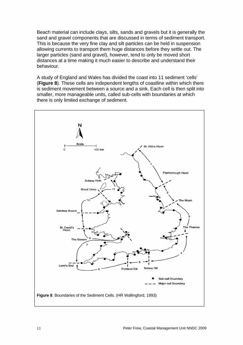
Beach material can include clays, silts, sands and gravels but it is generally the sand and gravel components that are discussed in terms of sediment transport. This is because the very fine clay and silt particles can be held in suspension allowing currents to transport them huge distances before they settle out. The larger particles (sand and gravel), however, tend to only be moved short distances at a time making it much easier to describe and understand their behaviour. A study of England and Wales has divided the coast into 11 sediment ‘cells’ (Figure 8). These cells are independent lengths of coastline within which there is sediment movement between a source and a sink. Each cell is then split into smaller, more manageable units, called sub-cells with boundaries at which there is only limited exchange of sediment.
Figure 8. Boundaries of the Sediment Cells. (HR Wallingford, 1993)
Peter Frew, Coastal Management Unit NNDC 2009 11

The East Anglian coastline has been designated as cell 3 and the North Norfolk coast falls within sub-cells 3A and 3B. The boundary between these cells is located roughly at Sheringham. This boundary is termed a drift divide, which means that the general trends are for material to move away from Sheringham. To the West of Sheringham, the net longshore movement is to the west while to the east of Sheringham there is a net movement to the east towards Great Yarmouth. This difference is believed to be caused by the change, at Sheringham, of both the angle of the coast and the dominant direction of wave approach. As indicated earlier, the angle waves approach the shore is important for longshore movement of material. These trends are long-term processes and at any specific time, sediment transport can be in either direction. The potential for sediment movement is very high on the Norfolk coast and often this can be clearly seen as a brown band of sediment laden water in the nearshore zone. So far sediment sources and movement have been discussed but sediments sinks have been ignored. A sediment sink is an area where the material supplied to the coastal system is deposited. As mentioned earlier, the finer clay and silt particles can travel huge distances and be deposited all over the North Sea. For larger material, the options are more limited. Some material obviously makes up the beaches and some accumulates at accretion zones such as the sand dunes at Horsey and the spit at Blakeney Point. It is estimated, however, that more material is supplied to the system than can be accommodated in these zones and it is believed that the remaining material is transported off shore where it accumulates in the sand-banks found off the Anglian coastline. The exact system of sediment movement in the Southern North Sea is still only partially understood. In 2002 NNDC part funded a major study (the Southern North Sea Sediment Transport Study) that significantly increased our knowledge. Changes in the water level of the North Sea Water levels in the North Sea can be affected by both short term and long term processes, as the following section illustrates. Storm Surges Storm Surges are a temporary build up of water in shallow, continental shelf, seas such as the North Sea. The water build up is caused partly by low pressure that allows sea level to rise slightly (while high pressure will depresses sea level), and partly by strong winds that ‘push’ water in the direction they are blowing. If this water is trapped by a coastline then it ‘piles up’ against it, causing a rise in water level. A surge typically occurs when a large low-pressure system tracks in from the Atlantic Ocean and heads north eastwards between Britain and Iceland and across the top of the North Sea. The surge moves down the North Sea’s West Coast (Britain’s East Coast) and then up the Sea’s East Coast at approximately the same speed as the astronomical tide.
Peter Frew, Coastal Management Unit NNDC 2009 12
The height of a Storm Surge (above normal sea level) will depend on the meteorological conditions that produced it. On the North Norfolk coast a surge height of 2.5 to 3 metres can be reached, however, maximum surge heights in the North Sea occur in its south eastern corner, off the coast of the Netherlands. The effects of a storm surge will depend on when it occurs relative to high tide. If the peak of the surge coincides with low tide then the increase in water level will only raise sea level to about the normal high tide position. If, however, the surge occurs close to high tide then sea level may be raised several metres higher than normal, putting severe pressure on coastal defences and potentially leading to significant damage from both flooding and erosion. Sea Level Rise Sea level can be altered by a number of natural processes and is known to have varied significantly in the past. When an increase in sea level occurs, it results in an inland migration of beaches and erosion of coastal cliffs. Beaches suffer accelerated erosion as the rise in sea level opens up higher areas of the beach to wave action and the eroded material can be deposited in the nearshore zone, leaving coastlines more exposed to high energy storm waves. Natural sea level change is a fairly slow process; however, there is now a suggestion that human activities may lead to a far more rapid change. In 1990 the Intergovernmental Panel on Climatic Change (IPCC) calculated that the continuing emission of greenhouse gases would cause the earth to become warmer and sea levels to rise. The degree of global warming remains uncertain but the original estimates indicate that mean global temperatures will rise by 1 degree C by 2025 and 3 degrees C by 2100, if emissions of greenhouse gases continue unabated. This could lead to a sea level rise of 200mm by 2030 and 650mm by 2100. These rates were amended in 2006 to 65mm by 2025, 320mm by 2055, 640mm by 2085 and 1090mm by 2115 (or 107mm by 2030 and 965mm by 2100). New guidance is expected at the end of 2009. Research has obviously continued into global warming and the predictions are constantly being refined, although they are not universally accepted. However, this document is not the appropriate place to debate the global warming issue. In any case, in planning future coastal defences it must be assumed that this ‘man made’ sea level rise will occur so that we are prepared if it does. In the UK the potential sea level rise is further exacerbated by a natural effect called glacio-isostacy. 20-30,000 years ago during the last glacial stage, a large ice sheet covered much of northern Britain while southern Britain was ice-free. The weight of this ice caused northern Britain to sink and, because the Earth's Crust floats on the semi-molten Mantle below, the depression of the Crust in northern Britain was compensated for by a rise in the Crust in southern Britain. On the melting of the ice sheet around 10,000 years before present, northern Britain began to rise as the weight of the overlying ice was released, and consequently southern Britain started to sink. This "see-saw" effect is called
Peter Frew, Coastal Management Unit NNDC 2009 13
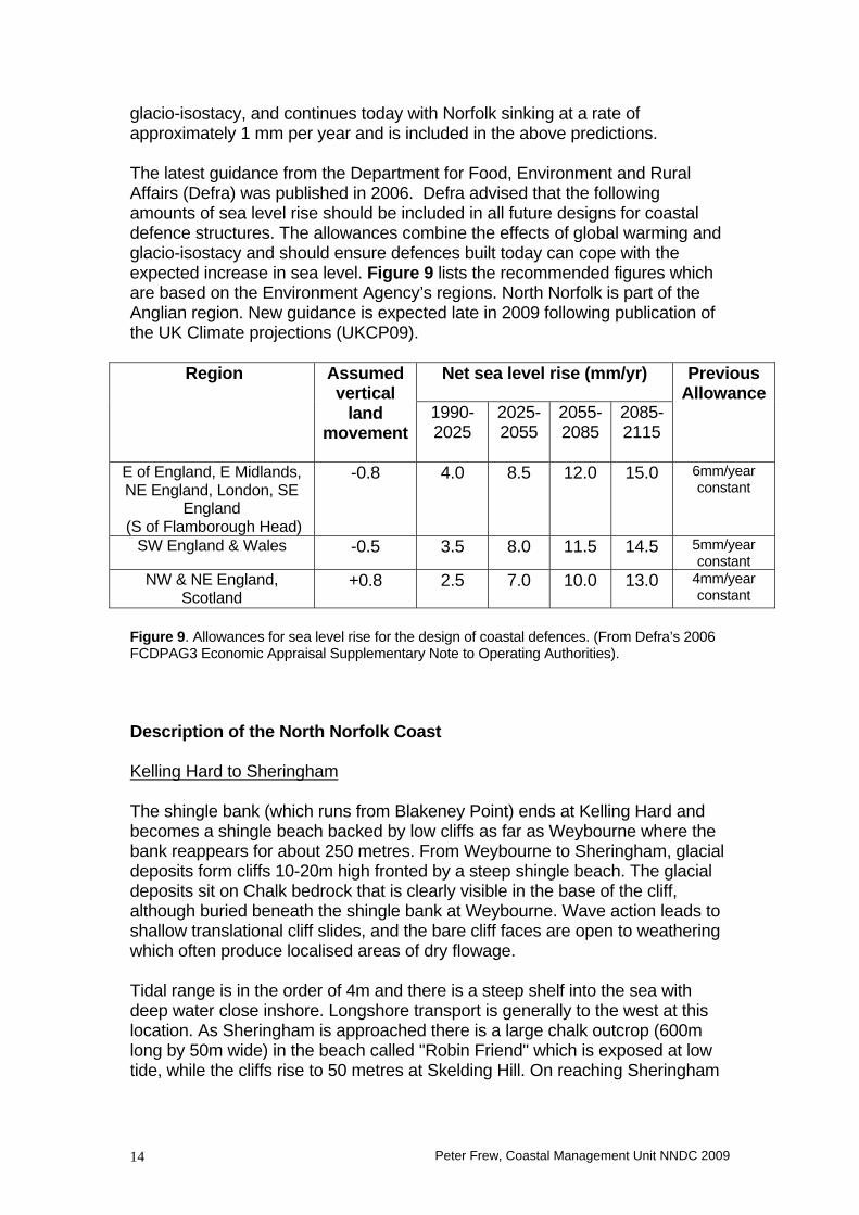
glacio-isostacy, and continues today with Norfolk sinking at a rate of approximately 1 mm per year and is included in the above predictions. The latest guidance from the Department for Food, Environment and Rural Affairs (Defra) was published in 2006. Defra advised that the following amounts of sea level rise should be included in all future designs for coastal defence structures. The allowances combine the effects of global warming and glacio-isostacy and should ensure defences built today can cope with the expected increase in sea level. Figure 9 lists the recommended figures which are based on the Environment Agency’s regions. North Norfolk is part of the Anglian region. New guidance is expected late in 2009 following publication of the UK Climate projections (UKCP09).
Net sea level rise (mm/yr) Region Assumed vertical
land movement
1990- 2025
2025-2055
2055-2085
2085- 2115
Previous Allowance
E of England, E Midlands, NE England, London, SE
England (S of Flamborough Head)
-0.8 4.0 8.5 12.0 15.0 6mm/year constant
SW England & Wales -0.5 3.5 8.0 11.5 14.5 5mm/year constant
NW & NE England, Scotland
+0.8 2.5 7.0 10.0 13.0 4mm/year constant
Figure 9. Allowances for sea level rise for the design of coastal defences. (From Defra’s 2006 FCDPAG3 Economic Appraisal Supplementary Note to Operating Authorities). Description of the North Norfolk Coast Kelling Hard to Sheringham The shingle bank (which runs from Blakeney Point) ends at Kelling Hard and becomes a shingle beach backed by low cliffs as far as Weybourne where the bank reappears for about 250 metres. From Weybourne to Sheringham, glacial deposits form cliffs 10-20m high fronted by a steep shingle beach. The glacial deposits sit on Chalk bedrock that is clearly visible in the base of the cliff, although buried beneath the shingle bank at Weybourne. Wave action leads to shallow translational cliff slides, and the bare cliff faces are open to weathering which often produce localised areas of dry flowage. Tidal range is in the order of 4m and there is a steep shelf into the sea with deep water close inshore. Longshore transport is generally to the west at this location. As Sheringham is approached there is a large chalk outcrop (600m long by 50m wide) in the beach called "Robin Friend" which is exposed at low tide, while the cliffs rise to 50 metres at Skelding Hill. On reaching Sheringham
Peter Frew, Coastal Management Unit NNDC 2009 14
the beach widens into a sandy foreshore although shingle is still found at the top of the beach. Sheringham to Cromer A sandy foreshore extends from a shingle bank at the base of the coastal defences at Sheringham. The cliffs are 20–25 metres high and are vegetated and fairly stable. Heading towards Cromer the cliffs rise quickly to 50 metres at Beeston Regis but then drop back to 10-20 m high. There are good exposures of the Cromer Forest Bed Series at their base, overlain by glacial deposits contorted in places through folding and thrusting by overlying ice sheets. The cliffs are undercut by wave erosion and generally fail via small translational slides and debris falls. Between Sheringham and West Runton Gap the beach is comprised of a mixture of sand and shingle, with chalk being exposed as a series of rock pools at low water, which is approximately 100-120m from the cliff base. From West Runton to Cromer East the foreshore is predominately sand and shingle, with low water about 120-150m from cliff base but the chalk rock pools are no longer present. Longshore sediment movement is variable but is generally in an easterly direction. Beach levels also fluctuate significantly. Cromer to Overstrand The beach at Cromer is predominately sand with outcrops of chalk and flint occurring at several places. Some shingle is often found at the inshore end of the beach with substantial amounts present to the east of the Pier. The cliffs are generally stable behind the defences and are 15-20 metres in height. The cliffs from Cromer rise to a height of 75m and form a major landslide complex. Failures are usually large deep-seated rotational slides with a return period in the order of tens of years. Towards Kirby Hill small scale rotational slides occur. These slides often develop translational slides on their steep rear scarps, and the toe area develops into areas of mudflow through groundwater seepage. The cliffs from Cromer east to Overstrand are well vegetated, except for the rear scarp and toe area. This vegetation cover enhances discharge of water from the cliff base by allowing free percolation of rain water and sea spray. The chalk bedrock disappears from the beach between Cromer and Overstrand, while the long beaches extend 150m from the cliff base at low water. Overstrand to Mundesley The beaches at Overstrand are low and sandy, with high water reaching the seawall each day. Low water mark is approximately 80-100m from the seawall. The cliffs are between 20 and 30 metres high and, despite the defences, continue to experience minor failures because of the presence of high levels of groundwater.
Peter Frew, Coastal Management Unit NNDC 2009 15

In 1990 a large landslide occurred at Clifton Way on the eastern edge of Overstrand. The failure was driven by high pore water pressure and a series of failures occurred until 1995 when the slip was finally stabilised. In total, roughly 90 metres of land were lost over five years and the scar is clearly visible in the cliff line. Between Overstrand and Trimingham the cliffs are generally undefended. They are up to 70m high and experience rotational failures and mudslides. This length of coast displays a fine series of geological exposures. At Sidestrand, chalk is visible in the foreshore and cliffs where it has been uplifted through glacial action. The foreshore is predominately sandy, with little shingle in evidence. At Trimingham there is a major landslide/mudflow complex which is very heavily influenced by groundwater in the cliffs. The cliffs are around 60 metres high with a complex and varying geology. There is a sandy beach and its level is very variable. The cliffs on towards Mundesley are also 60-70 metres high and can fail in a similar manner to those to the west. However, they do become better drained and more stable which has allowed them to become more vegetated than elsewhere on the coast. Mundesley to Bacton At Mundesley the cliffs are relatively stable, largely due to the defences that protect them. Between Mundesley and Bacton the cliffs gradually reduce in height from about 20m to 10m. Small translational slides and debris falls are then main forms of cliff failure. The beaches are wide and sandy stretching 120-150m from the cliff base and a good beach level is maintained throughout. Marram grass has colonised some cliff toe areas, and small sand dunes have started to form. Tidal lagoons have developed in front of Bacton Gas Terminal. Bacton to Ostend This length of coast did have very low cliffs but the seawall that stretches continuously along this frontage now covers these. There is a sandy beach throughout, which extends about 100m down to the low water mark. In storm conditions the beach can drop quite dramatically, with as much as 80cm being eroded in one tide. It has been known for the beach at Walcott to be eroded down as far as a clay deposit, which lies 3m below the level of the seawall apron. Ostend to Cart Gap The cliffs on this frontage are approximately 10m high and consist of Cromer Tills sat on top of the Cromer Forest Bed Series, which also outcrops in the foreshore. A flat sandy beach extends from the cliff toe to beyond the low water
Peter Frew, Coastal Management Unit NNDC 2009 16
mark. Just to the east of Happisburgh a length of defences was lost in the early 1990’s and rapid erosion of the cliffs followed because waves could now reach the cliff toe unhindered. Today the cliffs are clearly setback a significant distance from the position of those to the west. Studies indicate that longshore sediment transport is greatest on this part of the coastline and decreases both to the east and west. The Natural Environment and Conservation In addition to its geology and physical processes, the North Norfolk coastline is also important for its flora, fauna and landscape. This section briefly covers some of the designations that exist, but again it concentrates on the cliffed section of the coast. Information is available elsewhere on the nationally and internationally important habitats that exist on the low-lying lengths of North Norfolk’s coast. Most of the Coast between Weybourne and Bacton is designated as an Area of Outstanding Natural Beauty (AONB) and is part a larger area covering much of North Norfolk. Only the coastal settlements are excluded from this designation, because the boundary skirts round the inland edge of them. The purpose of the AONB designation is to conserve and enhance the natural beauty of the area, which includes protecting flora, fauna, geological and landscape features. The designation is of national importance and provides development restrictions to prevent any large scale development. There are a number of Sites of Special Scientific Interest (SSSIs) on the North Norfolk coast, designated on the grounds that they exhibit geology, geomorphology, flora or fauna of national, and in some cases international, interest. The sites are designated by Natural England to protect locations considered worthy of conservation from damage through use, management or development, be it wilful or accidental. Owners and occupiers of SSSIs are provided with lists of Potentially Damaging Operations (PDO) for the site. It is illegal to undertake a PDO without Natural England’s permission and doing will result in a fine and potentially an order to restore the damage. Appendix 1 provides details on the reasons for notification of a number of coastal SSSIs in North Norfolk. The Cliffs between Cromer and Overstrand have been proposed as a candidate Special Area of Conservation (SAC). This is a European Designation and would give extra protection to the cliffs because of the flora and fauna associated with the landslide complex. There are also a number of County Wildlife sites on the coast. These are non-statutory designations providing some protection to sites of local or regional environmental importance.
Peter Frew, Coastal Management Unit NNDC 2009 17

The Human Environment Cromer and Sheringham are the principle coastal towns on the cliffed North Norfolk coastline, although there are also a number of smaller settlements as indicated on Figure 10. Aside from the developed towns and villages, agriculture is the predominate type of land use between Weybourne and Happisburgh, with clifftop land used primarily for arable farming (see Appendix 2). The area from Weybourne to Mundesley is medium quality agricultural land (grade 3) and from Mundesley to Happisburgh is mainly high grade land (Grade 1).
Figure 10. The North Norfolk coastline. Tourism is the principle economy of the coastline and attracts visitors from far and wide to North Norfolk. The coastal settlements provide excellent beaches, several with Blue Flag awards, as well as car parks, toilets, promenades, amenity lighting, lifeguards, accommodation, facilities and attractions such as Cromer Pier. This type of development is largely confined to the main settlements but along the coastline a number of static caravan sites are present in cliff top locations. Additionally there are golf courses at Sheringham and Cromer, which stretch along the cliff tops, and inland at Mundesley and West Runton. North Norfolk also has many inland attractions, which also bring people to the area. North Norfolk, and especially Cromer is famous for its crab fishery, and many small boats operate from the beaches around Cromer and Sheringham. This area remains one of the main locations in Britain for the landing of brown crab (Cancer pegurus) and lobster (Homarus gammarus). The only major industrial complex on the North Norfolk coast is Bacton Natural Gas Terminal, which handles a significant percentage of Britain’s gas supply via pipelines from the North Sea gas fields and the European continent. This site is of national importance.
Peter Frew, Coastal Management Unit NNDC 2009 18
Appendix 1 Summary of the Reasons for the Notification of Sites of Special Scientific Interest (S.S.S.I.) Weybourne Cliffs The cliffs between Weybourne and Sheringham are of national importance because they contain outstanding Pleistocene sections showing the pre-Cromerian deposits of the Cromer Forest bed. This site is the type locality for the Pastonian "Weybourne Crag", a deposit rich in marine molluscs that has been known since the early days of geology. The marine "crags" here have also yielded both large and small mammal remains, of Pastonian and probably also pre-Pastonian age. Little has been published on these important fossils and the site remains one with considerable potential for future vertebrate finds. Additional biological interest is provided by breeding colonies of sand martins in the cliff-face and of fulmars (73 pairs in 1982) on the cliff ledges. Beeston Cliffs This is a nationally important Pleistocene reference site and the type site for the Beestonian Stage of the Pleistocene. The cliffs provide sections in both marine and freshwater pre-Pastonian and Pastonian, Beestonian and Cromerian sediments. The Beestonian is especially well-developed with freshwater fluviatile and pool deposits, and marine beach gravels and sands. Pollen spectra have been obtained from many horizons throughout this varied sequence recording the pattern of vegetational changes which occurred as the sediments were being deposited. Botanical interest is present in unimproved calcareous grassland on the cliff top including a nationally rare plant, Purple Broomrape (Orobanche purpurea). West Runton Cliffs West Runton is one of the most important Pleistocene localities in the British Isles and is an internationally important locality for its vertebrate fauna fossil assemblages. In the cliffs and foreshore are exposed a series of sediments representing two temperate stages (Pastonian, Cromerian) and three cold stages (Pre-Pastonian, Beestonian, Anglian). Pollen spectra indicative of temperate forests have been obtained from the temperate stages, while the cold stage deposits show permafrost structures and subarctic herb floras. The whole Cromer Forest-bed Formation sequence is overlain by glacial tills of the Anglian Glaciation. The sequence records several periods of transgression and regression (major advances and retreats of the sea) represented by alternations of marine and non-marine sedimentation. The entire Cromerian Interglacial vegetation cycle is represented within the West Runton Freshwater Bed and overlying marine sediments, and this locality has been designated the
Peter Frew, Coastal Management Unit NNDC 2009 19
stratotype for the Cromerian stage. Molluscan and vertebrate fossils occur at several horizons, especially in the West Runton Freshwater Bed. The West Runton Freshwater Bed (Cromerian Interglacial) has yielded by far the richest fauna of any open Pleistocene site in Britain. Fossils include a wide range of large and small mammals, freshwater fish and other vertebrates. These fauna have considerable international importance for their value in correlations with early Middle Pleistocene deposits across Europe and beyond. Marine gravels above have provided an interesting vertebrate assemblage including a Pre-historic elephant that was found and excavated between 1993 and 1995. The Pastonian "crag" below the Freshwater Bed contains abundant vertebrates, of particular note are the voles and marine fish - the only known fauna which can with certainty be assigned to this lower Pleistocene stage. East Runton Cliffs The foreshore at East Runton exposes pre-Cromerian (Lower Pleistocene) sediments, including successively ‘Weybourne Crag’, Pastonian clay conglomerate and marine shell beds, overlain in turn by marine silts. In the cliff can be seen spectacular rafts of ice transported chalk and highly deformed ‘contorted drift’. The deposits contain an extensive vertebrate fauna, which includes carnivores, extinct horse, elephant and several species of 'comb-antlered' deer. This is the best available locality for fossil vertebrates of this age. Overstrand Cliffs This stretch of coast between Cromer and Overstrand provides the best example of a soft cliff habitat in East Anglia. The cliffs are subject to slumping and cliff falls and this has led to the development of a succession series of habitats from bare sand and ruder communities to semi-stabilised grassland and scrub. Freshwater seepage lines emerging from the cliff face and stable cliff top grassland are important in the overall botanical diversity of the site, which also supports on outstanding assemblage of specialist invertebrates. The cliff section at Overstrand includes all three Cromer Tills and intervening beds, showing a variety of deformation structures due to both glacially- induced and loading disturbance. The special value of the site lies in the completeness of the succession and the variety and style of the deformations which are not seen elsewhere along the coast. Sidestrand and Trimingham Cliffs This stretch of cliffs provides a fine series of geological exposures in unconsolidated Pleistocene sediments and in the underlying chalk. The cliffs are subject to frequent cliff falls and slumping. This mobility creates a mosaic of habits from bare clay and sand to ruderal communities and semi-stabilised grassland with occasional seepage lines which support an outstanding assemblage of invertebrates.
Peter Frew, Coastal Management Unit NNDC 2009 20

The geology of the site is of special interest for four main reasons. • The chalk exposed on the foreshore and in the cliffs has been thrust
upwards as a series of blocks by glacial action. The chalk is of Lower Maastrichtian age, and these exposures comprise the only significant outcrops of chalk this age in Britain. The exposures are important in determining late cretaceous succession in both Britain and north-west Europe.
• The cliffs expose one of the best pre-glacial stratigraphic sequences in
England and analysis of this has led to the development of a detailed picture of the early Pleistocene environments in north Norfolk.
• Sampling of the pre-Pastonian and Pastonian beds has yielded an
interesting mammalian fauna. • The stretch of cliffs is regarded as the finest site of slumping unconsolidated
sediments in Britain. The cliffs also support probably the best specialist soft rock invertebrate fauna in East Anglia. Mundesley Cliffs The cliffs along this stretch of coast provide some of the very best sections in the Pleistocene Cromer Forest-bed Formation, especially in Cromerian marine and freshwater deposits, and freshwater sediments of the early Anglian Cold Stage. At both Mundesley and Paston (the type locality), marine and rarer freshwater deposits of Pastonian age are particularly well-developed. A nationally important site for its extensive Pleistocene sequence. Happisburgh Cliffs This locality is important both for the cliff exposures which uniquely show three glacial deposits, the Cromer Tills (of Anglian age) with intercalated water-lain sediments, and for the underlying Cromer Forest-bed Formation, exposed in the foreshore, with excellent development of pre-Pastonian and Pastonian sediments. An important site for dating the Pleistocene succession of East Anglia with a range of sediments from marine to freshwater and glacial, spanning five stages, from the pre-Pastonian to the Anglian. Although this document considers primarily the cliffed length of North Norfolk’s coastline, there are also important environmental sites at the following locations:
Peter Frew, Coastal Management Unit NNDC 2009 21

Blakeney Point A shingle spit of great physiographic interest. Blakeney Point has been the scene of extensive scientific research and educational work for many years, the results of which have provided important observations on the formation of coastal shingle and saltmarsh. The site is of great importance for its breeding birds and as an observation point for migration. Blakeney Point is owned by the National Trust and was established as a Nature Reserve in 1912. Cley and Salthouse Marshes This area, which adjoins the National Trust Nature Reserve at Blakeney Point, includes a good range of coastal, brackish and freshwater habitats, including extensive reed beds and glazing marshes. The area is famous for the bird life it supports, including a wide range of breeding, wintering and migrant species. Managed as a Nature Reserve by the Norfolk Naturalists' Trust.
Peter Frew, Coastal Management Unit NNDC 2009 22

Appendix 2 Coastal Land Use The following table provides an estimate of the amount of land given to various land-use types along the ‘coastal strip’ between Kelling Hard in the west and Cart Gap in the east. For the purposes of this document it has been assumed that the ‘coastal strip’ is a band of land stretching approximately 300 metres inland from the base of the cliffs. The coastline has been split into the Management Units used in the Shoreline Management Plan, and the estimates are based on information from the Plan. The figures are the percentage area of the ‘coastal strip’ (in each Management Unit), given to each land-use type. The land-use types are: Residential • Includes housing, associated privately owned land and allotments. Also
includes Hotels and Guesthouses. Tourism • Areas of both tourist attraction and tourist accommodation (includes
caravan/campsites but not hotels, guesthouses etc). Industrial Public Buildings/Amenities • Includes infrastructure for public use such as schools, libraries, hospitals,
churches, fire stations, lighthouses, cemeteries and car parks. Recreational • Land such as parks, golf courses and play areas. Agricultural • Includes agricultural buildings and woodland. Commercial Nature Conservation • Land with a Nature Conservation designation. Often comprises large cliff
face areas e.g. The landslide complex between Cromer and Overstrand. Open Space • Areas of open space not in private ownership and with no specified use
identified at present. MOD • Ministry of Defence land.
Peter Frew, Coastal Management Unit NNDC 2009 23
Peter Frew, Coastal Management Unit NNDC 2009 24
Notes: The table includes some values of <1% where the area given over to that land-use was too small to register as a full percentage point. Typically this occurred in the small coastal settlements where one or two shops (Commercial land use) exist.
All values are only simple estimates for illustrative purposes.
Valuation of Coastal Land Coastal land use is very important for coast protection because it affects the value of the land. As Document 3 explains, Benefit/Cost analysis is used in determining whether coastal defences will be built so the higher the value of the land/assets at risk, the more likely it is that defences can be constructed. For Residential, Commercial, Industrial or Public/Amenity land it is the value of the buildings on the land rather than the land itself that is valued. The actual value will vary depending on the location and type of building but usually values will be fairly high. Agricultural land value in North Norfolk averages £12,800 per hectare though prime arable land can be worth significantly more. Importantly though, when calculating benefits for coast protection schemes the value must be reduced by approximately half to remove the contribution of UK agricultural support. Consequently agricultural land is only actually worth around £5,000 per hectare when contributing to coastal defence schemes. Generally other land uses, such as Recreational land, Open land and campsites, are valued as if they were agricultural land (but without the reduction factor). Important Nature Conservation sites may be attributed a higher value depending on the specifics of each site. This may be appropriate for SSSIs and European designations, but ‘lesser’ sites are also simply valued as agricultural land.
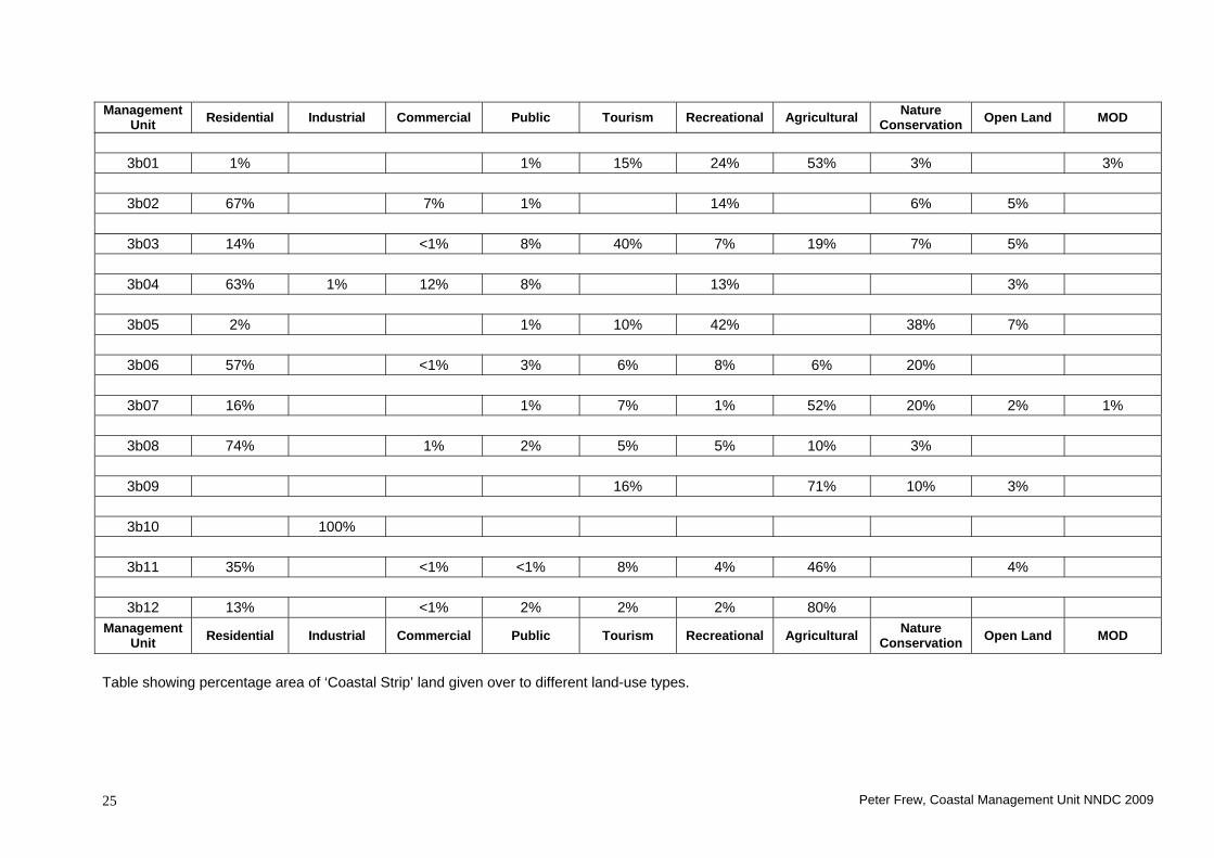
Management
Unit Residential Industrial Commercial Public Tourism Recreational Agricultural Nature Conservation Open Land MOD
3b01 1% 1% 15% 24% 53% 3% 3%
3b02 67% 7% 1% 14% 6% 5%
3b03 14% <1% 8% 40% 7% 19% 7% 5%
3b04 63% 1% 12% 8% 13% 3%
3b05 2% 1% 10% 42% 38% 7%
3b06 57% <1% 3% 6% 8% 6% 20%
3b07 16% 1% 7% 1% 52% 20% 2% 1%
3b08 74% 1% 2% 5% 5% 10% 3%
3b09 16% 71% 10% 3%
3b10 100%
3b11 35% <1% <1% 8% 4% 46% 4%
3b12 13% <1% 2% 2% 2% 80%
Management Unit Residential Industrial Commercial Public Tourism Recreational Agricultural Nature
Conservation Open Land MOD
Table showing percentage area of ‘Coastal Strip’ land given over to different land-use types.
Peter Frew, Coastal Management Unit NNDC 2009 25


![Eric W. Frew - University of Colorado Boulder · PDF file... Research and Engineering Center for Unmanned Vehicles (RECUV) ... July-August 2008. [25] Eric W. Frew, Cory Dixon*,](https://img.dokumen.tips/doc/110x75/5ab4614d7f8b9a1a048bccac/eric-w-frew-university-of-colorado-boulder-research-and-engineering-center.jpg)