Embed Size (px)
Citation preview

A summary of 2016 beta release
for wildland fires, prescribed and
agricultural burns for USA and
outside USA; last minute changes
YEAR 2016 EMISSIONS MODELING PLATFORM PURPOSES
J. VUKOVICH (USEPA)
DEC 6, 2018

Outline
Summarize states, tribes, and other agencies submitted data
(voluntary)
Other national fire information used
Last minute change involving national fire information database
International fires (Canada and Mexico)
Next steps towards 2016v1
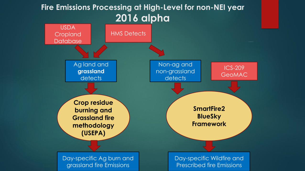
Fire Emissions Processing at High-Level for non-NEI year
2016 alpha
Non-ag and
non-grassland
detects
Ag land and
grassland
detects
HMS DetectsUSDA
Cropland
Database
ICS-209
GeoMAC
Crop residue
burning and
Grassland fire methodology
(USEPA)
SmartFire2
BlueSky
Framework
Day-specific Wildfire and
Prescribed fire Emissions
Day-specific Ag burn and
grassland fire Emissions
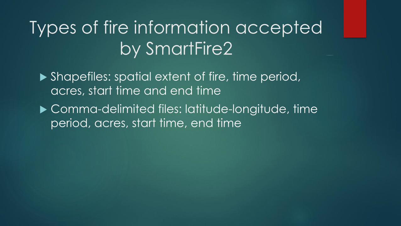
Types of fire information accepted
by SmartFire2
Shapefiles: spatial extent of fire, time period,
acres, start time and end time
Comma-delimited files: latitude-longitude, time
period, acres, start time, end time
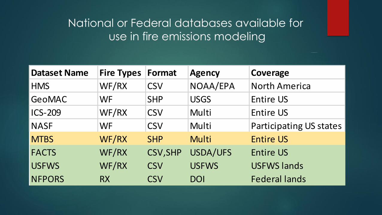
Dataset Name Fire Types Format Agency Coverage
HMS WF/RX CSV NOAA/EPA North America
GeoMAC WF SHP USGS Entire US
ICS-209 WF/RX CSV Multi Entire US
NASF WF CSV Multi Participating US states
MTBS WF/RX SHP Multi Entire US
FACTS WF/RX CSV,SHP USDA/UFS Entire US
USFWS WF/RX CSV USFWS USFWS lands
NFPORS RX CSV DOI Federal lands
National or Federal databases available for
use in fire emissions modeling

Monitoring Trends in Burn Severity (MTBS)
Monitoring Trends in Burn Severity (MTBS) is an interagency program(USGS and USDA Forest Service) whose goal is to consistently map the burn severity and extent of large fires across all lands of the United States from 1984 to present. This includes all fires 1000 acres or greater in the western United States and 500 acres or greater in the eastern Unites States. The extent of coverage includes the continental U.S., Alaska, Hawaii and Puerto Rico.
Aug 3, 2018: MTBS released 1,337 new fires to MTBS.gov bringing the total number of fires mapped by the project to 21,673. This data release contains all 2016 fires.
National - Burned Area Boundaries Dataset: The burned area boundaries dataset is a vector polygon ESRI shapefile of the extent of the burned areas of all currently completed MTBS fires for the continental United States, Alaska, Hawaii and Puerto Rico.
https://www.mtbs.gov/direct-download
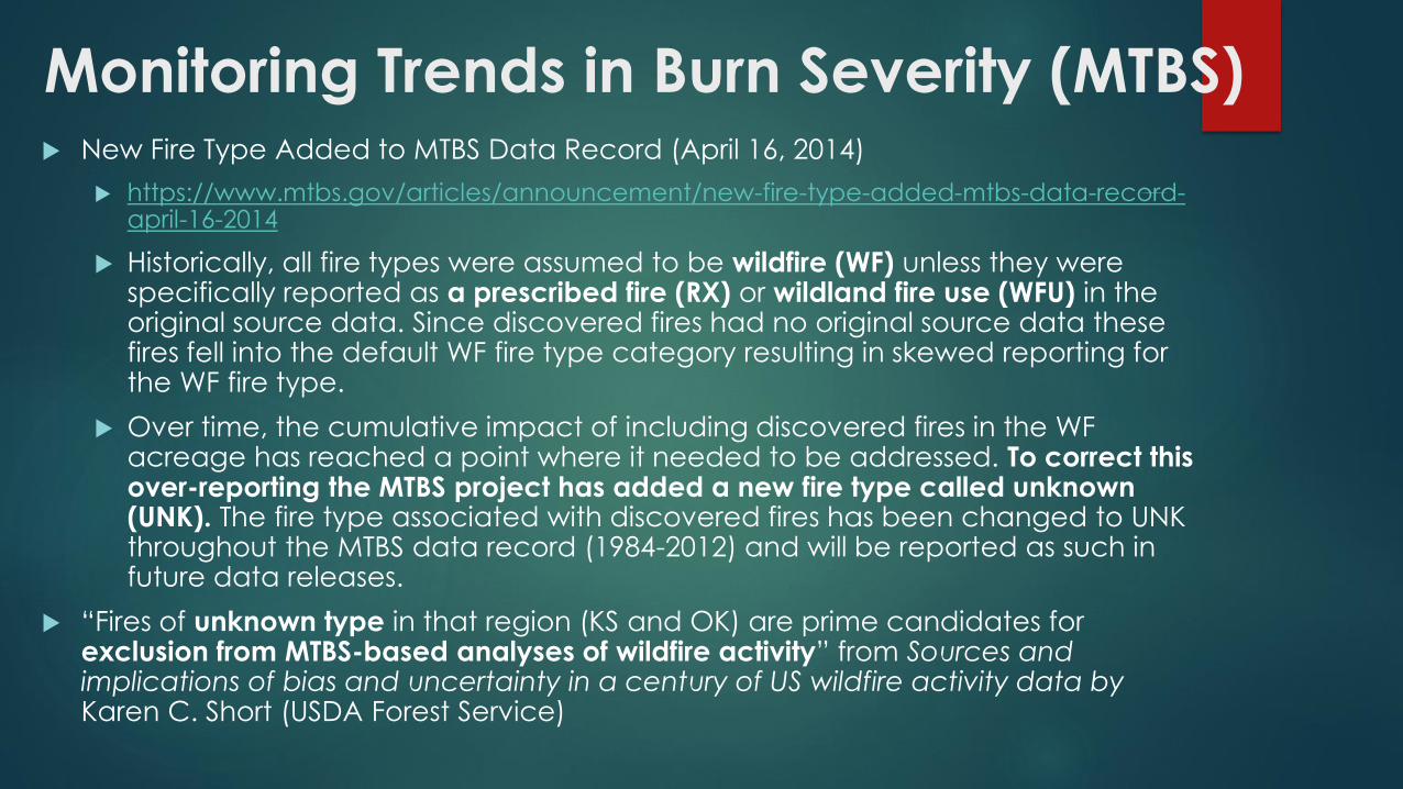
Monitoring Trends in Burn Severity (MTBS) New Fire Type Added to MTBS Data Record (April 16, 2014)
https://www.mtbs.gov/articles/announcement/new-fire-type-added-mtbs-data-record-april-16-2014
Historically, all fire types were assumed to be wildfire (WF) unless they were specifically reported as a prescribed fire (RX) or wildland fire use (WFU) in the original source data. Since discovered fires had no original source data these fires fell into the default WF fire type category resulting in skewed reporting for the WF fire type.
Over time, the cumulative impact of including discovered fires in the WF acreage has reached a point where it needed to be addressed. To correct this over-reporting the MTBS project has added a new fire type called unknown (UNK). The fire type associated with discovered fires has been changed to UNK throughout the MTBS data record (1984-2012) and will be reported as such in future data releases.
“Fires of unknown type in that region (KS and OK) are prime candidates for exclusion from MTBS-based analyses of wildfire activity” from Sources and implications of bias and uncertainty in a century of US wildfire activity data by Karen C. Short (USDA Forest Service)

Last minute change to 2016beta:
Remove MTBS Unknown “fires”
MTBS 2016 MTBS 2016
Fire type Millions of acres UNK Millions of acres
WF 3.85 KS 1.52
RX 0.74 OK 0.44
UNK 1.99 Rest 0.03
TOTAL 6.58 1.99
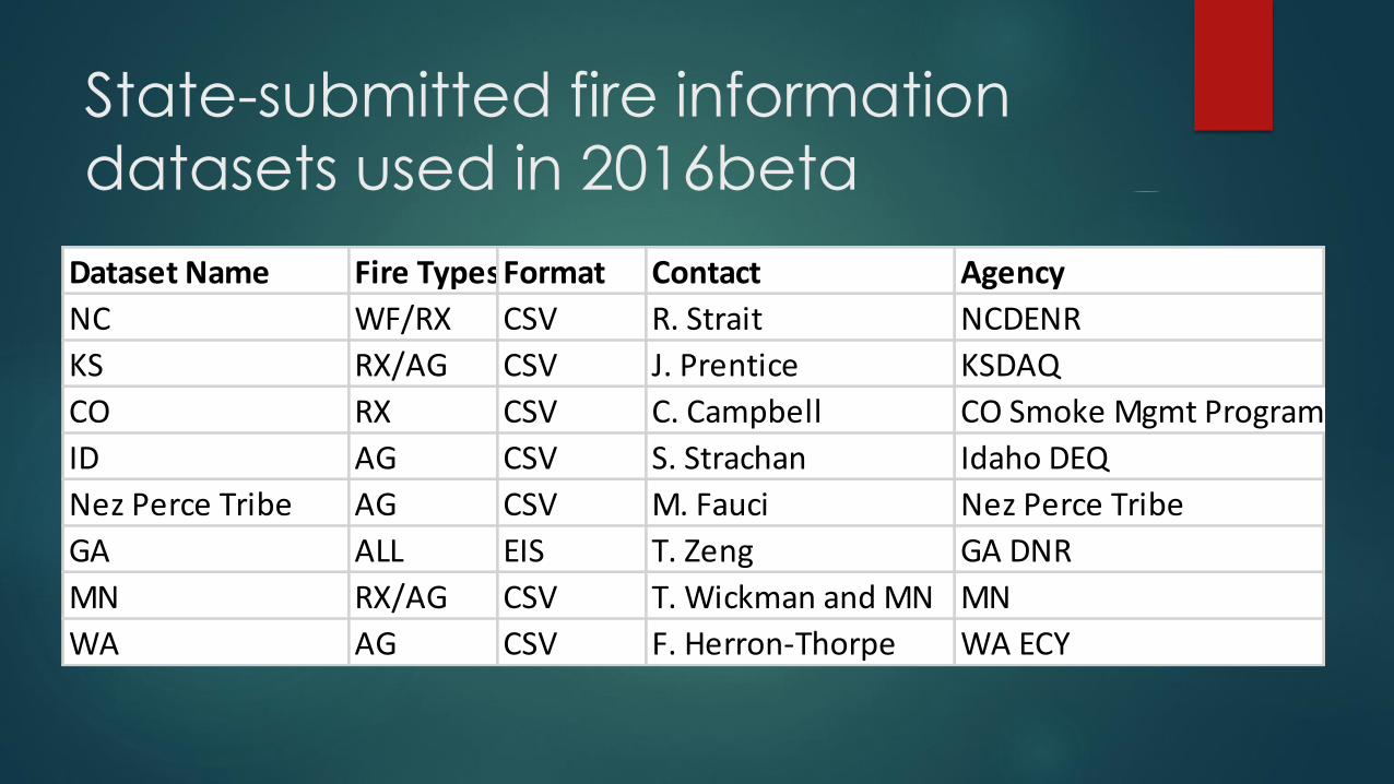
State-submitted fire information
datasets used in 2016beta
Dataset Name Fire TypesFormat Contact Agency
NC WF/RX CSV R. Strait NCDENR
KS RX/AG CSV J. Prentice KSDAQ
CO RX CSV C. Campbell CO Smoke Mgmt Program
ID AG CSV S. Strachan Idaho DEQ
Nez Perce Tribe AG CSV M. Fauci Nez Perce Tribe
GA ALL EIS T. Zeng GA DNR
MN RX/AG CSV T. Wickman and MN MN
WA AG CSV F. Herron-Thorpe WA ECY

Fire Emissions Processing at High-Level for 2016 beta
Non-ag and
grassland
detects
Ag land detects
HMS Detects
(no VIIRS)
USDA
Cropland
Database ICS-209(WF/Rx)
GeoMAC (WF)
NASF (WF)
ICS-209 PIR (Rx)
MTBS (WF/Rx)
Crop residue
burning fire
methodology
(USEPA)
SmartFire2
BlueSky
Framework
(updated fuel
bed data/
FCCSv3)
Day-specific Wildfire and
Prescribed fire Emissions
Day-specific Ag burn fire
Emissions
ID, Nez Perce,
MN, KS info
KS, NC, CO, MN
info
GA
inventory
WA month-
specific
info
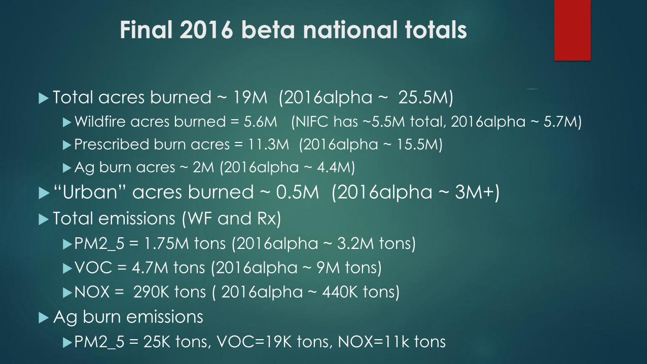
Final 2016 beta national totals
Total acres burned ~ 19M (2016alpha ~ 25.5M)
Wildfire acres burned = 5.6M (NIFC has ~5.5M total, 2016alpha ~ 5.7M)
Prescribed burn acres = 11.3M (2016alpha ~ 15.5M)
Ag burn acres ~ 2M (2016alpha ~ 4.4M)
“Urban” acres burned ~ 0.5M (2016alpha ~ 3M+)
Total emissions (WF and Rx)
PM2_5 = 1.75M tons (2016alpha ~ 3.2M tons)
VOC = 4.7M tons (2016alpha ~ 9M tons)
NOX = 290K tons ( 2016alpha ~ 440K tons)
Ag burn emissions
PM2_5 = 25K tons, VOC=19K tons, NOX=11k tons
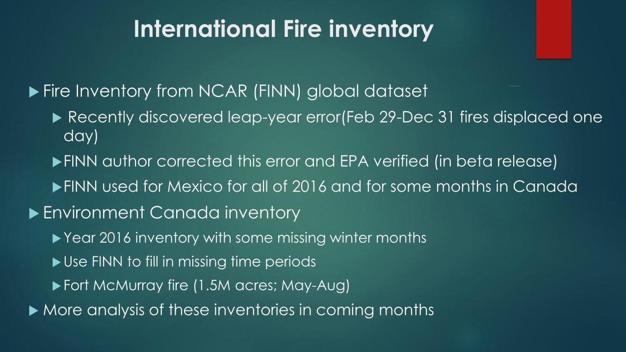
International Fire inventory
Fire Inventory from NCAR (FINN) global dataset
Recently discovered leap-year error(Feb 29-Dec 31 fires displaced one
day)
FINN author corrected this error and EPA verified (in beta release)
FINN used for Mexico for all of 2016 and for some months in Canada
Environment Canada inventory
Year 2016 inventory with some missing winter months
Use FINN to fill in missing time periods
Fort McMurray fire (1.5M acres; May-Aug)
More analysis of these inventories in coming months
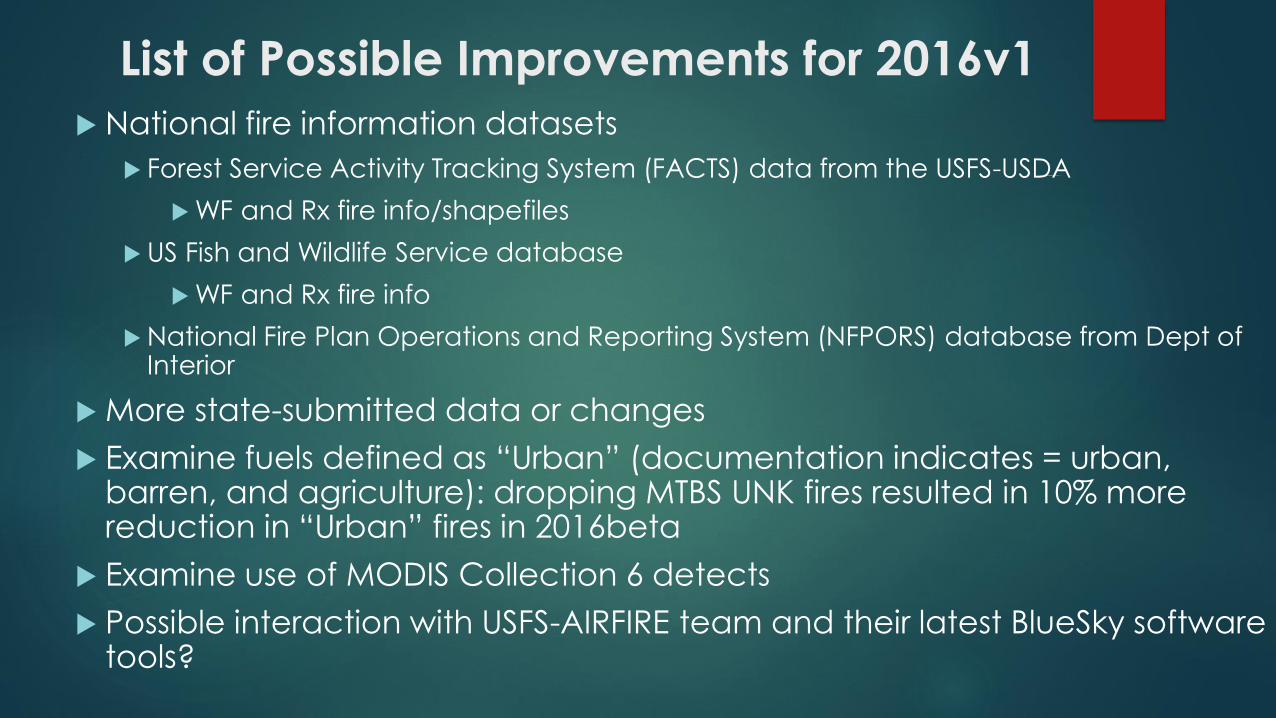
List of Possible Improvements for 2016v1
National fire information datasets
Forest Service Activity Tracking System (FACTS) data from the USFS-USDA
WF and Rx fire info/shapefiles
US Fish and Wildlife Service database
WF and Rx fire info
National Fire Plan Operations and Reporting System (NFPORS) database from Dept of Interior
More state-submitted data or changes
Examine fuels defined as “Urban” (documentation indicates = urban, barren, and agriculture): dropping MTBS UNK fires resulted in 10% more reduction in “Urban” fires in 2016beta
Examine use of MODIS Collection 6 detects
Possible interaction with USFS-AIRFIRE team and their latest BlueSky software tools?