Embed Size (px)
Citation preview
I
I
A Strontium f$9topic SlUdy of ~
Plute,ps and •.fl.·•·· •···· ••• ·· ;ociate ; Rocks o;t;t,the Southern Sierra~ Nevada; and Viclhity, Califo.rnia
U.S. GEOLOGICAL SURVEY BULLETIN 1920
AVAILABILITY OF BOOKS AND MAPS OF THE U.S. GEOLOGICAL SURVEY
Instructions on ordering publications of the U.S. Geological Survey, along with prices of the last offerings, are given in the current-year issues of the monthly catalog "New Publications of the U.S. Geological Survey." Prices of available U.S. Geological Survey publications released prior to the current year are listed in the most recent annual "Price and Availability List" Publications that are listed in various U.S. Geological Survey catalogs (see back inside cover) but not listed in the most recent annual "Price and Availability List" are no longer available.
Prices of reports released to the open files are given in the listing "U.S. Geological Survey Open-File Reports," updated monthly, which is for sale in microfiche from the U.S. Geological Survey, Books and Open-File Reports Section, Federal Center, Box 25425, Denver, CO 80225. Reports released through the NTIS may be obtained by writing to the National Technical Information Service, U.S. Department of Commerce, Springfield, VA 22161; please include NTIS report number with inquiry.
Order U.S. Geological Survey publications by mail or over the counter from the offices given below.
BY MAIL
Books Professional Papers, Bulletins, Water-Supply Papers, Techniques
of Water-Resources Investigations, Circulars, publications of general interest (such as leaflets, pamphlets, booklets), single copies of Earthquakes & Volcanoes, Preliminary Determination of Epicenters, and some miscellaneous reports, including some of the foregoing series that have gone out of print at the Superintendent of Documents, are obtainable by mail from
U.S. Geological Survey, Books and Open-File Reports Federal Center, Box 25425
Denver, CO 80225
Subscriptions to periodicals (Earthquakes & Volcanoes and Preliminary Determination of Epicenters) can be obtained ONLY from the
Superintendent of Documents Government Printing omce
Washington, D.C. 20402
(Check or money order must be payable to Superintendent of Documents.)
Maps
For maps, address mail orders to
U.S. Geological Survey, Map Distribution Federal Center, Box 25286
Denver, CO 80225
Residents of Alaska may order maps from
Alaska Distribution Section, U.S. Geological Survey, New Federal Butlding -Box U
101 Twelfth Ave., Fairbanks, AK 99701
OVER THE COUNTER
Books Books of the U.S. Geological Survey are available over the
counter at the following Geological Survey Public Inquiries Offices, all of which are authorized agents of the Superintendent of Documents:
• WASHINGTON, D.C.--Main Interior Bldg., 2600 corridor, 18th and C Sts., NW.
• DENVER, Colorado--FederalBldg., Rm.169, 1961 Stout St. • LOS ANGELES; California--Federal Bldg., Rm. 7638, 300 N.
Los Angeles St. • MENLO PARK, California--Bldg. 3 (Stop 533), Rm. 3128,
345 Middlefield Rd. • RESTON, Virginia--503 National Center, Rm. 1C402, 12201
Sumise Valley Dr. • SALT LAKE CITY, Utah--Federal Bldg., Rm. 8105, 125
South State St. • SAN FRANCISCO, California--Customhouse, Rm. 504, 555
Battery St. • SPOKANE, Washington--U.S. Courthouse, Rm. 678, West
920 Riverside Ave .. • ANCHORAGE, Alaska--Rm. 101, 4230 University Dr. • ANCHORAGE, Alaska--Federal Bldg, Rm. E-146, 701 C St.
Maps Maps may be purchased over the counter at the U.S. Geologi
cal Survey offices where books are sold (all addresses in above list) and at the following Geological Survey offices:
• ROLLA, Missouri--1400 Independence Rd. • DENVER, Colorado--Map Distribution, Bldg. 810, Federal
Center • FAIRBANKS, Alaska--New Federal Bldg., 101 Twelfth Ave.
A Strontium Isotopic Study of Plutons and Associated Rocks of the Southern Sierra Nevada and Vicinity, California
By R.W. KISTLER and D.C. ROSS
Rubidium and strontium concentrations and strontium isotopic compositions for granitic rocks of the southern Sierra Nevada and vicinity
U.S. GEOLOGICAL SURVEY BULLETIN 1920

DEPARTMENT OF THE INTERIOR
MANUEL LUJAN, JR., Secretary
U.S. GEOLOGICAL SURVEY
Dallas L. Peck, Director
Any use of trade, product, or firm names in this publication is for descriptive purposes only and does not imply endorsement by the U.S. Government
UNITED STATES GOVERNMENT PRINTING OFFICE, WASHINGTON 1990
For sale by the Books and Open-File Reports Section, U.S. Geological Survey, Federal Center, Box 25425, Denver, CO 80225
Library of Congress Cataloging-In-Publication Data
Kistler, Ronald Wayne, 1931-A strontium isotopic study of plutons and associated rocks of the southern
Sierra Nevada vicinity, California I by R.W. Kistler and D.C. Ross. p. cm.-(U.S. Geological Survey bulletin; 1920)
Includes bibliographical references (p. ). Supt. of Docs. no.: I 19.3:1920 1. Rocks, Igneous-Sierra Nevada Mountains Region (Calif. and Nev.)
2. Geology-Sierra Nevada Mountains Region (Calif. and Nev.) 3. Rubidium-strontium dating. I. Ross, Donald Clarence, 1924- . II. Title. Ill. Series. QE75.89 no. 1920 557.3 s-dc20 90-3470 [QE461] [552' .3'097944] CIP

CONTENTS Abstract 1 Introduction 1
Analytical methods 1 Observations 2
Terrane boundary in the southern Sierra Nevada 2 Isotopic and chemical characteristics of plutons in the southern
Sierra Nevada 3 Summary and conclusions 4 References cited 4
FIGURES
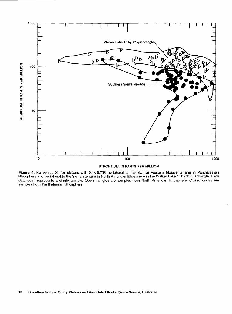
1. Map of California and Nevada showing the Sri=0.706 isopleth determined for Mesozoic and Cenozoic plutons 9
2. Map of the southern Sierra Nevada and El Paso Mountains strontium isotope isopleths and three age groups of plutons that crop out in the area 10
3. Fields of Sri versus o180 per mil for plutons in and peripheral to the Salinian-western Mojave terrane (Panthalassan lithosphere) in the southern Sierra Nevada and for plutons in the central Sierra Nevada and eastern Mojave Desert (North American lithosphere) ll
4. Rb versus Sr for plutons with Sri< 0.706 peripheral to the Salinian-western Mojave terrane in Panthalassan lithosphere and peripheral to the Sierran terrane in North American lithosphere in the Walker Lake 1 o by 2° quadrangle 12
TABLE
1. Rubidium and strontium data for plutons and associated rocks of the southern Sierra Nevada and vicinity 13
Contents Ill

A Strontium Isotopic Study of Plutons and Associated Rocks of the Southern Sierra Nevada and Vicinity, California
By R.W. Kistler and D.C. Ross
Abstract
Plutons and associated rocks in the southern Sierra Nevada and vicinity range in age from about 240 to 80 Ma. Triassic plutons form a narrow northwest-trending belt that lies between predominantly Middle Jurassic plutons on the east and Cretaceous plutons on the west. The belt of Triassic plutons is along a boundary between plutons with chemical and isotopic compositions that reflect source materials derived from two different lithospheres called North American and Panthalassan. The two lithospheres are in tectonic contact expressed by sheared plutons of the Middle Jurassic lnyo Mountains intrusive epoch, by sheared plutons in the Triassic belt, and by fault zones exposed in scattered roof pendants of metamorphosed sedimentary rocks of probable Paleozoic age. Late Cretaceous plutons engulf the tectonic contact along much of its length, and in the southern Sierra Nevada constrain the time of shearing to between about 160 and 80 Ma.
Oxygen isotopes are different in plutons with initial 87Sr/88Sr (Sri) values greater than 0.706 in the two lithosphere types, and they indicate a significantly greater sedimentary component in plutons with source materials in Panthalassan lithosphere than in plutons with source materials in North American lithosphere. In contrast to the North American lithosphere, there is no evidence that a Proterozoic sialic crystalline basement is present in the Panthalassan lithosphere. The plutons with Sr1 > 0. 706 and with source materials in Panthalassan lithosphere probably acquired that isotopic characteristic by assimilation of sediments derived from a Proterozoic sialic crust. Plutons with Sri< 0. 706 have chemical and Nd isotopic compositions that indicate timeintegrated depletion of large-ion-lithophile elements in the magma source regions in Panthalassan lithosphere relative to the magma source regions in North American lithosphere.
INTRODUCTION
Rubidium and strontium concentrations and 87Sr/ 86Sr values are documented herein for samples of plutons and associated rocks from 238 locations in the southern
Manuscript approved for publication, December 8, 1989.
Sierra Nevada and vicinity. The goals of this investigation were to determine ages of rock units, to aid in the separation of plutons in poorly exposed areas, to determine the pattern of variation of initial 87Srf6Sr (hereafter called SrJ for plutons, and to constrain more rigorously the boundaries of the continental Sierran and Salinian-western Mojave terranes defined on the basis of the Sri of their plutons by Kistler (1978) and by Kistler and Peterman (1978). These new data expand the boundaries of the Salinian-western Mojave terrane and make it part of the Panthalassan lithosphere that lies west of the tectonic boundary, whereas the Sierran terrane is made part of the North American lithosphere that lies east of the tectonic boundary.
The Sri=0.706 isopleth (modified from Kistler, 1983) determined for plutons in California and Nevada (fig. 1) was interpreted to approximate the position of the margin of Proterozoic sialic crust in the region (Kistler and Peterman, 1978). This isopleth was also used as a piercing point across faults, like the San Andreas and Garlock, to restore offsets of basement rocks along these structures (Kistler and others, 1973; Kistler and Peterman, 1978). A simplified bedrock map of the southern Sierra Nevada and the El Paso Mountains with numbered locations of samples analyzed for this report is shown in figure 2. Most of these same locations are shown on the more detailed basement map of the southern Sierra Nevada by Ross (1987). 'The area shown in figure 2 is entirely of Panthalassan lithosphere except fm an area of North American lithosphere in the eastern Sierra Nevada intruded predominantly by Jurassic plutons.
Analytical Methods
Analytical data are given in table 1. Concentrations of Rb and Sr were determined by energy-dispersive X-ray fluorescence using a direct-comparison method on standard samples of similar bulk composition. Uncertainties in Rb/Sr are in the range ±3 percent or less at 2 sigma by this method. All Sr isotopic ratios were normal-
Introduction
ized to 86Srl8Sr=0.1194. The measured 87Srl6Sr values have a coefficient of variation less than 0.01 percent and were obtained from a mass spectrometer that yielded 87Srl6Sr values of 0.70800±3 and 0.71023±3 from replicate analyses of the E and A and NBS 987 SrC03
standards, respectively. Values of Sri for plutons were determined from values of the intercept on the ordinate using York (1969) isochron regressions, by calculation for individual samples of known age, and by calculation for an assumed age of 100 Ma for those units with only one sample and no other age data. The decay constant for Rb is 1.42X 10⁻¹¹ yr-1
• Pluton names given in table 1 are from Ross (1987).
OBSERVATIONS
Ages of the plutons investigated range from about 240 Ma to about 80 Ma. Triassic plutons (240 to 218 Ma) lie in a narrow northwest-trending belt (fig. 2) that extends from the El Paso Mountains through the Walker Pass area almost to Sherman Peak just north of the map area in the Hockett Peak quadrangle at about long. 118° 22' W. These plutons are bounded on the east by plutons of Middle Jurassic age (177 ± 5 Ma) collectively called the Sacatar Quartz Diorite of Miller and Webb (1940), by isolated roof pendants of sedimentary rocks that contain bedded barite (Taylor, 1984) similar to the Paleozoic metamorphic rocks of the western Sierra Nevada foothills (Weber, 1963), and by scattered small felsic plutons of Late Cretaceous age. To the west of the belt of Triassic plutons, the bedrock is predominantly plutons of Cretaceous age (120 to 80 Ma) that intruded scattered roof pendants of sedimentary and volcanic rocks of Paleozoic and Mesozoic age called the Kings and Erskine Canyon sequences (Saleeby and Busby-Spera, 1986) and Pampa Schist of Dibblee and Chesterman (1953).
The Sri=0.706 isopleth extends from the Garlock fault to the north margin of the map area in several northeast- and northwest-trending segments (fig. 2). The 0.706 isopleth is offset about 9 km in a right-lateral sense by the Kern Canyon fault. The Sri values less than 0.706 can be contoured. However, these isopleths do not parallel the 0.706 isopleth, and the 0.704 contours intersect the 0.706 contour at a 90° angle. This results in plutonic rocks with Sri of 0.70325 and 0.70656 (Nos. 97 and 82, respectively, fig. 2) within 1 km of each other in the west-central part of the map area. The Sri values of the Triassic plutons, in the belt trending northwest from the El Paso Mountains to the vicinity of Sherman Peak just north of the map area, are all less than 0.706 and are as low as 0.70362 in the quartz diorite of Walker Pass and the quartz diorite and trondjhemite of the El Paso Mountains. Plutons of this age and isotopic characteristic are found in a narrow belt discontinuosly exposed for 240 km from the Mineral King pendant in the north to near
Barstow in the Mojave Desert to the south (fig. 1). The unradiogenic Sri values of these plutons are a major anomaly in the region of plutons with Sri >0.706 in California.
Four samples in a traverse across the map area (Nos. 97, 82, 202, and 206, fig. 2 and table 1) with Sri values that range from 0.7032 to 0.7083 were investigated for Sm and Nd concentrations and initial 143Nd/44Nd values (DePaolo, 1981). Initial 143Nd/44Nd (Ndi) correlates negatively with Sri. The Ndi (epsilon Nd(T)) for sample 26-73 (No. 206, fig. 2 and table 1) from the quartz diorite of Walker Pass was recalculated to be +2.8 at the emplacement age of 240 Ma given in this report, rather than +0.6 at the 86 MaK-Ar age for hornblende (Evernden and Kistler, 1970) used by DePaolo (1981).
Oxygen isotopic compositions were determined for many of the same samples for which strontium isotopic data were already obtained (Masi and others, 1976, 1981; Saleeby and others, 1987). In the southern Sierra Nevada, there is a good correlation between strontium and oxygen isotope ratios, but there is a pronounced greater proportion of plutons with high-180 upper-crustal isotopic signatures relative to plutons in other parts of the Sierra Nevada and in the Mojave Desert (fig. 3). The high-180 signature is similar to that of plutons in the northwestern Mojave Desert and the Salinian block to the south and northwest, respectively (Masi and others, 1976, 1981).
Terrane Boundary in the Southern Sierra Nevada
The narrow northwest -trending belt of Triassic plutons marks a boundary between two different terranes, each characterized by distinct metamorphosed sedimentary rocks in roof pendants. The boundary, where not engulfed by Cretaceous plutons, appears to be tectonic and is characterized by sheared and foliated plutons of Triassic and Jurassic age. The east margins of the Triassic plutons and the west margins of the Middle Jurassic plutons are sheared. This same boundary is exposed discontinuously northwestward as fault zones in the Mineral King and Boyden Cave roof pendants and is expressed as the Melones fault zone in the western foothills of the Sierra Nevada (fig. 1). The fault zone in the Mineral King roof pendant contains a mylonitic dacite with Sri of 0.7046 and a U/Pb zircon age of 240 Ma (Busby-Spera, 1983), whereas the fault zone in the Boyden Cave roof pendant contains badly deformed Triassic and Jurassic fossils (Moore and Dodge, 1962; Girty, 1985). South of the Garlock fault, the boundary can be followed almost to Barstow in the Mojave Desert as a narrow belt of plutons of Triassic and Jurassic age that have unradiogenic Sri< 0.706 (Kistler and Peterman, 1978; Kistler, unpublished data). The southern part
2 Strontium Isotopic Study, Plutons and Associated Rocks, Sierra Nevada, California

of the boundary from the vicinity of Walker Pass in the southern Sierra Nevada to the vicinity of Barstow in the Mojave Desert is the same as the boundary between two terranes characterized by plutons with Sri> 0.706 called the Sierran and the Salinian-western Mojave by Kistler and Peterman (1978).
These new data indicate that the Salinian-western Mojave terrane of Kistler and Peterman (1978) extends well into the Sierra Nevada and that wall rocks of plutons with Sri> 0. 706 include the metamorphosed sedimentary and volcanic rocks of early Mesozoic and mid-Cretaceous age called the Kings sequence and the Erskine Canyon sequence, respectively, near Lake Isabella (Saleeby and Busby-Spera, 1986). The expanded terrane is herein called the Salinian-western Mojave-Kings terrane. The Kings sequence was first defined for Upper Triassic and Lower Jurassic sedimentary and volcanic rocks exposed in the Kings River Canyon north of the map area of figure 2 in the Boyden Cave roof pendant (Bateman and Clark, 1974); rocks of similar age and lithology (Christensen, 1963) are also found in the Mineral King roof pendant between the Boyden Cave roof pendant and the map area of figure 2. The region in the Sierra Nevada batholith that contains metamorphosed sedimentary and volcanic rocks of the Kings sequence was called the Kings terrane by Nokleberg (1983). However, the eastern part of the Kings terrane and rocks in roof pendants in the eastern part of the southern Sierra Nevada assigned to the Kings sequence (Saleeby and others, 1978; Nokleberg, 1983) are in the Sierran terrane and are excluded from the combined Salinian-western Mojave-Kings terrane of this report. These metamorphosed sedimentary rocks of roof pendants on the west margin of the Sierran terrane are similar to those found to the north in the western Sierra Nevada foothills (Weber, 1963). These pendants contain bedded barite indicating a protolith of Paleozoic age (Taylor, 1984; Diggles and others, 1985). To the south in the El Paso Mountains and along the west margin of the Sierran terrane into the central Mojave desert near Barstow, other metamorphic rock sequences crop out that are early and late Paleozoic in age and lithologically similar to the western facies rocks of west-central Nevada (Carr and others, 1981).
Other metamorphosed wall rocks of the batholith in the western part of the southern Sierra Nevada are called the Pampa Schist, which consists of sillimanite and andalusite-bearing graphitic pelite interlayered with psammitic schist and local lenses of amphibolitic mafic to intermediate volcaniclastic rocks (Dibblee and Chesterman, 1953). This assemblage strongly resembles lower Mesozoic slaty rocks that lie depositionally above the Paleozoic Kings-Kaweah ophiolite belt about 50 km to the north (Saleeby, 1979). Blocks of quartzite and stratified sequences of quartz-rich turbidites intermixed with the Kings-Kaweah slaty strata suggest that these rocks and the Pampa Schist are a western facies of the Kings
sequence (Saleeby and others, 1978). Basement rocks for the Kings sequence are unknown, except for the apparent westward overlap relation with Paleozoic ophiolitic rocks (Saleeby and others, 1978). Plagiogranite dikes that are about 300 Ma in age intruded the Paleozoic KingsKaweah ophiolite belt (Saleeby, 1982). Rocks mapped as the Kings sequence in the Tule River roof pendants (Saleeby and others, 1978) east of the Kaweah serpentinite melange (Saleeby, 1979) include 300-Ma volcanic rocks (Kistler and Sawlan, unpub. data, 1986). Other volcanic rocks in the Bean Canyon metamorphosed rocks section south of the Garlock fault and in the Salinianwestern Mojave terrane were tentatively dated at about 300 Ma (R. J. Fleck, written commun., 1986) and give further support to a correlation of the metamorphosed sedimentary and volcanic rocks of the Salinian-western Mojave terrane with the Kings sequence.
Isotopic and Chemical Characteristics of Plutons in the Southern Sierra Nevada
The plutons that intruded the Salinian-western Mojave-Kings and Sierran terranes have isotopic and chemical characteristics that indicate different source materials for the magmas of each terrane. The lithospheres that include the Salinian-western Mojave-Kings and Sierran terranes are the Panthalassan and North American lithospheres, respectively.
Plutons, in a northwest -trending belt in the western Sierra Nevada, which are described as strongly contaminated and reduced (Ague and Brimhall, 1987) on the basis of less than 6 mole percent Fe2 0 3 in their contained ilmenite and which lack hornblende and sphene in their mineral assemblages, have source materials in the Panthalassan lithosphere. Their chemical characteristics, unique in the Sierra Nevada, are interpreted to be due to assimilation of highly reducing pelites in the sedimentary rocks of the Kings sequence (Ague and Brimhall, 1987). The strongly contaminated and reduced plutons identified by Ague and Brimhall occur only in the restricted area of the Kings terrane as defined in this report.
The high o180 values of plutons with source materials in Panthalassan lithosphere (Masi and others, 1976, 1981; Ross, 1983; Saleeby and others, 1987), consistently greater than + 9 per mil in those with Sri > 0. 706 and often greater than +9 per mil in those with Sri< 0.706, also indicate significant sedimentary components in their parent magmas (fig. 3). In contrast, o180 values for all plutons with source materials in the North American lithosphere are less than +9 per mil (fig. 3).
Concentrations of Rb in plutons having Sri< 0.706 along the northern boundary of the Salinian-western Mojave-Kings terrane and derived from sources in Panthalassan lithosphere were consistently less than the concentrations of Rb in plutons having similar Sri values
Observations 3
along the margins of the Sierran terrane and derived from sources in North American lithosphere (Kistler and Peterman, 1978). This observation is still valid with the increased data now available. Rb is plotted against Sr for plutons with Sri< 0.706 that intruded the North American lithosphere in the Walker Lake 1° by 2° quadrangle (Robinson and Kistler, 1986) and intruded the Panthalassan lithosphere in the southern Sierra Nevada and vicinity (fig. 4). Plutons with these Sri< 0.706 values have, in general, Rb concentrations less than or greater than 100 ppm in the Panthalassan and North American lithospheres, respectively. Also, in samples with Sri< 0.706, Sm and Nd concentrations are generally lower in plutons with source materials in the Panthalassan lithosphere than in plutons with source materials in North American lithosphere. In addition, the epsilon Nd values of plutons that intruded North American lithosphere are less positive than those for plutons with the same Sri (0.704) that intruded Panthalassan lithosphere. These chemical and isotopic characteristics indicate that the magma source for plutons with Sri< 0.706 is depleted in large-ionlithophile elements in the Panthalassan lithosphere relative to the North American lithosphere.
Finally, a crustal model that compares near-surface geology with residual gravity, assuming perfect Airy-type isostasy, along a traverse from Visalia to Lone Pine across the southern Sierra Nevada (Oliver and Robbins, 1982) crosses the tectonic boundary between the Panthalassan and North American lithospheres in the Mineral King roof pendant. In the Oliver and Robbins model, the depth to the Moho increases abruptly by 4 km, from about 30 to 34 km, across the subsurface projection of the lithospere boundary . This change indicates that the Panthalassan lithosphere is thinner. Therefore, the two lithospheres differ not only in chemical and isotopic characteristics but also in thickness.
In the southernmost Sierra Nevada, distinctive gneisses are present that represent the deepest exposed levels of the Cretaceous Sierra Nevada batholithic belt (Sharry, 1981; Ross, 1985; Sams, 1986; Saleeby and others, 1987). Thermobarometric estimates of up to 8 kb for mineral equilibration in the gneiss complex and the plutons indicate that mid-crustal levels of the batholith are exposed here. These gneisses are predominantly Early Cretaceous (110-120 Ma) in age, and no direct remnants of Proterozoic sialic basement have been found at this level of the Panthalassan lithosphere (Sams, 1986; Saleeby and others, 1987). In contrast, strontium isotopic systematics of Phanerozoic plutons with Sri >0.706 and sources in the North American lithosphere are interpreted to indicate source materials for the plutons that are predominantly Proterozoic lower crust (Kistler and Peterman, 1978; Kistler and others, 1986). In addition, xenoliths entrained in Tertiary volcanic rocks that penetrate the North American lithosphere in the central Sierra Nevada include garnet granulites that represent a
direct sample of the Proterozoic lower crust in that area (Domenick and others, 1983).
SUMMARY AND CONCLUSIONS
Three geographically distinct age groups of plutons were classified on the basis of this strontium isotopic study in the southern Sierra Nevada. In the study area, plutons in the eastern part are mostly Middle Jurassic in age (177±5 Ma), whereas plutons in the western part are mostly of Cretaceous age (120 to 80 Ma). A narrow northwest-trending belt of plutons of Triassic age (240 to 218 Ma) lies between the Jurassic and Cretaceous plutons.
The Triassic and Jurassic plutons are in tectonic contact along a shear zone that is engulfed by Late Cretaceous plutons along much of its length. The shear zone is exposed to the north as faults in pre-Jurassic wall rocks in the Mineral King and Boyden Cave roof pendants and as the Melones fault zone along the northwestern foothills of the Sierra Nevada. Distinct chemical, isotopic, and geophysical characteristics of the plutons on either side of this tectonic boundary permit the cryptic trace of the shear to be followed, even where it is destroyed by Cretaceous plutons. The profound differences in the chemical, isotopic, and geophysical characteristics of the plutons are interpreted to reflect magma sources in two different lithospheres called Panthalassan and North American on the west side and the east side of the tectonic boundary, respectively.
REFERENCES CITED
Ague, J.J., and Brimhall, G.H., 1987, Granites ofthe batholiths of California: Products of local assimilation and regionalscale crustal contamination: Geology, v. 15, p. 63-66.
Bateman, P.C., and Clark, L.D., 1974, Stratigraphic and structural setting of the Sierra Nevada batholith, California: Pacific Geology, v. 8, p. 78-89.
Busby-Spera, C.J., 1983, Paleogeographic reconstruction of a submarine volcanic center: geochronology, volcanology, and sedimentology of Mineral King roof pendant, Sierra Nevada, California: Ph.D. dissertation, Princeton, New Jersey, Princeton University, 290 p.
Carr, M.D., Poole, F.G., Harris, A.G., Christiansen, R.L., 1981, Western facies Paleozoic rocks in the Mojave Desert, California: U.S. Geological Survey Open-File Report 81-503, p. 15-17.
Chen, J.H., and Moore, J.G., 1982, Uranium-lead isotopic ages from the Sierra Nevada batholith, California: Journal of Geophysical Research, v. 87, no. B6, p. 4761-4784.
Christensen, M.N., 1963, Structure of the metamorphic rocks at Mineral King, California: California University Publications in Geological Sciences, Berkeley, California, v. 42, no. 4, p. 159-198.
Collins, L.G., 1988, Hydrothermal differentiation and myrmekite-a clue to many geologic puzzles: Theophrastus Publications, S.A., Athens, Greece, 382 p.
4 Strontium Isotopic Study, Plutons and Associated Rocks, Sierra Nevada, California

Cox, B.F., and Morton, J.L., 1980, Late Permian plutonism, El Paso Mountains, California: Geological Society of America Abstracts with Program, v. 12, no .3, p. 103.
DePaolo, D.J., 1981, A neodymium and strontium isotopic study of the Mesozoic calc-alkaline granitic batholiths of the Sierra Nevada and Peninsular Ranges, California: Journal of Geophysical Research, v. 86, no. Bll, p. 10470-10488.
Dibblee, T.W., Jr., and Chesterman, C.W., 1953, Geology of the Breckenridge Mountain quadrangle, California: California Division of Mines and Geology, Bulletin 168, 56 p.
Diggles, M.F., 1984, Peraluminous granite from the southern Sierra Nevada, California [abs.]: Geological Society of America Abstracts with Program, v. 16, no. 5, p. 278.
Diggles, M.F., Tucker, R.E., Griscom, Andrew, Causey, J.D., and Gaps, R. S., 1985, Mineral Resources of the Owens Peak and Little Lake Canyon Wilderness Study Area, Inyo and Kern Counties, California: U. S. Geological Survey Bulletin 1708-B, 14 p.
Domenick, M.A., Kistler, R.W., Dodge, F.C.W., Tatsumoto, Mitsunobu, 1983, Nd and Sr isotopic study of crustal and mantle inclusions from the Sierra Nevada and implications for batholith petrogenesis: Geological Society of America Bulletin, v. 94, p. 713-719.
Evernden, J.F., and Kistler, R.W., 1970, Chronology of emplacement of Mesozoic batholithic complexes in California and western Nevada: U.S. Geological Survey Professional Paper 623, 42 p.
Fox, L.K., 1981, Compositional variations and implications of petrogenesis of the Kernville pluton, southern Sierra Nevada, California: Unpublished senior thesis, Princeton University, Princeton, New Jersey, 77 p.
Girty, G.H., 1985, Boyden Cave roof pendant, west-central Sierra Nevada, Madera and Tulare Counties: California Geology, v. 38, no. 3, p. 51-55.
Griffis, R.A.,1987, Kern Knob pluton and other highly-evolved granitoids in east-central California: Ms dissertation, Northridge, California State University, Northridge, 305 p.
James, E.W., Kimbrough, David, and Mattinson, J.M., 1986, Evaluation of pre-Tertiary piercing points along the northern San Andreas fault using U/Pb zircon dating, initial Sr, and common Pb isotopic ratios [abs.]: Geological Society of America Abstracts with Programs, v. 18, p. 121.
Kistler, R.W., 1978, Mesozoic paleogeography of California: a viewpoint from isotope geology, in Howell, D.G. and McDougall, K.A., eds. Mesozoic paleogeography of the western United States: Society of Economic Paleontologists and Mineralogists Pacific Coast Paleogeography Symposium 2, Proceedings, p. 75-84.
---1983, Isotope geochemistry of plutons in the northern Great Basin: Geothermal Resources Council Special Report 13, p. 3-8.
Kistler, R.W., Chappell, B.W., Peck, D.L., and Bateman, P.C., 1986, Isotopic variation in the Tuolumne Intrusive Suite, central Sierra Nevada, California: Contributions to Mineralogy and Petrology, v. 94, p. 205-220.
Kistler, R.W., and Peterman, Z.E., 1973, Variations in Sr, Rb, K, Na, and initial 87Sr;B6Sr in Mesozoic granitic rocks and intruded wall rocks in central California: Geological
Society of America Bulletin, v. 84, p. 3489-3512. ---1978, Reconstruction of crustal blocks of California on
the basis of initial strontium isotopic compositions of Mesozoic granitic rocks: U.S. Geological Survey Professional Paper 1071, 17 p.
Kistler, R.W., Peterman, Z.E., Ross, D.C., and Gottfried, David., 1973, Strontium isotopes and the San Andreas fault, in Kovach, R.L. and Nur, Amos, eds., Proceedings of the conference on tectonic problems of the San Andreas fault system, Stanford University Publications in Geological Sciences, v. XIII, p. 339-347.
Masi, Umberto, O'Neil, J.R., and Kistler, R.W., 1976, Stable isotope systematics in Mesozoic granites near the San Andreas and Garlock fault systems, California [ abs.]: Geological Society of America Abstracts with Programs, v. 8,no.6,p.998.
---1981, Stable isotopes in Mesozoic granites of central and northern California and southwestern Oregon: Contributions to Mineralogy and Petrology, v. 76, p. 116-126.
Miller, J.W., and Webb, R.W., 1940, Descriptive geology of the Kernville [30'] quadrangle, California: California Journal of Mines and Geology, v. 36, p. 343-378.
Moore, J.G., and Dodge, F.C., 1962, Mesozoic age of metamorphic rocks in the Kings River area, southern Sierra Nevada, California, in Geological Survey Research 1962, U.S. Geological Survey Professional Paper 450-B, p. B19-B21.
Moore, J.G., and duBray, Edward, 1978, Mapped offset on the right lateral Kern Canyon fault, southern Sierra Nevada, California: Geology, v. 6, p. 205-208.
Nokleberg, W.J., 1983, Wallrocks of the central Sierra Nevada batholith, California: A collage of accreted tectonostratigraphic terranes: U.S. Geological Survey Professional Paper 1255, 28 p.
Oliver, H.W., and Robbins, S.L., 1982, Bouguer gravity map of California, Fresno sheet: California Division of Mines and Geology, 23 p.
Robinson, A.C., and Kistler, R.W., 1986, Maps showing isotopic dating in the Walker Lake 1 o by 2° quadrangle, California and Nevada, U.S. Geological Survey Miscellaneous Field Studies Map MF-1382-N.
Ross, D.C., 1984, Generalized geologic map of the southern Sierra Nevada, California, showing the location of basement samples for which whole-rock 180 has been determined: U. S. Geological Survey Open-File Report 83-904.
---1985, Mafic gneiss complex (batholithic root?) in the southernmost Sierra Nevada, California: Geology, v. 13, p. 288-291.
---1987, Generalized geologic map of the basement rocks of the southern Sierra Nevada: U.S. Geological Survey Open-File Report, 87-276.
Ross, D.C., Wentworth, C.M., and McKee, E.H., 1973, Cretaceous mafic conglomerate near Gualala offset 350 miles by San Andreas fault from oceanic crustal source near Eagle Rest Peak, California: U. S. Geological Survey Journal Research, v. 1, no. 1, p. 45-52.
Saleeby, J.B., 1979, Kaweah serpentinite melange, southwest Sierra Nevada foothills, California: Geological Society of America Bulletin, v. 90, p.29-46.
---1982, Polygenetic ophiolite belt of the California Sierra
References Cited 5
Nevada-geochronologic and tectonostratigraphic development: Journal of Geophysical Research, v. 87, p. 1803-1824.
Saleeby, J.B., and Busby-Spera, C.J., 1986, Metamorphic framework rocks of the Lake Isabella area, southern Sierra Nevada, California, in Dunne, G .C., compiler, Mesozoic and Cenozoic structural evolution of selected areas, east-central California: Geological Society of America Annual Meeting, Cordilleran section, 82d, Guidebook, p. 81-94.
Saleeby, J.B., Goodin, S.E., Sharp, W.D., and Busby, C.J., 1978, Early Mesozoic paleotectonic-paleogeographic reconstruction of the southern Sierra Nevada region, in Howell, D.G., and McDougall, K.A., eds., Mesozoic paleogeography of the western United States: Society of Economic Paleontologists and Mineralogists Pacific Coast Paleogeography Symposium 2, p. 311-336.
Saleeby, J.B., Sams, D.B., Kistler, R.W., 1987, U/Pb zircon, strontium, and oxygen isotopic and geochronological study of the southernmost Sierra Nevada batholith, California: Journal of Geophysical Research, v. 92, no. BlO, p. 10443-10466.
Saleeby, J.B., and Sharp, W.D., 1980, Chronology of the structural and petrologic development of the southwest Sierra Nevada foothills, California: Geological Society of America Bulletin, v. 91, Pt. 1, p. 317-320, pt. 2, p.1416-1435.
Sams, D.B., 1986, U/Pb geochronology, petrology, and structural geology of the crystalline rocks of the southernmost Sierra Nevada and Tehachapi Mountains, Kern County, California: Pasadena, California Institute of Technology, Ph.D. dissertation, 315 p.
Sharry, James, 1981, The geology of the western Tehachapi Mountains, California: Ph.D. dissertation, Cambridge, Massachusetts Institute of Technology, 215 p.
Taylor, G.C., 1984, Rockhouse basin wilderness study area, Kern and Tulare Counties: California Geology, v. 37, no. 12, p. 263-272.
Weber, H.F., Jr., 1963, Barite in California: Mineral Information Service, California Division of Mines and Geology, v. 16,no. 10,p. 1-10.
York, Derek, 1969, Least-squares fitting of a straight line with correlated errors: Earth and Planetary Science Letters, v. 5, p. 320-324.
6 Strontium Isotopic Study, Plutons and Associated Rocks, Sierra Nevada, California
FIGURES 1-4; TABLE 1


·-··-··-··-··-··-··-··-"-··-··-··-·····-.. - .. _··-··-··-··-··-··-··-··-··-··-··-.. -··-··-
CALIFORNIA
EXPLANATION
Sri= 0.706 isopleth
[}~~t}tt~J Sri> 0.706
~ - • Fault-Showing relative ~ horizontal direction of
movemenL Dashed 33° where approximately
located
0 100 200 KILOMETERS
1
I
I NEVADA
Figure 1. Map of California and Nevada showing the Sr1=0.706 isopleth determined for Mesozoic and Cenozoic plutons. Shaded area has plutons with Sr1>0.706.
Figures 1-4; Table 1 9
119°30' 119000' ~000'.-------------------------~~--r-------,-----~~
EXPLANATION m Cenozoic rocks
D Cretaceous plutons
§ Jurassic plutons
- Triassic plutons
Contact .706 I' I Strontium isotope isopleth
Sample location- Numbers refer to table 1
Fault-Dashed where approximate; dotted where concealed
Shear
~ «,;s ~ .
.:f.o ••.. ·· ~<v .•• ••
.:f.~ .• ••· .... ··
118°30'
34°45 ~------------------------~----------~----------~--------~
0 15 KILOMETERS
Figure 2. Map of the southern Sierra Nevada and El Paso Mountains showing strontium isotope isopleths and the three age groups of plutons that crop out in the area. Shaded area has plutons with Sri> 0. 706.
10 Strontium Isotopic Study, Plutons and Associated Rocks, Sierra Nevada, California
0.710
Central Sierra Nevada, Salinian-western eastern Mojave Mojave
:::i! 0.708 Desert
::::> i= z 0 a: ~ en
I ~ ::::> 0.706 i= z 0 a: ~
,..en ~ < E z 0.704
Mantle
0.702 5 7 9 11 13
6 180 PER MIL
Figure 3. Fields of Sri versus o180 per mil for plutons in and peripheral to the Salinian-western Mojave terrane (Panthalassan lithosphere) in the southern Sierra Nevada and for plutons in the central Sierra Nevada and eastern Mojave Desert (North American lithosphere).
Figures 1-4; Table 1 11
z 0 100 ::; ...J
~ a: w a. Southern Sierra Nevada------..-,;=:;.,. ~ a: < a. z
~ :::> 25 10 m :::> a:
1 ~-----~---~---~-~~~~~~~-----~~----~--~--~--~~~~~ 10 100 1000
STRONTIUM, IN PARTS PER MILLION
Figure 4. Rb versus Sr for plutons with Sr1 < 0.706 peripheral to the Salinian-western Mojave terrane in Panthalassan lithosphere and peripheral to the Sierran terrane in North American lithosphere in the Walker Lake 1° by 2° quadrangle. Each data point represents a single sample. Open triangles are samples from North American lithosphere. Closed circles are samples from Panthalassan lithosphere.
12 Strontium Isotopic Study, Plutons and Associated Rocks, Sierra Nevada, California
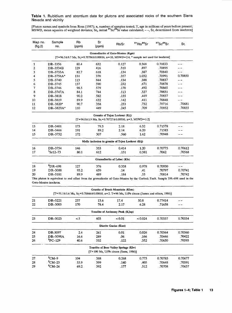
Table 1. Rubidium and strontium data for plutons and associated rocks of the southern Sierra Nevada and vicinity
[Pluton names and symbols from Ross (1987); n, number of samples tested; T, age in millions of years before present; MSWD, mean squares of weighted deviates; Sri> initial 87Srf8Sr value calculated;--, Sri determined from isochron]
Map no. Sample Rb Sr Rb/Sr 87Rbf8Sr 87Srf6Sr Sri
(fig.2) no. (ppm) (ppm)
Granodiorite of Gato-Montes (Kgm) [T=96.3±8.7 Ma, Sr;=0.70786±0.00016, n= 10, MSWD=2.4, * sample not used for isochron]
1 DR-3356 80.4 632 0.127 0.368 0.70833 2 DR-3534B 129 416 .310 .897 .70895 3 DR-3733A 82.7 618 .134 .387 .70840 4 DR-3756A* 131 370 .357 1.032 .70991 0.70850 5 DR-3740 113 844 .134 .388 .70837 6 DR-3745 137 590 .232 .671 .70878 7 DR-3746 98.5 579 .170 .492 .70865 8 DR-3747A 84.1 744 .113 .327 .70831 9 DR-3818 90.2 582 .155 .449 .70837
10 DR-3819 89.9 632 .142 .411 .70848 11 DR-3820* 90.7 358 .253 .732 .70716 .70681 12 DR-3829A* 110 449 .245 .709 .70952 .70855
Granite of Tejon Lookout (Ktj) [T=96.0± 1.9 Ma, Sr;=0.70727±0.00010, n=3, MSWD= 1.2]
13 DR-3401 173 79.3 2.18 6.32 0.71578 14 DR-3466 191 89.2 2.14 6.20 .71583 15 DR-3752 172 307 .560 1.62 .70948
Mafic inclusion in granite of Tejon Lookout (Ktj)
16 DR-3754 146 353 0.414 1.20 0.70775 0.70612 17 1Sr12-73 80.1 612 .131 0.381 .7062 .70568
Granodiorite of Lebec (Kie)
18 2DR-698 127 376 0.338 0.978 0.70930 19 DR-3088 93.2 659 .14 .41 .70797 0.70741 20 DR-3181 89.9 489 .184 .53 .70814 .70742 This pluton is equivalent to and offset from the granodiorite of Gato-Montes by the Garlock Fault. Sample DR-698 used in the Gato-Montes isochron.
Granite of Brush Mountain (Kbm) [T=91.1±1.6 Ma, Sr;=0.70846±0.00010, n=2. T=98 Ma, U/Pb zircon (James and others, 1986)]
21 DR-3221 237 13.6 17.4 50.8 0.77414 22 DR-3005 170 78.4 2.17 6.28 .71658
Tona1ite of Antimony Peak (KJap)
23 DR-3023 <5 603 <0.01 <0.024 0.70337 0.70334
Diorite Gneiss (Kset)
24 DR-3097 2.4 261 0.01 0.026 0.70364 0.70360 25 DR-3098A 16.6 289 .06 .166 .70446 .70422 26 8PC-129 40.6 332 .122 .352 .70650 .70593 -----
Tonalite of Bear Valley Springs (Kbv) [T= 100 Ma, U/Pb zircon (Sams, 1986)]
27 8CM-9 104 388 0.268 0.775 0.70785 0.70677 28 8CM-25 55.9 399 .140 .405 .70648 .70591 29 8CM-26 69.2 392 .177 .512 .70708 .70637
Figures 1-4; Table 1 13
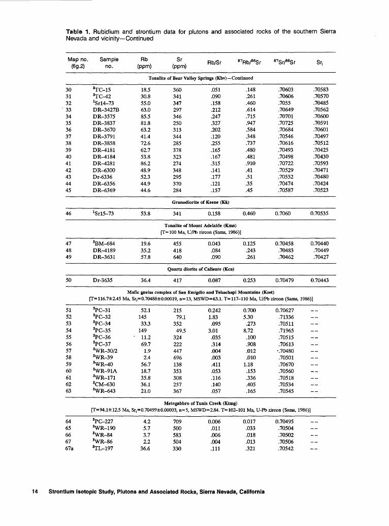
Table 1. Rubidium and strontium data for plutons and associated rocks of the southern Sierra Nevada and vicinity-Continued
Map no. Sample Rb Sr Rb/Sr 87Rbf8Sr 87Srf8Sr Sri
(fig.2) no. (ppm) (ppm)
Tonalite of Bear Valley Springs (Kbv) -Continued
30 ~C-15 18.5 360 .051 .148 .70603 .70583 31 ~C-42 30.8 341 .090 .261 .70606 .70570 32 1Sr14-73 55.0 347 .158 .460 .7055 .70485
. 33 DR-3427B 63.0 297 .212 .614 .70649 .70562 34 DR-3575 85.5 346 .247 .715 .70701 .70600 35 DR-3837 81.8 250 .327 .947 .70725 .70591 36 DR-3670 63.2 313 .202 .584 .70684 .70601 37 DR-3791 41.4 344 .120 .348 .70546 .70497 38 DR-3858 72.6 285 .255 .737 .70616 .70512 39 DR-4181 62.7 378 .165 .480 .70493 .70425 40 DR-4184 53.8 323 .167 .481 .70498 .70430 41 DR-4281 86.2 274 .315 .910 .70722 .70593 42 DR-6300 48.9 348 .141 .41 .70529 .70471 43 Dr-6336 52.3 295 .177 .51 .70552 .70480 44 DR-6356 44.9 370 .121 .35 .70474 .70424 45 DR-6369 44.6 284 .157 .45 .70587 .70523
Granodiorite of Keene (Kk)
46 1Sr15-73 53.8 341 0.158 0.460 0.7060 0.70535
TonaJite of Mount Adelaide (Kma) [T=100 Ma, U/Pb zircon (Sams, 1986)]
47 3BM-684 19.6 455 0.043 0.125 0.70458 0.70440 48 DR-4189 35.2 418 .084 .243 .70483 .70449 49 DR-3631 57.8 640 .090 .261 .70462 .70427
Quartz diorite of Caliente (Kca)
50 Dr-3635 36.4 417 0.087 0.253 0.70479 0.70443
Mafic gneiss complex of San Emigdio and Tehachapi Mountains (Kset) [T=116.7±2.45 Ma, Sr;=0.70488±0.00019, n=13, MSWD=63.1. T=ll?-110 Ma, U/Pb zircon (Sams, 1986)]
51 3PC-31 52.1 215 0.242 0.700 0.70627 52 3PC-32 145 79.1 1.83 5.30 .71336 53 3PC-34 33.3 352 .095 .273 .70511 54 3PC-35 149 49.5 3.01 8.72 .71965 55 3PC-36 11.2 324 .035 .100 .70515 56 3PC-37 69.7 222 .314 .908 .70613 57 3WR-30/2 1.9 447 .004 .012 ·.70480 58 3WR-39 2.4 696 .003 .010 .70501 59 3WR-40 56.7 138 .411 1.18 .70670 60 3WR-91A 18.7 353 .053 .153 .70560 61 3WR-171 35.8 308 .116 .336 .70518 62 3CM-630 36.1 257 .140 .405 .70534 63 3WR-643 21.0 367 .057 .165 .70545
Metagabbro of Tunis Creek (Ktmg) [T=94.1± 12.5 Ma, Sr;=0.70499±0.00003, n=S, MSWD=2.84. T= 102-101 Ma, U-Pb zircon (Sams, 1986)]
64 3PC-227 4.2 709 0.006 0.017 0.70495 65 3WR-190 5.7 500 .011 .033 .70504 66 3WR-84 3.7 583 .006 .018 .70502 67 3WR-86 2.2 504 .004 .013 .70506 67a ~L-197 36.6 330 .111 .321 .70542
14 Strontium Isotopic Study, Plutons and Associated Rocks, Sierra Nevada, California

Table 1. Rubidium and strontium data for plutons and associated rocks of the southern Sierra Nevada and vicinity-Continued
Map no. Sample Rb Sr Rb/Sr 87Rbf8Sr 87Sr/sesr Sri (fig.2) no. (ppm) (ppm)
Gabbro of Eagle Rest Peak (Jer) [Minimum age is 161 Ma, U/Pb zircon, James and others (1986). Maximum age is 200 Ma, K/AI hornblende (Ross and others, 1973)]
68 2DR-1182C 8.8 228 0.016 0.046 0.7042 0.70407 69 2DR-671B <2 147 .7031 .7031 69 2DR-671Pl 4.2 293 .014 .041 .7035 .70337
Gneiss of Tweedy Creek (Kset) [f= 110 Ma, U/Pb zircon (Sams, 1986)]
70 s.rc-12A 66.7 216 0.309 0.890 0.70818 0.70679
Inclusion in the tonalite of Bear Valley Springs (Kbv)
71 8CM-22B 16.0 265 0.060 0.173 0.70629 0.70604
Paragneiss of Cummings Mountain (Kset)
72 8CM-110 110 165 0.667 1.931 0.71442 0.71168
Quartzite in the Tehachipi metasedimentary belt of Ross (1987)
73 8CM-640 32.3 90.3 0.358 1.037 0.72581 0.72434
Granodiorite of Poso Flat (Kpf) [f=100 Ma. Probable facies of tonalite of Bear Valley Springs]
74 DR-6292 80.5 227 0.291 0.84 0.70609 0.70490 75 DR-6297 52.3 285 .183 .53 .70534 .70459 76 DR-6359 61 300 .205 .59 .70587 .70503 77 DR--6373 53.6 310 .172 .50 .70549 .70478
Granodiorite of Alder Creek (Kal)
[f=91 Ma. Probable facies of tonalite of DunL'lp Meadow)
78 DR-5236 108 328 0.329 0.953 0.70812 0.70677 79 DR-5261 116 305 .380 1.10 .70831 .70675 80 DR-6245 123 232 .530 1.53 .70855 .70638 81 DR-6269 117 220 .532 1.54 .70861 .70644 82 1Sr4-73 146 249 .586 1.69 .7089 .70656 83 1Sr5-73 154 238 .646 1.86 .7084 .70576
Tonalite of Walt Klein Ranch (Kwk) [f=l11±2.5 Ma, K/AI hornblende (Evemden and Kistler, 1970)]
84 DR--6061 33.1 294 0.113 0.326 0.70433 0.70382 85 DR--6088 46.1 311 .148 .429 .70485 .70417 86 DR--6096 60.6 295 .205 .594 .70485 .70391 87 DR-6281A 37.7 423 .089 .26 .70460 ... 70419 88 DR-6314-1 79.3 288 .275 .80 .70540 .70414 89 DR-6321 42.4 349 .121 .35 .70476 .70421 90 1Sr1-73 77.2 360 .215 .62 .7048 :70382 91 1Sr2-73 57.7 399 .145 .42 .7050 .70434
Tonalite of Fountain Springs (Kfs) [f= 102 Ma, U/Pb zircon (Saleeby and Sharp, 1980)]
92 DR-6024 34.6 341 0.101 0.293 0.70432 0.70390 93 DR-6106 34.4 281 .122 .354 .70441 .70390
Figures 1-4; Table 1 15
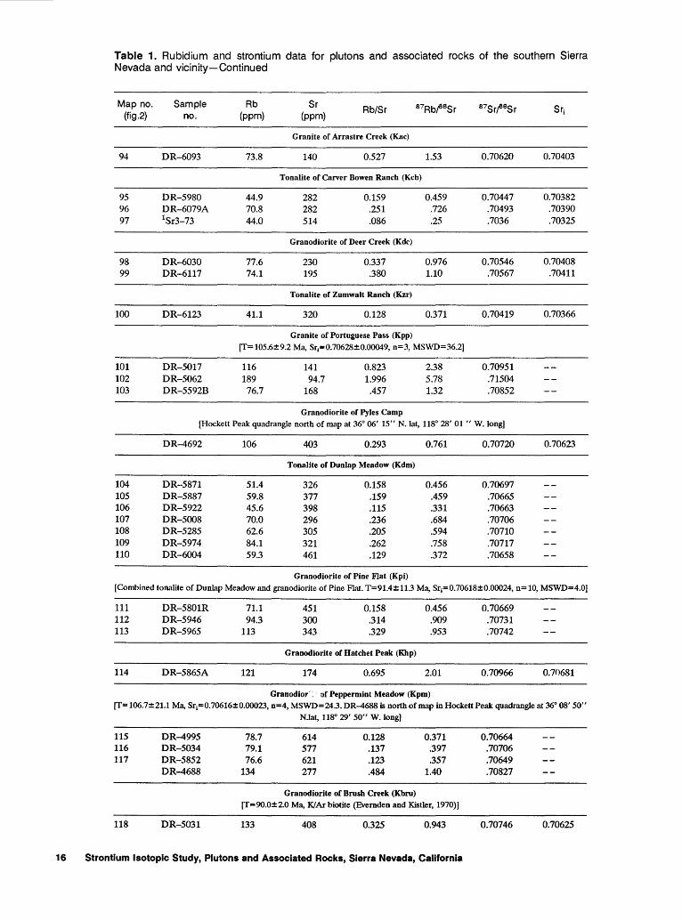
Table 1. Rubidium and strontium data for plutons and associated rocks of the southern Sierra Nevada and vicinity-Continued
Map no. Sample Rb Sr Rb/Sr 87Rbf8Sr 87Srf8Sr Sri
(fig.2) no. (ppm) (ppm)
Granite of Arrastre Creek (Kac)
94 DR-6093 73.8 140 0.527 1.53 0.70620 0.70403
Tonalite of Carver Bowen Ranch (Kcb)
95 DR-5980 44.9 282 0.159 0.459 0.70447 0.70382 96 DR-6079A 70.8 282 .251 .726 .70493 .70390 97 1Sr3-73 44.0 514 .086 .25 .7036 .70325
Granodiorite of Deer Creek (Kdc)
98 DR-6030 77.6 230 0.337 0.976 0.70546 0.70408 99 DR-6117 74.1 195 .380 1.10 .70567 .70411
Tonalite of Zumwalt Ranch (Kzr)
100 DR-6123 41.1 320 0.128 0.371 0.70419 0.70366
Granite of Portuguese Pass (Kpp)
[T= 105.6±9.2 Ma, Sri=0.70628±0.00049, n=3, MSWD=36.2]
101 DR-5017 116 141 0.823 2.38 0.70951 102 DR-5062 189 94.7 1.996 5.78 .71504 103 DR-5592B 76.7 168 .457 1.32 .70852
Granodiorite of Pyles Camp (Hockett Peak quadrangle north of map at 36° 06' 15" N. L'lt, 118° 28' 01 " W. long)
DR-4692 106 403 0.293 0.761 0.70720 0.70623
Tonalite of Dunlap Meadow (Kdm)
104 DR-5871 51.4 326 0.158 0.456 0.70697 105 DR-5887 59.8 377 .159 .459 .70665 106 DR-5922 45.6 398 .115 .331 .70663 107 DR-5008 70.0 296 .236 .684 .70706 108 DR-5285 62.6 305 .205 .594 .70710 109 DR-5974 84.1 321 .262 .758 .70717 110 DR-6004 59.3 461 .129 .372 .70658
Granodiorite of Pine Flat (Kpi) [Combined tonalite of Dunlap Meadow and granodiorite of Pine Flat. T=91.4±113 Ma, Sri=0.70618±0.00024, n=10, MSWD=4.0)
111 DR-5801R 71.1 451 0.158 0.456 0.70669 112 DR-5946 94.3 300 .314 .909 .70731 113 DR-5965 113 343 .329 .953 .70742
Granodiorite of Hatchet Peak (Khp)
114 DR-5865A 121 174 0.695 2.01 0.70966 0.70681
Granodior·:- of Peppermint Meadow (Kpm) [T= 106.7±21.1 Ma, Sri=0.70616±0.00023, n=4, MSWD=24.3. DR-4688 is north of map in Hockett Peak quadrangle at 36° 08' 50"
N.lat, 118° 29' 50" W. long)
115 DR-4995 78.7 614 0.128 0.371 0.70664 116 DR-5034 79.1 577 .137 .397 .70706 117 DR-5852 76.6 621 .123 .357 .70649
DR-4688 134 277 .484 1.40 .70827
Granodiorite of Brush Creek (Kbru) [1'=90.0±2.0 Ma, K/Ar biotite (Evemden and Kistler, 1970)]
118 DR-5031 133 408 0.325 0.943 0.70746 0.70625
16 Strontium Isotopic Study, Plutons and Associated Rocks, Sierra Nevada, California
Table 1. Rubidium and strontium data tor plutons and associated rocks of the southern Sierra Nevada and vicinity-Continued
Map no. Sample Rb Sr Rb/Sr 87Rb/sesr 87Sr/sasr Sri (fig.2) no. (ppm) (ppm)
Granodiorite of Alta Sierra (Kas) [f=89.0±2.1 Ma, K/Ar biotite (Evemden and Kistler, 1970))
119 DR-5423 60.1 527 0.114 0.330 0.70658 0.70616 120 DR-5425 42.6 676 .063 .182 .70676 .70653 121 DR-4796-1 63.1 567 .111 .321 .70660 .70619 122 DR-4789A 63.7 541 .118 .341 .70670 .70626
Granite of Kern River (Kkr) [f=87 and 89 Ma, K/Ar biotite (Evemden and Kistler, 1970). T=81.1±11.1 Ma, Sri=0.70810±0.00039, n=4, MSWD=12.6, Rb/Sr
whole-rock isochron)
124 DR-5006 127 200 0.635 1.84 0.70999 0.70767 125 DR-4763 155 147 1.054 3.05 .71158 .70773 126 DR-4819A 155 148 1.047 3.03 .71169 .70767 127 424-73 105 203 .516 1.49 _7100 .70812
Granodiorite ofWagy Flat(Kwl)
128 DR-4273 74.1 623 0.119 0.344 0.70698 0.70649 129 DR-4294 59.5 583 .102 .295 .70722 .70680
Granite of Saddle Springs (Kss) [mafic inclusions]
130 DR-5089 50.1 387 0.129 0.373 0.70724 0.70671 131 DR-5153 56.7 480 .118 .341 .70656 .70608
Granodiorite of Rabbit Island (Kri)
[f=99 Ma, U!Pb zircon (Saleeby and Busby-Spera, 1986)]
132 DR-4848 107 604 0.177 0.512 0.70712 0.70639 133 DR-5421 70.6 530 .133 .385 .70648 .70593 134 DR-5407 108 623 .173 .502 .70716 .70645 135 5LGC-4 82.9 732 .113 .328 .70713 .70664 136 5LGC-5 107 615 .174 .503 .70746 .70675 137 5LGC-6 69.3 776 .089 .258 .70706 .70669 138 5LGC-7 116 378 .307 .888 .70805 .70679 139 5LGC-8 124 480 .258 .747 .70813 .70707 140 DR-5191A 56.7 956 .059 .171 .70814 .70790
Granodiorite of Castle Rock (Kcr)
141 DR-4528 117 449 0.261 0.754 0.70909 0.70813 142 DR-4402 89.9 573 .157 .454 .70851 .70793 143 DR-4354 99.4 526 .189 .547 .70852 .70782 144 DR-4341 82.0 603 .136 .393 .70850 .70800 145 DR-5356 101 456 .221 .641 .70752 .70671 146 DR-4093 81.3 652 .125 .361 .70864 .70818 147 5LGC-3 195 470 .415 1.200 .70875 .70706 148 1Sr6-73 140 349 .401 1.16 .7073 .70582 149 1Sr8-73 98 737 .133 .384 .7080 .70751 150 1Sr9-73 81.8 695 .118 .341 .7084 .70746 151 DR-5133R 182 75.5 2.41 6.98 .71654 .70762 152 DR-5403 130 460 .283 .818 .70791 .70687 153 DR-6539 94.9 713 .133 .385 .70786 .70731 154 DR-4686 170 511 .333 .962 .70783 .70660
Wbiterock facies of the granodiorite of Castle Rock (Kcw)
[f=90 Ma, U!Pb zircon (Sams, 1986)}
155 DR-4314 103 552 0.187 0.540 0.70835 0.70766 156 DR-4102A 96.6 504 .192 .554 .70817 .70746 157 DR-3737 86.0 893 .096 .279 .70813 .70777
Figures 1-4; Table 1 17
Table 1. Rubidium and strontium data for plutons and associated rocks of the southern Sierra Nevada and vicinity-Continued
Map no. Sample Rb Sr Rb/Sr 87Rbf8Sr 87Srf8Sr Sri (fig.2) no. (ppm) (ppm)
Wbiterock facies of the granodiorite of Castle Rock (Kcw) -Continued
158 So-rC-27 71.2 562 .127 .367 .70777 .70730 159 So-rC-40 48.1 578 .083 .241 .70735 .70704
Dikes in Isabella roof pendant in the Long Canyon metasedimentary belt of Ross (1987)
160 PM-505 123 186 0.661 1.91 0.71701 0.71443 161 PM-536 144 289 .498 1.44 .70981 .70787 162 DR-5629 67.5 621 .109 .315 .70725 .70683
Volcanic rocks of Piute Peak in the Erskine Canyon sequence of Saleeby and Busby-Spera (1986) [f=97.3±0.5 Ma, Sr;=0.70576±0.00011, n=3, MSWD=O.Ol. T=98 Ma, U!Pb zircon (Saleeby and Busby-Spera, 1986))
163 EM-10 77.6 136 0.571 1.651 0.70804 163 EM-lOB 71.8 232 .309 .895 .70699 163 EM-10C 58.2 242 .240 .696 .70672
Volcanic rocks in Erskine Canyon sequence of Saleeby and Busby-Spera (1986) [f=102 Ma, U/Pb zircon (Saleeby and Busby-Spera, 1986)]
164 82SS7 137 143 0.958 2.77 0.71038 0.70637
Granite of Bodfish Canyon (Kbo)
165 DR-5071 194 41.1 4.72 13.7 0.72647 0.70896
Tonalite of Hoffman Canyon (Kbc)
166 1Sr10-73 89.6 634 0.141 0.408 0.7076 0.70708
Amphibolite of Jawbone Canyon (KJc)
167 DR-4497B 29.8 662 0.045 0.130 0.70814 0.70793 168 DR-4498B 64.5 237 .272 .787 .70877 .70750 169 DR-4499 33.1 719 .046 .133 .70779 .70758
Granite of Bishop Ranch (Kbr)
170 DR-4472 93.1 665 0.140 0.405 0.70904 0.70852
Granite of Cannell Creek (Kcc) [f=80±2 Ma, U!Pb zircon (Saleeby and Busby-Spera, 1986)]
171 '1._GC-9 99 366 0.270 0.783 0.70854 0.70743 172 5LGC-11 195 29.6 6.59 19.1 .73642 .70930 173 5LGC-17 57.7 517 .117 .323 .70768 .70723 174 5LGC-18 148 318 .465 1.35 .70925 .70734 175 5LGC-23 171 392 .436 1.26 .70904 .70725 176 5LGC-25 133 28.9 4.60 13.34 .73010 .71116
Quartz diorite of Cyrus Flat (Kcl) (Unit "A" Fox, 1981)
177 5LGC-12 10.0 780 0.013 0.037 0.70681 0.70676 178 5LGC-13 13.5 623 .027 .063 .70686 .70677
Quartz diorite of Cyrus Flat (Kcl)
[f= 100 Ma, U/Pb zircon (Saleeby and Busby-Spera, 1986)]
179 5LGC-14 117 408 0.287 0.830 0.70814 0.70796 180 5LGC-15 110 407 .270 .782 .70811 .70700 181 5LGC-16 113 384 .294 .851 .70770 .70650
18 Strontium Isotopic Study, Plutons and Associated Rocks, Sierra Nevada, California

Table 1. Rubidium and strontium data for plutons and associated rocks of the southern Sierra Nevada and vicinity-Continued
Map no. Sample Rb Sr Rb/Sr 87Rb/86Sr 87Srf8Sr Sri
(fig.2) no. (ppm) (ppm)
Quartz diorite of Cyrus Flat (Kcl)-Continued
182 5LGC-20 57.7 471 .123 .354 .70821 .70771 183 5LGC-21 103 366 .281 .814 .70908 .70793 184 5LGC-22 99.5 306 .325 .941 .70918 .70785 185 5LGC-24 91.2 521 .175 .506 .70763 .70691 186 5LI-33 74.8 498 .150 .435 .70813 .70751 187 5LI-34 46.9 683 .069 .199 .70827 .70799 188 5LI-35 203 198 1.025 2.97 .71134 .70712 189 5LI-36 195 243 .802 2.32 .70951 .70622 190 5LI-37 218 249 .876 2.53 .71104 .70745 191 5LI-38 105 569 .184 .534 .70887 .70811 192 5LI-39 102 579 .176 .510 .70848 .70776 193 5LI-40 93.4 445 .210 .607 .70857 .70771 194 5LI-41 129 265 .487 1.41 .70937 .70737 195 5LI-42 125 406 .308 .891 .70886 .70760 196 5LI-43 180 242 .744 2.15 .71044 .70739 197 5LI-44 59.0 511 .115 .334 .70776 .70729
Sedimentary rocks south of the quartz diorite of Cyrus Flat in the Long Canyon metasedimentary belt of Ross (1987)
198 5LGC-1 67.5 445 0.152 0.439 0.72032 0.71970 199 5LGC-2 123 165 .745 2.16 .73827 .73520 200 5LGC-10 122 35.6 3.43 9.96 .75232 .73818 201 5LGC-19 71.6 459 .156 .451 .70917 .70853
Granite of Onyx (T=81 Ma, K/Ar biotite (Evemden and Kistler, 1970)]
202 425-73 170 343 0.496 1.435 0.7098 0.70801
Quartz diorite of Freeman Junction (Trtj) [T=222 Ma, Sr1=0.70428, n=2)
203 DR-6438A 35.5 531 0.067 0.19 0.70488 204 DR-6439 49.8 456 .109 .32 .70529
Quartz diorite of Walker Pass, unsheared part (Trwp) (T=240.4±14 Ma, Sr1=0.70362±0.00007, n=lO, MSWD=4.06. lsochron from these and unsheared quartz diorites and trondjhemites
of the El Paso Mountains]
205 DR-6226 35.0 599 0.058 0.169 0.70434 206 426-73 76.8 396 .194 .561 .7056 207 DR-6179 30.8 694 .044 .128 .70411 208 DR-6391 33.0 762 .043 .13 .70416 209 DR-6217 70.8 633 .111 .324 .70475
Quartz diorite of Walker Pass, sheared part (Trwps)
[Samples do not yield an isochron)
210 DR-6220 43.4 539 0.081 0.233 0.70475 0.70396 211 DR-6394A 27.2 714 .038 .110 .70440 .70403 212 DR-6400 30.6 668 .045 .132 .70452 .70407 213 DR-6176A 36.1 577 .062 .181 .70460 .70398 214 DR-6174D 26.9 643 .042 .121 .70441 .70400 215 DR-6385A 73.5 654 .112 .325 .70538 .70428
Gray gneiss in the summit gabbro of Miller and Webb (1940) (JTrsg) (T=218 Ma, Sr1=0.70366]
216 DR-6511 58.2 616 0.094 0.273 0.70451 217 DR-6516 93.2 446 .209 .605 .70554
Figures 1-4; Table 1 19
Table 1. Rubidium and strontium data for plutons and associated rocks of the southern Sierra Nevada and vicinity-Continued
Map no. (fig.2)
Sam pte no.
Rb (ppm)
Sr (ppm)
Rb/Sr
Quartz diorite and trondjhemite of El Paso Mountains (frPe)
(T=240±14 Ma, Sri=0.70362±0.00007, n=10, MSWD=4.1. T=247-223 Ma, K/Ar hornblende (Cox and Morton. 1980)]
218 GR-151 42 604 0.069 0.200 0.70424 219 GR-152 26 574 .045 .130 .70392 220 1Sr1Cr73 98.1 382 .257 .743 .7062 221 S28-84 67.8 500 .136 .393 .70477 222 S31-84 67.0 512 .131 .379 .70489
Quartz diorite of Long VaHey (frlv)
223 DR-6509A 43.4 925 0.047 0.136 0.70558 0.70512
Granodiorite of Five Fingers (Kll)
(T=90 Ma, estimnted from Rb/Sr data]
224 DR-6535 92.7 799 0.116 0.336 0.70721 0.70679 225 DR-6415 76.6 809 .095 .27 .70716 .70682 226 DR-6208 93.2 544 .171 .496 .70738 .70675
Sacatar quartz diorite of MiJier and Webb (1940) (Js) [T=1TI.4±4.9 Ma, Sri=0.70718±0.00015, MSWD=12.5, n=l9. T> 170 Ma, U/Pb zircon preferred intrusive age (Chen and Moore, 1982) for unit 6 of Moore and DuBray (1978), which is Sacatar Quartz Diorite equivalent in the Hockett Peak quadrangle north of map
(fig. 2)]
227 DR-6483A 94.2 659 0.143 0.413 0.70883 228 DR-6472A 88.7 525 .169 .489 .70847 229 DR-6523A 132 460 .287 .830 .70952 230 DR-6425 105 532 .197 .57 .70861 231 S6Cr84 137 470 .291 .843 .70963 231 S66A-84 178 132 1.35 3.90 .71710 232 S67-84 188 348 .540 1.56 .71117
Granite of No Name Canyon (Knc) (T=80.5±1.7 Ma, Sri=0.70880±0.00008, MSWD=0.17, n=4. T=80.1±5.3 Ma, K/Ar muscovite (Diggles, 1984). Samples are from
Griffis (1987)]
233 NM-4A 366 5.54 66.06 195.3 0.93265 234 NM-4B 329 11.8 27.88 81.40 .80172 235 NM-30 119 478 .25 .720 .70960 236 NM-31 155 462 .335 .971 .70993
Granite of Tehachapi Airport (Kta)
237 DR-4100A 165 78.7 2.097 6.07 0.71645
Granodiorite of Little Lake (JII) (T== 175±5 Ma, Rb/Sr whole-rock isochron from 5 samples outside map area]
238 Sr20-73
1Kistler and Peterman (1978) 2Kistler and others (1973) 8Sams (1986) 4Kistler and Peterman (1973) 5Collins (1988)
132 339 0.389 1.126
20 Strontium Isotopic Study, Plutons and Associated Rocks, Sierra Nevada, California
0.7089
0.70955
0.7061
SELECTED SERIES OF U.S. GEOLOGICAL SURVEY PUBLICATIONS
Periodicals
Earthquakes & Volcanoes (issued bimonthly). Preliminary Determination of Epicenters (issued monthly).
Technical Books and Repons
Professional Papers are mainly comprehensive scientific reports of wide and lasting interest and importance to professional scientists and engineers. Included are reports on the results of resource studies and of topographic, hydrologic, and geologic investigations. They also include collections of related papers addressing different aspects of a single scientific topic.
Bulletins contain significant data and interpretations that are of lasting scientific interest but are generally more limited in scope or geographic coverage than Professional Papers. They include the results of resource studies and of geologic and topographic investigations; as well as collections of short papers related to a specific topic.
Water-Supply Papers are comprehensive reports that present significant interpretive results of hydrologic investigations of wide interest to professional geologists, hydrologists, and engineers. The series covers investigations in all phases of hydrology. including hydrogeology, availability of water, quality of water, and use of water.
Cb'culars present administrative information or important scientific information of wide popular interest in a format designed for distribution at no cost to the public. Information is usually of short-term interest.
Water-Resources Investigations Reports are papers of an interpretive nature made available to the public outside the formal USGS publications series. Copies are reproduced on request unlike formal USGS publications, and they are also available for public inspection at depositories indicated in USGS catalogs.
Open-Flle Reports include unpublished manuscript reports, maps, and other material that are made available for public consultation at depositories. They are a nonpermanent form of publication that may be cited in other publications as sources of information.
Maps
Geologic Quadrangle Maps are multicolor geologic maps on topographic bases in 7 ln.- or 15-minute quadrangle formats (scales mainly 1:24,000 or 1 :62,500) showing bedrock. surficial, or engineering geology. Maps generally include brief texts; some maps include structure and columnar sections only.
Geophysical Investigations Maps are on topographic or planimetric bases at various scales; they show results of surveys using geophysical techniques, such as gravity, magnetic, seismic, or radioactivity, which reflect subsurface structures that are of economic or geologic significance. Many maps include correlations with the geology.
Miscellaneous Investigations Series Maps are on planimetric or topographic bases of regular and irregular areas at various scales; they present a wide variety of format and subject matter. The series also includes 7 1/2-minute quadrangle photogeologic maps on planimetric bases which show geology as interpreted from aerial photographs. Series also includes maps of Mars and the Moon.
Coal Investigations Maps are geologic maps on topographic or planimetric bases at various scales showing bedrock or surficial geology, stratigraphy, and structural relations in certain coal-resource areas.
Oil and Gas Investigations Charts show stratigraphic information for certain oil and gas fields and other areas having petroleum potential.
Miscellaneous Field Studies Maps are multicolor or black-andwhite maps on topographic or planimetric bases on quadrangle or irregular areas at various scales. Pre-1971 maps show bedrock geology in relation to specific mining or mineral-deposit problems; post-1971 maps are primarily black-and-white maps on various subjects such as environmental studies or wilderness mineral investigations.
Hydrologic Investigations Atlases are multicolored or black-andwhite maps on topographic or planimetri(.. bases presenting a wide range of geohydrologic dataofboth regular and irregular areas; principal scale is 1:24,000 and regional studies are at 1:250,000 scale or smaller.
Catalogs
Permanent catalogs, as well as some others, giving comprehensive listings of U.S. Geological Survey publications are available under the conditions indicated below from the U.S. Geological Survey, Books and Open-File Reports Section, Federal Center, Box 25425, Denver, CO 80225. (See latest Price and Availability List)
"Publications of the Geological Survey, 1879-1961" may be purchased by mail and over the counter in paperback book form and as a set of microfiche.
"Publications of the Geological Survey, 1962- 1970" may be purchased by mail and over the counter in paperback book form and as a set of microfiche.
"Publications of the U.S. Geological Survey, 1971-1981" may be purchased by mail and over the counter in paperback book form (two volumes, publications listing and index) and as a set of microfiche.
Supplements for 1982, 1983, 1984, 1985,1986, and for subsequent years since the last permanent catalog may be purchased by mail and over the counter in paperback book form.
State catalogs, "List of U.S. Geological Survey Geologic and Water-Supply Reports and Maps For (State)," may be purchased by mail and over the counter in paperback booklet form only.
"Price and A vailabillty List of U.S. Geological Survey Publications," issued armually, is available free of charge in paperback booklet form only.
Selected copies of a monthly catalog "New Publications of the U.S. Geological Survey" available free of charge by mail or may be obtained over the counter in paperback booklet form only. Those wishing a free subscription to the monthly catalog "New Publications of the U.S. Geological Survey" should write to the U.S. Geological Survey, 582 National Center, Reston, VA 22092.
Note.--Prices of Government publications listed in older catalogs, announcements, and publications may be incorrect. Therefore, the prices charged may differ from the prices in catalogs, announcements, and publications.