Embed Size (px)
Citation preview

A Stereo Vision Based Mapping Algorithm for DetectingInclines, Drop-offs, and Obstacles for Safe Local Navigation
Aniket MurarkaComputer Science
The University of Texas at [email protected]
Benjamin KuipersComputer Science and Engineering
University of [email protected]
Abstract— Mobile robots have to detect and handle a varietyof potential hazards to navigate autonomously. We present areal-time stereo vision based mapping algorithm for identifyingand modeling various hazards in urban environments – wefocus on inclines, drop-offs, and obstacles. In our algorithm,stereo range data is used to construct a 3D model consistingof a point cloud with a 3D grid overlaid on top. A novelplane fitting algorithm is then used to segment the 3D modelinto distinct potentially traversable ground regions and fitplanes to the regions. The planes and segments are analyzedto identify safe and unsafe regions and the information iscaptured in an annotated 2D grid map called a local safetymap. The safety map can be used by wheeled mobile robots forplanning safe paths in their local surroundings. We evaluate ouralgorithm comprehensively by testing it in varied environmentsand comparing the results to ground truth data.
I. INTRODUCTION
A wheeled mobile robot navigating in an urban environ-ment has to deal with many potential hazards (Table I). Therobot must be able to avoid obstacles and, critically, detectcatastrophic hazards like drop-offs. It is also important thatthe robot is able to detect inclined surfaces and estimate theirslopes so as to avoid rolling over or slipping.
Potential Hazards ExamplesObstacles: Static Walls, furnitureDynamic People, doorsInvisible Glass doors and glass wallsDrop offs Sidewalk curbs, downward stairsInclines Wheelchair ramps, curb cuts, sloped sidewalksOverhangs Table tops, railings, tree branchesRough surfaces Gravel paths, grass bedsNarrow regions Doorways, elevators
TABLE I: Potential hazards that a mobile robot must deal with inurban environments.
Research in mobile robotics has primarily focused ondetecting obstacles [1]. Methods for detecting drop-offs [2],[3], inclines and other hazards have featured less prominentlyeven though detecting them is just as important. Furthermore,laser range-finders have been used as the primary sensorson most robots because they provide reliable and highquality range information. Cameras have also been usedextensively, but on almost all practical navigation systemsthey are accompanied with lasers [1]. Reasons for camerasnot taking a central role include the sensitivity of camerasto environmental conditions and the difficulty in reliablyinterpreting images.
However, we focus on the use of cameras as the primarysensors, instead of lasers, because cameras are cheaper andsmaller and an image provides a lot more information than
a laser scan. For the price of a single laser scanner, itis possible to have several cameras on a robot providinga greater field-of-view and information. Furthermore, inaddition to being useful for navigation, cameras are usefulfor a variety of other tasks such as detecting objects andrecognizing places.
Therefore, in this paper we present a stereo vision basedmapping algorithm for detecting inclines, drop-offs, andstatic obstacles for enabling wheeled mobile robots to nav-igate safely in urban environments. Our stereo mappingalgorithm identifies safe and unsafe regions in the robot’slocal surroundings and represents this information using anannotated 2D grid map called a local safety map. The 2Dlocal safety map can be used by the robot to plan safe localpaths using standard planning algorithms [19]. In addition,we also present an evaluation framework that allows for thecomprehensive evaluation of mapping systems, such as ours.An overview is provided in the following section.
A. OVERVIEW OF SYSTEM
As the robot explores its local surroundings it gets aconstant stream of stereo images. Each new stereo imagepair (or frame) is processed as outlined in the followingsteps (corresponding to Sections III through VI), to updatethe robot’s current knowledge of the world:
A. A depth (or disparity) map is computed from the stereoimage pair (Fig. 1). The depth readings are transformed intoglobal coordinates (i.e., map coordinates).
B. A 3D model consisting of a 3D grid and 3D point cloudis updated with the new depth readings using an occupancygrid algorithm (Fig. 2).
C. Planes are fit to potentially traversable ground segmentsin the 3D model. The process consists of segmenting the 3Dgrid followed by fitting planes to points corresponding to thesegments using linear least squares (Fig. 3).
D. Finally, the segments and planes are analyzed for safetyto yield the local safety map (Fig. 4).
Cells in the local safety map are annotated with one ofthe following labels: Level: implying the region in the cellis level and free of obstacles; Inclined: the cell region isinclined; Non-ground: the cell has an obstacle or overhangor is lower in height than nearby ground regions; Unknown:there is insufficient information about the region. Leveland Inclined cells are considered safe and whereas Non-ground cells are considered unsafe. Safe cells can be furtherannotated as being Potential Drop-off Edges, if a drop-off is

expected to be present in the vicinity of the cell. Additionally,Inclined cells are annotated with their surface normals.
To transform the depth readings into global coordinatesin step A, we need to know the robot’s pose in the globalframe. Since the focus of this work is on building models ofthe environment, we assume that the robot is able to localize.For our experiments we use a laser based 3-DOF localizationalgorithm [4] for providing the robot’s pose to our mappingalgorithm (the 3-DOF method can be replaced by a camerabased 6-DOF SLAM algorithm [5]). Since we use a 3-DOF localization module, our robot is restricted to travellingonly on level surfaces for the experiments reported in thispaper. However, our reconstruction algorithm is general andapplicable without modification to the case when the robot’smotion has 6-DOF.
We evaluate our system quantitatively by constructingsafety maps for five different datasets and measuring errorrates by comparing the constructed maps against ground truthmaps. We also measure latencies present in the system andthe accuracy of the plane fitting process. The evaluationframework is very general and we believe it to be a compre-hensive way of evaluating and comparing the performanceof a variety of mapping systems. Towards this goal we havemade our video datasets and associated ground truth datapublicly available [6].
Our contributions in this work are as follows: (i) A real-time stereo vision based system for detecting inclines, drop-offs, and obstacles. (ii) A comprehensive evaluation frame-work for measuring the performance of various mappingsystems. As part of the system, our contributions are: (a)A novel method for fitting planes to traversable ground seg-ments in 3D point clouds. (b) A novel method for analyzingthe segments and planes to build 2D annotated safety maps.
II. RELATED WORK
Here we discuss related prior work on hazard detectionusing vision and other sensors. We begin with two systemsthat are closely related to our own. Gutmann et al. [7] presenta real-time stereo based navigation system for humanoidrobots. To get accurate floor heights, the raw range data isfirst segmented into planes. They then build a 3D modelconsisting of an occupancy grid and floor height maps anduse labels similar to ours. However, their system only worksfor level surfaces and does not handle inclines. Rusu etal. [8] present a real-time stereo algorithm that creates a3D model consisting of polygonal patches. Each patch isanalyzed locally to determine semantic labels similar to ourlabels. Since the analysis is very local we believe it canlead to incorrect labels unlike our work where we firstsegment surfaces into larger regions and then assign labels.Furthermore, they do not detect drop-off edges in theirsystem.
Other stereo algorithms include work by Iocchi et al. [9]who present a stereo vision based system for building planar3D models. However, they only consider vertical planesand a level ground. Singh et al. [10] fit planes to stereodata to construct 2D local grid maps and to estimate the
(a) (b)
Fig. 1: (a) Left image from the stereo camera showing a scene fromdataset 1, with a drop-off to the left, and a ramp to the right, of thecenter rail. (b) Computed disparity map (brighter areas closer).
traversability of cells. Again the analysis is local in naturemeaning that it can lead to incorrect estimates of slopes. Inaddition no semantic labels, like ours, are determined.
Two vision-based methods for the detection of drop-offsare evaluated in [11]. One method looks for gaps in stereorange data, while another looks at height differences andgaps in local terrain/height maps of the environment. Theresults from both methods are combined to identify drop-offs. Ramps are not considered. Rankin et al. [12] mergestereo vision and thermal signatures to detect drop-offs atnight, requiring the use of special infrared cameras.
There exist various methods for fitting planes to pointcloud data [13], [14]. Of these, Expectation Maximization(EM) based methods are very popular [14]. However, EMbased methods require that the number of planes be estimatedin some manner beforehand and are subject to local minimathat can be difficult to avoid. Recently, Gaussian Processes(GP) [15] have become popular for analyzing laser range datafor traversability. However, GPs require heavy computationand it is unlikely that GPs can handle the sort of false read-ings produced by stereo unless coupled with other methods.
Laser range-finders are used extensively for detecting ob-stacles and other hazards. In their DARPA Grand Challengevehicle, Thrun et al. [1] use lasers mounted on top of the carto detect obstacles by measuring height differences of regionsin front of the car. Heckman et al. [3] find drop-offs using3D laser data. They ray-trace to find occlusions in the lasergrid and determine the cause of the occlusions. Wellingtonet al. [16] use lasers and cameras to find the true groundheight and traversability of vegetation covered regions. Thesesystems differ significantly from ours in the algorithms usedand require the use of expensive laser sensors.
In the following sections we describe in detail the mainsteps in our system.
III. COMPUTING STEREO DEPTH MAPS
In the first step a disparity map is computed from theimage pair returned by the stereo camera. We use a standardoff-the-shelf multi-scale correlation stereo method [17] tocompute the disparity maps (Fig. 1). In post-processing,we remove range readings that are significantly differentfrom neighboring range readings. Such readings have a highlikelihood of being incorrect and their removal noticeablyimproves our system’s performance.
The disparity map provides distances to points in theworld relative to the camera (and hence relative to the robot

assuming the camera’s coordinates are known in the robot’sframe). Since localization gives the robot’s pose in the globalcoordinate frame, a point’s 3D position in the global frame(denoted (x,y,z)T ) can be computed. Since we are onlyinterested in safe local motion the localization method doesnot have to be globally consistent, only locally consistent.
The output of this step is a set of 3D range points in theglobal (or map) coordinate frame.
IV. UPDATING THE 3D MODEL
In the second step, the 3D range points are used to updatea 3D model, consisting of a point cloud and an occupancygrid, of the robot’s surroundings. The grid is of a fixed sizesince we are interested in local reconstruction. We can havethe grid move while centered on the robot thereby alwaysproviding the robot with a model of its local surroundings.However, in our experiments the distance moved by the robotis typically small, so a non-scrolling grid suffices. A fixedsize grid has the benefit of bounded computation irrespectiveof the distance travelled.
The occupancy grid is updated probabilistically [18]. Foreach 3D range point, a ray is cast from the camera tothe 3D point and voxels along the ray have their log oddsprobability (LOP) of occupancy updated. Updates are doneby incrementing or decrementing the LOP by the log oddslikelihood of the voxel having produced the range point [18](the sensor model). In our work, the LOP of the voxel inwhich the point falls is incremented by incrH ; this voxel’sfore and aft neighbors have their LOP incremented by a loweramount, incrL; and all other voxels between the fore neighborand camera have their LOPs decremented by a fixed amountdecr. A voxel starts off with a LOP of zero. Finding thecorrect sensor model amounts to tuning the relative valuesof the increment and decrement parameters. In Section VII-A we examine the effect of different decr values (for fixedvalues of incrH = 10 and incrL = 4) on mapping accuracy.
For occupancy grid algorithms to work properly, rangereadings should be independent [18]. Unfortunately, this isnot true of stereo range readings. Stereo range points that fallin a particular voxel are produced by neighboring pixels andhence are usually highly correlated. We reduce the effect ofcorrelation by updating the grid for only one point per voxelper timestep – we use the first point that falls in a voxel anddiscard all other points (a side effect of this is an increasein computational efficiency). We also discard entire stereoframes when the robot is stationary, since range readingsacross such frames are highly correlated.
A point cloud database is also updated in this step. Foreach voxel a list of the points that fall in the voxel over timeis maintained. The indices of the voxel in which a point(x,y,z)T falls are given by,
(u,v,w) = ([x/lv], [y/lv], [z/lv]) (1)where [·] is the rounding operator and lv is the length of avoxel’s side (in our experiments we found lv = 0.1m to give agood balance between mapping accuracy and computationalefficiency). The list is of a fixed size and at each frame thelist is updated with the current point that falls in the voxel.
(a) (b)
Fig. 2: 3D model of dataset 1 (rendered from a viewpoint differentfrom the image in Fig. 1(a)), built after processing 459 stereoframes. The 3D model consists of (a) a 3D grid and (b) the cor-responding 3D point cloud model. Note the discretization imposedon the ramp by the 3D grid (figure better viewed in color).
Each voxel’s list is ordered according to the distance of thecamera from the point, when the point was seen. Thus, whenthe list is pruned, points seen from closer distances are givenpreference since such points have lower error.
Once the updates are done, voxels that have a highprobability of occupancy (we use a threshold of occt = 100on LOP to determine when a voxel is occupied) are identifiedin the 3D occupancy grid. Thus, the output of this step is a3D grid of occupied voxels plus the list of points (the 3Dpoint cloud) associated with the occupied voxels (Fig. 2).
V. SEGMENTING & FITTING PLANES TO THE 3D MODEL
In this step, the 3D model is first segmented into po-tentially traversable ground regions (Section V-A) and thenplanes are fit to points corresponding to the segments usinglinear least squares (Section V-B).
A. Segmenting the 3D grid
The segmentation of the 3D grid is achieved as explainedin Algorithm 1. The segments found for a 3D grid are shownin Fig. 3(a). Each segment is a collection of voxel columnsthat have the same height where a voxel column consists ofvoxels that have the same (u,v) indices (Eq. (1)). The indexw is along the vertical direction and is called the indexedheight of a voxel (u,v,w). The height of a voxel column is theindexed height of the highest occupied voxel in the columnthat is below the robot’s height (the robot can travel underoccupied voxels higher than it). The segments representdistinct level and inclined ground regions that might bepotentially traversable. All remaining voxel columns thatare not part of any segments either represent obstacles orunreachable areas and are considered non-traversable.
An important detail in the algorithm is that we only con-sider voxel columns within a given planning radius Rmax ofthe robot’s current pose. This is because stereo returns goodrange data only within a limited distance and consideringcells far away results in many errors. Section VII-B providesan experimental justification for the choice of Rmax.
Finding the segments utilizes the fact that robot can travelonly on horizontal or slightly inclined surfaces such asramps. Since we are interested in wheeled mobile robots,surfaces with high inclines are considered non-traversable.Therefore in the segmentation process we look for regionsof the same height, that are potentially reachable from wherethe robot currently is. The segmentation algorithm is very fast

Algorithm 1 Find Traversable Ground Segments in a 3DGridRequire: 3D grid and the robot’s pose in the grid.
1: Build a height map: a 2D grid with each (u,v) cellcontaining the height w of the corresponding (u,v) voxelcolumn in the 3D grid.
2: Initialize c = (ur,vr) – the cell in the height map wherethe robot is currently located.
3: Mark all cells that are greater than a planning radiusRmax (= 4m) away from the robot as “not to be exam-ined”.
4: Create an empty list LU . The list will contain cells thathave to be examined. Let k← 1.
5: Create a new segment Sk and add to it the voxel columncorresponding to cell c.
6: while A cell ci ∈ Sk can be found whose height has notyet been compared to that of its neighbors do
7: Let wi be cell ci’s height.8: Find the list of cells, Nc, neighboring ci (do not include
cells marked as “not to be examined”).9: for each cn ∈ Nc do
10: Let wn be cell cn’s height.11: if wn = wi then12: Add the voxel column corresponding to cn to
segment Sk.13: else if |wn−wi| ≤ wT (= 1) then14: Add cn to LU . cn’s height is not that different
from ci’s and hence it can lead to the creationof a new segment. Cells whose height is verydifferent are probably unsafe.
15: end if16: end for17: Mark ci as a cell whose height has been compared to
that of its neighbors.18: end while19: if LU 6= φ then20: Pop LU until a cell c not yet part of any segment is
found. If no such cell is found, Return the list ofsegments Sk, ∀k found.
21: k← k +1. Goto step 5.22: end if23: Return the list of segments Sk, ∀k found.
(see Section VII-D) and finds appropriate ground segments.It over-segments, in that a single incline can get broken intotwo or more segments, but this allows our algorithm to findsmall changes in slope.
B. Least Squares Fit
Once we obtain a segmentation of the 3D grid, for eachsegment S we find the 3D points associated with all voxelsin the segment (using the 3D point cloud). We then fit aplane of the form z = ps1x + ps2y + ps3 to the points usinga standard linear least squares formulation to find the bestfitting plane parameters ps = (ps1 , ps2 , ps3). Fig. 3(b), 3(c)show the planes obtained for the segmentation in Fig. 3(a).
(a) (b)
(c)Fig. 3: (a) Segments obtained for the 3D grid in Fig. 2(a) (shownusing different colors). (b) Corresponding planes obtained for eachof the ground segments after the least squares fit. (c) Cross-sectionalview of the planes showing the level ground, the ramp, and thebelow ground region (figure better viewed in color).
The output from this step is the list of ground segments,their associated plane parameters, and also the list of non-traversable voxel columns.
VI. BUILDING THE LOCAL SAFETY MAP
In this step we analyze the segments and plane parametersfor safety. We assume that the segment on which the robot islocated, is safe. We then find all segments that are reachableby the robot from the first segment and label those as Safe.All unreachable segments are labeled as Non-ground, i.e.,unsafe.
We begin by finding interior and boundary cells of allsegments (we can think of the segments in 2D terms aseach voxel column corresponds to a cell in a 2D grid).Interior cells are those that have 8 neighbors, with all ofthose neighbors belonging to the segment itself. Cells forwhich this does not hold are boundary cells. Next we findneighboring segments: 2 segments are neighbors if any oftheir boundary cells are neighbors.
The segments are then analyzed for connectivity andlabeled for safety as described in Algorithm 2. The localsafety map is then obtained by creating a 2D grid (with thesame (u,v) dimensions as the 3D grid) and assigning thesame labels to the cells as the labels of their correspondingsegments. Cells corresponding to the list of non-traversablevoxel columns found above (previous section) are markedNon-ground. Cells that fall outside the planning radius, Rmaxare labeled as Unexamined. Cells with no labels are markedUnknown.
If desired, boundary cells of segments labeled Level orInclined, can be further annotated as Potential Drop-offEdges. We consider a boundary cell as possibly being a drop-off edge if it is next to an Unknown cell and is close tocells that are lower in height than it. This condition findscells that are drop-off edges but also find cells that are not.As a result, in a practical navigation system cells markedas Potential Drop-off Edges should be treated as requiringfurther observation (it is possible to find confirmed drop-offedges in front of the robot using the method described in [2]).
The parameters θmax, hT , and numT in Algorithm 2 aredetermined using the motion capabilities and dimensions of
Algorithm 2 Labeling Segments and their Planes for Con-nectivity and SafetyRequire: Segment and plane list with neighborhood infor-
mation.1: Initialize by labeling all segments in the segment list as
Unexamined.2: Label segments with planes with a slope greater than
θmax (= 10o) as Non-ground.3: Label small segments with less than nsmall (= 6) cells
as Unknown.4: Label thin segments as Unknown. Thin segments are
those for which: #interior cells < rthin×#boundary cellswhere rthin = 0.1. Small and thin segments are usuallypoorly observed and hence not considered.
5: Create an empty list LS. LS will contain segments to beexamined further for safety.
6: Label the segment on which the robot is located as Safeand add it to LS.
7: while LS 6= φ do8: Pop LS until a segment S is obtained that has not had
its neighbors examined.9: Find neighboring segments, NS, of S.
10: for each R ∈ NS do11: Find neighboring boundary cells cRS of S and R.12: numRS← 013: for each cell c ∈ cRS do14: Compute the xy-coordinates (xc,yc) of the center
of cell c = (u,v) as follows: xc = u · lv and yc =v · lv (From Eq. (1)).
15: Compute the expected ground height at cell c’scenter using the plane parameters of both seg-ments R and S: hS
c = ps1xc + ps2yc + ps3 andhR
c = pr1xc + pr2yc + pr3 .16: Compute the difference, hc(S,R) = |hS
c −hRc |.
17: if hc(S,R) < hT (where hT = 0.05m) then18: numRS← numRS +119: end if20: end for21: if numRS ≥ numT (= 5) then22: Segment R is reachable from S. Label R as Safe
and add R to LS.23: end if24: end for25: Mark S as having had all its neighbors examined.26: end while27: Re-label all remaining segments still labeled Unexam-
ined as Non-ground as they are unreachable from therobot’s current position.
28: Re-classify all segments labeled Safe into Level or In-clined segments depending on the slope of their planes. Ifthe slope is greater than θT = 3 degrees label the segmentas Inclined else label it as Level.
29: Return all segments with their labels.
(a) (b)
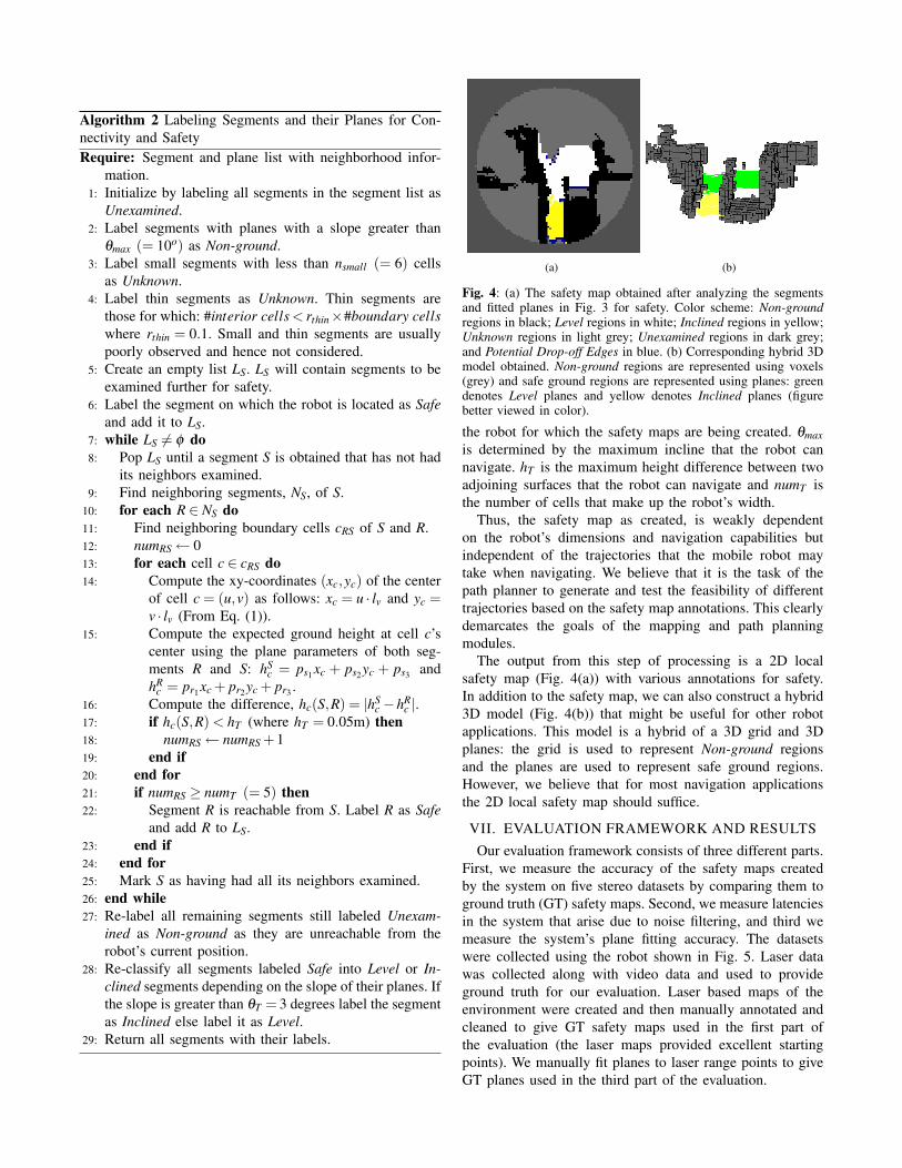
Fig. 4: (a) The safety map obtained after analyzing the segmentsand fitted planes in Fig. 3 for safety. Color scheme: Non-groundregions in black; Level regions in white; Inclined regions in yellow;Unknown regions in light grey; Unexamined regions in dark grey;and Potential Drop-off Edges in blue. (b) Corresponding hybrid 3Dmodel obtained. Non-ground regions are represented using voxels(grey) and safe ground regions are represented using planes: greendenotes Level planes and yellow denotes Inclined planes (figurebetter viewed in color).
the robot for which the safety maps are being created. θmaxis determined by the maximum incline that the robot cannavigate. hT is the maximum height difference between twoadjoining surfaces that the robot can navigate and numT isthe number of cells that make up the robot’s width.
Thus, the safety map as created, is weakly dependenton the robot’s dimensions and navigation capabilities butindependent of the trajectories that the mobile robot maytake when navigating. We believe that it is the task of thepath planner to generate and test the feasibility of differenttrajectories based on the safety map annotations. This clearlydemarcates the goals of the mapping and path planningmodules.
The output from this step of processing is a 2D localsafety map (Fig. 4(a)) with various annotations for safety.In addition to the safety map, we can also construct a hybrid3D model (Fig. 4(b)) that might be useful for other robotapplications. This model is a hybrid of a 3D grid and 3Dplanes: the grid is used to represent Non-ground regionsand the planes are used to represent safe ground regions.However, we believe that for most navigation applicationsthe 2D local safety map should suffice.
VII. EVALUATION FRAMEWORK AND RESULTSOur evaluation framework consists of three different parts.
First, we measure the accuracy of the safety maps createdby the system on five stereo datasets by comparing them toground truth (GT) safety maps. Second, we measure latenciesin the system that arise due to noise filtering, and third wemeasure the system’s plane fitting accuracy. The datasetswere collected using the robot shown in Fig. 5. Laser datawas collected along with video data and used to provideground truth for our evaluation. Laser based maps of theenvironment were created and then manually annotated andcleaned to give GT safety maps used in the first part ofthe evaluation (the laser maps provided excellent startingpoints). We manually fit planes to laser range points to giveGT planes used in the third part of the evaluation.

Fig. 5: The wheelchair robot used for collecting the video datasets.The robot has a stereo camera and one horizontal and one verticallaser-rangefinder. The lasers are only used for localization andproviding ground truth data.
A. Error Rates
The first part of the evaluation measures the classificationaccuracy of the system by comparing the stereo safety mapsagainst ground truth safety maps. We do this for five stereovideo data sets (between 350-500 stereo image pairs in eachdataset) collected in a wide variety of environments. Two ofthe datasets have both ramps and drop-offs, one dataset hastwo ramps, and the remaining two datasets have drop-offsonly. Most environments have large poorly textured regions,and both indoor and outdoor areas are represented. Lightingvaries from good to fair.
For each constructed safety map we identify the followingcells: (i) False Positives (FP): cells marked unsafe in theconstructed stereo map but labeled safe in the GT map. (ii)False Negatives (FN): cells marked safe in the constructedmap but marked unsafe in the GT map. (iii) True Positives(TP): cells marked unsafe that are unsafe. (iv) True Negatives(TN): cells marked safe that are safe. For purposes ofevaluation, cells marked Level or Inclined are considered safeand only cells marked Non-ground are considered unsafe.Cells marked Unknown or Unexamined are considered to beunclassified. For each safety map we find the number of FP,FN, TP, and TN cells. Also, of all classified cells in a safetymap we find the number of true safe and unsafe cells present(the cells have to be classified by the GT map as well).
The errors are computed for all stereo image pairs forwhich a safety map is created - frames that capture exactlythe same scene as previous images (this happens when therobot is stationary, see Section IV on why we do this)are discarded. Discarded frames only account for 10 to 20percent of all images. For a given dataset we compute anoverall false negative rate by summing the number of falsenegatives in all safety maps created and dividing by the sumof the number of unsafe cells in those safety maps. Othererror rates are computed in a similar manner. Once errorrates have been computed for each data set, they are averagedacross all datasets and the standard deviations are computed.
Table II shows these averaged error rates for our systemfor three different values of the decrement parameter decrmentioned in Section IV. We deemed our system to besensitive to this parameter and hence measured its effecton the error rates - Fig. 6(a) shows an ROC curve of theaverage FP and TP values in Table II. These results alongwith Fig. 7 and 8 demonstrate the good performance of our
Decrement Parameter Value 1 3 5False Negative Rate (FN) 3.0 ± 1.8 8.5 ± 5.3 11.2 ± 7.3False Positive Rate (FP) 9.3 ± 4.7 6.2 ± 3.7 5.2 ± 2.4True Positive Rate (TP) 97.0 ± 1.8 91.5 ± 5.3 88.8 ± 7.3True Negative Rate (TN) 90.7 ± 4.7 93.8 ± 3.7 94.8 ± 2.4
TABLE II: Safety map error rates for the system, averaged acrossall datasets, shown for three values of the decrement parameter decr(Section IV). Standard deviation values are also given.
(a) (b)
Fig. 6: (a) ROC curve showing TP rate vs FP rate for the decrparameter (Section IV). Increasing the parameter increases theeffect of negative evidence in the occupancy grid. As expected asdecr increases both the FP and TP rates decrease (the FN rateincreases). Depending on what is a minimum acceptable TP ratethe parameter can be adjusted to get closer to a desired FP rate.(b) Frame Latency: Plot showing number of frames that go by,before 50% and 90% of the width of a board is visible in therobot’s occupancy grid, as a function of the initial distance to theboard and the board’s texture. Both textured (Tex) and untextured(Untex) boards are detected in about the same number of framesfor the 50% case whereas for the 90% case the robot reaches theuntextured board before it is detected (we plot the maximum valueof frame latency for this case).
system. All figures and the movie associated with this paperare for decr=1.
The most important error metric is the FN rate which turnsout to be very low for our system. It should be noted that aparticular FN rate does not translate directly into the chancesof an accident (e.g., a 3 percent FN rate does not meanthe robot has a 3 percent chance of having an accident).The movie associated with this paper shows the nature anddistribution of the FN errors the robot experiences. They arefew and usually at some distance from the robot thereby notputting the robot in immediate danger. Furthermore robotsusually have a margin of safety and so in general the effectof a particular FN rate is expected to be far less than whatthe numbers suggest - this is a direction of future study [19].Nevertheless the FN rate is a very useful metric.
The FP rate of our system is higher. A high FP rate seemslike a hindrance to navigation because the robot might seeobjects where there are none. This would indeed be the caseif false positives were distributed randomly across the safetymap. However, as the movie shows, almost all of the FPsoccur adjacent to existing obstacles - that is most FPs arecaused by obstacles “bleeding” into nearby regions - andthat most false positives disappear as the robot comes closerto the obstacles. The high FP rate also indicates the noisynature of stereo range data.
As the ROC curve shows (Fig. 6(a)) we can reduce the FPrate by changing the decrement parameter but at the expense

(a) (b) (c)
(d) (e) (f)
Fig. 7: Figures (a) and (d) show sample images from datasets 2 and 3. Figures (b) and (e) show stereo safety maps in the process ofbeing constructed by the robot (i.e., after the robot has processed only a fraction of the images in the datasets). The robot is shown as ared triangle. Figures (c) and (f) show the ground truth safety maps for comparison - areas that are in common with the stereo safety mapson the left are highlighted using circles. The annotations used are the same as those in Fig. 4(a) except that Potential Drop-off Edges arenot marked (figure better viewed in color).
of increasing FN rates. Additional ways to overcome sucherrors would be to fit surfaces to all the point cloud data muchlike the way we have fit planes to ground points. Anothermethod would be to use active sensing - as we see in themovie, false positives disappear as the robot moves closerand more data is obtained.
B. Detection Latency and Distance
The use of the occupancy grid for noise filtering leadsto latencies in hazard detection. However, such filteringis necessary because in its absence the robot may be too“paralyzed with fear” to move. To evaluate the effect offiltering we measure Frame Latency, defined as the numberof camera frames between the appearance of an object ina video sequence and its detection by the robot. To makethe notion of detection concrete, we defined it to be theevent when N% of the width of the board is visible in theoccupancy grid.
The Frame Latency depends on object texture and theinitial distance of the object from the robot. To measurelatency as a function of these quantities we drive the robottowards two boards, one textured and one without texture,placed at various initial distances from the robot. The resultsare plotted in Fig. 6(b).
As the figure shows, when the board is at an initial distanceof 5 meters or less, the robot is able to detect N = 50%of both textured and untextured boards within 8 frames.However, for N = 90%, it takes significantly more time forthe untextured board to be detected as expected. In fact,the robot reaches the board before 90% of it is detected.This appears like it can be a bit dangerous for the robot, but
what happens is that different parts of the untextured boardare detected, making it appear as an impassable obstaclenevertheless.
It is worth noting that as the initial distance to the objectincreases from 4 to 5 meters, the number of frames taken todetect the board jumps for N = 90%. This means that it cantake a long time before objects at a distance of more than 4meters are seen properly with our camera. This provides anexperimental justification for the use of a restricted planningradius in Section V-A as analysis of objects far away is goingto be unreliable.
C. Plane Fitting AccuracyWe evaluate the accuracy of the plane fitting process by
comparing the detected planes against ground truth planesobtained using laser range data. We compute: (i) the anglebetween the normal of a detected plane and the GT plane,and, (ii) the average distance between the detected and theGT plane. From each of the five data sets, we randomlychoose 5 frames and compute the above measures for allsafe planes detected in those frames. We average across allplanes and all data sets. The mean and standard deviationfor the angle are found to be: 1.2 ± 0.5 degrees. The meanand standard deviation for the distance are found to be: 1.9± 0.8 centimeters. This shows that plane fitting works verywell and that we are able to accurately estimate the normaland location of ground surfaces. Fig. 8 shows examples ofplanes found using stereo compared to laser data.
D. Computation TimeWe implemented a real-time version of our algorithms on
the wheelchair robot. The average computation times per

(a) (b)
(c) (d)Fig. 8: (a) Hybrid 3D model of the environment in Fig. 7(d) (dataset 3). Green represents safe Level planes and yellow represents Inclinedplanes. (c) Cross sectional view of the planes in the model compared to laser range data shown as black dots. (b) Hybrid 3D model ofdataset 4 with long low steps each about 15 cm high. The planes in red are found to be unsafe and marked as such - this demonstratesthe system’s ability to detect even small drop-offs. (d) Cross-sectional view of the planes. As can be seen from (c) and (d) the systemdoes very well at finding Level and Inclined planes and distinguishing Inclined planes from steps (figure better viewed in color).
stereo frame of the algorithms for the real-time version fora 10× 10× 3 m3 map size are as follows: (i) Updating 3Dmodel: 92ms. (ii) Grid segmentation: 4ms. (iii) Least squaresfit: 61ms. (iv) Safety analysis: 71ms. This corresponds to anaverage cycle rate of 4.4Hz. The algorithms were run ona laptop with a 1.83 GHz dual core processor which wassimultaneously running a laser-based SLAM algorithm andthe GUI. The stereo depth computation algorithm was runon a 1.2 GHz machine on the robot at an average cycle rateof 9Hz.
VIII. CONCLUSION AND FUTURE WORKWe have presented a stereo vision based system for finding
inclines, drop-offs, and static obstacles. Finding such hazardsis very important if robots are to navigate autonomously.We have comprehensively evaluated our system on fivedifferent datasets and demonstrated good performance. Wehave made these datasets and the corresponding ground truthdata publicly available so as to provide a common testingground for other robot mapping systems [6].
Our results suggest several avenues for further research.We plan to estimate the true chances of failure that falsenegative error rates translate to. We would also like toexplore the use of active sensing to further reduce error ratesand the effect of stereo noise. Another possible method forreducing the effect of noise is by fitting surfaces to the entirepoint cloud data not just to points representing the ground.However, that is a much harder problem as obstacles andother objects can have complex topologies, e.g., due to thepresence of holes.
IX. ACKNOWLEDGMENTSThis work has taken place in the Intelligent Robotics Lab
at the Artificial Intelligence Laboratory, The University ofTexas at Austin. Research of the Intelligent Robotics labis supported in part by grants from the Texas AdvancedResearch Program (3658-0170-2007), and from the NationalScience Foundation (IIS-0413257, IIS-0713150, and IIS-0750011). The authors would like to thank members of theIntelligent Robotics Lab for their valuable comments.
REFERENCES
[1] S. Thrun and et al., “Stanley: The robot that won the DARPA grandchallenge,” Journal of Field Robotics, 2006.
[2] A. Murarka, M. Sridharan, and B. Kuipers, “Detecting obstacles anddrop-offs using stereo and motion cues for safe local motion,” in IROS,2008.
[3] N. Heckman, J. Lalonde, N. Vandapel, and M. Hebert, “Potentialnegative obstacle detection by occlusion labeling,” in IROS, 2007.
[4] P. Beeson, A. Murarka, and B. Kuipers, “Adapting proposal distribu-tions for accurate, efficient mobile robot localization,” in ICRA, 2006.
[5] A. Comport, E. Malis, and P. Rives, “Accurate quadrifocal trackingfor robust 3D visual odometry,” in ICRA, 2007.
[6] A. Murarka and B. Kuipers, 2009. [Online]. Available:http://eecs.umich.edu/∼kuipers/research/pubs/Murarka-iros-09.html
[7] J.-S. Gutmann, M. Fukuchi, and M. Fujita, “3D perception andenvironment map generation for humanoid robot navigation,” Intl.Journal of Robotics Research, 2008.
[8] R. Rusu, A. Sundaresan, B. Morisset, M. Agrawal, and M. Beetz,“Leaving flatland: Realtime 3D stereo semantic reconstruction,” inICIRA, 2008.
[9] L. Iocchi, K. Konolige, and M. Bajracharya, “Visually realistic map-ping of a planar environment with stereo,” in ISER, 2000.
[10] S. Singh, R. Simmons, T. Smith, A. Stentz, V. Verma, A. Yahja, andK. Schwehr, “Recent progress in local and global traversability forplanetary rovers,” in ICRA, 2000.
[11] A. Rankin, A. Huertas, and L. Matthies, “Evaluation of stereo visionobstacle detection algorithms for off-road autonomous navigation,” in32nd AUVSI Symposium on Unmanned Systems, 2005.
[12] ——, “Night-time negative obstacle detection for off-road autonomousnavigation,” in SPIE, 2007.
[13] J. Poppinga, N. Vaskevicius, A. Birk, and K. Pathak, “Fast planedetection and polygonalization in noisy 3D range images,” in IROS,2008.
[14] S. Thrun, C. Martin, Y. Liu, D. Hahnel, R. Emery-Montemerlo,D. Chakrabarti, and W. Burgard, “A real-time expectation maximiza-tion algorithm for acquiring multi-planar maps of indoor environmentswith mobile robots,” IEEE Transactions on Robotics, 2004.
[15] C. Plagemann, S. Mischke, S. Prentice, K. Kersting, N. Roy, andW. Burgard, “Learning predictive terrain models for legged robotlocomotion,” in IROS, 2008.
[16] C. Wellington, A. Courville, and A. Stentz, “Interacting markov ran-dom fields for simultaneous terrain modeling and obstacle detection,”in Robotics: Science and Systems, 2005.
[17] “Videre Design,” http://www.videredesign.com.[18] K. Konolige, “Improved occupancy grids for map building,” Au-
tonomous Robots, vol. 4, no. 4, 1997.[19] A. Murarka, “Building safety maps using vision for safe local mobile
robot navigation,” Ph.D. dissertation, The University of Texas atAustin, 2009.
![A Sliding Window-Based Algorithm for Detecting Leaders ...afariha/papers/[2015] A Sliding Window... · A Sliding Window-Based Algorithm for Detecting Leaders from Social Network Action](https://img.dokumen.tips/doc/110x75/5e06d96f4d6fba74fe2883e3/a-sliding-window-based-algorithm-for-detecting-leaders-afarihapapers2015.jpg)