1
A stable vertical reference for bathymetric surveying and tidal analysis in the high Arctic The EM300 multibeam sonar mounted on the Amundsen is one of the prime tools used for marine geomorphologic and hydrographic investigations as part of ArcticNet. Under reconnaissance conditions, the data, as collected, serve as a valuable source of information even if imperfect. Sources of imperfection generally include bottom tracking degradation due to seastate or ice-conditions, imperfect sound speed information and imperfect calibration but perhaps most significantly the lack of a stable vertical datum. . The measurements, as routinely collected and currently presented, are strictly with respect to the local water surface. If multiple passes of data, acquired on different missions and at different phases of the tide, are to be used to build up an accurate picture, variations in the long term vessel elevation due primarily to tide, but also due to draft changes (due to loading, squat and trim) have to be properly backed out. The traditional method used for this has been through the use of a network of tide gauges combined with draft and squat estimates. Such an approach is not practical however in the high arctic as the existing network of water level monitoring stations is too sparse and the existing hydrodynamic models have not yet proven reliable at robust spatial interpolation. An alternate approach to a stable vertical datum is to adopt the ellipsoid as the reference. Recent advantages in wide-area differential GPS (WADGPS) now allow vertical referencing to within a few decimeters vertically without the need for coastal base stations. With appropriate filtering and use of inertial sensors, the same data can potentially be relied upon for work at the decimeter level. In doing so it completely bypasses the need for draft, trim and squat measurements. As part of an experiment, almost all data acquired so far with the Amundsen has had synoptic measures of the vessel ellipsoid elevation derived using the CNav WADGPS service. This potentially allows us to co-reference the data using a common vertical datum. A particularly critical application for this will be repetitive monitoring of the seabed instability features (rotational slump fields) to try and detect fine scale changes. An additional byproduct of this technology is that, as long as appropriate draft and squat models are applied, the same data can be used to examine the variations in the phase and amplitude of the tide at locations remote from the existing tides network. This will allow calibration of existing hydrodynamic models, improved confidence in the extrapolation of the geoid-ellipsoid separation offshore and even perhaps the establishment of viable chart datums interpolations for these remote areas. 20cm/km 0 TIDE STN. A TIDE STN. B MSL ~= geoid Sonar-relative Depth measurement Ch a r t Dat u m ( a level b elo w w h ich th e w a ter ra r ely fa lls) Instantaneous Water level Elli psoid draught C-Nav RTG - WADGPS 29-27m 16m 9.7m 18.7m 6.3m 5m 3.5m CNav antenna RP - IMU Heave zero-mean 1600 Time - JD281 (GMT) 1700 1800 1900 Speed (over ground) knots Ellipsoid Height (antenna) C-Nav RTG metres 8 knots 10 knots 13.5 knots ~30cm ~18cm ~12cm Squat Trials 7 th October 2004 tide falling John E. Hughes Clarke 1 , Travis Wert 2 , Peter Dare 1 , Jonathan Beaudoin 1 and Jason Bartlett 3 1: Dept. Geodesy and Geomatics Engineering, University of New Brunswick, 2: Mapping and Charting Establishment, DND, Ottawa 3: Canadian Hydrographic Service, Burlington Ontario 0.78m 0m 5.6m 0m M2 and K1 tidal amplitudes (range = 2x) M2 K1 Makkovik Survey Makkovik Survey C-Nav Ellipsoid Heights – 1 Hz EGM96 – predictive model of Ellipsoid-Geoid Separation along Amundsen shiptrack, Labrador Sea C-Nav Ellipsoid Height – EGM96 Geoid-Ellipsoid Separation Model 1Hz data (with heave) 60 second averages Gale 1 Gale 2 Cape Chidley Strait Belle Isle N.W. Atlantic Model M2-S2-N2-K1-O1 Hudson Bay Model M2-S2-N2-K1-O1- M4-MS4 WebTide Predictions (3D barotropic F.E. hydrodynamic model) C-Nav Antenna Geoid Height (Ellipsoid Height, Reduced using EGM96) Makkovik Survey JD278 JD279 JD280 JD281 JD277 JD276 33 23 C-Nav Antenna Geoid Height (m) (Ellipsoid Height, Reduced using EGM96) WebTide Predictions (m) (3D barotropic F.E. hydrodynamic model) +5 -5 2004 JD279 0000Z 26.7 25.7 Makkovik Bank Survey 2004 JD279 0600Z 2004 JD279 1200Z 2004 JD278 1800Z 2004 JD279 0000Z 2004 JD279 0600Z 2004 JD279 1200Z JD278 1800Z C-Nav -1Hz Ellipsoid Heights (m) C-Nav Ellipsoid Heights – 60 sec. average E E E E E W W W W CCGS Amundsen – Speed over Ground (knots) 2004 JD279 0000Z 2004 JD279 0600Z 2004 JD279 1200Z Labrador Sea Transit - Ungava Bay to Quebec City A comparison of geoid height observations against WebTide tidal predictions in an area of particularly steep geoid-ellipsoid slopes.. 67m -50m EGM 96 : Geoid Ellipsoid Separation 5m contours CCGS Amundsen Shiptrack, July/August 2004 Passing through all three of the WebTide model zones NorthWest Passage Transit : ArcticNet Leg-9 A comparison of geoid height observations against WebTide tidal predictions. EGM96 : Geoid-Ellipsoid Separation Model C-Nav WADGPS – Antenna Ellipsoid Height 2004 JD220 2004 JD225 2004 JD230 2004 JD235 Arctic8 Model M2-S2-N2-K1-O1 Hudson Bay Model M2-S2-N2-K1-O1- M4-MS4 WebTide Predictions (3D barotropic F.E. hydrodynamic model) C-Nav AntennaGeoid Height (Ellipsoid Height, reduced using EGM96) 2004 JD220 2004 JD225 2004 JD230 2004 JD235 CCGS Amundsen Squat 0.0027*pow(sp,1.8) 0 0.1 0.2 0.3 0.4 0.5 0.6 0 5 10 15 20 Speed knots Squat (m) Observations Model Geoid-Ellipsoid Separation (EGM96, 1m contours) Makkovik Bank EM300 Bathymetric Survey Steaming up and down the geoid-ellipsoid slope on the edge of Labrador margin. A practical application of the use of C-Nav ellipsoid heights as a means of reducing a hydrographic survey. . WebTide http://www.mar.dfo-mpo.gc.ca/science/ocean/coastal_hydrodynamics/WebTide/webtide.html 3 models – Arctic Archipelago – Hudson Bay - NW Atlantic. An independent means of predicting sea surface topography. Obviously does not include non-tidal variations (storms, river input, seiches, long term barotropic sea surface slopes etc..). Calibrated against existing observed harmonics (M2,S2,N2,K1O1). Can be used as a check on C-Nav geoid height signal. Antenna height solutions include both water level variations and draft variations. The draft variations are as a result of long term changes such as loading (fuel and stores consumption, ballast tank trim adjustments etc..) and most significantly hydrodynamic effects due to driving a displacement hull through the water. Field trials using ellipsoid height solutions (these figures) indicate that the vessel squats down an extra 30cm at speeds of 14 knots. As much of the ArcticNet operations involve transit and then sitting on station, this effect must be accounted for. 33 27 33 27 33 26.7 25.7 26.7 25.7 20 0 2004 JD278 1800Z +5.0 -5.0 23 33 23 33 -37 13 -10 40 JD278 JD279 JD280 JD281 JD277 JD276 JD278 JD279 JD280 JD281 JD277 JD276 JD278 JD279 JD280 JD281 JD277 JD276 -50 20 -23 47 23 33 -5 +5 EGM96 – Gradient Map The ellipsoid-geoid separation surface is generally most reliable in areas of low slope. Estimates of sea- surface topography are most likely to be compromised in areas of rapid geoid undulations. The most notable regions in Canada lie along the east side of Baffin Island and along the Labrador margin (where the Makkovik survey (right-most data set) took place). The zigzag ellipsoid height profile is a direct result of 180º survey line azimuth reversals as the vessel climbs up and down the geoid relative to the ellipsoid After removal of the EGM96 ellipsoid- geoid separation model at the instantaneous vessel location, the residual profile reflects the vertical motion of the vessel w.r.t. the geoid as is thus a valid proxy for the tide With instantaneous heave 1 minute filter to remove heave Vessel speed through the water was reduced with increasing sea state to lower bubble washdown. The net result being vessel draft alterations (squat) The vessel vertical profile w.r.t. the geoid does not match the predicted WebTide solution. One possible reason may be a storm surge associated with the SE gale underway. The survey consisted of 9 E-W parallel lines, each around 25 km long, lasting 60-70 minutes, depending on speed CCGS Amundsen Squat 0.0027*pow(sp,1.8) 0 0.1 0.2 0.3 0.4 0.5 0.6 0 5 10 15 20 Speed knots Squat (m) Observations Model ? long period sea surface anomalies? not accounted for in EGM96 Antenna Geoid Profile Squat-Adjusted Profile (using squat model) Final Profile allowing for dynamic draft 67m -50m EGM 96 : Geoid Ellipsoid Separation 5m contours CCGS Amundsen Shiptrack, October 2004

A stable vertical reference for bathymetric surveying · A stable vertical reference for bathymetric surveying ... draught C-Nav RTG - WADGPS 29-27m 16m 9.7m 18.7m 6.3m 5m 3.5m CNav

  • Upload
    docong

  • View
    226

  • Download
    0

Embed Size (px)

Citation preview

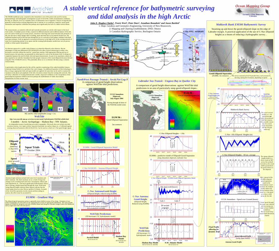
A stable vertical reference for bathymetric surveying and tidal analysis in the high ArcticThe EM300 multibeam sonar mounted on the Amundsen is one of the prime tools used for marine

geomorphologic and hydrographic investigations as part of ArcticNet. Under reconnaissance conditions, the data, as collected, serve as a valuable source of information even if imperfect. Sources of imperfection generally include bottom tracking degradation due to seastate or ice-conditions, imperfect sound speed information and imperfect calibration but perhaps most significantly the lack of a stable vertical datum. .

The measurements, as routinely collected and currently presented, are strictly with respect to the local water surface. If multiple passes of data, acquired on different missions and at different phases of the tide, are to be used to build up an accurate picture, variations in the long term vessel elevation due primarily to tide, but also due to draft changes (due to loading, squat and trim) have to be properly backed out. The traditional method used for this has been through the use of a network of tide gauges combined with draft and squat estimates. Such an approach is not practical however in the high arctic as the existing network of water level monitoring stations is too sparse and the existing hydrodynamic models have not yet proven reliable at robust spatial interpolation.

An alternate approach to a stable vertical datum is to adopt the ellipsoid as the reference. Recent advantages in wide-area differential GPS (WADGPS) now allow vertical referencing to within a few decimeters vertically without the need for coastal base stations. With appropriate filtering and use of inertial sensors, the same data can potentially be relied upon for work at the decimeter level. In doing so it completely bypasses the need for draft, trim and squat measurements. As part of an experiment, almost all data acquired so far with the Amundsen has had synoptic measures of the vessel ellipsoid elevation derived using the CNav WADGPS service. This potentially allows us to co-reference the data using a common vertical datum.

A particularly critical application for this will be repetitive monitoring of the seabed instability features (rotational slump fields) to try and detect fine scale changes. An additional byproduct of this technology is that, as long as appropriate draft and squat models are applied, the same data can be used to examine the variations in the phase and amplitude of the tide at locations remote from the existing tides network. This will allow calibration of existing hydrodynamic models, improved confidence in the extrapolation of thegeoid-ellipsoid separation offshore and even perhaps the establishment of viable chart datumsinterpolations for these remote areas.

20cm/km

0

TID

E S

TN

. A

TID

E S

TN

. B

MSL ~= geoid

Sonar-relativeDepth measurement

Chart Datum

(a level below which the water rarely falls)

Instantaneous Water level

Ellipsoid

draught

C-Nav RTG - WADGPS

29-27m

16m9.7m

18.7m

6.3m

5m

3.5m

CNav antenna

RP - IMU

Heavezero-mean

1600Time - JD281 (GMT)

1700 1800 1900

Speed(over ground)

knots

EllipsoidHeight(antenna)

C-Nav RTG metres

8 kn

ots

10 k

nots

13.5

kno

ts

~30cm

~18cm~12cm

Squat Trials7th October 2004

tide falling

John E. Hughes Clarke1, Travis Wert2, Peter Dare1, Jonathan Beaudoin1 and Jason Bartlett3

1: Dept. Geodesy and Geomatics Engineering, University of New Brunswick,2: Mapping and Charting Establishment, DND, Ottawa3: Canadian Hydrographic Service, Burlington Ontario

0.78m

0m

5.6m

0m

M2 and K1 tidal amplitudes (range = 2x)

M2 K1

Mak

kovi

kSu

rvey

Mak

kovi

kSu

rvey

C-Nav Ellipsoid Heights – 1 Hz

EGM96 – predictive model of Ellipsoid-Geoid Separationalong Amundsen shiptrack, Labrador Sea

C-Nav Ellipsoid Height – EGM96 Geoid-Ellipsoid Separation Model

1Hz data (with heave)

60 second averages

Gale 1 Gale 2

Cape Chidley

StraitBelle Isle

N.W. Atlantic ModelM2-S2-N2-K1-O1

Hudson Bay ModelM2-S2-N2-K1-O1- M4-MS4

WebTidePredictions

(3D barotropic F.E. hydrodynamic model)

C-Nav AntennaGeoid Height(Ellipsoid Height,

Reduced using EGM96)

Mak

kovi

kSu

rvey

JD278 JD279 JD280 JD281JD277JD276

33

23

C-Nav AntennaGeoid Height (m)

(Ellipsoid Height,Reduced using EGM96)

WebTidePredictions (m)(3D barotropic F.E. hydrodynamic model)

+5

-5

2004JD2790000Z

26.7

25.7

Makkovik Bank Survey

2004JD2790600Z

2004JD2791200Z

2004JD2781800Z

2004JD2790000Z

2004JD2790600Z

2004JD2791200Z

2004JD2781800Z

C-Nav -1Hz Ellipsoid Heights (m)

C-Nav Ellipsoid Heights – 60 sec. average

E E E E EWWWW

CCGS Amundsen – Speed over Ground (knots)

2004JD2790000Z

2004JD2790600Z

2004JD2791200Z

Labrador Sea Transit - Ungava Bay to Quebec CityA comparison of geoid height observations against WebTide tidal predictions in an area of particularly steep geoid-ellipsoid slopes..

67m

-50m

EGM 96 :Geoid Ellipsoid Separation

5m contours

CCGS AmundsenShiptrack,

July/August 2004

Passing through all three of the WebTide model zones

NorthWest Passage Transit : ArcticNet Leg-9A comparison of geoid height observations

against WebTide tidal predictions.

EGM96 : Geoid-Ellipsoid Separation Model

C-Nav WADGPS – Antenna Ellipsoid Height

2004JD220

2004JD225

2004JD230

2004JD235

Arctic8 ModelM2-S2-N2-K1-O1

Hudson Bay Model

M2-S2-N2-K1-O1-M4-MS4

WebTide Predictions(3D barotropic F.E. hydrodynamic model)

C-Nav AntennaGeoid Height(Ellipsoid Height, reduced using EGM96)

2004JD220

2004JD225

2004JD230

2004JD235

CCGS Amundsen Squat0.0027*pow(sp,1.8)

0

0.1

0.2

0.3

0.4

0.5

0.6

0 5 10 15 20

Speed knots

Squa

t (m

)

ObservationsModel

Geoid-Ellipsoid Separation(EGM96, 1m contours)

Makkovik Bank EM300 Bathymetric SurveySteaming up and down the geoid-ellipsoid slope on the edge of

Labrador margin. A practical application of the use of C-Nav ellipsoid heights as a means of reducing a hydrographic survey. .

WebTidehttp://www.mar.dfo-mpo.gc.ca/science/ocean/coastal_hydrodynamics/WebTide/webtide.html

3 models – Arctic Archipelago – Hudson Bay - NW Atlantic. An independent means of predicting sea surface topography. Obviously does not include non-tidal

variations (storms, river input, seiches, long term barotropic sea surface slopes etc..). Calibrated against existing observed harmonics (M2,S2,N2,K1O1). Can be used as a check on C-Nav geoid height signal.

Antenna height solutions include both water level variations anddraft variations. The draft variations are as a result of long term changes such as loading (fuel and stores consumption, ballast tank trim adjustments etc..) and most significantly hydrodynamic effects due to driving a displacement hull through the water. Field trials using ellipsoid height solutions (these figures) indicate that the vessel squats down an extra 30cm at speeds of 14 knots. As much of the ArcticNet operations involve transit and then sitting on station, this effect must be accounted for.

33

27

33

27

33

26.7

25.7

26.7

25.7

20

02004

JD2781800Z

+5.0

-5.0

23

3323

33

-37

13

-10

40

JD278 JD279 JD280 JD281JD277JD276

JD278 JD279 JD280 JD281JD277JD276

JD278 JD279 JD280 JD281JD277JD276

-50

20

-23

47

23

33

-5

+5

EGM96 – Gradient MapThe ellipsoid-geoid separation surface is generally most reliable in areas of low slope. Estimates of sea-surface topography are most likely to be compromised in areas of rapid geoid undulations. The most notable regions in Canada lie along the east side of Baffin Island and along the Labrador margin (where the Makkovik survey (right-most data set) took place).

The zigzag ellipsoid height profile is a

direct result of 180ºsurvey line azimuth

reversals as the vessel climbs up and down the geoid relative to

the ellipsoid

After removal of the EGM96 ellipsoid-geoid separation

model at the instantaneous vessel location, the residual

profile reflects the vertical motion of the vessel w.r.t. the geoid

as is thus a valid proxy for the tide

With instantaneous

heave

1 minute filter to remove heave

Vessel speed through the water was reduced

with increasing sea state to lower bubble

washdown.The net result being

vessel draft alterations (squat)

The vessel vertical profile w.r.t. the geoid does not

match the predicted WebTide solution.

One possible reason may be a storm

surge associated with the SE gale

underway.

The survey consisted of 9 E-W parallel lines, each around 25 km long, lasting 60-70 minutes, depending on speed

CCGS Amundsen Squat0.0027*pow(sp,1.8)

0

0.1

0.2

0.3

0.4

0.5

0.6

0 5 10 15 20

Speed knots

Squ

at (m

)

ObservationsModel

? long period sea surface anomalies?not accounted for in EGM96

Antenna Geoid Profile

Squat-Adjusted Profile(using squat model)

Final Profile allowing for dynamic draft

67m

-50m

EGM 96 :Geoid Ellipsoid Separation

5m contours

CCGS AmundsenShiptrack,

October 2004