Embed Size (px)
Citation preview

A Spatial Domain Approach for Airborne Gravity Data Processing
WANWU GUO School of Computer and Information Science
Edith Cowan University 2 Bradford Street, Mount Lawley, WA 6050
AUSTRALIA
Abstract – Airborne gravity data contain more unwanted noises due to the high sensitivity of the airborne survey system. A common approach to minimise these noises is to smooth the data using various approaches. Traditionally, data smoothing is carried out using separate programs based on different mathematical models. The adaptive spatial data processing system (ASDPS) provides a new way in processing gravity data in spatial domain. ASDPS not only can be implemented as a unique user interface for either selecting an implemented method or defining a new method without recoding and recompilation, but also supports parallel processing in a multithreaded computing environment. This paper presents an application of ASDPS to airborne gravity data processing firstly for reducing the survey noises contained in the original data, and secondly for easy data transformation for different purposes in gravity studies. Key-Words: - Airborne gravity, Spatial data processing, Downward continuation, Vertical derivative 1 Introduction Gravity data are fundamental to Earth science studies and commonly used in energy and mineral explorations. Gravity data were predominantly collected from ground gravity surveys on land and from vessel-borne gravity surveys in waters. In the past 30 years airborne gravity has become popular in acquiring gravity data, particularly for the remote regions, dense forests, lakes, and marine territories. Data acquisition in airborne gravity survey is much more efficient than ground and vessel-borne gravity surveys, but data processing for airborne gravity survey is more complex than that for the ground and vessel-borne surveys. The sensor must be very sensitive for the above-ground airborne survey, but the high sensitivity also contributes some unwanted noises to the acquired data.
A common measure to minimise these noises is to remove the noises using various smoothing approaches [1][2][3][4]. A moving window varying from 2×2 to 9×9 can be used to smooth the data with either a best-fitted plane or a quadratic surface. In practice, windows with 3×3 and 5×5 sizes are commonly used. This is because a small window may not be able to remove some potential systematic errors whereas a large window is likely to artificially flatten the patterns contained in the data [2].
Traditionally, data smoothing is carried out using separate programs based on different mathematical models. The adaptive spatial data processing system
(ASDPS) proposed recently by Guo [5] provides a new way in processing gravity data in spatial domain. ASDPS not only can be implemented as a unique user interface for either selecting an implemented method or defining a new method without recoding and recompilation, but also supports parallel processing in a multithreaded computing environment. This paper firstly outlines the methodology of this adaptive spatial data processing system, and then describes its application to airborne gravity data processing for reducing the survey noises contained in the original data, and other data transformations for different purposes. 2 Methodology Spatial data can be expressed as a 2D array A(m×n). In conventional spatial domain processing, this array is used as input to a collection of individual programs for different manipulations. Each selected program will be executed in sequential order, and the resultant data arrays is then stored as the outcome. Element Rk(i,j) in the resultant array Rk(m×n) is calculated in the following format:
∑−=
++=p
pllk ljliacjiR ),(),( , (1)
where c is a constant value associated with a processing method for a specific array element; p is
Proceedings of the 6th WSEAS International Conference on Multimedia Systems & Signal Processing, Hangzhou, China, April 16-18, 2006 (pp220-224)
the number of points in the half width of the moving window; a(i+l;j+l) represents a particular element in the window. Relation (1) can be converted as the following expression using a local coordinating system in reference to the centre of the moving window (Fig. 1a), in which Rk(i,j) becomes Rk(0,0):
∑−=
=p
pjijik jiACR
,, ),()0,0( , (2)
where C is a constant value associated with a processing method for a specific array element in the local window coordinating system.
Relations (1) and (2) show that in traditional spatial domain processing individual processing methods in the same package must repeat the similar procedure with different sets of constants to get the corresponding resultant arrays, even though the same input matrix is used. This is because the constants and the array elements are mixed together in this procedure.
Figure 1. Spatial domain data array – square representation (a) and circular representation (b)
If the constants and the array elements are deliberately separated from each other, Relation (2) can be rewritten as [5]
∑=
=N
ikk iAiWR
0)()()0,0( , (3)
where Wk(i) is the new constant for all points on the ith circle after taking into account the use of the average A(i) of all the on-circle points (Fig. 1b).
Using Relation (3), any element in a resultant array becomes the sum of N+1 multiplications from N+1 paired values. For example, for a 5×5 moving window, any element of the resultant array using the kth processing method will be the sum of 6 multiplications from 6 paired values, i.e., from Wk(0)A(0) to Wk(5)A(5).
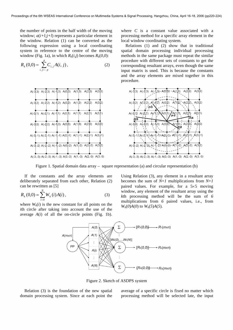
Figure 2. Sketch of ASDPS system
Relation (3) is the foundation of the new spatial domain processing system. Since at each point the
average of a specific circle is fixed no matter which processing method will be selected late, the input
Proceedings of the 6th WSEAS International Conference on Multimedia Systems & Signal Processing, Hangzhou, China, April 16-18, 2006 (pp220-224)

data matrix A(m×n) can be simply pre-processed as N independent arrays, i.e., A1 – AN, which host the N circular averages of every point. During data processing, it is the selection of circular constants that determines the outcome of the resultant array. Such a procedure is illustrated in Figure 2.
In terms of the number of arithmetic operations required to compute a resultant array, this new system takes a similar number of arithmetic operations to get the results as the conventional system does. The new system even requires more memory to store the circular average arrays compared with the conventional system. However, this new system supports parallel processing for multiple methods at the same time with the input data being fed in from separate data arrays. Further more, when there is a need to create a new
processing method, choosing a set of new weights that defined by the new method can easily produce the result without recoding, recompiling, and reinstalling the system. 3 Airborne Gravity Data Processing Using ASDPS The original airborne gravity data is shown in Figure 3. The contours in the image are not smooth, which indicates there are some noises contained in the original data. In using ASDPS, each new array component is computed using a moving 3×3 or 5×5 window following Relation (3). The weight constants for the smoothing methods used to process the data array are given in Table 1 and their corresponding images are shown in Figure 4.
5 10 15 20 25 30 35 40
5
10
15
20
25
30
35
22.5
23
23.5
24
24.5
25
25.5
26
26.5
Figure 3. Image of original airborne gravity data
Table 1. Weights used in gravity data smoothing using 3×3 and 5×5 moving windows
Result Method W(0) W(1) W(2) W(3) W(4) W(5) Fig. 4a 3×3 surface 0.5556 0.8888 0.4444 0 0 0 Fig. 4b 3×3 plane 0.1111 0.4444 0.4444 0 0 0 Fig. 4c 5×5 surface 0.1543 0.5028 0.3886 0.1600 0.0914 -0.2972 Fig. 4d 5×5 plane 0.0400 0.1600 0.1600 0.1600 0.3200 0.1600
Visually there is no significant difference between
the original image and the smoothed image using 3×3 surface model (Fig. 4a). The 5×5 surface model (Fig. 4c) produces a much improved result, so does the 3×3 plane model (Fig. 4b). The smoothest result
is produced by the 5×5 plane model (Fig. 4d), but some subtly consistent and useful features are removed as well. As a result, the result of the 5×5 surface model is chosen as the base for further data processing.
Proceedings of the 6th WSEAS International Conference on Multimedia Systems & Signal Processing, Hangzhou, China, April 16-18, 2006 (pp220-224)

5 10 15 20 25 30 35 40
5
10
15
20
25
30
35
22.5
23
23.5
24
24.5
25
25.5
26
26.5
5 10 15 20 25 30 35 40
5
10
15
20
25
30
35
22.5
23
23.5
24
24.5
25
25.5
26
a b
5 10 15 20 25 30 35 40
5
10
15
20
25
30
35
22.5
23
23.5
24
24.5
25
25.5
26
5 10 15 20 25 30 35 40
5
10
15
20
25
30
35
22.5
23
23.5
24
24.5
25
25.5
26
c d
Figure 4. Images of smoothed gravity data a - 3×3 plane, b - 3×3 surface, c - 5×5 plane, and d - 5×5 surface
Data transformation can also be made easily using
ASDPS. Downward continuation (DWC) gravity (by one unit), second vertical derivatives (2VD) using Healck, Elkins I and Elkins III approaches [2][3][4]
can be computed by choosing the corresponding sets of weights (Table 2) using the smoothed data array resulted from the 5×5 surface model.
Table 2. Weights used in gravity data transformation using smoothed data of 5×5 surface model Result Method W(0) W(1) W(2) W(3) W(4) W(5) Fig. 5a DWC 0.3969 0.3026 0.3356 0.1526 0.2749 0.1117 Fig. 5b 2VD Healck 4.0000 -4.000 0 0 0 0 Fig. 5c 2VD Elkins I 1.0667 -0.1333 -0.2667 0 -0.667 -0.2972 Fig. 5d 2VD Elkins III 0.7097 0.2581 -0.1935 0 -0.7742 0.1600
Downward continuation makes the observation
elevation closer to the sources of gravity field, so this processing enlarges the amplitude of the gravity field, which is shown in Figure 5a with a maximum value of 30 mgal compared to that of 26.5 mgal in Figure 4c.
The second vertical derivatives suppose to outline the relatively shallow gravity sources. Healck approach enhances the short wavelength component of the source (Fig. 5b) whereas Elkins approaches delineate both the short and long wavelength components of the source (Figs. 5c & 5d).
Proceedings of the 6th WSEAS International Conference on Multimedia Systems & Signal Processing, Hangzhou, China, April 16-18, 2006 (pp220-224)

5 10 15 20 25 30 35 40 45
5
10
15
20
25
30
35
40
24
25
26
27
28
29
30
5 10 15 20 25 30 35 40
5
10
15
20
25
30
35
-0.06
-0.04
-0.02
0
0.02
0.04
0.06
a b
5 10 15 20 25 30 35 40
5
10
15
20
25
30
35
-0.04
-0.03
-0.02
-0.01
0
0.01
0.02
0.03
0.04
0.05
0.06
5 10 15 20 25 30 35 40
5
10
15
20
25
30
35
-0.04
-0.03
-0.02
-0.01
0
0.01
0.02
0.03
0.04
0.05
0.06
c d
Figure 5. Transformed gravity images a – downward continuation, b – Healck, c – Elkins I, and d – Elkins III
4 Conclusion ASDPS supports parallel processing in a multithreaded computing environment, and also offers a unique user interface, through which execution of various processing methods in spatial domain becomes choosing the corresponding set of weights for the method without rewriting code and recompilation. This overcomes the weaknesses with the conventional spatial domain processing due to its sequential execution procedure. The use of this system in airborne gravity processing in this paper demonstrates that this new system is very useful in spatial data processing and transformation. References: [1] R. Laurini and D. Thompson, Fundamentals of spatial information systems, Academic Press, 1992. [2] J. Claerbout, Fundamentals of geophysical data processing, McGraw-Hill, 1976.
[3] F.S. Grant and G.F. West, Interpretation theory in applied geophysics, McGraw-Hill, 1965. [4] W.M. Telford, L.P. Geldart and R.E. Sheriff, Applied geophysics, Cambridge University Press, 1990. [5] W. Guo, “Adaptive spatial data processing system (ASDPS)”, Knowledge-Based Intelligent Information & Engineering Systems, Lecture Notes in Artificial Intelligence, 3214, Springer-Verlag, 2004, pp. 432-439
Proceedings of the 6th WSEAS International Conference on Multimedia Systems & Signal Processing, Hangzhou, China, April 16-18, 2006 (pp220-224)


![Airborne Gravity Gradiometry in the Search for Mineral Deposits · 2015-12-14 · Airborne Gravity Gradiometry in the Search for Mineral Deposits Dransfield, M. [1] 1. BHP Billiton](https://img.dokumen.tips/doc/110x75/5e9ffa54bed7367cd454cf0a/airborne-gravity-gradiometry-in-the-search-for-mineral-deposits-2015-12-14-airborne.jpg)