Embed Size (px)
Citation preview
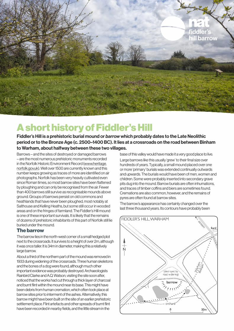
A short history of Fiddler’s Hill Fiddler’s Hill is a prehistoric burial mound or barrow which probably dates to the Late Neolithic period or to the Bronze Age (c. 2500–1400 BC). It lies at a crossroads on the road between Binham to Warham, about halfway between these two villages.Barrows – and the sites of destroyed or damaged barrows – are the most numerous prehistoric monuments recorded in the Norfolk Historic Environment Record (www.heritage.norfolk.gov.uk). Well over 1500 are currently known and this number keeps growing as traces of more are identified on air photographs. Norfolk has been very heavily cultivated even since Roman times, so most barrow sites have been flattened by ploughing and can only be recognised from the air. Fewer than 400 barrows still survive as recognisable mounds above ground. Groups of barrows persist on old commons and heathlands that have never been ploughed, most notably at Salthouse and Kelling Heaths, but some still occur in wooded areas and on the fringes of farmland. The Fiddler’s Hill mound is one of these important survivals. It is likely that the remains of dozens of prehistoric inhabitants of this part of Norfolk still lie buried under the mound.
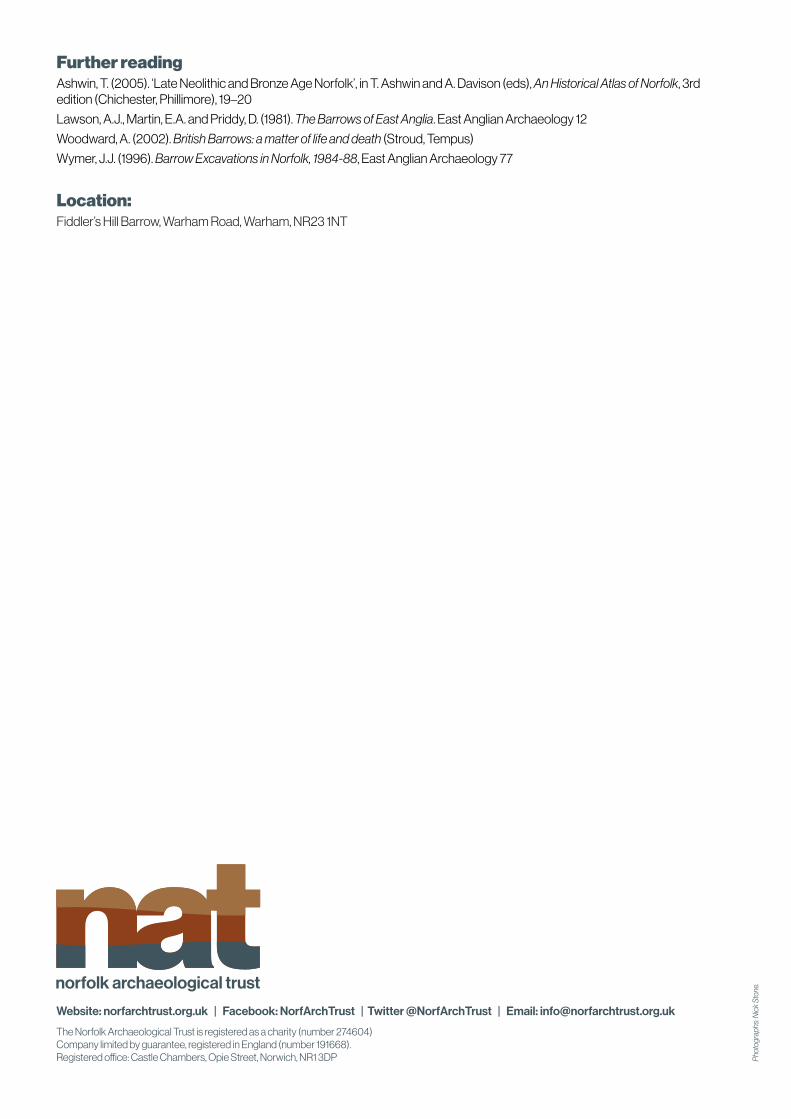
The barrowThe barrow lies in the north-west corner of a small hedged plot next to the crossroads. It survives to a height of over 2m, although it was once taller. It is 34m in diameter, making this a relatively large barrow.
About a third of the northern part of the mound was removed in 1933 during widening of the crossroads. Three human skeletons and the bones of a dog were found, although much other important evidence was probably destroyed. Archaeologists Rainbird Clarke and A.Q. Watson, visiting the site soon after, noticed that the works had cut through a thick layer of charcoal and burnt flint within the mound near its base. This might have been debris from human cremation, which often took place at barrow sites prior to interment of the ashes. Alternatively, this barrow might have been built on the site of an earlier prehistoric settlement place. Flint artefacts and other spreads of burnt flint have been recorded in nearby fields, and the little stream in the
base of this valley would have made it a very good place to live.
Large barrows like this usually ‘grew’ to their final size over hundreds of years. Typically, a small mound placed over one or more ‘primary’ burials was extended continually outwards and upwards. The burials would have been of men, women and children. Some were probably inserted into secondary grave pits dug into the mound. Barrow burials are often inhumations, and traces of timber coffins and biers are sometimes found. Cremations are also common, however, and the remains of pyres are often found at barrow sites.
The barrow’s appearance has certainly changed over the last three thousand years. Its contours have probably been

‘softened’ by erosion and ploughing. Also, it was probably surrounded by a deep, round quarry ditch which has now filled up.
Many barrows remained important landmarks long after their use for burial had ended. This is shown by the way in which many – like Fiddler’s Hill – lie at crossroads or on parish boundaries. Some barrows in locations like this were undoubtedly used as execution sites in Anglo-Saxon and medieval times. The ditch of a barrow excavated during the 1980s on the boundary between South Acre and West Acre was found to contain many shallowly-buried skeletons, some bound and decapitated. Perhaps the skeletons found close to the northern edge of the barrow in 1933 were of similar date?
There is a well-known legend associated with this mound. The story goes that a tunnel was once found running from Blakeney Guildhall to Binham Priory. A fiddler was the only person brave enough to enter, and so set off with his dog while the mayor and corporation of Blakeney followed above ground, guided by the noise of the fiddle. When the fiddle music stopped they believed the Devil had taken him and the dog, and they erected a mound to mark the last spot where the fiddler was heard!
Recent historyNorfolk County Council bought the site, along with other farmland, after the First World War to create smallholdings to rent out to ex-servicemen to start them on the farming ladder. ‘Land fit for Heroes’ and ‘Homes for Heroes’ were popular slogans in the campaign to help re-settle men who had survived the war when so many others had died. However, it
has become clear that it is virtually impossible through farming to accumulate enough capital to buy land on any scale. Norfolk bought more farmland to create smallholdings than most other counties but in recent years this has been sold off, often to amalgamate with larger farms again. A smallholding bungalow stood very close to the mound until the 1980s.
In 1986 Norfolk County Council developed the site as a picnic area by planting a hedge around the boundary. In 2009 an orchard of twenty unusual varieties of apple and pear trees were planted within the enclosure as part of the East of England Apples & Orchard Project (list below).
Excavations and researchThe central part of the mound itself has never been excavated.

The new apple and pear trees1. Robin Dessert Pear on a Quince rootstock.
2. Not known
3. Not known
4. St Magdalen culinary apple.
5. Winter Broaden culinary apple.
6. Winter Broaden culinary apple.
7. Herbert Eastoe dual purpose apple.
8. Five Crowned Pippin culinary apple.
9. Red Ellison dessert apple.
10. London Pearmain dessert apple.
11. Captain Palmer dual purpose apple.
12. Emneth Early culinary apple.
13. Look East dessert apple.
14. Happisburgh dessert apple.
15. Leeders Perfection dual purpose apple.
16. Banns dessert apple.
17. Not known
18. Baxters Pearmain dual purpose dessert apple.
19. Dutch Mignonne dual purpose apple.
20. Admiral dessert apple.
Norfolk Archaeological Trust ownershipThe Norfolk Archaeological Trust acquired the site from Norfolk County Council in 2011 and at the same time received English Heritage and County Council grants to clear out sycamore trees and scrub to make the mound and the site more accessible.
Pho
togr
aph:
Nic
k St
one
Further readingAshwin, T. (2005). ‘Late Neolithic and Bronze Age Norfolk’, in T. Ashwin and A. Davison (eds), An Historical Atlas of Norfolk, 3rd edition (Chichester, Phillimore), 19–20
Lawson, A.J., Martin, E.A. and Priddy, D. (1981). The Barrows of East Anglia. East Anglian Archaeology 12
Woodward, A. (2002). British Barrows: a matter of life and death (Stroud, Tempus)
Wymer, J.J. (1996). Barrow Excavations in Norfolk, 1984-88, East Anglian Archaeology 77
Location:Fiddler’s Hill Barrow, Warham Road, Warham, NR23 1NT
Website: norfarchtrust.org.uk | Facebook: NorfArchTrust | Twitter @NorfArchTrust | Email: [email protected]
The Norfolk Archaeological Trust is registered as a charity (number 274604) Company limited by guarantee, registered in England (number 191668). Registered office: Castle Chambers, Opie Street, Norwich, NR1 3DP P
hoto
grap
hs: N
ick
Ston
e.