Embed Size (px)
Citation preview

1
A possible astronomical observatory at Dholavira
M N Vahia1, 2 and Srikumar M Menon3
1 Tata Institute of Fundamental Research, Mumbai 2 Manipal Advanced Research Group, Manipal University, Manipal, Karnataka
3 Manipal School of Architecture and Planning, Manipal University, Manipal, Karnataka
Abstract:
Astronomy arises very early in a civilisation and it evolves as civilisation advances. It is
thetrefore logical that a civilisation of the size of the Harappan civilisation would have a vibrant
knowledge of astronomy and structures to keep track of the heavens. These would have been
useful for calendrical (including time of the day, time of the night, seasons, years and possibly
even longer periods) and navigational purposes apart from providing an intellectual challenge
to understanding the movement of the heavens. We suggest that structures dedicated to
astronomy should have existed in all major cities. Dholavira, situated on the Tropic of Cancer, is
believed to be a port city for trading with West Asia during the peak period of the Harappan
civilisation when the sea levels were higher. We have therefore searched for an observatory in
Dholavira.
The bailey at Dholavira slopes up towards the north and has two circular structures aligned to
cardinal directions with openings in exact North and exact West. These two structures have
layout, one opening in exact north and the other in exact east, which is significant in itself. We
have surveyed these structures in detail. We simulate the movement of the sunlight inside the
structure by assuming reasonable superstructure with a strategic hole in the ceiling. We show
that the interplay of image and the architecture of the structure and its surroundings all seem
to suggest that it is consistent with being an observatory. If this is true, then the Harappan
observatories had fundamentally different design ideas from megalithic structures and were
more akin to similar structures found in South America several millennia later.
1. Introduction
Harappan civilisation is the largest and the most sophisticated of the Bronze Age civilisations
(Wright, 2010; Agrawal, Joshi, 2008, Possehl, 2002) in the world. During its peak period of 2500
BC to 1900 BC, it covered an area of more than 1.5 million square km and traded over several
thousand kilometres to west Asia and the Horn of Africa. The civilisation itself was settled along
the banks and upper reaches of two major rivers east of the Thar Desert.

2
One of its most interesting features is several large and medium sized settlements in the
present day Kutch region of Gujarat (Rajesh and Patel, 2007). Studies of the sites in the Kutch
region suggest that the Little Rann of Kutch was covered with water with a few scattered
islands. Several Harappan settlements have been found along the higher points in the Kutch
region suggesting that the sites in Gujarat were used as trading outposts from which the
Harappans traded with West Asia. This is further reinforced by the nature of settlements, ports
and industries found in this area. Several of these are urban centres and there are, villages,
craft centres, camp sites, fortified places etc (Ratnagar, 2001).
1.1 About Dholavira
Dholavira is an important city of the Harappan civilization (Joshi, 2007). It is the largest site in
Gujarat region. Located in the Little Rann of Kutch, it was set up on the banks of two seasonal
rivulets (figure 1). It is close to a port from where extensive trading is believed to have taken
place.
Figure 1: Layout of Dholavira (from the Website of the Archaeological Survey of India
http://www.asi.nic.in/asi_exca_2007_dholavira.asp).

3
Table 1: Dimensions of Dholavira (from Danino, 2007)
Location Measurements in meters
Length Width
Lower town (entire city) 771.1 616.9
Middle town 340.5 290.5
Ceremonial ground 283 47.5
Castle (inner) 114 92
Castle (outer) 151 118
Bailey 120 120
The city is divided into smaller sectors based on understanding of such cities in other parts of
the world. The precise reason for any region can only be conjectured. The dimensions of
different parts of the city are given in table 1. The region of interest is the region marked out as
Bailey in figure 1. It lies to the west of the Citadel which is an exclusive place of residence which
may have housed the most important people in the city.

4
Figure 2: Picture of the structure in the bailey at Dholavira. There are two circular structures
one in the bottom right of the picture and one in the centre. The one on the left has a central
structure that faces exact North.
1.1.1. The Bailey
A photograph of the Bailey taken from the Citadel is given in figure2. In the Bailey region of the
city is a structure with a plan-form that is markedly different from the rest of the structures in
the city and from Harappan plan-forms in general. It consists of the plinth and the foundations
of what was probably a 13-room rectangular structure, of which two are circular rooms
embedded within. It is located west of the Citadel and is near the edge of the terrace forming
the Bailey with a drop in the west. The flat featureless horizons to the north, west and south
are visible without any obstruction, while to the east the mound of the citadel obscures the
horizon to a large extent. The ground slopes down to the south, where one of the artificial
water reservoirs is located which would have permitted a clear view of the southern horizon.
As can be seen from the figure 2 (for a ground plan of the same, see figure 3), the structure
under discussion consists of components of circular and rectangular shapes in plan. Since most
other residential and workshop buildings in Dholavira are rectangular, it is generally assumed

5
that these belong to the Late Harappan or even later period. In addition, it is built on top of
some pre-existing rectangular structure.
However, we suggest that the structure is not Late Harappan for the following reasons:
1) The structure consists of both rectangular and circular construction built to interlink
with each other.
2) Structurally, in terms of wall construction and the nature of masonry work, the quality is
consistent with the masonry work found in the rest of Dholavira.
We also suggest that the circular structures were designed for non-residential purposes. This is
because of the following reasons.
1) The rectangular structures adjoining the circular structures have bathing and other
utilitarian areas which are not evident in the circular structures.
2) Rectangular rooms are typically connected to one or more rooms while the circular
structures have only one opening.
3) The circular rooms have very small internal area which will not make it convenient for
residence unless it was connected to other rooms which is not the case with these two
structures. In addition, the northern circular structure has a straight wall that divides the
space into two, rendering each half too small for independent use.
However, it also clear that the structure is on top of some other structures which also seem to
be of mature Harappan period. We therefore suggest that the entire Bailey area was reset at
the peak period of the civilisation by filling it up in a manner that gives it its present shape.
1.1.2 Survey of the Bailey
We have surveyed the remains of the structure (Fig. 3) in December 2010 and noticed a few
unique features of the construction. Firstly, at three places where the East – West oriented
cross walls meet a North – South oriented wall, their points of intersection are offset by an
amount equal to the thickness of the wall. Since the obvious common sense approach would
have been to carry on the cross walls in the same line, it looks deliberately done as has been
done in other parts of Dholavira. There are two circular rooms – one in the north (figure 4,
henceforth Structure 1) and one in the west (figure 5, henceforth Structure 2). Of these,
Structure 1 (figure 4) is like a spiral in plan. The line of the outer surface of its wall comes in line
with its inner line at its northernmost point as it completes the structure. Structure 2 (figure 5)
is nearly circular with an average diameter of 3.4 m and a wall thickness of 0.75m;. A straight
wall of thickness 0.75m extends north-south into the room at this point for 4.0 m. A wedge

6
shaped segment 1.5m on two sides and bounded by the curvature of the circular wall of the
room is situated in the south west quadrant of the room.
Figure 3: Showing the plan of the structure with circular rooms in the Bailey at Dholavira.
North is to the top.
Figure 4: The ground plan of the northern circular structure in the bailey at Dholavira

7
Figure 5: The ground plan of the western circular structure in the bailey at Dholavira. All
dimensions are in meters
In addition to the survey, there are the following unusual aspects to the entire area.
1) Unlike all other regions, the Bailey area rises from South to North with an estimated
inclination of 23.5o which corresponds to the latitude of the place. Hence standing at
the southern end of the Bailey, the celestial North Pole would be seen at the top of the
slope.
2) While the city walls of Dholavira is inclined by 6o + 0.5 to the exact north, the two
circular structures point exactly to the northern (0o + 0.5) and the western (270o + 0.5)
directions.
3) Unlike other structures, both have clearly laid out plan forms, further emphasizing the
direction of importance for the structure.
4) Structure 1 has a small platform in the south-west part.
5) At the southern end of the Bailey structure are two deep square pits with no steps for
entry which would be ideal to observe stars close to the azimuth even in the presence of
light pollution, some amount of which would have existed even in those times.
We therefore investigate if this structure has any relation to astronomy.
1.1.3 Our reconstruction and simulations
The image of the composite structure in the Bailey, as per our reconstruction, is given in figure
6.
Assuming a height of 2.5m for the structure and entry to the two circular rooms (Structure 1
and 2) via the north and west respectively, we simulated the structure for response to solar

8
geometry for the latitude of Dholavira. The assumptions and the simulation procedures are
detailed below.
Figure 6: Showing the hypothetical reconstruction of the Dholavira Bailey structure with 2.5m
high walls
For the north circle (Structure 1), we assume that the entry is via a break in the 2.5m high
circular wall where the straight wall penetrates from the north. The width of the entry is taken
as 0.50 m – which is the thickness of the straight wall. The straight wall is taken as a walkway
only 0.60 m high. A flat roof was assumed for the structure, with a circular opening 0.50 m in
diameter directly above the termination point of the straight wall.
In figure 7 we have shown the movement of the image of the circle of sunlight cast by the hole
in the ceiling of Structure 1 for summer solstice day. In figure 8 we have given the movement of
the circle of sunlight in structure 1 during winter solstice.
Upon simulation for summer solstice day, the circle of light cast by the aperture in the roof of
Structure 1 slides down the circular wall in the west and across the floor and, at local solar
noon, falls directly upon the extreme south portion of the straight wall before continuing across
the floor and up the eastern portion of the circular wall. This is expected since we have
deliberately positioned the aperture over the southern extreme of the straight wall and the sun
is straight overhead at local solar noon on summer solstice for the latitude of Dholavira. But

9
what it is probably significant is that, simulating the movement of the sun on winter solstice for
the same geometry, the circle of light travels down the N-W part of the circular wall and when
it is on the top surface of the straight wall, its northern edge grazes the bottom edge of the
circular wall.
Note that at noon, the circle of sunlight is on the 60 cm high platform, grazing the base of the
northern wall and when the circle moves to the floor past noon, it grazes the offset wall since
the imaging plane is lower. This could possibly explain the strange plan-form of a spiral with the
walls meeting offset by the wall thickness in the north.
Figure 7: The circle of light cast by the roof aperture for the northern circular structure at
summer solstice.

10
Figure 8: The circle of light cast by the roof aperture for the northern circular structure on
winter solstice.
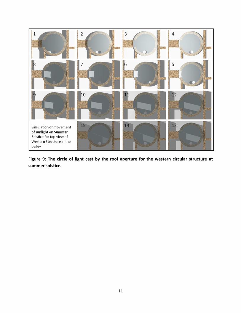
Similarly, for structure 2 (figure 9), we assume that the entry is via a break in the 2.5m high
circular wall where the straight wall joins from the west. The width of the entry is taken as
1.30m – which is the thickness of the straight wall. The straight wall is once again taken as a
walkway only 0.60m high. A flat roof was assumed for the structure, with a circular opening
0.50 m in diameter at the southern extreme.
In figures 9 and 10 we have simulated the movement of the Sun in Structure 2 and the light
patterns clearly show that the structure’s design seems to be closely related to the play of the
images.
Upon simulation for summer solstice day, the circle of light cast by the aperture in the roof
slides down the circular wall in the south west and is on the floor at local solar noon, its
southern edge grazing the bottom edge of the southern wall before continuing up the S-E
portion of the circular wall. This is expected since we have deliberately positioned the aperture
over the southern extreme and the sun is straight overhead at local solar noon on summer
solstice at Dholavira. Simulating the sun’s movement on winter solstice day for this same
geometry, the circle of light travels down the N-W part of the circular wall and when it is on the
straight wall, its northern edge passes close to the bottom edge of the circular wall.
11
Figure 9: The circle of light cast by the roof aperture for the western circular structure at
summer solstice.

12
Figure 10: The circle of light cast by the roof aperture for the western circular structure at
winter solstice.
In figure 12 and 13 we have shown the sunlight patterns on summer and winter solstice for
Structure 2 and it can be seen that the shadow of two outer flanking walls in the west touches
the structure at characteristic locations indicating that these walls were probably made to note
the exact point of sunset at solstice days.
It is seen that the two sections of E-W oriented walls to the west of the west circle frame the
extreme points of setting of the sun as seen from the 1.30m wide slit in the circular wall. In
other words, the shadow of the northern wall touches the northern extremity of the slit at
sunset on summer solstice day and that of the southern of these walls touches the mid-point of
the slit on winter solstice day.

13
Figure 11: The shadow of the flanking walls with respect to the slit in the western circular
structure at sunset on summer solstice
Figure 12: The shadow of the flanking walls with respect to the slit in the western circular
structure at sunset on winter solstice

14
Discussion
The city of Dholavira is on the Tropic of Cancer (latitude 23o 26’ 22”). The location of structure 1
is latitude 23o 53’ 14.0” N; 70o 12’ 44.5”. However the earth’s axis of rotation fluctuates by
about 0.5o over centuries (Vahia and Menon, 2011). Hence, we can assume that Dholavira lay
exactly on the Tropic of Cancer. Hence the shadows of all the structures would be to the north
of the structure except for the local solar noon of Summer Solstice when the Sun would come
to the zenith and no shadows would be cast. This is clearly something a civilisation as complex
as the Harappan civilisation must have noticed.
The Bailey structure of Dholavira is unusual in several ways. It is built on what seems to be an
intentional incline that points to the celestial pole. It also has two circular structures, a rare
structure for the rectangle- loving Harappans. However, from the workmanship and relation to
the neighbouring structures, these structures seem to be contemporaneous to other structures
in the Bailey. While structures of the Harappan civilisation do not have stone pathways leading
to the entrance, these two buildings have such pathways. The whole city is inclined 6 degrees
to the West of north, but the two circular structures in the Bailey have openings that are
exactly to the north and west respectively. In addition, the west-facing structure has two walls
that are so constructed that their shadow would just touch the entrance to the structure on
winter and summer solstice days.
We have simulated the Bailey structures by making assumptions about the superstructure such
as the height of the walls (2.5 meters) the flat roof. We have also assumed the presence of an
aperture of a certain size (which is not crucial to the simulation) and its positioning. However,
none of these parameters are at variance with what is known about Harappan architecture
(Possehl, 2002).
Using these assumptions we have simulated the movement of the image cast by a hole in the
ceiling of the structures. The image clearly coincides with important points within the structure.
Hence important days of solar calendar could easily be identified by analysing the image inside
the room. The narrow beam of light from the entrances would also enhance the perception of
the movement of the sun over the period of one year.
In the case of Structure 1, what is interesting is that for the given geometry of the aperture
above the southern extreme of the straight wall, the northern and southern extremes of the
straight wall mark the points where the circle of light is cast at noon on the solstices. A simple
long marked plank of wood on the path would allow reading of the calendar in a unique and
accurate way, especially if the hole in the roof used here is replaced by a slit.
In the case of Structure 2, once again, for the given geometry of the aperture above the
southern extreme of the circular wall, the extremes of the north - south diameter of the room

15
mark the points where the circle of light is cast at noon on the solstices. In addition, the
positioning and extent of the two E-W oriented walls as well as the slit in the circular wall,
respond to the positions of sunset on the solstice days.
Conclusions
It is highly implausible that an intellectually advanced civilisation such as the Harappan
civilisation did not have any knowledge of positional astronomy (see for example, Vahia and
Menon, 2011). However, apart from some suggestive references (Danino, 1984), there has
been no positive identification of any astronomy-related structure in any of the 1500-odd sites
known today. The structures in the Bailey at Dholavira, however, seem to have celestial
orientations inbuilt into their design. More precisely, these structures seem to have a response
to the solar geometry at the site inbuilt into their design. It is, therefore, highly probable that
these two rooms in the structure were meant for observations of the sun. If so, this is the first
identification of a structure used for observational astronomy in the context of the Harappan
Civilization.
We summarise our arguments in favour of this suggestion as follows:
1) The City of Dholavira is on what is thought to have been an island at that time and is
also almost exactly on the Tropic of Cancer and was an important centre of trade.
Keeping track of time would therefore be crucial to the city. No obvious structures have
been identified in Dholavira that could have aided this.
2) The Bailey has an inclination that corresponds to the latitude of the place and hence,
viewed from the south, it would point to the north celestial pole.
3) While the layout of the whole city is 6 degrees to the west of north the two structures of
interest have opening in exact North and exact West (with an error of less than 1o).
4) These two structures are not conducive to human habitation and have well defined
stone paths leading to and into the structure.
5) A simulation of the nature of the structure and internal movement of the sunlight
passing through into the structure by assuming reasonable superstructure with a
strategic hole in the ceiling reveals interesting patterns. The interplay of image and the
structure of the structure and its surrounding structures all seem to suggest that the
structure which is consistent with it being a solar observatory to mark time.
6) The west-facing circle has two flanking walls outside the exit whose shadow touches the
entrance on winter and summer solstice.
7) The two square well-like structures at the southern end would provide an excellent
location to observe zenith transiting stars even in the presence of city lights, which are
certain to have lit prominent places like the Citadel.

16
8) Arguing from sociological point of view we suggest that such structures had to exist in all
major cities and hence our suggestion is consistent with other aspects of this
sophisticated civilisation.
We therefore conclude that the possibility that the Bailey may be a calendrical and
astronomical observatory should be seriously considered. If this is true, then the Harappan
observatories had fundamentally different design ideas from, say, megalithic structures of the
same function and was more akin to similar structures found in South America several millennia
later (Hadingham, 1983).
Acknowledgement
The authors wish to acknowledge the funding for the project from Jamsetji Tata Trust under the
programme Archaeo Astronomy in Indian Context. We also wish to gratefully acknowledge the
permission given to us by the Archaeological Survey of India to survey the site in 2007, 2008
and 2010. Without this it would have been impossible to do the work. We also wish to thank
our friends Mr. Kishore Menon and others whose endless discussions greatly helped in this
work. We also wish to thank Prof. Vasant Shinde for his continuing encouragement for this
work. We wish to thank Sir Arnold Wolfendale for helpful suggestions.
References 1. Agrawal D P, 2007, The Indus Civilisation, Aryan Books International 2. Danino, M, 2007, Man and Environment 3. Danino M, 1984, The Calendar Stones of Mohenjo-daro, Interim report on the field work
carried out at Mohenjo-daro 1982 - 1983, ed. Michael Jensen and G Urban, Aachen and Roma, volume 1
4. Hadingham, E., 1983, Early Man and the Cosmos William Heinemann, Ltd. London. 5. Joshi J P, 2008, Harappan Architecture and Civil Engineering, Rupa Publications India 6. Possehl, G. L. (2002) The Indus Civilization: a contemporary perspective, Vistaar
Publications, New Delhi 7. Ratnagar, S. (2001) Understanding Harappa: civilization in the Greater Indus valley,
Tulika Books, New Delhi 8. Rajesh S V and Patel, A, 2007, A gazette of Pre and Post historic sites in Gujarat , Man
and Environment, 33. 61 - 136 9. Vahia M N and Menon S, 2011, Foundations of Harappan Astronomy, to appear in the
proceedings of the 7th International Conference on Oriental Astronomy, Tokyo, Japan, September 2010.
10. Vahia M N and Yadav Nisha, 2011, in Journal of Social Evolution and History 11. Wright Rita P, 2010, The Ancient Indus: Urbanism, Economy and Society, Cambridge
University press.