Embed Size (px)
Citation preview

A PLAN ING STUDY KINGSTON, ONTARIO
1960

•
•
•
A PLANNING STUDY OF KINGSTON, ONTARIO
PREPARED FOR THE CITY COUNCIL
by GORDON STEPHENSON, M.T.p.le.
Professor of Town and Regional Planning
University of Toronto
and G. GEORGE MUIRHEAD, M.T.P.Le.
Planning Officer of the City of Kingston
Planning Board
PUBLISHED BY THE CORPORATION
OF THE CITY OF KINGSTON
1961

a
..
•
•
•
FOREWORD
by HIS WORSHIP, "VILLIAM T. MILLS
Mayor of the City of Kingston
T HE CITY of Kingston is a unique blend of past and present. Stately old buildings, many of them reposing in parklike settings,
have given it the name of "The Limestone City". Well designed industrial plants, shopping facilities and pleasant new subdivisions mark it as a progressive, modern city as well. It is also a great military, medical and educational centre. Historically, it ha~ been an important port. Now a century and a half old, the structure of our City has undergone a process of continuous change as it has adapted itself to new conditions. The demands of the 20th Century however, have imposed new strains on the structure of the City which must be reshaped if it is to continue to function efficiently. Certain parts of the fabric are wearing out and must be replaced. Other parts show signs of deterioration which must be halted. Some areas have been allowed to become ugly; their beauty must be restored. This process of improvement is called Urban Renewal and it has but one justification-the enhancement of the general welfare of the people of Kingston. The Kingston Urban Renewal Study, which has been prepared by Professor Cordon Stephenson and Mr. Ceorge Muirhead indicates the lines along which such improvements should take place. I warmly commend the reading of this Report to all our people.
City Hall, Kingston WILLIAM T. MILLS
Mayor
•
•
PREFACE
On December 13, 1955, a Committee on Housing was appointed by the late Mayor George Clark Wright to enquire into the housing situation in the City of Kingston. The Committee held its first meeting on December 20th, 1955 when it was decided to give priority to the matter of clearance or redevelopment of substandard housing in Kingston and to low cost housing projects for the City, including a scheme with subsidized rentals. On January 4th, 1956, it was resolved that a city-wide survey should be made to determine the location of substandard housing in the City, beginning with Weller Avenue and continuing through the Rideau Heights Area. As the Housing Committee's survey progressed it became increasingly evident that the Rideau Heights district could not be treated as an isolated area and that the realization of redevelopment objectives would have to be integrated with the planning of the entire city. Consequently, the Housing Committee and the Planning Board cooperated to urge an Urban Renewal Study of the whole City which would endeavour to solve the interrelated problems of replanning the old sections of the City and remedying unsatisfactory housing conditions.
Also, at about this time and at the request of the Housing Committee, a Housing Needs Survey was carried out by the Ontario Department of Planning and Development. The Survey resulted in a proposal for a low-cost housing project for the City of Kingston, and preparations for this began late in 1958. A site in Rideau Heights was chosen on which 71 units of public housing will be constructed, beginning in 1960.
The present Study has been carried out under the general supervision of the Urban Renewal Advisory Committee, consisting of Mr. J. F . Brown, Community Planning Branch of the Department of Municipal Affairs (Chairman); Mr. D. Taylor, Community Planning Branch of the Department of Municipal Affairs; Mr. J. McCulloch, Regional Administrator, Operations, Central Mortgage and Housing Corporation; Mr. P. Dovell, Ontario Regional Architect, Central Mortgage & Housing Corporation; Mr. K. Ganong, Manager, Central Mortgage & Housing Corporation, Kingston; Aldermen R. Bruce and O. A. Earl (1958): Aldermen G. Vosper and F. D. Stevens (1959-60). The Committee held its first meeting in June, 1958 while actual work on the Study commenced in May, 1958.
Mr. John Billingham, Dip. Arch., A.R.I.B.A., a graduate in Town and Regional Planning of the University of Toronto, was engaged full time on the Study from May, 1958 to September, 1959. We are greatly indebted to him for his unfailing energy and consistently good work. He has been ably assisted by Mr. K. Grace, Mr. R. Ollerhead and Mrs. E. MacMaster, members of the City Planning Office Staff. Mr. K. Grace was responsible for the organization of work for the printer after Mr. Billingham's departure.
It would be impossible to mention by name all those persons who have given of their time and interest in the preparation of the Study although it is with a real sense of obligation that we acknowledge their contributions. There are some, however, whose assistance was especially helpful and · we record their names with gratitude.
Mayor Frank Boyce, in 1958, and His Worship Mayor William T. Mills, in 1959, have aided the survey of internal housing conditions by informing all residents within the Study Area by circular letter of the purpose of the survey. Mayor Mills has shown continuous interest in the study and has joined in discussions about it several times. Mr. B. G. Allmark, M.P., the Federal representative and the Honourable W. M. Nickle, Minister of the Department of Planning and Development of Ontario, have shown great interest from the beginning. The City Planning Board have been most helpful in arranging meetings with different individuals and groups in the City for discussions about ideas as well as facts . Various Departments of City Hall have helped in compiling this Report. The records of the Assessment Department were made available, and Mr. H. O. Morris, the Commissioner, and his staff have been most cooperative. Through Mr. N. J. Robinson, the Welfare Administrator, and Mrs. S. Buck, the Relief Supervisor, the records of the City Welfare Department have been open to us. Mr. R. Tear and Mr. H. E. Bishop, Probation Officers for the Juvenile Court, allowed us to use a numbet of their records for the Study. On several occasions we have consulted with the Engineering Department, particularly with regard to road proposals and sewage disposal requirements for the City.
Mr. D. Bruce, Building Inspector, has assisted us with surveys in the Rideau Heights Area. Fire Chief V. C. Brightman made available the records of his Department for the past five years. Inspectors P. L. Rapley and G. K. Ball of the Fire Department
vi
were assigned to help during the early stages of the survey of the interiors of dwellings. Police Court Records were made available by the late Police Chief J. T. Truaisch and his successor Police Chief R. Nesbitt. Detective Inspector R. E. Haunts kindly took a number of photographs which appear in the Study. Dr. R. A. Kelly and his staff at the Department of Health helped us to investigate tuberculosis cases, infant mortality and other health records. Mr. R. McPherson, the Sanitary Inspector, made it possible for us to enter some of the downtown residential dwellings. Colonel L. F. Grant, an Alderman of the City, was able to make valuable suggestions relating to the Harbour and Waterfront. Lieut. Commander E. Phipps-Walker, the Harbourmaster, helped with information on the present use of the Harbour. Mr. C. Hudson and other members of the Chamber of Commerce provided photographs and information for the Study and publicized Planning Board meetings arranged for the Downtown Merchants. We are grateful to the members of the Parking Authority for their interest in our proposals, some of which have already been adopted. Messrs. H. Abramsky, R. Bruce and S. Goodman, among other downtown merchants, have helped with suggestions for the Central Area.
With the aid of Dr. Lamb, considerable historical information was obtained from the Public Archives of Canada. Dr. R. Preston of the Royal Military College has been kind enough to provide information from his own files, and to offer comments
February, 1960.
on the historical section of this Study. Mrs. W. Angus of the Kingston Historical Society has helped with information and opinions, and the Librarians at Queen's University and the Public Library have helped in the search for historical maps. The Editors of the Whig-Standard have made the Urban Renewal Study the subject of numerous articles and talks. Dr. S. Fyfe and Professor D. Slater of Queen's University discussed with us the economic structure of the Kingston Area, and Dr. Fyfe has written a chapter of the Study for which we are grateful. Details of C.P.R. freight distribution were kindly supplied by Robert Purtell Cartage. Mr. J. D. Lee ar,d Professor H. M. Edwards of Queen's University were consultants to the City on engineering and traffic studies which have been valuable guides.
The internal and external survey of buildings was begun in June, 1958. It was carried out by Mr. Billingham, Miss J. Estall, Mrs. N. Hooper and Miss C. Newell. Miss J. Estall worked for two long periods during the preparation of the Report. Her contribution has been of great value. Mrs. Flora C. Stephenson has also worked at different times on the survey and report. She was an invaluable assistant to the Consultant. Miss M. Seymour's report on land use and zoning in the Old City and Mr. I. MacGregor's report on population have been of use in this Study. We were grateful to have them, and other reports and information which may not have been mentioned specifically.
GORDON STEPHENSON G. GEORGE MUIRHEAD
..
o
•
o
PART PART PART PART PART PART
PART
,
CONTENTS
FOREWORD BY HIS WORSHIP THE MAYOR, WILLIAM T. MILLS ........... . PREFACE .... ......................................... . .... ........................... ... ...................... .
I THE DEVELOPMENT OF KINGSTON .......... .... ......... .... .... ....................................... . II CONTEMPORARY KINGSTON . . ..................................................................... ..
III KINGSTON AND REGION . . ....... .. ............. .... .. ...... .... ............................... . IV ECONOMIC BACKGROUND . . ....... .. ............ . .. ....... ... ......... .... .... ............ . V PROBLEMS AND PROPOSALS . ... .. .......................................................... .. .
VI THE CITY AS A WHOLE Section 1 The Structure of the City ...... ............ .. ............................................ . Section 2 Population ........................... .. .. ..... ... ............. ... .. .. ................. .... .................. .. Section 3 Relief Cases ... ................................................. .. ............................... .. ...... .. Section 4 Children and Their Problems ....... .. ............... ...................................... .. Section 5 Police Cases ................................. .. ..... .................................................. ..... .
VII THE STUDY AREA Section 1 Building Use . . ........ ............................................. ..................................... .. Section 2 Fires in Dwellings ... ................................. ..... ... .................... ...... .... ........ ..... . Section 3 Property Values ........................................... . ................ ........ .. ........ . Section 4 Overcrowding ." .. ..... ....... .. . . ... ............... ... .................. ........................ .. Section 5 Sanitation ... . ......................... .. ................... ......... ... .................................. . .. Section 6 Condition of Dweliings . ............... .. .. ............ . ......... .. Section 7 Distribution of Substandard Housing .................... .......... ..
PART vm REDEVELOPMENT PROPOSALS
PART
Section 1 The City as a Whole Section 2 The Redevelopment Areas
IX SPECIAL STUDIES Section 1 Rideau Heights ..... . Section 2 Old Sydenham Ward Section 3 The Central Area ... . ..... .. . .. Section 4 The Waterfront ...... .. ............ . APPENDICES
... ...... ....... ......... .. ..... ....... .............. ...... ,.
Central Area Parking . ... .... ............ ................ ............ .. .... .. Residential Zoning ........ ... ............................ ...... .. ..... .. ...................... . Housing Code .. . .. .. ................ ... ....... ..... .......... ...... ...... ......... . Preservation of Buildings ......... ....... ..... ....... .. ......... .. ..... .. . .. Index Map ...... . ....................... ... ................. ....................... .. ........... .. ... .... . Some References .... .. .. .. ..... ... .. .... ...... .. .. .. .......... .. ... .... .. ... .. ..... ..... .. .............. .. . .
TABLES
I POPULATION FOR CENSUS YEARS ............ .. .................................................. . II PERCENTAGE OF LABOUR FORCE EM?LOYED IN MANUFACTURING
III LABOUR FORCE BY INDUSTRY ........ ... ........... ..... ... ..................... ............. .. . IV EDUCATIONAL LEVEL OF LABOUR FORCE ....... .. .... .. .. ... .......... .................... .... .... . .. V POPULATION FORECAST ... . ........................... .. ........... .. ......................................... ..
VI FIRE CALL FREQUENCY . . ........... ........................... ........... .. ........................ . VII PROPERTY VALUES ............. . ............................. ..................... ......................................... .
VIII OVERCROWDING .................... ... ... .. ... ........... ....................... ... ............................................ . IX SANITARY DEFICIENCIES ... ...... ... ... .... .... ... ........ .. ... .... ........................................... .. ...... ..... . X BUILDING CONDITIONS . ............... . .. .............. .. ........ .. ..................... .. .......... ...... .
XI SUBSTANDARD HOUSING ............................ ................................................... ... .. .. XII REDEVELOPMENT PROPOSALS ...................................................................... .. .............. .
XIII CENTRAL AREA-SUMMARY OF FLOOR SPACE PROPOSALS XIV CENTRAL AREA-PARKING SURVEY . ... .. ..... ... .. .. ...... ............ .. .. ..
.. vii
ill v 1 7
17 22 29
38 40 42 44 415
48 50 52 54 56 58 60
62 64
67 70 75 92
95 95 97 96 99
100
Page 22 24 24 26 27 50 52 54 56 58 60 62 86 95

viii MAPS Illustration Page
33 REGION: EXISTING LAND USE .. ...... .......... . .. .... .... ........... ..... .. ..... ....... ............. .... 18 34 REGION: LAND USE 1980 ........ ""''''''''''.. ......................................................... 19
. 36 CITY: THE STRUCTURE OF THE CITy ................. .. ......... ... ....................................... .. 39 37 CITY: DISTRIBUTION OF POPULATION .. ... ..... .. .... .. ........... .. .......... .. .... ...................... 41 38 CITY: DISTRIBUTION OF RELIEF CASE) .............. .... .... .... ..... ... ... .... .... ..... ....... .... .. 43 39 CITY: DISTRIBUTION OF JUVENILE COJRT CASES .. ................................ ....... ........... 45 40 CITY: DISTRIBUTION OF POLICE CASES ....................... ...... ..................................... 47 41 STUDY AREA: EXISTING USE OF BUIV)INGS .. ........ .. ................. .......................... 49 42 STUDY AREA: FIRE CALLS IN DWELLINGS ...... .. ... ..................... .. .................. 51 43 STUDY AREA: ASSESSED VALUES OF PROPERTIES .... . ..... .................... .. ..... .. .......... 53 44 STUDY AREA: OVERCROWDING IN DWELLINGS ...................................... ....... ....... 55 45 STUDY AREA: SANITATION DEFICIENCIES IN DWELLINGS .. ............ ...... ..... ........ 57 46 STUDY AREA: CONDITION OF DWELLINGS .... ..... ....................... .................... ..... 59 47 STUDY AREA: DISTRIBUTION OF SUBSrANDARD HOUSING ... ............................ 61 48 CITY: PROPOSALS FOR LAND USE AND MAJOR STREETS ...................... ............ ...... 63 49 STUDY AREA: PROPOSALS FOR LAND USE AND MAJOR STREETS ....... ................ 65 54 RIDEAU HEIGHTS: PROPOSALS FOR L<\ND USE AND MAJOR STREETS ............ 69 83 CENTRAL AREA: EXISTING USE OF B-J ILDINGS . .............................................. ... ... 82 86 CENTRAL AREA: PROPOSED USE OF BUILDINGS ............. ...... .. ............................ ... . 85
111 STUDY AREA: PRESERVATION OF BUILDINGS .... .................................................. . 98 STUDY AREA: KEYMAP WITH STREET NAMES AND BLOCK NUMBERS ....... .. .. .. ... 99
DIAGRAMS 4-8 KINGSTON BUILT-UP AREA IN 1800, 1350, 1867, 1915 AND 1960 .............. . ......... 2
9 KINGSTON: PANORAMIC VIEW 1875 ................................................... ...... .. ........... .. . 4 10 KINGSTON: ORIGINAL LAYOUT 1784 .. .. .. .......... .............. ... .................... .... . .. ............ 4 29 REGION: POLITICAL BOUNDARIES ......................... ... .. ... .. ........................ 16 35 KINGSTON AND REGION: POPULATION GRAPH 1930 TO 1980 ...... . .......................... 21 50 STUDY AREA: PROPOSED REHABILITATION EXAMPLE .............. .. ....................... .. . 66 53 RIDEAU HEIGHTS: PROPOSED REDEVELOPMENT .............................................. 68 55 SYDENHAM WARD: MAP OF 1865 .............. ................................................................. 70 59 SYDENHAM WARD: DEVELOPMENT PROPOSALS- EARL AND BAGOT STREETS 72 62 SYDENHAM WARD: EXISTING BUILDING USE ....... ................................................... 73 63 SYDENHAM WARD: PROPOSAL NO. 1 ..... .. ......... .... ....................... ........... ..................... 73 64 SYDENHAM WARD: PROPOSAL NO. 2 ..................................................... .. .............. 73 66 SYDENHAM WARD: DEVELOPMENT PRC>POSALS-WEST STREET ................. ... .. . 74 67 SYDENHAM WARD: CONVERSION PLAN-GORE AND WELLINGTON STREETS . 74 71 CENTRAL AREA: FUNCTIONAL CLASSIFICATION ................ ........ ......... ..... ........... 76 79 CENTRAL AREA: EXISTING FLOOR SPACE ........................... ... .... ....... ....... ........... 79 80 CENTRAL AREA: PRINCESS STREET PROPERTY VALUES ................ .. ........... .... ...... .. 79 81 CENTRAL AREA: TRAFFIC DENSITY AND PARKING .................. ..... ....... ..... .. ...... ... . 80 82 CENTRAL AREA: PROPOSED TRAFFIC FLOW AND PARKING .................. .. ...... .. .... 81 84 CENTRAL AREA: PROPOSED FLOOR SPACE ........................................................... 84 85 CENTRAL AREA: FLOOR SPACE DIAGRAM .. . ............ ,.................. ... .. ................ 84 89 CENTRAL AREA: DIAGRAMMATIC DEVELOPMENT PROPOSALS ................. .... .. ... 87 91 CENTRAL AREA: VISUAL IMPROVEME-'J'TS PRINCESS STREET ..... .. ..... .......... 88 93 CENTRAL AREA: DEVELOPMENT PRO?OSALS MARKET SQUARE ........................ 89 95 CENTRAL AREA: PROPOSED ARCADE MONTREAL STREET "" ""'"'''''''''''' 90 97 CENTRAL AREA: PROPOSED ARCADE PRINCESS STREET ................................... 90 99 CENTRAL AREA: DEVELOPMENT PROPOSALS CLERGY STREET .. .............. ....... 91
101 CENTRAL AREA: DEVELOPMENT PRO?OSALS LOWER PRINCESS STREET ........ 91 103 WATERFRONT: EXISTING LAYOUT . ........ ...... ..... ............ ... ...................................... 92 104 WATERFRONT: PROPOSED DEVELOPMENT AERIAL VIEW ... .... .. .... ... .................. 93 105 WATERFRONT: PROPOSED LAYOUT .... . .......................... .. ...... .. .................. 93 107 WATERFRONT: PROPOSED DEVELOPMENT- VIEW FROM WATER ... ... .......... ....... . 94
PHOTOGRAPHS
Illustration Page
1 Aerial View of Region .... ... ... .. Cover 3 City Hall ....... .................. .... ... ... Frontispiece
11 Yacht Club Boats ... .... . .... ... ... ................. 7 12 Aerial of City .. ... ... .. .... .... ........ ..... 8 13 Aerial of Central Area .................. .......... 9 14 City Silhouette ..................... ............ ........ . 10 15 St. George's ........... ........ ... ... ........... .......... 10 16 County Courthouse .... ..... ....... ...... .............. 10 17 Market Square ........ .... .............. ........ ....... . 11 18 Aerial-University Area ...................... .. .. 11 19 Stone House: Cartwright House ......... ....... 12 20 Frame House: J ohnson Street ....... .. ......... 12 21 Brick House: Gore Street . ..... ........ ........ 12 22 Stone Tenement Housing: Ontario Street .. 13 23 Frame House: Main Street .................... . 13 24 Brick House: Ellice Street .. ......... ...... ...... 13 25 Recreation: Frontenac Park ....... .. 14 26 Waterfront Park: Murney Tower ... .... .... 14 27 Cataraqui Bay: Grain Elevator .... 15 28 Aerial View of New Housing Areas .... ... 15 30 View of 401 ....................... .................... . 16 31 Shopping Centre and Aluminum Plant ... . 16 32 Nylon Plant ......... ... ........ .......... ..... ........ .. 16 51 Dwelling-Weller Avenue ....................... 67 52 Unfinished Dwelling-Rideau Heights 67 56 House-Bagot Street .......... ................ 71 57 Houses-King Street .... ....... ...... ...... . 71 58 Bagot Street Housing .. ..... .... . . .. ... ...... 72 60 View of Model-Existing .. .... . ... ..... 72 61 -Proposed ........ .............. 72 65 Coal Dump-West Street 74 68 Gore Street Store-Before ........... .. 74 69 Gore Street Apartments-After 74 70 Central Area: Vertical Aerial View 75 72 King Street Housing ........... .................... . 77 73 Wellington Street Housing ........ .. ... . .. .. . . 77 74 Ontario Street Housing ... . .. .... ... .......... 77 75 Brock Street Poor Housing ........... . 78 76 Brock Street Good Buildings .......... ........ 78 77 Queen Street: Service Area to Shops 78 78 Brock Street: Service Area to Shops 78 87 Princess Street Signs . ... ........ 86 88 Gourdier Sign-Brock Street .. 86 90 Princess Street-Existing 88 92 Market Square-Existing . ...... ...... ...... ... 89 94 Montreal Street-Existing ....... ...... ...... .. 90 96 Archway to Princess Street . . .. .. .... ....... 90 98 Clergy Street-Existing ............................ 91
100 Foot of Princess-Existing . . ................. 91 102 Aerial View of Waterfront-Existing . 92 106 Waterfront-Existing ................ 94 108 Row Housing-Simcoe Street ......... ... ...... 97 109 Stucco House-Brock Street ....... .... . .. ... 97 11 0 Stone Houses-Earl Street ........ ........ .. .. .... 97
Credit
Wallace Berry Robinson-Holder Wallace Berry R.C.A.F. Dick Herrington J. Billingham Robinson-Holder George Lilley R. E. Haunts Wall ace Berry George Lilley R. E. Haunts R. E. Haunts R. E. Haunts J. K. Billingham R. E. Haunts R. P. Ollerhead Robinson-Holder R. P. Ollerhead Wallace Berry H. R. Oakman Wallace Berry Wall ace Berry R. E. Haunts R. E. Haunts R. E. Haunts R. E. Haunts R. E. Haunts George Lilley George Lilley R. P. Ollerhead Marion Seymour George Lilley Spartan Air Services R. E. Haunts R. E. Haunts R. E. Haunts R. E. Haunts R. P. Ollerhead R. E. Haunts R. E. Haunts George Lilley R. E. Haunts Robinson-Holder R. P. Ollerhead R. E. Haunts R. E. Haunts R. E. Haunts R. P. Ollerhead Dick Herrington R. P. Ollerhead R . E. Haunts George Lilley R. P. Ollerhead
ix
Source
Chamber of Comm. Chamber of Comm.
Dept. Mines & Tech. Chamber of Comm.
Chamber of Comm.
Police Department Police Department Police Department
rolice Department
Chamber of Comm.
Dept. of Highways
Police Department Police Department Police Department Police Department Police Department
Police Department Police Department Police Department Police Department
Police Department Police Department
Police Department
Police Department Police Department Police Department
Chamber of Comm.
Police Department

FRONTISPIECE. The City Hall was built during the mayoralty of John Counter when for three years Kingston was the capital of Canada. The cornerstone was laid by the GovernorGeneral, Sir Charles Metcalfe, on June the 5th, 1843, and the building was completed by November the 21st, 1844. The architect was George Browne and the building cost £30,000. Professor A. M. Lower describes it as the mos t dignified City Hall in Canada, an opinion with which many must agree. The magnificent waterfront view is spoiled by the absence of the portico which was removed in 1956. The restoration of the portico deserves the highest priority in an urban renewal programme in which the old battery site facing the portico on the water's edge should once more become a public park.

..
•
..
I. THE DEVELOPMENT OF KINGSTON
Kingston and its surrounding region have experienced more than three hundred years of history since the arrival of the first white man. Although no urban growth took place for a hundred years, the site was always important, for strategic and trading reasons, to both French and British. The first recorded visit by white explorers took place in 1615. Samuel de Champlain and his party of French explorers spent some thirty-eight days in the vicinity hunting, fishing and exploring. A century later the French wished to push further west with their fur trading and exploration, and in 1673 Cataraqui, as the region was then called, was selected by doughty Count Frontenac for a fort and trading post. He wrote of his expedition that, "with the Naval vessels now being built, it will command Lake Ontario, keep peace with the Iroquois, and cut off trade with the English".
In the next year La Sal1e was granted the first Seignory of Frontenac by Louis XIV. His grant included the fort, four leagues along the waterfront, one half a league inland, and W olfe and Amherst Islands. However, La Salle was more interested in further exploration westward than in building up Frontenac as a rival trading post to Montreal. During the years that followed, the fort had various commanders, but after Frontenac's recall there was no firm policy towards trade and relations with the Indians. After the massacre at Lachine in 1689, the fort was partly destroyed and the Commandant withdrew to Montreal with his soldiers. In 1696 Frontenac, now an old man, returned to Canada and rebuilt the fort which had been named in his honour.
Half a century later came the eventful Seven Years' War. The last important occasion on which the post of Frontenac was used to mount an attack against the English was in July, 1756, when Montcalm left it to attack Oswego. Two years later, Fort Frontenac fell to the English under Colonel Bradstreet who destroyed it, using its own guns to batter down the walls. To the French the destruction of Fort Frontenac and their fleet was a major calamity, because it cut off free access to their far western outposts and opened the way for the English victories at Montreal and Quebec.
Cataraqui now became a British outpost and entered a thirty year period of virtual stagnation. In 1760, after the fall of Montreal, a British party formally took possession of the post, but from 1759 to the close of the American Revolution the site was
used mainly by a few fur traders and wandering Indians. The American Revolution sparked a new period of development at Frontenac and in Upper Canada. Of the thousands of Loyalists who left the American colonies, some 10,000 came to Lower and Upper Canada. At this time all communications with other parts of Canada were by water; the shores of Lake Ontario were still a trackless wilderness, quite unsettled. From the earliest fur trading days, however, Kingston had been an important site for the forwarding trade, and for this reason was chosen for a Loyalist settlement.
In 1783 orders were issued for a survey of Kingston Township, including reservations for the fort and town-site. In 1784 numerous groups arrived at Cataraqui, soon renamed Kingston, where they underwent considerable hardship for several years . The refugees were issued supplies, tools and clothing but these seemed to have been in short supply or unevenly distributed. Most of the Loyalists took up their land grants in the township, while some artisans and traders settled in the new village of Kingston. Major Holland, the first British official to arrive after the Treaty of Paris in 1783, was in charge of the party who made the survey and prepared plans. His assistant, Ensign Peachey, has left us the only etching of Cataraqui before the Loyalists came. Within ten years all the street lines were projected, and blocks were subdivided in the townsite. The townsite was on land between the waterfront and Sydenham Street to the north of Princes's Street. 350 town lots and 20 waterfront lots were laid out, and by 1796 some 75 of the lots had been built upon.
The arrival of the Loyalists marked the first real spurt of growth around Kingston. By 1789 the Naval Dockyards, which had been removed to Carleton Island during the Revolution, were returned to Kingston. Already some shipbuilding yards had returned. A new fort was built and garrisoned, and the presence of many soldiers and sailors, with money to spend, quickened the commercial life of the little town. It was still, however, a small and primitive community. When Governor Simcoe came to Kingston in 1792, Mrs. Simcoe wrote in her Diary: "Kingston is a small town of about 50 wooden houses and merchants' storehouses ; only one house is built of stone". In 1800 the town was made a regular Customs port of entry, and in 1801 an Act established a market for the district of Kingston.
Steady progress was made in population ami

2
1800
1867
.J .:_ · r- ' "' ' .
.... -..."L ..
PART I
, /
I I
I ,
,/
I I
I , J
I I I '-
\ I \ \ }
,../",,,1
/
\ I \ I }
-'
"" ......... ,-)
) , , ~
1850
1915
1960
ILLUSTRATION NOS. 4 to 8 INCL.-THE DEVELOPMENT OF KINGSTON FROM 1800-1960.

•
•
•
THE DEVELOPMENT OF KINGSTON 3
housing, and the War of 1812 brought more troops, sailors and prosperity to Kingston. During these early years the Loyalist settlement regarded itself as the centre of Upper Canada and looked upon Toronto as a mere upstart. During the War of 1812 the woods around the town and on Point Henry were cut down for protection, five block houses and palisades were built to encircle the town, batteries put up at strategic points, and a stone fort erected on Point Henry. When the War ended in 1814, Newark (Niagara) and York (Toronto), were severely damaged, commercial ruin had come to other olaces, but Kingston had prospered. SinceKingston was strongly fortified it had not been attacked, and the Naval Dock Yard workers and the soldiers had put money into circulation. At this time there were 450 dwellings, three churches, a government building, a theatre, a newspaper, and a semi-public library in Kingston.
The years following the War of 1812 witnessed steady growth. Slowly the population, commerce, and physical aspect of the city changed and improved. By 1821 Kingston was the largest town in Upper Canada. Communications were also improved. A stage service had existed to Montreal since early in the century, and the discomforts and uncertainty of the journey have been vividly described by early travellers. Now a stage service was started to York, but the distances to both Montreal and Toronto were so great, and the populations involved so small, that it was impossible to maintain good roads and reliable communication by land.
It was the use of steam power in ships that first changed the picture and made the future brighter for Kingston and other settlements on the Lake. In 1815 a steamboat, the "S.S. Frontenac," was commissioned by leading Kingston merchants. It was built at nearby Bath and launched in 1816 for service on Lake Ontario and the St. Lawrence. It was soon followed by others. Ten years later the Rideau Canal was begun, an undertaking which enabled Kingston to maintain her position as a port
of transhipment and to develop into a busy town. The Canal was designed with military needs foremost in mind, so that Upper Canada could more easily be protected from the new Republic to the south, but it also stimulated commerce throughout the province. Kingston in particular benefited quickly, because goods, both east and westbound, had to be trallshipped at this point. The forwarding trades and shipyards became active and remained so until late in the century. The opening of the St. Lawrence Canals in the 1840's, and the construction of railways in the 1850's, reduced the commercial importance of the Rideau Canal, but wheat from the Bay of Quinte and Western Ontario continued to be trans-'shipped at Kingston. By 1857 over 100 vessels, both steam and sail, hailed from Kingston. Only Quebec City had more ships claiming her as their home port.
During these mid-century years of expansion and growth, the fate of Kingston was very much identified with historical events of importance to Canada as a whole. The Rebellion of 1837 in Upper Canada resulted from abuses of power and privilege by a minority. Kingston was affected by these dissensions, but not nearly so much as other parts of the country. The grievances were mainly connected with the granting and tenure of land and the injurious influence of the Family Compact. The Hon. Thomas Markland of Kingston who wrote a report on the Midland District, referred to the abuses as: "The same cause which has surrounded Little York with a desert, created gloom and desolatioa about Kingston, otherwise beautifully situated- I mean the seizure and monopoly of land by people in office and favour" . The monopoly meant that the outskirts of Kingston, to the east in particular, were desolate. with no dwellings for miles, the roads were in bad condition, and vegetables and other produce had to be imported by water from the United States. After the Rebellion, Britain recognized the need for a careful readjustment of colonial government policy. Lord Durham was sent to investigate and his famous Report changed Empire colonial policy.
ILLUSTRATIONS NOS. 4 to 8 incl. THE MAP of 1800 shows the original site of the English Fort, which replaced the earlier Fort Frontenac, the development southerly from the Fort, and also growth beginning to extend westerly up what is now Princess Street. THE AREA BUILT UP BY 1850 included all of the old Sydenham Ward. City Park was now enclosed. Barrie Street was being built and suburbs were appearing in Portsmouth around the Penitentiary, and in Williamsville at Princess Street. At Barriefield, across the Great Cataraqui River, Fort Henry had been established in its permanent form together with a group of buildings on Point Frederick. THE MAP OF 1867 shows the consolidation of previous development, and a continuously built-up residential area in the centre of the City corresponding in a general way with the study area. DEVELOPMENT UP TO 1915 consisted mainly of concentric growth outside the already built-up area, with a small settlement occurring a"ound the Outer Station which had been established in the 1850's. A group of houses were beginning to form a link between Portsmouth and the City. The population of the City at this time was about 20,000. THE 1960 MAP ind:cates the present stage of development.

4 PART 1
i f
...... . -.. -~ . ..,. '-"'-
ILLUSTRATION NO. 9 (above) KINGSTON, 1875. A birdseye view of the City as it existed 85 years ago. A striking feature is the commercial development of the harbour. The Grand Trunk Railway ran in front of the Market Battery, which became a park and then a railway station at the entrance to the City Hall. Queen's University was established on its present site and large sections of Brock and Princess Streets were used commercially.
ILLUSTRATION NO. 10 (left). The layout of Old Fort Frontenac and the town plot of Kingston prepared in Quebec, in 1784, by Frederick Haldimand. The town was based .on the site of the Fort with three town blocks being laid out along what is now Ontario Street. The surveyor was instructed to layout the remaining ground in the same manner according to the shape of the ground.

•
..
THE DEVELOPMENT OF KINGSTON 5
In 1841 the Provinces of Upper and Lower Canada were united and Lord Sydenham, as Governor-General, chose Kingston for the capital. Unfortunately ill-health dogged both Lord Sydenham and the three men who succeeded him. Finally under Lord Elgin, the son-in-law of Lord Durham, the union was made secure and there was a full exercise of responsible government. During this unsettled period of just over three years Kingston was the capital city, but in 1844 Lord Elgin removed the government to Montreal. The citizens of Kingston continued to hope for the return of capital status, but in 1858 Ottawa was, by Royal choice, made the capital. The decision in 1843 was a great blow to commercial prosperity in Kingston. Not only were its future character and destiny changed, but there was a sudden business depression, and land speculators who had been counting on King5ton's choice as capital were left with their hopes unrealized.
During this time of historical ups and downs the physical face of Kingston had begun to take on the character which is familiar to us today. St. George's Cathedral, built between 1825 and 1844, and the old St. Andrew's Church were erected in this period. In 1832 the Provincial Penitentiary, the present massive stone building, was begun, and Portsmouth and its ship-building yards grew up around it. In 1832 the old Fort Henry, built in 1813-14, was demolished and work started on the present structure.
The Loyalist settlers had come largely from New England and New York. Although loyal to the Crown, they earnestly desired self-government. After a half-century of agitation they secured an Act of Incorporation in 1838 with a constitution similar to that of Toronto, and the construction of a fine City Hall and Market was begun in 1843. The Roman Catholic Cathedral of St. Mary's was started in 1843. The handsome Bank of Montreal and Commercial Bank buildings (now occupied by the Frontenac Club Apartments and the Empire Life Insurance Company) belong to this period. The Martello towers, which remain today as wonderful landmarks for Kingston, were built in 1846. In 1848 the Market Battery was built between the City Hall and the lakefront but was demolished about 1875. For several years a park occupied this fine site, but in 1885 the railway was allowed to occupy it. The New Court House dates from 1855, and the Customs House and old Post Office were built in 1858. The Roman Catholic Regiopolis College was founded in 1838, but moved in 1869, when the buildings became part of the Hotel Dieu Hospital.
Queen's University, first known as "Queen's College" was incorporated by Royal Charter in 1841.
The University grew a'ld prospered and, in a few decades, produced many graduates who became important in the life of Kingston and of the whole country. In 1877 the University entered an era of great progress under George Grant, a Nova Scotian, who became the first native Canadian Principal. In 1884 Queen's refused to merge with the large central Univenity of Toronto, preferring to retain an independent existence and its fine situation at King5ton.
As the years passed in the middle and latter part of the 19th century, those very things which had served as a foundation for Kingston's early prosperity began to slip away. It was no longer important as a military station, and shipbuilding dwindled. Due to the depletion of the white pine forests of Eastern Ontario, the timber trade declined. Grain elevators were built in the 1890's and Kingston retained much of the forwarding trade in wheat, but not as big a proportion of the vast new total, because of diversion to rail and to United States routes. Bulk cargoes, however, still went chiefly by water, and they do so today via the new Seaway; but it was chiefly the decline of the "package freight" business in the second half of the 19th Century which hit Kingston. Nevertheless, some thriving industries came to the town and physically Kingston made good progress in paving, street lighting, public utilities, and public parks.
From the earliest days education in Kingston had been considered important, and by the turn of the century there was a well established public school system, a fine Collegiate Institute, and a few private schoo!s. In City Park, Kingston came to have the fint public recreation ground of its kind in Canada. The land was bought from the Murney family as a possible site for the parliament buildings, and then later used as a parade ground for the Royal Artillery. It was handed over to the City by the Ordnance Board in 1852 for use as a park. Later. in the 1890's the City showed vision and foresight by acquiring two blocks of land, fencing and planting it with trees, and leaving it enclosed until the trees were grown. When Victoria Park was opened, it was perhaps considered a wasteful gesture, bul time has proved how excellent was the planning for this project.
The years before the first World War saw an established way of life flourishing in Kingston. In 1911 street paving was begun with Barrie Street and later Princess Street. Theatres were always popular in Kingston, and silent films were being shown in several movie houses. Social life was active, with the Royal Military College and Queen's each providing a stimulating focus. The harbour was still a busy place, and numerous excursion boats

6 PART I
carried thousands of holiday makers up the Rideau Canal to Ottawa, through the Thousand Islands, across to Cape Vincent, or along the Bay of Quinte. At Queen's, Principal Grant had died in 1902, but it was not until 1912 that his dream of legislation to make the University non-denominational was realized. Faculties of Arts, Medicine, and Science were established during the reorganization and a period of steady improvement and growth began.
Kingston became immediately and personally involved in the first World War. The 21st Infantry Battalion was organized in October, 1914, and Headquarters were established at the Armouries. The Battalion, including hospital units from Queen's, McGill and Laval sailed for England in May, 1915. The 59th and 146th Battalions were also raised in Kingston. The 21st returned to Kingston in 1919, having lost 830 men and suffered 2,000 wounded.
Although the civic life of Kingston was sadly interrupted by the first War, the prosperous 1920's saw a new growth and many changes. The endowment of Queen's University was increased to over One Million Dollars, distinguished speakers appeared in town, travelling theatrical groups performed, and new motion picture theatres were opened.
The great economic depression of the 1930's brought hard times to all of Canada, although Kingston, with its many established institutions, was affected less than most cities and grew steadily. By 1938, Kingston was celebrating the centenary of its incorporation as a city. Fort Henry was restored and opened as' a National Historical site. In 1939 King George and Queen Elizabeth visited Kingston and received a tremendous welcome. A few months after the Royal visit Kingston was again at war. The years which followed produced a different atmosphere from those of 1914-18, partly because of the long economic depression and partly because of the changes in Kingston itself. The second World War brought a new kind of industrial plant and life to the City. With their hundreds of trained workers, enormous factories, and large capital outlay, the Aluminum Company of Canada and the Canadian Industries Nylon Division have brought a distinctly 20th century outlook to Kingston. Professor J. A. Roy, in his book "The King's Town" observes that "the new companies are concerned with the civic organization of the city primarily as it affects the well-being of their employees and their factories". During the war years both these industries played a vitally important part in the war effort, and since 1945 have continued to expand and prosper.
As in 1812, Kingston again became busy with shipbuilding. The Canadian ShipbUilding and Engi· neering docks turned out four corvettes, warrior-type
tugs, and were kept busy with overhaul and repair jobs. The British Empire Training Plan brought an important air station to Kingston and a Service Flying Training School for the R.A.F. and R.C.A.F. Many military formations were raised in Kingston during the war and served overseas with distinction. The Royal Military College was closed and the permanent force personnel placed on active service. Three other events of the war years were Queen's centenary celebrations, the choice of Kingston as publishing centre for the Catholic Register, and the establishment of a commercial radio station, C.K.W.S. The City itself observed its centenary in 1946. In 1948 a new National Defence College was opened at Fort Frontenac, and in the same year the Royal Military College was re-opened on a triservice basis.
In the middle of the twentieth century Kingston is still a relatively small city. For its size, however, it has always played an exceptionally important part in the history of Canada as a whole. The opening of the St. Lawrence Seaway will undoubtedly have an effect on Kingston, but it will probably be instrumental in making it more the centre of a region of large modern industrial plants rather than an important lake port in itself. The gradual industrialization of the region around Kingston is diversifying employment and bringing prosperity and change. However, the inestimable benefits of such industrialization can be easily lost if care is not taken to maintain a balance between all the elements which go into the creation of a community which is truly a good place in which to work and live. Factories and stores are needed- so are parks and schools. New buildings of inspiring architecture have their place but may be found in any Canadian city. What is not so easily obtainable in the modern community is the sense of being in a "place"; of being somewhere that is different from all other places because this place has something that is its own and which cannot be duplicated elsewhere. Kingston has this unique quality which makes it such a splendid example of what a city ought to be. Tourists who each year come to Kingston in ever greater numbers have long recognized the City'S beauty and individuality. This uniqueness comes in part from the City's magnificent scenic setting in one of the most beautiful parts of Canada and also from its numerous limestone buildings- many of noble proportions. Bruce Hutchinson, the author, has described Kingston as "a forever gray masterpiece". But B. K. Sandwell has seen it as "a bulwark of old-world, nineteenth-century quiet, gradually being sun :mnded and engulfed by twentieth-century induSltry." It is important that the intimate, ordered
•
..
THE DEVELOPMENT OF KINGSTON 7
and historical atmosphere of the city should be guarded jealously and even improved upon by citizens and officials alike. It was this fine character which made the City of Kingston, the Royal Military College and Fort Henry such a dramatic backdrop for the visit of Queen Elizabeth and Prince Philip in the Summer of 1959.
Kingston is one of the few older cities in which it is still possible for families of all kinds to live downtown . In fact there are not many modern suburbs to equal the quality and character of the Old Sydenham Ward, which lies between the lakefront parks and the centre of town. It is typical of all that is best in Kingston.
lI. CONTEMPORARY KINGSTON
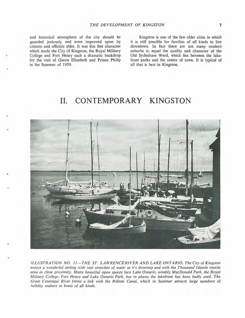
ILLUSTRATION NO. II - THE ST. LA WRENCERIVER AND LAKE ONTARIO. The City of Kingston enjoys a wonderful setting with vast stretches of water at it's doorstep and with the Thousand Islands tourist area in close proximity. Many beautiful open spaces face Lake Ontario, notably MacDonald Park, the Royal Military College, Fort Henry and Lake Ontario Park, but in places the lakefront has been badly used. The Great Cataraqui River forms a link with the Rideau Canal, which in Summer attracts large numbers of holiday makers in boats of all kinds.
8 PART II
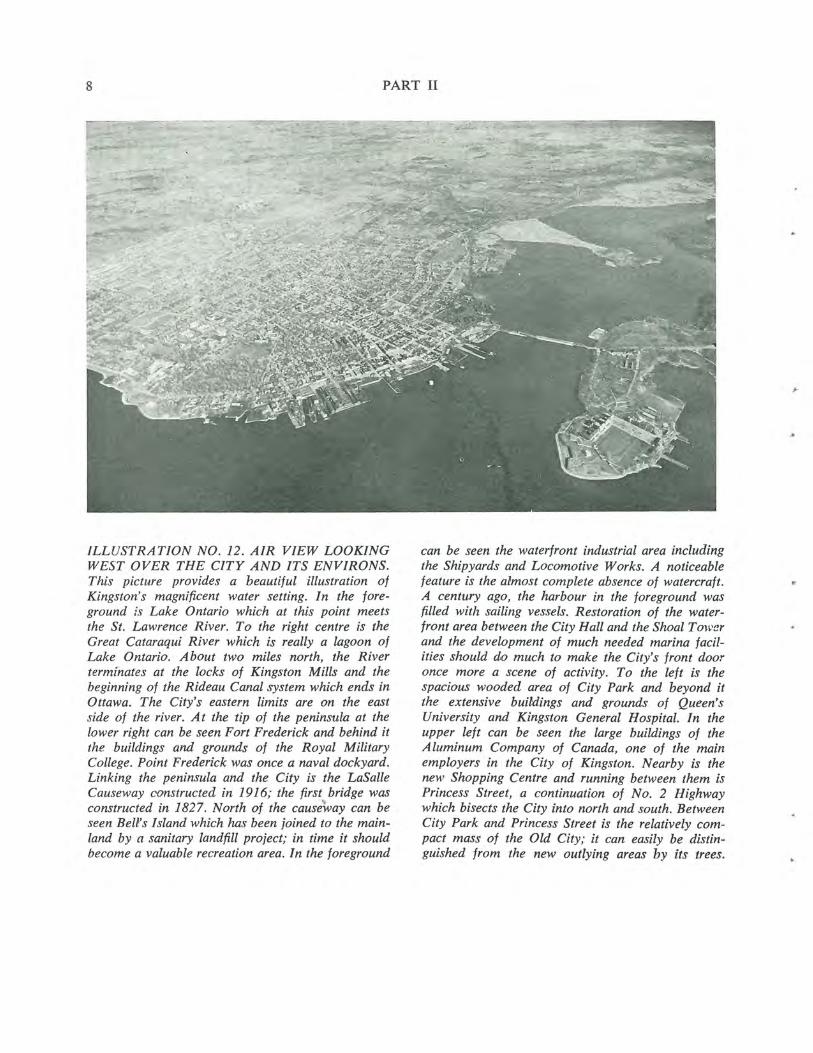
ILLUSTRATION NO. 12. AIR VIEW LOOKING WEST OVER THE CITY AND ITS ENVIRONS. This picture provides a beautiful illustration of Kingston's magnificent water setting. In the foreground is Lake Ontario which at this point meets the St. Lawrence River. To the right centre is the Great Cataraqui River which is really a lagoon of Lake Ontario. About two miles north, the River terminates at the locks of Kingston Mills and the beginning of the Rideau Canal system which ends in Ottawa. The City's eastern limits are on the east side of the river. At the tip of the peninsul'l1 at the lower right can be seen Fort Frederick and behind it the buildings and grounds of the Royal Military College. Point Frederick was once a naval dockyard. Linking the peninsula and the City is the LaSalle Causeway constructed in 1916; the first bridge was constructed in 1827. North of the causeway can be seen Bell's Island which has been joined to the mainland by a sanitary landfill project; in time it should become a valuable recreation area. In the foreground
can be seen the waterfront industrial area including the Shipyards and Locomotive Works. A noticeable feature is the almost complete absence of watercraft. A century ago, the harbour in the foreground was filled with sailing vessels. Restoration of the waterfront area between the City Hall and the Shoal Tower and the development of much needed marina facilities should do much to make the City's front door once more a scene of activity. To the left is the spacious wooded area of City Park and beyond it the extensive buildings and grounds of Queen's University and Kingston General Hospital. In the upper left can be seen the large buildings of the A luminum Company of Canada, one of the main employers in the City of Kingston. Nearby is the new Shopping Centre and running between them is Princess Street, a continuation of No. 2 Highway which bisects the City into north and south. Between City Park and Princess Street is the relatively compact mass of the Old City; it can easily be distinguished from the new outlying areas by its trees.

•
CONTEMPORARY KINGSTON 9
ILLUSTRATION NO. J3-AIR VIEW OF CITY CENTRE TOWARDS THE WEST. In the foreground appears the City Hall, complete with portico, and behind it is the Market Square. From 1848 to 1875 the space in front of the City Hall was occupied by the Market Battery which formed part of the defence system protecting Kingston and the entrance to the Rideau Canal. In 1875 the Battery was demolished and the area made into a park. In 1885 it was leased to? the Kingston and Pembroke Railway for a station and freight yard. The Central Shopping Area, mainly based on Princess Street, begins to the right of the City Hall, and is bounded generally by Clarence Street, Brock Street and Queen Street going as far as Division Street. The two lower blocks to the right of the City Hall on either side of the bottom of Princess Street are in very poor condition and this whole lower area is deteriorating rapidly. Within recent months the City has been obliged to condemn some of the buildings and order their demolition in the interests of public safety_ To' the
left of the Shopping Area a block-wide buffer oj institutional buildings has discouraged the spread 01 commercial uses into the very fine residential area of Old Sydenham Ward. This buffer consists of such buildings as St. Mary's Cathedral and its associated tchools, the Hotel Dieu Hospital Area,_St. George's Cathedral, the Customs House and Old Post Office and other smafier institutions. The northern side oj the Central Area to the right of Queen Street is less fortunate although the Army property between Svdenham and Bagot Streets together with the House of Providence form a similar buffer. It can be seen t'wt there are few off-street parking spaces available, and most of the blocks in the Shopping Area appear solidly built up. Many industrial uses on the Water· front between lohnson and Queen Streets have been abandoned and others are obsolescent. Much of the land they occupy could be used for much more valuable Waterfront development such as marinas; and hotels (or motels) and tlzirwould, in' rum, encourage redevelopment- of ih"i lower Central Area.

10 PART II
ILLUSTRATION NO. 14 (above)-In this view taken from the Wolfe Island ferry, many of the buildings that are representative of Kingston's Golden Age can be seen. The City Hall, Shoal Tower, St. George's Cathedral and the spire of Sydenham Street United Church present a colourful silhouette, with the tower of St. Mary's Cathedral dominating the Kingston skyline from a distance.
ILLUSTRATION NO. 15 - ST. GEORGE'5 CATHEDRAL. The Cathedral forms the easterly end of the Institutional buildings which have acted as a bulJer between the residential area of Sydenham Ward and the Shopping Area. The first part of St. George's Church was built in 1825; it was extended in 1846 with the addition of a clock tower and portico. In 1891 it was further enlarged, and its appearance cleverly changed from a simpler to a more decorative Classic, when the Great Dome was added.
ILLUSTRATION NO. 16 - FRONTENAC COUNTY COURT HOUSE. The Court House was built by the County Council in 1855-56. 11 stands on an elevated site facing the City Park and Lake Ontario, and has a .fine entrance portico and dome. Its excellent proportions and imposing character never fail to impress visitors.
Kingston is a city of domes and towers. Seen from the water or from the commanding heights of Fort Henry they form an urban composition of the greatest beauty especially in the Summer months when viewed in the surrounding lawns and trees or against the blue waters of Lake Ontario.

•
G
CONTEMPORARY KINGSTON 11
ILLUSTRATION NO. 17 - THE MARKET SQUARE AND CITY HALL. The present location of the market place for the City of Kingston Wa.l
established in very early days-long before the City Hall buildings were constructed. The latter, in their original form, included a large wing, extending towards King Street, which was destroyed by fire in 1865. The present police station is a somewhat modified version. Both the City Hall and the build-' ings on the .9outh side of the Market Square form a fine architectural background to the Market, which is held three days weekly in the Summer and Fall.
ILLUSTRATION NO. 18-AERIAL VIEW OF UNIVERSITY AND HOSPlT AL AREA. This view indicates the present growth of Queen's University and the Kingston General Hospital. Both institutions were established in the Golden Age of Kingston's history-the University being established first on Colborne St. in 1840, while the Hospital moved to its present site in the 1840's, to a building constructed originally to house the meeting of the first Provincial Government. Since then many buildings have been added in the hospital area. and it can be seen from this view that the site is far from spacious, in sharp contrast to the layout of the University property.
Both areas are enhanced by the fine Park between Stuart Street and the Arts Buildings on the Campus. Kingston is fortunate in possessing also a fine Waterfront Park that surrounds the Murney Tower (in the bottom right-hand corner).
12 PART II
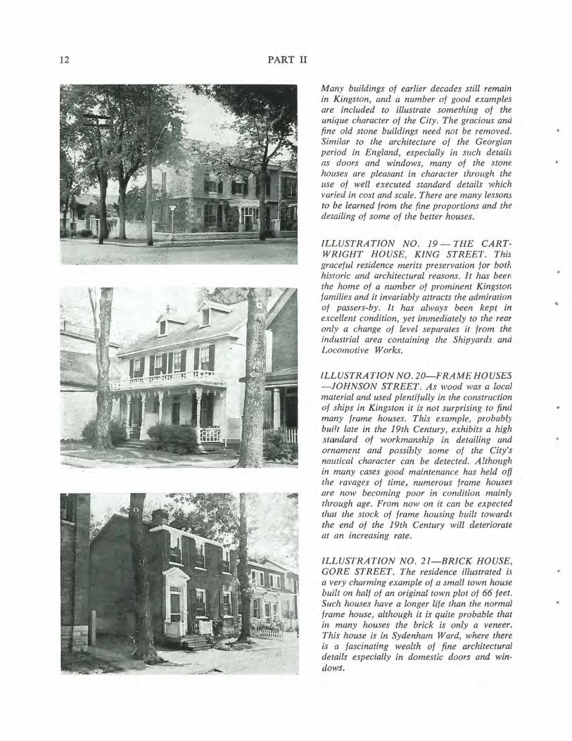
Many buildings of earlier decades still remain in Kingston, and a number of good examples are included to illustrate something of the unique character of the City. The gracious and fine old stone buildings need not be removed. Similar to the architecture of the Georgian period in England, especially in sllch details as doors and windows, many of the stone houses are pleasant in character through the use of well executed standard details which varied in cost and scale. There are many lessons to be learned ff10m the fine proportions and the detailing of some of the better houses.
ILLUSTRATION NO. 19 - THE CART· WRIGllT HOUSE, KING STREET. This graceful residence merits preservation for botf. historic and architectural reasons. It has beer. the home of a number of prominent Kingstor. families and it invariably attracts the admiration of passers-by. It has always been kept in excellent condition, yet immediately to the rear only a change of level separates it from the industrial area containing the Shipyards and Locomotive Works.
ILLUSTRATION NO . 20-FRAME HOUSES -JOHNSON STREET. As wood was a local material and used plentifully in the construction of ships in Kingston it is not surprising to find many frame houses. This example, probably built late in the 19th Century, exhibits a high standard of workmanship in del'ailing and ornament and possibly some of the City's nautical character can be detected. Although in many cases good maintenance has held off the ravages of time,. numerous frame houses are now becoming poor in condition mainly through age. From now.on it can be expected that the stock of frame housing built towards the end of the 19th Century will deteriorate at an increasing rate.
ILLUSTRATION NO. 21-BRICK HOUSE, GORE STREET. The residence illustrated is a very charming example of a small town house built on half of an original town plot of 66 feet. Such houses have a longer life than the normal frame house, although it is quite probable that in many houses the brick is only a veneer. This house is in Sydenham Ward, where there is a fascinating wealth of fine architectural details especially in domestic doors and win· dows.
..
.,
Q
CONTEMPORARY KINGSTON
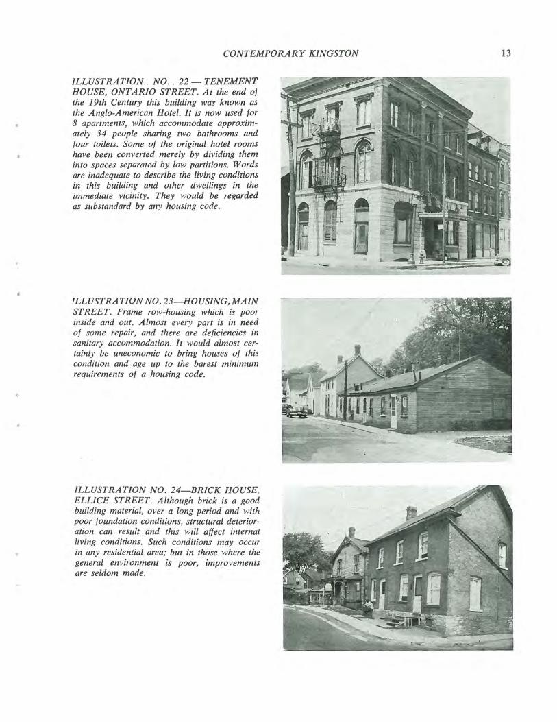
ILLUSTRATION. . NO ... 22 - TENEMENT HOUSE, ONTARIO STREET. At the end oj the 19th Century this building was known as the Anglo-American Hotel. It is now used for 8 apartments, which accommodate approximately 34 people sharing two bathrooms and four toilets. Some of the original hotel rooms have been converted merely by dividing them into spaces separated by low partitions. Words are inadequate to describe the living conditions in this building and other dwellings in the immediate vicinity. They woufd be regarded as substandard by any housing code.
fLLUSTRATION NO. 23-HOUSING,MAIN STREET. Frame row-housing which is poor inside and out. Almost every part is in need of some repair, and there are deficiencies in sanitary accommodation. It would almost certainl)' be uneconomic to bring houses of thi5 condition and age up to the barest minimum requirements of a housing code.
ILLUSTRATION NO. 24-BRICK HOUSE, ELLlCE STREET. Although brick is a good building material, over a long period and with poor foundation conditions, structural deterioration can result and this will affect internal living conditions. Such conditions may occur in any residential area; but in those where the general environment is poor, improvements are seldom made.
13
14 PART 11
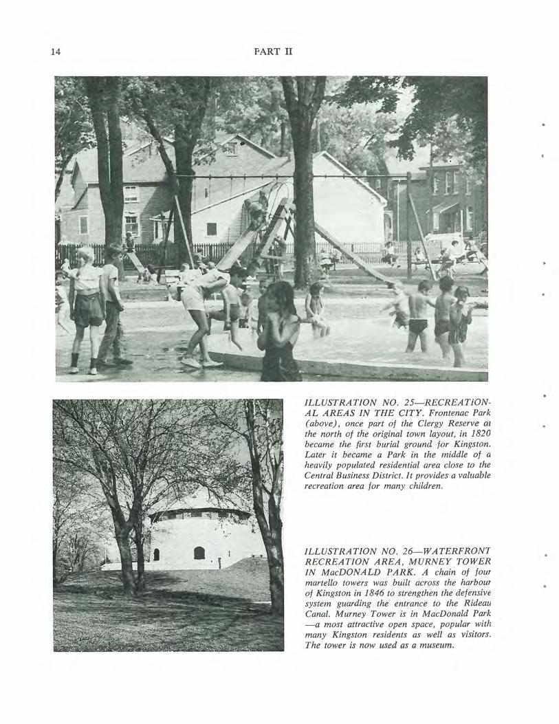
ILLUSTRATION NO. 25-RECREATiONAL AREAS IN THE CITY. Frontenac Park (above), once part of the Clergy Reserve al
the north of the original town layout, in 1820 became the first burial ground for Kingston. Later it became a Park in the middle of a heavily populated residential area close to the Central Business District. It provides a valuable recreation area for many children.
ILLUSTRATION NO. 26-WATERFRONI RECREATION AREA, MURNEY TOWER IN MacDONALD PARK. A chain of four martello towers was built across the harbour of Kingston in 1846 to strengthen the defensive system guarding the entrance to the Rideau Canal. Murney Tower is in MacDonald Park -a most attractive open space, popular with many Kingston residents as well as visitors. The tower is now used as a museum.
..
..
•
CONTEMPORARY KINGSTON
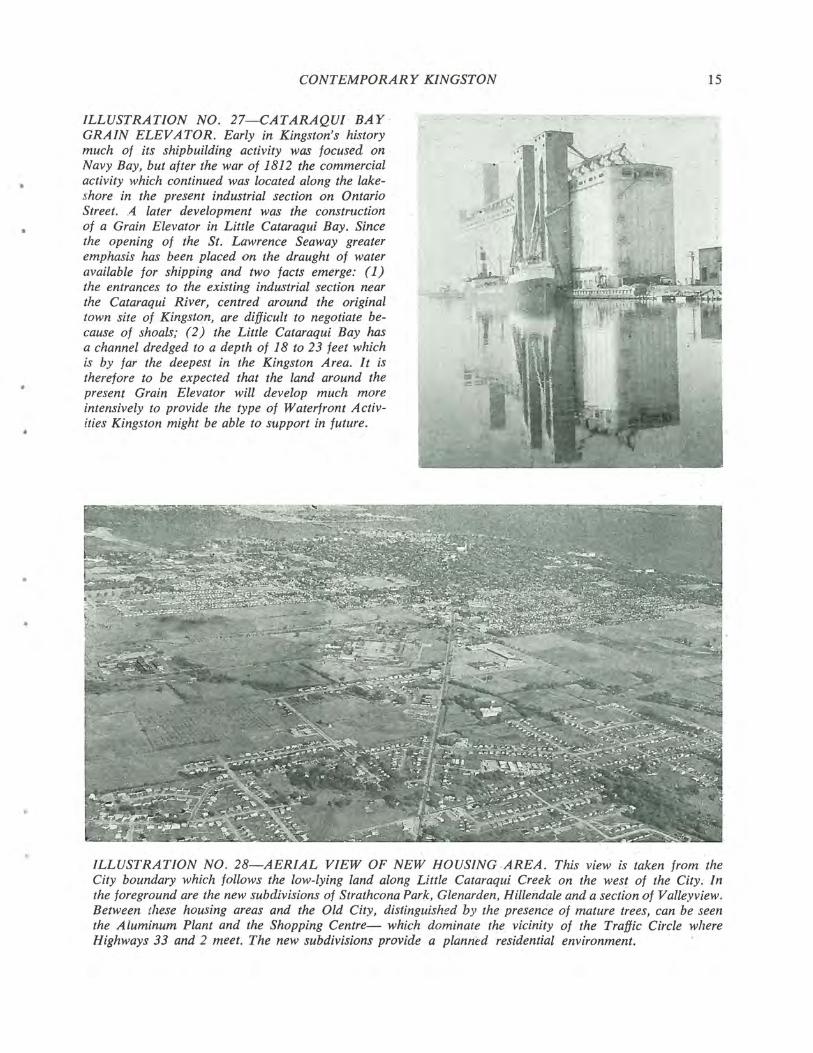
ILLUSTRATION NO. 27-CATARAQUl' BAY · GRAIN ELEVATOR. Early in Kingston's history much of its shipbuilding activity was focused on Navy Bay, but after the war of 1812 the commercial activity which continued was located along the lakeshore in the present industrial section on Ontario Street. A later development was the construction of a Grain Elevator in Little Cataraqui Bay. Since the opening of the St. Lawrence Seaway greater emphasis has been placed on the draught of water available for shipping and two facts emerge: (1) the entrances to the existing industrial section near the Cataraqui River, centred around the original town site of Kingston, are difficult to negotiate because of shoals; (2) the Little Cataraqui Bay has a channel dredged to a depth of 18 to 23 feet which is by far the deepest in the Kingston Area. It is therefore to be expected that the land around the present Grain Elevator will develop much more intensively to provide the type of Waterfront Activities Kingston might be able to support in future .
15
ILLUSTRATION NO. 28-AERIAL VIEW OF NEW HOUSING .AREA. This view is taken from the City boundary which follows the low-lying land along Little Cataraqui Creek on the west of the City. In the foreground are the new subdivisions of Strathcona Park, Glenarden, Hillendale and a section of Valleyview. Between these housing areas and the Old City, distinguished by the presence of mature trees, can be seen the Aluminum Plant and the Shopping Centre- which dominate the vicinity of the Traffic Circle where Highways 33 and 2 meet. The new subdivisions provide a planned residential environment.
16 PART HI
LENNOX... 8ÇDDftGTON COUNTY RCHMON
TP i ERÑESTOWN TP
-1 BATH
AMHERST S TP
ONTENACr COUNTY -
KINGSTON TP
CITY OF xNGsroçq PITTSBURGH TP LEEDS TP
7 GANANOQI I, -.----.-
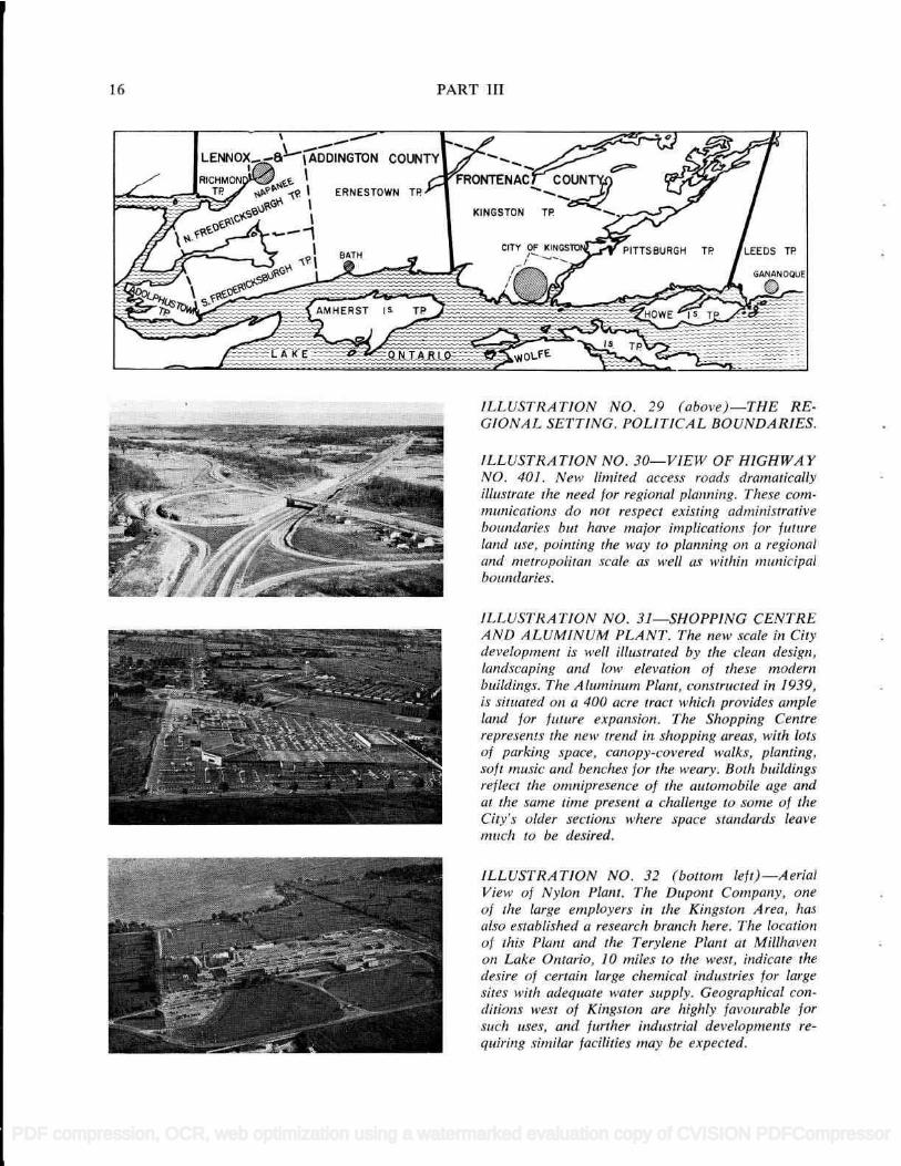
ILLUSTRATION NO. 29 (above)-THE RE- ClONA L SETTING. POLiTiCA L BOUNDA RIES.
ILLUSTRATION NO. 30-VIEW OF HIGHWAY NO. 401 . New limited access roads dramatically illustrate the need for regional planning. These corn- munications do not respect existing administrative boundaries but have major implications for future land use, pointing the way to planning on a regional and metropolitan scale as well as within municipal boundaries.
ILLUSTRA TION NO. 31-SHOPPiNG CENTRE AND ALUMINUM PLANT. The new scale in City development is well illustrated by the clean design, landscaping and low elevation o! these modern buildings. The A luminum Plant, constructed in 1939, is situated on a 400 acre tract which provides ample land for future expansion. The Shopping Centre represents the new trend in shopping areas, with lots of parking space, canopy-covered walks, planting, soft music and benches for the weary. Both buildings reflect the omnipresence of the automobile age and at the same time present a challenge to some of the City's older sections where space standards leave much to be desired.
ILLUSTRA TION NO. 32 (bottom left)-Aerial View of Nylon Plant. The Dupont Company, one of the large employers in the Kingston Area, has also established a research branch here. The location of this Plant and the Terylene Plant at Millhaven oli La/ce Ontario, ¡0 miles to the west, indicate the desire of certain large chemical industries for large sites with adequate water supply. Geographical con- ditions west of Kingston are highly favourable for such uses. and further industrial developments re- quiring similar facilities may be expected.
16 PART HI
ILLUST R AT ION NO. 29 ( above )--T HE RE-LJIUIY /l ]- L3 1 1 1 I Y . [ Ul 1 1 1 Ld D U 1Y LJ/I 1Y1 .
]LLUST R AT ION NO. 30--VIE W OF HIGH WAYNO. 401. New limited access roads dramaticallyillustrate the need for regional planm'ng. These com-mum'cations do not respect existing admim'strativeboundaries but have major implications for futureland use, pointing the way to planm'ng on a regionaland metropolitan scale as well as within mum'cipalboundaries.
ILLUSTRATION NO. 31--SHOPPING CENTREAND ALUM INUM PLANT . T he new scale in Citydevelopment is well illustrated by the clean design,landscaping and low elevation of these modernbuildings. The Aluminum Plant, constructed in 1939,is situated on a 400 acre tract which provides ampleland for future expansion. The Shopping Centrerepresents the new trend in shopping areas, with lotsof parking space, canopy.-covered walks, planting,soft music and benches for the weary. Both buildingsreflect the omnipresence of the automobile age andat the same time present a challenge to some of theCity's older sections where space standards leavemuch to be desired.
ILLUST R AT ION NO. 32 ( bottom le f t )--AerialView o f N ylon Plant. T he Dupont Company, oneof the large employers in the Kingston Area, hasalso established a research branch here. The locationof this Plant and the Terylene Plant at Millhavenon Lake Ontario, 10 miles to the west, indicate thedesire of certain large chemical industries for largesites with adequate water supply. Geographical con-ditions west of Kingston are highly favourable forsuch uses, and further industrial developments re-quiring similar facilities may be expected.
PDF compression, OCR, web optimization using a watermarked evaluation copy of CVISION PDFCompressor
•
Ill. KINGSTON
Today we hear the term "Kingston Region" used, but it may mean different things to different persons. One could say that a "region" is an area of land which may be identified as an entity with a centre of its own, and having special physical, economic and social characteristics. For instance, a pamphlet published by the Kingston Whig-Standard says that the Kingston Market Area extends approximately 40 miles east and west, and 50 miles north of the City itself. In this area there is a population of 101,000 including that of the City itself.
]n a region of this kind administrative boundaries tend to become obsolete, and spheres of influence may more easily be defined by physical rather than administrative boundaries. In order that planning problems may be in a reasonable context, it is nece3sary to study and plan for changes in land use on a city-regional basis. Two areas embracing the city have been studied. To examine the economic and physical growth of the region on a broad background we have considered an area from Adolphustown to Gananoque. But in order to make physical proposals the Planning Study was confined to the City and surrounding Townships of Kingston and Pittsburgh.
With the decision to re-establish Fort Frontenac and the movement of the United Empire Loyalists from the United States, the Townships of Kingston, Ernestown, Fredericksburgh, Adolphustown and Marysburgh were laid out along Lake Ontario in 1784. A townsite plan was also laid out for the town of Cataraqui or Kingston. Adolphustown served certain administrative functions but became largely an agricultural township. Bath, in Ernestown Township, formed an early commercial centre for shipbuilding and then for the grain trade.
At the head of the St. Lawrence and at the foot of Lake Ontario, Kingston was early prominent as a trans-shipment port. It was in a key position for fur trading, shipbuilding, and timber trading. As a centre of national and provincial importance, its growth was related to that of Upper Canada. As Canada grew Kingston's area of influence gradua:ly decreased and it came to share less in Canadian expansion. The building of the Grand Trunk Railway in ] 853 was the first blow to the city's importance as a trans-shipment centre. With the transfer of grain production to Western Ontario, population began to drift away from the farms of Frontenac County and this decline in population was accentuated by the disappearance of the lumber trade at the turn of
AND REGION
the century. After the great activity of the early period in Kingston there followed a long period of adjustment and slow growth. During this latter time King5ton was sustained more and more by its institutions, and less by its commerce and industry.
The city is no longer a physical entity within administrative boundaries. It is now part of a cityregion. In the past methods of communication were slow, and with a smaller population and a different social and economic life, urban growth was on the edge of the urbanized area. The advent of the automobile has coincided with a general rise in living standards and city growth has become explosive with urban fragments scattered in the surrounding countryside. The Aluminum and Nylon Plants, built in Kingston at the beginning of the last War, marked a change in the pace of growth and signalled the beginning of a marked increase in population . Located at that time beyond the City Limits, the new industries stimulated growth in the area immediate·y surrounding the City. In 1953, the large C.I.L. Terylene Plant was built in the Township of Ernestown, ten miles beyond the Kingston City boundary. It has encouraged a new series of residential developments in rural areas, which also serve an increasing number of commuters to Kingston.
The three large industrial plants of the Aluminum Company, DuPont, and the C.I.L. are forerunners of the kind of industrial development which may occur in the Kingston city-regior.. Communications for industrial plants of this type will be by ship, rail, road and perhaps air, and will be important in any plan for the whole region. There wili be heavier demands in the regions outside the city for land for housing, schools, local roads, and recreation areas. A regional plan should show where the new elements of growth would best be placed as well as consider the continuing needs of agriculture.
Geologically, the region is generally composed of a limestone plain but a section of clay flats, the mmt suitable land for residential development, exists between Collins Bay and the Little Cataraqui Creek, stretching as far north as Cataraqui Village and parts of Highway 401.
Physically, the area is distinguished by its relation to Lake Ontario. The lake supplies water and receives sewage effluent. It is also a valuable recreation area, and a means of transport. The major element next in importance to the lake is the Great Cataraqui River which connects with the Rideau

18 PART III
WATERSHED BOUNDARY ~
-WATERCOURSES ~
sm
-- St 41 ~ I" ,t( T
ILLUSTRATION NO. 33-MAP 1. REGION, EXISTING LAND USE.
Canal. To the west, the low-lying lands of Little Cataraqui Creek form a noticeabl~ obstacle to development and should remain as a valuable · open space.
The land of the city is ridged, with high land passing through it and becoming considerably higher above Highway 401.
In this age of the automobile and great personal mobility, the well-being of a central City is inseparable from the efficient functioning of its surrounding region. In 1952 the City annexed 5,585 acres of land containing 9,000 persons. Included were several partially developed suburbs-Rideau Heights, Kingscourt, Grenville Park, Hillendale, Valleyview, and Portsmouth Village. The extension of city services to these areas has encouraged considerable subdivision and home building. There is still enough serviceable land within the City Limits to provide for another 10 years of growth both residential and industrial. The availability of serviceable land however, has not halted the growth of new unplanned development on cheap land beyond the City limits, and if this process continues some of the problems incurred in 1950 will emerge again in greater magnitude in 1970. This is not to say that there should not be development in outlying areas, but it does suggest that planning should be effective on a regional as well as a local scale.
The dimensions of the area which constitutes the community of Greater Kingston may more
readily be appreciated by examination of the regional maps in the Report and by a consideration of the anticipated population growth. By 1980, the population which now stands at more than 60,000, in all probability will have reached 120,000 - 130,000 and will require twice as many schools and other facilities. Most of the new growth will undoubtedly be towards the west. While there will be some development in Pittsburgh Township to the east, various inhibiting factors such as the Great Cataraqui River, the extensive grounds of the military camp and the rocky and uneven character of the terrain will probably continue to discourage large scale development. To the west, however, especially south of Highway 401, conditions are highly favourable. Soil cover is good, the terrain is reasonably level, and highway communications to the City are excellent.
Conditions which favour residential development also attract industry. (It will be noted that the area's three largest manufacturing plants are all located to the west of Kingston.) There are large tracts of suitable land readily available at reasonable prices close to the bountiful water supply of Lake Ontario and to major highway, rail and water communications. In addition, the Kingston area is close to and equidistant from Montreal and Toronto, the largest market areas in Canada. The presence of so many favourable factors should ensure a continuation of the present trend towards
..
KINGSTON AND REGION 19
_ WATERSHED BOUNDARY ~ EXISTING RESIDENTIAL PROPOSED RESIDENTIAL c::::J PROPOSED CJ SHOPPING AREAS
EXISTING INDUSTRIAL -AND COMMERCIAL PROPOSED INDUSTRIAL ~ PROPOSED C:i~ PU BLlC SCHOOLS PROPOSED CQ:] HIGH SCHOOLS
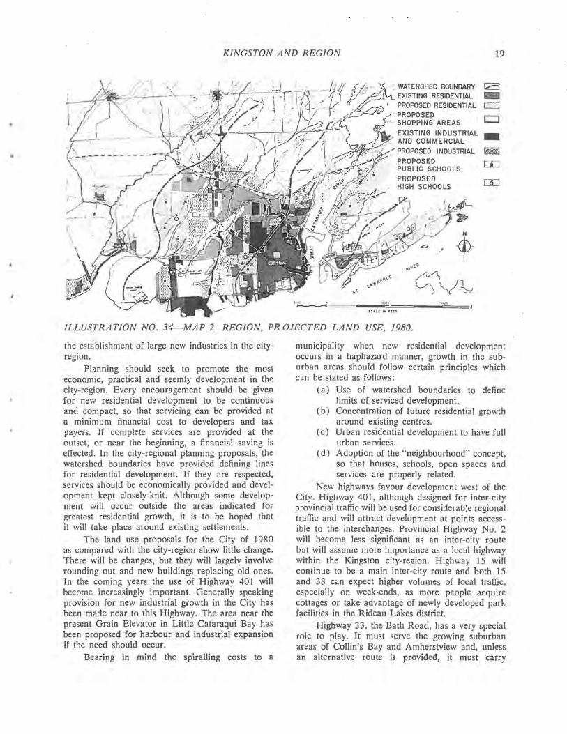
ILLUSTRATION NO. 34-MAP 2. REGION, PR OJECTED LAND USE, 1980.
the establishment of large new industries in the cityregion.
Planning should seek to promote the most economic, practical and· seemly development in the city-region. Every encouragement should be given for new residential development to be continuous and compact, so that servicing can be provided at a minimum financial cost to developers and tax payers. If complete services are provided at the outset, or near the beginning, a financial saving is effected. In the city-regional planning proposals, the watershed boundaries have provided defining lines for residential development. If they are respected, services should be economically provided and development kept closely-knit. Although some develop· ment will occur outside the areas indicated for greatest residential growth, it is to be hoped that it will take place around existing settlements.
The land use proposals for the City of 1980 as compared with the city-region show little change. There will be changes, but they will largely involve rounding out and new buildings replacing old ones. In the coming years the use of Highway 401 will become increasingly important. Generally speaking provision for new industrial growth in the City has been made near to this Highway. The area near the present Grain Elevator in Little Cataraqui Bay has been proposed for harbour and industrial expansion if the need should occur.
Bearing in mind the spiralling costs to a
municipality when new residential development occurs in a haphazard manner, growth in the suburban areas should follow certain principles which can be stated as follows:
(a) Use of watershed boundaries to define limits of serviced development.
(b) Concentration of future residential growth around existing centres.
(c) Urban residential development to have full urban services.
(d) Adoption of the "neighbourhood" concept, so that houses, schools, open spaces and services are properly related.
New highways favour development west of the City. Highway 401, although designed for inter-city provincial traffic will be used for considerab!e regional traffic and will attract development at points accessible to the interchanges. Provincial Highway No. 2 will become less significant as an inter-city route but will assume more importance as a local highway within the Kingston city-region. Highway 15 will continue to be a main inter-city route and both 15 and 38 can expect higher volumes of local traffic, especially on week-ends, as more people acquire cottages or take advantage of newly developed park facilities in the Rideau Lakes district.
Highway 33, the Bath Road, has a very special role to play. It must serve the growing suburban areas of Collin's Bay and Amherstview and, unless an alternative route is provided, it must carry
20 PART HI
increasing volumes of traffic between the City and the large new industrial areas to the west. The Bath Road is one of the finest scenic highways in Canada and it deserves very close consideration and special treatment by the Province. It should become an integral part of the St. Lawrence parks system now being developed along the Seaway. An important step in this direction has already been taken with the acquisition of historic Fairfield House, but this should be regarded as only a beginning. It will also be necessary to secure as much land as possib:e between the road and the shoreline without delay. To serve the needs of the increasing volume of truck and local automobile traffic, as new growth takes place towards Bath, a new east-west road north of Highway No. 33 and south of Highway No. 2, should be established. Improvement of north-south connections should also be effected by linking up Highway 38 with Day's Road. With the adoption of these two suggestions the regional road pattern in this area would provide a more suitable framework for development.
Such improvements however, are obviously not within the financial capacity of the rural-suburban townships wherein they would occur. Nor is it likely that they could be afforded by a regional pooling of local resources. Nevertheless it is important for the region's future that steps be taken now at least to reserve the needed rights of way and it would appear to be a provincial responsibility to see that this is done.
Mention has been made of the region's good system of communications by road, rail and water. Air service is the missing link. The region already possesses an exceIlent facility in Norman Rogers Airport and there is the promise of an airline operation in 1960. It would be wise to protect the airport and it; environs in anticipation of its serving a very real need within the entire region. By 1980 the airport may well be regarded by the region as an indispensable part of the province's inter-city transportation system.
As Kingston grows, the preservation of existing open space both in the City proper and in the region should be given careful consideration. An increasing population will need more "breathing space," and it will be wise to provide for recreational areas and green spaces of diverse character.
Much progress has been made in the provision of Provincial Parks. Within recent years fine new parks have been established at Black Lake, Silver Lake, Big Sandy Bay and Adolphustown. In addition there are numerous small parks along the highways. AIl of these however are too small or too far from Kingston. There is need for a larger park reasonably
close to the more heavily populated centre. The Rideau Lakes District would appear to offer an ideal setting for such a regional park. The Provincial Government should consider the establishment of a park of this type which would not only be of use to the people of the Kingston region but to the whole of the province between Toronto, Ottawa and Cornwall.
A regional problem is posed by the need for new water intakes and sewage disposal facilities. In fact, this is the kind of provincial problem which led to the creation of the Ontario Water Resources Commission. Rapidly growing municipalities cannot go on indefinitely dumping their raw sewage into cach other's water supply. It would also seem to be the height of economic foIly not to consider water supply and sewage disposal on a regional basis. At present, only the City with its greater financial resources can afford proper water and sewage facilities, and it has not yet provided full treatment for its sewage. The Provincial Government has r~centIy ha:ted the further subdivision of land in King,ton Township where it has been proposed to llse septic tanks and has suggested the provision of proper sanitary sewage disposal works. In the long run such provision cannot be made on a purely local ba ;is. The time is ripe for a high level conference of provincial, county and municipal officials to consider an overall solution to this regional problem.
Sewerage Policy: In the City of Kingston:
There is still the northern section to be serviced; nearly all other lots in the City have sewers and water supply.
In Kingston Township: Sewer instaIlation is imminent; the La SaIle Park area may be the first to be served, but rural "suburban" development should be stopped or a policy established to provide services foIlowing development.
In Pittsburgh Township: Development should be restricted initially to an area capable of being serviced by the City Sewage Treatment Plant. The army property unfortunately prevents any economical continuation northwards of the new sewer line. Septic tanks may, therefore, be required in the northern section of the Township, near the 401 bridgehead. The policy would vary from that proposed for Kingston Township, but the area to be developed with septic tanks would be minor. Another solution might be the acceptance of a higher density scheme in this area to enable a
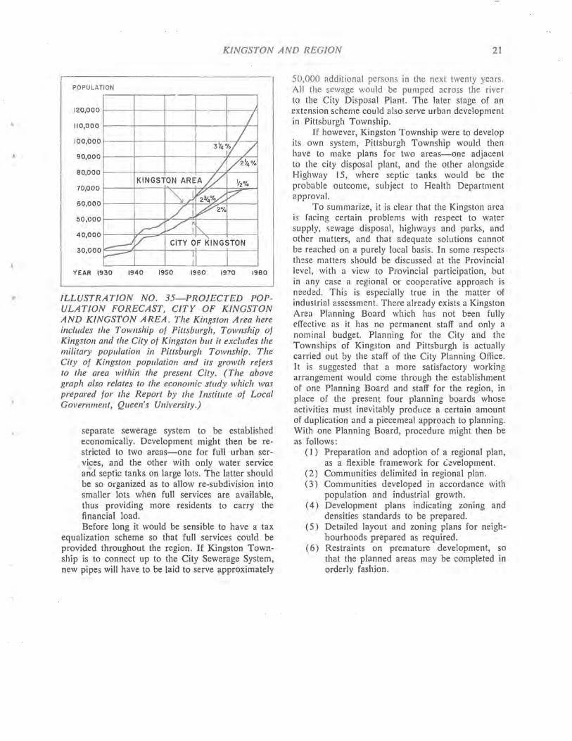
.I
KINGSTON AND REGION 21
POPULATION
120,000
110,000
100,000
90,000
80,000
70,000
60,000
50,000
40,000
30,000
/ /
3Y4°(.f /
I [/2~4% KINGSTON AREA Y ~2·/.
~) ~4°~ ~ / 1 ~2%
~ Vi '" ~ V CITY OF KINGSTON
~ I 1
YEAR 1930 1940 1950 1960 1970 1980
ILLUSTRATION NO. 35-PROJECTED POPULATION FORECAST, CITY OF KINGSTON AND KINGSTON AREA. The Kingston Area here includes the Township of Pittsburgh, Township of Kingston and the City of Kingston but it excludes the military population ill Pittsburgh Township. The City of Kingston population and its growth refers to the area within the present City. (The above graph also relates to the economic stlldy which was prepared for the Report by the Institl/te of Local Government, Queen's University.)
separate sewerage system to be established economically. Development might then be restricted to two areas-one for full urban services, and the other with only water service and septic tanks on large lots. The latter should be so organized as to allow re-subdivision into smaller lots when full services are available, thus providing more residents to carry the financial load. Before long it would be sensible to have a tax
equalization scheme so that full services could be provided throughout the region. If Kingston Township is to connect up to the City Sewerage System, new pipes will have to be laid to serve approximately
50,000 additional persons in the next twenty years. All the sewage would be pumped across the river to the City Disposal Plant. The later stage of an extension scheme could also serve urban development in Pittsburgh Township.
If however, Kingston Township were to develop its own system, Pittsburgh Township would then have to make plans for two areas-one adjacent to the city disposal plant, and the other alongside Highway 15, where septic tanks would be the probable outcome, subject to Health Department approval.
To summarize, it is clear that the Kingston area is facing certain problems with respect to water supply, sewage disposal, highways and parks, and other matters, and that adequate solutions cannot be reached on a purely local basis. In some respects these matters should be discussed at the Provincial level, with a view to Provincial participation, but in any case a regional or cooperative approach is needed. This is especiaIly true in the matter of industrial assessment. There already exists a Kingston Area Planning Board which has not been fully effective as it has no permanent staff and only a nominal budget. Planning for the City and the Townships of Kingston and Pittsburgh is actually carried out by the staff of the City Planning Office. It is suggested that a more satisfactory working arrangement would come through the establishment of one Planning Board and staff for the region, in place of the present four planning boards whose activities must inevitably produce a certain amount of duplication and a piecemeal approach to planning. With one Planning Board, procedure might then be as folIows:
( I) Preparation and adoption of a regional plan, as a flexible framework for L\!velopment.
(2) Communities delimited in regional plan. (3) Communities developed in accordance with
popUlation and industrial growth. (4) Development plans indicating zoning and
densities standards to be prepared. (5) Detailed layout and zoning plans for neigh
bourhoods prepared as required. (6) Restraints on premature development, so
that the planned areas may be completed in orderly fashion.

IV. ECONOMIC BACKGROUND
PREPARED BY THE INSTITUTE OF LOCAL GOVERNMENT
QUEEN'S UNIVERSITY
Kingston's Early Importallce
From the date of its founding, Kingston has been important, not because of the products of the city and the surrounding area, but because of its special relationships to a much wider area. Unlike most cities of its size, Kingston is not primarily a manufacturing centre but is a place which supplies services of regional, provincial and national importance.
Originally Kingston was a military, administrative and trading centre, and until about 1840 its growth and prosperity depended on these functions. Its geographic position meant that all traffic on the St. Lawrence River had to pass Kingston. Being a convenient place to change from river to lake boats and vice versa, and as it was a strategic military location, Kingston was the most important place west of Montreal. With the coming of the Loyalists it also became the centre of the earliest and largest settled area in what was soon to be Upper Canada.
Kingston rapidly developed an importance as a commercial and wholesaling centre for both the surrounding district and the province as a whole. Across its docks passed most of the merchandise imported into Upper Canada and its early leading citizens were merchants and forwarders. It was also the centre for the export trade in timber, potash and, at a later date, grain, and was an important manufacturing centre with many small industries catering to the local market. To these activities were added those of a military and naval centre. As a result of these circumstances Kingston benefited particularly from the War of 18 I 2. As late a5 1830, Kingston was the unquestioned economic and cultural capital of Upper Canada and, with a population of 3,800, considerably larger than its only rival, the more recent settlement of York, later to become Toronto.
Already changes in the economy were working against the dominance of Kingston. Its rate of growth became less rapid and although the population tripled between 1830 and 1851, the population of Toronto increased ten fo!d in the same period. The brief period 1841-44 as capital of Canada, after the Act of Union, enhanced Kingston's position but on the transfer of the capital it lost about 1,700 inhabitants.
The decline in importance relative to other centres was due to a combination of factors. The centre of settlement moved westward and Kingston
was handicapped then, as now, by having a restricted local market due to its relatively poor and sparsely populated hinterland. The opening of the Erie Canal in 1825 diverted much of the American grain trade away from the St. Lawrence ports and Toronto gradually replaced Kingston as the chief commercial centre of Upper Canada. Furthermore, in the period 1850-\880 the provincial road system and the railway network of Ontario became centred on Toronto,
TABLE [
POPULATION FOR CI!NSUS YEARS
PopIIlatioll of YeaI' Olltario KillgstOIl City -- ---1820 2,300 1830 3,800 1851 11,585 1861 13,743
1871 1,624,000 12,407 1881 1,927,000 14,091 1891 2,114,000 19,263 1901 2,183,000 17,961
1911 2,527,000 18,874 1921 2,934,000 21,753 1931 3,432,000 23,439 1941 3,598,000 30,126 1951 4,598,000 33,459
1956 5,405,000 48,581
Source: Census.
Note: 1. 1861-1871: The decrease of 1,336 between 1861 and 1871 is apparently due entirely to the withdrawal of the British garrison.
2. 1941-1956: These should be adjusted fol' a true picture as there is no allowance made in the 1941 and 1951 census figures for the population in the area annexed to the City in 1952, nor for the substantial suburban development outside the City limits in the 1956 population figure.

•
ECONOMIC BACKGROUND 23
and this, together with the decreasing relative importance of lake shipping, further undermined Kingston's position. In addition, towards the latter part of the nineteenth century there were great changes in the industrial structure of Canada generally and of Ontario in particular. The large number of small plants, serving mainly the local market, gave way to a smaller number of much larger plants serving a wide area. In Kingston the results of this were astonishing; the number of manufacturing establishments decreased from 401 in 1891 to 42 twenty years later. The workings of these factors are dramatically shown by the changes in population.
The population of Kingston from 1851 onwards to 1921 was relatively static, except for jumps b:::tween 1881 and 1891, and between 1911 and 1921, the latter being due to the First World War. In some years the population actually declined. This is a striking contrast to the population changes in Canada generally and in Ontario in particular. This period of what amounts almost to stagnation was due to the absence of any substantial basi5 for growth in Kingston.
On the one hand the general growth of Ontario and Canada and the urbanization of economic activity would be expected to produce growth in Kingston as elsewhere. On the other hand, there were influences working to retard Kingston's growth, including, in addition to those already mentioned, the movement of population out of the surrounding rural areas and the tendency of the increasingly important manufacturing activity to concentrate in other centres which were better located with relation to the main markets. The forces making for growth and those making for a reduction in size almost balanced and as a result Kingston, having had its growth early, along with the rest of Eastern Ontario. did not share in the general prosperity to the extent it had earlier.
This period of very slow growth following after many years of prosperity left its mark on the character of the city. The limited opportunities available !'leant that many Kingstonians went elsewhere to find employment. The city matured earlier than other centres where prosperity arrived later and Kingston came to have a reputation of being very pleasant but a bit of a backwater. Like most reputations there was an element of truth in this .
Renewed Prosperity
Between 1920 and 1935 changes began to appear with a renewed prosperity and a steady population increase. Today it is readily apparent that a different set of forces have been and are at work. As a result of a new conjunction of influences Kingston is enjoying a rate of growth and general
prosperity somewhat above the average for Canadian cities.
In the first place, the forces which had held King~ton back were largely spent. The importance of Kingston as a port had reached a low level and its commercial and shipping activities ceased to be among the major industries. The movement of population out of the surrounding rural areas could not continue at the same rate indefinitely, and most of the small industries which supplied the local market had closed down or moved elsewhere. These elements all had a braking effect on the local economy but as they worked themselves out, other influences making for expansion were becoming more significant.
There are a number of main identifiable influences, particularly changes in the manufacturing pattern, which are closely related to the improvements in the road network. Lying between the two major markets of Toronto and Montreal, the improvement in the road system has been particularly important in Eastern Ontario, having the effect of making access to the two largest markets easier. Consequently Kingston has become a more attractive location for industry, particularly for the branch plants which are the form which industrial growth is increasingly taking. In addition, changes in technology are making water more important in industrial processes, and in this respect the Kingston area enjoys a very favourable position which has already attracted two large chemical plants. The revival of economic activity in Eastern Ontario, the trend towards urbanism which has brought a general growth in urban centres, and the growing importance of Kingston as a centre supplying services to a wide area have all been important.
Present Economic Activity Having surveyed the main historical elements
which shape the character of the city, one can begin to examine its present character. Particular reference will be made to the factors mentioned in the foregoing paragraph. Based on these, some estimates can be made as to the nature and magnitude of growth that may be anticipated in future.
The rural areas around Kingston have become more prosperous as roads and access to both the local and more distant markets have improved; at the same time urban markets for agricultural products have increased in size and the tourist trade has become a significant source of income with particular importance in the poorest agricultural areas. The greater opportunities in Kingston have also helped the rural area in that many rural dwellers have seasonal or permanent employment in Kingston. A more prosperous rural area means larger markets for Kingston

24 PART IV
businesses and hence a larger and more prosperous city population. In addition, Kingston has shared in the general increase in manufacturing to a very large extent. The number of manufacturing establishments in Kingston rose from 57 in 1930 to 80 in 1957 and the labour force they employed increased from 1632 to 6310 or 287% in the same period. This is a considerably larger increase than most urban centres in the Toronto-Kingston area experienced in this period. (1)
By themselves these figures would justify a very large growth in population. That this is not the whole story can be seen from examining the employment statistics.
TABLE II
PERCENTAGE OF LABOUR FORCE EMPLOYED
IN MANUFACTURING
1941 1951 average of ten largest metropolitan
areas (I) 34.5 31.8 average of all Canadian cities
30-100,000 populati'on 35.2 31.8 Toronto (metropolitan area) 38.0 35.3 Oshawa 67.4 63.8 Peterborough 54.0 54.8 London 34.2 32.2 Brantford 58.0 56.1 Belleville 28.0 29.7 Kitchener 59.7 54.7 Kingston 32.8 26.7
(1) Quebec, Montreal, Ottawa, Toronto, Hamilton, Winnipeg, Windsor, Calgary, Edmonton and Vancouver. Source: Census.
From these figures it is apparent that Kingston is not primarily dependent on industry in the sense that Kitchener, Oshawa or, for example, Peterborough are. Employment in manufacturing is important and has increased but as the proportion has not increased, this cannot explain all of the increase in population. To account for this one must turn to the other economic activities of Kingston as shown in the figures of employment in different types of industry.
Some of the variations in Table Ill, particularly in "manufacturing" and "service," can be explained largely by the change from depression to war to peace. The growth in the proportion employed in manufacturing from 14.5% to 26.7% has been largely at the expense of transportation (-6.1 % ), construction (-2.4 '70), and other (-2.3%) which includes agriculture, quarrying, public utilities and unemployed. (1) See J. Spelt, The Urban Development of South
Central Ontario p. 186 for comparable figures.
From these employment figures a good picture of the basic economic activity of Kingston can be derived. The dominant category is the so-called service industry.
TABLE III
KINGSTON: LABOUR FORCE BY INDUSTRY (%)
1931 1941 1951 Manufacturing 14.5 32.8 26.7 Construction 8.8 10.0 64 Transportation 11.0 6.9 4.9 Trade 17.3 15.6 16.2 Finance and insurance 3.0 3.1 3.3 Service 40.9 29.0 40.3 Other 4.5 2.6 ., .,
TOTAL 100.0 100.0 100.0
Note: 1931 alld 1941 are not strictly comparable to 1951 due to a change in the basis of the census. The difference is not significant for our purpose here. Source: Census.
The service occupations or industries are of a personal nature and can be divided into two main types, according to the area served. Some are of a largely local nature-dry-cleaning, window-washing, teachers, lawyers, nurses, gardeners, police, etc. All cities and towns have a considerable proportion of the labour force engaged in these kinds of activity catering to the needs of the city and the area immediately around it. The other type of service industry i, that serving the needs of a larger areathe hospitals, penitentiaries, religious and educational institutions and the military establishments. Kingston has an unusually large amount of this type of actIvity related principally to national and provincial needs. While forty per cent of the labour force in Kingston is engaged in service industries, the percentages in some predominantly manufacturing towns are: Oshawa 7.2, Peterborough 11.2, Sarnia 8.9 and Kitchener 14.8. Even London, which is comparable to Kingston as the centre for a large area and which has many institutions, has only 26.1 per cent of the labour force so occupied. The service industries employ the largest proportion of Kingston's labour force and the proportion has remained remarkably constant. This concentration in Kingston of a variety of institutions and military establishments, if taken together, at least equal manufacturing as a major industry. Like most of Kingston's manufacturing plants, they are concerned mainly with supplying provincial and national needs.
Aside from the military element which has always been important in Kingston, the complex of

ECONOMIC BACKGROUND 25
institutions dates back to the 1830's and 1840's when the Kingston Penitentiary, Ontario Hospital, Kingston General Hospital, Hotel Dieu Hospital and Queen's University were all established. All of these institutions have grown and are now very large employers. The relation between the hospitals, the university and some of the military establishments has produced a combination with a considerable growth potential. There is a group of related medical institutions based on the teaching facilities, and also a group of research facilities for which Kingston has considerable attractions. The combination of long established military and educational facilities has also probably been decisive in the Army locating many of its more recently added establishments in Kingston. In this group of institutions the university, while not the largest employer, is certainly the indispensable element. The penitentiary has also expanded until there are four penal institutions and the Penitentiary Staff College all in and around Kingston.
There is a diversity of industries in Kingston which, with few exceptions, are all characterized by being stable employers. Most of them have a record of steady expansion which seems likely to continue. The depression did not affect Kingston as severely as many cities for, although the manufacturing plants were very hard hit, the institutions and the military establishments acted as cushions. Certainly another major depression would not have the effect in Kingston that it would have elsewhere. In addition, seasonal variations in employment are relatively low.
The reasons for this can be seen from a list of the principal employers. The largest single employer is the Department of National Defence with 2,000 civilian employees in the various establishments. In addition, there are several thousand troops stationed in the Kingston area and the Royal Military College employs several hundred civilians. The five civilian hospitals as a group employ some 2,000 aside from professional staff, and the university employs about 800. There are about 750 employed at the penitentiaries including the new Joyceville Institution some fifteen miles north-east of Kingston. These "service" industries not only represent direct employment but also bring many people to Kingston on a temporary basis whether as hospital patients, students, members of the armed forces or otherwise. The effects of this are particularly noticeable in winter when temporary residents form a counterpart to the substantial summer tourist business.
Of the major manufacturers, the Aluminum Company of Canada Limited, engaged in aluminum fabrication, employs 2,100 in addition to those in a sizeable research establishment. The nylon plant of
the DuPont Company employs 1,400 and also has over one hundred employed in the research laboratories. These, and the Canadian Industries Limited plant ten miles west of Kingston, which employs 650, have all located since 1938 and are of the type likely to expand. There is also a variety of smaller industries. Only two sizeable industries are highly vulnerable to economic recessions. The Canadian Locomotive Company has employed as many as 900 men when it was active but today is almost closed down. It seems most improbable that a plant of this size will remain vacant for any length of time, but finding new uses for the property is not likely to be easy. The shipyard and the activities centred on ship repairing have been particularly important because they are normally busiest in the winter. These will probably suffer a reduction in activity due to the canal boats, to which they principally catered, being rendered obsolete by the opening of the St. Lawrence to large ships for which there are not service facilities in Kingston.
In addition to manufacturing and service industries a third but less significant reason for Kingston's importance is its special relationship to eastern Ontario. Being the largest city within the MontrealOttawa-Toronto triangle, a large part of that area looks to Kingston for a variety of services and faci :ities which are not available locally and for which the large metropolitan centres are too remote. Many of the wholesale, retail and professional facilities and some of the institutions derive a good part of their activity from meeting the requirements of this wider area. If eastern Ontario were more populous and prosperous, compared to other parts of Ontario, this function as a regional centre would be considerably more important.
The character of the main types of employment i i also important in other respects. Although earnings in some of the industries are good, there are no industries which can really be called high wage. The industrial plants employ mostly semi-skilled workers and the proportion of employment of an unskilled or of assembly-line nature is not great. Some of the institutional employees are very well paid and general wage levels in the institutions, which traditionally have been low, in recent years have been rising faster than wages generally. For many who are employed in the institutions, the alternative in other centres would be seasonal work with higher wage rates but possibly lower incomes, such as the needle trades, assembly line work, domestic service or waitresses and labouring.
Generally in the urban centres of eastern Ontario comparable to Kingston there is some unskilled and unstable factory-type employment. For
26 PART IV
Kingston the low proportion of this type of employment is accounted for by the concentration of institutional employment. While rates of pay on a weekly or hourly basis may be lower for comparable types of labour, labour evidently prefers the alternative of institutional employment which offers greater security and perhaps better annual income, together with perhaps a more desirable type of work and better working conditions. Certainly for both the community and the individual there may be "social" advantages in better home life and greater stability in having institutional employment available. For th05e who for one reason or another, such as age or physical disability, cannot effectively compete for the better paid industrial jobs, or where two members of a household work, institutional employment may be preferable to alternative types of work.
There is apparently a need for industrial opportunities for semi-skilled female labour, for which the demand has been limited.
One piece of evidence that Kingston has a heaILhy economy shows in the quality of the labour force as indicated by its level of education. Given the character of employment in Kingston, the large proportion of the population with a high standard of educaticn is not surprising. What is also important is that the general level of education is high.
TABLE IV
kDUCATIONAL LEVEL OF LABOUR FORCE (EXPRESSED AS A PERCENTAGE)
No. oj year. Killgstoll Bralltjort Oshawa LOlldor. !Jellel'iIIe Education
o - 4 1.4 2.5 3.0 1.8 2.0 5 - 8 28.6 42.2 42.1 31.3 33.8 9 - 12 46.1 43.8 44.9 48.6 46.9
13- 23.9 11.5 10.0 18.4 17.3 Total 100.0 100.0 100.0 100.0 100.0
'rota I labou 14,691 16,166 18,383 43,156 8,404 force
Source: Census.
Future Growth
Any forecast as to what the future holds can only be an informed guess, and the further ahead one looks the greater the possibility of error. Kingston's future will depend in large part on what happens to the Canadian economy as a whole. If difficult times should return, then Kingston will suffer along with the rest of the country, although probably not to the same extent. On the other hand, if there is general prosperity, barring some unforeseen factor, Kingston should share in that as it has in the recent past. Indeed, in so far as a wealthier and more complex economy requires more "service industries," Kingston would appear to be in a
particularly favourable position to benefit from such change in the emphasis of economic activity, through greater demands for its medical, research and educational facilities. The military establishment can be affected considerably by the changes in the international situation. This is an unpredictable factor and may make for expansion or contraction. Because the establishments in Kingston are concerned with either the technical or educational aspects of national defence, the general trend towards increasing complexity in military technology should increase the importance of Kingston as a military centre. Generally Kingston's existing manufacturing industries are very modern and of a type which is likely to grow. As a location for industry Kingston offers many advantages with a central location, a good labour force, many specialized facilities, good communications, and unlimited water supply. It seems probable that industrial employment will continue to expand. A factor inhibiting growth is the combination of topographical problems and institutional land holdings which make it difficult to find industrial sites of any size within the city. Outside the city boundaries there is no fully serviced land for development and there are problems in securing sites for any sizeable development. These problems can be solved, at least partly, with time.
The prosperity of Kingston will also depend on the degree to which Eastern Ontario shares in any changes in the Canadian economy: whether it goes ahead faster or slower than the country as a whole. It is beginning to appear as if the main impact of the St. Lawrence Seaway will be felt elsewhere and the Kingston area will benefit chiefly indirectly. The limited population and manufacturing of eastern Ontario is not sufficient to call for any extensive use of shipping, in fact even package freight has almost vanished in the region. It is more likely to be a matter of larger ships going past faster than any significant development as a port.
A prediction of what the population will actually be at a future date depends on many factors. The best that can be done in the circumstances is to examine past growth, and the reasons for that growth, and then to see if there are any reasons for believing that these trends will not continue in future; and if not, in what direction and to what degree the changes are likely to be. For the Kingston area there appear to be good reasons to expect prosperity to continue. In terms of population there are three reasons for estimating a somewhat lower rate of growth for the future, all of which also apply to the country as a whole; immigration is not likely to regain the high levels of 1946-57; changes in the age composition of the population will probably

ECONOMIC BACKGROUND 27
mean a lower birth rate for the next ten years; and we cannot continue to expect the economy to continue to grow indefinitely at the rate experienced in the boom years 1946-1958.
The technique used has been to project a rate of increase for the Kingston area (being the City and the adjoining Kingston and Pittsburgh townships) using a range of 214 per cent per annum and 3 Vt. per cent per annum, the latter being slightly more than the average rate of population increase for the past seven years. These give populations for 1980 of 108,000 and 134,000. The estimates made for the Royal Commission on Canada's Economic Prospects (the Gordon Commission) predict certain population changes for Ontario cities for the year 1980. If the population of the Kingston area increases at the rate as is forecast for Ontario cities generally, the figure is almost identical with the average of the two rates of growth: 121,000.
For the City proper a slightly different technique has been used for two reasons. In the first place, the population of the City is and has been growing less rapidly than that of the area as a whole. For the past seven years the average rate of increase has been only 2.3 per cent. As a result, allowance has been made for lower rates of increase-a 2 per cent minimum and 2%. per cent maximum have been used. The second factor is the limited amount of vacant land available for building. Using the higher rate of growth it is estimated that the area within the present city limits wiII be substantially built up by 1970 when the population is estimated at 67,000. Using the lower rate it is estimated that this wiII not occur until 1973, when the population is also placed at 67,000. From then until 1980, a slow rate of growth of % per cent is forecast with a population of 70,000 reached in 1980. The exact population figures and the rate of growth wiII depend in part on how services are extended to new areas, if large serviced areas become available outside the City limits, and the population density. If the trend towards apartments continues, higher figures are possible. At some point, perhaps about 1980, the population may actually stabilize or even begin to decline. This actually happened for the old city immediately prior to annexation.
Any change in the city boundaries wiII increase the proportion of the population growth of the area taking place within the city limits.
Also as roads improve and living habits change, the amount of growth taking place outside the City and the two adjacent townships will increase. There is already a significant development in Ernestown Township to the west partly created by the Canadian Industries Limited plant. The scattered urban-orient-
ed population in the surrounding townships probably amount to several thousands already and is growing steadily.
TABLE V
POPULATION FORECAST
Kingston Area City of Kingston
Year Maximum Minimum Maximum Minimllm PoplI!ation PoplI!ation PoplIlatioll PoplIlation --
1959 70,710 70,710 50,661 50,661
1960 73,250 72,120 52,050 51,670
1965 85,500 79,630 59,500 57,000
1970 100,000 88,060 67,000 62,700
1975 116,000 97,480 69,000 69,000
1980 134,000 108,000 70,000 70,000
Source: A Population Forecast for the Kingston A rea and the City of Kingston, City of Kingston Planning Board, Rev. Ed., 1960.
Financial Implications of Growth
The prospect of continued growth of Kingston and the Kingston area has implications for the finances of the municipalities in the area. This is of special relevance for this study because the planning for the extension and improvement of services requires some estimate to be made of the demands for additional services and of the resources avai:able to finance them. Also the urban renewal proposals entail some expenditure by the City on both current and capital account.
Exact comparisons of the finances of municipalities are practicaliy impossible because of the variety of local circumstances and service ... rendered. In 1958 the Kingston tax levy was $4,825,750 or $100.78 per capita. This was about average for cities in southern Ontario between 40,000 and 100,000 population. As for the actual level of taxation, when account is taken of inflation, present levels, while more than double the unusually Iow level existing in 1942-46, are only about ten per cent above those prevailing in 1933-37. Any comparisons must take account of the greatly improved standards of service and the greater ability to pay taxes today compared to that of twenty-five years a.;o. It can then be safely said that the level of municipal taxation is not unreasonable. This is supported by the high level of tax collection.
The other important relevant aspect of the City's finance is the debt. The gross debenture debt at the end of 1958 was $16,021,000 or $337 per

28 PART IV
capita. However, to give a more accurate picture by arriving at net burdensome debt, a deduction from this of the sinking fund, public utilities debt and the owner's share of local improvements (which are only a contingent liability-) should be made. The net burdensome debt which is a charge on the tax levy (although government grants are receivable on a substantial part of it) is $10,518,000 or $220 per capita. These figures are high but not beyond favourable effective interest rates on its debentures. The debenture debt has grown rapidly in recent years because of a number of factors: catching up with the arrears of public works postponed during the depression and war years; the extension of services to new areas, particularly in the period 1952-58 in the area annexed in 1952 to bring them up to the same standard of services as the rest of the city; the increase in the population, and particularly the high birth rate, has meant a large school building programme; and general prosperity with a higher standard of living has meant that citizens demand a higher standard of services. The largest expenditures have been on the trunk sewer system, f>ewage plant and local improvements. The period when debentures being issued greatly exceeded debentures redeemed is now past and some
reduction of the net burdensome debt is foreseeable so that there will be some borrowing capacity available should it be needed to implement the recommendations of this report. In addition the growth of the city brings with it increased taxable resources. The danger is that too rapid a growth may strain its finances.
The protection of property values and making the city a more efficient, more prosperous and pleasanter place in which to live are prime responsibilities of the civic authorities. Wise expenditures in these directions can in part be recovered through the increase in the taxable assessment which wiII result from the greater prosperity of the citizens and through attracting new business and industry. It is becoming increasingly recognized that one of the powerful factors influencing industries in choosing a site for a new plant is the general agreeableness of the city and a good standard of civic services, because this means a good quality labour force and higher productivity. More directly, urban renewal means protecting and even increasing the values of existing properties. In this way the tax base can be increased using existing services which are already paid for rather than by the expensive process of extending services into new areas.
,.
9
v. PROBLEMS
Kingston is older than most Canadian cItIes yet it has remained relatively small. Population growth has been steady but not spectacular. Although, since World War II, Kingston's population has increased by half as much again it remains a community of stability and character rather than "bigness". Nevertheless, the same inexorable pressures of growth now so characteristic of North American cities are affecting Kingston, and will continue to do so in the future. By 1951, the City population had spilled over its boundaries in several directions in the form of new subdivisions with low standards of services. The result was a large annexation in 1952 which added 5,585 acres and 9,000 people to the previous 1,900 acres and 33,000 people of the City. The costs of municipal services for the new areas including a sewage disposal plant, major trunk sewers and watermains were assumed by the City. Notwithstanding this substantial extension, which almost quadrupled the area of the City, new subdivisions have continued to form outside the new boundaries and today, eight years after annexation, there are almost as many people living outside them as there were in 1951. As then, the new subdivisions have a low level of services. Furthermore, with the exception of the large concentration of LaSalle Park, suburban growth has been characterized by a much greater scattering of development especially in Kingston Township. Comparison of the 5 maps, showing the history of development (see page 4) indicates the explosive nature of Kingston's population growth during the last few years.
Ever since the 1952 annexation there has been a steady shift in population balance from the City to the adjacent townships; one per cent per year for the last five years. In 1960, the City contains approximately 80 per cent of the population, while Kingston and Pittsburgh Townships have 15 and 5 per cent respectively. By 1970 the City will probably have little land left for development and after that date it is to be expected that the Townships wiII fairly rapidly overtake the City in population growth. By 1980 when the area's population wiII probably have reached 120,000, over half the population may well be living outside the present City limits. It is obvious that planning for Kingston will have to be in a regional cont::xt it some of the problems associated with the 1952 annexation are not to be repeated in even greater measure a few years from now.
AND PROPOSALS
Irrespective of municipal boundaries, the present City of Kingston will continue to exercise an increasingly important role as a regional and, in some respects, a national centre. Although there are some important industries in and around Kingston, its chief function is as an educational, military, administrative, cultural and service centre. Appreciation of this fact is essential to an understanding of the City'S place in its regional setting. As the population of Greater Kingston expands, the provision ut land for new housing and industrial are~s within the present City wiII become of decreasing significance. while the growth of institutions and government administration will be of ever increasing: importance to the City's economic structure.
Kingston contains many institutions of national as well as regional importance. Located in or near Kingston are the Royal Military College, the Canadian Army Staff College, the National Defence College, Barriefield Military Camp and Eastern Ontario Defence Headquarters. There are also four federal penitentiaries, two within the City limits. Queen's University attracts students from all over the world, as does Regiopolis College for Boys. Also established in Kingston are various Dominion Government regional offices such as Veterans' Affairs, Income Tax, Customs and National Employment Service to mention but a few. Provincially, it contains a large group of hospitals for the mentally ill and it is also the regional headquarters for the Department of Highways. The City is the administrative centre for the County of Frontenac. It is also an extremely important non-governmentai regional centre. Two large general hospitals with the most modern specialized facilities, together with other associated medical institutions, serve an extensive region of eastern Ontario and northern New York State. It is an important commercial, cultural and educational centre for the surrounding region. It is important as a labour pool even to industries located beyond the City limits. In Old Fort Henry, maintained by the Provincial Government, Kingston has an attraction that each year draws thousands of tourists. The complete list would be much longer.
It is unlikely that Kingston, within its present boundaries, will ever become an important manufacturing centre, although additional large industries can be expected in the region. As an institutional, educational and cultural centre, however, Kingston can expect steady expansion and continued stability.
30 PART V
Elsewhere, the Survey proposes that Kingston would make a magnificent setting for a Canadian Festival of the Arts. Because of its importance as an educational and institutional centre and the beauty of the site on the lake, the City could attain great importance as a national festival centre.
It would appear to be inevitable that within the next 20 years the City should assume the major responsibility for the administration of services for a population of some 120,000 within the Greater Kingston Area. For example, there already appears to be a need for an integrated regional school system for both the City and the adjacent Townships. Before the new high school in Kingston Township was built in 1957, pupils from the area attended the centrally located City high schools by an arrangement with the Kingston Board of Education. Under the present system students in Pittsburgh Township are now obliged to travel across the City to attend the new high school at LaSalle Park. If similar unsatisfactory situations are not to develop in other areas of municipal service, the City must take an active interest in the preparation of a plan of development for the City-region. Other matters which will require regional consideration and action are sewage disposal for the Greater Kingston Area, water supply, air transport and improvements to the regional highway system. Kingston is not large enough to afford the luxury of a metropolitan form of governm\~nt, and problems of urban growth can be solved only by the City assuming responsibility for the City-region.
Within the City, the planning problem is much more complex. Although the Annexation Area is being developed in reasonably good order, there is a serious task in the redevelopment of the Old City. Nearly all cities have a substantial area of decay on the fringe of the central business district. This area of deterioration constitutes a sort of "noman's land" between the downtown area and the twentieth century residential districts. Such areas were often very good residential districts in the nineteenth century, and even now have many people living in them. The worst deterioration occurs most frequently when there are commercial and industrial intruders mixed with the older houses. They are poor living areas and conditions are made worse because residential property owners are reluctant to spend money in maintaining their buildings on the assumption that change to commercial use is inevitable. In every city it can be shown that many such assumptions are falsely based. Squalor, inefficiency, low tax revenues and high municipal expenditures are characteristic of the central twilight zones.
The Survey has revealed the existence of serious
blight in the central area of Kingston, especially at the bottom of Princess Street. Due to the barrier of institutional buildings between J ohnson anc Brock Streets, Old Sydenham Ward has been spared much of the deterioration usually associated with residential districts adjacent to the central business district. On the north side of Princess Street, however, there is serious evidence of blight. Although this deterioration occurs in a rather scattered fashion it is found at a considerable distance north of the central area-in fact in numerous small patches throughout the Study Area north of Princess Street and east ot Division Street.
Bed H ollsing There is some bad housing in Kingston. It does
not become dignified when called "substandard housing"; it does not become less wretched when claims are made that "there are no slums in our town". The Survey shows there are ma:ty houses which are overcrowded, seriously lacking in sanita:-j facilities, dangerously exposed to fire hazards Ol
in a state of disrepair. Some houses suffer from all these deficiencies. This is not the first time such conditions have received attention in Kingston. 1n 1947, a housing survey revealed a serious situation. No action of any kind resulted from this early survey since it was considered not to be of sufficient public interest! That this attitude is changing is evident from the attention that has been focused on the subject by the local press, by the statements of i!ldividuals in responsible positions, and three years ago by the appointment of a Special Committee on Housing to investigate substandard housing conditions and the possibility of redevelopment. Recently, there has been: a special survey of the Rideau Heights area; the decision to conduct the Urban Renewal Survey; a housing needs survey; and the initiation of the 71-unit Rideau Heights su bsidized low rental housing, now underway. These are all steps in the right direction and a necessary preliminary to the actual removal of bad housing.
An unusual manifestation of the problem of bad housing in Kingston is the manner in which such hOllsing is scattered in small pockets over a wide area. Although bad housing conditions are nearly all confined to the Study Area, nowhere are there substantial areas in which all the houses are in poor condition. This fact contains advantages and disadvantages. Wholesale clearance and redevelopment can be very disruptive to an old, wellestablished neighbourhood; the clearance of small dispersed pockets will avoid this difficulty. On the other hand, it is much more difficult to devise a clearance and redevelopment program on such a piecemeal basis.
PROBLEMS AND PROPOSALS 31
General HOLlsing Objectives
A continuous supply of new housing will be needed to take care of the requirements of Kingston's expanding population. At present the City is in a very favourable position in this respect. Three years ago when it appeared that the supply of building lots would dwindle under the impact of the City's new subdivision policy which made the financing of services wholly the responsibility of the developer, the City wisely entered into an agreement with the Federal and Provincial Governments for the establishment of a land assembly scheme which would provide 244 serviced lots at cost to owner-builders. The success of the project, known as PoIson Park, is apparent, two thirds of the lots having been sold within two years of the scheme's inauguration. At this rate, the supply of lots in PoIson Park will be exhausted within another year or so, but fortunately arrangements are being made to start a new scheme on adjacent land owned by the Department of Justice. This land includes about 270 acres which should with adequate planning provide a steady flow of building lots for some years to come. In addition to these projects, it is obvious from casual observation that there is also land in sufficient quantity in and around Kingston for the building of higher cost homes. It would therefore seem that there is adequate housing for middle and upper income groups both within and without the City limits.
A promising start in the provision of housing for lower income groups has been made with the 71-unitsubsidized low-rental project in Rideau Heights. The number of units in the project resulted from the findings of a housing needs survey conducted by the Housing Branch of the Department of Planning and Development. As yet there is no sure way of knowing if this number of units will be sufficient, but experience elsewhere indicates that once such a project is built and can be seen the number of applicants usually far outnumber the supply.
Since it is a condition of federal and provincial assistance that there must be alternative housing accommodation for families displaced by rede~elopment, and since the Report indicates that it will be necessary to demolish a certain amount of substandard housing, for some time to come there will have to be a supply of public low rental housing over and above that now being built in the Rideau Heights project. This Report indicates elsewhere the approximate total number of dwelling units which should be removed and how many new ones will be necessary to accommodate displaced families. Decisions as to timing and location however must be made in accordance with approved redevelopment
p:ans. It is anticipated that the Housing Authority will be in a position to invite applications for tenancy in the Rideau Heights project by July of 1960. The number of applications, together with the locations of the applicants' present residences, should determine how much further pubric housing will be needed and when.
In the special section on Rideau Heights, a proposed redevelopment plan assumes it will be possible to reserve a certain number of dwelling units for families within the project now under way. However, if the Housing Authority is able to fill all units immediately, it is obvious that provision will have to be made for an addition to the present project. It is important for the City to have enough land for public housing. The City is fortunate in this respect since, in addition to the 5.5 acres occupied by the present project, there are 35.35 acres of adjacent publicly owned land. It is recommended that the City continue to reserve this land for future public housing p,rojects. Although some public housing could be constructed on cleared sites in the redevelopment areas, it would be wise to assume that much of it would be used for other purposes, such as road improvements or more appropriate commercial or industrial uses.
Essential to the elimination of bad housing conditions is the adoption and firm administration of a Housing Code. Money spent on public housing and redevelopment is wasted if the causes of bad housing conditions are not removed. One prerequisite to the elimination of slums is a steady supply of housing at prices or rents which people can afford. The other is to maintain the existing housing stock in good condition. This latter can be done through the enforcement of a minimum standards housing code and a neighbourhood improvement program.
Rideau Heights
Rideau Heights is in the north-eastern part of the City. Although not well-known to most Kingston residents this area has received considerable publicity because of its alleged substandard housing. Rideau Heights represents a problem of fringe development which is common to many Canadian cities but which has received little attention outside of Kingston. It is to the credit of the City that it has recognized the problem and has been working out a careful fcheme of redevelopment, which it is hoped will achieve happy results for an unusual situation.
Ric1eau Heights developed shortly after the War as a "do-it-yourself" housing suburb outside the City limits. Lots were extremely cheap, taxes low and housing regulations apparently non-existent. There were no municipal services until 1954 and

32 PART V
1955 when water was put in. Numerous squatters put up shacks; others built homes which would be a credit to any community; the majority fell somewhere in between. About half of the area is subdivided into lots having 80 feet frontage which will make sewerage very costly to owners. Until recently the area was remote from sewers, but in 1959 a trunk sewer was laid to the public housing project. A survey made in 1957 revealed that of 279 houses 188 or 6870 were definitely substandard.
In spite of the large proportion of substandard housing, the area possesses a remarkably high degree of community spirit. Social organizations are very active, parents and children are proud of the two new schools, and the area enjoys a healthy geographic situation with a beautiful view of the Great Cataraqui River. Obviously any scheme of redevelopment will have to take into account the peculiar mixed nature of the housing conditions and the strong social solidarity of the residents. The essential first step towards redevelopment has already been taken with the construction of a nearby subsidized low-rental public housing scheme. The Report suggests a scheme for the redevelopment of part of the area which it is believed will achieve a satisfactory improvement to the area's physical appearance with a minimum of social disruption.
Neighbourhood Conservation Redevelopment of substandard housing areas
by means of clearance and rebuilding can be costly and disruptive. The price has to be paid, but it should be remembered that many deteriorating houses were not properly built in the first place and others were built in the wrong place. There are deteriorated houses which might have had many more years of useful life if they had been properly maintained and overcrowding prohibited. It is a waste of money and physical resources for a community to permit shoddy building or conversion and the needless deterioration of its greatest asset-its stock of livable housing.
To prevent needless deterioration of housing areas which are basically sound, a program of neighbourhood conservation is essential. Such a program will require resolute action on the part of the City as well as the residents. There is no good reason why many of Kingston's charming old neighbourhoods cannot continue to grow old gracefully and at the same time be gradually rejuvenated.
Municipal action may take the form of a minimum standards housing code together with adequate enforcement of building and zoning regulations. In addition, encouragement should be given to the formation of voluntary neighbourhood groups who will undertake measures designed to encourage
high standards of maintenance by property owners, householders and tenants . Assistance could be made available to such groups by the Planning Office through the dissemination of information and the preparation of plans of neighbourhood improvement. Fundamental to the success of a program of neighbourhood conservation will be a close collaboration between the neighbourhood citizen group and the City Administration.
Old Sydenham Ward Wedged between City Park and the Central
Business District is a residential area of most unusual charm and character known as Old Sydenham Ward. It contains what are undoubtedly among the finest early 19th century residences in Canada. It also enjoys a very strategic location adjacent to City Park, MacDonald Park and the Waterfront, Queen's University and the central shopping area. It has been protected from any great commercial encroachment by a barrier of institutional buildings along 10hnson Street inc;uding St. George's Cathedral, the Masonic Temple, Hotel Dieu Hospital and St. Mary's Cathedral.
Unfortunately, its age and its very proximity to downtown makes it vulnerable to the processes of decay. There has been a minor infiltration of commercial uses allowed by an unwise zoning by-law. There is a serious lack of off-street parking for residents at night and during the day the streets are lined with overflow parking from downtown; and too many properties have been allowed to run down. Nevertheless, the area is essentially sound, and a few well-directed measures should ensure its continuance as a high-class residential district enjoying a remarkably high degree of convenience and amenities. The application of a Housing Code, the formation of an active neighbourhood organization, and better zoning protection would enable the Ward to continue to be one of the finest urban neighbourhoods in North America.
Redevelopment Procedures It would be well at this point to state the
procedure which must be followed if comprehensive redevelopment is to take place. The first requirement is the adoption of a comprehensive plan of city development based on appropriate planning studies. These studies form the basis of this Report. An official plan is already in effect for the 1952 Annexation Area. It will be necessary to adopt an official pwn for the Old City. Then there will be one comprehensive plan for the whole City.
The second step is for Council to designate redevelopmellt areas with the approval of the Min-

..
PROBLEMS AND PROPOSALS 33
ister of Municipal Affairs and, if it is to be a partner, the Dominion Government. Council will then have authority to acquire land within the redevelopment areas and it may clear and prepare such land for redevelopment.
The Council must also adopt a redevelopment plan for the redevelopment area with the approval of the Ontario Municipal Board. The redevelopment plan must conform with the official plan and also be approved by the Dominion Government if it is involved. Council will then be able to receive authority to construct buildings, sell, lease or otherwise dispose of such buildings or land in conformity with the redevelopment plan.
Provincial and federal financial assistance for redevelopment is quite generous. Generally speaking, a total contribution of 75 per cent of the cost of acquisition and clearance for redevelopment purposes is obtainable from the Federal and Provincial governments; 50 and 25 percent respectively. An indispensable condition of such assistance, however, is that the redevelopment project contain a substantial amount of housing either at the beginning or end of the redevelopment process. Grants are available when non-residential land is redeveloped for residential purposes or when residential land is redeveloped for non-residential purposes. However, if non-residential land is to be redeveloped for nonresidential purposes, federal and provincial financial assistance is not available. In such circumstances it is expected that the cost of redevelopment will be borne by private enterprise, by the City, or jointly by private enterprise and the City.
Where redeveloped land is to be used for housing, again generous financial assistance may be had from the senior governments. In the case of subsidized Iow rental housing, the complete costs of construction are paid by the federal and provincial governments; the municipality is responsible for extending services to the edge of the housing area and agrees to receive payments based on a percentage of the rents in lieu of taxes.
The Central Area
Nowhere in Kingston does deterioration appear more startling than in the lower end of the main shopping street. The heart of one block adjacent to the Market Square presents a scene of almost unbelievable desolation. The City Hall which once faced a harbour bustling with commercial activity now looks out on little-used railway tracks and small sheds where once stood a park on the site of the Market Battery. The removal of the portico from the front of the City Hall in 1957 (for safety reasons) has made the scene even more depressing. Ontario
Street, once the commercial heart of [ue: City, is now but a shadow of its former self. The interior of nearly every block in the Central Area presents a picture of decaying building and inefficient land use.
Central area blight is usually due to a number of reasons. Overzoning for commercial use allows marginal bus in eases to be established in lower priced residential properties just outside the main business district. Princess Street west of Division Street is an example of this process. It is also a good example of the devastating effect commercial encroachment can have on a good if old residential district. Overzoning for commercial use inflicts a double penaltyit results in the neglect of good residential areas close to downtown because the owners hope to realize the sale of their properties for commercial uses-hopes which can be realized only for a few since the amount of land actually needed for commercial purposes is seldom more than about three per cent of the total. It also results in the neglect of the older parts of the central business district which run down without new development acting as a rejuvenator.
As in cities everywhere, the central business district suffers from a lack of provision for off-street parking, yet the view from a tall building reveals an astonishing amount of unused space. The reason for this paradox is in large part due to the incoherent building of commerce on lots which were originally laid out for houses. It is the original pattern of small lot ownership which holds up the efficient development and functioning of the Central Area. For better or for worse we live in an age demanding coIlective action. If the present deterioration in downtown Kingston is to be halted, collective action is essential either by the affected property owners or by the City acting on their behalf. A successful redevelopment of downtown Kingston cannot be carried out by the piecemeal efforts of a few isolated individuals. What is required is reconstruction on a larger scale. This can be achieved only through united action in accordance with an overall scheme of redevelopment, with the City as an important participant..
Adequate off-street parking and relief of traffic congestion are of course basic to the efficient functioning and restoration of the central area. The City has taken positive steps in acquiring land for car parks which are operated by the City Parking Authority. Parking alone, however, is not enough. If the central area is to maintain its place as the main shopping centre for Kingston and region, it must also be inviting. There are many stores with attractive fronts and interiors, but this does not necessarily make for a shopping centre which is pleasing and con-
34 PART V
venient as a whole. Fortunately, the central area of Kingston possesses many attributes which will always distinguish it from a new shopping centre. Chief among these is the view of the water looking south on Princess Street, the Market Square and City Hall, some government buildings of excellent design, nearby churches and some fine open spaces. In addition there are the handsome stone facades of many of the stores, some of which have been restored to their original condition. With such a large shdre of fine features and the possibility of redevelopment at the bottom end of Princess Street, the central area should become a stimulating and enticing shopping district and one of the finest and most unique in Canada.
A proposed plan of redevelopment for downtown Kingston is contained in the Report. In accordance with this plan, two new civic parking lots on Queen and Brock Streets have already been established by the City. The building of new commercial buildings should be carried out by private enterprise, but participation by the City will be essential since the plans of private enterprise should fit into an overalI scheme for redevelopment.
Redevelopment of the central area must be comprehensive, and include not only the modernization of the main shopping street but also its environs, especially the area around the City Hall and along Ontario Stree.t. As indicated in the economic analysis which forms a chapter of this Report, Kingston has made a successful transition from trans-shipment port to service centre. Waterfront activity in the vicinity of the central area is now greatly reduced. Considerable change is proposed for the waterfront area between Fort Frontenac and the City Hall. As can be seen in the charming panoramic view of 1875, the waterfront was once a scene of bustling activity with dozens of ships berthed at the numerous quays and docks of which few now remain. There is no reason why this scene cannot be repeated in a somewhat different form. The post-war years have witnessed a phenomenal increase in the use of motorized pleasure boats. It is reported that 4,000-5,000 such craft, mostly American, entered the Rideau Canal at Kingston last year. In Summer, Lake Ontario and the St. Lawrence River are swarming with pleasure boats yet the City p03sesses few facilities for harbouring them. As part of t'le general improvement of the central area, it is suggested that a marina be built in front of the City Hall. This would be one step in a grand scheme of redevelopment which would link up the waterfront, the City Hall, the Market Square and the Princess Street Shopping District. Other improvements would include the redevelopment of Ontario
Street, to stabilize the bottom end of the central business district, and to remove the causes of a decay which is gradually creeping up Princess Street. The graph of Princess Street property values on Page 79 illustrates the point.
Major Street Improvements
Rideau-Montreal Street
Considerable attention has been paid in this Report to the improvement of the central area, which from its start near the City Hall and Market Place has gradually built up around No. 2 Highway (formerly the York Road), the major inter-city route in Southern Ontario. A new orientation will occur when Highway 401 is completed and replaces No. 2 Highway as the major inter-city route. The central area has two routes which connect it with Highway 401, Division and Montreal Street. Neither can be regarded as adequate without major improvements in the form of widening and subways or bridges at railway crossings. Both streets are built up and have narrow rights of way along much of their length. As an alternative, it is proposed that a new route be established from Place-D'Armes Square. Starting at Place D' Armes Square the new route would utilize Wellington Street which would join up with Rideau Street at Bay Street at a junction effected by the removal of two or three buildings. From Bay Street north, existing Rideau Street could ea;:ily be widened on the east side and little other improvement would be needed except for a slight realignment between River and Cataraqui Street. At the junction of Montreal and Rideau Streets a new right of way would be established on the west side of the C.N.R. spur line and thence northward to Highway 401 by means of a new right of way on the west side of the C.N.R. main line except at the existing subway on Montreal Street which should become a part of the new route but which would have to be improved. A major advantage would be derived. As in th.:: early days, the waterfront end of Princess Street, approached by the improved access route, would once more be a vital part of the central area.
Sir John A. MacDonald Boulevard This proposed road on the west flank of the
residential district known as Kingscourt has been on the City plan for many years and has been subjected to a variety of modifications. Early City plans all indicate that it was the purpose to have this road connect with Division Street as close as possible to Highway 401. The Report accepts this original idea in principle, but suggests improvements to its terminal connections at Concession and Counter Streets. In addition to the present proposed connec-
..
PROBLEMS AND PROPOSALS 3S
tion to Concession Street, another connection should be made to the Traffic Circle. Traffic from 401 could then proceed directly to the south-west quadrant of the City via Princess Street west, the Bath Road or Palace Road. The traffic circle intersection may have to be drastically altered: the present entrance to the Aluminum Plant in the Circle should be closed and the Aluminum Company traffic redistributed at new entrances on Sir John A. MacDonald Boulevard and Princess Street West. Elliott Avenue, Weller Avenue.
to: It is proposed to divert Elliott A venue in order
1. eliminate three level railway crossings between Division and Montreal Streets;
2. achieve a more satisfactory traffic flow between the industrial areas west of Division Street and on Elliott A venue and Montreal Street and
3. steer industrial traffic away from residt:ntial areas.
Elliott A venue should be continued west of Division Street along what is now WeIIer Avenue extension. Weller Avenue, at its western end, would be diverted into ElIiott Avenue and the present junction with Division Street closed. Hagermall Street.
It is essential that there be a good east-west connection between Sir John A. MacDonald Blvd. and Montreal Street at the north end of the City. This cannot be achieved by means of existing Elliott A venue becau~e of the interruptions caused by the three railway level crossings and the alteration of industrial and residential land use. It is proposed to eliminate these crossings by the simple expedient of having the main roads follow the railway lines. It has been suggested above that Elliott A venue be carried along the north side of the C.P.R. branch line and under Division Street which would be elevated over it and the C.P.R. and C.N.R. tracks. Similarly. Hagerman Street would be carried along the south side of the C.N.R. main line to cross Division Street at the south boundary of the H.E.P.C. property, thus linking up Sir John A. MacDonald Boulevard and Montreal Street. The major junction thus formed at Division Street would enable 401 traffic entering Division Street to proceed directly to the south-west or south-east quadrants of the City. Grade Crossing Improvements.
The overall proposals contemplate the elimination of four major grade crossings, one spur line crossing and the improvement of the existing subway on Montreal Street. One new crossing would have to be established to enable Hagerman Street to cross the C.P.R. Tt is recommended that all these improve-
mt:nts be considered as integral parts of one scheme and that an application for financial assistance to the Department of Transport be made on this basis since the savings would probably be much greater than by separate applications for each project.
The General Improvement of the City Town planning is concerned with the whole
physical structure of the community which is a composition of many diverse elements. The conventional attitude towards planning however, has often had very limited expression, usually in terms of zoning, hO'lsing and traffic movement and very often these have been regarded independently of one another. The creation of a community in which all development, public or private, results in community b!!tterment can only be achieved when each element is a part of a comprehensive scheme in which the separate parts are all related. Once a comprehensive plan is developed and accepted, zoning, public and private housing, parks, traffic movement, industrial and commercial development, can all be seen in proper perspective. Without this overall guide, the processes of land use regulation, traffic control, housing, etc. can be conducted only in a piecemeal and disjointed fashion, a procedure which results in endless disputes and confusion as the placing of many elements must then lead to conflict.
A City plan for Kingston should contain the following:
( I) a comprehensive housing policy which will provide for a supply of privately-owned and public low-rental housing, and which will provide for the redevelopment of substantial housing areas (it should contain a housing code to enforce minimum standards and a program of neighbourhood conservation) ;
(2) a land use plan which is related to the community's residential, commercial and industrial growth, and is designed to avoid a confused mixture of conflicting interests as well as to knit together land use and the highway system.
For the most part the existing Official Plan of Land Use, which is in force only for the area annexed to the City in 1952, will serve the purpose there but land uses in certain other parts of the Old City, especially in the Study Area, will have to be c3refully adjusted. The Report provides the basis for the extension of the official plan to the Old City, which should be the first step in the process of bringing policy up to date.
A major road system for the City of Kingston, in order to serve all parts of the City satisfactorily,
36 PART V
must be directly related to proposed major land uses. It must also extend into the surrounding region and link with the inter-city system represented by Provincial Highways 401, 2, 15, 33 and 38. On the whole, the City and region is served by a good highway system which needs only a few new strategic extensions to make it a complete interconnected network. The Survey makes important proposals in this respect with regard to the central business district, Rideau-Montreal Street, Sir John A. MacDonald Boulevard, Division Street, Elliott Avenue, Highway 38 and Highway 33 (the Bath Road) .
Suggestions for improving the function and appearance of the main shopping street are made in the Report. Since all shoppers as such are pedestrians they include proposals for pedestrian ways, arcades and malls. Most of the proposals are simple enough to be put into effect without any disruption of downtown activity yet they would greatly improve pedestrian circulation and make shopping a pleasanter experience. The improvement of the central business district will, in large measure, depend on cooperative action by the downtown merchants and business men, but the City will have a big role to play in providing off-street parking and easing traffic congestion. As a result of this Study the City Parkin!! Authority has already acquired parking lots on both Queen and Brock Streets as proposed in the Survey.
If decisions are made to engage in large-scale commercial redevelopment especially in the lower end of Princess Street, assistance may welI be required from the City in order to assemble land, create parking, close streets, etc. In any event, since large-scale redevelopment will have considerable effect on the City's service and tax structure in such areas the City should be an active participant.
The enhancement of the City Hall environs and the waterfront is vital to downtown redevelopment. Kingston has always faced Lake Ontario but immediately below the city centre the land facing the lake now contains a clutter of old buildings, and for the most part their uses are unrelated to water transport. Of the medium sized cities, Kingston has the finest water approach in Canada. From it may be seen Fort Henry, the Royal Military College, Fort
Frederick, the Martello Towers, Fort Frontenac, the University and Hospital Buildings; and the city silhouette with its towers and domes is impressive to those who arrive in Kingston by water, as do thousands of American tourists each year. The City Hall is in the foreground of the water approach to downtown. It would require only the removal of the C.P.R. yards and freight sheds to a more ample and modern iocation to create a truly magnificent open space between the City Hall and the water. The Report suggests redevelopment of the waterfront between the City Hall and Fort Frontenac along with the construction of a civic marina as an important part of the general improvement of the central area. An early step in this direction should be the restoration of the waterfront facade of the City Hall. All would agree that the City Hall is more than an administrative centre. It is a wonderful and unique symbol of the City. Its preservation should be a matter not only of civic but also national concern.
Kingston has been well named "The Limestone City" because of the many fine buildings constructed of this local building material. Queen's University has carried on the tradition of building in limestone and great care is taken with the maintenance of many of the City's old stone buildings. Within recent years, however, many limestone buildings have become victims to change, recent examples being the stone archway of the military riding stables in Place D'Armes, now occupied by a supermarket, the old stone post office on Lower Princess Street, now occupied by a gasoline station, and the immigration building at the foot of Brock Street. Many of Kingston's o~d stone buildings are in serious disrepair and it seems unavoidable that some of these, especially in the central area, will disappear. There is a danger, however, that buildings which are of great architectural or historical value may also be destroyed not of necessity but because of thoughtlessness. 'Kingston has taken steps to preserve such buildings since they form such an important element in the general character and appearance of the City. The City Council has already appointed a Special Committee on the Preservation of Buildings of Historic or Architectural Value.

THE SURVEY AND RECOMMENDATIONS
The next three Parts of the Study contain information and recommendations in the form of a series of maps and tables accompanied by appropriate written commentaries. The material gathered and classified for this part of the survey was voluminous and of necessity it has been greatly condensed and simplified. Much of the information was obtained by a field survey which in some districts involved a house to house inspection.
PART VI, which includes five sections, examines the city as a whole with respect to physical structure, population distribution, and social problems represented by the incidence of welfare cases, juvenile delinquency and police cases. Observation of the geographical location of persistent groupings indicated areas requiring more intensive study.
PART VII, comprising seven sections, is concerned with a detailed inspection of the area regarded as requiring careful consideration.
PART VIII, includes two sections, the first of which contains general recommendations for tile redevelopment and future growth of the city as a whole. The second section pays particular attention to specific areas requiring redevelopment. Within the general study area, nine sub-areas were given closer study and within these sub-areas thirteen areas have been designated for redevelopment exclusive of the waterfront and central business district.
There is a key map at the end of the Report for use as a reference when other maps are examined.
38 PART Vt: SECTION 1. THE STRUCTURE OF THE CITY
The Land Use Map in this section of the Report shows the use categories of land within the City boundaries. The uses are industrial, commercial, three types of residential, and a mixed category of residential, commercial and industrial.
The three residential types reflect the major classes of use. First, there is the predominantly multi-family residential district, usually indicating where the highest concentration of population occurs. Next there is the 25% muLti-family residential district; and finally the single family residential district. A study of the mixed uses on the map will show that these usually occur along the main highways. The new and the older residential areas generally show a contrast in the amount of multi- family dwelling space available. The Study Area is predominantly multi-family in use. Much of Syden- ham Ward, although an older part of the City, is still a very desirable residential district because of its location near to the Central Area, the City Park, the Waterfront, and the University. Sydenham Ward developed in the early 19th century as the City grew slowly up Princess Street and along the lake to the South. The early major streets that linked up to the York Road (first of all Highway 33 and later Highway 2 ) form the main structure of the City from which early streets radiated, adapting themselves to the gridiron plan.
The Waterfront industrial area, the early scene of much of Kingston's shipbuilding and of its trading wharves, is now changing in character partly because of developments in transportation and mechanization. Some ship repair work is undertaken by the Kingston Shipyards and some freight is unloaded at the LaSalle Causeway Quay; but today more freight traffic is entering the small harbour in Cataraqui Bay where the Grain Elevator is located.
Other industrial uses form a semi-circle to the north of the City, with the large expanse of the Aluminum Plant extending downwards between two residential areas.
The "Grand Trunk Railway" influenced devel- opment in the City. Most of the earlier industrial development was adjacent to this facility which, on the eastern side of the City, links up with waterborne transportation on the Great Cataraqui River.
The newly constructed section of Highway 401 is an omen of things to come. It will have great regional significance when the Highway finally links Toronto and Montreal. It will greatly help to change the form of the city-region, and will be a partial barrier to northerly extension.
The commercial development of the City began at the lower end of Princess Street, spreading laterally in its early days around Brock Street, King Street, and part of Queen Street. lt has tended to move tip
Princess Street, and as a consequence there is an air of decay at the foot which will be removed only through vigorous public and private action at the Waterfront and in the vicinity of the City Hall.
The main through route in the City has been Highway 2. In many sections, a ribbon formation of shops follows it, with the main concentration in the downtown area. An important recent addition to the City is a large shopping centre located strategically between Highways 2 and 33, and adjacent to the Aluminum Company property. This will always be a major element of the City. As the city-region grows, it should play a complementary and different role from that of the downtown heart of the City.
in general, Kingston is fortunate in having a number of beautiful parks and open spaces. City Park, which links to MacDonald Park on the Water- front, accounts for much of the charm and dignified beauty of central Kingston. Other sections of the older part of the City are not so well provided with open space.
The University and Hospital areas can be seen on the map to the south of Division Street, a straight highway forming a major link to Highway 401 . Both of these institutions are near to the Waterfront and City Park, and together they can expand in only two directions. Other major institutional groups border the downtown commercial area on !ts south and north boundaries, and because of their position they have helped to keep the commercial "spine" fairly compact. The Penitentiary and Ontario hospital properties form a major ownership in the Portsmouth Area.
Large sections of vacant land appear on the map. Many of these are occupied by institutions which are denoted by the letters included within the outlines. Such a piece of land is the Penitentiary Farm, soon to become a Residential Area, which will be well located to the south-west of the Traffic Circle where Highways 2 and 33 meet. There arc other sections of the City which are still vacant. They have probably remained so because general services have not been available. The Rideau Heights Area will have sewers in 1961 . Other vacant areas in the north of the City are zoned for industry. They will gradually be occupied during the next ten years.
PDF compression, OCR, web optimization using a watermarked evaluation copy of CVISION PDFCompressor
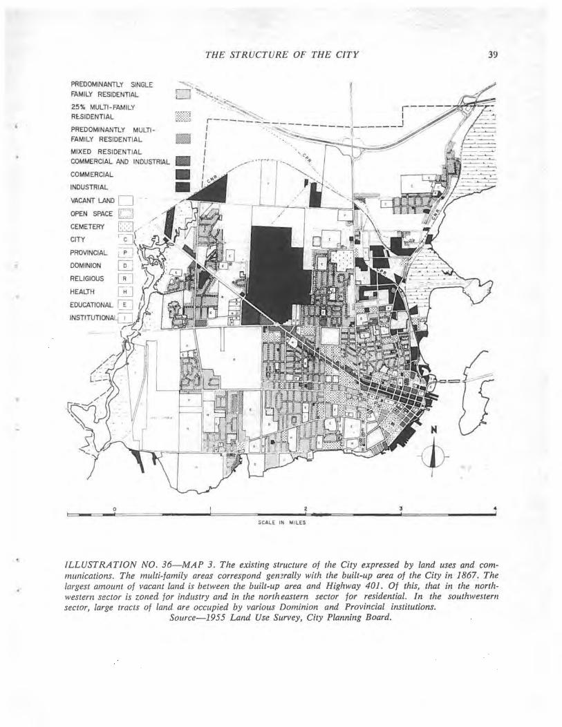
•
PREDOMINANTLY SINGLE
FAMILY RESIDENTIAL
25% MULTI- FAMILY RE:.SIDENTIAl
PREDOMINANTLY MULTIFAMILY RESIDENTIAL
MIXED RESIDENTIAL
COMMERCIAL AND INDUSTRIAL
COMMERCIAL
INDUSTRIAL
VACANT LAND 0 OPEN SPACE k:::.>l / CEMETERY [8], . '. '
~,., ( . CITY
PROVINCIAL ,-pi L._!
DOMINION ~
RELIGIOUS ~
HEALTH 0 EDUCATIONAL 0
o --
THE STRUCTURE OF THE CITY
~'" " r-l'~.. 11
w..J ..... ~ ... , I"
."'--~ ...... ... S~ ,
f----- ~~----------------~ I . I I , I ,
2 , SCALE IN MI LES
3 ,
39
4 I
ILLUSTRATION NO. 36-MAP 3. The existing structure of the City expressed by land uses and communications. The multi-family areas correspond gemrally with the built-up area of the City in 1867. The largest amount of vacant land is between the built-up area and Highway 401. Of this, that in the northwestern sector is zoned for industry and in the north eastern sector for residential. In the southwestern sector, large tracts ot land are occupied by various Dominion and Provincial institutions.
Source-1955 Land Use Survey, City Planning Board.
40 PART VI: SECTION 2. POPULATION
The density of population within the City varies a great deal. The greatest number of persons per acre is to be found in the older parts where many houses have been subdivided and there are apartment buildings. Generally, the City may be divided into six areas.
Sydenham Ward Sydenham Ward (which is the complete Sydenham Ward of today) lies between the central commercial area and the University. Because it is one of the earliest sections of the City, its density has been increased by the insertion of many more dwellings than there were original building lots, and by conversions of larger houses. Even in the nineteenth century some apartment buildings were erected in the Ward which also provides a large number of living quarters [or university students. With a population of nearly 60 persons per acre, Sydenham Ward has the highest density in the City. Although the buildings are close together there is a large amount of floor space per person.
Portsmouth With early shipbuilding activity and the building of institutions in the locality, Portsmouth was settled at an early date. Some of the older village houses show internal overcrowding; in many cases the floor space per person is lower than the 200 ft. standard utilized. The average density for the area is below 25 persons per acre, but there is an average of 0.97 persons per room, showing that there must be some overcrowding.
North of Princess Street The settlement north of Princess Street began at an early date, with North Street at one time a boundary of the City. Small settlements grew beyond the boundary but were later absorbed by the main City growth. Fewer multiple dwellings exist on this side of the central area as compared with the area north of Barrie Street, but its density is still high and the space per person considerably reduced. Many row houses exist to bring the density up to 49 persons per acre. On the fringes of this development there exist smaller houses which previously filled the role of many of today's dwellings in the Rideau Heights area-houses often below standard in finish and conveniences, and with insufficient space. The only alternative is public low rental housing.
Pre-War Housing In general, housing before the war spread in a westerly direction from the University Area to Princes's Street, and was developed at a moderate density of 30 persons per acre as against the average for the City of 33 persons per acre. Because of subdivision control and minimum lot sizes, it is difficult for further subdivision to occur, although undoubtedly apartment dwellings will be constructed in the future in some locations, notably near parks.
Kingscourt-Wartime Housing Area. The area of housing immediately north of Concession Street has a moderate density of 25 persons per acre but some of the individual houses are badly overcrowded. Because it had to meet an emergency this housing is substandard in its floor space.
Post-War Suburbs The newer areas of the City, west of Victoria Street and the Aluminum Plant, have no noticeable overcrowding, and the percentage of owner-occupied dwellings is very high. The density is about 14 persons per acre.
The population of the City is at present about 50,000 persons. Its most rapid growth has been experienced since the beginning of the last war when the coming of the larger scale industries boosted the economy and the popUlation. Since the war Kingston has grown at a rate of approximately 2.5 % per year, with the suburban or outer municipalities increasingly taking more of the residential growth. With a continuation of this rate, most of the available vacant residential land within the City will be developed by 1970, and the City'S population wiII be approximately 70,000. Any further change \ViII be caused by redevelopment within the older sections of the City.
The probable density of new areas will vary with their location. No doubt the medium and higher priced houses, with lots which average 6,000 square feet each, will be found in the western section of the City with densities of approximately 15 persons per gross acre, including schools, parks and roads. Medium ~nd lower priced houses may be located in the northern sections of the City where a higher density can be expected. Here the lots will probably average 3,000 square feet in area which would result in a gross density approximating 25 persons per acre.

.J
EACH DOT REPRESENTS 25 PERSONS r----,
I , , , I ,
POPUl.ATION
2 J
SCALE IN MILES
41
r----~-~~v// I ____ J
3 4 !
ILLUSTRATION NO. 37-MAP 4. The distribution of population in the City shown diagrammatically. It can be seen that there are concentrations of people in the vicinity of the central business district. It is also evident that the outer residential areas of the City are at relatively low density.
Source: Unpublished Population Report, 1956, City Planning Board.
42 PART VI: SECTION 3. RELIEF CASES
The information concerning relief recipients was obtained from the City Department of Social Welfare. In plotting the cases on the map no differentiation was made between the various categories. In all, there were 109 cases handled in June, 1958 which was regarded as a typical month.
The relief recipients are divided into a number of categories. It might be worth noting these groupings though they have not been considered when plotting cases.
1. Ullemployable-
male head 8 cases female head 25 cases single male 11 cases single female - 18 cases
This category includes those who by reason of health or physical disability are unable to find work (generally a medical certificate is required) and widows or deserted wives with children who by law do not have to work and need a source of income. In the latter case the recipient may be working part or whole time yet still is classed as unemployable for relief purposes.
2. Employable (ullemployed)
male head 16 case female head 5 cases single male 7 cases single female - 2 cases
In these cases relief is usually in place of unemployment insurance (or in addition to).
3. Non-Shareable-17 cases.
These recipients are not covered by Provincial relief. Generally they are people who need a small sum to tide them over a short period of time. Often the recipient is a transient.
The map indicates a decided concentration of relief cases in the area north of Princess Street. There are individual cases elsewhere, and isolated groups of 6 or g cases.
In general, the greatest concentration of relief cases is found where poor housing is most prevalent. In the newer and better areas of the City relief case~ are practically non-existent.
For recurrent cases in the Welfare Department, there is continuing evidence of a connection between the cases and poor housing. Because of their poor economic conditions, persons on relief are forced to obtain the lowest standard of accommodation available and if they are ejected, try to find accommodation similarly poor. However, they are not in a position to question what may be an extortionate rent for substandard living space, and often pay more comparatively for their accommodation than tenants in better dwellings.
One typical family lives within a very poor group of houses (Ontario Street) located near heavy industry; the accommodation itself is ranked as poor in condition, and the dampness of the building is most unhealthy. There is a total of 8 persons in the family and the 6 children range from 6 months to 14 years of age. They occupy a total of 5 rooms in rented accommodation. The husband, on relief for 2 years, is classed as an employable unemployed, but in fact is mentally retarded and has little hope of steady work. Poor housing conditions here may be partly responsible for the fact that some children of this family have been in trouble with police.
Some families in outer residential developments (Rideau Heights) are also badly situated. One particular family with 9 children lives in a 3-roomed shack, which they own. There is no water available. It appears that the husband will not work steadily, so that conditions will not improve. In this case also there have been problems with one of the children. The large families often associated with relief cases are in particular need of better housing. They cannot provide it for themselves and the children's live:; can be permanently affected by their poor livin!, conditions.
It may be argued that the association of persons on relief with poor housing conditions is not in itself cause and effect. For example, statistics maintained for a number of years by the Department of Social Welfare indicate that the number of employable unemployed registered for welfare assistance is directly influenced by the gel1eral availability of employment. It is nevertheless true that wherever there is substandard housing there also may be found a high incidence of persons barely above subsistence level. It is therefore not surprising to find that the largest numbers of relief recipients are identified with poor housing areas. ..

RELIEF CASES 43
2 4 : ,
SCALE IN MILES
ILLUSTRATION NO, 38-MAP 5, A total of 109 relief cases were handled in June. 1958, which WQJ
regarded as a typical month. They consisted of 62 unemployables, 30 employables and 17 other cases. (i) Note that the greatest concentrations appear in those parts of the City where there is overcrowding
alld poor housing. Source-Department of Social Welfare, City of Kingston.
44 PART VI: SECTION 4. CHILDREN AND THEIR PROBLEMS
The Juvenile Court cases as such are indicative of the whole environment of the children concerned. Parents, living conditions and individual personality are all reflected in the child's particular way of life.
It is thus very difficult to separate the actions of the child from these other influences, and they all combine to provide an atmosphere where morals are often low.
Where boys are concerned in court cases, it is usually for theft (petty thieving of articles that they may not possess, such as bicycles). Real trouble begins when they start drinking to be considered equal with the others, trying to appear mature in older boy's company, and refusing to "chicken out" in any venture.
Girls' court cases again are petty thieving, usually for more feminine articles 'such as bracelets, rings and articles of clothing. Generally their offences tend to recur more than those of the boys. Also they are often involved in cases of running away from home for a few nights.
Family problems do not take long to influence the children, and often it does not take much more than a recession in work to make things difficult. Many of the families with whom the court deals have debts of at least one thousand dollars owing to finance companies of some type. The families are generally large and it seems to the parents that extra facilities have always to be obtained on credit. The larger the family the poorer, generally, is the living accommodation. Many family problems occur through the conflict of personalities, but there is no doubt that environment aggravates a situation that might otherwise not arise. The wife frequently becomes aggressive as a result of the husband's failing to improve their conditions or being out of work. His retaliation often consists of going out to drink it off which, far from solving the problem, takes it one stage further, and there is less money to put things right. Children in such an atmosphere will hardly pay the respect to their parents that is normally due, and in many cases will continuously be disobeqient. The children may have to work part time to help support the family, which will separate them from the normal activities of their friends and make a barrier between them and their parents.
Overcrowding does nothing to help, and in many of the large families trouble often develops because the parents cannot supervise all their children's activities or show them the love and understanding that is needed. Living in meagre accommodation must inevitably mean a desire to get outside the home, and home life is then not something to be respected. The children will seek their self-expression in a way completely unrelated to the home.
Economic conditions can make life unbearable, despite municipal assistance, if the children concerned are unable to enjoy some of the normal possessions of other boys and girls. Shortages of every day needs as well as the condition of accommodation, will be the source of quarrels, violence and separations between parents which will undoubtedly affect children for the whole of their life.
While many things related to these problems are being improved, such as financial assistance, little is being done about the total environmentthe removal of 'slums and the provision of more suitable low-rental residential areas. An obvious deficiency is the lack of open space and recreational facilities so that children have an opportunity to enjoy leisure time in the right surroundings and environment-fresh clean air as against the dank common hallways of apartments or the unsafe through traffic streets. By having well designed residential areas unaffected by nearby industries, heavy trucks and noise, the home can begin to mean something different. This would be an. important step in a general improvement of social conditions.
The Juvenile Court cases fall mainly north of Princess Street, and a decided concentration of them occurs within the wartime housing north of Concession Street, itself an area poor in condition. However, a generally more important area as far as total environment is concerned is that between Montreal Street, Rideau Street and Charles Street. This district suffers through being on major traffic routes and having industry mixed with the housing; and it has little public open space available within its immediate area.
It is interesting to note that in the 5 years there were only 9 reported cases in Rideau Heights, although cases of a similar nature to those in the City may not have been reported: so that although juvenile delinquency is without doubt connected in some way with poor living conditions the openness of the development may be an advantage.
A typical case in the Juvenile Court is as follows: the family has lived in poorer areas of Kingston on sections of Queen and Montreal Streets lately, with 5 persons in 4 rooms. The family originally had 10 children, with 4 now left at home. The father was frequently absent from home and has now left. He claims it was because of his wife's aggressiveness. She says he is an alcoholic. It is interesting to note that he was an orphan raised by foster parents and that he changed his religion at marriage. He had an unsteady job for 5 years, during which time he was frequently on relief. Of the 6 children living away, 4 are in less than ideal situations and of the other two there is no news.

..
..
CHILDREN AND THEIR PROBLEMS 45
o 2:3 4 c= ____ ~ __ ~~====~¥N~ . =n=---~====~--------·=======3-------'C=====~ ______ .. ' SCALE IN MILES
ILLUSTRATION NO. 39-MAP 6. The background of both parents and children is examined on appearance at the Juvenile Court. Few of the cases occur south of Princess Street. There were a total of 158 cases in the years 1953-7, about one-third involving people from outside the City. (ii) Again it is to be noted that the greatest concentrations appear where there is overcrowding and poor housing.
Source-Juvenile Court Records.

46 PART VI: SECTION 5. POLICE CASES
Information was obtained from the Magistrate's Court and Police records regarding incidents occuring under the criminal code from July 1956 to June 1958. Those involving the Highway Traffic Act, Liquor Control Act, and Local By-Laws, were omitted.
The list of names was used to discover from the Police files the offender's home address in Kingston, if any, and where the incident took place. No classification of the type of offence was made.
A map compiled of incidents, indicates a consistent grouping along Princess Street with the greatest concentration downtown, particularly in any hotel area. Outside the central area there are a number of incidents occurring among the Montreal Street housing, and in the housing on the north border of downtown. Impaired driving is an offence under the Criminal Code. Most incidents involving it are plotted on the road where the arrest was made, making a relationship to environment difficult.
The second map (Illustration No. 40) is based on the home addresses of offenders. It is more useful in establishing the relationship to bad housing, but again impaired driving cases could create a false impression in 'Some areas. There are, however, noticeably more offenders living north of Princess Street and a strong group in some bad housing on Ontario Street. Most cases are distributed equally through the original study area north of Princess Street, with a concentration in the Wellington Street housing near Princess Street. The marked grouping of cases north of Princess Street relates to the larger number of domestic problems that occur there. Police cases in other areas are generally of a different type. As was to be remarked in an examination of cases before the Juvenile Court, the actions of parents influence their children, and the environment itself is detrimental to all. Pressures and conflicts between husband and wife become much more tense and aggressive as trouble, often economic, affects them. The man searches for an outlet outside the house but when he returns has to face the problem from which he fled, and which his wife faces constantly. When both have to work from necessity, this can also cause unnecessary friction. South of Princess Street, police calls take on a different nature and often are related to the University students in that area.
An analysis of the police cases plotted on the map reveals that 26% are major crimes such as assault, theft, and breaking and entering. 32% are caused by traffic infringements under the criminal code, and the remaining 42 % are miscellaneous minor cases.
Summary of Part VI It seems almost unnecessary to emphasize the
close association between poor housing conditions and social problems such as juvenile delinquency, crime, poverty, disease, retardation and general SOCial maladjustment. Innumerable investigations in count· less communities, large and small, throughout North America ~md Europe have yielded abundant statistical evidence to show that bad housing is a breeding ground for social ills. It is from such areas that the bulk of social casualties arise which largely constitute the case loads of family, child care and protective agencies and result in excessive health and welfare costs. Information on the subject now appears to be reasonably complete and conclusive.
Of much greater importance is the small but rapidly growing fund of information which has been accumulated on the good results which are obtained when poor housing is removed and when families from such areas are provided with housing adequate for their needs and at a price they can afford. This is the positive side of redevelopment. In some instances the results have been dramatic with marked decreases in civic expenditures for fire protection, social assistance, public health, police protection, etc. More important are the positive gains in social well-being of the people themselves who have enjoyed surprising improvements in health, children's school work and general well-being. The following report from a group of Canadian social workers is typical: "Each time a new building is occupied it is interesting to watch the windows blossom with fresh and often new curtains .... Although no inference should b~ drawn that there are not problem cases, an unlimited supply of hot water available simply by turning on the tap, together with convenient laundry facilities, certainly produces visible results. The management has seen some startling improvements in housekeeping on the part of families whose standards left something to be desired before they moved into the new buildings. These resul1l<i are confirmed by various interested agencies in the neighbourhood as well as schOol officials, all of whom are very familiar with the difficulties confronting families living in the overcrowded sub-standard accommodation which made up most of the old neighbourhood. Fewer fire hazards, fewer absences from school for health and other reasons, and less juvenile delinquency, are matters of fact borne out by actual results. Almost half the old dwellings were stove heated, and a frequent excuse for absence from school was that the house was too cold for the children to leave their beds. With central heating in the new units, absence for this excuse has simply disappeared."
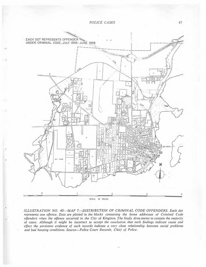
POLICE CASES
~, EACH- DOT REPRESENTS OFFENDER~,
UNDER CRIMINAL CODE ,JULY 1956r~~~~5~_, _______ J~ _____ f-----I -,.-- j I - ~~-=;::c_
o !
I , - 'y I .~ I I
SCALE IN' MILES
2 !
3 !
47
ILLUSTRATION NO. 40-MAP 7-DISTRIBUTION OF CRIMINAL CODE OFFENDERS. Each dot represents one offence. Dots are plotted in the blocks containing the home addresses of Criminal Code offenders when the .offence occurred in the City of Kingston. The Study Area seems to contain the majo,.ity of cases. Although it might be incorrect to accept the conclusion that such findings indicate cause and effect the persistent evidence of such records indicate a very dose relationship between social problems and bad hOllsing conditions. Source-Police Court Records, Chief of Police.