Embed Size (px)
Citation preview

A new hypothesis for the amount and distribution of dextraldisplacement along the Fish Lake Valley–northern DeathValley–Furnace Creek fault zone, California-Nevada
Byrdie Renik1,2 and Nicholas Christie-Blick1
Received 9 June 2012; revised 31 October 2012; accepted 4 November 2012.
[1] The Fish Lake Valley–northern Death Valley–Furnace Creek fault zone, a ~250 kmlong, predominantly right-lateral structure in California and Nevada, is a key element intectonic reconstructions of the Death Valley area, Eastern California Shear Zone andWalker Lane, and central Basin and Range Province. Total displacement on the fault zoneis contested, however, with estimates ranging from ~30 to ~63 km or more. Here wepresent a new synthesis of available constraints. Preextensional thrust faults, folds, andigneous rocks indicate that offset reaches a maximum of ~50 km. Neogene rocks constrain itspartitioning over time. Most offset is interpreted as ≤ ~13–10 Ma, accruing at ~3–5 mm/yrin the middle of the fault zone and more slowly toward the tips. The offset markers imply~68 � 14 km of translation between the Cottonwood Mountains and Resting Spring–NopahRange (~60 � 14 km since ~15 Ma) through a combination of strike slip and crustalextension. This suggests that a previous interpretation of ~104 � 7 km, based on themiddle Miocene Eagle Mountain Formation, is an overestimate by ~50%. Our results alsohelp to mitigate a discrepancy in the ~12–0 Ma strain budget for the Eastern CaliforniaShear Zone. Displacement has previously been estimated at ~100 � 10 km and ~67 � 6 kmfor the Basin and Range and Mojave portions of the shear zone, respectively. Ournew estimate of ~74 � 17 km for the Basin and Range is within the uncertainty of theMojave estimate.
Citation: Renik, B., and N. Christie-Blick (2013), A new hypothesis for the amount and distribution of dextraldisplacement along the Fish Lake Valley–northern Death Valley–Furnace Creek fault zone, California-Nevada, Tectonics,32, doi:10.1029/2012TC003170
1. Introduction
[2] The Fish Lake Valley–northern Death Valley–FurnaceCreek fault zone, a ~250 km long, predominantly right-lateralstructure in eastern California and western Nevada, is akey element of research into both (1) displacementbudgets for the Eastern California Shear Zone and (2)tectonic reconstructions of the Death Valley area andcentral Basin and Range Province (Figure 1) [e.g., Wrightand Troxel, 1967, 1970; Stewart, 1967, 1983, 1992;Stewart et al., 1968, 1970; Wernicke et al., 1988a, 1988b;Snow and Wernicke, 1989, 2000; Dokka and Travis, 1990a,1990b; Snow, 1992a; Stevens et al., 1991, 1992; Serpa andPavlis, 1996; Reheis and Sawyer, 1997; Bennett et al., 2003;McQuarrie and Wernicke, 2005; Frankel, Brantley, et al.,2007; Frankel, Dolan, et al., 2007]. Each line of researchis of general significance (the former to the distributed
accommodation of plate boundary motion, and the latter tomechanisms of crustal extension), but important uncertaintiesare still to be resolved in both cases. Dextral displacementacross the Eastern California Shear Zone is thought to be~28% of San Andreas transform fault system, averaged since12 Ma [McQuarrie and Wernicke, 2005]. Displacementestimated for the portion of the shear zone in the western Basinand Range (~100� 10 km), however, is ~150% of the value forthe Mojave portion (~67 � 6 km; Figure 1) [McQuarrie andWernicke, 2005; Lease et al., 2009]. Palinspastic reconstruc-tions of the Death Valley area have been influential in thedevelopment of the low-angle normal fault and rolling hingemodels of extension. The restored positions of critical markersare nonetheless disputed, and the manner in which crustalextension has been accommodated is unresolved [cf., e.g.,Hamilton, 1988; Wernicke et al., 1988a; Snow and Wernicke,2000; Topping, 2003; Miller and Pavlis, 2005].[3] Total displacement on the Fish Lake Valley–northern
Death Valley–Furnace Creek fault zone is contested, withrecent estimates ranging from as little as ~30 km [Çemen andBaucke, 2005] to ~63 km or more [e.g., Snow and Wernicke,2000]. There has been disagreement over the correlationof piercing points as well as the original configuration ofcorrelated markers, e.g., local sinuosity in the regionaltrends of isopachs and facies boundaries [e.g., Prave and
1Department of Earth and Environmental Sciences and Lamont-DohertyEarth Observatory of Columbia University, Palisades, New York, USA.
2Now at ExxonMobil, Houston, Texas, USA.
Corresponding author: B. Renik, ExxonMobil, CORP-GP3-628, 233Benmar Dr., Houston, Texas 77060, USA. ([email protected])
©2013. American Geophysical Union. All Rights Reserved0278-7407/13/2012TC003170
1
TECTONICS, VOL. 32, 1–23, doi:10.1029/2012TC003170, 2013

Wright, 1986a, 1986b; Stewart, 1986]. Comprehensivesyntheses have been published [e.g., Snow and Wernicke,1989, 2000; Serpa and Pavlis, 1996], but several recentobservations along the Death Valley portion of the faultzone cast doubt on elements of those reconstructions[e.g., Miller and Friedman, 1999; Turner and Miller,1999; Czajkowski and Miller, 2001; Czajkowski, 2002;Niemi, 2002; Miller, 2003; Çemen and Baucke, 2005;Golding Luckow et al., 2005;Miller and Pavlis, 2005; Reniket al., 2008]. Few interpretations have integrated piercingpoints from the entire length of the fault zone, from northernFish Lake Valley, through Death Valley and Furnace CreekWash, to the central Amargosa Valley in the vicinity ofEagle Mountain (FLV, DV, FCW, AV, EM in Figure 1).This is important for distinguishing spatial variations inoffset from temporal variations [e.g., Christie-Blick andBiddle, 1985, p. 22], both of which are documented inthis example.[4] Here we present such a synthesis. For ease of reference,
we use the name “Furnace Creek fault zone” for the entiretyof the structure over all of its history, including both active
and inactive segments. We propose a new hypothesis for thedistribution of dextral displacement along strike and overtime. Our synthesis has implications for the long-termdisplacement budget of the Eastern California Shear Zoneand for the magnitude of extension across Death Valley.
2. Geologic Setting
[5] Rocks and structures exposed in ranges surroundingthe Furnace Creek fault zone reflect a protracted geologicalhistory. The oldest rocks constitute a 1.7 Ga crystallinebasement [Wasserburg et al., 1959; Silver et al., 1962;Wrightet al., 1981; DeWitt et al., 1984], most extensively exposed inthe BlackMountains (Figure 1). Mesoproterozoic to Paleozoicsiliciclastic and carbonate rocks record episodic rifting andpassive margin development, and the onset of convergentplate boundary tectonics [e.g., Stewart, 1972; Christie-Blickand Levy, 1989; Levy and Christie-Blick, 1991; Burchfielet al., 1992; Wright and Prave, 1993]. In late Paleozoic-Mesozoic time, and possibly into the Paleogene, theserocks were deformed by folding and thrust faulting and, in
Figure 1. Location of the Fish Lake Valley–northern Death Valley–Furnace Creek fault zone. Faultzone and local ranges and valleys; location shown by outline in regional map. Bold, dashed line nearsouthern tip of fault zone represents a strand that developed relatively late in the history of the fault zone,as a link to a predominantly normal fault system along the Black Mountain front (Figure 2). Adapted fromSnow [1992a], Reheis and Sawyer [1997],Wright and Troxel [1999], Snow and Wernicke [2000], Oldowet al. [2001], Miller and Pavlis [2005], Faulds and Henry [2008], Oldow et al. [2008], and Lease et al.[2009]. Inset shows fault zone (bold) in context of Basin and Range and Mojave Provinces (shaded),and of faults of the Eastern California Shear Zone, Mina deflection, and Walker Lane (differentiatedby the change in structural grain).
RENIK AND CHRISTIE-BLICK: DISPLACEMENT ON FURNACE CREEK FAULT ZONE
2

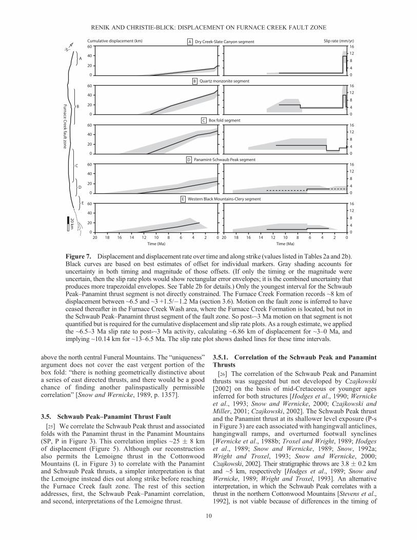
western ranges, intruded by arc-related plutonic rocks[Burchfiel et al., 1992, and references therein; Miller,2003]. Today, some of the contractile structures are notvisible directly because they have been reactivated orcut out by normal faults. Their existence can be inferrednonetheless from bedding attitudes and older-over-youngerrelations [e.g., Snow and Wernicke, 1989; Snow, 1990,1992a; Çemen and Wright, 1990].[6] There is evidence in the area for extensional disruption
of the orogen as early as late Cretaceous-Paleogene time[e.g., Hodges and Walker, 1990; Saylor, 1991; Applegateet al., 1992; Hoisch and Simpson, 1993; Applegate andHodges, 1995], but Basin and Range extension and strike-slipdeformation in this portion of the Eastern California ShearZone are predominantly Miocene and younger [e.g., Snowand Lux, 1999; Snow and Wernicke, 2000; McQuarrie andWernicke, 2005]. Sufficient extension has occurred at leastlocally to exhume high-grade metamorphic rocks in fourprominent extensional complexes: in the Silver Peak–LoneMountain area, in the northern Funeral Mountains, atTucki Mountain in the northern Panamint Mountains, andin the western Black Mountains (Figures 1 and 2). Broadly
synextensional sedimentary and volcanic rocks haveaccumulated in valleys along the fault zone, and also atselected localities within what are now adjacent ranges.[7] Given that the Furnace Creek fault zone contributes to
plate boundary dextral shear and is coordinated with Basinand Range normal faults, it is generally assumed that much,or all, of the displacement occurred since mid-Miocenetime. Most of the available piercing points from whichsubstantial offset is inferred are pre-Cenozoic, however.Thus, the time of onset of strike-slip deformation is notwell constrained. The Fish Lake Valley–northern DeathValley portion remains active today, and is linked southwardto the active dextral-normal central and southern DeathValley fault zones (Figure 2); motion has ceased on theFurnace Creek Wash–Amargosa Valley section (FCW andAV in Figure 1).
3. Magnitude and Distribution of DextralDisplacement
[8] Dextral displacement is inferred here to reach amaximumof ~50 km in the north central portion of the fault zone, and
Figure 2. Selected normal and strike-slip faults in the vicinity of the Furnace Creek fault zone, includingstructures related to the Basin and Range, Eastern California Shear Zone, and Walker Lane. Motion senseof individual faults is discussed in text. The Walker Lane, Mina deflection, Garlock, and Southern DeathValley faults continue outside area of figure. Adapted fromWright et al. [1991], Snow [1992a], Reheis andSawyer [1997], Wright and Troxel [1999], Snow and Wernicke [2000], Golding Luckow et al. [2005],Miller and Pavlis [2005], Guest et al. [2007], and Oldow et al. [2008].
RENIK AND CHRISTIE-BLICK: DISPLACEMENT ON FURNACE CREEK FAULT ZONE
3

to decrease toward the tips. Preextensional faults, foldsand igneous rocks (Figure 3) provide the best constrainton total displacement for specific segments of thefault, though with uncertainty both in the correlation ofmarkers and in determining offset once correlation hasbeen established. From northwest to southeast, theseinclude the Slate Canyon–Dry Creek thrust fault (SC, DCin Figure 3), the quartz monzonite of Beer Creek (QMin Figure 3), the Grapevine–Last Chance thrust fault (G,LC in Figure 3), the White Top–Marble Canyon box fold(WT, MC, DB in Figure 3), the Schwaub Peak–Panamintthrust fault (SP, P-s, P-d in Figure 3), and the Clery–Western Black Mountains thrust fault (C, WBM in Figure 3).Miocene and younger igneous and sedimentary rocksconstrain the partitioning of displacement over time (offsetsin Figure 4).
3.1. Slate Canyon–Dry Creek Thrust Fault
[9] The Slate Canyon thrust in the Silver Peak Range(SC in Figure 3; see also Figure 1) correlates across FishLake Valley with a thrust fault in the Dry Creek area ofthe White Mountains (DC in Figure 3; see also Figure 1);the distance between the traces, as measured along theFurnace Creek fault zone, implies ~20 km of dextraldisplacement (Figure 5) [Reheis and McKee, 1991; Reheisand Sawyer, 1997]. The thrust faults are interpreted tocorrelate because both place Cambrian over Ordovicianrocks and verge generally south or southwestward [Buckley,1971; Krauskopf, 1971; Crowder et al., 1972; Robinson andCrowder, 1973; Stewart et al., 1974]. In the footwall of eachfault, granitic rocks intrude the same Lower Ordoviciansiliciclastic unit [Buckley, 1971]. Some workers havecorrelated the Slate Canyon and Dry Creek faults with the
Figure 3. Markers inferred to predate faulting and therefore record total displacement, with additionalfeatures pertinent to the interpretation of the markers. Black and colored lines represent folds and thrusts, withthe latter distinguished by upper plate teeth. Colors emphasize inferred structural correlations. Circles showtie points in quartz monzonite of Beer Creek. Abbreviations: BC, Bonnie Claire thrust; BV, Butte Valleythrust; C, Clery thrust; CP, Chicago Pass thrust; DB, Dry Bone syncline; DC, Dry Creek thrust; G, Grapevinethrust; IP, Indian Pass syncline; KS, Kwichup Spring thrust; L, Lemoigne thrust; LC, Last Chance thrustsystem; M, Montgomery thrust; MC, Marble Canyon thrust; PA, Panamint anticline; P-d, Panamint thrust(deep exposure); P-s, Panamint thrust (shallow exposure); QM, quartz monzonite; SC, Slate Canyon thrust;SP, Schwaub Peak thrust; TC, Titus Canyon anticline; WBM, Western Black Mountains thrust system; WP,Winters Pass thrust; WhP, Wheeler Pass thrust; WPLC, Winters Peak/Lees Camp anticline; WT, White Topfold pair. Adapted from Krauskopf [1971], Crowder et al. [1972], Robinson and Crowder [1973], Stewartet al. [1974], Snow andWernicke [1989, 2000], Snow [1992a], Reheis and Sawyer [1997],Wright and Troxel[1999], Niemi [2002], Miller and Pavlis [2005], and Oldow et al. [2008].
RENIK AND CHRISTIE-BLICK: DISPLACEMENT ON FURNACE CREEK FAULT ZONE
4

Roberts Mountains thrust [e.g., Oldow, 1984; Stockli et al.,2003], whereas others have interpreted the RobertsMountains thrust to lie farther north, past the terminationof the Furnace Creek fault zone [e.g., Buckley, 1971]. Asmuch as ~5.9 +1.1/�1.4 km of the total dextral displacementin the vicinity of the Slate Canyon and Dry Creek thrustsis inferred to have accrued since just ~0.62 +0.08/�0.02Ma, based on the offset and age of alluvial fan sedimentsin central Fish Lake Valley (FLV in Figure 1; alluvial fan 1in Figure 4 and Table 1) [Reheis and Sawyer, 1997].
3.2. Quartz Monzonite of Beer Creek
[10] Correlation of the Middle Jurassic quartz monzoniteof Beer Creek (QM in Figure 3) between the Sylvania andWhite Mountains (Figure 1) implies ~40–50 km of dextraldisplacement, and most likely ~50 km (Figure 5) [McKee,1968; Reheis and McKee, 1991; Reheis and Sawyer, 1997].Uncertainty in offset results from each exposure being apartial representation of a three-dimensional body, ratherthan a linear feature intersecting the fault zone at a singlepoint. Although this marker has been regarded as “the bestestimate of total motion on the Furnace Creek fault” [Niemi,2002, p. 200], correlation of the exposures could be furthertested by “fingerprinting” each of them with moderngeochemical techniques. Along this same part of the faultzone, Reheis [1993] initially interpreted a ~40 km offset ofa distinctive, ~6 Ma sandstone to imply that most or allof the quartz monzonite displacement accumulated after
Miocene time. Subsequently, she concluded that this wasunlikely because the implied slip rate would have nearlyequaled the total displacement rate for the Basin and Rangeat that latitude, leaving no way to account for the contributionsof other faults in the region [Reheis and Sawyer, 1997]. Soeither the initial correlation was incorrect, or the sandstonewas originally distributed in such a way that its total offsetsince ~6 Ma is less than ~40 km.
3.3. Grapevine–Last Chance Thrust Fault
[11] The Grapevine thrust in the Grapevine Mountains(G in Figure 3; see also Figure 1) is widely considered tocorrelate with the Last Chance thrust system in the LastChance Range and Cottonwood Mountains (LC in Figure 3;see also Figure 1) [e.g., Stewart et al., 1966; Wernicke et al.,1988a; Snow and Wernicke, 1989, 2000; Snow, 1990, 1992a;Niemi, 2002]. Both structures verge eastward and havestratigraphic throws estimated at ~5–6 km [Reynolds, 1969;Snow, 1990, 1992a; Snow and Wernicke, 2000; Niemi, 2002].[12] Their offset along the Furnace Creek fault zone,
however, is poorly quantified. Snow and Wernicke [2000]inferred that a ramp in the system had been displaced≥ 63 km between the Cottonwood and Grapevine Mountains.Niemi [2002, 2012] showed that the Grapevine ramp actuallyreflects the cutoff of an antecedent anticline, and does notmatch the ramp in the Cottonwood Mountains.[13] Younger markers constrain displacement in the
Grapevine–Last Chance portion of the fault zone, although
Figure 4. Offsets of selected Neogene markers. Adapted from Oakes [1977, 1987], McKee [1985], Reheisand Sawyer [1997], Blair and Raynolds [1999], Klinger [2001], and Frankel, Brantley, et al. [2007, 2007].
RENIK AND CHRISTIE-BLICK: DISPLACEMENT ON FURNACE CREEK FAULT ZONE
5

they provide only minimum estimates of total offset. Corre-lation of granitic stocks suggests ~32 km of dextral dis-placement since ~7.6 � 0.3 Ma (Figure 4) [Oakes, 1987],an interpretation that could be further tested by geochemicalcomparison of the stocks. Extrapolating the average slip rateimplied by this marker (32 km per 7.6 � 0.3 Myr) back to10–13 Ma (when faulting likely began; section 4.2) impliesa total offset of ~49 � 8 km, which is compatible with othernearby estimates, such as from the quartz monzonite. Thefinal ~8 km has been interpreted to have accrued since~3.3 Ma (a maximum age estimate), and the last ~4.05 kmsince ~1.2 Ma (a minimum age estimate), based on theprogressive offset of basaltic alluvial fan gravel from itssource (Figure 4) [Klinger and Sarna-Wojcicki, 2001].
3.4. Box Fold
[14] A pair of west and east vergent structures in the Cotton-wood Mountains is inferred to correlate with comparablestructures in the Grapevine–Funeral Mountains block(Figure 1). The structures in the Cottonwoods are the westvergent White Top fold pair and the east vergent Marble
Canyon thrust and Dry Bone footwall syncline (WT, MC,DB in Figure 3). Taken together (Figure 6A), they define afaulted box fold with 3.5 � 1.1 km of vertical structural re-lief on the fold pair and 3.0 � 0.3 km of stratigraphic throwon the thrust [Snow and Wernicke, 1989, 2000; Snow, 1990,1992a]. The structures are inferred to be no younger than latePermian to Middle Triassic, based on crosscutting relation-ships with stocks of that age (Figure 3) [Snow et al., 1991].[15] East of Death Valley, the box fold includes several
structures dispersed by subsequent faulting. The westvergent structure manifests in the northern GrapevineMountains as the imbricate Bonnie Claire thrust system(BC in Figure 3) [Niemi, 2002] and in the central andsouthern Grapevines as an upright to recumbent fold pair:the Titus Canyon anticline and associated synclines (TC inFigure 3) [Reynolds, 1969; Snow and Wernicke, 1989;Niemi, 2002]. This correlation assumes that the GrapevineMountains structures have rotated counterclockwise [Snowand Prave, 1994; Snow and Wernicke, 2000]. The thrustfault’s stratigraphic throw and the structural relief of thefold pair are both ≥ ~2.4–2.5 km [Reynolds, 1969; Snow
Figure 5. Location of total offset estimates. Dashed tie lines represent total offset. Inset (top right, samescale as main figure) shows details of how box fold offset was calculated. Brown-and-white-striped areasshow span of box fold in Cottonwood Mountains (defined between White Top and Dry Bone fold axes)and in Funeral Mountains (defined between Boundary Canyon fault, which excised at least part ofthe structure, and Indian Pass syncline axis). Black dashed lines represent maximum and minimumdisplacement estimates. Maximum estimate of ~53 km is distance between southern limits of box foldin each mountain range. (Note additional offset along Keane Wonder fault.) Minimum estimate of~41 km is distance between northern limit of box fold in Cottonwood Mountains and northernmostpossible limit of excised fold in Funeral Mountains.
RENIK AND CHRISTIE-BLICK: DISPLACEMENT ON FURNACE CREEK FAULT ZONE
6

and Wernicke, 1989; Niemi, 2002]. The age of these structuresis not tightly constrained. Crosscutting relationshipsindicate that deformation started between Mississippian orPennsylvanian and Oligocene time, and possibly continuedintoMiocene time [Niemi, 2002]. The east vergent counterpartto the structures, which is not exposed in the GrapevineMountains, would originally have lain still farther to theeast. At the southern end of the range, the west vergent foldpair decreases significantly in amplitude and becomes relativelyupright in the vicinity of the underlying Boundary Canyondetachment (Figure 2), a normal fault inferred to haveseparated the Grapevine and Funeral Mountains in Neogenetime [e.g., Reynolds et al., 1986; Troxel and Wright, 1989;Hoisch and Simpson, 1993; Wright and Troxel, 1993;Applegate and Hodges, 1993, 1995].[16] We hypothesize that any southward continuation
of the fold pair, as well as much or all of its east vergentcounterpart, was excised during exhumation of high-grademetamorphic rocks in the northern Funeral Mountains(with an along-strike continuation of the fold pair potentiallystill present under cover in the Amargosa Valley). A missing,excised thrust fault in that area has been previously interpretedon the basis of (1) thermobarometric evidence for overburdenexceeding the stack of preserved thrusts and (2) comparisonsof suites of contractile structures across the Furnace Creekfault zone [Hodges and Walker, 1990; Czajkowski, 2002;cf. Hoisch and Simpson, 1993]. Applegate and Hodges[1995] suggested that the high-grade rocks originated not
in the footwall of an additional fault between the Grapevineand Schwaub Peak thrusts (G, SP in Figure 3), but beneaththe basal décollement of the fold and thrust belt. Themissing overburden totals ~12–18 km [Applegate andHodges, 1995], more than the throw of individual thrustfaults in the region. In the hypothesis of Applegate andHodges [1995], lateral extrusion of a crustal wedge at depthwould have permitted excision of the décollement andexhumation of high-grade material without requiring uppercrustal normal faulting [cf. Hodges and Walker, 1990;Mattinson et al., 2007]. This deep-seated mechanism wasintended to rationalize Late Cretaceous mineral coolingages with the absence of an extensional basin of that age.[17] We agree that an original, subdécollement location
for the high-grade rocks can account for the paleopressures,but infer, in addition to that explanation, another thrust faultbetween the Grapevine and Schwaub Peak thrusts. Such afault is consistent with a paleodepth estimate of ~22 kmfor strata in the Indian Pass area (IP in Figure 3) [Hoischand Simpson, 1993], rocks that were not derived from belowthe basal décollement. Although such a fault would need tohave been at least partially excised by upper crustal normalfaulting and erosion, just a few kilometers of uplift anddowncutting would most likely suffice to excise the thrust,and that could have been accomplished during Mioceneactivity on the Boundary Canyon detachment. Additional,earlier normal faulting cannot be ruled out because theassociated basin may have been sufficiently localized not
Table 1. Timing of Offsets and Implied Average Displacement Ratesa
Constraint
Offset (km) Start Dateb (Ma)DisplacementRatec (mm/yr)
NotesMax Pref Min Max Pref Min Max Pref Min
Slate Canyon–DryCreek Thrust (1,2)
20 20 15 13 11 10 2.0 1.8 1.2 Start dates follow section 4.2.
Quartz monzonite (1,2,3) 50 50 40 13 11 10 5.0 4.5 3.1 Start dates follow section 4.2.Box fold 53 47 41 16 11.5 9 5.9 4.1 2.6 Range of possible offset shown in Figure 5. Start
dates follow section 4.2.Schwaub Peak–Panamintthrust
33 25 17 18.5 13 11 3.0 1.9 0.9 Max, min, offsets from uncertainty in projections ofthrusts to fault zone. Start dates follow section 4.2:max from en echelon folds (4), pref from onset ofsignificant extension in northern Black Mountains,min from Eagle Mountain Formation (5).
Clery–WesternBlack Mountains thrust
30 (6) 20 10 18.5 13 11 4.6 2.0 0.6 Max, min offsets from uncertainty in projection ofthrusts to fault zone. Cessation of faulting in thisarea ≤4.5 and >1.8 Ma (7,8); our preferred estimateis ~3 Ma (section 3.6).
Sandstone (9) 40 6 6.7Granitic stocks (10, 11, 12) 32 7.9 7.6 7.3 4.4 4.2 4.1Furnance Creek Formation(7)
8 6.5 4.0 2.3 1.7 Cessation of faulting in this area ≤4.5 and >1.8 Ma(7,8); our preferred estimate is ~3 Ma (section 3.6).
Alluvial fan 1 (2) 7 5.9 4.5 0.7 0.62 0.6 11.7 9.5 6.4Basaltic gravel (13, 14) 8 3.3 1.9 Displacement rate calculated for 3.3–1.2 Ma.
4.05 1.2 3.4 Displacement rate calculated for 1.2–0 Ma.Alluvial fan 2 (15) 0.2 0.18 0.16 0.08 0.07 0.06 2.9 2.5 2.1 Max, pref, min displacement rates from (15).Sedimentary contact (2) 0.58 0.55 0.52 0.19 0.13 0.1 5.75 4.4 2.7Alluvial fan 3 (16) 0.31 0.3 0.29 0.09 0.07 0.05 6.1 4.5 3.1 Max, pref, min displacement rates from (16).
aReferences used for estimates of offset and start dates, where not indicated otherwise in notes. Note that additional, younger markers have been identifiedalong the fault zone; see Reheis and Sawyer [1997] and Frankel, Brantley, et al. [2007, 2007] for summaries. Numbers in parentheses are data sources asfollows: 1, Reheis and McKee [1991]; 2, Reheis and Sawyer [1997]; 3, McKee [1968]; 4, Çemen et al. [1999]; 5, Niemi et al. [2001]; 6, Çemen and Baucke[2005]; 7, Blair and Raynolds [1999]; 8, Knott et al. [2005]; 9, Reheis [1993]; 10, Oakes [1977]; 11, McKee [1985]; 12, Oakes [1987]; 13, Klinger [2001];14, Klinger and Sarna-Wojcicki [2001]; 15, Frankel, Dolan, et al. [2007]; 16, Frankel, Brantley, et al. [2007].
bStart date reflects time when indicated offset began to accrue. For pre-Neogene markers, this is the start of Neogene faulting. For other markers, it is theage of the marker.
cMax, pref, min displacement rate obtained by dividing max, pref, min displacement by min, pref, max duration, respectively. Duration equal to intervalbetween start date and 0 Ma unless otherwise noted.
RENIK AND CHRISTIE-BLICK: DISPLACEMENT ON FURNACE CREEK FAULT ZONE
7

to have survived subsequent erosion. We consider thehypothesized thrust fault excised in this manner to providea potential correlate for the portion of the box fold equivalentto the Marble Canyon thrust.[18] Although correlating a portion of the box fold with a
fault that is now missing may seem speculative, we cautionagainst assuming that all map traces of the original fold-and-thrust belt are preserved in some form – particularlywhere exhumation has been extreme, as in the case of thenorthern Funeral Mountains metamorphic core complex.Given the inherent uncertainties in correlating preextensionalstructures, it seems judicious not to invoke missing thruststructures arbitrarily, but to allow for them – as hypotheses– where clues are available. In the case of the box fold, thoseclues include: (1) the observation that its Grapevine Mountainsexpression appears to be truncated by the Boundary Canyonfault, (2) the thermobarometric evidence for additionaloverburden, (3) the presence of a syncline at the southernend of the core complex near Indian Pass (IP in Figure 3,Figure 5) [Troxel and Wright, 1989; Çemen and Wright, 1990;
Wright and Troxel, 1993], which implies that the east vergentportion of the box fold was not entirely excised, and (4)the unlikelihood that other Funeral Mountains thrust faultscorrelate with the box fold (discussed below).[19] The inference that the box fold originally continued
through the northern Funeral Mountains implies dextral offsetof ~47� 6 km along the Furnace Creek fault zone (Figure 5).A minimum offset of ~41 km is required by the distancebetween the fold in the Cottonwood Mountains and theBoundary Canyon fault (Figure 5 inset). This minimumestimate represents the possibility that the GrapevineMountains expression of the box fold not only decreasesin amplitude in the southernmost portion of that range, butdies out altogether under Cenozoic cover in the area ofthe Boundary Canyon fault. A maximum estimate is thedistance between Indian Pass syncline and its potentialequivalent in the Cottonwood Mountains, the Dry Bonesyncline adjacent to the Marble Canyon thrust (DB, MC inFigure 3, Figure 5). The distance between the Indian Passand Dry Bone synclines is ~53 km, accounting for ~5 km
S
Figure 6. Cross sections of structures in Cottonwood and Funeral Mountains. Line locations shown inmaps to right of each section. (A) Cross section of box fold in Cottonwood Mountains, with displacementalong normal faults restored. Box fold is defined by west vergent structures shown at left (White Top foldand associated thrust faults) and east vergent structures shown at right (Marble Canyon thrust and DryBone syncline). Interaction between west and east vergent structures at depth is uncertain (circled areawith question mark). (B) Cross section of Winters Peak/Lees Camp anticline and Schwaub Peak thrustin Funeral Mountains. Dotted line shows present-day topography. Geology above topography and at depthis projected from outside the plane of section. The Winters Peak/Lees Camp and Schwaub Peak structuresverge southeastward, very nearly parallel to each other, with only minor overprinting on the anticlineshowing northwest vergence. Note that a westward tilt correction would produce a west vergent foldcarried by an east directed thrust fault. Abbreviations: DB, Dry Bone syncline; FCFZ, Furnace Creek faultzone; IP, Indian Pass syncline; KWF, Keane Wonder fault; MC, Marble Canyon thrust; SP, Schwaub Peakthrust; WPLC, Winters Peak/Lees Camp anticline; WT, White Top fold pair. Adapted from Snow [1990]and Czajkowski [2002].
RENIK AND CHRISTIE-BLICK: DISPLACEMENT ON FURNACE CREEK FAULT ZONE
8

of dextral displacement on the KeaneWonder fault (Figure 5inset) [Çemen and Wright, 1990]. Although the Indian Passfold appears to be fairly open, it is possible that the exposurerepresents only the lower limb and part of the trough ofa larger, tighter structure, and that the axis of the latter,at the same stratigraphic level, is located farther to thenorthwest. Note also that normal faulting within the rangehas spread out the fold in map view, exaggerating itsopenness. In any case, our interpretation does not dependcritically on this syncline, because correlations betweenstructures southeast of the Cottonwood Mountains box folddo not permit it to restore much past the Indian Pass area.[20] Our estimate of ~47 � 6 km is less than estimates
from previous reconstructions using the White Top andMarble Canyon structures: ~68 � 4 km [Snow and Wernicke,1989, 2000; Snow, 1990, 1992a] and ~80 km [Stevens et al.,1992]. Only the extreme upper limit on our estimateapproaches 64 km. The still larger estimate of ~80 km involvescorrelating the box fold with the east vergent Clery thrust(C in Figure 3) and an unnamed, west vergent anticlinenearby. These structures are not a good match. The unnamedanticline dies out abruptly along strike [Snow and Wernicke,1993], and there is no particular structural similarity tosuggest correlation of the Marble Canyon and Clery thrusts.As acknowledged by Stevens et al. [1992, p. 1069], thethrust correlation was a “by-product” of reconstructingMississippian facies belts.[21] The ~68� 4 km estimate was based on the identification
of the west and east vergent Funeral Mountains structures asthe Winters Peak/Lees Camp anticline and the SchwaubPeak thrust, respectively (WPLC and SP in Figures 3 and 6).The distance is the length of a displacement vector betweenthe box fold in the Cottonwood and Funeral Mountains(projected into Death Valley), corrected for offsets alongnormal and strike-slip faults at the edge of each range. Theuncertainty of 4 km accounts for errors in the orientation ofthe contractile structures, as well as a possible upper limiton displacement set by a Cottonwood Mountains intrusion(stock indicated by the eastern arrow in Figure 3 and shownin more detail in Figure 6) that has no correlate in the FuneralMountains.[22] Because the regional fold-and-thrust belt generally
verges eastward, the west vergent portion of the box foldcorrelation was presented as the “unique” key to a set ofthree contractile-structure matches between the Cottonwoodand Funeral Mountains [Snow and Wernicke, 1989]. Theother two correlations involve the Marble Canyon andSchwaub Peak thrusts (the east vergent portion of the boxfold), and the Lemoigne and Clery thrusts farther south(sections 3.5 and 3.6 and Figure 3). As expressed in theoriginal paper, the set of correlations is “based largely onrecognition of the backfold as a regionally persistent, uniquestructural marker” [Snow and Wernicke, 1989, p. 1359].This distinctive structure is hypothesized to have originatedas part of a broad anticlinorium mechanically localizedbetween the Paleozoic shelf-slope transition and an imbricatethrust stack in older, clastic strata [Snow and Wernicke, 1989].[23] Our correlation scheme is consistent with this
“uniqueness” argument.We accept the west vergent correlationbetween the Cottonwood and Grapevine Mountains (WhiteTop and Titus Canyon fold pairs) and reinterpret only itslocation in the footwall of the Boundary Canyon fault:
excision from the northern Funeral Mountains is still consistentwith the anticlinorium explanation. Interpreting the footwallexpression of the box fold as the Winters Peak/Lees Campanticline and the Schwaub Peak thrust does not accountfor the missing overburden discussed above. Moreover, laterwork casts doubt on the correlation [Czajkowski, 2002].
1. The Winters Peak/Lees Camp anticline verges southeastrather than west (Figure 6B) [Wright and Troxel, 1993;Czajkowski and Miller, 2001; Czajkowski, 2002]. (Stevenset al. [1992] also argued that the White Top and WintersPeak/Lees Camp folds have different orientations.)Previous interpretation of west vergence may havebeen guided by a minor northwest vergent overprint(Figure 6B) [Czajkowski and Miller, 2001; Czajkowski,2002] or by a westward tilt correction for the FuneralMountains range block. Regardless, the fold is nearlyparallel to the Schwaub Peak thrust (Figure 6B), incontrast to the geometry of the White Top and MarbleCanyon structures in the Cottonwood Mountains, whichstrongly diverge upward (Figure 6A).Czajkowski [2002]interpreted the Winters Peak/Lees Camp anticline not aspart of a box fold but as a detachment fold that devel-oped with the Schwaub Peak thrust. She proposed thatthe anticline formed by buckling above the SchwaubPeak thrust. Support for this interpretation includesisoclinally folded, relatively weak marble in the core ofthe fold, with the overlying section including alternatingstrata of higher and lower competency that exhibitflexural slip and flexural flow.
2. The northwest vergent overprint on the Winters Peak/Lees Camp anticline dies out upward [Czajkowski,2002]. This poses a problem both for correlation to theWhite Top fold pair, which represents a higher structurallevel and also amplifies upward [Czajkowski, 2002], andfor correlation to the Titus Canyon fold pair, whichdeforms a higher part of the stratigraphic section thanthe Winters Peak/Lees Camp anticline.
3. The Winters Peak/Lees Camp anticline and SchwaubPeak thrust are inferred to be Cretaceous [Czajkowskiand Miller, 2001; Czajkowski, 2002]. The ~92 Matiming of peak paleopressure in the northern FuneralMountains requires imposition of a Cretaceous load[Mattinson et al., 2007], beyond the original sedimentaryoverburden and Permian-Triassic thrust sheets. Applegateand Hodges [1995, their Figure 7] inferred the additionalload to come from the combined thickness of theSchwaub Peak and lower thrust plates. (Note that, atthe time of their publication, the loading was not yetconstrained as Cretaceous.) The work of Applegate andHodges and Mattinson et al. together suggests thatSchwaub Peak thrust (and its associatedWinters Peak/LeesCamp fold) were involved in the ~92 Ma event. Thismeans that these structures postdate the CottonwoodMountains box fold substantially.
[24] The existence of these Funeral Mountains structuressupports our estimate of box fold offset. Because theGrapevine Mountains show no expression of the WintersPeak/Lees Camp or Schwaub Peak (or Clery) structures,the Boundary Canyon detachment could not have movedthe Grapevine terrane farther than from a paleoposition
RENIK AND CHRISTIE-BLICK: DISPLACEMENT ON FURNACE CREEK FAULT ZONE
9
above the north central Funeral Mountains. The “uniqueness”argument does not cover the east vergent portion of thebox fold: “there is nothing geometrically distinctive abouta series of east directed thrusts, and there would be a goodchance of finding another palinspastically permissiblecorrelation” [Snow and Wernicke, 1989, p. 1357].
3.5. Schwaub Peak–Panamint Thrust Fault
[25] We correlate the Schwaub Peak thrust and associatedfolds with the Panamint thrust in the Panamint Mountains(SP, P in Figure 3). This correlation implies ~25 � 8 kmof displacement (Figure 5). Although our reconstructionalso permits the Lemoigne thrust in the CottonwoodMountains (L in Figure 3) to correlate with the Panamintand Schwaub Peak thrusts, a simpler interpretation is thatthe Lemoigne instead dies out along strike before reachingthe Furnace Creek fault zone. The rest of this sectionaddresses, first, the Schwaub Peak–Panamint correlation,and second, interpretations of the Lemoigne thrust.
3.5.1. Correlation of the Schwaub Peak and PanamintThrusts[26] The correlation of the Schwaub Peak and Panamint
thrusts was suggested but not developed by Czajkowski[2002] on the basis of mid-Cretaceous or younger agesinferred for both structures [Hodges et al., 1990; Wernickeet al., 1993; Snow and Wernicke, 2000; Czajkowski andMiller, 2001; Czajkowski, 2002]. The Schwaub Peak thrustand the Panamint thrust at its shallower level exposure (P-sin Figure 3) are each associated with hangingwall anticlines,hangingwall ramps, and overturned footwall synclines[Wernicke et al., 1988b; Troxel and Wright, 1989; Hodgeset al., 1989; Snow and Wernicke, 1989; Snow, 1992a;Wright and Troxel, 1993; Snow and Wernicke, 2000;Czajkowski, 2002]. Their stratigraphic throws are 3.8 � 0.2 kmand ~5 km, respectively [Hodges et al., 1989; Snow andWernicke, 1989; Wright and Troxel, 1993]. An alternativeinterpretation, in which the Schwaub Peak correlates with athrust in the northern Cottonwood Mountains [Stevens et al.,1992], is not viable because of differences in the timing of
Figure 7. Displacement and displacement rate over time and along strike (values listed in Tables 2a and 2b).Black curves are based on best estimates of offset for individual markers. Gray shading accounts foruncertainty in both timing and magnitude of those offsets. (If only the timing or the magnitude wereuncertain, then the slip rate plots would show rectangular error envelopes; it is the combined uncertainty thatproduces more trapezoidal envelopes. See Table 2b for details.) Only the youngest interval for the SchwaubPeak–Panamint thrust segment is not directly constrained. The Furnace Creek Formation records ~8 km ofdisplacement between ~6.5 and ~3 +1.5/�1.2 Ma (section 3.6). Motion on the fault zone is inferred to haveceased thereafter in the Furnace Creek Wash area, where the Furnace Creek Formation is located, but not inthe Schwaub Peak–Panamint thrust segment of the fault zone. So post-~3 Ma motion on that segment is notquantified but is required for the cumulative displacement and slip rate plots. As a rough estimate, we appliedthe ~6.5–3 Ma slip rate to post-~3 Ma activity, calculating ~6.86 km of displacement for ~3–0 Ma, andimplying ~10.14 km for ~13–6.5 Ma. The slip rate plot shows dashed lines for these time intervals.
RENIK AND CHRISTIE-BLICK: DISPLACEMENT ON FURNACE CREEK FAULT ZONE
10

thrusting (references above), original thrust fault geometry,and proximity to metamorphosed strata [Snow and Wernicke,1993]. We follow Snow and Wernicke [2000, and referencestherein] in regarding the latter, the Cottonwood Mountainsthrust, as part of the Last Chance system.[27] The Schwaub Peak–Panamint correlation differs
from a prior interpretation of the Panamint thrust, whichholds that its exposures at shallow and deep levels representthe updip and downdip continuations, respectively, of theChicago Pass thrust system in the Resting Spring and Nopahranges (CP in Figure 3; RSR, NR in Figure 1). Whereas thedeeper-level exposure of the Panamint thrust is in highlymetamorphosed rock, the deeper-level exposure of the ChicagoPass thrust is not, posing a challenge to the correlation(M. B. Miller, personal communication, 2009). In addition,the Chicago Pass system has potential correlates along strike:the Winters Pass, Wheeler Pass, and possibly Montgomerythrusts (WP, WhP, M in Figure 3) [Wernicke et al., 1988a,1988b, 1993; Snow and Wernicke, 2000]. If correlative, thesemap view counterparts imply that no additional match is re-quired. We infer that the updip and downdip continuationsof the Chicago Pass thrust were simply eroded away and/ordown-faulted and buried.
3.5.2. Interpretations of the Lemoigne Thrust
[28] Although it is conceivable that the Lemoigne thrust(L in Figure 3) correlates with the Panamint–Schwaub Peakthrust, a more parsimonious interpretation is that it diesout along strike before reaching the Furnace Creek faultzone, which lies ~35 km northeast of the thrust’s nearestexposure. Of all the contractile structures in the CottonwoodMountains, the Lemoigne thrust crops out farthest from thelatter fault zone.[29] A Lemoigne–Panamint correlation was proposed by
Serpa and Pavlis [1996] and is consistent with severalobservations. Serpa and Pavlis [1996] noted the similarityin both upper and lower plate rocks, despite the slightlylower 3.0 � 0.3 km of throw for the Lemoigne thrust [Snowand Wernicke, 1989]. The correlation is also consistent withthe presence of hangingwall ramps and footwall synclines inboth structures [Snow and Wernicke, 1989; Snow, 1992a;Wernicke et al., 1993; Snow and Wernicke, 2000]. The twothrust faults are separated by the normal fault system ofthe Tucki Mountain complex (Figure 1). More specifically,the Lemoigne footwall structurally overlies the Panaminthangingwall. Thus, correlation requires heave on the normalfault system to be approximately the map view separationbetween the thrust fault traces, where each emplacesCambrian over Permian strata [Snow and Wernicke, 2000].That amounts to perhaps ~16 km (L to P-s in Figure 3),depending on vertical axis rotation and the original configurationof exposed thrust sections.[30] Either option for the Lemoigne thrust is consistent
with available evidence for the paleoposition of the CottonwoodMountains relative to the Panamint Mountains, but there isno independent support for a restoration of the CottonwoodMountains so far to the southeast that the two thrusts merge.Palinspastic reconstruction of younger features suggeststhat the Lemoigne thrust originally projected toward andpossibly overlapped the northern Panamint Mountains[Andrew and Walker, 2009]. Substantial overlap has beeninferred from correlation of the White Top and Panamint
anticlines (PA in Figure 3) [Wernicke et al., 1988a, andreferences therein], but there is significant evidence againstthis proposed match. Whereas the White Top fold is noyounger than late Permian to Middle Triassic [Snow et al.,1991], the Panamint anticline is younger, having been mostrecently interpreted variously as Jurassic, Cretaceous, andMiocene [Labotka and Albee, 1988, and references therein;Snow and Wernicke, 1989; Hodges et al., 1990]. Alsocasting doubt on the correlation are the observations thatthe White Top fold pair terminates southward within theCottonwood Mountains [Snow, 1990, 1992a; Snow andWernicke, 2000] and that there is no equivalent to the restof the box fold, including the Marble Canyon thrust, withinthe Panamint Mountains.[31] The age of the Lemoigne thrust is not sufficiently
well constrained to test its correlation with the Panamintthrust, which is of mid-Cretaceous age or younger. TheLemoigne thrust has been represented as crosscut by theJurassic Hunter Mountain batholith (Figure 1) [e.g., Burchfielet al., 1970; Snow et al., 1991; Snow, 1992a]; however, maprelations are ambiguous in detail [Hall and Stephens, 1962;Hall, 1971; Stevens and Stone, 2005]. A fold interpretedas intrusion-related deforms the thrust [Dunne, 1986, citingB. C. Burchfiel, personal communication, 1985], and thebatholith folds, intrudes, and metamorphoses hangingwallstrata [Hall and Stephens, 1962; Hall, 1971; Dunne, 1986;Snow and Wernicke, 1989]. Yet the batholith does notclearly crosscut the fault itself. Similarly, mapped thrusttraces locally crosscut the batholith or follow its edge [Halland Stephens, 1962; Hall, 1971]. Nonetheless, the batholithis not significantly offset or otherwise deformed by thefault. Although the Lemoigne thrust has been correlatedwith a Permian fold southwest of the range [Snow, 1992a;Snow and Wernicke, 2000], that correlation does notestablish the Lemoigne age any more than a Panamint thrustcorrelation does.[32] A third, more speculative interpretation exists for
the Lemoigne-Panamint relationship. If the shallow anddeep exposures of the Panamint thrust are not actually thesame structure (requiring revision to reconstructions ofnormal faulting in the northern Panamint Mountains [e.g.,Wernicke et al., 1993]), only the deeper fault need bemid-Cretaceous or younger. That fault could then stillcorrelate with the Schwaub Peak thrust, while the shallowerlevel fault could correlate with both the Lemoigne thrustand a structurally lower thrust east of Death Valley suchas the Clery.
3.6. Clery–Western Black Mountains ThrustSystem
[33] We correlate the Clery thrust (C in Figure 3) withone or more of the thrust traces identified in the westernBlack Mountains (WBM in Figure 3), following Çemenand Baucke [2005]. These authors observed that the sameCambrian and Ordovician units are juxtaposed across theClery thrust and a thrust near Desolation Canyon inthe Black Mountains (DC in Figure 1), and hypothesizedthat the Desolation Canyon thrust relates in some way tothrust faults exposed at deeper structural levels elsewherein the same range (Figure 3) [Otton, 1976; Holm, 1992;Miller and Friedman, 1999; Turner and Miller, 1999;
RENIK AND CHRISTIE-BLICK: DISPLACEMENT ON FURNACE CREEK FAULT ZONE
11

Miller, 2003; Miller and Pavlis, 2005]. The relationshipbetween the various Black Mountains thrust faults remainsuncertain, however. Çemen and Baucke [2005] inferreddextral offset of 30 � 5 km. Although their exact rationalefor this number was not given, it seems to be a maximumestimate of the distance between the Clery and DesolationCanyon structures (Figure 3). We tentatively infer adisplacement of ~20 � 10 km (Figure 5), depending onthe strike of the latter fault and accounting for the possibilitythat the Clery correlates more directly with one of the othertraces of the Black Mountains thrust system.[34] An alternative hypothesis is that the Clery thrust is a
frontal splay of the Schwaub Peak thrust, and therefore wasoriginally linked to the Panamint system. Serpa and Pavlis[1996] proposed a Clery-Panamint-Lemoigne correlationon the basis of similar upper and lower plate strata, buildingon the prior Clery-Lemoigne correlation of Wernicke et al.[1988a, 1988b], Snow and Wernicke [1989], and Snow[1992a]. If the Panamint–Schwaub Peak system gains afrontal splay eastward in the form of the Clery thrust, alateral ramp would be implied in approximately the positionof the Furnace Creek fault zone. The ramp would provide apreexisting weakness, potentially helping to explain thelocation of the fault zone. We view this hypothesis as lesslikely because it does not account for the Black Mountainsthrust faults.[35] Both hypotheses permit, but do not require, the
view that upper Oligocene to Miocene deposits, now foundin the Funeral, Panamint, and Cottonwood Mountains,accumulated in the same basin and drainage system [Wernickeet al., 1993; Snow and Lux, 1999; Snow and Wernicke, 2000;cf. Çemen et al., 1999]. The tightest paleogeographicconstraint arises from the inference that remnants of thesame ~15 Ma alluvial fan deposits are present near theClery and Panamint thrusts, implying an original distanceof ≤ 10–20 km between those structures [Snow andLux, 1999; Niemi et al., 2001; cf. Çemen et al., 1999]. Inboth our interpretations of the Clery thrust, its originaldistance from the Panamint–Schwaub Peak thrust is ≤ ~19km, which is its present-day distance from the SchwaubPeak thrust.[36] The final 8 km of displacement on this segment of the
Furnace Creek fault zone occurred between 6.5 Ma andperhaps ~3 Ma, as documented by synkinematic FurnaceCreek Formation sediments (Figure 4) [Blair and Raynolds,1999]. The deposits were originally inferred to be 6.5–4.5 Ma[Blair and Raynolds, 1999], but more recent interpretationssuggest the youngest are <3.5 Ma, perhaps ~3 Ma, withfault-related deformation in Furnace Creek Wash ceasingby > ~1.8 Ma [Knott et al., 2005]. Part of the differencebetween these estimates may relate to activity on differentfault strands at different times.
3.7. Mesoproterozoic-Paleozoic StratigraphicMarkers
[37] Although several Mesoproterozoic-Paleozoic strati-graphic markers are of historical significance in suggestingdextral displacement consistent with our estimates, e.g.,the ≤ ~45–50 km offset of a Cambrian facies boundary,located between the ~50 km quartz monzonite offset andthe ~20 km Slate Canyon–Dry Creek offset [Stewart,
1967, 1992], as well as the offset of Cambrian isopachs inthe vicinity of the Panamint and Schwaub Peak thrusts[Prave and Wright, 1986a], we regard constraints from suchmarkers as imprecise, for several reasons.
1. Pre-Mesozoic rocks have been substantially deformedby crustal shortening as well as extension and strike slip,including dextral faults other than the Furnace Creekstructure. It is therefore difficult to isolate the FurnaceCreek component of total displacement, especially becauseit is not the only dextral fault in the area [e.g., Fridrich,1999, and references therein; Guest et al., 2007].
2. Control points for stratigraphic markers are sparse,particularly in the Grapevine, Funeral, and BlackMountains[see, e.g., Stevens et al., 1991, 1992; Snow, 1992b; Snowand Wernicke, 2000, Figure 5].
3. The regional trend of isopachs and facies boundaries is ori-ented at a smaller angle to the Furnace Creek fault zonethan the traces of contractile structures [e.g., Snow andWernicke, 2000, Figure 5]. The stratigraphically basedoffsets are therefore inherently less well constrained thanthe structural ones. This effect may be underappreciated be-cause crustal shortening reduced the southeast-northwestdistance between stratigraphic control points, increasingthe apparent angle between stratigraphic contours andthe Furnace Creek fault zone.
4. In contrast to relatively simple regional patterns, isopachsand facies transitions are likely to have been originallysinuous or irregular in detail, and their exact configurationhas been debated [cf., e.g., Prave and Wright, 1986a,1986b; Stewart, 1986]. Thus, even if the markers can becorrelated, their realignment remains poorly constrained.
4. Timing of Faulting
4.1. Pre-Neogene Activity
[38] We speculate that any pre-Neogene motion on thefault zone was Late Cretaceous or perhaps Paleogene inage. This is consistent with similarity in offsets betweenthe mid-Cretaceous Schwaub Peak–Panamint thrust and olderPaleozoic-Mesozoic markers. Late Cretaceous–Paleogenedextral displacement has been identified along variousstructures, from ranges immediately west of Fish LakeValley and Death Valley to the Sierra Nevada [e.g., Kylander-Clark et al., 2005, and references therein; Bartley et al., 2007,and references therein].[39] If it occurred at all, Late Cretaceous dextral transfer
faulting seems most explicable between what are now thenorthern Panamint and Funeral Mountains, although weinfer that any such displacement would have been limited.Northwest directed extension of that age has been inferredalong shear zones in the northern Funeral Mountains(Figure 1) [Applegate et al., 1992; Applegate and Hodges,1995] and was potentially linked to transport along the earlyextensional complex at Tucki Mountain (Figures 1 and 2)[Applegate et al., 1992;Andrew andWalker, 2009]. Realignmentof the box fold and the Schwaub Peak–Panamint thrustimplies a left step between these complexes, permissive ofdextral transfer faulting, although they need not have beenbounded by strike-slip faults at all. Transfer faulting wouldhave displaced the box fold and not the quartz monzonite.Those markers have respective offsets of ~47 � 6 km and
RENIK AND CHRISTIE-BLICK: DISPLACEMENT ON FURNACE CREEK FAULT ZONE
12

~50 km, and the difference between these values limits thehorizontal component of the transfer-related displacement.In addition, the late Miocene granitic stocks (section 3.3)indicate an average post-~7.6 Ma displacement rate of~4.2 mm/yr. At that rate, the full ~47–50 km offset couldbe achieved if faulting initiated at ~11–12 Ma, consistentwith previous interpretations for that part of the fault zone[e.g., Reheis and Sawyer, 1997; Oldow et al., 2008].
4.2. Neogene Activity
[40] Most Neogene motion along the full length of thefault zone is interpreted to be ~13–10 Ma and younger. InFish Lake Valley, activity is inferred to have begun at~13–10 Ma. The earliest indication is from the extensionapparently coordinated with the Furnace Creek fault zonein the Silver Peak–LoneMountain complex (Figure 2) [Oldowet al., 2008, and references therein], where synkinematicdeposits are as old as ~15–13 Ma, and ~13 or ~12 Main their western reaches [Stewart and Diamond, 1990;Diamond and Ingersoll, 2002; Oldow et al., 2008]. Zirconfission track ages from the footwall are ~11 Ma [Oldowet al., 1994]. The shift from a tectonically quiescent toactive landscape around and west of the fault zone has beenestimated as ~10 Ma, potentially 11.9–8.2 Ma, based on theages of an erosional surface and fault-related deposits[Reheis and Sawyer, 1997]. It is possible, however, that thelandscape relates more to vertical than to lateral tectonism.Stockli et al. [2003] suggested that strike-slip faulting inFish Lake Valley began at ~6 Ma, but this does not accountfor the ~13 � 5 km difference in offset between the Jurassicquartz monzonite and the late Miocene granitic stocks. Sucha young inception date was considered unlikely by Reheisand Sawyer [1997] because the implied average slip ratewould have nearly equaled the total displacement rate forthe Basin and Range at that latitude, leaving no way toaccount for the contributions of other faults in the region.[41] Along northern to central Death Valley, the inception
of Furnace Creek activity is inferred to have been coevalwith the onset of Neogene extension in the northern FuneralMountains at ~12–11Ma. The 40Ar/39Ar cooling ages indicaterapid (extensional) exhumation at that time [Applegate andHodges, 1993; Applegate, 1994]. A pre-12 Ma, potentially~16 Ma, unconformity has been interpreted as the earliestevidence of extension [Applegate, 1994; Saylor and Hodges,1994], but hanging wall strata have also been interpretedto date the onset at ~9 Ma [Reynolds et al., 1986].[42] The inception of dextral motion from central Death
Valley to the Amargosa Valley has been debated. We interpretit to be approximately early Miocene, with an intensificationof activity in late middle Miocene time. The oldest reportedevidence of strike slip is ~19–18Ma for interpreted en echelonfolds and an associated reverse fault in the southeasternFuneral Mountains [Çemen et al., 1999]. Inverted stratigraphyobserved in clasts in synkinematic deposits in the same area,alternatively interpreted as ~16–17 Ma [Çemen et al., 1999]and ~15 Ma [Snow and Lux, 1999], has been viewed asconsistent with some lateral migration as well as uplift ofthe source area [Çemen et al., 1999]. If those depositscorrelate with an ~15 Ma alluvial fan remnant near TuckiMountain, minimal displacement could have accrued beforethat time (section 3.6) [Snow and Lux, 1999; cf. Çemenet al., 1999]. Development of a basin along Furnace Creek
Wash at ~14 Ma [e.g., Çemen et al., 1985, 1999; Wrightet al., 1999; Miller and Prave, 2002] indicates tectonismand possibly activity on the Furnace Creek fault zone itself,consistent with the interpretation of Fridrich and Thompson[2011]. In the northern Black Mountains, evidence indicatesprolonged motion on midcrustal, ductile extensional shearzones that began between 16 and 12 Ma [Holm et al., 1992;Holm and Dokka, 1993; Miller, 1999; Miller and Pavlis,2005, and references therein]. This is consistent withdifferential tilting of Cambrian and middle Miocene strataat Eagle Mountain from 13.4–11.6 Ma, and especially after11.6 Ma (EM in Figure 1) [Niemi et al., 2001; Renik et al.,2008]. Norton [2011] proposed that strike-slip tectonismin Death Valley postdates extension and did not start until~3 Ma, but this is inconsistent with (1) the difference inoffsets between pre-Pliocene and Plio-Pleistocene markersalong the Furnace Creek fault zone, (2) the observation thatthe Miocene and younger Furnace Creek basin is boundedby the Furnace Creek fault zone and shows pre-3 Ma,strike-slip deformation [e.g., Blair and Raynolds, 1999;Wright et al., 1999; Miller and Prave, 2002], and (3) thepre-Pliocene development of the Eastern California ShearZone and Walker Lane [e.g., McQuarrie and Wernicke,2005; Oldow et al., 2008], including strike-slip structuresin the central Death Valley region such as the Stateline faultsystem [Guest et al., 2007; Fridrich and Thompson, 2011]and the Sheephead fault zone [Renik, 2010].
5. Displacement Rates
[43] Average displacement rates over both the full history ofthe fault zone and shorter time intervals are generally between3 and 5 mm/yr in the middle section of the fault zone, and theydrop off toward its tips (Tables 1, 2b and Figure 7). Weassume minimal pre-Neogene movement. We also assumerelatively uniform development of the fault zone (to the extentshown by the smooth curves in Figure 7), given the absence ofmore Miocene and Pliocene markers. The long-term averagerate (~13–10 to 0 Ma) is as great as ~4.1–4.5 mm/yr, oneof the highest, if not the single highest, Neogene averagedisplacement rates among the dextral faults of the EasternCalifornia Shear Zone [Reheis and Sawyer, 1997; Brady andTroxel, 1999; Bartley et al., 2007; Guest et al., 2007, andreferences therein; Andrew and Walker, 2009; Renik, 2010].That rate, as well as rates over most shorter time spans, iscomparable to geodetically calculated rates, which vary from~3 to ~8 mm/yr [Frankel et al., 2008, and references therein].Our best-estimate rates (black curves in Figure 7) are closer tothe low end of geodetic rates before the Pleistocene, butthey are higher than geodetic rates during that epoch alongthe northern and central portion of the fault zone. It is possibleto construct smoother slip rate curves within our errorenvelopes, but the Pleistocene acceleration may also be real.Reheis and Sawyer [1997] noted a synchronous increase invertical motion along the northern part of the fault zone aswell as other structures in the region. Referring to the workof dePolo [1989] and Gillespie [1991], Reheis and Sawyersuggested a connection to the eruption of the Bishop ashat around the same time.[44] The other notable change in displacement rate over
time is at ~3 Ma (Figure 7), when motion appears to haveceased in the Furnace Creek Wash–Amargosa Valley area.
RENIK AND CHRISTIE-BLICK: DISPLACEMENT ON FURNACE CREEK FAULT ZONE
13

We regard this development as incompletely understood, butthe fault zone is inferred to have merged with the centralDeath Valley fault (Figure 2) at this time, through northwardgrowth of the latter [Knott et al., 2005]. Available data(Tables 2a and 2b) lack sufficient resolution to confirmor deny a change in plate boundary motion at ~8 Ma[Atwater and Stock, 1998; Oldow et al., 2008] or ~6 Ma[e.g., Doubrovine and Tarduno, 2008], except perhaps alongsegment B, where the data potentially suggest that the sliprate decreased in late Miocene time.[45] Were the Furnace Creek fault zone to have evolved
according to the classical pattern for a single fault notinitially linked to other structures, it should have lengthenedover time, with the maximum slip and slip rates located inthe central portion of the fault. The overall pattern of offsetmatches expectations. The timing constraints, however, donot. Much of the fault zone became active at close to thesame time in the late middle Miocene, and the southeasternend of the fault, between Furnace Creek Wash and theAmargosa Valley become inactive while displacementcontinued elsewhere.
6. Relationship to Associated Extension
[46] The observed behavior is consistent with dextraldisplacement along the Furnace Creek fault zone havingaccrued in coordination with northwest-southeast extensionin the western part of the Basin and Range Province(Figure 1). Neither strike slip nor extension is a simplebyproduct of the other: extension has not been restricted tobends in the fault zone or to stepovers at its tips, and dextralslip represents more than the transfer of extension betweenjuxtaposed blocks. The Furnace Creek fault zone is one ofseveral regional-scale dextral faults with approximatelythe same orientation [e.g., Reheis and Sawyer, 1997].Variations in its displacement are taken up not only bynormal faults, but by other strike-slip and oblique-slip
faults, for example, in the vicinity of the Mina Deflection(Figure 1), and by the central Death Valley, the Grand Viewand Stateline fault systems (Figure 2), and small faults westof Fish Lake Valley [Reheis and Sawyer, 1997; Guest et al.,2007; Oldow et al., 2008; Fridrich and Thompson, 2011].The Furnace Creek fault zone is not just a lateral rampin the normal fault systems of central Death Valley, but astructure of equivalent importance in regional strainaccommodation. Dextral offset is greatest between the northcentral Funeral Mountains and the White Mountains, wherethe box fold and quartz monzonite are located (Figure 8).The maximum extension differential across the fault zoneis interpreted between the southern Funeral Mountainsrange block and the highly extended terrane of the BlackMountains, central Death Valley, and Tucki Mountain(Figure 8). Farther to the northwest, extension on theBoundary Canyon fault system reduces the differential.Mancktelow and Pavlis [1994] showed that evidence inthe Black Mountains for both northeast directed shorteningand clockwise, vertical axis rotation is best explained bydistributed dextral shear. Mancktelow and Pavlis [1994, p.679] explained that “the extension cannot be viewed asa two-dimensional process where the strike-slip systemsserved solely as displacement transfer features.”[47] Strike slip and extension are thus best viewed as
coordinated but only partially related phenomena, withdisplacement transferred back and forth in an environment ofregionally distributed transtension [Mancktelow and Pavlis,1994; Serpa and Pavlis, 1996]. For example, just as theFurnace Creek fault zone has transferred strain to extensionalcomplexes at its tips, so have those complexes passed strainto other strike-slip faults on their far sides. The reduction indextral slip toward the Amargosa Valley (AV in Figure 1)was associated with extension from the Resting SpringRange to the central Death Valley area. In the southern partof this extended terrane, strain was passed to the dextralSheephead and Southern Death Valley fault zones and to
Table 2a. Values Used for Cumulative Displacement Plots in Figure 8a
Contraints Used
Preferred Top of Error Envelope Base of Error Envelope
Date (Ma)CumulativeOffset (km) Date (Ma)
CumulativeOffset (km) Date (Ma)
CumulativeOffset (km)
Slate Canyon–Dry Creek thrust, alluvial fan 1, alluvial fan 2 11 0 13 0 10 00.62 14.1 0.7 15.5 0.6 80.071 19.822 0.079 19.842 0.063 14.8020 20 0 20 0 15
Quartz monzonite, granitic stocks, alluvial fan 1, sedimentary contact 11 0 13 0 10 07.6 18 7.9 18 7.3 80.62 44.1 0.7 45.5 0.6 330.125 49.45 0.19 49.48 0.1 39.4250 50 0 50 0 40
Box fold, basaltic gravel, alluvial fan 3 11.5 0 16 0 9 03.3 39 3.3 47 3.3 331.2 42.95 1.2 48.95 1.2 36.950.066 46.703 0.092 52.712 0.05 40.6940 47 0 53 0 17
Schwaub Peak–Panamint thrust, Furnace Creek Formation 13 0 18.5 0 11 06.5 10.14 6.5 18.14 6.5 2.143 18.14 4.5 26.14 1.8 10.140 25 0 33 0 41
Clery–Western Black Mountains thrust, Furnace Creek Formation 13 0 18.5 0 11 06.5 12 6.5 22 6.5 23 20 4.5 30 1.8 10
aDates and cumulative offsets derived from individual marker ages and offsets (Table 1).
RENIK AND CHRISTIE-BLICK: DISPLACEMENT ON FURNACE CREEK FAULT ZONE
14
the sinistral Garlock and Wingate Wash faults (Figure 2)[Renik, 2010; Golding Luckow et al., 2005]. An additionalpathway for strain transfer was hypothesized by Guestet al. [2007], in the form of a stepover to the dextralStateline fault (Figure 2).[48] In Fish Lake Valley, the northwestward decrease in
dextral displacement was accompanied by a shuttling ofstrain east-northeastward, to the “central Walker Lanedisplacement transfer system” (Figure 2) [Reheis andSawyer, 1997; Oldow et al., 2008, p. 274]. The configurationof the transfer system changed over time. From ~12 to
~3 Ma, dextral displacement was absorbed by northwestdirected extension in the Silver Peak–Lone Mountainextensional complex (Figure 2) [Oldow, 1992; Oldow et al.,1994, 2008, 2009]. After ~3 Ma, dextral displacement wastransferred to east-northeast striking, sinistral-normal obliquefaults in the same general area, which form part of the Minadeflection (Figures 1 and 2) [Oldow, 1992; Oldow et al.,1994, 2008, and references therein]. Some of the extensionaccrued in Fish Lake Valley itself, starting at ~6–4Ma [Reheisand Sawyer, 1997]. On the other side of the transfer system,the strain was accommodated by the northwest oriented,
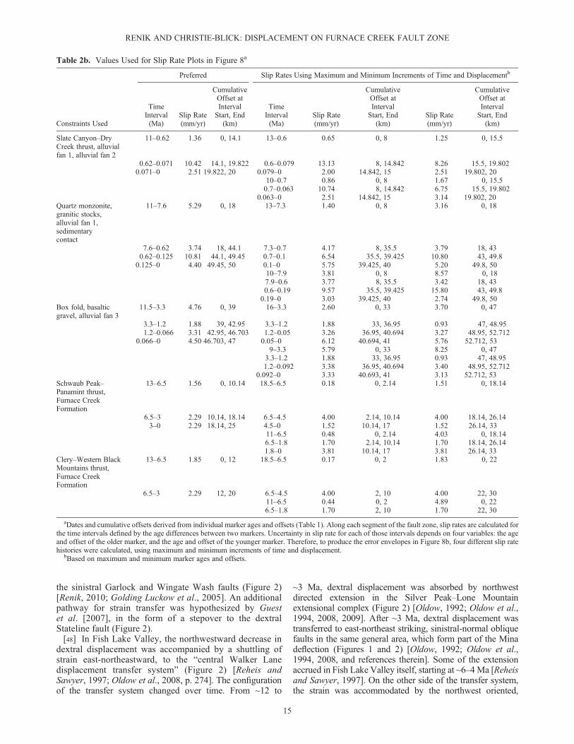
Table 2b. Values Used for Slip Rate Plots in Figure 8a
Constraints Used
Preferred Slip Rates Using Maximum and Minimum Increments of Time and Displacementb
TimeInterval(Ma)
Slip Rate(mm/yr)
CumulativeOffset atIntervalStart, End
(km)
TimeInterval(Ma)
Slip Rate(mm/yr)
CumulativeOffset atIntervalStart, End
(km)Slip Rate(mm/yr)
CumulativeOffset atIntervalStart, End
(km)
Slate Canyon–DryCreek thrust, alluvialfan 1, alluvial fan 2
11–0.62 1.36 0, 14.1 13–0.6 0.65 0, 8 1.25 0, 15.5
0.62–0.071 10.42 14.1, 19.822 0.6–0.079 13.13 8, 14.842 8.26 15.5, 19.8020.071–0 2.51 19.822, 20 0.079–0 2.00 14.842, 15 2.51 19.802, 20
10–0.7 0.86 0, 8 1.67 0, 15.50.7–0.063 10.74 8, 14.842 6.75 15.5, 19.802
0.063–0 2.51 14.842, 15 3.14 19.802, 20Quartz monzonite,granitic stocks,alluvial fan 1,sedimentarycontact
11–7.6 5.29 0, 18 13–7.3 1.40 0, 8 3.16 0, 18
7.6–0.62 3.74 18, 44.1 7.3–0.7 4.17 8, 35.5 3.79 18, 430.62–0.125 10.81 44.1, 49.45 0.7–0.1 6.54 35.5, 39.425 10.80 43, 49.8
0.125–0 4.40 49.45, 50 0.1–0 5.75 39.425, 40 5.20 49.8, 5010–7.9 3.81 0, 8 8.57 0, 187.9–0.6 3.77 8, 35.5 3.42 18, 430.6–0.19 9.57 35.5, 39.425 15.80 43, 49.8
0.19–0 3.03 39.425, 40 2.74 49.8, 50Box fold, basalticgravel, alluvial fan 3
11.5–3.3 4.76 0, 39 16–3.3 2.60 0, 33 3.70 0, 47
3.3–1.2 1.88 39, 42.95 3.3–1.2 1.88 33, 36.95 0.93 47, 48.951.2–0.066 3.31 42.95, 46.703 1.2–0.05 3.26 36.95, 40.694 3.27 48.95, 52.712
0.066–0 4.50 46.703, 47 0.05–0 6.12 40.694, 41 5.76 52.712, 539–3.3 5.79 0, 33 8.25 0, 47
3.3–1.2 1.88 33, 36.95 0.93 47, 48.951.2–0.092 3.38 36.95, 40.694 3.40 48.95, 52.712
0.092–0 3.33 40.693, 41 3.13 52.712, 53Schwaub Peak–Panamint thrust,Furnace CreekFormation
13–6.5 1.56 0, 10.14 18.5–6.5 0.18 0, 2.14 1.51 0, 18.14
6.5–3 2.29 10.14, 18.14 6.5–4.5 4.00 2.14, 10.14 4.00 18.14, 26.143–0 2.29 18.14, 25 4.5–0 1.52 10.14, 17 1.52 26.14, 33
11–6.5 0.48 0, 2.14 4.03 0, 18.146.5–1.8 1.70 2.14, 10.14 1.70 18.14, 26.141.8–0 3.81 10.14, 17 3.81 26.14, 33
Clery–Western BlackMountains thrust,Furnace CreekFormation
13–6.5 1.85 0, 12 18.5–6.5 0.17 0, 2 1.83 0, 22
6.5–3 2.29 12, 20 6.5–4.5 4.00 2, 10 4.00 22, 3011–6.5 0.44 0, 2 4.89 0, 226.5–1.8 1.70 2, 10 1.70 22, 30
aDates and cumulative offsets derived from individual marker ages and offsets (Table 1). Along each segment of the fault zone, slip rates are calculated forthe time intervals defined by the age differences between two markers. Uncertainty in slip rate for each of those intervals depends on four variables: the ageand offset of the older marker, and the age and offset of the younger marker. Therefore, to produce the error envelopes in Figure 8b, four different slip ratehistories were calculated, using maximum and minimum increments of time and displacement.
bBased on maximum and minimum marker ages and offsets.
RENIK AND CHRISTIE-BLICK: DISPLACEMENT ON FURNACE CREEK FAULT ZONE
15

predominantly dextral Walker Lane (Figure 1) [Oldow et al.,2008, and references therein].
7. Implications for Displacement Between theCottonwood Mountains and Resting Spring–NopahRange
7.1. Magnitude and Direction
[49] We interpret tectonic transport of ~68� 14 km oriented~ N58� � 6�W between the Cottonwood Mountains and theResting Spring and Nopah ranges, with displacement since~15 Ma totaling ~60 � 14 km oriented ~N57� � 6�W. Thesefigures sum displacements between the Cottonwood andPanamint Mountains and between the Panamint Mountainsand Resting Spring–Nopah Range block.[50] Our Cottonwood-Panamint estimate, ~8.4–16 km in
the direction ~N65�W, is based on Neogene markers andcontractile structures [Andrew and Walker, 2009]. Volcanicand sedimentary deposits indicate 8.4 km of displacement,oriented N65�W, since ~15 Ma [Andrew and Walker,2009]. Earlier displacement is limited by (1) the mismatchbetween the Panamint and White Top anticlines (section 3.5)and (2) the lack of an alternative Cottonwood Mountainscorrelate to the Panamint anticline, as well as the lack ofan alternative Panamint Mountains correlate to the WhiteTop anticline. Thus, total displacement between the ranges
is less than the separation of the anticlines, 22 � 3 kmdirected N45�W [e.g., Wernicke et al., 1988a, and referencestherein; McQuarrie and Wernicke, 2005]. By the samereasoning, a stricter limit of ~16 km total displacement isset by noncorrelation of the Lemoigne and Panamint thrusts(section 3.5).[51] Our estimate between the Panamint Mountains and
Resting Spring–Nopah Range block, ~52 � 14 km orientedN56� � 7�W, implies that the area widened by a stretch of~2.5� 0.5. The area of interest and the azimuth of displacementare shown by the double-headed arrow in Figure 9A. Theazimuth reflects kinematic indicators in the northernBlack Mountains [Miller, 1991] and the approximateaverage strike of the Furnace Creek fault zone in this area.The widening of the area between the Panamint Mountainsand Resting Spring–Nopah Range block can be viewed asthe map view widening of two thrust plates. The Chicago Passthrust plate (purple in Figure 9B) is exposed discontinuouslybetween the Nopah Range and the Western Black Mountainsthrust (CP, WBM in Figure 3). (Note that the Nopah Rangeand Resting Spring Range actually expose a thrust stack.Local complexities notwithstanding, we follow Snow andWernicke [2000] in interpreting the major structure asthe Chicago Pass thrust system.) Outcrops of the WesternBlack Mountains thrust plate (red in Figure 9B) are, inturn, bounded to the west by the Panamint thrust (P-sin Figure 3). Thus, to estimate the displacement between
Figure 8. Zones of maximum extension differential (approximate) and maximum dextral offset (as con-strained by available markers). See text for details. The two zones overlap only partially, indicating thatthe Furnace Creek fault zone is not just a lateral ramp in the normal fault systems.
RENIK AND CHRISTIE-BLICK: DISPLACEMENT ON FURNACE CREEK FAULT ZONE
16

the Panamint Mountains and the Resting Spring–NopahRange block, we calculated the original widths of thetwo thrust plates (Figure 9C), and subtracted this fromthe present-day width in map view. This approach isjustified because each thrust plate is exposed across its
full width within a single range block along strike tothe northeast.[52] The along-strike equivalent to the Western Black
Mountains thrust plate is the Clery thrust plate in southernFuneral Mountains (Figures 1 and 9D), bounded by the
Figure 9. Distances used in calculating displacement between range blocks. (A) Area of displacementcalculation. Double-headed arrow shows azimuth of widening (N56�W) between endpoints in Panamintand Nopah–Resting Spring blocks (ranges labeled in Figure 1). Thrust fault abbreviations follow Figure 3.(B) Thrust plates in area of interest, on either side of Furnace Creek fault zone. Chicago Pass plate shownin purple. Western Black Mountains and Clery plates (correlative) shown in red. (C) Displacement betweenPanamint Mountains and Nopah–Resting Spring Range is ~52 km, equal to the present-day width ofthe thrust plates (86 km) minus their original width (~34 km). (D and E) Details of calculation. See text foradditional information.
RENIK AND CHRISTIE-BLICK: DISPLACEMENT ON FURNACE CREEK FAULT ZONE
17

Clery and Schwaub Peak thrusts (C, SP in Figure 3). Thisthrust plate is now ~19 km wide (Figure 9D). Restorationof minor normal faulting within the Funeral Mountainsindicates that the thrust plate has widened by a stretch of~1.15 � 0.05 [Prave and Wright, 1986a], implying anoriginal width of ~17 km. The Western Black Mountainsthrust plate has now both widened and moved northwestwardfrom its original continuity with the Clery thrust plate, sothat the total displacement between the Panamint andsouthern Funeral Mountains is ~27 km (Figure 9D).[53] The along-strike equivalent to the Chicago Pass thrust
plate is the Wheeler Pass thrust plate in the Spring Mountains(Figures 1 and 9E). This is based on correlation between theChicago Pass and Wheeler Pass thrusts (CP, WhP inFigure 9A) [Snow and Wernicke, 2000], and between theClery and Kwichup Spring thrusts (C, KS in Figure 9A)[Snow and Wernicke, 2000]. Tilt correcting the essentiallyunextended Spring Mountains implies a width of ~17 kmfor the Wheeler Pass thrust plate [Snow and Wernicke,2000]. Restoring the now ~42 km wide Chicago Pass plateto the same, ~17 km width produces a displacement estimateof ~25 km (Figure 9E). So the total displacement be-tween the Panamint Mountains and the Resting Spring–Nopah Range block is the sum of ~27 km (Figure 9D) and~25 km (Figure 9E), or ~52 km (Figure 9C).[54] We estimate an uncertainty in magnitude of � ~14 km
and in orientation of � ~7�, on the basis of several consid-erations. Limited outcrop and low dips complicate theattempt to measure thrust plate widths between thePanamint, Black, and Resting Spring–Nopah range blockstoday. The original widths are likely to have varied by anuncertain amount both along strike and down dip. Theamount and direction of displacement probably variedsomewhat even within the study area. There is evidencefor vertical axis rotation in the Black Mountains [Holmet al., 1993; Petronis et al., 2002], but the effect on thekinematic indicators is unclear because the dimensions ofrotated blocks are difficult to assess.[55] The ~52 � 14 km of total displacement between the
Panamint Mountains and Resting Spring–Nopah Rangeblock sets an upper limit on the magnitude of extensionbetween them. It is probably an overestimate, however. Partof the separation between the ranges has arisen because theResting Spring and Nopah ranges are located past the tip ofa major strike-slip fault and the Panamint Mountains blockwas translated along that fault. The extension between theranges could equal the full displacement between them onlyif offset on the Furnace Creek fault represented no morethan an extension differential, which does not appear to bethe case (section 6).[56] At the other extreme, if the Furnace Creek fault zone
were purely an expression of plate boundary dextral shearsuperimposed on an extending region, extension would bethe full displacement between the ranges (~52 � 14 km)minus the strike-slip transport of the Panamint Mountains(~25 � 8 km): ~27 � 22 km. Even this is not the absoluteminimum, because a poorly quantified component ofstrike slip between the Panamint Mountains and RestingSpring–Nopah Range block is accommodated by the GrandView fault, by oblique faults in the Furnace Creek horsetailsplay, and by other unnamed faults [Burchfiel et al., 1983;Wright and Troxel, 1999].
7.2. Partitioning of Displacement Between the DeathValley–Furnace Creek Wash and Amargosa ValleyAreas
[57] The displacement of ~52 km between the PanamintMountains and Resting Spring–Nopah Range block ispartitioned rather evenly between the Death Valley–FurnaceCreek Wash area and the Amargosa Valley, at ~27 km and~25 km, respectively. The Death Valley–Furnace CreekWash area is spanned almost exactly by the Clery andWestern Black Mountains thrust plates (Figure 9D), now~44 km but originally ~17 km, implying ~27 km ofdisplacement. This leaves ~25 km of displacement to beaccommodated across the Amargosa Valley.[58] The estimate of ~27 km in the Death Valley–Furnace
Creek Wash area is supported by other evidence for thepaleoposition of the Panamint Mountains either adjacentto the Black Mountains or minimally overlapping them.(1) Essentially unmetamorphosed Proterozoic-Paleozoicstrata are exposed intermittently in the north, central, andsouthern Black Mountains, and although the preservedrecord is fragmentary and brittlely deformed, it is in manyplaces demonstrably autochthonous [e.g., Wright andTroxel, 1984; Prave and Wright, 1986a, 1986b; Topping,1993; Miller and Prave, 2002; Miller and Pavlis, 2005],(2) the Black Mountains show no roots of Mesozoicplutonic rocks found in the Panamint and CottonwoodMountains [e.g.,Miller and Prave, 2002;Miller and Pavlis,2005], and (3) Pre-Cenozoic cooling ages from midcrustalrocks exposed along the central Black Mountains front[Holm et al., 1992; Meurer, 1992; T. L. Pavlis as cited byHolm et al., 1994] indicate minimal overburden at the onsetof Miocene extension, although the hypothesis that the rockis allochthonous is a potential alternative [Holm andWernicke,1990; Holm et al., 1992; Holm and Dokka, 1993; cf. Meurer,1992; T. L. Pavlis as cited byHolm et al., 1994; Renik, 2010].
7.3. Comparison With Previous Interpretations
[59] Our displacement estimates of ~52 � 14 km betweenthe Resting Spring–Nopah Range block and PanamintMountains and ~27 km in the Death Valley–Furnace CreekWash area are compatible with some previous reconstructions[e.g., Labotka and Albee, 1988] (and lower estimates ofMcKenna and Hodges [1990], Wright et al. [1991], Serpaand Pavlis [1996], Wright and Troxel [1999], Miller[2002], and Miller and Pavlis [2005]) but are substantiallyless than indicated in others [e.g., Stewart, 1983, 1986;Wernicke et al., 1988a; Topping, 1993; Snow and Wernicke,2000; Niemi et al., 2001; McQuarrie and Wernicke, 2005;Fridrich and Thompson, 2011; Norton, 2011]. The latter werebased on three general lines of evidence: (1) correlation ofpre-Cenozoic structural and stratigraphic markers, particularlythe Panamint and Chicago Pass thrusts; (2) interpretationof the scarcity of Mesoproterozoic-Paleozoic sedimentarycover in the Black Mountains to indicate preextensionalburial beneath the Panamints; and (3) reconstruction ofNeogene depositional systems. The pre-Cenozoic markers,both structural and stratigraphic, are discussed in section3, with the exception of correlations between the ButteValley thrust (BV in Figure 3) and the Winters Passthrust [Snow and Wernicke, 2000] or the Chicago Passthrust [Serpa and Pavlis, 1996]. Because the Butte Valley
RENIK AND CHRISTIE-BLICK: DISPLACEMENT ON FURNACE CREEK FAULT ZONE
18

thrust is substantially south of the Furnace Creek fault zone,however, greater displacement at that latitude could potentiallybe accommodated by vertical axis rotations and/or theMiocene-Pliocene Sheephead fault zone (Figure 2) [Renik,2010]. Right-lateral displacement along the Sheephead faultzone, which totals as much as ~18.5 � 8.5 km [Renik,2010], could help to account for a displacement differentialbetween the southern Death Valley area (where the ButteValley thrust is located) and the central and northern DeathValley areas (where the Furnace Creek fault zone is located).Another possible solution – the most parsimonious explana-tion – is for the Butte Valley and correlate(s) to haveoriginated in a configuration such as a relay, implying theywere kinematically related but not immediately adjacent.[60] Our reconstruction permits substantial tectonic
denudation of the Black Mountains without requiringcomplete restoration of the Panamint terrane atop them.We view the paucity of pre-Cenozoic outcrop to reflect acombination of faulting, erosion, and burial by abundantCenozoic sedimentary and volcanic rocks. Various indicatorssuggest substantial preextensional erosion [Prave and Wright,1986a, 1986b]. Miocene strata lie in depositional contactwith Cambrian strata at Eagle Mountain (EM in Figure 1)[Renik et al., 2008] and the southern Panamint Mountains(Figure 1) [Golding Luckow et al., 2005], and with Neopro-terozoic strata in the Black Mountains near the Sheepheadfault zone (Figures 1 and 2) [Renik, 2010]. Pre-Cenozoiccooling ages from several broadly denuded areas in thesoutheastern Black Mountains [Holm et al., 1992; Holm andDokka, 1993] suggest that a scarcity of sedimentary rockdoes not require predominantly extensional exhumation.[61] Miocene strata in the southern Black Mountains
and Amargosa Valley suggest greater displacement thanwe interpret, but they are reconcilable with our results.Inferred alluvial fan and rock avalanche deposits there,thought to have been sourced in the Panamint Mountainsand Kingston Range (Figure 1), have been used to reconstructa distance of 15–20 km between the ranges until 7.8 Maand a displacement of 75 km thereafter [Topping, 1993](summarized more generally by Fridrich and Thompson[2011]). However, the inferred source areas are not necessarilyunique, and one alternative potential source is the southernBlack Mountains (Figure 1) [e.g., Snow and Wernicke,2000]. Some of the discrepancy may relate to vertical axisrotation and/or displacement along the Sheephead faultzone, as described above.[62] A reevaluation of the ~15–11 Ma Eagle Mountain
Formation, which is exposed in Furnace Creek Wash, atEagle Mountain, and on the east flank of the Resting Spring
Range, substantially reduces the significance of these rocksfor palinspastic reconstruction [Renik et al., 2008]. Clastsfrom the Hunter Mountain batholith in the CottonwoodMountains (Figure 1) that were originally interpreted tohave accumulated at an alluvial fan, and imply that theCottonwood Mountains were no more than 10–20 kmfrom the Resting Spring Range until after ~11 Ma [Niemiet al., 2001], are now interpreted to have been transportedand deposited in a river system [Renik et al., 2008]. Takentogether, structural and stratigraphic evidence suggests thatthe terrane immediately south of the southeastern FurnaceCreek fault zone widened by a stretch of ~2.5, rather thana stretch as high as ~4–5 [Snow and Wernicke, 2000; Niemiet al., 2001; McQuarrie and Wernicke, 2005].
7.4. Implications for the Eastern California Shear Zone
[63] Our new estimates of displacement along the FurnaceCreek fault zone and between the Panamint Mountainsand Resting Spring–Nopah Range block offer a way tomitigate the ~33 � 16 km discrepancy in the ~12–0 Mastrain budget of the Eastern California Shear Zone. Theinconsistency has been hypothesized to derive in part fromunderestimation of displacement in the Mojave, becausethe inferred displacement there does not include diffuselydistributed deformation [McQuarrie and Wernicke, 2005].We suggest instead that the previously inferred displacementin the western Basin and Range was too high by ~26 � 17 km(Table 3). The Basin and Range estimate of ~100 � 10 kmoriented N25�W [McQuarrie and Wernicke, 2005] wasbased upon offsets across central and northern DeathValley. A direct input to the calculation of cumulativedisplacement in that reconstruction is the Eagle MountainFormation [McQuarrie and Wernicke, 2005, Figure 4 andTable 2]. It is interpreted to indicate displacement of104 � 7 km in the direction N67�W, implying a N25�Wcomponent of 77 � 5 km (Table 3), between the CottonwoodMountains and eastern Resting Spring Range. We estimatea N 25�W displacement component of ~51 � 12 kmbetween the Cottonwood Mountains and Resting Spring–Nopah Range block. (Only a very small fraction of thisdisplacement is likely to have occurred before 12 Ma, giventhe timing of motion on the Furnace Creek fault zone;see section 4.) This implies a reduction in the previouslycalculated value of ~26� 17 km. Replacing 77� 5 km with~51 � 12 km in the summed Eastern California Shear Zonedisplacement in the western Basin and Range yields a newestimate of ~74 � 17 km (instead of ~100 � 10 km). Thisis within error of the estimate in the Mojave, 67 � 6 km[Lease et al., 2009]. Resolving the discrepancy between
Table 3. Estimates of Displacement Between Cottonwood Mountains and Resting Spring–Nopah Range
Ranges Marker Total Displacement (km) Azimuth
Difference inAzimuth FromN25�W (deg)
ResolvedDisplacement
Toward335�a (km)
Cottonwood, Panamint Volcanic and sedimentary deposits[Andrew and Walker, 2009]
8.4 N65�W 40 6
Panamint, Resting Spring–Nopah Thrust plates (this paper, Figure 8) 52 � 14 N56� � 7�W 31 � 7 45 � 12Cottonwood, Resting Spring–Nopah Above markers 51 � 12Cottonwood, Resting Spring Eagle Mountain Formation
[Niemi et al., 2001]104 � 7 N67�W 42 77 � 5
aResolved displacement calculated as (total displacement) � cos(difference in azimuth).
RENIK AND CHRISTIE-BLICK: DISPLACEMENT ON FURNACE CREEK FAULT ZONE
19

the two regions is critical to the concept of the EasternCalifornia Shear Zone. Dokka and Travis [1990a, p. 333],who coined the term, explained that the “inference of aregional zone of right shear that includes the Death Valleyregion and the south central and eastern part of the MojaveDesert Block is based on the observation that both areasdisplay similar amounts of late Cenozoic right slip.”
8. Conclusions
[64] A review of markers along the Furnace Creek faultzone leads to a new hypothesis for the distribution of dextraldisplacement along strike and over time (Figure 7). Thefirst-order pattern involves an increase of total offset fromthe fault tips to a maximum of ~50 km in northern DeathValley and southern Fish Lake Valley, and accruing at ratesof between 3 and 5 mm/yr, mainly since late middleMiocene time. Full displacement is best constrained by fivepre-Cenozoic markers: the Slate Canyon–Dry Creek thrust,the quartz monzonite of Beer Creek, the White Top–MarbleCanyon box fold, the Schwaub Peak–Panamint thrust, andthe Clery–Western Black Mountains thrust. The estimatesof magnitude and timing of strike slip, the interpretationsof various markers, and the inferences about the relationshipbetween strike slip and extension in the region presented inthis paper have implications for palinspastic reconstructionin the Death Valley region and displacement budgets inthe Eastern California Shear Zone:
1. We estimate ~68 � 14 km of displacement, oriented N~58 � 6�W, between the Cottonwood Mountains andthe Resting Spring–Nopah Range, with displacementsince ~15 Ma totaling ~60 � 14 km oriented N ~57 �6�W. This includes transport of ~8.4–16 km directed~N65�W between the Cottonwood and Panamint Moun-tains and ~52 � 14 km oriented N56� � 7�W betweenthe Panamint Mountains and the Resting Spring–NopahRange block. The latter is relatively evenly partitionedbetween the Death Valley–Furnace Creek Wash areaand the Amargosa Valley area. Our results suggest thatthe previous interpretation of ~104 � 7 km for displace-ment between the Cottonwood Mountains and RestingSpring–Nopah Range block is an overestimate by a factorof ~50%.
2. Post-12 Ma displacement oriented N25�W in the EasternCalifornia Shear Zone north of the Garlock fault appearsto be lower than previously thought, at ~74 � 17 km, andwithin error of the estimate in the Mojave, 67 � 6 km.
[65] Acknowledgments. Sources of support for this research include aNational Science Foundation Graduate Research Fellowship (to B.R.) andthe Donors of the American Chemical Society Petroleum Research Fund(PRF 46983-AC8). We thank Mark Anders, Nadine McQuarrie, DonnaShillington, Marli Miller, Jessica Czajkowski, Ralph Klinger, Terry Pavlis,Lauren Wright, Bennie Troxel, Doug Walker, and Chris Johnson for discus-sions; Terry Pavlis, Doug Walker, and two anonymous reviewers for helpfulcomments on the manuscript; Darrel Cowan, Marli Miller, Terry Pavlis, andLaura Serpa for use of the SHEAR facility in Shoshone, California; andRafael Almeida for field assistance. Lamont-Doherty Earth Observatorycontribution 7635.
ReferencesAndrew, J. E., and J. D. Walker (2009), Reconstructing late Cenozoicdeformation in central Panamint Valley, California: Evolution of slippartitioning in the Walker Lane, Geosphere, 5, 172–198.
Applegate, J. D. R. (1994), The unroofing history of the Funeral Mountainsmetamorphic core complex, California, PhD thesis, 240 pp., Mass. Inst. ofTechnol., Cambridge.
Applegate, J. D. R., and K. V. Hodges (1993), Episodic unroofing of theFuneral Mountains metamorphic core complex, Death Valley, California,Geol. Soc. Am. Abstr. Programs, 25, 411–412.
Applegate, J. D. R., and K. V. Hodges (1995), Mesozoic and Cenozoicextension recorded by metamorphic rocks in the Funeral Mountains,California, Geol. Soc. Am. Bull., 107, 1063–1076.
Applegate, J. D. R., J. D. Walker, and K. V. Hodges (1992), LateCretaceous extensional unroofing in the Funeral Mountains metamorphiccore complex, California, Geology, 20, 519–522.
Atwater, T., and J. Stock (1998), Pacific-North America plate tectonics ofthe Neogene southwestern United States: An update, Int. Geol. Rev., 40,375–402.
Bartley, J. M., A. F. Glazner, D. S. Coleman, A. Kylander-Clark, R. Mapes,and A. M. Friedrich (2007), Large Laramide dextral offset across OwensValley, California, and its possible relation to tectonic unroofing of thesouthern Sierra Nevada, in Exhumation Associated With ContinentalStrike-Slip Fault Systems, edited by A. B. Till et al., Spec. Pap. Geol.Soc. Am., 434, 129–148.
Bennett, R. A., B. P. Wernicke, N. A. Niemi, A. M. Friedrich, andJ. L. Davis (2003), Contemporary strain rates in the northern Basin andRange province from GPS data, Tectonics, 22(2), 1008, doi:10.1029/2001TC001355.
Blair, T. C., and R. G. Raynolds (1999), Sedimentology and tectonicimplications of the Neogene synrift Hole in the Wall and Wall Frontmembers, Furnace Creek basin, Death Valley, California, in CenozoicBasins of the Death Valley Region, edited by L. A.Wright and B.W. Troxel,Spec. Pap. Geol. Soc. Am., 333, 127–168.
Brady, R. H., III, and B. W. Troxel (1999), The Miocene Military CanyonFormation: Depocenter evolution and constraints on lateral faulting,southern Death Valley, California, in Cenozoic Basins of the DeathValley Region, edited by L. A. Wright and B. W. Troxel, Spec. Pap.Geol. Soc. Am., 333, 277–288.
Buckley, C. P. (1971), The structural position and stratigraphy of thePalmetto complex in the northern Silver Peak Mountains, Nevada, PhDthesis, 66 pp., Rice Univ., Houston, Tex.
Burchfiel, B. C., P. J. Pelton, and J. Sutter (1970), An early Mesozoicdeformation belt in south-central Nevada-southeastern California, Geol.Soc. Am. Bull., 81, 211–215.
Burchfiel, B. C., G. S. Hamill IV, and D. E. Wilhelms (1983), Structuralgeology of the Montgomery Mountains and the northern half of theNopah and Resting Spring ranges, Nevada and California, Geol. Soc.Am. Bull., 94, 1359–1376.
Burchfiel, B. C., D. S. Cowan, and G. A. Davis (1992), Tectonic overviewof the Cordilleran orogen in the western United States, in The Geologyof North America, vol. G-3, The Cordilleran Orogen: Conterminous U.S., edited by B. C. Burchfiel, P. W. Lipman, and M. L. Zoback, pp.407–479, Geol. Soc. of Am., Boulder, Colo.
Çemen, I., and W. Baucke (2005), Magnitude of strike-slip displacementalong the southern Death Valley-Furnace Creek fault zone, Death Valley,California, Geol. Soc. Am. Abstr. Programs, 37, 275.
Çemen, I., and L. A. Wright (1990), Effect of Cenozoic extension onMesozoic thrust surfaces in the central and southern Funeral Mountains,Death Valley, California, in Basin and Range Extensional Tectonics Nearthe Latitude of Las Vegas, Nevada, edited by B.P. Wernicke, Mem. Geol.Soc. Am., 176, 305–316.
Çemen, I., L. A. Wright, R. E. Drake, and F. C. Johnson (1985), Cenozoicsedimentation and sequence of deformational events at the southeasternend of the Furnace Creek strike-slip fault zone, Death Valley region,California, in Strike-Slip Deformation, Basin Formation, and Sedimentation,edited by K. T. Biddle and N. Christie-Blick, Spec. Publ. SEPM, 37,127–141.
Çemen, I., L. A. Wright, and A. R. Prave (1999), Stratigraphic and tectonicimplications of the latest Oligocene and early Miocene sedimentarysuccession, southernmost Funeral Mountains, Death Valley region,California, in Cenozoic Basins of the Death Valley Region, editedby L. A. Wright and B. W. Troxel, Spec. Pap. Geol. Soc. Am., 333,65–86.
Christie-Blick, N., and K. T. Biddle (1985), Deformation and basin forma-tion along strike-slip faults, in Strike-Slip Deformation, Basin Formation,and Sedimentation, edited by K. T. Biddle and N. Christie-Blick, Spec.Publ. SEPM, 37, 1–34.
Christie-Blick, N., and M. Levy (1989), Stratigraphic and tectonic frame-work of Upper Proterozoic and Cambrian rocks in the western UnitedStates, in Late Proterozoic and Cambrian Tectonics, Sedimentation,and Record of Metazoan Radiation in the Western United States, Int.Geol. Congr. Field Trip Guideb., vol. T331, edited by N. Christie-Blickand M. Levy, pp. 7–22, AGU, Washington, D. C.
RENIK AND CHRISTIE-BLICK: DISPLACEMENT ON FURNACE CREEK FAULT ZONE
20

Crowder, D. F., P. F. Robinson, and D. L. Harris (1972), Geologic map ofthe Benton Quadrangle, Mono County, California and Esmeralda andMineral Counties, Nevada, U.S. Geol. Surv. Geol. Quadrangle Map,GQ-1013.
Czajkowski, J. (2002), Cretaceous contraction in the Lees Camp Anticline:Inyo Mine and vicinity, Funeral Mountains, Death Valley, California, MSthesis, 73 pp., Univ. of Oreg., Eugene.
Czajkowski, J. L., and M. G. Miller (2001), Cretaceous contraction in theLees Camp Anticline: Inyo Mine and vicinity, Funeral Mountains, DeathValley, California, Geol. Soc. Am. Abstr. Programs, 33, 151.
dePolo, C. M. (1989), Seismotectonics of the White Mountains fault system,east-central California and west-central Nevada, MS thesis, 354 pp.,Univ. of Nev., Reno.
DeWitt, E., R. L. Armstrong, J. F. Sutter, and R. E. Zartman (1984), U-Th-Pb,Rb-Sr, and Ar-Ar mineral and whole-rock isotopic systematics in ametamorphosed granitic terrane, southeastern California, Geol. Soc.Am. Bull., 95, 723–739.
Diamond, D. S., and R. V. Ingersoll (2002), Structural and sedimentologicevolution of a Miocene supradetachment basin, Silver Peak Range andadjacent areas, west-central Nevada, Int. Geol. Rev., 44, 588–623.
Dokka, R. K., and C. J. Travis (1990a), Late Cenozoic strike-slip faulting inthe Mojave Desert, California, Tectonics, 9, 311–340.
Dokka, R. K., and C. J. Travis (1990b), Role of the Eastern California ShearZone in accommodating Pacific-North American plate motion, Geophys.Res. Lett., 17, 1323–1326.
Doubrovine, P. V., and J. A. Tarduno (2008), A revised kinematic model forthe relative motion between Pacific oceanic plates and North Americasince the Late Cretaceous, J. Geophys. Res., 113, B12101, doi:10.1029/2008JB005585.
Dunne, G. C. (1986), Geologic evolution of the southern Inyo Range,Darwin Plateau, and Argus and Slate ranges, east-central California—An overview, in Mesozoic and Cenozoic Structural Evolution of SelectedAreas, East-Central California: Guidebook and Volume, Trips 2 and 14,edited by G. C. Dunne, pp. 3–21, Geol. Soc. of Am., Cordilleran Sect.,Los Angeles, Calif.
Faulds, J. E., and C. D. Henry (2008), Tectonic influences on the spatialand temporal evolution of the Walker Lane: An incipient transform faultalong the evolving Pacific – North American plate boundary, in Oresand Orogenesis: Circum-Pacific Tectonics, Geologic Evolution, and OreDeposits, edited by J. E. Spencer and S. R. Titley, Ariz. Geol. Soc.Dig., 22, 437–470.
Frankel, K. L., K. S. Brantley, J. F. Dolan, R. C. Finkel, R. E. Klinger,J. R. Knott, M. N. Machette, L. A. Owen, F. M. Phillips, J. L. Slate,and B. P. Wernicke (2007), Cosmogenic 10Be and 36Cl geochronologyof offset alluvial fans along the northern Death Valley fault zone:Implications for transient strain in the eastern California shear zone,J. Geophys. Res., 112, B06407, doi:10.1029/2006JB004350.
Frankel, K. L., J. F. Dolan, R. C. Finkel, L. A. Owen, and J. S. Hoeft (2007),Spatial variations in slip rate along the Death Valley–Fish Lake Valleyfault system determined from LiDAR topographic data and cosmogenic10Be geochronology, Geophys. Res. Lett., 34, L18303, doi:10.1029/2007GL030549.
Frankel, K. L., et al. (2008), Active tectonics of the Eastern California shearzone, in Field Guide to Plutons, Volcanoes, Faults, Reefs, Dinosaurs, andPossible Glaciation in Selected Areas of Arizona, California, and Nevada,Field Guide, vol. 11, edited by E. M. Duebendorfer and E. I. Smith, pp.43–81, Geol. Soc. of Am., Boulder.
Fridrich, C. (1999), Architecture and Miocene evolution of the NortheastDeath Valley detachment fault system, Nevada and California, inProceedings of Conference on Status of Geologic Research and Mapping,Death Valley National Park, edited by J. L. Slate, U.S. Geol. Surv. OpenFile Rep., 99-0153, 20–27.
Fridrich, C. J., and R. A. Thompson (2011), Cenozoic tectonic reorganizationsof the Death Valley region, southeast California and southwest Nevada,U.S. Geol. Surv. Prof. Pap., 1783, 36 pp.
Gillespie, A. R. (1991), Quaternary subsidence of Owens Valley, California,in Natural history of Eastern California and High-AltitudeResearch, White Mt. Res. Stn. Symp., vol. 3, edited by C. A. Hall, Jr.,V. Doyle-Jones, and B. Widawski, pp. 365–382, White Mt. Res. Stn.,Nederland, Colo.
Golding Luckow, H., T. L. Pavlis, L. F. Serpa, B. Guest, D. L. Wagner,L. Snee, T. M. Hensley, and A. Korjenkov (2005), Late Cenozoicsedimentation and volcanism during transtensional deformation inWingate Wash and the Owlshead Mountains, Death Valley, Earth Sci.Rev., 73, 177–219.
Guest, B., N. Niemi, and B. Wernicke (2007), Stateline fault system: A newcomponent of the Miocene-Quaternary Eastern California shear zone,Geol. Soc. Am. Bull., 119, 1337–1346.
Hall, W. E. (1971), Geology of the Panamint Butte quadrangle, InyoCounty, California, U.S. Geol. Surv. Bull., 1299, 67 pp.
Hall, W. E., and H. G. Stephens (1962), Preliminary geologic map of thePanamint Butte Quadrangle, Inyo County, California, U.S. Geol. Surv.Miner. Invest. Field Stud. Map, MF-251.
Hamilton, W. B. (1988), Detachment faulting in the Death Valley region,California and Nevada, in Geologic and hydrologic investigations of apotential nuclear waste disposal site at Yucca Mountain, southernNevada, edited by M. D. Carr and J. C. Yount, U.S. Geol. Surv. Bull.,1790, 51–85.
Hodges, K. V., and J. D. Walker (1990), Petrologic constraints on theunroofing history of the Funeral Mountain metamorphic core complex,California, J. Geophys. Res., 95, 8437–8445.
Hodges, K. V., B. P. Wernicke, and J. D. Walker (1989), Day 6: MiddleMiocene(?) through Quaternary extension, northern Panamint Mountainsarea, California, in Extensional Tectonics in the Basin and Range Prov-ince Between the Southern Sierra Nevada and the Colorado Plateau, Int.Geol. Congr. Field Trip Guideb., vol. T138, edited by B. P. Wernickeet al., pp. 45–55, AGU, Washington, D. C.
Hodges, K. V., L. W. McKenna, and M. B. Harding (1990), Structuralunroofing of the central Panamint Mountains, Death Valley region,southeastern California, in Basin and Range Extensional Tectonics nearthe Latitude of Las Vegas, Nevada, edited by B. P. Wernicke,Mem. Geol.Soc. Am., 176, 377–390.
Hoisch, T. D., and C. Simpson (1993), Rise and tilt of metamorphic rocks inthe lower plate of a detachment fault in the Funeral Mountains, DeathValley, California, J. Geophys. Res., 98, 6805–6827.
Holm, D. K. (1992), Structural, thermal, and paleomagnetic constraints onthe tectonic evolution of the Black Mountains crystalline terrane, DeathValley region, California, and implications for extensional tectonism,PhD thesis, 237 pp., Harvard Univ., Cambridge, Mass.
Holm, D. K., and R. K. Dokka (1993), Interpretation and tectonicimplications of cooling histories: An example from the Black Mountains,Death Valley extended terrane, California, Earth Planet. Sci. Lett., 116,63–80.
Holm, D. K., and B. Wernicke (1990), Black Mountains crustal section,Death Valley extended terrain, California, Geology, 18, 520–523.
Holm, D. K., J. K. Snow, and D. R. Lux (1992), Thermal and barometricconstraints on the intrusive and unroofing history of the Black Mountains:Implications for timing, initial dip, and kinematics of detachment faultingin the Death Valley region, California, Tectonics, 11, 507–522.
Holm, D. K., J. W. Geissman, and B. Wernicke (1993), Tilt and rotation ofthe footwall of a major normal fault system: Paleomagnetism of the BlackMountains, Death Valley extended terrane, California, Geol. Soc. Am.Bull., 105, 1373–1387.
Holm, D. K., T. L. Pavlis, and D. J. Topping (1994), Black Mountainscrustal section, Death Valley region, California, in Geological Investiga-tions of an Active Margin, edited by S. F. McGill and T. M. Ross, pp.31–54, Geol. Soc. of Am., Cordilleran Sect., Redlands, Calif..
Klinger, R. E. (2001), Late Quaternary volcanism of Ubehebe Crater,in Quaternary and Late Pliocene Geology of the Death Valley Region:Recent Observations on Tectonics, Stratigraphy, and Lake Cycles(Guidebook for the 2001 Pacific Cell—Friends of the PleistoceneFieldtrip), edited by M. N. Machette, M. L. Johnson, and J. L. Slate,U.S. Geol. Surv. Open File Rep., 01-51, A21–A24.
Klinger, R. E., and A. M. Sarna-Wojcicki (2001), Active tectonics anddeposition in the Lake Rogers basin, in Quaternary and Late PlioceneGeology of the Death Valley Region: Recent Observations on Tectonics,Stratigraphy, and Lake Cycles (Guidebook for the 2001 Pacific Cell—Friends of the Pleistocene Fieldtrip), edited byM.N.Machette,M. L. Johnson,and J. L. Slate, U.S. Geol. Surv. Open File Rep., 01-51, A25–A31.
Knott, J. R., A. M. Sarna-Wojcicki, M. N. Machette, and R. E. Klinger(2005), Upper Neogene stratigraphy and tectonics of Death Valley—Areview, Earth Sci. Rev., 73, 245–270.
Krauskopf, K. B. (1971), Geologic map of the Mt. Barcroft Quadrangle,California-Nevada, U.S. Geol. Surv. Geol. Quadrangle Map, GQ-960.
Kylander-Clark, A. R. C., D. S. Coleman, A. F. Glazner, and J. M. Bartley(2005), Evidence for 65 km of dextral slip across Owens Valley, California,since 83 Ma, Geol. Soc. Am. Bull., 117, 962–968.
Labotka, T. C., and A. L. Albee (1988), Metamorphism and tectonics of theDeath Valley region, California and Nevada, in Metamorphism andCrustal Evolution of the Western United States, Rubey vol. 7, edited byW. G. Ernst, pp. 714–736, Prentice-Hall, Englewood Cliffs, N. J.
Lease, R. O., N. McQuarrie, M. Oskin, and A. Leier (2009), Quantifyingdextral shear on the Bristol-Granite Mountains fault zone: successfulgeologic prediction from kinematic compatibility of the Eastern CaliforniaShear Zone, J. Geol., 117, 37–53.
Levy, M., and N. Christie-Blick (1991), Tectonic subsidence of the earlyPaleozoic passive continental margin in eastern California and southernNevada, Geol. Soc. Am. Bull., 103, 1590–1606.
Mancktelow, N. S., and T. L. Pavlis (1994), Fold-fault relationships inlow-angle detachment systems, Tectonics, 13, 668–685.
RENIK AND CHRISTIE-BLICK: DISPLACEMENT ON FURNACE CREEK FAULT ZONE
21

Mattinson, C. G., J. P. Colgan, J. R. Metcalf, E. L. Miller, and J. L. Wooden(2007), Late Cretaceous to Paleocene metamorphism and magmatismin the Funeral Mountains metamorphic core complex, Death Valley,California, in Convergent Margin Terranes and Associated Regions: ATribute to W.G. Ernst, edited by M. Cloos et al., Spec. Pap. Geol. Soc.Am., 419, 205–223.
McKee, E. H. (1968), Age and rate of movement of the northern part of theDeath Valley-Furnace Creek fault zone, California, Geol. Soc. Am. Bull.,79, 509–512.
McKee, E.H. (1985), Geologic map of the Magruder Mountain Quadrangle,Esmeralda County, Nevada, and Inyo County, California, U.S. Geol.Surv. Geol. Quadrangle Map, GQ-1587.
McKenna, L. W., and K. V. Hodges (1990), Constraints on the kinematicsand timing of late Miocene-Recent extension between the Panamint andBlack Mountains, southeastern California, in Basin and Range ExtensionalTectonics Near the Latitude of Las Vegas, Nevada, edited by B. P. Wernicke,Mem. Geol. Soc. Am., 176, 363–376.
McQuarrie, N., and B. P. Wernicke (2005), An animated tectonicreconstruction of southwestern North America since 36 Ma, Geosphere,1, 147–172.
Meurer, K. J. (1992), Tectonic evolution of Smith Mountain-Gold Valleyregion, Death Valley, California, MS thesis, 96 pp., Univ. of NewOrleans, New Orleans, La.
Miller, M. B., and T. L. Pavlis (2005), The Black Mountains turtlebacks:Rosetta stones of Death Valley tectonics, Earth Sci. Rev., 73, 115–138.
Miller, M. G. (1991), High-angle origin of the currently low-angle BadwaterTurtleback fault, Death Valley, California, Geology, 19, 372–375.
Miller, M. G. (1999), Implications of ductile strain on the BadwaterTurtleback for pre-14-Ma extension in the Death Valley region, California,in Cenozoic Basins of the Death Valley Region, edited by L. A. Wrightand B. W. Troxel, Spec. Pap. Geol. Soc. Am., 333, 115– 126.
Miller, M. G. (2002), Constraints on the slip magnitude of the AmargosaFault; implications for extension in Death Valley, California, U.S.A.,Geol. Soc. Am. Abstr. Programs, 34, 178.
Miller, M. G. (2003), Basement-involved thrust faulting in a thin-skinnedfold-and-thrust belt, Death Valley, California, USA, Geology, 31, 31–34.
Miller, M. G., and R. M. Friedman (1999), Early Tertiary magmatismand probable Mesozoic fabrics in the Black Mountains, Death Valley,California, Geology, 27, 19–22.
Miller, M. G., and A. R. Prave (2002), Rolling hinge or fixed basin?: A testof continental extensional models in Death Valley, California, UnitedStates, Geology, 30, 847–850.
Niemi, N. A. (2002), Extensional tectonics in the Basin and Range Provinceand the geology of the Grapevine Mountains, Death Valley region, Californiaand Nevada, PhD thesis, 337 pp., Calif. Inst. of Technol., Pasadena.
Niemi, N. A. (2012), Geologic map of the central Grapevine Mountains,Inyo County, California and Esmeralda and Nye Counties, Nevada, Dig-ital Maps Charts Ser., DMC12, scale 1:48,000, 28 pp., Geol. Soc. of Am.,Boulder, Colo., doi:10.1130/2012.DMCH012.
Niemi, N. A., B. P. Wernicke, R. J. Brady, J. B. Saleeby, and G. C. Dunne(2001), Distribution and provenance of the middle Miocene EagleMountain Formation, and implications for regional kinematic analysisof the Basin and Range province, Geol. Soc. Am. Bull., 113, 419–442.
Norton, I. (2011), Two-stage formation of Death Valley, Geosphere, 7,171–182.
Oakes, E. H. (1977), Geology of the northern Grapevine Mountains, northernDeath Valley California, MS thesis, 107 pp., Univ. of Wyo., Laramie.
Oakes, E. H. (1987), Age and rates of displacement along the FurnaceCreek fault zone, northern Death Valley, California, Geol. Soc. Am.Abstr. Programs, 19, 437.
Oldow, J. S. (1984), Spatial variability in the structure of the Roberts Mountainsallochthon, western Nevada, Geol. Soc. Am. Bull., 95, 174–185.
Oldow, J. S. (1992), Late Cenozoic displacement partitioning in thenorthwestern Great Basin, in Geological Society of Nevada: ProceedingsVolume: Walker Lane Symposium: Structure, Tectonics and Mineralizationof the Walker Lane, edited by S. D. Craig, pp. 17–52, Geol. Soc. of Nev.,Reno.
Oldow, J. S., G. Kohler, and R. A. Donelick (1994), Late Cenozoicextensional transfer in the Walker Lane strike-slip belt, Nevada, Geology,22, 637–640.
Oldow, J. S., C. L. V. Aiken, J. L. Hare, J. F. Ferguson, and R. F. Hardyman(2001), Active displacement transfer and differential block motion withinthe central Walker Lane, western Great Basin, Geology, 29, 19–22.
Oldow, J. S., J. W. Geissman, and D. F. Stockli (2008), Evolution and strainreorganization within late Neogene structural stepovers linking the centralWalker Lane and northern Eastern California Shear Zone, western GreatBasin, Int. Geol. Rev., 50, 270–290.
Oldow, J. S., E. A. Elias, L. Ferranti, W. C. McClelland, and W. C. McIntosh(2009), Late Miocene to Pliocene synextensional deposition in fault-bounded basins within the upper plate of the western Silver Peak-Lone
Mountain extensional complex, west-central Nevada, in Late CenozoicStructure and Evolution of the Great Basin-Sierra Nevada Transition,edited by J. S. Oldow and P. H. Cashman, Spec. Pap. Geol. Soc. Am.,447, 275–312.
Otton, J. K. (1976), Geologic features of the central Black Mountains, DeathValley, California, in Geologic Features, Death Valley, California, editedby B. W. Troxel and L. A. Wright, Spec. Rep. 106, pp. 27–34, Calif. Dep.of Conserv., Div. of Mines and Geol., Sacramento.
Petronis, M. S., J. W. Geissman, D. K. Holm, B. Wernicke, and E. Schauble(2002), Assessing vertical axis rotations in large-magnitude extensionalsettings: A transect across the Death Valley extended terrane, California,J. Geophys. Res., 107(B1), 2010, doi:10.1029/2001JB000239.
Prave, A. R., and L. A. Wright (1986a), Isopach pattern of the LowerCambrian Zabriskie Quartzite, Death Valley region, California-Nevada:How useful in tectonic reconstructions?, Geology, 14, 251–254.
Prave, A. R., and L. A. Wright (1986b), Isopach pattern of the LowerCambrian Zabriskie Quartzite, Death Valley region, California-Nevada: How useful in tectonic reconstructions?: Reply, Geology, 14,811–812.
Reheis, M. (1993), When did movement begin on the Furnace Creek faultzone?, Geol. Soc. Am. Abstr. Programs, 25, 138.
Reheis, M. C., and E. H. McKee (1991), Late Cenozoic history of slip onthe Fish Lake Valley fault zone, Nevada and California, in Late CenozoicStratigraphy and Tectonics of Fish Lake Valley, Nevada and California,edited by M. C. Reheis et al., U.S. Geol. Surv. Open File Rep., 91-290,26–45.
Reheis, M. C., and T. L. Sawyer (1997), Late Cenozoic history and sliprates of the Fish Lake Valley, Emigrant Peak, and Deep Springs faultzones, Nevada and California, Geol. Soc. Am. Bull., 109, 280–299.
Renik, B. (2010), Distribution of Neogene extension and strike slip inthe Death Valley region, California-Nevada, with implications forpalinspastic reconstruction and models of normal faulting, PhD thesis,238 pp., Columbia Univ., New York.
Renik, B., N. Christie-Blick, B. W. Troxel, L. A. Wright, and N. A. Niemi(2008), Re-evaluation of the middle Miocene Eagle Mountain Formationand its significance as a piercing point for the interpretation of extremeextension across the Death Valley region, California, U.S.A., J. Sediment.Res., 78, 199–219.
Reynolds, M. W. (1969), Stratigraphy and structural geology of the Titusand Titanothere canyons area, Death Valley, California, PhD thesis, 310pp., Univ. of Calif., Berkeley.
Reynolds, M. W., L. A. Wright, and B. W. Troxel (1986), Geometryand chronology of late Cenozoic detachment faulting, Funeral andGrapevine mountains, Death Valley, California, Geol. Soc. Am. Abstr.Programs, 18, 175.
Robinson, P. T., and D. F. Crowder (1973), Geologic map of the DavisMountain Quadrangle, Esmeralda and Mineral Counties, Nevada, andMono County, California, U.S. Geol. Surv. Geol. Quadrangle Map,GQ-1078.
Saylor, B. Z. (1991), The Titus Canyon Formation: Evidence for earlyOligocene strike slip deformation in the Death Valley area, California,MS thesis, 54 pp., Mass. Inst. of Technol., Cambridge.
Saylor, B. Z., and K. V. Hodges (1994), 40Ar/39Ar age constraints on thedepositional history of the Oligocene Titus Canyon Formation, DeathValley, CA, Geol. Soc. Am. Abstr. Programs, 26, 88.
Serpa, L., and T. L. Pavlis (1996), Three-dimensional model of the lateCenozoic history of the Death Valley region, southeastern California,Tectonics, 15, 1113–1128.
Silver, L. T., C. R. McKinney, and L. A. Wright (1962), Some Precambrianages in the Panamint Range, Death Valley, California, Spec. Pap. Geol.Soc. Am., 68, 55.
Snow, J. K. (1990), Cordilleran orogenesis, extensional tectonics, andgeology of the Cottonwood Mountains area, Death Valley region,California and Nevada, PhD thesis, 964 pp., Harvard Univ., Cambridge,Mass.
Snow, J. K. (1992a), Large-magnitude Permian shortening and continen-tal-margin tectonics in the southern Cordillera, Geol. Soc. Am. Bull.,104, 80–105.
Snow, J. K. (1992b), Paleogeographic and structural significance of anUpper Mississippian facies boundary in southern Nevada and east-centralCalifornia: Discussion, Geol. Soc. Am. Bull., 104, 1067–1069.
Snow, J. K., and D. R. Lux (1999), Tectono-sequence stratigraphy ofTertiary rocks in the Cottonwood Mountains and northern Death Valleyarea, California and Nevada, in Cenozoic Basins of the Death ValleyRegion, edited by L. A. Wright and B. W. Troxel, Spec. Pap. Geol.Soc. Am., 333, 17–64.
Snow, J. K., and A. R. Prave (1994), Covariance of structural andstratigraphic trends: Evidence for anticlockwise rotation withinthe Walker Lane belt Death Valley region, California and Nevada,Tectonics, 13, 712–724.
RENIK AND CHRISTIE-BLICK: DISPLACEMENT ON FURNACE CREEK FAULT ZONE
22

Snow, J. K., and B. Wernicke (1989), Uniqueness of geological correlations:An example from the Death Valley extended terrain, Geol. Soc. Am.Bull., 101, 1351–1362.
Snow, J. K., and B. Wernicke (1993), Large-magnitude Permian shorteningand continental-margin tectonics in the southern Cordillera: Reply, Geol.Soc. Am. Bull., 105, 280–283.
Snow, J. K., and B. P. Wernicke (2000), Cenozoic tectonism in the centralBasin and Range: Magnitude, rate, and distribution of upper crustal strain,Am. J. Sci., 300, 659–719.
Snow, J. K., Y. Asmerom, and D. R. Lux (1991), Permian-Triassic plutonismand tectonics, Death Valley region, California and Nevada, Geology, 19,629–632.
Stevens, C. H., and P. Stone (2005), Structure and regional significance of theLate Permian(?) Sierra Nevada-Death Valley thrust system, east-centralCalifornia, Earth Sci. Rev., 73, 103–113.
Stevens, C. H., P. Stone, and P. Belasky (1991), Paleogeographic andstructural significance of an Upper Mississippian facies boundary insouthern Nevada and east-central California, Geol. Soc. Am. Bull., 103,876–885.
Stevens, C. H., P. Stone, and P. Belasky (1992), Paleogeographic andstructural significance of an Upper Mississippian facies boundary insouthern Nevada and east-central California: Reply, Geol. Soc. Am.Bull., 104, 1069–1071.
Stewart, J. H. (1967), Possible large right-lateral displacement along faultand shear zones in the Death Valley–Las Vegas area, California andNevada, Geol. Soc. Am. Bull., 78, 131–142.
Stewart, J. H. (1972), Initial deposits in the Cordilleran geosyncline:Evidence of a Late Precambrian (< 850 m.y.) continental separation,Geol. Soc. Am. Bull., 83, 1345–1360.
Stewart, J. H. (1983), Extensional tectonics in the Death Valley area,California: Transport of the Panamint Range structural block 80 kmnorthwestward, Geology, 11, 153–157.
Stewart, J. H. (1986), Isopach pattern of the Lower Cambrian ZabriskieQuartzite, Death Valley region, California-Nevada: How useful intectonic reconstructions?: Comment, Geology, 14, 810–811.
Stewart, J. H. (1992), Paleogeography and tectonic setting of Miocene con-tinental strata in the northern part of the Walker Lane Belt, in GeologicalSociety of Nevada: Proceedings Volume: Walker Lane Symposium:Structure, Tectonics and Mineralization of the Walker Lane, edited byS. D. Craig, pp. 53–61, Geol. Soc. of Nev., Reno.
Stewart, J. H., and D. S. Diamond (1990), Changing patterns of exten-sional tectonics; Overprinting of the basin of the middle and upperMiocene Esmeralda Formation in western Nevada by younger structuralbasins, in Basin and Range Extensional Tectonics near the Latitude ofLas Vegas, Nevada, edited by B. P. Wernicke, Mem. Geol. Soc. Am. 176,447–475.
Stewart, J. H., D. C. Ross, C. A. Nelson, and B. C. Burchfiel (1966), LastChance thrust—A major fault in the eastern part of Inyo County,California, U.S. Geol. Surv. Prof. Pap., 550-D, D23–D34.
Stewart, J. H., J. P. Albers, and F. G. Poole (1968), Summary of regionalevidence for right-lateral displacement in the western Great Basin, Geol.Soc. Am. Bull., 79, 1407–1414.
Stewart, J. H., J. P. Albers, and F. G. Poole (1970), Summary of regionalevidence for right-lateral displacement in the western Great Basin: Reply,Geol. Soc. Am. Bull., 81, 2175–2180.
Stewart, J. H., P. T. Robinson, J. P. Albers, and D. F. Crowder (1974),Geologic map of the Piper Peak Quadrangle, Nevada-California, U.S.Geol. Surv. Geol. Quadrangle Map, GQ-1186.
Stockli, D. F., T. A. Dumitru, M. O. McWilliams, and K. A. Farley (2003),Cenozoic tectonic evolution of the White Mountains, California andNevada, Geol. Soc. Am. Bull., 115, 788–816.
Topping, D. J. (1993), Paleogeographic reconstruction of the Death Valley ex-tended region: Evidence from Miocene large rock-avalanche deposits in theAmargosa Chaos basin, California, Geol. Soc. Am. Bull., 105, 1190–1213.
Topping, D. J. (2003), Stratigraphic constraints on the style and magnitudeof extension in the southern Black Mountains, Death Valley, California;10.5 Ma to present, Geol. Soc. Am. Abstr. Programs, 35, 347.
Troxel, B. W., and L. A. Wright (1989), Geologic map of the central andnorthern Funeral Mountains and adjacent areas, Death Valley region,Southern California, U.S. Geol. Surv. Open File Rep., 89-0348.
Turner, H. L., and M. G. Miller (1999), Kinematic indicators in pre-56 Mafabrics, Black Mountains turtlebacks, Death Valley, California, Geol. Soc.Am. Abstr. Programs, 31, 369.
Wasserburg, G. J., G. W. Wetherill, and L. A. Wright (1959), Agesin the Precambrian terrane of Death Valley, California, J. Geol., 67,702–708.
Wernicke, B., G. J. Axen, and J. K. Snow (1988a), Basin and Rangeextensional tectonics at the latitude of Las Vegas, Nevada, Geol. Soc.Am. Bull., 100, 1738–1757.
Wernicke, B., J. K. Snow, and J. D. Walker (1988b), Correlation of earlyMesozoic thrusts in the southern Great Basin and their possible indicationof 250–300 km of Neogene crustal extension, in This Extended Land:Geological Journeys in the Southern Basin and Range: Geol. Soc. Am.,Cordilleran Section Meeting, Field Trip Guidebook, edited by D. L.Weide and M. L. Faber, pp. 255–267, Dep. of Geosci., Univ. of Nev.,Las Vegas.
Wernicke, B., J. K. Snow, K. V. Hodges, and J. D. Walker (1993),Structural constraints on Neogene tectonism in the southern Great Basin,in Crustal Evolution of the Great Basin and the Sierra Nevada, edited byM. M. Lahren, J. H. Trexler Jr., and C. Spinosa, pp. 453–479, Dep. ofGeol. Sci., Univ. of Nev., Reno.
Wright, L. A., and A. R. Prave (1993), Proterozoic-Early Cambriantectonostratigraphic record in the Death Valley region, California-Nevada, in The Geology of North America, vol. C-2, Precambrian:Conterminous U.S, edited by J. C. Reed Jr. et al., pp. 529–533, Geol.Soc. of Am., Boulder, Colo.
Wright, L. A., and B. W. Troxel (1967), Limitations on right-lateral,strike-slip displacement, Death Valley and Furnace Creek fault zones,California, Geol. Soc. Am. Bull., 78, 933–949.
Wright, L. A., and B. W. Troxel (1970), Summary of regional evidence forright-lateral displacement in the western Great Basin: Discussion, Geol.Soc. Am. Bull., 81, 2167–2174.
Wright, L. A., and B. W. Troxel (1984), Geology of the north 1/2Confidence Hills 15’ quadrangle, Inyo County, California, Map Sheet34, Calif. Dep. of Conserv., Div. of Mines and Geol., San Francisco.
Wright, L. A., and B. W. Troxel (1993), Geologic map of the centraland northern Funeral Mountains and adjacent areas, Death Valleyregion southern California, U.S. Geol. Surv. Misc. Invest. Ser. Map,I-2305.
Wright, L. A., and B. W. Troxel (1999), Levi Noble’s Death Valley, a58-year perspective, in Classic Cordilleran Concepts: A View fromCalifornia, edited by E. M. Moores, D. Sloan, and D. L. Stout, Spec.Pap. Geol. Soc. Am., 338, 399–411.
Wright, L. A., B. W. Troxel, B. C. Burchfiel, R. H. Chapman, andT. C. Labotka (1981), Geologic cross section from the Sierra Nevada to theLas Vegas Valley, eastern California to southern Nevada, Geol. Soc. Am.Map Chart Ser., MC-28M.
Wright, L. A., R. A. Thompson, B. W. Troxel, T. L. Pavlis, E. H. DeWitt,J. K. Otton, M. A. Ellis, M. G. Miller, and L. F. Serpa (1991), Cenozoicmagmatic and tectonic evolution of the east-central Death Valleyregion, California, in Geological Excursions in Southern Californiaand Mexico, Annual Meeting Guidebook, edited by M. J. Walawenderand B. B. Hanan, pp. 93–127, Geol. Soc. of Am., Boulder, Colo.
Wright, L. A., R. C. Greene, I. Çemen, F. C. Johnson, and A. R. Prave(1999), Tectonostratigraphic development of the Miocene-PlioceneFurnace Creek Basin and related features, Death Valley region, California,in Cenozoic Basins of the Death Valley Region, edited by L. A. Wrightand B. W. Troxel, Spec. Pap. Geol. Soc. Am., 333, 87–114.
RENIK AND CHRISTIE-BLICK: DISPLACEMENT ON FURNACE CREEK FAULT ZONE
23

![Crossed aphasia in a dextral without minor hemisphere signs · 2019. 8. 1. · Behavioural Neurology (1992),5,247 -250 I CASE REPORT] Crossed aphasia in a dextral without "minor"](https://img.dokumen.tips/doc/110x75/60c90adaa19e714d7631132e/crossed-aphasia-in-a-dextral-without-minor-hemisphere-signs-2019-8-1-behavioural.jpg)