Embed Size (px)
Citation preview

A Monitoring Strategy for the Afon Teifi Restoration Project
J.H.R. Gee, I. Keirle, J.M. Wheaton, & R.J. Wootton
CCW Contract Science Report No. 773
© CCGC/CCW date
You may reproduce this document free of charge for non-commercial and internal business purposes in any format or medium, provided that you do so accurately, acknowledging both the source and Countryside Council for Wales's copyright, and do not use it in a misleading context.
This is a report of research commissioned by the Countryside Council for Wales. However, the views and recommendations presented in this report are not necessarily those of the Council and should, therefore, not be attributed to the Countryside Council for Wales.

Report series: CCW Contract Science Report
Report number: 773
Publication date: April 2007
Contract number: FC 73-02-347
Contractor: University of Wales, Aberystwyth
Contract Manager: T.W. Hatton-Ellis
Title: A Monitoring Strategy for the Afon Teifi Restoration Project
Author(s): Gee J.H.R., Keirle I., Wheaton J.M. & Wootton R.J. Restrictions: None
Distribution list (core): CCW HQ Library, Bangor CCW North Region Library, Mold CCW North Region Library, Bangor CCW S&E Region Library, Cardiff CCW S&E Region Library, Llandrindod CCW West Region Library, Aberystwyth
National Library of Wales British Library Welsh Assembly Government Library Joint Nature Conservation Committee Library Scottish Natural Heritage Library Natural England Library
Distribution list (others): River Restoration Centre, Cranfield Jon Turner, CCW Aberystwyth Paul Culyer, CCW Tregaron Charlotte Gjerlov, CCW Aberystwyth Rhian Thomas, CCW Bangor
Mike Jenkins, Environment Agency Sarah Andrews, Ceredigion County Council Chris Mainstone, Natural England Phil Boon, Scottish Natural Heritage Chris Dyson, CCW Llandrindod
Recommended citation for this volume: Gee J.H.R., Keirle I., Wheaton J.M. & Wootton R.J. 2007. A Monitoring Strategy for the Afon Teifi Restoration Project. CCW Contract Science Report No: 773, 45pp, CCW, Bangor.

CCW Contract Science Report No. 773
CONTENTS CONTENTS.....................................................................................................................................i
LIST OF FIGURES .......................................................................................................................ii
LIST OF TABLES.........................................................................................................................iii
CRYNODEB GWEITHREDOL ................................................................................................... iv
EXECUTIVE SUMMARY............................................................................................................. v
1 Introduction ............................................................................................................................1
2 REVIEW OF Project Objectives............................................................................................4
2.1 Hydrogeomorphic Objectives.......................................................................................5 2.1.1 Water Framework Directive....................................................................................5 2.1.2 Physical Habitat.......................................................................................................5 2.1.3 Floodplain Connectivity..........................................................................................6 2.1.4 Water Quality ..........................................................................................................6
2.2 Objectives Relating to Aquatic Invertebrates and Plants .........................................7 2.2.1 Macroinvertebrates..................................................................................................7 2.2.2 Aquatic Plants .......................................................................................................10 2.2.3 Floodplain Habitat.................................................................................................11
2.3 Fish Objectives.............................................................................................................12 2.3.1 Habitat Utilisation .................................................................................................12 2.3.2 Migratory Fish.......................................................................................................12 2.3.3 Angling Catches ....................................................................................................13
2.4 Educational & Social Objectives................................................................................13 2.4.1 Educational Visits .................................................................................................13 2.4.2 Visitor Activity......................................................................................................14 2.4.3 Awareness & Understanding.................................................................................14
3 MODIFIED PROJECT OBJECTIVES & RECOMMENDED MONITORING.............16
3.1 Modified Project Objectives.......................................................................................16
3.2 Hydrogeomorphology – Objectives Ia-d ...................................................................17 3.2.1 Mapping Techniques .............................................................................................18 3.2.2 Topographic Surveying .........................................................................................18 3.2.3 Aerial Photography ...............................................................................................21 3.2.4 Habitat Mapping....................................................................................................22 3.2.5 Floodplain Sedimentation .....................................................................................25 3.2.6 Hydraulic & Water Quality Monitoring................................................................25
3.3 Aquatic Invertebrates and Plants – Objectives IIa-d ..............................................27 3.3.1 Macroinvertebrates................................................................................................27 3.3.2 Macrophytes ..........................................................................................................28 3.3.3 Floodplain Pond Habitat........................................................................................28
3.4 Fish................................................................................................................................28
3.5 Social & Educational Outreach .................................................................................29
4 CONCLUSION.....................................................................................................................31
5 Acknowledgements ...............................................................................................................34
6 References.............................................................................................................................35
i

CCW Contract Science Report No. 773
LIST OF FIGURES Figure 1 – Catchment context of the restoration project at Cors Caron National Nature Reserve. The 8 km2 reserve is situated in a 123 km2 upper portion of the Afon Teifi Catchment, which itself is over 1008 km2. This project will influence a roughly 1.5 km stretch of the mainstem Afon Teifi, which is over 118 km in length. There are over 1,128,960 kilometres of streams within the Afon Teifi. ........................................................................................................................................2 Figure 2. Macroinvertebrate sampling sites (I1-!6EA) used in the baseline survey of 2006, canalized river sections (1-4) and sections to be restored (A-D). ..................................................8 Figure 3 – Hillshade derived from a 2 metre DEM of the Environment Agency’s LiDAR coverage of the project area. This figure shows the extent of LiDAR coverage in relation to the project, which should be used to augment and substitute floodplain and valley-floor topography required for modelling and context, but not collected as part of the survey monitoring. Note that LiDAR does not penetrate the water surface, so channel bathymetry is not included. The orange line reflects the alignment of the proposed restoration design. ...........................................................20 Figure 4 - Proposed hydrogeomorphic monitoring locations & boundaries. The underlying aerial photography is a 40 cm resolution aerial photograph from a flight flown in 2006. ..........22 Figure 5 – Location of existing Environment Agency monitoring sites in Upper Teifi. The base map is a 1:50,000 OS Map............................................................................................................24
ii

CCW Contract Science Report No. 773
LIST OF TABLES Table 1 – Original Afon Teifi Restoration Project Objectives. Most of the objectives were modified in some way, and these are elaborated on in the sections listed in the far right column.4 Table 2- Summary data from samples collected at upstream control (T1) and canalized (I5) reaches in spring 2006. ...................................................................................................................9 Table 3 - Summary data from differing habitats in the samples collected at upstream control (T1) and canalized (I5) reaches in spring 2006......................................................................................9 Table 4- Modified Project Objectives (see Table 1 for original objectives).................................16 Table 5 – Surveying Tasks – Note that the actual number of days in the field is likely to be substantially less as a crew of 2 or more people will generally be assigned to each task............21 Table 6 – Sedimentation Monitoring Tasks & Approximate Costs...............................................25 Table 7 – Hydraulic and Water Quality Monitoring Tasks & Approximate Costs.......................26
iii

CCW Contract Science Report No. 773
CRYNODEB GWEITHREDOL
iv

CCW Contract Science Report No. 773
EXECUTIVE SUMMARY The Afon Teifi, Wales’ longest river, flows southwest from its source in the Teifi pools to its estuary at Cardigan (Aberteifi). The entire river is designated as a special area of conservation (SAC). In the upper part of its course, downstream of Pontrhydfendigaid, the Teifi is remarkable for a low gradient section which traverses the Cors Caron National Nature Reserve. Here the river flows in a meandering channel deeply cut into the clay sediments of a former shallow lake, which underlie the bog. About a century ago parts of this course were canalized, isolating former meanders as ponds. A proposed restoration project would return the river to its original meandering course, leaving the canalized sections as ponds linked to the river channel.
This project reviews the objectives of the Afon Teifi restoration project, suggests modifications to these objectives, and describes a costed monitoring programme designed to fit the modified objectives. The report does not aim to describe the restoration plan, so it should be read in conjunction with Gill et al. 2005).
We consolidated the five original objectives relating to hydrogeomorphology into four objectives that still retain the basic intent of the original objectives. The first of these replaces the original objective of meeting WFD morphological standards with the overarching project aim of rerouting the channel into its formerly meandering course and accommodating whatever geomorphic change the river channel and floodplain experience through time. The suggested monitoring programme involves topographic surveying, collecting aerial photography and habitat mapping. This work then provides the information base needed to assess the modified objectives of increasing habitat diversity instream and in the floodplain. The remaining hydrogeomorphic monitoring establishes a post-restoration water quality and stream-flow dataset through the deployment of sediment tiles, fixed pressure transducers and an automatic water quality monitoring station.
A baseline survey carried out in 2006 has provided preliminary data against which to test the original objective relating to stream invertebrates, and from which to propose modified objectives. The latter include raising the taxon richness in the midstream benthos of the currently canalized sections and raising the depleted diversity of the east bank throughout the reserve by managing grazing in the riparian zone. To monitor progress on these objectives the 2006 sampling protocol should be retained, with the addition of new sites on the restored sections. The modified objectives of increasing the cover of instream macrophytes and replacing lost floodplain ponds with ponds (ex-canalized river reaches) of equivalent conservation interest should be monitored through aerial photography combined with a limited sampling programme to match the 2006 baseline survey.
The objectives proposed in connection with fish are to maintain fish populations within the restored sections and to ensure that physical habitats provided in the restored sections do not act as a barrier to fish migration. Monitoring should involve survey by electrofishing of the extent of use by fish of the restored sections, with upstream and downstream control sections as comparators. If catch per unit effort data are available these could be used to monitor effects on the brown trout fishery.
Our review eliminated the aim of increasing educational visits on the grounds that the extent of this activity would be mainly determined by the effectiveness of marketing. However, it would be practicable and economic to use existing traffic monitoring technology to determine whether the numbers of visitors using the riverside walk had increased following the restoration. We also recommend the use on-site questionnaires to assess the awareness and understanding of the visiting public against specific criteria.
Achieving the overarching and important objective of sharing experience and acting as a demonstration project will depend critically on adequate investment in the rest of the monitoring programme. A well-implemented programme will provide the pre- and post-restoration data that
v

CCW Contract Science Report No. 773
will be essential if the restoration project is to inform future river restoration projects worldwide. The degree to which the information transfer aspect of the objective has been met can be monitored through requests for information, web site hits and citations in the restoration literature.
vi

CCW Contract Science Report No. 773
1 INTRODUCTION At about 300 km in length, the Afon Teifi is the longest river to have its course entirely in Wales. It rises on the slopes of the Cambrian mountains at Teifi Pools and flows approximately southwest to Cardigan Bay (see Figure 1). The whole river has been designated a Special Area of Conservation (SAC), principally for its outstanding examples of Ranunculion fluitantis and Callitricho-Batrachion vegetation.
In the upper part of its course, the Teifi flows across Cors Caron National Nature Reserve, just downstream of the village of Pontrhydfendigaid. Cors Caron contains active raised bogs which have formed in the basin of a former shallow lake. The river meanders through Cors Caron in a channel which has an unusually low gradient for a water course in west Wales. The channel is narrow and deep, incised into the clay sediments of the lake which underlie the bogs.
About a century ago parts of the river’s course at Cors Caron were straightened by excavating channels which cut off former meanders. The meanders that were isolated by this modification remain as ponds, some of which have become filled with sediment and emergent vegetation. The riparian zone and much of the flood plain to the east of the river (on which lies the former meander that still retains a significant area of open water) is grazed, in contrast to the land to the west of the river. It is proposed that the river should be returned to its former course and that the canalized sections are retained to replace the pond habitat that the restoration would destroy.
The aim of this report is to review the project objectives proposed in the specification for this project, to recommend modifications to the objectives (where appropriate) and to describe a monitoring programme designed around the modified objectives. The report does not aim to provide background information on the Teifi system, except where it is necessary for an understanding of the detail of the monitoring plan, or to describe the restoration plan itself. For this reason this report should be read in conjunction with Gill et al. 2005).
In the brief for the present project most of the objectives were grouped by location (in-river, floodplain, catchment). In practice, this classification cuts across the expertise of the authors of the present report. For convenience, the relevant objectives are tackled below by subject area (hydrogeomorphology, invertebrate and plants, fish), but the relationships between the two classifications are described clearly.
One of the ‘educational and social’ objectives, described as sharing experience and acting as a demonstration project for similar schemes, stands out not only in its importance but also in that it encompasses all the other objectives. It is particularly important because the science relating to river management is not yet sufficiently mature to enable accurate prediction of the consequences of intervention. River restoration is being attempted increasingly frequently (Ormerod 2004) but there is still a dearth of information from monitoring programmes. It is to the credit of CCW that the importance of a well-designed monitoring programme has been recognized. If pre- and post-restoration monitoring is carried out effectively then a key requirement for meeting the objective of acting as a demonstration project will be assured. Without such monitoring the Teifi restoration project will not attain a high international profile.
The remaining element of this objective is that the information gained through the monitoring programme should be made available to interested parties. This will be covered in part by the emphasis that CCW puts on the importance of publication in the scientific literature, and on providing access to project reports. In addition to these avenues it would be helpful to provide information on the restoration project, including the data from the monitoring programme, on the CCW website. Each of these avenues for dissemination of experience lends itself to a metric which would be an index of the degree to which the objective has been achieved.
1

CCW Contract Science Report No. 773
The number of citations of papers in the scientific literature can be easily traced through bibliographic databases, such as the Web of Science, although the true impact of a paper can take many years to become apparent. Requests for access to project reports could be monitored easily
Figure 1 – Catchment context of the restoration project at Cors Caron National Nature Reserve. The 8 km2 reserve is situated in a 123 km2 upper portion of the Afon Teifi Catchment, which itself is over 1008 km2. This project will influence a roughly 1.5 km stretch of the mainstem Afon Teifi, which is over 118 km in length. There are over 1,128,960 kilometres of streams within the Afon Teifi.
2
CCW Contract Science Report No. 773
within CCW. With appropriate software, the number of hits on web pages could also be recorded. Taken together these measures of interest would indicate the level of influence of the project, although it would be difficult to set a target against which that level could be assessed.
In itself, the objective of sharing experience acting as a demonstration project involves little additional cost beyond those incurred internally in dealing with information requests and managing the web site. However it does depend entirely on sufficient investment in the monitoring programme which is described in the remainder of this report.
The historical and current standards of practice for restoration monitoring are very poor (Wohl et al. 2005). Most projects do not include monitoring and those that do often yield little scientifically meaningful information or even enough to critically and objectively assess a project’s performance. One of the barriers to effective restoration monitoring has been an assumption that monitoring should cost some fixed fraction of the expense of actually doing the restoration (Downs and Kondolf 2002). Unfortunately, the luxury of ‘knowing’ and/or quality assurance that effective monitoring affords is typically well in excess of the actual restoration construction costs. While counter-intuitive at first, this makes sense when one contrasts the human resources and running time required for restoration planning and construction (i.e. 2-5 years) with those requirements for monitoring (i.e. 5- 10 years). Most restoration schemes settle for a minimal monitoring effort, so they can be seen to be doing something. In our experience, such practice is a wasted investment that rarely provides a true project assessment, even if it ticks the right boxes.
3

CCW Contract Science Report No. 773
2 REVIEW OF PROJECT OBJECTIVES
Table 1 shows the sixteen project objectives for the Afon Teifi Restoration Project as outlined in the original CCW brief for this project.
Original Project Objectives Recommendation Addressed in
Section(s) a) Meet morphological standards for High Ecological Status under the Water Framework Directive
Remove 2.1.1
b) Double the instream habitat diversity Modify 2.1.2
c) Increase the proportion of EPT invertebrates in running water sections by 50% within 10 years of completion of the project.
Modify 2.2.1
d) Double the biomass of juvenile salmonids utilising the section, and demonstrate that newly created pool habitat is utilised by adult salmonids.
Modify 2.3.1
1. IN
-RIV
ER
OB
JEC
TIV
ES
e) Increase the aquatic plant biodiversity by 20%, and double the area of instream aquatic macrophytes.
Modify 2.2.2
a) At least maintain the area of floodplain pond habitat, and increase the range of successional stages available.
Modify 2.2.3
b) Increase the cover of any of the following floodplain habitats to at least 50% of the floodplain in the project area within 10 years: wet woodland; reedbed/swamp; valley mire; ponds (including temporary ponds).
Modify 2.1.3
2. F
LOO
DP
LAIN
O
BJEC
TIVE
S
c) Increase the area of land that floods in winter by 5 ha.
Modify 2.1.4
a) Increase migratory fish populations in the Teifi above Cors Caron by 10% within 10 years.
Modify 2.3.2
3. C
ATC
HM
ENT
OBJ
ECTI
VES
b) Reduce suspended solid levels below the restored section by 50% of baseline within 10 years.
Modify 2.1.5
a) Generate 50 educational visits within 10 years (includes school visits).
Remove 2.4.1
b) Increase angler catches of brown trout in the reserve by 20%.
Modify 2.3.3
c) Share experience and act as a demonstration project for similar schemes.
See Introduction 1
d) Increase the number of visitors using the riverside walk by 50%, in line with the Walking the Way to Health initiative.
Retain 2.4.2
4. E
DU
CAT
ION
AL
AN
D
SO
CIA
L O
BJE
CTI
VE
S
e) Increase awareness and understanding of the river environment.
Modify 2.4.3
Table 1 – Original Afon Teifi Restoration Project Objectives. Most of the objectives were modified in some way, and these are elaborated on in the sections listed in the far right column.
It is not mandatory that a monitoring program is precisely aligned to project objectives, but it can be helpful for assessing the performance of the project relative to those objectives. Nor is it compulsory that restoration objectives be entirely target driven. However, this target-driven monitoring model is increasingly the paradigm being promoted under the Water Framework Directive and Habitats Directive. Monitoring programs that are structured in this manner work from the assumption that the initial objectives and targets are reasonable and appropriate. At the
4
CCW Contract Science Report No. 773
end of a monitoring campaign, it may be revealed that a project objective and its targets have not been achieved and this may be perceived by some as a failure of the project in that regard. However, the targets themselves are often based on an inadequate understanding of the system. Here we have taken a different approach that we consider reflects the current scientific understanding of river restoration and specifically accommodates natural variability over specific predictions (e.g. Hughes et al. 2005).
The purpose of this section is to review each of the existing project objectives, assess their appropriateness and highlight any shortcomings. For disciplinary coherence and consistency throughout the report, the objectives have been segregated by discipline into hydrogeomorphic (2.1), those relating to aquatic invertebrates and plants (2.2), fish (2.3), and social and educational (2.4).
2.1 Hydrogeomorphic Objectives 2.1.1 Water Framework Directive
Objective 1a - Meet morphological standards for High Ecological Status under the Water Framework Directive
A River Basin Management Plan, as required under the Water Framework Directive (WFD), is not yet in place for the Afon Teifi. The Afon Teifi Basin falls within the Western Wales River Basin District, and a RBMP may become available and operational by 2009 at the earliest. Currently, there is little consensus about how best to assess hydromorphological quality with respect to the standards of the Water Framework Directive (WFD) and Habitats Directive (HD), and methods are still under development (Newson and Large 2006). Although UKTAG 2006, p. 66-68) has published some initial guidance on Environmental Standards under the WFD for the UK, their guidance on morphology of rivers is not finalized. What will eventually be proposed is likely to be a broad-brushed scoring and decision support system (e.g. MImAS – morphological impact assessment system). Given that a specific River Basin Management plan is not in place for the Teifi, it is premature to identify specifically how this restoration project will fit into that plan1.
Recommendation 1: Since the existing WFD guidance is incomplete with respect to morphological standards, we recommend that this objective be removed from the project. Achievement of ‘high ecological status’ could be tested at a later date, once the criteria are fully defined, but at present there is little justification for separate monitoring in respect of this objective
2.1.2 Physical Habitat Objective 1b - Double the instream habitat diversity
Objective 2b - Increase the cover of any of the following floodplain habitats to at least 50% of the floodplain in the project area within 10 years: wet woodland; reedbed/swamp; valley mire; ponds (including temporary ponds).
The basic intent behind these objectives is to increase habitat diversity, which is reasonable. This could be justified by the assumption that morphological diversity leads to greater biodiversity, which in turn is better for ecosystem health (Newson 2002). Given the homogenized form of the canalised channel and the restoration plan to reoccupy the formerly meandering path, it is reasonable to expect an increase in the instream habitat diversity (e.g. mix of pools, runs, riffles 1 However, it his highly likely that these restoration efforts will be complementary.
5

CCW Contract Science Report No. 773
as opposed to plane bed topography). However, the target to ‘double’ instream habitat diversity is arbitrary. The floodplain objective will depend to a large extent on the initial conditions produced post restoration, the frequency of floodplain inundation and the grazing management program. There is little quantitative data about the levels of habitat diversity that are desirable or appropriate for ecosystem health. It is generally accepted that a mix of habitat types in proximity to each other so as to provide specific ecological functions for a mix of species is desirable. While it may be possible to achieve the numeric targets of either objective; we do not feel that achieving or not achieving these targets gives a meaningful indication as to whether fluvial processes are in place to sustain them nor whether they are providing ‘necessary’ or ‘desirable’ ecological functions.
Recommendation 2: We suggest that these objectives are changed to drop the specific numerical targets, but retain the basic conceptual intent (see Table 4 and Section 3.2.4).
2.1.3 Floodplain Connectivity Objective 2c - Increase the area of land that floods in winter by 5 ha.
We interpret the intent behind this objective to be to increase flooding within the project area. This could be justified based on the concept that a healthy river is well-connected to its floodplain and that natural floodplains are home to very productive and diverse ecosystems (e.g. Tockner and Stanford 2002). Without detailed baseline data on the spatial extent of flooding pre project, or a specific floodplain boundary, it is difficult to assess whether 5 ha is an appropriate or meaningful target. Detailed 2D or 1.5D hydrodynamic flood modelling of pre project conditions versus post-project conditions could provide further insight. However, it would be difficult to rationalize a specific target of floodable area without tying it to specific hydrogeomorphic or ecological functions. In our experience, a project of this size is unlikely to have an appreciable impact on flooding downstream. The influence of climate on the magnitude, duration or frequency of storms capable of producing flooding is likely to be much stronger than the effect of the restoration on the pattern of inundation. This should be borne in mind when developing expectations about changes in flooding.
Recommendation 3: While we expect that flooding patterns and frequency in the reach will change as a result of the project, we recommend that this specific objective is omitted. We feel that if the modified Objective 2b is met, this would be due to increased floodplain connectivity. We therefore, do not see a need to state it as a separate objective. The monitoring suggested elsewhere (see sections 3.2.3 3.2.5 and 3.2.6) would serve to document changes in inundation.
2.1.4 Water Quality Objective 3b - Reduce suspended solid levels below the restored section by 50% of baseline within 10 years.
This objective was based on the observation that many Welsh rivers have increased fine sediment loads and associated high levels turbidity due to agricultural runoff. The hope was that increased floodplain inundation (presuming objective 2c is met) might have lead to a measurable drop in sediment loads downstream. No baseline data exist to establish whether this general observation of increased fine sediment loads pertains on the Teifi (Gill et al. 2005), or if it does, whether it is problematic. A few event-based or individual spot samples prior to the restoration would be inadequate to establish conclusively that suspended solids present a problem (but would be better than nothing). Continuous monitoring with an auto-sampler would be better, but even a year of such monitoring would be less than ideal for establishing a baseline. In this context we feel that a target that makes reference to a baseline should be avoided.
6

CCW Contract Science Report No. 773
Conceptually, it makes sense that if the frequency and duration of floodplain inundation increases, the floodplain would act as a more effective sink for suspended sediment and nutrients. However, given the size of floodplain and the extent of flooding currently experienced, it is highly likely that there will not be a noticeable improvement in water quality downstream. Moreover, as Gill et al. 2005, pp. 59) suggested, increased contact of floodwaters with a grazed and potentially contaminated floodplain may actually lead to a decrease in water quality downstream.
Recommendation 4: We suggest shifting the emphasis in this objective from a prediction of improved water quality to an adaptive monitoring element built around the monitoring of water quality (see Objective 1d in Table 4 and section 3.2.6). The combination of water quality, physical habitat, macroinvertebrate and fish monitoring could be used to indicate whether fine sediment was a problem and to what extent the restoration project may be helping address it. If and when a RBMP under the WFD is established for the Teifi, these data would be a useful source of supportive information.
2.2 Objectives Relating to Aquatic Invertebrates and Plants 2.2.1 Macroinvertebrates
Objective 1c - Increase the proportion of EPT inverts in running water sections by 50% within 10 years of completion of the project.
The EPT taxa (Ephemeroptera, Plecoptera and Trichoptera) are more sensitive than most other invertebrate groups to environmental degradation, particularly to factors which affect dissolved oxygen levels e.g. organic pollution, reduced flows and increased water temperature. Not surprisingly, the richness (number of taxa) or density (number of individuals) of EPT invertebrates are used worldwide either as direct measures of river quality, or as the basis of derived variables. These include the richness of EPT taxa and the density of EPT taxa in relation to the density of all taxa (e.g. Suren and Jowett 2006) or the richness of EPT taxa in relation to total richness or to richness of a subgroup of taxa (e.g. Bonada et al. 2006), and the density of EPT taxa in relation to density of other taxon groups (e.g. Silveira et al. 2005).
Given the utility of EPT taxa generally as indicators of environmental quality, the proposal that they should be used as a metric in the Teifi restoration is understandable. However, it is important also to establish whether they are appropriate in the particular conditions of the Teifi restoration, and to determine the extent to which it is reasonable to expect an improvement in the restored section. More specifically, is there any evidence that the upstream control sections of the river are presently of higher quality, as judged by EPT taxa, than the canalized section? If the restoration established conditions in the restored reaches similar to the upstream control reach would a 50% improvement in EPT be likely, and would it be demonstrable in a monitoring programme at realistic cost? A long run of invertebrate data from both canalized and upstream control reaches would be the ideal basis on which to answer these questions. Regrettably such data do not exist: routine invertebrate monitoring by the Environment Agency on the Teifi has been at sites which are too far upstream or downstream of the study reaches to be of value for this purpose.
7

CCW Contract Science Report No. 773
The best indication of the potential for detectable improvement in invertebrates in the restored reaches may obtained from the early data from the baseline surveys conducted for CCW by UWA in 2006. At the time of writing the full set of data (nine sites sampled in spring and autumn) are not available, but the spring data from one site (T1) in the upstream control area and one site (I5) in the canalized section (for locations see Figure 2) are shown in Table 2.
Figure 2. Macroinvertebrate sampling sites (T2-I6EA) used in the baseline survey of 2006, canalized river sections (1-4) and sections to be restored (A-D).
8

CCW Contract Science Report No. 773
T1 I5 Density of all taxa 487 659 Total taxon richness 33 29 EPT richness 12 11 EPT density as % total density 29.8 28.2
Table 2- Summary data from samples collected at upstream control (T1) and canalized (I5) reaches in spring 2006.
Accepting that the data are limited in spatial and temporal extent, they suggest that there is some prospect of a modest increase in total taxon richness. The taxa that were present at T1 but absent from I5, and therefore candidates for resestablishment in the restoration, include Alainites muticus, Caenis luctuosa, Potamophylax cingulatus/latipennis, Brachyptera risi, Tipulinae B, Helophorus sp., Eiseniella tetraedra, Pericoma sp., Erpobdella octoculata, Asellus aquaticus. Four of these are EPT taxa, so there appears to be limited scope for increasing EPT richness. On the other hand, three caddis species (Lepidostoma hirtum, Limnephilus lunatus and L. marmoratus) were recorded only at I5, so it is possible that the EPT losses could balance the gains following restoration. The evidence suggests that there is also little prospect of a substantial change in EPT density.
The material collected at each site in the 2006 baseline survey was from replicated (n = 4) kick samples from the streambed and replicated sweeps (n = 2) from each of the east and west banks. The east and west banks were sampled separately because there is an obvious distinction between them in development of riparian vegetation. The right bank is heavily grazed, mainly consisting of a short grass sward at the top and a clay bank face on which there is often very little vegetation. In contrast the left bank is protected from grazing and in most places has a dense cover of riparian vegetation, principally Phalaris. The data from these samples are shown in Table 3.
T1 Streambed Right bank Left Bank
Density of all taxa 224 157 105 Total taxon richness 16 13 22 EPT richness 7 7 8 EPT density as % total density 25.0 22.9 50.0
I5 Density of all taxa 227 92 340 Total taxon richness 10 12 20 EPT richness 4 5 8 EPT density as % total density 15.9 22.4 38.8
Table 3 - Summary data from differing habitats in the samples collected at upstream control (T1) and canalized (I5) reaches in spring 2006.
Whilst again recognizing the limitations of the data, two conclusions may be drawn. The first is that the bank samples, despite often containing fewer individuals (sampling effort per bank was 25% that of the streambed) often contain as many or more taxa. The importance of the contribution of stream banks to invertebrate richness is well established (e.g. Harrison 2000), so this result was expected. An even greater difference is evident between the samples collected from the right and left banks, where the greater structural diversity of the left bank may have been responsible for the greater taxon richness, EPT richness and EPT density.
9

CCW Contract Science Report No. 773
These baseline data provide an empirical basis for a realistic restoration objective for invertebrates and for design of a monitoring programme. It would be reasonable to aim to establish greater total taxon richness in the restored channel than in the existing canalized section, although the difference is unlikely to be as great as 50%. It would be reasonable also to expect the streambed taxon richness to be higher in the restored section than in the canalized section. It is unlikely that either of these differences would be evident in the EPT taxa, a finding that reflects the particular and very unusual natural condition of the Teifi as it traverses Cors Caron
The clear distinction between the west and east banks provides the basis for an additional objective, which in general conservation terms arguably is at least as important as those above. It also draws attention to the importance of the management of the riparian zone in both the restored and upstream control reaches. Irrespective of the restoration, exclusion of grazers from a buffer zone along the east bank is likely to increase both total and, to a smaller degree, EPT richness. After restoration, if the area grazed remains as it is at present, then the restored sections will differ markedly. Sections A, C & D (see Figure 2) will have, in terms of riparian vegetation, two ‘west’ banks, whereas section B will acquire two ‘east’ banks. If grazers are allowed free access to the land to the east of the river, as at present, then the expectation is that the existing west/east difference in taxon richness will persist. If grazers are excluded from a buffer zone to the east, then all of the restored sections would be likely to acquire two ‘west’ banks, to the benefit of the diversity of aquatic invertebrates. The change in riparian vegetation following exclusion of grazers is also likely to improve the stability of the east bank, which at present is subject to undercutting and collapse of the clay. Development of the riparian zone of the restored sections also depends on the form chosen for the banks and the accuracy with which the plan is executed by the contractors.
Objective 1c specifies ten years for its achievement. It is likely that the invertebrates of the streambed will colonize much more rapidly; an assemblage typical of the sediment and hydraulic conditions in the restored sections will probably be established in one or two years. Development of riparian and instream vegetation will be slower, although it could be accelerated through propagation and planting. Consequently it is sensible to regard ten years as the minimum period that would elapse before the full benefit of restoration could be determined.
It should be noted that achievement of any objective relating to invertebrates, and particularly to EPT taxa, is subject to other factors over which CCW may be able to exert little, if any, control. An acute example of these is the release of synthetic pyrethroids into upstream drainage. There is already evidence that the Teifi, in common with other rivers in west Wales, has been affected by this pollutant (Gill et al. 2005) and there is no guarantee of protection against similar incidents post-restoration, despite well-publicised convictions. Upstream control sites will allow larger scale influences to be isolated from changes that result from restoration.
Recommendation 5: The existing evidence indicates that a 50% in EPT invertebrates as a result of restoration is unlikely to be achieved. We suggest that this objective should be revised to include an expectation of a more modest increase in total invertebrate taxon richness. It should also aim to achieve a substantial increase in richness on the east bank, through management of grazing in the riparian zone.
2.2.2 Aquatic Plants Objective 1e - Increase the aquatic plant biodiversity by 20%, and double the area of instream aquatic macrophytes
There is little empirical evidence with which to assess this objective. Measurement of aquatic plant diversity was not required in the 2006 baseline survey. A strong impression that the cover of instream macrophytes is higher in the upstream control reaches than in the canalized sections
10

CCW Contract Science Report No. 773
was gained whilst sampling for invertebrates. In summer 2006 dGPS mapping (Trimble Asset Surveyor) was carried out on 30 metre sections at each of the nine invertebrate sampling sites. The data from this exercise have not been analysed fully, but they confirm the impression that cover is higher in the upstream control reach. The greater depth of the canalized section and the exposure of clay over much of the streambed, with little accumulation of riverine sediment, would limit the development of macrophytes. Providing the restored section is engineered to avoid replicating these conditions an increase in cover seems a reasonable aspiration.
Recommendation 6: We suggest that, in the absence of data to support a specific increase in aquatic plant richness or cover, this objective should be to bring instream plant cover to values similar to those in the upstream, uncanalized reaches.
2.2.3 Floodplain Habitat Objective 2a - At least maintain the area of the floodplain pond habitat, and increase the range of successional stages available
The area of floodplain pond that is retained post-restoration is determined largely by the engineering design that is adopted, and is much less susceptible to factors outside CCW control. There are two ways in which the range of successional stages could be interpreted; temporal and spatial. Ponds are ephemeral habitats created either by environmental ‘accident’ (meander cut-off, windthrow of trees, beaver dams etc) or, increasingly, by habitat creation (e.g. for water supply, aesthetics, fisheries, conservation etc.). If allowed to develop naturally they become shallower by sedimentation and encroachment of marginal vegetation. In due course they are destined to lose all permanent open water, although this process proceeds at varying rates and can be very slow. A landscape that contains ponds of varying ages is likely to include a wide range of stages in this temporal succession. The second sense in which ‘successional stages’ could be interpreted is in the range of habitat types (bank form, depth, marginal vegetation etc.) represented in any one pond. Creators or managers of ponds often aim to maximize this sort of spatial diversity by careful engineering at the time of excavation followed by regular clearance of vegetation from parts of the pond.
A wider range of temporal successional stages seems an inevitable consequence of restoration. If the ponds created by isolating the previously canalized sections of the rivers course represent the young end of the successional sequence, and existing, older floodplain ponds in the reserve are retained, then the range of successional stages will be increased. Over time the range will diminish.
The existing ponds in the previous meanders (mainly B, with little open water in A, C or D) include a very wide range of spatial ‘successional stages’. Within B, for instance, there are areas which are shallow and weed choked, but also steep sided and deep pools which appear to have changed relatively little since their isolation when the river was originally canalized. Retention of this range of habitat types is a desirable objective. Like the retention of the area of floodplain pond, it is largely under the control of engineering design, with some scope for management through planting aquatic macrophytes.
It is notable that this objective does not refer directly either to diversity/cover of aquatic macrophytes in ponds, or to the diversity/abundance of aquatic invertebrates. The latter was required as part of the 2006 baseline survey. It would seem appropriate to bring these within the scope of a modified project objective.
Recommendation 7: We suggest that this objective should be modified to an expectation that both the range of habitat types and the invertebrate richness should be as great in the ponds created from the former canalized reaches as in the ponds that will be destroyed by the river restoration.
11

CCW Contract Science Report No. 773
2.3 Fish Objectives 2.3.1 Habitat Utilisation
Objective 1d - Double the biomass of juvenile salmonids utilising the section, and demonstrate that newly created pool habitat is utilised by adult salmonids.
The Environment Agency has maintained long-term monitoring of the salmonid densities in tributaries of the Teifi upstream and downstream of Cors Caron National Nature Reserve using semi-quantitative electro-fishing. None of the sites are in the mainstream of the Teifi in Cors Caron. Thus, there are no baseline data on salmonid densities that could be used to identify a doubling of juvenile salmonid biomass within the reserve. The EA data show that inter-annual variations in densities of salmon (Salmo salar) and trout (Salmo trutta) juveniles within streams are high; the coefficients of variation of total salmonid juvenile densities range from 24 – 97%. The data also suggest that the inter-annual variations of juvenile densities in streams are not highly synchronized, so the variations in one stream cannot be used to predict the variations in another stream, although the two are close geographically.
The present state of knowledge on the effects of habitat restoration on salmonid densities is too restricted to allow quantitative predictions. Although the juveniles of the two species do show some habitat partitioning in relation to preferred depths, flow regimes and diet, the similarities between the two species mean that modifications that are favourable to one species are also likely to be favourable to the other. However, the objectives do need to recognize that the restoration may have adverse as well as beneficial effects on salmonid populations.
A more realistic aim would be to obtain quantitative data on salmonid densities. These data, in conjunction with Environment Agency data and salmonid habitat models, could be used in the assessment of any transient or long-term beneficial or adverse effects on salmonid populations. Pre- and post- restoration densities would be estimated using standard techniques at sites that will be affected by the restoration and control upstream and downstream sites. The post-restoration monitoring would track the temporal changes in densities over a sufficiently long period to distinguish between any transient effects of the restoration, caused, for example, by the engineering works, and any long-term changes that reflect the habitat alterations. Standard sampling regimes also provide data on length and mass of the fish collected and scale samples for subsequent ageing of fish, so the temporal changes in the size- and age-structure of the salmonid populations could be defined.
Both electro-fishing and seining will capture resident juveniles and adults, but would also capture any adult salmonids migrating through the sample reach. It will also provide an estimate of the total number of fish species present.
Recommendation 8: Given the short run of pre-restoration data, and its likely variability, it is unrealistic to expect to demonstrate a doubling of biomass. However, pre and post-restoration monitoring of restored and control reaches would afford an assessment of the transient or sustained beneficial (or detrimental) effects of restoration.
2.3.2 Migratory Fish Objective 3a - Increase migratory fish populations in the Teifi above Cors Caron by 10% within 10 years.
The inter-annual, within-stream variation in the densities of salmonid juveniles in the streams above Cors Caron is so great that no realistic sampling regime could reliably detect a change of 10%. Sampling of selected upstream sites could be used to provide information on any changes
12

CCW Contract Science Report No. 773
affecting the Cors Caron area that were not related to the restoration works (for example, episodes of upstream pollution, unusually high or low discharge levels).
Recommendation 9: It is very unlikely that an increase of 10% could be detected reliably, so this objective should be replaced with confirmation that the conditions resulting from restoration do not limit migratory fish populations in the Teifi above Cors Caron.
2.3.3 Angling Catches Objective 4b - Increase angler catches of brown trout in the reserve by 20%.
The angling is a private fishery so angler catches are determined by the changes in effort of the anglers, which may not mirror changes in population abundance. Past catch data for the Cors Caron section were not available, so there are no data against which a 20% increase could be detected. A better index of population abundance would be catch per unit effort, which is a frequently used index of fish abundance. If these data were available, or could be obtained from 2007 onwards, they could be used in conjunction with the monitoring data to assess any beneficial or adverse effects on salmonids of a takeable size.
Recommendation 10: If the data were available, monitoring catch per unit effort would provide a means of assessing the impact of the restoration on angling.
2.4 Educational & Social Objectives 2.4.1 Educational Visits
Objective 4a - Generate 50 educational visits within 10 years (includes school visits).
There are several issues associated with this objective that need to be considered in deciding its relevance to overall project management.
• There needs to be clarity as to whether this objective relates to visits that are specifically generated by the restoration project or whether it relates to educational visits across the whole of the reserve for a variety of educational purposes. It will be very difficult to separate one from the other. With the new infrastructure that is being developed on Cors Caron, such as the new hide, it is likely that the number of education groups visiting will increase even without the improvements made by the river restoration. Particularly important in this is the development of the car park, toilets and the hide.
• The objective does not state the kind of educational visits. Will it matter if all of the visits are Key Stage 2 with no increase in university groups? Will the purpose of the visit matter? Potential visits could be for ‘science’ purposes, linked into wider subject areas within the national curriculum, or could be groups studying conservation or countryside management at colleges and universities.
• The number of educational visits will be directly related to the amount of effort that is put into developing educational resources and publicising to schools and colleges the resources that exists at the site. As such, educational visits are less likely to be a product of the restoration project but will be generated by the development and marketing of educational resources.
• The nature of educational visits makes the monitoring of numbers problematic. With the open access nature of the site facilitated by the development of infrastructure such as car parks, boardwalks and hide, many education groups may use the site for educational purposes without any contact with CCW. This makes recording numbers difficult.
13

CCW Contract Science Report No. 773
The difficulties outlined above mean that this objective is not suitable for the restoration project specifically but could be added as a broader site objective. However, the overall objective of increasing the use made of the site for educational groups is a sound one. The site has great potential for a wide range of educational activities at a range of educational levels.
Recommendation 11: Since the number of visits is likely to reflect marketing activity, would be difficult to monitor effectively at an open site, and could not easily be linked to the restoration, we suggest that this objective should be dropped.
2.4.2 Visitor Activity Objective 4d - Increase the number of visitors using the riverside walk by 50%, in line with the Walking the Way to Health initiative.
With the improvements to site infrastructure that are at present being developed, this should be an easily achievable target and the level at which it is placed seems appropriate. In addition, the changing course of the river developed by the restoration project will improve the visual aspect of this walk with the river taking on a more natural appearance. This should lead to an increase in visitor use for the walk. The riverside walk will always have fewer visits than the circular boardwalk and the railway walk due the length of the walk, its linear nature and the rougher and ‘damper’ path surface. However, the walk is a good one and provides the visitor with greater solitude, a real feeling of open space and the potential for close contact with wildlife. Providing that there is information published about it to let the visitor know it is there, and that it is furnished with suitable signposting, way making and other path infrastructure, the walk could become considerably more popular than it is at present.
Monitoring of visitor numbers using the riverside walk will provide information on whether the restoration project has made the walk more attractive and increased usage. It will be difficult to separate out the influence of the restoration project from that of infrastructure development, but monitoring will provide an understanding of the use made of the walk and how it compares with other walks on the site.
Recommendation 12: This objective appears to be achievable, desirable and susceptible to monitoring, so we suggest that it should be retained in its present form.
2.4.3 Awareness & Understanding Objective 4e - Increase awareness and understanding of the river environment.
To increase awareness and understanding of the river environment there needs to be communication with the visitor through interpretation and/or environmental education. This can take many forms, ranging from static panels and displays, leaflets and guided walks through to programmed educational activities. Providing that resources are provided for this to occur then there is no reason to doubt that understanding and awareness of the river environment can increase.
Evaluating the direct effectiveness of site interpretation or education is problematic. Past studies of the effectiveness of interpretation or education have found difficulty in separating what has been directly learnt on-site from the broader understandings that people have previously developed from a variety of other sources such as school, television and the media. In addition, probing the level of understanding of an individual is very different from questioning their recall of knowledge gained directly from on-site interpretation and education.
It is noticeable that no target has been set for this objective. On the face of it this appears sensible. The complex nature of what could be communicated, such as hydrology, ecology, geomorphology and management and the range of levels that communication can occur at,
14

CCW Contract Science Report No. 773
ranging from Key Stage 1 through to Further and Higher Education makes setting targets difficult. However, ‘best practice’ when it comes to interpretive planning considers that interpretation is at its most effective when it is themed and has very specific objectives. If objectives are specific enough they should be measurable. The term for such objectives is ‘interpretive objectives’ (Veverka 1994). Without these being set prior to any survey being carried out it is very difficult to benchmark any results gained. Whilst the education and interpretation in relation to the proposed restoration is not yet finalised it is possible to draw up a broad overarching target (in the form of an interpretive objective) that could be adapted at a future date to allow monitoring of awareness and understanding to take place. The suggested interpretive objective for the restoration project is:
By the time they leave the site 25% of visitors will know that the River Teifi has been restored to its natural course. Additional related interpretive objectives for the site could be:
By the time they have left the site 50% of visitors will know that the River Teifi forms an important element of the conservation value of Cors Caron.
By the time they have left the site 100% of visitors will know that Cors Caron is an important site for wildlife. At a future date it will be possible to write more specific interpretive objectives that will directly relate to the interpretation and education that is delivered.
Recommendation 13: That monitoring of the effectiveness of interpretation and environmental education programmes at Cors Caron be developed as part of whole site monitoring.
Recommendation 14: That the objective set for raising awareness and understanding of the restoration project be made more specific and to ensure that at least 25% of visitors to the site know that the River Teifi has been restored to its natural course.
Recommendation 15: That additional related interpretive objectives for the site could be set as ensuring that by the time they have left the site 50% of visitors will know that the River Teifi forms an important element of the conservation value of Cors Caron, and 100% of visitors will know that Cors Caron is an important site for wildlife.
15

CCW Contract Science Report No. 773
3 MODIFIED PROJECT OBJECTIVES & RECOMMENDED MONITORING 3.1 Modified Project Objectives Based on the review outlined in sections 2.1 through 2.4, we suggested the modified project objectives listed in Table 4. We have recommended the addition of Objective Ia to draw attention to the one restoration intervention activity the project actually has a direct influence on. Virtually all the other objectives (in their original and modified forms) are to some extent dependent on factors outside the scope of the project and management remit of CCW.
Modified Objectives Previous
Objective(s) a) Reroute channel from its presently artificially straightened course through its formerly meandering course, and allow channel and floodplain to adjust geomorphically (e.g. lateral migration, floodplain deposition) through time
NEW
b) Increase instream habitat diversity by resetting boundary conditions to a mix of habitat types (e.g. pool, run and riffle habitats) and allow these to adjust into their own self-sustaining forms.
1b & 1d
c) Increase floodplain habitat diversity with expansion of a temporally dynamic mix of floodplain habitats (e.g. wet woodland; reedbed/swamp; valley mire; ponds) through time by allowing geomorphic and ecological changes to the floodplain to take place in response to flood disturbance and where possible not imposing a homogenous grazing policy
2b
I. H
YDR
OG
EOM
OR
PHIC
d) Establish a post-restoration baseline water quality dataset against which an adaptive management scheme could be developed and implemented (with potential to integrate with future WFD river basin management plan)
3b
a) Achieve a higher overall invertebrate taxon richness in the streambed of the restored section than in the equivalent canalized section.
1c
b) Increase the taxon richness in the river margins to levels typical of the upstream control and raise east bank diversity to match that of the west bank
1c
c) Increase the cover of instream macrophytes to the level typical of the upstream control reaches
1e
II. A
QU
ATI
C IN
VER
TAB
RA
TES
& P
LAN
TS
d) Replace the floodplain pond lost by restoration with ponds of equivalent area, range of habitat types and invertebrate diversity
2a
a) Assess pre-and post-restoration juvenile salmonid densities at post-restoration and unchanged sites to distinguish between transient and long-term beneficial or adverse effects of restoration.
1d
b) Confirm that the physical habitat conditions provided on the Teifi within the Cors Caron National Nature Reserve do not act as a limiting factor for migratory fish populations in the Teifi above Cors Caron.
3a
III. F
ISH
c) Use CPE as an index of population size to evaluate any beneficial or adverse effects of restoration on abundance of salmonids of a takeable size
4b
a) Increase the number of visitors using the riverside walk by 50%, in line with the Walking the Way to Health initiative.
4d
b) Ensure that at least 25% of visitors know that the Teifi has been restored to its original course, 50% know that the Teifi contributes to the conservation value of Cors Caron, and that 100% know that Cors Caron is an important site for wildife
4e
IV. E
DU
CA
TIO
NA
L A
ND
SO
CIA
L
Table 4- Modified Project Objectives (see Table 1 for original objectives)
16

CCW Contract Science Report No. 773
Our modified objectives place a greater emphasis on those characteristics that the restoration project is likely to have an influence on, as well as anticipating and accommodating future changes which may take place. The switch in emphasis from prescriptive targets based on uncertain predictions of static endpoints to objectives that recognize that biological and physical variability is the ‘hallmark of a fully functional river system’ (Hughes et al. 2005), will be key to appropriately managing expectations about the outcomes of the restoration efforts. As there are very few structural or management constraints on the Afon Teifi through Cors Caron, it makes sense to adopt a flexible and adaptive management approach, which seeks to accommodate the full range of hydrogeomorphic variability that the future may present the Teifi with. Based on our experience, such approaches are cheaper to manage, more likely to be perceived as a success, and simpler to passively manage through time.
The monitoring protocols detailed in Sections 3.2–3.5 below are linked to the specific objectives laid out in Table 4. The monitoring we have suggested below is the minimum investment required to provide enough information to make a scientifically sound judgment about the performance of the restoration project with respect to the objectives in Table 4. Any lesser investment would certainly generate information, but it would be unlikely to permit conclusions that would withstand critical scrutiny. The monitoring suggested, while in excess of the restoration standards of practice, would probably not produce novel scientific findings worthy of publication in high impact scientific journals, but might merit publication in less prestigious but still widely-read journals. It would add to the small stock of well-documented experience which will inform future restoration efforts throughout the world. Original research could grow out of this monitoring effort through additional analyses and or monitoring, and this may be possible through partnerships with researchers and with additional grant income from other sources.
3.2 Hydrogeomorphology – Objectives Ia-d We designed the hydrogeomorphic monitoring of the Afon Teifi restoration project to assess the physical state of the system through time. The purpose of our suggested hydrogeomorphic monitoring is to consider the performance of the Afon Teifi Restoration Project with respect to the hydrogeomorphic objectives set out in Table 4. A secondary purpose is to produce a long-term monitoring record of sufficient quality to be of use to other investigators interested in the Afon Teifi (e.g. CCW staff, other agencies, researchers, students).
In the Cranfield Project Plan, Gill et al. 2005) suggested that whilst geomorphic monitoring “should focus on changes to river and floodplain habitat (such as channel boundaries, meanders and riffle spacing) it will be important to also consider changes to river channel form, sediment fluxes (storage and transport), channel-floodplain interactions and changes in riparian habitat over time.” Given the emphasis of the project objectives on hydrogeomorphic dynamics, this suggestion is highly appropriate. Gill et al. 2005) then suggested an array of standard geomorphic techniques (e.g. cross section and long profile surveys, and River Habitat Survey) to achieve these basic monitoring aims. While their recommendations are in keeping with the standard of practice, they do not provide sufficient insight into ‘changes to river & floodplain habitat’. In particular, inference of geomorphic change from inter-comparison of cross sections and long profiles is highly prone to misinterpretation (Fuller et al. 2003), because the magnitude of error in the sampling technique is of the same order as the magnitude of geomorphic change one might expect in a system like the Afon Teifi through Cors Caron. Moreover, the River Habitat Survey (RHS) methodology is a highly subjective checkbox exercise that provides a reasonable first order description of river form, but is not an appropriate tool for tracking fluvial processes (Newson et al. 1998).
Our suggested monitoring program provides a baseline dataset from which all of the standard analyses Gill et al. 2005) suggested could be derived. However, the baseline dataset also enables a much greater range of morphometric analyses, GIS modelling, hydraulic modelling,
17

CCW Contract Science Report No. 773
morphodynamic modelling and/or physical habitat modelling. The data collected should have potential benefits beyond just CCW’s monitoring requirements (i.e. to other agencies and researchers), which would be particularly valuable in the light of CCW’s aspiration to use this project as a demonstration project. If the monitoring protocols are followed, they could also facilitate an excellent Masters research program, which could be of great practical benefit to M.Sc. students and provide CCW with a greater depth of analyses at little or no additional cost.
To track geomorphic changes to the physical habitat of the channel and floodplain a mix of repeat topographic surveying, aerial photography and habitat mapping through time is proposed. Comparison of the differences between maps through time provides both a documentary record and a basis from which to calculate morphometric changes directly. Each of these mapping exercises should be performed prior to the restoration intervention, immediately following restoration and then repeated every summer for the duration of the monitoring program. All data should be geo-referenced to the British National Grid, compiled into a GIS, and made available in standard formats (compatible with MapInfo that CCW uses, and ArcGIS that many others use). These basemaps and the resulting project GIS will provide an excellent contextual backdrop in which all of the monitoring data collected on this project can be overlaid, interrogated and analysed. In the following subsections, first the mapping techniques are described and then their protocols are specified in relation to the project objectives.
3.2.1 Mapping Techniques A network of survey control will be necessary to facilitate efficient and accurate repeat surveying at the site and ensure that all data is correctly georeferenced. An experienced field crew trained in dGPS and total station surveying should establish a quasi-permanent control network tied to the British National Grid onsite prior to any mapping (3 person days @ £350/day = £1050; £500 consumables; +T&S). Either a total-station or survey-grade GPS could be used to set the control network, which should include a network of roughly 15-20 quasi-permanent control points distributed throughout the reach to facilitate total-station surveys. Two permanent monuments (for redundancy and logistical convenience) should be installed for occupation with GPS base stations.
3.2.2 Topographic Surveying Topographic surveying will help test the modified hydrogeomorphic objectives Ia, Ib, and Ic (Table 4). Specifically, a comparison of the pre-project and as built topographic surveys would be enough to establish whether the construction aspect of objective Ia is achieved. Similarly, topographic surveys should be used in part to show whether the habitat heterogeneity sought in objectives Ib and Ic is achieved post-construction and whether or not it is self-sustaining. Finally, geomorphic changes recorded in the topographic surveys would give some indication as to the reach’s resilience (or otherwise) to changes imposed by extrinsic factors (e.g. catchment scale processes, climate change). The topographic data collection and modelling are intended to facilitate the following:
• Morphometric sediment budgeting
• Boundary Condition for potential hydrodynamic modelling (for flooding and/or fish habitat)
• Morphological habitat classification
• 3D visualisation
• Derivation of cross sections and long-profiles (if necessary)
18
CCW Contract Science Report No. 773
Topographic surveying should be conducted by a crew of experienced surveyors with background in geomorphology and/or hydrology. A survey-grade differential GPS or a total station (or equivalent) should be used for acquiring topographic points, from which digital elevation models (DEM) would be derived. The topographic points should be used to construct triangular irregular network (TIN) surface elevation models and then raster digital elevation models should be derived at 0.5 to 1.0 metre resolutions. The morphometric method (Brasington et al. 2000) should be used to compare topographic surveys through time. Briefly, when the elevation values in a older DEM are subtracted from the corresponding elevation values in a newer DEM on a cell-by-cell basis, a spatial map representing depths of erosion (negative values) and deposition (positive values) can be produced. The DEM of difference can then be used to derive volumetric geomorphic changes and construct a sediment budget. Either a simple thresholding error analysis (e.g. Lane et al. 2003) or more sophisticated techniques (e.g. Wheaton et al. 2004) to account for propagation of surface representation errors should be performed.
A feature-based stratified sampling scheme should be adopted whereby point density is coarsened in areas of low topographic complexity and increased in areas of high topographic complexity. As a rule of thumb, rough in-channel point density of 0.5 pts/m2 may be targeted and roughly 0.1 pts/m2 on the adjacent floodplain will be more than adequate. Major grade-breaks (e.g. toe and top of bank) should be surveyed separately. Standard feature codes should be used. The water-surface edge at the time of survey should also be surveyed.
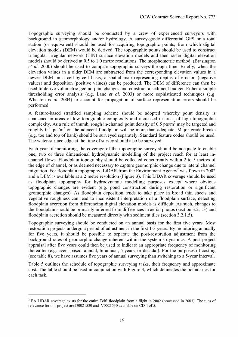
Each year of monitoring, the coverage of the topographic survey should be adequate to enable one, two or three dimensional hydrodynamic modelling of the project reach for at least in-channel flows. Floodplain topography should be collected concurrently within 2 to 5 metres of the edge of channel, or as deemed necessary to capture geomorphic change due to lateral channel migration. For floodplain topography, LiDAR from the Environment Agency2 was flown in 2002 and a DEM is available at a 2 metre resolution (Figure 3). This LiDAR coverage should be used as floodplain topography for hydrodynamic modelling purposes except where obvious topographic changes are evident (e.g. pond construction during restoration or significant geomorphic changes). As floodplain deposition tends to take place in broad thin sheets and vegetative roughness can lead to inconsistent interpretation of a floodplain surface, detecting floodplain accretion from differencing digital elevation models is difficult. As such, changes to the floodplain should be primarily inferred from differences in aerial photos (section 3.2.1.3) and floodplain accretion should be measured directly with sediment tiles (section 3.2.1.5).
Topographic surveying should be conducted on an annual basis for the first five years. Most restoration projects undergo a period of adjustment in the first 1-3 years. By monitoring annually for five years, it should be possible to separate the post-restoration adjustment from the background rates of geomorphic change inherent within the system’s dynamics. A post project appraisal after five years could then be used to indicate an appropriate frequency of monitoring thereafter (e.g. event-based, annual, bi-annual, 5 years, or decadal). For the purposes of costing (see table 8), we have assumes five years of annual surveying than switching to a 5-year interval.
Table 5 outlines the schedule of topographic surveying tasks, their frequency and approximate cost. The table should be used in conjunction with Figure 3, which delineates the boundaries for each task.
2 EA LiDAR coverage exists for the entire Teifi floodplain from a flight in 2002 (processed in 2003). The tiles of relevance for this project are D0021530 and V0021530 available on CD 4 of 5.
19

CCW Contract Science Report No. 773
Figure 3 – Hillshade derived from a 2 metre DEM of the Environment Agency’s LiDAR coverage of the project area. This figure shows the extent of LiDAR coverage in relation to the project, which should be used to augment and substitute floodplain and valley-floor topography required for modelling and context, but not collected as part of the survey monitoring. Note that LiDAR does not penetrate the water surface, so channel bathymetry is not included. The orange line reflects the alignment of the proposed restoration design.
20

CCW Contract Science Report No. 773
Task Frequency Approx. Cost3
Set Survey Control Network (2 person days in field; 1 person day in office, both @ £350/day = £1050; £500 consumables; +T&S)
Once, pre project £1550
Pre Project Channel Survey (6 person days in field; 1 person day in office, both @ £350/day = £2450; +T&S)
Once, pre project £2450
Post Project Channel & Floodplain Survey (10 person days in field; 1 person day in office, both @ £350/day = £3850; +T&S)
Once, post project £3850
Repeat Channel Survey (8 person days in field; 1 person day in office, both @ £350/day = £3150; +T&S)
Annually for 5 years, then reassess frequency for up to 10 years
£3150 per year
Table 5 – Surveying Tasks – Note that the actual number of days in the field is likely to be substantially less as a crew of 2 or more people will generally be assigned to each task.
3.2.3 Aerial Photography Similar to topographic surveying, aerial photography would help test the modified hydrogeomorphic objectives Ia, Ib and Ic (Table 4); but additionally should help with objective Id. In each case, the aerial photography would provide a spatial and visual context as well as a documentary record for the entire monitoring effort. As the imagery should be georeferenced, simple calculation of areas and distances from image-based classification would be easy to undertake. With respect to objective Id, the imagery would provide evidence of floodplain deposition patterns that would help assess the effectiveness of the floodplain as a sink for fine sediment.
Aerial photography (at a minimum resolution of 40 cm; 5-15 cm preferable) should be acquired concurrently with each topographic survey. A network of temporary ground control flight panels should be laid out and surveyed prior to each flight by an experienced surveyor using either survey-grade dGPS or a total station. The control should be laid out so that there are at least five common control points within each photo.
The area to be surveyed is approximately 500 m in width and 1300 metres in length and (61 hectares) and is roughly depicted in Figure 4 with red shading. As high resolution aerial imagery from 2006 already exists (Figure 4), a pre project flight or kite aerial photography is not necessary. However, a flight immediately following construction and at annual intervals thereafter (concurrent with the topographic surveying) is recommended.
If financially feasible, aerial photography acquired professionally by an air plane for photogrammetric purposes is perfectly acceptable. Alternatively, we suggest that kite aerial photography is used (e.g. Aber 2004). Ground control should take 1.5 - 2 person days to set for each flight (2.5 person days in field; 0.5 person day in office, both @ £350/day = £1050; £50 consumables; +T&S). The aerial photographs should be orthorectified, georeferenced and mosaiced into a single image of the project area. The imagery would be used to assist in geomorphic unit mapping, habitat mapping, vegetation mapping and inferring geomorphologic processes (e.g. sediment splays on floodplain indicative of deposition). All image-based classification should be produced as shape files or rasters. Depending on the depth of analyses undertaken, 3-7 days of GIS technician time (at approx. £350/day) should be allocated for such work at key post project appraisal intervals (Year 1, Year 5 & Year 10). However, as long as the aerial photographs are orthorectified, georeferenced and mosaiced, the image analyses could be done at any time, potentially by trained post-graduate students.
3 Not including T&S or VAT
21

CCW Contract Science Report No. 773
Figure 4 - Proposed hydrogeomorphic monitoring locations & boundaries. The underlying aerial photography is a 40 cm resolution aerial photograph from a flight flown in 2006.
3.2.4 Habitat Mapping Habitat mapping should be used to document and compare the structure of physical habitat. In combination with the monitoring of fish, aquatic invertebrates, aquatic and floodplain vegetation,
22

CCW Contract Science Report No. 773
habitat mapping would provide part of the story on habitat utilisation. If any numerical habitat modelling is performed, the habitat mapping and utilisation data would provide verification/validation of model performance. With respect to the hydrogeomorphic objectives, the habitat mapping would provide direct calculations of distributions of habitat types and diversity, necessary to appraise objectives Ib & Ic.
We suggest physical habitat mapping should be performed by a combination of desktop GIS study and field mapping/ ground-truthing. Habitat mapping should be performed by an experienced individual with geomorphic and ecological training. In every instance, the habitat mapping should take place after completion of the topographic and aerial surveys. The topographic map would provide the basis for a first-cut geomorphic unit analysis. The aerial photos should be used to solidify that analysis and allow a similar classification of sediment distribution (facies maps), vegetation patches and hydraulic units. The classification of geomorphic units and hydraulic units should be done in accordance with the River Styles habitat classification framework (Thomson et al. 2001), which is a multi-scalar4 habitat classification technique with a strong geomorphological basis. These habitat classifications should then be taken into the field and ground-truthed. Hard copies could be printed and marked up in the field by hand. Similarly, a pocket PC or tablet PC with the basemaps loaded and linked to a GPS could be used to ground truth and make modifications in the field. A trained geomorphologist could make a qualitative assessment of sediment class boundaries for the facies mapping in the geomorphic unit assessment. If deemed necessary, sediment samples from each facies class could be collected and analysed in the lab to derive grain size distributions (e.g. Pasternack 2000a; Bunte and Abt 2001). The desktop portion of the mapping should take roughly 2 person days, and the field portion should take 1 day without sediment sampling (1 person day in field; 2 person days in office, both @ £350/day = £1050; +T&S; approx £700 for sediment sampling). Habitat mapping should take place prior to restoration, immediately following restoration and then in conjunction with topographic surveying on an annual basis. After five years, a judgment about the rates of change of the physical habitat could be made and if appropriate the habitat mapping schedule could be adjusted accordingly.
Gill et al. 2005) suggested using River Habitat Survey (RHS) for habitat monitoring and diversity assessment. The RHS is a broad-brushed habitat assessment tool that consists of a checkbox exercise. RHS is appropriate for catchment, regional or national scale planning and inter-comparison (Walker et al. 2002), but is ill-suited for resolving detailed differences to habitat through time. The Environment Agency has a host of RHS sites scattered throughout the upper Teifi Catchment (Figure 5), including site G, which is next to sections C & D of the project. It would be worth coordinating with the EA to ensure that site G is reappraised post-restoration. The RHS could be largely derived from the more detailed monitoring proposed here.
4 Note that the higher-scale analyses of the River Styles Framework will not be undertaken as part of the habitat mapping. Such broader brush assessments are useful for context (similar to a Fluvial Audit), but are not suited to monitoring sub-reach scale changes in habitat distributions.
23

CCW Contract Science Report No. 773
Figure 5 – Location of existing Environment Agency monitoring sites in Upper Teifi. The base map is a 1:50,000 OS Map.
24

CCW Contract Science Report No. 773
3.2.5 Floodplain Sedimentation As mentioned above, floodplain sedimentation is difficult to derive accurately from DEM differencing. As an alternative, a simple network of sediment tiles should be installed to measure floodplain deposition directly. In conjunction with the aerial photo analysis, this would allow a direct assessment of the extent to which the floodplain acts a sink for sediment; thereby allowing evaluation of morphometric objective Id
Sediment tiles should be constructed and deployed in accordance with Pasternack 2000b) or an equivalent method. Figure 4 shows suggested locations for placement of sediment tiles in three transects across the floodplain, spaced roughly 300 m apart down valley. We specified between six and nine tiles in each section (spacing varies between 35 and 125 m), positioned according to morphological features on the floodplain. The placement and number of sediment tiles could be changed upon installation to account for practical site considerations not foreseen here. However, once locations are established, they should be kept throughout the duration of the monitoring project. Once a tile is placed, its location should be surveyed in and kept in the project GIS. This would also allow easy recovery of the sediment tiles, using a GPS or total station stakeout to navigate quickly to the exact location the tiles were originally deployed.
Sediment tiles should be measured and re-installed flush with the new floodplain level at least on an annual basis (preferably in conjunction with the other surveying efforts). Event-based monitoring would be interesting, but very laborious. Table 6 outlines an estimate of costs associated with this monitoring activity.
Task Frequency Approx. Cost5
Install sediment tiles (2 person days in field @ £350/day = £700; £300 consumables; +T&S)
Once, post project £1000
Field work, (2 person days in field @ £150/day = £300; +T&S)
Annually (or event-based if deemed necc.)
£300
Sediment Analysis in Lab (2 person days in lab @ £350/day = £700)
Optional (in conjunction with field work)
£700
Table 6 – Sedimentation Monitoring Tasks & Approximate Costs
3.2.6 Hydraulic & Water Quality Monitoring Hydraulic and water quality monitoring for this project should consist of a continuous monitoring component and some event-based sampling. The purpose of the hydraulic and water quality monitoring we propose is twofold. First, to achieve hydrogeomorphic objective Id (monitor water quality), suspended sediment and basic water quality upstream and downstream of the project should be measured. Secondly, continuous measurements of river stages in the project reach would provide a hydrographic record of the flooding experienced at the site. Such a record would be instrumental in attributing causal links to the geomorphic change observed through the other monitoring efforts, important for establishing the influence of the project on flooding, critical to explaining changes and patterns in vegetative colonization of the floodplain, and essential to any hydrodynamic modelling undertaken.
Pressure transducers should be installed in at least three locations (as shown in Figure 4) to measure water depths continuously along the main channel. These should be at the top of the reach, top of restored section ‘B’ (at the existing footbridge), and at the bottom of the reach (at the existing footbridge). In addition, it would make sense to install groundwater monitoring wells throughout the floodplain (for example at each of the sediment tile locations). Other than the initial installation costs, pressure transducers linked to data loggers, or simple crest gauges
5 Not including T&S or VAT
25

CCW Contract Science Report No. 773
(manually recorded), could be uploaded or logged during other project monitoring activities adding little additional cost to the monitoring. The insight gained by tracking groundwater levels throughout the bogs / floodplain would provide insight into the bog’s hydrology as well as an interpretive framework for explaining the vegetative monitoring from aerial photos on the site.
To measure water quality continuously, sondes should be installed as an Automatic Water Quality Monitoring Station (AWQMS) at the same locations as the pressure transducers at the top and bottom of the reach to measure water quality. Sondes should be specified to at least collect temperature, pH, electrical conductivity, and turbidity. If additional funds were available, periodic samples could be taken to the laboratory for full chemical speciation. Depending on the exact specification of instruments used, varying degrees of basic maintenance and site visits to download data from data loggers and retrieve samples would be necessary. Given that no baseline at the site exists, it would be desirable to deploy the instrumentation as soon as possible prior to the project. The pressure transducers and AWQMS should collect data continuously for the duration of the monitoring effort.
Development of a rating curve at one or more of the cross sections would be desirable for specification of a flow boundary condition for any hydrodynamic modelling effort. This would entail taking discharge measurements at a range of flows. This would be straight-forward for in-channel flows, particularly if deployed from one of the two bridges. However, gauging overbank flows would be much more difficult. For high flows, it would probably be as helpful to develop rating curves at a more tightly controlled cross-section (e.g. EA gauges at Pontrhydfendigaid or Pont Einon – see Figure 5) and correlating this to the stage records at the site provided by the pressure transducers.
Table 7 gives an indication as to costs associated with the hydraulic and water quality monitoring activities proposed above. It should be noted that that there may be opportunities to share infrastructure and monitoring costs on some of these items if deployed and managed in conjunction with other existing monitoring schemes (e.g. Environment Agency or University research).
Task Frequency Approx. Cost6
Install 3 pressure transducers & 2 sondes (2 person days in field @ £350/day = £700; £1500 consumables; +T&S)
Once, pre project £1850
Install monitoring wells (0.25 person days in field @ £150/day per well; £100 consumables per well + £500 pressure transducer; £ +T&S)
Once, pre project £150 - £650 / well
Downloading and maintaining pressure transducers & sondes (2 person days in field @ £350/day = £700; + T&S)
2-4 visits per year £700
Monitoring wells – getting data During other site visits Incl.
Table 7 – Hydraulic and Water Quality Monitoring Tasks & Approximate Costs.
6 Not including T&S or VAT
26

CCW Contract Science Report No. 773
3.3 Aquatic Invertebrates and Plants – Objectives IIa-d 3.3.1 Macroinvertebrates
Objective IIa – Achieve a higher overall invertebrate taxon richness in the streambed of the restored section than in the equivalent canalized section.
Objective IIb – Increase the taxon richness in the river margins to levels typical of the upstream control and raise right bank diversity to match that of the left bank
A corollary of objective 1a is that there would be no demonstrable difference between the taxon diversity of the restored section and the upstream control reaches. In order to be confident that the lack of any apparent difference between restored and control reaches is not due to inadequate sampling, an estimate of statistical power is required. The preliminary data from the 2006 baseline survey provide an indication of the mean difference between the canalized section and the upstream control reaches, and of the expected variance in the data. These can be used to estimate the power (1-β, where β is the Type 2 error rate) for any given level of sample replication. At a power of 0.8, the existing level of replication would detect a difference in mean taxon richness per replicate of about 3.6, compared with the observed difference of 1.5. To detect this smaller mean difference reliably replication would have to be increased from 12 to about 64. In the same way, the number of samples required to detect the estimated mean difference between west and east banks of 5.0 taxa per sample with a power of 0.8 can be estimated to be 9. These estimates of sample should be treated with caution because they are based on data from samples replicated within a single site in each river section (in the case of benthic taxon richness) or from only two sites (in the case of the east/west bank comparison). They also relate to just one season. However, they give a strong indication that the level of replication adopted in the baseline survey should not be reduced in any monitoring programme.
Detection of an improvement of invertebrate taxon richness as a result of restoration also depends on the extent of pre-restoration data. The design of the sampling programme in the 2006 baseline survey aimed to facilitate a BACI design for analysis of the outcome of the restoration. Sampling followed ECN recommendations (Sykes et al. 1999), which will enable these data to be assessed through RIVPACS and to be compared directly with existing monitoring data collected for the Teifi, and other rivers in the UK, by the Environment Agency.
The recommended monitoring strategy for this objective includes retention of the sampling design adopted in the 2006 baseline survey. To maximize the extent of pre-restoration data it would be desirable to repeat the survey before restoration work commences. The longer the run of pre-restoration data, the less likely it will be that the assessment of the outcome of restoration will be affected by year-to-year variation.
In detail, the recommended programme is to repeat in 2007 the spring and autumn sampling at the nine sites established in the 2006 baseline survey (Figure 2). At each site the ECN protocol is met by dividing the three minute sampling time between the streambed and the banks in the ratio 2:1, reflecting relative areas. The two minutes allocated to the streambed are comprised of four 30 second kick samples distributed as randomly as possible but encompassing pro rata the major habitat types. These samples are bagged and analysed separately. In the same way four 15 second sweep samples are taken from the margins, with equal number of samples from each bank.
In the period after restoration three of the sites (I2, I4, I5) will no longer be riverine. These should be replaced with six new sites on the restored sections; three on B, one each on A, C & D (Figure 2). To provide an understanding of the rate of improvement of the restored sections and the sequence of events, and also to ensure a dataset of adequate size to ensure statistical power, it
27

CCW Contract Science Report No. 773
is recommended that the spring and autumn surveys are repeated at 1, 2, 5 and 10 years post restoration.
The cost of the monitoring programme for objectives 1a and 1b would be approximately £11,500 in each year (2007 prices), on the assumption that identification will be to species except in the case of taxa (e.g. Diptera, Oligochaeta) where it is more practicable and cost effective to restrict identification to a higher level. This figure covers the acquisition of data (field work, sample sorting, identification and counting) but not the preparation of reports. The additional cost of preparation of each report would be c. £1500.
3.3.2 Macrophytes Objective IIc – Increase the cover of instream macrophytes to the level typical of the upstream control reaches
Since there are no suitable data from which to estimate differences between upstream control and canalized sections, or sample variances, the proposed monitoring strategy is less securely based. A randomized sampling programme would be less expensive than a comprehensive census of the study area (estimated at >1.5 km of river length). It is proposed that species richness and cover should be recorded in 10 x 10m reaches in each of the upstream control and canalized sections prior to restoration, and in the upstream control and restored sections at 5 years and 10 years post-restoration. The cover estimates could be made either by using dGPS asset surveying or from the blimp-flown aerial photography recommended for geomorphic monitoring. Sampling should be carried out in mid-summer at low water levels. The cost of this work is estimated at c. £1000 on each occasion.
3.3.3 Floodplain Pond Habitat Objective IId - Replace the floodplain pond lost by restoration with ponds of equivalent area, range of habitat types and invertebrate diversity
Three invertebrate samples were collected from the existing pond (at B, Figure 2) in summer 2006, using standard NPS methodology (Biggs et al. 1998). It is suggested that this sampling should be repeated in 2007, and in the replacement ponds 5 and 10 years post-restoration. Pond area and representation of distinctive mesohabitats (sensu National Pond Survey) should be made by dGPS asset surveying or aerial photography in 2007 and at 5 and 10 years post-restoration. The cost of this is estimated at £1500 on each occasion.
3.4 Fish Objective IIIa - Assess pre-and post-restoration juvenile salmonid densities at post-restoration and unchanged sites to distinguish between transient and long-term beneficial or adverse effects of restoration.
Objective IIIb - Confirm that the physical habitat conditions provided on the Teifi within the Cors Caron National Nature Reserve do not act as a limiting factor for migratory fish populations in the Teifi above Cors Caron.
Sampling sites, typically 50 m in length should be selected at the following sites: 1) two upstream tributary streams to act as upstream controls; 2) two downstream tributary sites to act as downstream controls; 3). three pre-restoration sites in the canalized sections of the river; 4) three post-restoration sites in the newly restored sections; 4) three pre-restoration sites in the historic meander sections; 5) three post-restoration sites in the newly created pond-like sections.
28

CCW Contract Science Report No. 773
At each sampling site, stop nets should be used to prevent fish moving out of the sample section. The section is then fished three times in succession, fishing upstream. If the section can be waded, electrofishing should be used; if not, then a seine net. Fish caught in each run should be identified to species, enumerated, length and mass measured and scale samples taken for ageing. The abundance can be estimated by the standard Zippin likelihood method (Seber 1973).
Sampling should take place in August-September, when sexually mature adults are likely to be migrating to their natal streams. The sampling will provide estimates of densities of juvenile salmonids, together with an enumeration of any adult anadromous salmon or sea trout moving through the sampled reach.
Given the length of life of salmonid fishes, it is suggested that the monitoring continues for ten years, to allow the fish populations to recover from any transient effects of the disturbance caused by the engineering works on the river channel.
The sampling effort is 10 sites with three runs per site. This would require three operatives for five days of sampling, i.e. 15 man days per year of sampling. A further 5 man days would be required for the scale analyses and data analysis, giving a total of 20 man days per year. Annual reports on estimated densities, size and age structure of salmonid populations would be prepared.
Objective IIIc - Use CPE as an index of population size to evaluate any beneficial or adverse effects of restoration on abundance of salmonids of a takeable size.
This objective is dependent on the availability of suitable data, but it would provide a valuable supplement to the data obtained by electrofishing, especially given that it would integrate information on salmonid availability over an extended period of time (the fishing season). The results would be incorporated into the annual report alongside the population estimates from electrofishing.
.
3.5 Social & Educational Outreach Objective IVa - Increase the number of visitors using the riverside walk by 50%, in line with the Walking the Way to Health initiative.
Monitoring the number of visitors who use the walk is relatively straightforward and can be carried out with accuracy. The reserve already has a network of four automatic people counters which are operated under contract by the company Linetop Limited. This company installs and maintains the counters, collects the data, and provides CCW with detailed reports on visitor numbers that can be at a yearly, monthly, weekly, daily or hourly scale.
It is suggested that to monitor the number of visitors using the riverside walk that two Linetop pyro-counters (detect thermal radiation of passing visitors) linked to data loggers be located on the walk, one at either end. The exact positioning should be left to Linetop who are expert in the placing and operating of automatic counters. Calibration of these counters to check accuracy will be difficult as the number of people using the riverside walk is likely to be small. However, by having two counters on the same route an overview of visitor numbers can be gained as data from the two counters can be compared. The cost of these counters is in the region of £350 each. The upkeep, monitoring, data capture and data processing can be added as on as an extension to the existing counter contract at a small extra cost (c. £250 p.a.).
Objective IVb - Ensure that at least 25% of visitors know that the Teifi has been restored to its original course, 50% know that the Teifi contributes to the conservation value of Cors Caron, and that 100% know that Cors Caron is an important site for wildife
29

CCW Contract Science Report No. 773
The most suitable technique to monitor visitors’ understanding and awareness is before and after analysis (Keirle 1998). This technique involves using an interviewer-administered questionnaire asking a representative sample of people questions relating to interpretive objectives that have been set. This is carried out in two stages, one sample taken before interpretation or environmental education activities are developed and a second sample taken after. Effectiveness can be judged by comparing the before sample with the after sample. If the communication process has worked the after sample should show a higher level of knowledge and understanding than the before sample. In effect the technique allows an assessment to be made of:
• How much visitors know about the subject matter that is being investigated
• How much the interpretation and education on the site has influenced their knowledge of the subject matter.
It should be noted that the questionnaire format used in this technique is good at measuring knowledge but is less precise in measuring understanding. The location and details of sampling would be dependent on whether the survey relates to the whole reserve or just the section restored and on the media to be used for communication. Decisions can be made on this at a letter date. However, standard representational sampling protocols should be used (Veak 2006, Finn et al. 2000). Reasonably large sample sizes are required to ensure that sample error is minimised and that any differences between the two samples can be safely attributed interpretation and education on site. A minimum of 200 before and 200 after interviews is recommended, which is likely to require at least 30 days of survey work.
Task Approximate cost
30 days of survey £2500Development and pilot testing of
questionnaire – 3 days £800
Input and analysis of data – 5 days £300Report writing £400
Total cost £4000
Table 8. Before and after analysis tasks and approximate costs.
30

CCW Contract Science Report No. 773
31
4 CONCLUSION In the preceding sections we have examined each of the objectives that were originally identified in the project specification and have made recommendations for their revision. For convenience, the original objectives and the relevant recommendations are listed in abbreviated form in Table 9.
Objective
No. Original formulation Recommendation No.
A Meet WFD morphological standards Remove pending definition of WFD Criteria
1
B Double instream habitat diversity Abandon numerical targets but retain conceptual intent
2
C Increase EPT invertebrates by 50% Increase overall invertebrate taxon richness, and richness on the east bank
5
D Double juvenile salmonid biomass and show use new habitat by adults
Abandon doubling, but aim to maintain use of the river by salmonids
8
1. IN
-RIV
ER O
BJE
CTI
VES
E Increase aquatic plant biodiversity by 20% and double instream plant cover
Bring instream plant cover to levels typical of uncanalized reaches
6
A Maintain area of floodplain pond and increase successional stages
Maintain range of habitat types and invertebrate richness in ponds
7
B Increase selected habitats to 50% floodplain cover
Abandon numerical targets but retain conceptual intent
2
2. C
ATC
HM
ENT
OB
JEC
TIVE
S
C Increase flooded are by 5 ha Not necessary as a separate objective 3
A Increase migratory fish above Cors Caron by 10%
Ensure conditions in the restored reaches do not limit migratory fish
9
3. F
LOO
DPL
AIN
O
BJE
CTI
VES
B Reduce SS downstream by 50% Change emphasis from improvement to monitoring of water quality
4
A Generate 50 educational visits Target dependent on marketing; this objective should be dropped
11
B Increase angler catches of brown trout by 10%
Abandon target increase in catches, but monitor catch per unit effort if possible
10
D Increase use of the riverside walk by 50%
Retain as specified 12
Develop as part of a programme of whole site monitoring
13
Ensure 25% of visitors know that the Teifi has been restored
14
4. E
DU
CA
TIO
NA
L A
ND
SO
CIA
L O
BJE
CTI
VES
E Increase awareness and understanding of the river environment
Ensure that 50% or visitors know the Teifi is important to conservation of Cors Caron, and 100% know that Cors Caron is important for wildlife
15
Table 9. A summary of the original objectives and the recommendations for changes
The modified objectives that arise from the recommendations shown above have been listed in Table 4, and the suggested strategy for monitoring these objectives has been described in full in section 3. Table 10 shows the costs of this monitoring strategy broken down of by task and by year.

CCW Contract Science Report No. 773
32
Task Project Objective Year post restoration Total
. -1 1 2 3 4 5 6 7 8 9 10
Topographic survey* Ia-d 4000 3850 3150 3150 3150 3150 0 0 0 0 3150 23600
Aerial photography* Ib, Ic, IIa 1100 1100 1100 1100 1100 1100 0 0 0 0 1100 7700
Habitat mapping* Ib, Ic, IIa 1750 1750 1750 1750 1750 1750 0 0 0 0 1750 12250
Monitoring floodplain sedimentation* Id 0 1000 1000 1000 1000 1000 0 0 0 0 0 5000
Hydraulic and water quality monitoring (not including installation of monitoring wells) Id 2050 700 700 700 700 700 700 700 700 7000 700 15350
Hydrogeomorphic data synthesis / post project appraisal Ia – Id 0 0 2450 0 0 2450 0 0 0 0 2450 7350
River invertebrate sampling (not including report preparation) IIa, IIb 0 11500 11500 0 0 11500 0 0 0 0 11500 46000
Instream macrophyte cover measurement (if no aerial photography) IIc 1000 0 0 0 0 1000 0 0 0 0 1000 3000
Pond habitat assessment (if no aerial photography) and invertebrate sampling IIc 1500 0 0 0 0 1500 0 0 0 0 1500 4500
Monitoring fish populations and angling returns IIIa-c 6000 6000 6000 6000 6000 6000 6000 6000 6000 6000 6000 66000
Monitoring use by visitors of the riverside walk IVa 950 250 250 250 250 250 250 250 250 250 250 3450
Assessing visitors’ understanding of the restoration (timing could be any year post restoration) IVb 0 4000 0 0 0 0 0 0 0 0 0 4000
Total 18349 30151 27902 13953 13954 30405 6956 6957 6958 13259 29410 198200
*Assuming that annual surveying is conducted for 5 years, and a post project appraisal then determines every 5 years is adequate thereafter.
Table 10. Breakdown of monitoring costs by year, and by task and project objective.

CCW Contract Science Report No. 773
We acknowledge that implementation of the recommended monitoring strategy in its entirety would be expensive, certainly in comparison with the proportion of environmental project expenditure generally devoted to monitoring. It would be possible to design a cheaper monitoring programme that would satisfy the basic requirement of recording the events following restoration, but this sort of minimal monitoring would not yield data of sufficient quality to be resistant to scrutiny.
If the Teifi restoration project is to stand as a demonstration project (original objective 4c), then it is essential that the outcomes can be validated beyond reasonable doubt and, where possible, attributed to the restoration. Our approach to designing a monitoring programme started from the presumption that it should be scientifically robust and thus capable of producing data sufficient in extent and precision to identify clearly the consequences of the restoration. Within this constraint, we have sought to design a programme that would deliver the desired outcome at the least cost.
It follows that there is no part of the proposed programme that could be abandoned without significant loss. Since one of the main goals of the restoration, and the target of the intervention on the ground, is the reestablishment of the Teifi in its original course, there would seem to be an unavoidable requirement to determine whether this has been adequately achieved and to monitor the hydrogeomorphic consequences of the engineering work.
Given that the river is part of a National Nature Reserve it would be highly desirable to determine the effects of the restoration on plant and animal populations. Invertebrates are a natural focus for monitoring, not least because they are at the centre of the national system for monitoring river quality. This means that there is an extensive database which provides a background against which to assess the Teifi, even though the local routine sampling stations are not well placed to monitor the Teifi restoration. Furthermore, pre-restoration samples were collected from sites on the Teifi selected specifically for monitoring purposes in 2006, and there is an opportunity to obtain a second year’s data in 2007 (n.b. this has not been included in the costing in Table 10). This potential for replication of pre-restoration data sets the invertebrates apart from other organisms.
Destruction of the existing floodplain ponds within the reserve brings with it the requirement to document the losses and to determine the extent to which they are mitigated by the new ponds created from the canalized sections of the river. Once again invertebrates are the natural target for monitoring the effects of the restoration, but given the small additional cost it would be sensible to include an assessment of the changes in riverine and pond vegetation. The former is especially important in view of its role in the designation of the Teifi as a SAC.
Arguably, the monitoring aimed at fish populations is the least scientifically robust part of the biological programme, mainly due to the natural background variation in population density and distribution, and the short run of pre-restoration data that it would be possible to obtain. If carried out at the recommended frequency, it would constitute a large part of the overall monitoring budget. Nonetheless, there is keen public interest in the fate of fish populations, especially salmonids, and the work on the Teifi could affect populations in the part of the river system above Cors Caron.
The interests of the pubic are also paramount in the assessment of the extent to which they benefit from the restoration. Monitoring the frequency of use of the riverside walk would be inexpensive, and it would cost little more to measure the level of public understanding achieved by the interpretive materials provided on the site.
33

CCW Contract Science Report No. 773
The overall cost of the monitoring programme is due as much to the length of the period over which monitoring is planned to continue as to the number of variables monitored. River restoration is not an exact science and there is not yet sufficient information to predict with any certainty the time course of the response of the system. We have arrived at a best guess for the timescales of change and we have scheduled the monitoring events accordingly. An adaptive monitoring programme would use the flow of data to adjust upwards or downwards the frequency of data collection as events unfolded. When expressed as an annual cost spread over ten years the programme is cost efficient. Finally, it is worth noting that the cost of the monitoring proposed in Gill et al. 2005, see Table 7), which we have assessed as inadequate in several respects, runs to between £58,000 and £95,000 over ten years, i.e. between 50 and 80% of their estimated £115,000 construction costs.
5 ACKNOWLEDGEMENTS We are grateful to Tristan Hatton-Ellis and Paul Culyer at CCW, and to the Environment Agency for provision of fish data. At UWA, Nadine Atchison-Balmond, Jenny Bayliss, Enfys Evans, Emma Jones, Elayne Looker, Daniel Osborne and David Thompson assisted with collecting and processing of the spring 2006 invertebrate samples.
34

CCW Contract Science Report No. 773
6 REFERENCES Aber, J.S. (2005). ES 555 Kite Aerial Photography Cameras and Rigs [Online]. In :ES 555
Small Format Aerial Photography. Available from: http://www.geospectra.net/kite/equip/camera_rigs.htm [Accessed: 1/10/05].
Biggs, J., Fox, G., Nicolet, P., Walker, D., Whitfield, M. & Williams, P. (1998). A Guide to the
Methods of the National Pond Survey. Pond Action, Oxford. Bonada, N., Rieradevall, M., Prat, N. & Resh, V.H. (2006). Benthic macroinvertebrate
assemblages and macrohabitat connectivity in Mediterranean-climate streams of northern California. Journal of the North American Benthological Society 25: 32-43.
Brasington, J., Rumsby, B.T. & McVey, R.A. (2000). Monitoring and modelling morphological
change in a braided gravel-bed river using high resolution GPS-based survey. Earth Surface Processes and Landforms 25: 973-990.
Bunte, K. & Abt, S.R. (2001). Sampling Surface and Subsurface Particle-Size Distribution in
Wadable Gravel- and Cobble-Bed Streams for Analyses in Sediment Transport. Hydraulics and Stream Bed Monitoring. Gen. Tech. Rep. RMRS-GTR-74. US Department of Agriculture, Forest Service, Rocky Mountain Research Station, Fort Collins, CO. RMRS-GTR-74. 428pp.
Downs, P.W. & Kondolf, G.M. (2002). Post-project appraisals in adaptive management of river
channel restoration. Environmental Management 29: 477-496. Finn, M., Elliott-White, M. & Walton, M. (2000). Tourism and Leisure Research. Longman,
Harlow. Fuller, I.C., Large, A.R.G., Charlton, M.E., Heritage, G.L. & Milan, D.J. (2003). Reach-scale
sediment transfers: An evaluation of two morphological budgeting approaches. Earth Surface Processes and Landforms 28: 889-903.
Gill, A.B., Pepper, A., Eaton, J.W., McAllister, H. & Neame, C. (2005). Restoring the Afon Teifi
at Cors Caron National Nature Reserve: a Project Plan. Bangor, Countryside Council for Wales.
Harrison, S.S.C. (2000). The importance of aquatic margins to invertebrates in English chalk
streams. Archiv Fur Hydrobiologie 149: 213-240. Hughes, F.M.R., Colston, A. & Mountford, J.O. (2005). Restoring riparian ecosystems: The
challenge of accommodating variability and designing restoration trajectories. Ecology and Society 10, 12. [Online]. Available from: http://www.ecologyand society.org/vol10/iss1/art12/. [Accessed: 25/01/07]
Keirle, I. (1998). An Evaluation of interpretation in Welsh National Nature Reserves.
Countryside Council for Wales, Bangor. Lane, S.N., Westaway, R.M. & Hicks, D.M. (2003). Estimation of erosion and deposition
volumes in a large, gravel-bed, braided river using synoptic remote sensing. Earth Surface Processes and Landforms 28: 249-271.
35

CCW Contract Science Report No. 773
Newson, M.D. (2002). Geomorphological concepts and tools for sustainable river ecosystem management. Aquatic Conservation-Marine and Freshwater Ecosystems 12: 365-379.
Newson, M.D., Clark, M.J., Sear, D.A. & Brookes, A. (1998). The geomorphological basis for
classifying rivers. Aquatic Conservation-Marine and Freshwater Ecosystems 8: 415-430. Newson, M.D. and Large, A.R.G. (2006). 'Natural' rivers, 'hydromorphological quality' and river
restoration: a challenging new agenda for applied fluvial geomorphology. Earth Surface Processes and Landforms 31: 1606-1624.
Ormerod, S.J. (2004). A golden age of river restoration science? Aquatic Conservation-Marine
and Freshwater Ecosystems 14: 543-549. Pasternack, G.B. (2007). Grain Size Distribution Protocol for Sediment Samples. [Online].
Available from: http://pasternack.ucdavis.edu/grainsize.htm [Accessed 02/01/07] Pasternack, G.B. (2007). Net Sedimentation Tile (NST) Protocol for Monitoring Short-term
Sedminet Fluxes in Depositional Environments. [Online]. Available from: http://pasternack.ucdavis.edu/sedtiles.htm [Accessed 02/01/07]
Seber, G.A.F. (1973). The Estimation of Animal Abundance and Related Parameters. Griffin,
London. Silveira, M.P., Baptista, D.F., Buss, D.F., Nessimian, J.L. & Egler, M. (2005). Application of
biological measures for stream integrity assessment in south-east Brazil. Environmental Monitoring and Assessment 101: 117-128.
Suren, A.M. & Jowett, I.G. (2006). Effects of floods versus low flows on invertebrates in a New
Zealand gravel-bed river. Freshwater Biology 51: 2207-2227. Sykes, J.M., Lane, A.M.J. & George, G., Eds. (1999). The United Kingdom Environmental
Change Network: protocols for standard measurements at freshwater sites. Institute of Freshwater Ecology, Huntingdon.
Thomson, J.R., Taylor, M.P., Fryirs, K.A. & Brierley, G.J. (2001). A geomorphological
framework for river characterization and habitat assessment. Aquatic Conservation-Marine and Freshwater Ecosystems 11: 373-389.
Tockner, K. & Stanford, J.A. (2002). Riverine flood plains: present state and future trends.
Environmental Conservation 29: 308-330. UKTAG (2006). UK Environmental Standards & Conditions (Phase 1). UK Technical Advisory
Group on the Water Framework Directive. Final Report SR1-2006. 83pp. Veak, A.J. (2006). Research Methods for Leisure and Tourism. Pitman Publishing, London. Veverka, J.A. (1994). Interpretive master Planning. Falcon Press Publishing Ltd, Montana. Walker, J., Diamond, M. & Naura, M. (2002). The development of Physical Quality Objectives
for rivers in England and Wales. Aquatic Conservation-Marine and Freshwater Ecosystems 12: 381-390.
36

CCW Contract Science Report No. 773
Wheaton, J.M., Brasington, J. & Williams, R.D. (2004). Modelling Fluvial Sediment Budgets Under Uncertainty.. Eos Trans. AGU, 85, Fall Meeting Supplement, Abstract H53C-1264.
Wohl, E., Angermeier, P.L., Bledsoe, B., Kondolf, G.M., MacDonnell, L., Merritt, D.M.,
Palmer, M.A., Poff, N.L. & Tarboton, D. (2005). River restoration. Water Resources Research 41.
37