Embed Size (px)
Citation preview

prepared by for PLANNING OFFICERS SOCIETY FOR WALESwith the support of WELSH ASSEMBLY GOVERNMENT
March 2005
a model design guide for
Walesresidential development
Planning OfficersSocietyfor Wales
a model design guide for Wales residential development01
foreword
I welcome the launch of this model design guide produced by the Planning Officers Society (Wales)as another milestone in moving our country towards a more sustainable future. The funds beingmade available by the Assembly Government under the Planning: delivering for Wales programmeare producing not only extra resources to improve services for each local planning authority butalso valuable all Wales tools such as this guide for changing how planning is implemented on theground. Thanks are due to the members of the steering group and consultees for their contributionto the production of such a useful model. I commend it to all local planning authorities,their communities and to those who wish to build new homes in Wales.
Carwyn JonesMinister for Environment, Planning and Countryside
SW
AN
SE
AF
OY
ER
DE
VE
LO
P-
ME
NT:
GW
AL
IAH
OU
SIN
GG
RO
UP
/ P
CK
O A
RC
HIT
EC
TS

a model design guide for Wales residential development02

1.0
2.0
3.0
4.0
5.0
6.0
c o n t e n t s
introduction
the objectives of good design
the design process
submitting the application
design appraisal
case studies
appendix
further reading
glossary
a model design guide for Wales residential development03
RAISDALE ROAD: LOYN & CO ARCHITECTS

a model design guide for Wales residential development04
1.0introduct ion
1.1 All design and development contributes to a nation's image and says much about its culture, confi-dence and aspirations. It also directly affects the social, economic and environmental well being ofcities, towns and villages.
1.2 The Welsh Assembly Government is committed to achieving good design in all development at everyscale throughout Wales. Good design is a key aim of the planning system and Planning Policy Wales[WAG 2002] requires that Unitary Development Plans (UDPs) provide clear policies setting out plan-ning authorities' design expectations. Technical Advice Note 12 (TAN 12) [WAG 2002A] gives adviceto local planning authorities on how good design may be facilitated within the planning system.
1.3 This document has been designed as a practical tool to be used by local planning authorities as sup-plementary planning guidance to meet the requirements of PPW and convey the design implicationsof TAN 12 to anyone proposing new residential development in excess of 1 dwelling. It is a require-ment of PPW and TAN 12 that applications for planning permission are accompanied by a 'designstatement'. This document therefore also clarifies the issues a design statement for new residentialdevelopment should address.
1.4 The document seeks to establish a common design language for residential development in Wales,clarifying the fundamental design issues and how to address them by:
describing the key objectives of residential design and providing guidance on how they may beachieved; describing the design process which should be followed to adequately address each objective; providing information on how to submit a planning application to demonstrate how the requirementof good design has been addressed; clarifying how proposals will be appraised on design grounds; and,providing case study examples which illustrate how many of the principles have been achieved inrecent developments in Wales.
1.5 Local authorities are also required to have due regard to crime and disorder prevention in the exer-cise of their functions under Section 17 of the Crime and Disorder Act 1998 and consider the issueof accessibility for all including the needs of those with visual and hearing impairments and thosewith limited mobility, at an early stage in the design process. This document addresses these issuesand aims to promote safe inclusive environments through good design.
1.6 Design is only one consideration when making a decision to approve or refuse an application forplanning permission. In addition to addressing the requirements of this guide development propos-als will need to demonstrate compliance with the UDP and other material considerations and insome cases be accompanied by a formal Environmental Impact Statement.
a model design guide for Wales residential development05

a model design guide for Wales residential development06
2.1 The general aim of TAN 12 with respect to housing design and layout is to:
create places with the needs of people in mind, which are distinctive and respect local character;promote layouts and design features which encourage community safety and accessibility;focus on the quality of the places and living environments for pedestrians rather than the movementand parking of vehicles;avoid inflexible planning standards and encourage layouts with reduced road widths;promote energy efficiency in new housing;secure the most efficient use of land including appropriate densities; and,consider and balance potential conflicts between these criteria.
2.2 Tan 12 spells out the objectives of good design and encourages a design process which seeks toaddress these aims from the outset of a project. The objectives of good design are based on anunderstanding of what makes existing places attractive and sustainable places in which to live.
2.3 This guide restates the objectives of good design set out in TAN 12 and provides some simple guid-ance on how each objective can be addressed in a typical residential development to achieve highquality, safe and inclusive residential development.
2.4 Anyone proposing a residential development will be expected to work with the local planning author-ity and stakeholders to develop a design that addresses each relevant objective. They shoulddescribe how their design achieves each objective in a ‘design statement’ to be submitted with theplanning application. Design appraisal by the local planning authority may involve assessing howwell each objective has been met before making a decision whether to support a proposal on designgrounds.
2.5 The best way to meet the requirements of this guide is to develop a clear vision for the site whichaddresses and integrates each objective.
2.0the ob ject ives o f good des ign
TY
NE
WY
DD
: M
AR
ED
UD
D A
B I
ES
TY
N

woodland & water courses
ecological importance
potential development area
topography
a model design guide for Wales residential development07
objective 1natural heritage
design gu idanceuse specialist input such as ecologists, landscape architects andlandscape managers to advise on natural heritage issues;ensure a thorough understanding of natural processes (e.g. flood-ing) and natural heritage resources relevant to the site and designto positively incorporate areas with established importance;design in new features to promote biodiversity, for example byusing native trees or developing the ecological value of sustainableurban drainage features;ensure that features with established ecological or landscape valueare protected throughout the site clearance and constructionprocess;compensate for any loss of biodiversity elsewhere on site or off siteif necessary;put in place mechanisms for positive and sustainable managementand aftercare of landscape and ecological resources.
Development should be designed to integrate with, protect andenhance the landscape and biodiversity values of the site.
The landscape is one of the most important resources of Wales andneeds to be protected and enhanced. This does not mean that thereshould be no change but requires high quality design solutions thatcomplement or contribute to landscape character. Biodiversity is one ofthe building blocks of all life and needs to be preserved and enhancedwherever possible.
ABOVE: SIMPLIFIED PROCESS OF CONSIDERING NATURAL HERITAGERESOURCE AND DEFINING DEVEL-OPABLE AREA
Landscape and ecological resources are often seen as a constraint todevelopment. Often the reverse could be true. The sensitive incorporationof natural heritage can in fact help to give a site a distinct identity and pos-sibly even a marketing advantage. The value of trees and other elements ofnatural heritage cannot be overstated. As well as giving a development asense of instant maturity, a growing body of evidence points to health andwell-being benefits. The key to addressing natural heritage is to ensure thatit forms a positive part of the vision for the site's development and is not sim-ply a hindrance to a standard layout.
Box 1 | incorporating natural heritage

des ign gu idanceensure density relates to the vision for the site and an understand-ing of its urban or landscape character context - for example is it'tight and urban' or ‘loose, leafy and suburban’?where ecological and landscape resources are to be protecteddesign-in natural heritage as part of green space but discuss withthe planning authority where it is appropriate to maintain overall sitedensity by creating higher densities in certain areas;use higher densities positively to define spaces, frontages andmain streets in accessible areas or around concentrations of serv-ices/facilities;design open space as an integral part of built form and locate pro-vision so that it does not detract from density of use/populationaround concentrations of services/facilities;integrate parking at planning authority standards efficiently butdesign in some flexibility for parking growth without encouraginggreater numbers and loss of compactness;ensure that the compact development form still allows for adequategreen space and room for tree roots and canopies to spread.
a model design guide for Wales residential development8
objective 2compactness
Development should useland efficiently and whereappropriate provide a density ofuse/population that supports public transportand commercial/community services.
Compact developmentforms minimise land takeand encourages densities sufficient to sup-port local services andamenities. This in turnenhances the sense ofcommunity and reducesthe need to travel. This is not to suggest that compactness should beas high as possible every-where. It will vary accord-ing to context and insome locations a low den-sity solution may be mostappropriate.
FLATS DEVELOPMENT IN TENBY. THE DENSITY OF THE SCHEME FITS WITH THE TOWN SCAPE WHILST ATTHE SAME TIME PROVIDING A DENSITY OF USE THAT SUPPORTS THE FUNCTIONS OF THE TOWN CENTRE
AXONOMETRIC AND PLAN ILLUSTRATING POSSIBLE GRADATION
IN DENSITY FROM CENTRE TO EDGE OF DEVELOPMENT

a model design guide for Wales residential development9
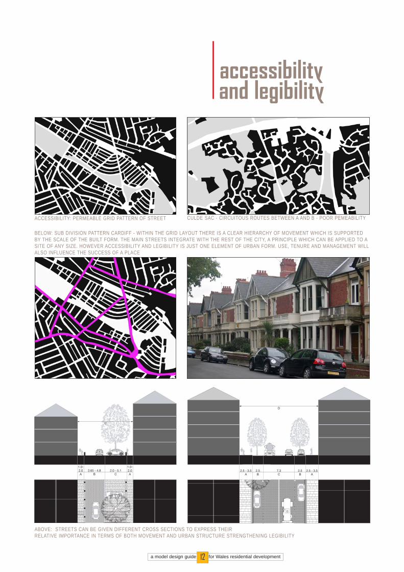
Create development layouts that are accessible to all in society, make links intosurrounding areas, create new links wherenecessary and ensurethat it is easy to get from A-B within a development.
Accessibility and ease of movement considerations effectivelyform the urban structureof a place. They determine how effectively it connects withthe existing urban andrural fabric and influence key issues suchas the ‘walkability’ ofplaces, reducing car useand enhancing the lifeand vitality of streets andspaces. It is vital that thepattern of accessibilityand ease of movement isdesigned hand in handwith measures to reduce crimeand create safe andsecure streets, spacesand buildings.
objective 3accessibility & ease of movement
design gu idanceensure a collaborative design approach in which vehicular, pedes-trian and cycle linkages are designed in conjunction with the ‘urbandesign’ for the site. In practice this means ensuring that the people responsible for the highways and urban design workclosely together;design ‘access for all’ including the needs of those with visual andhearing impairments and those with limited mobility;design to connect with adjacent places and communities;ensure safe and efficient access for all modes of transport, emer-gency services and other service vehicles but wherever possiblegive priority to pedestrian and cyclist movement;ensure good access for/to public transport where available;ensure that routes within the site also allow for future stages ofdevelopment;distinguish between primary routes, secondary routes and tertiaryroutes by varying street cross-section and design. This can help toreinforce a hierarchy of streets and spaces that makes the devel-opment easier to understand (see legibility below). It can also beimportant in defining areas that are public and those that are sole-ly for residents, helping to discourage crime (see Box 2 on page 11);establish a layout that is permeable and interconnected within thesite but avoid any ‘short-cuts’ or routes that will be underused or notoverlooked; design for low vehicle speeds to ensure that streets and spaces arecomfortable for pedestrians and cyclists to use. This can be doneby minimising straight stretches of road with extended forward vis-ibility and through the use of right angle junctions and minimum(2.4m) visibility splays where appropriate.
A PERMEABLE NETWORK OFSTREETS CONNECTED TO
ADJACENT AREASFUTURE
DEVELOPMENTPHASE

des ign gu idanceensure that the movement function of each street is reinforced bythe width of the carriageway, the design of the public realm and thescale, form and design of adjacent buildings. In this way it is possi-ble to create a hierarchy of streets, each with a clear movementrole and identity which helps people to find their way around adevelopment;design to create a positive image and sense of place for the devel-opment - avoid a negative identity such as, for example' the estateoff the 'ring road';tie the development into the existing pattern of landscape, streetsand roads so that it is contiguous with the existing urban or ruralfabric. In particular integrate with the main uninterrupted linear fea-tures, such as existing landscape elements, streets, footpaths andcycleways. This helps to reinforce the pattern and legibility of thesite context; carefully consider the placement and design of landscape andbuildings to create memorable spaces, landmarks, vistas and focalpoints;link to existing landmarks and views as orientating features;ensure that it would be easy for a resident of the proposed devel-opment to direct someone to where they live with reference to thekey streets, spaces and landmarks.
a model design guide for Wales residential development10
objective 4.0legibility
Create development layouts that are easy tounderstand and find yourway around.
The structure of keystreets and spaces formsthe main image of a placeand makes it easy forpeople to orientate themselves and find their wayaround. It helps to createthe identity of a place andthe perception of it byothers.
LEGIBILITY: THE MAIN STREET CREATES THE SPINE OF THE DEVELOPMENT. LANDMARK BUILDINGS DEFINE THE ENTRANCE TO THE DEVELOPMENT
LANDMARK BUILDING
MAIN STREET
a model design guide for Wales residential development11
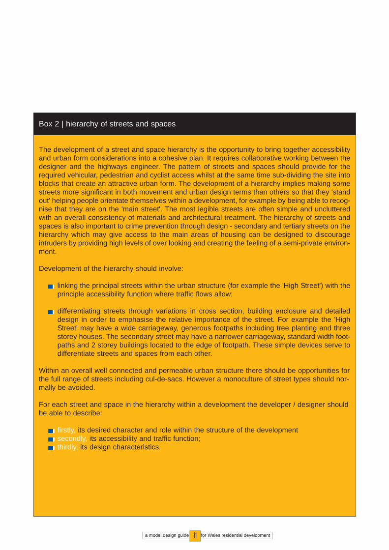
The development of a street and space hierarchy is the opportunity to bring together accessibilityand urban form considerations into a cohesive plan. It requires collaborative working between thedesigner and the highways engineer. The pattern of streets and spaces should provide for therequired vehicular, pedestrian and cyclist access whilst at the same time sub-dividing the site intoblocks that create an attractive urban form. The development of a hierarchy implies making somestreets more significant in both movement and urban design terms than others so that they 'standout' helping people orientate themselves within a development, for example by being able to recog-nise that they are on the 'main street'. The most legible streets are often simple and unclutteredwith an overall consistency of materials and architectural treatment. The hierarchy of streets andspaces is also important to crime prevention through design - secondary and tertiary streets on thehierarchy which may give access to the main areas of housing can be designed to discourageintruders by providing high levels of over looking and creating the feeling of a semi-private environ-ment.
Development of the hierarchy should involve:
linking the principal streets within the urban structure (for example the 'High Street') with theprinciple accessibility function where traffic flows allow;
differentiating streets through variations in cross section, building enclosure and detaileddesign in order to emphasise the relative importance of the street. For example the 'HighStreet' may have a wide carriageway, generous footpaths including tree planting and threestorey houses. The secondary street may have a narrower carriageway, standard width foot-paths and 2 storey buildings located to the edge of footpath. These simple devices serve todifferentiate streets and spaces from each other.
Within an overall well connected and permeable urban structure there should be opportunities forthe full range of streets including cul-de-sacs. However a monoculture of street types should nor-mally be avoided.
For each street and space in the hierarchy within a development the developer / designer shouldbe able to describe:
firstly, its desired character and role within the structure of the developmentsecondly, its accessibility and traffic function;thirdly, its design characteristics.
Box 2 | hierarchy of streets and spaces
a model design guide for Wales residential development12
1accessibilityand legibility
BELOW: SUB DIVISION PATTERN CARDIFF - WITHIN THE GRID LAYOUT THERE IS A CLEAR HIERARCHY OF MOVEMENT WHICH IS SUPPORTEDBY THE SCALE OF THE BUILT FORM. THE MAIN STREETS INTEGRATE WITH THE REST OF THE CITY, A PRINCIPLE WHICH CAN BE APPLIED TO ASITE OF ANY SIZE. HOWEVER ACCESSIBILITY AND LEGIBILITY IS JUST ONE ELEMENT OF URBAN FORM. USE, TENURE AND MANAGEMENT WILLALSO INFLUENCE THE SUCCESS OF A PLACE
2.5 - 3.5A
2.5 - 3.5A
2.5B
2.5B
7.3C
D
D
1.0-2.0A
1.0-2.0A
2.0 - 5.1C
3.65 - 4.8B
ABOVE: STREETS CAN BE GIVEN DIFFERENT CROSS SECTIONS TO EXPRESS THEIR RELATIVE IMPORTANCE IN TERMS OF BOTH MOVEMENT AND URBAN STRUCTURE STRENGTHENING LEGIBILITY
ACCESSIBILITY: PERMEABLE GRID PATTERN OF STREET CULDE SAC - CIRCUITOUS ROUTES BETWEEN A AND B - POOR PEMEABILITY
Development shouldrespond to the characterand local distinctivenessof site context.
The character and contextof any development iscreated by the locallydistinctive patterns andform of development,landscape, culture andbiodiversity. Theseelements have often builtup over a considerabletime and tell a story of thesite's history andevolution. The create its‘sense of place’.
The character and contextof a site should influencedesign positively so thatdevelopment does notsimply replace what wasthere but reflects andresponds to it. If thecontext to a developmenthas been compromised byan earlier stage ofdevelopment it should notbe seen as a reason toperpetuate what has beendone before.Opportunities should besought to deliver highquality sustainabledevelopment that reflectsthe technologies andaesthetics of the 21st
century and creates astrong sense of place.
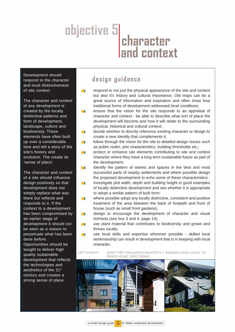
objective 5characterand context
des ign gu idancerespond to not just the physical appearance of the site and contextbut also it's history and cultural importance. Old maps can be agreat source of information and inspiration and often show howtraditional forms of development addressed local conditions;ensure that the vision for the site responds to an appraisal ofcharacter and context - be able to describe what sort of place thedevelopment will become and how it will relate to the surroundingphysical, historical and cultural context;decide whether to directly reference existing character or design tocreate a new identity that complements it;follow through the vision for the site to detailed design issues suchas public realm, plot characteristics, building thresholds etc.;protect or enhance site elements contributing to site and contextcharacter where they have a long term sustainable future as part ofthe development;identify the pattern of streets and spaces in the best and mostsuccessful parts of nearby settlements and where possible designthe proposed development to echo some of these characteristics;investigate plot width, depth and building height in good examplesof locally distinctive development and see whether it is appropriateto adopt a similar pattern of built form; where possible adopt any locally distinctive, consistent and positivetreatment of the area between the back of footpath and front ofhouse (such as small front gardens);design to encourage the development of character and visualrichness (see box 3 and 4, page 14);use plant material that contributes to biodiversity and grows andthrives locally;use local skills and expertise wherever possible - skilled localworkmanship can result in development that is in keeping with localcharacter.
a model design guide for Wales residential development13
LEFT TO RIGHT: BURRY PORT: GWALIA/PCKO ARCHITECTS | RAISADALE ROAD: LOYN & COPRIVATE HOUSE: DAVID THOMAS

Often there is a perception that innovative 'contemporary' design conflicts with established patternsof settlement and traditional styles of architecture. In reality architectural styles and traditions haveevolved numerous times in the past in response to changing social and economic conditions.There is no reason why design which uses modern materials and responds to contemporaryaesthetics should not fit in with context as well as more traditional forms of development.
When the merits of 'contemporary' versus 'traditional' architecture are considered the debate oftenrevolves around the style of the building itself. Often some of the most important design issuesrelated to character and context are totally overlooked. These can be simple issues like buildingsetback, plot width, building height or verticality. If these are responded to appropriately thenarchitecture using modern materials and construction methods, with styling that reflects aestheticsof the 21st century, can be entirely in-keeping with character and context.
Box 3 | character and context: innovative design
Visual richness does not imply fussy, complicated or expensive design. In fact many of our bestsettlements and built form models such as the Victorian terrace are very simple The richnesscomes from the simple elegance of some of the basic architectural details (such as sash windows),scale and proportion and also from the tone and quality of materials. Public realm is also importantwith the natural weathering of good quality natural materials adding to richness over time. Howeverrichness also comes from knowing where to do something special. Added building height oncorners, well thought out articulation where buildings turn corners and well-detailed facades at theends of vistas are just a few simple examples where the richness of a scheme can be enhanced.This guide encourages richness of detail in all residential schemes.
Box 4 | character and context: visual richness
a model design guide for Wales residential development14
LEFT TO RIGHT:
1. VISUAL RICHNESS IN AMODEST TERRACE WITHPERSONALISED FRONTGARDENS. 2. SUBTLE USE OF COLOURAND JUXTAPOSITION WITH MODERN MATERIALS INCARDIFF. 3. TIMBER SLATE AND STEELIN A NEW DEVELOPMENT,BURRYPORT.
objective 5characterand context
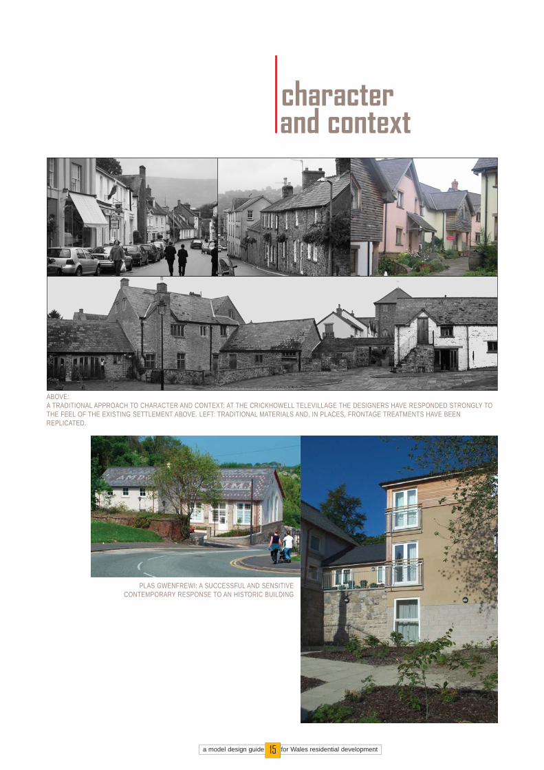
ABOVE:A TRADITIONAL APPROACH TO CHARACTER AND CONTEXT: AT THE CRICKHOWELL TELEVILLAGE THE DESIGNERS HAVE RESPONDED STRONGLY TOTHE FEEL OF THE EXISTING SETTLEMENT ABOVE. LEFT: TRADITIONAL MATERIALS AND, IN PLACES, FRONTAGE TREATMENTS HAVE BEENREPLICATED.
PLAS GWENFREWI: A SUCCESSFUL AND SENSITIVECONTEMPORARY RESPONSE TO AN HISTORIC BUILDING
a model design guide for Wales residential development15

des ign gu idanceensure the block structure / layout allows for overlooking, enclosureof streets and spaces and a clear distinction between public andprivate areas. In practice perimeter blocks are the best way toachieve this;in the absence of building frontages use hard and soft landscapeelements where necessary to provide continuity and enclosure ofstreets and spaces ; locate parking to avoid disruption to continuity of street frontage.This will mean avoiding on-plot parking to the front of house andconsidering on-street parking, courtyard parking or provision ofparking at the side of house. However always ensure goodoverlooking and surveillance of parking areas by the car owners;ensure adequate building height in relation to street width to createa sense of enclosure;correlate the main pedestrian/cycle routes with the mostoverlooked areas to create a safe public realm;locate active frontages and entrances that contribute to the vitalityof streets/spaces;clearly demarcate public and private space and avoid left overspace;
Streets and spaces shouldbe overlooked withcontinuous streetfrontage:
Enclosure and continuityof street frontage createsspaces that areoverlooked and aretherefore safer and morepleasant to use. Theymaximise opportunities forsocial interaction andcreate a stronger sense ofplace and a morerecognisable identity.Continuity and enclosurecan also be created bytree and hedge planting,walls and fences. Overthe centuries most of ourbest settlements havebeen based around theconcept of clearly definedstreets and spaces.
objective 6continuityand enclosure
a model design guide for Wales residential development16
CONTINUITY OF STREET FRONTAGE CREATED THROUGHTERRACED FORMS ALONG MAIN STREET. ELSEWHERE
BUILDINGS TO FRONT PLOT MAINTAIN CONTINUITY

a model design guide for Wales residential development17
1continuityand enclosure
EXAMPLES ABOVE: SIMPLE APPROACHES TO CONTINUITY OF FRONTAGE AND ENCLOSURE OF STREETS AND SPACES. BUILDINGS ADDRESS THESTREET CREATING A SAFE AND OVERLOOKED PUBLIC REALM.
GOOD OVER LOOKING OF GREENSPACE - ESSENTIAL TO ENSURE SAFE AND CARED FOR PUBLIC REALM
CONTEMPORARY URBAN INFILL MAINTAINS THE CONTINUITY OF BUILDING LINE AND ENCLOSURE OF THE STREET. ALTHOUGH ARCHITECTURALLYDISTINCTIVE IT FITS INTO THE HISTORIC STREET: PHOTO BY MIKE BIDDULPH

des ign gu idanceplan the public realm as an integral part of the development and notas an add-on. This means agreeing how much public open spaceis required with the planning authority and designing it in as apositive part of the urban form, often in conjunction with measuresto protect and manage natural heritage on the site;avoid shared private drives in which the responsibility to care forand maintain public realm is not absolutely clear;ensure that public realm is clearly separate from private space;integrate the public realm design with that of the built form - forexample create higher density areas with taller houses around afocal square or centre which could serve as a community focus;use a limited palette of simple, robust hard wearing and preferablynatural materials for hard landscape areas, ensuring that they havebeen agreed with the planning authority;create simple, well enclosed spaces with simple, well designed androbust street furniture located to minimise visual clutter, physicalobstruction and avoid anti-social behaviour;carefully consider the scale and form of key streets and spaces -visit other spaces of a similar size to ensure that it is appropriate tothe type of use planned;minimise 'landscape' areas that serve no useful function as part ofthe public realm. Instead optimise the impact of street trees andprivate realm landscape as a means to green the development.
Ensure high quality,attractive and safe streetsand spaces for allmembers of society
Public realm is the spacethat is accessiblephysically, visually andculturally to the public. Inresidential developmentsit includes the streets,green spaces, squaresand playgrounds. Thepublic realm is wherechance meetings betweenneighbours happen, orcommunity events occur.It is vital not just to thequality of a developmentbut how pleasant andsociable it is to live in.
objective 7public realm
a model design guide for Wales residential development18
PUBLIC REALM DESIGNED AS ANINTREGAL PART OF THE SCHEME

des ign gu idanceconsider whether there are opportunities to provide other uses, inaddition to residential, that will make the development more self-contained, reducing the need for car use; and/or provide facilitiesand services that will make the local area more sustainable; where other uses are appropriate, consider greater numbers ofsmaller uses in preference to one larger site user. For example, arange of businesses and smaller shops will help to animate publicstreets and spaces more successfully than a single largesupermarket;mix uses vertically as well as horizontally. For example considerresidential or above ground floor office use or the provision of live-work units; allow for future changes in the use of ground floor units in keylocations such as next to public spaces and on street corners. Thismay involve allowing greater floor to ceiling heights and flexiblespaces within the ground floor of such buildings;avoid any ground floor uses that do not provide an active frontagesuch as large buildings without door or window openings at groundfloor level;provide a mix of tenures and property types within sufficiently largedevelopment to encourage the development of a diversecommunity with living opportunities for all members of society.Pepper-pot the ‘affordable’ housing to meet the requirements of theregistered social landlord. Normally this means in clusters;old buildings can be retained to add interest and diversity to thedevelopment;
Wherever possible thereshould be a mix of uses,and variety and choice intypes of properties andplaces.
Although this guide isintended principally forapplicants for residentialdevelopment, there isincreasingly a need to mixuses in order to buildsustainable communities.Whilst this is particularlythe case for largerdevelopments, even smalldevelopments may beable to offer opportunitiesto contribute to localsustainability through theprovision of facilities suchas shops, offices orworkspaces.
objective 8varietyand diversity
a model design guide for Wales residential development19
BELOW: BRAINS BREWERY CARDIFF. A SUCCESSFUL INNER CITY MIXED USEDEVELOPMENT WITH RESIDENTIAL,LEISURE AND RETAIL USES NON RESIDENTIAL USES INTEGRATED AT
CORE OF DEVELOPMENT. AFFORDABLEHOUSING PEPPER-POTTED
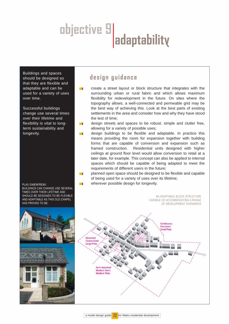
des ign gu idancecreate a street layout or block structure that integrates with thesurrounding urban or rural fabric and which allows maximumflexibility for redevelopment in the future. On sites where thetopography allows, a well-connected and permeable grid may bethe best way of achieving this. Look at the best parts of existingsettlements in the area and consider how and why they have stoodthe test of time;design streets and spaces to be robust, simple and clutter free,allowing for a variety of possible uses;design buildings to be flexible and adaptable. In practice thismeans providing the room for expansion together with buildingforms that are capable of conversion and expansion such asframed construction. Residential units designed with higherceilings at ground floor level would allow conversion to retail at alater date, for example. This concept can also be applied to internalspaces which should be capable of being adapted to meet therequirements of different users in the future; planned open space should be designed to be flexible and capableof being used for a variety of uses over its lifetime;wherever possible design for longevity.
Buildings and spacesshould be designed sothat they are flexible andadaptable and can beused for a variety of usesover time.
Successful buildingschange use several timesover their lifetime andflexibility is vital to long-term sustainability andlongevity.
objective 9adaptability
a model design guide for Wales residential development20
PLAS GWENFREWI:BUILDINGS CAN CHANGE USE SEVERALTIMES OVER THEIR LIFETIME ANDSHOULD BE DESIGNED TO BE FLEXIBLEAND ADAPTABLE AS THIS OLD CHAPELHAS PROVED TO BE.
AN ADAPTABLE BLOCK STRUCTURECAPABLE OF ACCOMMODATING A RANGE
OF DEVELOPMENT SCENARIOS
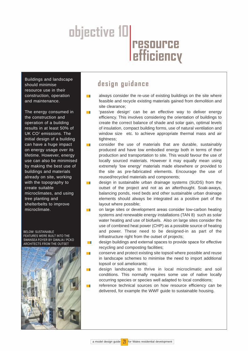
des ign gu idancealways consider the re-use of existing buildings on the site wherefeasible and recycle existing materials gained from demolition andsite clearance; ‘passive design’ can be an effective way to deliver energyefficiency. This involves considering the orientation of buildings tocreate the correct balance of shade and solar gain, optimal levelsof insulation, compact building forms, use of natural ventilation andwindow size etc. to achieve appropriate thermal mass and airtightness;consider the use of materials that are durable, sustainablyproduced and have low embodied energy both in terms of theirproduction and transportation to site. This would favour the use oflocally sourced materials. However it may equally mean usingextremely ‘low energy’ materials made elsewhere or provided tothe site as pre-fabricated elements. Encourage the use ofreused/recycled materials and components;design in sustainable urban drainage systems (SUDS) from theoutset of the project and not as an afterthought. Soak-aways,balancing ponds, reed beds and other sustainable urban drainageelements should always be integrated as a positive part of thelayout where possible;on large sites or development areas consider low-carbon heatingsystems and renewable energy installations (TAN 8) such as solarwater heating and use of biofuels. Also on large sites consider theuse of combined heat power (CHP) as a possible source of heatingand power. These need to be designed-in as part of theinfrastructure right from the outset of projects;design buildings and external spaces to provide space for effectiverecycling and composting facilities;conserve and protect existing site topsoil where possible and reusein landscape schemes to minimise the need to import additionaltopsoil or soil ameliorants;design landscape to thrive in local microclimatic and soilconditions. This normally requires some use of native locallyoccurring species or species well adapted to local conditions;reference technical sources on how resource efficiency can bedelivered, for example the WWF guide to sustainable housing.
Buildings and landscapeshould minimise resource use in theirconstruction, operationand maintenance.
The energy consumed inthe construction andoperation of a buildingresults in at least 50% ofUK CO2 emissions. Theinitial design of a buildingcan have a huge impacton energy usage over itslifetime. However, energyuse can also be minimisedby making the best use ofbuildings and materialsalready on site, workingwith the topography tocreate suitablemicroclimates, and usingtree planting andshelterbelts to improvemicroclimate.
objective 10resourceefficiency
a model design guide for Wales residential development21
BELOW: SUSTAINABLE FEATURES WERE BUILT INTO THESWANSEA FOYER BY GWALIA / PCKOARCHITECTS FROM THE OUTSET

3.0the des ign process
3.0.1 Without a logical, comprehensive and inclusive design process it will be virtually impossible toachieve good design. An effective design process consists of:
effective consultation and engagement throughout the projectan inception phasepolicy reviewcontext and site appraisalvisioningdesign development and refinement
Planning authorities will expect anyone proposing residential development to describe the design processfollowed in a design statement which should accompany every application. It is therefore advisable toagree the design process with the planning authority before developing plans for any site.
3.1 consultation and engagement3.1.1 Designs should be developed in consultation and engagement with the planning authority, local
stakeholders and the community. Consultation is essential to address key planning and design con-cerns before taking a design too far. The first consultee should be the planning authority to fullyunderstand the issues that will need to be addressed in developing the design. This initial meetingmay help to clarify which skills will be needed on the design team, other stakeholders to consult aswell as confirming contacts and a programme for submitting the application. Key issues to consid-er in carrying out a programme of consultation and engagement are:
develop the consultation/engagement programme in agreement with the planning authority to reflectthe local importance or scale of the project. In the simplest of cases this may involve little more thaninforming the neighbours and discussing concerns with them. For larger projects it may involve amore extensive series of events and meetings such as visioning events, enquiry by design or focusgroup meetings;consider the use of experts who are experienced in the management and facilitation of consultationand engagement;clearly set out the parameters of the consultation and engagement process to participants at theoutset and spell out the fixes such as the number and density of houses allocated for the site. Avoidrevisiting first principles such as whether the site should have been identified for development in thefirst place;
a model design guide for Wales residential development22
IMAGES: THE LEVEL OF CONSULTATION WILL VARY FROMPROJECT TO PROJECT. FORLARGE OR SENSITIVE PROJECTSVISIONING AND DESIGN DEVELOPMENT CAN INCLUDE‘ENQUIRY BY DESIGN’ IN WHICHSTAKEHOLDERS ARE INVOLVEDIN THE DESIGN PROCESS. CONSULTEES CAN BE ENCOURAGED TO PROVIDE CREATIVE INPUT IN A VARIETYOF WAYS.

a model design guide for Wales residential development23
always hold pre-application discussions with the planning authority to confirm the vision (3.5) for thesite before plans have been resolved;consult with relevant authorities including the police (through the local architectural liaison officer),Environment Agency, Countryside Council for Wales etc.;provide opportunities for the community and stakeholders to provide input into the design processbefore plans have been prepared so that there is a genuine opportunity for ideas and suggestionsto be responded to;always let people know how their comments / input will be used at the outset and give them feed-back on how/if comments have been taken into account;consultation and engagement should be seen as part of a collaborative approach in which thedesign team, planning authority and stakeholders influence the final design solution.
3.2 inception phase3.2.1 The easiest way to deliver well-designed, sustainable development is to employ a good design
team. On the whole, good designers produce good design and quicker planning permission. In con-sidering what consultants to appoint always:
use consultants with a proven track record and skills in the delivery of well designed sustainabledevelopment; and,select consultants on the basis of quality as well as price - in the long run a good designer will becost effective and should be able to secure a planning permission efficiently.
3.3 policy review3.3.1 Developers and designers must understand the planning policy context within which they are work-
ing.
3.3.2 In particular the following should be considered:
National policy and guidance; Development Plan Policies in the Development Plan;Other Supplementary Planning Guidance;Standards and regulations applying within the LPA area;
TAN 12

Advice from statutory consultees.Legal/planning constraints (eg Public Rights of Way, Listed Buildings, Tree Preservation Orders,easements etc.).Local initiatives such as design advisory panels, Conservation Area advisory groups etc. who maybe a source of assistance and information.Planning history including previous planning and appeal decisions and results of public consulta-tions, particularly with respect to design issues. Non-statutory design guidance.
3.4 context and site appraisal3.4.1 To adequately address each design objective, certain characteristics of the context and site need to
be identified, recorded and responded to by the designer. The attributes of context and site essen-tial to an understanding of any place and to enable development are:
its history and pattern of growth;its landscape and biodiversity; the social and economic profile;patterns of movement and the location of local facilities and services;site constraints and opportunities, (including topography and existing buildings)
3.4.2 Not all of these will be relevant to all projects. The local authority can advise on the main site andcontext issues to concentrate on.
3.4.3 Site and context appraisal should always be carried out by qualified professionals. These mayinclude:
landscape architect engineer town plannerurban designer ecologist arboriculturist architect surveyor
3.4.4 Where they have been completed Biodiversity Action Plans, Conservation Strategies, LANDMAPstudies and others carried out by the LPA should be referred to as these may be useful sources ofdata relating to the site and context. LANDMAP studies normally include information on scenic, sen-sory, ecological, archaeological and cultural aspects of an area.
a model design guide for Wales residential development24
LEFT: AN ECOLOGICAL SURVEYSHOULD ALWAYS BE APRECURSOR TO THE DEVELOPMENT OF ANY SITE.MANY SPECIES ARE PROTECT BYLAW AND DISTURBING THEM IS ANOFFENCE.
a model design guide for Wales residential development25
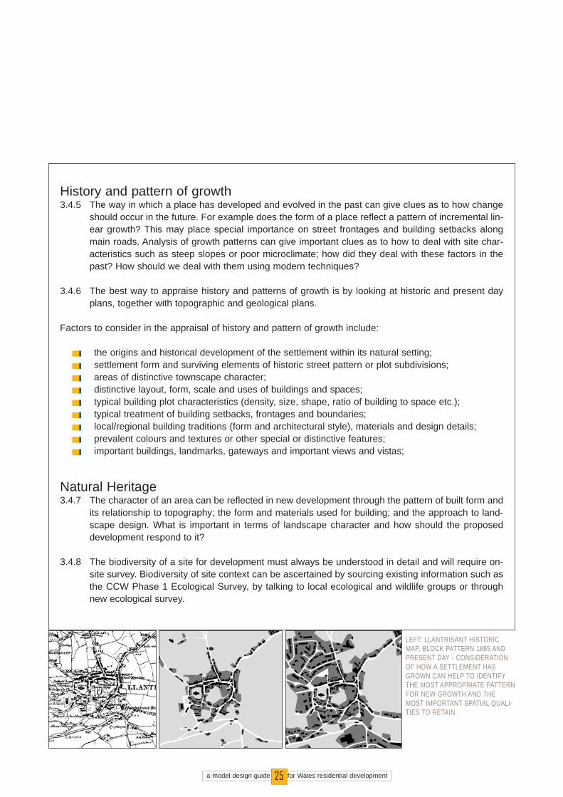
History and pattern of growth 3.4.5 The way in which a place has developed and evolved in the past can give clues as to how change
should occur in the future. For example does the form of a place reflect a pattern of incremental lin-ear growth? This may place special importance on street frontages and building setbacks alongmain roads. Analysis of growth patterns can give important clues as to how to deal with site char-acteristics such as steep slopes or poor microclimate; how did they deal with these factors in thepast? How should we deal with them using modern techniques?
3.4.6 The best way to appraise history and patterns of growth is by looking at historic and present dayplans, together with topographic and geological plans.
Factors to consider in the appraisal of history and pattern of growth include:
the origins and historical development of the settlement within its natural setting;settlement form and surviving elements of historic street pattern or plot subdivisions;areas of distinctive townscape character;distinctive layout, form, scale and uses of buildings and spaces;typical building plot characteristics (density, size, shape, ratio of building to space etc.);typical treatment of building setbacks, frontages and boundaries;local/regional building traditions (form and architectural style), materials and design details;prevalent colours and textures or other special or distinctive features;important buildings, landmarks, gateways and important views and vistas;
Natural Heritage 3.4.7 The character of an area can be reflected in new development through the pattern of built form and
its relationship to topography; the form and materials used for building; and the approach to land-scape design. What is important in terms of landscape character and how should the proposeddevelopment respond to it?
3.4.8 The biodiversity of a site for development must always be understood in detail and will require on-site survey. Biodiversity of site context can be ascertained by sourcing existing information such asthe CCW Phase 1 Ecological Survey, by talking to local ecological and wildlife groups or throughnew ecological survey.
LEFT: LLANTRISANT HISTORICMAP, BLOCK PATTERN 1885 ANDPRESENT DAY - CONSIDERATIONOF HOW A SETTLEMENT HASGROWN CAN HELP TO IDENTIFYTHE MOST APPROPRIATE PATTERNFOR NEW GROWTH AND THEMOST IMPORTANT SPATIAL QUALI-TIES TO RETAIN.

RIGHT: IT IS VITIAL TO UNDER-STAND HOW VISIBLE A SITE IS AND
WHAT IMPACT THE VIEWS WILLHAVE. THERE IS NO REASON FOR
DEVELOPMENT TO HAVE ANEGATIVE VISUAL IMPACT BUT IF
NOT DESIGNED CAREFULLY ITCAN SERIOUSLY DETRACT FROM
LANDSCAPE CHARACTER .
a model design guide for Wales residential development26
Factors to consider in the appraisal of natural heritage include:
visibility of site;role/prominence of the site in important views within the area from which the site is visible;the character of the landscape surrounding the site and important features that contribute to it;the role of the site, if any, in contributing to the character of the surrounding landscape;how the site relates to the surrounding landscape (e.g. position in relation to topography, aspect,character of edges, visual prominence etc.);the features that define its natural setting and natural edges (e.g. ridge-lines, valleys, blocks of vegetation);the role, if any, of the site in relation to the setting of any adjacent settlement;important landmarks, views and skylines to be respected;green spaces, corridors, trees, hedges, other cultivated elements and natural features (e.g. semi-natural vegetation, watercourses and wetlands etc.);the character and condition of the site boundaries and the relationship between the site and contiguous areas of landscape and townscape;positive characteristics of the local landscape and vegetation immediately adjacent to the site,including its quality, condition, scale, enclosure, and important links to be maintained (e.g. greencorridors);features or intrusive influences that detract from the character and quality of the site and need to bemitigated as part of the development proposals;ecological survey of site;review of ecological data related to site context, for example Phase 1 ecological survey.
Social and economic profile3.4.9 An understanding of the social and economic profile of an area can be useful for large or complex
sites but may not be necessary for smaller allocated sites. It can help a developer deliver a mix andtenure of properties that meet the identified needs of the local area. It is particularly important formixed use development in which a good understanding of the local market is essential to be ableto plan effectively for employment and retail uses. An understanding of issues related to crime anddisorder can also be very important at the outset of the project and can help the designer to ensurethat the development contributes to a safe and secure community.

a model design guide for Wales residential development27
Factors to consider in the appraisal of social and economic profile include:
population of area; social and economic needs - how can the proposed development contribute;issues related to crime and disorder;market demands and deficiencies;
Patterns of Movement and Use3.4.10 Development proposals need to be taken forward from a position of having a clear understanding
of the surrounding movement network so that they can be positively designed to complement it.
Factors to consider in the appraisal of patterns of use and movement include:
existing patterns of movement and opportunities for linkage;pattern and distribution of uses including parks, schools, shops and other facilities including public transport;barriers to movement (roads, watercourses etc.); rights of way and other paths and evidence of recreational or other use of the site;potential main access points and other potential access links (e.g. footpath and bridleway) fromadjacent areas into the site;potential linkages to subsequent stages of development.
Site constraints and opportunities3.4.11 The physical characteristics of a site need to be identified and recorded to allow a development to
proceed in the full knowledge of all site features, archaeology, infrastructure, services and groundconditions.
Factors to consider in the appraisal of site constraints and opportunities include:
the physical characteristics of the site (e.g. slope, aspect, soils, ground conditions, drainage, micro-climate etc.) which may influence development capacity;archaeology;the location and condition of features to be retained (e.g. trees, shrubs, hedges, ponds, watercours-es, buildings, structures, walls etc.);

a model design guide for Wales residential development28
the presence and location of services (e.g. drains, sewers, ducts, utilities, wayleaves, power cablesetc.);the siting of neighbouring buildings, especially housing, in order to ensure development protectsexisting amenities.
3.5 visioning3.5.1 All projects should be supported by a design statement including a 'vision' describing clearly the
special role and distinctive character that the development is seeking to achieve.
3.5.2 A vision is not the same as a design; it is the idea behind the design, for example whether a site willbe developed as a 'loose leafy suburb' or a 'tight urban village'. Vision does not necessarily meansomething exciting or out of the ordinary. In fact a vision could be simply 'to create an attractive bitof town in keeping with the local area'. The vision for the site will inform all elements of the design.For example if a development is 'tight and urban' it is likely to be high density with well enclosedstreets and spaces. If 'loose, leafy and suburban' it may be spacious, with a lot of trees and low den-sity.
3.5.3 The development of the vision should precede design development. The process of vision develop-ment is an excellent time to engage the planning authority, community and other stakeholders in thedesign process. Anyone proposing new residential development should have a vision for the sitewhich answers the following questions:

a model design guide for Wales residential development29
what sort of place should this site become taking into account its natural heritage characteristics andcontext?what key words or phrases describe the qualities that it is hoped development will achieve? what character and uses would achieve these qualities?
3.5.4 Sometimes it is necessary to think big and be bold. Strong and simple ideas are usually the best.
3.6 design development and refinement3.6.1 Design development will involve considering how each design and sustainability objective can be
achieved on a particular site.
3.6.2 Developers and designers should always talk to the local authority before detailed proposals havebeen developed. A pre-application discussion can help the authority give an opinion on a develop-ment proposal at an early stage. At a pre-application discussion the designer or developer shouldbe able to convey:
the policy background;the results of the site and context appraisal;reports of any relevant consultations;the initial 'vision' for the site's development in response to the policy background, the site and itssettings, the purpose of development and the desire to create a high quality of life for residents; and,an initial indication of how each of the design and sustainability objectives will be achieved.
3.6.3 This information can be set out in a pre-application statement.
3.6.4 Ideally the developer and the local authority should work together to produce an agreed vision state-ment and approach to the design principles before detailed design development proceeds. This willensure that all parties are clear about the aims and objectives of the project at the outset.
a model design guide for Wales residential development30
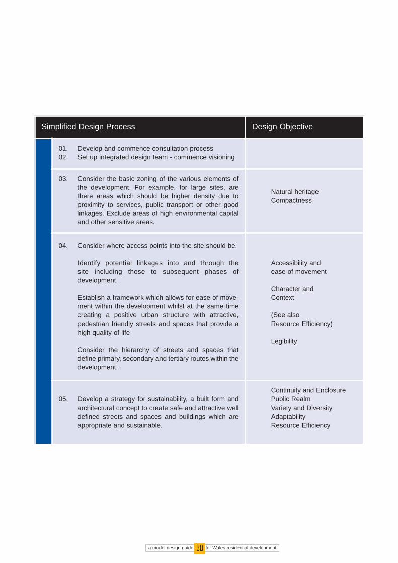
Simplified Design Process Design Objective
01. Develop and commence consultation process02. Set up integrated design team - commence visioning
03. Consider the basic zoning of the various elements ofthe development. For example, for large sites, arethere areas which should be higher density due toproximity to services, public transport or other goodlinkages. Exclude areas of high environmental capitaland other sensitive areas.
Natural heritageCompactness
04. Consider where access points into the site should be.
Identify potential linkages into and through the site including those to subsequent phases of development.
Establish a framework which allows for ease of move-ment within the development whilst at the same timecreating a positive urban structure with attractive,pedestrian friendly streets and spaces that provide ahigh quality of life
Consider the hierarchy of streets and spaces thatdefine primary, secondary and tertiary routes within thedevelopment.
Accessibility and ease of movement
Character andContext
(See also Resource Efficiency)
Legibility
05. Develop a strategy for sustainability, a built form andarchitectural concept to create safe and attractive welldefined streets and spaces and buildings which areappropriate and sustainable.
Continuity and EnclosurePublic RealmVariety and DiversityAdaptabilityResource Efficiency
a model design guide for Wales residential development31
4.0submitting the planning application
4.1 The requirements for submitting a planning application will vary from council to council. The sup-porting information outlined in this section gives an indication of minimum requirements.
4.2 design statement4.2.1 PPW and TAN 12 require that applications for planning permission are accompanied by a design
statement. A design statement is an opportunity for developers and designers to describe theirvision for a site and demonstrate how they have responded to each of the key design and sustain-ability principles.
4.2.2 TAN 12 spells out the required content for a design statement as:
the design principles and design concept;how these are reflected in the development 's location, layout, density, scale, detailed design andlandscape;how the design relates to its site and its wider context;andhow the development will meet UDP design policies and SPG requirements.
4.2.3 In preparing a design statement to meet these requirements the following are of particular impor-tance to demonstrate compliance with this guide:
the design concept should meet the requirements of section 3.5 of this guide setting out a holisticvision for the site's development;the 'design principles' should specifically set out how each of the relevant design objectives includ-ed in this guide have been addressed;
4.2.4 A written design statement should be illustrated, as appropriate by:
plans and elevations;photographs of the site and its surroundings;andother illustrations such as perspectives.
4.2.5 The appendix contains a checklist of information requirements for a planning application which localplanning authorities are encouraged to use as a model and adapt to individual circumstances.

UDP design policies and SPG
Site and context appraisal
Vision describing the 'place' and how it relates to site and context
Design principles and how they respond to site and context appraisal
Natural Heritage
Compactness
Accessibility and ease of movement
Legibility
Character and context
Continuity and enclosure
Public realm
Variety and diversity
Adaptability
Resource efficiency
Supporting information (see appendix 1)
a model design guide for Wales residential development32
SUPPORTING INFORMATION, PLANSAND ELEVATIONS FOR
ASSISTED LIVING AND DAY CARECENTRE, BURRY PORT.
Design Statement Checklist
a model design guide for Wales residential development
5.0des ign appra isa l
5.1 This guide spells out the design objectives which should be taken into account by anyone propos-ing a new residential development in excess of one dwelling. It requires a design statement describ-ing a vision for the site and how the proposal meets each objective.
5.2 Design appraisal will be carried out by the planning authority and may involve:
asking whether the proposal/design statement includes a clear and appropriate vision / design con-cept which relates to the policy review and site appraisal process; and,appraising how well the development proposal addresses each of the relevant design objectives.
5.3 The design appraisal process should be carried out to allow sufficient time before determination ofthe application to allow design improvements to be made. The appraisal may be carried out collab-oratively between the planning authority and the person or team proposing the development. Itshould be a positive and creative process to identify specific areas in which improvements can bemade.
5.4 It will not be possible to make a fundamentally poor development proposal acceptable through com-pliance with this guide. However proposals for sites supported by the UDP and which have a strongvision and which respond to each relevant design objective should be supported by the planningauthority on design grounds.
5.5 For major applications, those important to the local community or likely to set a precedent any oneproposing development may wish the Design Commission for Wales (DCfW) to review the propos-als. The Design Commission for Wales is a national organisation established and core funded bythe National Assembly for Wales. DCFW's mission is to champion high standards of architecture,landscape and urban design in Wales, promoting wider understanding of the importance of goodquality in the built environment, supporting skill building, encouraging social inclusion and sustain-able development.DcFW has its own design review process which can be found on its website atwww.dcfw.org. Contact details are: DCfW, 4th Floor Building, Two Caspian Point, Caspian Way,Cardiff Bay CF10 4DQ.
33

a model design guide for Wales residential development34
a model design guide for Wales residential development35
6.0case s tud ies
6.1 The Building for Life website http://www.buildingforlifewales.org includes a number of case studies of residential schemes that exhibit some positive qualities of design. The case studies have been researched and reviewed by Mike Biddulph and Alan Hooper on behalf of DCfW in partnership with the House Builders Federation and the Civic Trust. This chapter reviews thesecase studies and shows how they achieve many of the objectives of good design described in thisdocument. Users of this document are encouraged to visit the Building for Life Wales website to seethe full review of each scheme and links to related sites.
6.2 The inclusion of these case studies in this document is intended to demonstrate the relevance ofeach of the objectives to the design process and does not indicate any particular endorsement ofthe projects by POSW.

OverviewThe relocation of the S.A. Brains brewery left a vacant industrial site inCardiff City Centre. The scheme is arranged around courtyard spaceenclosed by high quality architecture giving a distinct character and iden-tity to the development. The scheme has a vibrant mix of uses andincludes restaurants, bars, commercial space and residential units. The complex retains 2 listed buildings and renovates several other structures.
Principles The site represented an opportunity to create a catalyst for future invest-ment in this part of Cardiff. The resulting scheme combines a complexindustrial site with a vibrant mix of uses to deliver a development whichis not only successful in its own right but is also generating renewed inter-est in the surrounding area.
VisionThe vision called for a unique solution, with a European flavour, ascheme that would become a destination within the city of CardiffThe scheme utilised imagery from Covent Garden and Temple Barin Dublin to generate a picture of the desired scheme
CompactnessCompactness relates directly to the vision through the creation of adense European style and a city destinationExternally, units continue street frontagesInternal spaces are defined by built form to create routes and courtyards
Accessibility and Ease of MovementRelated to the vision through the creation of permeable internalspaces, linked to external streetsInternal routes are overlooked, maximising safety
Character and ContextStrong vision for a contemporary and unique schemeA new identity based around high quality architecture, a mix of usesand restored heritage from the previous brewery use
Key Information
Date Completed:Autumn 2003
Client: Mansford Holdings PLC & S ABrains
Architect/designer:Powell Dobson Architects
Planning Authority:Cardiff County Council
Number and type of dwellings42, 1,2 and 3 bed apartments
Key Success Factors
Strong vision creating a clearimage of the desired design, car-ried through into the built scheme
Mixed use development using thequalities of each different use tomaximise the vibrancy of the over-all scheme
High quality central public spaceintegrated with built form and theactivity of uses on the ground floorof surrounding units
Brewery Quartercard i f f
BREW
ERY
QUAR
TER:
POW
ELL
DOBS
ONAR
CHIT
ECTS
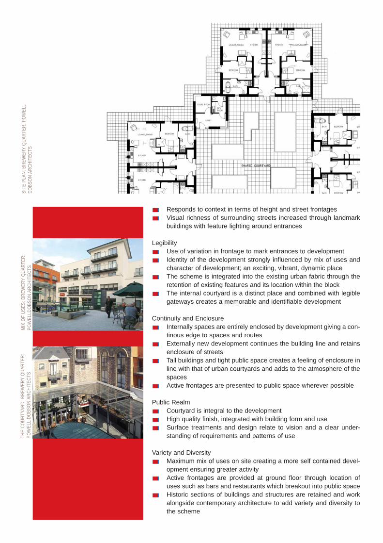
Responds to context in terms of height and street frontagesVisual richness of surrounding streets increased through landmarkbuildings with feature lighting around entrances
LegibilityUse of variation in frontage to mark entrances to developmentIdentity of the development strongly influenced by mix of uses andcharacter of development; an exciting, vibrant, dynamic placeThe scheme is integrated into the existing urban fabric through theretention of existing features and its location within the blockThe internal courtyard is a distinct place and combined with legiblegateways creates a memorable and identifiable development
Continuity and EnclosureInternally spaces are entirely enclosed by development giving a con-tinous edge to spaces and routesExternally new development continues the building line and retainsenclosure of streetsTall buildings and tight public space creates a feeling of enclosure inline with that of urban courtyards and adds to the atmosphere of thespacesActive frontages are presented to public space wherever possible
Public RealmCourtyard is integral to the developmentHigh quality finish, integrated with building form and useSurface treatments and design relate to vision and a clear under-standing of requirements and patterns of use
Variety and DiversityMaximum mix of uses on site creating a more self contained devel-opment ensuring greater activityActive frontages are provided at ground floor through location ofuses such as bars and restaurants which breakout into public spaceHistoric sections of buildings and structures are retained and workalongside contemporary architecture to add variety and diversity tothe scheme
MIX
OF
USES
: BRE
WER
YQU
ARTE
R:
POW
ELLD
OBSO
N AR
CHIT
ECTS
SITE
PLA
N: B
REW
ERY
QUAR
TER:
POW
ELL
DOBS
ON A
RCHI
TECT
STH
E CO
URTY
ARD:
BRE
WER
YQU
ARTE
R:PO
WEL
LDO
BSON
ARC
HITE
CTS

OverviewPenarth is a Victorian town in close proximity to Cardiff. CoronationTerrace and the site fall within the Penarth conservation area. The sitefaces east and has good views across Cardiff and Cardiff Bay. Previouslyhousing garages, the site represented an opportunity to develop a con-temporary scheme within the conservation area.
Principles Responses to character and context are among the most emotive designdecisions that have to be made when developing small infill schemes.Whilst contrasting to the existing character of the area, the scheme suc-ceeds on a number of levels through careful consideration of the princi-ples set out within this document.
VisionA clear vision to create a contemporary infill development creating anew identity in an established residential area on a small site
CompactnessThe scheme makes efficient use of a tight site
Character and ContextStrong vision for a contemporary schemeProducing a bold distinct new identityResponds to context in terms of height and orientation but uses setback, boundary treatments, materials and architectural form anddetail to contrast with existingVisual richness is increased by the scheme which creates a strongaddition to Coronation Terrace through form and fenestration
LegibilityThe project, although controversial, should deliver a very strongpositive image based upon its high quality distinctive architectureThe massing of the unit enables the scheme to have a greater influ-ence over the character of the street and introduces a distinct land-mark, creating a memorable place
Key Information
Date Completed:2003
Client: Andton Properties Ltd
Architect/designer:Atkins DE2
Planning Authority:Vale of Glamorgan
Number and type of dwellings3, 1 bed 3 storey houses
Key Success Factors
A strong vision for a contemporaryscheme within a conservationarea has produced a controversialyet successful design which cre-ates a new identity within anestablished residential area
Massing increases enclosure ofCoronation Terrace and creates acontinuous active facade
Architectural detailing has allowedviews across to Cardiff and CardiffBay to be enjoyed by the maximi-um quantity of rooms
Coronation Terracepenarth
PROP
OSED
AND
BUI
LTSC
HEM
E:CO
RONA
TIOO
N TE
RRAC
E: A
TKIN
S DE
2:
PHOT
O M
IKE
BIDD
ULPH

Continuity and EnclosureMassing and terraced form dramatically increases enclosure of thestreetContinuity of the facade is improved Increased level of overlooking on streetPartially internalised parking providing securityHeight of buildings respond to existing
Variety and diversityBold new identity increases architectural diversity of the areascheme introduces an unusual size of unit which will increase thediversity in housing stock of the area
AdaptabilityOrientation of units allows integration into the existing street formGround floor and parking areas could be adapted to liveable roomsin the future with parking moving on street
FRON
TEL
EVAT
ION
PERS
PECT
IVE:
CO
RONA
TION
TER
RACE
: ATK
INS
DE2
CORO
RNAT
ION
TER
RACE
: AT
KINS
DE2
: PHO
TO M
IKE
BIDD
ULPH
AXON
OMET
RIC:
CO
RONA
TION
TER
RACE
: ATK
INS
DE2

OverviewThe planned closure of existing long term care facilities for people withsevere disabilities required re-provision for 6 permanent residents. Thisbrought forward a site adjacent to the existing facility for development.The site is within a grade II listed walled garden.
Each resident requires 24hr care and accommodation that responds tochanging physical needs of each person whilst promoting independence.In addition the scheme would also have to consider the specific require-ments of individuals who have been in long term institutional care.
Principles Achieved in the SchemeThe bespoke scheme is a specific response to a specific problem. To thisend it does not demonstrate an approach consistent with all the principlesset out in the design guide. However, in terms of many factors it is a high-ly successful piece of design, demonstrating that all schemes need avision and that the level of success is linked directly to the clarity of thevision. In addition the scheme takes an approach to energy efficiency thathas produced an excellent example of energy efficient design in excessof the requirements of current guidance.
VisionCreate a scheme with an environment for end users which is sup-portive, yet allows independence, is designed for longevity andincorporates both contemporary and existing historic structuresThe design is a bespoke response to this vision
CompactnessThe combination of 6 single storey residential units and a commu-nal central garden makes efficient use of the site2 parking spaces are provided for each unit
Accessibility and Ease of MovementLinked to the overall vision, accessibility is one of the key require-ments enabling easy access by end users and a higher level of inde-pendence through the use of motorised doors and attention tothreshold details
Key Information
Date Completed:December 2003
Client: Charter Housing Association Ltdand Monmouthshire CountyCouncil Social Services Dept.
Architect/designer:Ainsley Gommon Architects
Planning Authority:Monmouthshire County Council
Number and type of dwellings6 dwellings, residential care home
Key Success Factors
Clear vision related to the specificneeds of end users
An excellent approach to energyefficiency resulting in an energyefficient scheme over and aboveguidance
Flexibility within use for changingneeds of end users
Dry BridgeGardens
EXTE
RNAL
AND
INTE
RNAL
: DRY
BRID
GEGA
RDEN
S: A
INSL
EYGO
MM
ON A
RCHI
-TE
CTS
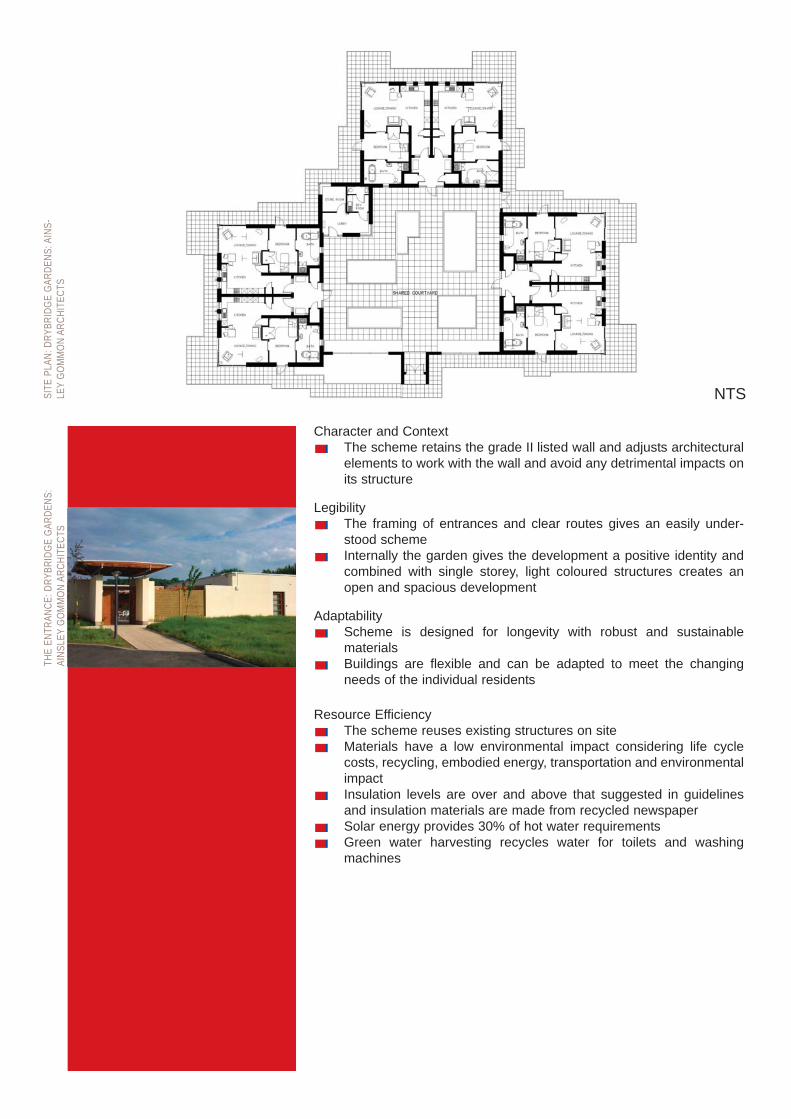
Character and ContextThe scheme retains the grade II listed wall and adjusts architecturalelements to work with the wall and avoid any detrimental impacts onits structure
LegibilityThe framing of entrances and clear routes gives an easily under-stood schemeInternally the garden gives the development a positive identity andcombined with single storey, light coloured structures creates anopen and spacious development
AdaptabilityScheme is designed for longevity with robust and sustainable materials Buildings are flexible and can be adapted to meet the changingneeds of the individual residents
Resource EfficiencyThe scheme reuses existing structures on siteMaterials have a low environmental impact considering life cyclecosts, recycling, embodied energy, transportation and environmentalimpactInsulation levels are over and above that suggested in guidelinesand insulation materials are made from recycled newspaperSolar energy provides 30% of hot water requirementsGreen water harvesting recycles water for toilets and washingmachines
THE
ENTR
ANCE
: DRY
BRID
GE G
ARDE
NS:
AINS
LEY
GOM
MON
ARC
HITE
CTS
SITE
PLA
N: D
RYBR
IDGE
GAR
DENS
: AIN
S-LE
YGO
MM
ON A
RCHI
TECT
S
NTS
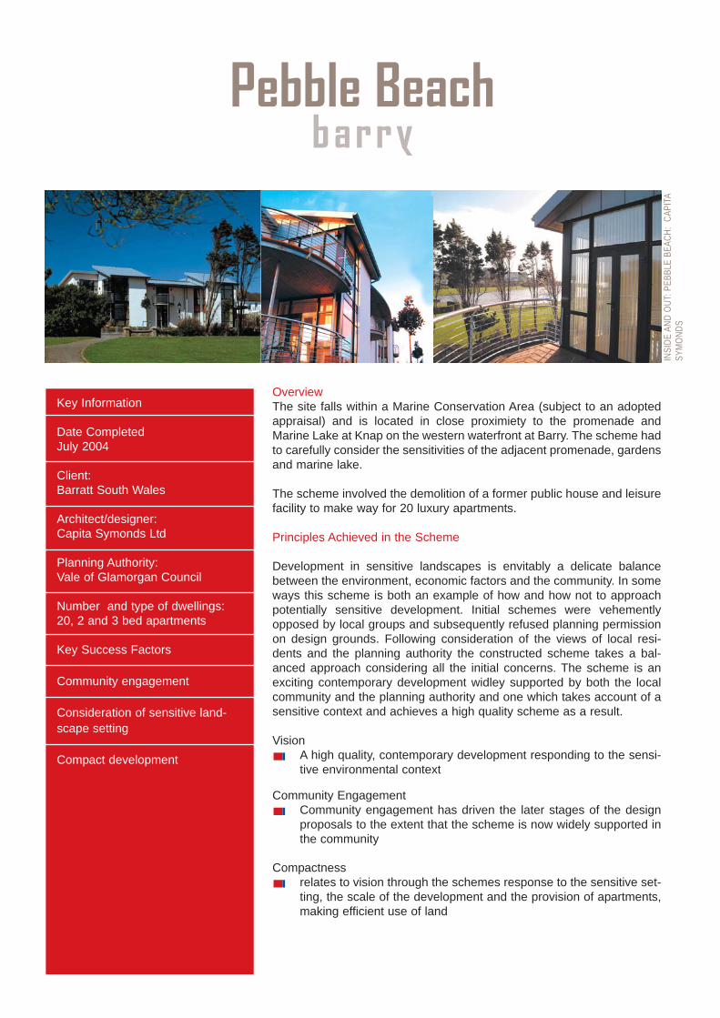
OverviewThe site falls within a Marine Conservation Area (subject to an adoptedappraisal) and is located in close proximiety to the promenade andMarine Lake at Knap on the western waterfront at Barry. The scheme hadto carefully consider the sensitivities of the adjacent promenade, gardensand marine lake.
The scheme involved the demolition of a former public house and leisurefacility to make way for 20 luxury apartments.
Principles Achieved in the Scheme
Development in sensitive landscapes is envitably a delicate balancebetween the environment, economic factors and the community. In someways this scheme is both an example of how and how not to approachpotentially sensitive development. Initial schemes were vehementlyopposed by local groups and subsequently refused planning permissionon design grounds. Following consideration of the views of local resi-dents and the planning authority the constructed scheme takes a bal-anced approach considering all the initial concerns. The scheme is anexciting contemporary development widley supported by both the localcommunity and the planning authority and one which takes account of asensitive context and achieves a high quality scheme as a result.
VisionA high quality, contemporary development responding to the sensi-tive environmental context
Community EngagementCommunity engagement has driven the later stages of the designproposals to the extent that the scheme is now widely supported inthe community
Compactnessrelates to vision through the schemes response to the sensitive set-ting, the scale of the development and the provision of apartments,making efficient use of land
Key Information
Date CompletedJuly 2004
Client: Barratt South Wales
Architect/designer:Capita Symonds Ltd
Planning Authority:Vale of Glamorgan Council
Number and type of dwellings:20, 2 and 3 bed apartments
Key Success Factors
Community engagement
Consideration of sensitive land-scape setting
Compact development
Pebble Beachbarry
INSI
DE A
ND O
UT: P
EBBL
E BE
ACH:
CAP
ITA
SYM
ONDS
Character and ContextStrong vision for luxury development works with the landscape set-ting through a sensitive approach to design in roof lines and detailedmaterial choicesThe development expresses a distinct identity responding to coastallocation
LegibilityThe scheme has a clear identity related to the vision- high qualitywell designed luxuryHeight and massing has been varied to create variation in impor-tance and help to demarcate gatewaysThe high quality of the architecture and landscape setting will makethis scheme and the places it enhances memorable
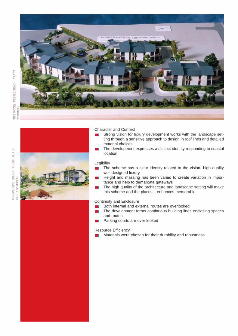
Continuity and EnclosureBoth internal and external routes are overlookedThe development forms continuous building lines enclosing spacesand routesParking courts are over looked
Resource EfficiencyMaterials were chosen for their durability and robustness
PERS
PECT
IVE
SKET
CH: P
EBBL
E BE
ACH:
CAPI
TASY
MON
DSSI
TE M
ODEL
: PEB
BLE
BEAC
H: C
APIT
ASY
MON
DS

OverviewThe site is located near Holywell and is within the Holywell ConservationArea. The scheme involved the rennovation of a derelict school andschool house, sympathetic extension and the restoration of a Grade IIlisted monument of Jesus. The scheme involved the demolition of all butthe main facade to the street and the reconstruction and extension of thebuilding allowing the interior to be adapted to 8 apartments. Sympatheticextension to the building allowed the further 7 aprtments to be built. Allunits are affordable and built to Lifetimes Homes Standard.
Principles Conversion, restoration and conservation projects can often becomeexpensive and complex; as a result a number of developers backed outof this project. It is a testament to the project team and planning authori-ty that the scheme has been such as success, both in terms of budgetand finished product.
Visiona high density conversion and extension scheme to provide a num-ber of affordable housing units
CompactnessRelates directly to the vision to achieve a high density developmentaround the compact form of the existing school buildingsScheme maintains the enclosure given to the street by the existingfacades1.5 parking spaces per dwelling have been provided
Accessibility and Ease of MovementThe central courtyard is overlooked by a number of apartmentsConversion from disused school house to residential use will haveincreased overlooking of the street from habitable rooms
Character and ContextThe character of the development relates directly to the visionthrough the retention of elements which gave the site its characterExtensions respond to height and position of original unitsExtensions give additional interest by referencing but not copyingthe details of the existing units
Key Information
Date Completed:March 2004
Client: Wales and West HousingAssociation
Architect/designer:Ainsley Gommon Architects
Planning Authority:Flintshire
Number and type of dwellings15, 1 and 2 bed apartments and 11 bed bungalow
Key Success Factors
Retention of historic features relat-ing to character
High level of energy efficiency
Plas Gwenfrewiho lywe l l
EXTE
RNAL
VIEW
S: P
LAS
GWEN
FREW
I:AI
NSLE
YGO
MM
ON A
RCHI
TECT
S

LegibilityThe scheme will carry some of the existing identity of the previoususe and buildings but the high quality finish and new use will beginto form a positive identity of its own; a composite of new and old
Continuity and EnclosureOverlooking of the street has been improved by the positive changeof usePublic and private space is demarcated by the original boundary walland gate
Variety and DiversityThe scheme has a mixture of unit sizesHistoric buildings have been retained and along with new additionsadd interest and diversity to the street scene
Resource EfficiencyRecycling of buildings materialsUse of local skilled tradesmen, with traditional skillsHighly insulated buildingsProvision of low cost- low maintenance housing for the local community
STAT
UE O
F JE
SUS:
PLA
S GW
ENFR
EWI:
AINS
LEY
GOM
MON
ARC
HITE
CTS
SITE
PLA
N: P
LAS
GWEN
FREW
I: AI
NSLE
YGO
MM
ON A
RCHI
TECT
S
0 5 10m
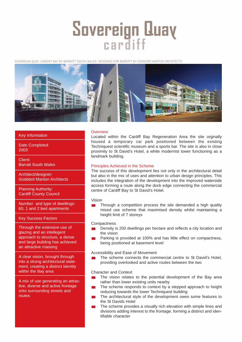
OverviewLocated within the Cardiff Bay Regeneration Area the site orginallyhoused a temporary car park positioned between the existingTechniquest scientific museum and a sports bar. The site is also in closeproximity to St David’s Hotel, a white modernist tower functioning as alandmark building.
Principles Achieved in the SchemeThe success of this development lies not only in the architectural detailbut also in the mix of uses and attention to urban design principles. Thisincludes the integration of the development into the improved watersideaccess forming a route along the dock edge connecting the commercialcentre of Cardiff Bay to St David’s Hotel.
VisionThrough a competition process the site demanded a high qualitymixed use scheme that maximised density whilst maintaining aheight limit of 7 storeys
CompactnessDensity is 200 dwellings per hectare and reflects a city location andthe visionParking is provided at 100% and has little effect on compactness,being positioned at basement level
Accessibility and Ease of MovementThe scheme connects the commercial centre to St David’s Hotel,providing overlooked and active routes between the two
Character and ContextThe vision relates to the potential development of the Bay arearather than lower existing units nearbyThe scheme responds to context by a stepped approach to heightreducing towards the lower Techniquest buildingThe architectural style of the development owes some features tothe St Davids Hotel The scheme provides a visually rich elevation with simple lines anddivisions adding interest to the frontage, forming a distinct and iden-tifiable character
Key Information
Date Completed2003
Client: Barratt South Wales
Architect/designer:Goddard Manton Architects
Planning Authority:Cardiff County Council
Number and type of dwellings:60, 1 and 2 bed apartments
Key Success Factors
Through the extensive use ofglazing and an intellegentapproach to structure, a denseand large building has achievedan attractive massing
A clear vision, brought throughinto a strong architectural state-ment, creating a distinct identitywithin the Bay area
A mix of use generating an attrac-tive, diverse and active frontageonto surrounding streets androutes
Sovereign Quaycard i f f
SOVEREIGN QUAY, CARDIFF BAY BY BARRATT SOUTH WALES. DESIGNED FOR BARRATT BY GODDARD MANTON ARCHITECTS.
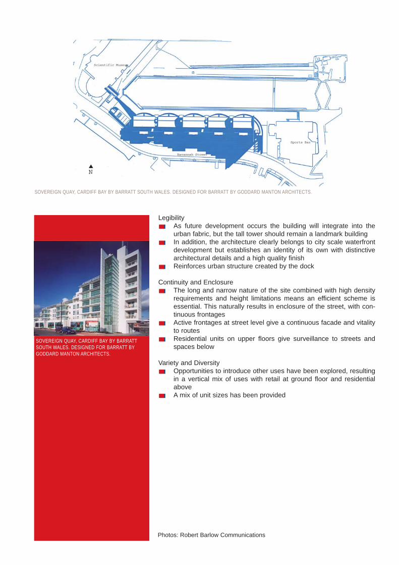
LegibilityAs future development occurs the building will integrate into theurban fabric, but the tall tower should remain a landmark buildingIn addition, the architecture clearly belongs to city scale waterfrontdevelopment but establishes an identity of its own with distinctivearchitectural details and a high quality finishReinforces urban structure created by the dock
Continuity and EnclosureThe long and narrow nature of the site combined with high densityrequirements and height limitations means an efficient scheme isessential. This naturally results in enclosure of the street, with con-tinuous frontagesActive frontages at street level give a continuous facade and vitalityto routes Residential units on upper floors give surveillance to streets andspaces below
Variety and DiversityOpportunities to introduce other uses have been explored, resultingin a vertical mix of uses with retail at ground floor and residentialaboveA mix of unit sizes has been provided
Havannah Street
Scientific Museum
Sports Bar
N
SOVEREIGN QUAY, CARDIFF BAY BY BARRATT SOUTH WALES. DESIGNED FOR BARRATT BY GODDARD MANTON ARCHITECTS.
SOVEREIGN QUAY, CARDIFF BAY BY BARRATTSOUTH WALES. DESIGNED FOR BARRATT BYGODDARD MANTON ARCHITECTS.
Photos: Robert Barlow Communications

OverviewThe site is located in a residential area but was in commercial use priorto development. Contextually the immediate area consists of a number ofcouncil built buildings in the form of maisonnettes and flatted blocks. Theredevelopment was approached as a key deliverable regeneration proj-ect and was supported by both Cardiff County Council and WelshAssembly Government. With a strong community involvement, thedesign reflects the identity and nature of the local community. In addition,the scheme achieves a number of essential urban design criteria .
Principles Achieved in the SchemeThe scheme succeeds on a number of levels through careful considera-tion of the principles set out within this document. Below and overleaf isan explanation of what has been considered and why it led to the highquality scheme that was developed.
VisionA strong vision based on the requirements of local Yemeni commu-nity and potential end usersVision is related to both layout and architecture as well as internalarrangement and materialsScheme design allows the vision to be translated into form and lay-out achieving a connection to Yemani community both in terms ofidentity and density
Community EngagementThe project is based upon a high and continued level of communityengagement
CompactnessLayout and resulting density relates directly to vision through thecre-ation of a compact form arranged around a central courtyard Open space provision is offsiteCourtyard open space is integral to the scheme
Accessibility and Ease of MovementDesign of central courtyard space closely related to that of a homezone creating a safe community areaVehicle speed has been designed out of the space through the useof shared surfacing and the pedestrian orientated design
Key Information
Date CompletedConstruction started in March,2001 and completed October2003
Client: Cardiff Community Housing Association
Architect/designer:PCKO (pre contract), Pentan (postcontract)
Planning Authority:Cardiff County Council
Number and type of dwellingsTotal 28 units; 7 three-storey houses; 19 one and two-bedroomapartments; 2 mobility accesstwo-bedroom apartments
Key Success Factors
Community engagement is at theheart of all stages of designresulting in a scheme whichreflects the requirements anddiversity of the community.
Mixture of types and sizes of Units
Layout enables the delivery of a compact scheme with a cen-tral focus and an active façadeonto Hannah Street
Steffani Courtcard i f f
INSI
DE A
ND O
UT: S
TEFF
ANI C
OURT
:PC
KO/P
ENTA
N
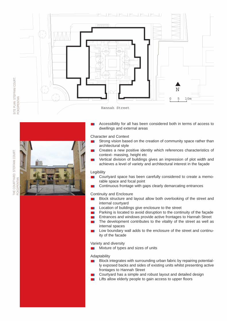
Accessibility for all has been considered both in terms of access todwellings and external areas
Character and ContextStrong vision based on the creation of community space rather thanarchitectural styleCreates a new positive identity which references characteristics ofcontext- massing, height etcVertical division of buildings gives an impression of plot width andachieves a level of variety and architectural interest in the façade
LegibilityCourtyard space has been carefully considered to create a memo-rable space and focal pointContinuous frontage with gaps clearly demarcating entrances
Continuity and EnclosureBlock structure and layout allow both overlooking of the street andinternal courtyardLocation of buildings give enclosure to the streetParking is located to avoid disruption to the continuity of the façadeEntrances and windows provide active frontages to Hannah StreetThe development contributes to the vitality of the street as well asinternal spacesLow boundary wall adds to the enclosure of the street and continu-ity of the facade
Variety and diversityMixture of types and sizes of units
AdaptabilityBlock integrates with surrounding urban fabric by repairing potential-ly exposed backs and sides of existing units whilst presenting activefrontages to Hannah StreetCourtyard has a simple and robust layout and detailed designLifts allow elderly people to gain access to upper floors
N
0 10m5
Hannah Street
THE
COUR
TYAR
D: S
TEFF
ANI C
OURT
:PC
KO/P
ENTA
NSI
TE P
LAN:
STE
FFAN
I COU
RT:
PCKO
/PEN
TAN
append ixLocation plan
Scale 1:1250 preferably and no smaller than 1:2500North point, date and drawing numberOutline the application property, and indicate any adjoining property owned or controlled by theapplicantShow the application property in relation to all adjoining properties and the immediate surroundingarea, including roadsShow vehicular access to a highway if the site does not adjoin a highway
Details of existing site layoutScale, typically 1:200 or appropriate scale to ascertain required level of detailNorth point, date and number on plansShow the whole property, including all buildings, gardens, open spaces and car parkingWhere appropriate: Tree survey. - Nature conservation, biodiversity, drainage and other natural fea-tures. - Existing services
Details of proposed site layoutScale, typically 1:200North point, date and number on plansShow the siting of any new building or extension, vehicular/pedestrian access, changes in levels,landscape proposals, including trees to be removed, new planting, new or altered boundary wallsand fences, and new hard-surfaced open spacesShow proposals in the context of adjacent buildings
Floor plansScale 1:50 or 1:100In the case of an extension, show the floor layout of the existing building to indicate the relationshipbetween the two, clearly indicating new workShow floor plans in the context of adjacent buildings, where appropriateIn the case of minor applications it may be appropriate to combine the layout and floor plan (unlessany demolition is involved)Include a roof plan where necessary to show a complex roof or alteration to one
ElevationsScale 1:50 or 1:100 (consistent with floor plans)Show every elevation of a new building or extensionFor an extension or alteration, clearly distinguish existing and proposed elevationsInclude details of material and external appearanceShow elevations in the context of adjacent buildings, where appropriate
Cross SectionsScale 1:50 / 1:100 (consistent with floor plans), where appropriate.
Supporting InformationUse of photomontages, artist's impressions and / or CAD visualisations to illustrate schemes.3D built models are valuable on major schemes to help show massing and relationship betweenbuildings.
Other matters which may be included where appropriate are:Energy use and efficiency aspectsOn site waste managementFuture maintenance implications and commitment
List of requirements for submitting a planning application from TAN 12.
further read ingThis document is not a comprehensive design guide. Further detailed information on how to addresseach design objective can be found in numerous other documents including those listed below:
Audit Commission 1999, Listen Up! Effective Community Consultation, BRE 2000, The Green Guide to Housing Specification BRE 2004 Thinking Business Space, BREEAM (BRE Environmental Assessment Method), www.breeam.orgBritish Standards Institute BS8300, ‘Access for Disabled People’CABE 2002, The Value of Good Design, CABE/DCfW 2004, Creating Excellent Buildings CABE/DCfW 2004, Creating Successful Masterplans Cardiff University/WWF 2004, Sustainable Construction - Practical Guidance for Crime and Disorder Act1998, Section 17Planners and Developers, Sustainable Housing Design Strategy for WalesCIRIA 2004, Code of Practice: Rights of Access - Goods facilities, services and premises, Considerate Constructors Scheme, www.ccscheme.org.ukDETR 1998, Places Streets and Movement DETR 2000, By Design DETR GPG274, Environmentally Smart Buildings - a Quantity Surveyors Guide to the cost - effectiveness of energy efficient offices DETR GPG287, The Design Team's Guide to Environmentally Smart Buildings Disability Rights Commission www.drc.org.uk, Designing for Accessibility, Centre for AccessibleEnvironments www.cae.org.ukDTLR/CABE, 2001, Better Places to Live English Partnerships, 2000, Urban Design Compendium Evans et al November 1998 - The Long Term Costs of Owning and Using Buildings, The Royal Academyof EngineeringFaber Maunsell/DTI 2004, Engage - how to deliver socially responsible construction - a client's guide Housing Forum February 2002, Rethinking Construction, 20 steps to encourage the use of whole lifecostingIDeA Knowledge and WWF (website), Mainstreaming Sustainable Development through ModernisationKing Sturge 2004, Property Sustainability Matters - Caveat Emptor Local Planning Authorities, Local Biodiversity Action PlansNational Assembly for Wales 2004, Starting to Live Differently ODPM 2004, Safer Places - The Planning System and Crime PreventionSustainable Buildings: Benefits for occupiers, BRE Information paperTCPA 2004, Biodiversity by Design - A Guide for Sustainable Communities UWE 2003, Shaping Neighbourhoods UWE/LGMB, 1995, Sustainable Settlements WDA 1995, Landscapes Working for Wales WDA 2003, Biodiversity Guidelines WDA 2005, ‘The Welsh Development Agency Design Strategy’Welsh Assembly Government 2002, Planning Policy WalesWelsh Assembly Government 2002a, TAN 12 DesignWelsh Assembly Government 2004, Sustainable Development Action Plan Welsh Office Circular 16/94, ‘Planning Out Crime’
glossary: a language for designFrom: DETR and CABE (2000) By Design:Urban design in the Planning System - TowardsBetter Practice, London, Thomas TelfordPublishing
Accessibility The ability of people to move roundan area and to reach places and facilities,including elderly and disabled people, those withyoung children and those encumbered withluggage or shopping.
Adaptability The capacity of a building or space tobe changed so as to respond to changing social,technological and economic conditions.
Area appraisal An assessment of an area's landuses, built and natural environment, and socialand physical characteristics.
Brief This guide refers to site-specific briefs asdevelopment briefs. Site-specific briefs are alsocalled a variety of other names, including designbriefs, planning briefs and developmentframeworks.
Building line The line formed by the frontages ofbuildings along a street. The building line can beshown on a plan or section.
Bulk The combined effect of the arrangement,volume and shape of a building or group ofbuildings. Also called massing.
Character assessment An area appraisalidentifying distinguishing physical features andemphasizing historical and cultural associations.
Charrette An event (ranging from a couple ofhours to several days) which brings together arange of people to discuss design issues. Acharrette may or may not use techniques ofcollaborative design. Also known as a designworkshop.
Conservation area character appraisal Apublished document defining the specialarchitectural or historic interest which warrantedthe area being designated.
Context The setting of a site or area, includingfactors such as traffic, activities and land uses aswell as landscape and built form.
Context (or site and area) appraisal A detailedanalysis of the features of a site or area (includingland uses, built and natural environment, andsocial and physical characteristics) which servesas the basis for an urban design framework,development brief, design guide or other policy orguidance.
Density The floorspace of a building or buildingsor some other unit measure in relation to a givenarea of land.
Built density can be expressed in terms of plotratio (for commercial development); number ofunits or habitable rooms per hectare (forresidential development); site coverage plus thenumber of floors or a maximum building height; ora combination of these.
Design advisory panel A group of people (oftenarchitects) with specialist knowledge, whichadvises a local authority on the design merits ofplanning applications or other design issues. Alsoknown as an architects panel.
Design assessment An independent ass-essment of a design usually carried out for a localauthority by consultants, another local authorityor some other agency.
Design guide A document providing guidance onhow development can be carried out inaccordance with the design policies of a localauthority or other organisation often with a viewto retaining local distinctiveness.
Design principle An expression of one of thebasic design ideas at the heart of an urbandesign framework, design guide, developmentbrief or a development.

Design standards Specific, usually quantifiablemeasures of amenity and safety in residentialareas.
Design statement (a) A pre-application designstatement is made by a developer to indicate thedesign principles on which a developmentproposal in progress is based. It enables the localauthority to give an initial response to the mainissues raised by the proposal. (b) A planningapplication design statement sets out the designprinciples that the planning applicant has adoptedin relation to the site and its wider context, asrequired by PPG1.
Design workshop see 'charrette'.
Desire line An imaginary line linking facilities orplaces which people would find it convenient totravel between easily.
Development brief A document, prepared by alocal planning authority, a developer, or jointly,providing guidance on how a site of significantsize or sensitivity should be developed. Site-specific briefs are sometimes known as planningbriefs, design briefs and developmentframeworks.
Elevation The facade of a building, or the drawingof a facade. Enclosure The use of buildings tocreate a sense of defined space.
Energy efficiency The extent to which the use ofenergy is reduced through the way in whichbuildings are constructed and arranged on site.
Feasibility The viability of development in relationto economic and market conditions.
Fenestration The arrangement of windows on afacade.
Figure and ground (or figure/ground, or Nolli)diagram A plan showing the relationship betweenbuilt form and publicly accessible space(including streets) by presenting the former inblack and the latter as a white background (or theother way round).
Form The layout (structure and urban grain),density, scale (height and massing), appearance(materials and details) and landscape ofdevelopment.
Height The height of a building can be expressedin terms of a maximum number of floors; amaximum height of parapet or ridge; a maximumoverall height; any of these maximum heights incombination with a maximum number of floors; aratio of building height to street or space width;height relative to particular landmarks orbackground buildings; or strategic views.
Human scale The use within development ofelements which relate well in size to an individualhuman being and their assembly in a way whichmakes people feel comfortable rather thanoverwhelmed.
Indicative sketch A drawing of building forms andspaces which is intended to convey the basicelements of a possible design.
Landmark A building or structure that stands outfrom its background by virtue of height, size orsome other aspect of design.
Landscape The character and appearance ofland, including its shape, form, ecology, naturalfeatures, colours and elements and the waythese components combine. Landscapecharacter can be expressed through landscapeappraisal, and maps or plans. In towns'townscape' describes the same concept.
Layout The way buildings, routes and openspaces are placed in relation to each other.
Layout structure The framework or hierarchy ofroutes that connect in the local area and at widerscales.
Legibility The degree to which a place can beeasily understood and traversed.
Local distinctiveness The positive features of aplace and its communities which contribute to itsspecial character and sense of place.
Massing The combined effect of the height, bulkand silhouette of a building or group of buildings.
Mixed uses A mix of uses within a building, on asite or within a particular area. 'Horizontal' mixeduses are side by side, usually in differentbuildings. 'Vertical' mixed uses are on differentfloors of the same building.
Movement People and vehicles going to andpassing through buildings, places and spaces.The movement network can be shown on plans,by space syntax analysis, by highwaydesignations, by figure and ground diagrams,through data on origins and destinations orpedestrian flows, by desire lines, by details ofpublic transport services, by walk bands or bydetails of cycle routes.
Natural surveillance (or supervision) Thediscouragement to wrong-doing by the presenceof passers-by or the ability of people to be seenout of surrounding windows. Also known aspassive surveillance (or supervision).
Node A place where activity and routes areconcentrated often used as a synonym forjunction.
Passive surveillance See 'natural surveillance'.
Permeability The degree to which an area has avariety of pleasant, convenient and safe routesthrough it.
Planning brief This guide refers to site-specificbriefs as development briefs. Other names,including planning briefs, design briefs anddevelopment frameworks are also used.
Technical Advice Notes (TANs) Documentsembodying Welsh Assembly Governmentguidance on general and specific aspects ofplanning policy to be taken into account informulating development plan policies and inmaking planning decisions.
Plot ratio A measurement of density generallyexpressed as gross floor area divided by the netsite area.
Proactive development control Any process bywhich a local authority works with potentialplanning applicants to improve the quality ofdevelopment proposals as early as possiblebefore a planning application is submitted.
Public art Permanent or temporary physicalworks of art visible to the general public, whetherpart of the building or free-standing: can includesculpture, lighting effects, street furniture, paving,railings and signs.
Public domain The parts of a village, town or city(whether publicly or privately owned) that areavailable, without charge, for everyone to use orsee, including streets, squares and parks. Alsocalled public realm.
Public realm See 'public domain'.
Scale The impression of a building when seen inrelation to its surroundings, or the size of parts ofa building or its details, particularly asexperienced in relation to the size of a person.Sometimes it is the total dimensions of a buildingwhich give it its sense of scale: at other times it isthe size of the elements and the way they arecombined. The concept is a difficult andambiguous one: often the word is used simply asa synonym for 'size'. See 'Human scale'.
Section Drawing showing a slice through abuilding or site.
Settlement pattern The distinctive way that theroads, paths and buildings are laid out in aparticular place.
Sight line The line of sight from a travellingvehicle or person. Sight lines will help todetermine how fast vehicles are likely to moveand how safe other road users are likely to be.
Street furniture Structures in and adjacent to thehighway which contribute to the street scene,such as bus shelters, litter bins, seating, lighting,railings and signs.
Surveillance The discouragement to wrong-doingby the presence of passers-by or the ability ofpeople to be seen from surrounding windows.

Tissue study Comparison of scale and layout ofdifferent settlements. This technique makes useof overprinting or tracing maps of successfulplaces over the proposed development site orarea, at the same scale. Its gives the designer aclue to the capacity of a place and how it may bestructured.
Topography A description or representation ofartificial or natural features on or of the ground.
Urban design The art of making places. Urbandesign involves the design of buildings, groups ofbuildings, spaces and landscapes, in villages,towns and cities, and the establishment offrameworks and processes which facilitatesuccessful development.
Urban design framework A document whichinforms the preparation of development planpolicies, or sets out in detail how they are to beimplemented in a particular area where there is aneed to control, guide and promote change. Areadevelopment frameworks are also called a varietyof other names, including urban designstrategies, area development frameworks, spatialmasterplans, and planning and urban designframeworks.
Urban grain The pattern of the arrangement andsize of buildings and their plots in a settlement;and the degree to which an area's pattern ofstreet-blocks and street junctions is respectivelysmall and frequent, or large and infrequent.
Vernacular The way in which ordinary buildingswere built in a particular place, making use oflocal styles, techniques and materials andresponding to local economic and socialconditions.
View What is visible from a particular point.Compare 'Vista'.
Vista An enclosed view, usually a long andnarrow one.