Embed Size (px)
Citation preview

UNLV Theses, Dissertations, Professional Papers, and Capstones
12-2011
A landscape approach to Late Prehistoric settlement and A landscape approach to Late Prehistoric settlement and
subsistence patterns in the Mojave Sink subsistence patterns in the Mojave Sink
Tiffany Ann Thomas University of Nevada, Las Vegas
Follow this and additional works at: https://digitalscholarship.unlv.edu/thesesdissertations
Part of the Archaeological Anthropology Commons, Climate Commons, Desert Ecology Commons,
Human Geography Commons, and the United States History Commons
Repository Citation Repository Citation Thomas, Tiffany Ann, "A landscape approach to Late Prehistoric settlement and subsistence patterns in the Mojave Sink" (2011). UNLV Theses, Dissertations, Professional Papers, and Capstones. 1290. http://dx.doi.org/10.34917/2839023
This Thesis is protected by copyright and/or related rights. It has been brought to you by Digital Scholarship@UNLV with permission from the rights-holder(s). You are free to use this Thesis in any way that is permitted by the copyright and related rights legislation that applies to your use. For other uses you need to obtain permission from the rights-holder(s) directly, unless additional rights are indicated by a Creative Commons license in the record and/or on the work itself. This Thesis has been accepted for inclusion in UNLV Theses, Dissertations, Professional Papers, and Capstones by an authorized administrator of Digital Scholarship@UNLV. For more information, please contact [email protected].

A LANDSCAPE APPROACH TO LATE PREHISTORIC SETTLEMENT AND
SUBSISTENCE PATTERNS IN THE MOJAVE SINK
by
Tiffany Ann Thomas
Associate of Arts
Barstow Community College
2006
Bachelor of Arts
California State University, San Bernardino
2008
A thesis submitted in partial fulfillment
of the requirements for the
Master of Arts in Anthropology
Department of Anthropology
College of Liberal Arts
The Graduate College
University of Nevada, Las Vegas
December 2011

Copyright by Tiffany Ann Thomas, 2012
All Rights Reserved
ii
THE GRADUATE COLLEGE
We recommend the thesis prepared under our supervision by
Tiffany Ann Thomas
entitled
A Landscape Approach to Late Prehistoric Settlement and Subsistence
Patterns in the Mojave Sink
be accepted in partial fulfillment of the requirements for the degree of
Master of Arts in Anthropology Department of Anthropology
Barbara Roth, Committee Chair
Alan Simmons, Committee Member
Karen Harry, Committee Member
Brenda Buck, Graduate College Representative
Ronald Smith, Ph. D., Vice President for Research and Graduate Studies
and Dean of the Graduate College
December 2011

iii
ABSTRACT
A Landscape Approach to the Late Prehistoric Period Settlement
and Subsistence Patterns in the Mojave Sink
by
Tiffany Thomas
Dr. Barbara Roth, Examination Committee Chair
Professor of Anthropology
University of Nevada, Las Vegas
The environment of the Late Prehistoric period (1200 A.D. to Historic Contact)
Mojave Sink was wetter than modern conditions. The settlement and subsistence patterns
of the occupants of the region during this period were driven by the availability of water,
subsistence resources, raw material sources, and tradition. These people utilized the
regional landscape based upon the seasonal availability of these resources. Supplemental
agricultural production has been proposed for the Mojave River Delta due to the more
favorable environmental conditions of this period. If agriculture was being practiced it
would have affected the regional land-use patterns. For this thesis I propose that the
archaeological sites in the Mojave Sink are part of a larger landscape that should be
evaluated on a regional scale to interpret Late Prehistoric period settlement and
subsistence patterns. A portion of the Mojave Sink, which includes the Mojave River
Wash and Soda Playa, were sampled to develop a model of Late Prehistoric period
landscape use in the Mojave Sink region.

iv
ACKNOWLEDGMENTS
This thesis is the culmination of three years of hard work that could never have
been accomplished without the help and support of my friends, family, and peers. I would
like to thank Dr. Barbara Roth, my thesis committee chair, for all of her valuable advice
and guidance throughout this process. The other members of my thesis committee, Dr.
Karen Harry, Dr. Alan Simmons and Dr. Brenda Buck also deserve thanks. I would like
to thank Dave Nichols and the Mojave National Preserve, and Jim Shearer and the
Bureau of Land Management for their assistance during this process. The students of the
Fall 2009 Archaeological Field School are acknowledged for providing both manual
labor and amusement during our work at the Mojave Delta Site. A special thanks to Ryan
Brown, Cara Connolly, Richie Cruz, Rory Goodwin, Laura Gryder, Tom and Karen
Harvey, Jennifer Mohr, and Robert Smith. This project could never have been completed
without the dedication of these individuals who volunteered their weekends to brave the
wilds of the Mojave Sink to assist me with the sample survey. For help with GIS
mapping I thank Rolla Queen and Justin DeMaio. Special thanks go to my grandparents,
Richard and Eula Thomas, to Jim and Mary Proctor, and to all of my friends at the
Mojave River Valley Museum. Their love of the desert encouraged my own fascination
with the Mojave, its history, and its archaeology. Finally, my greatest thanks goes to my
parents, Chuck and Tina Thomas, for their unwavering love and support throughout this
process.

v
PREFACE
The Devil in Hell one time was chained
And there a thousand years remained;
He never complained nor did he groan,
just decided to have a Hell of His own,
where He could torture to like degree
all living things and watch with glee.
So He asked the Lord, “Have You land to spare
That you would sell at a price that’s fair?”
The Lord said “Yes, I have plenty, I think,
I left it all down round the Mojave Sink;
In fact, Old Boy, the stuff is so poor
I doubt it can be used as a Hell anymore.”
The Devil examined it closely and well
But reported the country “too dry for Hell.”
So the Lord, to get it off His hands,
told the Devil He’d water the lands.
As he had some water no longer of use
Stagnant old bog-holes that stuck like the deuce.
The Devil, tickled, danced round and round
In the place that’s called
THE DEVILS PLAYGROUND!
So the trade was made, the deed duly given,

vi
The Lord went back to His home in Heaven.
“Now,” the Devil said, “this is all I have needed
To make a Hell,” and, at once, He proceeded.
He piled the sands in queer ridges and drifts,
Shattered the rocks into ragged sharp rifts;
Scatted, in places, a sparse growth of brush,
drove hot winds about with a staggering rush.
He put ugly bugs in the stale water-holes,
Made the sun shine down like a bed of hot coals.
With foot-evil He troubled the Longhorn steer
And, with ticks, infested the poor creature’s ear.
He crazed the Bronco with the loco weed
And poisoned the feet of the Centipede.
He hid the Chuckwallas in crevice and cracks,
Ugly old lizards with scales on their backs.
To the Jackrabbit He gave unbelievable speed,
Told Kitfox to “starve or on Jackrabbit feed.”
Thru miles of country where there’s never a road
He put thorns on the foliage and horns on the toad.
He filled the sands with scorpions and ants,
You can’t sit down ‘thout halfsoles on your pants.
With colonies of Tarantulas He peopled the hills,
made Turtles eat cactus in spite of its quills.

vii
Over rough, rocky crags sent the Bighorns to roam,
Dug canyon caves for the Lynxcats’ home.
The howl of the Coyote thru the dread night
Makes the wanderer long for the morrows daylight.
One can’t describe the feat that prevails,
Snakes walk on their bellies and talk with their tails.
With Mirages He fools the thirsty one’s eyes
‘Till he’s lost in the wastes and, in agony, dies.
Round thru the hills He scattered some ore,
Put false signs here and there to indicate more.
The wise old Prospector, with pick and pack-jack,
Sighting this region, turns on his back-track,
For this land of disaster, hard luck and groans,
Is everywhere cluttered with fool Prospector’s bones;
Their lost Souls wander thru the lean Chaparral
Along the Arrowhead Trail, which crosses this Hell.
The Mojave Sink
by Elmo Proctor
Reproduced with permission from the Proctor family.

viii
TABLE OF CONTENTS
ABSTRACT ....................................................................................................................... iii
ACKNOWLEDGMENTS ................................................................................................. iv
PREFACE ........................................................................................................................... v
CHAPTER 1 INTRODUCTION .................................................................................... 1
Research Questions and Data Requirements ................................................................... 5
Thesis Organization....................................................................................................... 10
CHAPTER 2 BACKGROUND .................................................................................... 12
Environmental Background........................................................................................... 12
Archaeological Background .......................................................................................... 13
The Mojave River Valley.............................................................................................. 18
Agriculture .................................................................................................................... 24
Landscape Model .......................................................................................................... 24
CHAPTER 3 METHODOLOGY ................................................................................. 27
Archival Research ......................................................................................................... 29
Sample Survey............................................................................................................... 30
Recording ...................................................................................................................... 34
Site Relocation .............................................................................................................. 34
Mojave Delta Site .......................................................................................................... 35
Data Analysis ................................................................................................................ 36
CHAPTER 4 ARCHIVAL RESEARCH AND SURVEY RESULTS ......................... 37
Archival Research ......................................................................................................... 37
Western Shoreline ......................................................................................................... 41
Eastern Shoreline .......................................................................................................... 42
Mojave River Wash ...................................................................................................... 42
Southwestern Shoreline ................................................................................................ 42
Southern Shoreline ........................................................................................................ 43
Results ........................................................................................................................... 44
Survey Results ............................................................................................................... 45
Site Descriptions ........................................................................................................... 47
Relocated Sites .............................................................................................................. 55
Mojave Delta Site Excavations ..................................................................................... 57
Geographic Information System Analysis .................................................................... 59

ix
CHAPTER 5 DISCUSSION AND CONCLUSION .................................................... 66
Research Question Redux ............................................................................................. 66
Water ............................................................................................................................. 69
Geography ..................................................................................................................... 71
Resources ...................................................................................................................... 73
Mojave Sink Landscape Use ......................................................................................... 76
Outside the Mojave Sink ............................................................................................... 79
Future Directions for the Mojave Sink .......................................................................... 82
Conclusions ................................................................................................................... 85
REFERENCES ................................................................................................................. 87
APPENDIX A ................................................................................................................... 97
VITA ............................................................................................................................... 110

1
LIST OF TABLES
Table 1 Previously recorded sites. ................................................................................... 39
Table 2 Isolated artifacts recorded during survey. ........................................................... 45
Table 3 Newly recorded sites. .......................................................................................... 46
Table 4 Relocated sites .................................................................................................... 56
LIST OF FIGURES
Figure 1. Location of the Mojave Desert. From Schneider 1989. ..................................... 3
Figure 2. Soda Lake North 7.5’ USGS Quadrangle Map showing linear transects along
the eastern shore of Soda Playa. ....................................................................................... 32
Figure 3. Soda Lake South 7.5’ USGS Quadrangle Map showing linear transects along
the southern shore of Soda Playa and block transect areas in the Mojave River Wash. .. 33
Figure 4. Water sources within the project area. .............................................................. 61
Figure 5. Vegetation distribution within the project area. ................................................ 62
Figure 6. Site locations by chronology. ............................................................................ 64
Figure 7. Late Prehistoric sites in relation to available resources..................................... 65
Figure 8. Silver Lake, December 2010. ............................................................................ 84
2
CHAPTER 1
INTRODUCTION
The archaeology of the Mojave Desert has been studied with varying degrees of
intensity for the last one-hundred years. The particularly harsh and remote nature of the
Mojave Desert has been one of the most important factors hindering larger scale
archaeological research. Archaeological work in the area has generally focused on
individual sites, early human occupations, and the development of chronological
sequences. With the exception of research conducted at Fort Irwin (Warren 1998; Basgall
2000), the Halloran Springs turquoise mines (Rogers 1929; Leonard and Drover 1980;
Weigand and Harbottle 1993), and on the Old Mojave Trail (Colton 1941; Fagan 2000),
very little archaeological research has attempted to answer broader questions related to
regional settlement and subsistence patterns, changes in these patterns over time, methods
of trade and exchange, or other contact with outside groups. Research in the Mojave
Sink, located at the terminus of the Mojave River in the Central Mojave Desert, is no
different (Figure 1).
In this thesis I propose that Late Prehistoric archaeological sites in the Mojave
Sink are part of a regional landscape and should be looked at on a regional scale to
interpret land-use patterns. This regional approach is well-suited to the Mojave Sink, due
to the abundance of local plant, animal, and water resources in the region. The regional
approach, however, may not be appropriately applied to other areas of the Mojave Desert
during the same period, which may lack such diverse resources. Late Prehistoric period
site locations in the Mojave Sink are hypothesized to be generally associated with
resource locations, including water sources, and resource availability. The possibility of

3
Figure 1. Location of the Mojave Desert. From Schneider 1989.

4
horticultural production as a supplement to gathered resources is also explored. The
environment of the Late Prehistoric period was wetter than today and may have been
more conducive for horticultural production (Warren 2010a).
The Mojave Sink is located in the Central Mojave Desert. The area was once
inundated by Lake Mojave, a late Pleistocene/early Holocene lake that supported a Paleo-
indian population some 8,000-10,000 years ago (Warren and Crabtree 1986). The history
of the Mojave Sink has since been defined by gradual drying interspersed by short-lived
periods of wetter environmental conditions. The last such period when wetter, more
favorable conditions occurred was during the Late Prehistoric period, between 1200 A.D.
and historic contact (1776 A.D.) (Warren 2010a). During this period normally dry playas
were periodically inundated to create shallow, fresh-water lakes that supported a more
diverse set of plant and animal species (Wells, et al. 1998). The Mojave River flowed
more frequently and more predictably, and springs in the area also flowed more freely
(Warren 2010a).
The settlement and subsistence patterns of the Late Prehistoric period occupants
of the Mojave Sink followed a well-defined seasonal round. During this period the
people would travel to areas where food was available, set up a temporary camp while
they exploited the food resources, and would then move on to the next resource area.
Location was not a random choice, but was determined by resource availability, water
availability, and tradition. Late Prehistoric inhabitants knew where food resources were
located in the region based upon a cultural knowledge of the landscape. Cultural
knowledge can be thought of as information that is passed down in practice, tradition, and
oral history.

5
These settlement and subsistence patterns can be examined from a regional
perspective by applying the theoretical model of landscape use. This theoretical model
assumes that archaeological deposits are patterned based upon both cultural and natural
factors (Ramenofsky 1998). Resource location and availability coupled with how people
are spread across the region guide landscape-use interpretations (Grayson and Cannon
1999). By taking a landscape approach to the study of settlement and subsistence, a
regional pattern of prehistoric use may be determined. The significance of this study is to
determine the land-use pattern of the Mojave Sink as a region, rather than the patterns at
individual sites. The study area for this project includes Soda Playa and the Mojave
River Wash. This segment of the Mojave Sink will be used as a sample to develop a
model of landscape use for the entire region.
Research Questions and Data Requirements
The main hypothesis for this project is that Late Prehistoric period occupants of
the Mojave Sink followed a diverse subsistence pattern that utilized a large landscape that
included many of the surrounding environmental resources. A smaller segment of the
larger Mojave Sink, which includes Soda Playa and the Mojave River Wash, has been
chosen as the study area for this project. Based on the project hypothesis, three research
questions are proposed to attempt to determine how the archaeological landscape was
defined by subsistence activities. The possibility of agriculture being practiced on the
Mojave River Delta, and how that practice would fit into the archaeological landscape
and subsistence pattern of the area, will also be addressed.

6
1. What subsistence activities are apparent at Late Prehistoric archaeological sites
in the Mojave Sink?
Understanding the subsistence patterns of prehistoric people tells us how those
people utilized their landscape. It is necessary to know where water sources were
located, what types of foods were available during which seasons, and which of these
sources were actually utilized. By determining what subsistence activities were being
practiced at particular sites in the Mojave Sink, it will be possible to reconstruct
subsistence patterns for the whole region.
The Late Prehistoric people of the Mojave Desert relied on a variety of plant and
animal species for survival. Many of these species could be found around reliable water
sources, which were also important for human survival. Animal species, such as bighorn
sheep, would be reliant upon the same water sources and could be hunted as they came to
drink. Evidence for hunting includes projectile points for the actual kill, and knives,
scrapers, and perforating tools possibly used for hide working activities. Smaller
animals, such as rabbits, were probably captured using snares and traps similar to those
used by the Kawaiisu people of the Western Mojave Desert (Zigmond 1986). Basgall
(2000) has even argued that small game, which includes reptiles such as chuckwalla and
tortoise, were more important on a daily basis than larger game animals. Evidence for this
type of small game hunting would include the remains of the traps or snares themselves.
Plants would be collected during their peak season and processed with either
manos and metates or mortars and pestles. The presence of these tools can indicate the
types of plants being utilized and processed at particular sites. Some plants, including
honey mesquite and screwbean mesquite, which were important prehistorically, were

7
even stored after processing. Presumably, some types of vessels or storage pits were used
to store these foods.
Other features in the Mojave Sink are related to subsistence activities
including shellfish ovens and roasting pits. Shellfish ovens have been located and tested
in the Cronese Basin (Drover 1979). These ovens were utilized to cook shellfish, such as
Anodonta, that are common during wet years when lake stands exist in usually dry desert
lakes. Roasting pits, or ring middens, have been recorded in the Eastern Mojave and
appear to be related primarily to agave roasting activities, however, some of the roasting
pits also contained animal remains (Schneider, Lawlor, and Dozier 1996). The presence
of similar features may indicate that agave roasting was being practiced. Hearth features,
defined by heat-altered rock, have been recorded in the Central Mojave Desert, and may
be similar to the roasting pits noted in the East Mojave. Work in the Superior and
Avawatz Expansion Areas of Fort Irwin has shown that these hearth features are more
common on the western end of the installation (Smith 2004).
2. Is there any evidence for agriculture being practiced on the Mojave River Delta?
The earliest reports of the possibility of agriculture being practiced on the Mojave
River Delta come from Malcolm Rogers in 1929. During his reconnaissance of the
Mojave Sink region he noted that the area most likely to have supported agricultural
activity was on the Mojave River Delta. He also suggested that agriculture here may
have been conducted in a way similar to that practiced by the people living on the
Colorado River. He made this declaration based on a single corncob and an abundance of
Southwestern pottery found in the region. He believed agriculture entered the Mojave
Sink with Southwestern peoples when they moved into the area for the purpose of

8
exploiting the Halloran Springs turquoise sources. Since this first suggestion by Rogers,
others have noted the possibility of agriculture being practiced on the delta; however,
little work has been done to verify or deny this possibility.
The presence of corn cobs in the area shows that corn was being procured by the
prehistoric inhabitants. Whether this corn was actually grown in the area, or simply
traded in, becomes the question. If there are large quantities of corn present this may
indicate that it was being grown in the area. However, this could also mean that there
was an excellent system of trade in place.
Processing materials may yield better results. Jenny Adams has shown that corn
is typically processed in formal, trough-style metates for efficiency (Adams 2002). The
presence of such metates would be a definite indication of corn agriculture. If corn
agriculture was not very widespread, and used only as a supplement, however, such
formal processing tools would probably not have been used. In such cases, flat or
concave metates could also have been used to process corn (Adams 2002). Rogers
(1929), notes the presence of a large number of flat metates and their corresponding
manos in the Mojave Sink region. Mesquite, one of the most important plant resources
prehistorically, was processed with a mortar and pestle. Thus, Rogers states that “there is
no seed native to the region necessitating the presence of so many large metates” (Rogers
1929: 8).
To answer this question, several lines of evidence will be addressed. If a
significantly large number of flat metates are found in the Mojave River Wash portion of
the project area, where mesquite is the most abundant plant resource present, this could
indicate the practice of agricultural production. The presence of corn cobs may also be

9
an indication of agriculture. Separately, these lines of evidence do not definitively
indicate that agriculture was being practiced in the Mojave Sink. However, the presence
of both a large number of metates and corncobs, in addition to evidence from residue
analysis, may indicate that agriculture was taking place.
3. How do the subsistence activities from single sites tie into the larger Late
Prehistoric subsistence pattern of the Mojave Sink?
Traditionally, archaeologists have looked at individual sites in isolation (e.g. -
Rector, Swenson, and Wilke 1983; Schneider 1989). Subsistence patterns have been
defined for the individual sites, and seasons and periods of occupation have been
recognized. Individual sites are not isolated, however; they are only a single component
of a regional system of sites. The people of the Mojave Sink utilized different areas of
the region for specific purposes. Some sites were used for hunting purposes, others for
gathering specific plants or for processing foods, some sites are strictly lithic
procurement sites, and still others had entirely religious or ritual significance.
The landscape model of archaeology provides for a method of interpreting
archaeological remains that focuses not on individual archaeological sites, but on
recognizing regional archaeological patterns (Ramenofsky 1998). Site location and
arrangement, the arrangement of features within sites, or artifact arrangements are
common patterns used to define archaeological landscapes. Anschuetz, Wilshusen, and
Scheick (1999) state that space is culturally defined, and this affects how space is
utilized. They also recognize that the environmental conditions that affect a region
equally determines how it is utilized and defined. The landscape model has been applied

10
to archaeological assemblages on Fort Irwin to describe changing land-use patterns over
time in the North Central Mojave (Basgall 2000).
This model can be applied to the archaeology of the Late Prehistoric period in the
Mojave Sink region. This model proposes that site locations in the Mojave Sink are not
arbitrary, they were specifically chosen based upon resource availability. Resources such
as water, subsistence resources, raw material sources, and others are important factors
that determine site locations. Other activities may also have driven site location choices,
including agricultural production. If Late Prehistoric peoples of the Mojave Sink were
practicing agricultural production this would change their use of the landscape.
Understanding how the landscape of the project area was used can allow a better
understanding of settlement and subsistence patterns in the Mojave Sink region as a
whole and how they may differ from other areas of the Mojave Desert.
Using the Landscape model to interpret settlement and subsistence patterns will
enhance the understanding of regional land-use patterns in the Mojave Sink. Settlement
and subsistence data will then provide a much more complete picture of what was
happening in the Mojave Sink during the Late Prehistoric period. While cultural aspects
of groups living in the Mojave Sink region during the Late Prehistoric period were likely
an additional influence on regional landscape use, this research will focus specifically on
settlement and subsistence data to develop a model of regional landscape use.
Thesis Organization
Chapter 2 presents an introduction to the environment of the Mojave Sink, and
how this environment differed during the Late Prehistoric period. A summary of previous

11
research in the Mojave Desert, including settlement and subsistence patterns and the Late
Prehistoric period in the Mojave Sink. An introduction to the theoretical model of
Landscape Archaeology, which is used to analyze the data gathered during this research,
is also presented.
In Chapter 3, definitions of the site types within the project area are presented.
This chapter also includes a discussion of the methods used to gather data during this
research. Chapter 4 presents the results of the data collection performed for this project.
Finally, Chapter 5 places the results of this research into the context of the Late
Prehistoric period in the Mojave Sink region. A review of the research questions
developed for this project is presented, incorporating data from this project and possible
explanations. A model for Late Prehistoric period landscape use is developed for the
project area. This chapter also includes comparisons with other areas of the Mojave Sink,
as well as suggestions for further research.

12
CHAPTER 2
BACKGROUND
This chapter discusses the environmental background of the Central Mojave
Desert and presents a summary of previous archaeological research in the area. The
archaeological background focuses on settlement and subsistence patterns in the Mojave
Sink during the Late Prehistoric period. This chapter also includes an introduction to
landscape theory, which is the theoretical model used in the analysis for this project.
Environmental Background
The Mojave Desert, located in the southern Great Basin, encompasses much of
southeastern California, southern Nevada, and northwestern Arizona (Figure 1).
According to MacMahon (1979), in his description of North American deserts, its
location, in the rain-shadow of both the Sierra Nevada and the Transverse Ranges of the
San Bernardino and San Gabriel mountains, makes it an arid environment receiving
approximately 6 inches of rain annually. The eastern portion of the Mojave is within the
Basin and Range Province. Elevations in the Mojave range from 280 feet below sea level
at Bad Water in Death Valley to just over 11,000 feet at Telescope Peak (Pavlik 2008).
Large elevational ranges, as well as the Mojave Desert’s position as a transition
zone between the Great Basin to the north and the Sonoran Desert to the south, allow a
number of biologic communities to exist within its geographic range (MacMahon 1979,
Pavlik 2008). In the highly salinated areas along the edges of basin playas, or dry lakes,
exists the Saltbush Scrub and Alkali Meadow Community. The Creosote Scrub
Community covers up to 70 percent of the Mojave Desert. This community dominates
from near the saline edges of playas up to about 5,000 feet, and is characterized by the

13
creosote bush. Joshua Tree Woodlands become common between about 2,500 and 5,600
feet. Finally, in the few mountain ranges that reach above about 5,000 feet, a Piñon-
Juniper woodland community is present.
The Mojave River provides an additional biological community. The Mojave
River begins on the north side of the San Bernardino Mountains and winds its way north
and east into the Central Mojave Desert (Pavlik 2008). It drains into Soda Lake in the
Central Mojave Desert, a region also known as the Mojave Sink. The abundance of
water along the Mojave River allows a riparian community to exist. Riparian
communities also exist within the direct vicinity of springs. This community is
dominated by honey mesquite, screwbean mesquite, desert baccharis, cattail, tule reed,
and common reed (Pavlik 2008).
The resource zones in the Central Mojave Desert are widely dispersed. While
these zones do appear generally at certain elevational ranges, these elevations do not
necessarily mean that those resources will be available. Other factors, including rainfall
and temperature are also factors in resource distribution. The Saltbush Scrub, Creosote
Scrub, and Joshua Tree communities all occur within the Mojave Sink, but they are very
widely dispersed. The dispersed nature of available resources affected how people used
the region and makes a regional landscape approach necessary to describe the
archaeology of the Mojave Sink.
Archaeological Background
According to Claude Warren (1984) the aridity of the Central Mojave Desert,
coupled with its isolation from large population centers, have been major obstructing

14
factors to archaeological research in the area. This isolation was especially apparent in
the early days of the twentieth century when there were fewer roads in the desert, and the
condition of those roads was always in question. Archaeologists who did work in the
area usually focused on short survey expeditions that included surface collection and
minimal testing (e.g. Rogers 1929). The type of archaeological work conducted in the
area was driven partially by environmental considerations but also by the type of
archaeological sites present in the area. Sites in the Central Mojave Desert tend to be on
the surface with few subsurface deposits. Warren (1984) also states that there are
relatively few dry rockshelters that would allow stratified excavation.
Warren and Crabtree (1986) developed a chronological sequence for the Central
Mojave Desert that is based on a series of cultural assemblages located throughout the
southwestern Great Basin. Extensive work on the National Training Center, Fort Irwin
have helped to further refine this chronology (Warren 1998; Basgall 2000). Evidence for
human occupation of the Central Mojave dates back to at least 10,000 B.C. The different
periods of occupation have been named after distinctive projectile point types that are
also associated with radiocarbon dates (Warren and Crabtree 1986). Paleoenvironmental
data, paleohydrological data, and research on packrat middens in Fort Irwin have helped
refine the chronology based on environmental data (Wells 1988; Enzel, et al. 1989;
Cleland and Spaulding 1992).
The time period from 10,000 to 5,000 B.C. is called the Lake Mojave Period.
During this period the sites on the shores of Pleistocene lakes were occupied periodically,
but over a long period of time, which makes their occupation appear more intensive that
it was (Basgall 2000). The large stemmed projectile points of the Lake Mojave Period

15
are considered to be associated with large game hunting and are usually found along the
shorelines of these lakes. Few faunal remains are available from these sites, however,
due to the fact that they are located directly on the surface. There are also few artifacts
associated with plant processing activities recovered from sites dating to this period.
The Pinto Period, from 5,000 to 2,000 B.C., is associated with the drying of the
Pleistocene lakes. Archaeological evidence for this time period in the Central Mojave is
scarce and some, including William Wallace (1962), believe that the entire area was
abandoned due to extreme aridity. Work at Fort Irwin, however, has shown that Pinto
period sites are common throughout the North-central Mojave and that they tend to occur
near reliable water sources (Gilreath, Basgall, and Hall 1987; Basgall 2000). Warren and
Crabtree (1986) believe that, rather than the area being abandoned, the point styles in the
Mojave are simply different from the Pinto style points common in other areas of the
Great Basin during this time period. The people appear to have been highly mobile and
settlements would have been restricted to known useable water sources in the desert
(Warren 2010a). Few, simple groundstone artifacts at only a small number of Pinto
period sites indicates that subsistence during this period continued to rely heavily on
hunting, though actual faunal remains are also rare (Warren and Crabtree 1986). Large
game appears to have been regularly targeted but smaller game such as small mammals
and reptiles were hunted more frequently (Basgall 2000).
The Gypsum Period dates to between 2,000 B.C. and 500 A.D. and is
characterized by the return of a wetter environment. Site locations during this period
correspond to those during the Pinto period indicating a continuation of use (Basgall
2000). Settlements remained mobile with both hunting and gathering activities

16
continuing. Targeted fauna during this period shifts to a heavier reliance on small
mammals and reptiles (Basgall 2000). Milling stones were increasingly more common
and the mortar and pestle appear to have been introduced in this period (Warren and
Crabtree 1986). This is evidence for subsistence patterns changing towards more seed
processing activities, especially mesquite, which was processed with a mortar and pestle.
The period from 500 to 1200 A.D. is known as the Saratoga Springs, or Rose
Springs, Period. This period is associated with changes outside the Mojave Desert that
ultimately had an effect on the region. There is evidence that the Anasazi were exploiting
the turquoise mines in the Halloran Springs area and may have exerted considerable
influence on native inhabitants of the area (Rogers 1929, Leonard and Drover 1980). The
emergence of villages in the western Mojave (Sutton 1988), along the Mojave River at
Oro Grande (Rector, Swenson, and Wilke 1983) and Afton Canyon (Schneider 1989),
and in the Mojave Sink at the Cronese Lakes (Drover 1979) also occurred during this
period. These settlements seem to be linked to lake-recharge and a generally wetter
climate during this period (Warren 2010a). Milling stones and mortars continued to be
utilized throughout this period and settlements continue to be tied to water sources.
Work on Fort Irwin has shown that subsistence activities were spread across smaller
regional landscapes that included a wider variety of food sources available at specific
times of the year (Basgall 2000). Similar environmental conditions throughout the
Central Mojave Desert make it likely that this subsistence pattern dominated in the entire
region.
Schneider (1988) suggests that any cultural change in the Mojave Sink was
influenced by changes outside of the area rather than by internal forces, because many of

17
the changes appear to have been influenced by a well-established trade route that
developed between the California coast and the Southwest beginning in the Saratoga
Springs period and lasting into the historic period (Warren and Crabtree 1986). The trade
route, known as the Old Mojave Trail, followed the Mojave River to the Mojave Sink and
then traveled between known water sources to the Colorado River (Colton 1941; Fagan
2000). This trade route may have been developed in part due to the availability of water
along the Mojave River, as well as to the use of turquoise from the Halloran Springs
sources as a trade item. Anasazi influence, especially in relation to the turquoise mines,
appears to have increased during this time period (Rogers 1929, Leonard and Drover
1980). Anasazi influence is determined by the presence of southwestern style ceramics
including black on white, black on red, and a gray ware with olivine temper characteristic
of Virgin Anasazi ceramics (Rogers 1929).
The Late Prehistoric Period, 1200 A.D. to contact, was the final chronological
phase in the Mojave Desert sequence. Warren (2010a) describes this as a wetter period in
the Central Mojave Desert with springs periodically recharged in the Mojave Sink region.
Development of the Mojave Sink region, trade routes with outside groups, and village
occupations near the Cronese Lakes continued during this period and may have been a
result of the wetter climate. Exploitation of local tool-stone sources indicates a shift to
less extensive mobility, and fewer lithic materials in general indicate less reliance on
hunting as a subsistence activity (Basgall 2000). By the end of the Late Prehistoric
period, the climate again becomes more arid (Warren 2010a). Village settlements
disperse, possibly due to the drying of the Cronese Lakes, and the trade route along the
Mojave River was disrupted by the Chemehuevi, or Southern Paiute, moving into the

18
area (Warren and Crabtree 1986). Diagnostic artifacts from the Late-Prehistoric period
include brownware ceramics, Owens Valley Brownware north of the Mojave River and
Colorado River Buffwares south of the Mojave River, and Desert Side-notched and
Cottonwood Triangular projectile points (Warren and Crabtree 1986).
The subsistence practices of the prehistoric people of the Central Mojave Desert
have been a continuous area of investigation by archaeologists. This chronology includes
information on changing subsistence-related tools, including point styles, milling stones,
and mortar and pestle use. The Mojave Desert in general is characterized by diversified
subsistence systems and regional variation (Warren 1984). Large elevational changes and
a wide dispersal of resource zones allows for variability in subsistence resources. This
variability in plant and animal resources required the subsistence practices of the
prehistoric people to change with the seasonal availability of these resources.
The Mojave River Valley
The Mojave Sink, located in the Central Mojave Desert at the terminus of the
Mojave River, is an especially diverse subsistence region. This area has been called a
“regional phenomenon” by Warren (1984) due to the presence of the riparian
environment of the Mojave River as well as its location along the well-established trade
route between the California coast and the Southwest. Work conducted at the Oro
Grande and Afton Canyon sites, both located on the Mojave River have documented Late
Prehistoric subsistence activities for the Mojave Sink. Additionally, excavations at the
Soda Springs Rockshelter near Soda Playa, and an extensive study of the Cronese Basin
have also considered the Late Prehistoric subsistence activities for this region.

19
Oro Grande
The Oro Grande site, recorded by Rector, Swenson, and Wilke in 1983, is located
near a permanent pond in the Mojave River near Victorville, CA. The main occupation
of this site occurred from about the middle of the Saratoga Springs period into the late-
prehistoric period, or from 840 A.D. to 1300 A.D. The investigators state that three
separate phases of occupation are represented in the assemblage, but that these phases are
not distinguishable stratigraphically. The uppermost layer of the site is dominated by
Cottonwood Triangular points, which date to the Late Prehistoric period. There were no
ceramics present in the assemblage. Subsistence related artifacts included 33 Cottonwood
Triangular points, 66 manos, 54 portable metates, 3 pestles and 4 mortars.
Floral and faunal remains were also studied for this site and indicate that it was
used for an extensive time period as a seasonal camp (Rector, et al. 1983). Plant remains
recovered during flotation reveal a number of grass species (e.g. buckwheat, bluegrass,
and indian rice grass), juniper berries, and marsh-related plants (e.g. bulrush and nut
grass). Jackrabbit and cottontail dominated the faunal assemblage at the Oro Grande site.
There were also a number of Artiodactyls, desert tortoise, meadow mouse, and various
bird species in the assemblage. Seasonality could not be determined based on the faunal
remains represented. While the season of occupation cannot be definitively determined,
the site appears to have been occupied sometime between mid-spring and mid-autumn.
The floral and faunal remains at the site indicate that the people living there utilized a
geographically large resource base. This large, diverse resource base and the stable water
supply are the basis for occupation of the Oro Grande site.

20
Afton Canyon
The Afton Canyon site is also located at a permanent pond on the Mojave River
(Schneider 1989). The site was used intermittently from the Early Saratoga Springs
period through the Late Prehistoric period, or from about 500 A.D. to European contact.
Ceramics recovered from the site date from the late Saratoga Springs period through the
Late Prehistoric period. The late Saratoga Springs, possibly early Late Prehistoric,
ceramics include grayware sherds and a single Tizon Brownware sherd. The Late
Prehistoric ceramics included two types of Lower Colorado Buffware.
The site appears to have been used as a camp for lithic resource procurement and
secondarily, for bighorn sheep hunting (Schneider 1989). These activities do not appear
to have been restricted to any particular season, however, bighorn sheep tend to spend the
cooler winter and spring months at lower elevations. The proximity of the site to a
reliable water source, and the presence of coastal shell beads may indicate that the site
was an important stop on the trade route between the Southwest and the California coast.
The artifact assemblage contained few groundstone items. There were only 11
metate fragments, 4 whole manos and 12 mano fragments recovered at the site. The
floral remains included several grass species (e.g. rush, wire grass, and spring grass),
marsh plants (e.g. tule, bulrush), and screwbean and honey mesquite. Seasonality is
difficult to determine based on these plant species, but most seem to have been available
during the spring and summer seasons.
The high proportion of projectile points and faunal remains at the site indicate that
it was used as a hunting site. While Elko, Rose Spring, and Eastgate points are present in
very low numbers, the assemblage is almost exclusively dominated by Cottonwood

21
Triangular points. Faunal remains at the site are dominated by bighorn sheep. The
paucity of axial remains appears to indicate that these portions of the sheep were taken
back to the main camp. Rabbit and rodent species make up the second largest percentage
of faunal remains at the Afton Canyon site. A number of bird and reptile species are also
apparent, especially desert tortoise. While there are few food processing artifacts, their
presence indicates at least periodic use of the site for more than simply hunting activities.
Periodic flooding of the Mojave River may have also altered the assemblage to be
artificially biased towards the hunting and lithic procurement activities, which may have
taken place at higher elevations.
Soda Springs Rockshelter
The Soda Springs Rockshelter is near Soda Springs along Soda Playa.
Excavations at this site have been conducted by archaeologists from California State
University, Fullerton from 1980 to 1982 (Schroth 1982), and University of Nevada, Las
Vegas in 2006 (Roth and Warren 2008). Projectile point types found in the rockshelter
indicate that it has been used repeatedly from perhaps as early as the Gypsum period
through the Late Prehistoric period (Roth and Warren 2008).
Faunal materials uncovered during the 1980-1982 CSU Fullerton excavations
indicate that pronghorn antelope and bighorn sheep dominated the assemblage.
Jackrabbits, cottontail rabbits, various rodent species, and desert tortoise were also
common. Several bird bones were also recovered. Two fish vertebrae and Anodonta
shells are also mentioned in notes from the 1980-1982 field seasons (Roth and Warren
2008).

22
Very few groundstone artifacts were found at the site during both periods of
excavation. Floral analysis from the 1982 excavation showed the presence of honey
mesquite, screwbean mesquite, and barrel cactus. A much higher proportion of faunal
remains seems to indicate that this was a hunting site (Schroth 1982). While plant
procurement activities may have been conducted at this site, the presence of only two
manos indicates that processing did not take place here.
Cronese Basin Sites
The Cronese Basin was the subject of Christopher Drover’s 1979 Ph.D.
dissertation. In this work he looked specifically at Late Prehistoric occupations along the
edges of both East and West Cronese Lakes. These occupations include pueblo-like
house structures, “shellfish ovens,” at least two cemeteries that include both inhumation
and cremation burials and a number of trade items including southwestern ceramics, shell
beads from the California coast as well as characteristically Hohokam shell pendants
(Drover 1979: 137). A wide variety of ceramic types have also been found in the Cronese
Basin including: Lino Gray, Pyramid Grey, Deadman’s Gray, Fugitive Red, Black-on-
Gray, Lower Colorado Buff Wares, and some Gray Wares that included the olivine
temper characteristic of Virgin Anasazi ceramics (Drover 1979). The sites along the
shorelines of these lakes have been periodically occupied from about 100 A.D. in the late
Gypsum Period to 1790 A.D. Occupations at these sites correspond to lake stands in the
basin.
Floral samples were taken from two contemporary shellfish ovens in the area.
These samples included sea purslane, saltbush seeds, grass seeds (e.g. desert sunflower,

23
crab grass, goldfields, and stinkweed), wild squash, pinon nuts, and marsh plants (e.g.
tule, cattail). A single acorn fragment may indicate some form of food trade, as the
species is not indigenous to the area.
The fauna utilized by prehistoric people were also determined by these samples.
The samples included remains of reptiles (e.g. chuckwalla and desert tortoise), several
species of birds represented by single individuals, rodents (e.g. pack rat and ground
squirrel), jackrabbits and cottontail rabbits, and bighorn sheep. Drover also describes
large middens of Anodonta, or freshwater mussel, shells surrounding the Cronese Lakes.
The availability of the plants in the samples may indicate late spring through early fall
occupations, and the faunal material does not help to refine this timeline.
Ring-shaped features containing cooked plant and animal remains have also been
discovered throughout the Central Mojave Desert, including the Mojave Sink. These
features are characterized by fire-cracked rock (usually limestone) and dark ashy soil.
Schneider, Lawlor, and Dozier (1996) state that these features, commonly called ring
middens, may be the remains of roasting pits. They tend to occur where large stands of
agave grow, and agave is the most common plant material found within these roasting
pits (Schneider, Lawlor, and Dozier 1996). Some have also been found to contain animal
remains. While no direct ethnographic evidence for agave roasting is available for the
Mojave, there are reports of the Paiute from the Great Basin to the north roasting agave in
roasting pits. The Cahuilla from southern California also used roasting pits
prehistorically and even continue their use today on special occasions (Schneider,
Lawlor, and Dozier 1996).

24
Agriculture
Since Malcolm Rogers’ (1929) extensive survey of the Mojave Sink region in
1928, the possibility that agriculture, particularly maize agriculture, was practiced in the
area has been a recurring question. Rogers discovered a corncob near house structures in
the Cronese Basin (Drover 1979). Due to the corncob’s proximity to the house structure,
and the abundance of Southwestern ceramics, Rogers attributed it to trade with groups in
the Southwest (Drover 1979). Rogers’ survey also included the Soda Playa and the
Mojave River Wash or Delta.
He declared that “[i]f agriculture, such as corn culture, was ever practiced in the Mohave
Desert, this locus [the Mojave River Delta] has always seemed to me to have
offered the most favorable environment. If the overflowing of the lower reaches
of the Mohave River and its sinks was fairly periodical, corn-culture could have
been conducted as it was by the Yuman peoples of the Colorado River” (Rogers
1929:8).
Since Roger’s investigations, other researchers have looked for any evidence of
agriculture in the Mojave Sink. Early excavations along the western edge of Soda Playa
supposedly revealed a corncob in a midden near the Desert Research Center kitchen. No
report was ever published, however, and the corncob is not in any known collection (Roth
and Warren 2008).
Landscape Model
Landscape Archaeology looks at the “frequency and distribution of artifact
concentrations over time within one contiguous area” (Basgall 2000). Archaeological

25
landscapes are represented by a “convoluted but patterned distribution of archaeological
traces across space” (Anschuetz, Wilshusen, and Scheick 1999:188). This space is
culturally defined, but environmental conditions of the space also affect how it is utilized
and defined.
The theoretical model of landscape use assumes that archaeological deposits are
patterned based upon both cultural and natural factors (Ramenofsky 1998). Resource
location and availability coupled with how people are spread across the landscape guide
landscape-use interpretations (Grayson and Cannon 1999). The importance of applying
the Landscape Model to archaeological assemblages has been demonstrated with work
conducted at Fort Irwin, which is using data collected from small, diffuse sites to redefine
the chronological sequence of the Central Mojave Desert (Mikkelsen and Hall 1990). By
taking a landscape approach to the study of subsistence patterns, a regional pattern of
prehistoric use may be determined. The significance of this study is to determine the
settlement and subsistence patterns of the entire Mojave Sink Region rather than defining
the practices at individual sites.
Based on this model, archaeological site locations in the Mojave Sink are not
arbitrary. Site locations were chosen based upon resource availability. Resources such as
water, plant and animal species, raw material sources, and others are important factors
determining site locations. These resources are scattered across a particular region, are
seasonally available, and will only be exploited during the appropriate season. Thus, site
location can be tied to the seasonal availability of particular resources as well. Other
activities may also have driven site location choices. One example could be agricultural
production. If Late Prehistoric peoples of the Mojave Sink were also practicing

26
agriculture, then this would change how archaeologists view their subsistence patterns.
Understanding how the landscape of the Mojave Sink was used can allow a better
understanding of settlement and subsistence patterns in the region and how they may
differ from other areas of the Mojave Desert.

27
CHAPTER 3
METHODOLOGY
Settlement and subsistence information are both necessary to understand how a
particular landscape was used. In order to understand and develop a Late Prehistoric
period land-use model of the Mojave Sink, information was obtained from a number of
different sources. First, a segment of the larger Mojave Sink, which includes Soda Playa
and the Mojave River Wash, was chosen as a sample for this project. Then, settlement
and subsistence data were obtained from archival research, a sample survey of the project
area, excavation at the Mojave Delta Site, and geo-spatial data gathered by creating maps
of site and resource locations using Geographic Information Systems (GIS) technology.
The archaeological sites described in the archival records and identified during
the field work for this project were defined and organized based on assemblage types.
These site types include:
Campsites: These sites are characterized by a wide variety of occupational debris.
Assemblages of campsites include thermal features, lithic scatters, ceramic
scatters, groundstone materials, and visible faunal remains. Campsites can include
either short-term, single-use sites generally targeting exploitation of a specific
resource, and longer-term sites that were occupied for more extensive periods of
time. The functions of individual campsites may vary but are generally associated
with exploitation of specific resources.
Hunting Camps: These camps are associated specifically with hunting activities.
Artifacts associated with these types of sites can include broken projectile points,
formal processing tools such as knives or blades, bifaces, or scrapers. Hunting

28
camps also contain high quantities of faunal remains, usually belonging to the
species targeted in the hunting activity.
Plant Processing Sites: These sites are characterized by archaeological
assemblages related to initial plant processing activities. These assemblages can
include expedient flake tools and the lithic debitage associated with their
manufacture, groundstone materials, and ceramics. More in-depth processing and
cooking activities most likely took place at formal campsites.
Lithic Scatters/Lithic Reduction Sites: These sites are characterized by the
presence of lithic materials. Sites can include any or all types of lithic materials in
any stage of reduction including cores, shatter, waste flakes, bifacial thinning
flakes, tool fragments, and, less frequently, formal tools.
Ceramic Scatters/Pot Drops: Pot drops are characterized by numerous sherds from
a single vessel. Ceramic scatters are characterized by the presence of ceramic
sherds. Various ceramic types may be represented at a single ceramic scatter site.
Thermal Features: These sites are characterized by fire affected and/or fire
cracked rock, charcoal, and ash. There may also be burned bone mixed in with the
charcoal and ash. Very few lithic and ceramic artifacts may also be associated
with these features. Thermal features are usually located within campsites,
however, a few were noted as isolated occurrences. These may be roasting pit
features constructed where specific plant or animal resources were initially
collected and used for primary processing.
Quarry Sites: These sites are located at known raw material sources. Quarries
contain some evidence of removal of raw materials. High quantities of tested

29
cobbles, and large primary flakes are common. Formal tools showing high
degrees of re-use and broken tools or preforms may also be located at quarry sites.
There is generally little to no subsistence related activities at quarry sites.
Rockshelter: These sites are located within openings of rock walls. These sites are
dry, protected from the forces of weather, and generally include some
depositional context. Thermal features, midden soils with plant and animal
remains, lithic, ceramic, and groundstone artifacts, and a discoloration on the roof
of the rockshelter are common features and artifacts of rockshelter site
assemblages. Rockshelters provided both shelter from the elements and usually
good vantage points. Rockshelters are a variation of habitation/campsites.
Other: Other site types include rock alignments, petroglyph sites, trails, cleared
circles, and circular stone features. The functions of many of these sites are
unclear. Because many of these sites are noted only a single time, the typically
associated artifacts are difficult to define.
Archival Research
Information on previously recorded sites and previous surveys conducted in the
project area was obtained through records searches with the National Park Service,
Mojave National Preserve (MNP); the Bureau of Land Management, Barstow Field
Office (BLM); and the San Bernardino Archaeological Information Center (SBAIC).
Copies of all pertinent unpublished notes, unpublished reports, and site records were
made during this process. Archival research provided me with information on the
individual site types as well as their distribution across the study area. Results of the

30
archival research determined which sites would be chosen for relocation and which areas
would be chosen for further survey.
Sample Survey
The results of the archival research indicated that most of the eastern and southern
shoreline of Soda Playa had not previously been surveyed. Few sites have ever been
recorded along the eastern and southern shoreline, and even fewer reports mention these
areas. The Mojave River Wash has been the focus of only a few surveys with dated and
inadequate site recordation. It was determined that a sample survey was necessary to
determine if there really was a lack of archaeological sites in the area, or if the lack of
sites was due to the lack of survey coverage. The additional survey was important in
order to fully characterize site type, density, and distribution information necessary for
determining landscape use in the project area.
A sample survey was developed to adequately sample the margins of Soda Playa
and the Mojave River Wash. The survey area included one transect spaced every mile
along the eastern and southern margins of Soda Playa. Each transect began at the margin
of the playa, extended out for one mile, and returned to the playa. Three archaeologists
were spaced 30 meters apart for a total coverage of 180 meters per transect. For the
Mojave River Wash area six quarter sections were block surveyed in 30 meter transects
with each survey crew consisting of three archaeologists. The block survey areas
included: the NE ¼ of Sec 34, the SE ¼ of Sec 26, and the NE ¼ of Sec 36 within T12N,
R8E; the SW ¼ of Sec 6 within T11N, R9E; and the NE ¼ of Sec 11, and the NE ¼ of
Sec 10 within T11N, R8E (Figures 3.1 and 3.2 provide maps of the survey areas). An

31
additional quarter-section block survey area (Block 7) was added north of the Mojave
River Wash. This new survey area was located immediately west of Block 1 at NW1/4 of
Sec 34, T12N, R8E. This block was added due to the high quantity of sites encountered
in that area.
This method of sampling gave an adequate representation of the types and
distribution of sites located along the margins of Soda Playa and the Mojave River Wash.
The edges of many sites could be located during these surveys and then the entire site
recorded and analyzed. See Appendix A for individual transect and block survey area
descriptions.
Several survey areas were altered during the course of fieldwork for this project.
During the fieldwork it was determined that three areas would not be physically covered
because of the extremely low probability that these locations would contain any
archaeological materials. Survey coverage in adjacent survey areas during this project
produced no archaeological materials. These conditions were also believed to exist in the
excluded survey areas. The three areas excluded from physical coverage include Transect
13, Block 3, and Block 4.
Transect 13 was not physically covered during this project. During a
reconnoitering trip to this area it was determined that the transect was located within the
Mojave River Delta. Rains during the current winter season have allowed the Mojave
River to flow into Soda Playa. Transect 13 showed very clear signs of being recently
effected by water including erosion, large puddles of standing water, and flowing water
in several areas. Any archaeological materials that may have existed here have long since
been washed onto Soda Playa.

32
0 1 20.5
Kilometers
0 2,000 4,000 6,000 8,000 10,000
Feet
0 1 20.5
Miles
Figure 2. Soda Lake North 7.5’ USGS Quadrangle Map showing linear transects along
the eastern shore of Soda Playa.

33
0 1 20.5
Kilometers
0 2,000 4,000 6,000 8,000 10,000
Feet
0 1 20.5
Miles
Figure 3. Soda Lake South 7.5’ USGS Quadrangle Map showing linear transects along
the southern shore of Soda Playa and block transect areas in the Mojave River Wash.

34
Block survey areas 3 and 4 were excluded from physical coverage for similar
reasons. Block 3 is located one half-mile south of Transect 13. A reconnoitering trip to
Block 3 indicated that it was also located entirely within the Mojave River Delta. Block
survey area 4 is the eastern-most block survey area south of the Mojave River Wash.
Reconnoitering in the location of Block 4 indicated that it was located entirely on an
active dune surface. Survey conducted in Block 5 and Block 6, to the west, produced no
archaeological materials.
Recording
All sites were recorded on California Department of Parks and Recreation (DPR)
Form 523 with all of the necessary continuation sheets and attachments. No artifacts
were collected during these surveys. All analysis was conducted in the field and is
included in the field notes for the project. Detailed sketch maps were drawn for each site
using a Trimble GPS unit, and were included as an attachment for each site record.
Photos were taken of each site, all features, and any formal tools, and were also attached
to the site record forms. Smithsonian trinomial site classification numbers were obtained
from the SBAIC for all newly recorded sites. All sites that were newly recorded or
updated for this project have been submitted to the MNP, the BLM, and the SBAIC.
Site Relocation
Based on the results of the archival research a sample of 15 previously recorded
sites was chosen to be relocated and re-evaluated. A variety of site types and locations
were chosen to provide an adequate sample of site types in the Mojave Sink region. Site

35
types for this targeted relocation sample included: lithic scatters, pot drops or ceramic
scatters, quarry sites, food processing sites, and campsites.
The sites chosen for relocation were sites that could provide important
information on landscape use. Many of these sites were poorly recorded and the site
records included very little information. It was important, however, to get a sample of site
types in all locations. The areas in which these sites were chosen were areas that had
been the focus of previous intensive survey and recordation projects. Relocating a
variety of sites in these areas provided a means to gather necessary information from
these areas without resurveying them. All re-visited sites were updated on California
DPR Form 523, and the updated forms submitted to the MNP, the BLM, and the SBAIC.
Mojave Delta Site
The Mojave Delta Site (CA-SBR-001989) is located on the Mojave River delta at
the southwestern end of Soda Playa. The site sits on an active dune at the base of the
Soda Mountains. Surface materials at the site included a high number of lithics, as well as
ceramics, and groundstone. During the Fall of 2009, Dr. Barbara Roth’s UNLV
Archaeological Field School conducted surface collections and test excavations at the
site. The focus of this research was to determine the nature of the occupation of the site,
what subsistence strategies were being practiced at the site, and to further our
understanding of subsistence practices in the Mojave Sink in general.
Results from this research were used as part of this project. The type of
settlement and subsistence strategies represented by the Mojave Delta Site are included in

36
the site type and distribution analysis. This site represents a single example that was used
to help develop a model of Late Prehistoric period landscape use in the region.
Data Analysis
Finally, I combined all of the information gathered from the archival research,
sample survey, site relocation, and excavations at the Mojave Delta Site to look at
landscape use in the project area. The types of sites, their densities, and their
distributions are important for understanding settlement and subsistence patterns for the
area, which is the basis for determining the landscape use of the region. The model
developed for the project area is proposed as the model for the Mojave Sink region as a
whole.
Geographic Information Systems (GIS) mapping software was used to assist with
the regional analysis. Maps of the area were created that included general site locations.
These maps also include topography, water sources, and vegetation zones to see how site
locations relate to these resources. Analysis of regional settlement and subsistence
patterns were made easier by using the maps to see distributional characteristics. The
theoretical model of landscape use was then used to interpret these patterns.

37
CHAPTER 4
ARCHIVAL RESEARCH AND SURVEY RESULTS
This chapter presents the data that was gathered during each phase of my research
and how these data fit into the research questions presented in Chapter 1. The first section
includes the results of the archival research and how those results helped to determine the
survey methodology that was chosen, including site-relocation versus sample survey in
some areas, and where to locate specific survey areas. The results of the survey are then
presented, including general trends that were noted during this phase of the research. A
description of the excavations conducted at the Mojave Delta Site is then presented.
Finally, the mapping results of the GIS analysis that includes the information gathered
from each phase of this research are presented.
Archival Research
Archaeological site and survey records maintained at the MNP, the BLM, and the
SBAIC were consulted to determine what previous work has been conducted within the
project area. These records searches were conducted between May and June 2010. These
records include information on previous surveys that have been conducted in the research
area both academically and commercially. The records also include site records from all
previously recorded archaeological sites in the project area.
The records search indicated that at least seven previous surveys had been
conducted within the research area. Most of this previous work was done along the
western shore of Soda Playa, on the eastern face of the Soda Mountains, and in the
Mojave River Wash area. The eastern shore appears to have only been covered by
Malcolm Rogers during his reconnaissance of the Mojave Sink in 1929 (See Rogers

38
1929). The southern shore of Soda Playa was not previously targeted for a comprehensive
survey. The following published and unpublished reports cover the research area:
Brooks, Richard
1978 Sample Unit 516, East Mojave Planning Unit. Archaeological Sample
Unit Record. Notes from archaeological survey conducted in support of
the California Desert Plan, Bureau of Land Management.
Elder, David M.
1982 Early Man on Soda Mountain. Pacific Coast Archaeological Society
Quarterly 18 (4): 45-63.
Jenkins, Richard Charles
1982 A Study in Aboriginal Land Use: Southern Paiute Subsistence in the
Eastern Mojave Desert. Unpublished Master’s thesis, Department of
Geography, University of California, Riverside.
Joesink-Mandeville, L.R.V., Constance Cameron, and Ronald Douglas
1979 Lake Mojave Archaeological Project: First Preliminary Report, 1979 Fall
Season. Interim report on file with the San Bernardino Archaeological
Information Center, Redlands, California.
King, Chester and Dennis G. Casebier
1976 Background to Historic and Prehistoric Resources of the East Mojave
Desert Region. United States Department of Interior, Bureau of Land
Management: Riverside, CA.
Ritter, Eric W., and Gary B. Coombs
1990 Southern California Desert Archaeology: Prospectus for Settlement-
Subsistence Studies. Pacific Coast Archaeological Society Quarterly 26
(1): 24-41.
Warren, C. N.
N.D. Evaluation of Archaeological Resources of Southern Soda Playa.
Unpublished report prepared for the Bureau of Land Management.
1983 An Archaeological Survey of 300 Acres Within the Rasor Open Area.
Unpublished report prepared for the Bureau of Land Management.
The records search also showed that a number of archaeological sites have been
previously recorded in the project area. The locations of these sites roughly correspond
with the previously surveyed areas, though some areas show a higher propensity of sites
than others. Sixty-eight total archaeological sites have been recorded in the project area.

39
The records range from single-page basic checklists with no maps, to more detailed fill-
in-the blank type forms that usually include a general vicinity map.
This project focuses specifically on Late-Prehistoric period sites. As such, only
those sites pertaining to that period are included in this analysis. Many of the obviously
older sites could be culled immediately, as well as any sites with historic rather than
prehistoric significance. The remaining 57 sites are used in this analysis. Each site was
categorized based on approximate function. Site function was determined based upon the
site description and archaeological assemblages present. Due to the highly variable nature
of the site records, site function could only be assumed based on the quality of the
information available. See Table 1 for a complete list of the previously recorded sites, the
general site location, and possible site functions.
Table 1. Previously recorded sites.
Site Number General Location Site Function
CA-SBR-000363 Western Shoreline Hunting camp
CA-SBR-000668 Western Shoreline Plant processing site
CA-SBR-001985 Western Shoreline Lithic scatter
CA-SBR-001986 Western Shoreline Rock alignment
CA-SBR-001987 Western Shoreline Hunting camp
CA-SBR-001989 Western Shoreline Plant processing site
CA-SBR-001997 Eastern Shoreline Plant processing site
CA-SBR-002769 Western Shoreline Quarry
CA-SBR-003498 Southwest Shoreline/North of River Campsite
CA-SBR-003567 Southwest Shoreline/North of River Campsite
CA-SBR-003568 Southwest Shoreline/North of River Campsite
CA-SBR-003570 Southwest Shoreline/North of River Pot drop
CA-SBR-003571 Southwest Shoreline/North of River Pot drop
CA-SBR-003572 Southwest Shoreline/North of River Lithic scatter
CA-SBR-003573 Southwest Shoreline/North of River Lithic/ceramic scatter
CA-SBR-003574 Mojave River Wash Lithic scatter
CA-SBR-003579 Southwest Shoreline/North of River Lithic scatter

40
CA-SBR-003600 Mojave River Wash Campsite
CA-SBR-004040 Western Shoreline Campsite
CA-SBR-004126 Western Shoreline Petroglyphs
CA-SBR-004127 Western Shoreline Petroglyphs
CA-SBR-004284 Eastern Shoreline Campsite
CA-SBR-004310 Eastern Shoreline Quarry
CA-SBR-004312 Eastern Shoreline Rockshelter
CA-SBR-005007 Eastern Shoreline Lithic scatter
CA-SBR-005118 Western Shoreline Campsite
CA-SBR-005119 Eastern Shoreline Lithic scatter
CA-SBR-005193 Western Shoreline Lithic scatter
CA-SBR-005269 Western Shoreline Lithic scatter
CA-SBR-005270 Western Shoreline Plant processing site
CA-SBR-005401 Western Shoreline Lithic scatter
CA-SBR-005402 Western Shoreline
Lithic scatter, trails, possible
quarry
CA-SBR-005403 Western Shoreline Lithic scatter
CA-SBR-005404 Western Shoreline Lithic/ceramic scatter
CA-SBR-005405 Western Shoreline Lithic scatter
CA-SBR-005407 Western Shoreline Lithic scatter
CA-SBR-005408 Western Shoreline Lithic scatter
CA-SBR-005409 Western Shoreline Lithic scatter
CA-SBR-005410 Western Shoreline Lithic scatter
CA-SBR-005411 Western Shoreline Lithic scatter
CA-SBR-005412 Western Shoreline Lithic scatter
CA-SBR-005413 Western Shoreline Lithic scatter, cleared circles
CA-SBR-005414 Western Shoreline Lithic scatter
CA-SBR-005415 Western Shoreline Lithic scatter
CA-SBR-005416 Western Shoreline Circular stone feature
CA-SBR-005417 Western Shoreline Campsite
CA-SBR-005418 Western Shoreline Campsite
CA-SBR-005420 Southwest Shoreline/North of River Campsite
CA-SBR-005421 Southwest Shoreline/North of River Campsite
CA-SBR-005422 Southwest Shoreline/North of River Campsite
CA-SBR-005424 Western Shoreline Campsite
CA-SBR-005425 Western Shoreline Lithic scatter
CA-SBR-005426 Southwest Shoreline/North of River Campsite
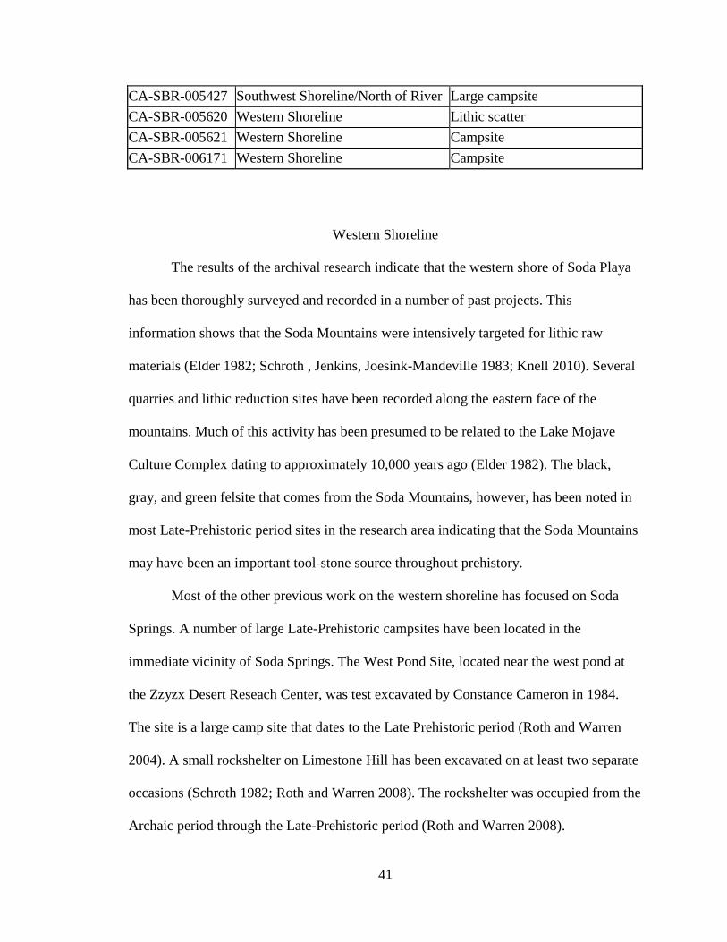
41
CA-SBR-005427 Southwest Shoreline/North of River Large campsite
CA-SBR-005620 Western Shoreline Lithic scatter
CA-SBR-005621 Western Shoreline Campsite
CA-SBR-006171 Western Shoreline Campsite
Western Shoreline
The results of the archival research indicate that the western shore of Soda Playa
has been thoroughly surveyed and recorded in a number of past projects. This
information shows that the Soda Mountains were intensively targeted for lithic raw
materials (Elder 1982; Schroth , Jenkins, Joesink-Mandeville 1983; Knell 2010). Several
quarries and lithic reduction sites have been recorded along the eastern face of the
mountains. Much of this activity has been presumed to be related to the Lake Mojave
Culture Complex dating to approximately 10,000 years ago (Elder 1982). The black,
gray, and green felsite that comes from the Soda Mountains, however, has been noted in
most Late-Prehistoric period sites in the research area indicating that the Soda Mountains
may have been an important tool-stone source throughout prehistory.
Most of the other previous work on the western shoreline has focused on Soda
Springs. A number of large Late-Prehistoric campsites have been located in the
immediate vicinity of Soda Springs. The West Pond Site, located near the west pond at
the Zzyzx Desert Reseach Center, was test excavated by Constance Cameron in 1984.
The site is a large camp site that dates to the Late Prehistoric period (Roth and Warren
2004). A small rockshelter on Limestone Hill has been excavated on at least two separate
occasions (Schroth 1982; Roth and Warren 2008). The rockshelter was occupied from the
Archaic period through the Late-Prehistoric period (Roth and Warren 2008).

42
Eastern Shoreline
The eastern shore of Soda Playa has been surveyed only once, by Malcolm
Rogers during his 1929 reconnaissance of the Mojave Sink Region. The mylar overlays
housed at the San Bernardino Archaeological Information Center indicate that Rogers
declared most of the eastern shore of Soda Playa to be one large prehistoric campsite. No
specific dates for this site were given, and no actual record exists for this proposed
campsite. It was identified as a “pending” resource. Several large lithic scatters were also
recorded near Cowhole Mountain.
Mojave River Wash
The Mojave River Wash, a largely undefined area between the mouth of Afton
Canyon and the location where the Mojave River enters Soda Playa had been previously
surveyed in a few areas. This is the site of Malcolm Rogers’ surveys of the 1930’s,
including site M-15, the site where Rogers located a corncob and where he believed
railroad workers from Crucero found a village site with house foundations (Rogers 1929).
The locations provided in his notes, however, are too vague to accurately relocate, and
their position in the Mojave River Wash may indicate that they were destroyed in a flood
event (Rogers 1929; see also Warren n.d.).
Southwestern Shoreline
The southwestern shore of Soda Playa and northern Mojave River Wash was the
second most targeted area for previous research. Two previous surveys have been
conducted in the area, but only one project ever had a final report completed (Warren

43
1983). A number of sites were recorded during both of these surveys. The sites in this
area appear to date exclusively to the Late-Prehistoric period. Nearly every previously
recorded site contains lithics, ceramics, groundstone, and thermal features. Some of these
sites are very large habitation sites, while others may represent smaller campsites or
resource collection areas.
Southern Shoreline
The southern shore of Soda Playa and the south side of the Mojave River Wash
do not appear to have ever been previously surveyed. No survey reports specifically
mention these areas, and no previously recorded sites were noted in the area. The
southern shoreline is near the active sand dunes of Devil’s Playground and the Mojave
River Delta.
Dr. Edward Knell, with California State University, Fullerton, is currently
conducting research on the late Pleistocene/early Holocene human occupation of Lake
Mojave. This research included a field school conducted in June of 2009 in which several
areas on the eastern and western shores of Soda Playa were surveyed. The survey area
near Hank’s Mountain included the detailed recording of a camp site with cultural
components that included at least six groundstone artifacts including both manos and
metates. Two diagnostic projectile points, a Pinto (5000-2000 B.C.) and an Elko (2000
B.C – 500 A.D.) were also noted in this area. No ceramics were noted at the site. A
second survey area near Cowhole Mountain included the detailed recording of a large
lithic scatter. This research project is on-going (Knell, personal communication 2010).

44
Results
The results of the records search informed the specific sampling strategy that
would be used for this project, as well as which areas to focus on for intensive survey. It
was determined that the one-mile transects, spaced every mile along the shore line would
be used along the eastern and southern shores of Soda Playa. These areas were the subject
of few previous studies and this sample survey strategy would provide a comprehensive
sample of both shores.
The Mojave River Wash was surveyed in a different manner. Based on the
previous survey results, archaeological sites tended to be located in blown-out areas of
the sand dunes common to this area. The actual extent of these dunes was difficult to
determine based solely on existing maps, so six random one-quarter section blocks were
chosen to sample the entire area both north and south of the Mojave River.
Finally, due to the amount of previous work conducted on the western shore of
Soda Playa it was determined that this area would not be resurveyed for this project.
Instead, 15 previously recorded sites would be relocated and re-recorded. The sites
chosen for relocation included sites that most likely dated to the Late-Prehistoric period.
Diverse site-types were also chosen to provide some information on land-use patterns.
Most of the relocated sites were located on the western shore of Soda Playa; however,
several previously recorded sites were also chosen on the eastern shore and the
southwestern shore/northern Mojave River Wash areas.

45
Survey Results
Surveying for this project was conducted between January and May 2011. A total
of 2,194 acres of land were covered during this survey, including both linear transects
and block survey areas. All archaeological sites encountered during this project were
recorded including 2 historic and 27 prehistoric isolates. A total of 27 of new
archaeological sites and 29 isolates (Table 2).
Table 2. Isolated artifacts recorded during survey.
Isolate Number Material General Location
MSS-HI-001 Two wooden fence posts Eastern Shoreline
MSS-HI-002 Rock cairn along old road Eastern Shoreline
MSS-I-001 Tested chert cobble Eastern Shoreline
MSS-I-002 Red jasper flake Southwest Shoreline/North of River
MSS-I-003 Brownware sherd Southwest Shoreline/North of River
MSS-I-004 Red jasper flake Southwest Shoreline/North of River
MSS-I-005 Two white chert flakes Southwest Shoreline/North of River
MSS-I-006 Large cream chert flake Southwest Shoreline/North of River
MSS-I-007 Red jasper flake, gray
rhyolite scraper Southwest Shoreline/North of River
MSS-I-008 Gray Rhyolite flake Southwest Shoreline/North of River
MSS-I-010 Brown chalcedony flake Southwest Shoreline/North of River
MSS-I-011 Black felsite flake Southwest Shoreline/North of River
MSS-I-012 Rhyolite metate fragment Southwest Shoreline/North of River
MSS-I-013 Black felsite flake, red and
orange chert flake Southwest Shoreline/North of River
MSS-I-014 Two clear chalcedony flakes Eastern Shoreline
MSS-I-015 Two red and orange chert
flakes Eastern Shoreline
MSS-I-017 Black felsite core Eastern Shoreline
MSS-I-018 White chert flake Eastern Shoreline
MSS-I-019 Rhyolite metate Eastern Shoreline
MSS-I-020 Possible deflated hearth Southern Shoreline
MSS-I-021 Chert flake Southwest Shoreline/North of River
MSS-I-022 Green felsite shatter Eastern Shoreline
MSS-I-023 Red chert flake Eastern Shoreline
MSS-I-024 Red and white mottled chert
flake Eastern Shoreline
MSS-I-025 White chert flake and small
rock cairn (3 stones) Eastern Shoreline
MSS-I-026 Red jasper biface fragment Eastern Shoreline

46
Four historic and 23 prehistoric sites were recorded during this survey. Of the
prehistoric sites, 10 could be definitively dated to the Late-Prehistoric period; all other
sites either did not contain diagnostic materials or represent earlier periods in the local
chronology of the region. Table 3 lists the sites recorded during this survey, their
location, and period of significance.
Table 3. Newly recorded sites.
Temporary
Site Number
General Location Approximate
Date
Site Type
MSS-002 Southwest Shoreline
/North of River
Unknown Lithic scatter
MSS-003 Southwest Shoreline
/North of River
Late Prehistoric Plant processing site
MSS-004 Southwest Shoreline
/North of River
Unknown Lithic scatter
MSS-005 Southwest Shoreline
/North of River
Late Prehistoric Campsite
MSS-006 Southwest Shoreline
/North of River
Late Prehistoric Plant processing site
MSS-007 Southwest Shoreline
/North of River
Late Prehistoric Lithic scatter
MSS-008 Southwest Shoreline
/North of River
Late Prehistoric Lithic scatter
MSS-009 Southwest Shoreline
/North of River
Late Prehistoric Thermal feature
MSS-010 Eastern Shoreline Unknown Lithic scatter
MSS-011 Eastern Shoreline Unknown Lithic scatter
MSS-012 Eastern Shoreline Saratoga Springs Campsite
MSS-014 Eastern Shoreline Unknown Lithic scatter
MSS-015 Eastern Shoreline Unknown Lithic scatter
MSS-016 Southwest Shoreline
/North of River
Late Prehistoric Thermal feature
MSS-017 Southern Shoreline Historic Rasor Ranch
MSS-018 Southwest Shoreline
/North of River
Late Prehistoric Plant processing site
MSS-019 South of River Historic Ranching outpost
MSS-I-027 Orange chert flake Eastern Shoreline
MSS-I-028 One red jasper and two black
chert flakes
Eastern Shoreline
MSS-I-029 Rock alignment Eastern Shoreline

47
MSS-020 South of River Historic Ranching related
MSS-021 South of River Unknown Lithic scatter
MSS-022 Eastern Shoreline Unknown Lithic scatter
MSS-023 Eastern Shoreline Unknown Lithic scatter
MSS-024 Eastern Shoreline Unknown Lithic scatter
MSS-025 Eastern Shoreline Historic Mining site
MSS-026 Eastern Shoreline Unknown Lithic scatter
MSS-027 Eastern Shoreline Unknown Lithic scatter
MSS-028 Southwest Shoreline
/North of River
Unknown Plant processing site
Site Descriptions
The following are descriptions of each prehistoric site recorded including general
location, artifacts and features, possible function, and dates if possible. The four historic
sites are not further described here.
MSS-002 – This site is located on a rocky flat within a small, deflated dune-field on the
southwestern edge of Soda Playa. It is a diffuse lithic scatter, which includes several gray
rhyolite flakes that appear to have been part of a single tested cobble. It also contains an
expedient tool of an orange chert material.
MSS-003 – This site is located in a flat area between large, mesquite stabilized dunes
west of Soda Playa and north of the Mojave River. This is a small, dispersed plant
processing site that includes both lithic and groundstone materials. Lithic materials
included cherts, a white chalcedony, purple rhyolite, jasper, and metavolcanics. A red
jasper blade with one utilized edge and a black metavolcanic flake were noted. The two
pieces of groundstone appear to be metate fragments and both were a gray rhyolite
material.

48
MSS-004 – This site is located in small, deflated dunes southwest of Soda Playa. Site is a
small lithic scatter with approximately 20 total flakes, which appears to be eroding out of
the dune. Several andesite, rhyolite, and metavolcanic flakes are present and all appear to
represent earlier stages of reduction. Most of the lithics include cryptocrystaline silicates,
including chert, chalcedony, and jasper, and all of these appear to represent later stages of
reduction, including bifacial thinning. One jasper flake appears to have been heat-treated.
There was also a possible red basalt groundstone fragment noted.
MSS-005 – This site is a large Late Prehistoric period campsite located southwest of Soda
Playa on a flat, clay-bottom clearing between large mesquite-stabalized dunes. It included
four separate loci containing high artifact concentrations and some features, and a low-
density artifact scatter throughout. Greyware and brownware ceramics were noted,
including a worked sherd. Lithics included cherts, chalcedonys, jasper, rhyolite, and
felsite. Most indicated later stages of reduction or tool maintenance or manufacturing
activities. Three projectile points were noted on the site, one Desert side-notched, one
Hohokam serrated, and another unidentifiable point tip. Groundstone fragments were
common throughout the site and included both manos and metates. All metates were a
gray rhyolite material, while the manos included gray rhyolite, andesites, and basalts. A
high quantity of crushed and burned bone was present. Fire affected rock, which indicates
the presence of a thermal feature, was noted in Locus 4.

49
MSS-006 – This site is located southwest of Soda Playa on a large flat between small,
deflating dunes. It is a sparse lithic and ceramic scatter. Lithics include red jasper, orange
chalcedony, and a brown chert core. Ceramics include greywares with large mica temper,
greywares with quartz temper, and brownwares. Two gray rhyolite metate fragments and
a red granitic mano were also noted.
MSS-007 – This site is located southwest of Soda Playa on a large, flat gravelly area
between small, active dunes. It is a sparse lithic scatter that contains about 20 flakes.
Materials include jasper, white and tan cherts and chalcedonys, and a small chalcedony
nodule. All flakes appear to represent later stages of reduction associated with tool
maintenance or manufacture activities. One granitic mano fragment was also noted.
MSS-008 – This site is located southwest of Soda Playa on a large, flat gravelly area
between small, active dunes. It is a sparse lithic scatter with materials similar to site
MSS-007, and the site’s proximity to MSS-007 may indicate that they are part of a single
site. A white chalcedony desert side notch projectile point was located at this site, which
dates it to the Late Prehistoric period.
MSS-009 – This site is located southwest of Soda Playa on a mud flat between small,
active dunes. This site includes a thermal feature and ceramic scatter. The thermal feature
includes fire-affected rock, many of which have been broken into a number of smaller
pieces. Brownware and greyware sherds with mica temper, and several flat rim sherds
were noted throughout the site and within the thermal feature. Two small lithics including

50
red jasper and a black and yellow mottled chert were present. One gray rhyolite double-
sided metate and small granitic mano were also noted.
MSS-010 – This site is located east of Soda Playa on a gravelly flat east of an area of
small active dunes. It is a small, sparse lithic scatter with seven total flakes. Six black
felsite flakes and one white chert flake. All flakes are small and representative of later
stages of reduction associated with tool maintenance or manufacture activities.
MSS-011 – This site is located east of Soda Playa on a gravelly flat east of an area of
small active dunes. It is a small, sparse lithic scatter with a density of approximately 1
flake per square meter. Materials include green felsite, jasper, white chert with pink
bands, and black and yellow mottled chert. All flakes of cryptocrystaline silicate
materials are small and representative of later stages of reduction associated with tool
maintenance or manufacture. Felsite flakes are representative of earlier stages of
reduction and includes two cores.
MSS-012 – This site is a Saratoga Springs period campsite located east of Soda Playa on
a small, stable dune. It includes two small rock concentrations that may be deflated
thermal features. Lithics include black and green felsite, grey and purple chert, jasper,
and a clear glass quartz. Green felsite flakes are large and represent earlier stages of
reduction including one core. All cryptocrystaline silicate flakes are small and
representative of later stages of reduction associated with tool maintenance or
manufacture. One green felsite chopper, and a gray chert biface were noted. A gray chert

51
Rose Springs projectile point was also located, which dates this site to the Saratoga
Springs period.
MSS-014 – This site is located east of Soda Playa on a flat clay pan between large,
stabilized dunes. It is a small, sparse lithic scatter with a density of approximately one
flake per square meter. Materials include orange chert, black and yellow mottled chert,
red and white mottled chert, jasper, and green felsite. All flakes are small and
representative of later stages of reduction associated with tool maintenance or
manufacture. There was a jasper biface fragment noted at the site.
MSS-015 – This site is located east of Soda Playa on a flat clay pan between large,
stabilized dunes. It is a small, sparse lithic scatter with a density of less than one flake per
square meter. Materials include yellow, orange, and red and white mottled cherts, black
and green felsite, and jasper. All flakes are small and representative of later stages of
reduction associated with tool maintenance or manufacture. An orange chert biface
fragment and a grey rhyolite drill were noted at the site.
MSS-016 – This site is located southwest of Soda Playa on a large, flat gravelly area
between small stabilized dunes. It includes a single thermal feature with ash eroding out
of it and a concentration of fire-affected rock. A broken mano, brownware sherd with
quartz temper, and late stage chert lithics are also present.
52
MSS-018 – This site is located southwest of Soda Playa on a flat gravelly area between
small, stabilized dunes. It is a small, sparse lithic scatter that contains five flakes.
Materials include jasper, black chert, green felsite, and a chalcedony nodule. A single
gray rhyolite metate fragment was also noted.
MSS-022 – This site is located on the eastern shoreline of Soda Playa on the clay pan lake
bottom near a small mesquite stabilized dune. It is a small lithic scatter that includes two
flakes of purple chert and a green felsite. A gray rhyolite pestle fragment was also located
at this site.
MSS-023 – This site is located on the eastern shoreline of Soda Playa on the clay pan lake
bottom in a field of basalt rocks. This is a large, dense lithic scatter with lithics
representing various stages of reduction. Materials include purple, white, orange, black
and orange mottled, and red and white mottled cherts, black and green felsite, white
chalcedony, jasper and quartzite. Formal tools include a purple chert biface fragment and
scraper, and a quartzite core. A gray rhyolite metate fragment and a rock cairn were also
noted.
MSS-024 – This site is located on the eastern shoreline of Soda Playa on a large, shell-
filled berm that represents an earlier lake-stand. It is a large dispersed lithic scatter with a
density of approximately one flake per square meter. Materials include red and yellow
jasper, black and green felsite, white and orange chert, gray and purple rhyolite, white
chalcedony, and a black metavolcanic. Most of the flakes represent earlier stages of

53
reduction and many include cortex. Two utilized flakes and three cores were the only
tools noted. This site was noted by Knell during his summer 2010 survey (Knell, personal
communication 2011).
MSS-026 – This site is located on the eastern shoreline of Soda Playa on a flat clay pan
between small, stabilized dunes. It is a sparse lithic scatter that contains about 12 flakes.
Materials include green felsite and cherts. All flakes are small and representative of later
stages of reduction associated with tool maintenance or manufacture.
MSS-027 – This site is located on the eastern shoreline of Soda Playa on a clay flat
surrounding several large mesquite trees. It is a light lithic scatter with a density of about
two flakes per square meter. Materials include jasper, felsite, cherts, and chalcedonys.
All flakes are small and representative of later stages of reduction associated with tool
maintenance or manufacture activities.
MSS-028 – This site is located southwest of Soda Playa in a flat between large, mesquite-
stabalized dunes. It consists of five large, flat, gray rhyolite rocks. These may be metate
blanks, or may have been used for pounding rather than for grinding. They are of the
same material as all other metates noted during this survey, and are the only large rocks
in the vicinity.
Results of this survey indicate that several archaeological patterns are present in
the survey area. Very few archaeological sites were located along the eastern shore of

54
Soda Playa. Most sites on the eastern shore were located near Hank’s Mountain, Little
Cowhole Mountain, and Cowhole Mountain and these topographical features may have
provided some protection from the winds that are common to the area. Site density
increased along the southeastern shore where mesquite stabilized dunes were more
common. All sites recorded in this area were located between one-quarter and one-half
mile from the current shoreline of Soda Playa and date to periods earlier than the Late-
Prehistoric Period. These sites may be associated with an earlier and higher shoreline for
Soda Playa.
Most of the southern shore of Soda Playa was essentially devoid of archaeological
materials. This area is characterized by large active dunes and any archaeological
materials may have been buried by the action of the active dunes. The pattern from the
eastern shore continued into Transect 11, but this transect is located at the very eastern
extent of the southern shoreline. Transects 12, 13, and 14 contained no archaeological
materials. This area is part of the Mojave River Delta, where the Mojave River empties
into Soda Playa, and commonly to washes out when rainfall amounts are high enough to
allow the Mojave River to flow to its terminus. Block 3 is also within this geographic
feature.
The southwestern shore of Soda Playa and the area north of the Mojave River
Wash was characterized by large mesquite stabilized sand dunes with blown-out areas
between. Previous surveys indicate that a number of Late Prehistoric period
archaeological sites were located within these blown-out areas (Warren n.d, 1983). This
area contained the highest number of archaeological sites recorded during this project.

55
All sites in this area were located in the blown-out areas between the dunes, and all sites
dated to the Late-Prehistoric period.
Finally, the area south of the Mojave River Wash was chiefly characterized by
large active sand dunes with a small area of vegetation-stabilized dunes. This area
contained only a single prehistoric archaeological site. The site was a small, sparse lithic
scatter with no dateable materials, however, so it could not be assigned to any particular
period in the chronological sequence of the Mojave Sink.
Relocated Sites
Fifteen previously recorded archaeological sites were chosen for relocation and
re-recording during this project. Most of these sites were located along the western
shoreline of Soda Playa and the southwestern shoreline/northern Mojave River Wash
areas. There has been a lot of previous work along the western shore, so rather than re-
surveying this area, a diverse set of sites that most likely date to the Late-Prehistoric
period were chosen for relocation. Sites were chosen for relocation in the other project
areas as well because many of the previously recorded sites were recorded more than 30
years ago. These sites broadened the information base for the development of a land-use
model for the project area. While most of the Late-Prehistoric period sites are located on
the southwestern side of Soda Lake, the entire area appears to have been at least
nominally used during this period. No sites were chosen for relocation on the south side
of Soda Playa because no sites have been previously recorded in that area. Table 4 lists
all the sites chosen for relocation, the general location of the site in relation to this
project, and whether or not the site was relocated.

56
Table 4. Relocated sites
Site Number Site Location Relocated?
CA-SBR-000668 Southwest Shoreline /North of River Yes
CA-SBR-001985 Southwest Shoreline /North of River Yes
CA-SBR-001997 Eastern Shoreline Yes
CA-SBR-003498 Southwest Shoreline /North of River Yes
CA-SBR-003567 Southwest Shoreline /North of River No
CA-SBR-003568 Southwest Shoreline /North of River No
CA-SBR-003573 Southwest Shoreline /North of River Yes
CA-SBR-004040 Western Shoreline Yes
CA-SBR-004312 Eastern Shoreline Yes
CA-SBR-005270 Western Shoreline No
CA-SBR-005410 Western Shoreline No
CA-SBR-005417 Southwest Shoreline /North of River No
CA-SBR-005420 Southwest Shoreline /North of River No
CA-SBR-005421 Southwest Shoreline /North of River Yes
CA-SBR-005427 Southwest Shoreline /North of River No
Site relocation can be difficult, especially when the site records are very old and
they include no location maps or site sketch maps. Most of the previously recorded sites
were recorded before the advent of GPS technology, in a completely different datum, on
a different scale of maps (i.e. 15 minute quads versus the current 7.5 minute quads). Of
the 15 sites chosen for relocation only 8 were relocated.
Most of the sites on the western shore of Soda Playa were related to quarrying
activity. The lithics of Soda Mountain have been intensively studied by California State
University, Fullerton in the late 1970’s and early 1980’s (Joesink-Mandeville, Cameron,
and Douglas 1980; Schroth 1982; Elder 1982; and Schroth, Jenkins, and Joesink-
Mandeville 1983), and again more recently in 2009 and 2010 (Knell 2010). This research
focused instead on campsites and food resource procurement locations. There were only
three such sites previously recorded on the western shore, and only one of these (CA-
SBR-004040) was relocated during this survey.

57
The southwestern shoreline of Soda Playa and the area north of the Mojave River
Wash has had a number of archaeological sites previously recorded. Based on the
information available on the site records, it appears that almost all of these sites date to
the Late Prehistoric period. Nine of the larger campsites, smaller collection areas, and
sites with very outdated site records were chosen for relocation. Eight of these sites were
relocated during this project. All of these sites appear to date to the Late-Prehistoric
period, with one exception. Site CA-SBR-001985 is a small diffuse lithic scatter with no
diagnostic materials, making it unclear as to its date.
Two sites were chosen for relocation on the eastern shore of Soda Playa. Only six
sites were previously recorded along the entire eastern shore. All of these sites were very
similar according to the site records, so only two were chosen to represent them. A
comprehensive sampling survey was also conducted to augment the fewer number of
relocated sites in this area. Both of the previously recorded sites were relocated during
this survey. Site CA-SBR-004312 dates to the Late-Prehistoric period. It is likely that site
CA-SBR-001997 has a Late-Prehistoric component; however, the site is very large and
has diagnostics which date to the Gypsum period, or from 2000 B.C. to 500 A.D., and
may associate the site with the Late Archaic period (Warren and Crabtree 1986; Basgall
2000). This site appears to have been utilized for an extended period of time, possibly
throughout prehistory after the desiccation of Pleistocene Lake Mojave.
Mojave Delta Site Excavations
The Mojave Delta Site (CA-SBR-001989) is located on active dunes at the base
of the Soda Mountains near where the Mojave River empties into Soda Playa. This site

58
was excavated and surface collected by the University of Nevada, Las Vegas during a
2009 field school (Roth and Thomas 2010). Investigations at the Mojave Delta Site
focused on site function, examining subsistence practices, and how these practices tied
into Late Prehistoric landscape use in the Mojave Sink region.
Surface components of the site included a high density of lithic debitage but few
formal tools and no projectile points. A large number of ceramic sherds and groundstone
artifacts, including both manos and metates, were present. Six rock concentrations were
also recorded and mapped. Two of these rock concentrations had charcoal eroding out of
them, which appeared to indicate that the rock features actually represented thermal
features.
The presence of groundstone is generally indicative of plant processing activities,
and the high number of groundstone artifacts at this site indicates that it was probably the
primary activity of the Mojave Delta Site (Roth and Thomas 2010). Two hearth features
were excavated. One hearth was relatively deflated and included only small areas of
charcoal and ash. The other hearth was more intact and contained a large area of ash and
charcoal. Several ceramic sherds, including mostly Parker Buff and a single Tizon
Brown sherd, were also recovered, which dates the site to the Late Prehistoric Period
(Roth and Thomas 2010).
Flotation and pollen analysis did not provide information on what plants were
being processed prehistorically (Roth and Thomas 2010). The results only represented the
plant species currently growing on the dunes and is likely attributable to the site’s
location on an active dune surface. The location of the site on dunes adjacent to the playa,
however, suggests that the site was used primarily for procuring and processing spring

59
annuals. It is clear from the groundstone and features that seed processing was the
primary activity at the site (Roth and Thomas 2010).
Geographic Information System Analysis
Geographic Information Systems (GIS) technology allows geospatial data to be
analyzed in such a way that geographic patterns can be discerned. Geospatial Information
can be defined as “information about natural and anthropogenic phenomena and their
relationships with each other” (Connolly and Lake 2006: 12). GIS technology is a
particularly powerful tool for studying archaeological landscapes, which include both
spatial and aspatial attributes (Connolly and Lake 2006). Analyzing archaeological
remains using GIS technology can facilitate an understanding of broad prehistoric
patterns including landscape use.
GIS mapping technology was used to analyze the data gathered for this research.
It is universally accepted that archaeological resources are generally associated with
water sources and prehistorically important natural resources. The maps created for this
project include data related to resource availability and site locations. Several maps were
constructed based upon the data gathered from the archival and survey results of this
project. Base maps including U.S. Geologic Survey Topographic Quadrangle maps,
vegetation zone maps, and geographic landform maps obtained from outside sources
were used. The base maps were then layered with data gathered during the research for
this project to develop a land-use model for the project area during the Late Prehistoric
period.

60
Figure 4 shows the locations of water sources in the project area. These water
sources include modern water sources such as Soda Springs and the Mojave River, which
still floods periodically. Mapped water sources also include historically known water
sources, including Alkali Spring, Soda Springs, more numerous small springs along the
base of the Soda Mountains, as well as the Mojave River. Based on the map, it is obvious
that all of the water sources around Soda Playa and the Mojave River Wash are located
along the southwestern shoreline of the playa and north of the Mojave River. The Mojave
River, as previously mentioned, flooded more regularly during the Late Prehistoric period
and would have provided a major source of fresh water in this area (Warren 2010a).
Figure 5 includes the various vegetation resources present surrounding Soda Playa
and within the Mojave River Wash. The model developed for this project assumes several
characteristics of the local vegetation given the different environmental conditions of the
Late Prehistoric period. The greater amount of surface and ground water available during
this period would have allowed more water-dependent resources such as mesquite to have
occupied a wider range than they do today (Warren 2010a). The abundance of these
water-dependent flora would have made the drought resistant plant species, such as the
altriplex and other saline-tolerant species, more restricted. Creosote would have
continued to dominate in all areas. Based on this map, all plant resources would have
been in similar locations as modern species. Mesquite would have been more prominent
during the Late Prehistoric period while altriplex would have been less prominent,
especially along the southwestern shoreline and in the Mojave River Wash area.
Archaeological sites dating to particular periods of prehistory are presented in Figure 6.
Because specific archaeological site locations are confidential, this map presents only

61
Figure 4. Water sources within the project area.

62
Figure 5. Vegetation distribution within the project area.

63
general areas where sites dating to a particular period are located.Late Prehistoric period
sites are depicted in crosshatching and earlier sites are depicted in stippling. Based on
this map, Late Prehistoric period sites are densely clustered along the western and
southwestern shoreline of Soda Playa and north of the Mojave River Wash. While sites
dating to this period also occur on the eastern shoreline, these are strictly tied to food and
water resources or geographic features such as rockshelters. Almost all sites on the
eastern shoreline date to earlier periods of occupation.
Finally, Figure 7 combines the data from Figures 4 through 5. Each previous map
is combined as a separate layer, and when all are viewed together a model of Late
Prehistoric period landscape use can be interpreted. Figure 7 shows that both plant and
water resources occur in the same general area, the southwestern shoreline and north of
the Mojave River. The layer from Figure 6 also shows that Late Prehistoric period
archaeological sites are most common, and most densely congregated in the same area.
Based on these maps a model of Late Prehistoric period land use can be
developed. Resource availability, especially water and subsistence resources, are the most
common indicators of prehistoric archaeological site location. Almost all prehistoric
archaeological site locations are tied specifically to the presence of particular resources.
While water and subsistence resources are the most common, other resources, including
tool stone sources, can also be important indicators of site location.

64
Figure 6. Site locations by chronology.

65
Figure 7. Late Prehistoric sites in relation to available resources.

66
CHAPTER 5
DISCUSSSION AND CONCLUSION
This chapter will focus on a discussion of the results of this project. Archival data,
survey data, and excavation data have been interpreted through the use of GIS
technology. The specific results of GIS modeling were presented in Chapter 4, but are
more fully explained in this chapter. A model of regional landscape use is presented
based upon the results of this project. This model is then compared and contrasted to the
model previously created for the Cronese Basin, another portion of the Mojave Sink, to
determine what similarities and differences exist. A discussion of further research is also
presented. A final conclusion for general patterns of landscape use in the Mojave Sink
region during the Late Prehistoric period is then discussed.
RESEARCH QUESTION REDUX
Three research questions were originally developed for this study. These
questions and the data requirements necessary to answer them were presented in Chapter
One. The questions are restated here along with the data gathered during this survey that
provide answers, or indicate further areas of research necessary to answer these specific
questions.
1. What subsistence activities are apparent at Late Prehistoric archaeological sites
in the Mojave Sink?
It was previously stated that in order to better understand how Late Prehistoric
inhabitants of the Mojave Sink used the landscape of the region is important to more fully
understand their subsistence practices during this period. Past research has indicated that

67
groups in this area relied on a variety of plants and animals that were locally and
seasonally available. Sites in the Cronese Basin, however, differ in that groups in this
area were heavily targeting resources tied specifically to the lacustrine environment
provided by the inundation of the Cronese Lakes.
Data gathered during this research from archival sources, excavations at the
Mojave Delta Site, and the large-scale sample survey conducted around Soda Playa and
the Mojave River Wash support earlier conclusions about subsistence patterns in the
Mojave Sink. Late Prehistoric period archaeological sites recorded or re-recorded during
this project indicate that site functions are specialized to the extraction or utilization of
specific resources. Quarry sites along the eastern flanks of the Soda Mountains serve
specifically as tool-stone procurement areas. All groundstone implements, which are
generally associated with plant food production, are found at sites located within large
stands of mesquite, or other seasonally available plant foods such as altriplex and grasses.
Sites specifically tied to hunting and butchering activities are also common.
2. Is there any evidence for agriculture being practiced on the Mojave River Delta?
The possibility of agricultural production in the Mojave Sink region has long been
considered a viable subsistence option (Rogers 1929). While very little data has been
gathered to support this theory, it persists to the extent that it has almost taken on
mythical proportions. If corn was ever grown in the Mojave Sink it is more probable that
it would have taken the form of horticultural rather than agricultural production. While
stories of caches of corn-cobs, lost corn cobs, and Anasazi turquoise miners abound, hard
evidence to support this theory has been hard to come by.

68
Malcolm Rogers once noted the high quantity of large metates in the Mojave Sink
region and stated that “there is no seed native to the region necessitating the presence of
so many large metates” (Rogers 1929: 8). Mesquite processing has been generally
associated with use of a mortar and pestle. While only a single pestle was noted during
this research, a large quantity of manos and metates were found to exist. Sites containing
these tools were also found in association with stands of mesquite. It seems probable that
mesquite seed processing could have been accomplished in more than one way. It is also
possible that the prehistoric inhabitants may have been specifically targeting grasses at
these sites.
The groundstone noted during this survey was all made of the same stone
material: a locally available gray rhyolite. This tool-stone source is located on the
southwestern shoreline of Soda Playa. Most of this area is devoid of large rocks with the
exception of these metates. One site, however, seemed to be anomalous to this trend. Site
MSS-028 included six large, flat rhyolite rocks. These rocks did not contain any signs of
grinding, however they were located in a blowout between large mesquite stabilized sand
dunes. They may have been used to pound mesquite seeds, rather than grind them.
Several similar rocks were noted along the southwestern shoreline, however, a lack of
associated artifacts and any sign of use precluded their recordation.
The association of all groundstone with other edible plant resources would
indicate that they were used to process these plant materials, rather than corn. A complete
lack of even a single trough style metate, which has been strictly tied to the processing of
corn meal, indicates that intensive corn-grinding was not being practiced here (Adams
2002). This data, combined with a complete lack of corn-cobs, any evidence of

69
horticultural fields or gardens, or any other evidence for horticulture seems to indicate
that this type of subsistence activity was not practiced around Soda Playa or the Mojave
River Wash. The most probable location for horticultural activity in the Mojave Sink, if it
occurred, remains the Cronese Basin (Warren 2010b).
3. How do the subsistence activities from single sites tie into the larger late
prehistoric subsistence pattern of the Mojave Sink?
Understanding how individual archaeological sites tie into the larger land-use
pattern is important for understanding how an entire region was used by its prehistoric
inhabitants. Site location and arrangement, the arrangement of features within sites, or
artifact arrangements are common patterns used to define archaeological landscapes. This
landscape approach to archaeology has been applied to the data gathered during this
research. GIS mapping was utilized to identify how resources overlapped in order to
make interpretations regarding land-use patterns.
Based on the results of this project, patterns of land use during the Late
Prehistoric period are evident. Sites dating to this period are most common in the Mojave
River Wash north of the Mojave River, on the southwestern shoreline of Soda Playa, and
around Soda Springs. There is geographic as well as resource-based evidence for why
this pattern exists. Similar evidence can explain why the other areas of the Soda Playa
region are less commonly utilized during this period.
Water
Water is the most important resource for inhabitants of arid environments. Almost
all archaeological sites in desert areas are tied strictly to known and reliable sources of
water. The Late Prehistoric period in the Mojave Sink was characterized by less aridity

70
than the current environmental conditions (Warren 2010a; Enzel, et al. 1989; Cleland and
Spaulding 1992). The Mojave River flowed more frequently during this period, the
Playas common to the area periodically contained shallow saline lakes, and springs
throughout the area were restored with water (Warren 2010a; Wells, et al. 1998).
The Mojave River was necessary for any abundance of plant, animal, and human
life in the Mojave Sink Region. Evidence of concentrated human exploitation of water
and resources from the Mojave River can be found archaeologically (Rector, et al. 1983;
Schneider 1989) as well as from historical accounts of the first Europeans to encounter
inhabitants of the Mojave Sink and the Mojave River Valley (Garces 1900). It is not a
leap, therefore, to assume that more frequent flowing of the Mojave River would
encourage more concentrated prehistoric use of areas near this major source of fresh
water. Such a high density of Late Prehistoric sites in the Mojave River Wash can be
explained by the more frequent flowing of the river during this period.
More frequent flowing of the Mojave River may have even filled Soda Playa to
create a shallow lake with more regularity than today. This lake would not have
contained drinkable water due to the highly saline nature of the lake bottom sediments.
This lake may have provided habitat for animals such as waterfowl, however, that would
have been attractive resources for Late Prehistoric period inhabitants of the area.
Springs in the Mojave Sink region provided the most reliable source of water
throughout prehistory. A number of springs are known in the project area from the
modern period as well as historic accounts from the first explorers in the region. The
historic period, however, has been generally characterized by increasing aridity. With

71
springs recharged during much of the Late Prehistoric it is likely that more springs
existed during that period.
Many sites dating to the Late Prehistoric period are concentrated around the
modern Soda Springs. This is a large spring system that contains water even during
droughts, and would have been a major source of reliable water in the region. Other
springs known historically include Alkalai Springs, which is located along the
southwestern shore of Soda Playa. This spring is currently dry, though must have
contained water in the recent past because it was mapped by the U.S. Geologic Survey.
Early explorers also describe small springs and watering holes at the south end of Soda
Lake that may include alkalai springs and springs that may have been completely dry by
the time of the U.S.G.S. mapping of the area (Duffield-Stoll 1994).
Geography
Geography is another determining factor in site location. Prehistoric peoples
would pick geographically protected areas for more long-term use sites such as villages
and campsites. In general, most archaeological sites are located in areas that are more
protected from wind, rain, and water runoff. For example, a camp on the lee-ward side of
a hill or mountain is preferable to a camp on an open alluvial plain. Late Prehistoric
period sites in the Mojave Sink are no exception.
The sites in the Mojave River Wash are concentrated on the north side of the
river, with only a single diffuse lithic scatter located south of the river. The geography of
the two areas make it clear why the north side was chosen over the south side. There are
very large mesquite stabilized dunes located north of the river between which many large
archaeological sites are located. Sites are also common around the base of a number of

72
small hills that exist in the area. The elevation here is slightly higher than the Mojave
River Wash. The area south of the river, however, is located at about the same elevation
as the river and has been cut and trenched by flowing water. It is covered with loose
blowing sand and there are no hills to provide any protection from the wind that is
common in this area (Appendix A provides full descriptions of geography, landforms,
flora, and fauna located in each survey area).
Late Prehistoric period sites are also more common on the west side of Soda
Playa than on the east side. Geography can explain this pattern, as well as why sites occur
in particular areas on the east side of the Playa. The western shore of Soda Playa meets
the alluvial fans at the base of the Soda Mountains. The most common site locations are
around Soda Springs, which sits slightly above the playa bottom. This area is protected
from the prevalent western winds and from flooding during lake inundations, as well as
providing reliable year-round water.
Most of the eastern shoreline of Soda Playa is composed of wide, open alluvial
plains. There are no small hills to protect from water run-off or prevailing winds. There
are several large mountains along the eastern shore, and it is near the base of these
mountains that two Late Prehistoric period sites have been found. One site is a
rockshelter overlooking all of Soda Playa, the other is a large site that appears to have
been used continuously since the desiccation of Lake Mojave. This site is located on the
lee-ward side of a series of mesquite anchored dunes, at the base of Cowhole Mountain.
This site surrounds a large modern mesquite bosque. There was a spring here during the
recent past, and was also likely present during the Late Prehistoric period. The presence
of this water source may have allowed the small mesquite bosque to take root. The

73
protected nature of this site and the potential for a Late Prehistoric period water source
would have made it an optimal campsite.
The geography of the southern shore of Soda Playa, likewise, provides an
explanation for the complete lack of archaeological sites in this area. The eastern end of
the southern shoreline abuts the edge of Devil’s Playground, a large area of active, wind-
blown sand dunes. The western end includes the Mojave River Delta. This is a wide and
expansive area that covers several miles of the shoreline. Everything in this area is over-
grown and washed out. While there is seasonally standing water in this area that may
have been exploited, any archaeological remains have long since been washed away. The
general instability of both areas probably precluded people from inhabiting them.
Resources
The final determining factor in site location is the availability of resources. If
there are no useable resources at a particular location there is very little reason to be
there. Water, which has already been discussed, is one such resource. Other resources
include subsistence and raw-material resources. Subsistence resources include plants and
animals that are commonly exploited as food. Raw materials can include tool-stone
sources, wood sources for bow and arrow or spear construction, or sources of favored
groundstone materials. This is the third major factor for determining Late Prehistoric
period site location in the project area.
Subsistence resources can include any of the plants or animals commonly
exploited as food. Mesquite is the major plant food-source in the Mojave Sink. Small
annual grasses, seeds of black sage and of the Altriplex family of plants, and tule rushes
and cattails were also important (Bean and Saubel 1972). Animals commonly exploited

74
as food sources include: big horn sheep, jack rabbits, cottontail rabbits, and the variety of
rodents, reptiles, and birds common to the area.
The greatest abundance of all of these resources is located along the southwestern
shoreline of Soda Playa and north of Mojave River Wash. These areas also correspond to
the greatest density of Late Prehistoric period sites. Large, thick mesquite bosques are
common north of the Mojave River Wash, interspersed with altriplex and various grasses.
The mesquite also provides a safe area for all types of fauna including very high densities
of jack rabbits and cottontail rabbits.
Soda Springs also contains many of these subsistence resources. Tule rushes and
cattail are common to the springs, and larger game birds such as quail are also drawn to
these water sources. Mesquite is common in this area as well. The springs also represent
the second densest area of Late Prehistoric period occupation in the project area.
The east side of Soda Playa is dominated by altriplex immediately adjacent to the
playa, and creosote upslope from that. There are several small mesquite trees widely
dispersed along the eastern shore. In only one area is there a significant quantity of large
mesquite trees concentrated in a small area. The mesquite is located near the base of
Cowhole Mountain at the location of one of the two Late Prehistoric period sites recorded
on this side of the playa. Other vegetation in this area is sparse, and evidence very few
animal species were noted during the survey, with the exception of two big horn sheep
observed traveling towards Cowhole Mountain.
Vegetation on the southern shore of Soda Playa and south of the Mojave River
Wash was also sparse. There are areas of large mesquite stands in the Mojave River
Wash, but again, this area is prone to flooding. Some of the dunes south of the river are

75
mesquite anchored, however, the mesquite looked unhealthy. They were small, contained
little new growth but a lot of dead areas, and were covered with mistletoe, a parasite that
attacks the mesquite plant. The active, wind-blown dunes of this area also contained very
little vegetation. As on the eastern shoreline, very few animal species or evidence of
animal species were noted in these areas.
Other resources that may determine site type include raw-material sources.
During this research two raw-material procurement areas were noted. Both of these areas
include materials commonly used during the Late Prehistoric period, and both are located
in the areas with the highest densities of sites dating to this period.
The Soda Mountains, which make up most of the western shore of Soda Playa, are
the source of a felsite tool-stone material. This material is a fine-grained volcanic
material that is commonly black, green, or gray in color. This material was quarried from
the Soda Mountains and is common in all Late Prehistoric period sites. The density of
this local felsite material at a site depends upon the distance of the site from the raw-
material source. Sites closer to the source contain a higher quantity of the material than
those sites that are located further away from the source. This material appears to have
been used to create expedient cutting and processing tools, as no formal tools of this
material were noted during this research.
A small hill south of the Soda Mountains is composed of a distinctive gray
colored rhyolite with large porphyritic inclusions. Every metate recorded during this
project was made of this material. Groundstone materials are most common in the area
north of the Mojave River and along the southwestern shoreline where this hill is located.
A single metate and single pestle fragment composed of this same material were noted on

76
the eastern shoreline. A similar principle of distance as that applied to the felsite material
can also be applied to this material; sites closer to the source tend to have more
groundstone artifacts than those further away.
Mojave Sink Landscape Use
The results of this project indicate that a distinctive land-use pattern is discernible
in the vicinity of Soda Playa and the Mojave River Wash during the Late Prehistoric
period. This research, however, only focuses on a single portion of the Mojave Sink. The
Mojave Sink region, as defined before, also includes the Cronese Basin and Silver Playa.
To fully understand how the entire Mojave Sink region was used during the Late
Prehistoric period the model developed based upon the results of this research must also
consider what was going on in these other areas during the same time period.
Previous research surrounding Silver Playa has been dominated almost
exclusively on defining Lake Mojave period assemblages and attempts to further define
the environmental sequence of the earliest periods in the Mojave Desert chronology
(Campbell, et al. 1937; Wells, et al. 1989; Warren 2010a). Work in the Cronese Basin,
however, has focused almost exclusively on the Late Prehistoric period. Malcolm Rogers
was looking for evidence of house-pits, corn-cobs, and other remains that would indicate
the presence of people from the Southwest (Rogers 1929). Christopher Drover (1979)
also conducted research in the Cronese Basin, looking specifically at Late Prehistoric
land-use patterns.
Drover’s research built upon Rogers’ initial work in the Cronese Basin. Drover
focused on the human ecology of the area during the Late Prehistoric period. He

77
incorporated Rogers’ theories concerning the presence of Southwestern peoples in the
Cronese Basin. Drover was unable to relocate any of the house-pits or corn-cobs
described by Rogers. What he was able to do, however, was to further define the
environmental conditions of the Cronese Basin during the Late Prehistoric period and
how those conditions drove prehistoric land-use patterns.
The conclusion Drover reached with his research indicates that there are general
similarities between the types of resources in the project area and how they were
exploited by the Late Prehistoric inhabitants. The same types of plant and animal
resources are present in the Cronese Basin as those that exist surrounding Soda Playa and
the Mojave River Wash. Drover states that the subsistence patterns observed in the
Cronese Basin during the Late Prehistoric period are common to those patterns observed
for other hunter/gatherers in similar environments (Drover 1979: 206).
There are at least two major exceptions to the similarities between the two areas.
First, mesquite was not a commonly exploited resource in the Cronese Basin.
Excavations of two “oven-features” produced no mesquite remains (Drover 1979: 207).
Drover (1979) simply describes the groundstone of the Cronese Basin as being
represented by small quantities of mortar and pestle and higher quantities of mano and
metate, similar to other areas of the Mojave Sink. Mesquite is prevalent throughout the
Cronese Basin and Drover states that it is possible that mesquite beans were simply
consumed raw, rather than being prepared in any way. It seems unlikely that such an
important resource elsewhere in the Mojave Sink would be completely ignored here,
especially given its abundance.

78
A second major exception to the subsistence patterns of the Cronese Basin is
rooted in the geologic nature of the basin itself. The Cronese Basin is an enclosed basin
with a high water table that allows a riparian biologic community to thrive, even during
dry years (Drover 1979). The basin also filled with water more regularly, and for longer
periods of time, than both Soda and Silver Playas (Drover 1979). As a result of these two
characteristics, the Cronese Basin provided a number of unusual resources that were
specifically targeted by Late Prehistoric period inhabitants. These resources included fish,
Anodonta, pond turtle, migratory bird species, and tule rushes.
Late Prehistoric inhabitants of the Mojave Sink would have exploited the
resources in the Cronese Basin in the same manner they did for all other resources in the
Mojave Sink region. The difference for the Cronese Basin, however, lies in the large
diversity of subsistence resources available. Resource diversity and abundance, combined
with a more stable water supply would have made the Cronese Basin an attractive
location. Longer-term occupation of the area would have been possible, especially during
the long periods of lake recharge. The presence of house-pits noted by Rogers may be
indicative of longer-term occupation. The length of this occupation was probably never
year-round, but seasonal use of the area could include occupation at a single location for
the entire season (or several seasons). The diversity of floral and faunal resources could
support this type of seasonal stability for a small population.
The subsistence patterns identified for the Cronese Basin differ from those
defined by this research for the Soda Playa and Mojave River Wash area. Seasonal
occupation, and specialized exploitation of locally available resources was common
throughout the Mojave Sink. The diversity and abundance of wild resources available in

79
the Cronese Basin during the long periods of lake recharge described by Drover (1979)
and others (Rogers 1929; Warren and Schneider 2000; Warren 2010a) allowed Late
Prehistoric inhabitants of the Mojave Sink to diversify their subsistence strategies while
remaining in a single location for an entire season, and possibly several seasons. During
drier years, the inhabitants of the Mojave Sink would have to return to the more mobile,
but specialized subsistence patterns observed in the Soda Playa and Mojave River Wash
areas.
Outside the Mojave Sink
Defining the patterns of landscape use for the Mojave Sink region requires
information about the region itself, but similar information about the surrounding areas
should also be incorporated. Understanding the land-use patterns common to the
surrounding areas can help better define the region as well as define the land-use patterns
for that region. Exploring how the Mojave Sink was connected to surrounding geographic
areas, as well as surrounding cultural groups can further illustrate how the Mojave Sink
was inhabited during the Late Prehistoric period.
Previous archaeological work in the Mojave Sink region is sparse and tends to
focus on a few specific areas, leaving others completely unstudied and unknown. The
same situation exists for most of the areas immediately surrounding the Mojave Sink
region. The occasional project-driven archaeological survey has been conducted, but even
most of these are very early and conducted to a highly variable set of requirements, many
of which fall short of today’s expectations. Work on Fort Irwin, located immediately
north of the Mojave Sink, is a major exception.

80
A long-term archaeological program was developed on Fort Irwin during the late
1970’s and early 1980’s. This program is funded by the military, but is also driven by
research designed written to answer both broad and specific questions important in the
archaeology of the Central Mojave Desert (Warren 1998). Work since the 1980’s has
been summarized in several unpublished reports (Gilreath, Basgall, and Hall 1987;
Mikkelsen and Hall 1990) as well as published articles (York and Spaulding 1995;
Warren 1998; Basgall 2000). It has been a common approach by Fort Irwin
archaeological program to analyze date based upon the Landscape Model (Basgall 2000).
Based on this model, the North Central Mojave Desert has been continuously occupied
since the late Pleistocene, that site locations correspond to water resources, and that these
locations have remained stable through time (Basgall 2000).
A recent study of the Fort Irwin Avawatz Expansion Area (Smith 2004) included
a sample survey of the expansion area, which is located immediately north of the Mojave
Sink. Data from the expansion area was also tied into the model developed by Basgall.
Based on the results of this study, lithic reduction sites are the most common site type in
the Avawatz Expansion. Campsites, habitation sites, and larger more complex sites
become more common as you move west across Fort Irwin, and are least common in the
Avawatz Expansion Area. Smith (2004: 7-34) describes the Avawatz Expansion Area as
a “strikingly homogenous” secondary lithic procurement landscape. He also states that
this method of land-use may represent a common pattern for large areas of the mid-
Mojave Desert (Smith 2004).
In 2009, the small valley between the Cronese Basin and the large valley that
contains both Soda and Silver Playas was also surveyed for a proposed solar power

81
generating facility (Duke and Patterson 2009). This survey included all 6775 acres of the
valley and the foothills of the surrounding mountains. The results of this survey indicated
a very sparse historic component, several trails near the Soda Mountains, but no
prehistoric archaeological remains. This entire valley, although very close to the Mojave
Sink and in fact even separating the two main basins by only eight miles, appears to have
been completely ignored by the prehistoric inhabitants of the Mojave Sink region.
The reasons for the lack of archaeological remains in the valley between the
Cronese Basin and the Soda Mountains are simple. There is also no water in this valley.
There are no subsistence resources located in this valley. Late Prehistoric groups were
concentrating on the Mojave Sink because of the abundant resources in those areas. The
areas outside of the Mojave Sink may include transportation routes and probably tool-
stone sources and hunting areas, but for the most part would not have been frequently
visited by Late Prehistoric peoples.
Looking beyond the Mojave Sink, and even the Mojave Desert, can help in our
understanding of not only how and where the area was occupied, but also to inter-cultural
interactions. Previous research has revealed southwestern-style ceramics and a Hohokam-
style ¾ grooved axe in the area of the Cronese Basin and the turquoise mines near
Halloran Springs (Rogers 1929). The turquoise from these mines has been found as far
away as the Hohokam occupation of Snaketown in south central Arizona (Sigleo 1975).
Shell from the coasts of California have also been found in the Cronese Basin (Warren
and Crabtree 1986). Finally, during the research for this project, a Hohokam serrated
projectile point was located at a Late Prehistoric period site.

82
All of these occurrences of exotic materials and artifacts suggests at least some
level of communication, probably both trade and exchange, with neighboring cultural
groups was taking place. In fact, there is ample evidence for a major trade route across
the Mojave Desert extending from the Colorado River and the Southwest, through the
Mojave Sink along the Mojave River, and out to the California coast (Colton 1941, Fagan
2000). This trade route jumps from watering place to watering place then follows the
Mojave River water source across the desert. The presence of the water made a trade
route through this area possible. The trade route, and the presence of coveted raw
materials such as turquoise, may have provided an attraction for Late Prehistoric
inhabitants to occupy such a harsh environment.
Future Directions for the Mojave Sink
To more fully understand how the Mojave Sink region was being used by its Late
Prehistoric inhabitants a broader understanding of the entire region must be reached.
There is also ample of evidence that the Mojave Sink region has been occupied since the
Paleoindian period (Campbell, et al. 1937). Studies into land-use patterns in other areas
of the Mojave Sink, and during other periods of occupation, would provide a perspective
on changing land-use patterns and the drivers of that change.
The Cronese Basin has been the subject of an intensive study of Late Prehistoric
period subsistence patterns (Drover 1979). Incorporating settlement patterns with this
data can provide a better understanding of the landscape use of the region. Studies on
changing land-use patterns over time could also be conducted, including how those
changes were tied to fluctuations in lake stands. This type of study could then lend to the

83
larger study of changing land-use patterns through the Mojave Sink as a whole. The lack
of flood severity in the Cronese Basin area has made it the most likely candidate for
horticultural activity in the entire Mojave Sink (Rogers 1929; Warren 2010a). Further
research in the Cronese Basin area could focus on either proving or dispelling what has
become almost a myth in the Mojave Desert.
Silver Lake, located north of Soda Playa, is also part of the Mojave Sink. This
lake still periodically fills with water during wet winter months such as the winter of
2010/2011 (see Figure 8). Little research has been conducted on here, and the lack of
work in this area is a major roadblock to understanding Late Prehistoric landscape use in
the Mojave Sink region. A similar sample survey, such as the one conducted for this
project, could be conducted around the perimeter of Silver Lake to gain even the most
basic of information regarding prehistoric use of the area.
Information from surrounding areas is necessary to further defining how the
Mojave Sink region was occupied. Data from bordering area could provide information
that could be used to further define regional boundaries. Understanding how the areas
surrounding the Mojave Sink were either used, or not used, helps our understanding of
how and why the Mojave Sink seems to have been a major focus of prehistoric activity in
the Mojave Desert.
The Mojave Sink region has been continuously occupied since the Paleoindian
period, approximately 10,000 years ago (Warren and Crabtree 1986). The current
research has focused specifically on patterns of landscape use in the vicinity of Soda
Playa and the Mojave River Wash during the Late Prehistoric Period. To answer broader
questions regarding changing land-use patterns in the Mojave Sink as a whole, or perhaps

84
Figure 8. Silver Lake, December 2010.
even in the Mojave Desert in general, additional research would be necessary. This
research could focus on defining land-use patterns for other periods, other areas of the
Mojave Sink, and how those patterns changed over time.
A final area that requires further research in the Mojave Sink deals with trade,
exchange, and other contacts with outside cultural groups. There is ample evidence in the
Mojave Sink of contact with neighboring cultural groups (Rogers 1929; Warren and
Crabtree 1986). This contact appears to occurred over a significant period of time but
further work would be necessary to more adequately describe how and why this contact
was taking place.

85
Assembling all of this research would allow an understanding of changing land-
use patterns through time. Questions such as how the landscape use of the Mojave Sink
changed throughout prehistory could be answered. Larger questions of regional climate
change and human adaptation to those changes could be posed. A complete model of
landscape use for the Mojave Sink region is a complex goal but not an end in itself. This
model could then be used to understand land-use patterns in the Mojave Desert as a
whole. The model could also be used to compare and contrast with other arid
environments with an understanding of regional landscape as an ultimate goal.
Conclusions
Based on the results of this research, all previous research, and comparisons with
other areas within and outside the Mojave Sink region, a model for Late Prehistoric land-
use patterns has been developed. Late Prehistoric period inhabitants of the Mojave Sink
occupied the region because of the stable water and subsistence resources available there.
Water encouraged a travel route through the area, and important resources such as
turquoise may have been an encouraging factor to occupation. Surrounding areas did not
have these resources and were thus nearly devoid of occupation. Landscape use in the
Mojave Sink during the Late Prehistoric Period focused on the exploitation of specific
resources and individual site functions represent that specialization of resource
extraction. Sites are located specifically in areas with resource availability.
The Cronese Basin is different from the rest of the Mojave Sink in that the area
provided an abundance and diversity of resources not common elsewhere in the region.
Late Prehistoric inhabitants could stay for extended periods of time in one location

86
extracting the diverse locally available resources. This location also seems to make the
most sense as a location for prehistoric horticultural activity, and may have been
conducted as a supplement to the utilization of natural resources. Horticulture, if
successful, may have even allowed even longer-term occupation of the area. The current
research only shows that further work in all areas of the Mojave Sink are necessary to
fully define how region was used prehistorically.
87
REFERENCES
Adams, Jenny L.
2002 Groundstone Analysis: A Technological Approach. University of Utah
Press, Salt Lake City; Center for Desert Archaeology, Tucson.
Anscheutz, Kurt F., Richard H. Wilshusen, and Cherie L. Scheick
2001 An Archaeology of Landscapes: Perspectives and Directions. Journal of
Archaeological Research 9(2):157-208.
Basgall, Mark E.
2000 The Structure of Archaeological Landscapes in the North-Central Mojave
Desert. Archaeological Passages: A Volume in Honor of Claude Nelson
Warren, edited by Joan S. Schneider, Robert M. Yohe II, Jill K. Gardner.
Western Center for Archaeology & Paleonotology Publications in
Archaeology, Number 1. 123-138.
Bean, Lowell John, and Katherine Siva Saubel
1972 Temalpakh: Cahuilla Indian Knowledge and Usage of Plants. Malki
Museum Press, Morongo Indian Reservation, Banning.
Brooks, Richard
1979 Sample Unit 516, East Mojave Planning Unit. Archaeological Sample
Unit Record. Notes from archaeological survey conducted in support of
the California Desert Plan, Bureau of Land Management.
Cleland, James H. and Geoffrey Spaulding
1992 An Alternative Perspective on Mojave Desert Prehistory. Society for
California Archaeology Newsletter 26(5): 1, 3-6.

88
Colton, Harold Sellers
1941 Prehistoric Trade in the Southwest. The Scientific Monthly 52(4):308-319.
Connolly, James and Mark Lake
2006 Geographical Information Systems in Archaeology. Cambridge Manuals
in Archaeology. Cambridge University Press, New York.
Drover, Christopher Elvis
1980 The Late Prehistoric Human Ecology of the Northern Mojave Sink, San
Bernardino County, California. Ph.D. dissertation, University of
California, Riverside. University Microfilms, Ann Arbor.
Duffield-Stoll, Anne Q.
1994 Zzyzx: History of an Oasis. California Desert Studies Consortium,
California State University, Fullerton.
Duke, Darron and Brandon Patterson
2009 Cultural Resources Inventory of 6,775 Acres for the Soda Mountain Solar
Project, San Bernardino County, California. Prepared for RMT, Inc and
the Bureau of Land Management. Far Western Anthropological Research
Group, Inc: Davis, CA.
Elder, David M.
1982 Early Man on Soda Mountain. Pacific Coast Archaeological Society
Quarterly 18 (4): 45-63.
Enzel, Y.
1992 Flood Frequency of the Mojave River and the Formation of Late Holocen
Playa Lakes, Southern California. The Holocene 2:11-18.

89
Fagan, Brian M.
2000 Ancient North America: The Archaeology of a Continent. Thames and
Hudson, Ltd., London.
Gilreath, A. J., M. E. Basgall, and M. C. Hall
1987 Compendium of Chronologically Indicative Data from Fort Irwin
Archaeological Sites, San Bernardino County, California. Prepared for
U.S. Army Corps of Engineers and U.S. Army National Training Center.
Far Western Anthropological Research Group, Inc: Davis, CA.
Grayson, Donald K., and Michael D. Cannon
1999 Human Paleoecology and Foraging Theory in the Great Basin. In Models
for the Millennium: Great Basin Anthropology Today, edited by Charlotte
Beck, pp. 141-151. University of Utah Press, Salt Lake City.
Jenkins, Richard Charles
1984 A Study in Aboriginal Land Use: Southern Paiute Subsistence in the
Eastern Mojave Desert. Unpublished Master’s thesis, Department of
Geography, University of California, Riverside.
Joesink-Mandeville, L.R.V., Constance Cameron, and Ronald Douglas
1981 Lake Mojave Archaeological Project: First Preliminary Report, 1979 Fall
Season. Interim report on file with the San Bernardino Archaeological
Information Center, Redlands, California.
King, Chester and Dennis G. Casebier
1976 Background to Historic and Prehistoric Resources of the East Mojave

90
Desert Region. United States Department of Interior, Bureau of Land
Management: Riverside, CA.
Knell, Edward
2010 Preliminary Findings and Progress Report: Mojave Desert Lithic
Procurement and Production Research Project, 2009 Field Season. Interim
report on file with the Mojave National Preserve, Barstow, California.
Leonard, N. Nelson, III, and Christopher E. Drover
1980 Prehistoric Turquoise Mining in the Halloran Springs District, San
Bernardino County, California. Journal of California and Great Basin
Anthropology 2(2):245-256.
MacMahon, J. A.
1979 North American Deserts: Their Floral and Faunal Components. In Arid-
land Ecosystems, edited by D. W. Goodall and R. A. Perry, pp. 21-82.
International Biological Programme, Vol. 1, Cambridge University Press,
Cambridge.
Mikkelsen, Patricia J. and M.C. Hall
1990 A Cultural Resources Sample Survey of the Proposed Fort Irwin Land
Expansion Area, San Bernardino County, California. With Contributions
by Mark E. Basgall and Paul D. Bouey. Far Western Anthropological
Research Group, Inc. Submitted to U.S. Army Corps of Engineers, Los
Angeles District. Contract No. DACA09-88-D-0016.
Pavlik, Bruce M.
2008 The California Deserts: An Ecological Rediscovery. University of

91
California Press, Berkeley.
Ramenofsky, Ann F.
1998 Unit Issues in Archaeology: Measuring Time, Space, and Material.
Foundations of Archaeological Inquiry. University of Utah Press, Salt
Lake City.
Rector, Carol H., James D. Swenson, and Philip J. Wilke
1985 Archaeological Studies at Oro Grande Mojave Desert, California. San
Bernardino County Museum Association, Redlands, California.
Ritter, Eric W., and Gary B. Coombs
1990 Southern California Desert Archaeology: Prospectus for Settlement-
Subsistence Studies. Pacific Coast Archaeological Society Quarterly 26
(1): 24-41.
Rogers, Malcolm Jennings
1929 Report of an Archaeological Reconnaissance in the Mohave Sink Region.
San Diego: The San Diego Museum of Man Archaeological Papers 1(1).
Roth, Barbara J., and Claude Warren
2008 On the shores of Pleistocene Lake Mojave: Investigations at Soda
Springs Rockshelter. Proceedings of the Three Corners Conference.
Roth, Barbara J., and Tiffany Thomas
2010 Landscapes and Land Use along Soda Playa. Paper presented at the 2010
Annual Meeting of the Society for California Archaeology, Riverside.
Schneider, Joan S.
1988 Late Prehistoric Times in the Central Mojave Desert: Some Problems.

92
Pacific Coast Archaeological Society Quarterly 24(1):30-44.
1989 The Archaeology of the Afton Canyon Site. San Bernardino County
Museum Association, Redlands, California.
Schneider, Joan S., Elizabeth J. Lawlor, and Deborah L. Dozier
1996 Roasting Pits and Agave in the Mojave Desert: Archaeological,
Ethnobotanical, Ethnographic Data. In Punctuated Chaos in the
Northeastern Mojave Desert, edited by Robert E. Reynolds and Jennifer
Reynolds, pp. 29-33. San Bernardino County Museum Association,
Redlands, California.
Schroth, Adella
1982 Progress Report – 1982 Season at the Soda Springs Rockshelter: CA-SBR-
363B. Report on file, San Bernardino State Museum, San Bernardino,
California.
Schroth, Adella B., Bruce Jenkins, and L.R.V. Joesink-Mandeville
1983 Bifaces from the Soda Springs Rockshelter. A paper presented at the
Southwestern Anthropological Association Meetings, San Diego,
California, March 1983. On file at California State University, Fullerton.
Sigleo, Anne Colberg
1975 Turquoise Mine and Artifact Correlation for Snaketown Site, Arizona.
Science 189:459-460.
Smith, Craig S.
2004 Cultural Resource Inventory and Evaluation and Geomorphic
Characterization for the Proposed Fort Irwin Land Expansion Project

93
(2002), Superior, Avawatz, and Powerline Expansion Areas, Fort Irwin,
National Training Center, San Bernardino County, California. TRC – Salt
Lake City. Submitted to U.S. Army Corps of Engineers, and Fort Irwin,
National Training Center.
Sutton, Mark Q.
1988 An Introduction to the Archaeology of the Western Mojave Desert,
California. Coyote Press, Salinas.
Thomas, Tiffany
2010 Maize in the Mojave: A Look at Agriculture in the Mojave Sink. Paper
presented at the 75th
Annual Meeting of the Society for American
Archaeology: St. Louis, Missouri.
Wallace, William J.
1962 Prehistoric Cultural Development in the Southern Californian Deserts.
American Antiquity 28(2):172-180.
Warren, Claude N.
N.D. Evaluation of Archaeological Resources of Southern Soda Playa. Prepared
for the Bureau of Land Management, California Desert District Office:
Riverside, California.
1983 An Archaeological Survey of 300 Acres Within the Rasor Open Area.
Prepared for the Bureau of Land Management, California Desert District
Office: Riverside, California.
1984 The Desert Region. In California Archaeology. Edited by Michael
Moratto, pp. 339-430. Academic Press, Orlando.

94
1998 Understanding Siluria: A History of Central Mojave Desert Archaeology.
In, Springs and Lakes in a Desert Landscape: Archaeological and
Paleoenvironmental Investigations in the Silurian Valley and Adjacent
Areas of Southeastern California. ASM Affiliates, Inc. Submitted to U.S.
Army Corps of Engineers, Los Angeles District.
2010a Holocene Lakes and Prehistory in the Mojave Desert.
2010b Late Holocene Lakes and Their Significance for the Prehistory of the
Mojave Sink. Paper presented at the 44th
Annual Meeting of the Society
for California Archaeology: Riverside, California.
Warren, Claude N. and Joan S. Schneider
2000 Archaeology in the Cronese Basin: A History. In Empty Basins, Vanished
Lakes: A Field Guide to Afton, Baxter, Tecopa, Shoshone, Pahrump and
Kingston, edited by Robert E. Reynolds and Jennifer Reynolds, pp. 40-41.
San Bernardino County Museum Association Quarterly 47(2), Redlands.
Warren, Claude N., and Robert H. Crabtree
1986 Prehistory of the Southwest Area. In Great Basin, edited by Warren L.
D’Azevedo, pp. 183-193. Handbook of North American Indians, Vol. 11,
William C. Sturtevant, general editor, Smithsonian Institution,
Washington, D.C.
Weigand, Phil C., and Garman Harbottle
1993 The Role of Turquoises in the Ancient Mesoamerican Trade Structure. In

95
The American Southwest and Mesoamerica: Systems of Prehistoric
Exchange, edited by Jonathon E. Ericson and Timothy G. Baugh, pp. 159-
177. Plenum Press, New York.
Wells, Stephen G., Roger Y. Anderson, Leslie D. McFadden, William J. Brown,
Yehouda Enzel, and Jean-Luc Miossec
1989 Late Quaternary Paleohydrology of the Eastern Mojave River Drainage,
Southern California: Quantitative Assessment of the Late Quaternary
Hydrologic Cycle in Large Arid Watersheds. Technical Completion
Report, New Mexico Water Resources Research Institute in cooperation
with the Department of Geology, University of New Mexico.
Wells, Stephen G. Kirk C. Anderson and Roger Kriedberg
1998 Late Quaternary Geology and Geomorphology of the Lower Mojave
River/Silurian Valley System and Southern Death Valley Area,
Southeastern California. In Brian F. Byrd (ed.), Springs and Lakes in a
Desert Landscape: Archeaological and Paleoenvironmental Investigations
in theSilurian Valley and Adjacent Areas of Southeastern California. Vol.
1:137-259. Prepared by ASM Affiliates, Inc. for U.S. Army Corps of
Engineers.
York, Andrew L. and W. Geoffrey Spaulding
1995 Late Holocene Environment and Culture in the Central Mojave Desert.
Paper presented at the 29th
annual meeting of the Society for California
Archaeology: Eureka, California.

96
Zigmond, Maurice L.
1986 Kawaiisu. In Great Basin, edited by Warren L. D’Azevedo, pp. 398-411.
Handbook of North American Indians, Vol. 11, William C. Sturtevant,
general editor, Smithsonian Institution, Washington, D.C.

97
APPENDIX A

98
SURVEY AREA DESCRIPTIONS
Transect 1 – Transect extends northeast from the northeastern shoreline of Soda Playa.
Western ¼ mile of transect is located on the edge of the playa and consists of clay playa
bottom soils, with moderately spaced vegetation. Black and Red basalt common and
appears to have been clustered into large areas as a result of alluvial action. Vegetation
includes altriplex and. An area of low undulating sand dunes appears to represent the
actual shoreline of Soda Playa, and extends for approximately ¼ mile. The dune area is
covered more uniformly with the red and black basalt. The vegetation community
changes from altriplex to creosote as you move away from the shoreline, and also
includes small grasses, the circular cactus, and yellow and white flowers. The last ½ mile
of the transect sits on an alluvial plain dominated by the creosote scrub community and
appears to be subject to sheet washing. Black and Red basalt continue to uniformly cover
the ground surface, and some limestone is also present. Only a single isolated tested
orange chert cobble was noted in this transect, and was located in the sandy area
approximately 1/3 mile from the westernmost extent of the transect.
Transect 2 - Transect extends northeast from the northeastern shoreline of Soda Playa.
Western ¼ mile of transect is located on the edge of the playa and consists of clay playa
bottom soils, with moderately spaced vegetation. Black and Red basalt common and
appears to have been clustered into large areas as a result of alluvial action. Vegetation
includes altriplex and. An area of low undulating sand dunes appears to represent the
actual shoreline of Soda Playa, and extends for approximately ¼ mile. The dune area is
covered more uniformly with the red and black basalt. The vegetation community

99
changes from altriplex to creosote as you move away from the shoreline, and also
includes small grasses, the circular cactus, and yellow and white flowers. The last ½ mile
of the transect sits on an alluvial plain dominated by the creosote scrub community. This
alluvial plain is cut by several intermittent drainages and appears to be subject to sheet
washing. Black and Red basalt continue to uniformly cover the ground surface, and some
limestone is also present. There were no cultural materials noted in this transect.
Transect 3 - Transect extends slightly northeast from the northeastern shoreline of Soda
Playa. Western ¼ mile of transect is located on the edge of the playa and consists of clay
playa bottom soils, with moderately spaced vegetation. Black and Red basalt common
and appears to have been clustered into large areas as a result of alluvial action.
Vegetation includes the altriplex community of plants, including small grasses and white
and yellow flowers. An area of low undulating sand dunes appears to represent the actual
shoreline of Soda Playa, and extends for approximately ¼ mile. The dune area is covered
more uniformly with the red and black basalt. The vegetation community in this area of
the dunes continues to be altriplex and also includes small grasses, the circular cactus,
and yellow and white flowers. The last ½ mile of the transect sits on an alluvial plain
dominated by the creosote scrub community. This alluvial plain is cut by several
intermittent drainages and appears to be subject to sheet washing. Black and Red basalt
continue to uniformly cover the ground surface, and some limestone is also present.
There were no cultural materials noted in this transect.

100
Transect 4 - Transect extends northeast from the eastern shoreline of Soda Playa.
Western ¼ mile of transect is located on the edge of the playa and consists of clay playa
bottom soils, with moderately spaced vegetation. Black and Red basalt common and
appears to have been clustered into large areas as a result of alluvial action. Vegetation
includes the altriplex community of plants, including small grasses and white and yellow
flowers. An area of low undulating sand dunes appears to represent the actual shoreline
of Soda Playa, and extends for approximately ¼ mile. The dune area is covered more
uniformly with the red and black basalt. The vegetation community in this area of the
dunes continues to be small, sparse, and widely separated altriplex and also includes
small grasses, the circular cactus, and yellow and white flowers. The last ½ mile of the
transect is located on a wide alluvial plain that appears to be subject to sheet washing.
The vegetation community changes from altriplex to creosote scrub as you move away
from the Playa. All vegetation in this transect is small, sparse, and widely separated. The
area appears to have burned in the recent past. Black and Red basalt continue to
uniformly cover the ground surface, and some limestone is also present. This transect is
also cut by the road that runs along the east side of Soda Lake. A large red jasper biface
fragment was located approximately ¾ mile from the shoreline. The biface is heavily
weathered and may be associated with either a higher (older) lake stand of Soda Lake, or
Pleistocene Lake Mojave.
Transect 5 - Transect extends northeast from the eastern shoreline of Soda Playa and the
road that runs along the eastern shore of Soda Playa along the northwestern base of Little
Cowhole Mountain. Western 1/10th
mile of transect is located on the edge of the playa

101
and consists of clay playa bottom soils, with moderately spaced vegetation located in
small, stabilized dunes. Black and Red basalt common and appears to have been clustered
in some areas as a result of alluvial action. Vegetation includes the altriplex community
of plants, including small grasses and white and yellow flowers. The landform slowly
tilts upwards for approximately 1/10th
and becomes cobbled with small loose stones
before dropping dramatically to the alluvial plain forming a distinct berm. Anodonta
shells are common along this berm. This landform appears to represent a remnant
shoreline of a previous lake stand of Soda Lake. Vegetation changes to the creosote
scrub community near the base of the berm and continues for the rest of the transect. The
black and red basalt becomes less prominent, but still covers the ground more uniformly
beyond the current shoreline. A small area of low undulating sand dunes is located
approximately ¼ mile from the current shoreline. The last 3/4 mile of the transect sits on
an alluvial plain that appears to be subject to sheet washing. All vegetation in this transect
is small, sparse, and widely separated. The area appears to have burned in the recent past.
Black and Red basalt continue to uniformly cover the ground surface though it is much
less prevalent. Some limestone is also present. An historic placer mine was located
approximately 1/10th
mile east of the shoreline berm. A large prehistoric lithic scatter
consisting of a variety of CCS materials, rhyolite, felsite, and local materials was located
on the old lakeshore berm (west side). This site was previously recorded by CSUF in the
summer of 2010.
Transect 6 – Transect extends east from the eastern shoreline of Soda Playa in the valley
between Little Cowhole Mountain and Cowhole Mountain. The first ½ mile from the

102
shoreline of Soda Playa is densely covered in large red and black basalt stones, almost
like a desert pavement. Vegetation in this area is sparse and shifts from altriplex to
creosote the further east you move. The last ½ mile includes much less dense basalt
concentrations. This area is cute by a large intermittent drainage. The vegetation in this
area includes large creosote scrub community, including small shrubs, grasses, and
yellow and white flowers. This transect is cut by several roads, including the historic
Mojave Road. This was part of a large prehistoric trading route that connected the
Mojave Desert to the Southwest and the California Coast. A small trail was noted through
the dense basalt pavement. It is unclear if this trail is modern, historic, or prehistoric, but
it appears to be only wide enough for use as a footpath. There were no cultural materials
noted in this transect.
Transect 7 – Transect extends east from the southeastern shoreline of Soda Playa to the
northwestern base of Cowhole Mountain. Western ¼ mile of transect is located on the
edge of the playa and consists of clay playa bottom soils covered with black and red
basalt, with moderately spaced vegetation. Vegetation includes the altriplex community
of plants, including small grasses, white and yellow flowers, and several large mesquite
trees with sediment buildup around them. An area of low undulating sand dunes appears
to represent the actual shoreline of Soda Playa, and extends for approximately ¼ mile.
The red and black basalt is more dispersed in the dune area. The vegetation community in
the dunes consists of altriplex with some creosote, and also includes small grasses, and
yellow and white flowers. The last ½ mile of the transect is located on a wide alluvial
plain that is cut by small seasonal drainages. The last 1/10th
of a mile is adjacent to

103
Cowhole Mountain. The vegetation community consists of creosote scrub, small bush,
grasses, and white and yellow flowers. A site with a pestle fragment and lithics was
recorded near several large mesquite trees located where the sand dunes cover the playa
surface. This site appears to be located on the current shoreline of Soda Playa and may
represent a Late Prehistoric Period site.
Transect 8 - Transect extends east from the southeastern shoreline of Soda Playa to the
base of Cowhole Mountain. Western ½ mile of transect is located on the edge of the
playa and consists of small areas of clay playa bottom soils separated by small undulating
sand dunes. Dunes are covered with altriplex and small grasses. There are several large
Mesquite trees scattered throughout this area. The last ½ mile of the transect is located on
an alluvial fan west of Cowhole Mountain. The vegetation community consists of
creosote scrub, small bushes, and grasses. A large lithic site was located near some
mesquite trees approximately ¼ mile east of the shoreline. Several isolates were noted to
the east of this site and represent outliers.
Transect 9 – Transect extends one mile east from the southeastern shoreline of Soda
Playa. There are very large semi-active dunes on the western margin of this transect.
Vegetation on the dunes includes the altriplex community of plants. Surrounding these
dunes is an area of Tule rushes 4-6 feet in height, and salt grass. The first ¼ mile beyond
the large dunes includes the tule rushes, salt grass, and a thick salt build-up on top of the
clay playa soils. The next ½ mile of the transect includes small undulating dunes
separating patches of clay playa bottom soils and covered with the altriplex community

104
of plants. Creosote and more solid desert pavement type soils begin to appear in the last
¼ mile of the transect. All sites were located in the altriplex covered dunes which appear
to represent the actual shoreline of Soda Lake. One site included two possible roasting
features, lithics, and a Rose Springs Projectile Point. Others sites included lithic scatters,
isolated lithics, and a single isolated metate.
Transect 10 - Transect extends one mile south from the southern shoreline of Soda Playa
into the Devil’s Playground dune field. The first ½ mile includes small dunes separating
areas of clay playa bottom soils. Vegetation on the dunes includes the altriplex
community of plants. The last ½ mile of the transect is characterized by an increase in the
amount of sand and size of the sand dunes. The altriplex community of plants continues
to dominate, mixed with plants more common on active sand dunes including Russian
Thistle. All sites were located on the playa bottom between the dunes between about ¼ to
½ mile from the northern end of the transect. Two lithic scatter sites were recorded which
included bifaces and a single drill.
Transect 11 - Transect extends one mile south from the southern shoreline of Soda Playa
into the Devil’s Playground dune field. The first ½ mile includes small dunes separating
areas of clay playa bottom soils. Vegetation on the dunes includes the altriplex
community of plants. The last ½ mile of the transect is characterized by an increase in the
amount of sand and size of the sand dunes. The altriplex community of plants continues
to dominate, mixed with plants more common on active sand dunes including Russian
Thistle. All sites were located on the playa bottom between the dunes between about ¼ to

105
½ mile from the northern end of the transect. A single site, consisting of a possible
thermal feature was recorded.
Transect 12 – Transect extends one mile south from the southern shoreline of Soda Playa
into the Devil’s Playground dune field. The first ½ mile includes small dunes separating
areas of clay playa bottom soils. Vegetation on the dunes includes the altriplex
community of plants as well as some small mesquite bushes near the ½ mile mark. Most
of this area appears to be subject to frequent flooding. The last ½ mile of the transect is
characterized by an increase in the amount of sand and size of the sand dunes. The
altriplex community of plants continues to dominate, mixed with plants more common on
active sand dunes including Russian Thistle. No sites were observed on this transect.
Transect 13 – Transect 13 was not covered on the ground. A reconnaissance trip
indicated that this is the actual location where the Mojave River empties into Soda Playa.
This transect is completely washed out in several areas, with mud and standing water
throughout. Large, thick mesquite bosques throughout, surrounded by salt grass, Russian
Thistle almost 4 feet tall, and other large, dense weeds. It was determined that any
archaeological remains would have been washed away long ago.
Transect 14 - Transect extends one mile south from the southern shoreline of Soda Playa
to the Mojave River Wash. The entire transect includes small dunes separating areas of
clay playa bottom soils. Vegetation on the dunes includes the altriplex community of
plants as well as Russian Thistle, and other large, dense weeds. Most of this area appears

106
to be subject to frequent flooding, and much of this transect included mud and standing
water. No sites were observed on this transect.
Transect 15 – Transect extends one mile south from the southern shoreline of Soda Playa
just east of a prominent hill south of the Soda Mountains. The first ¼ mile of the transect
includes clay playa bottom soil covered with an even layer of small pebbles and sand.
There are several small mesquite stabilized dunes in this area and other vegetation
includes the altriplex community of plants as well as plants common to unstable sand
dunes. The next ¼ mile includes small semi-stable undulating sand dunes interspersed
with moderately sized mesquite stabilized dunes. Altriplex vegetation continues to
dominate. The final ½ mile includes moderately sized undulating semi-stable sand dunes
interspersed by very large mesquite stabilized dunes. A number of archaeological sites
and isolates were recorded between the large mesquite stabilized sand dunes including
lithics, ceramics, and groundstone.
Block 1 – This ¼ section block includes the northeast ¼ of Section 34 of Township 12
North, Range 8 East. The southern ¼ mile generally consists of large active dunes. The
northern ¼ mile generally consists of very large mesquite stabilized dunes separated by
low sandy blown-out areas. The dunes are more prominent in the west, and become
smaller and fewer in number as you move east. Vegetation includes the altriplex
community of plants, some creosote, and plants common to active dune surfaces. The
northwest portion of the block was once part of the BLM Rasor Open Area and has been
heavily disturbed. All archaeological sites were found in the northeast ¼ of the block.

107
The sites included a very large campsite consisting of thermal features, groundstone,
ceramic sherds, lithic debitage, formal tools, and projectile points (desert side-notched
and Hohokam serrated). Several smaller sites and isolates with similar features and
artifacts were also present.
Block 2 – This ¼ section block includes the southeast ¼ of Section 26 of Township 12
North, Range 8 East. This block was characterized by widely separated moderately sized
mesquite stabilized dunes, low undulating semi-stable dunes, and several areas of active
dunes. The most active dunes were located in the central portion of the transect. Sites
were most common in the northern and western portions of the block. Sites included
lithic scatters with some formal tools and desert side-notched projectile points, as well as
groundstone, and thermal features. Rasor Ranch was relocated in the southeastern corner
of the block.
Block 3 – This ¼ section block includes the northeast ¼ of Section 36 of Township 12
North, Range 8 East. This block was not covered on the ground. Reconnaissance for this
block indicated that it was located entirely within the Mojave River Wash, was highly
disturbed, and any archaeological materials that may have been present would have long
since washed away or been in a completely disturbed context.
Block 4 – This ¼ section block includes the southwest ¼ of Section 6 of Township 11
North, Range 8 East. This block was not covered on the ground. Reconnaissance for this

108
block indicated that it was located entirely within the Devil’s Playground dune field and
included only active sand dunes.
Block 5 – This ¼ section block includes the northeast ¼ of Section 11 of Township 11
North, Range 8 East. This block is characterized by large active sand dunes, deeply cut
wash-out areas, and large mesquite trees. The northwest corner of the transect included
smaller, mesquite stabilized dunes with altriplex and creosote. One site was recorded in
the northwest corner of the block and included a very small, very sparse lithic scatter with
no diagnostics.
Block 6 – This ¼ section block includes the northeast ¼ of Section 10 of Township 11
North, Range 8 East. The southern ½ of this block is characterized by large active sand
dunes, deeply cut wash-out areas, and large mesquite trees. The northern ½ of this block
includes smaller mesquite stabilized dunes separated by low undulating to flattened
dunes. Vegetation includes mesquite, creosote scrub community, and some altriplex
between the active and stable dune areas. There is a cabin in the northeast corner of the
block and a watering trough that are most likely associated with Rasor Ranch. No
prehistoric sites were located in this area.
Block 7 – This ¼ section block includes the northwest ¼ of Section 34 of Township 12
North, Range 8 East. This block is immediately adjacent to Block 1 and was added after
the initial survey design was created due to the preponderance of sites in the northern
blocks and the complete lack of sites in the southern blocks. This block is characterized

109
by large mesquite stabilized dunes throughout. The dunes are more active in the
southeastern corner. Mesquite is so thick it made surveying almost impossible. This area
was once part of the BLM Rasor Open Area and has been heavily disturbed. No sites
were recorded in this block.

110
VITA
Graduate College
University of Nevada, Las Vegas
Tiffany Ann Thomas
Degrees:
Associate of Arts, Social Sciences, 2006
Barstow Community College
Bachelor of Arts, Anthropology, 2008
California State University, San Bernardino
Special Honors and Awards:
Graduate and Professional Student Association Grant in the amount of $430 in
order to travel and assist with a UNLV Archaeological Field School in Mimbres,
New Mexico. Awarded in May 2010.
Graduate and Professional Student Association Grant in the amount of $450 in
order to travel and give presentation at the Society for American Archaeology
annual conference in St. Louis, Missouri. Awarded in April 2010.
California State University, San Bernardino Dean’s List 2006-2008
Thesis Title: A Landscape Approach to the Late Prehistoric Period Settlement
and Subsistence Patterns in the Mojave Sink
Thesis Examination Committee:
Chairperson, Barbara Roth, Ph. D.
Committee Member, Karen Harry, Ph. D.
Committee Member, Alan Simmons, Ph. D.
Graduate Faculty Representative, Brenda Buck, Ph. D.