Embed Size (px)
DESCRIPTION
A land systems approach: Bay of Plenty
Citation preview
Simon Swaffield is Professor of Landscape Architecture, Landscape
Architecture Group, Lincoln University, PO Box 84, Canterbury,
Aotearoa New Zealand.
Telephone: (03) 3253804
Fax: (03) 3253854
Email: [email protected]
Di Lucas, Lucas Associates, 351 Manchester St, Christchurch,
Aotearoa New Zealand.
Telephone: (03) 365 0789
Fax: (03) 365 0798
Email: [email protected]
KEY WORDS
Ecological integrity
Landscape assessment
Monitoring
N elF Zealand
CASE STUDIES
A land systems approach: Bay of Plenty SIMON SWAFFIELD AND DI LUCAS
LAND SYSTEMS HAVE BEEN AN IMPORTANT scientific concept in New Zealand landscape studies for many years (Swaffield and O'Connor I986),
but have only recently been incorporated fully into landscape assessments by landscape architects. This case study features the combination of land systems with related ecological and climatic concepts in the Bay of Plenty (BOP) region of New Zealand.
The BOP study was undertaken by Lucas Associates in association with Ian Lynn and Wildland Consultants, who provided specific scientific expertise. The aim of the study was to develop a framework for monitoring ecological integrity. It differs in focus from landscape assessments that address the specific requirements of s 6(b) of the Resource Management Act I99I (RMA9I) for the protection of outstanding natural features and landscapes. However, the difference is more than one of statutory focus - it is also one of philosophy as it illustrates the distinctive emphasis of Lucas Associates's approach, which Lucas Associates now applies to most landscape assessments.
The essential feature of the BOP assessment is that it is based on a systematic analysis of ecological integrity, measured in terms of the spatial configuration, processes and evolving condition of the biophysical environment, and that culminates in the development of management guidelines for the entire landscape of the region.
Concepts The key concepts of the assessment are land systems, landform components, bioclimatic zones, ecological districts, and ecological units (eco units). In this study, land systems are interpreted as physiographic land types, reflecting both lithology and tectonic regimes. The BOP study uses broad land systems (eg igneous/volcanic country) as a large-scale classification, as well as specific systems (eg Rotoroa-Okataina). Within land systems, landform components are identified (eg scarps, low terraces and volcanic fan). These provide the basic spatial ordering framework for the analysis, evaluation and subsequent management of landscapes.
Overlaid on this land systems base are bioclimatic zones, based on the distribution of indicator plant species. Ecological districts are classifications of topography, geology, climate, soils and biota, each with a characteristic landscape and range of biological communities (McEwen I987). The ecological districts are complemented by the reconstruction of indigenous vegetation cover at several historic periods: before human modification, I840 (pre-European modification) and present day.
The term 'eco unit' has been developed to refer to a landform component lying in a particular land system, ecosystem, bioclimatic zone and ecological
LANDSCAPE REVIEW 1999:5(1) PAGES 38-41

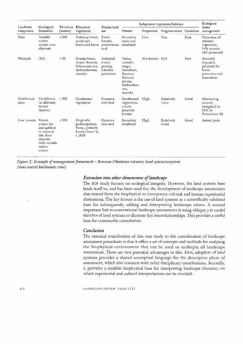
Indigenous vegetation/habitats Ecological Landform Geological Elevation Historical Present land issues component formation (metres) vegetation use Present Proportion Fragmentation Condition management
Flats Variable < 300 Podocarp forest, Exotic Secondary Low Very Poor Protection of tephra podocarp/ forestry, scmb and remnant mantle over hardwood forest conservation shmbland vegetation, alluvium land 14% remains
(4% protected)
Wetlands N/A <30 Swamp forest, Industrial Varies, Not known N/A Poor Generally raupo, Baumea, site(s), includes degraded, Schoenoplectus, grazing, raupo, potential for Bolboschoenus, informal Elcocharis, better manuka protection BauInea, protection and
Schoeno- restoration plcctus, Bolboschoe-nus, manuka
Geothermal U ndi fferent- < 300 Geothermal Conserva- Geothermal High Relatively Good Monitoring areas ial alluvium, vegetation tion land vegetation, intact recently
terrace mainly instigated by deposits prostrate DoC in
kanuka Parimahana SR
Low terraces Recent < 300 Originally Conserva- Secondary High Relatively Good Animal pests terrace fan podocarp/tawa tion land shmbland intact and uplifted forest, probably or remnant kanuka forest by lake floor c 1840 deposits with variable tephra mantic
Figure 2: Example of management framework - Rotorua-Okataina volcanics land system/ecosystem (semi-coastal bioclimatic zone)
40
Extension into other dimensions of landscape The BOP study focuses on ecological integrity. However, the land systems base lends itself to, and has been used for, the development of landscape assessments that extend from the biophysical to incorporate cultural and human experiential dimensions. The key feature is the use of land systems as a scientifically validated base for subsequently adding and interpreting landscape values. A second important link to conventional landscape assessments is using oblique 3-D model sketches ofland systems to illustrate key interrelationships. This provides a useful base for community consultation.
Conclusion The essential contribution of this case study to the consideration of landscape assessment procedures is that it offers a set of concepts and methods for analysing the biophysical environment that can be used to underpin all landscape assessments. There are two potential advantages in this. First, adoption of land systems provides a shared conceptual language for the descriptive phase of assessment, which also connects with other disciplinary contributions. Secondly, it provides a credible biophysical base for interpreting landscape character, on which experiential and cultural interpretations can be overlaid.
LA N D S CA PER E V lEW 19 9 9 : 5 ( I )
REFERENCES Lucas Associates with Lynn, I and Wildland Consultants (1998) A Fmmtlvork for Monitoring
Ecological Integrity in the Bay of Plenty Region, Christchurch: Lucas Associates.
McEwen, W M (1987) Ecological Districts and Regions ofNtlP Zcaland, 3rd ed. Biological Resources Centre Publication No 5, Wellington: Department of Conservation.
McHarg, I (1969) Design with Nature, New York: Doubleday.
Swafficld, S R and O'Connor, K F (1986) Conceiving, Perceiving, Protecting and Using NtlP Zealand
Landscape Systems, Canterbury: Centre for Resource Management, Lincoln College.
SIMON SWAFFIELD AND DI LUCAS 41