Embed Size (px)
Citation preview

~
li
I ' I
I I I 'I I I
'I I
~I
~' ~'
PROVINCE OF BRITISH COLUMBIA MINISTRY OF ENVIRONMENT
WATER MANAGEMENT DIVISION
A HYDROGEOLOGIC
INVENTORY AND RECONNAISSANCE
OF
KEATS ISLAND
D. Johanson, B.Sc. Groundwater Technician
Groundwater Section Hydrology Branch
Water Management Division
January 1993

1 I I I
ii
TABLE OF CONTENTS
I 1 I 1 I I I I
Pa ye
TABLE OF CONTENTS.. ........................................... ii
LIST OF FIGURES ................................................. iii
LIST OF TABLES .................................................. iii
LISTOF APPENDICES ............................................. iii
1. INTRODUCTION ......................................... 1
2. PHYSIOGRAPHY .......................................... 1
3. BEDROCKGEOLOGY ...................................... 2
4. SURFICIALGEOLOGY ..................................... 2
5. HYDROGEOLOGY ......................................... 3
6. HYDROCHEMISTY ........................................ 3
7. SUMMARY ............................................... 5
8. REFERENCES.. ........................................... 5

I
I I I I I
1 1 I I I 1 I I I I
iii
LIST OF FIGURES
Paye
FIGURE 1 Location Map ....................................... 6
FIGURE 2 ..... 7 FIGURE 3 Keats Island bedrock geology ......................... 8
FIGURE 4 Cross-section A - A', Keats Island ..................... 9
Mosaic prepared from airphoto coverage of Island
TABLE 1
LIST OF TABLES
Data summary of wells ....................... 10
LIST OF APPENDICES
APPENDIX A
APPENDIX B
Detailed data report .......................... 11
Detailed water rights report ................... 30

~~
I I 'I I I I I i I 1 I
A HYDROGEOLOGIC INVENTORY AND RECONNAISSANCE OF KEATS ISLAND
INTRODUCTION
Upon receipt of a request from the Sunshine Coast Regional District the Groundwater Section of the Water Management Division undertook a groundwater inventory and reconnaissance of Keats Island.
The Sunshine Coast Regional District is investigating the feasibility of improving water supply on the Island. Part of their investigation involves groundwater and wells. However, no water well data was available in the Groundwater Section Data Base for this Island.
In early October,1992, the author spent two days on Keats Island. During this time a well inventory was carried out, five wells were sampled for chemical analysis, and a beginning made on a hydrogeological investigation of the Island.
On completion, the Groundwater Section's Data Base was updated with the new water well record and chemistry information obtained, and four new 1 to 5,000 Water Well Location Maps, conforming to the British Columbia Geographical System (BCGS), were prepared for the Island.
I I I I I I 1 I
This preliminary hydrogeologic report was prepared to present some of the data and to give a few comments on the findings.
PHYSIOGRAPHY
Keats Island has a land area of approximately 600 hectares (1500 acres), primarily made up of sloping terzain rising to a central ridge with summits of around 200 metres (650 feet). It is a rugged island with rock dominated topography which is characterized by frequent bedrock outcrops or shallow overburden over bedrock. The shoreline consists of rock bluffs, separated by beaches of sand or gravel at several points on all sides of the island (Keats Island Community Plan,1975). Figure 1 shows the location of Keats Island and illustrates the topography.
There are no lakes or major streams on the island, however, a few minor creeks with intermittent flow are present and water rights have been obtained on some of these.

I 1 ‘ I I
1 ~1
1 I I I I I 1
1 1 I I I
The Island’s forests are extensive, mostly coniferous, and are home to a considerable deer and other small animal life population. Figure 2 is a mosaic, prepared from airphoto coverage of the Island.
BEDROCK GEOLOGY
Metamorphosed volcanic and lesser interbedded sedimentary rocks of the Bowen Island Group, along with Coast Plutonic granitic rocks at the east and west ends of the Island, comprise the bedrock of Keats Island. A comprehensive description of these rocks can be found in Roddick, J. A. (1965), ’Vancouver North, Coquitlam, and Pitt Lake Map Areas, British Columbia” (G.S.C. Memoir 335). Figure 3 shows Keats Island bedrock geology with generalized strike and dip for bedding and glacial striations (from Armstrong, 1954).
SURFICIAL GEOLOGY
The occurrence of bedrock over much of the island suggests the surficial materials are not very thick. Water well records confirm this. However, two drill logs are reported to penetrate over sixty feet of mainly till before encountering bedrock. No drill records were obtained for the interior valleys and possibly there are isolated deeper pockets of overburden in these areas.
HYDROGEOLOGY
Four well location maps were prepared and are located in the pocket of this report (926.033.4.3,92G.033.4.4,92G.043.2.1 and 92G.043.2.2 ). Table 1 is a data summary of the sixteen (16) wells located during the field work ( 6 dug and 10 drilled ). Appendix A is a detailed data report for each of these wells. Appendix B is a detailed water rights report for springs and creeks licensed on the Island and three (3) fifty percent reduced water rights maps with location data are enclosed in the pocket (926.033.4.3,92G.033.4.4, and 92G.043.2.1).
The predominent source of recharge to groundwater is precipitation, and its hydraulic behaviour is governed by topography, distribution of bedrock and surficial deposits, climate and vegetation. Precipitation replenishes the soil moisture and eventually reaches the water table to replenish the groundwater aquifers. On Keats Island this recharge occurs mainly during the winter months, when precipitation is high and the vegetation is dormant.

(3)
I I I I I I I I 1 I 1 I 1 1 1 t 1 1 I
A number of dug wells have been completed in the surficial deposits of the Island. They often appear to be adequate for domestic use if precaution is taken with use during late summer. However,, where large numbers of people draw on them, which occurs with the three Eastbourne community wells in the summer months, they are not adequate. It was reported that the three Eastbourne dug wells are depleted on weekends in the late summer and it takes a number of the week days for the water level to recover. The owner of dug well 92G.033.4.4.3 #9 reported the water level in his well rose 3 feet overnight after a recent September rainfall, and demonstrates how quickly precipitation recharges this aquifer.
The ability to develop screened wells in the overburden depends on finding saturated permeable materials (ie: sand and gravels). However, the occurrence of bedrock over much of the Island and the drilling to date indicates the surficial material is not very thick. The interior valleys may have some potential.
All drilled wells on the Island are completed in the bedrock and produce groundwater from fractures. The productivity depends on the size and frequency of the fracture openings encountered. The depth of these wells vary from 80 to 407 feet and yield is reported as varying from 35 to 1.0 gpm. However, a 1988 groundwater report by Piteau Associates of West Vancouver, for the Keats Camp water supply notes the 35 gpm well (mentioned above) supplied the Camp for years but in the spring of 1987,the well was incapable of meeting the water demand and rationing was necessary. They estimated the average summer water usage at 10.5 igpm and recommended another well be drilled to make up the camp requirement (Holmes, 1988).
At Eastbourne, a water shortage occurs in the summer. A cross-section A - A' (Figure 4 ) was drawn for this area. It's location is shown on well location maps 92G.033.4.3 and 92G.033.4.4. It shows bedrock wells with reported yields of 10 and 11 gpm near the east end of the section. This appears to be an area where further groundwater exploration may prove worthwhile for larger supplies. However, water quality and pumptesting should be carried out to confirm the true capacity and quality of the bedrock aquifer. Upstream of Bonner Creek, where it crosses the section line may be an area of overburden potential.
HYDROCHEMISTRY
Groundwater on Keats Island originates from precipation which infiltrates the soils and rocks and eventually returns to the surface at natural or man-made discharge points. From the point of recharge to the point of discharge the chemical quality of groundwater changes by increasing in total dissolved and suspended solids and by the relative proportions of these constituents.

:I I 1 1 I 1 1 1 I I I I I 1 I I I I
(4)
During the two days of field work five water samples were collected for analysis in the evening using a Beckman Solu-Bridge and a field Hach kit (model AL-94). Two laboratory analyses were acquired separately.
The results are summarized as follows:
1) pH 2) Hardness 3) Specific Conductance 4) NaCl 5) Total Alkalinity
varied from 6.6 to 7.92 varied from 51 to 187 pprn varied from 110 to 400 micro/mhos/cm less than 37.5 ppm varied from 68 to 170 pprn
All above parameters tested show values acceptable for drinking water. A laboratory analysis for well 92G.033.4.4.3 #1 showed acceptable water, except for manganese which tested as 0.22 mg/liter. The proposed aesthetic objective for this parameter is less than or equal to 0.05 mg/L (Guidelines for Canadian Drinking Water QualityJ989). At values exceeding 0.05 mg/L it may stain both plumbing fixtures and clothes being washed.
The laboratory analyses are included with the detailed data report in Appendix A.

I I 1 I I I I I I I I 1 I 1 1 I I I I
(5) SUMMARY
1) Dug well owners report a significant decrease in yield during the late summer.
2) Individual domestic water supplies can probably be obtained from most wells drilled on Keats Island, if drilled to sufficient depth.
3) Small community systems may obtain a supply exceeding 10 gpm from favourably located bedrock wells.
4) Sites for screened wells in sand and gravel are not very favourable due to the shallow overburden. However, there may be potential in the valley bottoms where the irregular bedrock topography may have channelled glacial melt waters and left permeable materials.
5) All water quality parameters tested, in samples collected, were below the maximum allowable concentrations as given in the "Guidelines for Canadian Drinking Water Quality, 1989", except for well 92G.033.4.4.3 #1 which had an elevated concentration of manganese (0.22 mg/L).
REFERENCES
Armstrong, J.E. 1954. Preliminary Map,Vancouver North, British Columbia Geological Survey of Canada, Paper 53-28.
Health and Welfare Canada. 1989. Guidelines for Canadian Drinking Water Quality 1989, Health and Welfare Canada, Ottawa.
Holmes, A.T. 1988. Well for Keats Camp Water Supply. Piteau Associates. / West Vancouver, British Columbia. Unpublished Report.
Keats Island Community Plan, 1975. Regional District of Sunshine Coast, By-Law No. 107, Sechelt, British Columbia.
Roddick, J. A. 1965. Vancouver North, Coquitlam, Pitt Lake Map-Areas, British Columbia. Geological Survey of Canada, Memoir 335.
D. Johanson, B.Sc. Groundwater Technician Groundwater Section Hydrology Branch Water Management Division

Ferry
15' E
SCALE 1:50.000 Miles I 0 1 2 3 Mlllcs
M Y --- - I - I + Metres loo0 500 0 1 0 0 0 3000 4000 Mitre3
Fig 1 : KEATS ISLAND
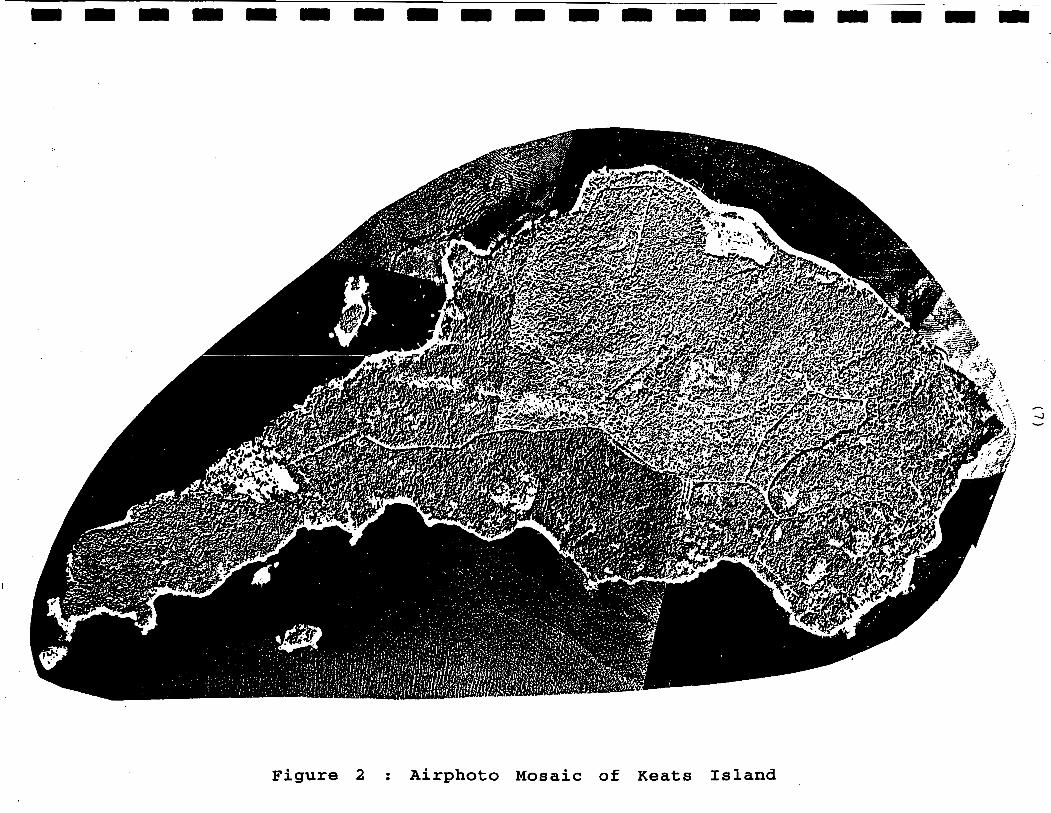
Figure 2 : Airphoto Mosaic of Keats Island

TRIASSIC(?)ANDX)R EARLIER
LEGEND
ton
F i g 3 : KEATS ISLAND GEOLOGY G e o l o g y by J. E. Armstrong, 1948-51

1 I I ,I
rl rl Q) 5 . m aD rl
a k ld Q)
rl rl m
E: 0
BEDROCK (Bowen Island Group)
-Sear Level-
Figure 4 : Cross-Section A - A ' , K e a t s Island
rl rl
.
-. .a
x -%
BEDROCK SWl 'r
5GPM lGPM
SGPM'
-100m
.- 8 Om
-60m
- 0
LEGEND
S t a t i c Water Level........ .. owl Horizontal Scale: 1 t o 5 , 0 0 0 V e r t i c a l S c a l e : S u r f i c i a l D e p o o i t o ........... od
as ohown
- 4 Om'
. - 2 Om

BCGS Map Area W e l l Lot No. No.
0926.033.4.3.3 0926.033.4.3.4 0926.033.4.3.4 0926.033.4.4.3 om.033.4.4.3 0926.033.4.4.3 0926.033.4.4.3 0926.033.4.4.3 0926.033.4.4.3 0926.033.4.4.3 0926.033.4.4.3 0926.033.4.4.3 0926.043.2.1.2 0926.043.2.1.2 0926.043.2.2.1 0926.043.2.2.1
001 001 7 002 001 11 0 0 2 6 0 0 3 2 004 005 006 007 0 0 8 A 009 001 002 001 002
Plm Elk TP SC RG D.L. No. No.
6646 18682 10378 10378 10378 18682 18682
18682 26% 18682
18682 18682
23
16 19 30 30
27
27
41 40
1467 1593 15% 15% 15% 15% 15% 15% 1593 1593 1593 1468 1469 15% 15%
G m r r k a t e r DaiebaSe Systen Data Sumnry - w i t h Legal Descriptias
L.D.
37 37 37 37 37 37 37 37 37 37 37 37 37 37 37 37
KEATS W(BABT1ST) DAVID BENTALL C W PEARSON D. FtDDIFANT SOREN NIL- EASTBaRNE W I N CARL UALTERS CARL UALTERS EASTBOLRNE W I N EASTBOLRNE W I T Y MR. GECRGE K(3NIffi GEfRGE KONlNG
BARNABUS FAMILY MIN. LEX HANSON(J0RDANS) RICHARD w\FMoND
E N V . , W S & PARKS
Date Carstructd
(W) 01 -01 -68 01-01-67 06-05-92 20-08-91 14-05-92 01 -01 -50 03-05-92
07-07-89 15-05-91 17-09-83
Cast. Depth Dgrth Uell Uell D r i l l Method Well Yld. to t o Aarif Screen Depth Dim. Ca-i t r (ft.) (in.) No.
160.0 6.0 26s 80.0 6.0 120
185.0 6.0 101 145.0 6.0 101 165.0 6.0 101 20.0 84.0 UNK
265.0 6.0 101 15.0 24.0 UNK 20.0 60.0 UNK 20.0 120.0 UNK 11.0 0.0 UNK 11.0 144.0 UNK
235.0 6.0 081 407.0 6.0 032 245.0 6.0 101 200.0 6.0 101
DRI DRI DRI DRI DRI DUG DRI wc DUG DUG Dw Dw DRI DRI DR I DRI
Yield lht. Water Begk Litho Interval (ft.) (ft.) (ft.)
35.0 GPM 3.0 GPM 4.0 GPM 56
11.0 GPM 10.0 GPM 46
2.0 BM 68
8 10
6 20.0 GPM 22 3.0 GPM 30 5.0 GPM 1.0 GPM 45
4om O B E D
18 BED 2 B E D 9BED
IMK wc 1 B E D
IMK wc IMK wc IMK wc IMK wc IMK wc 24 BED 66 BED 2 B E D
59 BED
G.W. Chem Chem Chem R p t Ld, Fld Site
No.
Y Y Y
Y
Y Y
Y
Y
A
P 0 Y
DISUAIEER: The PrWince disclaim e l l respasibility for the acarracy of this infonmticn. This infonmtien sharld not be lsed as a basis for mki rg f i m i a l or my other c m i t m t s .

I I I 1 I I I I I I I 1 I I I 1 I I. I
. . 2. : . . . . . . .
APPENDIX A
D e t a i l e d Data Report

27/01/93 Ministry of Environment - Water Mana ement Branch - Groundwater Section
Groundwater Dazabase S stem Detailed Data Rep04
WELL IDENTIFICATION DETAILS:
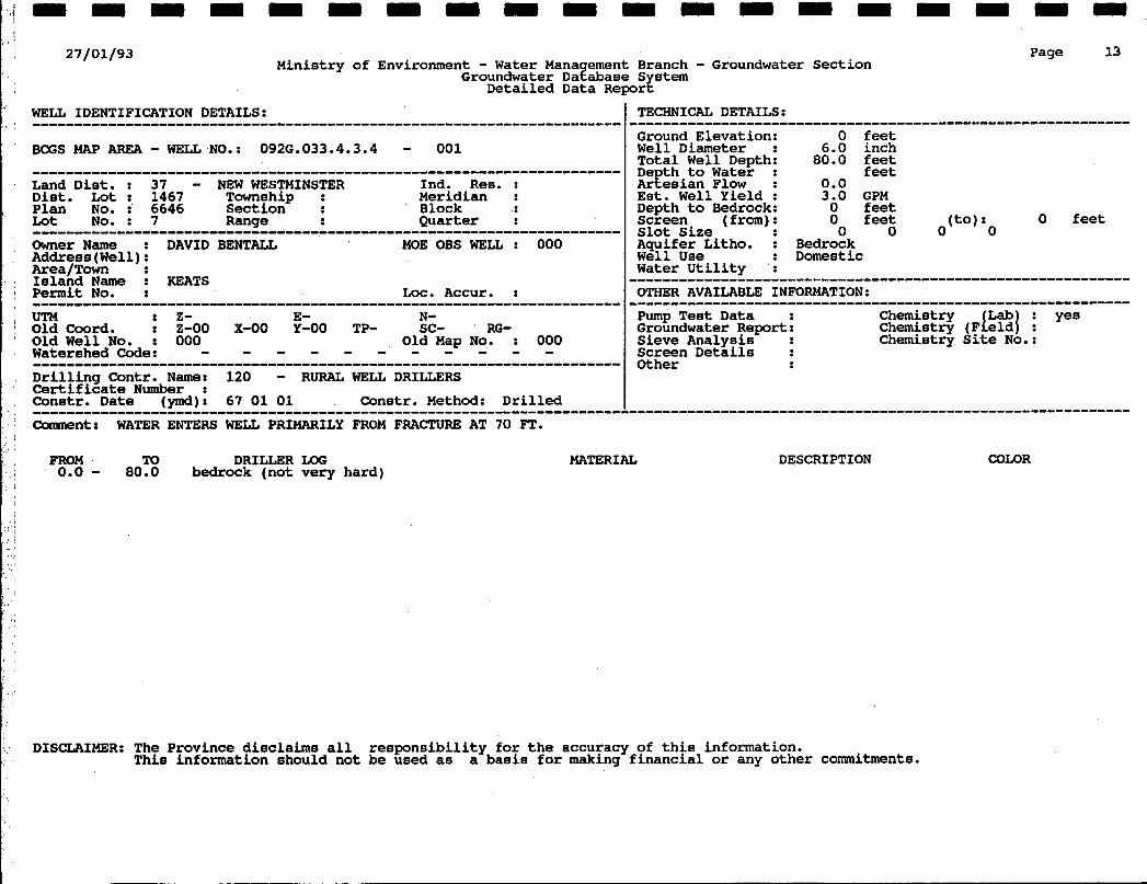
BCGS MAP AREA - WELL NO.: 092G.033.4.3.3 - 001
UTM : z- E- N- Old Coord. : Z-00 X-00 Y-00 TP- sc- RG- Old Well No. : 000 Watershed Code: - Old Map No. : 000 - - - - - - - - - - ...................................................................... Drilling Contr. Name: 265 - FRIESEN DRILLING Certificate Number : Constr. Date Ivmdl: 68 01 01 Constr. Method: Drilled
Page 12
TECHNICAL DETAILS:
0 feet Ground Elevation: Well Diameter 6.0 inch Total Well Depth; 160.0 feet Denth to Water : feet
............................................................
GEesian Flow- : 0.0 Est. Well Yield : 35.0 GPM Depth to Bedrock: 40 feet Screen ( from) : Slot Size Aauifer Litho. : Bedrock
0 feet (to) : 0 feet 0 0 0 0
we'll Use : Domestic Water Utility :
OTHER AVAILABLE INFORMATION: ............................................................ ~~
Pump Test Data Chemistry (Lab : Groundwater Report yes Chemistry (Field1 : yes Sieve Analysis : Chemistry Site No.: Screen Details : Other
Comnentr ORIGINALLY RATED AT 35GPM BUT 1988 REPORT BELIEVES IT PRODUCES APPROX, lOGPM SUPPLY APPROX. 80 CABINSIFLOWS DURING WINTER MONTHS.INADEQUATEIN LATE SUMMER.
FROM To DRILLER LOG
40.0 - 160.0 bedrock (fractured at 100ft.) 0.0 - 40.0 stoney clay & till?
MATERIAL DESCRIPTION
DISCLAIMER: The Province disclaims all responsibility for the accuracy of thjs information. This information should not be used as a basis for making financial or any other commitments.
COLOR
27/01/93 Ministry of Environment - Water Mana ement Branch - Groundwater Section
Groundwater Dazabase S stem Detailed Data Reporg
Page 13
WELL IDENTIFICATION DETAILS:
UTM : 2- E- N- Old Coord. : 2-00 X-00 Y-00 TP- sc- RG- Old Well No. : 000 Old Map No. : 000
TECHNICAL DETAILS :
Ground Elevation: 0 feet Well Diameter 6.0 inch Total Well Depth; 80.0 feet
............................................................
De th to Wate: : feet
Est. Well Yield : 3.0 GPM Artesian Flow : 0.0
Depth to Bedrock: 0 feet Screen ( from) : 0 feet (to) : Slot Size 0 0 0 0 Aquifer Litho. : Bedrock Well Use : Domestic Water Utility ':
OTHER AVAILABLE INFORMATION:
0 feet
............................................................ Pump Test Data : Chemistry {Lab : yes Groundwater Report: Chemistry (Field1 : Sieve Analysis : Chemistry Site No.: Screen Details : Other
FROM To DRILLER UX: 0.0 - 80.0 bedrock (not very hard)
MATERIAL DESCRIPTION COLOR
DISCLAIMER: The Province disclaims all responsibility for the accuracy of this information. This information should not be used as a basis for making financial or any other commitments.

27/01/93 Mini s t ry of Environment - Water Mana ement Branch - Groundwater Sec t ion
Groundwater Daeabase S s tem Deta i led Data R e p o r z
Page 15 , j :
WELL IDENTIFICATION DETAILS: ...................................................................... BCGS MAP AREA - WELL NO.: 0926.033.4.3.4 - 002 ...................................................................... Land D i s t . : 37 - NEW WESTMINSTER Ind. R e s . :
Township : Meridian : Block : 23
D i s t . L o t : 1593 Quar te r :
Plan NO. : 18682 Sect ion L o t No. : Range
Owner N a m e : CHUCKPEARSON MOE OBS WELL : 000 ...................................................................... Address(Wel1): Area/Town : I s l a n d N a m e : KEATS P e r m i t No. Loc. Accur. : _ _ ~ ~ ~ ~ ~ ~ ~ ~~
UTM : z- E- N- Old Coord. : Z-00 X-00 Y-00 TP- sc- RG- Old W e l l No. : 000 Watershed Code:
D r i l l i n g Contr. N a m e : 101 - NOR-WEST WELL DRILLING C e r t i f i c a t e Number : Constr. D a t e (ymd): 92 05 06 Constr. Method: Drilled
Comment: DARK FINE GRAINED BEDROCK OUTCROPS NEAR WELLSITE
O l d Map No. : 000 - - - - - - - - - - - ......................................................................
......................................................................
Ground Elevat ion: W e l l Diameter T o t a l W e l l Depth; D e t h to Water : & e s i a n Flow : E s t . W e l l Yield : Depth t o Bedrock: sc reen ( from) : slot S i z e Aquifer Li tho. : W e l l U s e : Water U t i l i t v :
0 f e e t 6.0 inch
185.0 f e e t 56 f e e t 0.0 4.0 GPM 18 f e e t 0 f e e t (to) : 0 f e e t 0 0 0 0
Bedrock Domestic
OTHER AVAILABLE INFORMATION:
Chemistry Chemistry (d%{ f Pump T e s t Data :
Groundwater R e p o r t : S ieve Analysis : Chemistry S i t e No.: Screen Details . : Other
............................................................
FROM 0.0 - 5 . 0 - - . -
12.0 - 18.0 - 70.0 - . ~ . ~
0.0 - 82.0 - 106.0 - 0.0 -
124.0 - 156.0 - 169.0 -
To DRILLER LOG
12.0 sand & ravel 18.0 grave l 2 cobbles 70.0 y e n g r a n i t e (some f r a c t u r e s 82.0
106.0 b lack grani te 124.0 black g r a n i t e & l e n s e of q u a r t z
156.0 r een g r a n i t e 169.0 qractured green g r a n i t e (2 gpm) 185.0 black g r a n i t e
5.0 f i l l
t i g h t green r a n i t e ( s o m e f r a c u r e s ) 0.0 1 gpn at 70- 2 f t
0.0 1 gpm a t 106-124
MATERIAL DESCRIPTION WWR
DISCLAIMER: The Province d i sc l a ims a l l r e s p o n s i b i l i t y f o r t h e accuracy of t h i s information. This information should no t be used as a basis f o r making f i n a n c i a l o r any o t h e r conanitments.
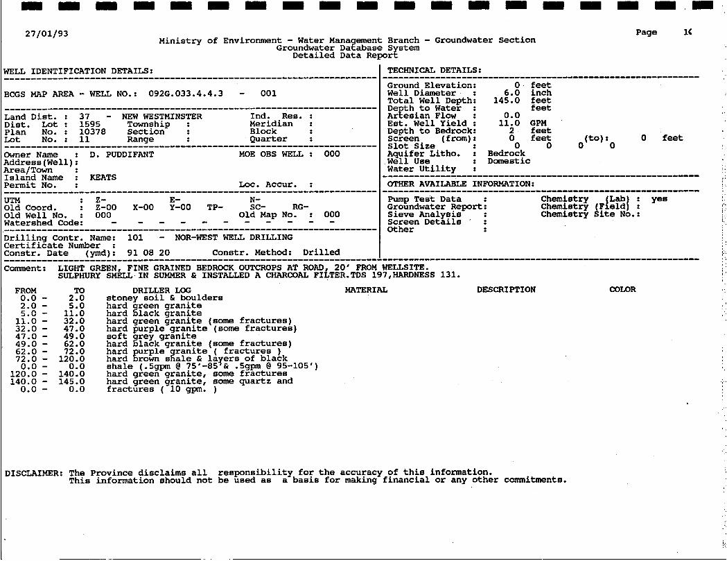
27/01/93 Mini s t ry of Environment - Water Mana ement Branch - Groundwater Sec t ion
Groundwater Da?abase S stem Deta i led Data R e p o r $
Page 14
JTM : z- E- N- l l d Coord. : Z-00 X-00 Y-00 TP- sc- RG- 31d W e l l N o . : 000 O l d Map No. : 000
W e l l Diameter : 6.0 i nch T o t a l W e l l Depth: 145.0 f e e t D e t h t o Water : f e e t
E s t . W e l l Yield : 11.0 GPM Depth to Bedrock: 2 f e e t Screen ( from) : 0 f e e t (to) : 0 feet S l o t S i z e 0 0 0 0 Aquifer Litho. : Bedrock W e l l U s e : D o m e s t i c Water U t i l i t y :
Artes i an Flow : 0.0
FROM To DRI+ER LOG MATERIAL 0.0 - 2.0 s toney so i l & boulders 2.0 - 5.0 hard reen g r a n i t e 5.0 - 11.0 hard %lack g r a n i t e 11.0 - 32.0 hard green g r a n i t e (some f r a c t u r e s ) 32.0 - 47.0 hard pu rp le g r a n i t e (some f r a c t u r e s ) 47.0 - 49.0 s o f t %my g r a n i t e 49.0 - 62.0 hard l a c k g r a n i t e (some f r a c t u r e s ) 62.0 - 72.0 hard u r p l e r a n i t e ( f r a c t u r e s ) 72.0 - 120.0 hard grown szale layers of black
120.0 - 140.0 hard green g r a n i t e , some f r a c t u r e s 140.0 - 145.0 hard green g r a n i t e , some q u a r t z and
0.0 - 0.0 shale (.5gpm (3 75 -85 & .5gpm @ 95-105')
0.0 - 0.0 f r a c t u r e s ( 10 gpm. )
DESCRIPTION COulR
DISCLAIMER: The Province d i sc l a ims a l l r e s p o n s i b i l i t y f o r t h e accuracy of t h i s information. Th i s in format ion should n o t be used as a b a s i s f o r making f i n a n c i a l or any o t h e r commitments.

~ 1 ; I I ;
RLE Ho: E6S3J
I
. . . . . . . .
We have tss2ed t b e d e srbmtllorj b y y u and r q o - l a s id-.
. ............. . . . . . . . . . . . . - ............. . . . . . . . . . . . . . . . . .. . ..... __ . ' . 'LS:...:. - . . - --.---- -._ .-:-
'I DATE W wspec- DATE SUBAUITED: 24. 'I 992
7.92 197. 131. c 0.05
0.22 0.19
L * . ... . . .
.p: .
I I
I . ' . . . . . .
...
.. . . . . . . . . . .
. . . . . . . . .
.. _ . . .
. . .-
. . .. . .

27/01/93
JTM : z- E- N- )Id Coord. : Z-00 X-00 Y-00 TP- sc- RG- )Id W e l l N o . : 000 Jatershed Code:
Old Map No. : 000 - - - - - - - - - - -
Minis t ry of Environment - Water Mana ement Branch - Groundwater Sec t ion Groundwater Dazabase S stem
Deta i led Data R e p o r $
pump T e s t Data : Groundwater R e p o r t : S ieve Analysis : Screen Details ’ :
Page 18
W e l l D i a m e t e r - - 6.0 inch 165.0 f e e t
D e t h t o Water : 46 f e e t
E s t . W e l l Y i e l d : 10.0 GPM Depth t o Bedrock: 9 feet Screen ( f r o m ) : 0 f e e t ( to) : 0 f e e t s lo t S i z e 0 0 0 0 Aquifer Li tho. : Bedrock W e l l U s e : Domestic Water U t i l i t y :
OTHER AVAILABLE INFORMATION:
I Total W e l l Depth;
Ar t e s i an F l w : 0.0
............................................................ Chemistry Lab t Chemistry ( F f e l d j : Chemistry S i t e No.:
FROM To DRILLER LOG MATERIAL 0.0 - 2.0 stoney t o soil 2.0 - 9.0 s i l t y sans , g r a v e l & cobbles 9.0 - 34.0 grey Et r een g r a n i t e 34.0 - 78.0 gurp le 2 grer g r a n i t e 78.0 - 96.0 rown & l r g h green g r a n i t e , f r a c t u r e s 0.0 - 0.0 96.0 - 134.0 :is reen g r a n i t e - 134.0 - 156.0 green 2 brown g r a n i t e ( f r a c t u r e s 9 gpn) 156.0 - 165.0 green g r a n i t e
DESCRIPTION COLOR
IISCLAIMER: The Province d i sc l a ims a l l r e s p o n s i b i l i t y f o r t h e accuracy of t h i s information. Th i s in format ion should no t be used as a b a s i s f o r making f i n a n c i a l or any o t h e r commitments.

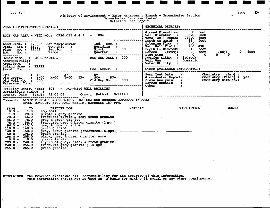
27/01/93 Ministry of Environment - Water Mana ement Branch - Groundwater Section
Groundwater Dazabase S stem Detailed Data Repori!
Page 19
I BCGS MAP AREA - WEU NO.: 092G.033.4.4.3 - 003
Address(Wel1): Area/Town : EASTBOURNE Island Name : KEATS
Well Diameter : 84.0 inch Total Well Depth: 20.0 feet De th to Water : feet
Est. Well Yield t 0.0 Depth to Bedrock: UNK feet Screen ( from) : 0 feet slot Size : 0 0 0 0 Aquifer Litho. : Unconsolidated Well Use : Commercial and Industrial Water Utility :
Arfesian Flow : 0.0
(to) : 0 feet
I certifidate Number : Constr. Date (ymd): 50 01 01 Constr. Method: Dug
FROM To DRILLER LOG MATERIAL 0.0 - 20.0 till, water enters in grey gravelly 0.0 - 0.0 seams in till
DESCRIPTION COLOR
. .. . - . .-..
DISCLAIMER: The Province disclaims all responsibility for the accuracy of this information. This information should not be used as a basis for making financial or any other commitments.
27/01/93 Mini s t ry of Environment - Water Mana ement Branch - Groundwater Sec t ion
Groundwater Da?abase S stem Deta i led Data Reporg
Page a0
FROM 0.0 - 1.0 - 28.0 - 46.0 - 78.0 - 96.0 - 110.0 -
-140..0 - 150.0 - 195.0 - 0.0 -
205.0 - 240.0 - 255.0 -
To 1.0 28.0 46.0 78.0 96.0 110.0 140.0 150.. 0 195.0 205.0 0.0
240.0 255.0 265.0
DRILLER UX: top so11
u r p l e & grey r a n i t e Trac tured purpye & grey green g r a n i t e
r ey & green g r a n i t e Yractured g rey & brown g r a n i t e (lgpm ) grey & brown g r a n i t e
grey, green Eranite rown _grani te-( f ractures- . S-gpn-) -
%lack, y y I green g r a n i t e , some 9"a;zE o$GEEy, b l ack & brown g r a n i t e f r a c t u r e d grey g r a n i t e ( .5 gpm ) green g r a n i t e
reen g r a n i t e
MATERIAL
__-
DESCRIPTION COLOR
DISCLAIMER: The Province d i sc l a ims a l l r e s p o n s i b i l i t y f o r t h e accuracy of t h i s information. This information should no t be used as a b a s i s f o r making f i n a n c i a l or any o t h e r commitments.

27/01/93 Ministry of Environment - Water Mana ement Branch - Groundwater Section
Groundwater Dazabase S stem Detailed Data Reporf
Page 2'1
Drilling Contr. Name: UNK - Unknown Certificate Number : Constr. Date lvmdl: Constr. Method: Dug
FROM To DRIUER LOG 0.0 - 0.0 gravelly at surface
0 feet
MATERIAL DESCRIPTION COLOR
DISCLAIMER: The Province disclaims all responsibility for the accuracy of this information. This information should not be used as a basis for making financial or any other conanitments.

27/01/93 Ministry of Environment - Water Mana ement Branch - Groundwater Section
Groundwater Dazabase S s t e m Detailed Data R e p o r $
?ELL IDENTIFICATION DETAILS: ...................................................................... 3CGS MAP AREA - WELL NO.: 0926.033.4.4.3 - 006
;and D i s t . : 37 - NEW WESTMINSTER Ind. Res . : Township : Meridian :
Block list. Lot : 1595
sec t ion Quarter :
Plan No. : kt NO. : Range
mer N a m e : EASTBOURNE COMMUNITY MOE OBS WELL : 000 4ddress ( W e l l ) : &ea/Town : tsland N a m e : KEATS P e r m i t No. LOC. Accur. :
......................................................................
TECHNICAL DETAILS:
Page
~ ~~ ~~ _ _ _ _ ~ _ _ _ _ ~ _ ~ ~ ~ ~ ~ 0 f e e t Ground Elevation:
W e l l D i a m e t e r 60.0 inch Total W e l l Depth; 20.0 f e e t D e t h t o Water : 8 f e e t
E s t . W e l l Yield : 0.0 Depth t o Bedrock: UNK f e e t Screen ( from) : 0 f e e t (to) : 0 f e e t S l o t S i ze 0 0 0 0 Aquifer Litho. : Unconsolidated W e l l U s e : Conrmercial and Indus t r i a l Water U t i l i t v :
Artesian Flow : 0.0
Zomment: THIS WELL I S NOT CASED TO THE BOTTOM, BUT WAS OBSERVED TO BE CASED BELOW THE H2O LEVEL I N WEU.HEAVY USE ON SUMMER WEEKENDS DEPLETES WELL.SYPHON SYSTEM NO PUMP.
FROM To D R I U E R LOG MATERIAL 0.0 - 0.0 f i n e s i l t y 0.0 - 0.0 water en ters w e l l through grey grave l ly 0.0 - 0.0 seams i n till
DESCRIPTION COLOR
I '
DISCLAIMER: The Province disclaims a l l r e s p o n s i b i l i t y f o r t h e accuracy of t h i s information. This information should not be used as a bas i s f o r making f i n a n c i a l or any o ther commitments.
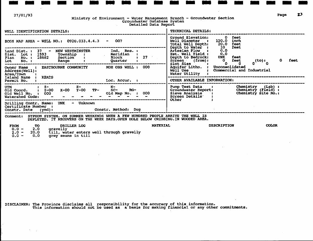
27/01/93 Ministry of Environment - Water Mana ement Branch - Groundwater Section
Groundwater Dazabase S stem Detailed Data Repors
WELL IDENTIFICATION DETAILS:
BCGS MAP AREA - WELL NO.: 0926.033.4.4.3 - 007
UTM : z- E- N- Old Coord. : 2-00 X-00 Y-00 TP- sc- RG- Old Well No. : 000 Watershed Code:
Drilling Contr. Name: UNK - Unknown Certificate Number : Constr. Date (ymd): Constr. Method: Dug
Old Map No. : 000 - - - - - - - - - - - ......................................................................
......................................................................
Page 0
TECHNICAL DETAILS :
Ground Elevation: 0 feet Well Diameter 120.0 inch Total Well Depth; 20.0 feet De th to Water : 10 feet
Est. Well Yield : 0.0 Depth to Bedrock: UNK feet Screen ( from) : 0 feet (to) :o 0 feet slot Size 0 0 0 Aquifer Litho. : Unconsolidated Well Use : Commercial and Industrial Water Utility :
OTHER AVAILABLE INFORMATION:
............................................................
Artesian Flow : 0.0
............................................................ Pump Test Data : Groundwater Report: Sieve Analysis : Screen Details' : Other :
Comment: SYPHON SYSTEM. ON SUMMER WEEKENDS WHEN A FEW HUNDRED PEOPLE ARRIVE THE WELL IS DEPLETED. IT RECOVERS ON THE WEEK DAYS.OPEN HOLE BELOW CRIBBING.IN WOODED AREA.
FROM To DRILLER LOG MATERIAL DESCRIPTION 0.0 - 2.0 ravel ly 2.0 - 20.0 ? ill, water enters well through gravelly 0.0 - 0.0 grey seams in till
COulR
DISCLAIMER: The Province disclaims all responsibility for the accuracy of this information. This information should not be used as a basis for making financial or any other commitments.

. .
Specific Conductance I Turbidity
I '.::. Alkalinity Total 4.5
Hardness Total
I' ..,,. Colifoim - Total
200 uS/cm Cond. Meter Siebold
0. 1 NTU Nephel. Single Beam
31. 2 ng /L Automated Electrometer
1 c.4 rr.3 /L Calculated Result I
<: 2.0 C Fil Filter-Membrane . . . . . .
I
Fluoride Dissolved
B a r o n
Bar i urn
Calcium
Cht omium Di ...- . . . C o p p e r
. .
Magnesium
. . .
mg /L 1. S. E. .': 0. :a <: 0. cm1 mg /L IC? knalysis
< 0.01 mg i L ICP Analysis
56. 7 mg /L ICP Analysis
< 0.01 ng /L ICP Analysis
3. 06 mg /L ICP Analysis
<: 0. 01 mg /L ICP Analysis
2. =a mg /L ICP Analysis
.:: 0 e:: 1 /L 3 t P Analysis
0. crj: mg /L HN03 Dig: HGA Analysis
1; € 3. c-l mg /L ICP Analysis
Auto. Cadmium Reduction C. i f mg /L
-, - = R5 /L Calculated Result - -.I
.< .3 E45 mg /L Auto. Did 2 oti :at i on
I
*I . . I . . . ; . . . .
I:-.. '.-
. . . . . . . . . . . . .
..... . . . . . . . . . . . . . . . . . . : . . . . . . . . . . . . . . . . . . . . . . . . . . - 'I
' . . ...
. 9 . . . .. . _
.. . . . . . . ; . .
. . . ' . . . .
. . . . . . :
. . . .
. . ' . . -.
27/01/93 Min i s t ry of Environment - Water Mana ement Branch - Groundwater Sec t ion
Groundwater Dazabase S s t e m De ta i l ed D a t a R e p o r 8
Page aV
Land D i s t . : 37 - N E W WESTMINSTER Ind. R e s . : Township : Meridian :
Block Diet. L o t : 1593
s e c t i o n Quar t e r :
Plan N o . : 2668 Lot N o . : A Range
mer N a m e : MR. GEORGE KONING MOE OBS WELL : 000 9ddress I W e l l ) :
...................................................................... Nrea/Toh ': I s l a n d N a m e : KEATS P e r m i t N o . LOC. Accur. :
zomment :
FROM 0.0 - 2.0 - 0.0 -
W e l l Diameter 0.0 i nch T o t a l W e l l Depth; 11.0 f e e t D e t h to Water : f e e t
E s t . W e l l Yield : 0.0 Depth to Bedrock: UNK f e e t Screen ( from) : 0 f e e t ( t o ) : 0 f e e t s lot S i z e 0 0 0 0 Aquifer Litho. : Unconsolidated W e l l U s e : Domestic Water U t i l i t y :
Areesian Flow : 0.0
SUPPLIES LOG HOUSE ON PARCEL A, REF PLAN 2668 , DUG WITH BACKHOE.
To DRILLER LOG MATERIAL 2.0 g r a v e l l y so i l
0.0 seams i n till ) . 11.0 ( w a t e r en t e r s through grey g r a v e l l y
DESCRIPTION COLOR
DISCLAIMER: The Province d i s c l a i m s a l l r e s p o n s i b i l i t y f o r t h e accuracy o f t h i s information. This in format ion should n o t be used as a basis f o r making f i n a n c i a l o r any o t h e r commitments.

27/01/93
WELL IDENTIFICATION DETAILS:
Ministry of Environment - Water Mana ement Branch - Groundwater Section Groundwater Dazabase S stem
Detailed Data Reporz
BCGS MAP AREA - WELL NO.: 0920.033.4.4.3 - 009
TECHNICAL DETAILS :
Page as
~-~~~~~ ~~~ _ ~ _ _ ~ Ground Elevation: 0 feet Well Diameter : 144.0 inch Total Well Depth: 11.0 feet De th to Water : 6 feet
Est. Well Yield : 0.0 Depth to Bedrock: UNK feet Screen (from) I 0 feet (to) : 0 feet Slot Size 0 0 0 0 Aquifer Litho. : Unconsolidated Well Use : Domestic Water Utility :
Arfesian Flow : 0.0
Comment: USE FOR HOUSE AND GARDENINEVER RAN DRY BUT ONLY 18" OF WATER IN WELL IN LATE AUGUST (1992) BUT WITH RECENT RAIN IN SEPT. THE WATER LEVEL ROSE 3 FT. ONE NIGHT
FROM To DRILLER LOG 0.0 - 2.0 gravelly soil 2.0 - 11.0 ???I water enters through grey 0.0 - 0.0 gravelly seams in till 1.
MATERIAL DESCRIPTION COLOR
DISCLAIMER: The Province disclaims all responsibility for the accuracy of this information. This information should not be used as a basis for making financial or any other commitments.

27/01/93 Ministry of Environment - Water Mana ement Branch - Groundwater Section
Groundwater Dazabase S stem Detailed Data Repor8
WELL IDENTIFICATION DETAILS:
BCGS MAP AREA - WELL NO.: 0926.043.2.1.2 - 001
......................................................................
...................................................................... Land Dist. : 37 - NEW WESTMINSTER Ind. Res. :
Township : Meridian : Block
Dist. Lot : 1468 Sect ion
Quarter : Plan No. : Lot No. : Range Owner Name : ENV.,LANDS 61 PARKS MOE OBS WELL : 000 AddressIWell): PLUMBER COVE PROV. PARK
...................................................................... &ea/To&n ': Island Name : KJWTS Permit No. LOC. Accur. :
UTM : 2- E- N- Old Coord. : 2-00 X-00 Y-00 TP- sc- RG- Old Well No. : 000 Watershed Code: Drilling Contr. Name: 081 - LANGLEY WATER WELLS Certificate Number : Constr. Date (ymd) : Constr. Method: Drilled
Old Map No. : 000 - - - - - - - - - - - ......................................................................
......................................................................
Page aL
TECHNICAL DETAILS:
Ground Elevation: Well Diameter Total Well Depth; De th to Water : Arfesian Flow : Est. Well Yield : Depth to Bedrock: Screen ( from) : slot size Aquifer Litho. : Well Use Water Utility :
------------------- ......................................... 0 feet
6.0 inch 235.0 feet 22 feet 0.0 20.0 GPM 24 feet 0 feet (to) : 0 feet
0 0 0 0 Bedrock Other
OTHER AVAILABLE INFORMATION:
Pump Test Data : Chemietry Groundwater Report: Sieve Analysis : Chemistry Site No.: Screen Details ' Other
............................................................ Chemistry (F eld : yes
Comment: OCT.92 JUST A HANDPUMP ON WELL,IT IS USED FOR DRINKING WATER.FIELD ANALYSIS : SPEC. WND.200MICROMHOS/CM, PH 6.8, NACL <25 PPM, HARDNESS 68 PPM.
FROM To DRILLER LOG
10.0 - 23,O clav with stones 0.0 - 10.0 till
MATERIAL DESCRIPTION COLOR
23.0 - 24.5 silEy clay 24.5 - 235.0 bedrock,fractures @ 115',207',222'
DISCLAIMER: The Province disclaims all responsibility for the accuracy of this information. This information should not be used as a basis for making financial or any other commitments.

27/01/93 Ministry of Environment - Water Mana ement Branch - Groundwater Section
Groundwater Dazabase S stem Detailed Data Reprg
WELL IDENTIFICATION DETAILS:
UTM : 2- E- N- Old Coord. : 2-00 X-00 Y-00 TP- sc- RG- Old Well No. : 000 Old Map No. : 000 Watershed Code: e - - - - - - - - - - ...................................................................... Drilling Contr. Name: 032 - DRIUWELL ENT. / KEN SLADE Certificate Number : Constr. Date Ivmd): 89 07 07 Constr. Method: Drilled
Page a7
TECHNICAL DETAILS:
Ground Elevation: Well Diameter Total Well Depth; De th to Water : Artesian Flow : Est. Well Yield : Depth to Bedrock: Screen (from) : Slot Size Aquifer Litho. : Well Use Water Utilitv :
10 feet 6.0 inch
407.0 feet 30 feet 0.0 3.0 GPM 66 feet 0 feet (to) : 0 feet 0 0 0 0
Bedrock Domestic
Comment: THIS IS THE "CORKUM FARM", QUALITY STATED AS GOOD AND ADEQUATE SUPPLY
FROM To DRILLER LOG
40.0 - 66.0 TI[ il with boulders 66.0 - 407.0 shale and sandstone
0.0 - 5.0 soil 5.0 - 40.0 silt with sand layer
MATERIAL DESCRIPTION OOLOR
DISCLAIMER: The Province disclaims all responsibility for the accuracy of this information. This information should not be used as a basis for making financial or any other commitments.

27/01/93 Ministry of Environment - Water Mana ement Branch - Groundwater Section
Groundwater Dazabase S stem Detailed Data Repor8
Page 2 3
Comment: PLUTONIC BANDED BEDROCK OBSERVED AT SITE,SOME BANDS PINK AND TO 3 FT WIDE. FIELD TEST:SPEC. COND. 400,PH 7.7(?),NACL <25 PPM HARDNESS 170 PPM.
FROM To 0.0 - 2.0 2.0 - 7.0 7.0 - 12.0 12.0 - 22.0 22.0 - 90.0 0.0 - 0.0 90.0 - 140.0 140.0 - 145.0 145.0 - 170.0 170.0 - 240.0 240.0 - 245.0
DRILLER LOG MATERIAL fill multi coloured granite(fractured) hard green granite hard green and white granite hard multi coloured granite
hard green E h i t e ranite
fard green 61 white granite fratured green t white granite green t pink granite (fractured)Qgpm.
65-75ft. 1
ink granite (140-190ft .5 gpm )
DESCRIPTION COLOR
DISCLAIMER: The Province disclaims all responsibility for the accuracy of this information. This information should not be used as a basis for making financial or any other commitments.

27/01/93 Ministry of Environment - Water Mana ement Branch - Groundwater Section
Groundwater Dazabase S stem Detailed Data Reporf
WELL IDENTIFICATION DETAILS: ...................................................................... BCGS MAP AREA - WELL NO.: 0926.043.2.2.1 - 002
Land Dist. : 37 - NEW WESTMINSTER Ind. Res. : Township : Meridian : Dist. Lot : 1594
Plan No. : 18682 Section Lot NO. : Range Quarter :
Owner Name : RICHARD HAMMoND MOE OBS WELL : 000 Address(Wel1):
...................................................................... Block : 40
...................................................................... Area/Town : Island Name : KEATS Permit No. LOC. Accur. :
UTM : z- E- N- old Coord. : Z-00 X-00 Y-00 TP- SC- RG- Old Well No. : 000 Watershed Code:
Drilling Contr. Name: 101 - NOR-WEST WELL DRILLING Certificate Number : Constr. Date (ymd): 83 09 17 Constr. Method: Drilled
Comment: OCT.92 WELL NOT IN USE
...................................................................... Old Map No. : 000 - - - - - - - - - - - ......................................................................
......................................................................
Page 29
TECHNICAL DETAILS:
Ground Elevation: 0 feet Well Diameter 6.0 inch Total Well Depth; 200.0 feet De th to Water : 45 feet Est. Well Yield : 1.0 GPM Depth to Bedrock: 59 feet Screen ( from) : 0 feet (to) t o 0 feet slot Size 0 0 0 Aquifer Litho. : Bedrock Well Use : Domestic Water Utility :
OTHER AVAILABLE INFORMATION: Pump Test Data Chemistry Lab : Groundwater Report Chemistry (Field1 : Sieve Analysis : Chemistry Site No.: Screen Details ' : Other :
Areesian Flow : 0.0
............................................................
............................................................
FROM To DRILLER LOG MATERIAL
16.0 - 59.0 till & re cla 59.0 - 63.0 cap rocz, xard hack granite 63.0 - 93.0 hard grey ranite 93.0 - 155.0
155.0 - 200.0 & e r e ranite, s:me cracks
0.0 - 4.0 stoney clay 4.0 - 16.0 hardpan
grey grani?e $ la er? of sandstone 0.0 - 0.0 at 130 - 140
0.0 - 0.0 .5 gpn as 960' - 180
DESCRIPTION COLOR
DISCLAIMER: The Province disclaims all responsibility for the accuracy of this information. This information should not be used as a basis for making financial or any other commitments.
I .

- 30 -
APPENDIX B
D e t a i l e d Water R i g h t s Report

I I. I I I I I I I I I I I I I I I I
D e t a i l e d L icence R e p o r t Water L icence Inforrr ta t ion System DATE : 1992/07/2? TIME: 11:02 PAGE : CK)l
' Licence f4uaber: C016074 F i l e Number: I:) 152459 . D i s t / P r e c : 2% VAN - HOWE SOUND
P r i o r i t y Dste: 1944/05/08 Reg i o n : 02 LOWER MAINLANE1 L icence Status: C CURRENT Lic. S t a t u s Date: 15'91/05/24 P r o c e s s Status: P r o c S t a t u s [ late: - Lic. Exp. Date: - LTO Code OY. PID: Fee R e c e i p t No:
Appurtenancy : 3 . E l AC PARCEL A OF L 155'3 GP 1 N W f l PLAN 2668
L i c e n s e e Wo. 1 ( C l i e n t Last Updated: / / By Region: ) C 1 i en t No : 231 11 Work Phone: Home Phone : Rece ives B i l l : Y
----------- -----------
T o t a l Licence Dem~and: PUC D e s c r i p t i o n Q u an t i t y / Un i t s F rom T O I r r i g a t e d Area (:I 1 A DOM 2 , (:)(:)I>. 01:)(:) Jan.01 Dec.31 - L i c e n c e Comments :
POD 1: Map No: WR 92.6.033.4.4 F'OD: A Rediv: N PUC D e s c r i p t i o n P u s n t i t y / U n i t s Q t y S ~ Q From To I r r i g a t e d Area 014 DOM 2, OCu:). C)(:I~I G T Jan.01 Dec.31 - POD Comtmer~ts : wsc : KEA Source : Bonner C r e e k G a z / A l i a s : G
. . .. .. . . . . . . . . .. . : . .. . -. : . .
... -
.. .
. . . . . . . . ~ . . ... _. - ...- ---.-... :,., . .. - -: - : ~..,.' :... . - . . . : , . . . . .. - . . .. .~ ..-,.-.. -.-- :. . ~ .- ..

I I' 1 I I I I I I I I I I I I I I I
D e t a i l e d L i c e n c e R e p o r t
- 32 .-
Water L i c e n c e I n f o r m a t i o n System DGTE : 1992/(:)7/2? T I M E : 11:02 PAGE: 002
L i c e n c e Number: C024801 F i l e Number: (:I22 1 590 D i s t / P r e c : 2 9 C VAN - HOWE SOUND Re Q i on : 02 LOWER MAINLAND P r i o r i t y Date : 1958/08/ 1 1 L i c e n c e S t a t u s : C CURRENT L i e . S t a t u s Date: 1991/09/24 F'rocecs S t a t u s : F ' roc Status Date: - L i c . E n p . Date : - LTO Code s( F'II?: F e e R E c e i p t No:
Appur tenancy : L 14 $< 15 OF FLK G L 696 KEATS I GF' 1 NWD AS SHOWN ON ATTACHED PLAN
L i c E n s a e No. 1 ( C l i e n t L a s t Updated : / / By Region : 1 C 1 i e r i t No : 23 154 Work Phone: ----------- Home Phone : R e c e i v e s B i l l : Y
.. .-
-----------
T o t a l L i c e r l c c Demand: PUC D e s c r i p t i o n Qu an t i t y / U n i ts F r om To I r r i g a t e d A r e a 0 1 a DOM 500 . (:)Ot:r GD Jan . 0 1 r1cc.31 - L i c e n c e Comments :
POD 1 : Map No: WR 92.6.033.4.3 POfi: A R e d i v : rd PUC D e s c r i p t i o n Q u a n t i t y / U n i t s Qty SZo From To I r r i g a t e d Area 0164 EiOM 500 , 000 G T POD Comments : wsc : KEA Source : R e s o r t S p r i n g G a z / A l i a s : A
Jan.01 Dec.31 -
. . . . , . . . . .
-. _: .., . : . . . . ..
, . . .-
. . - . . . . . . , . . . .... .. . - . . . _I..-.: . .

I I I I I I I I I I I I I I I I I 1
- 33 -
D e t a i l e d Licence R e p o r t Water L i c e n c e Irlf o r m a t i o n System DATE : 1992/07/2? TIME: 11:02 PAGE : 003
Licence Number: C024802 F i l e Idumber: (:I 2 22 697 - D i s t / P r e c : 2 9 C VAN - HOiJE S O U N D
R e g i on : 02 LOWER MAINLAND P r i o r i t y Date: 1?58/ 10/29 Licence S t a t u s : C CURRENT Lic. S t a t u s Date: 1$91/05/24 P r o c e s s S t a t u s : Proc S t a t u s Date: - L i c . Exp. Elate: - Fee R e c e i p t No:
A p p u r t en an cy : L 12 & 13 OF ELK G OF L 696 KEATS I GP 1 N W D A S SHOWN ON ATTACHED PLAN
LTO Code t PID:
( C l i e n t L a s t Updated: / / By Region: 1 C 1 ierl t No : 23 155
Licensee No. 1
----------- Work Phone: . . . . Home Phone : ----------- . - Rece ives B i l l : Y
T o t a l Licence Demand: PUC D e s c r i p t i o n Q u an t it y / U n its F rOKi To I r r i g a t e d Area 0 1 A DOM 5(:)(:1 . 000 GD Jan.01 Dec. 31 - Licence Comments:
POD 1:
F'UC D e s c r i p t i o n 0 1 A DOM '100. 000 G T J a n . 0 1 Dec.31 - POD Comntents : wsc : K E A Source : R e s o r t S p r i n g G a r / A l i a s : A
Map No: WR 92.6.033.4.3 POD: A Rediv: N Q u a n t i t y / U n i t s Q t y Sto From To I r r i g a t e d A r e a
. . .... . . . . . . . .. . . . . . . . . . . . . . . . . . . . . . .. .. . . . . . . . . . . . . . . . . . . . . . .: ".: :... :..:- -1. ,. .. - . . . . . . . . . . . . . . . . . . .. - ... . . . . . . . . . . . . . . . . . . . . . . _-_--.. . .

i 1' I I I I 1 I 1 I I I I. I I I I I
- 34 -
f i e t a i l e d L icence Repor t Water L icence I n f o r m a t i o n System DATE : 1992/1:)7/2? TIME: 11:02 PAGE : OI:14
Licence Number: C024804 F i l e Number: 022 1737 D is t / P re c : 2 9 C VAN - HOWE SOUND Reg ion : 02 LOWER M A I N L A N D P r i o r i t y Date : L i c e n c e Status: C CURRENT L i c . Status Date: 19?1/05/24 P r o c e s s Status : P r o c S t a t u s Date: - Lic. Exp. Date: - LTO Code t PIKI: Fee R e c e i p t No:
1958/08/ 1 9
Appurtenancy : L 18 & 19 OF ELK G OF L 696 KEATS I GP 1 NWD A S SHOWN ON ATTACHED PLAN
L i c e n s e e No. 1 ( C l i e n t L a s t Updated: / / By Region: 1 C 1 i e n t No : 23 156
. . Work Phone: Home Phone: Rece ives B i l l : Y
. . ----------- -----------
T o t a l Licence Demand: PUC D e s c r i p t i o n Puan t i ty /Un i ts F row To I r r i g a t e d Area 0 1 A DOM 1 ,000. 000 G D J an . 0 1 Dec.31 - L icence Conments :
P O D 1: Map No: WR 92.6.033.4.3 Pori: A Rediv: N FUC D e s c r i p t i o n Q u a n t i t y / U n i t s Qty S t o From TO Irrigated A r E a oia KIOM 1 ,000. 000 G T Jan .01 Dec.31 - POD Comments : wsc : K E A Source : R e s o r t S p r i n g Gaz/Al ias : A
-. . . . . . . . . . . . . .. . . . . . . . . - . .
....... . . .
. : . .
. .
% .-2. I
... *
I I- 1 I I I I I I 1 I I I 1 P I I I
- 35 <-
c 02 4 8 7 4 2?C VAN - HOWE SOUND 02 LOWER MAINLAND C CURRENT
L i c e n c e Idumber: D i s t / P r e c : Reg ion : L i c e n c e S t a t u s : P r o c e s s S t a t u s : L i c . Exp. Date : Fee R e c e i p t No:
A p p u r t e n a n c y : L 1428 SHELTER
L i c e n s e e No. 1 - - .
SLETS t::EATS I GP 1
( C 1 i e n t L a s t U p d a t ad : . . - .
.-
P e r m i t s Over Crown Land: PCL !do Code t l e s c r i p t i o n 04511 06C OTHER - PIPELINE, ETC
JD
/ / By Reg ion : 1 C l i e n t No: 23 157 Work Phone: ----------- Home Phone : ----------- R e c e i v e s B i l l : Y
A c r e s , B i l l e d W i t h L i e 0.250 Y
T o t a l L i c e n c e Ilemand:
0 1 A DOM 1 , 000. (:)(:IO GD J s n . 0 1 I r r i g a t e d Area PUC Desc r i p t i o n Qu an t i t y / U n its F rom TO
Dec.31 -
L icence Comments :
POD 1:
PUC f l e s c r i p t i o n Q u a n t i t y / U n i t s Qty Sto From To I r r i g a t e d Area 01 FI rloM 1 ,000.000 G T Jan.01 Dec.31 - POD Cownlents : wsc : t:EA Source : R e s o r t S p r i n g G o z / A l i a s : A
Map No: WH 92.6.033.4.3 POD: A R e d i v : N
... *

- 36 --
D e t a i l e d L icence Repor t Water L icence In f ormat i o n System DATE : 1992/07/29 TIME: 11:02 PAGE: 006
Licence Number: CO25054 F i l e Number: 022 4 662 D i s t / F r e c : 29c VAN - HOWE sourm Re g i o n : 02 LOWER MAINLAND P r i o r i t y Date: 1 95 9/ 0 4 ; 03 L i c e n c e S t a t u s : C CURRENT Lic. S t a t u s Date: 1991/05/24 P r o c e s s S t a t u s : F r o c S t a t u s Date: - L i t . Exp. Date: - LTO Code t PID: Fee R e c e i p t No:
L i c e n s e e No. 1 ( C l i e n t Last Updated: 1992/05/14 By Region: 00) C 1 i e n t No : 23159 Work Phone: Home Phone : Rece ives Bill: Y
.. - . ----------- -----------
T o t a l Licence Denland: FUC Des c r i p t i on Q u a n t it y / Un i t s F ronl To I r r i g a t e d A r e a O l A DOM 250.000 GD J an .(I 1 Dec.31 - Licence Comments :
POD 1 : Map No: WR 92.6.043.2.1 Port: E PUC D e s c r i p t i o n Q u a n t i t y / U n i t s Q t y S t o From 0 1 A tlOM 2 5 0 . 0 C i O G M Jan.O1 POD ' Colilnlertfs : wsc : K E A Source : A lde r son S p r i n g
POD 2 : Map No: WR 92.6.043.2.1 POII: D PUC D e s c r i p t i o n Q u a n t i t y / U n i t s Q t y Stu . From 0 1 A DOM 250.C)C)C) G M J an . 0 1 POI3 Conments: wsc : K E A Source : Brown S p r i n g
Rediv: N T o I r r i g a t e d A r e a
rlec.31 - Gat /Al i a s : A
Rediv: N To I r r i g a t e d Area
Dec. 31 - G a t / A l i a s : CS
.. . . . . . :. .;.:... :_ , . .;..:.;. .., .. - . . C.

- 37 -
D e t a i l e d L icence Repor t WatEr L i c e n c e Irif o rma t ion System DATE : 1??2/07/29 TIME : 11 : 02 F'AGE : 007
Licence tdunlber : CO25055 F i l e Number: (:)226<)(:) 1 D i s t / P r e c : m c VAN - HOWE sours R e g i on : 02 LOWER MAINLAND P r i o r i t y 0 a .I- e : 1 $59/04/(:)3 L i c e n c e S t a t u s : C CURRENT Lic. S t a t u s Date: 1991/05/24 P r o c e s s S t a t u s : P r o c S t . a t u s Date: - Lic. Exp. Date: - LTO Code % PID: Fee R e c e i p t No:
A p p u r t a n an cy : L 10 OF L X OF L 1468 GP 1 N W D PLAN 8397
( C l i e n t L a s t IJpdated: / / By Region: 1 L i c e n s e e No. 1 C 1 i e n t No : 23 1 60 Work Phone: Home Phone : Rece ives B i l l : Y
. .. - ----------- -----------
T o t a l Licence T.lemand: PUC Ltesc r ip t ion Qu an t it y i Un its F rom To I r r i g a t e d Area 0 1 A DOM 250. OOQ GD Jan.01 Dec.31 - L icerlce Comments:
POD 1:
PUC D e s c r i p t i o n Quar t t i ty /Uni i - s Q t y Sto From TO I r r i g a t e d Area 0 1 A UOM 2'10.000 G M Jan .01 Dec.31 - P O D Coam~ents : wsc : K E A Source : A lde r son S p r i n g Gaz/Alias: A
Map No: WH O2.G.Cj43.2.1 POD: E Rediv: N
POD 2:
PUC D e s c r i p t i o n Q u a n t i t y / U n i t s Q t y S t o From To I r r i g a t e d GrEa 016 UOM 250.000 0 M Jan .01 Dec.31 - POD Comn~ents: wsc : KEA Source : Brown S p r i n g Gaz/Alias: A
Map N o : WR '92.6.043.2.1 POD: D Rediv: N
. . . .. . . ..
. . . . . . . . . . ,~~ ... .. .-
... -
* ,. .. .. . . . .., . . ~- .: - . . .- -. . .__._.~ -.- ;. . ._.. ..... . I . .. . ..._. c-- ~ - - - -: - . - - . - : ____. ._ .... __. . -- . . . ,.. . . . . .

1 1 - 1 I I I I I I I I 1 I 1 I I i I
- 3 8 -
D e t a i l e d L icence R e p o r t Water L i c ~ n c e Irlf ormat i o n System DATE : 1992/07/2? TIME: 11:02 PAGE : 008
L i c e n c e Number: D is t / P r ec : Region: L i c e n c e S t a t u s : P r o c e s s S t a t u s : Lic. Exp. Date: Fee R e c e i p t No:
A p p u r t en an cy : L 12 OF L X OF
L i c e n s e e No. 1
C C 1 2 5 ~ j 5 7 25'C V A N - HOWE SOUND 02 LOWER MAINLAND C CURRENT
, 1468 GP 1 NWD PL
T o t a l Licence tlemand: PUC 0 1 A DON
El es e r i p 4 i on
( C ! ient L a s t Updated:
P r i o r i t y Date: 19eJ?/04/03 Lie. S t a t u s Date: 1991/05/24 P r o c S t a t u s Date: - LTO Code t< PID:
IN ti397 I
/ / By Region: ) C 1 i e n t No : 23 162 Work Phone: Home Flhone : R e c e i v e s Bill: Y
----------- -----------
Q u art t i t y / Un i t B F rum To I r r i g a t e d Area 2.50. (](:IO GD J a n . 01 Dec.31 -
L i c e n c e Comments:
POD 1: Map N o : WR 92. G. 043.2. I POD: E Rediv: N PUC D e s c r i p t i o n Q u a n t i t y / U n i t s Q t y S t o From To I r r i g a t e d Area 01a DOM 250.000 G M Jan .01 Dec.31 POD Comlments: wsc : t ,EA Source : Aldercon S p r i n g Gar /Al i a s : A
POD 2:
PUC D e s c r i p t i o n Q u a n t i t y / U n i t s Q t y S t o From To I r r i g a t e d Area 01 A DOM 250.000 G M Jan .01 13ec.31 - POD Comments: wsc : K E A Source : Brown S p r i n g Gaz/Alias: A
-
Map No: WR 92.6.043.2.1 POD: D Rediv: N
-

- 39
[ l e t a i l e d L icence R e p o r t Water L i c e n c e I n f o r m a t i o n System DATE : 1992/07/2? TIME: 11 :02 PAGE : (X)?
F i l e Number: c)226(:)C)4 L icerlce Number: GO25058 D is t / P r ec : 2 9 C VAN - HOWE S O U N D
1959/04/03 Region: 02 LOWER MAINLAND P r i o r i t y Date: L i c e n c e S t a t u s : C CURRENT L i c . S t a t u s Date : 19?1/05/24 P r o c e s s S t a t u s : P r o c S t a t u s Date : - Lic. Exp. Date: - LTO Code & PID: Fee R e c e i p t No:
Appur tmancy : L 13 OF L X OF L 1468 GP 1 N W D
L i c e n s e e No. 1. ( C l i e n t L a s t Updated: 1??2/05/15 By Region: (I[:))
PLAN 8397
C 1 ierl t No : 23163 Work Phone: Home Phone: ----------- Rece ives B i l l : Y
-----------
T o t a l Licence Demand:
0 1 A DOM 250.000 GD J an . 0 1 Dec.31 - Licence Comntertts:
POD 1:
PUC D e s c r i p t i o n Q u a n t i t y / U n i t s Q t y Stu From To I r r i g a t e d firea 0 1 A DOM 250. 000 G M Jan.Ol D c c . 3 1 POD Comments: wsc : 1:: E A Source: A lde r son S p r i n g Gaz/Alias: A
Map No: WH 92.6.043.2.1 POD: E Rediv : N
-
POD 2:
PUC D e s c r i p t i o n 014 DOM 250. 000 G M Jan.O1 Dec.31 - POD Comments :
Map No: WR '72.6.043.2.1 POD: D Rediv: N Q u a n t i t y / U n i t s Qty Sto. From To I r r i g a t e d f i rea
Source : Brown S p r i n g Gaz /Al i a s : 6 . wsc: K E A
. . . . . . . . . . . . . . . . . .
. . , .
._.. . . . . . .
.... .: - .. r.. -*. . _._
........ . . . . . . . . . . . . . . . . . . . . . . . . . . . . . . . . . . . . . . . . . . . . . . . . . . . - - - . . . . . . . . . . . . . . . . . . . . . . . . . . . . . . 1 . . . . . . . . . . . . . . . . . . . . .: . . . . . . . . . . . . . . . . . . . . . . . . . . . . . . . . . _. . _ _ ... . . -.._

- 40 - I I' I I I I I I I I I I I 1 I I I I
D e t a i l e d --ence Repor t Water L i c e n c e In f ormat i o n System DATE TIME:
1992/07/2? 1 1 : 0 2
PAGE: 010
F i l e Number: c1226Cic15 Licence Number: C02505? D i s t / P r e c : 2 9 C VAN - HOWE SOUND
L i c e n c e S t a t u s : C CURRENT L i c . S t a t u s Date: 1??1/09/24 P r o c e s s S t a t u s : L i c . Exp. Elate: - LTO Code & PID: Fee R e c e i p t No:
Region : 02 LOWER MAINLAND P r i o r i t y Date: 1 9 99/ 0 4 / 03
P r o c S t a t u s Date: -
Appurtenancy : L 14 OF L X OF L 1468 GP 1 NWD PLAN s3w
( C l i e n t L a s t Updated: / / By Region: ) L i c e n s e e No. 1 C 1 ier l t No : 23164 Work Phone: ----------- Home Phone: ----------- Rece ives B i l l : Y
-,
T o t a l L icence Demland: PUC 0 1 A DOM 250.000 GD Jan.Ol Dec.31
Quart t i t y/ U n its From To I r r i g a t e d Area Des c r i pi- i on - L i c c n c e Comn~ents:
POD 1:
PUC Descr i p t ion Q u a n t i t y / U n i t s Q t y S t o From To I r r i g a t e d Area 014 DOM 250. U60 G M Jan.01 Dec.31 - POD Commtents :
Source : A lde r son S p r i n g Ga=/Alias: A wsc : K E A
POD 2:
PUC D e s c r i p t i o n Q u a n t i t y / U n i t s Q t y Sto ' From To I r r i g a t e d Area 0 1 A DOM 250.000 G M Jan.01 Dec.31 - PED Comments : wsc :
Map No: WR 92 . G. 043.2.1 POD: E R e d i v : N
Map No: WR 92.6.043.2.1 POD: D Hediv: N
K E A Source : Brown S p r i n g Gaz/Al ias : A
c > -
.. . . .. . . .
. . .. . . . . .. . . . . .
. . . . . . . . . . . . . .
I . 1. . ... . . . . . . . ._ ..:... ._ .
. _ _ .. - . . . .. _.._. .: . _. ... . . -. . -. . _.. . . . . .. 1.:

I 1- I I I I I I I I I I I I 1 I - I I
- 41 --
D e t a i l e d L i c e n c e R e p o r t WatEr L i c e n c e I n f o r m a t i o n System DATE : 19$2/07/29 TIME: 11:02 PAGE: 011
L i c e n c e Number: C 0 2 5 0 6 0 F i l e Number: 0226C)& D i s P / P r e c : 2 9 C VAN - HOWE SOUND R e g i on : 02 LOWER MAINLAND P r i o r i t y D a t e : 1959/04/03 L i c e n c e Sta'cus : C CURRENT L i c . Status Date: 1991/05/24 P r o c e s s S t a t u s : P r o c S t a t u s Date : - L i c . Exp. Date: - LTO Code t< PID: Fee R e c e i p t No:
Appur tenancy : L 15 OF L X OF L 1468 GP 1 NWD PLAN E397 ! L i c e n s e e No. 1 ( C l i e n t L a s t Updated: / / Fy Reg ion : 1
C 1 i en t No : 23165 Work Phone: Home Phone : R e c e i v e s B i l l : Y
_ - ----------- -----------
-
T o t a l L i c e n c e Demand: PUC ' firs c r i p t i o n Q uan t i t y / Un i t s F ronl TO I r r i g a t e d A r e a 0 1 A DOM 250.000 GD Jan. 01 Dcc.31
L i c e n c e Comlments:
POD 1: Map No: WR 92.6.043.2.1 POD: E R s d i v : N PUC D e s c r i p t i o n Q u a n t i t y / U n i t s Q t y S t o From To I I r r i g a t e d Area 0 1 A DOM 250.000 G M Jan. 0 1 De c .3 1 - F'OD Comments : wsc : KEA Source: A l d e r s p n S p r i n g G a r / A l i a s : A
POD 2: Map No: WR 92.6.043.2.1 POD: Is R e d i v : N PUC D e s c r i p t i o n P u a n t i t y / U n i t s P t y S t o From To I r r i g a t e d Area O l A DOM 250.600 G M Jan.01 Dec.31 - POD. Comments : wsc : KEA Source: Brown S p r i n g G a z / A l i a s : A
. . I
. .. . . . . , :. . . . . .
. . . . :As; ' :-...:?A>.
. . . . .. . . . .. . .

I I I I I I I I I I I I I I I I I I
- 42 7
.. t
D e t a i l e d L i c e n c e R e p o r t Wate r L i c e n c e I n f o r m a t i o n Systemi DATE : 1992/07/29 TIME : 1 1 : 02
k p p u r t e n a n c y : I L 8 ?< 9 OF ELK H OF L 6'76 KEATS I GP 1 NWD AS SHOWy ON ATTACHED PLAN
L i c e n s e e Nc 1 ( C l i e n t L a s t Updated: / / B y { R e g i o n : 1 I C 1 i en t No : 23 154 Work Phone: ----------- Home Phone : ----------- R e c e i v e s B i l l : Y
Total L i c e n c e Demand: PUC D e s c r i p t i o n Quan t i t y / U n i ts From To I r r i g a t e d A r e a 0 1 A IIOM 500. 000 GD Jan . 0 1 riec.31 - L i c e n c e Comments:
POD 1 :
PUC Iksc r i p t i o n Q u a n t i t y / U n i t s Q t y S t o From To I r r i g a t e d A r e a O l A K I M 500. 000 G T Jan. 0 1 De c .3 1 POD Comments : wsc : KEA Source: R e s o r t S p r i n g G a z / A l j a s : A
Map No: WR 72.6.033.4.3 POtI: A R e d i v : N
-
. . . . . . . . . . . . . . . . . . . . . . . . . . . . .
I I. I I I I I I I I I I I I I I I I
- 43 7
. L i c e n c e Number: CU42333 F i l e Number: 032205 7 D i s t / P r e c : 2 9 C VAN - HOWE SOUND
1?73/10/25 Region: 02 LOWER MAINLAND P r i o r i t y U a t e : L i c e n c e S t a t u s : C CURRENT Lic. S t a t u s Da%e: 19?1/05/28 P r o c e s s S t a t u s : F'roc S t a t u s Date: - L i c . Exp . Date: - LTO Code % PID: Fee R e c e i p t No:
A p p u r t en a rl cy : L 1428 GP 1 IJWD
I L i c e n s e e No. 1 ( I: 1 i e n t L WI; t Updated : / / By Region: 1 Cliient Nu: 23 157 Work Phone:
Rece ives B i l l : Y
. . . . . - _ . . : . . . - > . -----------
Hok~e Phone: ----------- % . -
. -
P e r m i t s Over Crown Land: PCL No Code D e s c r i p t i o n 09447 0 6 C OTHER - PIPELINE, ETC
Acres B i l l e d With Lic 0 . 900 Y
T o t a l Licence Denland: PUC D e s c r i p t i o n Q u a n t it y / Un i t s From To I r r i g a t e d Area 0 l A DOM 1 ,000. 000 GD Jarl .01 Dcc. 31 - L i c e n c e Conmerats :
POD 1: Map No: WR 92.6.043.2.1 Pori : t< Rediv: N PUC D e s c r i p t i o n Q u a n t i t y / U n i t s Q t y Sto From To I r r i g a t e d Area O l A DOM 1 , 000. 000 G T . Jan .01 Dec.31 POD Comments : wsc : K E A ~ Source : Meek C r e e k Gaa/Al ias : A
-
I I I I I I I I I I I I I I I I I I
- 44 e-
D e t a i l e d L i c e n c e R e p o r t Water L i c e n c e I n f o r m a t i o n System DATE: 1992/07/29 TIME: 11:W PAGE: 014
L i c e n c e Number: C042774 F i l e Number: 0322004 D i s t / P r e c : 2 9 C VAN - HOWE SOUND Reg ion : 02 LOWER MAII\ILAND P r i o r i t y Date : 1973/ 1 O / 17 L i c e n c e S t a t u s : C CURRENT L i e . S t a t u s D a t e : 1991/05/28 P r o c e s s S t a t u s : Proc S t a t u s D a t e : - L i c . Exp. D a t e : - LTO Code & PID: Fee R e c e i p t No:
A p p u r t e n a n c y : L 1 OF L 1467 GP 1 NWD PLAN 6646
L i c e n s e e No. 1 (C1;cn t Last Updated: / / By Reg ion : ) C l i e n t No: 24997 Work Phone : Home Phone: R e c e i v e s B i l l : Y
----------- -----------
T o t a l L i c e n c e Demand: PUC D e ~ , c r i p t i o n Qu an t i t y / Un i t 5 From To I r r i g a t e d A r e a 0 1 A DOM 5(j(j. ij00 G[i Jan.01 Dec.31 - L i c e n c e Comments:
POD 1: Map No: WR 9 2 . G. 043.2.1 POD: H R e d i v : N PUC D e s c r i p t i o n Q u a n t i t y / U n i t s Qty Sto From To I r r i g a t e d A r e a (3 1 A DOM 500. 000 G T Jan.01 Dec.31 - POD Comm1ents : wsc : K E A Source: Meel: Creel: Gaz/Alias: A
. . .. . . .
1
I I- I I I I I I I I I I I. I I I I I
- 45 7
D e t a i l e d L i c e n c e R e p o r t Water L i c e n c e Inf or r r ta t ion System DATE : 1992/07/29 TIME: 11:02 PAGE: 015
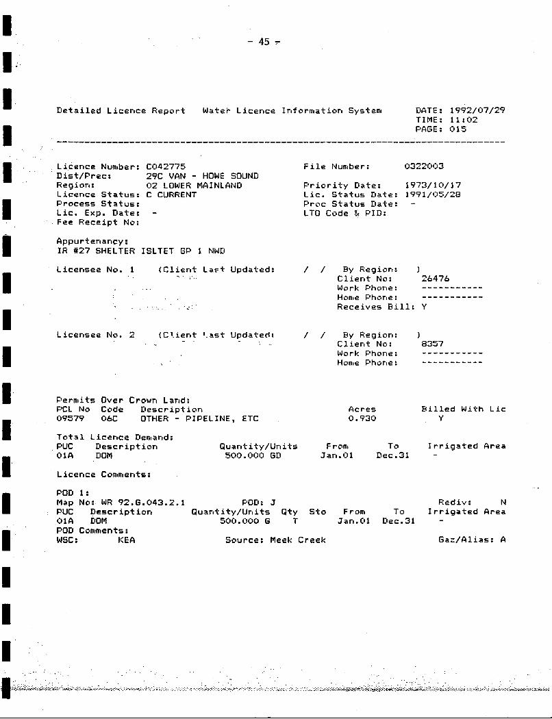
L i c e n c e Number: CO4277S D is t / P r e c : 2 9 C VAN - HOWE SOUND R e g i o n : 02 LOWER MAINLAND L i c e n c e S t a t u s : C CURRENT P r o c e s s S t a t u s : L i c . Exp . D a t e : - Fee R e c e i p t No:
A p p u r t e n a n c y : I R #27 SHELTER ISLTET GP 1 NWD
L i c e n s e e No. 1 ( C l i e n t L a c t Updated: -. .. . .
. .. . _ . . . . . . - .
F i l e Number: 0322l3(:)3
P r i o r i t y Date : 1973/ 1 O / 17 L i c . S t a t u s Date : 1991/05/28 P r o c S t a t u s Date : - LTO Code ti PID:
/ / By Region: 1 C l i e n t No: 26476 Work Phone: Home Phone : R e c e i v e s B i l l : Y
----------- -----------
( C 1. i en f 1 . as t U p d a t e d : / / By Reg ion : ) C l i e n t No: 8357 Work Phone:
1 % Home Phone :
L i c e n s e e No. 2
----------- -----------
P e r m i t s Over Crown Land: PCL No Code D e s c r i p t i o n 09579 ObC OTHER - PIPELINE, ETC
A c r e s B i l l e d W i t h L i c 0.930 Y
T o t a l L i c e n c e Demand: PUC Oesc r i p t i o n Q u an t i t y / Un i t 5 F rom To I r r i g a t e d Area 016 DOM 500. ( :100 GD Jan.01 Dec.31 - L i c e n c e Comments:
POD 1: Map No: WR 92.6.043.2.1 POD : J R e d i v : N PUC D e s c r i p t i o n Q u a n t i t y / U n i t s Q t y Sto From To I r r i g a t e d Area 0 1 A DOM SOU. 000 G T Jan. 0 1 De c .3 1 - POD Comments : wsc : K E A Source: Meek Creek G a z / A l i a s : A
. . . . . . . . .
i

I I.
- 46 -
I I I I I I I I I I I I I I I I
L i c e n c e Number: F019765 F i l e Number: i:)225396 El i s t/ P r e c : 2?C VAN - HOWE SOUND Reg i o n : 02 LOWER MAINLAND F’r i o r i t y t l a t e : 1 ?9?/C)9/ 17
L i c . S t a t u s t i a t e : 1?$1/(:)5/28 L i c e n c e S t a t u s : C CURRENT F’ rocess S t a t u s : F’roc Status D a t e : -
Fee R e c e i p t No: L i c . Exp. Elate: - L T O Code t PILI:
Appur tenancy : PARCEL F OF L 1468 }::EATS I GF’ 1 NIdJD
L i c e n s e e No. 1 ( r l i e r l t L a s t Up ‘ateid: 1992/06/22 B y Region : Ot:)) C l i e n t No: 14475 Work Phone: Home Phone : R e c e i v e s B i l l : Y
- -_ - - - - - - - - _- - - - - - - - - -
T o t a l L i c e n c c Demand: F’UC i:N:)p W W K 4 , ()i:)i). ( : i i : ) ( ) GIs J an . 0 1 Elec.31 -
F rorn To I r r i g a t e d Grea Des c r i p t i o n Q u an .t- i ty/ Un i ts
L i c e r l c e Conmer l ts :
POD 1 :
PUC D e s c r i p t i o n i:)i:)B wwtr: 4 , C)(:)i:, . i:)i:)(:) G T Jan. 01 t lec . 3 1 - POD Comments : wsc : t;: E A
Map Nu: WR 92.6.043.2.1 POD:: c R e d i v : N Q u a n t i t y / U n i t s Q t y S t o From To I r r i g a t e d A r e a
S o u r c e : P a r k B rook Gaz/A l i .as : A

r
+
+
+
.A-
+ +
+
ACH WATER WELL LOCATION N THIS MAP REFERS TO a ATER WELL RECORD CU ILE WITH THE 3
iTER INISTRY MANAGEMENT OF ENVIRONMENT BRANCb
AND PbRKS
CONTOUR INTERVAL m
-AND DISTRICT(S) :

r
L
+
' Preston Island
\\
\
+
t u P p P f
0
\\
+
I 1
LEGEND
DENOTES WATER
@ ::k%?NSER
:ACH WATER WELL LotATlOl )N THIS MbP REFERS TO A WATER WELL RECORD ON :ILE WITH THE I
b T E R IINISTRY YANbGEMENT OF ENVIRONYENT BRbNCl
AND PbRKS
CONTOUR INTERVAL m
AND DISTRICJ(S) :

~
I I I
+ +
H
I .
+ +
+
W E S O U N D
+
+
* 25' 30'
LAND DISTRICT(S) :
1
LEGEND
9 DENOTES WELL LOCATION WATER
AND WELL NUMBER
ICH 1 THIS WATER MAP WELL REFERS LOCATlOl TO A
bTER WELL RECORD ON LE WITH THE :
TER MANAGEMENT BRANC NlSTRI OF ENVlRONYENl
AND PARKS
;ONTOUR INTERVAL tm