Embed Size (px)
Citation preview

© 2017 The Association for Water and Rural Development
A guide to the Spatial Planning &
Land Use Management Act [SPLUMA]

A guide to the spatial planning & land use management act [SPLUMA]
| 2
What Is SPLUMA?
Spatial Planning and Land Use Management Act (SPLUMA) is the new national legislation for all
spatial planning in South Africa. SPLUMA was enacted in 2013 and implemented nationally from July 2015.
In its mandate to spatially transform the country, SPLUMA introduces a new, spatial planning system which
now places local municipality at the centre of spatial planning and decision making related to land use
management. SPLUMA basically reinforces the vision set out by the NDP (National Development Plan) to deal
with the serious socio-economic issues crippling South Africa through spatial transformation.
Looking Back Before SPLUMA
Before 1994, spatial planning was designed to serve a purpose of racial segregation. In this regard land use
was not the most efficient. Provincial governments played a bigger role in provincial planning and land use
management (SPLUM). Historically, municipalities played a role primarily in urban development control. In
some parts of the country provincial government would delegate decision-making powers to its local
municipalities to oversee certain types of land development applications. For example, the process of town
planning and township establishment was overseen by municipalities governed by ordinances. This municipal
planning function was restricted to the development of town or urban areas. Town and regional planning as
a field finds its place in this view of land development. Rural areas where not included in land use
management by municipalities - most rural areas were part of what was known as homelands which were
under traditional leadership.
Figure 1: Water supply clusters located within the Maruleng local municipality

A guide to the spatial planning & land use management act [SPLUMA]
| 3
The institutional conflict in planning
legislation After 1994, the Development Facilitation Act (DFA) of 1995 was introduced (as an interim measure) to
facilitate and fast track the Reconstruction and Development Programme (RDP) in an attempt to address
the legacy of unequal spatial patterns. Post 1994, a lot of planning related laws entailed different
procedures making land use management complex.
In 2001, a white paper on spatial planning and land use management was developed suggesting the need for
a uniform set of procedures for land development approvals. In this way the issue of different procedures
in different provinces would be addressed and there would be an integrated system of planning.
However Chapters 5 and 6 outlines procedures for land development applications in which developers may
go through provincial government for authorisation. In addition to this, the approval procedure for land
development applications through provincial government (under DFA) appeared to be easier and quicker for
land developments through the ordinances used by municipalities – a process often seen as tedious and time
consuming. The implication of the two chapters was that the DFA could serve as an alternative and parallel
procedure to the ordinances. This meant that there were two structures of governance that had decision
making powers relating to spatial planning on the same subject matter.
An institutional conflict emerged in a case that involved the City of Johannesburg Metropolitan Municipality
(local) and the Gauteng Development Tribunal (provincial). Between 2004 and 2005 the Gauteng provincial
tribunal approved three applications for developments (within the jurisdiction of the Johannesburg
Metropolitan Municipality) which the city of Johannesburg municipality had previously not approved. This
created conflict between the views held by two planning authorities. The local municipality then appealed
the validity of Chapters V and VI of the DFA after attempts to resolve the issue with province were fruitless.
In 2010, a Constitutional Court ruling declared the two chapters as unconstitutional and infringed on the
exclusive rights of local municipality with regards to spatial planning. This eventually led to the repeal of
DFA and since then legislation relating to planning was redefined. In 2012, a bill on spatial planning and
land use management was approved leading to the expiry of the DFA. After the repeal of chapters 5 and 6
of the DFA, all legislation related to spatial planning have been brought into one piece of framework
legislation.
In 2015, SPLUMA was passed as the new legislation on spatial planning replacing the Development
Facilitation Act (DFA) of 1995 and other pre- 1994 (national) spatial planning related legislation such as
the:
Removal of Restrictions Act (84 of 1967);
Physical Planning Act (88 of 1967);
Less Formal Township Establishment Act (113 of 1991) and the
Physical Planning Act (125 of 1991).
SPLUMA is now used in conjunction with other related planning legislation such as NEMA (National
Environmental Management Act) to ensure its consistency, uniformity and alignment with other legislation
on land management.

A guide to the spatial planning & land use management act [SPLUMA]
| 4
However the success of SPLUMA still requires commitment and alignment between all spheres of
government.
How important is SPLUMA? The Act provides a guiding framework for spatial planning and land use management in South Africa. The
principles of SPLUMA are not necessarily new but are in alignment with the normative direction outlined in
the National Development Plan. With support from provincial and national government, local municipalities
are land use regulators of first instance
SPLUMA seeks to address historical spatial
imbalances and promote sustainable development
in planning.
There is hope to bring out changes in the following ways:
Socially
Improve service
delivery to the people
Spatially
Deal with the unequal
spatial patterns of the
past.
Environmentally
Promote a balance in
meeting the socio-
economic needs of
people with
environmental
management.
Economically
Bring about investment in land development.
Making sense of SPLUMA SPLUMA is made up of 7 chapters. To fully understand SPLUMA, it is necessary to study the legislation in its
entirety as references are often made to various subsections or chapters which outline conditions or
principles that are interlinked.
Below is a brief description of each chapter: Special attention should be given to the preamble which states
clearly the intention of SPLUMA.
With this new Act, the local municipality is the authority of first
instance for land development where it is the best scale of
implementation.
A guide to the spatial planning & land use management act [SPLUMA]
| 5
Chapter 1: Definitions, Objectives
This chapter provides definitions to specific words or expressions that are used in the context of spatial
planning applicable to the Act.
Development principles, norms and standards.
This chapter provides the five main development principles that should guide all authorities responsible for
implementing any by-law or policy on land development. Norms and standards are also prescribed by the
Minister (of Rural Development and Land Reform) which reflect national policies on development.
Chapter 2: Development principles of SPLUMA
The development principles detailed in SPLUMA apply to all organs of state and authorities who are land use
regulators.
Spatial justice
Spatial plans (planning) should (not only) include the previously disadvantaged but also address past
imbalances in spatial planning.
Spatial resilience
Resilience simply put refers to the capacity or ability to recover quickly from difficulties. The livelihoods
of communities that are more vulnerable to socio-economic and environmental shocks should be secured
and accommodated in spatial plans that are flexible and innovative to speak to specific
local challenges.
Spatial sustainability
Environment management instruments such NEMA must be applied to protect prime agricultural land.
Spatially, land development should limit unsustainable settlement and infrastructural patterns. Spatial
sustainability refers to the promotion of land use management that is based on principles of socio-
economic and environmentally sustainable development.
Spatial efficiency
The use of land for development should take into account optimizing resource use and placement of
infrastructure in an efficient way.
Good administration
Good administration entails co-operative governance and transparency between all spheres of
government to contribute to spatial planning that reflects the national agenda for development and
land management. This principle is of vital importance as implementation of this framework requires
good governance and co-ordination towards a collective vision.

A guide to the spatial planning & land use management act [SPLUMA]
| 6
Co-operative governance entails a hierarchical relationship
Between local, provincial and national government in support
to each other and collective action.
Chapter 3: Inter-governmental support
This chapter outlines the role that provincial and national government play in providing support to local
municipalities on land use management. SPLUMA does not repeal provincial Acts nor any existing municipal
by-laws. Land use planning is a municipal function. In the case whereby an approved development by a
municipality has an impact that goes beyond a municipal jurisdiction, the relevant provincial authority may
put in place laws that will assist or support the municipality with land use management.
The Departments of Rural Development and Land Reform (DRDLR) and Co-operative Governance and
Traditional Affairs (DCoGTA) support the implementation of SPLUMA from a national level.
Provincial government provides technical support role to local municipalities and an advisory role in dispute
resolution.
Municipal by-laws
SPLUMA make provisions for Local Municipalities to develop land use planning by-laws to meet their unique,
local context. In some areas provincial municipalities develop standard draft by-laws which local
municipalities may consult or consider for adoption. In the absence of provincial legislation, local
municipalities draft by-laws as a basis for land use management. By-laws vary from municipality to
municipality but have to comply with SPLUMA. Because SPLUMA provides a framework for planning,
municipal land use planning by-laws are necessary to speak uniquely to each municipality’s context for
development or management. In other words, to implement SPLUMA, municipality use by-laws as rules to
facilitate implementation.
Chapter 4: Spatial development frameworks
SPLUMA requires all spheres of government (national, provincial, regional and local) to prepare an SDF. A
Municipal SDF is informed by the Municipal Systems Act (of 2000) and must align with its respective regional,
provincial and national SDFs. Land use management was regarded as the mechanism for the implementation
of the principles of the Act.
The SDF is therefore a key instrument which sets out the spatial development vision of the government
together with the IDP.
A guide to the spatial planning & land use management act [SPLUMA]
| 7
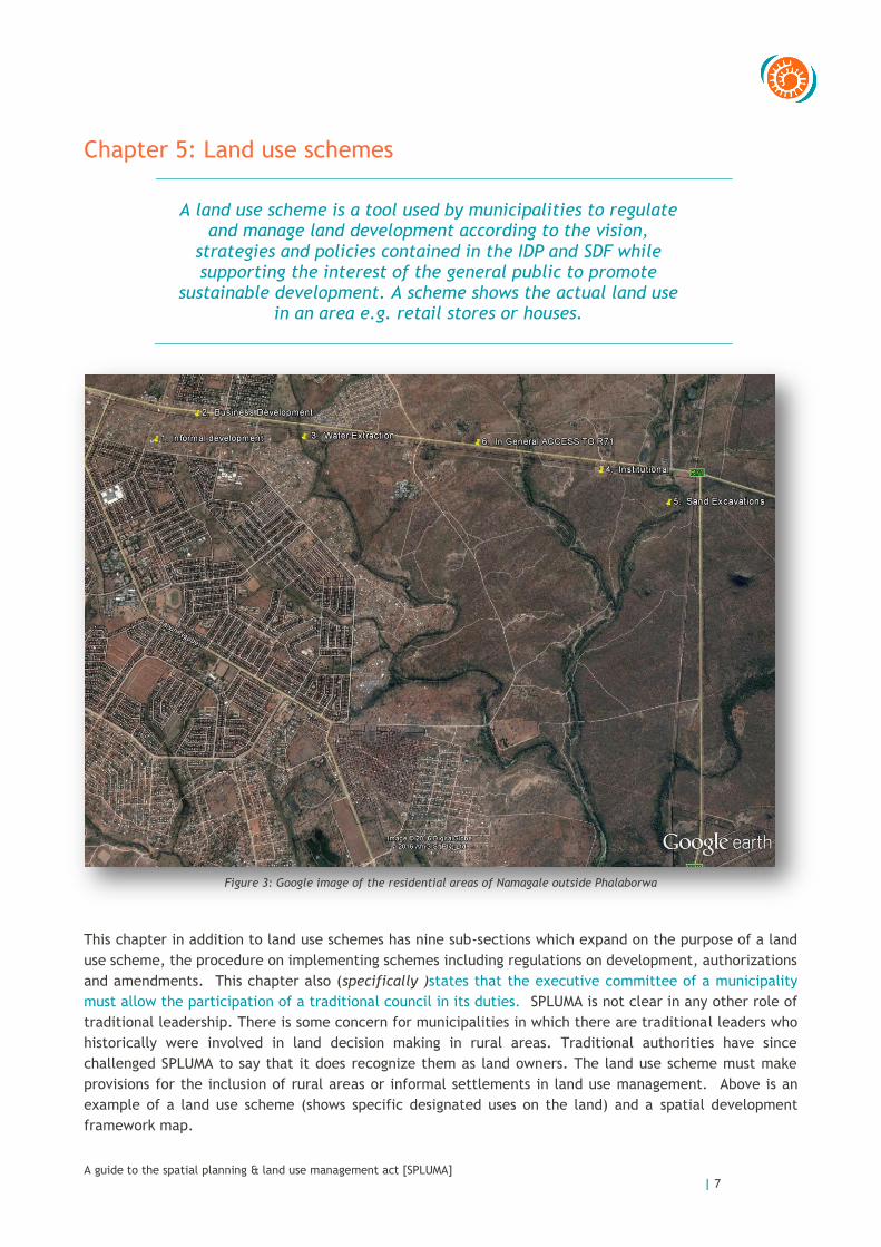
Chapter 5: Land use schemes
A land use scheme is a tool used by municipalities to regulate
and manage land development according to the vision, strategies and policies contained in the IDP and SDF while supporting the interest of the general public to promote
sustainable development. A scheme shows the actual land use in an area e.g. retail stores or houses.
Figure 3: Google image of the residential areas of Namagale outside Phalaborwa
This chapter in addition to land use schemes has nine sub-sections which expand on the purpose of a land
use scheme, the procedure on implementing schemes including regulations on development, authorizations
and amendments. This chapter also (specifically )states that the executive committee of a municipality
must allow the participation of a traditional council in its duties. SPLUMA is not clear in any other role of
traditional leadership. There is some concern for municipalities in which there are traditional leaders who
historically were involved in land decision making in rural areas. Traditional authorities have since
challenged SPLUMA to say that it does recognize them as land owners. The land use scheme must make
provisions for the inclusion of rural areas or informal settlements in land use management. Above is an
example of a land use scheme (shows specific designated uses on the land) and a spatial development
framework map.

A guide to the spatial planning & land use management act [SPLUMA]
| 8
Chapter 6: Land development management
Municipalities have a duty to establish a planning tribunal and appeal structures. A detailed explanation on
the establishment, roles of municipal Planning Tribunals, procedures relating to land use change or
developmentapplications is provided in this chapter. Provisions are also made for municipalities that want
to have a Joint Planning Tribunal. SPLUMA stipulates that municipal planning Tribunals may be established
as a body to make decisions relating to specified land development applications. This tribunal serves for
five years. Politicians and/councillors do not form part of a tribunal. Where necessary, provincial tribunals
are involved where municipal planning legislation conflicts with provincial legislation.
A Municipal Tribunal is made up of: Spatial planners, professional planners, engineers,
auditors, attorneys, environmental
assessment practitioners
Chapter 7: General provisions
Chapter 7 deals with regulations that may be made by the Minister, outlines what is regarded as offences
to the Act and the penalties for violation.
Schedules.
A schedule provides supplementary information additional to the text of the Act.
Schedule 1 of SPLUMA outlines what matters are to be addressed in provincial legislation.
Schedule 2 lists 15 land use purposes recognized under SPLUMA which may form part of a land use
scheme. To better understand regulations for each land use zone, it is necessary to access a
municipality’s land use scheme.
A guide to the spatial planning & land use management act [SPLUMA]
| 9
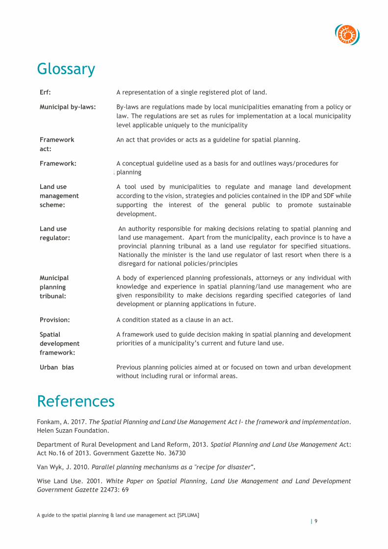
Glossary
Erf: A representation of a single registered plot of land.
Municipal by-laws: By-laws are regulations made by local municipalities emanating from a policy or
law. The regulations are set as rules for implementation at a local municipality
level applicable uniquely to the municipality
Framework
act:
An act that provides or acts as a guideline for spatial planning.
Framework: A conceptual guideline used as a basis for and outlines ways/procedures for
spatial planning
Land use
management
scheme:
A tool used by municipalities to regulate and manage land development
according to the vision, strategies and policies contained in the IDP and SDF while
supporting the interest of the general public to promote sustainable
development.
Land use
regulator:
An authority responsible for making decisions relating to spatial planning and
land use management. Apart from the municipality, each province is to have a
provincial planning tribunal as a land use regulator for specified situations.
Nationally the minister is the land use regulator of last resort when there is a
disregard for national policies/principles
Municipal
planning
tribunal:
A body of experienced planning professionals, attorneys or any individual with
knowledge and experience in spatial planning/land use management who are
given responsibility to make decisions regarding specified categories of land
development or planning applications in future.
Provision: A condition stated as a clause in an act.
Spatial
development
framework:
A framework used to guide decision making in spatial planning and development
priorities of a municipality’s current and future land use.
Urban bias Previous planning policies aimed at or focused on town and urban development
without including rural or informal areas.
References Fonkam, A. 2017. The Spatial Planning and Land Use Management Act I- the framework and implementation.
Helen Suzan Foundation.
Department of Rural Development and Land Reform, 2013. Spatial Planning and Land Use Management Act:
Act No.16 of 2013. Government Gazette No. 36730
Van Wyk, J. 2010. Parallel planning mechanisms as a "recipe for disaster".
Wise Land Use. 2001. White Paper on Spatial Planning, Land Use Management and Land Development
Government Gazette 22473: 69

A guide to the spatial planning & land use management act [SPLUMA]
| 10
The Association for Water & Rural Development [AWARD]
AWARD is a non-profit organisation specializing in participatory, research-based project implementation. Their work addresses issues of sustainability, inequity and poverty by building natural-resource management competence and supporting sustainable livelihoods. One of their current projects, supported by USAID, focuses on the Olifants River and the way in which people living in South Africa and Mozambique depend on the Olifants and its contributing waterways. It aims to improve water security and resource management in support of the healthy ecosystems to sustain livelihoods and resilient economic development in the catchment.
About USAID RESILIM-O
USAID: RESILIM-O focuses on the Olifants River Basin and the way in which people living in South Africa and Mozambique depend on the Olifants and its contributing waterways. It aims to improve water security and resource management in support of the healthy ecosystems that support livelihoods and resilient economic development in the catchment. The 5-year program, involving the South African and Mozambican portions of the Olifants catchment, is being implemented by the Association for Water and Rural Development (AWARD) and is funded by USAID Southern Africa.
P O Box 1919, Hoedspruit 1380, Limpopo, South Africa
T 015-793 0503 W award.org.za Company Reg. No. 98/03011/08: Non-profit org. Reg. No. 006 – 821
Acknowledgements: Project Funding & Support The USAID: RESILIM-O project is funded by the U.S. Agency for International Development under USAID/Southern Africa RESILIENCE IN THE LIMPOPO BASIN PROGRAM (RESILIM). The RESILIM-O project is implemented by the Association for Water and Rural Development (AWARD), in collaboration with partners. Cooperative Agreement nr AID-674-A-13-00008
Authors William Mponwana & Peggy Mphethi


![Land Acquisition Act, 1894...Land Acquisition Act, 1894 ၁၈၉၄ ၁၉၆၀ ၀ Burma Land Acquisition Manual, 1947 ၁၉၃၄ ၃1 THE LAND ACQUISITION ACT [ACT I, 1894] (1st](https://img.dokumen.tips/doc/110x75/6002be9f983db76f6a708206/land-acquisition-act-1894-land-acquisition-act-1894-.jpg)