Embed Size (px)
Citation preview

Extension Bulletin E-MICHU-SG-81-501
A GUIDE TO SAND DUNE AND COASTAL
ECOSYSTEM FUNCTIONAL RELATIONSHIPS
* Michigan State University Cooperative Extension ServiceEXTENSION ' Michigan Sea Grant Program • University of Michigan andSERVICE \Michigan State University cooperating
JhL.

A GUIDE TO SAND DUNE AND COASTAL
ECOSYSTEM FUNCTIONAL RELATIONSHIPS
By Joan M. Peterson, Graduate Assistant,and
Dr. Eckhart Dersch, Extension Specialist
Department of Resource DevelopmentMichigan State University

TABLE OF CONTENTS
Introduction 1Who is responsible for management of dunes? 1What constitutes a sand dune area? 1Sand dune and coastal ecosystems 2How and when were Lake Michigan's dunes formed? 2What factors are responsible for the shape of dunes? 2Dune dynamics 6How do hydrologic factors affect dune construction? 7Microenvironment 7Species diversity and productivity 11Plant and animal success 11Carrying capacity and its application to sand dune management 13
1. Limiters 13a. Nutrients 13b. Light 14c. Storage 14
2. Modulators 14a. Physical suitability 14b. Ground water fluctuations 14c. Vegetation 16
Appendix A 17Bibliography 18

LIST OF FIGURES AND TABLES
Figure Page
1 The anatomy of a typical beach front 22 Parabolic dunes 33 Stages in colony development and formation of 'embryonic dunes' by
Agropyron junceiforme 34 Dune morphology classification of the Lake Michigan shore 55 Designated boundary of the barrier dune formation 66 Marram grass in seed 87 Marram grass, showing undergrown growth and the lower part of the grass stem 98 Sand reed grass 99 Little Bluestem 10
10 Succession on Lake Michigan dunes 1211 Alternative dune successions 1312 Schematic diagram of storm wave attack on beach and dune 1513 Three annual growth cycles of a buried marram grass stem 14
Table1 Code for the dune morphology classification of the Lake Michigan shore 4

Introduction
Sand dunes bordering Lake Michigan represent thelargest assemblage of freshwater dunes in the world. Inthe state of Michigan alone, there are 269,760 acres ofdunes within a zone extending for two miles inlandfrom the lake. Formed during the last 13,000 years as aresult of the retreat of glaciers, these dunes are amongthe youngest geomorphic structures in the state. Thespecial climatic and geomorphic conditions respon-sible for the dune formations are no longer operative.These dune formations, therefore, are a unique andirreplaceable resource.
The dune environment remains a very dynamicsystem. A variety of factors such as wind, waves,currents and vegetation continually change the face ofthe dunes. Natural factors contribute both construc-tively and destructively to the maintenance of the sandstorage capacity of dunes. Ultimately, a balance be-tween the conflicting impacts of these natural forces isstruck, and the dunes are able to continue their vitalfunction of stabilizing and resupplying beachfrontswith sand. However, intense use pressures threaten todisrupt the dynamics of this ecosystem by interruptingor accelerating the natural processes.
The berm-and-dune system characteristic of the LakeMichigan coastal area acts as a buffer against stormwaves, protecting backlying areas from erosion anddeposition. By providing a reservoir of sand, the berm-and-dune system is able to deposit sand in neededareas and moderate change. Maintenance of the sandsupply of the berm-and-dune system is vital to the con-tinued functioning of the coastal ecosystem. Greaterstorm resistance is offered by increased dune height.Consequently, all human activities that accelerate ero-sion and/or lower the dune, increase the potentialstorm damage to shorelands.
Continued existence of the dune ecosystem is im-portant to the maintenance of the total ecosystem ofLake Michigan. Understanding the interrelationshipsbetween the factors responsible for dune formationprovides public and private resource managers theability to see opportunities for better planning andmanagement of the interdependent coastal eco-systems. Ideally, a site-specific survey of duneecosystem characteristics should be conducted andused as a basis for management.
Who is Responsible for Management ofSand Dunes?
Recognition of the importance of sand dunes by theState of Michigan prompted the enactment of the SandDune Protection and Management Act of 1976 (P.A.222). The major thrust of the legislation is to provide abasis for management of sand mining activities in duneareas. Specifically, the act provides for the "study, pro-tection, management and reclamation" of Great Lakessand dunes. It is the intent of this act that the aesthetic,recreational, ecological and economic benefits whichaccrue from sand dune areas be preserved. The multi-plicity of beneficial functions provided by sand dunes
are made possible by their inherently dynamic nature.For this same reason sand dunes must be managed asan integral part of the coastal ecosystem.
Administration of the Sand Dune Protection andManagement Act has been affected by the insufficientdata base from which to formulate management plans.Although limited information is available on theecology of Lake Michigan sand dunes, no systematicattempt has been made to identify the relationship be-tween these dunes and the Lake Michigan coastalecosystem.
Protection of coastal resources is mandated in thefederal Coastal Zone Management Act of 1972.Although state governments develop their own coastalzone management plans based on federal guidelines,plan implementation is primarily the responsibility oflocal governments. Local units of government have theauthority to adopt and implement land use controlsdesigned to direct development to environmentallysuitable areas. Interstate coordination of managementplans is recommended in the Act. However, to datethere has been little coordinated effort among GreatLakes states to protect shoreland resources.
Zoning ordinances provide one mechanism by whichcommunities can control growth in environmentallysensitive areas such as shorelands. Shorelands mayalso be protected by designating them as conservationdistricts, open space districts, or low density residen-tial districts. The content of an effective zoning ordi-nance would include a statement of purpose, permittedand conditional uses for each zoning district, regula-tions and performance standards.
What Constitutes a Sand Dune Area?
As legally defined by the Michigan legislature, a sanddune area includes "those geomorphic features com-posed primarily of sand, whether windblown or of otherorigin and which lie within 2 miles of the ordinary highwater mark on a Great Lake." Additional criteria for thedefinition were developed by the Geological SurveyDivision of the Michigan Department of NaturalResources. They include the following (22):
1. "An area which contains geomorphic feature(s) ofsignificant topographic relief as determined by ageologist as being composed of more than 50%of unconsolidated sand."
2. "Those areas identified as coastal dunes, inlanddunes or coastal sand strips."
3. "Those shorelines classified as high sand dunesor low sand dunes by the Great Lakes Frame WorkStudy."
4. "An area which contains soil types as identifiedand qualified by the U.S. Department of Agri-culture, Soil Conservation Service as sand dunetypes or sand dune associated soil types."
5. "An area which is identified as a transition orbuffer zone bordering or adjoining dune areas."
Sand Dune and Coastal Ecosystems
An ecosystem is characterized by a series of energyflows which lead to species diversity, trophic structure,and material cycles (28). While this concept of eco-system is useful for a functional understanding of aparticular environment like sand dunes, an ecosystemshould not be viewed as a separate and distinct entity.Energy flows are not confined to a particular eco-system. They exist and are interactive with variousdesignated ecosystems as well. In this way, the duneecosystem is connected to the larger unit of the GreatLakes coastal ecosystems.
The coastal ecosystem includes a defined waterbasin, all marginal transition areas and all shorelandwatersheds that drain into the coastal basin (6). Twotypes of areas of special significance to coastalecosystems are found in shorelands. They include"retention and direct drainage systems of the coastalwatersheds," and "special ecological areas at the loweredge of the shorelands, such as sand dunes" (6).
The relationship of the dunes to the rest of thecoastal area is illustrated in Figure 1. The profile of thebeach shifts with seasonal variations in wind and waveaction. The plunge zone is an erosional zone whichserves as the final breaking point of an incoming wave.The remaining forward motion of water which causes itto rush onto the beach engulfs the "swash zone" (39).Sand is transported by waves and deposited along theupper limit of the swash zone in ridges called berms."The berm moderates change by providing a reservoirof sand available to either dunes or beach as needed"(6). Harsh winter storms erode this sand ridge whilesummer storms restore it. Thus, the berm-and-dunesystem plays an important role in protecting uplyingareas from the destructive forces of storm waves.
How and When Were Lake Michigan'sDunes Formed?
The dunes along Lake Michigan formed primarily dur-ing the Algonquin and Nipissing lake stages 13,000 and4,000 years ago respectively. Glacial debris in the formof moraines1 were deposited when the ice melted andretreated. As the ice retreated, the depth of the lakeschanged. At the Algonquin and Nipissing lake stages, asingle lake formed with a depth of 605 feet, from thecombined waters of the Lake Michigan and Lake Huronbasins (13). With waters at this level (25 feet higher thanpresent) considerable wave action occurred, erodingglacial debris along the shoreline (39).
An understanding of the geological processes impor-tant to the formation of dunes along Lake Michigan isnecessary for identifying which assemblages areespecially unique and deserving of protection. In addi-tion, geological processes provide explanations fordeposition or erosion of sand in fragile dune areas.
What Factors are Responsible for theShape of Dunes?
The characteristic shape of a dune is determined by avariety of factors such as wind, waves, and vegetativegrowth. As a dune begins to form, it takes on a char-acteristic shape in relation to the prevailing wind. Aprevalence of westerly winds led to the formation of thedunes on the eastern shore of Lake Michigan. Dunesformed are parallel or at right angles to the wind direc-tion depending on wind strength. The windward slopeis generally more gradual than the leeward slope. Dune
COASTAL AREA
Seacliff,Dunes, Etc
Rip Feeder ChannelLow—Tide Terrace
Plunge Pot
Figure 1. The anatomy of a typical beachfront.
From: U.S. Army Corps of Engineers, Division of Pacific Ocean Corps of Engineers, 1971.
1. A moraine is an accumulation of earth, stones, etc. carried and finally deposited by aglacier.

formations which result from the effect of wind arecalled parabolic dune units (Figure 2).
Dune formation is altered by the growth of vegetationand storm waves. Vegetative growth ultimately deter-mines the shape of the dune (26). For example, marramgrass typically builds long, low gently sloping dunesdue to its vast network of underground stems. In con-trast, cottonwood, which has no means of vegetativepropagation, is responsible for the formation of thehighest, steepest dunes. Figure 3 shows the formation
of 'embryonic' dunes by one type of beach grass.Although the type of grass illustrated is more typicallyfound on dunes in a marine environment, the principleof dune formation by plant colonization displayed is thesame as would be observed from the growth of marramgrass along Lake Michigan sand dunes. Vegetativegrowth slows sand movement and initiates dunegrowth. Undercutting by storm waves can cause thewindward face of the dunes to be more vertical thanwould otherwise be expected.
Figure 2. Above, diagram of a parabolic dune; below, blowouts and parabolic dunes interruptingparallel dunes on a coast, and showing axes aligned with the onshore wind resultant.
From: Bird, 1969, p. 139.
Direction of wind
B
Sandsurface
D
Figure 3. Stages in colony development and formation of 'embryonic dunes' by Agropyronjunceiforme. The upper broken line represents the surface of the dune.
From: Nicholson, 1952.

Changes in the foredune into an irregular, "U"-shaped dune ridge known as a blowout, can result fromdisturbances of the sand-stabilizing vegetation byeither natural or man induced causes. Sand has beenknown to accumulate in drifts up to 250 feet high andmove inland for 1/2 mile or more (4, 16, 17). Historicalrecords show that some forests, farmlands and at leastone small town which existed at the beginning of thiscentury, have since been buried by the moving sand(16). Blowouts will continue to move inland until vegeta-tion once again becomes established and stabilizes thedune.
Sand dunes must be viewed as part of a continuousdune assemblage extending from the beach to theforested dune. Inland from the water's edge several dif-ferent zones or assemblages (dune types) are repre-sented. Nine dune types were named by Buckler in 1979including: parabolic dunes, linear dune ridges, duneterraces, dune platforms, domal dunes, complex dunefields, dune flats, marginal sand aprons, and inter-dunelowlands. These dunes differ with relative relief of duneform, orientation of dune form with respect to presentshoreline, and arrangement of dune form and underly-ing and/or associated landforms (Figure 4 and Table 1).
In addition to this classification scheme, Buckler in-cludes a practical definition for the identification of thebarrier dune formations. He defines it as "that firstdune assemblage whose forms display the greatestrelative relief within the officially designated 'sanddune area'; its inland boundary is at the base of theassemblage's landward limit" (3). The designatedboundary of the barrier dune formation is illustrated inFigure 5. Use restrictions should be applied in thebarrier dunes if they are to function in their protectivecapacity. They protect backlying areas from thedestructive forces of wind and waves. The Sand DuneProtection and Management Act of 1976 requires a per-mit for removal of all or a portion of the barrier dune.
First Letter (Dune Form)A Marginal Sand ApronC Complex Dune FieldD Domal DuneF Dune FlatL Inter-Dune LowlandP Parabolic DunePL Dune PlatformR Linear Dune RidgeT Dune Terrace
Second Letter (Relative Relief)1 low (0-20')m moderate (20'-80')h high (80'+)
Third Letter (Orientation)a arcuatei irregularn normal (perpendicular)p parallel
Fourth Letter (Arrangement)r repetitive (multiple)s singular
Relation of dune form to substratum formationXxxx^ non-elevatedXxxxk perched#
Xxxx/C overriding
Non-elevated dunes are represented by onlythe four (or less) code letters.
Perched dunes are represented by the four(or less) letter code over a horizontal barbelow which is the height above sea level ofthe surface of the underlying non-duneformation (the Lake Michigan surface isapproximately 580' above mean sea level).
Overriding dunes are represented by thefour (or less) letter code followed by a slash.
Table 1. Code for the dune morphology classification of theLake Michigan shore.
From: Buckler, 1979, p. 7.

RELATION OFDUNE FORM TOSUBSTRATUMFORMATION
DUNE FORM RELATIVE RELIEFOF DUNE FORM
ORIENTATION OFDUNE FORM WITHRESPECT TO PRESENTSHORELINE
ARRANGEMENTOF DUNE FORM
UNDERLYING AND/
OR ASSOCIATED
LANDFORMS
HIGH
^PARABOLIC DUNE |-Modtrot.
-L INEAR DUNE RIDGE (-Mod.rot..LOW
-DUNE TERRACE
-Dune Platform •
NON-ELEVATED
OVERRIDING
PERCHED J
1
rHIgh
I L Mod.iLi n w
-Domol Dune-
-Hlgh
. Modtratt .
-LOW
rHIGH
LMODERATEl-Low
High
-COMPLEX DUNE FIELD 4 *<*•»>*•LLOW
-DUNE FLAT
rHigh
-MARGINAL SAND APRON-Uoderot.
I-LOW
— Inter-Dune Lowland -
- PARALLEL
-Norntol
•ARCUATE
•Irrtgular
-Paralltl
- Norma I
-ArcuaU
-Irrtgulor
-SINGULAR
-REPETITIVE
p Singular
L Raptlitlv*
[Singular
R»p«titly«
LacustrineOutwash PLAINAlluvialEND OR RECESSIONALMORAINETILL PLAIN
LacustrineOutwash PLAINAlluvialEND OR RECESSIONALMORAINETILL PLAIN
Figure 4. Dune morphology classification of the Lake Michigan shore. Dune forms and correlatedcharacteristics which are more common or dominant are indicated by capitalization.
From: Buckler, 1979, p. 6.

LOW-RELIEFEPHEMERALDUNE
BARRIERDUNEFORMATION
INLAND BOUNDARYOF THE
BARRIER DUNEFORMATION
Figure 5. Designated boundary of the barrier dune formation.
From: Buckler, 1978, cover.
Dune Dynamics
Topography is an important factor in the dynamics ofthe sand dune ecosystem. The deposition and erosionof sand is influenced by topographical features such asthe presence or absence of bars and troughs, the slopeof the dune, the height of the dune, etc. An understand-ing of the relationships between sand movement, windflow and dune vegetation is essential for determinationof the effect topography will have on these factors.
Sand movement by wind is a result of two processes;surface creep and saltation. Surface creep occurs whenwind rolls the sand along the ground. In the process ofsaltation, sand advances by a series of short jumps.Saltation begins when sand grains are swept up by thewind's motion then fall back to the surface due to theforce of gravity (1). The impact of the fallen grains onthe surface sets other sand grains in motion.
The extent of sand movement depends on factorssuch as wind velocity, grain size, and surfaceroughness. Grain size is significant in the sense thatsmaller grains are transported at higher velocities thanare larger-sized grains (21). Generally speaking, thegreater the wind velocity, the more sand that can betransported. Occasional strong winds which can over-come the effect of surface drag may be more effectivein sand movement than the prevailing wind.
Surface roughness dictates the force needed to initi-ate sand movement. When the sand surface is relatively
smooth, the friction slowing sand movement will beminimal. Increasing surface roughness interferes withthe smooth flow of wind transporting sand. The conse-quence of increased surface roughness is decreasedwind velocity. If the wind velocity drops below thethreshold velocity, the minimal level needed to keepthe sand in motion, then sand will be deposited.
The threshold velocity of sand movement is alteredby surface characteristics such as dune relief, vegeta-tion, and moisture content. Vegetation increases sur-face roughness, reduces wind velocities to below thethreshold velocity for sand movement, and succeeds intrapping sand (29). Once the obstacle is covered, sandsmoothness is restored and dune movement con-tinues. Dune-building vegetation is able to maintain itsimpact on sand movement by continued growth whichregenerates surface roughness. Shrubs and trees aremore effective than grass at slowing wind and stabiliz-ing sand(29).
Moisture levels of the sandy surface greatly affectthe movement of sand particles. Water lying betweensand particles serves as an adhesive force effectivein holding sand at the surface. More wind energy isneeded to set in motion wet sand than dry sand.
The dune formation or topography has a pronouncedeffect on the continued movement of dune assem-blages. A greater wind velocity accelerates the rate ofdune movement regardless of the dune size. Anobstacle such as a mound or hillock will produce windreductions for great distances to the lee of the

obstacles and a short distance in front. Thus, some pro-tection is offered by the topographic form whichresults from dune building. However, this same form isresponsible for "crowding and accelerating the windover the dune summit and thereby increases the risk ofsubsequent wind erosion on the most exposed parts ofthe dune" (29).
One of the most significant topographical factorsfacilitating or inhibiting beach erosion is the presenceand location of sand bars. Offshore sand bars inducewave breaking, absorbing the energy of waves and cur-rents and protecting the beach from destructive forces.Thus, large sandy beaches lead to sand deposition.
Along the shores of Lake Michigan there is a predict-able movement of material in the coastal system deter-mined not only by the direction of prevailing winds andcurrents, but by the existence of various topographicfeatures. Sand is deposited in protected reaches suchas the lowlands formed by outwash and ice gouging.Deposition of sand at the mouth of rivers has led to ex-tensive areas of active dunes in certain locales (i.e.,Holland and Ottawa Beach) (8).
Sand dunes along the southeastern shore of LakeMichigan range from 75-200 feet in elevation (29).Perched dunes which occur when windblown sandaccumulates on a bluff may reach heights of approxi-mately 300 feet (25). Removal of all or a part of a dunewill restrict the types of plants able to reestablish onthe dune. Reduction of dune height will result in lowerhumidity, higher winds, more sunlight, and greatertemperature extremes. In effect, leveling a dunehomogenizes the ecosystem allowing less diversity ofplants and animals.
Data on topographic forms along the shorelineshould be collected and utilized in formulating sanddune management plans. A survey of landforms willprovide information on bars, points and troughs wheresand deposition can be expected. Regional top-ographic maps, aerial photographs and MichiganDepartment of Natural Resource's classification ofdunes into Series I, II, and III can provide a uniformbasis for the designation and determination of dunetypes. A survey of backlying areas such as wetlands,farms, or chards, woods, towns, etc. can be useful toidentification of areas protected by existing dune for-mations. Finally, data obtained by measurement of theslope and area of the dunes can be used to determinethe rate and probability of dune movement.
How Do Hydrologic Factors AffectDune Construction?
The transport of sediment by wind, generated wavesand currents has been researched extensively. "Aswaves break, the up-rushing water on the beach carrieswith it a certain amount of sand and gravel. When thewater does lose its momentum, it reaches the limit ofadvance and there is a momentary halt. Then the back-wash occurs, and the water and its sand load flow downto the beach and back into the lake" (25). Wind andcurrents cause the waves to strike the shore obliquely(9). Consequently, sand and beach detritus are moved
along the beach in this process known as long-shore orlittoral drift. The direction of these currents will in-dicate where deposition and erosion will occur.
Sand transport at the lakeward limit is significant upto a depth in water of 60 feet. Past this point, largerstorm waves do not agitate the bottom sediments toany appreciable degree. The sand is transported con-tinually from the large reservoir of sand under the waterto the beach, where it becomes available for the con-struction of dunes (31).
The transport of sediment by waves causes distinctchanges to take place in the nature of this material.Beach sand is mostly a fine quartz sand. Coarse gravelknown as beach shingle and composed of crystallineand sedimentary rocks is common. Wave action roundsthe edges of these originally subangular pebbles.
Frost and ice action play a considerable role in thedecomposition of larger rocks and pebbles. The abra-sive action of ice loosens material while the wedgingaction of ice weakens the substrata. The result of allthese forces acting on sediments is dune sand, whichhas unique qualities. The size, chemical purity, anduniformity of dune sand are special characteristicswhich make this sand a valuable resource for a numberof industries.
Surface runoff may cause gullying and erosion ofsuperficial materials on dunes. Additional waters willincrease ground water.
It has been speculated that removal of considerableweight may decrease the compaction of the soilsunderneath and increase permeability. The result mightbe a localized change in water levels or direction offlow (23). Furthermore, removal of significant quantitiesof sand may expose the water table and increase therisk of pollutants entering the water supply system. Thesignificance of these alterations has never been ascer-tained.
Mitigation of problems which may be caused byinterference with the ground water system depends onproper identification of the following:
1. Ground water table maps2. Permeability of bedrock material3. Location, depth, static level and pump setting of
wells in the area, and4. Existing surface waters.
Microenvironment
Microenvironments are the small environmentscreated by differences in temperature, moisture, andlight intensity within the sand dune ecosystem. Ex-amination of these small environments is essential to aclear understanding of the 'whole' ecosystem. Thediversity of organisms in sand dune areas is madepossible by the variety of habitats found in relativelysmall areas. Any alteration of the dune which homoge-nizes the ecosystem will allow less diversity of plantsand animals.
"Organisms occupying the same general habitat mayactually be living under very different conditions" (28).Depending on the orientation of the dune, variationswill exist in the vegetative cover, sunlight intensity and

winds. Microclimatic differences on the dune are evi-dent on 1) dune plateau; 2) solar slopes; 3) shadeslopes; 4) windward slopes; 5) leeward slopes; 6) in-termediate slopes; and 7) dune hollows (33). In addition,various topographic differences among dunes, i.e.blowouts, hummocks, pathways, etc., lead to differentconditions within the same general area of the dune en-vironment.
This variety of microenvironments allows for a diver-sification of species that would not be expected in amore uniform environment. Among the earliest in-vaders of the beach area are the seaside spurge,tumbleweed and sea rocket. These species are able tosink their roots to the water table and thus, survive thesevere desiccation of the sun and the instability of thesand. The plants have developed various mechanismsby which they are able to withstand this harsh environ-ment. For example, sea rocket is a succulent and is,therefore, able to store water in its leaves. Seasidespurge, found on the middle and upper beach and wind-ward slopes of active dunes, is characterized by asupply of latex and by a prostrate habit, both of whichare advantageous to survival in an arid environment.
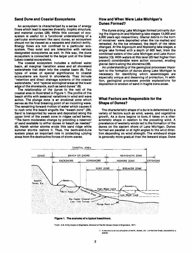
Marram grass (Figure 6) is the primary stabilizer ofsand in areas of rapid deposition due to its capacity forrhizomal propagation and internodal growth. Under-ground stems reach downward to the water table andupward to the surface to form new plants. The under-ground network of stems serves to hojd the sand inplace. In addition, beach grass is able to withstandburial by elongation of the intemodes (Figure 7)
The taller sand reed grass (Figure 8), on the otherhand, is the dominant dune builder in places where"lesser wind or sand supply account for less rapiddeposition rates or slow erosions as on many blowoutwindward slopes" (32). Another plant characteristic ofthe dune environment, bluestem bunchgrass (Figure 9),persists mainly on the sunny, south slopes of dunes. Inareas where plant growth increases shade and competi-tion on the dune, the population of bunchgrass will bereduced in abundance and vigor although plants mayflourish in small openings in the undercover (32).
The moist depressions created by blowouts producea favorable habitat for yet another invader of the duneenvironment, the jack pine. Successful colonization bythis species depends on close proximity to the watertable.
Basswood-maple series characteristic of the latersuccessional stages on the dune, thrives on steep-leeslopes and protected pockets. Basswood is especiallytolerant of sand burial. In fact, as one tree becomesburied, the exposed treetop may become a thicket ofmany trees. By shading and stabilizing the sandy sur-face, these trees accelerate the whole process of suc-cession.
Moist areas on the margin of a beach or blowoutpond may create favorable conditions for the germina-tion of cottonwood seedlings. This tree, which thrivesunder sand burial due to its long, fast-growing roots,can come to dominate the summit of an otherwisebarren blowout dune (15).
In addition to topographic and geographic factorsresponsible for the creation of microenvironments, anumber of variables caused by vegetative growth corn-
Figure 6. Marram grass in seed.
From: Daniel, 1977, p. 23.
CD
Stem node
Internode
Hairy collar on leavessheathing the stem(much enlarged)
Figure 7. Marram grass, showing underground growth and the lower part of the grass stem. Figure 8. Sand reed grass.
From: Daniel, 1977, p. 24. From: Daniel, 1977, p. 28.

bine to produce an array of microclimates. For in-stance, plant species colonizing one area alter nutrientcontent, moisture level, and substrate stability to suchan extent that the conditions become favorable for newspecies to establish.
The orderly process of development that involveschanges in species structure with time, and which isaccelerated by modifications of the physical environ-ment by the plant and animal communities, is calledsuccession, (see pages 11 and 12)
Figure 9. Little bluestem.
From: Daniel, 1977, p. 29.
10

btivilSpecies Diversity and Productivity
Sand dunes are characterized by highly diverse, butunproductive populations or organisms. Due to thehigh degree of specialization among organisms in-habiting dune areas, any alteration of the dunes willhave a direct impact on existing species.
The variety of microenvironments and moderation ofclimate offered in the dune environment permits adiversification of species that would not otherwise beexpected. "In the spring, Lake Michigan warms slowlykeeping the region cooler over an extended period oftime, thus preventing buds from opening too soon dur-ing the early spring. In the fall, waters of Lake Michiganretain much of their summer warmth" (25). Manyspecies of plants endemic to the Atlantic coastal plainare supported in this inland habitat (36).
The special environmental conditions made possibleby sand dunes provide habitats for various rare assemb-lages and species of plants. In one survey conductedby Cranbrook Institute of Science, species character-istic of southern flora, such as black gum, papaw andtulip tree were found in the same area with northernvarieties such as hemlock, Canada yew, and white pine.Another example of a unique plant association iden-tified by Wells and Thompson (40) in their survey of asand mining site is an assemblage of huckleberry andblueberry. Close proximity of microenvironments withvarying soil moisture, light exposure and pH character-istics explain the bizarre combinations of plants foundin transitional areas.
One outstanding factor responsible for the diversityof wildlife is the natural boundaries of various popula-tions. Often, Michigan represents the farthest extent ofthe range of a particular plant or animal species. Forexample, numerous southern species of plants andanimals reach their northern boundaries in dune areas.Many species are not native to Michigan, but passthrough the area during migration.
Unlike other fauna and flora which may be spaciallyshifted, or temporarily decreased or increased innumber by a sand dune change, some species may beirreversibly damaged or destroyed by a change in thedune environment. Endangered and threatened speciesof plants likely to be found in the dune environment arelisted in Appendix A. Among them are dwarf lake iris,Pitcher's thistle, spotted wintergreen, and ginseng.
Animal species also make either temporary or perma-nent homes in dune areas. Endangered, threatened andrare species found on sand dunes emphasize the needfor protection of their fragile habitats. Species ofanimals which may be found in dune areas and arelisted on either Michigan or U.S. endangered andthreatened species lists, include Indiana myotis,southern bog lemming, pine vole, Cooper's hawk, red-shouldered hawk, bald eagle, marsh hawk, osprey,peregrine falcon, piping plover, common tern, easternbox turtle, black rat snake, and bloater. "Increasedstress on the environment is generally manifested inlower species diversity" (18). Management of theresource must plan to avoid disruptions to the eco-system which result in increased uniformity of theenvironment and a corresponding decrease in speciesdiversity.
Sand dunes, while characterized by a diversity offlora, are not especially productive environments. Thisin itself makes sand dunes critical environments. Con-stant sand movement, scarcity of nutrients and organicmatter, rapid drainage of water, and high evaporationrates limit the extent of plant and animal growth. Free(14) points out that overdrainage, and not solely evapo-ration, is primarily responsible for the character of thedune flora. Although surface moisture evaporatesquickly due to the low capillary capacity of sand, newmoisture is supplied to the surface slowly, with theresult that the total evaporation from sand is less thanfrom soil containing organic matter.
Beach grass and some forbs are the dominantspecies found on the foredune or occurring in the first20 years of dune succession, since they are able tocolonize under the arid conditions of this harsh en-vironment. Colonization of sand dunes by dune grassesallows for the invasion of other species.
Overall, low productivity and scarcity of nutrientslimits the number of primary consumers that the en-vironment can support. Mammals which may be foundin sand dune areas along Lake Michigan include mole,shrew, bat, raccoon, weasel, mink, skunk, fox, squirrel,chipmunk, mice, lemming, vole, muskrat, rabbits, deerand woodchuck. Migrant and resident birds make forthe diverse bird populations found in dune environ-ments. In addition, numerous amphibians and reptilessuch as salamanders, newts, toads, frogs, turtles, andsnakes will be found in various environments within thesand dune system. Inhabiting nearby rivers, lakes, andstreams are a variety of fish. Insect species present inthe dune environment play an important role in therecycling of nutrients in the dune environment, (seepage 12)
Plant and Animal Succession
Plant and animal succession is a continuous processbeginning with the establishment of a climax forest.The entire successional series takes hundreds of yearsto complete. The dune environment is unique in thatthe various stages of plant and animal succession canbe viewed simultaneously in a small area. Removal offorests on dunes will initiate the process of dune suc-cession from its earliest stages. Similarly, and modifi-cation of the dune environment will interrupt the pro-cess of succession and weaken the stability of thedunes.
Succession is slow on sand dunes because the sandsubstrate makes establishment of plants difficult.Olson (32) estimates that about 1,000 years are requiredto reach a climax forest, the terminal succession stageof plant communities, on Lake Michigan dunes.Furthermore, in order that a typical climax beech-mapleforest be reached, the soil must be moist with a highnutrient level as would be found in depressions beyondstable dunes. Absence of these characteristics on themore elevated exposed slopes in many sand duneecosystems leads to the establishment of the oakforest as the terminal stage.
Dune formation begins at the top of the foreshorewhere tidal litter is deposited. Here conditions are
11

favorable for the germination of some pioneer species.The litter reduces the daily temperature of the normallyexposed sand surface and increases the nutrient con-tent. Moisture is available due to the proximity of theplants to the coastal waters. All of these factors ensurethe colonization of the beach by some of the viableseeds trapped in the litter. The scattered pioneerspecies interspersed in the tidal litter make up a line ofvegetation called the strandline. Plants characteristicof the strandline include sea rocket, seaside spurge,and beach pea. Because this vegetation has a limitedlifespan it will not be successful in stabilizing the shift-ing sand. However, it will play an important role in theultimate formation of the dune environment.
Vegetation protruding from the sandy surfacereduces windflow and allows for the deposition ofsand. This process of dune formation will be arrestedwhen the litter is buried and a smooth surface isrestored. The extent of dune formation by this processdepends on the physical features of the beach area.Narrow sandy shores may accumulate large quantitiesof tidal litter, but the insufficient supply of sand im-pedes dune formation. In contrast, wide sandy shoreshave an abundant supply of sand to enable large dunesto form (33).
Along the middle beach, the severe winds and ex-treme drying effect of the sun make habitation difficult.However, plants that are able to extend their roots tothe water table can survive in this harsh environment.Sea rocket is usually the dominant species of this en-vironment (8). Also, found in this environment is sea-side spurge. These hardy annuals have special adapta-tions which allow them to distribute their seeds.Seasonally, these scattered plants serve to trap somesand particles.
On the upper beach, beyond the reach of waves, theflora is richer. It is here that perennial dune grasses likemarram grass, sand reed grass, and little bluestemgrass establish and begin the formation of embryodunes. The vegetative growth influences the topog-raphy of the dune (30, 33). Furthermore, vegetationalters the nutrient and moisture content of the sand,making conditions favorable for species with differentrequirements.
Pioneer animal communities on the dunes such astiger beetles, burrowing spiders and grasshoppersestablish in response to the changing plant com-munities on the dune. In fact, some communities are in-strumental in affecting the successional changes thatoccur. For example, as cottonwoods and dune grassesbegin to grow, the digger wasps are continually burrow-ing, adding organic matter to the soil at a depth of a fewinches.
Additional plant and animal species are foundbeyond the foredunes in depressions, dune ponds andprotected areas where the accumulation of nutrients ispossible. This factor, together with the level of thewater table, allows for the invasion of cottonwoods,cherry and willow shrubs and a variety of herbs. Thedominant rooted plant in a Lake Michigan dune pond isthe rush.
In depressions, the accumulation of organic mattermay bury the sandy soil so deeply that flora which can-not tolerate extreme moisture or drought can become
established. "Increasing organic matter increases thecapacity of the soil to retain nutrients" (33). Treeswhich need vast nutrient supplies, water, and a stablesubstrate develop on the back dunes. Climax domi-nants found in these moderate environments with ade-quate moisture include black oak, white oak, maples,red oak, beech, hemlock, and birches. "The most strik-ing vegetation change occurs in the first few hundredyears, although organic matter, moisture equivalentsand exchange capacity continue to increase fairlyrapidly for a thousand years or so" (32). Figure 10shows the time sequence for plant succession and soilchanges on Lake Michigan dunes. Variations in thenormal sequence of succession and soil changes forLake Michigan result from diverse sites or micro-environments within the sand dune ecosystem. Thesealternative dune successions are illustrated in Figure11.
Management plans for sand dune areas should in-clude an understanding of the successional events ofthe ecosystem if the interrelatonships within theecosystem are to be maintained. The successional pro-cess occurs slowly reaching a climax forested condi-tion in 1,000 years. Consequently, "any alteration to thesand dune ecosystem affecting plant succession willproduce significant long-term changes in vegetation,habitats, species composition, species diversity andcarrying capacity" (25).
Figure 10. Succession on Lake Michigan dunes.
YEAR DOMINANTS
0-20 Ammophila breviligulata (beachgrass)and some forbs
20-50 CottonwoodBeachgrassCherryWillowHerbs
50-100 Increasing variety of shrubs, trees andherbsJack pine may dominate
100- Black oak may be among the first forest
dominants
Oak — Hickory Forest
Beech — Maple ClimaxFrom: Furlowe, 1977.
12

Initialconditions
Physiographicprocesses
Pioneervegetation
Conifers(mostlytemporary)
Climaxdominants
Dampdepression
Upperbeach
Erodingsurfaces
Depositingcrests
Steep pocketslee slopes
Basswood
Black oakWhite oak
p t m
OaksRed
White
"b m
MaplesSugarRed
m
Beech
m
Hemlock
m
Figure 11. Alternative dune successions.
From: Clarke, 1954.
Carrying Capacity and Its Application toSand Dune Management
The ultimate goal of sand dune management is tomaintain the system at its optimum natural carryingcapacity. To accomplish this goal it is necessary thatthe sources and flows of energy that power the systembe at a maximum and that the system maintain an op-timally balanced resource base.
Each habitat within the sand dune ecosystem is pre-sumed to have a specific carrying capacity (the limits ofthe amount of life that can be supported by the habitat).This value is considered to be the potential of thehabitat and differs from the standing crop, which is themass of species present in an area at one time. Variousprimary supply factors called limiters control primarypotential productivity. Nutrients, light intensity andstorage capacities are examples of limiters whichaffect primary productivity on dunes. Modulators, suchas temperature, habitat suitability, and water circula-tion are primary variable factors that govern total pro-ductivity (7).
1. LIMITERS
Various limiters affect the carrying capacity of thesand dune ecosystem and must be identified andmonitored before effective management plans can beinstituted.
a. NutrientsThe low nutrient level of the soil is one factor which
inhibits vegetative growth on the dunes along LakeMichigan. A low nitrogen level is the primary limitingfactor. Since the availability of nutrients only permitsthe production of a limited standing crop, little organicmatter is added to the soil to remedy the situation. Dueto the porous nature of the sand, the nutrients which doaccumulate from decaying plant and animal matter arequickly flushed through the sand.
Plants have developed various mechanisms andassociations which enable them to overcome nutrientdeficiencies in the soil. In one symbiotic relationshipbetween plants and fungi observed on Lake Hurondunes, the fungi Endogone assisted the dune grassAmmophilia, in binding sand particles together and inprocuring water and nutrients. Consequently, plantswith an association with fungi were observed to growbetter than plants without such an association on LakeHuron dunes (19). Numerous field studies at LakeMichigan dunes have revealed the same type of asso-ciation between plant roots and soil fungi (26). Altera-tion of the topsoil layer would reduce the amount ofnutrients available in this already nutrient-poor sand.
At the other extreme, excessive discharge of nitro-genous compounds will percolate through the sandinto the ground water. Eventually, these compoundswill enter the lake through the ground water-coastal
13

basin interconnections. Increased nutrient levels arepositively correlated with increased eutrophication oflake waters (6). This phenomenon will interefere withthe natural balance in the Lake Michigan ecosystem.
b. LightA second factor which limits the primary productivity
of ecosystems is light. Optimum productivity requiresadequate sunlight. Turbidity, which is a measure of thetotal suspended solid particles in a body of water,greatly reduces the light penetration in coastal watersand adversely affects productivity. Although the ero-sion of clayey soils into lake water produces thegreatest effect on turbidity, the erosion and resuspen-sion of sand in lake waters can also have pronouncedeffects on turbidity. Turbidity interferes with basicbiological processes such as primary production andfish spawning, with drinking water supply systems, andwith commercial fishing products (35).
The problems resulting from turbidity are extensive.Damage caused by the erosion and retreat of coastallands along Lake Michigan is evident in loss of houses,farmlands, forests, etc. However, the adverse effects ofincreased turbidity are not as obvious. Transparency ofthe water is used as an indicator of turbidity levels andcan be read with an instrument called a Secchi disc.Variations in turbidity are produced by seasonalchanges, climatic factors, and plankton blooms. Ab-normal changes in cyclical turbidity patterns may in-dicate excessive sediment loading.
Ecosystem management plans should seek to en-hance light penetration and thereby increase the carry-ing capacity of the system. Activities which willincrease sediment loading in coastal waters and result-ant turbidity levels should be kept under plannedcontrol.
c. StorageThe storage component of ecosystems, such as the
sand supplied by dunes, is another limiting factor of ex-treme value which must be protected. "Storage is thecapability of a natural system to store energy suppliesin one or more of its component units" (6). "Sincestorm resistance increases with dune height, all humanuse of the barrier dune that devegetates, erodes, orlowers the dune, exposes the shorelands to increasedstorm damage" (6).
The function of sand dunes in protecting uplandsfrom being eroded and flooded has been well docu-mented (6,12, 34). The dune and berm system acts as astorehouse of sand that impedes beach erosion andprovides protection from storm waves and wind. Themechanics of this system is diagrammed in Figure 12.Although this schematic diagram shows storm waveattack on the beach and dune system of a marine coast-line, the effect of wave attack on a freshwater system isvirtually the same except for the absence of a tidal in-fluence and a shorter wave period.
The vegetative cover which serves to stabilize thedunes must be protected in order to maintain the stor-age component of the coastal ecosystem. Roots pro-vide one means of mechanical reinforcement for thedunes. Beach grass, Ammophilia, is the primarypioneer grass which is responsible for initiating dune
building. Beach grass is capable of unlimited growth byspreading its roots both horizontally and vertically intothe sandy substrate. Species regeneration occursmainly from eroded root fragments. Seedlings, on theother hand, require more specialized conditions suchas a damp hollow or a protected site on the lee side ofthe dune before germination can occur. Horizontalroots provide a network effective in stabilizing thedune. The ability of beach grass to grow by stemelongation is one adaptation which enables the plant tosurvive continuous burial. Two species of beach grass,Ammophilia breviligulata and A. arenaia have beenshown to tolerate an absolute limit of sand burial of onemeter per year, but density diminishes rapidly if theseconditions persist (20, 33). These species are respon-sible for the really high dune landscapes.
As the grasses are buried by deposits of sand, eachstem segment elongates so that part of the plant re-mains above the sand surface. The length of each stemsegment (internodal length) indicates the extent ofsand burial. Thus, by measuring the internodal lengthsof grasses, the depositional patterns of sand inprevious years can be determined (Figure 13).
The amount of sand which will accumulate in a givenyear is related to vegetative growth. Once vegetation isburied, there will be less material to reduce wind flowand trap sand. Accretion will continue when newgrowth appears each year. Thus, activities which wouldremove the vegetative cover and restore the smoothsurface of the dune should be limited through planningand management.
Changing water levels in the Great Lakes can have apronounced effect on the sand supply available to thecoastal ecosystem. The high lake levels from 1965 to1975 caused significant erosion while the low lakelevels from 1963 to 1964 caused accretion (11).
2. MODULATORS
Modulators, the variable factors which limit carryingcapacity on a short term basis, i.e., temperature,dissolved oxygen, and minerals, should be monitoredto ensure optimum levels for carrying capacity.
a. Physical SuitabilityPhysical suitability is the primary modulator respon-
sible for the unique characteristics of the dune. Themicrohabitats created by the various exposures to sun-light, moisture, nutrients, wind, etc. permit a diversityof species to exist in this environment. Each specieshas adapted to the unique characteristics of its environ-ment. Alterations of these microhabitats will limit theplant and animal species found there.
b. Groundwater FluctuationsGroundwater fluctuations are one type of modulator
which will affect the types of plants and animals foundon the sand dunes. Species found on the dunes arethose which have adapted to the arid condition. A risein the ground water level would permit the invasion ofthe plants which require a greater availability of waterto survive. The intrusion of other plants will lead to in-creased competition for available niches and will dis-rupt the special composition of the dune.
14

Dune Crest
M.H.W.
P r o f i l e D - A f t e r j t o r m wove o t t o c k ,normol wove oction
P r o f i l t A
I year old
2 year old
Old sandsurfaces
3 year old
Figure 12. Schematic diagram of storm wave attack on beach and dune.
Figure 13. Three annual growth cycles of a buried marramgrass stem. The spacing of internodes provides a measure ofsand deposition. That portion of the stem between the en-larged parts where branches, stems and leaves arise is knownas the internode. As the stem of marram grass is buried, theinternodal length increases enabling part of the plant to remainabove the surface.
From: Olson, 1958b, p. 348.
From: U.S. Army Corps of Engineers, Coastal Engineering Research Center, 1971, p. 1-11.

c. Vegetation
Similarly, the removal of vegetation will alter themicroclimate and place stress on the remaining plantsand animals. "Where vegetation exists, overall tem-peratures are most moderate and fluctuate lessdramatically than areas devoid of vegetation. Moistureis held in all plant parts rather than immediately eitherevaporating or percolating to the groundwater" (23).Water vapor is given off from the surface of leaves inthe process called transpiration. The rate at which
moisture evaporates is dependent upon air temperatureand humidity. Evaporation and transpiration of mois-ture, together with shade from vegetation, act to cooldaytime temperatures and create a less hostile environ-ment for the establishment of flora and fauna. Thevarious soil conditions produced by plant succession,the relatively high humidity, and the lake modifiedtemperatures creates a unique diversity and complexityof soils within the sand dune. Alteration of the soilsubstrate will interfere with plant succession on thedunes.
16

APPENDIX
The following threatened and endangered plantspecies may be found in sand dune areas along LakeMichigan.
Lycopodium AppressumTradescantia bracteata (Spiderwort)Fuirena squarrosa (Umbrella grass)Eleocharis melandcarpaPsilocaryascirpoides(Bald Rush)ScleriareticularisPotamogeton capillaceusPolygonum careyiGeum triflorumValerianella chenopodifoliaTrillium recurvatumTrillium sessile (Toadshade)Carex Crus-corviCarex seorsaGentianasaponarai (Soapwort Dentian)Lycopodiuh xhabereriCypripedium candidum (White lady slipper)Habenaria ciliaris (Orange fringed orchid)Habaneria leucophaea (Prarie fringed orchid)Isotria medoloides (Smaller whorled pogonia)Tipularia discoloh (Cranefly orchid)Diarrhena americanaTriplasis purfuea(Sand grass)Uniolalatifolia (Wild oats)Zizania Aquatica (Wild rice)Zizaniaaquatica(Wild rice)Eryngium yuccifolium (rattlesnake Master or
Button-Snake)Aristolochia serpentaria (Virginia snakeroot)Cirsium pitcheri (Pitcher's thistle)Coreopsis palmataSilphium integrifoliumSilphium laciniatum (Rosinweed or
compass plant)Silphium perfoliatum (Cup plant)CuscutaolomerataBaptisia leucantha (White or Prairie
False Indigo)Gymnocladus dioica (Kentucky coffee tree)Castenea dentata (American chestnut)Sabatia angularis (Rose-pink)Hibiscus palustris (Swamprose-mallow)Ludwigia alternifolia (Seedbox)Polemonium reptans (Jacob's ladder)Populus Heterophylla (Swamp or
black cottonwood)
Ml-TMl-TMl-TMl-TMl-TMl-TMl-TMl-TMl-TMl-TMl-TMl-TMl-TMl-TMl-EMl-TMl-T, US-TMl-TMl-T, US-TMI-E.US-EMl-TMl-TMl-TMl-TMl-TMl-TMl-T
Ml-TMl-T, US-TMl-TMl-T, US-TMi-T
Ml-TMl-TMl-T
Ml-TMl-EMl-TMl-TMl-TMl-TMl-T
Trillium undulatum (Painted trillium)Aesculus glabra (Ohio buckeye)Potamogeton hilliiAgropyron dasystachyumOrchis rotundifolia (Round leaved orchid)Potamogeton confervoidesDryopteris felix (Male fern)Iris lacustris (Dwarf lake iris)JuncusstygiusHabenaria unalascensis (Alaska orchid)Ruppia maritima (Ditch grass)Erigeron hyssophfoliusSolidago houghtonii (Houghton's goldenrod)Tanacetum huronese, Lake Huron TansyArmoracia aquatica (Lake-cress)Draba arabisansPterospora andromedea (pine drops)Pinguicula vulgaris (Butterwort)Mimulus glabratus (Monkey flower)Calypso Bulbosa (Calypso or Fairy Slipper)Cypripedium arietinum (Ram's Head lady
slipperEleocharis atropurpureaHemicarpa micranthaScirpus halliiHabenaria f lava (Tubercleo orchid)Triphora trianthophora (Nodding pogonia
Three birds orch)Asclepias hiriellaCirsium hillii (Hill's thistle)Solidage remotaOpuntia fragilis (Fragiles prickly-pear)Orobanche fascirculata (Broom rape)Eleocharic trischostatPanax quinquefolius (Ginseng)Mertensia virginica (Bluebells)Pos paludigenaLycopodium sp.Woodwardia areolata (Netted chain fern)AcleriapaucifloraJuncusscirpoidesAristida tuberculosaPotamogeton lateral isAster sericeusHelianthus microcephalus (Small wood
Ml-TMl-TMl-TMl-TMl-TMl-TMi-TMl-T, US-TMl-TMl-TMl-TMl-TMl-T, US-TMl-TMl-TMl-TMl-TMl-TMl-T, US-TMl-TMl-rare, US-T
Ml-TMl-TMl-EMl-rare, US-TMl-T
Ml-TMl-TMl-TMl-EMl-TMI-PR Ext.Ml-T, US-TMl-TMl-rare, US-TMl-EMI-PR, Ext.Ml-TMl-TMI-PR, Ext.MI-PR, Ext.Ml-TMl-T
sunflowerPetalostemon purpureum (Red prairie clover) Ml-E
Ml-T Found on Michigan Threatened Species ListMl-E Found on Michigan Endangered Species ListMl-rare Found on Michigan Rare Species ListMl-Pr Ext. — Probably extinct in MichiganUS-E Found on U.S. Endangered Species ListUS-T Found on U.S. Threatened Species List
From: State of Michigan Department of Natural Resources, Geological Survey Division,1979.
17

BIBLIOGRAPHY
1. Bagnold, R.A. The Physics of Blown Sand and DesertDunes. London: Muthuen & Company, LTD, 1941.
2. Bird, E.C.F. Chapter 6 "Coastal Dunes." Coasts. Cam-bridge, Mass.: M.I.T. Press, 1969.
3. Buckler, William R. Dune Type Inventory and Barrier DuneClassification Study of Michigan's Lake MichiganShore, prepared for Michigan Department of NaturalResources, September 1978.
4. Carlisle, Norman. "Michigan's Marching Dunes." Coronet,Vol. 48, No. 2; pp. 159, June 1960.
5. Clark, John. Coastal Ecosystem Management—ATechnical Manual for the Conservation of Coastal ZoneResources. New York: John Wiley & Sons, 1977.
6. Clark, John. Ecosystems. Ecological Considerations forManagement of the Coastal Zone. Washington, D.C.:The Conservation Foundation, 1974.
7. Clarke, G.L. Elements of Ecology. New York: John Wiley &Sons, 1954.
8. Cowles, Henry C. "The Ecological Relationship of theVegetation on the Sand Dunes of Lake Michigan."Botanical Gazette, Vol. 27, pp. 95-117, 167-202, 281-308,361-391,1899.
9. Cressey, George B. The Indiana Sand Dunes and ShoreLines of the Lake Michigan Basin. The GeographicSociety of Chicago Bull. No. 8, Chicago: The Universityof Chicago Press, 1928.
10. Daniel, Glenda. Dune Country—A Guide for Hikers andNaturalists. Chicago: The Swallow Press, Inc., 1977.
11. Davis, R.A.; Fingleton, W.G. and Pritchett, P.C. Beach Pro-file Changes: East Coast of Lake Michigan 1970-72.Miscellaneous Paper No. 10-75. Fort Belvior, Virginia:U.S. Army Corps of Engineers, Coastal EngineeringResearch Center, 1975.
12. Ditton, R.B.; Seymoure, J.L.; and Swanson, G.C. CoastalResources Management. Lexington, Mass.: D.C. Heathand Company, 1977.
13. Dorr, John A., and Eschman, Donald F. The Geology ofMichigan. Ann Arbor, Mich.: University of MichiganPress, 1970.
14. Free, E.E. "The Movement of Soil Material by the Wind."Bureau of Soils Bulletin, No. 68, Washington: U.S.Government Printing Office, 1911.
15. Fuller, George D. "The Cottonwood-Dune Association."Trans. III. Academy of Science, Vol. 5, pp. 137-143,1912.
16. Furlowe, John T. Ecology of the Lake Michigan SandDunes—Introduction for a Field Trip to the SaugatuckDunes. East Lansing, Michigan: Michigan State Univer-sity, Department of Botany, unpublished.
17. Kelley, Robert W. Sand Dunes, A Geologic Sketch.Lansing, Michigan: Michigan Department of Conserva-tion, 1962, pamphlet.
18. Ketchum, Bostwick H., ed. The Water's Edge: Critical Prob-lems of the Coastal Zone. Cambridge, Mass.: The M.I.T.Press, 1972.
19. Koske, R.E.; Sutton, J.C.; and Sheppard, B.R. "Ecology ofEndogone in Lake Huron Sand Dunes." Canadian Jour*nal of Botany, Vol. 53, No. 2, pp. 87-93.
20. Laing, C. The Ecological Life-History of the AmmophiliaBreviligulata Community on Lake Michigan Dunes.University of Chicago, Department of Botany, Ph.D.Dissertation, 1954.
21. Mabbutt, J.A. Chapter 9—"Sand Deserts." In, Desert Land-forms. Cambridge, Mass.: M.I.T. Press, pp. 215-251,1977.
22. Michigan Department of Natural Resources. Proposed,Designated Sand Dune Areas—Series I: Lansing,
Michigan: Michigan Department of Natural Resources,1978.
23. Michigan Department of Natural Resources, GeologicSurvey Division. Sand Dune Mining. Generic En-vironmental Impact Statement. Lansing, Michigan:Department of Natural Resources, 1979.
24. Michigan Legislature "Sand Dune Protection and Manage-ment Act," Public Act No. 222, 78th Legislature, RegularSession of 1976.
25. Michigan State University, Department of ResourceDevelopment. Criteria and Methodology for AssessingtheEnvironmental-Aesthetic-Social-Economic Impact ofSand Mining on Barrier Dunes in Michigan. A Report toGeological Survey Division of Michigan Department ofNatural Resources. East Lansing, Michigan: MichiganState University, 1978.
26. Murphy, Peter. Personal communique, August 1980.Michigan State University Department of PlantPathology.
27. Nicholson, I.A. A Study of Agropyron junceum (Beauv.) inRelation to the Stabilization of Coastal Sand and theDevelopment of Sand Dunes. University of Durham,M.S. Thesis, 1952.
28. Odum, Eugene P. fundamentals of Ecology. Philadelphia:W. B. Saunders Company, 1971.
29. Olson, Jerry S. "Lake Michigan Dune Development: 1. WindVelocity Profiles." Journal of Geology, Vol. 66, No. 3,pp. 254-263,19583.1
30. Olson, Jerry S. "Lake Michigan Dune Development: 2.Plants as Agents and Tools in Geomorphology." Jour-nal of Geology, Vol. 66, No. 4, pp. 345-51,1958^
31. Olson, Jerry S. "Lake Michigan Dune Development: 3. LakeLevel, Beach, and Dune Oscillations." Journal ofGeology, Vol. 66, No. 5, pp. 473,19580.1
32. Olson, Jerry S. "Rates of Succession and Soil Changes onSouthern Lake Michigan Sand Dunes." BotanicalGazette, Vol. 119, No. 3, pp. 125-170,1958.
33. Ranwell, D.S. Ecology of Salt Marshes and Sand Dunes.London: Chapman and Hall, 1972.
34. Reinking, R.L. and Gephart, D.G. "Pattern of Revegetationof a Shoreline Dune Area, Allegan County, Michigan."The Michigan Academician, Vol. 11, No. 2, Fall 1978.
35. Sonzogni, William C ; Monteith, T.J.; and Seibel, E. "GreatLakes Shoreline Erosion: A Different Perspective."Shore and Beach, Vol. 46, No. 1, January 1978.
36. Thompson, P.W. Vegetation and Common Plants of Sleep-ing Bear, Bloomfield Hills, Michigan: Cranbrook In-stitute of Science, Bulletin 52,1967.
37. U.S. Army Corps of Engineers, Coastal EngineeringResearch Center. "Shoreline Protection Guidelines"National Shoreline Study Vol. 1,1971.
38. U.S. Army Corps of Engineers, Division of Pacific OceanCorps of Engineers. Hawaii Regional Inventory of theNational Shoreline Study. Honolulu, Hawaii, 1971.
39. Wells, James R. and Thompson, Paul W. VegetationAnalysis Manley Brothers Sand Mining Site-PeterManley Property, Berrien County, Michigan. BloomfieldHills, Michigan: Cranbrook Institute of Science, August1979.
40. Wells, James R. and Thompson, P.W. Vegetation Analysisof the Martin Marietta Aggregates Site, Berrien County,Michigan. Bloomfield Hills, Michigan: Cranbrook In-stitute of Science, October 1979.
'Copyright 1958 by the University of Chicago.
18

Publication of this document was sponsored by the Michigan Sea Grant Marine Advisory Service underGrant # NA-80-AA-D-0072, NOAA Office of Sea Grant, U.S. Dept. of Commerce.
MICHIGAN STATE UNIVERSITY
COOPERATIVEEXTENSIONSERVICE
MSU is an Affirmative Action/Equal Opportunity Institution. Cooperative Extension Service programs are open to all without regardto race, color, national origin, or sex.Issued in furtherance of cooperative extension work in agriculture and home economics, acts of May 8, and June 30, 1914, incooperation with the U.S. Department of Agriculture. Gordon E. Guyer, Director, Cooperative Extension Service, Michigan StateUniversity, E. Lansing, Ml 48824.This information is for educational purposes only. Reference to commercial products or trade names does not imply endorsementby the Cooperative Extension Service or bias against those not mentioned. This bulletin becomes public property upon publicationand may be reprinted verbatim as a separate or within another publication with credit to MSU. Reprinting cannot be used toendorse or advertise a commercial product or company.
1P-2M-7:81-UPMichigan State University Printing

; ;