Embed Size (px)
Citation preview

Acta Geoturistica, volume 5 (2014), number 2, 1-12
1
A geotourist treasure – abandoned greywacke quarry in Stará Ves
JAN JELÍNEK, PETR SKUPIEN, RADOMÍR GRYGAR, JIŘÍ MALIŠ
Institute of Geological Engineering, Faculty of Mining and Geology, VSB – Technical
University of Ostrava, 17. listopadu 15/2172, 708 33, Ostrava-Poruba, Czech Republic
(E-mail: [email protected])
ABSTRACT
A great many localities of a scientific interest may, on one hand, be fascinating for
experts among geologists, palaeontologists, biologists, etc., as well as they may have
a high tourist potential. In this respect, the newly developing form of tourism –
geotourism – may thus appreciate the abandoned greywacke quarry in Stará Ves
near Bílovec, which enriches the offer of tourist attractions in the Moravia-Silesian
Region. From the scientific as well as tourist point of view, it is a unique but
undervalued geosite. The article describes the geosite in terms of geotourist
requirements. It also gives a clear description of the genesis of the Variscan fold-
thrust belt documenting the orogeny at the end of the Palaeozoic, sedimentary
evolution of the individual rock strata, including the explanation of the genesis of
the diverse geological features that can be admired in the quarry. The geosite is also
described from the mineralogical perspective, which is equally attractive.
Key words: geosite, fold-thrust tectonics, flysh, Bílovec Microregion, Moravia-
Silesian Region
INTRODUCTION
The geosite under investigation is found
on the north-eastern edge of the
municipality Stará Ves (Altstadt in German)
below a hill top with ground elevation of 356
m.a.s.l. The municipality has the population
of about 564 citizens and an area of 1,165
ha, thus belonging to the largest out of the
six municipal parts of Bílovec town. The
municipality spreads on 6 km along both
river banks of the Bílovka. The population of
Bílovec is approximately 7.5 thousand
citizens and together with 11 municipalities
it covers 118.93 km2
forming the Bílovec
Microregion. The microregion is situated in
the centre of the Moravia-Silesian Region
(Fig. 1) and thus it is easily accessible from
the surrounding cities - Opava c. 24 km,
Ostrava c. 31 km, and Nový Jičín c. 26 km.
The microregion is intersected by the
motorway D1 (Prague - Ostrava) and a
high-speed railway corridor. An
international airport is located in nearby
Mošnov (c. 17 km).
As for the tourist industry, the
microregion is found between two
significant areas of natural wealth potential,
the Beskydy Mts. and the Hrubý Jeseník
Mts. Even if scientists are familiar with the
locality, the tourist potential of the
municipality itself is low. From the
archaeological point of view, archaeological
discoveries of the 'Bohunician' of the
Neolithic age and the Micoquien have been
made in the cadastre of the municipality
(Jelínková, 2007). With respect to the number
of the documented Middle Paleolithic
localities, Diviš (2002) considers the Bílovec
Microregion the most important locality
settled by the Micoquien culture (Neanderthal
culture) in the Moravia-Silesian Region.
The most attractive site in the
municipality, especially for geologists, is
the abandoned quarry (Fig. 3), where the
sediments of the Kyjovice Member of the
Hradec-Kyjovice Formation used to be
extracted. This locality has become a
sample locality documenting the tectonic
evolution of the Nízký Jeseník Mts. This
outcrop is referred to in numerous scientific

Acta Geoturistica, volume 5 (2014), number 2, 1-12
2
Fig. 1 Location of the study area the Bílovec Microregion and the quarry Stará Ves.
works (Dvořák, 1999; Grygar & Vavro,
1995; Grygar, 1997, Zimák et al., 2002).
The locality is also interesting from the
point of view of sedimentology and
mineralogy (occurrence of rock crystal and
ankerite). The locality is registered by the
Czech Geological Survey and belongs
among significant geological localities
recommended for protection (www.1). The
reason for this is the above mentioned
exposure of the fold-thrust tectonics and the
occurrence of 46 specially protected animal
species.
Interestingly, the locality has become an
excursion destination and a geological and
biological geosite for students from the
whole Czech Republic (CR), as well as for
local and foreign experts. Unfortunately, it
remains undisclosed to the wider public.
TOURISM IN THE BÍLOVEC
MICROREGION
As for tourism, the Bílovec Microregion
is situated in the tourist region of Northern
Moravia and Silesia. The natural wealth
potential of the tourist development is not
high in the microregion. However, the
microregion reaches into the natural park of
Oderské vrchy and partly falls into the
nature reserve Poodří (Fig. 1). Apart from
the beautiful landscape with numerous
ponds and forests, it offers a number of
sights of village architecture and urban
conservation area in Bílovec.
The natural park Oderské vrchy was
established in 1994 by the district authority
in Nový Jičín. The mission of the park is to
preserve the characteristic nature of the
landscape of the Nízký Jeseník, which is
rich in mixed forests with numerous rock
exposures and natural attractions. The
natural park can be visited all year long and
is suitable for hiking and cycling.
Another area of a higher natural wealth
tourist potential is Poodří. It is a well
preserved landscape along the watercourse
of the Odra River. The dominant is the
Poodří Nature Reserve with its unique
alluvial forests, wetland meadows and pond
systems. The frequent river meanders create
an irreplaceable image of a live and
captivating landscape. It is worth
mentioning that there are many nature
trails, where it is possible to observe the
majority of birds nesting in the CR. Poodří
is ideal for those interested in hiking and
Acta Geoturistica, volume 5 (2014), number 2, 1-12
3
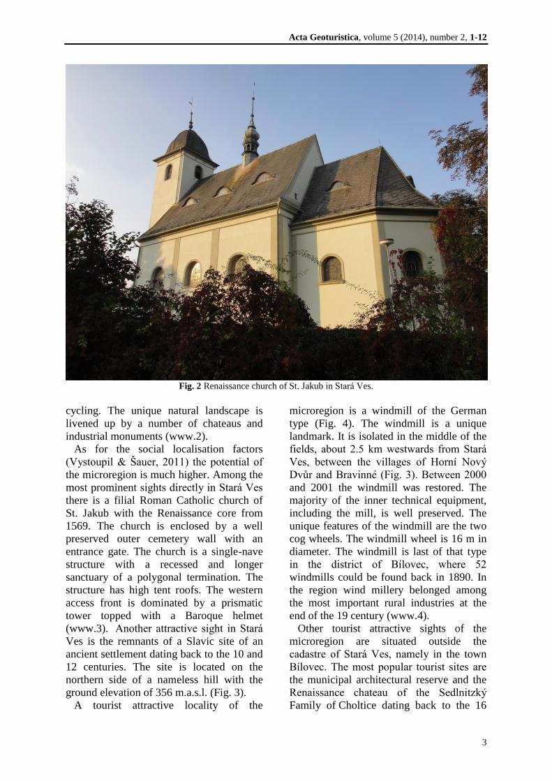
Fig. 2 Renaissance church of St. Jakub in Stará Ves.
cycling. The unique natural landscape is
livened up by a number of chateaus and
industrial monuments (www.2).
As for the social localisation factors
(Vystoupil & Šauer, 2011) the potential of
the microregion is much higher. Among the
most prominent sights directly in Stará Ves
there is a filial Roman Catholic church of
St. Jakub with the Renaissance core from
1569. The church is enclosed by a well
preserved outer cemetery wall with an
entrance gate. The church is a single-nave
structure with a recessed and longer
sanctuary of a polygonal termination. The
structure has high tent roofs. The western
access front is dominated by a prismatic
tower topped with a Baroque helmet
(www.3). Another attractive sight in Stará
Ves is the remnants of a Slavic site of an
ancient settlement dating back to the 10 and
12 centuries. The site is located on the
northern side of a nameless hill with the
ground elevation of 356 m.a.s.l. (Fig. 3).
A tourist attractive locality of the
microregion is a windmill of the German
type (Fig. 4). The windmill is a unique
landmark. It is isolated in the middle of the
fields, about 2.5 km westwards from Stará
Ves, between the villages of Horní Nový
Dvůr and Bravinné (Fig. 3). Between 2000
and 2001 the windmill was restored. The
majority of the inner technical equipment,
including the mill, is well preserved. The
unique features of the windmill are the two
cog wheels. The windmill wheel is 16 m in
diameter. The windmill is last of that type
in the district of Bílovec, where 52
windmills could be found back in 1890. In
the region wind millery belonged among
the most important rural industries at the
end of the 19 century (www.4).
Other tourist attractive sights of the
microregion are situated outside the
cadastre of Stará Ves, namely in the town
Bílovec. The most popular tourist sites are
the municipal architectural reserve and the
Renaissance chateau of the Sedlnitzký
Family of Choltice dating back to the 16

Acta Geoturistica, volume 5 (2014), number 2, 1-12
4
century. The chateau was rebuilt into a
Baroque mansion between 1736 and 1740.
Unfortunately, at the end of the Second
World War it was ransacked and set on fire.
Since 2011 the chateau has been under a
gradual reconstruction and restoration. A
valuable part of the premises is the
Renaissance gate and former chateau chapel
of St. Hyacinth.
The church of St. Mikuláš is also worth
visiting. It has a 51-mtere tall tower and
was rebuilt in the Gothic style in 1422.
Interesting are also the Renaissance
building of the town hall built in 1593, the
building of the municipal museum of the
second half of the 18 century and a villa of
the factory owner Salcher of 1908 (Kuchta,
2008).
In the microregion of interest there is also
a smaller late Baroque chateau Slatina with
a small park. It is a single-storey, rectangle
building with a mansard roof and buttresses
in the middle of both main faces terminated
by a frontispiece (www.5).
Another chateau can be found in
Klimkovice. This two-storey building with
a closed courtyard was damaged by fire
back in 1854. Only the valuable
Renaissance staircase survived from the
original furnishings. Nowadays, the chateau
is run by the municipal authority. The
Poodří Museum is situated there. Another
chateau, a former Renaissance treasure, is
in Bravantice and it is surrounded by an
English park. However, it is derelict and the
public is not admitted there (www.7).
A high potential as for the development
of tourism is seen in the Klimkovice
Convalescent Homes, which are a modern
spa with a unique medicinal source: iodine-
bromine brine. The iodine-bromine brine is
used in the spa in the form of baths and
packs, it helps to treat the organs of motion,
neurological disorders and gynaecological
problems, and it has a favourable effect on
the vascular system (www.8).
As for the technical infrastructure, in the
Bílovec Microregion there is a number of
signposted footpaths criss-cross the whole
region (Fig. 3). Bílovec is the starting point
for four signposted tourist footpaths;
Bílovec – Jakubčovice (16 km), path
Fig. 3 Location of the quarry, ground elevation of 356 m.a.s.l. and the windmill. The tourist footpaths are
marked by blue and red lines. The cycle paths are marked by purple lines (www.6 modified).

Acta Geoturistica, volume 5 (2014), number 2, 1-12
5
Bílovec – Fulnek (13 km) passing through
the forests with the panoramic views of the
Oderské vrchy and the Beskydy Mountains,
an undemanding trail Bílovec – Studénka (9
km) with an optional visit of the Wagon
Works Museum in Studénka, and path
Bílovec – Panský mlýn (10.5 km) passing
through the valleys of the brooks Jamník
and Sezina.
Two nature trails have been established in
the vicinity of the microregion in the Poodří
Nature Reserve. The nature trail 'Kotvice' is
3 km long and its six stops focus on
ornithology and botany. The second nature
trail 'Zámecká' is 5 km in length and its 12
information boards familiarise the public
with the current state of the agricultural
landscape, the adjacent wetlands, ponds,
forests, flora, fauna and the architectonic
monuments of Bartošovice.
Fig. 4 Windmill in Stará Ves near Bílovec.
In addition, cycle paths also rank to the
technical infrastructure. The microregion is
intersected by 8 registered cycle paths. The
most important one is the long-distance
cycle path called 'Amber Trail' connecting
Vienna and Krakow, which transits through
the Poodří Nature Reserve. Another
significant cycle path is the 'Silesia
Radegast Cycling Track' passing through
the undulating terrain of the Moravian Gate,
Poodří Nature Reserve, natural park of
Oderské vrchy and the Ostrava Basin. The
other cycle paths are of a lower order and
do not exceed 20 km.
The winter tourist infrastructure in the
microregion is represented by a shorter ski
lift in Slatina and cross-country tracks
through a valley called 'Údolí mladých', a
beautiful valley of the Jamník, all the way
to Pustá Polom.
The basic tourist infrastructure also
includes accommodation facilities,
restaurants and transport infrastructure
(Vystoupil & Šauer, 2011). According to
the public database of the Czech Statistical
Office, in the Bílovec Microregion there are
8 accommodation facilities, namely two
three-star hotels, two boarding houses, two
hostels (highest accommodation capacities)
and two closely unspecified facilities. The
offer is not very wide and, moreover, higher
standard accommodation (four to five-star
hotels) is completely missing.
In some categories the information on the
number of beds is not available and none of
the facilities discloses the exact number of
lodging nights. Nevertheless, the overall
attendance in 2013 was 4,118 visitors. The
majority were the guests from the CR, i.e.
3,490. The number of lodging nights was
8,755 (www.9). The data reveals that the
majority of the visitors come for shorter
periods only, which can be related to short
holiday/weekend stays. The low number of
lodging nights may thus also be explained
by a lower tourist appeal of the
microregion.
GEOLOGICAL EVOLUTION OF THE
REGION
The Bílovec Microregion is located on the
border of two geomorphological provinces,
i.e. the Czech Highlands and Western
Carpathians. In the east the province of the
Western Carpathians is represented by the
unit of Moravian Gate and the sub-unit
Acta Geoturistica, volume 5 (2014), number 2, 1-12
6
Odry Gate, which has the character of a flat
upland. The mean altitude is 260.9 metres.
The Czech Highlands forming the north-
western part of the microregion is
represented there by the spur of the Nízký
Jeseník unit and the sub-unit Vítkov
Upland. The mean altitude is 429.8 metres.
The highest, western part of the Nízký
Jeseník Mts. reaches as high as 800 m. It
steeps eastwards all the way to 350 m
(Demek et al., 1987). The interest geosite is
found in this above described part of the
Nízký Jeseník Mts.
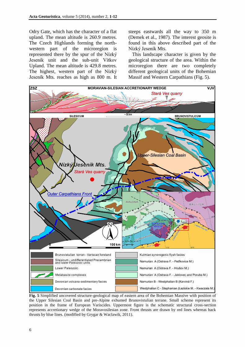
This landscape character is given by the
geological structure of the area. Within the
microregion there are two completely
different geological units of the Bohemian
Massif and Western Carpathians (Fig. 5).
Fig. 5 Simplified uncovered structure-geological map of eastern area of the Bohemian Massive with position of
the Upper Silesian Coal Basin and pre-Alpine exhumed Brunovistulian terrane. Small scheme represent its
position in the frame of European Variscides. Uppermost figure is the schematic structural cross-section
represents accretionary wedge of the Moravosilesian zone. Front thrusts are drawn by red lines whereas back
thrusts by blue lines. (modified by Grygar & Waclawik, 2011).

Acta Geoturistica, volume 5 (2014), number 2, 1-12
7
The geological unit of the Bohemian
Massif formed via the Variscan orogeny at
the end of the Palaeozoic. The Carpathian
orogenic belt formed as a result of the
processes of the Alpine orogeny towards
the end of the Cenozoic.
Therefore, the Nízký Jeseník Mts. is one
of the geological units in the Central
Europe. It is predominantly made up by
Palaeozoic, Culm sedimentary rocks,
conglomerates, greywacke and slate. This
Culm massif lies on the Devonian base of
earlier sediments and volcanic rocks that
had formed via intense volcanic activities
on the bottom of the Devonian sea.
In the Late Palaeozoic, in the Lower
Carboniferous Culm the territory of the
Nízký Jeseník Mts. was flooded with a
shallow sea. At that time, the rivers from
the contemporary Hrubý Jeseník Mts.
washed away the gravel, sand and mud,
which settled on the bottom of the
Devonian sea in layers as thick as several
kilometres. Gradually, the sediments of the
flysch character formed, resulting in the
Andělská Hora Formation, Horní Benešov
Formation, Moravice Formation and the
Hradec-Kyjovice Formation.
Each sedimentation process which starts
off quickly and fades away slowly produces
gradation. The ideal arrangement is usually
apparent in the flysch sediments deposited
by the turbidity currents. A turbidite (Fig.
6) is a higher density water current due to
an increased quantity of suspended
sedimentary material that flows downslope
near the bottom under the influence of
gravity. Such currents may be the
consequences of submarine slides,
earthquakes as well as the contribution of
concentrated water suspensions (especially
during floods) into lakes or sea, for
example. In the thin currents containing
clay, silt and sand, the grains are suspended
due to turbulence.
Flysch is a typical sequence deposited in
the deep-sea areas by the turbidity currents.
In the seas the turbidity currents flow down
the shelf edges, often through the
submarine canyons (the flow rate may reach
as fast as 100 km/h). The adrift material
deposits mainly on the continental rise,
where deep-sea fans are formed. The
sedimentary sequences caused by the
turbidity currents are called turbidites (Fig.
6), and the thickness of the individual
layers varies from several decimetres to 1
or 2 metres. The discrete particles deposit
according to the laws of gravity.
The lower part of the turbidite current is
frequently made up by conglomerates. The
boulders of quartz, granitoids,
Fig. 6 Scheme is showing formation of the turbidite deposits and graded bedding (modified by
Grotzinger et al. 2007).

Acta Geoturistica, volume 5 (2014), number 2, 1-12
8
metamorphic rocks and sedimentary rocks
(Fig. 7I) float in the fine-grained material
whose composition corresponds to
greywacke. The conglomerate positions
have uneven bases and well perceivable
gradation in places. A material
corresponding to greywacke frequently
follows. Greywacke has a dark grey, black-
grey or grey-green colour, and the texture is
usually sheeting (Fig. 7B). The top part is
represented by siltite and claystone. The
substance of the rock is a clayey matter that
may contain silt and fine grains of diverse
minerals (especially quartz) and organic
matter. Slate is always more or less
significantly layered. After settling the
material partially recrystallized under
normal temperatures and formed authigene
flaky clayey minerals and hydromica that
were arranged as parallel. In the fine-
grained members of the formation there is
less favourably preserved fauna (e.g.
Posidonia sp.), ichnofauna is abundant
though; there are also plant fossil remains,
e.g. fragments of horsetail of
Archaeocalamites genus (Fig. 7H). The
plant fragments are the remains of
clubmoss and horsetail which had been
redeposited from the continent or the
littoral areas. They are mostly indefinable
and considerably carbonised remains (Fig.
7D). In several places of the quarry it is
possible to observe a clear orientation of the
larger plant fragments, which corresponds
to the direction of the sea currents.
The irregularities of the bedding planes
are an important feature of the sediments
and the indicator of the sedimentation
conditions. The sedimentary rock
deformations most frequently are the sole
marks and the biogenic sedimentary
structures.
The irregularities of the mechanical
origin (sole marks) had been produced by
gullies on the clayey bottom either by the
particles tracted by the current along the
bottom (groove marks) or by the overall
erosion of the flow (flute marks - Fig. 7E).
The formed depressions in the clayey
bottom were filled with sandy sediments.
After the consolidation of the sediments,
the casts in the depressions have been
preserved as fine elevations on the sole of
the coarse-grained positions (Fig. 7C).
Immediately after deposition, casts form
on the bottom of the overlying bed of the
conglomerates and sandstone when in
contact with the underclay. These form as
a result of the differential squeezing of the
fast deposited coarser clastic positions
into the underlying unconsolidated
pelites. Therefore, they can be observed
as irregular swellings on the undersurface
of certain sandstone positions.
Biogenic sedimentary structures represent
the fossil traces of the presence of
organisms on the surface of the sediments
predominantly of the sea bed. These are
traces of crawling, resting, motion,
dwelling and eating the sediments. The
irregularities of the bedding planes are most
often preserved in the form of raised
fillings; the succession of strata can be
deduced according to those (Fig. 7F).
The series of strata in the flysch basin
settled via the processes described above,
i.e. the so-called turbidity currents. This
type of a sedimentary basin is typical for all
orogens irrespectively of age and it
characterises the final stages of the
orogeny. It is referred to as the foredeep,
which develops and is simultaneously filled
with eroded and transported sediments due
to the culminating collision between the
foreland of the orogen and its internal zones
(internides). In the Variscan orogeny, to
which the Moravian-Silesian Foredeep
belongs, it is the case of a collision of the
inner zones of the Moldanubicum and
Saxothuringicum with the foreland ranking
to the so-called Brunovistulicum (Dudek,
1980; Cháb et al., 2010). Within the
zonality of the European Variscides, the
Moravian-Silesian area itself makes part of
the Rheno-Hercynian Zone. In general, the
foredeep basins are characteristic of a
prominent wedge-like asymmetry in the
transverse section. Considering the fact that
huge amounts of sediments got
accumulated and thus significant

Acta Geoturistica, volume 5 (2014), number 2, 1-12
9
accretionary expansion of the zonal orogen
occurred, they are labelled as sedimentary
accretionary wedges. At the same time, as a
result of the increasing collision with the
foreland, the sedimentary accretion causes
thrusting of the extensive overlying rocks,
accompanied by folding in the style of
markedly asymmetrical drag folds. We talk
of a tectonic accretionary wedge, whose
activity was fading away from the
internides on the west to the eastern
foreland of the Brunovistulicum (Fig. 5).
The most eastern overthrusts of the
Moravian-Silesian accretionary wedge
(Grygar & Vavro, 1995) may be observed
eastwards all the way to the mining area of
ČSM Mine in the Upper-Silesian Coal
Basin (Grygar & Waclawik, 2011). The
studied locality demonstrates the described
evolution of an accretionary wedge and
evidences the tectonic development of the
Nízký Jeseník Mts.
Fig. 7 Aerial photograph of the quarry with the access road and documentation points. Legend: A, C – Load
casts and flute casts on the undersuface bedding plane; B – Shear fault cutting overturned limb of anticline
represents rudimentary stage of the thrust fault; D – Coalfield plant debris in the siltstone; E, F – Bounce and
flute marks on the undersuface bedding plane; G and J – Tectonic lineations (striations – J is more detail view)
on bedding plane of overturned limb of anticline structure are consequence of flexure-slip mechanism of fold-
thrust tectonics; H – Imprint of the horsetail of Archaeocalamites. I – Slump balls.

Acta Geoturistica, volume 5 (2014), number 2, 1-12
10
Erosion began to dominate after the
Variscan orogeny had stabilised. The
erosion or weathering in the Mesozoic
levelled the mountainous relief into a worn-
down plain. At the end of the Mesozoic and
the start of the Cenozoic, the alpine orogeny
broke the Variscan chain down into
blockmasses that formed the block relief
consisting of horsts and fault-block valleys.
The Hrubý and Nízký Jeseník Mts. were
lifted, while the area of the Upper-
Moravian Valley and Kladsko sank. The
Cenozoic sea again flooded the Upper-
Moravian Valley as well as the Moravian
Gate. It also swallowed a substantial part of
the old Variscan chain.
DESCRIPTION OF THE GEOSITE -
GREYWACKE QUARRY IN STARÁ
VES
The geosite is easily accessible from the
road No. 463 from Bílovec to Opava. Near
the house No. 143 the route turns right and
continues up a gentle slope along a not
much maintained, but paved road all the
way to the gate of the quarry (Fig. 7). The
quarry is abandoned and thus accessible all
year long.
Having entered the quarry, approximately
after 150 m the face of the quarry can be
viewed. The visitor can admire the
exposure of the fold-thrust tectonics (Fig. 8)
disrupting the sediments of the Kyjovice
layers of the Hradec-Kyjovice Formation
(Viséan age). The sedimentary succession
of the strata is characteristic of the altering
beds of fine-grained greywacke, siltstone
and silty claystone (Fig. 7B). The
greywacke is dark grey, frequently thinly
bedded in the parallel direction, or almost
laminated in places. The thickness of the
individual bed positions is from 10 to 120
cm, and in places it is possible to observe
gradation bedding documenting the
undersea slides (turbidity currents) caused
by earthquakes due to the movement of the
lithospheric plates during the collision of
the Brunovistulicum and the Lugicum.
The black-grey micaceous siltstone and
silty slates are prominently laminated in the
parallel direction. In the greywacke they
appear as several-centimetre thin or
several-decimetre thick positions. Flute
marks have been preserved on the lower
bedding planes (Fig. 7A, 7E, 7F)
documenting the longitudinal (from S to N)
filling of the Culm basin. These flute marks
may be most easily perceived on the eastern
wall of the quarry, which constitutes of the
east-vergent limb (Fig. 7C, 7G). Apart from
the so-called drags, it is possible to observe
load casts (Fig. 7C) and biogenic
sedimentary structures.
Plant debris has been identified in the
sediments: Lepidophloios sp.,
Archaeocalamites, Calamites sp., and
Fig. 8 Front view on the northern wall of Stará Ves quarry. Fold-thrust structures indicates top-to east thrusting
(vergency) typical for nappe tectonic of Variscan accretion wedge. Overturned limb of large anticline structure
crop out in eastern wall of the quarry on small figure B.

Acta Geoturistica, volume 5 (2014), number 2, 1-12
11
fragments of gymnosterms (Fig. 7D). On
the sedimentary surface of the medium
shank, a fragment of about 30-cm plant
stem can be seen (Fig. 7H). The most
fascinating geo-phenomenon that the
majority of the visitors come to admire is
the geological structure documenting the
tectonic evolution of the Nízký Jeseník Mts.
The face of the quarry belongs among the
best exposures of the fold-overthrust
tectonics in the Culm basin (Fig. 8). In the
quarry there are a number of inverted to
overturned east-vergent folds which had
been disrupted with thrusts. The
significantly asymmetrical flexures of the
flexure-slip fold type are accompanied by
interbed dislocations (Fig. 7G) subparallel
with flat limbs of the flexures.
The evidence of the movements along the
bedding planes are the findings of frequent
slickings, striations (Fig. 7J) and fault
polishes. Those features may be discovered
not only on the large lumps loosened from
the face of the quarry, but especially on the
eastern limbs of the overturned folds (Fig.
7). All those phenomena correspond to the
concomitant deformations related to
the mechanism of flexural slips, when
during the fold-thrust deformations slipping
between the discrete layers of the flysch
strata of different rheology occurred
(petrophysical characteristics). While the
above described sedimentary lineation
generally heads towards the NNE-SSW, i.e.
subparallel to the axis of the flysch basin
and the subsidiary folds, the fault polishes
and striations mostly bear along the fall line
of the bedding planes in the fold limbs, i.e.
ESE-WNW.
The described orogeny processes
participating in the geological structure of
the locality were accompanied by the
secondary mineralisation. The reason why
the majority of the visitors come is to
admire the manifestations of this
mineralisation. The rocks, especially the
greywacke, are interveined by a net of veins
constituted of quartz (Fig. 9A, 9B) and
carbonates (calcite dominates over
carbonate of the dolomite-ankerite family
Fig 9B, 9C). In places there are grey-green
aggregates of chlorite clinochlore-
chamosite family, barite is rare; in the
springs sulphides are represented by pyrite;
exceptional are chalcopyrite and sphalerite.
Those minerals may be discovered below
the face of the quarry.
CONCLUSION
The geotourist potential of the discussed
locality may be seen as very high.
Moreover, the Bílovec Microregion and its
surroundings offer a number of touristic
attractions, both landscape/natural and
social/localisation factors. The tourist rate
in the studied locality could be enhanced,
for example, by improving the quality of
the accommodation facilities, especially of
Fig. 9 Mineralisation: A – net of veins constituted of quartz, B – crystals of quartz with ankerite, C – detail of
crystals of quartz and ankerite (www.10).

Acta Geoturistica, volume 5 (2014), number 2, 1-12
12
the touristy character. It would also help if
the geosite was reclassified from category
of protection B (locality recommended for
protection) into the category A (protected
locality).
What may also help to improve the tourist
rate in the region is building a geotourist
trail connecting the individual, interesting
geosites in the Oderské vrchy. The most
important move, though, is to promote the
geosite under description, which is also the
aim of this paper.
REFERENCES
Demek, J., Balatka, B., Buček, A., Czudek, T.,
Dědečková, M., Hrádek, M., Ivan, A., Lacina,
J., Loučková, J., Raušer, J., Stehlík, O.,
Sládek, J., Vaněčková, L. and Vašátko, J.
(1987) Zeměpisný lexikon ČSR. Hory a nížiny.
Academia, Praha, 584 p.
Diviš, J. (2002) Nové archeologické nálezy z
Bílovecka, Archeologie Moravy a Slezska,
Informační zpravodaj české archeologické
společnosti, pobočka pro severní Moravu a
Slezsko Kopřivnice - Hulín - Frýdek-Místek –
Havířov, 35 - 38.
Dudek, A. (1980) The crystalline basement block of
the Outer Carpathians in Moravia: Bruno-
Vistulicum. Rozpr. Česk. Akad. Věd., Praha,
Řada Mat. Přír. Věd, vol. 90, nr. 8, 1-81.
Dvořák, J. (1999) Disharmonicky zvrásněné
hradecko-kyjovické souvrství ve Staré Vsi u
Bílovce (jv. část Oderských vrchů, sev. Morava).
Čas. Slez. Muz., Vědy přír., vol. 48, 91-93.
Grotzinger, J., Jordan, T.H., Press, F. and Silver,
R. (2007) Understanding Earth. W.H. Freeman
and Company, New York, 579 p. Grygar, R. (1997) Lokalita Stará Ves u Bílovce. In:
Sedimentární a tektonický vývoj synorogenních
pánví - exkurzní průvodce II. semináře České
tektonické skupiny, VŠB, Ostrava, 6 p.
Grygar, R. and Vavro, M. (1995) Evolution of
Lugosilesian Orocline (North-eastern periphery
of the Bohemian Massif): Kinematics of
Variscan deformation. Journal of the Czech
Geological Society, vol. 40, nr. 1-2, 65-90.
Grygar, R. and Waclawik, P. (2011) Structural-
tectonic conditions of Karviná Subbasin with
regard to its position in the apical zone of
Variscan accretion wedge. Acta Montanistica
Slovaca vol. 16 (2011), nr. 2, 159-175. Jelínková, R. (2007) Paleolitické nálezy z území
bývalých soudních okresů Bílovec, Fulnek a
Klímkovice. Magisterská diplomová práce,
Slezská univerzita v Opavě, Filozoficko-
přírodovědecká fakulta. 67 p.
Cháb, J., Breiter, K., Fatka, O., Hladil, J.,
Kalvoda, J., Šimůnek, Z., Štorch, P.,
Vašíček, Z., Zajíc, J. and Zapletal, J. (2010)
Outline of the geology of the Bohemian Massif:
the basement rocks and their Carboniferous and
Permian cover. Czech Geol. Surv. Publ. House,
Prague, 295 p.
Kuchta, Z. (2008) Kronika města Bílovce, X. díl.
Bílovec, 124 p.
Quitte, E. (1975) Mapa klimatických oblastí ČSR
1:500 000. Ggú, Brno.
Vystoupil, J. and Šauer, M. (2011) Geografie
cestovního ruchu České republiky.
Vydavatelství: Aleš Čeněk, Plzeň, 318 p.
Zimák, J., Losos, Z., Novotný, P., Dobeš, P. and
Hladíková, J. (2002): Study of vein carbonates
and notes to the genesis of the hydrothermal
mineralization in the Moravo-Silesian Culm.
Journ. Czech Geol. Soc., vol. 47, nr. 3-4, 111-
122.
Internet sources
www.1: Geologické lokality, Kukal, Z., Gilíková,
H. (2012) Geská geologická služba, available at:
http://lokality.geology.cz/3403 (e.g. 22. 10.
2014).
www.2: Správa CHKO Poodří, (2014) available at:
http://poodri.ochranaprirody.cz/ (e.g.
22.10.2014)
www.3: Kostel sv. Jakuba, Čížek, J. (2014)
Hrady.cz, available at:
http://www.hrady.cz/?OID=6646 (e.g.
22.10.2014)
www.4: Povětrník, Veselý, P. (2006) Stránky
Kruhu přátel Technického muzea v Brně (TMB)
sekce větrné mlýny, available at:
http://www.povetrnik.cz/rs/view.php?cisloclanku
=2006072801 (e.g. 22.10.2014)
www.5: Slatina, Čížek, J. (2014) Hrady.cz,
available at:
http://www.hrady.cz/index.php?OID=2870 (e.g.
22.10.2014)
www.6: Mapy. cz (2014) available at:
http://www.mapy.cz/zakladni?x=17.9659523&y
=49.7767609&z=12 (e.g. 22.10.2014)
www.7: Bravantice, (2014) Turistika.cz, available
at: http://www.turistika.cz/mista/bravantice--1
(e.g. 22.10.2014)
www.8: Sanatoria Klimkovice, (2013) Aquaklim,
s.r.o., available at: http://www.sanatoria-
klimkovice.cz/ (e.g. 22.10.2014)
www.9: Veřejná databáze, (2014) Český statistický
úřad, available at:
http://vdb.czso.cz/vdbvo/maklist.jsp?filtr_uzemi
=on%2C45%2Con&filtr_obdobi=2013&q_text=
&kapitola_id=null&vo=mapa&q_rezim=1 (e.g.
22.10.2014)
www.10: Ankerite - Photo Gallery, (2011) Mindat,
available at: http://www.mindat.org/photo-
493825.html (e.g. 22.10.2014)