Embed Size (px)
Citation preview

A Gaze-based Guidance System based on a Real-world3D Photo Logging System
Rieko KadobayashiNational Institute of Information and Communications Technology
3-5 Hikaridai, Seika-cho, Soraku-gunKyoto 619-0289, Japan
ABSTRACTTo achieve easy access to the information that users needin the real world, we are developing a gaze-based guidancesystem by extending the 3D photo-logging system we havepreviously developed for recording the real world. Theprototype system consists of several servers running on asingle machine and user terminals. The user terminals areequipped with mobile phones to which motion sensors areattached, a GPS sensor, and a notebook PC for logging theposition and orientation of the mobile phone. Collectingphotographs with 3D viewpoint information (based on thephotographer’s position and direction of gaze) by using the3D photo-logging system, we can use these photographsand the text explanations associated with them as guideinformation. Users can access the information simply bypointing and clicking their mobile phones in the real world.
Categories and Subject DescriptorsH.4.3 [Information Systems Applications]:Communications Applications—Information browsers;H.5.2 [Information Interfaces and Presentation]: UserInterfaces—Interaction styles, Prototyping
General TermsDesign, Experimentation, Human Factor
KeywordsGaze-based services, Navigation, mobile applications, photobrowsing
1. INTRODUCTIONIt is worthwhile to use a person’s direction of gaze as well ashis or her position when he or she is navigating in the realworld because navigation depends on the direction in whichthe person wants to go and on what kind of informationthe user needs most. On the basis of this idea, we aredeveloping a gaze-based guidance system for navigating inthe real world by extending the 3D photo-logging system [6]we have previously developed for recording the real worldwith photographs.
Our 3D photo-logging system uses viewpoint-based imageretrieval [5]. The key idea is to use 3D viewpointinformation [7] as metadata when taking pictures in the
real world to facilitate easy access to pictures of interest.The position and orientation of the camera are regardedas a user’s point of view in a 3D space and are referredto as 3D viewpoint information, which is a key elementfor bridging 2D images and 3D spaces (e.g., 3D computergraphics models, 3D virtual worlds, or the real world).
3D Viewpoint Information is basically a 3D vector from theobserver’s eye to the point where the observer is looking at.When it is not easy to obtain the 3D coordinates of thepoint correctly, we can use a direction vector, which startsthe observer’s eye to the direction the observer is facing, asthe 3D Viewpoint Information. The direction vector can becalculated from the extrinsic parameter, i.e., the positionand orientation, of the camera which the observer is using.
The most important feature of the 3D viewpoint informationis that it enables users to search pictures intuitively withoutthe need to specify key words [7]. Keyword-based searchesrequire users to formulate appropriate queries; however,combining several key words is often insufficient. Usersmay experience difficulty combining several keywords toformulate a query that can distinguish between images thatare very similar. Moreover, keyword-based searches requireusers to have some knowledge about the image content, sothey can make an appropriate query. This is too restrictivefor practical use.
Another retrieval method called “content-based imageretrieval” [4, 8], uses features, such as color, shape, andtexture, that are automatically extracted from images.However, photographs taken in the real world, especiallythose taken outdoors, are usually affected by naturalconditions, such as sunlight and weather, and artificialconditions, such as traffic and crowds. This causes diversityin the image features of the same object under variousconditions over time and hence reduces the efficiency ofimage retrieval. Viewpoint-based searches, on the otherhand, are robust against diversity in image features.
Moreover, 3D viewpoint information is useful for organizingand analyzing data associated with spatial data. It ishas many applications, such as archaeological informationsystems [3]. The 3D photo-logging system was designedto take full advantage of 3D viewpoint information. Aprototype of our gaze-based guidance system has beendeveloped based on the 3D photo-logging system.
Camera
Motion Sensor
GPS
Mobile Phone
(Picture, Text, Location)
Mail Server
Integration Server
3D Viewpoint Server
Wireless Communication
Database
Motion Sensor (Receiver)
GPS
Laptop Computer
(Orientation, Location)
Map ServerMap
Browser
Blog ServerBlog Site
Figure 1: System configuration.
Figure 2: Hardware setup for user terminal.
2. 3D PHOTO LOGGING2.1 OverviewWe use the term “photo logging” to express the methodof recording objects and events in the real world asphotographs. 3D photo logging means photo logging with3D viewpoint information. The 3D viewpoint information iscomposed of a person’s position and direction of view whenhe or she takes a photograph. His or her position is obtainedfrom a global positioning satellite (GPS) while his or herdirection of view is obtained from the motion sensor.
The goal of building the 3D photo logging system is to createa framework for recording, organizing, analyzing, searching,and presenting every object and event in the real world with“portable devices,” such as mobile phones, in an intuitiveand casual manner. Objects include, for example, buildings,monuments, landscapes, and archaeological sites, and eventsinclude, for example, festivals. Anything that exists orhappens at a particular location can be a target of the 3Dphoto-logging system.
2.2 System ConfigurationOur prototype system consists of a server machine anduser terminals. A database server, a mail server, and an
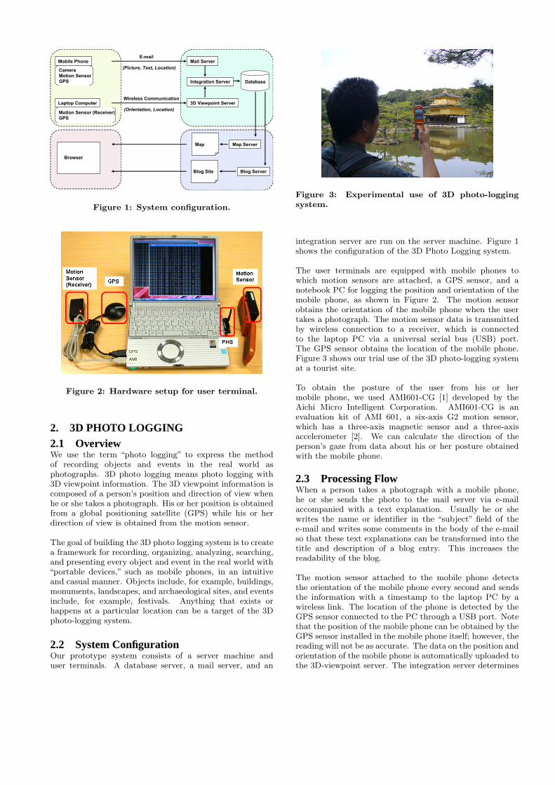
Figure 3: Experimental use of 3D photo-loggingsystem.
integration server are run on the server machine. Figure 1shows the configuration of the 3D Photo Logging system.
The user terminals are equipped with mobile phones towhich motion sensors are attached, a GPS sensor, and anotebook PC for logging the position and orientation of themobile phone, as shown in Figure 2. The motion sensorobtains the orientation of the mobile phone when the usertakes a photograph. The motion sensor data is transmittedby wireless connection to a receiver, which is connectedto the laptop PC via a universal serial bus (USB) port.The GPS sensor obtains the location of the mobile phone.Figure 3 shows our trial use of the 3D photo-logging systemat a tourist site.
To obtain the posture of the user from his or hermobile phone, we used AMI601-CG [1] developed by theAichi Micro Intelligent Corporation. AMI601-CG is anevaluation kit of AMI 601, a six-axis G2 motion sensor,which has a three-axis magnetic sensor and a three-axisaccelerometer [2]. We can calculate the direction of theperson’s gaze from data about his or her posture obtainedwith the mobile phone.
2.3 Processing FlowWhen a person takes a photograph with a mobile phone,he or she sends the photo to the mail server via e-mailaccompanied with a text explanation. Usually he or shewrites the name or identifier in the “subject” field of thee-mail and writes some comments in the body of the e-mailso that these text explanations can be transformed into thetitle and description of a blog entry. This increases thereadability of the blog.
The motion sensor attached to the mobile phone detectsthe orientation of the mobile phone every second and sendsthe information with a timestamp to the laptop PC by awireless link. The location of the phone is detected by theGPS sensor connected to the PC through a USB port. Notethat the position of the mobile phone can be obtained by theGPS sensor installed in the mobile phone itself; however, thereading will not be as accurate. The data on the position andorientation of the mobile phone is automatically uploaded tothe 3D-viewpoint server. The integration server determines

Figure 4: Sample of person’s Blog site generatedusing photo-logging data.
the correct position and orientation data for the pictureby comparing the timestamp in the e-mail containing thepicture and text with that in data on the position andorientation. It then stores this data in the database.
Every time the mail server receives e-mail with a pictureattached, the picture is processed and is stored in thedatabase along with metadata. The metadata includes the3D viewpoint information as well as picture ID, e-mail date,title (subject of the e-mail), and description (content in thebody of the e-mail). The blog server then updates the blogsite so that the most recent picture is shown as the latestentry.
2.4 User InterfaceVisualizing photographs in several different ways is easybecause they and their associated 3D viewpoint informationare stored in a general-purpose database. The systemenables users to browse photographs “blog style,” bytreating each photograph and corresponding explanation asa blog entry, displaying them in reverse-chronological order.Figure 4 shows an example of a blog generated using thephoto-logging data.
Alternatively, the collected photographs can be displayedon a 2D or 3D map. When people browse photographs ona 2D map, markers with line segments are displayed on themap to show the position of the camera, i.e., the locationfrom which the pictures were taken and the direction inwhich the camera was facing. The orientation of the camerais decomposed into an azimuth and an elevation angle,and the line segment attached to the markers representsthe azimuth angle. Clicking on a marker, a user can
Figure 5: Map-based user interface. The markersdenote the positions of the person when he or shetook a picture, and the lines denote the direction inwhich the he or she was facing.
see a photograph with the corresponding elevation datarepresented graphically. Figure 5 shows a map-basedinterface.
2.5 Searching ImagesThe 3D photo-logging system uses multiple criteria forsearching photographs, namely, the distance between twocameras, the degree of similarity in the azimuth angles,the degree of similarity in the elevation angles, the degreeof similarity in the directions of gaze represented as 3Dvectors, and the shooting date. After the user chooses apicture from those shown on the map, sets the values for thecriteria, and clicks the search button, the system displaysthe results on the map graphically, i.e., with markers andline segments.Users can search photographs intuitively byinteractively changing the value for the criteria. Figure 6shows an example of an image search. One picture retrievedfrom the search results is displayed on the map.
3. GAZE-BASED GUIDANCE WITHMOBILE PHONES
We have implemented a proof-of-concept system by usingthe 3D photo-logging system. The system configuration isdepicted in Figure 7. Suppose that we have a large collectionof photos of tourist sites stored in the 3D photo-loggingsystem. That is, each photo has 3D viewpoint information.Mobile phone users could then search for photographs ofthe tourist sites they are currently visiting by pointing andclicking with their mobile phones.
When a person is visiting a tourist site, he or she can receivea picture of his or her approximate location by accessingour experimental Web site. The system automaticallylocates the person’s position and the direction in which he

Figure 6: Image searches. A query image (on theright) and the corresponding search results (shownas markers on the map).
Figure 7: Configuration of searching function formobile phones.
or she is moving, and uses this information to query thedatabase. Note that the prototype system uses a motionsensor attached to the back of the mobile phone to detect thecamera’s orientation. In the current system, users receivepictures, as shown in Figure 8; however, they can eitherreceive pictures with text or text only so that they can easilyobtain information about what they are looking at.
4. CONCLUSION AND FUTURE WORKWe are developing a Gaze-based guidance system basedon a real-world application of a 3D photo-logging system.The 3D photo-logging system records the picture togetherwith its corresponding 3D viewpoint information and itsexplanation. Once the image database is created, we canuse the data to send mobile phone users information on thebasis of the direction of their gazes and their positions.
We believe that gaze-based guidance systems will increasethe ease of access to real-world information in the realworld. We intend to develop methods of finding themost appropriate photograph and/or information by using
Figure 8: Example of gaze-based guidance formobile phones.
contextual data as well as the direction of a person’s gazeand his or her position.
5. REFERENCES[1] Aichi Micro Intelligent Corporation. Computer
Graphics Controller (AMI601-CG) Instruction ManualAMI-MI-0132E, 2007. http://www.aichi-mi.com/3_products/601-cgmanual_e.pdf (accessed 31 May2007).
[2] Aichi Steel Corporation. AMI601 DeliverySpecifications, ver.1.3 061011 edition, 2006.http://www.aichi-mi.com/3_products/ami601ev1.3_
061011.pdf (accessed 31 May 2007).
[3] P. Drap et al. Photogrammetry and ArchaeologicalKnowledge: Toward a 3D Information SystemDedicated to Medieval Archaeology: A Case Study ofShawbak Castle in Jordan. In Proceedings of the ISPRSInternational Workshop 3D-ARCH 2007, 2007.
[4] M. Flickner et al. Query by Image and Video Content:The QBIC System. In IEEE Computer, volume 28,pages 23–32, 1995.
[5] R. Kadobayashi and R. Furukawa. Combined use of 2Dimages and 3D models for retrieving and browsingdigital archive contents. In Videometrics VIII,Proceedings of SPIE-IS&T Electronic Imaging 2005,volume 5665 of SPIE, pages 134–143, 2005.
[6] R. Kadobayashi, K. Kayama, T. Umezawa, and I. E.Yairi. Sensing Human Activities and Environment forCreating Knowledge Cycle. In Proceedings of the FirstInternational Symposium on Universal Communication.National Institute of Information and CommunicationsTechnology, 2007.
[7] R. Kadobayashi and K. Tanaka. 3D Viewpoint-basedPhoto Search and Information Browsing. In Proceedingsof the 28th Annual International ACM SIGIRConference (SIGIR 2005), pages 621–622, 2005.
[8] J. R. Smith and S. F. Chang. VisualSEEk: a FullyAutomated Content-Based Image Query System. InProceedings of ACM International Conference onMultimedia, pages 87–93, 1996.