Embed Size (px)
Citation preview

1
2017 CONFERENCE ON LAND POLICY IN AFRICA
UN ECONOMIC COMMISISON FOR AFRICA, ADDIS ABABA, ETHIPOIA, 14‐17 NOVEMBER 2017
A Fit‐For‐Purpose approach to Land Administration in Africa
in support of the new 2030 Global Agenda *
Prof Stig Enemark FIG Honorary President
Aalborg University, Denmark
1. INTRODUCTION
Most less developed countries are struggling to find remedies for their many land problems that are
often causing land conflicts, reducing investments and economic development, and preventing
countries reaching their true potential. Existing investments in land administration have been built on
legacy approaches, have been fragmented and have not delivered the required pervasive changes and
improvements at scale. The solutions have not helped the most needy ‐ the poor and disadvantaged
that have no security of tenure. In fact the beneficiaries have often been the elite and organizations
involved in land grabbing. It is time to rethink the approaches. New solutions are required that can
deliver security of tenure for all, are affordable and can be quickly developed and incrementally
improved over time. The Fit‐For‐Purpose (FFP) approach to land administration has emerged to meet
these simple, but challenging requirements.
This paper describes the key principles for building sustainable and FFP land administration systems
in African countries where often less the 10 per cent of the land and population is included in the
formal systems. It is argued that building such FFP land administration systems is the only viable
solution to solving the global security of tenure divide. The FFP approach is flexible and includes the
adaptability to meet the actual and basic needs of society today and having the capability to be
incrementally improved over time. This will be triggered in response to social and legal needs of
economic development, investments and financial opportunities that may emerge over the longer
term. In this FFP approach, land rights can be secured for all in a timely and affordable way.
The core elements of the FFP approach were laid down in joint FIG/WB declaration (Enemark, et al.,
2014) that includes the following statement: In 2014 UN‐Habitat / Global Land Tool Network (GLTN)
decided to elaborate this approach further by initiating a project in cooperation with Dutch Kadaster
on developing a Guide for FFP Land Administration in collaboration with key partners. This should
underpin the GLTN land tool development activities and enable implementation of sustainable land
administration systems in developing countries at scale. The project was completed end of 2015 and
released in the recent publication on Fit‐For‐Purpose Land Administration ‐ Guiding Principles for
Country Implementation (Enemark, et al., 2016) see:
http://www.gltn.net/index.php/publications/publications/download/2‐gltn‐documents/2332‐fit‐for‐
purpose‐land‐administration‐guiding‐principles‐for‐country‐implementation
* This paper was previously presented at the GLTN / Habitat for Humanity conference on Improving land
Governance and Administration in Africa, Pretoria, South Africa, 15‐17 august 2017.

2
2. FOCUS ON AFRICA
Sub‐Sahara Africa is often referred to as an underdeveloped region with a great potential. Many land
professionals having visited the region would agree to that. But Africa is now on the move. Economic
growth in Sub‐Sahara Africa is considerable with a rate of above 5 per cent per year for more than a
decade. Projections of the World bank indicates that this will continue for the years ahead while the
global economy will grow at only 2.5 per cent (and only about 1 per cent in Western economies). So
Africa is expected to grow twice as fast as the global economy.
However, Sub‐Sahara Africa is still mostly poor and has been unable to translate its recent robust
growth into rapid poverty reduction. Compared to other developing regions Sub‐Sahara Africa has
generally been left behind and are struggling with issues such as insecurity of tenure, informal
settlements and urban slums, landownership inequalities and landlessness, and degrading of natural
resources. These facts indicate that poor land governance, including the manner in which land rights
are defined and administered, may be the root of the problem.
Figure 1. Left: Africa is a huge continents with space for including major countries and regions such as
China, Mexico, Western Europe, India and United Sates. Right: If a hypothetical map of the world is
generated by using the Gross Domestic Product as the scale for territorial size, the so‐called western
regions – North America, Western Europe, South Korea and Japan – would ‘balloon’, while other
regions such as Africa and Central Asia would almost disappear (UNEP, 2007).
The global agenda is very much about bringing this map back to scale through poverty eradication,
improving education and health, facilitating economic development, encouraging good governance
and ensuring sustainability. In recent year significant progress has been achieved in countries such as
Rwanda and Ethiopia through comprehensive land reform projects and other countries are following
in the footsteps. At the regional scale the challenges are addressed by setting a promising agenda for
Africa and by focusing on sustainable land governance as the core means to achieve the goals. The
overarching agenda is set by the African Union, the African Development Bank, and the UN Economic
Commission for Africa. It is adopted by the African leaders through two seminal documents
“Declaration on land Issues and Challenges in Africa” and the “Framework and Guidelines on Land
Policy in Africa” (AUC/UNECA/ADB, 2009). But developing land policies is not an end in itself – they
need to be effectively implemented. This relates to land reform programmes, land administration
infrastructures and building of transparent and sustainable institutions.

3
3. LAND GOVERNANCE
The organizational structures for land governance and administration differ widely between countries
and regions throughout the world and reflect the cultural and judicial setting of the country and
jurisdiction. Sound land governance requires a legal and regulatory framework, operational processes
and capacity to implement policies consistently within a jurisdiction or country in sustainable ways. In
this regard, land administration systems provide a country with an infrastructure for implementing
land policies and land management strategies in support of sustainable development, see fig.2.
Fig. 2. The Land Management Paradigm (Enemark, 2004, Williamson et.al. 2010)
Sound land governance requires a legal and regulatory framework, operational processes and capacity
to implement policies consistently within a jurisdiction or country in sustainable ways. In this regard,
land administration systems provide a country with an infrastructure for implementing land policies
and land management strategies in support of sustainable development. The operational component
of the land governance concept is the range of land administration functions that include the areas
of: land tenure (securing and transferring rights in land and natural resources); land value (valuation
and taxation of land and properties); land use (planning and control of the use of land and natural
resources); and land development (implementing utilities, infrastructure, construction works, and
urban and rural developments). These functions interact to deliver overall policy objectives, and they
are facilitated by appropriate land information infrastructures that include cadastral and topographic
datasets linking the built and natural environment.
A land administration system provides governments with an infrastructure for securing land tenure
rights, determining valuation and taxation of land and managing its use and development. It sits within
the principles of responsible land governance in the framework of national land policies (Enemark,
et.al., 2016) .

4
4. THE GLOBAL AGENDA
There is a broad agreement that, while the MDGs provided a focal point for governments, they were
too narrow. The MDGs are now replaced by the Sustainable Development Goals (SDGs) with a new,
universal set of 17 Goals and 169 target that UN member states are committed to use to frame their
agenda and policies over the next 15 years (2016‐2030), see Figure 3. The goals are action oriented,
global in nature and universally applicable. Targets are defined as aspirational global targets, with each
government setting its own national targets guided by the global level of ambition, but taking into
account national circumstances. The goals and targets integrate economic, social and environmental
aspects and recognise their interlinkages in achieving sustainable development in all its dimensions.
Figure 3. The Sustainable Development Goals (UN, 2015).
While the MDGs did not mention land directly, the new SDGs include six goals with a significant land
component mentioned in the targets. For example, Goal 1 calls for ending poverty in all its forms
everywhere, and target 1.4 states that by 2030 all men and women will have equal rights to ownership
and control over land and other forms of property. Similarly the land component is referred to in
target 3 of Goal 2 on ending hunger, and, more generally in Goal 5 on gender equity, Goal 11 on
sustainable cities, Goal 15 on life on land, and Goal 16 on peace, justice and strong institutions. These
goals and targets will never be achieved without having good land governance and well‐functioning
countrywide land administration systems in place.
The SDGs, thereby, provide a framework around which governments, especially in developing
countries, can develop policies and overseas aid programmes designed to alleviate poverty and
improve the lives of the poor, as well as a rallying point for NGOs to hold them to account. In other
words, the SDGs is a key driver for countries throughout the world – and especially developing
countries – to develop adequate and accountable land policies and regulatory frameworks for meeting
the goals.
There is strong request for effective monitoring and assessment of progress in achieving the SDGs.
There is a need for reliable and robust data for devising appropriate policies and interventions for the
achievement of the SDGs and for holding governments and the international community accountable.
Such a monitoring framework is crucial for encouraging progress and enabling achievements at
national, regional and global level. This calls for a “data revolution” for sustainable development to
empower people with information on the progress towards meeting the SDG targets (UN, 2014, p.7).

5
For example, the 2014 progress report showed that the extreme poverty rate had been halved and
MDGs Goal 1 was thereby met at a global scale ‐ but with huge regional deviations. The was achieved
mainly due to the contribution from China where, in 1978, the collective farms were dismantled and
replaced by long‐term leases to allocate land rights to farming households. This policy enforced an era
of agricultural growth that trans‐formed rural China and led to the largest reduction of poverty in
history. The percentage of people living in extreme poverty declined from about 80% of the population
in 1981 (the highest in the world at that time) to only 13% in 2008. In the same way, in Vietnam, the
extreme poverty was reduced from 58% in early 1990s to 15% in 2008.
On the other hand, even if the Sub‐Saharan Africa has seen a considerable growth rate of above 5%
per year for more than a decade, this region remains poor for the most part and has been unable to
translate its recent robust growth into rapid poverty reduction (Byamugisha, 2013). This underpins
the necessity of detailed monitoring at regional and local / country level.
It should be recognised, that, next to the SDGs, the wider global agenda includes a range of global
issues such as responsible governance of tenure, human rights and equity, climate change and natural
disasters, rapid urbanisation, and land conflict situations, see figure 4 and (Enemark, 2014).
Figure 4. The Wider Global Agenda

6
5. UNDERSTANDING THE FIT‐FOR‐PURPOSE APROACH
In the context of building sustainable land administration systems in developing countries the term
“Fit‐For‐Purpose” means applying the spatial, legal, and institutional methodologies that are most fit
for the purpose of providing secure tenure for all. This approach will enable the building of national
land administration systems within a reasonable timeframe and at affordable costs. The systems can
then be incrementally improved over time.
The FFP approach starts by identifying and analysing the purpose(s) that the systems are intended to
serve and then deciding on the adequate means to be applied for meeting the purpose(s). This means
that systems should be designed to meet / fit the purpose(s) rather than just following some rigid set
of regulations and demands for accuracy. These unnecessary constraints, often imposed during
colonial times, result in systems that are unsustainable and frankly unattainable at a national wide
scale for developing countries. In this regard, of course, political commitment, corruption, largesse
and a range of other factors play in as well.
The FFP approach focuses firstly on defining the “what” in terms of the end outcome for society and
communities and then, secondly, it looks at the implementation design of “how” this could be
achieved. Or to put it another way, the means (the “how”) should be designed to be the most “fit” for
achieving the purpose (“what”). A catch phrase for this approach used in New Zealand is “As little as
possible – as much as necessary” (Grant and Haanen, 2007). This is just another way of saying “Fit‐
For‐Purpose”.
It is clear that the implementation proposed here is significantly different from the more advanced
systems embedded in many western economies. This could lead to concerns that, by not following
modern best practice for land administration as implemented predominantly in the Western world,
then developing countries might be wasting precious resources on building systems that will prove to
be outdated and ineffective.
What is usually forgotten in this discussion is that the advanced land administration systems of
developed economies did not suddenly appear fully formed in those countries. In most developed
countries the initial cadastral and registration systems were implemented very roughly and quickly –
rough even by the standards of the day. These rough methods were fit for the purpose for the society
at that time – and the result was a quickly developing and vibrant society and economy. As those
societies and economies developed, the methods that had once been fit for the purpose were, several
decades later, seen to be no longer fit. Governments undertook formal reviews, reports were written,
the old ways were condemned as inadequate and new FFP system upgrades were designed. What
was easily forgotten was how well those rough and ready methods had served to quickly build and
advance the societies that outgrew them. The FFP approach, as illustrated in Figure 2 below, has three
fundamental characteristics:
(i) Focus on the purpose. This new approach is focused mainly on the purpose of providing secure
tenure for all. The means to achieve this should then be designed to be the most “fit” for achieving
this purpose rather than blindly being guided by rigid standards for accuracy and top‐end
technological solutions
(ii) Flexibility. The FFP approach is about flexibility in terms of demands for accuracy, and for shaping
the legal and institutional frameworks to best accommodate societal needs. The FFP approach also

7
includes the flexibility to meet the need for securing different kinds of tenure types, ranging from
more social or customary tenure types to formal types such as private ownership and leasehold.
(iii) Incremental improvement. The systems should be designed for initially meeting the basic needs
of society today. This will identify the optimal way of achieving this by balancing the costs, accuracy
and time involved. This creates what is termed a “Minimum Viable Product”. Incremental upgrading
and improvement can then be undertaken over time in response to emerging needs and
opportunities.
These three characteristics underpin the FFP concept, consisting of three core components: the
spatial, legal & regulatory and institutional frameworks (see Figure 3 below). Each of the three
frameworks has four corresponding key principles as presented in Table 1 below.
The FFP Concept. The concept includes three core components: the spatial, the legal, and the
institutional frameworks. Each of these components includes the relevant flexibility to meet the actual
needs of today and can be incrementally improved over time in response to societal needs and
available financial resources. This means that the concept – in itself – represents a continuum. The
three framework components are interrelated and form a conceptual nexus underpinned by the
necessary means of capacity development. See Figure 3 below.
Figure 3. The Fit‐For‐Purpose Concept (Enemark, et al., 2016)
The spatial framework aims to represent the way land is occupied and used. The scale and accuracy
of this representation should be sufficient for supporting security of the various kinds of legal rights
and tenure forms through the legal framework as well as for managing these rights and the use of land
8
and natural resources through the institutional framework. The FFP approach therefore needs to be
enshrined in the land laws, and for administering this regulatory set‐up the institutional framework
must be designed in an integrated, transparent and user‐friendly way. This administration again
requires reliable and up to date land information that is provided through the spatial framework.
The FFP concept, this way, encompasses a dynamic interaction of the spatial, legal, and institutional
framework for achieving the overall land policy objectives and outcomes for society and communities
– and each of the frameworks can be incrementally improved over time. These dependencies need to
be carefully coordinated to ensure that the frameworks are mutually reinforcing. For example, if
legitimate rights are recognized then the legal framework will have to be modified to legally enshrine
the tenure type, ICT solutions will have to be adapted to support overlapping rights and new
relationships prevalent in social tenures, and data recording procedures in the spatial framework
modified to capture these relationships.
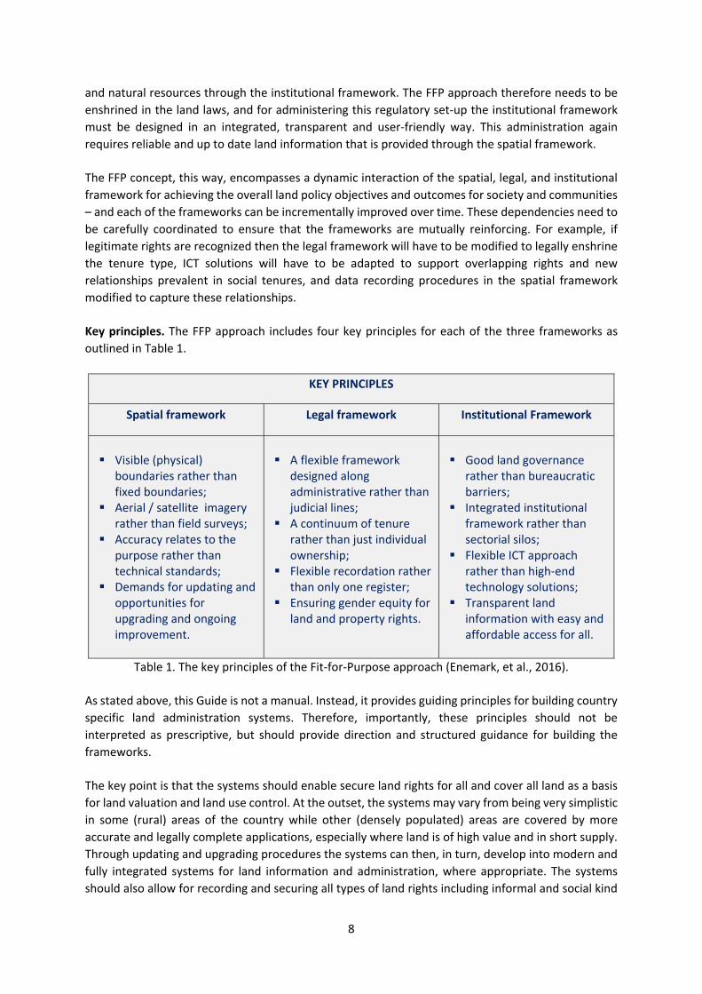
Key principles. The FFP approach includes four key principles for each of the three frameworks as
outlined in Table 1.
KEY PRINCIPLES
Spatial framework Legal framework Institutional Framework
Visible (physical)
boundaries rather than fixed boundaries;
Aerial / satellite imagery rather than field surveys;
Accuracy relates to the purpose rather than technical standards;
Demands for updating and opportunities for upgrading and ongoing improvement.
A flexible framework
designed along administrative rather than judicial lines;
A continuum of tenure rather than just individual ownership;
Flexible recordation rather than only one register;
Ensuring gender equity for land and property rights.
Good land governance
rather than bureaucratic barriers;
Integrated institutional framework rather than sectorial silos;
Flexible ICT approach rather than high‐end technology solutions;
Transparent land information with easy and affordable access for all.
Table 1. The key principles of the Fit‐for‐Purpose approach (Enemark, et al., 2016).
As stated above, this Guide is not a manual. Instead, it provides guiding principles for building country
specific land administration systems. Therefore, importantly, these principles should not be
interpreted as prescriptive, but should provide direction and structured guidance for building the
frameworks.
The key point is that the systems should enable secure land rights for all and cover all land as a basis
for land valuation and land use control. At the outset, the systems may vary from being very simplistic
in some (rural) areas of the country while other (densely populated) areas are covered by more
accurate and legally complete applications, especially where land is of high value and in short supply.
Through updating and upgrading procedures the systems can then, in turn, develop into modern and
fully integrated systems for land information and administration, where appropriate. The systems
should also allow for recording and securing all types of land rights including informal and social kind

9
of tenures. The legal and institutional frameworks have to be adapted to allow for this kind of flexibility
and also accessibility for all. This change process necessary for implementing a FFP approach to
existing land administration systems can start today. The three framework components are described
in detail in (Enemark, et al., 2016). In brief, they include the following:
The spatial framework should predominantly be developed using aerial / satellite imagery for
identifying the way land is occupied and used ‐ rather than using field surveys. The imagery will show
the actual physical boundaries and, in most cases, these visible boundaries are sufficient for identifying
and securing the land rights. By using georeferenced imagery the identified boundaries can
subsequently be vectorised and used as a cadastral index map. Conventional field surveys, handheld
GPS or cell phone recording methods may of course be used where relevant, e.g. to identify non‐
visible boundaries or to capture the situation in dense high value urban areas. The scale and accuracy
of the aerial imagery should relate to purpose and will therefore vary according to topography and
density of development. The resulting spatial framework can easily be updated and also upgrading
over time or whenever relevant, e.g. in relation to implementation of major infrastructure or land
development schemes or when boundary disputes occurs.
Figure 4. Example from Rwanda showing aerial imagery (left), from which the parcel boundaries are
easily identified (right). This is essentially a participatory approach undertaken by locally trained land
officers Source: Didier Sagashya, Rwanda
The process for providing the spatial framework will include the following steps: (i) Producing the
aerial imagery at scales according to topography, land use, and building density; (ii) Using the aerial
imagery in the field to identify, delineate and adjudicate parcel boundaries (general boundaries),
which can be drawn directly on the imagery and the parcels be numbered for reference to the
connected land rights; (iii) The resulting boundary framework can be digitized from the imagery to
create a digital cadastral map to be used as a basic layer in the land information system or in
combination with the satellite imagery.

10
The legal framework should be simple, flexible, and designed for decentralized administration rather
than judicial decisions. The legal system must be adapted to accommodate the various kinds of land
rights and social tenures that do exist rather than just focusing on land titling, ownership and
leasehold. The various tenure systems must be enshrined in the land laws. This should allow for
security of tenure within various kinds of communities and thereby enable secure land rights for all.
The Continuum of Land Rights (UN‐Habitat/GLTN, 2008) and the Social Tenure Domain Model
(FIG/GLTN, 2010) should be applied, which provides a standard for representing the people to land
relationships independent of the level of formality, legality and technical accuracy. Such flexibility also
relates to the recordation that should be organized at various levels rather than through one central
register. And, of course, the principle of gender equity should apply and should be seen first and
foremost as a universal human right, independently of any other argument in favour for it.
Figure 5. Continuum of land rights (UN‐Habitat / GLTN, 2008).
The institutional framework should be designed for administering the rights in land along with issues
related to land valuation and taxation, land use and development. The principles of good land
governance should be applied, which prescribes that governments should be legitimate, transparent,
accountable, equitable and dedicated to integrity (UN‐FAO, 2007). Furthermore, the Principles of
Responsible Governance of Tenure (UN‐FAO, 2012) should be applied to ensure efficient, transparent
administration of land rights and information with easy access for all (GLTN/UN‐Habitat, 2012).
The Guidelines outline principles and practices that governments can
refer to when making laws and administering land, fisheries and forests
rights. While the Guidelines acknowledge that responsible investments by
the public and private sectors are essential for improving food security,
they also recommend that safeguards be put in place. These protect
tenure rights of local people from risks that could arise from large‐scale
land acquisitions (land grabbing), and also to protect human rights,
livelihoods, food security and the environment. With the help of the
Guidelines a variety of actors can determine whether their proposed
actions and the actions of others constitute acceptable practices.
Importantly, administration and management of the land administration activities should be
organized in a holistic perspective aiming to treat land and natural resources as a coherent whole
rather than in isolated sectorial silos. Fundamental to this is the early formulation of a national land
policy that provides guidance for a coherent administration of land issues across sectors and provides
benefits to society, businesses and citizens. The institutions should be underpinned by a flexible ICT‐
infrastructure and consider alternatives, such as the use of open source solutions.
11
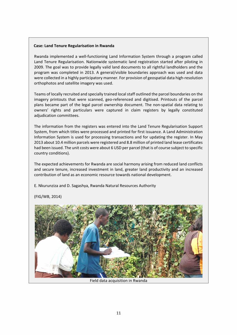
Case: Land Tenure Regularisation in Rwanda Rwanda implemented a well‐functioning Land Information System through a program called Land Tenure Regularisation. Nationwide systematic land registration started after piloting in 2009. The goal was to provide legally valid land documents to all rightful landholders and the program was completed in 2013. A general/visible boundaries approach was used and data were collected in a highly participatory manner. For provision of geospatial data high‐resolution orthophotos and satellite imagery was used.
Teams of locally recruited and specially trained local staff outlined the parcel boundaries on the imagery printouts that were scanned, geo‐referenced and digitised. Printouts of the parcel plans became part of the legal parcel ownership document. The non‐spatial data relating to owners’ rights and particulars were captured in claim registers by legally constituted adjudication committees.
The information from the registers was entered into the Land Tenure Regularisation Support System, from which titles were processed and printed for first issuance. A Land Administration Information System is used for processing transactions and for updating the register. In May 2013 about 10.4 million parcels were registered and 8.8 million of printed land lease certificates had been issued. The unit costs were about 6 USD per parcel (that is of course subject to specific country conditions).
The expected achievements for Rwanda are social harmony arising from reduced land conflicts and secure tenure, increased investment in land, greater land productivity and an increased contribution of land as an economic resource towards national development.
E. Nkurunziza and D. Sagashya, Rwanda Natural Resources Authority
(FIG/WB, 2014)
Field data acquisition in Rwanda

12
6. KEY DEMANDS FOR IMPLEMENTATION
The FFP approach aims to build country wide land administration systems providing secure tenure for
all. However, within the country context, some areas may be difficult to cover and there may be some
specific legal or institutional issues that call for further consideration. In this regard, implementation
of the FFP approach should not be held back for solving some specific issues, when the major part of
the country, say 80 per cent, can be covered straight forwardly using this approach. The remaining,
say 20 per cent, can then be completed once the specific issues are solved. More generally this 80/20
per cent distribution is known as the Pareto principle.
A key demand for implementation, of course, relates to developing the necessary capacity for building
and maintaining the systems. It is critical to ensure that the systems, once they are built, can be
properly and immediately maintained in terms of ongoing updating so that the systems are complete
and reliable at any time. Therefore, a capacity development strategy should be adopted up front
before starting the project. Another demand is about assessing the costs and establishing the
budgetary base for building the systems, e.g. by seeking development aid support such as through the
World Bank. And, most importantly, there is a fundamental requirement for strong political
commitment and leadership for adopting the project and keeping it on the track for achieving the
goals and outputs in terms of benefits for society, businesses and citizens. However, recent
experiences have shown that it is possible – as shown in the case of Rwanda above.
The FFP approach is participatory and inclusive – it is fundamentally a human rights approach. Further
benefits relate to the opportunity of building appropriate systems within a relatively short time and
for relatively low and affordable costs. This will enable political aims such economic growth, social
equity and environmental sustainability to be better supported, pursued and achieved.
7. CONCLUDING REMARKS
Most developing countries are struggling to find remedies for their many land problems that are
causing land conflicts, reducing economic development and preventing their countries reaching their
true potential. The FFP approach provides developing countries with a new, innovative and pragmatic
solution to land administration. The country specific solution is directly aligned with immediate needs,
is affordable, is flexible to accommodate different types of land tenure and can be upgraded when
economic or social requirements and opportunities arise. It is highly participatory, can be
implemented quickly and will provide security of tenure for all. Most importantly, the FFP approach
can start very quickly using a low risk entry point that requires minimal preparatory work.
The politicians and decision makers in the land sector are key in this change process and need to
become advocates of change through understanding the social, environmental and economic benefits
of this journey of change. This top‐level support for change will then allow any barriers to changes in
the legal framework and the professions to be dismantled. However, in many developing countries
land issues are highly political and controversial. Therefore, drivers for change cannot just be designed
at the highest levels, but will have to be initiated through influencers at other entry points in the
network of stakeholders across the land sector; and written in a language that they can understand.
The UN family of organizations has a significant role to play in this advocacy for change. GLTN will have
a pivotal role in disseminating the messaging for change and providing tools to support change. The
World Bank, UN‐GGIM, UN‐HABITAT and UN‐FAO should ensure that the land administration projects

13
they support are designed around FFP by default. The FFP approach for land administration directly
supports the implementation of the VGGTs. There are opportunities for the FFP approach for land
administration to be used innovatively in areas of priority for the UN, such as post‐conflict situations.
Support of these high profile applications of FFP will help to promote the importance and gain support
for the FFP approach.
Effective capacity building is fundamental to success. Society must understand that these simpler, less
expensive and participatory methods are just as effective and secure as conventional surveying
methodologies. Formal organizations such as government agencies, private sector organizations and
informal organizations, such as community based or voluntary organizations, need to ensure the
awareness and up‐to‐date skills of their members and staff. Although there are short‐term training
needs to effect FFP approaches in land administration, there is a longer‐term capacity building
initiative required to create a new generation of land professionals who have deep understanding of
the FFP approach to land administration and the ICT management of land.
It is hoped that the FFP approach as presented in this paper – and more comprehensively in (Enemark,
et al., 2016) – will pave the way forward towards implementing sustainable and affordable land
administration systems enabling security of tenure for all and effective management of land use and
natural resources. This, in turn, will facilitate economic growth, social equity, and environmental
sustainability.
BIOGRAPHICAL NOTES
Stig Enemark is Honorary President of the International Federation of
Surveyors, FIG (President 2007‐2010). He is a Senior Consultant and
Professor Emeritus of Land Management, Department of Planning, Aalborg
University, Denmark. He is a well‐known international expert in the areas
of land administration systems, land management, spatial planning and
related issues of education and capacity development. He has consulted
and published widely within these areas. For a full list of more than 400
publications, see http://personprofil.aau.dk/100037

14
REFERENCES
AUC/UNECA/ADB (2009): Framework and Guidelines on Land Policies in Africa.
http://www.uneca.org/sites/default/files/PublicationFiles/fg_on_land_policy_eng.pdf
Byamugisha, F. (2013): Sharing Africa´s Land for Shared prosperity. A Program to Scale up Reforms
and Investments. World Bank, Washington.
http://www.scribd.com/doc/144377306/Securing‐Africa‐s‐Land‐for‐Shared‐Prosperity
Enemark, S. (2004): Building Land Information Policies. Proceedings of United Nations, FIG and PC IDEA
Inter‐regional Special Forum on the Development of Land Information Policies in the Americas.
Aguascalientes, México, 26‐27 October 2004.
http://www.fig.net/resources/proceedings/2004/mexico/papers_eng/ts2_enemark_eng.pdf
Enemark, S. (2014): Global Agenda for Sustainable Development. Geospatial World, April 2014, pp 24‐
32. www.geospatialworld.net/Magazine/MArticleView.aspx?aid=30949
Enemark, S., Bell, C., McLaren, R., Lemmen, C. (2014): Fit‐For‐Purpose Land Administration. FIG
Publications No 60, FIG Office, Copenhagen.
http://www.fig.net/pub/figpub/pub60/figpub60.htm
Enemark, S., McLaren, R., Lemmen, C. (2016): Fit‐For‐Purpose Land Administration – Guiding Principles
for Country Implementation. UN‐HABITAT / GLTN, Nairobi, Kenya.
http://www.gltn.net/index.php/publications/publications/download/2‐gltn‐documents/2332‐
fit‐for‐purpose‐land‐administration‐guiding‐principles‐for‐country‐implementation
FIG / GLTN (2010): The Social Tenure Domain Model – A pro‐poor land tool. FIG Publications No 52,
FIG Office, Copenhagen.
http://www.fig.net/resources/publications/figpub/pub52/figpub52.pdf
Grant, D. and Haanen, A. (2007): Best Regulation Cadastral Surveys. GIM International, July 2007.
http://www.gim‐international.com/content/article/best‐regulation‐cadastral‐
surveys?output=pdf
UN (2014): The Millennium Development Goals Report 2014.
http://www.un.org/en/development/desa/publications/mdg‐report‐2014.html
UN (2015): Transforming our World: the 2030 Agenda for Sustainable Development. UN‐ General
Assembly resolution on 25 September 2015, p. 1‐14.
http://www.un.org/ga/search/view_doc.asp?symbol=A/RES/70/1&Lang=E
UNEP (2007). World economy cartogram. http://www.grida.no/graphicslib/detail/world‐economy‐cartogram_1551
UN‐FAO (2007): Good Governance in Land Tenure and Administration. FAO Land Tenure Studies No 9.
Rome. ftp://ftp.fao.org/docrep/fao/010/a1179e/a1179e00.pdf
UN‐FAO (2012): Voluntary Guidelines on the Responsible Governance of Tenure of Land, Fisheries and
Forests in the Context of Food Security. Rome.
http://www.fao.org/docrep/016/i2801e/i2801e.pdf
UN‐HABITAT, GLTN (2008): Secure Land Rights for All.
https://www.responsibleagroinvestment.org/sites/responsibleagroinvestment.org/files/Secure
%20land%20rights%20for%20all‐UN%20HABITAT.pdf
UN‐HABITAT, GLTN (2012): Handling Land – Innovative Tools for Land Governance and Secure Tenure.
Nairobi. http://www.unhabitat.org/pmss/listItemDetails.aspx?publicationID=3318
Williamson, I., Enemark, S., Wallace, J., Rajabifard, A. (2010): Land Administration Systems for
Sustainable Development. ESRI Academic Press, Redlands, California, USA.
http://www.esri.com/landing‐pages/industries/land‐administration/e‐
book#sthash.Lp4BYcKW.vmY1XWxG.dpbs