Embed Size (px)
Citation preview

A Deep Learning-based Radar and Camera SensorFusion Architecture for Object Detection
Felix Nobis∗, Maximilian Geisslinger†, Markus Weber‡, Johannes Betz and Markus LienkampChair of Automotive Technology, Technical University of Munich
Munich, GermanyEmail: ∗[email protected], †[email protected], ‡[email protected]
©2019 IEEE. Personal use of this material is permitted. Permission from IEEE must be obtained for all other uses, in any current or future media, includingreprinting/republishing this material for advertising or promotional purposes, creating new collective works, for resale or redistribution to servers or lists, orreuse of any copyrighted component of this work in other works.
Abstract—Object detection in camera images, using deep learninghas been proven successfully in recent years. Rising detectionrates and computationally efficient network structures are push-ing this technique towards application in production vehicles.Nevertheless, the sensor quality of the camera is limited in severeweather conditions and through increased sensor noise in sparselylit areas and at night. Our approach enhances current 2D objectdetection networks by fusing camera data and projected sparseradar data in the network layers. The proposed CameraRadarFu-sionNet (CRF-Net) automatically learns at which level the fusionof the sensor data is most beneficial for the detection result.Additionally, we introduce BlackIn, a training strategy inspiredby Dropout, which focuses the learning on a specific sensor type.We show that the fusion network is able to outperform a state-of-the-art image-only network for two different datasets. Thecode for this research will be made available to the public at:https://github.com/TUMFTM/CameraRadarFusionNet
Index Terms—Sensor Fusion, Object Detection, Deep Learning,Radar Processing, Autonomous Driving, Neural Networks, Neu-ral Fusion, Raw Data Fusion, Low Level Fusion, Multi-modalSensor Fusion
I. INTRODUCTION
In recent years convolutional neural networks (CNN) havebeen established as the most accurate methods for performingobject detection in camera images [1]. The visual repre-sentation of the environment in camera images is closelylinked to human visual perception. As humans perceive thedriving environment mainly via their visual sense, it is wellmotivated for autonomous vehicles to rely on a comparablerepresentation. However, in adverse conditions like heavy rainor fog, the visibility is reduced, and safe driving might notbe guaranteed. In addition, camera sensors get increasinglyaffected by noise in sparsely lit conditions. Compared tocamera sensors, radar sensors are more robust to environmentconditions such as lighting changes, rain and fog [2]. Thecamera can be rendered unusable through weather-inducedocclusion e.g. if water droplets stick to the camera lens andblock the view, as shown in Figure 1.
In this paper, we investigate the fusion of radar and camerasensor data with a neural network, in order to increase theobject detection accuracy. The radar acquires informationabout the distance and the radial velocity of objects directly. It
Fig. 1: Van occluded by a water droplet on the lens
is able to locate objects in a two-dimensional plane parallel tothe ground. In contrast to the camera, no height informationcan be obtained by the radar sensor. We develop a networkarchitecture that deals with camera and radar sensor datajointly. The proposed method is able to detect objects morereliably in the nuScenes dataset [3] and the TUM datasetwhich is created for this research. Additionally, we show thelimitations of our fusion network and directions for futuredevelopment.
Section II discusses related methods for object detection andsensor fusion. Section III describes our method to preprocessthe radar data before fusing it into the network. We continue todescribe the network architecture in Section IV. The evaluationand discussion of the approach is performed in Section V.Finally, our conclusions from the work are presented inSection VI.
II. RELATED WORK
[4] were the first to successfully implement a convolutionalneural network for the classification of images that outper-formed the state-of-the-art in the ImageNet competition. Thismarked a starting point for increased interest in researchinto image processing with neural networks. Sebsequently,
arX
iv:2
005.
0743
1v1
[cs
.CV
] 1
5 M
ay 2
020

neural network architectures for classification are augmentedto perform additional tasks such as object detection [5] andsemantic segmentation [6]. Several network meta-architecturesfor object detection exist, which build upon a variety ofconvolutional layer designs for feature extraction. In termsof real-time application, single shot architectures have beenshown to perform accurately while keeping computationaltimes reasonably low [7]. In recent years, new feature ex-traction architectures have been proposed which increase theobject detection performance when employed in a given meta-architecture [8]–[11]. Recently, further studies emerged toautomatically fine-tune an initial neural network design toincrease the detection performance or minimize the run-time,without effecting the detection performance significantly [12],[13].
The success of neural networks for image data processinghas led to an adaption to additional sensor principles and tosensor fusion. By incorporating multi-modal sensor data in thesensor fusion, researchers aim to obtain more reliable resultsfor the different tasks involved in environmental perceptionfor autonomous vehicles. [14] projects lidar data onto the 2Dground plane as a bird’s-eye view and fuse it with camera datato perform 3D object detection. [15] projects the lidar ontothe ground plane and onto a perpendicular image plane, andfuses both representations with the camera image in a neuralnetwork for object detection. [16] fuses lidar and cameradata in a neural network to segment the driveable road. Thepaper proposes a network structure which consists of twobranches for lidar and camera input. The interconnections ofthese branches are trainable so that the network can learn anoptimized depth level in the network for the data fusion duringthe training process. [17] uses a similar fusion approach whileoperating with a bird’s-eye view projection for both cameraand lidar.
Convolutional neural networks are widely applied to operateon regular 2D grids (e.g. images) or 3D grids (e.g. voxels). The3D lidar object detection approaches discussed above applythe idea of transforming unstructured lidar point clouds ontoa regular grid before feeding it into a neural network. Weemploy the same process to the radar data.
[18] uses radar detections to create regions of interest incamera images, in order to classify objects in these regionsusing a simple neural network. A similar approach of usingthe radar to guide the object detection in the image spaceis performed in a series of other works [19]–[22]. [23] fuseindependent detections of the camera and radar in order toassociate the distance measurements of the radar with objectsin the image space. [24] fuses independently tracked detectionsof each sensor to generate one final position estimation whichincorporates the readings of both sensors. [25] present adeep learning approach with Generative Adversarial Networks(GANs) to fuse camera data and radar data, incorporated intoa 2D bird’s-eye view grid map, in order to perform free spacedetection.
[26] gives an overview of deep learning methods for sensorfusion. They conclude that raw level fusion methods for imageand radar data have merely been investigated to date, andthat more research needs to be conducted in this respect.[27] projects low level radar data onto a camera image planeperpendicular to the road, and proposes a neural network forthe fusion with the camera image. They use the range andthe range rate of the radar as additional image channels. Thepaper proposes two fusion strategies by concatenation or byelement-wise addition on a fixed layer after initial separatedlayers for the sensors. They show the benefit of the fusionstrategy for a self-recorded dataset.
In this paper, we use a similar projection approach to [27] toproject the radar data onto the vertical plane of the cameraimage with which it is fused. We propose a fusion networkthat is able to learn the network depth at which the fusionis most beneficial to reduce the network loss. We operate inthe image space to operate with 2D ground-truth data whichsignificantly facilitates training data generation in comparisonto 3D labels.
Due to the range rate measurement, moving objects can bedistinguished from their surroundings in the radar data. Forpractical applications such as Adaptive Cruise Control (ACC),filtering for moving objects is applied to reduce the amount offalse postives in the radar returns. At the same time, importantstationary objects, e.g. cars stopped in front of a traffic lights,will be filtered out as well. In this approach no filtering formoving objects is performed, so that we are able to detectstationary and moving traffic objects alike.
III. RADAR DATA PREPROCESSING
This section describes the projection of the radar data to theimage plane that is used in our fusion approach. We describethe spatial calibration of the camera and radar sensors, howto deal with the missing height information from the radarreturns, how to deal with the sparsity of the radar data, andground-truth filtering methods to reduce the noise or clutter inthe radar data.
The radar sensor outputs a sparse 2D point cloud with associ-ated radar characteristics. The data used for this work includesthe azimuth angle, the distance and the radar cross section(RCS). We transform the radar data from the 2D ground planeto a perpendicular image plane. The characteristics of the radarreturn are stored as pixel values in the augmented image. Atthe location of image pixels where no radar returns are present,the projected radar channel values are set to the value 0. Theinput camera image consists of three channels (red, green,blue); to this we add the aforementioned radar channels asthe input for the neural network. In our own dataset, the fieldof view (FOV) of three radars overlap with the FOV of thefront-facing fish-eye camera. We concatenate the point cloudsof the three sensors into one and use this as the projected radarinput source. The projection differs, as the nuScenes dataset

uses a 70° FOV camera while the TUM dataset uses a 185°FOV fish-eye camera. In the nuScenes dataset, camera intrinsicand extrinsic mapping matrices are provided to transform apoint from world coordinates into image coordinates. The non-linearities of a fish-eye lens cannot be mapped with a linearmatrix operation. We use the calibration method presented by[28] to map the world coordinates to the image coordinatesfor our own data.
The radar detections give no information about the height atwhich they were received, which increases the difficulty tofuse the data types. The 3D coordinates of the radar detectionsare assumed to be returned from the ground plane that thevehicle is driving on. The projections are then extended inperpendicular direction to this plane, so as to account forthe vertical extension of the objects to be detected. Wedetect traffic objects which can be classified as cars, trucks,motorcycles, bicycles and pedestrians. To cover the height ofsuch object types, we assume a height extension of the radardetections of 3m to associate camera pixels with radar data.The radar data is mapped with a pixel width of one into theimage plane.
The camera data in the nuScenes dataset is captured at aresolution of 1600× 900 = 1, 440, 000 pixels at an openingangle of 70° for the front camera. The lidar returns up to14, 000 points for the same horizontal opening angle [29].On a fraction of the nuScenes dataset (nuScenes mini), wecalculated an average of 57 radar detections per cycle for thefront radar. The greater variety in the density of the radar andthe camera data - in comparison to the lidar and the camera -poses the challenge of finding a suitable way to fuse the datain one shared network structure. For our own dataset, we usethe Continental ARS430 radar which has a different outputformat but comparable radar characteristics to the radar usedin nuScenes. To deal with the sparsity of radar data, [25] usesprobabilistic grid maps to generate continuous informationfrom the radar. In this work, we increase the density of radardata by jointly fusing the last 13 radar cycles (around 1 s) toour data format. Ego-motion is compensated for this projectionmethod. Target-vehicle motion cannot be compensated. Thefusion of previous time steps adds to the information densityof the radar input. At the same time, it can also add noise tothe input data as the detections of moving objects at previoustime steps do not align with the current object position. Thisdrawback is tolerated to obtain an information gain due tothe additional data. Figure 2a shows the input data format forthe neural network in an exemplary scene. The radar channels(distance and RCS) are mapped to the same locations andtherefore shown in a uniform color.
The radar returns many detections coming from objects whichare not relevant for the driving task, such as ghost objects,irrelevant objects and ground detections. These detections arecalled clutter or noise for the task at hand. In the evaluation,we compare the fusion of the raw noisy radar data with twoadditionally filtered approaches. First, in the nuScenes dataset,
(a) Without ground-truth noise filter
(b) With ground-truth noise filter
Fig. 2: nuScenes sample with radar projection to the imageplane for the last 13 radar cycles. Radar channels are shownin yellow. The red color shift depicts increasing distances. Bestviewed in color.
only a fraction of the labeled objects is detected by the radar.In training and evaluation, we therefore apply an annotationfilter (AF), so that the filtered ground-truth data only containsobjects which yield at least one radar detection. This is donevia associating the 3D bounding boxes with radar points. Thefusion approach is expected to show its potential for thoseobjects which are detectable in both modalities. Second, weapply a ground-truth filter to the radar data which removesall radar detections outside of the 3D ground-truth boundingboxes. Of course, this step cannot be performed if appliedto a real scenario. It is employed here to show the generalfeasibility of the fusion concept with less clutter in the inputsignal. The radar data after the application of the filter is shownin Figure 2b. Note, that the ground-truth radar filter (GRF)does not output perfect radar data and partly filters out relevantdetections from the data for four reasons. First, we do notcompensate the motion of other objects when we concatenatethe past radar detections in the input. As the nuScenes datasetis labeled at 2Hz, no ground-truth is available for intermediateradar detection cycles, radar object detections only present inintermediate cycles are possibly filtered out. Second, slightspatial miscalibrations between the radar and camera sensorsresult in a misalignment of the radar detection locations and
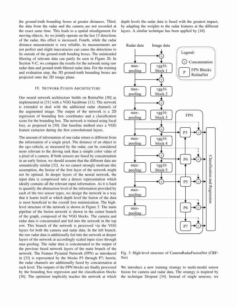
the ground-truth bounding boxes at greater distances. Third,the data from the radar and the camera are not recorded atthe exact same time. This leads to a spatial misalignment formoving objects. As we jointly operate on the last 13 detectionsof the radar, this effect is increased. Fourth, while the radardistance measurement is very reliable, its measurements arenot perfect and slight inaccuracies can cause the detections tolie outside of the ground-truth bouding boxes. The unintendedfiltering of relevant data can partly be seen in Figure 2b. InSection V-C, we compare the results for the network using rawradar data and ground-truth filtered radar data. For the trainingand evaluation step, the 3D ground-truth bounding boxes areprojected onto the 2D image plane.
IV. NETWORK FUSION ARCHITECTURE
Our neural network architecture builds on RetinaNet [30] asimplemented in [31] with a VGG backbone [11]. The networkis extended to deal with the additional radar channels ofthe augmented image. The output of the network is a 2Dregression of bounding box coordinates and a classificationscore for the bounding box. The network is trained using focalloss, as proposed in [30]. Our baseline method uses a VGGfeature extractor during the first convolutional layers.
The amount of information of one radar return is different fromthe information of a single pixel. The distance of an object tothe ego-vehicle, as measured by the radar, can be consideredmore relevant to the driving task than a simple color value ofa pixel of a camera. If both sensors are fused by concatenationin an early fusion, we should assume that the different data aresemantically similar [32]. As we cannot strongly motivate thisassumption, the fusion of the first layer of the network mightnot be optimal. In deeper layers of the neural network, theinput data is compressed into a denser representation whichideally contains all the relevant input information. As it is hardto quantify the abstraction level of the information provided byeach of the two sensor types, we design the network in a waythat it learns itself at which depth level the fusion of the datais most beneficial to the overall loss minimization. The high-level structure of the network is shown in Figure 3. The mainpipeline of the fusion network is shown in the center branchof the graph, composed of the VGG blocks. The camera andradar data is concatenated and fed into the network in the toprow. This branch of the network is processed via the VGGlayers for both the camera and radar data. In the left branch,the raw radar data is additionally fed into the network at deeperlayers of the network at accordingly scaled input sizes throughmax-pooling. The radar data is concatenated to the output ofthe previous fused network layers of the main branch of thenetwork. The Feature Pyramid Network (FPN) as introducedin [33] is represented by the blocks P3 through P7; herein,the radar channels are additionally fused by concatenation ateach level. The outputs of the FPN blocks are finally processedby the bounding box regression and the classification blocks[30]. The optimizer implicitly teaches the network at which
depth levels the radar data is fused with the greatest impact,by adapting the weights to the radar features at the differentlayers. A similar technique has been applied by [16].
Legend:
FPN
vgg16
block 1
Radar data Image data
max-
pooling
+
vgg16
block 2
+
vgg16
block 3
+
vgg16
block 4
+
vgg16
block 5
+
max-
pooling
max-
pooling
max-
pooling
max-
pooling
max-
pooling
max-
pooling
P4
P5
P6
P7
+P3
+
+
+
+
+
Classificatio
nan
dR
egressio
n
+ Concatenation
PFPN Blocks
RetinaNet
Fig. 3: High-level structure of CameraRadarFusionNet (CRF-Net)
We introduce a new training strategy to multi-modal sensorfusion for camera and radar data. The strategy is inspired bythe technique Dropout [34]. Instead of single neurons, we
simultaneously deactivate all input neurons for the cameraimage data, for random training steps. This is done at a rate of0.2 of all training images. We call this technique BlackIn. [35]introduced BlackOut which is inspired by dropout on the finallayer of the network. The absence of camera input data pushesthe network to rely more on the radar data. The goal is to teachthe network the information value of the sparse radar dataindependently of the much denser camera representation. Webegin the training with weights that are pretrained on imagesfor the feature extractor. The training focus towards the radar,additionally intends to overcome this bias.
V. EXPERIMENTS AND RESULTS
In this section, we evaluate the network on the nuScenesdataset and a second dataset collected during the work forthis paper. We compare our CameraRadarFusionNet (CRF-Net) with the baseline network, which is our adapted imple-mentation of RetinaNet [30].
A. Datasets
a) nuScenes dataset: The nuScenes dataset is extensivelydescribed in [3]. It is recorded in various locations andconditions in Boston and in Singapore. We condense theoriginal 23 object classes into the classes shown in Table I forour detection evaluation. The nuScenes results are evaluatedwith and without the application of ground-truth filters.
TABLE I: Number of objects per object class in nuScenes andour dataset
Object classes nuScenes TUMCar 22591 4020Bus 1332 109
Motorcycle 729 10Truck 5015 14Trailer 1783 45Bicycle 616 438Human 10026 678
b) Our data (TUM): We utilize the same classes for evalua-tion as for the nuScenes dataset. Our dataset is annotated with2D bounding boxes using the Computer Vision AnnotationTool (CVAT) [36]. As we lack 3D ground-truth data, noadditional ground-truth filter can be applied to this datasetduring the training and validation step. We reduce the defaultanchor sizes of RetinaNet by a factor two for our dataset, asthe objects appear smaller on the fish-eye images.
B. Training
We create an 60:20:20 split from the raw data of nuScenesto balance the amount of day, rain and night scenes in thetraining, validation and test set. We use the nuScenes imagesat an input size of 360 x 640 pixels. The fish-eye images of ourdataset are processed at 720 x 1280 pixel resolution. Objectsgenerally appear smaller in the fish-eye images which we
want to compensate with the augmentation of the resolution.We weight the object classes according to the number ofappearances in the respective datasets for the mean AveragePrecision (mAP) calculation.
The weights of the VGG feature extractor are pretrained onthe Imagenet dataset [37]. During preprocessing, the cam-era image channels are min-max scaled to the interval [-127.5,127.5], the radar channels remain unscaled. We performdata augmentation on our dataset because the amount oflabeled data is relatively small. The number of objects perclass for each dataset is shown in Table I.
Training and evaluation are performed with an Intel XeonSilver 4112 CPU, 96GB RAM and a NVIDIA Titan XP GPU.On the nuScenes dataset, the networks are trained for 25epochs and a batch size of 1 in a period of about 22 hoursfor the baseline network and about 24 hours for the CRF-Net.On our dataset, the networks are trained for 50 epochs and abatch size of 1 over a period of about 18 hours.
C. Evaluation
Table II shows the mean average precision for different con-figurations of our proposed network. The first block showsthe results on the nuScenes dataset. The fusion network isachieving comparable but slightly higher detection results thanthe image network for the raw data inputs. The CRF-Nettrained with BlackIn achieves a mAP of 0.35 %-points morethan without BlackIn. In the next step, we apply the annotationfilter (AF) which considers only objects which are detectedby at least one radar point. When the network additionallylearns on ground-truth filtered radar data (AF, GRF), the mAPadvantage of the CRF-Net rises to 12.96 %-points compared tothe image baseline (AF). The last line of the nuScenes blockshows an additional comparison study. The radar channels arereduced to one channel which indicates solely the existenceor non-existence of a radar detection in the image plane. Thedrop in the mAP score shows that the radar meta data, e.g.distance and RCS, are important for the detection result.
The second block of Table II shows the data for our owndataset. The performance gain of the fusion network comparedto the baseline (1.4 %-points) is greater for our data thanfor nuScenes. This could be due to the use of three partlyoverlapping radars in our data and due to the use of a moreadvanced radar sensor. In addition, we labeled objects thatappear small in the images in our dataset; in the nuScenesdataset, objects at a distance greater than 80m are mostly notlabeled. As suggested in [27], it is possible that the radar isbeneficial especially for objects at a greater distance from theego vehicle. The camera data differs in both datasets due to thedifferent lens characteristics and the different input resolutions,so that a definite reason cannot be given here.
Figure 4 qualitatively illustrates the superiority of the objectdetection with the CRF-Net for an example scene.

TABLE II: mAP scores of the baseline network and ourCameraRadarFusionNet. Configurations: (AF) - Annotationfilter, (GRF) - ground-truth radar filter, (NRM) - No radarmeta data
Data Network mAPnu
Scen
es
Baseline image network 43.47 %CRF-Net w/o BlackIn 43.6 %
CRF-Net 43.95 %Baseline image network (AF) 43.03 %
CRF-Net (AF) 44.85 %CRF-Net (AF, GRF) 55.99 %
CRF-Net (AF, GRF, NRM) 53.23 %
TU
M Baseline image network 56.12 %CRF-Net 57.50 %
(a) Baseline network detection
(b) CRF-Net detection
Fig. 4: Detection comparison of the baseline network (a) andthe CRF-Net (b). The baseline network does not detect thepedestrian on the left.
The overall higher mAPs for the fusion network comparedto the baseline presented in Table II show the potential ofthe fusion approach. This potential motivates further researchtowards an ideal network architecture for this type of fusion.The performance gain for ground-truth filtered radar data mo-tivates the development of a non-ground-truth based filteringmethod for the radar data during preprocessing, or inside theneural network. In future work, we will continue research intofiltering out noisy radar detections before feeding them into
the fusion network, to improve the results for the applicationunder real-world conditions.
The baseline network needs 33ms for the processing of oneimage at a size of 360 x 640 pixels. The CRF-Net needs43ms for the processing of the corresponding fused data.Additionally the data processing for the radar projection andchannel generation amounts to 56ms of CPU time. Thetime needed for the processing of the ground-truth filters isnegligible. In our TUM dataset, we input the data at a higherresolution, which results in increased execution times. Thebaseline network processing takes 92ms, the CRF-Net needs103ms, the data generation takes 333ms. In this dataset moreradar data is used and the projection is done with a fish-eyeprojection method which adds to the data generation time.However, the data generation is not optimized and the valuesare given as a reference to present the current status of theimplementation.
VI. CONCLUSIONS AND OUTLOOK
This paper proposes the CameraRadarFusion-Net (CRF-Net)architecture to fuse camera and radar sensor data of roadvehicles. The research adapts ideas from lidar and cameradata processing and shows a new direction for fusion withradar data. Difficulties and solutions to process the radar dataare discussed. The BlackIn training strategy is introduced forthe fusion of radar and camera data. We show that the fusionof radar and camera data in a neural network can augment thedetection score of a state-of-the-art object detection network.This paper lends justification to a variety of areas for furtherresearch. As neural fusion for radar and camera data has onlyrecently been studied in literature, finding optimized networkarchitectures needs to be explored further.
In the future, we plan research to design network layers toprocess the radar data prior to the fusion, so as to filter outnoise in the radar data. The fusion with additional sensormodalities such as lidar data could further increase the detec-tion accuracy, while at the same time adding complexity byaugmenting the layers or through the need to introduce newdesign concepts. The study of the robustness of neural fusionapproaches against spatial and temporal miscalibration of thesensors needs to be evaluated. We see an increased potentialfor multi-modal neural fusion for driving in adverse weatherconditions. Additional datasets modeling these conditions needto be created to study this assumption. Lastly, as the radar sen-sor introduces distance information into the detection scheme,the applicability of the fusion concept to 3D object detectionis a direction we want to explore.
On the hardware side, high-resolution or imaging radars [38]are expected to increase the information density of radar dataand reduce the amount of clutter. The hardware advancementis expected to enable an increase in the detection results ofour approach.

CONTRIBUTIONS AND ACKNOWLEDGMENTS
Felix Nobis initiated the idea of this paper and contributed es-sentially to its conception and content. Maximilian Geisslingerand Markus Weber wrote their master theses in the researchproject and contributed to the conception, implementation andexperimental results of this research. Johannes Betz revisedthe paper critically. Markus Lienkamp made an essentialcontribution to the conception of the research project. Herevised the paper critically for important intellectual content.He gave final approval of the version to be published andagrees to all aspects of the work. As a guarantor, he accepts theresponsibility for the overall integrity of the paper. We expressgratitude to Continental Engineering Service for funding forthe underlying research project and for providing the sensorhardware and guidance for this research.
REFERENCES
[1] T.-Y. Lin, G. Patterson, M. R. Ronchi, and Y. Cui, “Common objects incontext,” 2019. [Online]. Available: http://cocodataset.org/#detection-leaderboard
[2] F. de Ponte Muller, “Survey on ranging sensors and cooperative tech-niques for relative positioning of vehicles,” Sensors (Basel, Switzerland),vol. 17, no. 2, 2017.
[3] H. Caesar, V. Bankiti, A. H. Lang, S. Vora, V. E. Liong, Q. Xu, A. Kr-ishnan, Y. Pan, G. Baldan, and O. Beijbom, “nuscenes: A multimodaldataset for autonomous driving,” arXiv preprint arXiv:1903.11027, 2019.
[4] A. Krizhevsky, I. Sutskever, and G. E. Hinton, “Imagenet classificationwith deep convolutional neural networks,” in Proceedings of the 25thInternational Conference on Neural Information Processing Systems- Volume 1, ser. NIPS’12. USA: Curran Associates Inc, 2012,pp. 1097–1105. [Online]. Available: http://dl.acm.org/citation.cfm?id=2999134.2999257
[5] J. Huang, V. Rathod, C. Sun, M. Zhu, A. Korattikara, A. Fathi,I. Fischer, Z. Wojna, Y. Song, S. Guadarrama, and K. Murphy,“Speed/accuracy trade-offs for modern convolutional object detectors.”[Online]. Available: http://arxiv.org/pdf/1611.10012v3
[6] J. Long, E. Shelhamer, and T. Darrell, “Fully convolutional networksfor semantic segmentation,” IEEE Conference on Computer Vision andPattern Recognition, 2015.
[7] W. Liu, D. Anguelov, D. Erhan, C. Szegedy, S. Reed, C.-Y. Fu, andA. C. Berg, “Ssd: single shot multibox detector,” European Conferenceon Computer Vision, vol. 9905, pp. 21–37, 2016.
[8] K. He, X. Zhang, S. Ren, and J. Sun, “Deep residual learning for imagerecognition,” in 29th IEEE Conference on Computer Vision and PatternRecognition. Piscataway, NJ: IEEE, 2016, pp. 770–778.
[9] J. Redmon, S. Divvala, R. Girshick, and A. Farhadi, “You only lookonce: Unified, real-time object detection,” in 2016 IEEE Conference onComputer Vision and Pattern Recognition (CVPR), 2016.
[10] S. Ren, K. He, R. Girshick, and J. Sun, “Faster r-cnn: Towards real-timeobject detection with region proposal networks,” in Advances in NeuralInformation Processing Systems 28. Curran Associates, Inc, 2015, pp.91–99.
[11] K. Simonyan and A. Zisserman, “Very deep convolutional networks forlarge-scale image recognition,” Seventh International Conferenceon Learning Representations, 2015. [Online]. Available: https://arxiv.org/pdf/1409.1556.pdf
[12] Y. He, J. Lin, Z. Liu, H. Wang, L.-J. Li, and S. Han, “Amc: Automlfor model compression and acceleration on mobile devices,” ECCV’18,2018.
[13] M. Tan and Q. Le V, “Efficientnet: Rethinking model scaling forconvolutional neural networks,” International Conference on MachineLearning, 2019.
[14] J. Ku, M. Mozifian, J. Lee, A. Harakeh, and S. Waslander, “Joint 3dproposal generation and object detection from view aggregation,” IROS,2018.
[15] X. Chen, H. Ma, J. Wan, B. Li, and T. Xia, “Multi-view 3d objectdetection network for autonomous driving.”
[16] L. Caltagirone, M. Bellone, L. Svensson, and M. Wahde, “Lidar-camerafusion for road detection using fully convolutional neural networks,”Robotics and Autonomous Systems, no. 111, pp. 125–131, 2018.
[17] D. Yu, H. Xiong, Q. Xu, J. Wang, and K. Li, “Multi-stage residual fusionnetwork for lidar-camera road detection,” IEEE Intelligent VehiclesSymposium, 2019.
[18] Z. Ji and D. V. Prokhorov, “Radar-vision fusion for object classification,”11th International Conference on Information Fusion, 2008.
[19] J. Kocic, N. Jovicic, and V. Drndarevic, “Sensors and sensor fusion inautonomous vehicles,” in TELFOR 2018. Belgrade: Telecommunica-tions Society and Academic Mind, 2018, pp. 420–425.
[20] S. Han, X. Wang, L. Xu, H. Sun, and N. Zheng, “Frontal objectperception for intelligent vehicles based on radar and camera fusion,”in Proceedings of the 35th Chinese Control Conference, J. Chen andQ. Zhao, Eds. Piscataway, NJ: IEEE, 2016, pp. 4003–4008.
[21] X. Zhang, M. Zhou, P. Qiu, Y. Huang, and J. Li, “Radar and visionfusion for the real-time obstacle detection and identification,” IndustrialRobot: the international journal of robotics research and application,vol. 2007, no. 2, p. 233, 2019.
[22] S. Zeng, W. Zhang, and B. B. Litkouhi, “Fusion of obstacle detectionusing radar and camera,” Patent US 9.429,650 B2, 2016.
[23] H. Jha, V. Lodhi, and D. Chakravarty, “Object detection and identi-fication using vision and radar data fusion system for ground-basednavigation,” in 2019 6th International Conference on Signal Processingand Integrated Networks (SPIN). IEEE, 2019, pp. 590–593.
[24] K.-E. Kim, C.-L. Lee, D.-S. Pac, and M.-T. Lim, Sensor Fusion forVehicle Tracking with Camera and Radar Sensor: 2017 17th Interna-tional Conference on Control, Automation and Systems : proceedings: October 18-21, 2017, Ramada Plaza, Jeju, Korea. Piscataway, NJ:IEEE, 2017.
[25] V. Lekic and Z. Babic, “Automotive radar and camerafusion using generative adversarial networks,” ComputerVision and Image Understanding, 2019. [Online]. Avail-able: https://www-sciencedirect-com.eaccess.ub.tum.de/science/article/pii/S1077314219300530?via%3Dihub
[26] Di Feng, C. Haase-Schuetz, L. Rosenbaum, H. Hertlein, F. Duffhauss,C. Glaser, W. Wiesbeck, and K. Dietmayer, “Deep multi-modal objectdetection and semantic segmentation for autonomous driving: Datasets,methods, and challenges,” CoRR, vol. abs/1902.07830, 2019.
[27] S. Chadwick, W. Maddern, and P. Newman, “Distant vehicle detectionusing radar and vision,” CoRR, vol. abs/1901.10951, 2019.
[28] D. Scaramuzza, A. Martinelli, and R. Siegwart, “A toolbox for easilycalibrating omnidirectional cameras,” in IEEE/RSJ International Confer-ence on Intelligent Robots and Systems, 2006. Piscataway, NJ: IEEEOperations Center, 2006, pp. 5695–5701.
[29] A. Geiger, P. Lenz, C. Stiller, and R. Urtasun, “Vision meets robotics:The kitti dataset,” International Journal of Robotics Research (IJRR),2013.
[30] T.-Y. Lin, P. Goyal, R. Girshick, K. He, and P. Dollar, “Focal loss fordense object detection,” IEEE International Conference on ComputerVision (ICCV), 2017.
[31] Fizyr, “Keras retinanet,” 2015. [Online]. Available: https://github.com/fizyr/keras-retinanet
[32] K. Liu, Y. Li, N. Xu, and P. Natarajan, “Learn to combine modalities inmultimodal deep learning,” arXiv e-prints, p. arXiv:1805.11730, 2018.
[33] T.-Y. Lin, P. Dollar, R. B. Girshick, K. He, B. Hariharan, and S. J.Belongie, “Feature pyramid networks for object detection,” CoRR, vol.abs/1612.03144, 2016.
[34] N. Srivastava, G. Hinton, A. Krizhevsky, I. Sutskever, andR. Salakhutdinov, “Dropout: A simple way to prevent neuralnetworks from overfitting,” Journal of Machine LearningResearch, vol. 15, pp. 1929–1958, 2014. [Online]. Available:http://jmlr.org/papers/v15/srivastava14a.html
[35] S. Ji, S. V. N. Vishwanathan, N. Satish, M. J. Anderson, and P. Dubey,“Blackout: Speeding up recurrent neural network language models withvery large vocabularies.”
[36] Intel, “Computer vision annotation tool (cvat),” 2018. [Online].Available: https://github.com/opencv/cvat
[37] J. Deng, W. Dong, R. Socher, L.-J. Li, K. Li, and L. Fei-Fei, “Imagenet:A large-scale hierarchical image database,” in CVPR09, 2009.
[38] S. Brisken, F. Ruf, and F. Hohne, “Recent evolution of automotive imag-ing radar and its information content,” IET Radar, Sonar & Navigation,vol. 12, no. 10, pp. 1078–1081, 2018.