Embed Size (px)
Citation preview

A BRIEF HISTORY OF KARST HYDROGEOLOGY:CONTRIBUTIONS OF THE NSS
WILLIAM B. WHITEMaterials Research Institute and Department of Geosciences, The Pennsylvania State University, University Park, PA 16802 USA, [email protected]
Abstract: The hydrology of karst aquifers has been of interest since early historic times
with caves serving as water-carrying pathways. The modern period of karst hydrology
can be said to have begun roughly in the 1960s with the work of the International
Hydrologic Decade and with the recognition of the relationship of cave exploration to
groundwater basins. A theme for the 40 year period between the 25th anniversary of the
NSS and the present is the gradual melding of traditional hydrogeology, which does notwork well in karst, and the contributions of cave explorers who have provided
tremendous detail about the conduit systems in aquifers. Important progress has been
made in techniques for water tracing in karst areas and in systematic mapping of karst
groundwater basins. Qualitative studies have largely been replaced by quantitative
measurements of spring flow and water chemistry. The current research front deals with
the construction of flow models for karst aquifers.
INTRODUCTION
The most direct interface between cave exploration and
the earth sciences is the hydrology of karst aquifers. No
wonder. Here goes a survey team of cavers, splashing
through a base level water cave up to their belly buttons (or
chins) in the karst water table. How much more intimate
a connection can there be? Cavers have a deep un-
derstanding of the movement of groundwater in carbonate
rocks, but it took some time to convince the professional
community that they were worth listening to.
The purpose of this article is to trace the gradual
evolution of understanding of karst aquifers by the
professional community and the role that cavers have
played over the past 40 years. Cavers with their detailed
maps and their deep understanding of the layout of conduit
systems can take credit for a substantial portion of the
modern view of karst hydrology. The article does not claim
to be a comprehensive review of karst hydrogeology as
a whole. For more traditional and extensive reviews see
White (1993, 1998, 2002, 2006).
SOME HISTORICAL PERSPECTIVE
Although the primary focus of this article is karst
hydrology as it has evolved during the past 40 years, it is of
interest to look much farther back to see how caves have
figured in the precursor history. Summaries of these pre-
scientific roots of hydrology may be found in Adams
(1954) and LaMoreaux and Tanner (2001).
ANCIENT HISTORY
Because some of the earliest writings on the natural
world come from Greece, a country that is largely karst, it
is not surprising that springs and caves were strongly
linked. Early Greek writers such as Plato and Aristotle
incorporated caves as channel ways carrying water from
the sea up into the mountains from which it emerged from
springs to form rivers. Springs were of great importance as
water sources in the ancient world and many were karst
springs, fed by obvious cave passages. The ancient writers
were also aware of a version of the hydrologic cycle,
perhaps best said in Ecclesiastes (Chapter 1, verse 7). ‘‘All
the rivers run into the sea; yet the sea is not full; unto the
place from whence the rivers come, thither they return
again.’’ It was not, however, our contemporary hydrologic
cycle in which water evaporates from the sea, drifts over
land, and falls as rain. The means by which ‘‘thither they
return again’’ were thought to be caves.
After the long hiatus of the Dark Ages, one of the most
elaborate models for cavernous flow of groundwater was
proposed by Athanasius Kircher in his Mundus Subterra-
neus in 1664. Kircher proposed that water from the sea
moved through an elaborate system of conduits to
discharge into large cavernous chambers in the hearts of
mountains from which it emerged as springs at the heads of
rivers. Kircher also postulated subterranean fires and when
the feeder conduits passed near the fires, the water emerged
as hot springs. Springs and underground rivers acquired
a large literature prior to the extensive work that appeared
in the late 1800s and early 1900s. See Shaw (1992),
especially Chapters 13 and 14.
THE EARLY EUROPEAN VIEWS OF KARST AQUIFERS
Two developments took place in Europe in the latter
years of the 19th Century. One was the beginning of
systematic cave exploration especially by Schmidl in
Austria and Martel in France. The second was the
emergence of geomorphology as a science. Geomorphology
had two fathers – William Morris Davis in the United
States and Albrecht Penck in Vienna, Austria. These two
towering intellects laid the foundations of geomorphology
William B. White – A brief history of karst hydrogeology: contributions of the NSS. Journal of Cave and Karst Studies, v. 69, no. 1,
p. 13–26.
Journal of Cave and Karst Studies, April 2007 N 13
and both had at least a passing interest in karst. They even
participated in a joint excursion through the Adriatic karst
in 1899 (Davis, 1901). Penck’s influence on karst researchwas amplified by his student Jovan Cvijic with his 1893 Das
Karstphanomen, although a sequence of circumstances
greatly delayed final publication of his ideas (Cvijic,
1960). Another Penck disciple, Alfred Grund, was the
primary contributor to one of the main European views
of karst hydrology. Davis’ influence on karst research
remained minor until his classic interpretation of cave
origins published many years later (Davis, 1930).
European thought on the behavior of water in karst
aquifers divided into two distinct schools (Roglic, 1972).
The karst groundwater school, championed by Grund
(1903), was that sinking streams drained down into
a central body of groundwater. The groundwater body
had a water table that rose continuously from the sea into
the hinterlands and was essentially stagnant. Undergroundstreams were peripheral to the main water body. The
opposing view was that water drained through the karst as
independent rivers, flowing at different levels, and eventu-
ally draining through springs with no common groundwa-
ter. In many ways these were an essentially phreatic
concept and an essentially vadose concept. The indepen-
dent underground river concept was supported by those
with the greatest experience with cave exploration and theobserved behavior of cave rivers (von Knebel, 1906;
Katzer, 1909; Martel, 1910). As is frequently the case in
geological debates, both sides were partially correct. Later
stream tracing results showed that many alpine karst
regions with rushing underground rivers also contained
a deeper and more slowly moving groundwater body (Zotl,
1961).
EARLY VIEWS OF KARST AQUIFERS IN THE
UNITED STATES
Discussion of caves in the United States often beginswith the Davis (1930) cave-origin paper. But, in fact,
studies of water resources were well underway in the
United States early in the 20th Century and many of these
studies were of karst areas. There was Greene (1908) on
southern Indiana, Matson (1909) on the Kentucky Blue
Grass, Weller (1927) on the Mammoth Cave area, and
Piper (1932) on the Cumberland Plateau of Tennessee. All
of these reports recognized the role of joints and bedding-plane partings as permeability in otherwise impermeable
massive limestones. All recognized the interrelationships of
sinking streams, cave streams, and springs. In general,
these papers presented a reasonable qualitative picture of
the movement of groundwater in karst aquifers.
The hydrology of limestone terranes was recognized
as a distinct subdivision of the rapidly growing scienceof groundwater hydrology (or hydrogeology) in Oscar
Meinzer’s classic book (Meinzer, 1942; Swinnerton, 1942).
However, the Davis monograph recast the framework from
one of sinking streams, caves, and springs to one in which
caves were remnant features formed beneath old peneplainsand only fortuitously re-excavated and used by contempo-
rary drainage. Debate shifted to the vadose/phreatic
mechanism for cave origin and there were fewer investiga-
tions from a hydrological perspective.
THE TRANSITIONAL PERIOD 1942–1966J Harlan Bretz’s (1942) monograph marked the end of
the early period for both karst hydrology and cave-origin
theory. The succeeding several decades, which, curiously,
extend up to the appearance of the 25th anniversary volume
of the National Speleological Society Bulletin, were
a period of transition. Davies’ (1966) own review of the
earth sciences and speleology has little to say about karst
hydrology. But, in fact, the dry period from 1942 to 1957had ended and the modern period of karst research in
general and karst hydrology in particular was well
underway.
One of the transitional markers was Davies’ (1960)demonstration that caves are graded to present or past
local base levels. Other than it’s implications for the theory
of cave origin, this paper returned caves to their proper role
in the hydrology of contemporary karst-drainage basins. In
Europe, karst hydrology was high on the list of priorities
for the International Hydrologic Decade, 1964–1974.
Research shifted from qualitative descriptions of cave
systems and karst aquifers to quantitative measurementson aquifer properties and groundwater movement (IASH,
1965). The change in approach was nicely described in
Burdon and Papakis’ (1963) Handbook of Karst Hydrology.
Unfortunately, this exceedingly important document ap-
peared only as a manual for a UN training course and
never appeared as a more formal publication. As a contri-
bution to the IHD, Stringfield and LeGrand (1969)
prepared a comprehensive review of karst hydrologymainly in the United States.
It was at the beginning of the transitional period that
the NSS and systematic cave exploration and survey gotunderway. By the end of the period, systematic cave data
had been published for several states including California
(Halliday, 1962), Illinois (Bretz and Harris, 1961), Indiana
(Powell, 1961), Maryland (Davies, 1950), Missouri (Bretz,
1956), Pennsylvania (Stone, 1953), Tennessee (Barr, 1961),
Texas (P.J. White, 1948), Virginia (Douglas, 1964), and
West Virginia (Davies, 1949). Conditions were in place for
a melding of the groundwater hydrologist’s approach tokarst aquifers and the caver’s approach to karst aquifers.
What has happened in the succeeding 40 years is the topic
for the remainder of this review.
CAVE EXPLORATION AND SURVEY: A NEW PERSPECTIVE
Cave exploration in the old days was a straightforward
business. Cavers went to areas where there were known
caves, talked to farmers, hunters, and the good-old-boys
hanging out at the general store, and with some luck were
A BRIEF HISTORY OF KARST HYDROGEOLOGY: CONTRIBUTIONS OF THE NSS
14 N Journal of Cave and Karst Studies, April 2007

instructed as to where they could find new caves. Having
hiked across the fields following ‘‘over yonder in that
clump of trees,’’ they would sometimes be rewarded with
a nice new entrance yawning at the head of a wooded
ravine. Exploration was a matter of poking through all of
the accessible passages. Some would end in breakdown.
Some were choked with sediments and some by flowstone.
Regardless, all caves were thought of as ending. Some
caves descended to flowing streams and some did not.
Some caves were entered at spring mouths or at stream
sinks. Others were entered high on the hillsides. Regardless,
all caves were tallied separately. Cave catalogs and cave
data bases listed as separate caves those that were clearly
fragments of a once continuous master cave. Likewise,
every passage that could be accessed through the same
entrance was considered to be part of the same cave. Alarge cave might contain high level passages dating far back
into the Pleistocene and also base level stream passages
that are part of the contemporary drainage system. No
matter, it was considered to be a single cave.
Sometime in the 1960s came the gradual recognition
that caves in general do not end. Cave passages are
fragments of conduits that once carried water from some
recharge area, possibly a sinking stream, to an outlet at
a spring. These once continuous conduits are broken up by
processes of collapse, truncation by surface valleys, and
by sediment in-filling. This gradual realization was not
a documented discovery although Brucker (1966) formal-
ized it as a way of splicing together the passage fragments
that make up what was then the Flint Ridge Cave System.
With this understanding, it became possible to consider
individual caves as simply puzzle pieces of a larger master
drainage system.
With the insight of continuous conduits, cave explorers
could search for the missing pieces, either by digging,
moving breakdown, sump diving within the cave or by
excavating new entrances from the surface. Sometimes
a long and persistent effort paid off with a map of an entire
drainage basin. Over the past 40 years, a considerable
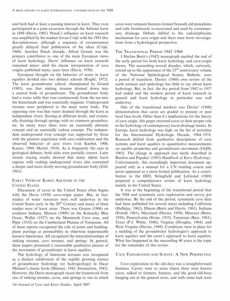
number of examples have been documented. One example
is the Mystery Cave – Rimstone River Cave complex in
Perry County, Missouri (Fig. 1). Extensive exploration and
survey have produced a detailed map of 40 km of mainly
two south-north master stream passages along with many
more kilometers of disconnected cave fragments (Walsh,
1988, 1989). Those who think such data are easy to obtain
are advised to read Walsh’s (2002) account of the actual
history of the exploration and survey.
CAVE MAPS AND MAPPING
Perhaps the caver’s greatest contribution to karst
hydrology is their current ‘‘map as you go’’ philosophy.
From the earliest days, cavers have prepared cave maps.
The reason is simple. On the land surface, a view from
a high ridge or an over flight in a small plane gives an
excellent perspective of the landscape. However, one
cannot see a cave. A caver can see only a small section of
passage at any one time. Without mapping, cavers must
depend on memory and have no way to accurately display
the layout of the cave or to share their discoveries with
others.
An accurate traverse line is important but so also is an
accurate sketch. For geological or hydrological interpreta-
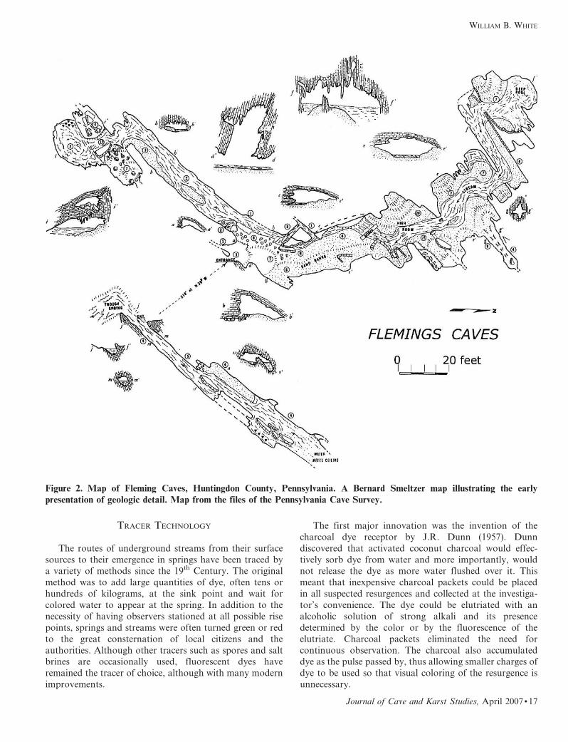
tion of cave maps, it is the accuracy of the sketching that ismost useful. One of the early pioneers in precise renditions
of cave passages was the late Bernard Smeltzer in
Pennsylvania. One of the finest examples, drawn in 1951,
is the Fleming Caves in Huntingdon County (Fig. 2). There
is accurate floor detail, the walls are sketched with an
artist’s eye, and the cross sections show the relation of the
cave to the structure of the bedrock. Other pioneers were
Paul Johnson, Tex Yocum, Lang Brod, and theircolleagues in the Missouri Cave Survey, whose outstanding
maps began appearing in the early issues of Missouri
Speleology in the late 1950s and early 1960s.
There have been great strides in the processing and
display of cave survey data. Computer programs are
available for compiling, plotting, and adjusting closure
errors. Maps can be displayed electronically so that they
can be expanded, contracted and rotated. Maps stored
electronically can have embedded photographs or addi-
tional passage detail. Behind the computational magic,
however, the primary data source remains the compass andtape measurements and the notebook sketches of the cavers
patiently slogging their way through the cave, station by
station. From the point of view of the hydrogeological use
of cave maps, current concerns with cave conservation
have an unfortunate side effect. Most of the early cave
data bases, such as those referenced above, were public
documents, many even public domain documents. As
population has increased over the past 40 years, access tocaves has become more limited at the same time that sport
caving has become more popular. Cave maps and cave data
bases have become proprietary information, often highly
restricted. Hydrogeologic investigations that require access
to extensive quantities of cave survey data also require
investigators to establish confidence and good working
relations with the caving community.
CAVE DIVING
The active conduit-drainage systems can often be
accessed either from cave entrances at stream sinks or
from cave entrances at spring mouths. Unfortunately, these
accessed caves often terminate at sumps. As equipment and
techniques for SCUBA diving have improved, many ofthese sumps have been penetrated to the great improve-
ment of our understanding of conduit systems.
Ford and Ewers (1978) laid to rest the vadose/phreaticdebate of the 1930s by showing that caves could form in
any relation to the water table depending on the local
geologic setting. One of the most common geologic settings
was a bedding and fracture guided conduit that would, at
WILLIAM B. WHITE
Journal of Cave and Karst Studies, April 2007 N 15
base flow, consist of a sequence of air-filled, open-channel-
flow cave segments interspersed with flooded, pipe-flowsegments. Any segment that happened to have an entrance
would appear as a stream cave sumped both upstream and
downstream. A number of such conduits have been
explored by divers and indeed, sumps are often relatively
shallow, relatively short, and link segments of air-filled
stream cave. Diving also shows the existence of deep
conduits well below present day base levels.
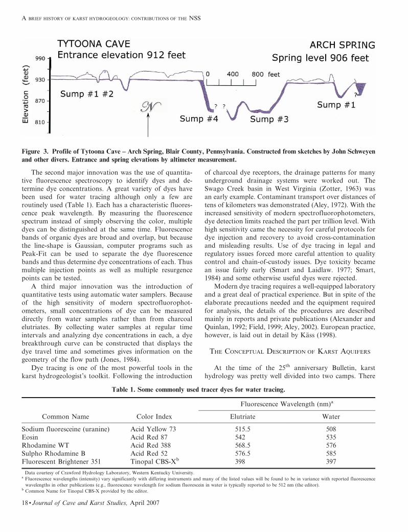
An example of the value of diving as part of
a hydrogeological investigation is Tytoona Cave, Blair
County, Pennsylvania, now an NSS Cave Nature Preserve
(Fig. 3). The entrance to Tytoona Cave, in a karst window,gives access to about 300 meters of open streamway. At the
end is a sump, followed by a chamber, a second sump,
a small chamber, a third sump, and finally, a long
streamway ending in a fourth sump. From the resurgence
end, at Arch Spring, there is immediately a deep sump,
then a streamway ending in a deep sump which is likely the
downstream end of the 4th sump in Tytoona Cave. The
diver’s sketch map here reveals both the undulatingpipe/open channel flow system and also the presence of
a deep system into which the present day drainage has
collapsed.
Figure 1. Stick map of Mystery Cave, Rimstone River Cave, and associated smaller caves in Perry County, Missouri. These
collections of caves represent two master drainage lines carrying water north to Cinque Hommes Creek. From Walsh (2002).
A BRIEF HISTORY OF KARST HYDROGEOLOGY: CONTRIBUTIONS OF THE NSS
16 N Journal of Cave and Karst Studies, April 2007
TRACER TECHNOLOGY
The routes of underground streams from their surface
sources to their emergence in springs have been traced bya variety of methods since the 19th Century. The original
method was to add large quantities of dye, often tens or
hundreds of kilograms, at the sink point and wait for
colored water to appear at the spring. In addition to the
necessity of having observers stationed at all possible rise
points, springs and streams were often turned green or red
to the great consternation of local citizens and the
authorities. Although other tracers such as spores and saltbrines are occasionally used, fluorescent dyes have
remained the tracer of choice, although with many modern
improvements.
The first major innovation was the invention of the
charcoal dye receptor by J.R. Dunn (1957). Dunn
discovered that activated coconut charcoal would effec-
tively sorb dye from water and more importantly, wouldnot release the dye as more water flushed over it. This
meant that inexpensive charcoal packets could be placed
in all suspected resurgences and collected at the investiga-
tor’s convenience. The dye could be elutriated with an
alcoholic solution of strong alkali and its presence
determined by the color or by the fluorescence of the
elutriate. Charcoal packets eliminated the need for
continuous observation. The charcoal also accumulateddye as the pulse passed by, thus allowing smaller charges of
dye to be used so that visual coloring of the resurgence is
unnecessary.
Figure 2. Map of Fleming Caves, Huntingdon County, Pennsylvania. A Bernard Smeltzer map illustrating the early
presentation of geologic detail. Map from the files of the Pennsylvania Cave Survey.
WILLIAM B. WHITE
Journal of Cave and Karst Studies, April 2007 N 17
The second major innovation was the use of quantita-
tive fluorescence spectroscopy to identify dyes and de-
termine dye concentrations. A great variety of dyes have
been used for water tracing although only a few are
routinely used (Table 1). Each has a characteristic fluores-
cence peak wavelength. By measuring the fluorescence
spectrum instead of simply observing the color, multipledyes can be distinguished at the same time. Fluorescence
bands of organic dyes are broad and overlap, but because
the line-shape is Gaussian, computer programs such as
Peak-Fit can be used to separate the dye fluorescence
bands and thus determine dye concentrations of each. Thus
multiple injection points as well as multiple resurgence
points can be tested.
A third major innovation was the introduction ofquantitative tests using automatic water samplers. Because
of the high sensitivity of modern spectrofluorophot-
ometers, small concentrations of dye can be measured
directly from water samples rather than from charcoal
elutriates. By collecting water samples at regular time
intervals and analyzing dye concentrations in each, a dye
breakthrough curve can be constructed that displays the
dye travel time and sometimes gives information on thegeometry of the flow path (Jones, 1984).
Dye tracing is one of the most powerful tools in the
karst hydrogeologist’s toolkit. Following the introduction
of charcoal dye receptors, the drainage patterns for manyunderground drainage systems were worked out. The
Swago Creek basin in West Virginia (Zotter, 1963) was
an early example. Contaminant transport over distances of
tens of kilometers was demonstrated (Aley, 1972). With the
increased sensitivity of modern spectrofluorophotometers,
dye detection limits reached the part per trillion level. With
high sensitivity came the necessity for careful protocols for
dye injection and recovery to avoid cross-contaminationand misleading results. Use of dye tracing in legal and
regulatory issues forced more careful attention to quality
control and chain-of-custody issues. Dye toxicity became
an issue fairly early (Smart and Laidlaw. 1977; Smart,
1984) and some otherwise useful dyes were rejected.
Modern dye tracing requires a well-equipped laboratory
and a great deal of practical experience. But in spite of the
elaborate precautions needed and the equipment required
for analysis, the details of the procedures are described
mainly in reports and private publications (Alexander and
Quinlan, 1992; Field, 1999; Aley, 2002). European practice,
however, is laid out in detail by Kass (1998).
THE CONCEPTUAL DESCRIPTION OF KARST AQUIFERS
At the time of the 25th anniversary Bulletin, karst
hydrology was pretty well divided into two camps. There
Figure 3. Profile of Tytoona Cave – Arch Spring, Blair County, Pennsylvania. Constructed from sketches by John Schweyen
and other divers. Entrance and spring elevations by altimeter measurement.
Table 1. Some commonly used tracer dyes for water tracing.
Common Name Color Index
Fluorescence Wavelength (nm)a
Elutriate Water
Sodium fluoresceine (uranine) Acid Yellow 73 515.5 508
Eosin Acid Red 87 542 535Rhodamine WT Acid Red 388 568.5 576
Sulpho Rhodamine B Acid Red 52 576.5 585
Fluorescent Brightener 351 Tinopal CBS-Xb 398 397
Data courtesy of Crawford Hydrology Laboratory, Western Kentucky University.a Fluorescence wavelengths (intensity) vary significantly with differing instruments and many of the listed values will be found to be in variance with reported fluorescence
wavelengths in other publications (e.g., fluorescence wavelength for sodium fluorescein in water is typically reported to be 512 nm (the editor).b Common Name for Tinopal CBS-X provided by the editor.
A BRIEF HISTORY OF KARST HYDROGEOLOGY: CONTRIBUTIONS OF THE NSS
18 N Journal of Cave and Karst Studies, April 2007

were the professional hydrogeologists, well educated in the
intricate mathematical details of groundwater behavior in
porous media and there were the cavers, not yet quite ready
to call themselves hydrogeologists. The professionals
drilled wells, ran pump tests, and made calculations.
Sometimes, as when they drilled into a highly fractured
dolomite, they got reasonable results. Sometimes, as when
they drilled into a water-bearing conduit, their results were
nonsense. There was a considerable effort (White and
Schmidt, 1966) to convince the professional community
that underground streams had something to do with
hydrology. Cavers were accumulating maps and data on
stream sinks, springs, and underground-drainage patterns,
but generally didn’t pay much attention to the mass of rock
that surrounded the caves. One of the most important
accomplishments of the past 40 years has been merging
these divergent points of view.
THE GROUND-WATER BASIN CONCEPT
The framework for discussion of groundwater is the
aquifer. Aquifers are characterized by the distribution and
anisotropy of hydraulic conductivity among the various
rock units that make up the aquifer. Aquifers often have
well-defined thicknesses, but rarely is one concerned with
the area of an aquifer. The framework for discussion of
surface water is the drainage basin. Drainage basins have
well-defined areas and a certain pattern of stream channels.
For geologic settings other than karst, groundwater
concepts and surface-water concepts rarely intersect. In
karst they are completely entangled.
Just as the notion of reconstructing conduits from
observable caves crept into karst thinking without much
notice, so also did the concept of the groundwater basin.
At some time it began to occur to karst researchers that it
was more profitable to think of karst hydrology in terms
of drainage basins with both surface and subsurface
components rather than thinking of a karst aquifer. For
the most part, it was a concept introduced by cavers
because it provided guidance about where to search for
new caves. Certainly the concept was established when
Jones (1973) wrote his report on the karst-drainage basins
in Greenbrier County, West Virginia. Jones was one of the
first to use extensive dye tracing to map out the entire
drainage system and subdivide spring catchments into
distinct groundwater basins. An even more elaborate
groundwater basin map was prepared by Quinlan and Ray
(1981; Quinlan and Ewers, 1989) for the Mammoth Cave
area in southcentral Kentucky. Underground drainage in
southcentral Kentucky flows either northwest to the
Green River or southwest to the Barren River. Quinlan
and Ray used cave data, geologic data, more than 500 dye
traces, and 1400 well observations to subdivide the
Mammoth Cave area into 28 groundwater basins, show
the main flow paths, and contour the water table. Many
groundwater basins have now been mapped, especially in
West Virginia (Jones, 1997) and in the series of drainage-
basin maps for Kentucky compiled by J.A. Ray and J.C.
Currens.
If the groundwater basin divide can be accurately
established, the basin area can be measured. Precipitation
within the basin and discharge from the basin can both be
measured. Essentially, the existence of a basin boundary
puts a mass-balance constraint on water moving through
the system. The various statistics developed for surface-
water basins can be applied to groundwater basins. If the
basin of interest discharges at a spring, the spring can be
gauged and a record of discharge established over long
periods of time. From these data can be calculated the
mean flow either over one water year or over the entire
period of record, the mean base flow, and the mean annual
peak flow (known as the annual flood for surface basins).The normalized mean base flow is the base flow divided by
the basin area. This quantity has been found to be
unusually small for karstic basins compared with other
surface water basins (E.L. White, 1977) because of the low
hydraulic resistance of the conduit system which allows the
aquifer to drain during period of low recharge. If
a numerical value for the normalized mean base flow can
be established for a given region, the basin areas of other
springs can be calculated by simply multiplying the
measured mean base flow of the spring of interest by the
normalized mean base flow for the region. A comparison
of various basins by Quinlan and Ray (1995) showed that
this simple calculation works well if the local hydrogeology
is taken into account. The calculation is a powerful check
on spring ground basin areas estimated by other methods.
The boundaries of surface water basins are usually
clearly defined by topographic highs and can be easilydrawn from topographic maps. The boundaries of ground-
water basins are more problematic. The boundaries of
contributing sinking-stream basins can be delineated, but
boundaries through the karst must be inferred from known
stream caves, from tracer tests, from the local geology and
from water-table maps constructed from depth-to-water
measurements in wells. Unlike surface-basin boundaries,
groundwater basin boundaries may shift with increasing or
decreasing discharge. Generally, high gradient basins have
the most sharply defined boundaries whereas low-gradient
basins may have fuzzy boundaries. Tracer tests near the
basin boundaries may indicate flow into several adjacent
basins. Piracy routes and high-discharge spill-over routes
are also common.
POROSITY AND PERMEABILITY
The treatment of a karst system as a groundwater basin
leads to certain insights. Treatment of the karst system as
an aquifer leads to other insights. These two conceptual
frameworks have existed comfortably side-by-side for the
40 year period of this review. The most fundamental
properties of an aquifer are its porosity and permeability. It
was recognized early on that the permeability (or porosity)
of karst aquifers has three components: the matrix
WILLIAM B. WHITE
Journal of Cave and Karst Studies, April 2007 N 19

permeability of the bedrock itself, the permeability pro-
duced by fractures (joints, joint swarms, bedding-plane
partings, and some faults), and the permeability due to
conduits. This has now been somewhat formalized and
researchers speak of the triple permeability model(Worthington, 1999).
The matrix hydraulic conductivities of most compacted
limestones are in the range of 1029 – 10211 m s21 and formost practical purposes can be ignored. The exceptions are
the young limestones, especially those on carbonate plat-
forms, that have never undergone deep burial or been
subject to orogenic forces. For these, the matrix perme-
abilities are in the range of 1026 to 1027 m s21 and matrix
flow is an important component. For information on the
hydrogeology of young limestones see Martin et al. (2002).
Matrix flow in porous limestones is Darcian and notintrinsically different from flow in other porous media.
Limestones and dolomites are brittle rocks and subject
to fracturing by tectonic forces and by stress relief causedby either erosion or glacier unloading. Fracture flow occurs
in other brittle rocks such as sandstones and granites.
Groundwater in fractures is a major component of the
stored water and is the reason that wells drilled into
limestone often produce useful quantities of water without
the well having penetrated a conduit. Fracture flow is
a major emphasis in contemporary hydrological research as
attempts are made to model fractures with irregularapertures and also to model fracture networks.
The practical boundary between fracture permeability
and conduit permeability occurs at an aperture of aboutone centimeter. In groundwater basins with typical
gradients, a one-centimeter aperture corresponds to the
onset of turbulence, to velocities sufficient to begin to
transport clastic sediment, and to an increase in the rate of
dissolution of the carbonate rock. Caves as conduit
fragments, can be mapped by human explorers down to
an aperture of about 0.5 m. Between 0.01 m and 0.5 m are
solution openings that are too small for direct mapping butlarge enough to behave hydraulically as conduits. Very
little is known about the conduit porosity in this size range.
Some insight into the flow behavior can be obtained from
the distribution of travel times obtained from tracer tests
(Fig. 4). The distribution is log-normal with a considerable
tail of the low velocity side. These measurements may
indicate tracer dyes moving through small and hence low
velocity pathways.
IMPORTANCE OF THE GEOLOGIC FRAMEWORK
The flow of water through karst aquifers is determined
by relatively simple principles of fluid mechanics and the
interaction of the water with the carbonate bedrock by
relatively simple principles of physical chemistry. As inmost of the Earth sciences, the devil is in the details. One of
those details that was widely overlooked in the early
development of karst hydrology was the geologic setting.
What karstic rocks are available and how are they
arranged with respect to other rocks? Any karst ground-
water basin is a work in progress. It evolved from some
precursor basin to its present configuration and the present
configuration will evolve further into the future. The
hydrology of the basin is controlled to a large extent by theunderlying stratigraphy and structure.
The geological variables that distinguish one karst
drainage basin from another include:
N Thickness of karstic rock units
N Placement of karstic rocks with respect to non-karstic
rocks and location within drainage basin
N Bulk lithology: limestone, dolomite or gypsum
N Detailed lithology: micritic limestone, crystalline lime-stone, shaley limestone
N Stratigraphic homogeneity: bedding thickness, lithologic
variations, shale or sandstone confining layers
N Large scale structure: folds, faults
N Small scale structures: density and connectivity of
vertical joints, bedding plane partings, few master
fractures vs. many smaller fractures
A great variety of karst drainage basins is possible
depending on the listed parameters. A variety of place-ments of karstic rocks with respect to other strata were
described early in the review period (White, 1969) and these
possibilities have been embellished by others. Most of the
karst of eastern United States is developed in at most a few
hundred meters of limestone producing fluviokarst land-
scapes. In locations such as the Cumberland Plateau or the
Ozark Plateau, the combination of low dip, limestones
located under valley floors and on valley walls, anda protective sandstone and shale caprock on the plateau
surface provides ideal conditions for the development of
long caves and vertical shafts. Other locations such as the
folded Appalachians, with carbonate rocks mainly in the
Figure 4. Distribution of travel velocities as determined
from 2877 tracer tests between sinking streams and springs.
From Worthington et al. (2000).
A BRIEF HISTORY OF KARST HYDROGEOLOGY: CONTRIBUTIONS OF THE NSS
20 N Journal of Cave and Karst Studies, April 2007
valley floors, produce strike-oriented caves and morelimited drainage basins.
The most recent calculations on cave development
(Dreybrodt et al., 2005) show that the patterns of conduit-drainage systems are determined during the initiation phase
of cave development. At this time, the system is highly
sensitive to details of the fracture pattern and to the
presence of confining layers. A few centimeters of shale
interbedded in the limestone is sufficient to deflect the
initial pathway that will later become a cave passage.
A great deal of the literature on karst hydrology
consists of studies showing how a particular drainage
basin developed in response to its specific geologic setting.
QUANTITATIVE HYDROLOGY: SPRING HYDROGRAPHS
The flow of karst springs is often variable, rising and
falling in response to storms. Some springs become muddy
during storm flow. Springs can be gauged to produce
a continuous recording of discharge as a function of time,
a curve known as a hydrograph. The water flowing from
a spring represents a composite of all inputs and flowsystems upstream in the basin. Use of spring hydrographs
to characterize karst aquifers developed early in Europe
(Burdon and Papakis, 1963; Milvanovic, 1981) and has
been developed to a considerable mathematical elegance in
France (Mangin, 1984; Labat et al., 2001). Only in the
1980s and later were spring hydrographs extensively used
in the United States. In part, this was not due to ignorance
but to the fact that most karst hydrology research wasbeing conducted by academics and cavers on shoe-string
budgets. Continuous stage recording was desirable but not
financially achievable.
Examination of a large number of spring discharge
records reveals a range of responses on a scale between two
end-members. There are karst groundwater basins with
very rapid response times so that the spring hydrograph
has peaks corresponding to each individual storm. The
other extreme are springs that exhibit essentially no
response at all to individual storms and at best rise and
fall a little in response to wet and dry seasons. In betweenare hydrographs with varying degrees of response (Fig. 5).
The aquifer characteristics that control hydrograph
pattern are not completely understood. The very flashyresponse with individual storm peaks requires a small open
aquifer with an overall transport time from recharge to
spring less that the spacing between storms. Less well-
resolved hydrographs can arise from aquifers sufficiently
large such that individual storm inputs are damped before
they reach the spring. Hydrographs with little storm detail
can arise from aquifers in which most of the recharge is
through the epikarst which tends to hold water intemporary storage. Springs fed by fracture flow will have
less detail in their hydrographs, but a flat hydrograph is
not evidence for the absence of conduits. The big Florida
springs have almost no detail in their hydrographs but
most are known to be fed by very large water-filled
conduits.
Sudden intense storms that follow several weeks
without rain are the best probes of aquifer behavior.
Figure 6 illustrates schematically the parameters that can
be measured. The lag time between the storm and the time
that storm water appears at the spring is a measure of
travel time only if the conduit is an open streamway from
sink to spring. If all or a portion of the conduit is flooded,
rising head at the upstream end will cause water to
discharge from the downstream end responding to
a pressure pulse that travels through the system at the
speed of sound. The time between the storm and increased
flow at the spring can be very short. The ratio of the
maximum flow to base flow is a measure of the flashinessof the aquifer, although this ratio also depends on storm
intensity. The recession limb of the hydrograph can usually
be fitted with an exponential curve (or several). The fitting
parameter for the exponential has been called the
exhaustion coefficient and has been used (Burdon and
Papakis, 1963) to calculate the volume of water held in
dynamic storage. The inverse of the exhaustion coefficient
has units of time and can be taken as the response time of
the aquifer.
CHEMICAL HYDROLOGY
On of the most important accomplishments of the
40 year period was to work out the chemistry of carbonatedissolution in considerable detail. The equilibrium chem-
istry of both dissolution and precipitation came first and is
described in detail in several textbooks (White, 1988;
Langmuir, 1997). The equally important kinetics of
dissolution and precipitation rates, although more compli-
cated and not so solidly established, has been largely
worked out. The dissolution rates of carbonate minerals
are important to many areas of science, resulting in a huge
literature. Much of it has been reviewed by Morse and
Arvidson (2002). Dissolution kinetics combined with flow
hydraulics forms the basis for current theories of speleo-
genesis. A major contributor has been Wolfgang Drey-
brodt and his students and collaborators at the University
of Bremen in Germany (Dreybrodt et al., 2005). Studies of
speleogenetic processes can be considered aquifer modeling
along the time axis by calculating the evolution of the
conduit permeability through a sequence of initiation,
enlargement, stagnation, and decay phases. Althoughmuch as been accomplished (Klimchouk et al., 2000), this
subject is outside of the scope of the present review.
Although many analyses of karst waters had been
obtained, about the best that could be done with them was
to plot the concentration of dissolved carbonates on the
calculated calcite solubility curve, which then gave some
indication of whether the water sample was saturated,
supersaturated, or undersaturated (aggressive) with respect
to calcite. In the early 1970s there were a number of efforts
WILLIAM B. WHITE
Journal of Cave and Karst Studies, April 2007 N 21

to more accurately measure the saturation state of cave
waters. Most successful of these was the introduction of the
saturation index and also the calculated CO2 partial
pressure (Langmuir, 1971). These calculations and other
aspects of aqueous chemistry quickly evolved into a collec-
tion of computer programs that have continued to evolve
down to the present time (Jenne, 1979; Melchior and
Bassett, 1990).
In the late 1960s and early 1970s there began studies of
spring-water chemistry in which the springs were sampled
at regular intervals, typically one or two weeks (Pitty, 1968;
Shuster and White, 1971). The dissolved carbonate content
of some springs remains essentially constant through the
year irrespective of the season or the influence of storm
flow. Other springs exhibit a widely fluctuating chemistry
and also a fluctuating temperature. There ensued a debate
concerning the cause of the chemical fluctuations, with
degree of conduit development, percentage of sinking-
stream recharge, and flow-through time being offered.
Then came the results of Dreiss (1989) who measured
a continuous record of the chemistry of Meramec Spring,
Missouri. It turned out that the fluctuations observed in
previous studies were due to a small number of sampling
points extracted from a continuous curve (now known as
a chemograph). Chemographs of carbonate species typi-
cally are the inverse of hydrographs and represent the
dilution of the resident water in the aquifer by injected
storm water (Fig. 6). Since their first introduction,
chemographs has been constructed for many chemical
parameters including groundwater contaminants.
The concentration of dissolved carbonate species in
karst aquifers is proportional to the specific conductance of
the water. Because specific conductance is easy to measure
and easy to record on a data logger, such measurements
allow easy determination of carbonate chemographs.
Many such have been measured and, in combination with
hydrographs, provide additional information on aquifer
response. What is observed is that there is a sharp rise in
the hydrograph in response to storms. However, there may
or may not be an equivalent dip in the chemograph. If the
Figure 5. Some representative hydrographs for karst springs. These are selected from U.S. Geological Survey surface water
records which are available online (http://waterdata.usgs.gov). Alley Spring is representative of the flashy, fast-response
springs where individual storm events appear on the hydrograph. Rainbow Spring displays an annual rainy season/dry seasonresponse but does not respond to individual storms.
A BRIEF HISTORY OF KARST HYDROGEOLOGY: CONTRIBUTIONS OF THE NSS
22 N Journal of Cave and Karst Studies, April 2007

rising hydrograph and falling chemograph are coincident,
it indicates that the conduit is an open streamway and therising hydrograph marks the arrival of storm water at the
spring. In other cases, there is a delay between the rising
limb of the hydrograph and the falling limb of the
chemograph. This delay, along with the spring discharge,
is a measure of the volume of water pushed out of flooded
conduits by the storm pulse (Ryan and Meiman, 1996).
CAN KARST AQUIFERS BE MODELED?
At the end of the review period, much contemporary
research on karst hydrogeology consists of attempts to
construct a useful, perhaps even valid, general model for
karst aquifers. The object of any groundwater model is to
reduce the recharge, storage, and flow hydraulics of an
aquifer to a computer program. With an accurate model,
one should be able to calculate well yields and distributionof hydrostatic heads within the aquifer, as well as the
response of the aquifer to varying recharge and to
extraction of water for water supply. For a karst aquifer,
an accurate model also should be able to reproduce the
expected spring hydrographs in response to a specified
precipitation event. Much karst hydrological research over
the past several decades has been efforts to construct such
a model. Results have been decidedly mixed. Summaries ofsome of the attempted approaches may be found in Jeannin
and Sauter (1998) and Palmer et al. (1999).
The guiding parameter for any groundwater model is
the hydraulic conductivity. The hydraulic conductivity can
be anisotropic and different values can be used for different
rock formations, but it should be constant within these
constraints. One of the most important difficulties in
modeling karst aquifers is that the hydraulic conductivity is
scale dependent. It was pointed out by Sauter (1991) and
Quinlan et al. (1992) that hydraulic conductivities for
highly karstic aquifers can vary over 8 orders of magnitude
depending on the scale of measurement (Fig. 7). In an
aquifer with this range in values over short distances, any
attempt to reduce the aquifer to a single value of hydraulic
conductivity can best be described as nonsense.
Without going into very much detail, the main
approaches to karst-aquifer modeling are summarized
below. Only a few key references are given. This subject
is beginning to develop a very large literature.
EQUIVALENT POROUS MEDIA MODELS
Standard porous-media models such as the USGS
MODFLOW program assume that at large enough scales,
the heterogeneities of the karst aquifer are smoothed out
and can be represented by an average hydraulic conduc-
tivity. Scanlon et al. (2003) had some success in applying
this type of model to the Edwards Aquifer in Texas.
Equivalent porous media models work best for aquifers in
which the karstic-flow paths are dispersed and consist
mainly of solutionally-widened fractures. They work least
well for aquifers with well developed conduit systems,
particularly those with large inputs of allogenic recharge.
PIPE FLOW MODELS
Equivalent porous-media models ignore the conduit
permeability and its localized turbulent flows. Pipe-flow
models focus entirely on the conduit system. Pipe-flow
models treat the conduit system as a network of pipes
Figure 6. Schematic hydrograph and chemograph for a karst
spring showing various measurable parameters. QB 5 base
flow. Qmax 5 peak flow for the storm hydrograph. Two time
lags are shown: tLS for the lag between the storm and the
rising limb of the hydrograph and tLC for the lag between the
rising limb of the storm hydrograph and the dip in the
chemograph. Both the recession limb of the hydrograph and
the recovery limb of the chemograph can be fitted with thefunctions shown.
Figure 7. Dependence of hydraulic conductivity on the scaleof measurement. From Quinlan et al. (1992).
WILLIAM B. WHITE
Journal of Cave and Karst Studies, April 2007 N 23

subject to the usual laws of fluid mechanics. The drawback
of the pipe flow models is that conduits are not exactly
pipes. They have varying cross sections, complicated
interconnections, and are often further modified by
breakdown and sediment infillings. Much detail aboutconduit pattern is needed. However, calculations of travel
times, head losses, and discharges for known conduit
systems have been generally successful (Halihan and
Wicks, 1998; Jeannin, 2001).
COUPLED CONTINUUM/PIPE-FLOW MODELS
Eventually, karst-aquifer modeling must face the reality
of the combined matrix, fracture, and conduit components
of the permeability. The conduit system is strongly coupled
to surface water through sinking streams and closed
depressions and so has a very dynamic response to storms.
The fracture and matrix systems receive most of their
recharge through the epikarst and have a slower response.
A dominant component of the total flow system is theexchange flow between the conduits and the surrounding
fractured matrix. During storm flow, heads in the conduit
system rise rapidly and water is forced into the surrounding
fractures. After the storm flow recedes, the conduit system
drains rapidly, heads reverse, and the water stored in the
fractures drains into the conduits.
Models have been constructed in which the fracture and
matrix system is described as a continuum with Darcy flow.
The conduits are put in by hand and described by pipe-flow
models. There is an exchange term that describes the influx
and outflux of water between the fracture system and theconduits. This model was developed for the Gallus Spring
in southern Germany (Sauter, 1992). This model worked
well in the sense that it accurately reproduced the storm
hydrographs measured at the spring. The drawback is that
the conduits must be put in by hand. Tracer studies and
cave exploration must supplement the strictly model
calculation. Continued development of this approach to
modeling has been very promising (Bauer et al., 2003; Liedlet al., 2003).
INPUT – OUTPUT MODELS
All of the modeling approaches described above require
considerable knowledge of the aquifer – the geometry of
the conduit system, the hydraulic conductivities of thefracture and matrix systems, and any geologic-boundary
conditions. In general, the more pre-knowledge available,
the more accurate the model. Of course, if all available
knowledge is used to construct the model, there may be
nothing left for the model to calculate. The diametrically
opposite approach is to treat the aquifer as a black box and
assume nothing about its internal properties. Instead,
models are built from inputs and outputs, both of whichcan be measured directly. These models make use of
linear-systems theory as pioneered by Dreiss (1982, 1989)
with more recent applications described by Wicks and
Hoke (1999). The idea is to use measured input and
output data to construct a kernel function (the black box)
which will connect all other relations between input and
output.
CONCLUSIONS
In the 40 years since the 25th anniversary Bulletin,
knowledge of karst hydrology has made giant forward
strides. By borrowing concepts from both groundwaterhydrology and surface-water hydrology, an excellent
conceptual model for karst aquifers has been developed.
There is good understanding of the physical and chemical
processes that take place in karst aquifers. The current
cutting edge is the development of a reasonable and
accurate model to describe the flow behavior within the
aquifer. Although there has been some success, a complete
model has yet to be obtained. However, the eventualconstruction of such a model does not seem as remote as it
did only a few years ago.
ACKNOWLEDGEMENTS
Reviewers William K. Jones and Stephen R. H.
Worthington are thanked for their constructive sugges-
tions.
REFERENCES
Adams, F.D., 1954, The Birth and Development of the GeologicalSciences: New York, Dover Publications, 506 p.
Alexander, Jr., E.C., and Quinlan, J.F., 1992, Practical tracing ofgroundwater with emphasis on karst terranes, published as AppendixB, in Schindel, G.M., Quinlan, J.F., Davies, G., and Ray, J.A., eds.:Guidelines for wellhead and springhead protection area delineation incarbonate rocks, U.S. Environmental Protection Agency Report EPA904-B-97-003 (1997), 38 p.
Aley, T., 1972, Groundwater contamination from sinkhole dumps: Cavesand Karst, v. 14, p. 17–23.
Aley, T., 2002, Groundwater tracing handbook: Protem, Mo., OzarkUnderground Laboratory, 33 p.
Barr, Jr., T.C., 1961, Caves of Tennessee: Tennessee Division of GeologyBulletin 64, 567 p.
Bauer, S., Liedl, R., and Sauter, M., 2003, Modeling of karst aquifergenesis: Influence of exchange flow: Water Resources Research, v. 39,doi: 10.1029/2003WR002218.
Bretz, J H., 1942, Vadose and phreatic features of limestone caverns: TheJournal of Geology, v. 50, p. 675–811.
Bretz, J H., 1956, Caves of Missouri: Missouri Geological Survey andWater Resources, v. 39, 490 p.
Bretz, J H., and Harris, Jr., S.E., 1961, Caves of Illinois: Illinois StateGeological Survey, Report of Investigations 215, 87 p.
Brucker, R.W., 1966, Truncated cave passages and terminal breakdown inthe central Kentucky karst: National Speleological Society Bulletin,v. 28, p. 171–178.
Burdon, D.J., and Papakis, N., 1963, Handbook of karst hydrology:Athens, Greece, United Nations Special Fund, Institute for Geologyand Subsurface Research, 276 p.
Cvijic, J., 1960, La Geographie des Terrains Calcaires: Monographs of theSerbian Academy of Sciences and Arts, v. 341, no. 26, 212 p.
Davies, W.E., 1949, Caverns of West Virginia: West Virginia Geologicaland Economic Survey, v. 19A, 353 p.
Davies, W.E., 1950, The Caves of Maryland: Maryland Department ofGeology, Mines and Water Resources, Bulletin 7, 75 p.
Davies, W.E., 1960, Origin of caves in folded limestone: NationalSpeleological Society Bulletin, v. 22, p. 5–18.
A BRIEF HISTORY OF KARST HYDROGEOLOGY: CONTRIBUTIONS OF THE NSS
24 N Journal of Cave and Karst Studies, April 2007
Davies, W.E., 1966, The earth sciences and speleology: NationalSpeleological Society Bulletin, v. 28, p. 1–14.
Davis, W.M., 1901, An excursion in Bosnia, Hercegovina, and Dal-matia: Bulletin of the Geographical Society of Philadelphia, v. 3,p. 21–50.
Davis, W.M., 1930, Origin of limestone caverns: Bulletin of the GeologicalSociety of America, v. 41, p. 475–625.
Douglas, H.H., 1964, Caves of Virginia: Falls Church, Va., Virginia CaveSurvey, 761 p.
Dreiss, S.J., 1982, Linear kernels for karst aquifers: Water ResourcesResearch, v. 18, p. 865–876.
Dreiss, S.J., 1989, Regional scale transport in a karst aquifer. 1.Component separation of spring flow hydrographs: Water ResourcesResearch, v. 25, p. 117–125.
Dreybrodt, W., Gabrovsek, F., and Romanov, D., 2005, Processes ofSpeleogenesis: A Modeling Approach: Carsologica, v. 4, 375 p. + CD.
Dunn, J.R., 1957, Stream tracing: MAR Bulletin, National SpeleologicalSociety, v. 2, p. 7.
Field, M.S., 1999, The QTRACER program for tracer breakthroughcurve analysis for karst and fractured-rock aquifers: U.S. Environ-mental Protection Agency Report EPA/600/R-98/156a, 137 p.
Ford, D.C., and Ewers, R.O., 1978, The development of limestone cavesystems in the dimensions of length and depth: Canadian Journal ofEarth Sciences, v. 15, p. 1783–1798.
Greene, F.C., 1908, Caves and cave formation of the Mitchell Limestone:Proceedings of the Indiana Academy of Science, v. 18, p. 175–184.
Grund, A., 1903, Die Karsthydrographie. Studien aus Westbosnien:Penck’s Geographische Abhandlungen, v. 9, p. 1–200.
Halihan, T., and Wicks, C.M., 1998, Modeling of storm responses inconduit flow aquifers with reservoirs: Journal of Hydrology, v. 208,p. 82–91.
Halliday, W.R., 1962, Caves of California: Privately published by theWestern Speleological Survey, 194 p.
IASH, 1965, Hydrology of fractured rocks: Proceedings of the DubrovnikSymposium, Publications 73 and 74 of the International Associationof Scientific Hydrology, Gentbrugge, Belgium, 689 p.
Jeannin, P.-Y., and Sauter, M., eds., 1998, Modelling in karst Systems:Bulletin d’Hydrogeologie, no. 16, 241 p.
Jeannin, P.Y., 2001, Modeling flow in phreatic and epiphreatic karstconduits in the Holloch Cave (Muotatal, Switzerland): WaterResources Research, v. 37, p. 191–200.
Jenne, E.A., 1979, Chemical Modeling in Aqueous Systems: AmericanChemical Society Symposium Series No. 93, 914 p.
Jones, W.K., 1973, Hydrology of limestone karst: West VirginiaGeological and Economic Survey Bulletin 36, 49 p.
Jones, W.K., 1984, Dye tracer tests in karst areas: National SpeleologicalSociety Bulletin, v. 46, p. 3–9.
Jones, W.K., 1997, Karst hydrology atlas of West Virginia: Karst WatersInstitute Special Publication 4, 111 p.
Kass, W., 1998, Tracing techniques in geohydrology: Rotterdam, A.A.Balkema, 581 p.
Katzer, F., 1909, Karst und Karsthydrographie. Zur Kunde derBalkanhalbinsel: Kajon, Sarajevo, 94 p.
Klimchouk, A.B., Ford, D.C., Palmer, A.N., and Dreybodt, W., eds.,2000, Speleogenesis: Evolution of Karst Aquifers: Huntsville, Ala.,National Speleological Society, 527 p.
Labat, D., Ababou, R., and Mangin, A., 2001, Introduction of waveletanalyses to rainfall/runoffs relationship for a karstic basin: the case ofLicq-Atherey karstic system (France): Ground Water, v. 39,p. 605–615.
LaMoreaux, P.E., and Tanner, J.T., eds., 2001, Springs and BottledWaters of the World: Berlin, Springer Verlag, 315 p.
Langmuir, D., 1971, The geochemistry of some carbonate ground watersin central Pennsylvania: Geochimica et Cosmochimica Acta, v. 35,p. 1023–1035.
Langmuir, D., 1997, Aqueous environmental geochemistry: Upper SaddleRiver, N.J., Prentice Hall, 600 p.
Liedl, R., Sauter, M., Huckinghaus, D., Clemens, T., and Teutsch, G.,2003, Simulation of the development of karst aquifers using a coupledcontinuum pipe model: Water Resources Research, v. 39, doi:10.1029/2001WR001206
Mangin, A., 1964, Pour une meilleure connaissance des systemeshydrologiques a partir des analyses correlatoires et spectrales: Journalof Hydrology, v. 67, p. 25–43.
Martel, E.A., 1910, La theorie de ‘‘Grundwasser’’ et les eaux souterrainesdu karst: Geographie, v. 21, p. 126–130.
Martin, J.B., Wicks, C.M., and Sasowsky, I.D., 2002, Hydrogeology andbiology of post-Paleozoic carbonate aquifers: Charles Town, W.Va.,Karst Waters Institute, Special Publication 7, 212 p.
Matson, G.C., 1909, Water resources in the Blue Grass region, Kentucky:U.S. Geological Survey Water Supply Paper 233, p. 42–45.
Meinzer, O.E., 1942, Hydrology: New York, Dover Publications, 712 p.Melchior, D.C., and Bassett, R.L., 1990, Chemical Modeling of Aqueous
Systems II: American Chemical Society Symposium Series No. 416,556 p.
Milanovic, P.T., 1981, Karst Hydrogeology: Water Resources Publica-tions, Littleton, Colo., 281 p.
Morse, J.W., and Arvidson, R.S., 2002, The dissolution kinetics of majorsedimentary carbonate minerals: Earth-Science Reviews, v. 58,p. 51–84.
Palmer, A.N., Palmer, M.V., and Sasowsky, I.D., 1999, Karst modelling:Charles Town, W.Va., Karst Waters Institute, Special Publication 5,265 p.
Piper, A.M., 1932, Ground water in North-Central Tennessee: U.S.Geological Survey Water Supply Paper 640, 238 p.
Pitty, A.F., 1968, Calcium carbonate content of karst water in relation toflow-through time: Nature, v. 217, p. 939–940.
Powell, R.L., 1961, Caves of Indiana: Indiana Geological Survey, Circular8, 127 p.
Quinlan, J.F., and Ray, J.W., 1981, Groundwater basins in the MammothCave Region, Kentucky: Friends of Karst Occasional Publication No.1, one sheet.
Quinlan, J.F., and Ewers, R.O., 1989, Subsurface drainage in theMammoth Cave area: in White, W.B., and White, E.L., eds., Karsthydrology: Concepts from the Mammoth Cave area: New York, VanNostrand Reinhold, p. 65–103.
Quinlan, J.F., Davies, G.J., and Worthington, S.R.H., 1992, Rationale forthe design of cost-effective groundwater monitoring systems inlimestone and dolomite terranes: cost-effective as conceived is notcost-effective as built if the system design and sampling frequencyinadequately consider site hydrogeology: 8th Waste Testing andQuality Assurance Symposium Proceedings, U.S. EnvironmentalProtection Agency, Washington, D.C., p. 552–570.
Quinlan, J.F., and Ray, J.A., 1995, Normalized base-flow discharge ofgroundwater basins: A useful parameter for estimating recharge areaof springs and for recognizing drainage anomalies in karst terranes, inBeck, B.F., ed., Karst geohazards: Rotterdam, A.A. Balkema,p. 149–164.
Roglic, J., 1972, Historical review of morphologic concepts, in Herek, M.,and Stringfield, V.T., eds., Karst: Important karst regions of theNorthern Hemisphere: Amsterdam, Elsevier, p. 1–18.
Ryan, M., and Meiman, J., 1996, An examination of short-term variationsin water quality at a karst spring in Kentucky: Ground Water, v. 34,p. 23–30.
Sauter, M., 1991, Assessment of hydraulic conductivity in a karst aquiferat local and regional scale: in Proceedings of the Third Conference onHydrogeology, Ecology, Monitoring and Management of GroundWater in Karst Terranes, National Ground Water Association,Dublin, Ohio, p. 39–57.
Sauter, M., 1992, Quantification and Forecasting of Regional Ground-water Flow and Transport in a Karst Aquifer (Gallusquelle, Malm,SW Germany: Tubinger Geowissenschaftliche Arbeiten, Reihe C, No.13, 150 p.
Scanlon, B.R., Mace, R.E., Barrett, M.E., and Smith, B., 2003, Can wesimulate regional groundwater flow in a karst system using equivalentporous media models? Case study, Barton Springs, Edwards Aquifer,USA: Journal of Hydrology, v. 276, p. 137–158.
Shaw, T.R., 1992, History of cave science: New South Wales, Australia,Sydney Speleological Society, 338 p.
Shuster, E.T., and White, W.B., 1971, Seasonal fluctuations in thechemistry of limestone springs: A possible means for characterizingcarbonate aquifers: Journal of Hydrology, v. 14, p. 93–128.
Smart, P.L., and Laidlaw, I.M.S., 1977, An evaluation of some fluorescentdyes for water tracing: Water Resources Research, v. 13, p. 15–33.
Smart, P.L., A review of the toxicity of twelve fluorescent dyes used forwater tracing: National Speleological Society Bulletin, v. 46, p. 21–33.
Stone, R.W., 1953, Descriptions of Pennsylvania’s undeveloped caves:National Speleological Society Bulletin, v. 15, p. 51–139.
WILLIAM B. WHITE
Journal of Cave and Karst Studies, April 2007 N 25

Stringfield, V.T., and LeGrand, H.E., 1969, Hydrology of carbonate rockterranes — A review: Journal of Hydrology, v. 8, p. 349–376.
Swinnerton, A.C., 1942, Hydrology of limestone terranes, in Meinzer,O.E., ed., Hydrology: New York, Dover Publications, p. 656–677.
Von Knebel, W., 1906, Hohlenkunde mit Besonderer Berucksichtigungdes Karstphanomens: Sammlung Naturwissenschaftlicher und Math-ematischer Monographien, No. 15, Druck und Verlag von FriedrichVieweg und Sohn, Braunschweig, 222 p., English translation of Chap.8 and 9 in Cave Geology, v. 1, p. 139–162, 1978.
Walsh, J., 1988, Mystery Cave: Missouri Speleology, v. 28, p. 1–141.Walsh, J., 1989, Rimstone River Cave: Missouri Speleology, v. 29,
p. 1–158.Walsh, J., 2002, Exploration of Rimstone River Cave: Missouri
Speleology, v. 35, p. 1–114.Weller, J.M., 1927, Geology of Edmonson County: Kentucky Geological
Survey, Frankfort, Ky., 246 p.White, E.L., 1977, Sustained flow in small Appalachian watersheds
underlain by carbonate rocks: Journal of Hydrology, v. 32, p. 71–86.White, P.J., 1948, Caves of central Texas: National Speleological Society
Bulletin, v. 10, p. 46–64.White, W.B., 1969, Conceptual models for limestone aquifers: Ground-
water, v. 7, no. 3, p. 15–21.White, W.B., 1988, Geomorphology and hydrology of karst terrains: New
York, Oxford University Press, 464 p.White, W.B., 1993, Analysis of karst aquifers, in Alley, W.M., ed.,
Regional Ground Water Quality: New York, Van Nostrand Rein-hold, p. 471–489.
White, W.B., 1998, Groundwater flow in karstic aquifers, in Delleur, J.W.,ed.: The handbook of groundwater engineering, Boca Raton, Fla.,CRC Press, p. 18.1–18.36.
White, W.B., 2002, Karst hydrology: Recent developments and openquestions: Engineering Geology, v. 65, p. 85–105.
White, W.B., 2006, Fifty years of karst hydrology: 1953–2003: GeologicalSociety of America Special Paper, v. 404, p. 139–152.
White, W.B., and Schmidt, V.A., 1966, Hydrology of a karst area ineast-central West Virginia: Water Resources Research, v. 2,p. 549–560.
Wicks, C.M., and Hoke, J.A., 1999, Linear systems approach to modelinggroundwater flow and solute transport through karstic basins: KarstWaters Institute Special Publication 5, p. 97–101.
Worthington, S.R.H., 1999, A comprehensive strategy for understandingflow in carbonate aquifers: Karst Waters Institute Special Publication,v. 5, p. 30–37.
Worthington, S.R.H., Ford, D.C., and Davies, G.J., 2000, Matrix,fracture and channel components of storage and flow in a Paleozoiclimestone aquifer, in Sasowsky, I.D., and Wicks, C.M., eds.,Groundwater flow and contaminant transport in carbonate aquifers:Rotterdam, A.A. Balkema, p. 113–128.
Zotl, J.G., 1961, Die hydrographie des nordostalpinen karsts: SteirischBeitrage der Hydrogeologie, v. 1960 /1961, p. 53–183.
Zotter, H., 1963, Stream tracing techniques and results: Pocahontasand Greenbrier Counties, West Virginia: NSS News, v. 21,p. 136–142.
A BRIEF HISTORY OF KARST HYDROGEOLOGY: CONTRIBUTIONS OF THE NSS
26 N Journal of Cave and Karst Studies, April 2007