Embed Size (px)
Citation preview

Waterfront Development
S u t h e r l a n d S h i r e C o u n c i l

WaterfrontDevelopment
0W a t e r f r o n t D e v e l o p m e n t C o n t r o l P l a n page 1S u t h e r l a n d S h i r e C o u n c i l
CONTENTS
1. Where does the Plan Apply?
2. Purpose of the Plan?
3. Objectives of the Plan?
4. How does this Plan relate to other Plans?
5. Can the Plan be Varied?
6. Does your Proposal need Approval?
7. Making an Application.
8. Site Analysis.
9. Is my Proposal an Integrated Development?
10. Development which may be Allowed Below M.H.W.M.
10.1 Jetties, Ramps and Pontoons
10.2 Sliprails
10.3 Berthing Areas
11. Development which may be Allowed Below the
Foreshore Building Line and Above M.H.W.M.
11.1 Boatsheds
11.2 Landscaping
11.3 In ground Swimming Pool
11.4 Inclinators and Stairs
12. Development which is Prohibited.
13. Origin.
Appendix 1: Clause 20 Sutherland Shire Local
Environmental Plan 2000.
Appendix: 2: How to Apply for Development Below
M.H.W.M.

WaterfrontDevelopment
0W a t e r f r o n t D e v e l o p m e n t C o n t r o l P l a n page 2S u t h e r l a n d S h i r e C o u n c i l
1. WHERE DOES THE PLAN APPLY?
This plan applies to all development within the SutherlandShire that is below the Foreshore Building Line and/or alongthe waterfront, above, on, or below Mean High Water Mark(M.H.W.M) and includes:
� land zoned for residential purposes in Sutherland ShireLocal Environmental Plan 2000 (SSLEP 2000);
� land zoned 7(a) Environmental Protection (Waterways) inSSLEP 2000; and,
� land at Sandy Point.
2. PURPOSE OF THE PLAN
The purpose of this plan is to provide a series of standardsand objectives that are intended to guide the form ofdevelopment in the waterfront areas of the Shire.
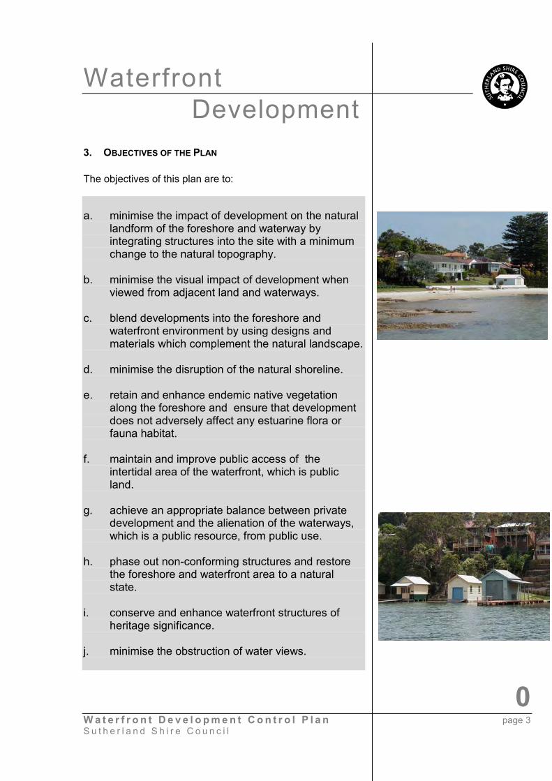
The Shire’s waterways and foreshore areas have both localand regional significance as they represent a valuableestuarine environment that provides the community withopportunities for passive and active recreation. Themaintenance of the natural beauty of the waterways and theforeshores is important to the scenic quality of the Shire.Consequently, the development of these areas by individualsfor private purposes carries with it a responsibility to ensurethat the visual and environmental quality of these foreshoreareas is maintained.
This plan seeks to allow development that is in harmony withthe natural surrounding, which minimises the impact on thenatural environment and acknowledges the importance of thewaterways as natural public resource.
WaterfrontDevelopment
0W a t e r f r o n t D e v e l o p m e n t C o n t r o l P l a n page 3S u t h e r l a n d S h i r e C o u n c i l
3. OBJECTIVES OF THE PLAN
The objectives of this plan are to:
a. minimise the impact of development on the naturallandform of the foreshore and waterway byintegrating structures into the site with a minimumchange to the natural topography.
b. minimise the visual impact of development whenviewed from adjacent land and waterways.
c. blend developments into the foreshore andwaterfront environment by using designs andmaterials which complement the natural landscape.
d. minimise the disruption of the natural shoreline.
e. retain and enhance endemic native vegetationalong the foreshore and ensure that developmentdoes not adversely affect any estuarine flora orfauna habitat.
f. maintain and improve public access of theintertidal area of the waterfront, which is publicland.
g. achieve an appropriate balance between privatedevelopment and the alienation of the waterways,which is a public resource, from public use.
h. phase out non-conforming structures and restorethe foreshore and waterfront area to a naturalstate.
i. conserve and enhance waterfront structures ofheritage significance.
j. minimise the obstruction of water views.

WaterfrontDevelopment
0W a t e r f r o n t D e v e l o p m e n t C o n t r o l P l a n page 4S u t h e r l a n d S h i r e C o u n c i l
k. ensure that any development does not obstruct orinterfere with navigation within the waterway.
l. minimise any adverse impact from development onwater quality and where possible, improve thequality of urban runoff entering the waterways.
Proposed developments will be assessed having regard tothe standards and objectives contained within this plan.Council will only consider a variation of a standard where theapplicant can demonstrate to Council’s satisfaction thatdespite the non – compliance the objectives of this plan areachieved.
4. HOW DOES THIS PLAN RELATE TO OTHER PLANS?
SSLEP 2000 provides the objectives, land use controls anddevelopment standards for development in the Shire. Thebasis for the LEP includes the Housing Strategy and HeritageStudy.
Together with this DCP there are other DCP’s that apply towaterfront developments, including:
� Duration of development consents� Notification of development applications� Landscape� Swimming pools
You should contact Council's Customer Service Centre formore information.
5. CAN THE PLAN BE VARIED?
This plan contains a number of planning objectives andcontrols which must be applied to development proposalsunder this plan.
The controls that are set out in this plan are generally moredetailed than those contained within SSLEP 2000. Anyvariation to these controls must be supported by a statementdemonstrating how the objectives of this plan are satisfied.

WaterfrontDevelopment
0W a t e r f r o n t D e v e l o p m e n t C o n t r o l P l a n page 5S u t h e r l a n d S h i r e C o u n c i l
Any submission in support of a variation to a standard orcontrol must be in writing and demonstrate how the objectiveswill be achieved.
6. DOES YOUR PROPOSAL NEED APPROVAL?
You need to submit a development application to obtainconsent from Council for all development proposals involvingnew buildings/structures, alterations & additions, subdivisionor works.
If your proposal involves work below M.H.W.M you arerequired to make application to The Department Land andWater Conservation (DLWC) for owners consent prior to thelodgement of a development application with Council. Thisapplication should be accompanied by a site analysis andsurvey plan as outlined in clauses 8 and 9 of this plan.
7. IS MY PROPOSAL AN INTEGRATED DEVELOPMENT?
Integrated Development is defined by Section 91A of theEnvironmental Planning and Assessment Act 1979 (asamended) as being development that requires an approval,licence or permit from a government agency other thanCouncil. The most common agencies involved with waterfrontdevelopment are:
NSW Fisheries – A permit is required under the FisheriesManagement Act 1994 for:
� Aquaculture;� Dredging or reclamation work in any waters;� Removal or damage to marine vegetation.
Generally, NSW Fisheries will not support any waterfrontdevelopment that causes or has the potential to causedamage (includes shading) to marine vegetation, macroalgae,seagrass or mangroves. In particular, NSW Fisheries will notpermit any structures to be built over or affect Posidoniaaustralis (strapweed seagrass).
Department of Land and Water Conservation (DLWC) – Apermit is required under the Rivers and ForeshoreImprovement Act 1948 if it is proposed to excavate or removematerial from within 40m of the waterway.

WaterfrontDevelopment
0W a t e r f r o n t D e v e l o p m e n t C o n t r o l P l a n page 6S u t h e r l a n d S h i r e C o u n c i l
In addition, DLWC is responsible for the granting of ownersconsent to lodge development applications and issuing oflicences for structures and works below M.H.W.M. In grantingits consent DLWC has regard to the Crown Land Assessmentthat has been undertaken pursuant to the Crown LandForeshore Tenures Policy – (Non Commercial –Occupations).
Waterways Authority – A permit or licence is not requiredfrom the Waterways Authority for a development to takeplace. However, applications for development belowM.H.W.M will be referred to Waterways for comment withrespect to impact on navigation. Matters that will beconsidered by Waterways include:
� Structures should not extend further into the navigablezone than adjoining structures.
� A passive zone will, where practicable, be maintainedto and extending 30metres from the mean low watermark.
� Obstruction of navigation channels, fairways and fishhauling grounds will not be permitted.
� Displacement of moorings may be permitted wheretheir relocation (at the applicant’s expense) is possiblewithin the same mooring area.
Council’s Customer Service Centre staff will be able to assistin advising whether a proposal is an Integrated Development.If so, an additional statutory fee is required at the time oflodging the Development Application and this is forwarded tothe relevant agency.
8. MAKING AN APPLICATION
After researching this document it is recommended thatintending applicants consult directly with Council's CustomerService Centre prior to preparing detailed development plans.
Pre-application consultation with staff can assist in the timetaken to assess applications and reduce amendmentsrequired to plans. A prerequisite of consultation is thepreparation of a Site Analysis and possibly a DevelopmentConcept Plan.

WaterfrontDevelopment
0W a t e r f r o n t D e v e l o p m e n t C o n t r o l P l a n page 7S u t h e r l a n d S h i r e C o u n c i l
To submit a development application you need to complete aDevelopment Application form together with the followingplans and information:
a. Site Plan – illustrates the location of all structuresboth proposed and retained on site and must include anorth point.
b. Site Analysis – identifies existing natural and human– made elements of the site, such as existingvegetation and seagrass, property dimensions, slopeand topography and all adjoining structures (jetties,pools, dwellings, boatsheds, reclamation). It mustinclude photos of the site as viewed from the water atlow and high tides.
c. Survey Plan – prepared by a registered surveyor andincludes existing site levels at the corners of theproposed site, the site contours at 0.5 metre intervalsand the proposed floor levels using a fixed benchmarkrelated to the Australian Height Datum (AHD). Theplan should also indicate the location of existingstructures, easements and services, trees and generalsite features, as well as north point, existing levels andimprovements within the public road to the frontage ofthe site. It must include the location of the ForeshoreBuilding Line and M.H.W.M relative to the Certificateof Title/Deposited Plan registered as at 24 April 1980.If the development is below M.H.W.M a hydrographicsurvey shall be required to determine depth of waterand extent & type of seagrass and other aquaticvegetation.
d. Elevations – illustrates all profiles of the proposeddevelopment, and includes dimensions of theproposed development, location of windows, doors,roof pitch and eave overhang. It must also includedetails of surface finishes/colours and constructionmaterials. It should also indicate the existing andfinished ground levels and all finished floor, ceiling andridge levels to AHD.
e. Sections – illustrates a cross section through theproposed structure, indicating building materials andconstruction method from the footings right through tothe roof.

WaterfrontDevelopment
0W a t e r f r o n t D e v e l o p m e n t C o n t r o l P l a n page 8S u t h e r l a n d S h i r e C o u n c i l
f. A4 Notification Plans – are included in letters ofnotification of a proposed development to neighboursand must include a complete floor, site and elevationplan reduced to an A4 page/s.
g. Erosion & Sedimentation Control Details - plan ordrawing that shows the nature and location of allerosion and sedimentation control measures to beutilised on the site, may be included with theConstruction Management Details.
h. Statement of Environmental Effects – a descriptionof how the application has had regard to the aquaticenvironment and how it satisfies the objectives andstandards of SSLEP 2000, relevant DCP’S andSection 79(C) of the Environmental Planning andAssessment Act.
Applicants should be aware that compliance with theguidelines within this development control plan will notguarantee approval of development applications. Theobjectives of the plan must be met.
Note: A development application will not be referred toany relevant government authority or placed on publicexhibition until all required information is submitted.
9. SITE ANALYSIS
All development requires perceptive and effective siteplanning. Good site analysis and design skills are thereforeessential in achieving a pleasant living environment foroccupants and minimising the impact on neighbours and theenvironment.
A site analysis establishes the development context byshowing graphically the constraints and opportunities on thesite in relation to natural elements and existing buildings inthe immediate surroundings. It should influence the designand minimise negative impacts on the amenity of adjoiningdevelopments and to complement neighbourhood character.

WaterfrontDevelopment
0W a t e r f r o n t D e v e l o p m e n t C o n t r o l P l a n page 9S u t h e r l a n d S h i r e C o u n c i l
A site analysis is to be submitted with a developmentapplication and should indicate (where relevant) in relation tothe site:
� Contours - at 0.5m intervals and related to AHD and mayrequire a hydrographic survey to determine depth ofwater.
� Existing vegetation - in particular, major trees significantareas of native understorey plants on the site, mangrovesand seagrasses below M.H.W.M, identified by size andbotanical names or common names.
� Buildings – location and uses of existing buildings andstructures.
� Views to and from the site
� Location of utility services and stormwater drainage linesand street crossings.
� Orientation, microclimate and noise sources
� Any contaminated soils and filled areas
� Fences, boundaries and easements
� Any other significant site features eg rock outcrops,substrate type, wetlands and watercourses.
And in relation to the surrounding area:
� Location, use and height of adjacent buildings – andwaterway access structures
� Views and solar access enjoyed by adjacent residents
� Major trees and seagrasses on adjacent properties andbelow M.H.W.M.
� The built form and character of adjacent and nearbydevelopment
� The difference in levels between the site and adjacentproperties

WaterfrontDevelopment
0W a t e r f r o n t D e v e l o p m e n t C o n t r o l P l a n page 10S u t h e r l a n d S h i r e C o u n c i l
The site analysis can be hand drawn but must be to scale,and must be accompanied by a declaration that theinformation provided is correct and true in every detail. Awritten statement should also be prepared explaining how thedevelopment and design has responded to the site analysisand should include an assessment of the bush fire hazard onthe site and/or the adjoining site.
10. DEVELOPMENT WHICH MAY BE ALLOWED BELOW MEANHIGH WATER MARK (M.H.W.M).
Pursuant to SSLEP 2000 “watercraft facilities” are apermissible form of development within the 7(a)Environmental Protection zone below M.H.W.M.
Watercraft facility means a pontoon, suspended ramp orwalkway, jetty, mooring, wharf, slipway, watercraft landingand launching facility or the like, but does not include amarina.
Shared and communal arrangements for structures will beencouraged, where appropriate, in order to minimise thenumber of structures and their cumulative impact.
Any development below M.H.W.M should be setback aminimum 2.5m from the prolongation of the common lotboundary unless there is explicit provision for shared use ofthe facility by neighbouring properties.
Generally, any waterfront development that causes or has thepotential to cause damage (includes shading) to marinevegetation, macroalgae, seagrass or mangroves will not beapproved.
The following outlines the specific controls that apply toparticular types of development.
10.1 Jetties, Ramps and Pontoons
Jetty, ramp and pontoon structures are designed to facilitateaccess to private recreational vessels where a reasonabledepth of water is available. The structures are intended onlyto be used for short stay embarking and disembarking ofpassengers and the transfer of personal goods.

WaterfrontDevelopment
0W a t e r f r o n t D e v e l o p m e n t C o n t r o l P l a n page 11S u t h e r l a n d S h i r e C o u n c i l
The following controls apply to jetties, ramps and pontoons:
a. A fixed jetty is not to exceed a length of 9 m fromM.H.W.M and any existing reclamations are includedin the 9 m. The jetty may have a maximum width of 2m and a maximum height of 750 mm above M.H.W.M(1.29m AHD).
b. A ramp is not to exceed a length of 6 m.
c. A ramp and pontoon extension to a jetty may bepermitted provided that the total length of the rampand jetty does not exceed 15 m from M.H.W.M.
d. In all cases, the length of the structure is to be only theminimum needed to reach usable water which is 600mm depth at 00 low tide (-1.53m AHD).
e. Pontoons are to be a maximum of 3.6m x 2.4m,constructed to the appropriate standard and used as afacility to provide access to the water.
f. Stabilisation and fender piles are used for reinforcingpontoons and facilitating access in areas exposed tohigh tidal runouts, strong currents and large windwaves. If proposed, stabilisation piles must be anintegral part of the pontoon (not free standing).Applications for stabilisation or fender piles must besupported by a report from a civil engineerdemonstrating their need.
g. Jetties and ramps are to be treated in brown or darktones to reduce the visual impact of the structure.
h. Council does not permit solid filled jetties or theconstruction of jetties, ramps or other structures inareas where they may interfere with public accessalong the waterfront. In exceptional circumstanceswhere a jetty is allowed across a public waterfront, thedesign must allow for pedestrian access across thestructure by providing provision of timber steps oneither side of the jetty.

WaterfrontDevelopment
0W a t e r f r o n t D e v e l o p m e n t C o n t r o l P l a n page 12S u t h e r l a n d S h i r e C o u n c i l
10.2 Sliprails
Sliprails are intended to facilitate access to and from thewater for vessels that are stored within a boatshed.
Sliprails are to be in the form of two parallel rails located asclose as practical to the seabed and must be recessed intoany seawall or reclamation to minimise the height of thesliprails.
In all cases, the length of the structure is to be onlythe minimum needed to reach usable water which is600 mm depth at 00 low tide (-1.53m AHD) to a maximumlength of 15 m from M.H.W.M and a maximum width of 2m.
There are to be no timber infills or walkways on the sliprails ortimber ramps and they will not be considered for the storageof boats on Crown Land.
10.3 Berthing Area
Berthing areas are intended to provide the landowner with theability to permanently moor or park a vessel adjacent to theirproperty. For the purposes of this plan a berthing area isdefined as:
Berthing area means a configuration of piles (typically four)positioned adjacent to a jetty, ramp or pontoon structuredesigned for the permanent mooring or parking of a vessel.
Council does not favour the creation of berthing areas forindividual properties along the foreshore. They are generallycontrary to the objectives of this plan.
However, berthing areas may be considered if they cansatisfy the objectives of this plan and they have beenidentified as an acceptable form of development in aparticular bay or stretch of waterway by a locality plan orspecific DCP.
In all cases, berthing areas shall be located adjacent to ajetty, ramp and pontoon structure, have maximum dimensionsof 9m X 5m and when measured together with other

WaterfrontDevelopment
0W a t e r f r o n t D e v e l o p m e n t C o n t r o l P l a n page 13S u t h e r l a n d S h i r e C o u n c i l
waterfront structures (including reclamations) shall not extendbeyond 15m from M.H.W.M.
The provision of multiple berthing areas adjacent to shared orcommunal waterfront facilities will not be supported.
11. DEVELOPMENT WHICH MAY BE ALLOWED BELOW THEFORESHORE BUILDING LINE AND ABOVE MHWM.
Pursuant to Clause 20 of SSLEP 2000 some limited forms ofdevelopment are permitted below the foreshore building lineand above M.H.W.M. These include:
� boatsheds;� watercraft facilities;� in ground swimming pools, no higher than 300mm above
ground level at any point;� works, including mechanical works, to enable pedestrian
access;� landscaping and barbeques.
(Clause 20 of SSLEP 2000 is attached as Appendix 1).
The following outlines the specific controls that apply toparticular types of development.
11.1 Boatsheds
Boatsheds are specifically intended for the storage of smallboats and boating equipment only. Council will not permit theuse of a boatshed for any other purpose.
Single storey boatsheds can only be located at or aboveM.H.W.M. Boatsheds can have a maximum length of 7 m, amaximum width of 4 m and a maximum height of 3 m to theeaves or ceiling of the elevation/s facing the water and 5m tothe highest part of the roof. The maximum floor level of theboatshed shall be 900 mm above M.H.W.M (1.44m AHD).
Boatsheds should be designed to minimise excavation andincorporate a pitched (gable form) roof that reflects thecharacter of the waterway. Boatsheds that exhibit a scale and

WaterfrontDevelopment
0W a t e r f r o n t D e v e l o p m e n t C o n t r o l P l a n page 14S u t h e r l a n d S h i r e C o u n c i l
character in keeping with traditional timber boatsheds arepreferred.
The materials of construction shall be of low maintenance andin a tone and colour appropriate to the natural landscape.Walls shall be restricted to timber, stone, brick or othermaterial with an applied surface finish satisfactory to Counciland shiny or reflective materials and finishes shall not beused. Roofs shall be of corrugated metal or tile or otherapproved non-reflective materials. Boatshed doors shall be ofnon-reflective material with traditional double hung timberdoors preferred.
Boatsheds shall be setback a minimum 1.5 m from the sideboundary. A variation may be considered where there is:
� No detrimental impact on the view from the waterway byvirtue of excessive bulk of the building;
� No loss of an existing view to the water from adjoininglands to the waterway; and
� An acceptable relationship between buildings along thewaterfront.
11.2 Landscaping
Landscaping below the Foreshore Building Line and theconstruction of steps to provide access to waterfront facilitiesis permitted. However, natural features along the foreshoreare to be retained and the removal of natural rock, trees andvegetation to enable the construction of landscaping is notsupported.
Natural ground levels are to be retained with minimal use ofretaining walls. Where retaining walls are constructedmaterials and colours that blend into the character andlandscape of the area shall be used. Landscaping shallconsist of native species, including canopy trees, that areendemic to the area.
The applicant must demonstrate to Council’s satisfaction thatthe development satisfies the objectives of this plan and haveregard to the provisions of Councils DCP for Landscaping.

WaterfrontDevelopment
0W a t e r f r o n t D e v e l o p m e n t C o n t r o l P l a n page 15S u t h e r l a n d S h i r e C o u n c i l
11.3 In Ground Swimming Pools
Swimming pools are not permitted below the ForeshoreBuilding Line. However, pursuant to Clause 20 (4) of SSLEP2000, in ground swimming pools, no higher than 300mmabove ground level at any point may be approved betweenM.H.W.M and the Foreshore Building Line
The applicant must demonstrate to Council’s satisfaction thatthe development satisfies the objectives of this plan and haveregard to the provisions of Councils DCP for Swimming Pools.
11.4 Inclined Lifts and Stairs
Inclined lifts and stairs to enable pedestrian access to thewaterfront are permitted between the Foreshore Building Lineand M.H.W.M.
Inclined lifts and stairs shall generally be constructed as closeas practical to ground level. However, natural features alongthe foreshore are to be retained and the removal of naturalrock, trees and vegetation to enable the construction of aninclined lift and stairs is not supported.
The applicant must demonstrate to Council’s satisfaction thatthe development satisfies the objectives of this plan.
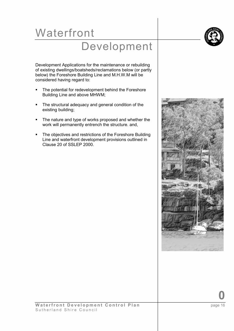
12. DEVELOPMENT WHICH IS PROHIBITEDDwellings, Reclamations and Boatsheds Below M.H.W.M
Land below M.H.W.M is generally zoned 7(a) EnvironmentalProtection (Waterways) under the SSLEP 2000. This zoningprohibits dwellings, reclamations and boatsheds as they arecontrary to the objectives of the zone. Existing dwellings orboatsheds below or partly below M.H.W.M are intended to bephased out, unless they have heritage significance.
Minor maintenance such as painting is acceptable butrecladding or structural alterations that would entrench thestructure require Development Consent from Council.
WaterfrontDevelopment
0W a t e r f r o n t D e v e l o p m e n t C o n t r o l P l a n page 16S u t h e r l a n d S h i r e C o u n c i l
Development Applications for the maintenance or rebuildingof existing dwellings/boatsheds/reclamations below (or partlybelow) the Foreshore Building Line and M.H.W.M will beconsidered having regard to:
� The potential for redevelopment behind the ForeshoreBuilding Line and above MHWM;
� The structural adequacy and general condition of theexisting building;
� The nature and type of works proposed and whether thework will permanently entrench the structure. and,
� The objectives and restrictions of the Foreshore BuildingLine and waterfront development provisions outlined inClause 20 of SSLEP 2000.
WaterfrontDevelopment
0W a t e r f r o n t D e v e l o p m e n t C o n t r o l P l a n page 17S u t h e r l a n d S h i r e C o u n c i l
13. ORIGIN
Code For Waterfront DevelopmentReference: DC000/1/19.Adopted by Council on 2nd September 1974.Amended on 15th December 1975.Amended on 26th November 1984.
Edition 1: Adopted by Council 3rd June 1985 (E.P.C. MinNo 176 of 20th May 1985 and amended byEPC Minute No 227 of 1st July 1985 asrequired).
Edition 2: Correction of minor errors and additionalinformation provided in the Origin.
Edition 3: Amended to upgrade standard of presentationOctober 1996.
DCP for Waterfront DevelopmentReference: 00/0836 & 02/00561
Edition 1:
Action DateCouncil Endorse Plan 4 February 2002
(EHC 174 – 02)Public Exhibition Period 2 April until 30 April 2002
Council Decision 21 October 2002(EHC 118 - 03)
In Effect 12 November 2002
� Update the Code for Waterfront Development bycorrecting any references to planning documents andmaking it consistent with current legislation;
� Update format so as to be consistent with Councils otherDevelopment Control Plans; and,
� Clarify Council’s position of not favouring berthing areasand specifically deleting any reference to multi housingdevelopment.

WaterfrontDevelopment
W a t e r f r o n t D e v e l o p m e n t C o n t r o l P l a n page 18S u t h e r l a n d S h i r e C o u n c i l
Appendix 1.
Clause 20 Foreshore Building Lines and Waterfront Development.
1. The objectives of this clause are:
a. preservation and enhancement of the natural features and vegetation nearwhere the land meets the water,
b. restoration of the land below the foreshore building line, so far as practicable,to a natural state, with a minimum intrusion of man-made structures,
c. no buildings below the foreshore building line other than buildings exceptedby this clause,
d. a significant reduction in the number of structures below the foreshorebuilding line, particularly on redevelopment of a site,
e. conservation and enhancement of waterfront buildings of heritage value,f. avoidance of adverse ecological effects on the waterways, andg. public use of the intertidal areas below the mean high water mark or high
water mark, where appropriate.
2. In this clause:foreshore building line for an allotment means:
a. if the maps indicate by a black line that a foreshore building line applies to theallotment—the line across the allotment parallel to, and at the greater of thefollowing distances from, the mean high water mark at 24 April 1980:
i. the distance specified on the maps, or ii. 7.5 metres from the mean high water mark for the time being, or
b. if the maps do not indicate by a black line that a foreshore building line appliesto the allotment, and the allotment adjoins or is adjacent to the mean highwater mark for the time being—the line across the allotment parallel to, and7.5 metres from, the mean high water mark for the time being, or
c. regardless of paragraphs (a) and (b), if the allotment adjoins a waterfrontreserve—the line across the allotment parallel to, and 7.5 metres from, thelandward boundary of the waterfront reserve.
For the purposes of this definition, the mean high water mark at 24 April 1980on any land is taken to be as shown on the last Deposited Plan or other planwhich defined the mean high water mark and was registered by the Registrar-General on or before 24 April 1980. It is not affected by reclamation, works orother changes before or after that date. Establishing the foreshore buildingline for an allotment to which
paragraph (a) or (b) applies will require reference to the mean high watermark at 24 April 1980 on adjoining or adjacent land in some cases.

WaterfrontDevelopment
0W a t e r f r o n t D e v e l o p m e n t C o n t r o l P l a n page 19S u t h e r l a n d S h i r e C o u n c i l
3. A person must not erect a building or carry out a work on land between aforeshore building line and the tidal water in respect of which the line is fixed.
4. However, subclause (3) does not apply to:
a. boat sheds,b. watercraft facilities,c. in-ground swimming pools, no higher than 300 millimetres above ground
level at any point,d. works, including mechanical works, to enable pedestrian access,
landscaping and barbecues.
5. Development consent must not be granted to any development on an allotment ofland affected by a foreshore building line, or to any development below the meanhigh water mark from time to time on an allotment or within the 7 (a)Environmental Protection (Waterways) zone adjoining the allotment, unless theconsent authority is satisfied that the following buildings or works (if any) will beremoved before, or within a reasonable time after, the development is carried out:
any building or work on the allotment between the foreshore building line and themean high water mark or high water mark, in each case as shown on the latestregistered Deposited Plan showing the allotment, not being a building or workspecified in subclause (4), or
any building or work below the mean high water mark or high water mark, in eachcase as shown on the latest registered Deposited Plan showing the allotment,being a building or work on the allotment or on land adjacent to the allotmentwhich is in the same ownership as the allotment or to which the owner oroccupier of the allotment has some form of occupancy rights, but not being abuilding or work specified in subclause (4) (b).
6. However, subclause (5) does not apply to a building or work if the consentauthority is satisfied that requiring removal of the building or work:
a. would be inconsistent with any of the objectives of this clause, or
b. is not necessary to achieve the objectives of this clause, or
is unreasonable or unnecessary in the circumstances of the case, having regard tothe provisions of any relevant development control plan.
This clause does not apply to buildings or works on reclaimed land, or on landadjacent to reclaimed land, in Sylvania Waters.
7. To avoid doubt, State Environmental Planning Policy No 1—DevelopmentStandards applies to a requirement made by subclause (3) in the same way as itapplies to a development standard.
WaterfrontDevelopment
0W a t e r f r o n t D e v e l o p m e n t C o n t r o l P l a n page 20S u t h e r l a n d S h i r e C o u n c i l
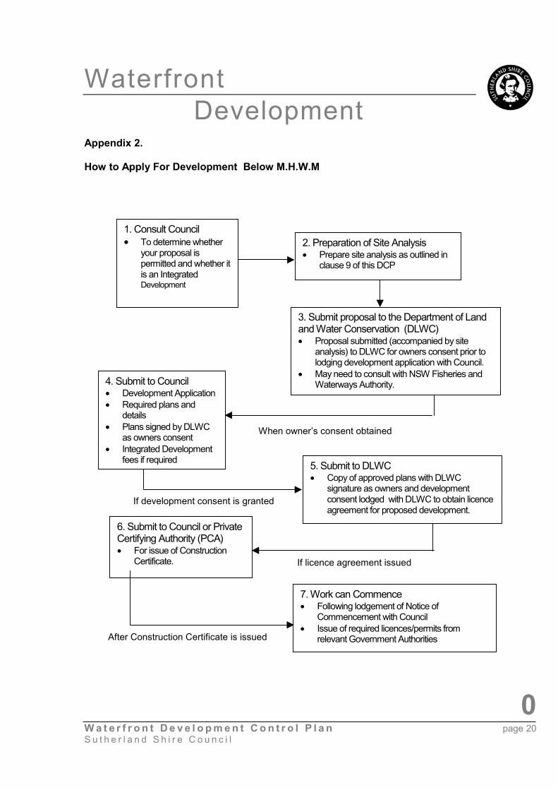
Appendix 2.
How to Apply For Development Below M.H.W.M
1. Consult Council� To determine whether
your proposal ispermitted and whether itis an IntegratedDevelopment
3. Submit proposal to the Department of Landand Water Conservation (DLWC)� Proposal submitted (accompanied by site
analysis) to DLWC for owners consent prior tolodging development application with Council.
� May need to consult with NSW Fisheries andWaterways Authority.4. Submit to Council
� Development Application� Required plans and
details� Plans signed by DLWC
as owners consent� Integrated Development
fees if required 5. Submit to DLWC� Copy of approved plans with DLWC
signature as owners and developmentconsent lodged with DLWC to obtain licenceagreement for proposed development.
6. Submit to Council or PrivateCertifying Authority (PCA)� For issue of Construction
Certificate.
7. Work can Commence� Following lodgement of Notice of
Commencement with Council� Issue of required licences/permits from
relevant Government Authorities
2. Preparation of Site Analysis� Prepare site analysis as outlined in
clause 9 of this DCP
When owner’s consent obtained
If development consent is granted
If licence agreement issued
After Construction Certificate is issued