Embed Size (px)
Citation preview

Sampling Evaluation of the
Barrington River Placer Claims
8 6 1 8 6 0
GEOLOGICAL REPORT
30 October 1986
Michael P. Wetherley Cons\xlting Geologist Phone: 403-281-5258 Calgary Alberta
M. WETHERLEY & ASSOCIATES LTD.

TABLE OF CONTENTS
Page
Introduction 1 Equipment and Procedures 1 Access 2 Communications 2 Topography 2 Gold Values 3 The Canyon 5 Cave Creek 6 Future Work: Roadbuilding 6 Seismic 6 D r i l l i n g 7 Deeper Sampling 7 Testing Plant 8 Production Plant 8 Conclusions and Discussion 8 Recommendations 10 C e r t i f i c a t e 12 Appendix
Sample Results A - l Distribution of Values A-2
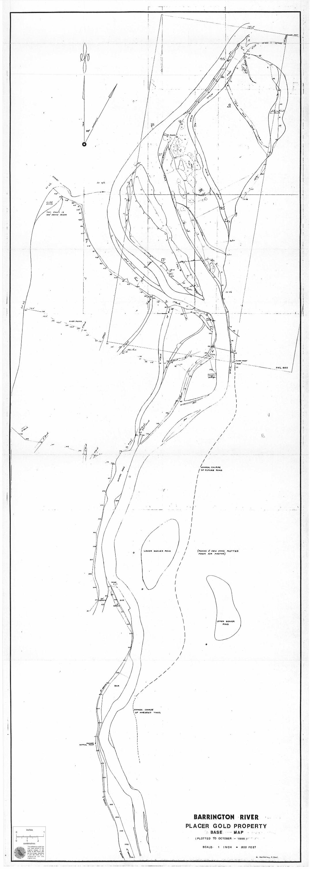
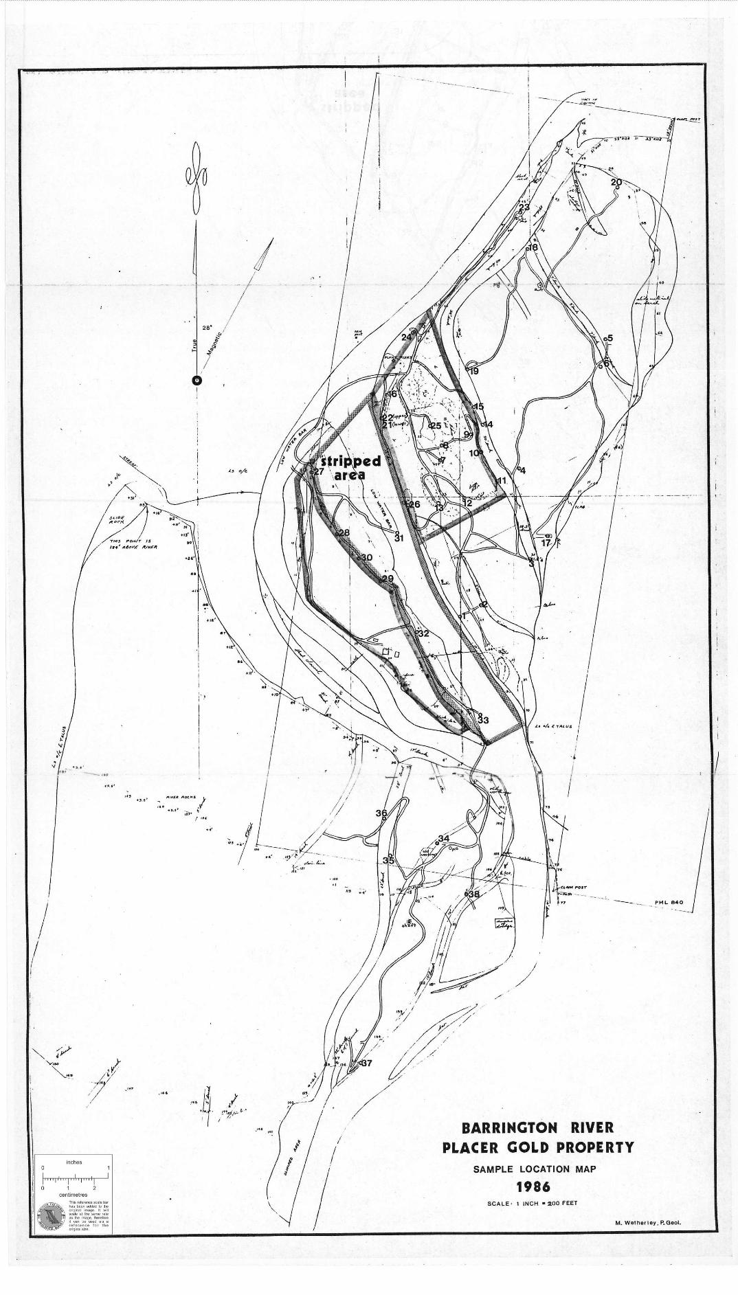
Maps (back pocket) Base Map Sample Location Map
M. WETHERLEY & ASSOCIATES LTD.

INTRODUCTION
The Barrington River Placer Group now comprises PML 840 and PLs 6945, 8259, 8260 and 9893, plus 4 additional PL applications made i n June and October, 1986. Refer to B.C. Placer T i t l e s Map 104G12 (west h a l f ) . The reader i s referred to a Geological Report by the writer dated 20 June, 1986 e n t i t l e d " I n i t i a l Evaluation of the Barrington River Placer Claims", as the present report serves i n part to update the former one.
An evaluation program on parts of PML 840 and PL 9893 was carried out from September 21 to October 17, 1986. The 4 person crew comprised John Hope - president of Integrated Resources Ltd., the writer, Tony Bennett - junior geologist, and Gabriela Mendez - junior mining engineer. The crew was frequently assisted by Wayne Eberg - the leaseholder, who was present throughout the program.
Of the 27 day t o t a l , approximately 4 days were taken up at the beginning by helicopter transport to the property, establishing camp and reassembling machinery. Three more days were accounted for at the end of the program by storing machinery and closing camp, waiting on weather, and helicopter transport. During the remaining 20 days approximately 2.2 miles of t r a i l were bulldozed and 38 samples were collected and processed. The mapped area was also extended, 0.7 miles of access road route was l a i d out on the ground i n Area "D", and a variety of information was collected about the property.
Of the 2.2 miles of t r a i l and 38 samples, 1.2 mile (56$) of t r a i l and 26 samples (68-£#) were from Area "A", 0.5 mile (22%) and 7 samples (18-^) were from Area "B", and 0.5 mile (22$) and 5 samples (13$) were from Area "C". A graphical presentation of the assays appears on Appendix Sheet 1. No additional s t a t i s t i c a l treatment has been applied because of the small populations of data which are drawn from di s s i m i l a r situations.
EQUIPMENT AND PROCEDURES
A Case 350 crawler tractor with a 6-way blade was used to make t r a i l s for a 3-wheeled Honda A l l Terrain Vehicle. The Honda towed a small
M. WETHERLEY & ASSOCIATES LTD.

hydraulic backhoe ("Cricket", manufactured by Ayer's C l i f f Industries Inc.) to sample si t e s and transported samples for concentration i n drums carried i n a 2-wheeled t r a i l e r . Sample material was collected in most cases at a depth of about 6 feet below the surface with only minus approximately 5 inches diameter material being retained. A Denver Gold Saver, which has a trommel mounted above a vibrating sluice was run over a 25 inch long stationary sluice and the recovered gold values were distributed on a weighted basis among the processed samples. The concentrates were seived, panned and amalgamated before weighing the gold on a beam balance having a s e n s i t i v i t y of 0.01 gram.
ACCESS
Property access was by helicopter from Dease Lake or Telegraph Creek. A B e l l 204 from Whitehorse was employed to s l i n g load the heavier equipment including the Case 350 which was disassembled into 3 loads. A l l of the heavier equipment was l e f t on the property and departure was made with 4 shuttle f l i g h t s of a Hughes 500-C to Glenora. One walking t r i p out was made by 2 members to Chutine Landing where r i v e r transport to Glenora was provided by a l o c a l resident.
COMMUNICATIONS
A rented radio telephone with access to one usually free channel (channel 3, ) provided excellent contact with the outside. A 6 f t . r e f l e c t o r type d i r e c t i o n a l antenna was mounted on a 50 f t . high wooden pole.
TOPOGRAPHY
The tested area at the head of the valley has been divided into Areas "A", "B", "C" and "D". Area "A" i s north of the Goat Walk and east of the r i v e r . Area "B" constitutes the island. Area "C" i s south of the island and west of the r i v e r . Area "D" i s south of the Goat Walk and east of the r i v e r .
The hummocky t e r r a i n around the beaver ponds i n Area "D" i s due to slumping of a high l a t e r a l moraine l e f t by the l a s t major ice advance
M. WETHERLEY & ASSOCIATES LTD.

down the Barrington River. Two contained beaver ponds could provide ideal s e t t l i n g basins for t a i l i n g s , but i t i s recommended that testing should precede such use. Extensive shallow workings exist i n the general v i c i n i t y of the beaver pond which i s closest to the r i v e r . A new road course was marked out to avoid swampy ground between the lower beaver pond and the r i v e r . According to Mr. Eberg, a l l of the beavers were removed by trapping during the 1985-86 winter. No recent beaver a c t i v i t y was evident i n October, 1986 although the dams were found to be i n good condition.
Clay exposed i n the west bank of the r i v e r near sample s i t e 37 occurs as slabs up to 5 feet i n length. These have been transported from a l o c a l source, such as a cutoff channel, and do not form a continuous bed. Lake sediments, i f they exist at depth, would l i k e l y be made up of boulder-free sand from reworked t i l l and alluvium, or possibly clay and s i l t . Such a bed could constitute a s i g n i f i c a n t marker horizon, as generally barren material which might be stripped and discarded, and as an indicator of the possible occurrence of gold bearing beach deposits, especially at the north end of the lower valley.
At a higher elevation than the top of the steep, glaciated walls of the present valley can be seen the remains of a gentler topography, but one which has s t i l l been modified by g l a c i a t i o n . Apparently, the g l a c i a t i o n occurred during an e a r l i e r Pleistocene advance.
The va l l e y i s narrower i n the northern 60$ of PML 840 than i n the southern part. A smaller, l a t e r g l a c i e r appears to have occupied the northern part and i t i s surmised that the bedrock base i s higher there than to the south.
An attempt was made to determine the f a l l of the r i v e r from the north end to the south end of the island (Area "B") with sightings through a hand-supported Suunto clinometer. The procedure i s a crude one which yielded a "best-guess" answer of 16 feet.
GOLD VALUES
About half of the samples (20 out of 38) were calculated to run at or above $3.64 per yd^(minus 5 inch material) before d i s t r i b u t i o n of the
M. WETHERLEY & ASSOCIATES LTD.

secondary sluice values. The reported losses could be s i g n i f i c a n t l y lower than actual because the secondary sluice dried out between samples, especially overnight, and losses due to skin f l o t a t i o n are probable. Whether the secondary sluice values are f a i r l y distributed i s d i f f i c u l t to determine. One might at f i r s t suspect that the richer samples contributed the most. However, i t should be noted that some of the richer samples contained very l i t t l e fine gold whereas the poorest samples contained only fine gold. It i s possible, therefore, that the largest losses came from the poorest samples. This might not be the case, but i t i l l u s t r a t e s just one of a number of problems i n determining true values.
Placer gold values are notorious for t h e i r e r r a t i c d i s t r i b u t i o n which becomes increasingly e r r a t i c as the values increase. Only large, bulk samples can come close to providing a true picture, and small samples (5-} f t ^ i s small) do not provide results which can be regarded with confidence. Small samples which y i e l d high results can be taken as j u s t i f i c a t i o n for running bulk samples, while small samples which y i e l d poor results do not prove that the ground i s poor although one often has l i t t l e choice than to accept the r e s u l t s .
The richest samples, as compared to the poorest samples, were t y p i f i e d by more magnetite, coarser gold, less fine gold, more clay, and more boulders.
The sample results are presented i n dollars (Canadian, $550.00 per ounce Troy, 80$ fine) per cubic yard. The cubic yards are loose, of minus approximately 5 inch diameter material. The amount of oversize was not recorded but i n some cases i t was considerable. To simply dilute the sample results by a factor r e f l e c t i n g the amount of oversize could be misleading and the writer favours subtracting an amount which r e f l e c t s the cost of removing the oversize on a production scale. Of course, the method employed must be made clear.
Information required to account for oversize was not available from thi s program, nor would i t be very meaningful to apply i t given the sample size and s i t e d i s t r i b u t i o n . In the case of a bulk sampling program a deduction for the cost of removing oversize would be appropriate. In the case of marginal material t h i s would be essential.
^ M. WETHERLEY & ASSOCIATES LTD. '
5 ^
The benches are what remains of valley-wide alluvium that has sometimes been reworked, frequently i n a braided stream environment, so that an exposed cross section reveals a complex pattern of channel scouring and bar deposition. Values are higher i n the channels but average out over a given area. In t h i s model, lower grade benches where fewer channels are found would have undergone less reworking. This leads one to question whether gold might have been continually introduced from the canyon to increase the gold content of o r i g i n a l l y lower grade alluvium i n the lower valley.
Some of the gold i s very f l a t , which i s t y p i c a l of a braided stream environment, but some appears very irregular as might r e f l e c t recent release. The gold i s t y p i c a l l y resistant to amalgamation due to some coating (iron oxide or iron carbonate ?) which i s readily removed by n i t r i c acid. Some samples alongside the r i v e r contained gold coated with fresh appearing mercury, and i t i s possible that a quantity of mercury was l o s t when the dredge was wrecked.
THE CANYON
The canyon provides an environment of rapid erosion with almost no deposition, and the lower va l l e y offers one of the few significant opportunities for deposition of gold and other heavy minerals released over an area of roughly 130 square miles. In particular, the contact zone of a 6 mile quartz d i o r i t e intrusive within folded volcanics and sediments on the northeast flank of Mt. Barrington i s only 1-J- miles upstream from the mouth of the canyon and i s bounded almost e n t i r e l y by steep slopes. Some 4 miles of contact contribute material to the canyon either d i r e c t l y or v i a the deeply incised course of Spann Creek.
The canyon i s also notable for a sizeable zone of gossan occurring within a series of folded volcanic flows near the entrance of Jimmie Creek. The gossans warrant investigation as they hold de f i n i t e p o s s i b i l i t i e s for hardrock mineralization. Access should be by helicopter at a time of lowest r i v e r l e v e l .
M. WETHERLEY & ASSOCIATES LTD.
^ 1 GAVE CREEK
This stream i s a tributary of the Barrington River which enters below the main area of investigation. It could be significant i n that i t s headwaters might drain up to about a mile of contact near the southwest end of the quartz d i o r i t e intrusiye, just west of the summit of Mt. Barrington. I f th i s i s so, the presence of gold values i n Cave Creek would tend to confirm the hypothesis that the intrusive contact zone i s contributing gold to the Barrington River, especially since Cave Creek flows through limestone t e r r a i n for much of i t ' s course. A suitable place to test for gold (by panning) would be on Cave Creek just above the entry of a tributary from the west which flows from Tuffa Lake. This point i s about one mile from the mouth of Cave Creek at the Barrington River. Weak contamination from g l a c i a l d r i f t above the sample point i s possible.
The absence of placer gold i n Cave Creek would not disprove the hypothesis as i t i s often the case at a contact that only a certain lithotype, such as a sp e c i f i c sediment, i s favoured with mineralization and our hypothetical lithotype might not occur within the r e s t r i c t e d Cave Creek drainage area.
FUTURE WORK
ROADBUILDING
The most important next step i s a road to the property. Additional sampling, bulk sampling, d r i l l i n g , and production on any practicable scale are a l l dependent upon a road. An application to procede with construction was pending i n October, 1986. The planned road constitutes a 12 mile extension to the road down the Stikine Valley from Glenora and Telegraph Creek.
SEISMIC
One of the results of the 1986 program has been improved understanding of the geological history of the claim group, at least on a speculative l e v e l , which enables one to specify a number of seismic traverses.
M. WETHERLEY & ASSOCIATES LTD.
Seismic r e f l e c t i o n i s the preferred mode as i t might reveal subtle sedimentary discontinuities such as those r e f l e c t i n g lacustrine deposition. Seismic refraction surveys are faster and cheaper and are good for mapping bedrock, which r e f l e c t i o n also does well. Only a f i e l d test w i l l determine whether good r e f l e c t i o n p r o f i l e s are obtainable. Refraction data i s almost certa i n l y obtainable. Several times as much explosives are required for r e f l e c t i o n work with a corresponding increase i n time and cost.
Seismic traverses are required to determine the valley p r o f i l e , depths to bedrock, position of a lower cirque i f i t exists, possible mouth of a hanging va l l e y at the entrance to the Chutine Valley, investigation of possible buried a l l u v i a l fans at the mouth of the canyon and below a lower cirque and at the entrance to the Chutine Valley, depth of any s i g n i f i c a n t lake sediments at the valley walls (especially at the north end where gold could occur i n beach deposits), and thickness of slumped material (especially i n Area "D").
Seismic information can be useful i n correlating and extrapolating d r i l l i n g r e s u l t s , which provide information on depths, type of material, and gold content, i n order to calculate economic reserves, establish the l i m i t s of uneconomic material, determine p i t depths and configurations, and i d e n t i f y bedrock l i m i t s .
DRILLING
D r i l l i n g should follow the seismic surveys to determine actual depths and to provide samples for i d e n t i f i c a t i o n of material type and assay of gold values. Several systems are available, none of which work well under a l l conditions. However, the writer has employed a Becker d r i l l under comparable conditions with acceptable r e s u l t s . Information on grades provided by d r i l l i n g i s not always r e l i a b l e and interpretation i s often required.
DEEPER SAMPLING
A larger backhoe w i l l be required to obtain deeper samples and to section the benches. It would also be used to dig bulk samples for larger scale t e s t i n g and i n the production of certain types of ground.
M. WETHERLEY & ASSOCIATES LTD. *

A front end loader i s normally used with a backhoe on sampling programs to transport material and feed the concentrator.
TESTING- PLANT
A small plant capable of running bulk samples w i l l be required to enable testing to proceed ahead of mining. A hopper over a shaking screen with high pressure water jets, plus concentrating equipment which might consist of a vibrating sluice or a j i g or centrifugal separator, and a small shaking table, are the main items required.
PRODUCTION PLANT
Boulders and black sand are major considerations influencing a choice in the type of plant. The writer favours a vibrating g r i z z l y , v ibrating screen with high pressure water jets, and a gravel pump as constituting the main items of a mobile s i z i n g plant. Oversize would be stacked or else trucked away. Undersize would be pumped to the concentrator.
The concentrator might use a hydrocyclone, primary ji g s or centrifugal concentrator, secondary j i g s or centrifugal concentrator, a shaking table, and a gravel pump for t a i l i n g s . A future, larger capacity concentrator, especially one processing sandy material from the higher benches might employ variable cross-section s p i r a l s .
CONCLUSIONS AND DISCUSSION
The 1986-fall program on the Barrington River Placer Group was regarded by those who participated, including the writer, as a success. L o g i s t i c a l challenges inherent i n conducting a mechanized program i n a remote area were faced and overcome, during what was reportedly one of the wettest autumns on record.
Any investigation of a placer property that i s based upon small samples from shallow depths over a wide area must be recognized as having limited objectives. Our major objective was to co l l e c t enough data so as to be able to determine whether additional work could be economically j u s t i f i e d . That objective was met, the determination was
M. WETHERLEY & ASSOCIATES LTD.

r positive, and the results of the program can be regarded with s a t i s f a c t i o n .
The writer concludes the following: 1. Widespread continuity of material type and grades appears to
occur. 2. Higher benches might not be economic to mine unless r i c h ground
underlies them. 3 . Lower benches could contain economic material above the present
l e v e l of the r i v e r . In particular, the benches of Area "C" have promising potential as they contain large reserves while the surface has been barely scratched with the c o l l e c t i o n of 5 small samples, 3 of which indicated economic or close to economic grades.
4. Areas "A" and MB , f adjacent to the old dredge cut, which yielded consistently high values, constitute a l o g i c a l place to obtain a bulk sample and to plan to commence mining, as p r a c t i c a l l y no overburden would need to be removed.
5 . The method used has probably exaggerated the values reported. On the other hand, values are widespread and there seems l i t t l e reason to doubt that higher values (employing the same approach) remain to be found. In pa r t i c u l a r , the fact that the lowest samples, topographically, yielded the best re s u l t s , contributes to an improved prognosis for the outcome of deeper sampling and d r i l l i n g programs.
The writer's f i r s t geological model incorporated the concept of higher grades at depth, as deeply weathered (enriched) and glaciated gold-bearing material from a nearby source was deposited i n a glaciated v a l l e y and then buried by increasingly d i l u t e material.
The second model incorporates a continual introduction of gold by the r i v e r to enrich formerly low grade alluvium. Both models may apply, but the writer leans toward the second model at least as being p a r t i a l l y established. I f so, then higher grade material i s the result of more reworking by the r i v e r , has a higher black sand and boulder content, and should be recognizeable by geophysical means (sensitive magnetometer and seismic r e f l e c t i o n , depending upon the depth). Higher benches may be poorer because the r i v e r cut through them faster, and
M. WETHERLEY & ASSOCIATES LTD.

. 10
whether enrichment occurred, or to what extent, may have depended more upon the character of the r i v e r at that time than upon any other factor.
Gold from an eroding bench may be added to the stream to increase the grade of that horizon. But i f t h i s were a major factor i n explaining the presence of gold i n the stream bed then the higher grades should not continue beneath an adjoining bench, which i s what i t does i n Area "A".
While the volume of flow of the r i v e r has undoubtedly fluctuated over the past several thousand years, no evidence indicates that the high benches were b u i l t and reb u i l t as a re s u l t . The writer suspects that sediments below the present r i v e r l e v e l have had a much more active history than those above i t . This would be encouraging for the prospect of encountering increasing grades with depth, and would focus attention on the question of whether high bench material should be processed or discarded. Much of i t would have to be moved regardless, i n such case, and a different c i r c u i t might treat i t more e f f i c i e n t l y .
The second model also places a higher p r i o r i t y upon exploration of the canyon to locate an economic hardrock source.
RECOMMENDATIONS
Further investigation of th i s property i s d e f i n i t e l y recommended, as itemized below:
1. A road to provide access from Glenora i s required. 2. A tes t i n g plant capable of processing samples of several cubic
yards i s required, with a backhoe to obtain the samples and a front end loader to transport them, feed the plant, and remove t a i l i n g s .
3. Seismic and d r i l l i n g programs should precede general development.
4. The gossan zone i n the canyon should be sampled. 5. Cave Creek and the canyon t r i b u t a r i e s should be panned and the
intrusive contact prospected i f i t i s found to be a source of gold.
M. WETHERLEY & ASSOCIATES LTD.

RECOMMENDATIONS (Continued).
6. Other targets may occur within the Barrington River drainage basin. They could be investigated by panning streams and co l l e c t i n g sediment samples for geochemical analysis, and by sampling gossans and talus. Helicopter support would be essential.
M. WETHERLEY & ASSOCIATES LTD.

CERTIFICATE
1. I am a professional geologist and a member of the Association of Professional Engineers, Geologists & Geophysicists of Alberta (APEGGA).
2. I am a graduate of the P r o v i n c i a l Institute of Mining, Haileybury, Ontario (Diploma i n Mining Technology granted 1962) and Michigan Technological University, Houghton, Michigan (B.Sc Geology, honours, granted 1966; completed M.Sc. Geology course
3. I have served as an executive director of a placer mining company l i s t e d on a public stock exchange, and I am familiar with the evaluation of placer prospects and placer mining a c t i v i t i e s .
4. I have worked on and am f a m i l i a r with the Barrington River Placer Claims which are the subject of t h i s report.
5. I have no b e n e f i c i a l interest i n t h i s claim group and do not expect to receive any return, direct or i n d i r e c t , from any mining a c t i v i t y that might take place there.
1967).
Michael P. Wetherley, P.Geol.
M. WETHERLEY & ASSOCIATES LTD.
/ 9 8 6 * loose » minus appro*. 5
A d d 5 9 t/yd* to
A d d 3 6 % d J to

HARRINGTON P/V£R PLACER. GOLD PROSPECT &/STAI BUT/ON OP )/ALUES
/S3 6
AREA W COXAJSCTEP
<. 01 . ozs .oso .07 3 .100 . \ Z S .150 .17 5 .ZOO . Z Z S -ZS 0 .Z7S . 3 00 .3Z5 . 3 5 0 . 3 7 5 . 4 0 0 . 4 * 5 . 4 5 0
1 4 6 10 18 20 5 15 17 13 12 2 3 14 14 21 22 3 II 8 23
6
5 2 2.
13
2< 7
. 0 |
. I 0
. £ 0
. 3 0
. 4 0 . 5 0 . 6 0 . 7 0 . 8 0 . 9 0
1.00
28 29 30 33 27 32
ACTUAL OCCURRING / v CALQO*.AT£D \/Aie/ES(r/cj<i )
< . 4 6 Mu*,»pJe); < .73 ( . 5 . 4 5 - f t 3 ) 0 . 4 6 - 1 . 8 5 Z.IQ - 3 . 6 4 4 - 6 3 ~ 5 . 0 9 6 . 3 5 - 7 . 2 8
1 7 . 4 7
3 0 . 3 7
2 9 . II
3 1 . 2 3
- 20. 8 4
20^> rcporb«J spill*.A. R«c<llcul»fcion i j
+ 30^/^<J 3 to all above •Pror** sluice. r « cov« r y
0 . 7 3 2 . f 8 1 4 . 5 5
7.z e
31 67.6 7
ACTUAL <0T (g)
. 01 . 0 3 . 0 5 . 0 7 . 0 3 . I I . / 3 . I 5
37 3S
36 38
34
0 . 7 3 / . 4 6
5 . 8 2
10.91 samples -Prom r e cove r y .
12 V(j<T fco * B * « n d