Embed Size (px)
Citation preview

7. Topography, Geomorphology, Geology and Soils

Cross River Rail
CHAPTER 7 TOPOGRAPHY, GEOLOGY, GEOMORPHOLOGY AND SOILS
JULY 2011


CrossRiverRail
Contents 7 Topography, geology, geomorphology and soils .........................................7-1
7.1 Introduction ...................................................................................................................... 7-1 7.1.1 Study corridor................................................................................................. 7-1 7.1.2 Methodology .................................................................................................. 7-1
7.2 Description of existing environment................................................................................. 7-3 7.2.1 Corridor-wide considerations ......................................................................... 7-3 7.2.2 Wooloowin to Bowen Hills ........................................................................... 7-26 7.2.3 Spring Hill to Dutton Park ............................................................................ 7-30 7.2.4 Fairfield to Salisbury .................................................................................... 7-37
7.3 Potential impacts and mitigation .................................................................................... 7-43 7.3.1 Impacts on existing study corridor features and values............................... 7-43 7.3.2 Corridor-wide considerations ....................................................................... 7-44 7.3.3 Wooloowin to Bowen Hills ........................................................................... 7-57 7.3.4 Spring Hill to Dutton Park ............................................................................ 7-62 7.3.5 Dutton Park to Salisbury .............................................................................. 7-67 7.3.6 Summary...................................................................................................... 7-69
7.4 Conclusions ................................................................................................................... 7-74 7.4.1 Geology........................................................................................................ 7-74 7.4.2 Settlement risk ............................................................................................. 7-75 7.4.3 Erosion risk .................................................................................................. 7-75 7.4.4 Acid Sulfate Soils ......................................................................................... 7-75

CrossRiverRail Page 7-1
7 Topography, geology, geomorphology and soils
7.1 Introduction This Chapter addresses section 3.3.1 of the Terms of Reference (ToR). It describes the existing environmental values of the study corridor with regard to topography, geology, geomorphology and soils and assesses the potential benefits and adverse impacts on these aspects attributable to Cross River Rail (the Project).
Potential cumulative impacts of the Project on the environmental values of the study corridor have also been identified and described in this chapter. Where appropriate, recommendations have been made regarding performance objectives and impact management and mitigation measures suitable for adoption as part of the project design criteria or for implementation during construction and operations phases of the Project.
7.1.1 Study corridor
The study corridor extends in a generally north-south direction between Wooloowin and Salisbury.
For the purpose of the presentation in this chapter, the study corridor has been divided into three sections:
� Northern section – Wooloowin to Bowen Hills
� Central section – Spring Hill to Dutton Park
� Southern section – Fairfield to Salisbury.
7.1.2 Methodology
The legislative framework relevant to the environmental values of the topography, geology, geomorphology and soils aspects within the study corridor are:
� Environmental Protection Act 1994 (EP Act)
� Environmental Protection Regulation 2008 (EP Reg)
� Land Protection (Pest and Stock Route Management) Act 2002 (LP Act)
� Sustainable Planning Act 2009 (SPA)
� Environmental Protection (Water) Policy 2009 (EPP (Water))
� State Planning Policy 2/02 Planning and Managing Development Involving Acid Sulfate Soils (SPP 2/02)
� State Planning Policy 2/07 Protection of Extractive Resources (SPP 2/07).
The purpose of this study is to provide an overview of the existing landform patterns, dominant geological units and processes, soil landscape characteristics and significant features of insitu material that are likely to be encountered or disturbed during construction. It is also important to identify areas of potential stability and erosion risk within the study corridor that would require further detailed investigation and special mitigating or management to be implemented in order to ensure that any negative potential impact of the Project are acceptable.

CrossRiverRail Page 7-2
The methodology for the preparation of the description of the existing environment and potential impact assessment included:
� review of existing mapping and geotechnical data
� review of previous reports and investigations
� review of the reference design, feasibility and planning reports, constraints mapping and construction issues and geotechnical investigation reports.
The review of the soil types mapped by Beckman et al (1987) within the study corridor and described during the geotechnical investigations was completed with reference to the Australian Soil and Land Survey Field Handbook (McDonald et al 1990) and the Australian Soil Classification (Isbell 2002) for the purpose of assessing erosion risk and potential impacts to stormwater runoff quality.
The provision of recommendations for the mitigation and management of erosion risks have been developed with reference to the Best Practice Erosion and Sediment Control (International Erosion Control Association (IECA) Australasia 2008), Soil Erosion and Sediment Control – Engineering Guidelines for Queensland Construction Sites (Institute of Engineers Australia (Qld Division) 1996) and Draft Urban Stormwater - Queensland Best Practice Environmental Management Guidelines 2009 (DERM 2009a).
A desktop assessment of the potential for encountering Acid Sulfate Soils (ASS) and the provision of recommendations for identifying ASS material that may be disturbed as a result of the construction of the Project was completed with reference to the requirements detailed in the SPP 2/02 and the accompanying Guideline 2/02. Recommendations for further investigations and management of disturbed ASS material have been developed with reference to the Guidelines for Sampling and Analysis of Lowland Acid Sulfate Soils (ASS) in Queensland 1998 (Ahern et al 1998) and the Queensland Acid Sulfate Soil Technical Manual – Soil Management Guidelines (Dear et al 2002), respectively. The assessment for ASS was completed through the review of existing mapping and geotechnical bore logs and characterisation data collected during the geotechnical investigations for the Project.
The review of the geotechnical investigations completed for the Project was undertaken for the purpose of identifying geological and geotechnical survey locations. The EIS is required to present an assessment of the adequacy of geological and geotechnical data compiled for the Project and the rationale for future geotechnical investigations, with a view to providing an estimate of the probability of encountering ground conditions that are significantly different from forecast conditions for each section of the tunnel. This information is detailed in the Cross River Rail Preliminary Geotechnical Interpretive Report (AECOM, 2010a).
For the purpose of assessing the potential impacts and developing mitigation measures, consideration was made of:
� the assessment of settlement risk in relation to excavation and groundwater drawdown
� the assessment of erosion risk and potential impacts in relation to stormwater quality
� the assessment of ASS disturbance resulting in the generation of acidified leachate during earthworks and construction.

CrossRiverRail Page 7-3
7.2 Description of existing environment 7.2.1 Corridor-wide considerations
Topography
The topography of the study corridor is generally characterised by undulating terrain with a number of prominent high and low points. The highest point within the corridor is on Wickham Terrace in Spring Hill at 55 m Australian Height Datum (AHD) and the lowest point is within the Brisbane River channel at less than 0 m AHD.
Topographical contours for each section of the study corridor are presented in Figure 7-1, Figure 7-2 and Figure 7-3.
Digital Elevation Model (DEM) terrain data is presented for each section of the study corridor in Figure 7-4, Figure 7-5 and Figure 7-6.
An overview of the significant topographical features within the study corridor are summarised in Table 7-1.
Table 7-1 Summary of significant topographical features
Study corridor section Catchments/ subcatchments
Higher ground/catchment boundaries
Kedron Brook: 6 m AHD Wilston (west of the study corridor extent): 50 m AHD Clayfield (east of the study corridor extent): 50 m AHD
Northern section – Wooloowin to Bowen Hills
Breakfast Creek: 5 m AHD
Ascot (east of the study corridor): 40 m AHD Bowen Hills (east of the study corridor): 40 m AHD Herston (west of the study corridor): 40 m AHD
Brisbane River: <0 m AHD
Spring Hill: 55 m AHD Kangaroo Point: 20 m AHD
Central section – Spring Hill to Dutton Park
Norman Creek: 10 m AHD
Kangaroo Point: 20 m AHD Dutton Park: 40 m AHD
Brisbane River: <0 m AHD
Dutton Park: 40 m AHD Annerley: 40 m AHD Moorooka: 35 m AHD
Southern section – Fairfield to Salisbury
Oxley Creek: <5 m AHD Moorooka: 35 m AHD Salisbury: 35 m AHD

!
!
!
!
!
!
!
Albion Station
Windsor Station
Wooloowin Station
Bowen Hills Station
Eagle Junction Station
Exhibition Station
Brisbane R
iver
ek
Breakfast Creek
w
Kedron Brook
5
35
15
10
40
30
20
55 60
15
5
40
20
5
15
5
5
15
10
15
10
5
40
40
20
40
20
10
10
20
5
55
55
35
15
5
20
5
535 30
20
10
20
5
155
5
30
5
15
10
10
30
10
10
20
5
35
15
15
10
10
20
15
15
101515
40
5
30
20
25
50
25
25
2525
25
25
25
25
WINDSOR
ALBION
CLAYFIELD
BOWEN HILLS
NEWSTEADBULIMBA
WOOLOOWIN
LUTWYCHE
HERSTON
GORDON PARK
HAMILTON
ASCOT
FORTITUDE VALLEY
KEDRON
WILSTON
GRANGE
SPRING HILL
STAFFORD
CROSS RIVER RAILENVIRONMENTAL IMPACT STATEMENT
Figure 7-1Topographic Contours
(Northern Section)
¯0 100 200 300 400 500m
LEGENDStudy Corridor
Suburbs! Station
Track
Contours25m Interval5m Interval
Watercourse
K:\C
ross
Riv
er R
ail\6
00 E
nviro
nmen
t\619
GIS
\Aur
econ
\205
555_
CR
R\G
008_
CC
R_C
onto
ur_S
heet
1_A
3_ve
r93.
mxd
0
7/07
/201
1 16
:10
Map
by:
MJS
1:18,000 at A4

!
!
!
!
!
!
!
!
!
n Station
Buranda Station
CentralStation
Roma Street Station
Southbank Station
Park Road Station
Dutton Park Station
South Brisbane Station
Fortitude Valley Station
Exhibition Station
YorksHollow
Brisbane River
Norman Creek
15
10
35
5
3040
20
55
6065
40
30
10
15
35
20
15
5
10
10
40
15
40
40
40
20
40
35
10
30
10
5
55
3020
40
10
15
5
10
30
10
40
15
15
5
35
5
530
30
15
15
5
40
10
15
5
10
10
5
30
15
15
15
20
15
20
65
10
5
10
35
5
5
15
5
15
5
5
20
5
30
35
20
5
10
30
20
30
5
65
15
30
20
35
10
30
15
10
20
20
10
20
20
10
35
30
1010
155
30
35
5
40
15
1510
35
5
5
40
10
5
10
15
30
20
25
50
25
25
50
50
50
50
50
25
25
25
50
25
2525
25
25
25
25
25
CITY
NEW FARM
ST LUCIA
SOUTH BRISBANE
WOOLLOONGABBA
SPRING HILL
KANGAROO POINT
EAST BRISBANE
HIGHGATE HILL
DUTTON PARK
FORTITUDE VALLEY
WEST END
NEWSTEAD
HERSTONKELVIN GROVE
MILTON
GREENSLOPES
PADDINGTON
RED HILL
BOWEN HILLS
FAIRFIELD
CROSS RIVER RAILENVIRONMENTAL IMPACT STATEMENT
Figure 7-2Topographic Contours
(Central Section)
¯0 100 200 300 400 500 600m
LEGENDStudy Corridor
Suburbs! Station
Track
Contours25m Interval5m Interval
Watercourse
K:\C
ross
Riv
er R
ail\6
00 E
nviro
nmen
t\619
GIS
\Aur
econ
\205
555_
CR
R\G
008_
CC
R_C
onto
ur_S
heet
2_A
3_ve
r93.
mxd
0
7/07
/201
1 16
:25
Map
by:
MJS
1:22,000 at A4

!
!
!
!!
!
!
!
!
!
!
Rocklea Station
Buranda Station
Yeronga Station
Tennyson Station
Moorooka Station
Salisbury Station
Park Road Station
Fairfield Station
Dutton Park Station
Yeerongpilly Station
Brisbane River
Moolabin
Creek
Rocky Waterholes Creek
Stable Swamp Creek
Norman Creek
Oxley C
reek
35
10
515
20
40
30
5
10
15
105
15
5
15
10
10
10
5
5
20
10
10
35
30
5
15
5
40
20
30
5
10
40
15
30
1515
5
5
15
20
30
30
20
10
30
15
20
35
40
5
5
30
40
10
30
35
5
15
35
10510
15
20
15
40
5
15
20
5
5
5
5
20
10
20
30
25
50
25
25
25
25
25
25
25
ROCKLEA SALISBURY
ST LUCIA
YERONGA
MOOROOKA
TARRAGINDI
ANNERLEY
NATHAN
GREENSLOPESFAIRFIELD
YEERONGPILLY
INDOOROOPILLY
TENNYSON
DUTTON PARK
ARCHERFIELD COOPERS PLAINS
WOOLLOONGABBA
CORINDA
HIGHGATE HILL
HOLLAND PARK WEST
TARINGA
CROSS RIVER RAILENVIRONMENTAL IMPACT STATEMENT
Figure 7-3Topographic Contours
(Southern Section)
¯0 100 200 300 400 500 600m
LEGENDStudy Corridor
Suburbs! Station
Track
Contours25m Interval5m Interval
Watercourse
K:\C
ross
Riv
er R
ail\6
00 E
nviro
nmen
t\619
GIS
\Aur
econ
\205
555_
CR
R\G
008_
CC
R_C
onto
ur_S
heet
3_A
3_ve
r93.
mxd
0
7/07
/201
1 16
:26
Map
by:
MJS
1:30,000 at A4

!
!
!
!
!
!
!
Albion Station
Windsor Station
Wooloowin Station
Bowen Hills Station
Eagle Junction Station
Exhibition Station
Brisbane R
iver
ek
Breakfast Creek
w
Kedron Brook
WINDSOR
ALBION
CLAYFIELD
BOWEN HILLS
NEWSTEADBULIMBA
WOOLOOWIN
LUTWYCHE
HERSTON
GORDON PARK
HAMILTON
ASCOT
FORTITUDE VALLEY
KEDRON
SPRING HILL
WILSTON
GRANGE
STAFFORD
Lutw
yche
Rd
Chalk St
Maygar St
Hud
son
Rd
Rose St
Brookes St
Constitution Rd
Newmarket Rd
Oriel Rd
Bow
en B
ridge
Rd
Sand
gate
Rd
Brea
kfas
t Cre
ek R
d
Commercial Rd
O'Connell Tce
Butterfield St
Montpelier Rd
Albion Rd
CROSS RIVER RAILENVIRONMENTAL IMPACT STATEMENT
Figure 7-4Digital Elevation Model
(Northern Section)
¯0 100 200 300 400m
LEGENDStudy Corridor
Suburbs
Highway/Freeway/Motorway
Main Road
Road
! Station
Track
K:\C
ross
Riv
er R
ail\6
00 E
nviro
nmen
t\619
GIS
\Aur
econ
\205
555_
CR
R\G
010_
CC
R_D
EM
_She
et1_
A3_v
er93
.mxd
0
7/07
/201
1 16
:28
Map
by:
MJS
Elevation (m)0 - 2
2 - 4
4 - 6
6 - 8
8 - 10
10 - 12
12 - 14
14 - 16
16 - 18
18 - 20
20 - 22
22 - 24
24 - 26
26 - 28
28 - 30
30 - 32
32 - 34
34 - 36
36 - 38
38 - 40
40 - 42
42 - 44
44 - 46
46 - 48
48 - 50
50 - 52
52 - 54
54 - 56
56 - 58
58 - 60
60 - 62
62 - 64
64 - 66
66 - 68
68 - 70
1:18,000 at A4

!
!
!
!
!
!
!
!
!
Buranda Station
CentralStation
Roma Street Station
Southbank Station
Park Road Station
Dutton Park Station
South Brisbane Station
Fortitude Valley Station
Exhibition Station
YorksHollow
Brisbane River
Norman Creek
CITY
NEW FARM
WOOLLOONGABBA
SOUTH BRISBANE
SPRING HILL
ST LUCIA
EAST BRISBANE
KANGAROO POINT
NEWSTEAD
HIGHGATE HILL
DUTTON PARK
FORTITUDE VALLEY
HERSTONKELVIN GROVE
WEST END
GREENSLOPES
RED HILL
BOWEN HILLS
MILTON
COORPAROO
PADDINGTON
FAIRFIELD
NORMAN PARK
BULIMBA
Vulture St
Ann St
Gre
gory
Tce
Grey St
Hal
e S
t
Wick
ham S
t
South East Fw
y
George St
Gladstone Rd
Wel
lingt
on R
d
Stanley St East
Sydne
y St
Roma St
Stephens Rd
Riv
er T
ce
O'Keefe St
James St
Montag
ue Rd
Dornoch Tce
Beeston St
Boundary St
Stanley St
Brad
field
Hw
y
Brunswick St
Felix St
CROSS RIVER RAILENVIRONMENTAL IMPACT STATEMENT
Figure 7-5Digital Elevation Model
(Central Section)
¯0 100 200 300 400 500m
LEGENDStudy CorridorSuburbsHighway/Freeway/MotorwayMain Road
Road
! StationTrack
K:\C
ross
Riv
er R
ail\6
00 E
nviro
nmen
t\619
GIS
\Aur
econ
\205
555_
CR
R\G
010_
CC
R_D
EM
_She
et2_
A3_v
er93
.mxd
0
7/07
/201
1 16
:31
Map
by:
MJS
Elevation (m)0 - 2
2 - 4
4 - 6
6 - 8
8 - 10
10 - 12
12 - 14
14 - 16
16 - 18
18 - 20
20 - 22
22 - 24
24 - 26
26 - 28
28 - 30
30 - 32
32 - 34
34 - 36
36 - 38
38 - 40
40 - 42
42 - 44
44 - 46
46 - 48
48 - 50
50 - 52
52 - 54
54 - 56
56 - 58
58 - 60
60 - 62
62 - 64
64 - 66
66 - 68
68 - 70
1:22,000 at A4

!
!
!
!!
!
!
!
!
!
!
Rocklea Station
Buranda Station
Yeronga Station
Tennyson Station
Moorooka Station
Salisbury Station
Park Road Station
Fairfield Station
Dutton Park Station
Yeerongpilly Station
Brisbane River
Moolabin
Creek
Rocky Waterholes Creek
Stable Swamp Creek
Norman Creek
Oxley C
reek
ROCKLEA
SALISBURY
ST LUCIA
YERONGA
MOOROOKA
TARRAGINDI
ANNERLEY
NATHAN
GREENSLOPESFAIRFIELD
YEERONGPILLY
INDOOROOPILLY
TENNYSON
WOOLLOONGABBA
DUTTON PARK
ARCHERFIELD COOPERS PLAINS
CORINDA
HIGHGATE HILL
HOLLAND PARK WEST
TARINGA
Tooh
ey R
d
Beau
dese
rt R
d
Evans Rd
Riawena Rd
Brisbane Cso
Hyde Rd
Meiers R
d
Fairf
ield
Rd
Ipswich R
d
Ipswich Mwy
Sherwood Rd
Tarragindi Rd
Hawken Dr
Henson Rd
Ekibin Rd East
Ring Rd
Junc
tion
St
Beau
dese
rt R
d
Fairf
ield
Rd
Hawken Dr
Ipswich
Rd
South East Fwy
Ipsw
ich
Mw
y
Sout
h E
ast F
wy
CROSS RIVER RAILENVIRONMENTAL IMPACT STATEMENT
Figure 7-6Digital Elevation Model
(Southern Section)
¯0 100 200 300 400 500 600m
LEGENDStudy Corridor
Suburbs
Highway/Freeway/Motorway
Main Road
Road
! Station
Track
K:\C
ross
Riv
er R
ail\6
00 E
nviro
nmen
t\619
GIS
\Aur
econ
\205
555_
CR
R\G
010_
CC
R_D
EM
_She
et3_
A3_v
er93
.mxd
0
7/07
/201
1 16
:33
Map
by:
MJS
Elevation (m)0 - 2
2 - 4
4 - 6
6 - 8
8 - 10
10 - 12
12 - 14
14 - 16
16 - 18
18 - 20
20 - 22
22 - 24
24 - 26
26 - 28
28 - 30
30 - 32
32 - 34
34 - 36
36 - 38
38 - 40
40 - 42
42 - 44
44 - 46
46 - 48
48 - 50
50 - 52
52 - 54
54 - 56
56 - 58
58 - 60
60 - 62
62 - 64
64 - 66
66 - 68
68 - 70
1:30,000 at A4

CrossRiverRail Page 7-10
Geology
Dominant geology
Review of the Queensland Government (July 2008) 1:100 000 Digital Geological Mapping Data indicates that the geology within the study corridor is dominated by the Mesozoic Aspley and Tingalpa formations in the northern section, at the southern extent of the central section and northern extent of the southern section. The Palaeozoic “Brisbane Metamorphics”, consisting of the Bunya Phyllite and Neranleigh-Fernvale formations, dominate throughout the central section of the study corridor. The Mesozoic sediments of the Woogaroo Subgroup dominate the southern extent of the southern section (Department of Mines, 1967).
All of the dominant geological formations are overlain by Quaternary alluvium within low-lying and floodplain areas associated with the Brisbane River and its tributaries. The regional geology units and geological features are illustrated in Figure 7-7. A summary of the geological formations within the study corridor is listed in Table 7-2.
Table 7-2 Geological formations present within the study corridor
Age
Era Period Epoch
Map symbol
Formation name
Lithotypes
Holocene Qhh Anthropogenic deposits
Fill – anthropogenic deposits; landfill, mine tailings, rubble
Qha/2 Second river terrace; sand, silt, clay gravel
Qha/1 Holocene Alluvium
Lowest river terrace; gravel, sand silt, clay
Cai
nozo
ic
Qua
tern
ary
Qhe Estuarine channel and banks; sandy mud, muddy sand, minor gravel
(Undifferentiated) Qa Quaternary Alluvium
Flood plain alluvium; clay, silt, sand, gravel
Cai
nozo
ic
Qua
tern
ary
Pleistocene Qpa Pleistocene Alluvium
High level alluvium; silt, clay, sand, gravel
Tria
ssic
–
Jura
ssic
Late Triassic – Early Jurassic
RJbw Woogaroo Subgroup
Quartzose sandstone, siltstone, shale conglomerate, coal
Late Rin Tingalpa Formation
Siltstone, shale, thin coal seams
Rip Aspley Formation
Sandstone, conglomerate, sandstone, shale
Mes
ozoi
c
Tria
ssic
Rif Brisbane Tuff
Rhyolitic tuff, ignimbrite, agglomerate, conglomerate, sandstone, shale
- DCf Neranleigh-Fernvale Beds
Mudstone, shale, arenite, chert, jasper, basic metavolcanics, pillow lava, conglomerate, metamorphosed to greenschist facies
Pala
eozo
ic
Dev
onia
n -
Car
boni
fero
us
- DCy Bunya Phyllite
Phyllite, minor arenite, basic volcanics, metamorphosed to greenschist facies

!
!!
!
!!
!!
!
!
!
!
!
!
!
!
! !
!
!
!
!
!!
!
!
!
!
!
!
!
!
!
!
!
!
!
!
!
!
! !
!
!
!
!
!
!
!
!
!
!
!
!
!
!
!
Brisbane River
Brisbane RiverBris
bane
Rive
r
Qa
DCf
Rin
Qhe
Rip
RJbw
Rif
DCy
Qa
Rif
Qa
Rin
DCy
Rif
Rip
RJbw
Qpa
Rif
Rif
Rip
Qpa
DCf
DCf
Qa
Qa
Qa
Qha/2
Rip
Qha/1
Qa
RJbw
Rif
Qa
Qhh
Qhh
DCy
Qha/2
Qhh
QaQpa
Qhh
Qpa
Qhh
Qhh
Qhh
Qhh
Qhh
CROSS RIVER RAILENVIRONMENTAL IMPACT STATEMENT
Figure 7-7Regional Geology and
Geological Features
¯0 0.5 1 1.5 2km
LEGENDStudy Corridor
! Station
Track
K:\C
ross
Riv
er R
ail\6
00 E
nviro
nmen
t\619
GIS
\Aur
econ
\205
555_
CR
R\G
004_
CC
R_G
eolo
gy_e
cono
mic
s_A3
_ver
93.m
xd
07/
07/2
011
16:3
4M
ap b
y: M
JS
LEGENDGeological HazardsDescription! Dyke or Vein! Dyke or Vein Containing Rhyolite
Fault ApproximateFault ConcealedSyncline ApproximateSyncline Approximate Showing Plunge
Geology within Study BoundaryQuaternary
Qhh (Anthropogenic deposits)Qha/2 (Holocene Alluvium)Qha/1 (Holocene Alluvium)Qhe (Holocene Alluvium)Qa (Quaternary Alluvium)Qpa (Pleistocene Alluvium)
MesozoicRJbw (Woogaroo Subgroup)Rin (Tingalpa Formation)Rip (Aspley Formation)Rif (Brisbane Tuff)
PalaeozoicDCf (Neranleigh-Fernvale Beds)DCy (Bunya Phyllite)
1:70,000 at A4

CrossRiverRail Page 7-12
General characteristics of the various geological units within each of the sections of the study corridor are presented in Section 7.2.2 to Section 7.2.4.
As part of the preliminary geotechnical investigations completed for the Project, a rock-head model has been developed using 3D modelling software. The rock-head model forms part of the information prepared for the reference design. The level of certainty in relation to predicted subsurface geology and conditions is detailed in the Cross River Rail Preliminary Geotechnical Interpretive Report (AECOM, 2010a).
Significant geological features
A number of significant geological features have been identified within the study corridor as a result of reviewing previous studies and maps.
The data collected during previous geotechnical investigations has been compiled as part of the Cross River Rail Preliminary Geotechnical Interpretive Report (AECOM 2010a) and has enabled the geotechnical investigations completed specifically for the Project to target the following locations:
� Roma Street Station
� Albert Street
� Brisbane River
� Woolloongabba
� Dutton Park
� Yeronga
� Yeerongpilly.
The perceived significant ground-related risks identified in the geotechnical report are summarised as:
� presence of poor (unsuitable) or variable ground in the vicinity of Boggo Road
� presence of significant water-bearing discontinuities hydraulically connected to lenses of significant compressible soil
� lack of cover material
� deeper than expected poor (unsuitable) ground potentially combined with nearby sensitive receiver to ground movements
� presence of the Brisbane Tuff-Neranleigh-Fernvale Beds contact zone and/or the tuffaceous sediments towards the base of the Brisbane Tuff in the vicinity of the Kangaroo Point cliffs
� presence of significant intersections with the Aspley Formation and tuffaceous sedimentary mudstones in the southern section
� variable consistencies associated with different rock types in the Aspley Formation and tuffaceous sedimentary rocks, which are likely to be expressed as hard/soft bands with coarser sediments that are water-bearing
� potential for low rock cover/mixed ground, particularly south of Boggo Road
� potential to intersect persistent, unfavourably oriented shears, particularly in the vicinity of Albert Street
� potential for the presence of poor (unsuitable), fractured, water-bearing ground
� potential for impact on existing structures and foundations.

CrossRiverRail Page 7-13
Geological features and hazards
Major geological features and potential geological hazards that may affect the study corridor include:
� areas of seismic activity
� faults
� zones of unconformity or weakness between geological units
� synclines and anticlines (folded rock layers).
Based on the desktop review of the geological mapping (Geological Survey of Queensland – Brisbane, Sheet SG 56-15 (Department of Mines 1974)), a number of significant geological features have been identified within or intercepting the study corridor. These features have been summarised for each section of the study corridor (refer to Section 7.2.2 to Section 7.2.4).
The study corridor is located in an area of very low seismicity such that earthquakes are not considered a significant geological hazard to the Project.
Faults represent a fracture in the plane of the earth’s surface or discontinuity within the surface geology, which shows significant displacement of the rock layers in an upward or downward direction. Faults may be encountered within or intercepting the study corridor. Based on the review of previous studies completed for the Brisbane region, two faults have been identified as potentially occurring in the vicinity of the study corridor:
� the Normanby fault
� the Buranda fault.
Geological mapping indicates that the Normanby fault is likely to be intercepted within the study corridor. However, there is no confirmation from geological mapping that the Buranda fault intercepts the study corridor. The faults identified within each section of the study corridor are detailed in Section 7.2.2 to Section 7.2.4.
An unconformity zone has been identified during previous investigations at the base of the Brisbane Tuff and represents a zone of less competent rock sandwiched between the Brisbane Tuff and the Neranleigh-Fernvale Beds. The unconformity zone is likely to be intercepted within the central section of the study corridor in the vicinity of the Kangaroo Point cliffs (refer to Section 7.2.3).
Synclines have been interpreted to intercept the study corridor and have been identified within each section of the study corridor that they occur. Synclines are folded rock layers that comprise the youngest layers of rock material at the core of the concave land surface.
Syncline locations are described further in Section 7.2.2 to Section 7.2.4 and are illustrated in Figure 7-7.
Fossils
Based on a review of the geological units mapped within the study corridor and surrounding area, the age and type of rocks of a number of the geological units likely to be encountered by the Project have the potential to contain fossil material. However, it is considered unlikely for significant fossil deposit locations to be encountered within the study corridor.
Geology types such as the Woogaroo Subgroup (RJbw), Tingalpa Formation (Rin) and the Aspley Formation (Rip) have potential to contain plant fossil material and crab claws have been discovered previously in Quaternary Alluvium (Qa) deposits.
There are no documented fossil sites within the study corridor.

CrossRiverRail Page 7-14
Economic geology resources
The protection of extractive resources in Queensland is managed through the application of the SPP 2/07. Under SPP 2/07, Key Resource Areas are identified, which include consideration of a number of associated elements eg resource/processing areas, transport routes and separation areas. Under SPP 2/07, extractive resources include sand, gravel, quarry rock, clay and soil.
An assessment of the potential for significant mineral, energy or extractive resources within the study corridor was completed, based on a review of the City of Brisbane Economic Geology Map, Sheet 3 and Sheet 4 (Department of Mines 1965), the Geological Survey of Queensland – Brisbane, Sheet SG 56-15 (Department of Mines 1974) and SPP 2/07 Key Resource Area mapping for Brisbane City.
Historically, a number of quarry operations for extractive materials have operated throughout inner Brisbane. Locations that have been identified within or near the study corridor are listed within each of the relevant sections (refer to Section 7.2.2 to Section 7.2.4).
Geomorphology
Geomorphologic history
Devonian-Carboniferous (approximately 416 - 360 million years ago)
The oldest bedrock formations in the inner Brisbane area are the Bunya Phyllite and the Neranleigh-Fernvale Beds. These formations consist of sequences of deep-water marine sediments and the Neranleigh-Fernvale Beds also contain some marine volcanics and have been subjected to weak regional metamorphism. The Bunya Phyllite has been subjected to several phases of deformation that have resulted in the development of complex wavy parting surfaces along the latest foliation. Evidence of two phases of deformation is also present in parts of the Neranleigh-Fernvale Beds, particularly in the vicinity of fault zones. As a consequence of metamorphism, the original bedding and sedimentary structures within these two formations are indistinct or else completely obscured by pervasive foliation that has developed as a result of deformation associated with metamorphism.
It has been suggested in previous studies that the Bunya Phyllite may represent a finer-grained, more ocean-ward facies of the Neranleigh-Fernvale Beds. However, the extra deformation phases to which the Bunya Phyllite has been subjected imply that it is an older formation than the Neranleigh-Fernvale Beds. In inner Brisbane, the two formations are separated by a northwest-trending thrust fault, the Normanby Fault, which lies on the western side of the Roma Street Rail Yard and was encountered in the South-East Transit Project during the construction of the Vulture Street Busway tunnel (SKM-Connell Wagner JV 2005) (refer to Figure 7-7). The Neranleigh-Fernvale Beds appear to be over thrust from the east.
Late Triassic (approximately 250-200 million years ago)
The Palaeozoic Bunya Phyllite and Neranleigh-Fernvale rocks made up the land surface exposed in the Late Triassic, immediately prior to the deposition of the volcanic ash falls of the Brisbane Tuff. A range of geomorphological features were present on this land surface and the evidence suggests that it consisted of mountainous terrain crossed by a deeply incised valley system. It is evident from surface mapping of the Brisbane Tuff that the tuff has been preserved because it is a valley-fill deposit and that this palaeo-valley trends in a north-south direction through Brisbane.
Recent drilling investigations carried out for the Clem Jones tunnel and Airport Link tunnel have shown that this main valley was steep-sided and almost canyon-like in places. The valley floors contained major streams that flowed over thick alluvial deposits. The basal sequence of these deposits consists of breccia and conglomerate beds. The breccia beds imply that surrounding elevated areas were present because these breccia beds are made up of large angular rock fragments derived from scree deposits that built up at the base of steep slopes. Thick conglomerate beds formed in places along the central axis of the main palaeo-valley. These conglomerate beds consist of breccia particles which have been rounded by fluvial action in the streams which flowed along the valley floor.

CrossRiverRail Page 7-15
The presence of irregular sandstone and shale beds with some associated thin coal lenses suggests that small lakes and swamps surrounded by areas of woodland developed along the stream tracts on the floor of the palaeo-valley system. Therefore, the volcanic ash falls settled on a very irregular land surface and progressively buried screes, soils, lake deposits and stream sediments in the valleys.
It has been proposed in previous studies that the volcanic eruptions that deposited the Brisbane Tuff proceeded in a series of short-lived episodes initially and much of the unconsolidated tuff was eroded and reworked or weathered in situ. These processes resulted in the formation of tuffaceous claystone, which appears to be more commonly preserved in the elevated tributary valleys. Gravels and sands from the Neranleigh-Fernvale Beds and the Bunya Phyllite continued to be deposited between and with the initial tuff falls. During periods of quiescence, these sediments were also subjected to short phases of revegetation and weathering. It is considered that ultimately, more massive eruptions occurred and the rhyolitic tuff was deposited as a series of extremely hot ash falls, possibly as a nuee ardente (fiery gas-charged lava avalanche), to form welded tuff or ignimbrite (SKM-CW JV 2005).
The abrupt contact between the two formations of disparate age is termed an unconformity. Generally, the unconformity zone between the Brisbane Tuff and the Neranleigh-Fernvale Beds consists of a competent rock sequence, but in some places where claystones have formed, zones of weakness have been observed. The unconformity zone is not a planar surface. Its geometry reflects the palaeo-topography on and in which it formed. When exposed in excavations it is usually a sloping surface and often represents a surface of weakness along which, it is considered, sliding failures can occur (SKM-Connell Wagner JV 2005).
After the Brisbane Tuff was deposited, erosion of the large valleys partially filled with tuff deposits re-commenced and the surface of the tuff itself became deeply incised. Subsequently these incised channels were filled predominantly with gravels and coarse grained sands. These deposits formed the conglomerate, coarse sandstone and shale beds of the Aspley Formation. The Aspley Formation in turn was overlain by siltstone, shale and thin coal seams of the Tingalpa Formation. Deposition of these sediments extended beyond the valley system and buried at least the major part of the surrounding elevated topography. These two formations were deposited in the Late Triassic, within a few million years of the formation of the Brisbane Tuff.
Triassic – Jurassic (approximately 200 – 150 million years ago)
The Woogaroo Subgroup, consisting of sandstone, siltstone, shale, conglomerate and coal, was deposited in active fluviatile ie river and lacustrine ie lake environments over the Tingalpa Formation during Late Triassic to Lower Jurassic times. The area of deposition was extremely extensive but sedimentary rocks of the Woogaroo Subgroup are now preserved only at the southern end of the study corridor.
Quaternary (approximately 2.6 million years ago)
The Quaternary deposits intercepting the study corridor were deposited along major stream channels during periods of fluctuating sea levels associated with the ice ages. During the initial periods of low sea level, the Brisbane River and its tributaries incised their channels deep into the underlying bedrock. During subsequent rises in sea level extensive deposits of alluvium were deposited both in the beds of the streams and in the developing floodplains. The floodplains were periodically re-incised to form a series of riverbank terraces which are recognisable in certain areas. At present, the bed of the Brisbane River is incised into bedrock at around RL-33 m but the bottom of the channel is filled with 10 m to 25 m of sand, gravel and mud.
Generally, continuous deposits of Quaternary alluvium infill the majority of the topographic valleys and low-lying areas within the study corridor. The alluvium comprises variable deposits of clay, silt, sand and gravel (SKM-CW JV 2005).

CrossRiverRail Page 7-16
Brisbane River
Lowered sea levels during the Pleistocene1 ice ages rejuvenated erosional down-cutting by the Brisbane River and its tributaries. With subsequent rising sea levels, these channels were inundated and the alluvium now filling the bottoms of drainage lines associated with the Brisbane River was deposited. The history of the Brisbane River is likely to have begun before the Quaternary period. It was considered by Sargent (1978) that the present Brisbane River channel is likely to date back to the earlier stages of the Pleistocene (approximately 2.6 million years ago) or late Pliocene epoch (approximately 3.6 to 2.6 million years ago).
It is estimated that the Brisbane River has cut through the Brisbane Tuff and progressively eroded away much of the Tingalpa and Aspley Formations and the Woogaroo Subgroup leaving outcrops of these formations on the tops of hills and elevated areas, following each of the recent ice ages and subsequent sea level changes.
The assessment of the hydrology and hydrogeology within the study corridor and surrounding area is detailed in Chapter 13 Surface Water Quality and Chapter 14 Flood Management. Initial findings for the water table elevations indicate that the study corridor intercepts areas of shallow groundwater (less than 3 m below ground level).
Sonargraph investigations from previous studies indicated that there are a series of alternating gorges and reaches extending upstream from Brisbane city (Sargent 1978).
A pattern of scour and sediment deposition within a high energy flow environment was inferred during the geophysical investigation completed for the Project by Douglas Partners (AECOM 2010b).
A summary of the findings of these investigations are in Section 7.2.3.
Soils
A review of the Soil Landscapes of Brisbane and South-Eastern Environs (Beckman et al 1987) was completed for the identification of the soil landscapes mapped throughout the study corridor. The soil landscapes mapped within each section of the study corridor are summarised in Table 7-3 and Section 7.2.2 to Section 7.2.4.
The geotechnical investigation locations used for the Project and from previous investigations are shown overlying the soil landscape mapping for each section of the study corridor and are illustrated in Figure 7-8, Figure 7-9 and Figure 7-10. Soil observations and descriptions recorded in bore logs during the geotechnical investigations reviewed for the Project have been included in Table 7-3.
The Soil Landscapes of Brisbane and South-Eastern Environs Queensland 1:100,000 map shows that the study corridor intercepts nine soil landscape types (refer to Figure 7-8, Figure 7-9 and Figure 7-10).
Erosion hazard
A review of the Erosion Hazard Map of South East Queensland (Department of Primary Industries 1995) indicates that the study corridor generally intercepts land where the erosion hazard has been assessed as low to negligible. The study corridor intercepts small, isolated areas of high erosion hazard in steeper areas within Wooloowin, Bowen Hills, Spring Hill, Woolloongabba and Dutton Park.
Areas within the study corridor that demonstrate a slope gradient greater than 10% have been identified in Section 7.2.2 to Section 7.2.4.
1 The Pleistocene period extended from 2.6 million years ago to about 12,000 years ago.

CrossRiverRail Page 7-17
Acid Sulfate Soils
ASS are a characteristic feature of low-lying coastal environments in Queensland, particularly where landform elevations are less than 5 m AHD. They comprise iron sulfides, the most common being pyritic material that is a product of the natural interaction between iron-rich land sediments, organic matter and sulfate rich seawater present in low energy estuarine environments.
ASS in an undisturbed environment within the subsurface profile are generally present in an anaerobic state and have a pH of neutral or slightly alkaline. These soils are referred to as Potential Acid Sulfate Soils (PASS). Actual Acid Sulfate Soils (AASS) are the oxidised (disturbed) form, which may occur as the result of disturbance from changes in groundwater levels and/or when PASS are exposed to air. When the iron sulfides are oxidised, sulfuric acid is produced and the soil becomes strongly acidic. Under these conditions, metal contaminants can be mobilised, if present. Runoff or drainage water from uncontrolled or poorly managed ASS has the potential to impact on sensitive receiving environments.
In Queensland, development within local government areas identified in Annex 1 of SPP 2/02 are subject to assessment under SPP 2/02. This encompasses all land, soil and sediment at or below 5 m AHD where the natural ground surface level is less than 20 m AHD (SPP 2/02, 2002). Brisbane is a listed local government area.
A review of the Acid Sulfate Soils – Tweed Heads to Redcliffe Map 1 (NR&M 2003) has identified ASS present within or directly adjacent to the study corridor. These areas are summarised for each section of the study corridor in Section 7.2.2 to Section 7.2.4.

Cros
sRive
rRail
Pa
ge 7-
18
Tabl
e 7-
3
Soil
land
scap
es
Soil
land
scap
e1 D
omin
ant
soil
grou
ps
Land
scap
e an
d pa
rent
ro
ck
CSI
RO
Soi
l O
rder
2 and
A
ustr
alia
n So
il C
lass
ifica
tion
(ASC
) Ord
er3
Soil
desc
riptio
ns fr
om G
eote
chni
cal I
nves
tigat
ions
4
Nun
dah
Red
-yel
low
po
dzol
ic
soils
with
re
d ea
rths
Low
hills
of
sand
ston
es
shal
es a
nd
clay
Tb64
R
udos
ol/T
enos
ol
No
geot
echn
ical
inve
stig
atio
ns fo
r the
Pro
ject
hav
e be
en u
nder
take
n fo
r thi
s so
il la
ndsc
ape
as th
ere
are
no w
orks
impa
ctin
g on
the
Nun
dah
soil
land
scap
e
Che
rmsi
de
Lith
osol
s w
ith
shal
low
po
dzol
ic
soils
Low
hills
, so
me
with
st
eep
slop
es o
f rh
yolit
ic tu
ff
Tb64
R
udos
ol
Dur
ing
the
geot
echn
ical
inve
stig
atio
ns fo
r the
Pro
ject
, obs
erva
tions
of s
oils
from
a n
umbe
r of b
ore
logs
in th
e C
herm
side
soi
l lan
dsca
pe w
ere
revi
ewed
. O
bser
vatio
ns re
cord
ed fo
r CR
R10
1 ne
ar D
utto
n P
ark
indi
cate
d a
dist
urbe
d su
rface
/nea
r sur
face
pr
ofile
inco
rpor
atin
g fil
l mat
eria
l ove
rlyin
g sh
allo
w s
ilty
clay
with
som
e fin
e to
med
ium
gra
ined
san
d to
0.
7 m
bel
ow g
roun
d le
vel (
bgl)5
. The
soi
l was
iden
tifie
d as
resi
dual
tuff,
whi
ch w
as o
verly
ing
extre
mel
y lo
w to
low
stre
ngth
, hig
hly
wea
ther
ed tu
ff. T
he s
oil p
rofil
e sh
owed
min
imal
pro
file
deve
lopm
ent.
Obs
erva
tions
reco
rded
for C
RR
207
near
the
Kan
garo
o P
oint
clif
fs o
n th
e so
uthe
rn s
ide
of th
e Br
isba
ne R
iver
indi
cate
d a
silty
san
dy c
lay
prof
ile c
onta
inin
g so
me
fine
to c
oars
e gr
avel
, ove
rlyin
g tu
ff at
app
roxi
mat
ely
1 m
bgl
5 . T
he s
oil p
rofil
e sh
owed
min
imal
pro
file
deve
lopm
ent.
Obs
erva
tions
reco
rded
for C
RR
210
near
Bog
go R
oad
indi
cate
d a
very
sha
llow
laye
r of g
rave
lly c
lay
at th
e su
rface
, ove
rlyin
g sh
allo
w s
ilty
clay
mat
eria
l with
som
e gr
avel
and
fine
gra
ined
tuff
at
appr
oxim
atel
y 0.
6 m
bgl
5 . The
soi
l pro
file
show
ed m
inim
al p
rofil
e de
velo
pmen
t. Th
ese
obse
rvat
ions
are
con
sist
ent w
ith th
e C
herm
side
soi
l lan
dsca
pe.
Obs
erva
tions
reco
rded
for C
RR
206
near
the
Kan
garo
o P
oint
clif
fs o
n th
e so
uthe
rn s
ide
of th
e Br
isba
ne R
iver
indi
cate
d a
dist
urbe
d su
rface
/nea
r sur
face
pro
file
inco
rpor
atin
g fil
l mat
eria
l ove
rlyin
g tu
ff at
app
roxi
mat
ely
1.6
m b
gl5 .
Obs
erva
tions
reco
rded
for C
RR
216,
sou
th o
f Bog
go R
oad
indi
cate
d a
shal
low
sur
face
laye
r of c
laye
y gr
avel
ove
r a m
oder
atel
y de
ep la
yer o
f gra
velly
cla
y ov
er a
sha
llow
silt
y gr
avel
laye
r ove
rlyin
g a
fine
grai
ned
pale
bro
wn
sand
ston
e at
app
roxi
mat
ely
2.9
m b
gl5 .
In th
e vi
cini
ty o
f the
RN
A s
how
grou
nds,
Inne
r City
Byp
ass
(ICB
) and
Bow
en H
ills/
Spr
ing
Hill
area
s, a
nu
mbe
r of b
ore
logs
from
the
Nor
th-S
outh
Byp
ass
Tunn
el (N
SB
T) g
eote
chni
cal i
nves
tigat
ions
hav
e be
en re
view
ed. S
oil p
rofil
e de
scrip
tions
for N
ST3
1 in
dica
ted
a di
stur
bed
surfa
ce/n
ear s
urfa
ce p
rofil
e in
corp
orat
ing
fill m
ater
ial o
verly
ing
sand
y gr
avel
tuff
mat
eria
l at l
ess
than
1 m
bgl
5 . Th
ere
is n
o w
ay o
f ass
essi
ng th
e co
nsis
tenc
y of
the
soil
prof
ile in
this
loca
tion
with
the
attri
bute
s of
th
e C
herm
side
soi
l lan
dsca
pe d
ue to
the
leve
l of p
rofil
e di
stur
banc
e at
this
loca
tion.
Cros
sRive
rRail
Pa
ge 7-
19
Soil
land
scap
e1 D
omin
ant
soil
grou
ps
Land
scap
e an
d pa
rent
ro
ck
CSI
RO
Soi
l O
rder
2 and
A
ustr
alia
n So
il C
lass
ifica
tion
(ASC
) Ord
er3
Soil
desc
riptio
ns fr
om G
eote
chni
cal I
nves
tigat
ions
4
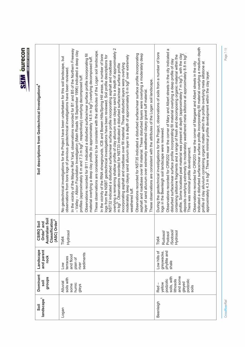
Loga
n Al
luvi
al
soils
with
so
me
hum
ic
gley
s
Low
te
rrace
s an
d flo
od
plai
n of
riv
er
sedi
men
ts
Tb64
H
ydro
sol
No
geot
echn
ical
inve
stig
atio
ns fo
r the
Pro
ject
hav
e be
en u
nder
take
n fo
r thi
s so
il la
ndsc
ape,
but
ob
serv
atio
ns fr
om b
ore
logs
of p
revi
ous
geot
echn
ical
inve
stig
atio
ns h
ave
been
revi
ewed
. In
the
vici
nity
of t
he M
ayne
Rai
l Yar
d, o
bser
vatio
ns re
cord
ed fo
r B1
and
B5
of th
e N
orth
ern
Free
way
–
Valle
y –
Albi
on F
ound
atio
n In
vest
igat
ion
(Mai
n R
oads
16
Sept
embe
r 199
6) in
dica
ted
a de
ep c
lay
prof
iles
(app
roxi
mat
ely
6 m
and
7.3
m b
gl5 , r
espe
ctiv
ely)
ove
rlyin
g de
com
pose
d tu
ff.
Obs
erva
tions
reco
rded
for B
11 in
dica
ted
a di
stur
bed
surfa
ce/n
ear s
urfa
ce p
rofil
e in
corp
orat
ing
fill
mat
eria
l ove
rlyin
g a
deep
cla
y pr
ofile
(to
appr
oxim
atel
y 14
.5 m
bgl
5 ) ove
rlyin
g de
com
pose
d tu
ff.
Thes
e ob
serv
atio
ns a
re c
onsi
dere
d to
be
cons
iste
nt w
ith th
e at
tribu
tes
of th
e Lo
gan
soil
land
scap
e.
In th
e vi
cini
ty o
f the
RN
A s
how
grou
nds,
ICB
and
Bow
en H
ills/
Spr
ing
Hill
are
as, a
num
ber o
f bor
e lo
gs fr
om th
e N
SB
T ge
otec
hnic
al in
vest
igat
ions
hav
e be
en re
view
ed. S
oil p
rofil
e de
scrip
tions
for
NST
32 in
dica
ted
a di
stur
bed
surfa
ce/n
ear s
urfa
ce p
rofil
e in
corp
orat
ing
asph
alt a
nd ro
adba
se
over
lyin
g a
rem
aini
ng s
hallo
w p
rofil
e of
cla
y al
luvi
um o
ver c
laye
y sa
nd to
a d
epth
of a
ppro
xim
atel
y 2
m b
gl5 . O
bser
vatio
ns re
cord
ed fo
r NS
T33
indi
cate
d a
dist
urbe
d su
rface
/nea
r sur
face
pro
file
inco
rpor
atin
g as
phal
t and
road
base
ove
r fill
mat
eria
l. Th
ese
dist
urbe
d la
yers
wer
e ov
erly
ing
mod
erat
ely
deep
cla
yey
sand
allu
vium
laye
r to
a de
pth
of a
ppro
xim
atel
y 6
m b
gl5 o
ver e
xtre
mel
y w
eath
ered
tuff.
O
bser
vatio
ns re
cord
ed fo
r NS
T35
indi
cate
d a
dist
urbe
d su
rface
/nea
r sur
face
pro
file
inco
rpor
atin
g as
phal
t and
road
base
ove
r fill
mat
eria
l. Th
ese
dist
urbe
d la
yers
wer
e ov
erly
ing
a m
oder
atel
y de
ep
laye
r of s
and
allu
vium
ove
r ext
rem
ely
wea
ther
ed c
laye
y gr
avel
tuff
mat
eria
l. Th
ese
obse
rvat
ions
are
con
sist
ent w
ith th
e at
tribu
tes
of th
e Lo
gan
soil
land
scap
e.
Been
leig
h R
ed –
ye
llow
po
dzol
ic
soils
, with
lit
hoso
ls
and
som
e gl
eyed
po
dzol
ic
soils
Low
hills
of
grey
wac
ke,
phyl
lite
and
shal
e
Tb64
R
udos
ol/
Podo
sol
/Sod
osol
/ H
ydro
sol
Dur
ing
the
geot
echn
ical
inve
stig
atio
ns fo
r the
Pro
ject
, obs
erva
tions
of s
oils
from
a n
umbe
r of b
ore
logs
in th
e B
eenl
eigh
soi
l lan
dsca
pe w
ere
revi
ewed
. O
bser
vatio
ns re
cord
ed fo
r CR
R20
2 ne
ar th
e co
rner
of M
ary
and
Alb
ert s
treet
s in
the
city
indi
cate
d a
dist
urbe
d su
rface
/nea
r sur
face
pro
file
inco
rpor
atin
g fil
l mat
eria
l ove
rlyin
g a
deep
pro
file
of c
lay
cont
aini
ng s
iltst
one
fragm
ents
and
a ra
nge
of fr
esh
and
deco
mpo
sing
org
anic
mat
eria
l with
in th
e pr
ofile
. Som
e lo
calis
ed p
eat m
ater
ial w
as p
rese
nt a
t dep
th (a
ppro
xim
atel
y 7
m b
gl5 ),
with
the
clay
de
posi
ts o
verly
ing
extre
mel
y to
mod
erat
ely
wea
ther
ed m
eta
silts
tone
at a
ppro
xim
atel
y 8.
8 m
bgl
5 . Th
ere
was
min
imal
pro
file
deve
lopm
ent.
Obs
erva
tions
reco
rded
for C
RR
203
near
the
corn
er o
f Mar
gare
t and
Alb
ert s
treet
s in
the
city
in
dica
ted
a di
stur
bed
surfa
ce/n
ear s
urfa
ce p
rofil
e in
corp
orat
ing
fill m
ater
ial o
verly
ing
a m
ediu
m d
epth
pr
ofile
of c
lay
allu
vium
con
tain
ing
orga
nic
mat
ter w
ithin
the
prof
ile o
verly
ing
met
a si
ltsto
ne a
t ap
prox
imat
ely
4.3
m b
gl5 . T
here
was
min
imal
pro
file
deve
lopm
ent w
ithin
the
clay
laye
r.

Cros
sRive
rRail
Pa
ge 7-
20
Soil
land
scap
e1 D
omin
ant
soil
grou
ps
Land
scap
e an
d pa
rent
ro
ck
CSI
RO
Soi
l O
rder
2 and
A
ustr
alia
n So
il C
lass
ifica
tion
(ASC
) Ord
er3
Soil
desc
riptio
ns fr
om G
eote
chni
cal I
nves
tigat
ions
4
Obs
erva
tions
reco
rded
for C
RR
205
at th
e co
rner
of A
lice
and
Alb
ert s
treet
s in
the
city
indi
cate
d a
dist
urbe
d su
rface
/nea
r sur
face
pro
file
inco
rpor
atin
g fil
l mat
eria
l ove
rlyin
g a
med
ium
dep
th p
rofil
e of
cl
ayey
gra
vel,
whi
ch w
as id
entif
ied
as re
sidu
al s
oil o
verly
ing
met
a si
ltsto
ne a
t app
roxi
mat
ely
4 m
bg
l5 . The
re w
as m
inim
al p
rofil
e de
velo
pmen
t with
in th
e cl
ay la
yer.
Thes
e ob
serv
atio
ns a
re n
ot c
onsi
sten
t with
the
Bee
nlei
gh s
oil l
ands
cape
due
to th
e de
pth
of th
e so
il pr
ofile
s an
d th
e na
ture
of t
he m
ater
ial o
bser
ved.
Bris
bane
R
iver
Pr
airie
so
ils w
ith
som
e al
luvi
al
soils
Low
un
dula
ting
plai
n an
d te
rrace
re
mna
nts
Tb64
D
erm
osol
D
urin
g th
e ge
otec
hnic
al in
vest
igat
ions
for t
he P
roje
ct, o
bser
vatio
ns o
f soi
ls fr
om a
num
ber o
f bor
e lo
gs in
the
Bris
bane
Riv
er s
oil l
ands
cape
wer
e re
view
ed.
Obs
erva
tions
reco
rded
for C
RR
204
in th
e C
ity B
otan
ic G
arde
ns in
dica
ted
a de
ep p
rofil
e of
silt
y cl
ay
(14.
7 m
bgl
5 ) whe
re a
nar
row
laye
r of s
ilty
sand
was
pre
sent
and
a m
arke
d te
xtur
e co
ntra
st to
a
med
ium
thic
knes
s la
yer o
f silt
y cl
ay o
ccur
red
over
lyin
g gr
avel
ly c
laye
y sa
nd th
at e
xten
ded
to 2
2.6
m
bgl5 . T
he d
eep
soil
prof
ile w
as in
terp
rete
d to
be
over
lyin
g m
eta
silts
tone
. O
bser
vatio
ns re
cord
ed fo
r CR
R21
1 ne
ar F
airfi
eld
Sta
tion
wes
t of t
he F
airfi
eld
Gar
dens
Sho
ppin
g C
entre
indi
cate
d a
deep
soi
l pro
file
of c
lay
with
a te
xtur
e co
ntra
st o
ccur
ring
at 9
m b
gl to
san
dy
grav
elly
cla
y an
d a
zone
of c
lay
com
pris
ing
mix
ed re
sidu
al s
oil a
nd e
xtre
mel
y w
eath
ered
rock
soi
l at
dept
h (1
1.8
m b
gl5 ).
The
soil
prof
ile w
as o
verly
ing
a na
rrow
laye
r of f
ine
to c
oars
e gr
aine
d sa
ndst
one,
ov
er c
ongl
omer
ate.
Th
ese
obse
rvat
ions
are
con
side
red
cons
iste
nt w
ith th
e B
risba
ne R
iver
soi
l lan
dsca
pe.
Mog
gill
Cre
ek
Gle
yed
podz
olic
so
ils w
ith
min
or
prai
rie a
nd
allu
vial
so
ils
Cre
ek fl
ats
of s
andy
an
d cl
ayey
al
luvi
um
Tb64
D
erm
osol
/ H
ydro
sol
Dur
ing
the
geot
echn
ical
inve
stig
atio
ns fo
r the
Pro
ject
, obs
erva
tions
of s
oils
from
one
bor
e lo
g in
the
Mog
gill
Cre
ek s
oil l
ands
cape
wer
e re
view
ed.
Obs
erva
tions
reco
rded
for C
RR
201
near
Rom
a S
treet
Sta
tion
indi
cate
d a
dist
urbe
d su
rface
/nea
r su
rface
pro
file
inco
rpor
atin
g fil
l mat
eria
l ove
rlyin
g m
ediu
m d
epth
pro
file
of s
ilty
clay
with
trac
e fin
e to
m
ediu
m g
rave
l, w
hich
indi
cate
d a
colo
ur c
hang
e at
1 m
bgl
5 and
som
e co
bble
s pr
esen
t at d
epth
. The
si
lty c
lay
laye
r was
ove
rlyin
g m
eta
silts
tone
. The
se o
bser
vatio
ns a
re n
ot c
onsi
sten
t with
the
Mog
gill
Cre
ek s
oil l
ands
cape
, alth
ough
the
pres
ence
of s
ilty
clay
and
gra
vel s
ugge
sts
an a
lluvi
al o
rigin
.
Toow
ong
Red
po
dzol
ic
soils
with
lit
hoso
ls
Low
hills
of
phyl
lite
Tb64
A
SC
Ord
er n
ot
dete
rmin
ed
No
geot
echn
ical
inve
stig
atio
ns fo
r the
Pro
ject
hav
e be
en u
nder
take
n fo
r thi
s so
il la
ndsc
ape
and
no
bore
logs
from
pre
viou
s ge
otec
hnic
al in
vest
igat
ions
wer
e re
view
ed a
s th
e P
roje
ct a
lignm
ent i
s no
t ex
pect
ed to
enc
ount
er/d
istu
rb th
is s
oil l
ands
cape
.

Cros
sRive
rRail
Pa
ge 7-
21
Soil
land
scap
e1 D
omin
ant
soil
grou
ps
Land
scap
e an
d pa
rent
ro
ck
CSI
RO
Soi
l O
rder
2 and
A
ustr
alia
n So
il C
lass
ifica
tion
(ASC
) Ord
er3
Soil
desc
riptio
ns fr
om G
eote
chni
cal I
nves
tigat
ions
4
Woo
drid
ge
Red
–
yello
w
podz
olic
so
ils, w
ith
litho
sols
, gl
eyed
po
dzol
ic
soils
and
la
terit
ic
podz
olic
so
ils
Low
hills
of
sand
ston
e an
d sh
ales
Tb64
/Sj1
2 R
udos
ol
Obs
erva
tions
reco
rded
for C
RR
102
indi
cate
d a
dist
urbe
d su
rface
/nea
r sur
face
pro
file
inco
rpor
atin
g fil
l mat
eria
l ove
rlyin
g a
med
ium
dep
th p
rofil
e co
ntai
ning
silt
y cl
ay w
ith s
ome
fine
to m
ediu
m g
rain
ed
sand
and
trac
e of
fine
gra
vel w
ith a
col
our c
hang
e to
ora
nge
brow
n si
lty c
lay
with
trac
e of
fine
gr
aine
d sa
nd.
A te
xtur
e ch
ange
to s
andy
cla
y oc
curr
ed a
t 1.4
m b
gl5 . T
he s
oil p
rofil
e w
as id
entif
ied
as re
sidu
al
mat
eria
l, w
hich
was
ove
rlyin
g ve
ry lo
w s
treng
th, m
oder
atel
y w
eath
ered
, med
ium
to c
oars
e sa
ndst
one
cont
aini
ng s
ome
cong
lom
erat
e at
app
roxi
mat
ely
2.5
m b
gl5 .
Obs
erva
tions
reco
rded
for C
RR
105
indi
cate
d a
dist
urbe
d su
rface
/nea
r sur
face
pro
file
inco
rpor
atin
g fil
l mat
eria
l ove
rlyin
g a
med
ium
dep
th p
rofil
e co
ntai
ning
silt
y cl
ay w
ith tr
ace
of fi
ne s
and.
A
text
ure
chan
ge to
san
dy c
lay
occu
rred
at 1
.3 m
bgl
5 . The
soi
l pro
file
was
iden
tifie
d as
resi
dual
m
ater
ial,
whi
ch w
as o
verly
ing
very
low
stre
ngth
, mod
erat
ely
wea
ther
ed m
ediu
m to
coa
rse,
sha
llow
sa
ndst
one
laye
r ove
rlyin
g tu
ff at
app
roxi
mat
ely
2 m
bgl
5 . Th
ese
soil
prof
ile o
bser
vatio
ns a
re c
onsi
sten
t with
the
Woo
drid
ge s
oil l
ands
cape
. O
bser
vatio
ns re
cord
ed fo
r CR
R10
7 in
dica
ted
a di
stur
bed
surfa
ce/n
ear s
urfa
ce p
rofil
e in
corp
orat
ing
fill m
ater
ial o
verly
ing
a sh
allo
w p
rofil
e co
mpr
ised
of s
ilty
clay
resi
dual
mat
eria
l con
tain
ing
trace
fine
to
med
ium
gra
ined
san
d ov
erly
ing
very
low
stre
ngth
, hig
hly
wea
ther
ed m
ediu
m to
coa
rse
grai
ned
sand
ston
e at
app
roxi
mat
ely
0.9
m b
gl5 . T
here
was
min
imal
pro
file
deve
lopm
ent.
Obs
erva
tions
reco
rded
for C
RR
103
indi
cate
d a
dist
urbe
d su
rface
/nea
r sur
face
pro
file
inco
rpor
atin
g fil
l mat
eria
l ove
rlyin
g a
mod
erat
e to
dee
p pr
ofile
com
pris
ed o
f silt
y cl
ay re
sidu
al m
ater
ial c
onta
inin
g tra
ce o
f fin
e to
med
ium
gra
ined
san
d ov
erly
ing
extre
mel
y lo
w to
ver
y lo
w s
treng
th, e
xtre
mel
y w
eath
ered
tuff
at a
ppro
xim
atel
y 2.
5 m
bgl
5 . The
re w
as m
inim
al p
rofil
e de
velo
pmen
t. O
bser
vatio
ns re
cord
ed fo
r CR
R10
4 in
dica
ted
a di
stur
bed
surfa
ce/n
ear s
urfa
ce p
rofil
e in
corp
orat
ing
fill m
ater
ial o
verly
ing
a m
ediu
m d
epth
pro
file
com
pris
ed o
f silt
y cl
ay re
sidu
al m
ater
ial c
onta
inin
g tra
ce
of fi
ne to
med
ium
gra
ined
san
d ov
erly
ing
extre
mel
y lo
w to
ver
y lo
w s
treng
th, h
ighl
y to
mod
erat
ely
wea
ther
ed tu
ff at
app
roxi
mat
ely
1.8
m b
gl5 . T
here
was
min
imal
pro
file
deve
lopm
ent.
Obs
erva
tions
reco
rded
for C
RR
212
in Y
eron
ga in
dica
ted
a po
tent
ially
dis
turb
ed s
urfa
ce /n
ear
surfa
ce p
rofil
e co
ntai
ning
a s
hallo
w la
yer o
f san
dy c
lay
tops
oil o
verly
ing
a la
yer o
f san
dy g
rave
l ash
. U
nder
lyin
g th
ese
surfa
ce la
yers
was
a s
hallo
w s
andy
cla
y ov
erly
ing
clay
, with
a te
xtur
e co
ntra
st
occu
rring
at 3
.9 m
bgl
5 to c
laye
y sa
nd o
ver s
ands
tone
. O
bser
vatio
ns re
cord
ed fo
r CR
R21
3 no
rth o
f Yer
onga
sta
tion
indi
cate
d a
dist
urbe
d su
rface
/nea
r su
rface
pro
file
inco
rpor
atin
g fil
l mat
eria
l (ro
ad b
ase)
ove
r cla
yey
sand
resi
dual
soi
l with
a te
xtur
e co
ntra
st o
bser
ved
at 2
m b
gl5 to
silt
y cl
ay. A
nar
row
laye
r of e
xtre
mel
y w
eath
ered
san
dsto
ne w
as
obse
rved
at 3
m b
gl5 o
verly
ing
very
low
stre
ngth
resi
dual
soi
l of s
andy
silt
ban
ds m
ixed
with
ban
ds o
f si
ltsto
ne, w
hich
was
ove
rlyin
g m
ediu
m to
coa
rse
grai
ned
sand
ston
e.

Cros
sRive
rRail
Pa
ge 7-
22
Soil
land
scap
e1 D
omin
ant
soil
grou
ps
Land
scap
e an
d pa
rent
ro
ck
CSI
RO
Soi
l O
rder
2 and
A
ustr
alia
n So
il C
lass
ifica
tion
(ASC
) Ord
er3
Soil
desc
riptio
ns fr
om G
eote
chni
cal I
nves
tigat
ions
4
Obs
erva
tions
reco
rded
for C
RR
214
near
the
railw
ay li
ne, s
outh
of t
he Y
eron
ga S
tatio
n in
dica
ted
a di
stur
bed
surfa
ce/n
ear s
urfa
ce p
rofil
e in
corp
orat
ing
fill m
ater
ial (
road
bas
e) o
ver s
hallo
w s
andy
gr
avel
ly c
lay
of fi
ne g
rave
l and
coa
rse
sand
. A te
xtur
e co
ntra
st w
as o
bser
ved
at 1
.5 m
bgl
5 to
med
ium
gra
ined
cla
yey
sand
resi
dual
soi
l ove
rlyin
g m
ediu
m to
coa
rse
grai
ned
sand
ston
e.
Obs
erva
tions
reco
rded
for C
RR
215
near
Fai
rfiel
d R
oad,
nor
th o
f the
Yee
rong
pilly
Sta
tion
indi
cate
d a
dist
urbe
d su
rface
/nea
r sur
face
pro
file
pote
ntia
lly in
corp
orat
ing
a fil
l mat
eria
l at t
he s
urfa
ce.
Und
erly
ing
this
mat
eria
l is
a m
oder
atel
y de
ep s
ilty
clay
con
tain
ing
carb
onac
eous
mat
eria
l and
ex
trem
ely
wea
ther
ed m
udst
one
at d
epth
, ove
rlyin
g ex
trem
ely
wea
ther
ed, f
riabl
e m
udst
one
of v
ery
low
to lo
w s
treng
th in
terb
edde
d w
ith c
arbo
nace
ous
laye
rs.
Thes
e ob
serv
atio
ns a
re s
omew
hat c
onsi
sten
t with
the
Woo
drid
ge s
oil l
ands
cape
. O
bser
vatio
ns re
cord
ed fo
r CR
R10
6 in
dica
ted
a di
stur
bed
surfa
ce/n
ear s
urfa
ce p
rofil
e in
corp
orat
ing
fill m
ater
ial o
verly
ing
a m
ediu
m d
epth
pro
file
com
pris
ed o
f silt
y cl
ay re
sidu
al m
ater
ial c
onta
inin
g so
me
fine
to m
ediu
m g
rain
ed s
and
over
lyin
g ex
trem
ely
low
to v
ery
low
stre
ngth
, hig
hly
to m
oder
atel
y w
eath
ered
tuff
at a
ppro
xim
atel
y 1.
6m b
gl5 . T
here
was
min
imal
pro
file
deve
lopm
ent.
Thes
e ob
serv
atio
ns a
re n
ot c
onsi
sten
t with
the
Woo
drid
ge s
oil l
ands
cape
.
Woo
ngoo
lba
Hum
ic
gley
s,
‘pea
ty
gley
s’ a
nd
solo
ncha
ks
Low
(c
oast
al)
plai
ns o
f al
luvi
um
and
narro
w
depr
essi
ons
Tb64
/Sj1
2 H
ydro
sol
Obs
erva
tions
reco
rded
for C
RR
208
indi
cate
d a
soil
prof
ile c
ompr
isin
g sa
ndy
silt
fill m
ater
ial a
t the
su
rface
, ove
rlyin
g a
deep
pro
file
of s
andy
cla
y co
ntai
ning
trac
e fin
e, a
ngul
ar, e
xtre
mel
y w
eath
ered
gr
avel
, with
incr
easi
ng s
and
cont
ent a
t dep
th, o
verly
ing
extre
mel
y to
hig
hly
wea
ther
ed tu
ff.
Obs
erva
tions
reco
rded
for C
RR
209
indi
cate
d a
mod
erat
ely
deep
pro
file
of c
lay
over
lyin
g fin
e to
co
arse
gra
ined
tuff.
Th
ese
obse
rvat
ions
are
con
side
red
to b
e co
nsis
tent
with
the
Woo
ngoo
lba
soil
land
scap
e.
Not
e:
1.
Bec
kman
et a
l (19
87)
2.
CS
IRO
(200
1)
3.
Isbe
ll (2
002)
4
AE
CO
M (2
010b
) 5.
B
elow
gro
und
leve
l (bg
l)

!
!
!
!
!
!
!
#*
#*#*
#*
#*
#*#*
#*
#*#*
#*#*
#*
#*
#*#*
#* #* #*
#*
#*#*
#*#*
#*
#*
#*#*
#*
#*
#*
#*#*
#*#*
#*
#*#*#*#*
#*
#*
#*
#*#*#*
#*#*
#*#*#*#*#*
#* #*#*
#*#* #* #*
#*#*#*#*
#*
#*#*
#*
#*#*
#*
#*#*
#*
#*#*
#*
#*
#*
#*
#*#*
#*
#*
#*
#*#*#*#*#*#*
Albion Station
Windsor Station
Wooloowin Station
Bowen Hills Station
Eagle Junction Station
Exhibition Station
Brisbane R
iver
B
L
L
Nu
L
L
Pu
L
Cl
Cm
CmB
B
Be
CkCm
Cm
B
Ck
CmB
B
Ck
WINDSOR
ALBION
CLAYFIELD
BOWEN HILLS
NEWSTEADBULIMBA
WOOLOOWIN
LUTWYCHE
HERSTON
GORDON PARK
HAMILTON
ASCOT
FORTITUDE VALLEY
KEDRON
SPRING HILL
WILSTON
GRANGE
STAFFORD
Lutw
yche
Rd
Chalk St
Maygar St
Rose St
Brookes St
Constitution Rd
Oriel Rd
Newmarket Rd
Bow
en B
ridge
Rd
Sand
gate
Rd
Brea
kfas
t Cre
ek R
d
Thistle St
Albion O/P
Montpelier Rd
Rob
lane
St
Campbell St
CROSS RIVER RAILENVIRONMENTAL IMPACT STATEMENT
Figure 7-8Geotechnical Investigation
(Northern Section)
¯0 100 200 300 400m
LEGEND
Study Corridor
Suburbs
Road
! Railway Station
Track
Soils within Study BoundaryB BEENLEIGH
Be BRISBANE RIVER
Cm CHERMSIDE
L LOGAN
MCk MOGGILL CK
Nu NUNDAH
T TOOWONG
W WOODRIDGE
Wo WOONGOOLBA
Geotechnical Bores
#* Cross River Rail Bore Logs
#* Bore Logs from previous studies K:\C
ross
Riv
er R
ail\6
00 E
nviro
nmen
t\619
GIS
\Aur
econ
\205
555_
CR
R\G
078_
CC
R_G
eo_I
nves
tigat
ion_
Nor
th_A
3_ve
r93.
mxd
0
7/07
/201
1 16
:35
Map
by:
MJS
1:18,000 at A4

!
!
!
!
!
!
!
!
!
#* #*#*#*#*#*#*#*#*
#*#*#*#*#*
#*
#*#*#*#*#*
#*#* #*#*#*#*
#*
#*#*
#*
#*
#*
#*#*
#*
#*
#*
#*
#*#*#*#*
#*
#*
#*
#*#*#*
#*#*
#*#*
#*#*#*
#*#*
#*#*#*#*
#*
#*
#*
#*
#*
#*#*
#*
#*
#*
#*
#*
#*
#*#*
#*#*#*#*
#*
#*
#*#*
#*#*
#*#*
#*#*
#*#*#*#*
#*#*#*
#*#*
#*#*
#*
#*#*#*
#*
#*#*
#*
#*
#*
#*
#*
#*
#*
#*
#*
#*
#*
#*
#*#*#*
#*
#*#*
#*#*
#*
#*
#*
#*
#*
#*
#*
#* #*#*
#*
#*
#*
#*
#*#*
#*
#*#*#*
#*#*#*#*
#*#*
#* #*#*#*#*
#*
#*
#*
#*#*#*#*
#*#*
#*#*#*
#*
#*#*
#*#*#*#*#*
#*
#*#*
#*
#*
#*#*#*
#*#*#*#*#*#*
#*#*#*#*#*
#*#*#*#*#*
#*#*#*#*#*#*#*#*#*
#*#*#*#*#*#*
#*#*#*#*#*#*
#*#*
#*#*#*#*
#*#*#*#*#*#*#*#*#*#*#*
#*#*#*
#*
#*
#*
#*
#*#*
#*
#*
#*#*#*#*
#*#*#*#*
#*
#*#*
#*#*#*#*#*
#*#*#*
#*#*
#*
#*#*#*#*
#*
#*#*#*#*#*
#*#*
#*#*#*#*#*#*#*#*#*
#*#*#*#*#*#*
#*#*#*#*#*#*#*#*#*
#*#*#*#*
#*
#*
#*#*#*#*#*
#*#*#*#*#*#*#*#*#*#*
#*#*#*#*#*#*#*#*#*#*#*
#*#*#*#*#*#* #*#*#*
#*#*#*#*#*#* #*#*
#*#*#*#*#*#*#*#*#*#*#*#*
#*#*#*#*#*#*
#*#*#*
#*#*#*#*#*#*#*#*#*
#*#*#*#*
#*#*#*#*
#*
#*
#*
#*#*
#*#*
#*#*#*
#*#*#*#*
#*#*
#*#*
#*#*#*#*
#*
#*#*
#*#*#*#*#*
#*#*#*
#*#*
#*#*#*#*#*
#*#*#*#*#*#*
#*
#*
#*#* #*#* #*
#* #*#*#*#* #*
#*
#*#*#*#*
#*#*#*#*
#*#*
#*#*
#*#*#*#*#*#*#*#*#*#*
#*#*#*#*
#*#*#*
#*#*#*#*#*#*#*#*#*#*#*#*
#*
#*#*#*#*
#*#*
#*
Buranda Station
CentralStation
Roma Street Station
Southbank Station
Park Road Station
Dutton Park Station
South Brisbane Station
Fortitude Valley Station
Exhibition Station
Brisbane River
CRR101
CRR218
CRR216
CRR210
CRR209
CRR208
CRR207CRR206
CRR205
CRR204
CRR203
CRR202
CRR201
T
B
L
Cm
B
Cm
W
B
T
Be
Wo
Be
B
B
Be
Be
B
BCm
BeMCk
B
Cm
MCk
T Be
Pu
CITY
NEW FARM
WOOLLOONGABBA
SOUTH BRISBANE
SPRING HILL
ST LUCIA
EAST BRISBANE
KANGAROO POINT
NEWSTEAD
HIGHGATE HILL
DUTTON PARK
FORTITUDE VALLEY
HERSTONKELVIN GROVE
WEST END
GREENSLOPES
RED HILL
BOWEN HILLS
MILTON
COORPAROO
PADDINGTON
FAIRFIELD
NORMAN PARK
BULIMBA
Vulture St
Ann St
Gre
gory
Tce
Grey St
Hal
e S
t
Wick
ham S
t
George St
Anne
rley R
d
Merthy
r Rd
Wel
lingt
on R
d
Stanley St East
Sydne
y St
Roma St
Rive
r Tce
O'Keefe St
James St
Montag
ue R
d
Mac
quar
ie S
tDornoch Tce
Boundary St
Stanley St
Brunswick St
CROSS RIVER RAILENVIRONMENTAL IMPACT STATEMENT
Figure 7-9Geotechnical Investigation
(Central Section)
¯0 100 200 300 400 500m
LEGEND
Study Corridor
Suburbs
Road
! Station
Track
Soils within Study BoundaryB BEENLEIGH
Be BRISBANE RIVER
Cm CHERMSIDE
L LOGAN
MCk MOGGILL CK
Nu NUNDAH
T TOOWONG
W WOODRIDGE
Wo WOONGOOLBA
Geotechnical Bores
#* Cross River Rail Bore Logs
#* Bore logs from previous studies K:\C
ross
Riv
er R
ail\6
00 E
nviro
nmen
t\619
GIS
\Aur
econ
\205
555_
CR
R\G
078_
CC
R_G
eo_I
nves
tigat
ion_
Cen
tral_
A3_
ver9
3.m
xd
07/
07/2
011
16:4
1M
ap b
y: M
JS
1:22,000 at A4

!
!
!
!!
!
!
!
!
!
!
#*
#*
#*
#*
#*
#*
#*
#*
#*#*#*#*
#*#*#*#*#*
#*#*
#*
#*
#*#*#*#*#*
#*#*#*
#*#*
#*#*#*#*#*#*#*#*
#*#*
#*#*#*
#*
#*#*#*#*#*#*
#*
#*#*#*#*#*#*
#*#*#*#*#*#*#*
#*#*
#*#*
#*#*#*#*#*#*#*
#*#*
#*#*#*#*
#*#*#*
#*#*#*#*#*#*#*#*
#*#*
#*#*#*#*#*#*
#*
#*
#*#* #*#*#*#*#*#*#*#*#*
#*#*#*
#*#*
#*#*#*#*#*#*
#*#*
#*#*#*#*#*#*#*#*#*#*
#*#*#*
#*#*#*#* #*#*#*
#*#*#*#*#*#*
Rocklea Station
Buranda Station
Yeronga Station
Tennyson Station
Moorooka Station
Salisbury Station
Park Road Station
Fairfield Station
Dutton Park Station
Yeerongpilly Station
Brisbane River
CRR107
CRR106CRR105
CRR104CRR103
CRR102
CRR101
CRR217
CRR216
CRR215
CRR214
CRR213
CRR212
CRR211
CRR210
W
W
B
T
Be
A
Pu
B
Bl
Be
Be
BeCm
Wo
T
Wo
B
T
Wo
CmCm
A
MCk
MC
Pu
CP
Be
Be
Be
MCk
ROCKLEA
SALISBURY
ST LUCIA
YERONGA
MOOROOKA
TARRAGINDI
ANNERLEY
NATHAN
GREENSLOPESFAIRFIELD
YEERONGPILLY
INDOOROOPILLY
TENNYSON
WOOLLOONGABBA
DUTTON PARK
ARCHERFIELDCOOPERS PLAINS
CORINDA
COORPAROOHIGHGATE HILL
Tooh
ey R
d
Beau
dese
rt R
d
Evans Rd
Riawena Rd
Brisbane Cso
Hyde Rd
Meiers R
d
Fairf
ield
Rd
Ipswich R
d
Ipswich Mwy
Sherwood Rd
Sexton St
Henson Rd
Ring Rd
Georgina St
Esher St
Swann R
d
Mon
tagu
e St
Bye St
Beaudesert Rd
Fairf
ield
Rd
Ipswich
Rd
South East Fwy
Ipsw
ich
Mw
y
Ipsw
ich
Mw
y
Sout
h E
ast F
wy
CROSS RIVER RAILENVIRONMENTAL IMPACT STATEMENT
Figure 7-10Geotechnical Investigation
(Southern Section)
¯0 100 200 300 400 500 600m
LEGEND
Study Corridor
Suburbs
Road
! Station
Track
Soils within Study BoundaryB BEENLEIGH
Be BRISBANE RIVER
Cm CHERMSIDE
L LOGAN
MCk MOGGILL CK
Nu NUNDAH
T TOOWONG
W WOODRIDGE
Wo WOONGOOLBA
Geotechnical Bores
#* Cross River Rail Bore Logs
#* Bore Logs from previous studies K:\C
ross
Riv
er R
ail\6
00 E
nviro
nmen
t\619
GIS
\Aur
econ
\205
555_
CR
R\G
078_
CC
R_G
eo_I
nves
tigat
ion_
Sou
th_A
3_ve
r93.
mxd
0
7/07
/201
1 16
:50
Map
by:
MJS
1:30,000 at A4

CrossRiverRail Page 7-26
Soil affected by Red Imported Fire Ants
Under the LP Act, Red Imported Fire Ants (RIFA) are a notifiable pest and are managed under the direction and requirements administered by Biosecurity Queensland, Department of Employment, Economic Development and Innovation (DEEDI).
A review of the restricted area mapping from the Restricted Area Search Engine (Version 42, 16 April 2010) indicated that the study corridor crosses or intercepts identified restricted areas. These locations are described in Section 7.2.2 to Section 7.2.4. The proposed spoil placement location at Swanbank is also located within a RIFA restricted area.
Further detailed information regarding RIFA is provided in Chapter 11 Nature Conservation.
7.2.2 Wooloowin to Bowen Hills
Topography
The northern section of the study corridor, in the vicinity of Wooloowin, is located in lower terrain between the hills at Wilston and Clayfield. Beyond the northern extent of the study corridor is the catchment of Kedron Brook, which is a significant surface water catchment within the northern Brisbane area and receives drainage from the Wooloowin area.
The topography of the northern section of the study corridor and surrounding area is generally characterised by a number of ridgelines and a landscape that slopes downwards towards Breakfast Creek (refer to Figure 7-1 and Figure 7-4). Within the study corridor, elevations are up to 30 m AHD to the east of the Wooloowin Station.
Within this section, there are a number of prominent topographical features, including a north-south ridgeline with elevations up to 60 m AHD located to the east of the study corridor and isolated elevations of around 40 m AHD on Sandgate Road and Boyd Street.
The landform patterns within this section of the study corridor are dominated by Breakfast Creek and its floodplain, which forms the low point of the catchment and is bounded to the north by the elevated area of Wooloowin and to the south by the elevated areas of Herston, Bowen Hills and the slopes associated with the ridgeline extending between Red Hill and Spring Hill (refer to Figure 7-4).
Geology
General characteristics of the various geological formations within the northern section of the study corridor are presented in Table 7-4. It is emphasised that these properties are generalised and the actual properties of the formations must be assessed by site-specific geotechnical investigations.
Significant geological features
Significant geological features have been identified within the northern section of the study corridor and a summary is provided in the following sections and are illustrated on Figure 7-7.
Geological features and hazards
Based on the desktop review of the geological mapping (Geological Survey of Queensland – Brisbane, Sheet SG 56-15 (Department of Mines 1974)), within the northern section of the study corridor a syncline is interpreted to occur within the Aspley Formation and crosses the North Coast Rail Line in the vicinity of Wooloowin Station in a north-north-west to south-south-east orientation.

Cros
sRive
rRail
Pa
ge 7-
27
Tabl
e 7-
4 G
ener
al c
hara
cter
istic
s of
the
geol
ogic
al fo
rmat
ions
with
in th
e no
rthe
rn s
ectio
n
Gen
eral
cha
ract
eris
tics
Map
sy
mbo
l Fo
rmat
ion
nam
e A
rea
pres
ent
Wea
ther
ing
Soils
Er
odib
ility
Sl
ope
stab
ility
Qa
Qua
tern
ary
Allu
vium
D
omin
ant p
aren
t m
ater
ial i
n lo
w
elev
atio
n ar
eas
in
the
vici
nity
of
Bre
akfa
st C
reek
an
d th
e Br
isba
ne
Riv
er
N/A
C
lay,
silt
, san
d an
d gr
avel
of
varia
ble
stre
ngth
or
den
sity
Sus
cept
ible
to e
rosi
on
but s
ever
ity d
epen
ds
on lo
cal t
opog
raph
y,
drai
nage
, nat
ure
of
clay
s, e
arth
wor
ks
Uns
tabl
e, w
ould
requ
ire
engi
neer
ed s
uppo
rt w
here
exc
avat
ed in
to.
Eros
ion
prot
ectio
n w
ould
be
requ
ired
arou
nd
brid
ges,
cul
verts
and
st
ruct
ures
Rip
A
sple
y Fo
rmat
ion
Woo
loow
in -
Nor
th
of B
reak
fast
Cre
ek
Ofte
n ve
ry d
eepl
y w
eath
ered
with
m
arke
d re
duct
ion
in
rock
stre
ngth
Cla
yey,
oc
casi
onal
ly
sand
y or
gra
velly
so
met
imes
hig
h pl
astic
ity
Var
iabl
e re
sist
ance
to
eros
ion
depe
ndin
g on
be
droc
k ty
pe a
nd lo
cal
deep
wea
ther
ing
Low
bat
ter a
ngle
s an
d sl
ope
prot
ectio
n re
quire
d fo
r sha
llow
cut
s, fu
ll su
ppor
t req
uire
d fo
r de
eper
cut
s
Rif
Bris
bane
Tuf
f Al
bion
and
Bow
en
Hills
- D
omin
ant
pare
nt ro
ck in
mor
e el
evat
ed s
ectio
ns
betw
een
May
ne
Rai
l Yar
ds a
nd
Sprin
g H
ill
Usu
ally
ver
y sh
allo
w
dept
h of
wea
ther
ing
but m
oder
atel
y w
eath
ered
tuff
is
stro
ng ro
ck
Very
sha
llow
, cl
ayey
W
elde
d tu
ff hi
ghly
re
sist
ant t
o er
osio
n,
stra
tifie
d tu
ff te
nds
to
fret.
Fine
gra
ined
bas
al
sedi
men
ts fr
et, b
recc
ias
pluc
k an
d ra
vel
Ste
ep fa
ces
with
oc
casi
onal
rock
bol
ting
poss
ible
in fr
esh
and
slig
htly
wea
ther
ed tu
ff.
Sel
ectiv
e su
ppor
t and
pr
otec
tion
in m
oder
atel
y w
eath
ered
tuff.
Bas
al
sedi
men
ts o
ften
mar
gina
lly s
tabl
e
DC
f N
eran
leig
h-Fe
rnva
le B
eds
Spr
ing
Hill
- D
omin
ant p
aren
t ro
ck th
roug
h th
e el
evat
ed a
reas
of
Sprin
g H
ill
Sha
llow
to m
oder
ate
dept
h of
wea
ther
ing,
of
ten
with
pen
etra
tive
wea
ther
ing
alon
g fra
ctur
es w
ith th
e de
velo
pmen
t of c
lay
infil
l
Sha
llow
cla
yey
grav
els/
grav
elly
cl
ays,
non
-ex
pans
ive
Ero
sion
resi
stan
t Lo
w b
atte
r ang
les
are
nece
ssar
y w
ith s
hallo
w
cuts
in h
ighl
y w
eath
ered
ro
ck. D
eepe
r cut
s in
to
less
wea
ther
ed ro
ck
usua
lly q
uite
sta
ble
depe
ndin
g on
orie
ntat
ion
of fo
liatio
n an
d jo
int s
ets,
ot
herw
ise
sele
ctiv
e su
ppor
t req
uire
d

CrossRiverRail Page 7-28
Fossils
Geology types within the northern section of the study corridor, such as the Aspley Formation (Rip) and Quaternary Alluvium (Qa) deposits have the potential to contain fossil material. A significant fossil find within close proximity to the study corridor occurred at the end of Comus Avenue in Albion, at the base of the old Petrie Quarry site. Footprints of Labrynthodonts were discovered here, however the entire site has been covered by housing development since the mid 1960s. This site is adjacent to the northern section of the study corridor. It is understood that this find may not have been documented (pers comm. Garth Forster, 30 August 2010).
Economic geology resources
Locations that have been identified as historically containing economic geology resources within or near the northern section of the study corridor include Albion and Windsor.
Geomorphology
Initial findings for the water table elevations indicate that the northern section of the study corridor intercepts areas of shallow groundwater (less than 3 m below ground level), associated with the Breakfast Creek floodplain. Further detail regarding the hydrogeological regimes that may be hydraulically connected to, intercepted by or in the vicinity of the northern section of the study corridor is presented in Chapter 12 Groundwater.
Soils
Within the northern section of the study corridor three soil landscapes were identified. These soil landscapes and the corresponding bore log locations from geotechnical investigations completed for the Project and a number of previous geotechnical investigations are illustrated in Figure 7-8. The characteristics of these soil landscapes and other soil attributes within the northern section of the study corridor are summarised in Table 7-5.
Table 7-5 Soil landscapes in the northern section
Soil landscape1
Dominant soil groups
Landscape and parent rock
CSIRO Soil Order2 and
Australian Soil Classification (ASC) Order3
ASS4 Erosion hazard5
Nundah Red-yellow podzolic soils with red earths
Low hills of sandstones shales and clay
Tb64 Rudosol/Tenosol
Unlikely Moderate to high susceptibility to erosion
Chermside Lithosols with shallow podzolic soils
Low hills, some with steep slopes of rhyolitic tuff
Tb64 Rudosol
Unlikely Low to moderate - erosion is an active process within this soil landscape
Logan Alluvial soils with some humic gleys
Low terraces and flood plain of river sediments
Tb64 Hydrosol
Likely Low
Notes: 1. Beckmann, et al (1987) 2. CSIRO (2001) 3. Isbell (2002) 4. NR&M (2002) 5. Charman and Murphy (2001)
Descriptions for each of the soil landscapes identified in Beckman et al (1987) are summarised as follows.

CrossRiverRail Page 7-29
The Nundah soil is found in the northern-most section of the study corridor (north of the Breakfast Creek channel) in the Wooloowin area. No geotechnical investigations for the Project have been undertaken for this soil landscape. However, this soil landscape is unlikely to be disturbed by any works, so is not described further in this ElS.
The Chermside soil is intercepted in a number of locations within the study corridor. In the northern section the Chermside soil landscape is identified in the vicinity of Sandgate Road, near Albion Station and, adjacent to the convergence of the Breakfast Creek and Brisbane River floodplains on the southern side of Breakfast Creek at Bowen Hills. Chermside soil, in this location, extends through to the eastern extent of Victoria Park at Spring Hill. The soil is comprised of lithosols with shallow podzolic soils. These are associated with high hills and steeply sloping areas. Soils within this soil landscape generally show little profile development.
Lithosols tend to be stony and gravelly soils of sandy, loamy or clayey texture usually overlying fragmented and weathering rock at shallow depth (40 cm to 60 cm). They occur mainly on ridge crests or steep to moderate upper slopes where continual removal of fine earth by erosion limits profile development (Beckmann et al 1987). These soils tend to occupy locations within the landscape where erosion is active (Charman and Murphy, 2001) and is a key characteristic/determining factor of this soil type.
During the geotechnical investigations for the Project, observations of soils from a number of bore logs in the Chermside soil landscape were reviewed as well as a number of bore logs from previous geotechnical investigations. Soil profile descriptions observed were generally consistent with the Chermside soil landscape.
The Logan soil is intercepted in two major locations within the study corridor associated with the Breakfast Creek and Brisbane River floodplains and tributaries. This soil type has a strong association with the Quarternary Alluvium deposits within these areas and appears to overlay the Chermside soil landscape within the northern section of the study corridor as a result of the deposition of alluvial sediment transported by overland flow.
This landscape is made up of sets of low, unmatched and discontinuous terraces and the modern floodplain depressions and levee banks. Alluvial soils and prairie soils generally occupy the stream banks, with gleyed clays and humic gleys present on the lower parts of plains. Peaty gleys are minor soils and are generally found in swampy areas of floodplains, gleyed clays are more common on floodplains higher upstream, and humic gleys tend to occur in the floors of depressions between the numerous low banks nearer the mouth the waterway.
Observations from bore logs of previous geotechnical investigations have been reviewed and these observations are considered to be consistent with the attributes of the Logan soil landscape.
Erosion hazard
Areas of high erosion risk and steep areas (eg greater than 10% gradient) have been identified within the northern section of the study corridor at Wooloowin, Albion and Bowen Hills.
Acid Sulfate Soils
ASS are mapped (NR&M 2003) within the northern section of the study corridor throughout Bowen Hills, Albion and Windsor. These sediments are associated with the Breakfast Creek and Brisbane River floodplain areas and are mapped as disturbed land likely to contain ASS, where partial or full treatment of the ASS material may have been undertaken previously (NR&M 2003).
Soil affected by Red Imported Fire Ants
A review of the restricted area mapping from the Restricted Area Search Engine (Version 42 16 April 2010) indicated that the northern section of the study corridor does not contain, cross or intercept any identified restricted areas.

CrossRiverRail Page 7-30
7.2.3 Spring Hill to Dutton Park
Topography
Continuing south from the elevated ridgeline of Spring Hill, the study corridor is characterised by the steep slopes downwards towards the Brisbane CBD, where a low-lying floodplain occupies much of the CBD east of George Street and in the vicinity of Gardens Point and the Riverside Centre in Eagle Street. On the northern side of the Brisbane River a low ridgeline extends south-east from the Merivale Street rail bridge crossing to Gardens Point. In the Brisbane CBD, this ridgeline lies between, and runs approximately in line with George Street and the Riverside Expressway.
Other prominent elevated locations on the northern side of the Brisbane River, within the central section of the study corridor include the ridgeline along Gregory Terrace in Spring Hill, at approximately 40 m AHD, which creates a barrier to surface drainage within the study corridor and is part of the northern boundary of the Brisbane River drainage area that intercepts the study corridor.
The dominant topographical feature within this section of the study corridor is the meandering channel of the Brisbane River.
On the southern side of the Brisbane River, an isolated peak is evident on Wild Street in Kangaroo Point and has an elevation of 35 m AHD (refer to Figure 7-5). There is also a ridgeline that runs along the eastern boundary of the study corridor, south of the Princess Alexandra Hospital (PAH) and extends through Annerley. This ridgeline also creates a barrier to surface drainage within the study corridor and is part of the boundary of the Brisbane River floodplain occurring, within the study corridor, in the vicinity of the southern and western areas of Dutton Park and Fairfield, respectively (refer to Figure 7-5 and Figure 7-6).
The topography of the central section of the study corridor and the surrounding area is generally characterised by a landscape that slopes downwards from Spring Hill in the north and Dutton Park in the south, towards the Brisbane River, with elevations of up to 55 m AHD and 45 m AHD, respectively (refer to Figure 7-2 and Figure 7-5). An exception to this downward sloping landscape is the increase in elevation at Kangaroo Point, which creates a barrier to drainage along the southern bank of the Brisbane River and directs localised drainage pathways towards the east and into the floodplain of Norman Creek. The landscape at Kangaroo Point rises up to an elevation of about 30 m AHD near the intersection of the Bradfield Highway and Shafston Avenue. Due to the presence of the Kangaroo Point cliffs, the elevation along the western side of Kangaroo Point reduces dramatically between River Terrace and the bank of the Brisbane River. The Kangaroo Point cliffs are the remains of historical quarrying activities within Brisbane where extensive extraction of Brisbane Tuff has occurred.
Geology
General characteristics of the various geological formations within the central section of the study corridor have been presented in Table 7-6. It is emphasised that these properties are generalised and the actual properties of the formations must be assessed by site-specific geotechnical investigations.
Significant geological features
Significant geological features have been identified within the central section of the study corridor and a summary is provided in the sections following.

CrossRiverRail Page 7-31
Geological features and hazards
Based on the desktop review of the geological mapping (Geological Survey of Queensland – Brisbane, Sheet SG 56-15 (Department of Mines 1974)), a number of significant geological features have been identified within or intercepting the central section of the study corridor:
� On the northern side of the Brisbane River, a fault is interpreted to intercept the western extent of the study corridor immediately west of the Roma Street Station and continues in a south-south-east direction to the edge of the Brisbane River channel. The fault is interpreted to occur between the Bunya Phyllite and Neranleigh-Fernvale Formations. This has been identified as the Normanby fault.
� The Normanby fault (or an extension of it) is interpreted to extend from the edge of the alluvial deposits within the Brisbane River floodplain, in a south-east direction, crossing the western boundary of the study corridor in the vicinity of Annerley Road and terminating at the western edge of the Brisbane Tuff formation in this area. This fault was encountered in the South East Busway tunnel under Vulture Street near the old South Brisbane Town Hall. Any extension of the Normanby Fault would be likely to cross the study corridor at about 45º and has the potential to create design and construction challenges for infrastructure projects that intercept it, but it is considered unlikely to be a significant hazard for Cross River Rail.
� A syncline is interpreted to occur, showing plunge, and is mapped in a north-north-easterly to south-south-westerly direction. The syncline is interpreted to intercept the eastern extent of the central section of the study corridor in two locations, at Park Road, Woolloongabba and Annerley Road, Fairfield. The syncline is interpreted to occur within the Aspley Formation and may form the northern part of the Archerfield syncline.
Fossils
Based on the review of the geological units identified as having the potential to contain fossil material within the central section of the study corridor, the Aspley Formation (Rip) and Quaternary Alluvium (Qa) deposits are both present.
Economic geology resources
Mapped locations containing economic geology resources that have been identified within or near the central section of the study corridor include:
� Exhibition site, east of Gregory Terrace, Spring Hill
� Quarry Street, Spring Hill
� Kangaroo Point cliffs on the southern side of the Brisbane River.
These locations have been identified as historical locations of quarrying activities, which are no longer active or deemed to contain viable economic geology resources.

Cros
sRive
rRail
Pa
ge 7-
32
Tabl
e 7-
6
Gen
eral
cha
ract
eris
tics
of th
e ge
olog
ical
form
atio
ns w
ithin
the
cent
ral s
ectio
n
Map
sym
bol
Form
atio
n na
me
Are
a pr
esen
t G
ener
al c
hara
cter
istic
s
W
eath
erin
g So
ils
Erod
ibili
ty
Slop
e st
abili
ty
Qhe
H
oloc
ene
Allu
vium
(E
stua
rine
chan
nels
and
ba
nks)
Dom
inan
t par
ent m
ater
ial
asso
ciat
ed w
ith th
e se
dim
ents
of t
he
Bris
bane
Riv
er c
hann
el
N/A
Sa
ndy
mud
, mud
dy
sand
and
min
or g
rave
l S
usce
ptib
le to
er
osio
n bu
t sev
erity
de
pend
s on
loca
l to
pogr
aphy
, dr
aina
ge, n
atur
e of
cl
ays,
ear
thw
orks
Uns
tabl
e, w
ould
requ
ire
engi
neer
ed s
uppo
rt w
here
ex
cava
ted
into
. Ero
sion
pr
otec
tion
wou
ld b
e re
quire
d ar
ound
brid
ges,
cu
lver
ts a
nd s
truct
ures
Qa
Qua
tern
ary
Allu
vium
D
omin
ant p
aren
t mat
eria
l in
low
ele
vatio
n ar
eas
in
the
vici
nity
of t
he S
prin
g H
ill, th
e C
BD
and
W
oollo
onga
bba
N/A
C
lay,
silt
, san
d an
d gr
avel
of v
aria
ble
stre
ngth
or d
ensi
ty
Rip
A
sple
y Fo
rmat
ion
Dom
inan
t par
ent r
ock
with
in th
e so
uth-
east
ern
exte
nt o
f the
cen
tral
sect
ion
– Pa
rk R
oad
Sta
tion
to D
utto
n P
ark
Sta
tion
Ofte
n ve
ry d
eepl
y w
eath
ered
with
m
arke
d re
duct
ion
in ro
ck s
treng
th
Cla
yey,
occ
asio
nally
sa
ndy
or g
rave
lly
som
etim
es h
igh
plas
ticity
Var
iabl
e re
sist
ance
to
ero
sion
dep
endi
ng
on b
edro
ck ty
pe a
nd
loca
l dee
p w
eath
erin
g
Low
bat
ter a
ngle
s an
d sl
ope
prot
ectio
n re
quire
d fo
r sh
allo
w c
uts,
full
supp
ort
requ
ired
for d
eepe
r cut
s
Rif
Bris
bane
Tuf
f D
omin
ant p
aren
t roc
k th
roug
h th
e ar
eas
of
elev
atio
n al
ong
the
sout
h-w
este
rn e
xten
t of
the
cent
ral s
ectio
n as
soci
ated
with
the
Kan
garo
o to
Dut
ton
Par
k
Usu
ally
ver
y sh
allo
w d
epth
of
wea
ther
ing
but
mod
erat
ely
wea
ther
ed tu
ff is
st
rong
rock
Ver
y sh
allo
w, c
laye
y W
elde
d tu
ff hi
ghly
re
sist
ant t
o er
osio
n,
stra
tifie
d tu
ff te
nds
to
fret.
Fine
gra
ined
ba
sal s
edim
ents
fret
, br
ecci
as p
luck
and
ra
vel
Ste
ep fa
ces
with
occ
asio
nal
rock
bol
ting
poss
ible
in
fresh
and
slig
htly
wea
ther
ed
tuff.
Sel
ectiv
e su
ppor
t and
pr
otec
tion
in m
oder
atel
y w
eath
ered
tuff.
Bas
al
sedi
men
ts o
ften
mar
gina
lly
stab
le
DC
f N
eran
leig
h-Fe
rnva
le B
eds
Dom
inan
t par
ent r
ock
thro
ugh
area
s of
hig
h el
evat
ion
and
expo
sed
ridge
line
s in
Spr
ing
Hill,
th
e C
BD a
nd S
outh
Br
isba
ne
Shal
low
to
mod
erat
e de
pth
of
wea
ther
ing,
ofte
n w
ith p
enet
rativ
e w
eath
erin
g al
ong
fract
ures
with
the
deve
lopm
ent o
f cl
ay in
fill
Sha
llow
cla
yey
grav
els/
grav
elly
cla
ys,
non-
expa
nsiv
e
Ero
sion
resi
stan
t Lo
w b
atte
r ang
les
are
nece
ssar
y w
ith s
hallo
w c
uts
in h
ighl
y w
eath
ered
rock
. D
eepe
r cut
s in
to le
ss
wea
ther
ed ro
ck u
sual
ly
quite
sta
ble
depe
ndin
g on
or
ient
atio
n of
folia
tion
and
join
t set
s, o
ther
wis
e se
lect
ive
supp
ort r
equi
red

CrossRiverRail Page 7-33
Geomorphology
Initial findings for the water table elevations indicate that the central section of the study corridor intercepts areas of shallow groundwater (less than 3 m below ground level) extending from the vicinity of the Riverside Centre to Gardens Point (refer to Figure 12-4 in Chapter 12 Groundwater).
Further detail regarding the hydrogeological regimes that may be hydraulically connected to, intercepted by or in the vicinity of the central section of the study corridor is presented in Chapter 12 Groundwater.
Riverbed levels within the Brisbane River channel at the proposed river crossing were observed during the geophysical investigation (Douglas Partnersb, June 2010 in AECOM 2010b) to range between RL-2 m and RL-21 m. The shallowest part of the investigation area was identified as the exposed alluvium deposits south-east of the City Botanic Gardens and two scour locations were inferred at the deepest parts of the channel (RL-21 m and RL-19 m).
Investigation results also showed that the riverbed was observed to flatten towards the northern end of the investigation area to range between RL-7 m and RL-9 m.
Detailed results of the geophysical investigation are provided in the Cross River Rail Preliminary Geotechnical Interpretive Report (AECOM 2010a).
It was interpreted from the investigation results that the bedrock surface underlying deposited sediments within the channel falls steeply towards the west from the Kangaroo Point cliffs below RL-32.5 m south-east of the City Botanic Gardens and below RL-27.5 m in the northern part of the investigation area (Douglas Partnersb, June 2010 in AECOM 2010b).
Investigations by Sargent (1978), using side-scan sonar revealed that there is a repeating pattern of narrowing and widening of the river bank, with narrow parts of the channel observed to be relatively deep (15 m to 30 m) with a slightly higher rate of flow inferred than the wider, shallower parts (‘gorges’ and ‘reaches’, respectively). It was observed by Sargent (1978) that it was common to find exposed bedrock in the gorges.
According to Sargent (1978):
The river for much of its length occupies a channel infilled with sediment of fluvial to fluvial and marine origin. In some localities the base of the original channel lies at depths considerably below the present river level, figures of over 45 m being recorded, which is in excess of the water depth anywhere along the river.
The “overdeepened channel” is a phenomenon now known to be the rule rather than the exception for most of those of the world’s rivers having a Pleistocene history; stillstands of lowered Pleistocene sea level generally being regarded as the principal cause.
Whilst the occurrence of knickpoints in rivers can be attributed to outcrops of competent materials, they are more often associated with fluvial erosion accompanying changes of sea level. The overdeepening of the Brisbane River may be accounted for by invoking stillstands at one or more lowered sea levels (p. 68).
It was also recorded by Sargent (1978) that:
The asymmetric ripple marks in fact clearly indicate a high velocity downstream flow immediately succeeding the preceeding gorge, in many cases exhibiting a diminishing energy level downstream in any given reach.

CrossRiverRail Page 7-34
The contemporaneous bed form of coarse gravel to fine sand was emplaced by a higher than normal energy regime, such was experienced during the flood of 1974. At that time velocity of flow rose dramatically and a type of “musical chairs” movement of the previously stable bed form took place. Along each “reach” mobilisation of the bed to considerable depths accompanied the increased (flood) flow. These materials moved by suspension, and by fluid bed movement along the “reach” into the “gorges”. Upon leaving the “gorge” zone a reduction in flow velocity led to the deposition of a regraded sediment largely derived from the preceeding “reach ( pp.70 – 71).
Soils
Within the central section of the study corridor, six soil landscapes have been identified (refer to Figure 7-9). Their characteristics and other corresponding attributes including the ASS (NR&M, 2002) and erosion hazard assessment based on the soil characteristics are summarised in Table 7-7.
Table 7-7 Soil landscapes within the central section
Soil landscape1
Dominant soil groups
Landscape and parent
rock
CSIRO Soil Order2 and Australian Soil Classification
Order3
ASS4 Erosion hazard5
Beenleigh Red – yellow podzolic soils, with lithosols and some gleyed podzolic soils
Low hills of greywacke, phyllite and shale
Tb64 Rudosol/Podosol /Sodosol/Hydrosol
Possible Moderate
Brisbane River
Prairie soils with some alluvial soils
Low undulating plain and terrace remnants
Tb64 Dermosol
Likely Moderate to high – susceptible to wind erosion
Moggill Creek
Gleyed podzolic soils with minor prairie and alluvial soils
Creek flats of sandy and clayey alluvium
Tb64 Rudosol/Chromosol
Unlikely Moderate
Chermside Lithosols with shallow podzolic soils
Low hills, some with steep slopes of rhyolitic tuff
Tb64 Rudosol
Unlikely Low to moderate - erosion is an active process within this soil landscape
Toowong Red podzolic soils with lithosols
Low hills of phyllite
Tb64 ASC Order not determined
Unlikely Moderate
Woodridge Red – yellow podzolic soils, with lithosols, gleyed podzolic soils and lateritic podzolic soils
Low hills of sandstone and shales
Tb64 Rudosol
Unlikely Moderate to high
Notes: 1. Beckmann, et al (1987) 2. CSIRO (2001) 3. Isbell (2002) 4. NR&M (2003) 5. Charman and Murphy (2001)

CrossRiverRail Page 7-35
Descriptions for each of the soil landscapes in Beckmann et al (1987) within the central section of the study corridor are summarised as follows.
The Beenleigh soil landscape is found covering large areas of Spring Hill and the Brisbane CBD with a small isolated area, at the eastern end of Queen Street, which is surrounded by the Brisbane River soil landscape. The soil is comprised of red – yellow podzolic soils with lithosols and some gleyed podzolic soils. It is characteristic of low hills of greywacke, phyllite and shale parent rock. Soils within this soil landscape generally show markedly differentiated profiles.
Red – yellow podzolic soils generally have distinct to prominent horizon contrasts in colour, texture, structure and related properties, mainly between the surface (A) and subsoil (B) horizons. Red – yellow podzolic soils have pronounced texture contrast and a clear to gradual boundary between weakly structured sandy to loamy A horizons and red or yellow-brown clay B horizons of moderate blocky or polyhedral structure and firm to friable consistence. Generally nutrient status of these soils tends to be low (Beckman et al, 1987) and erodibility can range between moderate to high, but this would be dependent on other factors such as the location of the soil within the landscape, the slope steepness and length exposure to high intensity rainfall or high velocity runoff and methods/effectiveness of surface stabilisation (Charman and Murphy, 2001).
Alternately, Lithosols tend to be stony and gravelly soils of sandy, loamy or clayey texture usually overlying fragmented and weathering rock at shallow depth (40 to 60 cm), occurring mainly on ridge crests or steep to moderate upper slopes where continual removal of fine earth by erosion limits profile development (Beckman et al 1987 p11). These soils tend to occupy locations within the landscape where erosion is active (Charman and Murphy, 2001) and is a key characteristic/determining factor of this soil type.
During the geotechnical investigations for the Project, observations of soils from a number of bore logs in the Beenleigh soil landscape were reviewed. However the observations recorded in the bore logs were not considered to be consistent with the attributes of the Beenleigh soil landscape due to the disturbed nature of the surface and near surface profiles and the depth and characteristics of the material observed.
The Brisbane River soil landscape is found on the northern banks of the Brisbane River within the Brisbane CBD. This soil landscape is comprised of prairie soils with some sandy alluvial soils. Brisbane River soils are associated with low undulating plain and terrace remnants of sandy alluvium parent rock and is characterised by markedly differentiated profiles.
During the geotechnical investigations for the Project, observations within the Brisbane River soil landscape were recorded at one borehole location within the central section of the study corridor, on the northern side of the Brisbane River channel, within the City Botanic Gardens. Observations of the soil profile and characteristics at this location were considered to be consistent with the attributes of this soil landscape.
The Moggill Creek soil landscape has been identified in an isolated area in the vicinity of the Roma Street Station, in the low point of the topography between Spring Hill and the Brisbane CBD. This soil landscape is generally comprised of gleyed podzolic soils, with minor prairie and alluvial soils. They are characteristic of creek flats of sandy and clayey alluvium parent material and generally indicate an influence of poor drainage. These soils usually show a pronounced texture contrast and clear to gradual boundaries between A and B horizons, a pale or bleached A2 horizon and acid reaction throughout, or acid and becoming neutral in the deep subsoil (Beckmann et al 1987).
In the natural state the gleyed podzolic soils have marked deficiencies of major plant nutrients but their water regimes generally ensure available water for plant growth for longer periods than occur in freely drained podzolic soils (Beckmann et al 1987).

CrossRiverRail Page 7-36
During the geotechnical investigations for the Project, observations within the Moggill Creek soil landscape were recorded at one borehole location, in the vicinity of Roma Street Station. However the observations recorded at this location were not considered consistent with the Moggill Creek soil landscape due to the level of disturbance and observed attributes and characteristics of the soil profile description.
The Chermside soil is intercepted in a number of locations within the study corridor. In the central section the Chermside soil landscape is identified on the southern side of the Brisbane River, in the vicinity of Kangaroo Point and Woolloongabba. The soil is comprised of lithosols with shallow podzolic soils. These are associated with high hills and steeply sloping areas. Soils within this soil landscape generally show little profile development.
During the geotechnical investigations for the Project, observations of soils from a number of bore logs in the Chermside soil landscape were reviewed for the central section of the study corridor. Soil profile descriptions observed were generally consistent with the Chermside soil landscape.
The Toowong soil is intercepted on the southern side of the Brisbane River west of the Kangaroo Point cliffs. This soil landscape shows a distinct to prominent horizon contrasts in colour, texture, structure and related properties, mainly between the surface (A) and subsoil (B) horizons. Soils are characterised as red – yellow podzolic soils on low hills of phyllite, that have pronounced texture contrast and a clear to gradual boundary between weakly structured sandy to loamy A horizons and red or yellow-brown clay B horizons of moderate blocky or polyhedral structure and firm to friable consistence.
No geotechnical investigations for the Project have been undertaken for this soil landscape. However, this soil landscape is unlikely to be disturbed by any Project works, so is not described further in this ElS.
The Woodridge soil landscape is intercepted in areas east of the Park Road Station and the Dutton Park Station. This soil landscape is comprised of red – yellow podzolic soils, with lithosols, gleyed podzolic soils and lateritic podzolic soils and is generally situated on low hills of sandstone and shales (Beckman et al 1987 p.11). Lateritic podzolic soils are similar to mottled intergrade form of red and yellow podzolic soils but with large amounts of ironstone nodules in the lower part of the thick sandy A2 horizon and mottled upper B horizon. They are usually of greater depth (more than 2 m) than the red and yellow podzolic soils and have prominent red and light grey coarse mottling toward the base of the solum. The upper B horizons are usually strongly blocky to polyhedral and friable to firm when moist but structure becomes coarser and consistence may be very firm in the deep subsoil (Beckmann et al 1987).
These podzolic soils are moderately to strongly acid, the clays are dominantly kaolin and exchange capacity and base saturation are low. Available water and nutrient status tend to be low (Beckmann et al 1987). Erodibility can range between moderate to high, but this would be dependent on other factors such as the location of the soil within the landscape, the slope steepness and duration of exposure to high intensity rainfall or high velocity runoff and methods/effectiveness of surface stabilisation (Charman and Murphy, 2001).
During the geotechnical investigations for the Project, observations of soils from a number of bore logs in the Woodridge soil landscape were reviewed for the central section of the study corridor. Soil profile descriptions observed were generally consistent with the Woodridge soil landscape.
Erosion hazard
Areas of high erosion risk and steep areas (eg greater than 10% gradient) have been identified within the central section of the study corridor at Spring Hill, Woolloongabba and Dutton Park.

CrossRiverRail Page 7-37
Acid Sulfate Soils
ASS has also been identified as being present in an area directly adjacent to the northern side of the Brisbane River channel extending beneath the Brisbane CBD in the vicinity of the Riverside Centre and Gardens Point. Sediments in this area are deposited between the 5 m AHD contour and the outer limit of Holocene sediments and are therefore considered to have a low potential for the presence of ASS.
A narrow band of sediment is mapped between the 5 m AHD contour and the outer limit of Holocene sediments, within the southern bank of the Brisbane River, in the vicinity of Woolloongabba. These sediments are associated with the western extent of the Norman Creek floodplain, and extend between the Brisbane River and into the study corridor in the vicinity of Fairfield/Yeronga. These areas are also mapped as areas with low potential for ASS to be present (NR&M 2003).
Soil affected by Red Imported Fire Ants
A review of the restricted area mapping from the Restricted Area Search Engine (Version 42 16 April 2010) indicated that within the central section of the study corridor Woolloongabba is an identified restricted area for RIFA (refer to Chapter 11 Nature Conservation).
7.2.4 Fairfield to Salisbury
Topography
The study corridor continues in a generally southerly direction from Fairfield, tracking the western extent of the hill slopes that bound the Brisbane River floodplain and the Oxley Creek sub catchment, through the suburbs of Fairfield, Yeronga, Yeerongpilly, Moorooka, Rocklea and Salisbury.
The topography of the southern section of the study corridor is relatively low-lying with only small areas greater than 25 m AHD in elevation (refer to Figure 7-3 and Figure 7-6). In general, the topography of the study corridor gradually slopes down to the south-west and west towards the Brisbane River, Moolabin Creek, Rocky Waterholes Creek, Stable Swamp Creek and Oxley Creek.
The study corridor is characterised by topographical features that are comparable with the landscape within the surrounding area. While the topography is relatively low-lying, it does increase in elevation as it moves further to the east, away from the Brisbane River and the other watercourses within the study corridor.
The dominant landform patterns within the area surrounding the study corridor consist of the lower slopes of elevated areas that are present to the east, beyond the extent of the study corridor and drainage pathways that generally direct surface drainage towards the Brisbane floodplain to the west of the study corridor (refer to Figure 7-6).
Geology
General characteristics of the various geological formations within the southern section of the study corridor are presented in Table 7-8. It is emphasised that these properties are generalised and the actual properties of the formations must be assessed by site-specific geotechnical investigations.

Cros
sRive
rRail
Pa
ge 7-
38
Tabl
e 7-
8 G
ener
al c
hara
cter
istic
s of
the
geol
ogic
al fo
rmat
ions
with
in th
e so
uthe
rn s
ectio
n
Gen
eral
cha
ract
eris
tics
Map
sym
bol
Form
atio
n na
me
Are
a pr
esen
t
Wea
ther
ing
Soils
Er
odib
ility
Sl
ope
stab
ility
Qhh
A
nthr
opog
enic
de
posi
ts
Dom
inan
t mat
eria
l in
high
ly d
istu
rbed
are
as
thro
ugho
ut A
nner
ley,
Y
eron
ga, R
ockl
ea,
Salis
bury
and
Y
eero
ngpi
lly
N/A
Fi
ll an
d la
ndfil
l S
usce
ptib
le to
ero
sion
bu
t sev
erity
dep
ends
on
loca
l top
ogra
phy,
dr
aina
ge, n
atur
e of
cl
ays,
ear
thw
orks
Uns
tabl
e, w
ould
requ
ire
engi
neer
ed s
uppo
rt w
here
ex
cava
ted
into
. Ero
sion
pr
otec
tion
wou
ld b
e re
quire
d ar
ound
brid
ges,
cu
lver
ts a
nd s
truct
ures
Q
ha/2
H
oloc
ene
Allu
vium
(S
econ
d riv
er
terra
ce)
Dom
inan
t allu
vial
m
ater
ial i
n Y
eero
ngpi
lly
N/A
C
lay,
silt
and
sa
nd o
f var
iabl
e st
reng
th o
r de
nsity
Sus
cept
ible
to e
rosi
on
but s
ever
ity d
epen
ds
on lo
cal t
opog
raph
y,
drai
nage
, nat
ure
of
clay
s, e
arth
wor
ks
Uns
tabl
e, w
ould
requ
ire
engi
neer
ed s
uppo
rt w
here
ex
cava
ted
into
. Ero
sion
pr
otec
tion
wou
ld b
e re
quire
d ar
ound
brid
ges,
cu
lver
ts a
nd s
truct
ures
Q
ha/1
H
oloc
ene
Allu
vium
(L
owes
t riv
er
terra
ce)
Dom
inan
t allu
vial
m
ater
ial i
n R
ockl
ea
N/A
C
lay,
silt
and
sa
nd o
f var
iabl
e st
reng
th o
r de
nsity
Sus
cept
ible
to e
rosi
on
but s
ever
ity d
epen
ds
on lo
cal t
opog
raph
y,
drai
nage
, nat
ure
of
clay
s, e
arth
wor
ks
Uns
tabl
e, w
ould
requ
ire
engi
neer
ed s
uppo
rt w
here
ex
cava
ted
into
. Ero
sion
pr
otec
tion
wou
ld b
e re
quire
d ar
ound
brid
ges,
cu
lver
ts a
nd s
truct
ures
Q
a Q
uate
rnar
y A
lluvi
um
Dom
inan
t par
ent
mat
eria
l in
low
el
evat
ion
area
s of
Y
eron
ga, A
nner
ley,
R
ockl
ea a
nd S
alis
bury
N/A
C
lay,
silt
, san
d an
d gr
avel
of
varia
ble
stre
ngth
or
den
sity
Sus
cept
ible
to e
rosi
on
but s
ever
ity d
epen
ds
on lo
cal t
opog
raph
y,
drai
nage
, nat
ure
of
clay
s, e
arth
wor
ks
Uns
tabl
e, w
ould
requ
ire
engi
neer
ed s
uppo
rt w
here
ex
cava
ted
into
. Ero
sion
pr
otec
tion
wou
ld b
e re
quire
d ar
ound
brid
ges,
cu
lver
ts a
nd s
truct
ures
Q
pa
Plei
stoc
ene
Allu
vium
O
ldes
t allu
vial
mat
eria
l ex
pose
d in
low
el
evat
ion
area
s of
An
nerle
y, Y
eero
ngpi
lly
and
Roc
klea
N/A
C
lay,
silt
, san
d an
d gr
avel
, ofte
n w
ell c
onso
lidat
ed
or d
ense
Sus
cept
ible
to e
rosi
on
but s
ever
ity d
epen
ds
on lo
cal t
opog
raph
y,
drai
nage
, nat
ure
of
clay
s, e
arth
wor
ks
Uns
tabl
e, w
ould
requ
ire
engi
neer
ed s
uppo
rt w
here
ex
cava
ted
into
. Ero
sion
pr
otec
tion
wou
ld b
e re
quire
d ar
ound
brid
ges,
cu
lver
ts a
nd s
truct
ures
R
Jbw
W
ooga
roo
Subg
roup
D
omin
ant p
aren
t roc
k in
the
vici
nity
of
Moo
rook
a, R
ockl
ea a
nd
Salis
bury
on
the
east
ern
side
of t
he
sout
hern
sec
tion
Usu
ally
dee
ply
wea
ther
ed w
ith
redu
ctio
n in
stre
ngth
of
arg
illac
eous
se
dim
ents
Mos
tly s
andy
, gr
adin
g to
cla
yey
sand
s/sa
ndy
clay
s, s
ome
grav
elly
Unp
rote
cted
san
dy
soils
sus
cept
ible
to
eros
ion.
Rill
ero
sion
de
velo
ps w
ith ti
me
on
expo
sed
wea
ther
ed
rock
Sta
ble
slop
es in
m
oder
atel
y w
eath
ered
rock
or
bet
ter,
but s
usce
ptib
le to
fre
tting
in th
e lo
ng te
rm

Cros
sRive
rRail
Page
7-39
Gen
eral
cha
ract
eris
tics
Map
sym
bol
Form
atio
n na
me
Are
a pr
esen
t
Wea
ther
ing
Soils
Er
odib
ility
Sl
ope
stab
ility
Rin
Ti
ngal
pa F
orm
atio
n D
omin
ant p
aren
t roc
k th
roug
hout
Ann
erle
y an
d Ye
eron
gpill
y al
ong
the
east
ern
side
of t
he
cent
ral e
xten
t of t
he
sout
hern
sec
tion
Ofte
n ve
ry d
eepl
y w
eath
ered
with
m
arke
d re
duct
ion
in
rock
stre
ngth
Cla
yey,
oc
casi
onal
ly
sand
y or
gra
velly
so
met
imes
hig
h pl
astic
ity
Var
iabl
e re
sist
ance
to
eros
ion
depe
ndin
g on
be
droc
k ty
pe a
nd
loca
l dee
p w
eath
erin
g
Low
bat
ter a
ngle
s an
d sl
ope
prot
ectio
n re
quire
d fo
r sha
llow
cut
s, fu
ll su
ppor
t req
uire
d fo
r dee
per
cuts
Rip
A
sple
y Fo
rmat
ion
Dom
inan
t par
ent r
ock
thro
ugho
ut D
utto
n P
ark
and
Yero
nga,
pr
edom
inan
tly a
long
th
e w
este
rn s
ide
of th
e ce
ntra
l ext
ent o
f the
so
uthe
rn s
ectio
n
Ofte
n ve
ry d
eepl
y w
eath
ered
with
m
arke
d re
duct
ion
in
rock
stre
ngth
Cla
yey,
oc
casi
onal
ly
sand
y or
gra
velly
so
met
imes
hig
h pl
astic
ity
Var
iabl
e re
sist
ance
to
eros
ion
depe
ndin
g on
be
droc
k ty
pe a
nd
loca
l dee
p w
eath
erin
g
Low
bat
ter a
ngle
s an
d sl
ope
prot
ectio
n re
quire
d fo
r sha
llow
cut
s, fu
ll su
ppor
t req
uire
d fo
r dee
per
cuts
Rif
Bris
bane
Tuf
f D
omin
ant p
aren
t roc
k in
ele
vate
d ar
eas
of
Anne
rley
Usu
ally
ver
y sh
allo
w
dept
h of
wea
ther
ing
but m
oder
atel
y w
eath
ered
tuff
is
stro
ng ro
ck
Very
sha
llow
, cl
ayey
W
elde
d tu
ff hi
ghly
re
sist
ant t
o er
osio
n,
stra
tifie
d tu
ff te
nds
to
fret.
Fine
gra
ined
ba
sal s
edim
ents
fret
, br
ecci
as p
luck
and
ra
vel
Ste
ep fa
ces
with
oc
casi
onal
rock
bol
ting
poss
ible
in fr
esh
and
slig
htly
wea
ther
ed tu
ff.
Sel
ectiv
e su
ppor
t and
pr
otec
tion
in m
oder
atel
y w
eath
ered
tuff.
Bas
al
sedi
men
ts o
ften
mar
gina
lly
stab
le
DC
y Bu
nya
Phyl
lite
Dom
inan
t par
ent r
ock
with
in a
n ex
pose
d el
evat
ed a
rea
of
Anne
rley
and
Fairf
ield
in
the
vici
nity
of t
he
Fairf
ield
Sta
tion
Sha
llow
to m
oder
ate
dept
h of
wea
ther
ing,
of
ten
with
pen
etra
tive
wea
ther
ing
alon
g fra
ctur
es w
ith th
e de
velo
pmen
t of c
lay
infil
l
Ver
y sh
allo
w
Ero
sion
resi
stan
t Lo
w b
atte
r ang
les
are
nece
ssar
y w
ith s
hallo
w
cuts
in h
ighl
y w
eath
ered
ro
ck. D
eepe
r cut
s in
to le
ss
wea
ther
ed ro
ck u
sual
ly
quite
sta
ble
depe
ndin
g on
or
ient
atio
n of
folia
tion
and
join
t set
s, o
ther
wis
e se
lect
ive
supp
ort r
equi
red

CrossRiverRail Page 7-40
Significant geological features
During the geotechnical investigations for the Project it was identified that a significant intersection with the Aspley Formation and tuffaceous sedimentary mudstones was present within the southern section of the study corridor in the vicinity of Yeerongpilly. It was also identified that there is a potential for mixed ground and low rock cover in areas south of Boggo Road.
Geological features and hazards
Based on the desktop review of the geological mapping (Geological Survey of Queensland – Brisbane, Sheet SG 56-15 (Department of Mines 1974)), a syncline is interpreted to occur, showing plunge, and extends in a north-easterly to south-westerly direction from the southern extent of the central section into the northern extent of the southern section of the study corridor, in the vicinity of Fairfield Station. The syncline is shown on Figure 7-7.
Fossils
Based on the review of the geological units identified as having the potential to contain fossil material within the southern section of the study corridor, the Woogaroo Subgroup (RJbw), Tingalpa Formation (Rin), Aspley Formation (Rip) and Quaternary Alluvium (Qa) deposits are all present.
Economic geology resources
No sites containing economic geology resources have been identified within the southern section of the study corridor.
Geomorphology
Initial findings for the water table elevations indicate that within the southern section of the study corridor there are areas of shallow groundwater (less than 3 m below ground level) identified in the vicinity of Dutton Park, Fairfield and Yeronga associated with the floodplain of the Brisbane River and its tributaries. Extending south from Yeerongpilly to Salisbury there is an extensive area of shallow groundwater extending west beyond the study corridor, which is associated with the Brisbane River floodplain and Oxley Creek sub catchment (refer to Figure 12-3 in Chapter 12 Groundwater).
Further detail regarding the hydrogeological regimes that may be hydraulically connected to, intercepted by or in the vicinity of the southern section of the study corridor is presented in Chapter 12 Groundwater.
Soils
Within the southern section of the study corridor four soil landscapes have been identified (refer to Figure 7-10) and their characteristics and other corresponding attributes including the ASS (NR&M 2003) and erosion hazard assessment based on the soil characteristics, are summarised in Table 7-9.

CrossRiverRail Page 7-41
Table 7-9 Soil landscapes in the southern section
Soil landscape1
Dominant soil groups
Landscape and parent rock
CSIRO Soil Order2 and Australian
Soil Classification Order3
ASS4 Erosion hazard5
Chermside Lithosols with shallow podzolic soils
Low hills, some with steep slopes of rhyolitic tuff
Tb64 Rudosol
Unlikely Low to moderate - erosion is an active process within this soil landscape
Brisbane River
Prairie soils with some alluvial soils
Low undulating plain and terrace remnants
Tb64 Dermosol
Likely Moderate to high – susceptible to wind erosion
Woodridge Red – yellow podzolic soils, with lithosols, gleyed podzolic soils and lateritic podzolic soils
Low hills of sandstone and shales Tb64/Sj12
Rudosol
Unlikely Moderate to high
Woongoolba Humic gleys, ‘peaty gleys’ and solonchaks
Low (coastal) plains of alluvium and narrow depressions
Tb64/Sj12 Hydrosol
Possible High
Notes: 1. Beckmann, et al (1987) 2. CSIRO (2001) 3. Isbell (2002) 4. NR&M (2003) 5. Charman and Murphy (2001)
Descriptions for each of the soil landscapes identified within the southern section of the study corridor by Beckmann et al (1987) are summarised as follows.
The Chermside soil is intercepted in the vicinity of the Dutton Park Station along the north-western boundary of the southern section. The soil is comprised of lithosols with shallow podzolic soils. These are associated with high hills and steeply sloping areas. Soils within this soil landscape generally show little profile development.
During the geotechnical investigations for the Project, observations of soils from a number of bore logs in the Chermside soil landscape were reviewed for the southern section of the study corridor. Soil profile descriptions observed were generally consistent with the Chermside soil landscape.
The Brisbane River soil landscape is found along the bank of the Brisbane River between Dutton Park and Fairfield Stations. This soil landscape is comprised of prairie soils with some sandy alluvial soils. Brisbane River soils are associated with low undulating plain and terrace remnants of sandy alluvium parent rock and is characterised by markedly differentiated profiles.
During the geotechnical investigations for the Project, observations within the Brisbane River soil landscape were recorded at one borehole location within the southern section of the study corridor, in the vicinity of Fairfield Road, west of Fairfield Station. Observations of the soil profile and characteristics at this location were considered to be consistent with the attributes of this soil landscape.
The Woodridge soil landscape is intercepted in extensive areas throughout the southern section of the study corridor, south of Dutton Park Station. It is dominant soil landscape within the study corridor south of Fairfield, especially in the vicinity of Yeerongpilly and the Clapham Rail Yard. This soil landscape is comprised of red – yellow podzolic soils, with lithosols, gleyed podzolic soils and lateritic podzolic soils and is generally situated on low hills of sandstone and shales (Beckmann et al 1987).

CrossRiverRail Page 7-42
These podzolic soils are moderately to strongly acid, the clays are dominantly kaolin and exchange capacity and base saturation are low. Available water and nutrient status tend to be low (Beckmann et al 1987). Erodibility can range between moderate to high, but this would be dependent on other factors such as the location of the soil within the landscape, the slope steepness and duration of exposure to high intensity rainfall or high velocity runoff and methods/effectiveness of surface stabilisation (Charman and Murphy 2001).
During the geotechnical investigations for the Project, observations of soils from a number of bore logs in the Woodridge soil landscape were reviewed for the southern section of the study corridor. Soil profile descriptions observed were generally consistent with the Woodridge soil landscape.
The Woongoolba soil landscape is intercepted within areas associated with the tributaries of Oxley Creek, south of the Yeerongpilly Station. This soil landscape is comprised of humic gleys, ‘peaty gleys’ and solonchaks and are generally situated in low (coastal) plains of alluvium and narrow depressions. Humic gleys with sandy or clayey profiles are the dominant soils in this unit and occur on the higher flat surface (Beckmann et al 1987).
Humic gleys are soils with a dark, humic surface horizon that is commonly much thicker than the A horizon of well-drained soils, prominently mottled ochrous and grey subsoils and grey deep subsoils. Texture range from sand to clay and the texture profiles vary from uniform to strongly contrasted, with clay subsoils. The humic surface soil is generally loamy, has moderate fine blocky to crumb structure and shows some rusty markings. For these soils, drainage is more important than available water (Beckmann et al 1987).
Peaty gleys are humic gleys with a peaty surface horizon and the peaty horizon and the solum are generally thin. Under natural conditions the water table is always close to the surface, rising to it for extended periods and thus limiting the oxidation. In this area, ‘peaty gleys’ occupy shallow depressions (Beckmann et al 1987).
During the geotechnical investigations for the Project, observations of soils from two bore logs in the Woongoolba soil landscape were reviewed. Soil profile descriptions observed were generally consistent with the Woongoolba soil landscape.
Erosion hazard
Areas of high erosion risk and steep areas (eg greater than 10% gradient) have been identified within the southern section of the study corridor in the vicinity of Dutton Park and Fairfield.
Acid Sulfate Soils
Along the south-western side of the study corridor between Yeerongpilly and Salisbury there are extensive areas of ASS mapped, which are associated with the Brisbane River and Oxley Creek floodplains. The sediments mapped within the study corridor are located between the 5 m AHD contour and the outer limit of Holocene sediments and have been identified as having a low potential for ASS to be present. However, directly adjacent to this area are sediments mapped as disturbed land likely to contain ASS, where partial or full treatment of the ASS material may have been undertaken previously, and land where ASS occurs within 5 m of the surface, which may contain both AASS and PASS (NR&M 2003).
Soil affected by Red Imported Fire Ants
A review of the restricted area mapping from the Restricted Area Search Engine (Version 42 16 April 2010) indicated that within the southern section, the study corridor intercepts identified restricted areas in the suburbs of Fairfield, Annerley, Yeronga, Yeerongpilly, Moorooka, Rocklea and Salisbury (refer to Chapter 11 Nature Conservation).

CrossRiverRail Page 7-43
7.3 Potential impacts and mitigation 7.3.1 Impacts on existing study corridor features and values
Topography
The longitudinal cross sections of the tunnel provide information about the depth of the tunnel beneath ground along the proposed alignment (refer to Volume 2 Reference design drawings). The tunnel is proposed to be up to 52 m below the peaks of the ridges and hills that it would pass beneath and the station caverns are proposed to be down to 33 m below the existing ground surface.
Topography within the study corridor has influenced the tunnel design as it has been necessary to position the tunnel within suitable, competent geological units and at the same time achieve safe design gradients for rail operations. Topography has also influenced the design and placement of surface structures associated with the Project, such as stations, station access locations, the Fairfield ventilation shaft, feeder station building locations and their height above flood levels.
During construction, significant temporary changes to topography would be associated with the development of the major construction worksites proposed in the vicinity of the Ekka Station/Mayne Rail Yard, the Gabba Station, the southern portal and Yeerongpilly Station sites. Also, it is proposed to undertake major top-down excavation for the construction of the Boggo Road, Gabba and Albert Street station sites.
It is not anticipated that there would be significant changes to topographical features as a result of major exposed cuttings as many of the surface structures are generally proposed to be located within the vicinity of existing structures. The major part of the construction for the Project is within tunnel, which is proposed to be excavated by tunnel boring machines and will therefore minimise disruption at the surface through the construction of new structures. Where possible surface connections with the tunnel have been located in areas of existing, dense urban development and it is intended that surface structures will be designed in line with prevailing structural design at the surface so as not to create unnecessary visual disruption to surface topography. The transition from tunnel to surface infrastructure has been designed with consideration of the existing topography of the study corridor.
Geology and geomorphology
The potential impacts to geology and geomorphology values, within the study corridor, as a result of the Project are likely to be associated with adverse impacts to geological stability resulting in settlement impacts and the loss of fossil material, not previously identified/documented, as a result of tunnelling activities.
There is also a potential to impact on surface and groundwater systems as a result of drawdown if tunnelling activities intercept significant water-bearing geological discontinuities that cause groundwater inflows to the tunnel.
The City of Brisbane Economic Geology Map (Sheets 3 and 4) do not indicate any significant mineral or energy resources within the study corridor and no economically significant minerals have been noted in the geotechnical bore logs (AECOM, 2010b). However, the maps show that immediately south of Bowen Hills and along the cliffs of Kangaroo Point, there is evidence of now redundant tuff quarries. Tuff was quarried by the Department of Harbours and Marine from the 1860s until the 1960s for dry docks and river revetment walls to prevent erosion (Willmott in Queensland Government Mining Journal 1979). Nevertheless, it is considered that the Project would not have any impact upon any existing economic geology resources.

CrossRiverRail Page 7-44
Soils
The potential impacts of the Project on existing soils values within the study corridor are likely to be associated with accelerated erosion and sediment movement due to disturbance of soils or impacts resulting from the disturbance of ASS. Impacts to soils values that have been identified include:
� loss of valuable topsoil material
� accelerated erosion of vulnerable soils
� oxidation of ASS material and mobilisation of acidified leachate
� mobilisation of contaminant concentrations resulting from a change to soil pH conditions due to ASS disturbance.
Impacts on soil values have the potential to result in adverse impacts to the values of the surrounding environment, which include:
� sedimentation of surface water and changes to flows
� changes to the water chemistry of receiving water bodies
� mortality of aquatic and riparian flora
� mortality of aquatic fauna
� acid contamination of surface water or groundwater
� contaminant mobilisation within surface water or groundwater.
The severity of the potential impacts on the values of the surrounding environment would depend on a number of factors, including:
� the nature of the affected soil (eg acid generating, sodic, saline or dispersive soils)
� the period and frequency of disturbance and exposure
� the buffering capacity of the receiving surface water bodies or the groundwater system.
7.3.2 Corridor-wide considerations
Benefits and opportunities
Throughout the development of the reference design for the Project, opportunities relating to the management of geological and soil characteristics within the study corridor have been identified. Potential opportunities or beneficial considerations include:
� running tunnels and underground station caverns have been designed to lie below the inferred rock-head levels to maximise landform stability during construction and throughout operation
� design of tunnels and underground station caverns to achieve minimum vertical depth to enable minimisation of spoil generation that would require disposal
� reuse of suitable excavated spoil for surface works that require fill material
� minimising generation of excavated spoil to minimise energy/fuel use for spoil management, removal/haulage and disposal, greenhouse gas emissions and traffic congestion and other impacts to the surrounding community
� the study corridor is located in an area of very low seismicity such that earthquakes are not considered a significant geological hazard to the Project
� there are no documented fossil sites within the study corridor
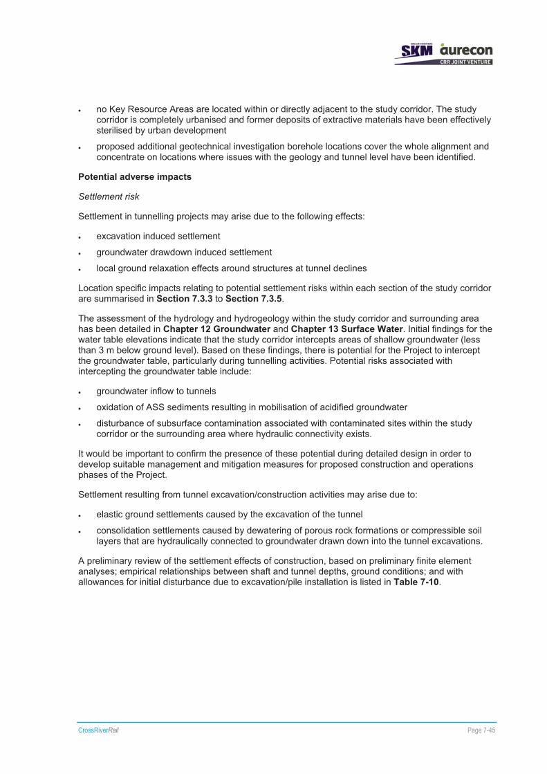
CrossRiverRail Page 7-45
� no Key Resource Areas are located within or directly adjacent to the study corridor. The study corridor is completely urbanised and former deposits of extractive materials have been effectively sterilised by urban development
� proposed additional geotechnical investigation borehole locations cover the whole alignment and concentrate on locations where issues with the geology and tunnel level have been identified.
Potential adverse impacts
Settlement risk
Settlement in tunnelling projects may arise due to the following effects:
� excavation induced settlement
� groundwater drawdown induced settlement
� local ground relaxation effects around structures at tunnel declines
Location specific impacts relating to potential settlement risks within each section of the study corridor are summarised in Section 7.3.3 to Section 7.3.5.
The assessment of the hydrology and hydrogeology within the study corridor and surrounding area has been detailed in Chapter 12 Groundwater and Chapter 13 Surface Water. Initial findings for the water table elevations indicate that the study corridor intercepts areas of shallow groundwater (less than 3 m below ground level). Based on these findings, there is potential for the Project to intercept the groundwater table, particularly during tunnelling activities. Potential risks associated with intercepting the groundwater table include:
� groundwater inflow to tunnels
� oxidation of ASS sediments resulting in mobilisation of acidified groundwater
� disturbance of subsurface contamination associated with contaminated sites within the study corridor or the surrounding area where hydraulic connectivity exists.
It would be important to confirm the presence of these potential during detailed design in order to develop suitable management and mitigation measures for proposed construction and operations phases of the Project.
Settlement resulting from tunnel excavation/construction activities may arise due to:
� elastic ground settlements caused by the excavation of the tunnel
� consolidation settlements caused by dewatering of porous rock formations or compressible soil layers that are hydraulically connected to groundwater drawn down into the tunnel excavations.
A preliminary review of the settlement effects of construction, based on preliminary finite element analyses; empirical relationships between shaft and tunnel depths, ground conditions; and with allowances for initial disturbance due to excavation/pile installation is listed in Table 7-10.

CrossRiverRail Page 7-46
Table 7-10 Estimated Greenfield settlements
Chainage (m)
Tunnel Depth to axis (m)
Description of surface structure (s)
Description of Cross River Rail structure
Estimated maximum settlement
(mm)
Estimated settlement
trough width (m)
0 – 500 0 – 10 m Queenslanders and single storey housing, running parallel to rail corridor
Dive structure, cut and cover tunnel, portal and TBM Launch Shaft
25 – 50 25 m from tunnel wall
500 – 1300 10 – 20 m Runs under existing rail corridor, Queenslanders and single storey housing
1300 – 2150
25 – 35 m Queenslanders and single storey housing
TBM Running Tunnels 10 – 25 50 – 100
1970 – 1990
30 m Road intersection Shaft 25 – 50 25 m from shaft wall
1990 – 2750
20 – 30 m Queenslanders, single storey housing and multistorey structures
10 – 25 75–125
2750 – 3250
15 – 35 m Queenslanders and Multistorey Structures, Industrial/Commercial
10 – 25 75–125
3250 – 3800
30 – 45 m Industrial/Commercial, two-storey structures and Queenslanders
TBM Running Tunnels
0 – 10 75–125
3800 – 4060
30 – 50 m Boggo Road Busway Station, Boggo Road Gaol (Heritage), Ecosciences Precinct
Boggo Road Underground Station
25 – 50 25 m from shaft wall
4060 – 4950
20 – 45 m Park Road Rail Station, Queenslanders, single and two storey houses
TBM Running Tunnels 10 – 25 75–125
4950 – 5200
25 – 45 m Pacific Motorway –Hawthorne Street overpass, Multistorey Structures and Queenslanders, Woolloongabba Busway Station
Gabba Underground Station
10 – 25 25 m from shaft wall
5200 – 6000
30 – 50 m Multistorey Structures, Queenslanders
0 – 10 100–150
6000 – 6400
35 – 55 m Brisbane River Crossing
0 – 10 100–150
6400 – 6700
30 – 40 m City Botanic Gardens
TBM Running Tunnels
0 – 10 100–150

CrossRiverRail Page 7-47
Chainage (m)
Tunnel Depth to axis (m)
Description of surface structure (s)
Description of Cross River Rail structure
Estimated maximum settlement
(mm)
Estimated settlement
trough width (m)
6700 – 7000
30 – 35 m Residential and Commercial Multistorey Structures
Albert Street Station 25 – 50 30 m from shaft wall
7000 – 7700
25 – 35 m Residential and Commercial Multistorey Structures, Queen Street Busway Station, City Hall, S1 Sewer, King George Busway Station
TBM Running Tunnels 0 – 10 100–150
7700 – 8050
25 – 30 m Crosses Busway and Rail Station Passages
Roma Street Station 10 – 25 25 m from shaft wall
8050 – 8500
30 – 50 m Multistorey Structures (low – medium), Roma Street Parkland
0 – 10 100–150
8500 – 8900
35 – 50 m One and two storey houses, Multistorey Structures (low – medium)
10 – 25 75–125
8900 – 9200
20 – 35 m Gregory Terrace, Parkland
TBM Running Tunnels
10 – 25 25–75
9200 – 9370
10 – 20 m Landbridge, borders to existing Rail corridor
Road Header Tunnel 50 – 75 100–150
9370 – 10000
0 – 10 m Runs with existing rail corridor, ICB, Bowen Bridge/Northern Busway overpass
Cut & Cover Tunnel, Portal Structure, Dive structure
25 – 50 25 m from shaft wall
Source – AECOM, 27 May 2011b
Erosion risk
The soil landscapes that are likely to be intercepted and disturbed as a result of the Project are illustrated in Figure 7-11.
Areas of high erosion risk and steep areas, eg greater than 10% gradient, are a potential risk to surface soil and landform stability during construction. There is also a risk of impacts to surface water quality within the receiving environment. Further sampling and analysis would be required during future geotechnical investigations to assess the physical and chemical conditions of surface and subsurface soils that are likely to be disturbed during construction in order to quantify the specific risks at each surface works site associated with accelerated erosion and to develop appropriate site specific soil management and erosion mitigation measures for each phase of the Project.

!
!
!
!
!
!
!
!
! !
!
!
!
!
!!
!
!
!
!
!
!
!
!
!
!
!
!
!
!
!
!
! !
!
!
!
!
!
!
!
!
!
!
!
!
!
!
!
Brisbane River
Brisbane RiverBris
bane
Rive
r
Albert Street Station
Gabba Station
Roma Street Station
Boggo Road Station
T
B
W
B
A
W
T
B
B
L
Cl
L
CPBl
Co
S
Pu
Pu
Be
Ck
Pu
En
L
Be
W
MCo
Be
W
Pu
Wo
MC
B
Wo
Cm
S
Be
Nu
W
Cm
L
Be
CP
Be
W
Da
Wo
B
Be
Be
Wo
Be
L
Cm
MC
B
Wo
Cm
Cm
PR
CkB
A
Cm
B
T
B
SaCk
En
Wo
MC
W
Sa
MCk
Cm
B
Ck
MCBe
Ck
T
B
L
Wo
Be
MCk
MCk
MCk
Be
Wo
Be
MCk
MCk
MCk
W
MC
Ck
MCk
Be
PR WoCROSS RIVER RAIL
ENVIRONMENTAL IMPACT STATEMENTFigure 7-11
Soil Landscapes
¯0 0.5 1 1.5 2km
LEGENDStudy CorridorMain Road
! StationTrack
Underground StationAlignment
Above GroundUnderground
Soils within Study BoundaryB BEENLEIGHBe BRISBANE RIVERCm CHERMSIDEL LOGAN
MCk MOGGILL CKNu NUNDAHT TOOWONGW WOODRIDGE
Wo WOONGOOLBA
K:\C
ross
Riv
er R
ail\6
00 E
nviro
nmen
t\619
GIS
\Aur
econ
\205
555_
CR
R\G
001_
CC
R_S
oils
_A3_
ver9
3.m
xd
07/
07/2
011
16:5
2M
ap b
y: M
JS
1:70,000 at A4

CrossRiverRail Page 7-49
Areas within the study corridor that demonstrate a slope gradient greater than 10% have been identified on Figure 7-12, Figure 7-13 and Figure 7-14. It should be noted that erosion risk at some of these sites will be reduced by the presence of surface coverage ie concrete or bitumen and the small extent of the disturbance footprint. The location specific hazards and impacts associated with accelerated erosion risks within each section of the study corridor are detailed in Section 7.3.3 to Section 7.3.5. A review of the gradient differences suggests soil erosion prevention techniques will need to be incorporated into the onsite management plan for the following sites:
� Ekka Station
� northern portal worksite in Spring Hill, including access points
� southern ventilation shaft and worksite
� southern portal worksite to Moolabin Creek.
Potential erosion and surface or shallow sediment movement impacts within the study corridor have been considered for:
� construction worksites
� onsite spoil management and removal
� surface works associated with surface stations, track work and road network changes/upgrades, tunnel portal locations, ancillary surface works and structures, such as service relocation/installation
� construction of building footprints for ventilation shaft, power systems and operational support facilities
� construction of structures such as bridges/elevated roads, rail and pedestrian access structures.
Disturbing surface and shallow soils and sediments on steep slopes (more than 10% gradient) during construction present a potential risk to the soil values within the study corridor. This is of particular concern for surface works that would be scheduled during the wet season (November to April). Specific soil management and erosion mitigation measures are required to be implemented to enable adequate sediment control for each of the sites within the study corridor. This will be important at sites identified as having high erosion risk.
Acid Sulfate Soils
A review of the Acid Sulfate Soils – Tweed Heads to Redcliffe Map 1 (NR&M 2003) has identified ASS present within or directly adjacent to the study corridor, which may be disturbed as a result of the Project. The extent of the ASS areas within the study corridor and surrounding areas are illustrated in Figure 7-15.
There is a possibility of encountering ASS where surface works are proposed in a number of the isolated alluvial valleys along the extent of the study corridor and there is potential for the disturbance of these sediments to result in impacts to the quality of both surface water and groundwater. Therefore, it would be important to undertake sampling and analysis for ASS as part of the geotechnical investigations, in order to confirm the presence/absence and status of ASS. The findings of these investigations would be required in order to develop suitable ASS management and mitigation measures to be implemented during construction for any areas of ASS disturbance.
Location specific impacts relating to the risk of disturbing ASS within each section of the study corridor are summarised in Section 7.3.3 to Section 7.3.5.

!
!
!
!
!
!
!
Albion Station
Windsor Station
Wooloowin Station
Bowen Hills Station
Eagle Junction Station
Ekka Station
Brisbane R
iver
MayneRail Yard
WINDSOR
ALBION
CLAYFIELD
BOWEN HILLS
NEWSTEADBULIMBA
WOOLOOWIN
LUTWYCHE
HERSTON
GORDON PARK
HAMILTON
ASCOT
FORTITUDE VALLEY
KEDRON
SPRING HILL
WILSTON
GRANGE
STAFFORD
CROSS RIVER RAILENVIRONMENTAL IMPACT STATEMENT
Figure 7-12Erosion Hazard
(Northern Section)
¯0 100 200 300 400 500m
LEGENDStudy Corridor
Suburbs
! Station
Track
Underground Station
AlignmentAbove Ground
Underground
SlopeGreater than 10%
K:\C
ross
Riv
er R
ail\6
00 E
nviro
nmen
t\619
GIS
\Aur
econ
\205
555_
CR
R\G
084_
CC
R_E
rosi
on_H
az_S
heet
1_A
3_ve
r93.
mxd
0
7/07
/201
1 16
:55
Map
by:
MJS
1:18,000 at A4

!
!
!
!
!
!
!
!
!
Buranda Station
CentralStation
Roma Street Station
Southbank Station
Park Road Station
Dutton Park Station
South Brisbane Station
Fortitude Valley Station
Exhibition Station
Albert Street Station
Gabba Station
Roma Street Station
Boggo Road Station
Ekka Station
Brisbane River
CITY
NEW FARM
WOOLLOONGABBA
SOUTH BRISBANE
SPRING HILL
ST LUCIA
EAST BRISBANE
KANGAROO POINT
NEWSTEAD
HIGHGATE HILL
DUTTON PARK
FORTITUDE VALLEY
HERSTON
WEST END
KELVIN GROVE
GREENSLOPES
MILTON
RED HILL
BOWEN HILLS
COORPAROO
PADDINGTON
NORMAN PARK
FAIRFIELD
BULIMBA
CROSS RIVER RAILENVIRONMENTAL IMPACT STATEMENT
Figure 7-13Erosion Hazard
(Central Section)
¯0 100 200 300 400 500m
LEGENDStudy Corridor
Suburbs
! Station
Track
Underground Station
AlignmentAbove Ground
Underground
SlopeGreater than 10%
K:\C
ross
Riv
er R
ail\6
00 E
nviro
nmen
t\619
GIS
\Aur
econ
\205
555_
CR
R\G
084_
CC
R_E
rosi
on_H
az_S
heet
2_A
3_ve
r93.
mxd
0
7/07
/201
1 16
:56
Map
by:
MJS
1:22,000 at A4

!
!
!
!!
!
!
!
!
!
!
Rocklea Station
Buranda Station
Yeronga Station
Tennyson Station
Moorooka Station
Salisbury Station
Park Road Station
Fairfield Station
Dutton Park Station
Yeerongpilly Station
Boggo Road Station
Brisbane River
ROCKLEA
SALISBURY
ST LUCIA
YERONGA
MOOROOKA
TARRAGINDI
ANNERLEY
NATHAN
GREENSLOPESFAIRFIELD
YEERONGPILLY
INDOOROOPILLY
TENNYSON
WOOLLOONGABBA
DUTTON PARK
ARCHERFIELD COOPERS PLAINS
CORINDA
COORPAROOHIGHGATE HILL
HOLLAND PARK WEST
TARINGA
CROSS RIVER RAILENVIRONMENTAL IMPACT STATEMENT
Figure 7-14Erosion Hazard
(Southern Section)
¯0 100 200 300 400 500 600m
LEGENDStudy Corridor
Suburbs
! Station
Track
Underground Station
AlignmentAbove Ground
Underground
SlopeGreater than 10%
K:\C
ross
Riv
er R
ail\6
00 E
nviro
nmen
t\619
GIS
\Aur
econ
\205
555_
CR
R\G
084_
CC
R_E
rosi
on_H
az_S
heet
3_A
3_ve
r93.
mxd
0
7/07
/201
1 16
:57
Map
by:
MJS
1:30,000 at A4

!
!
!
!
!
!
!
!
! !
!
!
!
!
!!
!
!
!
!
!
!
!
!
!
!
!
!
!
!
!
!
! !
!
!
!
!
!
!
!
!
!
!
!
!
!
!
!
Brisbane River
Brisbane RiverBris
bane
Rive
r
Albert Street Station
Gabba Station
Roma Street Station
Boggo Road Station
OXLEY
EAGLE FARM
ENOGGERA
NATHAN
CITY
INDOOROOPILLY
ST LUCIA
COORPAROO
TOOWONG
TARRAGINDI
YERONGA
CORINDA
BULIMBA
ANNERLEY
CLAYFIELD
NEW FARM
GREENSLOPES
HAMILTON
ARCHERFIELD
PADDINGTON
CANNON HILL
MOUNT GRAVATT
HERSTON
GRACEVILLE
NEWSTEAD
NORMAN PARK
WOOLLOONGABBA
NEWMARKET
EAST BRISBANE
KELVIN GROVE
SPRING HILL
THE GAP
HIGHGATE HILL
LUTWYCHE
KANGAROOPOINT
CA
TENNYSON
COOPERS PLAINS
FAIRFIELD
DUTTONPARK
MILTON
SOUTH BRISBANE
WINDSOR
ALBION
BOWEN HILLS
WOOLOOWIN
FORTITUDE VALLEY
CROSS RIVER RAILENVIRONMENTAL IMPACT STATEMENT
Figure 7-15Acid Sulfate Soils
¯0 0.5 1 1.5 2km
LEGENDStudy Corridor
Highway/Motorway/Major Alternate
Other Roads! Station
Track
Underground StationAlignment
Above Ground
Underground
Acid Sulfate Soils
K:\C
ross
Riv
er R
ail\6
00 E
nviro
nmen
t\619
GIS
\Aur
econ
\205
555_
CR
R\G
003_
CC
R_A
SS
_A3_
ver9
3.m
xd
07/
07/2
011
16:5
3M
ap b
y: M
JS
1:70,000 at A4
CrossRiverRail Page 7-54
ASS disturbance could result from a number of construction-related activities including:
� excavation of ASS material
� sediment movement into waterways and overland flow paths
� downward loading pressure on unconsolidated sediments from stockpiles, placement of fill material and the placement of structures such as footings, piers, piles and road and rail infrastructure construction
� groundwater drawdown
� changes for surface and subsurface flow regimes and pathways.
The potential environmental impacts associated with disturbance of ASS include:
� changes to water chemistry of receiving waterbodies such as Breakfast Creek, Brisbane River and Oxley Creek and its tributaries, as well as groundwater resources
� sedimentation of waterways and accelerated erosion due to loss of aquatic vegetation and degradation of the soil profile structure
� changes to the aquatic ecosystem within Breakfast Creek, Brisbane River and Oxley Creek and its tributaries
� oxidation of ASS affected sediments within Mayne Rail Yard and/or Clapham Rail Yard due to surface heaving, subsurface extrusion and displacement of ASS affected material above the groundwater table as a result of fill material creating downward loading pressure on unconsolidated sediments
� accelerated oxidation of ASS and uncontrolled release of generated acid leachate to stormwater systems resulting from exposure of insitu ASS affected sediments through excavation at portal locations, for the placement of structures such as footings, piers and piles and rail and road infrastructure construction activities
� oxidation of ASS affected sediments in the vicinity of the tie-in works on the southern approach to the Breakfast Creek rail bridge, the Bowen Bridge Road overpass and the northern portal and associated construction worksite due to extrusion/displacement of ASS affected material above the groundwater due to placement of footings and piers causing downward pressure on unconsolidated sediments
� accelerated oxidation of ASS and uncontrolled release of generated acid leachate to stormwater systems due to stockpiling of ASS material prior to treatment
� temporary exposure of ASS affected material within the area of influence of groundwater drawdown and subsequent inundation during post construction recharge of the water table resulting in potential generation and mobilisation of acid leachate within the groundwater system
� uncontrolled release of acid leachate from disturbed ASS under lowered/altered flow regimes due to the advent of structures
� mobilisation of contaminant concentrations from existing contaminated sites located within the study corridor and surrounding area resulting from the acidification of groundwater flows contacting subsurface materials, eg contaminant plumes, within the area. This would be of particular concern in the vicinity of Roma Street Station and Gabba Station.

CrossRiverRail Page 7-55
The severity and duration of the potential environmental impacts associated with the disturbance of ASS would depend upon a number of factors including:
� the nature of the soil eg soils would have varying acid producing potential subject to their texture, pyritic concentration and amount of natural buffering or neutralising material present in the soil structure
� the period and frequency of ASS exposure and oxidation
� the buffering capacity of the receiving water bodies downstream of the Mayne Rail Yard, Albert Street Station worksite and the southern portal worksite, such as Breakfast Creek, Brisbane River and Oxley Creek and its tributaries, respectively – acidic runoff would normally be neutralised by alkaline buffering capacity of seawater, although after heavy rainfall estuarine creeks may tend towards freshwater, which usually has little capacity to buffer acidic runoff.
It is anticipated that ASS would be disturbed during construction of the Project within each of the sections of the study corridor.
Loss of fossil material
A potential impact of the Project is the loss of fossil material, not previously identified/documented, as a result of tunnelling activities.
Corridor-wide mitigation measures
Settlement risk
To minimise the risk associated with settlement, it is important to adhere to suitable, systematic engineering practices that comply with relevant standards and codes, and ensure that effective settlement management and monitoring methods are implemented and reviewed from the onset of construction.
Prior to detailed design, a further round of geotechnical investigations (Phase 3) will be undertaken. The objective of the investigations is to further understand the ground conditions within the study corridor and to identify and geotechnical constraints to the alignment. It is planned that 15 boreholes be drilled in the bed of the Brisbane River to further investigate subsurface conditions along the tunnel’s river crossing. In addition, 13 boreholes are planned to be drilled at various locations between the proposed Albert Street and Roma Street stations and in the southern tunnel section between Boggo Road Station and the southern portal. Following this phase of geotechnical investigations, it is likely further phases will be undertaken for detailed design purposes.
Information gathered during these geotechnical investigations will be used to inform appropriate mitigation measures to be implemented during the detailed design process. Issues which would require careful consideration at that stage include tunnel face-loss, design of tunnel support and liners, stability assessment of portals, as well as detailed groundwater modelling of tunnel impacts. Further comprehensive geotechnical investigations would be required prior to construction to fully define the subsurface profile and geological conditions to be encountered.
Erosion Risk
� Mitigation measures to manage erosion risk for the Project will be detailed in an Erosion and Sediment Control Plan (ESCP). This plan will be development in accordance with the requirements of relevant environmental legislation, eg EP Act, and the associated EP(Water) Policy and the SP Act, and guidelines relevant to soil management on the project.
� Detailed information including confirmation of soil landscapes, soil depth, presence of fill and soil chemical properties will be gathered during site specific soil investigations at each of the worksites, prior to construction. This information will be used to inform site specific ESCPs for each of the worksites.
CrossRiverRail Page 7-56
Acid Sulfate Soils
Mitigation measures for the Project would implement best management and monitoring practices (commencing from the detailed design phase and extending through to the pre-construction and construction phases) to ensure potential environmental impacts associated with ASS disturbance are minimised and managed.
The ASS management measures would be a result of discussions with Department of Environment and Resource Management (DERM) representatives, and would incorporate the hierarchy of ASS management principles in line with the Queensland Acid Sulfate Soil Technical Manual - Soil Management Guidelines (version 3.8) (Dear et al 2002), which include:
� avoid disturbance
� minimise disturbance
� neutralise disturbed material
� hydraulic separation of disturbed material.
The SPP 2/02 and the EPA (2001) Instructions for the Treatment and Management of Acid Sulfate Soils would also be referenced. In particular, the following specific ASS management measures would be implemented for the Project:
� minimise changes in the natural groundwater levels
� investigate the acid generating potential of ASS material to be excavated from the Mayne Rail Yard worksite
� implement an ASS management plan for the Mayne Rail Yard worksite, Albert Street Station worksite, the southern portal worksite and Clapham Rail Yard worksite that addresses the potential disturbance and management of ASS material at each site. This would ensure that disturbed ASS material is adequately treated and managed throughout the construction phase.
� where ASS must be disturbed, soil treatment with fine agricultural lime or other neutralising agents would be used onsite to prevent the downstream or offsite impacts from acid generation and the uncontrolled release of acid leachate from the site
� the ASS material treatment pads and stockpiling areas would be constructed, bunded and prepared prior to commencement of construction and located within the spoil shed at the southern construction worksite, where overland flow can be adequately controlled and diverted away from the treatment area
� all leachate and runoff from areas excavated below 5 m AHD, ASS treatment pads and stockpile areas would be captured, contained, analysed and treated (if necessary) prior to offsite discharge in compliance with relevant works approvals and surface water discharge criteria adopted for the Project
� all fill proposed to be imported to site and used for filling activities would be free of ASS.
Fossil material
� Fossil material may be encountered during excavation of shafts in sedimentary material. Should significant fossil material or finds be encountered during excavation, works will cease and a paleontologist will be consulted to determine suitable management or preservation measures as required.

CrossRiverRail Page 7-57
7.3.3 Wooloowin to Bowen Hills
Sites directly impacted by the proposal
Sites within the northern section of the study corridor that would be directly impacted by surface works include:
� tie-in works and track realignment work on structure within the Breakfast Creek floodplain
� track work within the Mayne Rail Yard and construction of a Queensland Rail switch-gear building and Energex substation with separate (non-Queensland Rail) site access
� changes to the road surface and elevation (2.5 m) at O’Connell Terrace
� works in the RNA Showgrounds for the new Ekka Station
� construction of new Ekka Station
� at-grade track work and soil retaining structures in the vicinity of the Bowen Bridge Road overpass
� construction of an Energex substation (including a separate, non-Queensland Rail site access) within Victoria Park, at the northern portal
� construction of bridges, reinforced earth embankment, realignment of existing tracks and widening of the rail corridor adjacent to the alignment of the ICB between Bowen Bridge Road overpass and the northern portal.
Works at these locations are shown on the reference design drawings (refer to Volume 2 Reference design drawings).
Benefits and opportunities
Throughout the development of the reference design for the Project, opportunities relating to the management of geological and soil characteristics within the northern section of the study corridor have been identified. Potential opportunities include:
� reuse opportunities for suitable excavated spoil for surface works at Mayne Rail Yard, O’Connell Terrace and Ekka Station. It is estimated that approximately 96,000 m³ of spoil would be removed from the northern portal
� opportunities to coordinate works that require possession of the rail corridor with track work/maintenance activities to be undertaken by Queensland Rail between the Mayne Rail Yard worksite and the northern portal worksite to minimise impact to Queensland Rail operational conditions.
Potential adverse impacts
Significant geological features have been identified within the northern section of the study corridor and a summary is provided in the sections following. However, as recommended in the Cross River Rail Preliminary Geotechnical Interpretive Report (AECOM, 2010a), confirmation of potential geological hazards and the subsurface conditions represented in the rock-head model would need to be obtained through detailed geotechnical investigations during detailed design for the northern section of the study corridor for:
� confirming the geological model for the Project and tunnel construction methods involving the construction of the northern portal
� completion of detailed hydrogeological investigations during detailed design to confirm the hydraulic connectivity of geological units that would be encountered during tunnelling in the vicinity of the northern portal
� works approaching the Breakfast Creek rail bridge

CrossRiverRail Page 7-58
� excavation of the mined tunnel at the northern portal
� construction of the Ekka Station
� surface works in the vicinity of Mayne Rail Yard, Bowen Bridge Road overpass and the ICB.
Works at these locations are shown on the reference design drawings (refer to Volume 2 Reference design drawings).
No construction works are proposed north of the Breakfast Creek channel and therefore the geological feature (syncline) interpreted to cross the North Coast Railway in the vicinity of Wooloowin Station is unlikely to affect the Project.
Within the northern section of the study corridor:
� soils within the Nundah soil landscape are unlikely to be disturbed by surface works associated with the Project
� soils within the Chermside soil landscape are likely to be disturbed by surface works associated with the Mayne Rail Yard worksite and Ekka Station
� soils within the Logan soil landscape are likely to be disturbed by surface works associated with the southern approach to the Breakfast Creek Bridge, the Ekka Station, adjacent to the Bowen Bridge Road overpass and the ICB, and construction of the northern portal.
Settlement risk
Excavation induced settlement of ground adjacent to transition structures are a potential risk in the vicinity of the southern approach to the Breakfast Creek rail bridge, surface works between Mayne Rail Yard worksite and the Ekka Station and the approach to the Bowen Bridge Road overpass, where there is potential for unconsolidated sediments and shallow water table levels to be present within the disturbance footprint for the Project.
It is anticipated that the mined tunnel would intercept the water table during excavation and construction of the northern portal, which may result in groundwater inflow into the tunnel decline. At this location there is a potential risk of consolidation settlements if any unconsolidated sediments within the Logan soil landscape and alluvial material are impacted.
There is also a potential risk of some lateral relaxation of soils resulting from the construction of soil retaining structures that may be adopted in the vicinity of the Victoria Park land bridge and the northern portal areas.
Erosion risk
Areas of high erosion risk and steep areas, eg greater than 10% gradient, have been identified within the northern section of the study corridor at Wooloowin, Albion and Bowen Hills. The only area that is likely to pose a potential risk to surface soil and landform stability during construction is Bowen Hills. There is also a risk of impacts to surface water quality within the receiving environment of Breakfast Creek due to sediment movement. Further sampling and analysis in these areas would be undertaken during future geotechnical investigations to assess the physical and chemical conditions of surface and subsurface soils that are likely to be disturbed on steep slopes during construction in order to quantify the risks associated with accelerated erosion and to develop appropriate soil management and erosion mitigation measures.
As illustrated on Figure 7-12 and in Volume 2 Reference design drawings, surface works occurring on the southern approach to the Breakfast Creek rail bridge, on the eastern side of the Mayne Rail Yard and between the Mayne Rail Yard worksite and the northern portal worksite (including surface works at the Ekka Station) are likely to create or intercept slope gradients greater than 10%.

CrossRiverRail Page 7-59
The proposed northern construction worksite, between the Mayne Rail Yard and Ekka Station is expected to be either in Chermside or Logan soil landscapes. These soils are considered to be a moderate to low erosion risk, depending on steepness of the slope at the point of disturbance. The area between the approach to the Breakfast Creek rail bridge, the Mayne Rail Yard worksite, Ekka Station and the Bowen Bridge Road overpass are generally relatively flat and therefore significant accelerated erosion is not anticipated as a result of surface works within these areas. Standard sediment control measures for construction worksites are proposed for surface works within this area.
Between the Bowen Bridge Road overpass and the northern portal worksite the proposed alignment follows the ICB alignment closely and is likely to be located within the Logan soil landscape within a relatively flat, low-lying historical drainage line. The erosion risk associated with surface works within the worksite is anticipated to be low, but consideration of potential erosion and sediment movement risks associated with excavation and surface works for gaining access to the northern portal worksite will be required due to the steep slopes of the adjacent and surrounding area between the Bowen Bridge Road overpass and the northern portal worksite. Standard sediment control measures for construction worksites are proposed for surface works within this area. These will be developed in accordance with the Best Practice Erosion and Sediment Control (IECA Australasia 2008), Soil Erosion and Sediment Control – Engineering Guidelines for Queensland Construction Sites (Institute of Engineers Australia (Qld Division) 1996) and Draft Urban Stormwater – Queensland Best Practice Environmental Management Guidelines 2009 (DERM 2009a).
The nature of the proposed works at each of the sites during construction is likely to include the following:
� vegetation clearing and site preparation at each construction worksite
� preparation of laydown, material storage, handling, preparation and spoil stockpile/treatment areas within the construction worksites
� construction of embankments and soil retaining structures to support the construction of a surface station at the RNA Showgrounds, capping and ballast placement for track work
� installation/construction of storm water/drainage control and sediment control measures including bunding for material storage areas within the construction worksites
� construction of haul routes, carparks and vehicular access tracks for the construction worksites
� installation of services for site offices and workshops within the construction worksites
� construction activities for the northern portal, Ekka Station, track work and changes to the road network within the northern section of the study corridor
� formation works would be required in most track work locations, which includes bringing in and stockpiling material and ballast for placement during these works and would also include topsoil stripping with and adjacent to the surface work areas.
The potential impact to the surrounding environment within these construction worksites, the northern portal area and onsite spoil placement locations for construction and access purposes includes:
� potential surface water quality impacts from sediment and contaminants entrained in surface runoff resulting from construction related activities such as exposed soils, spoil stockpiles and material storage
� loss of valuable topsoil material during site preparation and from stripping and stockpiling for extended periods
� erosion due to vegetation clearing and soil disturbance on steep slopes to create space for the stockpiling of material, laydown activities and to establish access routes
� erosion of exposed vulnerable soils by wind or water action
� embankments constructed over weak alluvium may undergo settlement in the vicinity of the Mayne Rail Yard and RNA Showgrounds.

CrossRiverRail Page 7-60
Mitigation measures would be implemented throughout various stages of the Project to control and reduce the risk of accelerated erosion due to construction and operational.
Acid Sulfate Soils
ASS is likely to occur within the vicinity of the Breakfast Creek floodplain. Typical activities likely to be associated with construction and operation that may disturb ASS in this area include:
� surface works associated with the tie-in works with the Breakfast Creek rail bridge, Mayne Rail Yard and in the vicinity of the ICB alignment
� construction of embankments and soil retaining structures to support the construction of the surface Ekka Station at the RNA Showgrounds, capping and ballast placement for track work
� construction of stormwater collection, treatment and control measures
� lowering of groundwater levels in the vicinity of the northern portal during tunnel operation either temporarily or permanently
� stockpiling and removal of spoil material at the construction worksites.
Mitigation
Settlement risk
Appropriate mitigation measures would be identified and implemented during the detailed design process. Issues which would require careful consideration at that stage include tunnel face-loss, design of tunnel support and liners, stability assessment of portals, as well as detailed groundwater modelling of tunnel impacts within the northern section of the study corridor. Comprehensive geotechnical investigations would be undertaken during detailed design to fully define the subsurface profile and geological conditions along the proposed alignment within the northern section.
Measures would be required to limit settlement movements in the vicinity of live tracks.
‘Sensitive’ structures (as identified in AECOM 2010a) within the areas where surface settlements and possible damage are predicted would have a building condition survey completed. Surveys and other displacement monitoring would be used to monitor the effects of settlement, if any, from tunnelling. The actual settlements would be compared to predicted settlements and further mitigating measures taken where adverse departures from predictions are identified.
Mitigation measures would be implemented throughout various stages of the Project to control and reduce the risk of settlement impacts due to construction and operational activities.
Erosion risk
Mitigation measures would be implemented throughout various stages of the Project to control and reduce the risk of erosion due to construction activities. Proposed erosion control measures would be based upon reducing the risk of erosion during construction by:
� managing the stripping and stockpiling of topsoil material from construction worksites and surface works areas and segregation of potentially contaminated material, particularly within the Mayne Rail Yard worksite and the northern portal worksite (refer to Chapter 8 Land Contamination)
� managing the extent of soil disturbance and vegetation clearing as well as reducing the exposure of vulnerable soils and soils on steep slopes to accelerated erosion by wind and water action, particularly where site access works are required for the northern portal worksite
� designing stormwater management systems during detailed design and implemented during construction to control velocity of runoff from exposed areas and capture sediment entrained in runoff prior to release/discharge from worksites within the northern section of the study corridor

CrossRiverRail Page 7-61
� planning construction works to provide for progressive and timely stabilisation and rehabilitation of disturbed areas
� undertaking finishing and landscaping works for ongoing sediment and erosion control around the worksites following construction.
Detailed measures would be developed during the detailed design phase of the Project to achieve effective sediment control within worksites and surface works areas within the northern section and manage potential impacts from erosion due to construction and operational activities (refer to Chapter 24 Draft Outline EMP). Site specific erosion and sediment control plans would be prepared and adopted for the Mayne Rail Yard worksite, Ekka Station construction site and the northern portal worksite, including worksite access and all areas of surface disturbance, within the northern section of the study corridor, to ensure that erosion and sediment control measures are implemented and adequate to the nature and scale of disturbance. These measures would also include site reinstatement measures once surface works are complete.
Acid Sulfate Soils
� The mitigation measures for any ASS disturbance in the Project are indentified in Section 7.3.2 Mitigation.
� Mitigation measures for the Project would implement best management and monitoring practices (commencing from the design phase and extending through to the pre-construction and construction phases) to ensure potential environmental impacts associated with ASS disturbance are in priority order of, avoidance, minimisation and management.
Water management and surface runoff controls, to protect drainage lines and Breakfast Creek, would be key elements for the management and mitigation of potential impacts resulting from the disturbance of ASS. Runoff and drainage control points within and exiting the construction worksites would be identified and design suitable control measures and structures would be installed during construction that would divert or contain runoff from specific areas.
Design considerations for the management of ASS at the Mayne Rail Yard worksite include:
� protect Breakfast Creek and contain runoff from disturbed areas within the worksite and designated ASS stockpile/treatment areas
� minimise disturbance of the natural surface and subsurface drainage regimes within the Mayne Rail Yard worksite and surface works between the Breakfast Creek rail bridge, Mayne Rail Yard and Ekka Station
� design embankments and other construction activities to incorporate measures to minimise or prevent subsidence or uncontrolled settlement of unconsolidated alluvial material within the Mayne Rail Yard worksite and the approach to the Breakfast Creek rail bridge
� planning and staging of proposed construction activities in areas rated as having moderate to extreme risk for ASS material, eg approach to the Breakfast Creek rail bridge and the Mayne Rail Yard worksite, to ensure that disturbance is minimised and rehabilitation/reinstatement is progressive and timely.
Red Imported Fire Ants
An approved RIFA inspection program and risk management plan would be required for future phases of the Project.

CrossRiverRail Page 7-62
7.3.4 Spring Hill to Dutton Park
Sites directly impacted upon by the proposal
Sites within the central section of the study corridor that would be directly impacted by surface works include:
� construction of the Roma Street Station, including pedestrian access to Roma Street, reconfiguration of vehicle access to Roma Street Parklands and pedestrian connections to the Roma Street Station concourse
� construction of the Albert Street Station, including the northern construction worksite at Mary Street, the southern construction worksite at Alice Street, pedestrian access beneath Alice Street, and associated surface road works and demolition activities
� construction of the Gabba Station including the construction worksite, and associated surface road works and demolition activities
� construction of the Boggo Road Station, including the station construction worksite and pedestrian connections with Park Road Station
� construction of bridges and ramps for pedestrian access.
Works at these locations are shown on the reference design drawings (refer to Volume 2 Reference design drawings).
Benefits and opportunities
Throughout the development of the Project, opportunities relating to the management of geological and soil characteristics within the central section of the study corridor have been identified. Potential opportunities include:
� reuse opportunities, for suitable excavated spoil removed from tunnel excavations at the Albert Street Station worksite and the Gabba Station worksite, for reuse during surface works that require fill material and as suitable material for reuse at spoil placement locations.
Potential adverse impacts
Significant geological features have been identified within the central section of the study corridor and a summary is provided in the following sections. However, as recommended in the Cross River Rail Preliminary Geotechnical Interpretive Report (AECOM, 2010a), confirmation of potential geological hazards and the subsurface conditions represented in the rock-head model would occur through detailed geotechnical investigations during detailed design for the tunnel, cross passages and underground station caverns through:
� confirmation of the geological model for the Project and tunnel construction methods between the northern portal worksite and the Gabba Station worksite and south between Gabba Station and Boggo Road Station
� completion of detailed hydrogeological investigations to confirm the hydraulic connectivity of geological units that would be encountered during tunnelling, particularly in relation to the Brisbane River crossing and tunnel cross passage construction
� over water drilling to confirm and correlate with the seismic investigation of the river bed, particularly in light of the recent flooding event within the Brisbane River channel.

CrossRiverRail Page 7-63
These investigations will inform the detailed design and confirm the construction methodology to be adopted for:
� excavation of the mined tunnel at the northern portal and mined cross-passages
� surface works in the vicinity of the ICB, the Victoria Park land bridge and the Roma Street Station
� top-down excavations for the Albert Street Station (both the northern and southern ends, as well as the proposed pedestrian connection beneath Alice Street) and Boggo Road Station
� river crossing and to confirm the presence/location and orientation of the unconformity at the contact between the Brisbane Tuff and underlying Neranleigh-Fernvale Beds in the vicinity of the Kangaroo Point cliffs
� surface works associated with the construction of the Gabba Station and the construction worksite
� in the Tingalpa Formation to the south of Boggo Road where two geological sequences have been identified and would require more detailed differentiation and delineation, particularly relating to the presence and extent of mudstone.
Within the context of the Project, impacts to the six soil landscapes identified as a result of surface works are:
� soils of the Beenleigh soil landscape are likely to be disturbed by surface works associated with the Albert Street Station worksite
� soils of the Brisbane River soil landscape are likely to be disturbed by surface works associated with the Albert Street Station worksites
� soils of the Chermside soil landscape are likely to be disturbed by surface works associated with the Gabba Station worksite and Boggo Road Station
� soils of the Toowong soil landscape are unlikely to be disturbed by surface works
� soils of the Woodridge soil landscape are likely to be disturbed as a result of surface works associated with the Boggo Road Station.
Settlement risk
An unconformity zone has been identified during previous investigations at the base of the Brisbane Tuff and represents a zone of less competent rock sandwiched between the Brisbane Tuff and the Neranleigh-Fernvale Beds. The geometry and nature of this interface represents a risk to proposed tunnelling activities and should be delineated and clearly understood, with regard to geotechnical stability and potential environmental implications, through further detailed geotechnical investigations, before any tunnelling commences.
It is also anticipated that the tunnel would intercept the water table during excavation and construction of the running tunnels and station caverns, especially in the vicinity of the Albert Street Station, the river crossing and the Gabba Station, which may result in groundwater inflow into the tunnel. This may result in consolidation settlements of unconsolidated sediments within alluvial material present. There would also be a need to capture, monitor and potentially treat groundwater inflows captured in the pump station at the low point of the river crossing during operation.
There is also the potential for some lateral relaxation of soils associated with soil retaining structures that may be adopted in the vicinity of the surface works for each of the underground stations. This would be confirmed by detailed geotechnical investigations during detailed design.
Preliminary assessment of construction induced ground settlement indicates that there is a potential low risk of significant effects along the full tunnel alignment. Albert Street Station and northern shaft, Gabba Station (above the busway) and Boggo Road Station and the section of tunnel immediately north of Boggo Road Station would all need separate treatments to mitigate settlement risk.

CrossRiverRail Page 7-64
Further detail regarding potential settlement risk in the geotechnical investigations completed for the Project and compiled from previous investigations are provided in the Preliminary Geotechnical Interpretive Report (AECOM 2010a).
Erosion risk
Areas of high erosion risk and steep areas, eg greater than 10% gradient, have been identified at Spring Hill, Woolloongabba and Dutton Park and are a potential risk to surface soil and landform stability during construction. There is also a risk of impacts to surface water quality, within the receiving environment of the Brisbane River, resulting from sediment movement. Soil sampling and analysis in these areas would occur during future geotechnical investigations to assess the physical and chemical conditions of surface and subsurface soils that are likely to be disturbed on steep slopes during construction. This would quantify the risks associated with accelerated erosion and develop appropriate soil management and erosion mitigation measures.
Surface works, illustrated on Figure 7-13, occurring in the vicinity of Roma Street Station, Gabba Station worksite and Boggo Road Station are likely to create or intercept slope gradients greater than 10%.
The proposed southern construction worksite for the Albert Street Station is expected to be either in Beenleigh or Brisbane River soil landscapes. These soils are considered to be of a moderate to high erosion risk, depending on steepness of the slope at the point of disturbance. This site is relatively low-lying and does not have any steep slopes within or directly adjacent to the site, therefore, standard sediment control measures for the Albert Street Station worksites are proposed.
The Gabba Station worksite and Boggo Road Station are expected to be within the Chermside soil landscape. This soil type is considered to be low to moderate risk for erosion, depending on the steepness of the slope at the point of disturbance. Sediment control measures proposed for the Gabba Station worksite would need to address the potential for contaminated sediment mobilised at the site. However, standard sediment control measures for construction worksites are proposed for the Boggo Road Station. These will be developed in accordance with the Best Practice Erosion and Sediment Control (IECA Australasia 2008), Soil Erosion and Sediment Control – Engineering Guidelines for Queensland Construction Sites (Institute of Engineers Australia (Qld Division) 1996) and Draft Urban Stormwater – Queensland Best Practice Environmental Management Guidelines 2009 (DERM 2009a).
The nature of the works at each of the sites during construction is likely to include the following:
� minimal vegetation clearing would be undertaken as part of the surface works due to most of the works occurring within tunnel and surface works being limited to underground station construction locations
� site preparation and earthworks at each worksite
� preparation of laydown, material storage, handling, preparation and spoil stockpile/treatment areas within the Albert Street Station and Gabba Station worksites
� installation/construction of storm water/drainage control and sediment control measures including bunding for material storage areas within the Albert Street Station and Gabba Station worksites
� construction of haul routes, carparks and vehicular access tracks for the Albert Street Station and Gabba Station worksites
� installation of services for site offices and workshops within the Albert Street Station and Gabba Station worksites
� construction activities for the underground station caverns and changes to the surface road network.

CrossRiverRail Page 7-65
The potential impact to the surrounding environment within these construction worksites and onsite spoil placement locations for construction and access purposes includes:
� potential surface water quality impacts from sediment and contaminants entrained in surface runoff resulting from construction related activities such as exposed soils, spoil stockpiles and material storage
� erosion due to vegetation clearing and soil disturbance on steep slopes to create space for the stockpiling of material, laydown activities and to establish access routes
� erosion of exposed vulnerable soils by wind or water action.
Mitigation measures would be implemented throughout various stages of the Project to control and reduce the risk of accelerated erosion impacts due to construction and operational activities (refer to Chapter 24 Draft Outline EMP).
Acid Sulfate Soils
ASS is likely to occur within the vicinity of the southern end of the Albert Street Station worksite and the Gabba Station worksite. Typical activities likely to be associated with construction and operation that may disturb ASS in this area include:
� construction of storm water collection, treatment and control measures at the Albert Street and Woolloongabba construction worksites
� lowering of groundwater levels in the vicinity of the Albert Street Station site, the river crossing and Gabba Station site during tunnel operation either temporarily or permanently
� stockpiling and removal of spoil material at the construction worksites.
Mitigation
Settlement risk
To minimise the risk associated with settlement, suitable engineering practices are required and effective management and monitoring methods are to be implemented and reviewed during construction. Detailed mitigation measures would be identified and implemented during the detailed design process. Comprehensive geotechnical investigations will be completed during detailed design for the purpose of confirming the subsurface profile and geological conditions.
All buildings and structures within the areas where surface settlements and possible damage are predicted, such as Albert Street, would have a building condition survey completed. Surveys and other displacement monitoring would be used to monitor the effects of settlement, if any, from tunnelling. The actual settlements would be compared to predicted settlements and further mitigating measures taken where adverse departures from predictions are identified.
Specific treatments at higher risk locations (AECOM 2010a) would include;
� Albert Street Station – requires stiff lateral support in shafts, initial support of caverns/adits and sequential excavation. Buildings in the vicinity of the northern shaft would require direct measures of support. Intensive instrumentation to monitor settlement would be required at this location
� Gabba Station – potentially requires ground treatment to limit settlements above the busway. Intensive instrumentation of monitor settlement would be required at this location
� Boggo Road Station, including the tunnel section immediately north of Boggo Road Station – the tunnel section would potentially require ground treatment to limit settlements and the risks of crown-holes in shallow cover areas. At Boggo Road Station, a lateral support scheme would be required to prevent distress to the Ecosciences Precinct and Boggo Road Gaol. Intensive instrumentation to monitor settlement would be required at these locations.

CrossRiverRail Page 7-66
Treatment of high risk locations are discussed in the Preliminary Geotechnical Interpretive Report (AECOM 2010a).
Erosion risk
Mitigation measures would be implemented of the Project to control and reduce the risk of erosion due to construction and operational activities. Proposed erosion control measures would be based upon the objective of reducing the risk of erosion during construction by:
� reducing impacts from sediment and contaminants upon surface water through a spoil shed at the Albert Street Station worksite and the Gabba Station worksite for the activities associated with spoil management, handling and removal from site
� managing the stripping and stockpiling of surface spoil material from surface works areas with regard to potential contamination at Roma Street Station and the Gabba Station worksites
� stormwater management devices will be designed during detailed design and implemented during construction to control velocity of runoff from exposed areas and capture sediment, entrained in runoff at the Albert Street Station worksite and the Gabba Station worksite, prior to release/discharge from site in compliance with site stormwater discharge limits.
Detailed measures would be developed during the detailed design phase of the Project to achieve effective sediment control within worksites and surface works areas and manage potential impacts from erosion due to construction and operational activities (refer to Chapter 24 Draft Outline EMP). Site specific ESCPs would be prepared and adopted for the Albert Street Station worksite and Gabba Station worksite, including worksite access and all areas of surface disturbance to ensure that erosion and sediment control measures are implemented and adequate to the nature and scale of disturbance. These measures would also include site reinstatement measures once surface works are complete.
Acid Sulfate Soils
The mitigation measures for any ASS disturbance in the Project are detailed under Section 7.3.2.
Mitigation measures for the Project would implement best management and monitoring practices (commencing from the design phase and extending through to the pre-construction and construction phases) to ensure potential environmental impacts associated with ASS disturbance are in priority order of, avoidance, minimisation and management.
Water management and surface runoff controls, to protect drainage lines and Brisbane River, would be key elements for the management and mitigation of potential impacts resulting from the disturbance of ASS. Therefore, runoff and drainage control points will be identified within and exiting the Albert Street Station worksite and design suitable control measures and structures to be installed during construction that would divert or contain runoff from specific high risk areas.
Design considerations for the management of ASS at the Albert Street Station worksite would incorporate the following as a minimum:
� similar control measures that are to be implemented for erosion and sediment control, with respect to the protection of the Brisbane River and containment of runoff from disturbed areas within the worksite and designated ASS stockpile/treatment areas
� minimise disturbance of the natural surface and subsurface drainage regimes within the Albert Street Station worksite, such as retaining/maintaining existing flow pathways and directions for both surface water and groundwater resources and minimise changes to water table levels and tidal influences associated with the Brisbane River.

CrossRiverRail Page 7-67
Red Imported Fire Ants
An approved RIFA inspection program and risk management plan would be required for the future phases of the Project.
7.3.5 Dutton Park to Salisbury
Sites directly impacted upon by the proposal
Sites that would be directly impacted by surface works include:
� construction of the ventilation shaft at Fairfield and the associated construction worksite
� construction of the southern portal at Yeerongpilly, including the associated construction worksites and surface road works
� construction of the new surface station at Yeerongpilly
� the southern construction worksite, south of Yeerongpilly Station, including surface road works involving changes to Wilkes Street
� changes to the Muriel Avenue rail bridge
� surface road works associated with the removal of the level crossing on Beaudesert Road
� tunnelling south from Boggo Road Station and in the vicinity of the southern portal.
Works at these locations are shown on the reference design drawings (refer to Volume 2 Reference design drawings).
Benefits and opportunities
Throughout the development of the Project, opportunities relating to the management of geological and soil characteristics have been identified. Potential opportunities include:
� reuse opportunities for suitable excavated spoil for surface works between the southern portal, Yeerongpilly Station and the Clapham Rail Yard worksite
� housing spoil management and handling activities within a shed as a means of mitigating potential impacts to the surrounding community and environment resulting from dust generation.
Potential adverse impacts
Impacts to four soil landscapes as a result of surface works are:
� soils of the Chermside soil landscape are unlikely to be disturbed by surface
� soils of the Brisbane River soil landscape are likely to be disturbed by surface works associated with the proposed ventilation and emergency access building and construction worksite at Fairfield
� soils of the Woodridge soil landscape are likely to be disturbed as a result of surface works associated with the proposed ventilation and emergency access building and construction worksite, the southern portal, southern construction worksite, new Yeerongpilly Station and works within Clapham Rail Yard and the nearby Moorooka Station
� soils of the Woongoolba soil landscape are likely to be disturbed by surface works proposed between the Yeerongpilly Station and Clapham Rail Yard.

CrossRiverRail Page 7-68
Settlement risk
Excavation induced settlement of ground adjacent to transition structures are a potential risk in the vicinity of the southern portal, surface works between the southern portal and Clapham Rail Yard worksite, where there is potential for unconsolidated sediments and shallow water table levels.
There is also the potential for some lateral relaxation of soils associated with soil retaining structures that may be adopted in the vicinity of the Clapham Rail Yard worksite and the southern portal.
Preliminary assessment of construction induced ground settlement indicates that there is a low risk of significant effects between Boggo Road Station and the southern portal at Yeerongpilly.
Further detail regarding potential settlement risk identified in the geotechnical investigations completed for the Project and compiled from previous investigations are provided in the Preliminary Geotechnical Interpretive Report (AECOM 2010a).
Erosion risk
Areas of high erosion risk and steep areas, eg greater than 10% gradient, have been identified in the vicinity of Dutton Park and Fairfield, and are a potential risk to surface soil and landform stability during surface works in this area. There is also a risk of impacts to surface water quality within the receiving environment of Oxley Creek and its tributaries, as well as the Brisbane River resulting from sediment movement. Further investigation in these areas would occur through future geotechnical investigations to assess the physical and chemical conditions of surface and subsurface soils that are likely to be disturbed on steep slopes during construction in order to quantify the risks associated with accelerated erosion and develop appropriate soil management and erosion mitigation measures.
As illustrated on Figure 7-14, surface works occurring in Fairfield are likely to create or intercept slope gradients greater than 10% in the vicinity of the ventilation and emergency access building and associated worksite. Other areas of potential erosion risk include works associated with the construction of Yeerongpilly Station and the associated worksite, road network changes and works within Clapham Rail Yard.
The ventilation and emergency access building location and worksite at Fairfield is expected to be either in the Brisbane River or Woodridge soil landscapes. These soils are considered to be of moderate to high erosion risk, depending on steepness of the slope at the point of disturbance and exposure to wind erosion.
The southern portal, new surface station at Yeerongpilly, southern worksite and works within the Clapham Rail Yard worksite and the nearby Moorooka Station are expected to be within the Woodridge or Woongoolba soil landscapes. These soil types are considered to be moderate to high risk for erosion. Sediment control measures proposed for the sites within the southern section of the study corridor would need to address the potential for flooding and sediment mobilisation at each of the sites.
Mitigation measures would be implemented throughout to control and reduce the risk of accelerated erosion impacts due to construction and operational activities (refer to Chapter 24 Draft Outline EMP).
Acid Sulfate Soils
ASS is likely to be encountered by surface works between the southern portal and Clapham Rail Yard. Activities likely to be associated with construction and operation that may disturb ASS is this area include:
� surface works associated with the construction of the southern portal and the filling activities proposed at the Clapham Rail Yard worksite

CrossRiverRail Page 7-69
� construction of embankments and soil retaining structures to support the construction of a surface station at Yeerongpilly, capping and ballast placement for trackwork
� lowering of groundwater levels in the vicinity of the southern portal as a result of tunnel construction and operation either temporarily or permanently
� stockpiling and removal of spoil material at the southern worksite and the Clapham Rail Yard worksite.
Mitigation
Settlement risk
Specific treatments at identified higher risk locations (AECOM 2010a) could include specific treatment for settlement risk at the southern portal at Yeerongpilly and Boggo Road Station.
Treatment of high risk locations are further discussed in the Preliminary Geotechnical Interpretive Report (AECOM 2010a).
Erosion risk
Detailed measures would be developed during the detailed design phase to achieve effective sediment control within worksites and surface works areas and manage potential impacts from erosion due to construction and operational activities (refer to Chapter 24 Draft Outline EMP). Site specific erosion and sediment control plans would be prepared and adopted for the ventilation shaft location and associated worksite, southern portal, new surface station at Yeerongpilly, southern worksite and works within the Clapham Rail Yard worksite, including worksite access and all areas of surface disturbance, within the southern section of the study corridor, to ensure that erosion and sediment control measures are implemented and adequate to the nature and scale of disturbance. These measures would also include site reinstatement measures once surface works are complete.
Acid Sulfate Soils
The mitigation measures for any ASS disturbance in the Project are detailed under Section 7.3.2.
Water management at the southern construction worksite and Clapham Rail Yard would be one of the key elements for the management and mitigation of potential impacts resulting from the disturbance of ASS. Therefore, it is essential to identify runoff and drainage control points within and exiting the sites and design suitable control measures and structures to be installed during construction that would divert or contain runoff from specific areas.
7.3.6 Summary
A summary of the potential Project impacts relating to topography, geology, geomorphology and soils is presented in Table 7-11. The table also identifies the phase in which the impact is likely to occur, the likelihood of the impact occurring and the phase in which mitigation measures would be implemented.
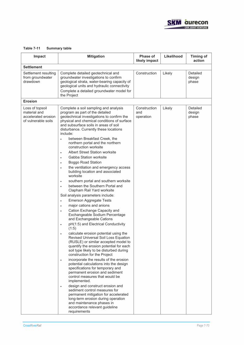
CrossRiverRail Page 7-70
Table 7-11 Summary table
Impact Mitigation Phase of likely impact
Likelihood Timing of action
Settlement Settlement resulting from groundwater drawdown
Complete detailed geotechnical and groundwater investigations to confirm geological strata, water-bearing capacity of geological units and hydraulic connectivity Complete a detailed groundwater model for the Project
Construction Likely Detailed design phase
Erosion
Loss of topsoil material and accelerated erosion of vulnerable soils
Complete a soil sampling and analysis program as part of the detailed geotechnical investigations to confirm the physical and chemical conditions of surface and subsurface soils in areas of soil disturbance. Currently these locations include: � between Breakfast Creek, the
northern portal and the northern construction worksite
� Albert Street Station worksite � Gabba Station worksite � Boggo Road Station � the ventilation and emergency access
building location and associated worksite
� southern portal and southern worksite � between the Southern Portal and
Clapham Rail Yard worksite Soil analysis parameters include: � Emerson Aggregate Tests � major cations and anions � Cation Exchange Capacity and
Exchangeable Sodium Percentage and Exchangeable Cations
� pH(1:5) and Electrical Conductivity (1:5)
� calculate erosion potential using the Revised Universal Soil Loss Equation (RUSLE) or similar accepted model to quantify the erosion potential for each soil type likely to be disturbed during construction for the Project
� incorporate the results of the erosion potential calculations into the design specifications for temporary and permanent erosion and sediment control measures that would be implemented.
� design and construct erosion and sediment control measures for permanent mitigation for accelerated long-term erosion during operation and maintenance phases in accordance relevant guideline requirements
Construction and operation
Likely Detailed design phase

CrossRiverRail Page 7-71
Impact Mitigation Phase of likely impact
Likelihood Timing of action
Design, implement and monitor performance of erosion and sediment control measures for temporary mitigation for accelerated erosion of disturbed areas during construction in accordance with the principles and intent of the IECA Australasia (2008) Best Practice Erosion and Sediment Control, Institute of Engineers Australia (Qld Division) (1996) Soil Erosion and Sediment Control – Engineering Guidelines for Queensland Construction Sites and Queensland Government (2009) Draft Urban Stormwater – Queensland Best Practice Environmental Management Guidelines 2009 (DERM 2009a)
Sedimentation of surface water
Undertake a soil sampling and analysis program as part of the future detailed geotechnical investigations to confirm the physical and chemical conditions of surface and subsurface soils in areas of soil disturbance immediately upstream of waterways. Currently these locations include: � approach to Breakfast Creek bridge � between Mayne Rail Yard and Ekka
Station site � northern portal and construction
worksite � Albert Street Station � construction worksite at Yeerongpilly
and Yeerongpilly Station � southern portal and southern
construction worksite � between the Yeerongpilly Station and
Clapham Rail Yard The soil analysis parameters include: � Emerson Aggregate Tests � major cations and anions � Cation Exchange Capacity and
Exchangeable Sodium Percentage and Exchangeable Cations
� pH (1:5) and Electrical Conductivity (1:5)
Calculate erosion potential using the Revised Universal Soil Loss Equation (RUSLE) or similar accepted model to quantify the erosion potential for each soil type likely to be disturbed during construction. Incorporate the results of the erosion potential calculations into the design specifications for temporary and permanent erosion and sediment control measures that would be implemented for the protection of waterways and drainage lines. Design, implement and monitor
Construction Possible Detailed design phase

CrossRiverRail Page 7-72
Impact Mitigation Phase of likely impact
Likelihood Timing of action
performance of erosion and sediment control measures for temporary mitigation for accelerated erosion of disturbed areas during construction in accordance with the principles and intent of the IECA Australasia (2008) Best Practice Erosion and Sediment Control, Institute of Engineers Australia (Qld Division) (1996) Soil Erosion and Sediment Control – Engineering Guidelines for Queensland Construction Sites and Queensland Government (2009) Draft Urban Stormwater – Queensland Best Practice Environmental Management Guidelines 2009 (DERM 2009a)
Changes to flow conditions in surface water
Undertake detailed geotechnical and groundwater investigations to confirm geological strata, water-bearing capacity of geological units and hydraulic connectivity to surface water bodies Develop a detailed groundwater model for the Project that confirms impacts to surface water bodies
Construction Possible Detailed design phase
Acid Sulfate Soils Disturbance of ASS Undertake an ASS investigation (in
accordance with the requirements of SPP 2/02) for the areas of proposed disturbance of Quaternary alluvium, as identified in the reference design. Currently these locations include: � approach to Breakfast Creek rail
bridge � Mayne Rail Yard worksite � Albert Street Station worksites � Clapham Rail Yard worksite
Construction Possible Detailed design phase
Mobilisation of acid leachate and/or contaminants in surface water and groundwater systems
Undertake a detailed geotechnical and groundwater investigations to confirm geological strata, water-bearing capacity of geological units and hydraulic connectivity Develop a detailed groundwater model for the reference design Undertake an ASS investigation for the areas of proposed disturbance of Quaternary alluvium, as identified in the Reference Project (refer to Disturbance of ASS) Develop and implement surface water and groundwater monitoring programs that would monitor changes in pH in at least three locations in each section of the study corridor Complete Site Investigations for identified contaminated sites within and directly adjacent to the corridor in accordance with NEPC Assessment of Site Contamination NEPM Develop and implement surface water and
Construction and operation
Possible Detailed design phase

CrossRiverRail Page 7-73
Impact Mitigation Phase of likely impact
Likelihood Timing of action
groundwater monitoring programs that would monitor the presence/absence and any changes in a suite of contaminant parameters at each location where ground contamination is identified
Changes to water chemistry of surface water and groundwater systems
Undertake detailed geotechnical and groundwater investigations to confirm geological strata, water-bearing capacity of geological units and hydraulic connectivity Develop a detailed groundwater model for the reference design Develop and implement surface water and groundwater monitoring programs that would monitor pH levels if discharge water across the site. Undertake Site Investigations for identified contaminated sites within and directly adjacent to the corridor in accordance with NEPC Assessment of Site Contamination NEPM Develop and implement surface water and groundwater monitoring programs that would monitor the presence/absence and any changes in a suite of contaminant parameters at each location where ground contamination is identified
Construction and operation
Possible Detailed design phase
Loss of aquatic and riparian flora and fauna – mortality or migration
Undertake an ASS investigation for the areas of proposed disturbance of Quaternary alluvium, as identified in the reference design (refer to Disturbance of ASS) Undertake a soil sampling and analysis program as part of the future detailed geotechnical investigations to confirm the physical and chemical conditions of surface and subsurface soils in areas of soil disturbance immediately upstream of waterways, as identified in the reference design (refer to Sedimentation of Surface Water).
Construction Possible Detailed design phase
Red Imported Fire Ants Infestation or mobilisation of RIFA
Prepare and implement an Approved Risk Management Plan for each construction worksite that incorporates all ancillary activities associated with the excavation and movement of high-risk materials
Construction Possible Detailed design phase

CrossRiverRail Page 7-74
7.4 Conclusions The topography of the study corridor is generally characterised by undulating terrain with a number of prominent high and low points, with the highest point within the corridor being on Wickham Terrace in Spring Hill at 55 m AHD and the lowest point within the Brisbane River channel at less than 0 m AHD.
The underlying geology within the study corridor is dominated by the Mesozoic Aspley and Tingalpa Formations in the northern section and at the southern extent of the central section and northern extent of the southern section. The Palaeozoic “Brisbane Metamorphics”, consisting of the Bunya Phyllite and Neranleigh-Fernvale Formations, dominate throughout the central section of the study corridor. The Mesozoic sediments of the Woogaroo Subgroup dominates the southern extent of the southern section. Further detailed geotechnical investigation through Phase 3 drilling is to be undertaken prior to detailed design, to adequately quantify and assess the geological/geotechnical conditions within the study corridor.
Erosion risk is highest in areas where surface and subsurface soils would be disturbed on steep slopes (greater than 10% gradient). Surface works at Ekka Station, the northern portal worksite in Spring Hill, the ventilation and emergency access building and southern portal worksite have been identified as having the highest erosion risk and will require soil erosion prevention techniques and onsite management plans. With the incorporation of erosion control techniques it is unlikely that significant erosion impacts will occur along the study corridor.
ASS are present within low lying areas within each section of the study corridor and would potentially be disturbed by surface works between Mayne Rail Yard and the northern portal, Albert Street Station and between the southern portal and Clapham Rail Yard. ASS investigations will be undertaken to inform management techniques in these areas. ASS impacts are unlikely to occur if management techniques are implemented for these areas.
It would be important to identify/confirm the presence of these potential geological, hydrogeological and soil condition hazards through further investigation in order to develop suitable management and mitigation measures for construction and operation of the Project.
Soil sampling and analysis would be required during geotechnical investigations to assess the physical and chemical conditions of surface and subsurface soils that are likely to be disturbed during construction in order to quantify the risks associated with accelerated erosion. These investigations would include analysis for ASS and erosion potential for surface and near-surface soils.
There is the potential for disturbance of ASS sediments to result in impacts to the quality of both surface water and groundwater. Implementation of ASS management techniques will reduce the likelihood of these impact occurring. This would include undertaking surface water and groundwater monitoring programs, during construction, with a view to protecting water resources and waterways from soil disturbance activities.
7.4.1 Geology
The perceived significant ground-related risks identified in the Cross River Rail Preliminary Geotechnical Interpretive Report (AECOM, 2010a) are:
� poor, variable ground/lack of cover for the river crossing and tunnels south of Boggo Road
� significant water-bearing discontinuities hydraulically connected to lenses of significant compressible soil above drained tunnels/cavern in rock
� lack of cover, poor ground at station caverns
� lack of cover, poor ground at running tunnels
� deeper than expected poor ground at station box/shaft location, potentially combined with nearby sensitive receiver to ground movements.

CrossRiverRail Page 7-75
The key geotechnical issues identified in the Cross River Rail Preliminary Geotechnical Interpretive Report (AECOM 2010a) included:
� variation of bedrock from the Reference Project based on differential weathering depths
� variability of rock mass from the Reference Project with a high likelihood of mixed face conditions particularly near geological boundaries
� impact of jointing and shear zones on tunnel stability and groundwater inflows
� potential groundwater inflows/dewatering and the drawdown-induced settlements in compressible overlying alluvial sediments
� impact on existing foundations and structures of the reference project, especially along Albert Street and in CBD locations.
It was concluded in the Cross River Rail Preliminary Geotechnical Interpretive Report (AECOM 2010a), that whilst there are a number of probable geotechnical risks associated with the Project, no geotechnical issues have been identified to-date that present as significantly unusual for such an urban tunnelling project, that cannot be adequately mitigated against by systematic engineering design.
7.4.2 Settlement risk
To minimise the risks associated with settlement, it is important to apply appropriate engineering practices and ensure that effective management and monitoring approaches are implemented and reviewed during construction. Appropriate mitigation measures applied in the detailed design process would include design of tunnel support and liners, stability assessment of portals and groundwater modelling of any impact from tunnel construction. Comprehensive geotechnical investigations would quantify the subsurface profile and geological conditions.
The results of the preliminary assessment indicated that the effects of construction induced ground movements associated with the Project are expected to be manageable through the application of systematic engineering solutions. There is likely to be a need to provide for initial ground support systems and ground treatment in some areas and dilapidation surveys prior to construction. Throughout construction it would also be important to implement a comprehensive instrumentation and monitoring program for settlement impacts (AECOM 2010a).
7.4.3 Erosion risk
Sediment control and mitigation measures to address the risk of accelerated erosion would be implemented throughout various stages of the Project to control and reduce the risk of wind and water erosion due to construction and operation activities. These would be developed as ESCPs during the design phase of the Project and incorporated into the EMPs prepared for construction and operation phases of the Project.
7.4.4 Acid Sulfate Soils
Detailed ASS investigations would be undertaken in areas where proposed surface works are likely to disturb ASS material. The ASS investigations for each area of potential ASS disturbance would be completed in accordance with the requirements of SPP 2/02.
Mitigation measures for managing ASS in the study corridor would involve implementing best management and monitoring practices in line with the principles outlined in Dear et al 2002 Queensland Acid Sulfate Soil Technical Manual - Soil Management Guidelines (version 3.8). The ASS management plan would form a sub-plan under the site Environmental Management Plans and would be implemented from the design phase and extend through to the pre-construction and construction phases.