Embed Size (px)
Citation preview

Larsen, H.C., Saunders, A.D., Clift, P.D., et al., 1994Proceedings of the Ocean Drilling Program, Initial Reports, Vol. 152
6. SITE 9141
Shipboard Scientific Party2
HOLE 914A
Date occupied: 30 September 1993
Date departed: 30 September 1993
Time on hole: 14 hr, 30 min
Position: 63°27.738'N, 39°43.489'W
Bottom felt (drill-pipe measurement from rig floor, m): 544.0
Distance between rig floor and sea level (m): 10.8
Water depth (drill-pipe measurement from sea level, m): 533.2
Total depth (from rig floor, m): 562.60
Penetration (m): 18.6
Number of cores (including cores having no recovery): 4
Total length of cored section (m): 18.60
Total core recovered (m): 11.88
Core recovery (%): 63.9
Oldest sediment cored:Depth (mbsf): 18.6Nature: gravel and dropstoneAge: QuaternaryMeasured velocity (km/s): 2.1
HOLE 914B
Date occupied: 1 October 1993
Date departed: 3 October 1993
Time on hole: 2 days, 14 hr
Position: 63°27.737'N, 39°43.482'W
Bottom felt (drill-pipe measurement from rig floor, m): 544.0
Distance between rig floor and sea level (m): 10.8
Water depth (drill-pipe measurement from sea level, m): 533.2
Total depth (from rig floor, m): 789.0
Penetration (m): 245.0
Number of cores (including cores having no recovery): 17
Total length of cored section (m): 151.20
Total core recovered (m): 17.78
Core recovery (%): 11.8
Oldest sediment cored:Depth (mbsf): 245.00Nature: sandy siltAge: early OligoceneMeasured velocity (km/s): 2.6
Comments: Washed from 0 to 93.8 mbsf.
1 Larsen, H.C., Saunders, A.D., Clift, P.D., et al., 1994. Proc. ODP, Init. Repts., 152:College Station, TX (Ocean Drilling Program).
Shipboard Scientific Party is as given in list of participants preceding the contents.
HOLE 914C
Date occupied: 3 October 1993
Date departed: 5 October 1993
Time on hole: 1 day, 13 hr, 15 min
Position: 63°27.736'N, 39°43.479'W
Bottom felt (drill-pipe measurement from rig floor, m): 544.0
Distance between rig floor and sea level (m): 10.8
Water depth (drill-pipe measurement from sea level, m): 533.2
Total depth (from rig floor, m): 768.0
Penetration (m): 224.0 m
Number of cores (including cores having no recovery): 0
Core recovery (%): 0
Comments: Drilled from 0 to 224.0 mbsf. No core recovered.
Principal results: Site 914 (proposed Site EG63-1A) is located on the EastGreenland Shelf, approximately 60 km from the coast. The site wasselected to penetrate a representative sequence of Quaternary and Tertiarysediments commensurate with deep penetration (400 m) of the featheredgeof the seaward-dipping reflector sequences (SDRS). The primary objec-tives at this site were (1) the Quaternary and Holocene glacial histories ofthe margin; (2) the Paleogene sedimentation and subsidence histories; and(3) the composition, age, and eruption environment of the SDRS.
Originally, we had intended that Site EG63-1 would include a cased, mul-tiple reentry hole for penetrating deep basement. However, a Theologicallyfirm, 120-m-thick layer of glacial diamicton with dropstones led to severedrilling difficulties, and three holes were required. Failure to reach basalticbasement led to our abandoning Site 914 in favor of sites to the west-northwest(Sites 915, 916, and 917), where the basement is at a shallower level.
A summary of the principal drilling results from Site 914 is given inFigure 1. The upper part of the succession cored in Holes 914A and 914Bcomprises Holocene glaciomarine sandy silt and mud with dropstones (lith-ologic Subunit IA; 0-5 mbsf), Quaternary compacted diamicton (SubunitIB; 5-14 mbsf), and glaciogenic sediment with gravel clasts, the matrix ofwhich was not recovered (Subunit IC: 14—158.5 mbsf). The interval from158.5 to 187.2 mbsf was not recovered; however, according to the seismicrecord, it also is of glaciogenic origin. A 5-cm-thick, ash-bearing layeroccurs at interval 152-914A-1H-1, 30-35 cm. The dropstones comprise avariety of lithologic types, including basalt, granite gneiss, and quartzite,and range in size from sand grains to cobbles of at least the width of the core.
Lithologic Unit II (187.2-245.0 mbsf; base not recovered) is charac-terized by massive, greenish-black sandy silt that has been extensively bio-turbated. Detrital grains include quartz, Plagioclase, amphiboles, pyrox-ene, garnet, mica, lithic fragments of basalt, and wood. The presence of azeolite, phillipsite, indicates alteration of volcanic glass by seawater. Cal-careous sandstones occur in Unit II. These contain glauconite and a varietyof biogenic detritus, indicating a marine origin for these sediments. Over-all, the fine grain size and bioturbation in Unit II suggest a mid- to outer-shelf environment of deposition. The sandy interbeds indicate increasedcurrent activity, perhaps related to storms.
Lithologic Unit II has been dated, using calcareous nannofossils, aslatest Eocene to early Oligocene age (32-35 Ma). Benthic foraminifersindicate paleowater depths of between 100 and 250 m.
53

SITE 914
10-
20-
£
o
1H
3X
4X
ico
very
DC
GeneralizedIithology
•'B" •'S' u'
' . - • L . - • ~
Sandy silt anddropstones
Diamictoπ
Gravellit
s
bu
nit
s
I
IA
IB
IC
och
UJ
cene
o
ACUü
o
Ple
is
Zones
nn
ofo
ssils
Bar
ren
ram
inif
ers
oLL
N.
pach
yder
msi
n. c
oilin
g
Paleo-mag.
lari
ty
ron
α. | o
1
A
Bru
nhes
MST
Magneticsusceptibility
(cgs)500 1500
1 0 -
2 0 -
3 0 -
4 0 -
5 0 -
6 0 -
7 0 -
80 π
90-
100-
1R
GeneralizedIithology
ZonesPa lee—
mag. MST
Magneticsusceptibility
(cgs)500 1500
Figure 1. Site summary for Site 914.
A detailed study of benthic and planktonic foraminifers in Core 152-
914A-1H was undertaken to provide a biostratigraphic framework for
environmental evaluation of physical properties measurements. Fluctua-
tions in sediment physical properties may be related to climatically induced
changes in depositional environment. The benthic foraminifer assemblage
indicates a transition from a glacial to interglacial environment in the upper
30 cm of the recovered sediments. Multisensor track (MST) data from the
uppermost part of Unit I revealed marked changes in all physical proper-
ties. These pronounced changes within the Quaternary sediments include
rapid downcore increases in wet bulk density, magnetic susceptibility, and
natural gamma. Diamictons recovered in Core 152-914A-2H exhibit high
shear strengths, which is consistent with subglacial compaction.
Core 152-914A-1H was analyzed for paleomagnetic properties in Hole
914A; below this core, recovery was minimal and most intervals showed
excessive drilling disturbance. The core is of normal polarity. Correlation
with the Brunhes Chron is proposed. Paleomagnetic data were obtained
from four cores in Hole 914B (Cores 152-914B-13R and -15R to -17R).
Core 152-914B-15R carries a reverse polarity magnetization. Core 152-
914B-16R and the upper part of Core 152-914B-17R (down to Section
152-914B-17R-3, 75 cm) also are reversely magnetized. The lower part of
Core 152-914-17R carries a normal polarity remanence. Biostratigraphic
data suggest that the reverse polarity remanence of Cores 152-914B-15R
and -16R probably represents a partial record of Chron C12r. Nannoplank-
ton data from Core 152-914B-17R indicate an age range of 32 to 35 Ma.
Thus, the downhole transition from reverse to normal polarity in Core
152-914B-17R may represent either the reversal between Chrons C12r and
C13n or that between Chrons C13r and C15n.
Principal findings at Site 914 were as follows:

SITE 914
-
110-
-
120-
130-
140-
fi50"ΦQ
160-
-
170-
-
180-
•
190"
oc\c\-
Co
re
2R
3R
4R
5R
6R
7R
8R
9R
10R
11R
12R
13R
Re
cove
ry
Generalizedlithology
Gravel
Gravel
No recovery
Sandstone
Sandstone
Un
its
Su
bu
nit
s
I
II
IC
Ep
och
ΦC
ooo
I
Ple
isto
cer
(?)
Zones
Na
nn
ofo
ssils
)N1
4
VI
(?)
Fo
ram
inif
ers
arre
n
m
Paleo-mag.
Po
lari
ty
Ch
ron
MST
Magneticsusceptibility
(cgs)500 1500
200-
210-
220-
230-
240-
250-
260-
270-
280-
2 9 0 -
Generalizedlithology
300
Figure 1 (continued).
Sandysiltstone
Sand
Sandysiltstone
Zones
12r
MST
Magneticsusceptibility
(cgs)500 1500
1. The presence of diamicton confirms that wet-based glaciers ad-
vanced to at least this point on the shelf, about 60 km east of the present ice
sheet. The tephra found in the uppermost part of the core will enable us to
determine whether this advance pre-dates the latest (Weichselian) glaciation.
2. The benthic and planktonic foraminifers in the Quaternary and
Holocene sediment illustrate changes in climatic conditions during glacial
and interglacial periods.
3. The oldest sediment recovered at this site is latest Eocene-early
Oligocene age, and it confirms that marine shelf conditions existed at
that time. Benthic foraminifers indicate water depths of between 100 and
250 m at that time, thus providing a datum point for the subsidence study
of the margin.
4. A marked hiatus exists between the early Oligocene strata and the
Quaternary glaciomarine deposits.
OPERATIONS
Reykjavik Port Call
Leg 152 began when JOIDES Resolution arrived at Sundahofn
Pier 411, Reykjavik, at 0700 hr (all times are in Universal Time
Coordinated or UTC) on 24 September 1993. The port call was
relatively light in terms of logistical and repair activities. In addition
to the routine air and ocean freight, technical support personnel were
available to service the Kappabridge and XRF equipment. Incoming
Operations shipments of note included 10 RBI (5-C4 and 5-C7)
rotary core barrel (RCB) bits and the Dril Quip 20/16 in. running tool.
The vessel took on 1519.8 MT of fuel, 860 gal of turbine-grade
oil, and 953 MT of potable/drilling water. The time-determining item

SITE 914
for this port call was the replacement of the Nos. 2 and 3 crown sheavebearings, a job that lasted until the evening of 29 September. Theauxiliary seawater cooling lines also were cleaned out during thisport call.
The port shaft seal, which was found to be leaking during Leg 151,was inspected by divers in the port. No visible reason could be foundfor the leaking seal. It was decided to load up with additional turbinegrade oil (860 gal) and continue the cruise as scheduled. The last linewas away at 1230 hr on 28 September, and the vessel sailed for thefirst site.
Transit to Site 914
When the JOIDES Resolution had cleared Reykjavik harbor, acourse was set nearly due west for the operating area. Initially, theweather was clear and cold, with occasional showers, but toward theevening hours, this turned to snow flurries. Gentle 8-ft swells fromthe south-southwest caused a gradual 3° to 4° roll. By the next day,swells had abated and the remaining transit was accomplished in calmseas and overcast skies.
At 0500 hr on 30 September, the ship slowed to 5 kt to deployseismic gear and to conduct a short site survey. At 0726 hr, a Data-sonics beacon (Model 354B, 16 kHz, serial number 758), modifiedto operate at a reduced source level (199 dB), was deployed. Afterthe seismic gear was retrieved, the ship returned to location and waspositioned on Site 914 by 0900 hr.
Site 914
The initial site of Leg 152 was on the continental margin ofSoutheast Greenland, approximately 23 nmi offshore and in approxi-mately 530 m of water. The plans called for an advanced pistoncorer/extended core barrel (APC/XCB) hole to be drilled to refusal,followed by a rotary core barrel (RCB) hole, which was to be ex-tended 50 m into basement. Sediments were estimated to be 420 mthick, and our ambitious basement objective called for coring 400 minto basalt. The third (RCB) hole of this site called for emplacementof a cased reentry cone. Logging was to be in two stages. The firstlogging run would be deployed in the pilot hole in sediment, with thesecond run planned solely for basement.
Upon coming on location, the crew was greeted with a spectacularview of the southeast coast of Greenland, illuminated by the rising sun.Large icebergs were observed heading south at various speeds, rangingfrom 1 to 3 kt. These icebergs appeared to be following a north-southchannel, which was about 12 nmi west of our location. In addition,several large icebergs seemed to be grounded, with one large icebergstuck on the seabed in 215 m of water about 10 nmi from the ship.
Hole 914A
The precision depth recorder (PDR) indicated that the correctedwater depth, adjusted to sea level, was 533.4 m. A used RBI 11-7/16-in. bit was fitted to the bottom-hole assembly (BHA). The C-3 bit waslowered to 529.8 m, and the first APC core was "shot" at 1430 hr on30 September. The depth of the seafloor was established at 533.8 mby direct pipe measurement (DPM), based upon the recovery of 5.01m of clay-laden sediments. APC coring was abruptly halted when thesecond core did not produce a full stroke. When the core barrel wasretrieved, we found that the liner was shattered, indicating a high-impact landing on firm sediment. After the core was dug out of thecore barrel, we found that it measured about 6.6 m.
Instead of employing the advance-by-recovery method to recordour progress, we recorded the amount of penetration at 1 m becausewashing down the interval represented by Core 152-914A-2H indi-cated a very hard zone after penetrating only 1 m. Apparently, whenthe core barrel was retracted, it sucked in clay from the surround-ing sediments.
XCB-coring was initiated, but was terminated after two cores thatsucceeded in recovering only 0.3 m of glacial till, while penetrating12.6 m in a lethargic 4 hr. The BHA was retrieved, and the hole termi-nated when the bit cleared the rig floor at 2200 hr on 30 September.The coring sequence at Hole 914A, as well as at other holes at Site914, is shown in Table 1.
Hole 914B
After a call to TAMU/ODP management, who approved our drill-ing to 100 m to be followed by continuous RCB coring, an RCB BHAwas made up with a bit release. The pipe was run in the hole, and Hole914B was spudded with a center bit in place at 0130 hr on 1 October.After drilling ahead for 14.5 hr at an average rate of penetration(ROP) of 8.6 m/hr, the core barrel was dropped and coring initiated at93.8 mbsf at 1500 hr on 1 October. During drilling, a 10-bbl high-viscosity mud sweep was done after every connection. No problemswere encountered in theJiole when drilling through the glacial till.
RCB-coring advanced to 139.5 mbsf through glacial materialhaving low recovery, with a 10-bbl high-viscosity slug pumped afterevery connection. At 116 mbsf, an extra 20-bbl high-viscosity pill wascirculated when a probable plugged bit caused the pressure to risetemporarily to 1000 psi. The drilling crew felt that the bit would clearitself, and after the next core, the pressure did return to 400 to 800 psi.The ROP for this interval ranged from 18 to 37 m/hr.
A problem arose with the drill string when the bit was at 187.2mbsf, immediately after making a connection. After lifting the pipeoff the slips, we found that the drill string could not be lowered downthe hole. With both knobbies and a newly added joint of pipe in thederrick, working the pipe upward was not possible because the com-pensator was locked. In addition, no movement down the hole waspossible because the drill string was stuck by the formation. Rotationwas possible with erratic high torque (300^400 A). During this opera-tion, circulation was maintained.
The ship was offset 165 ft forward, forcing the pipe connection tolower to the slip level. The connection then was broken, a joint of piperemoved, and the pipe pulled up approximately 10 m. After an addi-tional 20-bbl high-viscosity pill was circulated, the pipe was success-fully worked free. The joint of pipe that had been laid down was addedonce more to the drill string and coring proceeded.
By 0500 hr on 2 October, a storm from the north, which had startedthe previous evening, had built to sustained winds of 38 to 40 kt, withgusts to 60 kt. Although the sea's swells were 10 to 14 ft, operationscontinued. As coring advanced down the hole, the weather deterio-rated. By the time coring reached a depth of 245.0 mbsf, the storm hadbegun to push the vessel to her operational limits. Winds now hadreached a sustained 50 kt, with frequent gusts that exceeded 70 kt. Thesea's swells reached 25 ft, causing the ship to roll 3° to 5°, with pitchbetween 2° and 5°. Eight engines were online, producing an averageof 8 MW, with peak loads exceeding 10.8 MW. The dynamic position-ing system (DPS) was commanding 80% of available power merelyto hold the ship on station. Large waves impacting the vessel causedan immediate horizontal offset of 100 ft (18% of water depth), whichrequired that the overloaded power plants increase output to thethrusters to move the vessel back over the location. In addition, theheave compensator was frequently fully stroked out and at the limitof its capability. We decided to terminate operations and to pull out ofthe hole to wait for the storm to abate. The storm lasted through theevening, with no loss of wind strength. At the height of the storm, theseas were 40 to 60 ft with green water breaking over the ship's bow.
At 1030 hr on 3 October, the storm had lessened to allow thedrilling crew to pull the BHA to the surface. Although the original bitstill looked like new (with only 16 hr rotation time), another new C-4bit was made up, the MBR was replaced, and three more drill collarswere added to the BHA to anticipate the additional weight on bitrequired when coring basalt. By 1445 hr the same day, the BHA was
56

SITE 914
Table 1. Coring summary, Site 914.
Core
152-914A-1H2H3X4XCoring totals:
152-914B-1R2R3R4R5R6R7R8R9RI0RllRI2R13R14R15R16R17RCoring totals:Drilled:Total:
152-914CNo recovery
Date(1993)
Sept. 30Sept. 30Sept. 30Sept. 30
Oct. 1Oct. 1Oct. 1Oct. 1Oct. 1Oct. 2Oct. 2Oct. 2Oct. 2Oct. 2Oct. 2Oct. 2Oct. 2Oct. 2Oct. 2Oct. 2Oct. 2
Time(UTC)
1535161517501900
16001740193021302300001501300230033004300530075509201030120013101415
Depth(mbsf)
0.0-5.05.0-6.06.0-14.0
14.0-18.6
Lengthcored(m)
5.01.08.04.6
18.6
*** Drilled 0- 93.8 mbsf ***93.8-99.099.0-103.0
103.0-112.1112.1-121.3121.3-130.4130.4-139.5139.5-148.7148.7-158.5158.5-168.0168.0-177.6177.6-187.2187.2-196.8196.8-206.5206.5-216.1216.1-225.8225.8-235.5235.5-245.0
5.24.09.19.29.19.19.29.89.59.69.69.69.79.69.79.79.5
151.293.8
245.0
*** Drilled 0-224.0 mbsf ***
Lengthrecovered
(m)
5.016.570.200.10
11.88
0.000.000.120.130.540.150.210.180.000.000.000.140.140.001.946.647.59
17.78
Recovery(%)
100.0657.0
2.52.2
63.9
0.00.01.31.45.91.72.31.80.00.00.01.51.40.0
20.068.479.911.8
run down to 339.8 m. Our original plan was to try to reenter Hole914B, even though no free-falling funnel (FFF) had been deployed.When the surge though the moon pool proved too rough to launch avibration-isolated television camera (VIT), we decided that it wouldbe better to offset the vessel 5 m east, to spud a new hole, and to drilldown to 225 mbsf to resume coring.
Hole 914C
After a total of 22 hr was spent waiting on the weather, operationsagain resumed at Site 914 at 1845 hr, when the pipe was lowered to508.8 m. Hole 914C was spudded with the RCB and center bit at 2000hr on 3 October. While drilling in Hole 914B had been relatively freeof hole problems, Hole 914C required many short trips and extra mudflushes to keep the hole open. The hole was drilled to 224 mbsf, andthe center bit retrieved. When dropping the first core barrel at 1915 hron 5 October, circulation was immediately lost, and the drill stringcould not be rotated. The core barrel was brought up a few feet, whichallowed for a limited amount of circulation (80 spm and 1000 psi). A20-bbl high-viscosity pill was circulated without any effect. Frequentoverpulls of 100,000 lb (100 kips) were not effective in freeing thedrill string. During one of the overpulls, the ship heaved with theswell and added an additional overpull so that the string was subjectedto a total of 260 kips over the 240 kips of string weight (500 kips totalweight). The drill string immediately came free, and the pump pres-sure quickly dropped to 200 to 300 psi with 80 spm.
After pulling back to 204.0 mbsf, the pipe was lowered to 209.0mbsf, where we found an apparent 15.0 m of fill. The core barrel wasretrieved and the center bit dropped. No pressure change was ob-served, indicating a successful landing of the inner barrel. The drillstring was picked up approximately 10 m, after the wireline had beenrun in and picked up the inner barrel. The center bit was again run, butdid not land at bit level as expected. Instead, it landed at the bottomof the hole at 209 mbsf. This strongly suggested that the bit was nolonger on the end of the drill sting. We had no choice but to pull outof the hole and inspect the damage. An FFF was not deployed becauseof the high probability that the bit was missing. This was confirmedwhen the BHA arrived on deck at 1200 hr on 3 October. The bit and
mechanical bit release (MBR) were missing, and it appeared that thebit release had been forced apart from the dogs, which were stillmounted in the top connector. The bit, bit seal, lower support bearing,float valve, and the bit disconnect were left in the hole.
The site was abandoned in favor of moving approximately 2 nmiwest-northwest, where the glaciomarine sediments were thinner andthe basement closer to the mud line. The beacon was turned off as thevessel moved off location in case a return to the site was necessary.We expected to make a quick stop here to pick up the beacon whenconcluding operations in the area.
LITHOSTRATIGRAPHY
Introduction
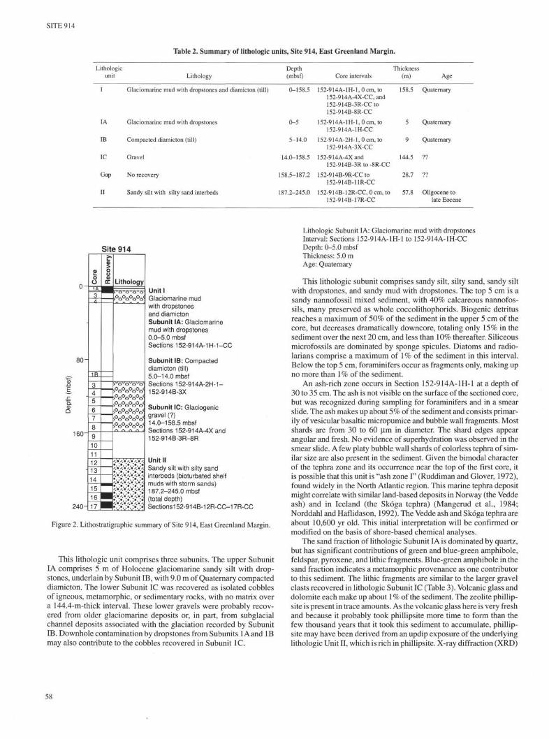
Site 914 is the most seaward of four sites (914,915,916, and 917)drilled along a 6-km-long transect at the outer, middle shelf of the EastGreenland Margin. It is located in 533 m of water, approximately 25km from the shelf edge. Three holes were drilled at this site, withrecovery from the first two holes only. We divided the recovered sec-tion into two lithologic units (Table 2, Fig. 2): an upper, Quaternaryage, glaciogenic deposit (lithologic Unit I) and an underlying, lowerOligocene-upper Eocene mixed volcaniclastic and siliciclastic shelfdeposit comprising bioturbated, sandy silt and mud with interbeds ofsilty sand (lithologic Unit II).
Lithologic Unit I comprises three glaciogenic subunits. We differ-entiated these subunits mainly by degree of compaction and presenceor absence of matrix. The sediments are not compacted in the upperSubunit I A, but are highly compacted in the medial Subunit IB. Nomatrix was recovered in the lower Subunit IC.
Lithologic Units
Lithologic Unit I: Glaciomarine mud with dropstones, diamicton (till), andgravel
Interval: Sections 152-914A-1H-1 to 152-914A-4X-CC, and 152-914B-3R-CC to 152-914B-8R-CC
Depth: 0-158.5 mbsfThickness: 158.5 mAge: Quaternary
57
SITE 914
Table 2. Summary of lithologic units, Site 914, East Greenland Margin.
Lithologicunit
I
IA
IB
IC
Gap
II
Lithology
Glaciomarine mud with dropstones and diamicton (till)
Glaciomarine mud with dropstones
Compacted diamicton (till)
Gravel
No recovery
Sandy silt with silty sand interbeds
Depth(mbsf)
0-158.5
0-5
5-14.0
14.0-158.5
158.5-187.2
187.2-245.0
Core intervals
152-914A-lH-l,0cm, to152-914A-4X-CC,and152-914B-3R-CCto152-914B-8R-CC
152-914A-1H-I,0cm,to152-914A-1H-CC
152-914A-2H-l,0cm, to152-914A-3X-CC
152-914A-4X and152-914B-3R to -8R-CC
152-914B-9R-CC to152-914B-11R-CC
152-914B-12R-CC, 0 cm, to152-914B-17R-CC
Thickness(m)
158.5
5
9
144.5
28.7
57.8
Age
Quaternary
Quaternary
Quaternary
??
??
Oligocene tolate Eocene
o-
80-
160-
-
240-
ΦO
o3A
1R
345
67
8
9
10
111?13
14
15
HT17
Site 914
| R
ec
ove
ry
-
Lithology
oöo0oö-0.
4O4O4öOO l
. - . . - . . • . . - , .
• • • • . • • . • • • . • • • • . • •
•• . • . • • • • . • • • • . • •
• ' ™• • ' " • • " " • • " " • •
•\ :•". >". :•. :•
Unit IGlaciomarine mudwith dropstonesand diamictonSubunit IA: Glaciomarinemud with dropstones0.0-5.0 mbsfSections 152-914A-1H-1-CC
Subunit IB: Compacteddiamicton (till)5.0-14.0 mbsfSections 152-914A-2H-1-152-914B-3X
Subunit IC: Glaciogenicgravel (?)14.0-158.5 mbsfSections 152-914A-4X and152-914B-3R-8R
Unit IISandy silt with silty sandinterbeds (bioturbated shelfmuds with storm sands)187.2-245.0 mbsf(total depth)Sectionsi 52-914B-12R-CC-17R-CC
Figure 2. Lithostratigraphic summary of Site 914, East Greenland Margin.
This lithologic unit comprises three subunits. The upper SubunitIA comprises 5 m of Holocene glaciomarine sandy silt with drop-stones, underlain by Subunit IB, with 9.0 m of Quaternary compacteddiamicton. The lower Subunit IC was recovered as isolated cobblesof igneous, metamorphic, or sedimentary rocks, with no matrix overa 144.4-m-thick interval. These lower gravels were probably recov-ered from older glaciomarine deposits or, in part, from subglacialchannel deposits associated with the glaciation recorded by SubunitIB. Downhole contamination by dropstones from Subunits lAand IBmay also contribute to the cobbles recovered in Subunit IC.
Lithologic Subunit IA: Glaciomarine mud with dropstonesInterval: Sections 152-914A-1H-1 to 152-914A-1H-CCDepth: 0-5.0 mbsfThickness: 5.0 mAge: Quaternary
This lithologic subunit comprises sandy silt, silty sand, sandy siltwith dropstones, and sandy mud with dropstones. The top 5 cm is asandy nannofossil mixed sediment, with 40% calcareous nannofos-sils, many preserved as whole coccolithophorids. Biogenic detritusreaches a maximum of 50% of the sediment in the upper 5 cm of thecore, but decreases dramatically downcore, totaling only 15% in thesediment over the next 20 cm, and less than 10% thereafter. Siliceousmicrofossils are dominated by sponge spicules. Diatoms and radio-larians comprise a maximum of 1% of the sediment in this interval.Below the top 5 cm, foraminifers occur as fragments only, making upno more than 1 % of the sediment.
An ash-rich zone occurs in Section 152-914A-1H-1 at a depth of30 to 35 cm. The ash is not visible on the surface of the sectioned core,but was recognized during sampling for foraminifers and in a smearslide. The ash makes up about 5% of the sediment and consists primar-ily of vesicular basaltic micropumice and bubble wall fragments. Mostshards are from 30 to 60 µm in diameter. The shard edges appearangular and fresh. No evidence of superhydration was observed in thesmear slide. A few platy bubble wall shards of colorless tephra of sim-ilar size are also present in the sediment. Given the bimodal characterof the tephra zone and its occurrence near the top of the first core, itis possible that this unit is "ash zone I" (Ruddiman and Glover, 1972),found widely in the North Atlantic region. This marine tephra depositmight correlate with similar land-based deposits in Norway (the Veddeash) and in Iceland (the Skóga tephra) (Mangerud et al., 1984;Norddahl and Haflidason, 1992). The Vedde ash and Skóga tephra areabout 10,600 yr old. This initial interpretation will be confirmed ormodified on the basis of shore-based chemical analyses.
The sand fraction of lithologic Subunit IAis dominated by quartz,but has significant contributions of green and blue-green amphibole,feldspar, pyroxene, and lithic fragments. Blue-green amphibole in thesand fraction indicates a metamorphic provenance as one contributorto this sediment. The lithic fragments are similar to the larger gravelclasts recovered in lithologic Subunit IC (Table 3). Volcanic glass anddolomite each make up about 1% of the sediment. The zeolite phillip-site is present in trace amounts. As the volcanic glass here is very freshand because it probably took phillipsite more time to form than thefew thousand years that it took this sediment to accumulate, phillip-site may have been derived from an updip exposure of the underlyinglithologic Unit II, which is rich in phillipsite. X-ray diffraction (XRD)
58

SITE 914
Table 3. Summary of hand-specimen descriptions of gravel recovered inlithologic Subunit IC, Site 914, East Greenland Margin.
cm105
Rock type
BasaltMetabasaltDiabase (dolerite)GabbroAndesiteFelsic gneissGarnet amphiboliteSerpentiniteQuartz dioriteGraniteQuartziteMetaconglomerateMetapeliteSiliceous metasediment
Number
101121511111111
Comments
Both altered and relatively fresh.Blackish-green in color.
Predominantly quartz and feldspar.
Metamorphosed.Metamorphosed.
Relict large clasts remain.Light gray and nonbedded.Some recrystallized small clasts.
results of the silt + clay fraction reveal a rock flour of amphibole,mica, quartz, Plagioclase, phillipsite, and dolomite. No clay mineralsare present because chemical weathering was minimal on Greenlandthroughout the Quaternary, and shales, which could provide detritalclay, were not a significant source for this unit.
The sediment is very soft and shows no bedding. Dropstonesoccur more or less randomly, in no preferred orientation, in the softsediment (Fig. 3). They are principally angular and range from sandsize to at least the width of the core (6 cm) and make up a variety ofmainly metamorphic and igneous rocks. Basalt, dolerite, graniticgneiss, gabbro, quartz diorite, and quartzite clasts were identified.
Lithologic Subunit IB: Compacted diamicton (till)Interval: Sections 152-914A-2H-1 to -3X-CCDepth: 5.0-14.0 mbsfThickness: 9.0 mAge: Quaternary
Diamicton was recovered in Cores 152-914A-2H and -3X, andsome fragments were recovered in Cores 152-914B-7R and -8R. Thissediment exhibits a preferred fabric (Fig. 4) and is very compactcompared to the sediment just above it (see "Physical Properties" sec-tion, this chapter). Gravel-size clasts are scattered randomly throughthe sediment. Most are angular, but a few are rounded. We interpretthe preferred fabric and the density of the sediment as being the resultof the compressive effects of an overriding glacier (see more detaileddiscussion in "Lithostratigraphy" section, "Site 916" chapter, thisvolume). Some red sandstone clasts in this sediment were not presentin the overlying subunit and may have been derived from deeperwithin the interior of Greenland or from the sedimentary basins inNortheast Greenland.
The sand fraction is dominated by quartz and contains abundantfeldspar, lithic fragments, and accessory minerals, such as amphiboleand pyroxene. XRD results from the silt + clay fraction are similar tothose of Subunit IA, except for the absence of mica in this subunit.The fines of this sediment make up a rock flour composed of quartz,Plagioclase, and amphibole. As for Subunit IA, no clay minerals arepresent. More till was recovered at Site 916, and a more detaileddescription of it can be found in that site chapter.
Lithologic Subunit IC: Glaciogenic gravelIntervals: 152-914A-4X and 152-914B-3R-CC, to 152-914B-8R-CCDepth: 14.0-158.5 mbsfThickness: 144.5 mAge: unknown, presumed Quaternary
This interval is identified by large drilling fragments of igneousand metamorphic rocks with no matrix material recovered. We thinkthat these fragments are derived from either the diamicton, from olderglaciomarine deposits, or, in part, from subglacial channel depositsassociated with the glaciation recorded by Subunit IB. Contaminationfrom sediments higher in the borehole cannot be excluded.
110 —
1 1 5 -
120 - 1
Figure 3. Photograph of lithologic Subunit I A, glaciomarine mud with drop-stones, interval 152-914A-1H-3, 105-120 cm. Matrix of silt has sand- togravel-sized fragments floating throughout. Calcareous nannofossils, plank-tonic and benthic foraminifers, and sponge spicules are common components,but other siliceous microfossils occur only as rare fragments.
Twenty-eight clasts were described by use of hand lens (Table 3).Thin sections of five clasts also were examined with a petrographicmicroscope (Table 4). We compared the lithologies of the clasts withrocks present on the East Greenland Margin to identify possible sourceareas. Clast compositions indicate that glaciers eroded source terranesfrom several regions of eastern Greenland. The source areas includeregions composed of Precambrian(?) gneiss, amphibolite, and meta-sedimentary rocks, and regions of Tertiary volcanic and plutonic rocks.Precambrian rocks occur along the coastline of East Greenland justwest of the drill site. However, at the present time, the nearest extensiveoutcrops of Tertiary volcanic rocks are in the Kangerdlugssuaq region(68 °N) more than 500 km north of the drill site. However, small
59

SITE 914
cm30 -i
3 5 -
4 0 -
4 5 -
Table 4. Composition of five rocks (estimated percentage for igneousrocks) from Hole 914B, determined by petrographic microscope fromthin sections.
50-1
Figure 4. Photograph of lithologic Subunit IB, compacted diamicton (till),interval 152-914A-2H-2, 30-50 cm. Note poor sorting, polymict aspect ofsediment and angular granitic fragment, 45 to 50 cm. Some oriented fabric isvisible on the left side of the core, 31 to 39 cm, suggestive of the plowing effectof a grounded glacier depositing this sediment.
Core interval(cm)
152-914B-5R-1, 20-25 (Piece 4)
152-914B-5R-1,40-45 (Piece 7)
152-914B-5R-1, 65-69 (Piece 11)
152-914B-6R-1, 8-13 (Piece 2)
152-914B-7R-CC, 13-17 (Piece 3)
Rocktype Minerals
Quartz diorite PlagioclaseQuartzHornblendeOrthoclaseIron oxidesEpidoteGarnetSpheneCalciteApatite
Olivine gabbro PlagioclaseClinopyroxeneOlivineIron oxides
Metapelite QuartzFeldsparHornblendeOpaque mineralsWhite mica
Ferrobasalt PlagioclaseClinopyroxeneIron oxidesEpidote
Granite PlagioclaseQuartzBiotiteHornblendeOrthoclaseEpidoteCalciteWhite micaSphene
Percentage(%)
403020
514trtrtrtr
4535128
453025tr
40351055trtrtrtr
Note: tr = trace amounts.
patches of Tertiary volcanic and plutonic rocks are present along thecoast farther south (66°N) and subcrop at the seafloor west of the drillsite. These could be the remnants of much larger areas of outcrops thathave been subsequently removed by erosion. Clearly, both Tertiarybasalts and Precambrian continental basement were being eroded toform this sediment.
Lithologic Unit II: Sandy silt with silty sand and sandstone interbedsInterval: 152-914B-12R-CC, 0 cm, to 152-914B-17R-CCDepth: 187.2-245.0 mbsf (t.d.)Thickness: 57.8 m (base not recovered)Age: early Oligocene and late Eocene
The dominant lithology in this unit is a greenish-black, massive,homogeneous sandy silt that has been extensively bioturbated (Fig.5). Sand-filled burrows are evident intermittently. This unit containsquartz, Plagioclase, amphiboles (some blue-green), pyroxene, garnet,mica, and lithic fragments of basalt. Pyrite, basalt fragments, amphi-bole, pyroxene, wood fragments, and glauconite all contribute to thedark green color of the sediment. Phillipsite is abundant in the lowerpart of the unit, where it constitutes up to 20% of the sediment. Thiszeolite is usually produced by the alteration of volcanic glass in sea-water (e.g., Biscaye, 1965). The presence of blue-green amphibole,garnet, and muscovite indicates erosion of a metamorphic sourceterrane, as is the case with lithologic Subunit IIA at Site 915 (see"Lithostratigraphy" section, "Site 915" chapter, this volume). XRDanalysis of the bulk sediment reveals phillipsite, quartz, calcite, andfeldspar. The only clay mineral present is smectite.
Calcareous sandstones (Fig. 6) in four cores from Hole 914Boccur in Sections 152-914B-12R-CC and -13R-CC and within thelower Oligocene black sandy silt (intervals 152-914B-15R-1, 0-19cm, and 152-914B-16R-3, 86-99 cm). These sandstones are darkgray to olive gray and consist predominantly of sand-sized grains in
60

SITE 914
cm50-
55 H
6 0 -
6 5 -
7 0 - 1
Figure 5. Photograph of black silty sand and sand from lithologic Unit II,interval 152-914B-16R-1, 50-70 cm. Close inspection of this photographreveals sandy burrows worked into the silty matrix (60-62 cm) and silt workedinto a sandier matrix (52-56 cm). White spots and circles are scatteredmolluscan fragments. A few laminae and cross laminae are faintly visiblebetween 62 and 65 cm, but most bedding and lamination have been destroyedby bioturbation.
1 2 -
1 6 -
2 0 -
24-1
Figure 6. Photograph of a sandy interbed of lithologic Unit II, within black siltysand, interval 152-914B-15R-1, 0-24 cm. Most, but not all, of the sandinterbeds are calcite-cemented, as shown here. All sandy intervals are highlyanisotropic, intensely bioturbated, and show elevated levels of glauconitepellets over the intervening silty sediment, indicating deposition by high energyevents, such as storms, followed by a hiatus during which the rapidly depositedsediment was intensively bioturbated.
61

SITE 914
a calcite cement. The top of the bed in interval 152-914B-16R-3,86-99 cm, is heavily burrowed, while the bottom part is not bur-rowed, suggesting that the bed was deposited during one event. Basedon the occurrence of similar sandstone in Cores 152-914B-15R and-16R, we surmise that the sandstone fragments recovered in the core-catcher samples of Cores 152-914B-12R and -13R are probably indi-vidual beds within an unrecovered softer and less lithified sequence.
We described and point-counted (Table 5) one thin section of thecalcareous sandstone (interval 152-914B-13R-CC, 10-14 cm). It con-sists of moderately well-sorted grains enclosed within a calcite cement.The grain shapes are subangular to well-rounded, with quartz and qùartz-ite composing about 70% of the sand-sized grains. One complete, butpartly recrystallized, foraminifer was identified in the thin section.
In smear slides, the cement appears to have been derived in partfrom the dissolution of calcareous nannofossils as well as foramini-fers, as only a few robust forms are present. Molluscan fragments,echinoid spines, benthic foraminifers, and wood fragments are scat-tered throughout the sediment. Glauconite pellets appear as fora-minifer molds and fecal pellet replacement and are enriched in thesand beds relative to the enclosing site. No sedimentary structures areevident in the sand beds aside from the intense bioturbation. Enrich-ment of the calcareous sandstone in quartz relative to the enclosingblack silt suggests a more mature source for these sandbeds and/ordifferent depositional regimes. The anisotropy of these intervals ishigh, which indicates rapid deposition from very strong currents, suchas might be encountered in strong storms (see "Physical Properties"section, this chapter). This period of rapid deposition was followedby a hiatus during which the sandy floor was intensely bioturbatedand later cemented.
The presence of marine fossils and glauconite pellets indicates amarine origin for lithologic Unit II. The fine grain size and extensivebioturbation suggest a mid- to outer-shelf environment of deposition,where mud that eroded from the continent accumulated at a rate slowenough to encourage benthic organisms to thoroughly bioturbate thesediment and for glauconite pellets to form. Sandy interbeds suggestperiodic episodes of increased current activity, probably related tolarge storms. These punctuated an otherwise low-energy regime, withmost of the sediment accumulating below wave base.
Summary
Unit I is a thick, Quaternary age, glaciogenic deposit comprisingan upper 5 m of glaciomarine sandy silt with dropstones (Subunit IA),a middle 9.0 m of subglacially derived till (Subunit IB), and a lower144.5 m of probable glaciogenic moraine or outwash plain gravel(Subunit IC). These sediments overlie a lower Oligocene-upperEocene mid- to outer-siliciclastic shelf deposit at Site 914. The objec-tive of describing the Greenland glaciation history, was advanced atthis site by the recovery of the Quaternary lithologic Unit I, as we nowhave direct evidence that wet-based glaciers advanced to at least thispoint on the shelf, about 60 km from the edge of the present ice sheet.
Another objective for this site was to determine the age of theregional unconformity. The entire Pliocene-upper Oligocene sectionis missing at this site.
The lower Oligocene-Eocene sediment (lithologic Unit II) is bio-turbated, glauconitic, mixed volcaniclastic and siliciclastic shelfmud with sandy interbeds. The sands are acoustically highly aniso-tropic, indicating rapid deposition from very strong, probably storm-induced currents.
BIOSTRATIGRAPHY
Calcareous Nannofossils
Sample 152-914A-1H-1, 20 cm, contains abundant nannofossilsthat have been moderately preserved. The species present includeCoccolithus pelagicus, Calcidiscus leptoporus, Emiliania huxleyi,
and Gephyrocapsa spp. On the basis of the common occurrence of £.huxleyi, this sample can be correlated with oxygen isotope stagesyounger than stage 4 (80 ka). Samples 152-914A-1H-CC through-3H-CC are barren of calcareous nannofossils. Sample 152-914B-8R-CC contains a mixture of nannofossils of different ages, includingCretaceous, Paleogene, and Pleistocene species. Apparently, thesehave been reworked in this glaciomarine sediment. The youngestspecies identified is Gephyrocapsa sp. (>4.5 µm), which indicatesthat the sediment is younger than 1.7 Ma.
Sample 152-914B-15R-CC contains a lower Oligocene assem-blage (Fig. 7). The presence of Reticulofenestra daviesii, R. umbilicus,and Chiasmolithus altus in the absence of Isthmolithus recurvus indi-cates an age of about 31 to 32 Ma. Sample 152-914B-16R-2, 31 cm,also contains these age-diagnostic species. Samples 152-914B-16R-CC and -17R-CC contain all the above species in addition to Isthmo-lithus recurvus, while Reticulofenestra reticulata is absent. Theseassemblages indicate a latest Eocene-early Oligocene age (Fig. 7).
Planktonic Foraminifers
Planktonic foraminifers generally are absent from sediments atSite 914, except in the uppermost part of the sequence (Cores 152-914A-1H, -2H, -3X), where they are rare and moderately preserved.Samples 152-914A-1H-CC, -2H-CC and -3X-CC contain a few sin-istrally coiled specimens of Neogloboquadrina pachyderma, whichrange from the lower Pleistocene to Holocene (Fig. 8). One specimenof Globigerina bulloides is recorded in Sample 152-914A-2H-CC.
The zonation of Spiegler and Jansen (1989), based on neoglobo-quadrinids, can be applied to sediments from Site 914. These as-semblages thus may be attributed to the Neogloboquadrina pachy-derma sinistral coiling Zone, which has an age range of Pleistoceneto Holocene.
Benthic Foraminifers
Benthic foraminifers were recorded in Samples 152-914A-1H-CC,-2H-CC, and -3X-CC, and in 152-914B-15R-CC, -16R-CC, and -17R-CC. Benthic foraminifers constitute about half of the total foraminif-eral assemblage within the Quaternary succession (Samples 152-914A-1H-CC, -2H-CC, and -3X-CC). Their preservation over this range ismoderate. The foraminiferal assemblages are characterized by theoccurrence of Cassidulina teretis and Elphidium excavatum. Cassidu-lina teretis was a dominant species during Pliocene to Pleistoceneglacial intervals of the North Atlantic region (Murray, 1984).
Benthic foraminifers contribute 85% of the total foraminiferalassemblage within the recovered Paleogene sediments (Samples 152-914B-15R-CC and -16R-CC). Their preservation is poor over thisinterval. Samples 152-914B-15R-CC and -16R-CC contain rare ben-thic foraminifers. Alabamina wilcoxensis, Cibicidoides alleni, Gy-roidina sp., and Lenticulina sp. were identified in Sample 152-914B-15R-CC. This fauna resembles that reported in DSDP Cores 48-403-27R and -28R by Murray (1979), who suggested a paleowater depthof 100 to 250 m, Sample 152-914B-16R-CC contains Anomalinoidesnobilis, Cibicidoides sp., Oridorsalis ecuadorensis, and Oridorsalissp. This assemblage was identified in DSDP Sample 81-553A-11-6,52 cm, by Murray (1984), who suggested a paleowater depth of 75 to200 m. Sample 152-914B-17R-CC is barren of benthic foraminifers.
A more detailed study was performed on benthic and planktonicforaminifers in six samples from Sections 152-914A-1H-1 and -1H-2to provide a refined biostratigraphic framework for the glacial/inter-glacial fluctuations. Benthic foraminifer specimens also were countedto quantify the relative abundance of each species in the samples.
The following samples were analyzed for their faunal content: 152-914A-1H-1, 0-2 cm, 32-35 cm, 95-97 cm; -1H-2, 83-85 cm, 96-98cm, and 135-137 cm. Sample 152-914A-1H-1, 32-35 cm, was takenwithin an interval where high abundances of basalt glass fragments hadbeen found. Abundances of benthic fauna are shown in Table 6.

SITE 914
200
2 5 0 -
Age-diagnosticnannofossil species
R. umbilicusR. bisectaC. altus
R. umbilicusR. bisectaC. altus
R. umbilicusI. recurvusC. altus
R. umbilicusI. recurvusC. altus
Depth-diagnostic benthicforaminifer species
Cibicidoides alien!Gyroidina sp.Lenticulina sp.
Anomalinoides nobilis. Cibicidoides sp.Oridorsalis ecuadorensis
<D
PIfCO <D
Q . TJ
100-250
75-200
uoα
LU
Figure 7. Biostratigraphic summary of Hole 914B. Paleowater depths inferred by benthic foraminiferal species also are shown.
Sample 152-914A-1H-1, 0-2 cm, contains common and well-pre-served planktonic specimens of sinistrally coiled N. pαchydermα, G.glutinαtα, G.juvenilis, and T. quinquelobα, along with rarer specimensof N. dutertrei. It also contains abundant and moderately preservedbenthic specimens. Eilohedrα sp., Cibicides spp., and Cibicides reful-gens are common. Cαssidulinα teretis constitutes about 5% of the totalbenthic assemblage, compared to only 1% of Elphidium excαvαtum.
The planktonic foraminiferal assemblage in Sample 152-914A-1H-1, 32-35 cm, consists of common to a few moderately preservedspecimens of sinistrally coiled N. pαchydermα, G. bulloides, T. quin-quelobα, G.juvenilis, and G. glutinαtα, rare A', dutertrei and extremelyrare specimens of Tenuitellα αnfrαctα, Hαstigerinopsis riedeli, andGαllitelliα vivαns. The benthic foraminiferal assemblage consists ofabundant and moderately preserved specimens of Cibicides spp., Cαs-sidulinα teretis, which constitutes more than 20% of the benthic assem-blage, Cibicides refulgens, and Cibicides lobαtulus, along with rarerspecimens of Elphidium excαvαtum (1%).
Sample 152-914A-1H-1,95-97 cm, contains only rare, moderatelypreserved sinistrally coiled specimens of N. pαchydermα, along withrarer G. juvenilis and G. glutinαtα. However, the sample containscommon and moderately preserved benthic specimens. Buliminellaelegαntissimα is abundant and Cαssidulinα norvαngi is common. Cαs-sidulinα teretis constitutes only 5% and Elphidium excαvαtum 1% ofthe benthic assemblage, respectively.
In Sample 152-914A-1H-2, 83-85 cm, the planktonic foraminif-eral assemblage consists only of rare, moderately preserved sinis-trally coiled specimens of N. pαchydermα. The benthic fauna com-prise only few and moderately preserved specimens, consisting pre-dominantly of Elphidium excαvαtum, which contributes 15% of thetotal benthic fauna. Also identified are Cibicides spp., Cαssidulinαnorvαngi, Stαinforthiα sp., and Cαssidulinα teretis, which constitutes10% of the assemblage.
Sample 152-914A-1H-1, 95-97 cm, contains only rare, moder-ately preserved sinistrally coiled specimens of N. pαchydermα and afew moderately preserved benthic foraminifers. The benthic assem-
Table 5. Composition of calcareous sandstone (interval 152-914B-13R-CC, 10-14 cm) based on a count of 500 points.
Composition
QuartzFeldsparCalciteAmphiboleOpaque mineralsEpidoteClinopyroxeneChloriteRock fragments
QuartziteGneissGranitic rocksMetapeliteUnknownsVolcanic rocksSchistUltramafic (?)
Percentage(%) Remarks
38 Single grains.7
38 Cement matrix of rock.5 Mostly plutonic.11
trtr
61111trtrtr
Note: Trace amounts (tr) are less than 1% of points counted.
blage is dominated by Elphidium excαvαtum, Cαssidulinα norvαngi,Nonionellinα lαbrαdoricα, and Cαssidulinα teretis. Cαssidulinα tere-tis and Elphidium excαvαtum contribute 10% and 15% of the benthicfauna, respectively.
In Sample 152-914A-1H-2, 132-135 cm, the planktonic forami-niferal assemblage consists only of rare, moderately preserved, sinis-trally coiled specimens of N. pαchydermα (Fig. 9) and a few, mod-erately preserved benthic foraminiferal specimens. Cαssidulinα nor-vαngi, Cαssidulinα teretis, and Elphidium excαvαtum are relativelycommon, with the latter two species constituting 10% and 15% of thebenthic assemblage, respectively (Table 6).
Aksu et al. (1989) suggested that during the North Atlantic glacialstages, the very low-diversity planktonic foraminiferal assemblages

SITE 914
0 -
2 0 -
Cor
e
1H
Z2HZ
3X
4X
Rec
over
y
IL
itho
log
yI • • J • •V • • s
• ; • T ; • T ; • ' • : :
Paleomag.
Pol
arity
IC
hron
Bru
nhes
PI.
fora
m.
zone
sN
. pa
chyd
erm
a si
n.co
iling
Zon
e
Age-diagnostic planktonicforaminifer species
^ N. pachydermasin. coiling
^ N. pachydermasin. coiling
Pal
eow
ater
dept
h (
m)
<500
<500
Depth-diagnostic benthicforaminifer species
^ Cibicides sp.Buccella tenerrima
Cibicides sp.Cibicides refulgens
Epo
chP
leis
toce
ne-H
oloc
ene
Figure 8. Biostratigraphic summary of Hole 914A. Paleowater depths inferred by benthic foraminiferal species also are shown.
Table 6. List of selected species of benthic foraminifers from Sections 152-914A-1H-1 and -2.
Core, section,interval (cm)
152-714-1H-1,0-2152-714-1H-1, 32-35152-714-1H-1,95-97152-714-1H-2, 83-85152-714-1H-2, 96-98152-714-1H-2, 135-137
420?,11
230243
123100
036636
00
62fi72
136
26303637
124713201922
1724
1352
3832
1
58
435415328
11
492??.46
222
374050
23?.100
1002401
210020
100100
100010
000043
501045
310
142415
340100
013
21167
000021
263207192222211203
Note: Total numbers of counted benthic specimens in each sample are reported in last column.
were dominated by sinistrally coiled specimens of N. pachyderma,with various percentages of T. quinqueloba, G. bulloides, and dex-trally coiled specimens of N. pachyderma. Rare specimens of N.dutertrei and globorotaliids also may be present. Interglacial inter-vals, on the other hand, are characterized by higher species diversityand a fauna dominated by dextrally coiled specimens of N. pachy-derma, G. bulloides, and G. inflata, with lower percentages of N.dutertrei, globorotaliids, and T. truncatulinoides.
Moreover, glacial intervals on the Rockall Plateau in the NorthAtlantic are characterized by the occurrence of the benthic speciesCassidulina teretis (Murray, 1984). In ODP Hole 644 A (water depth,1226.3 m), on the V0ring Plateau of the North Atlantic, glacial inter-vals are dominated by the same species (synonym of Cassidulinalaevigata), with abundant Elphidium excavatum, which has been inter-preted as a reworked shallow-water species (Osterman and Qvale,1985). Because the water depth in Hole 914A is only 533 m andbecause no difference in the degree of preservation is seen betweenElphidium excavatum and the other Quaternary species, this speciesmay be considered to be in situ and may indicate a shallow-waterglacial environment.
Both the planktonic and benthic assemblages of Sample 152-914A-1H-1, 0-2 cm, suggest a post-glacial environment.
The benthic assemblage in Sample 152-914A-1H-1, 32-35 cm,suggests the presence of the transition to a glacial environment withinthe upper 30 cm of sediments. However, the planktonic foraminiferalassemblage does not appear to be consistent with this interpretation,because of the presence of very few specimens of T. anfracta and H.
riedeli, which Kennett and Srinivasan (1983) suggested as a tropicalspecies. However, their presence, previously documented in this areaby Poore (1979), may result from an influx of relatively warmersurface water from the Central North Atlantic toward the LabradorSea during the early to middle stages of major ice-growth phases ofthe late Quaternary (Ruddimann et al., 1980; Aksu et al., 1989).
A transition to an interglacial environment, occurring at a depth ofabout 95 cm, is also suggested by benthic assemblages that show lowabundances of Cassidulina teretis and Elphidium excavatum.
A glacial environment has been tentatively inferred from benthicassemblages that consist of common Elphidium excavatum and Cas-sidulina teretis and from a planktonic assemblage that consists of thecold-water planktonic species N. pachyderma in three samples fromSection 152-914A-1H-2.
PALEOMAGNETISM
Paleomagnetic data were obtained from Holes 914Aand 914B. Allremanence data from Hole 914A are from WCC studies on the archive-half sections of Core 152-914A-1H (although drilling continued to Core152-914A-4H, minimal recovery, combined with excessive drilling dis-turbance, rendered studies of this interval meaningless, and the coreswere not measured). Initial natural remanent magnetization (NRM)intensities of Core 152-914A-1H typically were 100 to 500 mA/m.Demagnetization to 30 mT reduced the intensities to between 20%and 30% of the initial values. Core 152-914A-1H is of consistentnormal polarity and has a characteristic mean inclination angle of
64

SITE 914
αΦQ
Planktonic foraminifer
species
~N. pachyderma sin., G. glutinata,G. juvenilis, J. quinqueloba,N. dutertrei
'N. pachyderma sin., G. juvenilis,N. dutertrei, T. quinqueloba, andvery rare T. anfracta, H. riedeli
N. pachyderma sin. coiling,G. glutinata,
G. juvenilis
N. pachyderma sin. coiling
N. pachyderma sin. coiling
N. pachyderma sin. coiling
Dominant benthic
foraminifer species
"Eilohedra spp.,
Cibicides sp., C. refulgens
-Cibicides spp.,
Cassidulina teretis,
C. refulgens, C. lobatulus
-Buliminella elegantissima,
Cassidulina norvangi,
Cibicides spp.
Elphidium excavatum,
"Cassidulina norvangi,
Cassidulina teretis
-Elphidium excavatum,
Cassidulina norvangi,
Cassidulina teretis
P-gi.
Glac.
i-gi.
Glac.
Glac.
1£Ifre α>
O. TS
ca.500
<500
;500
<500
<500
Figure 9. Biostratigraphic summary of Core 152-914A-1H. Planktonic and benthic foraminiferal assemblages have been used to identify tentatively glacial andpost-glacial environments. Paleowater depths inferred by benthic foraminiferal species also are shown; P-gl. = post-glacial; Glac. = glacial; I-gl. = interglacial.
about 70° (Fig. 10), except where the remanence has been disturbed,either from the presence in the core of centimeter-scale dropstones orby the coring process itself. Foraminiferal data (see "Biostratigraphy"section, this chapter) indicate a Quaternary age for these sediments.The normal polarity remanence probably represents a record of partof the Brunhes Chron.
In Hole 914B, paleomagnetic data were obtained from four cores(152-914B-13R, and -15Rto -17R). Initial NRM intensities formate-rial in each of these cores was typically 200 to 400 mA/m. Demag-netization to 30 mT reduced the intensities to between 1% and 5% ofthe initial values. Demagnetization by about 10 mT removed a steepdownward-dipping remanence, which may possibly be a drilling-induced magnetization (e.g., Fig. 11). This component contributedabout 90% of the initial NRM.
At interval 152-914B-13R-1, 3-18 cm, a thin calcareous sand-stone recorded steep positive inclinations, indicating a normal polar-ity remanence. The two sections within Core 152-914B-15R include
a number of core pieces having lengths of >5 cm. Remanence datafrom these pieces show consistent negative inclinations, indicating areverse polarity magnetization (see Fig. 12). Core 152-914B-16R isof dominantly reverse polarity. The exception to this is seen at interval152-914B-16R-3, 95-130 cm, where the 30-mT demagnetizationrevealed steep positive inclinations. This is in contrast to the patternof behavior for the previous steps (up to 20 mT), where demagnetiza-tion indicated a systematic tracking toward negative inclinations. InFigure 12, this interval has been coded "?" to indicate anomalousbehavior. The same phenomenon occurred between Sections 152-914B-17R-2, 70 cm, and -17R-3, 40 cm. The upper part of Core152-914B-17R (down to Section 152-914B-17R-3,75 cm) is of dom-inantly reverse polarity. Below this level, steep positive inclinationswere recorded, indicating a normal polarity remanence.
Biostratigraphic data (see "Biostratigraphy" section, this chapter)allowed us to correlate these magnetozones to the geomagnetic polar-ity time scale. The reverse polarity remanence associated with Cores
65

SITE 914
Declination Inclination(degrees) (degrees)
0 180 360-90 00
1 -
Intensity(mA/m)
90 1 101 102 103
Q.
Q 3
2 - J4 -
Figure 10. Remanence data from Core 152-914A-1H (0-5 mbsf) following the30-mT demagnetization step. Shown are declination, inclination, and intensitydata, as well as the inferred magnetic polarity of the core. As the cores werenot oriented about a vertical axis, the declination data are defined with respectto the core's fiducial line. Biostratigraphic data suggest correlation of thesenormal polarity magnetized sediments with the Brunhes Chron.
W,Up
E, DownOmT
Div. = 5.0e -1 mA/m
Figure 11. An example of the typical responses of material from Cores 152-914B-13Rand-15R to-17R (at Section 152-914B-16R-1,75 cm) to alternatingfield demagnetization. The paleomagnetic data have been plotted on pairs oforthogonal planes (Zijderveld, 1967). In these orthogonal plots, solid symbolsrepresent points on the horizontal plane and open symbols points on the verticalplane. Demagnetization step values are shown adjacent to the vector plottedon the vertical plane. In this example, note the large contribution that thelow-coercivity remanence (possibly drilling-induced) makes to the initial rem-anence. Demagnetization reveals a reverse polarity magnetization at 30 mT.
152-914B-15R and - 16R probably represents a partial record of ChronC12r. Nannoplankton from this interval (the presence of Reticulofen-estra daviesii, R. umbilicus, and Chiasmolithus altus and the absenceof Isthmolithus recurvus) indicate an age of about 31 to 32 Ma. Polaritydata from Core 152-914B-17R can be correlated with the geomagneticpolarity time scale in two ways (see Fig. 12), as the nannoplankton
Inclination(degrees)
-90 0215
90
Intensity(mA/m)
10 100
225 -
Q
235 -,
245
~ Alternative-§ magnetochronQ- correlations
1 2
X
?Ci2r
Ci2r
Ci2r
?C12r
C12r
C13r
C13n C15n
Figure 12. The 30-mT paleomagnetic data for Cores 152-914A-15R to -17R.Shown are the inclination and intensity data and the inferred polarity of thecore. Although the biostratigraphic data permit alternative chron correlationsfor the magnetostratigraphy; (1) is considered the more likely (see text).
from this interval indicate an age range of between about 32 and 35Ma (the presence of Reticulofenestra daviesii, R. umbilicus, Chiasmo-lithus altus, and Isthmolithus recurvus). Thus, the downhole transitionfrom reverse to normal polarity at Section 152-914B-17R-3, 75 cm,may represent either the reversal between Chrons C12r and C13n orChrons C13r and C15n. Because there is no biostratigraphic evidencefor a significant discontinuity in Cores 152-914B-15A to -17A, theformer interpretation is preferred.
SEDIMENTATION RATES
Only a few data points are available for constructing an age-vs.-depth diagram for Site 914 (Fig. 13). Nannofossils from Section 152-914B-8R-CC (158 mbsf) are younger than 1.7 Ma. This suggests aminimum sedimentation rate of 9.3 cm/k.y. for the interval from theseafloor to 158 mbsf. Sedimentation rates could not be calculated forthe interval between 158 and 216 mbsf, as only a few pieces of gravelwere recovered in this interval, for which biostratigraphy was notpossible. Nannofossils older than about 31 Ma are present in Core152-914B-15R. We assume that the top of this core at 216 mbsf is olderthan 31 Ma, and this provides another age-control point (Fig. 13). Thethird age-control point used is the top of C13n (33.0 Ma) at 239 mbsf.The interval between 216 and 239 mbsf thus has a minimum sedimen-tation rate of 1.2 cm/k.y. The last age-control point has been placed atthe bottom of Core 152-914B-17R at 243 mbsf, which is younger than33.5 Ma (the bottom of C13n). This results in a minimum sedimenta-tion rate of 0.8 cm/k.y. for the interval between 239 and 243 mbsf.
ORGANIC GEOCHEMISTRY
As part of the shipboard safety and pollution monitoring program,concentrations of methane (Q) and ethane (C2) were monitored inevery core, where sediment was recovered, using standard ODP head-space-sampling techniques. No significant amounts of gases weredetected in the sediment column of Site 914.
Because of the limited core recovery, only 17 sediment samplesfor shipboard analysis could be collected from Core 152-914A-2Hand Cores 152-914B-15R to -17R. Results are presented in Table 7and Figure 14. The organic carbon content of the sediments remains
66

SITE 914
constantly low and ranges from 0.18 to 0.42 wt%. Total nitrogenvalues for these organic carbon-lean sediments are mostly near orbelow the detection limit of the shipboard NCS-analyzer. Sulfur con-tent was below the detection limit in samples from Hole 914A. Insamples from Hole 914B, total sulfur content varied between 0.17 and0.53 wt%. The upper part of the sediment sequence shows calciumcarbonate contents between 4 and 6 wt% (Hole 914A). In Hole 914B,however, values are distinctly lower and vary between 0 and 2 wt%.
A discussion of the results from the shipboard analyses from Site914 is given in the "Organic Geochemistry" section, "Site 915" chap-ter (this volume).
INORGANIC GEOCHEMISTRY
Only four interstitial-water samples were obtained at Site 914.Methods are described in the "Inorganic Geochemistry" section of the"Explanatory Notes" chapter (this volume). The results obtained arepresented in Table 8. The significance of the results is discussed in the"Inorganic Geochemistry" section, "Site 916" chapter (this volume).Sites 914, 915, and 916, which are in close proximity to each otherand to the Greenland coast, form a complementary set of data.
PHYSICAL PROPERTIES
Introduction
Continuous downcore profiling of physical properties was limitedby poor core recovery. Only two APC and no XCB cores wererecovered. Much of the RCB core recovered was biscuited, whichreduced the quality of the MST data and precluded strength testing.In most cases, sufficient core was not available to draw any detailedconclusions regarding the net downhole change in physical proper-ties. However, sufficient data exist from individual units to gain someinsight into their individual histories and, hence, to infer completeprofile conditions.
Multisensor Track (MST)
With the exception of Core 152-914A-2H, all cores collected atSite 914 were processed through the MST. P-wave velocities weremeasured only for APC Core 152-914A-1H. Gamma-ray attenuationporosity evaluator (GRAPE) wet bulk density, magnetic susceptibil-ity, and natural gamma data were collected for all cores. GRAPE-measured wet bulk density for RCB cores was corrected for drillingdisturbance (reduced diameter), as detailed in the "Physical Proper-ties" section, "Explanatory Notes" chapter (this volume).
The MST data suite of GRAPE wet bulk density, magnetic suscep-tibility, and natural gamma provides an excellent reference for evalu-ating changes in bulk sediment composition, sedimentary environ-ment, depositional rate, and post-depositional compaction history. Mag-netic susceptibility and natural gamma (total counts) measurements areparticularly good indicators of bulk variation in sediment compositionand, hence, changes in sediment source. MST data for Core 152-914A-1H highlight the lithologic changes in this core and provide clues to thedepositional environment of the sediments.
Core 152-914A-1H consists of muds, interglacial sandy silts, andglacial diamictons of unknown age. Each of these units has a uniqueMST signature. The surficial Holocene muds exhibit a rapid increasein wet bulk density, magnetic susceptibility, and natural gamma withdepth (Fig. 15). Interglacial sandy silts are relatively uniform in theirsignals. The glacial diamictons have high wet bulk densities, mag-netic susceptibilities, and natural gamma counts. MST data for thediamictons are frequently spiked. This erratic signal may be the resultof the increased clay content, and/or the inclusion of numerous clasts.The lithology of these clasts is highly variable, including abundantclasts of granitic composition, which are notorious for their erraticmagnetic susceptibility and natural gamma signals.
Core 152-914B-15R consists of interbedded, indurated sands andsilts. These sediments frequently were biscuited during drilling, which
Age (Ma)20 40
100
Q.CD
Q
200
>9.2 cm/k.y.
No recovery of cores or barren of nannofossilsand planktonic foraminifers
>1.2 cm/k.y.>0.8 cm/k.y.
Figure 13. Diagram of age vs. depth for Site 914. Sedimentation rates fordifferent stratigraphic intervals are shown.
TOC (wt%)0.2 0.4 0.6 0.8 1.0 0
CaCO3 (wt%)2 4 6 8 10
•g 100
Q .CDQ
200
Hole 914A
.%•. Hole 914B
Hole 914A
Jt% Hole 914B
Figure 14. Results of total organic carbon (TOC) and calcium carbonate(CaCO3) analyses vs. depth in sediments from Holes 914A and 914B.
resulted in erratic wet bulk densities. However, by carefully correlat-ing core gaps with the MST records, we note that the sands are denserthan adjacent silty bands. Wet bulk density of the sands within thisinterbedded unit decreases with depth, while the silt beds appear toremain constant. This suggests a greater sensitivity of sand beds tocompactional dewatering.
Sediments recovered in Cores 152-914B-16R and - 17R consist ofvolcanogenic silty sands that have a fairly uniform bulk density of 2.0g/cm3. These are grossly consistent in their natural gamma and mag-netic susceptibility signals. The erratic GRAPE wet bulk densitysignal results from core gaps and drilling-induced damage. Small-scale, continuous variations most likely reflect the interbedded natureof the sediments. First-order variations, especially noticeable in themagnetic susceptibility signal, may indicate pulses of sedimentationand, hence, variation in sediment composition.
Index Properties
Wet bulk density, grain density, dry density, water content, poros-ity, and void ratio (see "Physical Properties" section, "Explanatory
67

SITE 914
Table 7. Summary of organic chemistry analyses at Holes 914A and 914B.
Core, section,interval (cm)
152-914A-2H-1, 16-172H-2, 72-742H-3, 28-292H-4, 143-1442H-5, 19-20
152-914B-15R-1, 111-11315R-2, 91-9316R-1, 127-12816R-2, 124-12616R-3, 128-13016R-4, 125-12617R-1, 85-8617R-1, 131-13217R-2, 127-12917R-3, 128-13017R-4, 129-13117R-5, 126-128
Depth(mbsf)
5.166.737.79
10.4410.70
217.21218.43227.07228.54230.08231.55236.35236.81238.27239.78241.29242.76
TC(wt%)
0.830.810.780.830.89
0.400.620.320.390.380.320.450.270.290.260.520.34
IC(wt%)
0.60.50.50.60.6
0.20.20.10.20.10.10.20.10.10.00.20.0
TOC(wt%)
0.220.320.250.260.25
0.240.420.210.22
0.220.270.180.240.220.360.31
CaCO3
(wt%)
5.084.084.414.755.33
1.331.670.921.421.170.831.500.750.420.331.330.25
TN(wt%)
0.000.000.000.000.00
0.000.020.010.000.020.000.020.000.020.000.020.00
TS(wt%)
0.040.050.000.050.06
0.170.370.220.200.220.210.400.220.360.240.530.49
Note: TC = total carbon; IC = inorganic carbon; TOC = total organic carbon; CaC03 = calcium carbonate; TN = total nitrogen; TS = total sulfur.
Table 8. Chemical composition of interstitial waters at Site 914.
Core, section,interval (cm)
Bottom water
152-914A-1H-2, 140-1502H-3, 0-10
152-914B-15R-1,69-7717R-4,140-150
Depth(mbsf)
0
310
218240
pH
8.10
7.898.15
8.769.08
Alkalinity Salinity(mM) (g/kg)
2.35
4.242.57
1.471.36
34.9
34.234.2
34.034.0
ci-(mM)
557
543552
546546
Ca2+
(mM)
10.4
12.113.9
29.929.6
Mg2+
(mM)
54.0
48.343.8
31.331.1
Sr2+
(µM)
87
9097
128115
Li÷(µM)
27
1819
3741
Na+
(mM)
480
483487
465464
K+
(mM)
10.40
11.5010.50
5.526.16
soij-(mM)
29.0
27.829.2
22.021.8
NHJ(µM)
0
177317
131109
H4SiO4
(µM)
50
550380
125146
B3+
(mM)
0.42
0.470.22
0.340.29
Mn2+
(µM)
0
20.8
10.310.4
Notes" chapter, this volume) were determined for 30 discrete sam-ples. These data are presented in Table 9 and illustrated in Figure 15.
Wet bulk density of the shallow sediments ranges from 1.70 to1.80 g/cm3 for very wet, surficial muds and well-sorted, sandy inter-glacial silts to 2.20 g/cm3 for poorly sorted glacial diamictons. For allthese sediments, the grain density remains approximately constant at2.80 g/cm3, while the water content diminishes rapidly. Given therelative consistency of the grain density values, the variations in bulkdensity must be controlled by fluctuations in water content. Watercontent is a sensitive indicator of sedimentary environmental condi-tions (e.g., rate of deposition), or post-depositional burial history.
For the deeper volcanogenic sands and silts, a subtle, but constant,increase is seen in water content and porosity with depth. The vari-ations in grain density result from the fluctuation between silt andsand-dominated sediments. This is supported by the second-orderchanges in the magnetic susceptibility and natural gamma signals.
Velocimetry
The Hamilton Frame was used to measure compressional (P-wave)velocity for the stiff and indurated sediments of Cores 152-914B-15Rto -17R. Velocities were measured in three directions: longitudinal(Vz), transverse (Vx), and transverse (Vy) (see "Physical Properties"section, "Explanatory Notes" chapter, this volume). Data are presentedin Table 10 and illustrated in Figure 16. No digital sonic velocimeter(DSV) data were collected for soft sediments at Site 914 owing toequipment problems. Longitudinal velocities measured in Core 152-914B-15R decrease downcore from approximately 2.35 to 2.15 km/s.Longitudinal and transverse sonic velocities measured for Core 152-914B-16R range between 2.35 and 2.15 km/s, and 2.43 and 2.05 km/s,respectively, but show no principle pattern for sonic velocity. Interest-
ingly, samples from these three cores tend to exhibit transverse sonicvelocities that are slower than their longitudinal velocities.
Undrained Shear Strength
Soft sediments were recovered only in Cores 152-914A-1H and-2H. Core 152-914A-2H is problematic. Core penetration recordsstate that the APC advanced only 1.0 m, yet 6.0 m of material wasrecovered (5.0-11.0 mbsf). Index property data (e.g., uniform watercontent, and bulk density) and shear strength (discussed below) sup-port that this is not material that flowed in, but that an error must haveoccurred with the advance indicator.
Undrained shear strength data for Cores 152-914A-1H and -2H arepresented in Table 11 and illustrated in Figure 17. Of interest is theextremely high strength (peak strength =156 kPa) of the sedimentsbetween 6.00 and 6.50 mbsf. This material is a diamicton consisting ofabundant granule- to pebble-sized gravel in a sandy clay matrix. Thehigh gravel content from 8.00 to 10.00 mbsf precluded the insertion ofthe minivane into the sediment, and no tests were performed.
The validity of the strength of this material has been questioned,as the core (5.0-11.0 mbsf) had to be extruded from the core barrelusing compressed air at a pressure of more than 4000 psi. This isthought not to have influenced the strength for three reasons: (1)material deeper than 7.0 mbsf exhibits a normal strength of 20 to 40kPa, (2) the peak and residual strengths throughout the core showgood separation, and (3) the water content of the material is consistentwith the values in Core 152-914A-1H. Had a flowing in of plastic,followed by overstrengthening during extrusion, occurred, we wouldhave expected that (1) the entire core was equally overstrengthened,(2) residual strengths were equal to the peak strengths, and (3) thewater content of the material was different from the material recov-ered in Core 152-914A-1H.
68

SITE 914
Density(g/cm3)
1 2 3
Magnetic Naturalsusceptibility gamma Percentage Mechanical
(cgs) (TC) (%) ~ unit
750 1250 500 1000 0 40 80
Figure 15. Composite plot of MST and discrete index
property data for sediments recovered at Site 914:
GRAPE wet bulk density (corrected for reduced
diameter owing to RCB coring; see "Physical
Properties" section, "Explanatory Notes" chapter, this
volume), magnetic susceptibility, and natural gamma.
Discrete measurements include wet bulk density (open
squares), grain density (filled diamonds), dry density
(hatched squares), water content (open circles), and
porosity (filled squares).
Table 9. Index property data for Site 914.
Core, section,interval (cm)
152-914A-1H-1, 5-71H-1, 124-1261H-2, 75-771H-3, 28-301H-3, 124-1261H-4, 19-212H-1, 18-202H-1,93-952H-2, 70-722H-3, 25-272H-3, 129-1312H-4, 140-1422H-5, 22-24
152-914B-15R-1, 15-1715R-1, 107-10915R-2,43-4516R-1,25-2716R-1,124-12616R-2, 68-7016R-3, 25-2716R-3,129-13116R-4, 98-10016R-5, 24-2617R-1,24-2617R-1, 128-13017R-2, 73-7517R-3, 18-2017R-3, 124-12617R-4, 74_7617R-5, 23-2517R-5,124-126
Depth(mbsf)
0.051.242.253.284.244.695.185.936.717.768.80
10.4110.73
216.25217.17217.95226.05227.04227.98229.05230.09231.28232.04235.74236.78237.73238.68239.74240.74241.73242.74
Watercontent
W,(%)
61.3451.8922.6624.6822.6217.5821.8716.9816.9518.3228.0418.2222.07
03.4410.8410.2413.6816.6316.5818.2918.7825.3627.3124.8924.2224.9426.5328.9926.8026.6927.11
Bulkdensity(g/cm3)
MB
1.701.802.152.132.152.152.182.142.262.222.212.182.16
2.172.001.981.971.941.971.901.932.132.102.112.122.162.092.052.092.132.09
Graindensity(g/cm3)
MC
2.752.822.802.802.782.802.842.792.82
2.782.822.77
2.792.762.842.892.792.772.902.822.812.822.712.772.832.782.812.782.842.73
Drydensity(g/cm3)
MB
1.051.181.751.711.751.831.791.831.931.881.721.841.77
2.101.801.791.731.671.691.611.621.701.651.691.711.731.651.591.651.681.64
Porosity(%)MC
63.1159.9238.7741.1738.7631.4038.1330.2631.9633.6047.1532.7738.23
07.0419.0917.9223.1127.0627.4228.7329.7741.9944.0741.0440.4142.1942.7844.9043.1443.7743.44
VoidratioMC
1.651.430.620.680.610.480.610.460.470.510.760.500.60
0.090.290.280.390.450.450.520.520.700.750.660.660.690.720.800.730.740.72
Note: Data were calculated according to Method B (MB) or Method C (MC) as defined in "Physical Properties" section, "Explanatory Notes" chapter (this volume).
69

SITE 914
Table 10. P-wave velocity measurements for Hole 914B.
Core, section,interval (cm)
152-914B-15R-1, 15-1715R-1, 107-10915R-2, 4 3 ^ 516R-1,25-2716R-1,74-7616R-1, 125-12716R-2, 19-2116R-2, 80-8216R-2, 121-12316R-3, 19-2116R-3, 89-9116R-3,122-12416R-4, 17-1916R-4, 74-7616R-4, 124-12616R-5, 24-2617R-1,24-2617R-1, 74-7617R-1, 128-1317R-2, 23-2517R-2, 73-7517R-2, 125-12717R-3, 18-2017R-3, 72-7417R-3, 123-12517R-4, 22-2417R-4, 74-7617R-4, 128-13017R-5, 24-2617R-5, 68-7017R-5, 124-126
Depth(mbsf)
216.3217.2218.0226.1226.5227.1227.5228.1228.5229.0229.7230.0230.5231.0231.5232.0235.7236.2236.8237.2237.7238.3238.7239.2239.7240.2240.7241.3241.7242.2242.7
Calculated velocity
V.(m/s)
2876146423282356229622732321184322952188286822652268223722172156223822482136234922112226228422462191219523202209223821572188
(m/s)
3119138513652321230922532399184223092152295622112231224621602226225821052126242422192155229522162208214022612125204821312075
Vy(m/s)
2947
234522732307
181222252174270522492219221621562208225621742084242522362163225822252226210022162117212021022062
Comments
Very soft
CaCO3 cement
Poor surface
Well laminatedWell laminatedWell laminated
Well laminated
gooVelocity (m/s)
2400 3000
Note: Longitudinal velocity V, is perpendicular to core axis, transverse velocity Vx isparallel to bedding strike, transverse velocity Vy is perpendicular to bedding strike(see "Physical Properties" section, "Explanatory Notes" chapter, this volume).
Table 11. Undrained shear strengths measured at Sites 914, 915, and 917.
Core, section,interval (cm)
152-914A-1H-1,411H-2, 441H-2,110lH-3,441H-3, 1131H-4, 312H-1.232H-1.892H-2, 372H-2, 1132H-5, 23
152-915 A-1R-1,411R-1,1361R-2,43
152-917A-1R-2, 491R-3, 62
Depth(mbsf)
0.411.942.603.444.134.815.235.896.38IAA
10.74
0.411.361.93
1.993.62
Undrained shear strength
Peak(kPa)
22.820.529.414.125.026.220.1
151.0121.723.034.3
13.448.839.7
9.011.0
Residual(kPa)
12.54.0
3.717.923.43.6
115.381.211.121.9
3.721.515.5
3.27.2
Remolded(kPa)
5.95.4
8.5
11.830.4
20.2
16.1
7.0
13.015.4
Interbedded sands and silts recovered in Cores 152-914B-15R to-17R were too brittle to evaluate with the minivane. Testing wasattempted with a handheld penetrometer, but in general, the moresandy materials have strengths in excess of the instrument maximum(4.5 kg/cm2). The silts were tested similarly, but they tended to fail ina brittle manner, with the entire biscuit fracturing along beddingplanes. Average forces required to fail the silts ranged from 2.0 to 3.5kg/cm2. The variation in failure strength for the silts is directly relatedto bed thickness, with the thicker beds requiring larger forces toproduce failure.
245
Figure 16. Discrete longitudinal and transverse sonic velocity data for sedi-ments recovered in Hole 914B. Solid symbols = longitudinal velocity (V,);open squares = transverse velocity (Vx); open circles = transverse velocity (Vy).
Resistivity and Thermal Conductivity
Resistivity was measured only for the soft, upper sediments inCores 152-914A-1H and -2H. Values range from 0.52 to 4.60 ßm.Resistivity data have been tabulated in Table 12 and are displayed inFigure 18. Insufficient material was available for minicore testing ofthe deeper recovered sections.
Full-space thermal conductivity measurements were performed forCores 152-914A-1H, -914B-15R, and -17R. The deeper sedimentswere difficult to test, as they were frequently too stiff for the full-spacemethod, but not sufficiently lithified for half-space testing. Thermalconductivity increases downcore from an average of 1.42 W/(m K) inthe soft sediments (lithologic Unit I), to 1.65 W/(m K) for the deeper,semilithified, volcanogenic sands and silts (lithologic Unit II).
Summary
The sediments from Holes 914A and 914B may be divided intofive distinct mechanical facies. Mechanical Units Ml through M4correlate with lithologic Unit I, mechanical Unit M5 correlates withlithologic Unit II (see "Lithostratigraphy" section, this chapter).Mechanical Unit Ml (0-0.30 mbsf) comprises a thin sandy mud thatcorrelates with the uppermost sediment of lithologic Subunit IA.Mechanical Unit Ml exhibits a rapid, linear change in its physicalproperties. Downcore within Unit Ml, water content decreases fromW, > 60% to W, 40%, while exhibiting increases in bulk density(from p 1.70 to 2.10 g/cm3), grain density (from pgrain 2.75 to
2.80 g/cm3), magnetic susceptibility (from 250 to 400 cgs), andnatural gamma (from 500 to 800 TC). Given the rapid dewateringprofile for Unit Ml, we may infer that sedimentation rates for thissurficial mud are very slow.
Mechanical Unit M2 (0.30-0.50 mbsf) consists of a thin silty sandwith dropstones. The bulk density (average p = 2.15 g/cm3) andnatural gamma (NG = 800 TC) of Unit M2 are higher than sedimentsimmediately above (Unit Ml) or below (Unit M3). The pattern for allsignals in Unit M2 is similar (though of lesser magnitude) to those ofUnit M4 (described below). A marked decrease in bulk density sepa-
70

SITE 914
Table 12. Full-space thermal conductivity and electrical resistivity datafor Sites 914, 915, and 916. 50
Shear strength (kPa)100 150 0 50 0 50
Core, section,interval (cm)
152-914A-1H-1,251H-1,7O1H-2, 1261H-2, 251H-2, 1251H-2, 581H-3, 251H-3, 601H-3, 1251H-4, 202H-1.252H-2, 252H-2, 1212H-3, 292H-3, 1202H-4, 272H-4, 1202H-5, 182H-6, 9
152-914B-15R-2, 217R-l,6017R-2, 6017R-4, 7617R-5, 65
152-915 A-1R-1,3O1R-1,6O1R-1, 1281R-2, 251R-2, 3818R-1.4918R-2, 8018R-3,12219R-1.4419R-2, 5919R-4.2121R-1.8921R-2, 8021R-3, 5421R-4,6021R-5, 3322R-1.6222R-2, 6022R-3, 24
152-916A-4R-2, 364R-2, 405R-1.3913R-1.8613R-2.6313R-3, 6314R-1.5914R-2, 7315R-1.2015R-2.6115R-3, 55
Depth(mbsf)
0.250.701.261.752.752.083.253.604.254.755.256.357.227.808.719.28
10.2110.6911.30
216.12236.10237.60240.60242.15
0.300.601.281.751.88
149.10150.90152.80158.50160.20162.80168.80170.20171.40172.40173.20178.10179.60180.70
24.4624.5028.4979.6080.7382.2388.2989.9397.3197.6499.01
Thermalconductivity(W/[m.K])
1.256
1.282
1.781
1.366
1.9781.4611.4271.8211.576
1.247
1.5431.3511.4101.3081.3271.7691.5391.4241.5270.8180.9701.4341.6421.8611.601
1.3221.0781.1491.5911.3611.3960.8260.8551.175
Electricalresistivity
(Qm)
0.806
3.8850.6130.529
0.734
0.8061.1680.8344.5981.1450.7280.7110.6220.8980.5210.613
0.771
1.5970.734
rates Unit M2 from the underlying Unit M3. Mechanical Unit M3(0.50-2.10 mbsf) is characterized by its uniform bulk density (aver-age p = 1.85 g/cm3) and magnetic susceptibility (MS = 475 cgs). Onlynatural gamma shows any significant variation. This unit correlateswith the interglacial sandy silts of lithologic Subunit IA (see "Litho-stratigraphy" section, this chapter). Unit M4 is separated from theunderlying glacial diamicton by sharp increases in bulk density, mag-netic susceptibility, natural gamma, and shear strength, and by acorresponding sharp decrease in water content.
Sharp increases in bulk density, magnetic susceptibility, naturalgamma, and shear strength, and a corresponding decrease in watercontent separate the sandy silts of Unit M3 from the underlyingdiamictons of mechanical Unit M4. Mechanical Unit M4 (2.10-11.00mbsf) is made up of a poorly sorted mixture of lithic fragments in afine-grained matrix. Discrete sampling defines the bulk density of thematrix as relatively uniform at p = 2.10 g/cm3. The spiky nature of the
CLCD
Q
12
°?Site914
Δ Peakp Residualo Remolded
Site915
CZD
Site917
Figure 17. Undrained shear strengths for sediments recovered at Sites 914,915,and 917.
Resistivity (Qm)0 . 4 0
100
200
Site914
ΔThermal cond. (914A)
D Thermal cond. (914B)
• Resistivity (914A)
Site915
ΔThermal cond. (915A)
• Resistivity (915A)
Site916
Δ A
Δ Thermal cond. (916A)
0 4 0 4 0 4Thermal conductivity (W/[m K])
Figure 18. Resistivity and thermal conductivity data for sediments recoveredat Sites 914, 915, and 916.
GRAPE bulk density, magnetic susceptibility, and natural gammareflect the numerous, lithologically diverse assemblage of clasts.
Mechanical Unit M5 comprises the deepest recovered sedimentsand correlates with lithologic Unit II. The interbedded volcanogenicsands and silts show considerable mechanical variation within theunit as a whole, but little variation between beds of similar lithology.The one major exception is the peculiar increase in porosity and watercontent with depth.
Ms 152IR-106
NOTE: For all sites drilled, core-description forms ("barrel sheets") can be found in Section 4, beginning on page 303. Forms containingsmear-slide data can be found in Section 5, beginning on page 925. GRAPE, Index property, MAGSUS and Natural gamma-ray dataare presented on CD-ROM (back pocket).


![Kbd Six Hole to Character Five Hole Six Hole Five Recorder ... NAFTracks Flute Font Diagrams - Version 1.22 - Clint Goss [clint@goss.com] Kbd Entry Hopi Five Hole Six Hole to Diatonic](https://img.dokumen.tips/doc/110x75/6102dd35e4aaa61cf52b08b3/kbd-six-hole-to-character-five-hole-six-hole-five-recorder-naftracks-flute-font.jpg)


![[300-1-2]-1955-00288 - OSAARCHIVUMstorage.osaarchivum.org/low/da/6a/da6a56aa-f87c-4d36-914c-e74aa11… · nagyszerü t' szeme" van a szobában, ... verték meg HI VEST t és VILTMet](https://img.dokumen.tips/doc/110x75/5a7fce717f8b9a24668bad99/300-1-2-1955-00288-nagyszer-t-szeme-van-a-szobban-vertk-meg-hi-vest.jpg)

![mtsandtg.com · Dimensional drawing MB Bolt Installation hole M8 Bolt Installation hole Installation hole MB BOIt Installation hole 280 300 [T-30L-AOB] 104426](https://img.dokumen.tips/doc/110x75/5d5dca6b88c993a5678b580a/-dimensional-drawing-mb-bolt-installation-hole-m8-bolt-installation-hole-installation.jpg)