Embed Size (px)
Citation preview
113
AFFECTED ENVIRONMENT
6 AFFECTED ENVIRONMENT
The Affected Environment section describes the setting in which Olympic Coast National
Marine Sanctuary‟s (OCNMS) management plan will be implemented. This section focuses on
those resources most likely to be affected by specific actions and regulatory changes being
considered in the management plan alternatives. OCNMS‟ original Final Environmental Impact
Statement/Management Plan (NOAA 1993) also contains an in-depth affected environment
section, which is incorporated here by reference. The more recent OCNMS Condition Report
(ONMS 2008) is also incorporated by reference.
6.1 PHYSICAL SETTING
The physical setting of the sanctuary is the structural and dynamic foundation for its biological
processes. Through the physical setting and the linkages between its geography, geology and
oceanography, regional and large-scale ecosystem processes connect with and directly impact
local productivity and biodiversity patterns in the sanctuary.
OCNMS spans 2,408 square nautical miles (8,259 square kilometers) of marine waters and the
submerged lands thereunder off Washington state‟s Olympic Peninsula coast (Figure 3). In the
north, OCNMS lies at the western entrance to the Strait of Juan de Fuca, a large waterway between
United States and Canada that connects the Pacific Ocean with the Salish Sea.
The sanctuary boundary, as defined in the OCNMS regulations (15 CFR 922, Subpart O),
extends from Koitlah Point due north to the United States/Canada international boundary
seaward to the 100 fathom isobath (approximately 180 meters depth). The seaward boundary of
the sanctuary generally follows the 100 fathom isobath in a southerly direction to a point due
west of the Copalis River, cutting across the heads of Nitinat, Juan de Fuca, and Quinault
Canyons. The shoreward boundary of the sanctuary is the mean lower low water line when
adjacent to American Indian lands and state lands. When adjacent to federally managed lands,
the sanctuary includes intertidal areas to the mean higher high water line. The coastal boundary
of the sanctuary cuts across the mouths of but does not extend up rivers and streams.
Extending seaward 25 to 40 nautical miles (46 to 74 kilometers), the sanctuary covers much of
the continental shelf and the heads of three major submarine canyons, in places reaching depths
of over 1,400 meters (750 fathoms or 4,500 feet). The sanctuary borders a largely undeveloped
coastline, enhancing the protection provided by both the 104 kilometer-long (65 mile) coastal
strip of Olympic National Park (ONP) that includes 87 kilometers (52 miles) of designated
wilderness coast, as well as the approximately 600 offshore islands and emergent rocks within
the Washington Maritime National Wildlife Refuge Complex.
OCNMS lies in the northern portion of the Oregonian biogeographic province extending from
Point Conception, California, to Cape Flattery, Washington (Airame et al. 2003). The province
is characterized by a narrow continental shelf, mountainous shoreline, steep rocky headlands,
sandy pocket beaches with sea stack islands, many small and a few large rivers, and small

114
AFFECTED ENVIRONMENT
Figure 3 Olympic Coast National Marine Sanctuary

115
AFFECTED ENVIRONMENT
estuaries with barrier islands. The province is also noted as exhibiting the greatest volume of
upwelling in North America. This nutrient-rich upwelling zone drives high primary productivity
and supports a multitude of marine habitats. The sanctuary resides within the California Current
System (CCS) and represents one of North America‟s most productive marine ecosystems.
6.1.1 Geography and Geology
The Olympic Coast is located at a tectonically active boundary known as the Cascadia
Subduction Zone, where the edge of the North American continental plate meets and overrides
the Juan de Fuca oceanic plate. The geologic activity in the area creates potential hazards such
as earthquakes and associated submarine landslides, tsunamis and volcanic eruptions (McGregor
and Offield 1986).
The continental shelf extends 7 to 35 nautical miles (13 to 64 kilometers) from the outer coast of
Washington and provides a relatively shallow coastal environment between the near shore and
the shelf break at about the 100-fathom (180-meter) contour. The majority of the sanctuary
overlays the continental shelf. The shelf is composed primarily of soft sediment and glacial
deposits of cobble, gravel and boulders, punctuated by rock outcrops. As described in
section 6.2.4, the majority of the sanctuary seafloor has not yet been adequately mapped or
characterized, so a full understanding of sediments and habitat distribution remains elusive
(Intelmann 2006).
Sanctuary boundaries include portions of the Nitinat, Juan de Fuca, and Quinault submarine
canyons that cut into the continental shelf along the western boundary of the sanctuary
(Figure 3). The Quinault Canyon is the deepest, descending to 1,420 meters (777 fathoms or
4,660 feet) at its deepest point within the sanctuary. The Juan de Fuca Canyon Trough transects
the northern portion of the sanctuary angling toward the Strait of Juan de Fuca. These canyons
are dynamic areas where massive submarine landslides occur on the steep side walls and canyon
bottoms collect sediment deposited from above. These canyons also serve as conduits for dense,
cold, nutrient-rich seawater that is pulled toward shore into sunlight, an upwelling that feeds
surface productivity at the base of the food web.
Broad beaches, dunes, and ridges dominate the coastline from Cape Disappointment, on the
north side of the Columbia River, to the Hoh River, and rocky shores with smaller stretches of
beach dominate to the north. Wave action has eroded the shoreline through time to form steep,
tall cliffs at various places along the coast. Forested hills and sloping terraces are found near
river mouths. In many places, a wave-cut platform, underwater with the tides, fronts the ocean
where small islands, sea stacks, and rocks dot the platform's surface.
6.1.2 Oceanography
The area around the sanctuary is characterized by distinct patterns in oceanographic circulation,
winter storms, water flows influenced by topography and land-sea interactions. Large-scale
processes are the predominant controlling factors for seasonal upwelling-downwelling
fluctuations that produce a highly dynamic oceanographic environment. Large-scale movements
of oceanic water masses, such as the California Current, which flows southward beyond the
continental shelf, connect the sanctuary with the broader seascape of the eastern North Pacific
Ocean and influence climate and marine productivity for the region.

116
AFFECTED ENVIRONMENT
A general characterization of ocean climate and behavior for the sanctuary region was developed
recently from satellite imagery (Pirhalla et al. 2009; Figure 4). Winter months (November-mid-
February) are characterized by strong winds from the south (which forces downward transport of
surface waters), heavy rainfall, and northward transport of the Columbia River discharge of fresh
water and suspended materials. A spring transition period with variable conditions typically
occurs in March. A spring/early summer bloom period occurs in April-June, when strengthened
upwelling, increased surface water temperatures, and the Juan de Fuca outflow encourage
increased plankton growth. During the summer/early fall period, offshore transport of surface
waters, continued upwelling, increased light and temperature, with available nutrients out of the
Juan de Fuca Strait combine to promote chlorophyll (phytoplankton) production along the entire
Olympic Coast. A relaxation in upwelling, decrease in nutrients and chlorophyll, and shift
toward northward flow of surface waters typify the fall transition period.
Figure 4 Schematic of general physical factors controlling ocean surface response during January, May,
July, and September (from Pirhalla et al. 2009)
On shore, the visible rise and fall of tides follow a mixed, semidiurnal pattern with two high-
water and low-water phases per day. A mixed pattern means consecutive highs and lows have
different tidal heights. The tidal range on the outer coast of Washington is large, averaging about

117
AFFECTED ENVIRONMENT
11.5 feet (3.5m) between high and low tides. Ocean surface water temperatures average about
9°C (48°F) in winter and 15°C (58°F) in summer.
6.1.3 Water Quality
Water quality within OCNMS is largely representative of natural ocean conditions, with
relatively minor influence from human activities at sea and on land (ONMS 2008). By
conventional measures, marine water quality within OCNMS is not notably compromised, in part
because there have been few point sources of pollution in the vicinity, such as sewage outfalls or
industrial discharge sites, and because there are no large industrial developments or large
population centers adjacent to OCNMS.
Stressors that may impact water quality in the sanctuary include hypoxic (low oxygen)
conditions and harmful algal blooms. Results of increased water quality monitoring efforts in
recent years indicate more frequent occurrence of hypoxic conditions as well as greater
depression in oxygen levels than previously recorded (Chan et al. 2008; ONMS 2008),
phenomena that have been tentatively linked to climate change impacts on ocean systems.
Harmful algal blooms that impact wildlife and human populations are a naturally occurring
phenomena subject to monitoring since the 1990s. There are limited data that define an
increased frequency or geographical range of harmful algal blooms to human activities, such as
nutrient inputs or factors related to climate change. A large-volume oil spill is generally
considered the greatest threat to water quality in the sanctuary – a low-probability but high-
impact threat. Another water quality concern is impact to nearshore habitats of increased
sediment loading in rivers due to upland development, primarily road building and logging (see
section 6.2.2).
Another source of pollutants with potentially negative water quality impacts is intentional
discharges from vessels (e.g. sewage, graywater, ballast and bilge water). Vessel traffic volume
through the sanctuary is high, as most vessels using the Strait of Juan de Fuca heading to the
ports in Puget Sound and Vancouver, Canada, transit through OCNMS. Certain vessel classes,
particularly cruise ships, are capable of generating wastewater quantities on par with small cities.
The following sections evaluate vessel traffic in OCNMS and the quantity and types of vessel
discharges in the context of existing regulations.
6.1.3.1 Vessel Discharges
Wastewater is generated on all vessels through their normal operation. The quantity generated
and the types of discharges vary depending on vessel size, function, and condition. The
following sections describe types of discharges incidental to vessel operation, review the
regulatory context for vessel discharges to marine areas, and provide an analysis of the potential
annual inputs of specific discharges produced by the range of vessel types that use the sanctuary.
The potential direct and indirect environmental effects these discharges have on water quality
and marine life within the sanctuary are described in section 8.
Sewage, also referred to as blackwater, is defined as human body wastes and the wastes from
toilets and other receptacles intended to receive or retain body wastes 40 CFR 140.1(a). Sewage
from vessels is generally more concentrated than sewage from land-based sources, as it is diluted
with less water when flushed (e.g., 0.75 versus 1.5 - 5 gallons), and on many vessels sewage is
not further diluted with graywater (NOAA 2008). Sewage generated on vessels should be

118
AFFECTED ENVIRONMENT
directed to a marine sanitation device (MSD). MSDs, which are described in more detail below,
may either a) hold untreated waste until it can be legally discharged into the ocean (e.g., beyond
3 nmi from shore) or pumped to a land based treatment facility, or b) treat the sewage by
reducing bacteria concentrations through chemical means and reducing the amount of solids by
mechanical maceration or microbial decomposition prior to its discharge as treated effluent. In
the past decade, some large passenger vessels, or cruise ships, that transit through the sanctuary
have installed and utilized advanced wastewater treatment systems (AWTS) to treat sewage and,
on some vessels, graywater. AWTS are a type of MSD that typically utilize a combination of
biological and chemical treatment, and additional system components to produce an effluent with
substantially better water quality than a traditional MSD.
Graywater originates from a variety of sources, such as showers, sinks, galleys, food waste
pulpers and laundry and, if untreated, often contains pathogen and nutrient concentrations equal
to or higher than untreated domestic sewage (EPA 2008a). Graywater on vessels may be
discharged immediately upon generation, diverted to a wastewater treatment apparatus (e.g.,
MSD) or pumped to a long term holding tank. An individual vessel‟s ability to hold or treat
wastewater can be highly variable, and capacities for various vessel types have not been
accurately characterized in available literature.
Bilgewater is the mixture of fresh water and seawater, oily fluids, lubricants, cleaning agents,
paint and metal shavings and other similar materials that accumulate in the lowest part of a
vessel from a variety of different sources including the main and auxiliary engines; boilers,
evaporators and related auxiliary systems; equipment and related components; and other
mechanical and operational sources found throughout the machinery spaces of a vessel.
Bilgewater may also originate from onboard spills, wash waters generated during the daily
operation of a vessel, or waste water from operational sources (e.g., condensate from air coolers,
etc.) that collect in the bilge (EPA 2008a).
Ballast water is water intentionally taken on board and stored in ballast tanks to provide stability
under a range of vessel loading scenarios. Ballast water may contain a variety of marine
organisms that can be transported and discharged outside their native range where they can pose
a risk to local ecosystems.
Sewage, graywater, and other vessel discharges are regulated through a complex framework of
overlapping international treaties and standards, national laws and regulations, and local and
area-specific rules. In general, the purpose of such rules and regulations is to protect water
quality. The International Convention for the Prevention of Pollution from Ships (MARPOL)
was created in 1973 to regulate marine pollution including oil, chemicals, harmful substances in
package form, and sewage and garbage that enter the marine environment from either accidental
or operational causes. State and federal laws also regulate certain types of discharges from
vessels under authority of the Federal Water Pollution Control Act, also informally called the
Clean Water Act (CWA; 33 U.S.C.1251 et seq.), and other regulations.
In the U.S., all non-recreational vessels 79 feet or greater in length may not discharge substances
to marine waters without operating under a National Pollutant Discharge and Elimination System
vessel general permit (VGP). This permit allows and sets effluent limits for most discharges
incidental to the operation of large vessels, including desk wash, bilgewater, ballast water, boiler

119
AFFECTED ENVIRONMENT
blowdown, chain locker effluent, elevator pit effluent, graywater, distillation and reverse osmosis
brine, and more. Sewage discharges, however, are not covered by the VGP but are subject to the
applicable local, state, federal jurisdictional regulations. The geographic extent of coverage of
the VGP extends to 3 miles from shore, so the guidance and regulations therein do not pertain to
the majority of the sanctuary. However, the VGP does recognize national marine sanctuaries as
“waters federally protected wholly or in part for conservation purposes” and includes more
restrictive provisions addressing various wastewater sources that apply in OCNMS and other
national marine sanctuaries. Fishing and commercial vessels under 79 feet long are exempt from
VGP coverage based on a moratorium extending through December 2013. Certain discharges
from these vessels, such as ballast water, are not exempt even during the moratorium.
Recreational vessels and all military vessels are exempt from the VGP permanently, or until the
law changes.
The OCNMS boundary lies between 25 and 40 nmi from shore, with approximately 83% of the
sanctuary‟s area beyond 3 nmi from shore. Thus, Washington State regulations and the VGP
apply in near shore waters that comprise less than one fifth of the sanctuary. As outlined below,
under current federal, state, and local regulations and agreements, treated or untreated sewage
and graywater discharges by recreational and commercial vessels are allowed under current
regulations throughout a large portion of the sanctuary.
Regulatory Context for Vessel Discharges - Sewage
Internationally, sewage discharges are regulated under the authority of Annex IV of MARPOL,
adopted in 2003. These regulations and revisions now apply to all vessels over 400 gross tons
(GT) or certified to carry more than 15 persons, require an approved sewage treatment system,
and prohibit discharge of treated sewage within three nmi from shore and untreated sewage
within 12 nmi from shore (IMO 2002). Although the United States did not ratify MARPOL
Annex IV, it does apply to most foreign flagged ships. In 2009, 74% of the vessels included in
the analysis of sewage discharges below (Table 6) were foreign flagged. U.S. flagged vessels are
not subject to MARPOL Annex IV regulations, but they must comply with the CWA, VGP or
other state laws when operating in waters within 3 miles of shore.
The U.S. regulates sewage discharges from all vessels under the CWA. Collectively, CWA
Section 312 and its implementing regulations require all vessels with toilet facilities to have
operable MSDs, allow discharges of treated sewage any distance from shore (except where a no
discharge zone has been established), and allow discharges of both untreated and treated sewage
beyond three miles from shore or at land based pump-out facilities. CWA Section 312 requires
federal performance standards for MSDs, which have been described by the U.S. Coast Guard
(33 CFR Part 159). Standards for discharge from MSDs were developed by the U.S. EPA and
are described in 40 CFR Part 140. Larger vessels, such as cruise ships, may combine sewage
(blackwater) with graywater prior to treatment and discharge. Combined discharges of this sort
are subject to graywater effluent limits set forth in the VGP rather than MSD (sewage) effluent
standards.
Under the authority of the CWA states may establish No Discharge Zones (NDZs) in which the
discharge of sewage from vessels is prohibited if any of the following three criteria are met:

120
AFFECTED ENVIRONMENT
1. The state determines that the water body requires greater environmental protection, and
EPA finds that adequate pump-out facilities are available (commonly known as a
312(f)(3) NDZ).
2. EPA, upon application by the state, determines that the protection and enhancement of
the water body requires establishment of an NDZ even if pump-out facilities are not
reasonably available (commonly known as a 312(f)(4)(A) NDZ).
3. EPA, upon application by a state, will, by regulation, prohibit the discharge of sewage
from vessels within a drinking water intake zone (commonly known as a 312(f)(4)(B)
NDZ).
Table 6 Potential gallons of sewage discharges in OCNMS in 2009
Vessel Classification
Number of Transits through OCNMS
Number of People Aboard
Vessel Days in OCNMS
Sewage Discharge
Volume (low) a
Sewage Discharge
Volume (avg) b
Sewage Discharge
Volume (high) c
Percent Contribution
Commercial Fishing Vessel 3,006 4 1,577 34,694 94,620 189,240 9.5%
Charter Fishing Vessel 1,148 11 287 16,732 45,633 91,266 4.6%
Recreational Fishing Vessel 10,351 3 2,588 39,851 108,686 217,371 10.9%
Commercial Vessel < 300GT 249 4 34 752 2,052 4,104 0.2%
Commercial Vessel 300-1599 GT 65 12 10 653 1,782 3,564 0.2%
Commercial Vessel > 1600 GT 4,272 15 280 23,117 63,045 126,090 6.3%
Passenger Vessel < 300 GT 14 300 1 1,320 3,600 7,200 0.4%
Passenger Vessel 300-1599 GT 9 500 1 2,200 6,000 12,000 0.6%
Passenger Vessel > 1600 GT 280 2,921 14 231,343 630,936 1,261,872 63.3%
Public Vessel < 300 GT 16 2 2 23 63 126 0.0%
Public Vessel 300-1599 GT 75 8 10 458 1,248 2,496 0.1%
Public Vessel > 1600 GT 157 15 17 1,427 3,893 7,785 0.4%
Tank Vessel 1,401 15 145 11,996 32,715 65,430 3.3%
Tug with tank barge 189 4 35 779 2,124 4,248 0.2%
TOTAL 21,232 N/A 5,003 365,345 996,396 1,992,792 100%
a. Low sewage discharge volume estimate is based on a waste generation rate of 5.5 gallons/person/day. b. The average sewage discharge volume estimate is based on a waste generation rate of 15 gallons/person/day. c. The maximum sewage generation rate is based on a 30 gallon/person/day.

121
AFFECTED ENVIRONMENT
Historically, NDZs have not distinguished between vessel categories and apply to all vessels
regardless of size or purpose. However, the EPA and the State of California are in the process of
establishing a NDZ for the length of the California coast, based on criteria 2 (above), which will
prohibit sewage discharge, whether treated or not, and will apply only to commercial passenger
vessels 300 GRT or larger, and commercial vessels larger than 300 GRT with two or more days
of sewage holding capacity. The proposed rule (40 CFR 140) was signed in 2010 and
finalization of the regulation is pending.
In Washington State waters, vessel discharges must meet state water quality standards (per
Chapter 90.48 RCW and Chapter 173-201A WAC), yet most traditional MSDs and, in some
cases, AWTS do not meet those standards. Thus, Washington State guides vessels to onshore
pumpout treatment facilities or to withhold discharges until outside of state waters via general
outreach measures or by documented guidance, such as agreements.
In Washington State, cruise ships are subject to the same regulations as other large vessels.
However, in 2004, a memorandum of understanding (MOU) was developed between the North
West & Canada Cruise Association (NWCCA), Port of Seattle and the Washington Department
of Ecology (WDE), prohibiting sewage and graywater discharges within state waters (which
extend north to the border with Canada in the Strait of Juan de Fuca and 3 nautical miles offshore
from the Olympic Peninsula) from cruise ships not utilizing AWTS. This MOU is a voluntary
agreement with NWCCA member organizations. Cruise ships utilizing AWTS may attain
permission to discharge in Washington State waters if effluent limits and monitoring constraints
of the NWCCA MOU are met. Cruise ships without AWTS or without approval to discharge are
not allowed to discharge treated wastewater and all untreated wastewater is prohibited in state
waters. In 2007, this MOU was modified to eliminate any discharge into waters of OCNMS of
residual solids from either a Type II MSD or an AWTS (WDE 2009). However, there are no
provisions in the NWCCA MOU related to discharge of treated sewage from MSDs or AWTS in
OCNMS waters. In 2010, OCNMS proposed amendment of the MOU to prohibit all discharges
from cruise ships into waters of the sanctuary, but this amendment was opposed by the cruise
ship industry, which wanted to avoid complicating the MOU with multiple boundaries subject to
differing MOU provisions. In 2010, representatives from the NWCCA confirmed that affiliated
vessels currently avoid all wastewater discharges in OCNMS, a practice consistent with
regulatory requirements in national marine sanctuaries in California (John Hansen, former
President, NWCCA).
Cruise ships, as described in the discharge analysis below, have the potential to generate and
discharge greater quantities of sewage and graywater than other vessel categories. In light of
this fact, various jurisdictions have adopted regulatory and voluntary measures to mitigate
environmental impacts of sewage discharges from cruise ships. In 2001, The Alaska Department
of Environmental Conservation (ADEC) developed the Commercial Passenger Vessel
Environmental Compliance Program under Alaska Statute 46.03.460. This program set effluent
limits and sampling requirements for the discharge of blackwater and graywater from cruise
ships. Since then, additional measures have been instituted by ADEC to further regulate
discharges from cruise ships. Beginning in 2003 all blackwater and graywater discharges from
cruise ships in Alaska were subject to stricter water quality standards, with a requirement for
treatment by an approved AWTS. Cruise ships discharging treated sewage into Alaska state

122
AFFECTED ENVIRONMENT
waters are now required to operate under a State vessel general permit, which sets stringent
effluent limits for sewage and graywater discharges (ADEC 2010b).
There is a precedent for limiting sewage discharges from large vessels (greater than 300 GT),
and in some cases explicitly cruise ships, from national marine sanctuaries or other waters
protected for conservation purposes on the West Coast. The four national marine sanctuaries
off California, Cordell Bank, Gulf of the Farallones, Monterey Bay, and Channel Islands, have
instituted rules prohibiting vessels 300 GT or larger from discharging treated or untreated
sewage regardless of sanitation device type (15 CFR 922 Subparts G, H, K, and M). Cruise ship
discharges are expressly prohibited within Glacier Bay National Park through the U.S. National
Park Service‟s concession contract with large cruise ships for entry into the park.
Existing OCNMS regulations allow for MSD-treated sewage discharges from all vessel types,
although discharge of untreated sewage is prohibited under the CWA in state waters. In
addition, the Area to be Avoided (ATBA), a voluntary vessel traffic routing measure that applies
to vessels above 1600 GT and those carrying petroleum and hazardous materials as cargo,
indirectly prevents sewage and other vessel wastewater discharges from approximately 70% of
OCNMS. The ATBA routes these vessels 25 nmi off the coast except at the approach to the
Strait of Juan de Fuca (Figure 8; see section 6.4.2). Compliance with the ATBA is routinely
monitored, and compliance rates have been consistently near 98%. Thus, the majority of the
discharges from large commercial vessels estimated in Table 6 and Table 7 would take place in
the 30% of the sanctuary that is outside the ATBA.
Marine Sanitation Devices
The CWA requires that any vessel with installed toilet facilities must have an operable MSD.
Three general types of MSDs are available and in use. Type I MSDs rely on maceration and
chemical disinfection for treatment of the waste prior to its discharge into the water, and are only
legal in vessels under 65 feet in length (EPA 2010a). Type II MSDs utilize aeration and aerobic
bacteria in addition to maceration for the breakdown of solids. As with Type I MSDs, the waste
is chemically disinfected, typically with chlorine, ammonia or formaldehyde, prior to discharge.
Type II MSDs are legal in any size class of vessel, and there are a variety of different types
(EPA 2008b). Type III MSDs are storage tanks, may contain deodorizers and other chemicals,
predominantly chlorine, and are used to retain waste until it can be disposed of at an appropriate
pump-out facility or at sea. Most MSDs do not have the same nutrient removal capability as
land-based treatment plants. Thus, even treated vessel wastewater can have elevated nutrient
concentrations.
Advanced wastewater treatment systems (AWTS) are a complex form of Type II MSD that meet
a higher standards and testing regime as set out in federal law, and utilize techniques such as
reverse osmosis, ultrafiltration and ultra violet (UV) sterilization to provide more effective
treatment. AWTS have been installed and operational on more than half (9 of 15) larger
passenger vessels that will transit the sanctuary in 2011 and on these vessels blackwater and
graywater are combined (WDE 2011). AWTS have been installed on some of the other
passenger vessels; however, due to equipment and operating challenges, they are not functioning
properly and are not being used (Amy Jankowaic, WDE, personal communication). These
vessels are therefore currently using traditional (Type II) MSDs. The treatment capabilities of
AWTS for certain constituents (e.g. nutrients and metals) vary by design and manufacturer, but
123
AFFECTED ENVIRONMENT
overall, the performance of these units far surpasses the performance of traditional (Type II)
MSDs if functioning properly. For example, suspended solids, residual chlorine, and fecal
coliform concentrations in AWTS effluent are typically zero (ADEC 2010b). Because of the
varying treatment capabilities of the different AWTS systems, ADEC established technology
based effluent limits, similar to the methodology used by the EPA for issuing municipal
wastewater permits. The NWCCA MOU specifies effluent limits for conventional pollutants,
including organics, solids, pH, fecal coliform and residual chlorine for discharges from AWTS,
and does not include limits for ammonia, metals or other pollutants. The MOU also does not
differentiate between AWTS types.
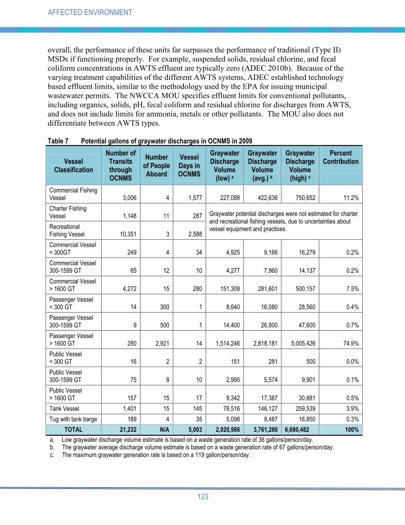
Table 7 Potential gallons of graywater discharges in OCNMS in 2009
Vessel Classification
Number of Transits through OCNMS
Number of People Aboard
Vessel Days in OCNMS
Graywater Discharge
Volume (low) a
Graywater Discharge
Volume (avg.) b
Graywater Discharge
Volume (high) c
Percent Contribution
Commercial Fishing Vessel 3,006 4 1,577 227,088 422,636 750,652 11.2%
Charter Fishing Vessel 1,148 11 287 Graywater potential discharges were not estimated for charter
and recreational fishing vessels, due to uncertainties about vessel equipment and practices. Recreational
Fishing Vessel 10,351 3 2,588
Commercial Vessel < 300GT 249 4 34 4,925 9,166 16,279 0.2%
Commercial Vessel 300-1599 GT 65 12 10 4,277 7,960 14,137 0.2%
Commercial Vessel > 1600 GT 4,272 15 280 151,308 281,601 500,157 7.5%
Passenger Vessel < 300 GT 14 300 1 8,640 16,080 28,560 0.4%
Passenger Vessel 300-1599 GT 9 500 1 14,400 26,800 47,600 0.7%
Passenger Vessel > 1600 GT 280 2,921 14 1,514,246 2,818,181 5,005,426 74.9%
Public Vessel < 300 GT 16 2 2 151 281 500 0.0%
Public Vessel 300-1599 GT 75 8 10 2,995 5,574 9,901 0.1%
Public Vessel > 1600 GT 157 15 17 9,342 17,387 30,881 0.5%
Tank Vessel 1,401 15 145 78,516 146,127 259,539 3.9%
Tug with tank barge 189 4 35 5,098 9,487 16,850 0.3%
TOTAL 21,232 N/A 5,003 2,020,986 3,761,280 6,680,482 100%
a. Low graywater discharge volume estimate is based on a waste generation rate of 36 gallons/person/day. b. The graywater average discharge volume estimate is based on a waste generation rate of 67 gallons/person/day. c. The maximum graywater generation rate is based on a 119 gallon/person/day.

124
AFFECTED ENVIRONMENT
Regulatory Context for Vessel Discharges - Graywater
Currently, there are no existing or proposed international regulations regarding graywater. In
the U.S., graywater discharge from ships is regulated under the VGP. The VGP graywater
rules include guidance to minimize production and discharge while in port, include different
requirements for medium (100-499 berths) and large (500 or more berths) cruise ships, prohibit
discharge within 3 miles of shore within a national marine sanctuary for vessels with graywater
storage capacity, allow for discharge from vessels greater than 400 gross tons if the effluent
meets treatment standards or if the vessel is underway more than 1 nmi of shore, and include
special considerations for nutrient impaired waters. Treated graywater must meet strict standards
for fecal coliform and chlorine concentrations that far exceed standards for traditional MSD
effluent (EPA 2008b). The VGP does not have treatment requirements for large vessels when
discharging underway (i.e., greater than 1 nmi from shore and when traveling faster than
6 knots).
Current OCNMS regulations allow discharge of graywater as “water generated by routine vessel
operations”. Under voluntary measures defined in the MOU between the North West and
Canada Cruise Association, Port of Seattle, and WDE, cruise ships represented by the association
will not discharge graywater (treated or untreated) in Washington State waters, with an exception
for discharge of treated graywater from vessels with AWTS.
Regulatory Context for Vessel Discharges - Ballast Water
The discharge rate and constituent concentrations of ballast water from vessels will vary by
vessel type, ballast tank capacity, and type of deballasting equipment. Volumes of ballast
water discharged are large and can be several hundred or thousand cubic meters of water. For
instance, passenger vessels have an average ballast capacity of about 2,600 cubic meters (about
686,850 gallons), and ultra large crude carriers have an average ballast capacity of about
93,000 cubic meters (about 24,568,000 gallons) (EPA 2008b). Ballast water exchange volume
for each of the vessel classes was not computed for further analysis, as the risk that ballast water
poses to the sanctuary has more to do with the manner (i.e., location) that ballast water is
exchanged rather than the volume of exchanges.
Ballast water from ships has been a major source of non-native species introduction around the
world. The current best practice for managing ballast water is an at-sea exchange of ballast
water, wherein coastal water taken at or near a port is replaced with less biologically productive
open oceanic water. Fewer organisms are present in open ocean water than in coastal waters.
This practice is not 100% effective as some non-native organisms can survive until discharged in
a foreign port or coastal area (NOAA 2008).
OCNMS is partially protected from the introduction of non-native species through existing
federal, state and international regulations associated with ballast water management. In July
2004, the U.S. Coast Guard published a final rule changing the nation‟s voluntary Ballast Water
Management Program to a mandatory one requiring all vessels equipped with ballast water tanks
and bound for ports or places of the United States to conduct a mid-ocean ballast water exchange
(more than 200 nmi offshore), retain their ballast water onboard, or use an alternative,
environmentally sound, ballast water management method approved by the USCG (69 FR
44952). The state of Washington‟s regulations have this same requirement for mid-ocean
exchange that applies to vessels 300 gross tons or larger that have traveled outside the economic

125
AFFECTED ENVIRONMENT
exclusion zone (EEZ). For vessels that do not leave the EEZ, ballast water exchanges must be
conducted beyond 50 nmi from shore (WDFW 2009). These measures substantially reduce the
risk of invasive species introductions into sanctuary waters. Washington State ballast water
management regulations only apply to vessels bound for American ports; however, Canada has
adopted the 2004 IMO International Convention for the Control and Management of Ship‟s
Ballast Water and Sediment (Transport Canada 2010). This agreement provides the same
restrictions as Washington State regulations, and all ships calling on Canadian ports are required
to comply (IMO 2004). The VGP requires vessels to avoid discharge of ballast waters within
3 nmi of shore within a national marine sanctuary. In summary, these regulations and
agreements prohibit discharge of all ballast water that originates from distant nearshore areas but
allow discharge into the sanctuary beyond 3 nmi from shore and other Washington State waters
of ballast water that originates from an open ocean exchange.
Regulatory Context for Vessel Discharges – Bilgewater Bilgewater is the mixture of fresh water and seawater, oily fluids, lubricants, cleaning fluids and
other wastes that accumulate in the bilge, or lowest part of a vessel hull, from a variety sources
including leaks, engines and other parts of the propulsion system and other mechanical and
operation sources found throughout the vessel (EPA 2008a). All vessels accumulate bilgewater
through their normal operation, but the generation rates depend on a variety of factors including
hull integrity, vessel size, engine room design, preventative maintenance and the age of the
vessel (EPA 2008a; EPA 2010b). In addition to oil and grease, bilgewater may also contain a
variety of other solid and liquid contaminants, such as rags, metal shavings, soaps, detergents,
dispersants and degreasers (EPA 2008a). Estimates of bilgewater discharges to the sanctuary are
not available for most classes of vessels. Data for bilgewater generation from cruise ships were
available, with an estimated volume of 25,000 gallons produced per week (3,500 gallons per
day) on vessels with 3000 passenger/crew capacity (EPA 2008b).
Several national and international regulations govern allowable discharges of bilgewater in an
effort to reduce oil contamination of the oceans. These regulations require ships to have in
operation oily-water separating equipment, and discharges may not exceed 15 parts per million
oil. The VGP prohibits discharge of treated or untreated bilgewater from vessels 400 gross tons
or more within 3 mi of shore in a national marine sanctuary. OCNMS regulations prohibit all
discharge of oily waste from bilge pumping. Because sanctuary regulations do not specify a
limit, this has been interpreted by ONMS as prohibiting any detectable amount of oil as
evidenced by a visible sheen (EPA 2008a; 73 FR 70488). Under current OCNMS regulations,
discharge of bilgewater not leaving a visible sheen is allowed.
Regulatory Context for Vessel Discharges – Other Discharges
Several discharges incidental to the normal operation of a vessel covered by the exclusion in
40 CFR 122.3 are also eligible for coverage under the VGP. Below is a list of these discharges:
Anti-fouling hull coatings
Boiler blow-down
Cathodic protection
Chain locker effluent (anchor wash)
Controllable pitch propeller and thruster hydraulic fluid and other oil to sea interfaces…
Distillation and reverse osmosis brine

126
AFFECTED ENVIRONMENT
Elevator pit effluent
Firemain systems
Freshwater layup
Gas turbine water wash
Motor gasoline and compensating discharge
Non-oily machinery wastewater,
Refrigeration and air condensate discharge
Seawater cooling overboard discharge (including non-contact engine cooling water,
hydraulic
System cooling water, refrigeration cooling water
Seawater piping biofouling prevention
Boat engine wet exhaust
Sonar dome discharge
Underwater ship husbandry discharges
Welldeck discharges
The volume and contents of the above listed discharges are presumed to be similar for similarly
sized vessels and are not dependent on the vessel purpose (EPA 2008b). With the exception of
graywater and pool and spa discharges from cruise ships, oily discharges, including oily
mixtures, and residual biocide limits from vessels utilizing experimental ballast water treatment
systems, numeric effluent limitations are not feasible to calculate for vessel discharges in VGP.
Therefore, the EPA establishes effluent limits based on Best Practical Control Technology
Currently Available (BPT) or Best Available Technology (BAT) rather than specifying specific
effluent limits. Existing OCNMS regulations include an exception to the discharge prohibition
for water generated by routine vessel operations, which includes those mentioned above.
Discharge Volume Estimation Methods
In order to evaluate the potential for water quality impacts to the sanctuary from vessel
discharges, estimates of discharges generated by classes of vessels were calculated based on the
time a given vessel class spent in the sanctuary during 2009 (vessel days) and published waste
generation rates. Vessel days for a given vessel class was calculated by determining the
cumulative time individual vessels of a specified class were within sanctuary boundaries.
Sewage generation rates used for estimates provided in Table 6 were based on information from
MSD manufacturers. Additional details regarding discharge volume estimation methods can be
found in Appendix K.
Although many vessels do have wastewater holding tanks and may not discharge while operating
in the sanctuary, it is not possible to accurately characterize the times, locations, and volumes
of sewage and other discharges that actually occur in the sanctuary. For the purpose of this
document, analysis was conducted on the potential to discharge to sanctuary waters based on
estimated waste generation rates and residence time (vessel days) in the sanctuary. Potential
discharge volumes are proportional to waste generation rates, which can be considered a worst-
case scenario because discharges may or may not occur in waters of the sanctuary. One factor
influencing wastewater discharges into waters of the sanctuary is average transit time. Large,
commercial vessels complying with the ATBA (vessels >1,600 GT, and tugs with tank barges)
would transit waters of the sanctuary only at the western approach to the Strait of Juan de Fuca

127
AFFECTED ENVIRONMENT
(Figure 8). In OCNMS regulations, cruise ships are defined as vessels with 250 or more
passenger berths for hire. However, the following analysis is based on categories of vessels
used by the vessel traffic system under which cruise ships are classified as passenger vessels
>1,600 GT. For cruise ships, the average transit time in OCNMS is 74 minutes (1.2 hours; Table
11). By comparison, commercial vessels of various sizes average about 170 minutes in
OCNMS, and public vessels and tank vessels average roughly 200 minutes in OCNMS (Table
11). While the estimated potential wastewater discharge volumes from all ships represent a
threat to water quality, actual discharges may not occur or impact OCNMS water quality because
transit times provide relatively short windows of opportunity for wastewater discharges to occur
in OCNMS.
Cruise Ship Wastewater Discharges
The cruise ship industry is rapidly expanding in the Pacific Northwest, with the number of
passengers through the Port of Seattle increasing from 120,000 to nearly 900,000 between 2000
and 2009 (WDE 2010). In 2009, there were 280 cruise ship transits in OCNMS (VEAT 2009),
representing 14 vessel days in sanctuary waters (see Passenger Vessels >1,600 GT in Table 6).
If the passenger numbers on these cruises continue to increase, there will be a proportional
increase in wastewater generation. The largest cruise ships are capable of carrying a combined
population of about 4,000 passengers and crew (WDE 2009).
Estimates of potential wastewater discharges from cruise ships (i.e., passenger vessels
>1,600 GT) presented in Table 6 and Table 7 assume an average of 2,921 passengers and crew
on board, the average reported for cruise ships using the Port of Seattle (WDE 2009). Despite
cruise ships spending relatively little cumulative time in the sanctuary compared to other large
vessel classes, the potential sewage discharge volume from cruise ships is higher than that
estimated for all other large vessel classes and represents 63% of all potential sewage discharges
in the sanctuary (Table 6). The average graywater generation rate of 67 gallons/person/day
(EPA 2008a) could potentially result in millions of gallons of graywater discharged from cruise
ships into the sanctuary annually, which dwarfs potential discharges from all other vessel classes
and represents 75% of the all potential graywater discharges in the sanctuary (Table 7).
The quality of potential blackwater and graywater discharges from cruise ships, hence risk to
sanctuary resources, is difficult to characterize based on existing data. Data from the 2011
Washington Department of Ecology discharge status report (WDE 2011) indicate that 15 cruise
ships are scheduled to call on the Port of Seattle for a total of 195 port calls, corresponding to
390 transits through or near the sanctuary. Whereas more than half (9 of 15) of the cruise ships
calling on the Port of Seattle have installed AWTS for blackwater and/or graywater treatment,
35% of the port calls will be completed by vessels that have traditional MSDs for blackwater
treatment and no treatment system for graywater (WDE 2011). Furthermore, only 2 of the 15
vessels have met effluent standards and monitoring requirements set forth in the NWCCA MOU
and have requested and gained authority to discharge while underway in Washington state waters
(WDE 2011). Only vessels that are authorized to discharge per the NWCCA MOU are required
to monitor and submit results, and are required to submit documentation that they have 24 hour
continuous monitoring for treatment system performance and disinfection, as well as the ability
and procedures to automatically shut down if continuous monitoring of treated effluent indicates
high turbidity or a disinfection system upset. Therefore, it cannot be assured that the AWTS
performance controls or effluent monitoring otherwise required by the VGP or NWCCA MOU

128
AFFECTED ENVIRONMENT
are performed on most ships. Some vessels only operate their AWTS when in certain areas
where it is required and use a traditional MSD for other discharges. Given the uncertainties in
the type and performance (operational performance and frequency of system upset) of the
treatment systems installed on board cruise ships, it is impossible to accurately estimate the
quantity (i.e., mass load) of contaminants potentially deposited into the sanctuary.
In open waters of the sanctuary, concern for localized and acute effects of wastewater discharges
from a cruise ship in transit is reduced by the free exchange of waters and dilution that occurs in
the ship‟s wake. Rapid dilution of wastewater (blackwater and graywater) discharged from
MSDs has been documented to occur when discharged from cruise ships under way. Loehr et al.
(2006) showed that under a worst case scenario (i.e., lowest dilution factor possible and high
discharge rate) that the dilution factor for discharges from large cruise ships is 1:50,000 when
traveling at 6 knots discharging at 200 cubic meters per hour. Loehr et al. (2006) further
documented, based on sampled effluent concentrations from 21 cruise ships using traditional
MSDs, that priority pollutants (metals and organics) were rapidly diluted to many times below
Alaska water quality standards. In Washington State, mixing zones have not been applied to
cruise ship discharges. Mixing zones are typically established for stationary discharges where a
particular location and receiving water can be evaluated and applied with a discharge permit.
Commercial (non passenger) Vessels Wastewater Discharges
The typical composition of sewage and graywater discharges from non-passenger vessels has not
been as extensively studied as cruise ship discharges. Most commercial, non-passenger vessels
are equipped with Type I or Type II MSDs, so the composition of sewage discharges in terms of
constituents and concentrations are likely to be similar to the cruise ship discharges evaluated by
the EPA (2008a), except for cruise ships equipped with AWTS. The estimated total amount of
sewage discharged in the sanctuary by non-passenger carrying, commercial vessels (including
commercial fishing vessels, commercial vessels and tank vessels) is between 71,991 and
392,676 gallons per year (Table 6). In sum, these vessels produced about 20% of the potential
sewage and 23% of the potential graywater discharges into the OCNMS in 2009.
Although the number of transits and vessel days for non-passenger vessels are many times
greater than that of cruise ships, the total combined discharge volume from non-passenger
vessels is much less because these vessels have substantially fewer passengers.
Charter and Personal Recreational Vessel Wastewater Discharges
OCMNS is a popular recreational fishing area in the Pacific Northwest spanning Washington
Department of Fish and Wildlife marine management units 2, 3, 4 and 4B. Private and charter
vessels using the sanctuary originate primarily from the ports of Neah Bay, La Push, and
Westport. In 2009, there were over 40,000 angler trips to the sanctuary. Of these trips about half
were conducted on small private or charter vessels typically carrying 6 or fewer passengers. The
remaining trips were conducted on larger charter vessels that carried an average of 10-13
passengers. Reliable data regarding the type(s) of MSDs (if any) installed on these vessels is
unavailable. The majority of these vessels are under 65 feet, so they could use any approved
Type I, II, or III MSD, or could have no MSD of any type.
The annual sewage discharge estimates for recreational and charter fishing vessels are between
56,583 and 308,637 gallons based upon waste generation rates used for other vessel classes
129
AFFECTED ENVIRONMENT
(Table 6). Thus, these vessel classes potentially could contribute as much as 15.5% of sewage
discharged to sanctuary waters. This likely overestimates true sewage discharges because these
vessels are typically on day trips and may hold waste using a Type III MSD until it can be
discharged at a shore-side pump-out facility. Waste generation rates may also be substantially
lower due to the estimated short duration of fishing trips (six hours). Graywater discharge
estimates were not calculated for recreational fishing vessels, as most would not have galleys or
sinks, and therefore would not generate sizeable volumes of graywater.
6.1.4 Climate/Meteorology
The maritime climate off the Olympic Coast is influenced by topography, location along the
windward coast, prevailing westerly winds, and the position and intensity of high and low
pressure centers over the North Pacific Ocean (Phillips and Donaldson 1972). The strong
oceanic influence creates a climate of western Washington characterized by relatively mild
winters and moderately dry, cool summers. In the late spring and summer, westerly to
northwesterly winds associated with the North Pacific high pressure system produce a dry
season. In late fall and winter, southwesterly and westerly winds associated with the Aleutian
low pressure system provide ample moisture and cloud cover for the wet season beginning in
October. Moist air transported across the ocean rises and cools on the windward terrestrial
slopes, giving rise to relatively high rainfalls in western Washington. Annual rainfall amounts
greater than 100 inches (254 cm) per year on the western portions of the Olympic Peninsula
contribute to seasonally high inputs of river waters to the marine system.
Large-scale oceanographic and atmospheric events across the Pacific basin also influence of
Olympic Coast waters. For example, the El Niño-Southern Oscillation is primarily driven by sea
surface temperatures along the equatorial Pacific Ocean and is a major source of inter-annual
climate and ecosystem productivity variability in the Pacific Northwest, with events lasting 6 to
18 months. Likewise, the Pacific Decadal Oscillation, a long-term cycle in ocean temperature
with warm or cool phases that can each last 20 to 30 years, influences the climate in the Pacific
Northwest. Climatic cycles such as these are natural events and often are associated with strong
fluctuations in weather patterns and biological resources.
6.1.5 Climate Change
Over the next century, climate change is projected to profoundly impact coastal and marine
ecosystems on a global scale, with anticipated effects on sea level, temperature, storm intensity
and current patterns. At a regional scale, we can anticipate significant shifts in the species
composition of ecological communities, seasonal flows in freshwater systems, rates of primary
productivity, sea level rise, coastal flooding and erosion, and wind-driven circulation patterns
(Scavia et al. 2002). Rising seawater temperatures may give rise to increased algal blooms,
major shifts in species distributions, local species extirpations, and increases in pathogenic
diseases (Epstein et al. 1993, Harvell et al. 1999). A better understanding of ocean responses to
global scale climatic changes is needed in order to improve interpretation of observable
ecosystem fluctuations, such as temperature changes, hypoxic events and ocean acidification that
may or may not be directly coupled to climate change.

130
AFFECTED ENVIRONMENT
6.2 BIOLOGICAL SETTING
Habitats are where organisms make their lives, where they survive, find food, water, shelter, and
space. The collected habitats of an area create the place for the living ecosystem. Healthy
marine habitats are the foundation of healthy communities of marine life.
OCNMS is comprised of a broad diversity of habitats, some we can see from land, others hidden
beneath the water, including rocky shores, sandy beaches, nearshore kelp forests, sea stacks and
islands, open ocean or pelagic waters, as well as the continental shelf seafloor and submarine
canyons. In addition to aquatic habitats in the sanctuary, islands and pinnacles, or sea stacks,
along the coast provide nesting and resting sites for California and Steller sea lions, harbor and
elephant seals, and thousands of seabirds.
6.2.1 Intertidal Habitats
Most accessible to people is the intertidal zone, a habitat alternating between the dry and wet
worlds where rock benches, tide pools and surge channels are formed amid boulders and rocky
outcrops. These substrates provide both temporary and permanent homes for an abundance of
“seaweeds” (e.g., macroalgae and seagrasses), invertebrates such as sea stars, hermit crabs,
nudibranchs, snails, and sea anemones, and intertidal fish. Between rocky headlands are
numerous sand-covered beaches and mixed rock/cobble benches hosting an array of intertidal
invertebrates and fishes – food for both shorebirds and humans. Surf smelt spawn at high tide on
sand-gravel beaches where surf action bathes and aerates the eggs.
Natural conditions in intertidal habitats of the Pacific Northwest challenge their inhabitants with
extreme fluctuations in temperature, salinity and oxygen, along with powerful physical forces
such as wave action and sand scouring. Yet, rocky shores of the Olympic Coast have among the
highest biodiversity of marine invertebrates and macroalgae of all eastern Pacific coastal sites
from Central America to Alaska (Suchanek 1979; Dethier 1992; PISCO 2002; Blanchette et al.
in press). Macroalgae or seaweeds are highly diverse in the region, with an estimated
120 species thought to occur within the sanctuary rocky intertidal zone (Dethier 1988).
With limited exceptions, nearshore and intertidal habitats in the sanctuary are remarkably
undisturbed by human use and development (e.g., armoring, wetlands alteration, dredging, and
land-based construction) that have modified shorelines in more urbanized areas. The remote
location, low levels of human habitation, protections provided by the wilderness designation of
Olympic National Park‟s coast, and restricted access to tribal reservations have allowed these
coastal habitats to persist largely intact. At the few locations where shoreline armoring has been
employed or where human visitation has focused on intertidal areas for food collection and
recreation, impacts do not appear to be dramatic or widespread (Erickson and Wullschleger
1998; Erickson 2005).
Monitoring conducted by Olympic National Park since 1989 indicates these habitats are healthy
and do not appear to be changing substantially in response to human influences. Large-scale
disturbances related primarily to extreme winter weather cause periodic damage to mussel beds
(Paine and Levin 1981) and other intertidal species. Coastal ecologists recently have designed
studies to better detect changes resulting from effects of global climate change, such as sea level
rise, increasing acidity and temperatures, and changes in storm frequency and magnitude. Local

131
AFFECTED ENVIRONMENT
trends in these parameters are uncertain, however, and no definitive results have yet been
published.
Relatively few nonindigenous or exotic species have been reported in the sanctuary, and, of
those, only a few are invasive and therefore threatening to community structure and function
(ONMS 2008). OCNMS-led rapid assessment intertidal surveys in 2001 and 2002 and a larvae
settlement study (deRivera et al. 2005) identified a few nonindigenous species. One invasive
species of concern, the green crab, has been found at sites both north and south of the sanctuary,
but no green crab have be found through routine monitoring near the sanctuary. A program to
prevent introduction and spread of invasive species is managed by Washington Department of
Fish and Wildlife.
Degradation of intertidal habitats, in the form of marine debris, is visible to even the casual
visitor to the shore. The majority of this debris is plastic ranging from large floats to beverage
bottles to tiny fragments the size of sand particles. Much of the debris originates from
commercial fisheries, both international and domestic.
6.2.2 Nearshore Habitats
In nearshore areas, canopy kelp beds form a productive, physically complex and protected
habitat with a rich biological community association of fish, invertebrates and sea otters. Annual
monitoring and quantification of the floating kelp canopy has been conducted since 1989 by the
Washington Department of Natural Resources and in collaboration with OCNMS since 1995.
Although the canopy changes every year, these kelp beds are generally considered stable, and the
area covered by floating kelp has been increasing along the outer coast and western portion of
the Strait of Juan de Fuca (Figure 5). This increase may be due in part to a growing population
of sea otters and subsequent decline in grazing sea urchins or may be influenced by changes in
oceanographic conditions. In contrast, extensive logging of the Olympic Peninsula, an area of
very high rainfall, has markedly increased sediment loads in rivers in the past. Long-term
residents along the coast have noted a reduction in kelp beds near river mouths, which may have
been associated with siltation of nearshore habitat and reduced light penetration (Chris
Morganroth III, personal communication in Norse 1994). Recently documented, widespread
hypoxic, or low oxygen conditions in nearshore areas off Oregon and Washington coasts have
stressed and killed marine life. Such hypoxic conditions appear to be increasing in severity and
frequency and may result from anomalous weather and oceanographic patterns.
Nearshore habitats off sand beaches occurring all along the outer Olympic Coast and dominate
the southern shores of the sanctuary tend to be less diverse, lacking macroalgae and physically
complex substrate. These are high energy environments where the inshore shelf is relatively
shallow. Nutrients delivered by upwelling currents support phytoplankton biomass that is grazed
and recycled by zooplankton. Wind and wave action support transport and retention of
productive waters near shore, which sustains sand beach infaunal communities of amphipods,
worms, and razor clams.
Relatively few exotic or nonindigenous species have been reported in the sanctuary and, of those,
only a few are invasive and therefore threatening to community structure and function in the
nearshore. Observations by coastal ecologists from Olympic National Park and OCNMS of
increased amounts of the invasive brown algae Sargassum muticum, the documented range

132
AFFECTED ENVIRONMENT
expansion of invasive ascidians (tunicates or sea squirts) (deRivera et al. 2005), and the
encroachment of the invasive green crab to areas both south and north of the sanctuary all
suggest negative impacts from nonindigenous species may increase in the future.
Figure 5 Kelp distribution
6.2.3 Pelagic (Water Column) Habitats
The pelagic habitat, or water column of the open ocean, is the most extensive habitat of the
sanctuary. Many fish, seabird, and marine mammal species are pelagic and have relatively little
association with seafloor or nearshore habitats. Phytoplankton at the base of the food web is
most abundant in the euphotic, or sunlit, layer near the surface of the water column. This
primary productivity supports a food chain based on grazing zooplankton, fish, and marine
bacteria. Ocean productivity can be nutrient limited and is influenced by large-scale
oceanographic currents and cycles. Seabirds can serve as indicators of productivity - poor
survival of one year‟s young can indicate nutrient poor and low productivity cycles in the coastal
marine system. Naturally occurring harmful algal blooms of plankton put humans and some
marine wildlife at risk of biotoxin poisoning, either from plankton or from shellfish
consumption.
In some marine areas of the world, pelagic habitats have been degraded by chemical
contaminants and wildlife conflicts with vessel traffic and noise pollution. Whereas variability
in contaminant concentrations complicates characterization of water column pollutants,
contaminants in animal and plant tissues can provide an integrated measure of bioavailability of
compounds present at low or variable levels in the marine system. In the sanctuary, chemical
concentrations were recently measured in a variety of invertebrates and sea otters for a study of

133
AFFECTED ENVIRONMENT
sea otter health (Brancato et al. 2009), the West Coast Environmental Monitoring and
Assessment Program, and for NOAA‟s Status and Trends, Mussel Watch Program. Contaminant
concentrations were found to be low in all organisms, with very few exceptions (ONMS 2008).
The potential for contamination of pelagic habitats by petroleum products is a concern reinforced
by experience and justified by the volume of large vessel traffic at the western end of the Strait
of Juan de Fuca. Four of the five largest oil spills in Washington state history have occurred in
or moved into the area now designated as the sanctuary. In the decade before sanctuary
designation, two major oil spills released more than 325,000 gallons of petroleum products
impacting marine ecosystems and human communities on the outer Washington coast.
Noise pollution, or the cumulative acoustic signature of human activities, is an aspect of the
pelagic habitat of OCNMS not currently well characterized or evaluated for potential impacts on
wildlife in the sanctuary.
6.2.4 Seafloor Habitats
The ocean floor of the sanctuary covers over 3,300 square miles and is comprised of a variety of
physically and biologically complex habitats. These habitats are shaped by the geology and
topography of the seafloor and enhanced by living organisms like corals and sponges. Prior to
development of remote sensing techniques, water depth measurements and bottom samples
provided spot data that was extrapolated to create crude seafloor maps. Modern exploration and
detailed habitat mapping involves carefully planned and costly surveys from large vessels using
sophisticated technology. Thus far, OCNMS has completed high resolution habitat mapping for
about 25 percent of its seafloor, while information on remaining areas lacks resolution and
specificity for development of accurate seafloor habitat maps (Figure 6). As a result,
generalizations about the sanctuary‟s seafloor habitats and their biological communities are
difficult to make.
The northern portion of the sanctuary is dominated by the Juan de Fuca Canyon and trough (the
shallower extensions of the canyon closer to the Strait of Juan de Fuca), which are complex,
glacially carved features containing a mixture of soft sediments, with significant cobble and
boulder patches and scattered large glacial erratics (boulders) deposited during ice retreat. High-
relief, submerged topographic features serve as fish aggregation areas. Low-resolution surveys
have revealed a generally wide and featureless continental shelf in the southern portion of the
sanctuary dominated by soft substrates (sand and mud bottoms, to pebble and cobble) with
scattered areas of rock outcrop and spires. The head of the Quinault Canyon also lies within the
sanctuary boundary.
Detailed information on historic and current conditions in the sanctuary‟s seafloor habitats is
limited because technological challenges and expense have limited the areas that have been
directly viewed. Thus, to a large extent the current condition of seafloor habitats must be
inferred. The most widespread anthropogenic impact to seafloor habitats is likely to have
resulted from the bottom trawl fishery using gear known to reduce complexity, alter the physical
structure of seafloor habitats, and damage biogenic habitat, or habitat formed by living
organisms, such as corals and sponges (NRC 2002; Auster et al. 1996, Auster and Langton 1999,
Norse and Watling 1999, Thrush and Dayton 2002). Bottom trawling and long-line fishing has
occurred widely throughout OCNMS for several decades, likely over all but the roughest of

134
AFFECTED ENVIRONMENT
seafloor habitats. Where biologically-structured habitats existed on the sanctuary seafloor, it is
likely they have been altered by fishing practices, except perhaps in the roughest of terrain
fishermen avoided. Recovery of biologically-structured habitats is expected to occur very
slowly, even in the absence of future pressures, due to low growth and reproductive cycles of the
habitat-forming organisms such as corals.
Figure 6 Habitat map
In recent years, fishery management measures restricting footrope gear size and limit areas open
to bottom trawlers, and in some places long-line and pot gear, have mitigated widespread
seafloor impacts of bottom trawling and focused trawl effort more toward soft seafloor substrates
where gear impacts on the physical habitat are less of a concern.
135
AFFECTED ENVIRONMENT
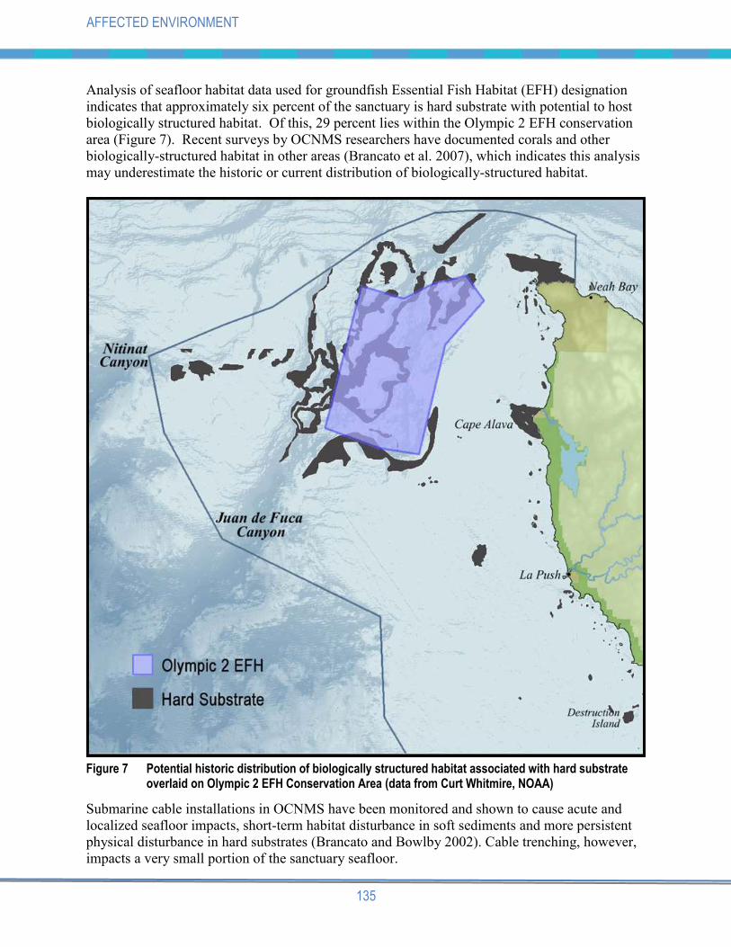
Analysis of seafloor habitat data used for groundfish Essential Fish Habitat (EFH) designation
indicates that approximately six percent of the sanctuary is hard substrate with potential to host
biologically structured habitat. Of this, 29 percent lies within the Olympic 2 EFH conservation
area (Figure 7). Recent surveys by OCNMS researchers have documented corals and other
biologically-structured habitat in other areas (Brancato et al. 2007), which indicates this analysis
may underestimate the historic or current distribution of biologically-structured habitat.
Figure 7 Potential historic distribution of biologically structured habitat associated with hard substrate overlaid on Olympic 2 EFH Conservation Area (data from Curt Whitmire, NOAA)
Submarine cable installations in OCNMS have been monitored and shown to cause acute and
localized seafloor impacts, short-term habitat disturbance in soft sediments and more persistent
physical disturbance in hard substrates (Brancato and Bowlby 2002). Cable trenching, however,
impacts a very small portion of the sanctuary seafloor.

136
AFFECTED ENVIRONMENT
Sediment contaminant levels (i.e., heavy metals and organic pollutants) in OCNMS are generally
low and do not appear to be increasing (ONMS 2008). Marine debris does compromise seafloor
habitat quality, but its impacts in OCNMS are not well-documented. Rough waters and complex
seabed features increase the potential for fishing gear entanglement and loss. Studies from
Puget Sound and beyond reveal that abandoned fishing gear can remain for decades, potentially
entangling and killing species encountering the gear (NRC Inc. 2008). Assessment of derelict
fishing gear on the seafloor has been limited to coastal areas around Cape Flattery and sites
viewed for characterization of seafloor habitat and seafloor community studies. These later
studies have documented lost fishing gear, most commonly long-line gear entangled on seafloor
features and corals (Brancato et al. 2007).
6.2.5 Benthic Invertebrates
The majority of the sanctuary‟s seafloor where bottom dwelling, or benthic invertebrates live
is composed of sand and mud. This submerged habitat is home to a variety of invertebrates
similar to those found in intertidal areas – brittle stars, sea urchins, worms, snails, and shrimp.
Dungeness crab and razor clams have long sustained commercial and recreational harvest off the
Olympic Coast.
Hard-bottom substrates harbor rich invertebrate assemblages, including deepwater coral and
sponges (Brancato et al. 2007). These living organisms with branching, upright structure are, in
turn, habitat where other invertebrates and fish find hiding places, attachment sites, food
sources, and breeding and nursery grounds in relatively inhospitable and otherwise featureless
environment (Whitmire and Clarke 2007). The distribution of such deepwater communities, as
well as their species richness and basic biology, are not well documented but are currently under
scientific investigation.
Human activities impacting seafloor habitats (described in section 6.2.4) can also harm benthic
invertebrates. Submarine cable installation and buoy anchors can physically disturb and displace
benthic invertebrates, but the cumulative area of impact is relatively small given small size of
most anchors and the narrow path of disturbance and relatively few cables installed in the area
(Brancato and Bowlby 2002). The most widespread human impact to benthic invertebrates
likely results from bottom contact fishing gear, especially bottom trawl fisheries with footropes
and roller gear repeatedly traversing relatively wide swaths of the seafloor.
6.2.6 Fishes
Among the many species of fish inhabiting OCNMS are commercially important ones including
at least 30 species of rockfish, 15 or more species of flatfish, Pacific halibut, Pacific whiting (or
hake), sablefish, and salmon. Five species of Pacific salmon (chinook, sockeye, pink, chum and
coho) occur along the outer coast of Washington and breed in the Olympic Peninsula‟s rivers and
streams. Three similar salmonid species found in freshwater systems (sea-run cutthroat trout, bull
trout, and steelhead) spend portions of their lives in nearshore marine waters. Nearshore habitats
of the sanctuary presumably are important for salmon spawning in adjacent streams and rivers,
but juvenile salmon use of nearshore habitats off the Olympic Coast is not well understood. The
sanctuary also is part of the migration corridor of both juvenile and adult salmonids from
California, Oregon, British Columbia, and Washington rivers beyond the Olympic Peninsula.

137
AFFECTED ENVIRONMENT
Migratory species, such as sharks, albacore, sardines, mackerel, and anchovies, are important
resources for tribal and non-tribal fishers that are found in the sanctuary seasonally.
Federal and Washington state listings of candidate, sensitive, threatened, or endangered species
are definitive indicators that some fish populations are not healthy. Olympic Coast populations
of Ozette sockeye and bull trout have been on the federal list of threatened species in 1999.
Thirteen species of rockfish are identified as state species of concern, and three of these are also
federal species of concern. In recent decades, West Coast groundfish stocks and fisheries were
in crisis, with steep declines in commercial ex-vessel value, overcapitalization, and several
groundfish stocks depleted by a combination of fishing and natural factors (NMFS 2002). Four
species of rockfish found in the sanctuary have been classified as overfished by the NMFS
Service (NMFS 2006a). And there have been increasing concerns about our limited ability to
forecast groundfish production from single species investigations is missing important natural
and fishery-induced changes in the ecosystem and will not be able to forecast truly sustainable
harvest policies (NMFS 2002). For example, age structure, an important measure of population
integrity, has been affected by fisheries. Some rockfish populations have been shown to have
reduced numbers of larger, older fish, a factor that could affect their recovery rate (PFMC
2008a). Older rockfish produce more eggs and more robust juveniles (Berkeley et al. 2004).
However, in most cases, the status of the larger, older fish within the population is unknown
because it has not been determined whether the older fish are simply missing because they have
been removed from the population, or are not fully represented in fishery or stock assessment
surveys.
However, professional fisheries managers generally are optimistic sustainable fisheries off the
outer coast of Washington are possible under new management regimes following these
historical stock declines. Recent fishery management measures implemented to reduce fishing
effort, monitor and minimize bycatch, and reduce impacts to habitat appear to have assisted
initial recovery of some overfished groundfish stocks and provide evidence for an improving
trend (ONMS 2008).
6.2.7 Seabirds
Seabirds are the most conspicuous members of the offshore fauna of the Olympic Coast. Sea
stacks and islands provide critical nesting habitat for 19 species of marine birds and marine-
associated raptors and shorebirds, including seven alcid species (including murres, puffins, and
murrelets), three cormorant species, four gull and tern species, two storm-petrel species, two
raptors and one shorebird, the Black Oystercatcher. Productive offshore waters also attract large
feeding aggregations of marine birds that breed in other regions of the world but travel great
distances to “winter” in sanctuary waters. The Sooty Shearwater, for example, breeds off New
Zealand and Chile in the austral summer and congregates along the Pacific coast in its non-
breeding season. Black-footed and Laysan Albatross travel far from their breeding grounds in
Hawaii and Japan to forage in the eastern Pacific. Nearer to shore, sand and gravel beaches are
foraging areas for shorebirds, crows, gulls and a host of other birds. The coastline also forms an
important migratory pathway for millions of birds that pass through each year, guiding
waterfowl, cranes, shorebirds and raptors toward northern breeding areas during the spring and
southward as winter approaches.

138
AFFECTED ENVIRONMENT
Seabirds are relatively numerous, conspicuous, and forage across multiple habitat types and
trophic levels. For these reasons, they are often considered indicators of ocean conditions, and
the status of their populations provides insight into ecosystem health (Parrish and Zador 2003,
Piatt et al. 2007). Many feed on forage fish, a critical link in the food chain, which are difficult
to quantify by direct observation or sampling. Populations of five species of marine birds
breeding in the sanctuary are declining in the area, which has led to their inclusion on federal or
state species of concern lists: Common Murre, Marbled Murrelet, Tufted Puffin, Cassin‟s Auklet,
and Brandt‟s Cormorant. Trends and common concerns for these seabirds are long-term declines
in their population sizes (Wahl and Tweit 2000, Wahl et al. 2005, Raphael 2006); vulnerability to
human disturbances such as oil spills, habitat disruption and fisheries bycatch (Piatt et al. 2002,
Raphael 2006); and susceptibility to natural disturbances such as ENSO events (Graybill and
Hodder 1985, Wilson 1991, Piatt et al. 2002, Wahl et al. 2005). Although some population
levels appear to be stabilizing at values lower than historical levels, a longer time series is
needed to determine a trend (Lance and Pearson 2008).
A closer examination of the Common Murre population provides insight into some factors
affecting the status of all seabirds on the Washington coast. The murre population declined
dramatically in 1982 and 1983, coinciding with a severe El Niño-Southern Oscillation (ENSO),
and has not recovered to pre-1983 levels since that time (Warheit and Thompson 2004). Aside
from declines associated with ENSO events, it has been suggested the population has not
recovered due to a combination of oil spills, disturbance at breeding colonies (e.g., historic Naval
bombing practices), and gillnet mortality (Warheit and Thompson 2004). During the Nestucca
spill in 1988 and Tenyo Maru spill in 1991, over 70% of bird carcasses recovered were Common
Murres, mortalities that represented a sizable proportion of the total Washington state Common
Murre population (The Tenyo Maru Oil Spill Natural Resource Trustees 2000). Although the
Common Murre population showed signs of recovery through the 1990s, the number of birds has
diminished greatly relative to pre-spill numbers, and modest declines have been found in recent
years (Manuwal et al. 2001). At the breeding colony on Tatoosh Island, Common Murre
populations have also been affected by an influx of avian predators, including Bald Eagles,
Peregrine Falcons and nest-depredating Glaucous-winged Gulls (Parrish et al. 2001). These
multiple stressors affecting the sluggish recovery of Common Murres may be indicative of the
challenges facing the long-term recovery of other seabirds.
Age structure and mortality rates are also in question in some bird populations on the coast.
Common Murres on Tatoosh Island have experienced documented breeding failures during
recent years, partially attributed to oil spills and observed heavy predation by raptors and gulls,
but also possibly due to low food supply during critical breeding periods (Parrish et al. 2001,
Warheit and Thompson 2003). Because they are long-lived, an occasional year of poor
productivity may not impact the population significantly, but multiple years or successive years
of breeding failure would likely have future impacts on the population. Recent demographic
studies of Marbled Murrelets in the region have indicated they have had low nesting success in
recent years (Raphael and Bloxton 2008), which may inhibit their recovery or at least slow the
rate of recovery.
6.2.8 Marine Mammals
Twenty-nine species of marine mammals have been sighted in Olympic Coast National Marine
Sanctuary. Whales, because of their size, abundance and visibility, are commonly seen in the
139
AFFECTED ENVIRONMENT
sanctuary. Sea otters, harbor and elephant seals, and Steller and California sea lions aggregate
along the shore and haul out on land at many locations along the coast throughout the year. The
humpback whale and the killer whale (also called orca) forage offshore, and some 20,000 gray
whales travel through the sanctuary on their annual migrations between breeding and calving
grounds off the Baja Peninsula and summer feeding grounds in the northern Pacific. Eleven
marine mammal species are on either federal or state species of concern lists across their range
(Washington Department of Fish and Wildlife 2008).
The sea otter is often considered a keystone species because of the strong top-down influence
they have on the nearshore kelp ecosystem. Sea otters are of high scientific interest because they
were extirpated from Washington state by commercial pelt hunters by 1911, then were
reintroduced in 1969 and 1970 (Lance et al. 2004). This population has been counted annually
since 1989 and has shown increases the past few years, with a peak of 1,121 animals in 2008
(Jameson and Jeffries 2008). The rate of population growth, however, has been slower than
expected (Laidre et al. 2002; Lance et al. 2004). The sea otter remains a federal species of
concern and an endangered species within Washington state, and the population remains
vulnerable because of its small size, limited genetic diversity, existing exposure to pathogens,
and extreme risks to oil spills.
Most wildlife populations in the sanctuary are relatively healthy and unburdened by
contaminants, pathogens or related maladies. There are, however, notable exceptions. Although
no negative health effects have been documented, the sea otter population has been shown to
carry several potentially lethal pathogens - 80 percent of the otters tested positive for the
distemper viral complex Morbillivirus and 60 percent tested positive for the protozoan
Toxoplasma gondii (Brancato et al. 2009). Fat-soluble contaminants are generally considered to
bioaccumulate or increase in concentration when moving up the food web (Cockcroft et al.
1989). Overall, tissue concentrations of assayed contaminants were relatively low in
Washington sea otters (Brancato et al. 2009). However, other top predators in the region, such as
killer whales, have been shown to carry high contaminant loads (e.g., PCBs and PBDEs) in their
blubber (Ross et al. 2000, Ross 2006), though the population effects of such high contaminant
loads are unknown.

140
AFFECTED ENVIRONMENT
6.3 CULTURAL AND HISTORICAL SETTING
Olympic Coast National Marine Sanctuary has a rich maritime heritage where lives, languages,
communities and cultures are continuously shaped by the sea. The native Makah, Quileute, Hoh
and Quinault peoples traditionally lived at the water's edge, thriving on the riches of the ocean
plants, fish, shellfish, seabirds and marine mammals. The waters off the Washington coast linked
native peoples along the coast as they traveled by canoe. These waters were highways that were
traversed by canoes and, more recently, ships supporting communities and industries along the
shores of the Strait of Juan de Fuca and Puget Sound and beyond. Historically, local maritime
activity ranged from fur hunting, whaling and fishing, to coastal trade with smaller coastal
communities. The rugged Olympic Coast could be treacherous, especially during winter storms
when high winds and strong currents pushed ships dangerously close to the rocky islands, reefs
and shoreline. Fog, too, led to collisions with disastrous results. Over 180 ships were reported
wrecked or lost at sea in or near sanctuary waters in the years between 1808 and 1972.
6.3.1 American Indian Cultural Resources
The modern shoreline of the Olympic Peninsula contains dozens of late prehistoric archaeological
sites rich in materials documenting the character of the maritime environment and the use of this
environment by the region‟s native peoples. Nearshore coastal forests adjacent to the sanctuary
contain mid-Holocene shorelines and older prehistoric archaeological sites. These older sites are
rich in materials documenting the character of maritime paleo-environments, the history of
environmental change, and the record of use of these environments by the region‟s native peoples.
The earliest dated archaeological site on the Washington Coast occurs adjacent to the sanctuary
on the Makah Indian Reservation, establishing human presence for the last 6,000 years. The
recent investigation of paleoshoreline sites on the Makah Reservation reveals high sea-stand
village sites inland along the Sooes and Waatch river valleys, in some cases greater than 10
meters above current sea level and kilometers from the current ocean shore (Wessen 2003).
These sites indicate complex interactions with marine resources of the period and yield important
clues to large-scale ocean and climate regimes, marine wildlife and fish populations, habitat
distribution and cultural patterns of marine resource use. The Makah Cultural and Research
Center in Neah Bay houses an extraordinary collection of artifacts from the Ozette
archaeological site, a Makah village that was partially buried by a mudslide nearly 500 years ago
and excavated in the 1970s.
Other tangible records of prehistoric human occupation include petroglyphs both above the
intertidal zone and within it, middens of shells and other discarded domestic materials, and canoe
runs, or channels cleared of boulders to facilitate landing of dugout watercraft. Research and
preservation of coastal native languages, traditional cultural properties, and traditional practices
of song, dance and activities like whaling also enhances awareness in native and non-native
peoples of the region‟s rich ocean-dependent heritage. The recent resurgence of the canoe
culture in the annual “Tribal Journeys” celebration transfers knowledge and understanding of
coastal culture to new generations.

141
AFFECTED ENVIRONMENT
6.3.2 Historical and Archaeological Resources
Historical-era resources are generally affiliated with archaeological remains of the western
cultures that appeared in the region by the mid-nineteenth century. A combination of fierce
weather, isolated and rocky shores, and thriving ship commerce have made the Olympic Coast a
graveyard for ships of many descriptions.
6.3.2.1 Historical Contexts
Early European-led visits to the Pacific Northwest were explorations to map the coast, assess
marketable natural resources, and stake claim to lands. Juan Perez, a Spaniard, sailed from
Mexico on the first European exploration of the Pacific Northwest in1774, an expedition that
extended as far north as the Alaskan panhandle. In 1778, James Cook explored the coast
between Oregon and Alaska. By the 1790s, Spain attempted to use the region as a buffer against
encroaching Russian and English fur hunters. In 1792, the Spanish established a short-lived
palisaded settlement known as Nunez Gaona near the mouth of the Strait of Juan de Fuca in
Neah Bay to support their main base on Vancouver Island. This Spanish settlement lasted less
than a year.
As the British settled Canada's Pacific Northwest, Americans also continued their westward
migrations into the United States northwestern territories of Washington and Oregon. A need for
timber to support the population explosion resulting from California's 1849 Gold Rush led to the
settlement and exploitation of the timber resources around Puget Sound and the Olympic
Peninsula. An increase in shipping around Cape Flattery resulted in an increase in ship losses.
The U.S. Lighthouse Board built lighthouses at both Destruction Island and Tatoosh Island to
reduce the hazards to the increased shipping.
The encroachment of settlers had a profound impact on the native tribes‟ traditional way of life.
The United States pressured the tribes to move to reservations in order to make way for
American settlement. In 1855, the Treaty of Neah Bay set aside land at Cape Flattery as a
reservation for the Makah tribe. Tatoosh Island was appropriated for the lighthouse and was not
returned to the tribe until 1984. In 1855-1856, the ancestors of the Hoh Tribe, Quileute Tribe
and the Quinault Indian Nation signed the Treaty of Olympia with the U.S. Government. The
Hoh and Quileute reservations were subsequently established by Executive Order.
Throughout the 1850s and 1860s, settlers moved onto lands formerly used by American Indians.
The remoteness and lack of access roads to areas near the coast prevented an influx of large
numbers of settlers, but small western communities, such as Port Angeles and Port Townsend
began to appear near American Indian communities that persisted in Neah Bay, La Push, and
Taholah. Grays Harbor, too, became a center of timber export. By the last quarter of the
nineteenth century, small sailing vessels and steamers used for fishing, whaling and local
commerce were commonly seen alongside native canoes.
Since the mid-1990s, NOAA's Office of National Marine Sanctuaries has compiled and
periodically updated a database of historic ship and military aircraft losses that includes known
The term "historical" refers to cultures with written language.
142
AFFECTED ENVIRONMENT
archaeological resources in the vicinity of Olympic Coast National Marine Sanctuary.
Approximately 207 historic ships have been documented as lost in what is now the sanctuary
between the early-nineteenth and mid-twentieth centuries (Schwemmer 2008). As the rate of
shipping increased with the growing regional economy and settlement, so too did the rate of
shipwreck increase off the Olympic Peninsula. An assessment of the database indicates the
majority of losses were weather-related, including founderings, collisions and groundings. Many
ships simply vanished after sailing past Tatoosh lighthouse, their resting place never known.
Ship types ranged from clippers and multi-sail rigged windjammers, to steam freighters, small
gasoline powered fishing boats and barges. There are a number of ships that have entered local
lore and are still remembered by local citizens of the peninsula. Examples include:
SS Skagway - On December 16, 1929, the Dollar line steam freighter, Skagway, caught fire and
drifted into the rocks around Fuca Pillar at Cape Flattery. The rocks where she went down have
since been referred to as Skagway Rocks.
W.J. Pirrie - The five-masted iron ship Pirrie had been reduced to a sailing barge after almost
forty years of sailing when it hit the rocks during a storm on November 11, 1920. Sixteen crew
(including the captain's wife and young child) drowned and were washed ashore around Cape
Johnson. Because the ship had Chilean registry at the time of its sinking, she became known as
the "Chilean Wreck" and is so commemorated by a monument at the site where most of the
bodies were recovered.
SS Pacific - Perhaps one of the greatest shipwreck mysteries of the Olympic Coast involves the
sidewheel steamer Pacific, lost in 1851. The ship was steaming for Panama out of Victoria and
reportedly carrying miners from the British Columbia gold fields when she collided with another
ship. Only two of almost three hundred passengers survived. Treasure salvors have sought the
ship in the past in the belief the miners on board may have been carrying unreported gold in their
baggage and on their persons. The ship has not yet been located.
Two locally well-known wrecks (among several others) occurred in the vicinity of La Push. One
of the earliest recorded local wrecks was the Russian brig St. Nicholas on Rialto Beach in 1808.
Several of the crew were captured by Native Americans and their ordeal was a well-told story.
The earliest steam shipwreck in the sanctuary region was the Southerner in 1854. A wooden
sidewheel steamer built in 1846, Southerner served as a passenger steamer when it sprang a leak
and the captain was forced to run her ashore at First Beach at Quillayute (now La Push). The
large island situated at the mouth of Quillayute River, originally called Alekistet Island by the
Quileute tribe, was renamed James Island by the white settlers to honor Francis W. James who
scaled it in order to watch over the remains of the ship and protect it from illegal salvage (Terrell
no date).
6.3.2.2 Archaeological Resources
In compliance with Section 110 of the National Historic Preservation Act, OCNMS undertook
five surveys to document historical shipwrecks between 1995 and 2001. Utilizing acoustic and
magnetic remote sensing and diver target identification, the research design identified areas of
high probability for finding historically-reported shipwrecks near the southern shore of the Strait

143
AFFECTED ENVIRONMENT
of Juan de Fuca, the vicinity of Tatoosh Island, Cape Flattery to Portage Head, as well as select
areas at Cape Alava, La Push/Quilleyute Needles and Destruction Island.
Often searching in difficult and dangerous nearshore areas, the teams were able to locate remains
associated with at least eight historic shipwrecks. A draft final report was compiled and a draft
manuscript is presently on file at OCNMS. The report concludes the majority of the wreck
remains in nearshore waters have been severely degraded due to heavy storm and wave impact.
Several of the sites, which were found using sidescan sonar, could not be safely dived or
documented by marine archaeologists.
Thus far, two historic shipwreck sites have been documented by the OCNMS. The remains of
the World War II/Korean War troopship General M.C. Meigs at Portage Head was examined by
diving archaeologists in 1997. Although scattered and broken in half, much material remaining
should be documented further. Also, in 1997 a team investigated the nearshore remains of a
nineteenth-century bark, the Austria at Cape Alava. Almost all wooden remains have been
destroyed by the environment, but the team was able to locate the orientation of the wreck by the
locations of significant objects such as the ship's anchor, anchor chains and hawseholes. The site
subsequently has been used as an educational tool to teach students about the maritime heritage
resources of the sanctuary.
Final recommendations in the report included further study of several sites, and focus of
OCNMS‟ future efforts towards locating historical shipwreck remains in deeper water. The lack
of exposure to winter storms suggest a better probability of preservation of submerged
archaeological remains (Terrell no date).
6.3.2.3 Maritime Cultural Landscape
The National Historic Preservation Act directs federal agencies like NOAA to inventory and
manage heritage resources, and, if appropriate, to nominate those properties to the National
Register of Historic Places. The act also recommends agencies interpret the cultural landscape
of a region. A search of National Register listings indicate three properties adjacent to the
OCNMS. They are:
Ozette Indian Village Archaeological Site
Tatoosh Island
Wedding Rock Petroglyphs
In addition to archaeological remains exhibiting the tribes' relationship with the sea, the region's
Indian cultural landscape may contain (among other things) such elements of culture as stories,
dances, traditional knowledge and practices, traditional place names and language. Even the
tribe's renewed interest in canoe construction and navigation and whaling represent the
prehistoric and tribal maritime cultural landscape.
So it is with historic maritime cultural landscapes. Archaeological remains of shipwrecks are but
one component. Historic structures on land, while technically outside of sanctuary boundaries,
remain as important tangible fragments of the past and provide insight into past human
interactions with the ocean. These include historic lighthouses at Tatoosh and Destruction
islands, lifesaving station remnants at Waadah Island and La Push, wartime defense sites at Cape

144
AFFECTED ENVIRONMENT
Flattery and Anderson Point, and sites of coastal patrol cabins scattered along the Olympic
Coast. Homesteads, resorts, graves, and memorials also reflect a human dimension to the coast
now largely reclaimed by time, the forest, or the sea. The oral traditions, stories, fishing
practices and local lore also are components of the historical maritime cultural landscape.

145
AFFECTED ENVIRONMENT
6.4 HUMAN/SOCIOECONOMIC SETTING
The Olympic Peninsula has a rich history supporting diverse commercial, recreational, cultural,
research and education activities. Western and American Indian populations alike, including the
Hoh, Makah, Quileute, and Quinault peoples, utilize plant, fish, and shellfish resources, as well
as the access and transportation routes within and adjacent to the sanctuary as an integral part of
economic and socioeconomic activities. This section describes the character of the sanctuary and
adjacent areas, including the population, overall economy, employment and housing. For the
purposes of this analysis, the discussion of the affected environment is focused on those areas
immediately adjacent to the sanctuary. Additional discussion focuses on the commercial activity
dependent on the sanctuary area.
6.4.1 Population, Housing, Income, and Employment
Table 8 shows information on population, housing, poverty and income in counties immediately
adjacent to the sanctuary. Despite the recent economic recession, populations, housing and
incomes in Clallam, Grays Harbor and Jefferson counties have increased over the last decade.
However, the percentage of the population with an income below the poverty level in each
county has also increased over same period.
Table 8 Population, housing and income for counties adjacent to OCNMS
Clallam County Grays Harbor County Jefferson County
2000 2009 2000 2009 2000 2009
Population 64,525 71,413 67,194 71,797 25,953 29,676
Housing Units 30,683 33,972 32,489 34,692 14,144 16,291
Area in Square Miles 1,739 1,739 1,917 1,917 1,814 1,814
Total Population Density per sq. mi. 37.1 41.1 35.1 37.5 14.3 16.4
Median Household Income $37,420 $47,537 $34,724 $41,787 $39,519 $50,463
Poverty Status (% below poverty level) 12.1% 13.6% 15.0% 15.9% 10.7% 12.4%
Source: U.S. Census Bureau 2000; Washington State Office of Financial Management 2009.
Table 9 shows information from the 2000 census on population, housing, poverty and income in
American Indian communities in the vicinity of the OCNMS. All Coastal Treaty Tribes have
experienced, and in many cases still experience, high unemployment and poverty rates. Much of
the tribal culture and economy is resource-based and focused on commercial fishing, timber, and
tourism.
Employment opportunities on American Indian reservations are much less diverse, given the
smaller populations, and cultural and geographic isolation from major population centers. Much
of the mainland adjacent to the sanctuary consists of sparsely populated areas under federal or
tribal management, as well as sizeable tracts of privately-owned timberlands. The public areas
outside tribal reservations are managed by the National Park Service, or administered by state or
county governments.

146
AFFECTED ENVIRONMENT
Table 9 Population, housing and income for American Indian Tribes adjacent to OCNMS
Population, Housing and Income Makah Tribe Quileute Tribe Hoh Tribe Quinault Nation
Population 1,356 371 102 1,370
Housing Units 534 128 33 406
Area in Square Miles 47.0 1.6 0.7 316.3
Total Population Density 28.9 236.6 137.1 4.3
Median Household Income $24,091 $21,750 $21,875 $26,488
Poverty Status (% below poverty level) 26.8% 34.5% 42.0% 31.5%
The Coastal Treaty Tribes are dependent economically, culturally and spiritually upon natural
resources found on their reserved lands and within their usual and accustomed hunting, fishing
and gathering areas. Much of the tribal economies are resource-based, focused on commercial
fishing, timber and tourism. Commercial fishing is one of the mainstays of the tribal economies,
with emphasis on Dungeness crab, groundfish, salmon and steelhead, blackcod (sablefish) and
razor clams (see section 6.4.3).
As with the rest of the Olympic Peninsula, while natural resources continue to support the area
economy, tourism is growing in importance for the Coastal Treaty Tribes, particularly
recreational fishing, nature viewing and active water sports (surfing and kayaking; section 6.4.8).
The Quinault Indian Nation runs a successful casino in Ocean Shores. The Quileute Tribe runs a
very popular resort and marina, and more recently with the overwhelming success of the
Twilight books and movies has become a popular tourist destination. The Makah Tribe also runs
an important regional marina and one of the most popular museums in Washington state, the
Makah Cultural and Historical Center.
The following sections describe the importance the resources within the boundaries of the
sanctuary play in the economic and socioeconomic lives of the coast‟s residents, residents of
Puget Sound, as well as the wider community dependent on sanctuary access. The potential for
effects on the human/socioeconomic setting derive mostly from these activities.
Employment opportunities on American Indian reservations are much less diverse, given the
smaller populations, and cultural and geographic isolation from major population centers. Much
of the mainland adjacent to the sanctuary consists of sparsely populated areas under federal or
tribal management, as well as sizeable tracts of privately-owned timberlands. The public areas
outside tribal reservations are managed by the National Park Service, or administered by state or
county governments.
The Coastal Treaty Tribes are dependent economically, culturally and spiritually upon natural
resources found on their reserved lands and within their usual and accustomed hunting, fishing
and gathering areas. Much of the tribal economies are resource-based, focused on commercial
fishing, timber and tourism. Commercial fishing is one of the mainstays of the tribal economies,
with emphasis on Dungeness crab, groundfish, salmon and steelhead, blackcod (sablefish) and
razor clams (see section 6.4.3).

147
AFFECTED ENVIRONMENT
As with the rest of the Olympic Peninsula, while natural resources continue to support the area
economy, tourism is growing in importance for the Coastal Treaty Tribes, particularly
recreational fishing, nature viewing and active water sports (surfing and kayaking; section 6.4.8).
The Quinault Indian Nation runs a successful casino in Ocean Shores. The Quileute Tribe runs a
very popular resort and marina, and more recently with the overwhelming success of the
Twilight books and movies has become a popular tourist destination. The Makah Tribe also runs
an important regional marina and one of the most popular museums in Washington state, the
Makah Cultural and Historical Center.
The following sections describe the importance the resources within the boundaries of the
sanctuary play in the economic and socioeconomic lives of the coast‟s residents, residents of
Puget Sound, as well as the wider community dependent on sanctuary access. The potential for
effects on the human/socioeconomic setting derive mostly from these activities.
Table 10 shows information on 2008 employment in counties adjacent to OCNMS. The
government service, wholesale/retail trade, manufacturing and healthcare sectors dominate
employment in the three counties, providing 68 percent, 71 percent and 71 percent in Jefferson,
Clallam, and Grays Harbor counties, respectively. By contrast, only 1 percent, 2.8 percent and
3.6 percent of employment relies on the agriculture, forestry, fishing, and hunting sector in
Jefferson, Clallam and Grays Harbor, respectively. Tourism, driven by the natural beauty and
resources of the Olympic Peninsula, is a growing economic driver, and its impact is spread
across several of the employment sectors shown, including fishing and hunting, retail trade, arts,
entertainment and recreation and accommodation and food service.
Employment opportunities on American Indian reservations are much less diverse, given the
smaller populations, and cultural and geographic isolation from major population centers. Much
of the mainland adjacent to the sanctuary consists of sparsely populated areas under federal or
tribal management, as well as sizeable tracts of privately-owned timberlands. The public areas
outside tribal reservations are managed by the National Park Service, or administered by state or
county governments.
The Coastal Treaty Tribes are dependent economically, culturally and spiritually upon natural
resources found on their reserved lands and within their usual and accustomed hunting, fishing and
gathering areas. Much of the tribal economies are resource-based, focused on commercial fishing,
timber and tourism. Commercial fishing is one of the mainstays of the tribal economies, with
emphasis on Dungeness crab, groundfish, salmon and steelhead, blackcod (sablefish) and razor
clams (see section 6.4.3).
As with the rest of the Olympic Peninsula, while natural resources continue to support the area
economy, tourism is growing in importance for the Coastal Treaty Tribes, particularly
recreational fishing, nature viewing and active water sports (surfing and kayaking; section 6.4.8).
The Quinault Indian Nation runs a successful casino in Ocean Shores. The Quileute Tribe runs a
very popular resort and marina, and more recently with the overwhelming success of the
Twilight books and movies has become a popular tourist destination. The Makah Tribe also runs
an important regional marina and one of the most popular museums in Washington state, the
Makah Cultural and Historical Center.

148
AFFECTED ENVIRONMENT
Table 10 Employment in counties adjacent to OCNMS (2008)
JEFFERSON COUNTY CLALLAM COUNTY GRAYS HARBOR
COUNTY
Avg. # of Employees Wages Paid
Avg. # of Employees Wages Paid
Avg. # of Employees Wages Paid
(Percent of Workforce)
(Percent of Total)
(Percent of Workforce)l
(Percent of Total)
(Percent of Workforce)
(Percent of Total)
Agriculture, Forestry, Fishing & Hunting
1.2% 1.0% 2.4% 2.8% 3.6% 3.6%
Mining 0.6% 0.8% 0.0% 0.1% 0.3% 0.3%
Utilities 0.7% 1.6% 0.1% 0.1% 0.0% 0.0%
Construction 6.9% 7.8% 5.7% 6.2% 5.8% 7.2%
Manufacturing 8.3% 11.9% 6.1% 8.2% 16.4% 20.6%
Wholesale/Retail Trade 12.6% 10.3% 16.7% 13.9% 14.0% 11.9%
Transportation & Warehousing
0.7% 0.6% 2.0% 2.1% 2.4% 2.4%
Information 1.6% 1.9% 1.3% 1.4% 0.9% 1.0%
Finance, Insurance, & Real Estate
3.9% 3.5% 3.4% 3.1% 3.5% 3.4%
Professional & Tech. Services
2.6% 2.7% 2.4% 2.6% 1.5% 1.8%
Management of Companies & Enterprises
0.0% 0.7% 1.4% 0.2% 0.3%
Administrative & Waste Services
1.7% 1.2% 1.9% 1.3% 2.0% 1.7%
Educational Services 1.7% 1.1% 0.3% 0.1% 0.0% 0.0%
Health Care & Social Assistance
15.7% 14.3% 11.2% 9.2% 9.0% 9.5%
Arts, Entertainment,& Recreation
1.3% 0.8% 1.0% 0.5% 0.9% 0.4%
Accommodation & Food Services
12.2% 5.2% 9.6% 4.0% 8.7% 3.5%
Other Services, except Public Administration
5.1% 3.7% 4.9% 3.0% 5.5% 2.7%
Government 23.3% 31.5% 30.3% 40.0% 25.2% 29.5%
Not Elsewhere Classified
0.1% 0.1%
The following sections describe the importance the resources within the boundaries of the
sanctuary play in the economic and socioeconomic lives of the coast‟s residents, residents of
Puget Sound, as well as the wider community dependent on sanctuary access. The potential for
effects on the human/socioeconomic setting derive mostly from these activities.

149
AFFECTED ENVIRONMENT
6.4.2 Maritime Transportation
Maritime transportation within the sanctuary includes both vessels in transit, simply passing
through the sanctuary under way to another destination, and vessels within the boundaries of the
sanctuary for a particular purpose. An understanding of vessel activity is necessary for sanctuary
management for a number of reasons, both from a perspective of potential impacts from vessel
activities and also from a more general perspective of characterizing human activities within the
sanctuary. In very broad terms most vessels found within the sanctuary can be described as large
commercial vessels, commercial fishing vessels and recreational vessels.
The sanctuary lies at the entrance to the Strait of Juan de Fuca, a major international waterway
linking the important North American ports of Seattle, Tacoma, and Vancouver, Canada, with
trading partners all around the Pacific Rim. Every year, approximately 10,000 large commercial
vessel transits occur at the western end of the Strait of Juan de Fuca. The uses of sanctuary
waters for maritime transportation, along with commercial fishing, are the most significant
commercial uses of the sanctuary. The total number of transits of vessels participating in the
Cooperative Vessel Traffic Service (CVTS) off the Olympic Coast in 2009 are summarized in
Table 11, along with the duration of their transit. These data were derived from observations by
the Canadian Coast Guard Marine Communications and Traffic Services (MCTS) Tofino Radar
facility. Public vessels are those engaged in work for the government or public institutions (e.g.,
Coast Guard, research, spill response).
Cruise ship operations generally utilize the sanctuary for purposes of transit, simply passing
through the sanctuary inbound to the Ports of Seattle and Vancouver, Canada or outbound to
Alaska and other cruise destinations in the Pacific or other U.S. or foreign ports. However, the
economic impact of the cruise ship industry in the region is substantial, and includes spending
and jobs related to ship supplies, repairs and maintenance, fuel, stevedoring, port costs, pilotage,
hotel accommodations for passengers and crew, local tours and shopping, restaurants, buses,
taxis and air transportation. The Port of Seattle estimates the cruise industry in 2008 produced
1,955 direct jobs, 1,125 induced jobs, and 701 indirect jobs in the Puget Sound area alone from
ships transiting the sanctuary. The Port of Seattle also estimates the cruise industry generated
$312.5 million in business revenue and $16.1 million of state and local taxes in the Puget Sound
(POS 2009). The North West and Canada Cruise Association estimates in British Columbia
alone, the estimated spending by the ships, passengers and crew is in excess of $500 million
(Canadian) per year. The Association estimates similar numbers for Alaska, where recent
studies cite more than $700 million (US) in annual economic benefits directly tied to the
industry.
Vessel traffic in northern portion of the sanctuary is managed through a 1979 formal agreement
between the Canadian and United States Coast Guards. This agreement created the Cooperative
Vessel Traffic Service (CVTS). The purpose of the CVTS is to provide for the safe and efficient
movement of vessel traffic while preventing collisions and groundings, and therefore minimizing
the risk of environmental damage that would follow.

150
AFFECTED ENVIRONMENT
Table 11 All Cooperative Vessel Traffic Service (CVTS) vessel transits in 2009. For transits in OCNMS, the cumulative time and average transit time in OCNMS for all vessels of a given classification combined is provided for each vessel class.
Vessel Classification Total
Transits OCNMS Transits
Cumulative Time (minutes)
Cumulative Time (days)
Avg Time (hours)
Commercial Vessel < 300 GT 354 249 49,272 34.2 3.3
Commercial Vessel 300-1599 GT 246 65 14,229 9.9 3.6
Commercial Vessel > 1600 GT 6,449 4,272 403,534 280.2 1.6
Fishing Vessel < 300 GT 915 243 37,927 26.3 2.6
Fishing Vessel 300-1599 GT 146 63 11,814 8.2 3.1
Fishing Vessel > 1600 GT 125 81 15,431 10.7 3.2
Passenger Vessel < 300 GT 15 14 1,208 0.8 1.4
Passenger Vessel 300-1599 GT 9 9 1,170 0.8 2.2
Passenger Vessel > 1600 GT 451 280 20,727 14.4 1.2
Public Vessel < 300 GT 42 16 3,064 2.1 3.2
Public Vessel 300-1599 GT 227 75 14,926 10.4 3.3
Public Vessel > 1600 GT 291 157 24,912 17.3 2.6
Recreational Vessel < 300 29 13 1,454 1.0 1.9
Recreational Vessel 300-1599 42 36 3,813 2.6 1.8
Tank Vessel 1,734 1,401 209,360 145.4 2.5
Tug with tank barge-laden 104 94 29,447 20.4 5.2
Tug with tank barge-unladen 100 95 21,568 15.0 3.8
TOTAL 11,279 7,163 863,856 599.9 2.0
As part of the agreement, Tofino Traffic in Canada provides CVTS coverage for the offshore
approaches to the Strait of Juan de Fuca and along the Washington State coastline from
48 degrees north. Seattle Traffic in the U.S. provides CVTS coverage for both the Canadian and
US waters of Strait of Juan de Fuca (http://www.uscg.mil/d13/cvts/purposeandobjective.asp). In
addition to the marine communications and traffic services provided by the Canadian Coast
Guard, the main features of the CVTS within the boundaries of the sanctuary are a number of
International Maritime Organization (IMO) vessel routing measures. These include a traffic
separation scheme with western and south-western approaches, a recommended route for
smaller, slower moving vessels that normally do not use the traffic separation scheme, and an
Area to be Avoided (ATBA) (Figure 8).
When the sanctuary was designated in May 1994, NOAA worked with the U.S. Coast Guard to
propose that the IMO approve and adopt an ATBA off the Olympic Coast. This ATBA, which
went into effect in June 1995 and was updated in 2002, advises operators of vessels above
1600 gross tons and those carrying petroleum and hazardous materials as cargo to maintain a
25-mile buffer from the coast. This distance narrows as the vessel traffic lanes converge at the
entrance to the Strait of Juan de Fuca. It is important to note that the boundaries of the ATBA

151
AFFECTED ENVIRONMENT
and of the Sanctuary are not contiguous. The ATBA compliance rate has consistently been very
high and was estimated to be 98.9% in 2009 (WDE 2010). OCNMS works with the USCG to
notify non-compliant vessels with a formal letter requesting that they adhere to the ATBA in the
future.
Figure 8 Vessel traffic management system
Just as marine transportation forms a vital economic link for Pacific Rim trade, the sanctuary
forms a vital link among resource management agencies, enforcement organizations and the
maritime transportation industry.

152
AFFECTED ENVIRONMENT
6.4.3 Commercial Fishing
Commercial fisheries within the sanctuary are major components of the coastal economy and
provide valuable food resources to the Northwest and beyond. Commercial and tribal fishers, as
well as the business supporting these fisheries, are significant stakeholders in the health of the
fisheries.
The commercial fishing industry in Washington state is structured around a multi-species
fishery. Groundfish, halibut, albacore, salmon and shellfish are all major species groups
important to the industry. In 2006, non-tribal commercial fishing generated nearly $100 million
in personal income and supported over 3,500 direct and indirect jobs in Washington state. These
figures include only fisheries conducted off the coast of Washington and do not include
commercial fishing by Coastal Treaty Tribes. When these segments are added, the harvest value
is nearly $150 million. Though not directly correlated to the boundaries of the OCNMS, the
Washington coast accounted for over 60% of the harvest value of commercial fisheries in 2006.
Including in-state processing, the wholesale value of fishery products caught in Washington
waters was an estimated $101 million in 2006 (WDFW 2008a).
Relative to uses of the OCNMS, commercial fishing activity can be described in two categories:
commercial fishing vessels transiting through the area on way to their fishing grounds, home port
or to another port for services; and those conducting operations in the sanctuary. Commercial
fishing activity in the sanctuary includes both tribal and non-tribal fleets. The Makah, Quileute
and Quinault fishers work respectively from the ports of Neah Bay, La Push and Grays Harbor.
The Hoh Tribe does not currently have an ocean fishing fleet. Non-tribal fishermen work out of
both Oregon and Washington ports.
Some groundfish species have been depleted in the past and have recovered quickly (e.g.,
English sole, Pacific whiting, and lingcod), while others are rebuilding more slowly (e.g., Pacific
ocean perch) (PFMC 2008a). For depleted species, rebuilding programs are in place, with
anticipated stock recovery period from several to over 80 years for different species. All species
considered depleted are on track to be rebuilt by their respective schedules, which take into
account their different life histories. Recent fishery management measures implemented to
reduce fishing effort, monitor and minimize bycatch, and reduce impacts to habitat appear to
have assisted initial recovery of some overfished groundfish stocks and provide evidence for an
improving trend.
There are some indications the biomass off Washington of several rockfish species is high (per
unit area) compared to Oregon and California, and this information has been taken into account
for the management of some stocks (e.g., black rockfish). Survey data collected during NMFS
trawl surveys have not been quantitatively analyzed to determine if other groundfish stocks off
Washington or in the sanctuary are more abundant than those off Oregon and California.
The commercial Dungeness crab fishery has over 200 Washington coastal commercial
Dungeness crab license holders. Dungeness crab landing data back to 1950 shows a large
fluctuation in landings, averaging 4,300 metric tons (9.5 million pounds) per year, with
variability likely due to varying ocean conditions including water temperature, food availability
and ocean currents. A fishery for pink shrimp off Washington peaked in 1988, with landings just

153
AFFECTED ENVIRONMENT
over 18 million pounds and about 100 vessels involved. Within a few years, a dramatic decline
in local abundance drove many fishers out of the fishery. Since 2000, the Washington coastal
fishery has been stable, with landings of seven to eight million pounds annually and about
25 fishers participating. Most shrimp and crab fishing occurs off the central and southern coast
of Washington.
The Pacific halibut female spawning biomass is estimated at three to four times above the
historical minimum in the mid-1970s, indicating that the halibut population is in good condition
(NMFS 2004). Catch limits in Area 2A (Washington, Oregon and California) for commercial,
treaty and recreational halibut fishing are approximately double limits imposed in the early
1990s.
Chinook and coho salmon are the main salmon species managed by PFMC and American Indian
tribes off Washington‟s outer coast. In odd-numbered years, fisheries are also conducted near
the Canadian border for pink salmon, which are primarily of Frasier River origin. Managing
ocean salmon fisheries is an extremely complex task, due to the wide oceanic distribution of the
salmon, wide variability and difficulty in estimating population sizes, and significant differences
between model estimates and actual returns. In the past decade, landings from the ocean troll
fishery off Washington (excluding the area south of Willapa Bay) varied five-fold for chinook
and nine-fold for coho between low and high catch years, but no clear trends in landings are
evident (PFMC 2008b). Salmon at all life history stages are affected by a wide variety of natural
and human-caused factors in the ocean and on land, including ocean and climatic conditions,
habitat degradation and loss, and predators (including humans). Other challenges to a
sustainable salmon fishery off the Washington coast include judging the effects of different
regional fisheries on salmon stocks, recovering salmon under the Endangered Species Act,
dividing the harvest fairly, impacts from salmon aquaculture, competition between wild and
hatchery salmon, and restoring freshwater habitat (PFMC 2008b).
Fisheries management policies enacted on the West Coast and within the sanctuary have been
progressive steps to incorporate ecosystem-based fishery management concepts and improve
trends toward restoring historical population levels. A variety of recent fishery management
actions off the Washington coast, such as trawl footrope gear restrictions, low-rise nets that
reduce bycatch, monitoring of bycatch, protection of Essential Fish Habitat, implementation of
stock rebuilding plans, and establishment of temporary area closures (Rockfish Conservation
Areas) to promote recovery of species under rebuilding plans, have provided early indications
that depleted stocks can recover and these fisheries can be sustainably practiced. OCNMS‟ role
in this management regime has been development of detailed seafloor habitat maps and
participating in evaluation of essential fish habitat designations for groundfish.
6.4.4 Developed Environment
The shoreline and submerged lands of the sanctuary are largely undeveloped, but there are a
number of manmade structures that do exist within or immediately adjacent to the sanctuary.
The La Push harbor at the mouth of the Quillayute River is the only port immediately adjacent to
the sanctuary. The La Push marina is managed by the Quileute Tribe and supports their tribal
fishers, as well as other non-tribal commercial and recreational fishers. The entrance to the
harbor is maintained by the U.S. Army Corps of Engineers (USACE) as part of the Quillayute

154
AFFECTED ENVIRONMENT
River Navigation Project. Activities related to this project include the maintenance of the
entrance channel, the boat basin and a protective jetty (USACE 2009). OCNMS regulations
include an exception to allow for continued harbor maintenance associated with this project
(15 CFR 922.152(a)(4)(iv).
There are several submarine cables that have been installed within the sanctuary, many of which
were in place at the time OCNMS was designated in 1994. Since 1994 three fiber optic cables
have been installed in the sanctuary (Figure 9). When OCNMS was studying the recovery of the
seafloor habitat following the 1999 installation of the two Pacific Crossing cables (PC-1),
sections of the cables were found to be exposed and suspended above the seafloor. In response
to concerns about long-term cable integrity and conflicts with fisheries, PC-1 cables were
recovered throughout the sanctuary and reinstalled in 2006 in an effort to comply with permit
conditions, minimize risk to the cables, and reduce conflicts with fisheries.
Figure 9 Location of the Alaska United and Pacific Crossing fiber optic cables

155
AFFECTED ENVIRONMENT
There are several year round and seasonal buoys within OCNMS, primarily navigational aids and
monitoring/research buoys. The U.S. Coast Guard maintains navigational aids within the
sanctuary; the National Data Buoy Center maintains weather observation platforms; and various
agencies and academic institutions deploy research moorings.
In today‟s world, there is evolving and expanding interest in development of coastal marine
waters, supported by technological advancements and in response to emerging social and
economic needs. While current managers may not be able to anticipate development that might
be proposed a decade or two in the future, access to physical forces in the ocean has emerged as
development feasible in the immediate future as a source of renewable energy from a domestic
source, without combustion of fossil fuels and exacerbation of climate change impacts. In fact,
Makah Bay in OCNMS was the site of the first federal license issued to an ocean energy project
intended to supply the public electricity grid. Beginning in 2000, AquaEnergy sought
partnerships for the Makah Bay Wave Energy Pilot Project and was successful in gaining interest
and agreements with several groups, including the Clallam County Public Utility District in
Washington State and the Makah Tribe. Finavera Renewables, Inc. acquired AquaEnergy in
May 2007, and the Federal Energy Regulatory Commission issued the first ocean energy license
in the U.S. to this project in December 2007. Finavera eventually rescinded this license, and the
pilot project was never constructed. From a resource protection perspective, this project was a
challenge to OCNMS during this FEC licensing process for several reasons. At the time when
OCNMS was required to define environmental concerns and monitoring requirements to
evaluate potential natural resource impacts, no functional wave energy buoys of similar design
had ever been constructed and field tested. Data for environmental impacts of similar projects
anywhere in the world was sparse. Specifications for design of anchors, cables and power
transmission lines had not been developed. In addition, this project was a new example of
tradeoffs between potential localized environmental impacts and development of the ocean for
renewable energy and, perhaps, sustainable human habitation of the planet. It is likely that
consideration of similar projects and similar tradeoffs will be in the future for ONMS.
6.4.5 Department of Defense Activities
In or adjacent to the sanctuary, the military has pre-established surface and subsurface ocean
operating areas, including two warning areas (W-237A and W-237B) and two military operation
areas (MOAs Olympic A and B) that are identified in OCNMS regulations (Figure 10). Military
activities in these areas consist of subsurface, offshore surface, aerial training activities, and
other military operations, which were described in general terms in the sanctuary‟s original
environmental impact statement (NOAA 1993) and have been analyzed in more detail in recent
Navy NEPA documents (U.S. Navy 2010a and b).
Whereas OCNMS regulations include several prohibited activities (15 CFR 922.152(d)), they
also provide an exception for the following military activities within W-237A, W-237B, and
MOAs Olympic A and B:
Hull integrity tests and other deepwater tests
Live firing of guns, missiles, torpedoes and chaff
Activities associated with the Quinault Underwater Tracking Range, including the in-
water testing of non-explosive torpedoes
Anti-submarine warfare operations

156
AFFECTED ENVIRONMENT
Figure 10 Military Operating Areas
Navy activities associated with technology research, development, testing and evaluation
conducted in the Quinault Underwater Tracking Range (QUTR), and fleet training exercises in
the Northwest Training Range Complex (NWTRC) recently have been described in considerable
detail, and their potential effects evaluated in separate environmental impact statements (EIS) via
the National Environmental Policy Act (NEPA) process. The Navy‟s Underwater Warfare
Center (NUWC) Division Keyport operates and maintains the QUTR located in Navy Operations
Area W-237A. The Navy has conducted underwater testing at the QUTR since 1981 and
maintains a control center at the Kalaloch Ranger Station. This range is instrumented to track
and test surface vessels, submarines and various undersea vehicles. Research work involves
testing of equipment and technologies, including mobile targets, torpedoes, underwater mine

157
AFFECTED ENVIRONMENT
shapes, and autonomous vehicles. The Navy has proposed expansion of this range‟s area more
than 50-fold to support existing and future needs in manned and unmanned vehicle programs
development (U.S. Navy 2010a). The preferred alternative in the final EIS expands this range‟s
boundaries to coincide with the existing W-237A Military Warning Area boundary and adds a
surf-zone access site at Pacific Beach (Figure 10). To minimize cetacean disturbance, it is the
policy of NUWC Division Keyport not to test when cetaceans are known to be present. The
Navy was issued a Letter of Authorization under the Marine Mammal Protection Act (MMPA)
for use of sound sources for Keyport activities in May 2011. The Navy does not plan to expand
any permanent bottom-mounted instrumentation, but has proposed temporary (up to two years)
installations on the seafloor. In its comments during EIS development in consultation with Navy
representatives, OCNMS requested avoidance of hard substrate areas that might support biogenic
habitat and minimization of military expendable materials use.
Navy fleet training activities were evaluated under a separate NEPA process that addressed the
Northwest Training Range Complex that covers large areas of the ocean off Washington, Oregon
and northern California (U.S. Navy 2010b). During scoping for these NEPA analyses, the
OCNMS Advisory Council requested the NEPA analysis consider a wide variety of issues,
including disturbance to birds, fish and mammals from increased activity and noise; damage to
seafloor habitats and wildlife from cables, anchors, targets, torpedoes and unmanned undersea
vehicles; accidental discharges of pollutants; interference with tribal fishing and subsistence
harvest activities; and restrictions on the ability of sanctuary and affiliated scientists to conduct
research. Within this area, the Navy conducts a variety of training activities, including anti-
surface warfare, anti-submarine warfare, electronic combat, mine warfare, strike warfare, and
special forces training. The preferred alternative in the Navy‟s 2010 EIS included a relatively
small percentage increase in use of various ordnances and expendables. In comments submitted
during EIS development in consultation with Navy representatives, OCNMS raised concerns
with impacts to disturbance-sensitive biogenic seafloor habitats and contributions to marine
debris from military expendable materials, and requested development and use of biodegradable
materials for expendable equipment. The Navy was issued a Letter of Authorization under the
MMPA for use of sound sources for NWTRC activities in November 2010.
6.4.6 U.S. Coast Guard/Homeland Security Activities
The U.S. Coast Guard (USCG) protects U. S. coastlines by enforcing Federal law related to
vessel safety, fishing, entry of illegal immigrants, drug trafficking and ocean dumping. The
USCG also conducts search and rescue operations, assumes the lead in responding to spills of oil
and hazardous waste into marine waters, and responds to complaints of improper conduct and
vessel operation. USCG coverage of the sanctuary is shared by the 13th Coast Guard District‟s
Sector Puget Sound and Sector Columbia River.
Sector organization allows complementary Coast Guard assets to be coordinated under one
command, focused on the primary areas of prevention and response. Sector Commanders fulfill
a number of functions, such as Captain of the Port, Federal Maritime Security Coordinator,
Federal On-Scene Coordinator, Officer-in-Charge of Marine Inspection, and Search and Rescue
Mission Coordinator. Sector Puget Sound combines the legacy Vessel Traffic Service, Group,
and Marine Safety Office into one consolidated organization with missions that include maritime
safety, maritime security, protection of natural resources, maritime mobility and national
defense.

158
AFFECTED ENVIRONMENT
OCNMS also works closely with USCG Air Station/Sector Field Office Port Angeles, which is
responsible for Neah Bay and Quillayute River Small Boat Stations; the 110-foot Patrol Boat
USCGC Cuttyhunk; and seven 87-foot Patrol Boats. In addition, the Air Station/Sector Field
Office Port Angeles maintains three MH-65C Dolphin short-range rescue helicopters. Certain
activities carried out by the USCG necessary to respond to emergencies threatening life,
property, or the environment, or necessary for law enforcement purposes are exempt from the
prohibitions set forth in sanctuary regulations (15 CFR 922.152 (c) and (d)). However, other
activities such as routine maintenance of aids to navigation and training exercises are not exempt
from sanctuary regulations. Recognizing many of these routine activities as necessary to support
OCNMS management objectives and ensure safe navigation at sea, the USCG and OCNMS have
entered into a Memorandum of Agreement, which establishes a consultation process whereby
USCG and OCNMS mutually agree upon procedures for conducting activities to support the
sanctuary‟s mission that might otherwise be prohibited by sanctuary regulations.
6.4.7 Recreational Fishing
Recreational fisheries within the sanctuary are major components of the coastal economy,
providing valuable recreational opportunity and food resources to the Northwest and beyond.
Recreational fishers, as well as the business supporting these fisheries, are significant
stakeholders in the health of the fisheries. Recreational fisheries in the sanctuary include shore-
based (surf casting, razor clamming and intertidal collection) and vessel-based activities
managed primarily by Washington Department of Fish and Wildlife and Olympic National Park.
In the entire state of Washington, recreational fishing, including finfishing and shellfishing,
supported nearly 12,000 direct and indirect jobs in 2006, producing over $390 million in
personal income in 2006. In 2006, recreational fishing in Washington state produced about
$355 million in trip-related spending and $549 million in equipment expenditures, which
includes the personal income generated. Of the jobs supported by recreational fishers, state
residents accounted for more than 90 percent of the spending supporting these jobs (WDFW
2008b).
Vessel-based recreational fishers typically operate in the sanctuary from marinas and boat launch
ramps in La Push and Neah Bay, or farther afield in Westport and Seiku. The sanctuary overlaps
WDFW marine management areas 2, 3, 4, and 4B. In 2009, nearly 100,000 angler trips were
documented in these areas, of which about 60% were on private vessels and 40% on charter
vessels (WDFW Ocean Sampling Program data).
6.4.8 Recreation and Tourism
Over three million visitors are drawn to the Olympic Peninsula each year, attracted by beautiful
scenery, the wilderness character of the landscape, spectacle of wildlife and the opportunity to
challenge themselves in a natural environment. Many of these visitors reach the 65 miles of
coastline the sanctuary shares with Olympic National Park. Nature viewing, hiking, camping
and surfing are popular pursuits along this coastal wilderness strip. Wildlife watching is superb,
with rewarding birding and whale watching opportunities available year round. In addition,
Cape Flattery, on the Makah Indian reservation is the northwestern-most point in the lower 48
United States, and a spectacular and very popular destination.

159
AFFECTED ENVIRONMENT
Most recreational boating in the sanctuary is sport fishers conducting day trips from the Neah
Bay and La Push marinas. Other marinas supporting smaller vessels frequenting the sanctuary
include Westport, Seiku and Snow Creek. Other recreational boating activity is associated with
the non-consumptive uses such as diving, kayaking, wildlife viewing and sightseeing. Most
recreational activity takes place during summer months, with recreational fishing largely
concentrated around limited fishery openings managed by the Washington Department of Fish
and Wildlife. Active water sports include sea and surf kayaking and surfing. Recreational use of
OCNMS is not well characterized, but due to the remoteness and occasionally harsh conditions
along the Olympic Coast, these recreational uses are relatively less common than in other coastal
areas. A few dive charter operators serve the Olympic Coast, but ocean conditions and isolation
require advanced skills and open-water experience.
Another recreational activity in the sanctuary is overflight from private pilots. An overflight is
broadly defined as an aircraft (helicopter, plane, or other type of aircraft) that flies over sanctuary
waters. Low overflights have the potential to cause wildlife disturbance. In order to protect
nesting seabirds and marine mammals from disturbance from low flying aircraft, OCNMS has a
regulation prohibiting aircraft from flying below 2,000 feet within one nautical mile of the
shoreline or the offshore islands (15 CFR § 922.152(a)(6). Low overflights are the most
frequently observed violation of sanctuary regulations.
The socioeconomic importance of recreation and tourism on Washington‟s coastal communities
is substantial. Statewide in Washington in 2008, travel and tourism generated over $14 billion in
direct spending and over 145,000 tourism-related jobs, approximately 3 percent of all jobs and 2
percent of all earnings in the state. Over 80 percent of 2008 traveler trips had some form of
leisure or recreation as the main purpose of the trip, and over half of those trips focused on
something other than visiting relatives or friends. While direct correlation of recreation and
tourism spending to the national marine sanctuary cannot be determined, it is known travel and
tourism generated over $1 billion in direct spending in the coastal region of the state. In
addition, travel and tourism represent a much higher proportion of overall spending and
employment in Washington‟s rural counties, including the coastal counties adjacent to OCNMS,
than in urban counties (DOC 2009).
6.4.9 Research and Monitoring
Characteristics identifying the Olympic Coast National Marine Sanctuary as a candidate for
sanctuary designation also make it an important resource and site for scientific investigations.
These characteristics include relatively undeveloped shoreline, high ecosystem productivity and
high biodiversity. Research in the sanctuary is conducted by numerous governments, tribes,
agencies and academic institutions for a variety of purposes. Much of this research is “basic”
research to gain understanding of marine populations and systems, yet some efforts relate to
resource management issues, such as fishery management. Emergent issues, such as hypoxic
conditions and ocean acidification, are receiving increased attention, for which the sanctuary
may become a focus area for research.
OCNMS‟ research program focuses on and supports scientific investigations to improve our
understanding of the sanctuary‟s marine ecosystems and historical and cultural resources in order
to provide managers with the information necessary to make informed decisions. In 2002,
OCNMS staff and members of the Sanctuary Advisory Council drafted a Science Framework
160
AFFECTED ENVIRONMENT
document intended to guide the sanctuary in prioritizing and implementing a sound research and
monitoring strategy.
OCNMS promotes and helps coordinate research programs in partnership with federal and state
agencies, academia and tribal governments across multiple habitat ecosystems and
geographic/oceanographic features. This includes accessible areas such as intertidal sites to
more difficult monitoring locations, such as deep-sea environments and pelagic environments.
OCNMS support for research and monitoring ranges from limited financial support to access to
research vessels, either OCNMS or NOAA ships. Expertise from sanctuary staff is available,
and logistical support is made available on a case-by-case basis.
6.4.10 Education and Outreach
OCNMS is an important regional educational asset. It is used as a living classroom by many
regional school groups and a training ground for many local educators. Part of the Sanctuary's
mission is to organize and present educational resources reflecting what we know about this
place. We strive to improve the understanding of future generations of citizens - students - now
in school classrooms. We assist teachers educating tomorrow's scientists and endeavor to help
people in local communities and around the globe see their role in enjoying and protecting the
Sanctuary.
Education is essential in protecting marine sanctuaries. We teach the science of protecting
marine resources. We encourage people who live both near and far from the ocean to take
appropriate actions. We introduce young people to the skills required to become ocean citizens,
perhaps even to pursue ocean–related careers.
Olympic Coast National Marine Sanctuary regularly conducts unique education events and
programs as well as ongoing outreach events in communities throughout the region. Each
OCNMS staff has expertise in some aspect of science, education and marine protection that is
regularly shared through informative and current presentations on topics of local interest.
Olympic Coast Sanctuary education programs use a wide range of media to present information.
We offer our services to teachers and students of all ages; we use the Internet, print media, video
and other high-tech ways of presenting our messages. We also assist others, offering training to
naturalists and accurate information to print and broadcast media. It has been said the greatest
threat is not what we put into the ocean or take out of the ocean. The greatest threat to the seas is
our ignorance, and our brightest hopes hinge on expanding our understanding.
6.4.11 Passive Users
Economists have long recognized a special class of non-market economic values for natural
resources and the environment referred to generally as nonuse or passive use economic value.
These values are widely accepted as legitimate values to include in benefit-cost analyses of
environmental regulations and in damage assessment cases. The term passive use, instead of
nonuse, has become more popular because it is recognized that for people to have value for
something they must have some knowledge about what they are valuing. People learn about
natural resources or the environment they are asked to value through books, newspapers,
magazines, newsletters, radio, television and other media sources. The people do not actually

161
AFFECTED ENVIRONMENT
visit the sites and directly use the resources protected themselves, they consume them passively
through the many indirect sources. The values have been referred to in the literature as option
value, bequest value and existence value to clarify people‟s underlying motives for their
willingness to pay. In other words, people have been shown to place a value on the ecological
status and “health” of places they only know indirectly through various media and other
channels, not through direct visitation or consumptive use.