Embed Size (px)
Citation preview
Environmental Impact Assessment for the Mzimvubu Water Project
Wetland Assessment
DIRECTORATE OPTIONS ANALYSIS January 2015 5-1
5 DESCRIPTION OF THE AFFECTED ENVIRONMENT
5.1 ECOLOGICAL DESKTOP DESCRIPTION
The following sections present data accessed as part of the desktop assessment. It is
important to note, that although all data sources used provide useful and often verifiable,
high quality data, the various databases used not always provide an entirely accurate
indication of the study area’s actual site characteristics. This information is however
considered to be useful as background information to the study. Thus, this data was used
as a guideline to inform the assessment and special attention will be afforded to areas
indicated to be of higher conservation importance.
5.1.1 Freshwater Ecosystem Priority Areas (FEPAs; 2011)
The Freshwater Ecosystem Priority Areas (FEPAs) database was consulted to define the
aquatic ecology of the wetland systems close to or within the study area that may be of
ecological importance.
Aspects applicable to the study area are discussed below:
The study area falls within the Mzimvubu to Kieskamma Water Management Area
(WMA). Each Water Management Area is divided into several sub-Water
Management Areas (subWMA), where catchment or watershed is defined as a
topographically defined area, which is drained by a stream, or river network. The
subWMA indicated for the study area is Mzimvubu;
The Tsitsa River is tributary of the Mzimvubu River and will be partially inundated by
both dams. It is a perennial river that is classified in Category C condition (Moderately
modified).
5.1.1.1 Lalini Dam
Aspects applicable to the Lalini Dam and surroundings are discussed below:
The subWMA is regarded by the FEPA database (2011) as important with regards to
fish corridors for movement of threatened fish between habitats and for the
conservation of crane species (Figure 6).
The subWMA is indicated by the FEPA database (2011) as a fish corridor
management area therefore effective management of activities near and between
corridors are of upmost importance;
The wetland vegetation groups is identified by the FEPA database (2011) as Sub-
escarpment Savanna.
The wetlands in the vicinity of the Lalini Dam are classified by the FEPA database
(2011) as channelled-valley bottom wetlands in Category Z1 condition (critically
modified).
According to the FEPA database (2011), the sub-WMA is classified as a FEPA
system, with a rank of 2 indicating that the majority of its area is within a sub-

Environmental Impact Assessment for the Mzimvubu Water Project
Wetland Assessment
DIRECTORATE OPTIONS ANALYSIS January 2015 5-2
quaternary catchment that has sightings or breeding areas for threatened Balearica
regulorum (Grey Crowned Crane) and Anthropoides paradiseus (Blue Crane).

Environmental Impact Assessment for the Mzimvubu Water Project
Wetland Assessment
DIRECTORATE OPTIONS ANALYSIS January 2015 5-3
5.1.1.2 Ntabelanga Dam and road upgrades
Aspects applicable to the Ntabelanga Dam and surroundings are discussed below:
The subWMA is regarded by the FEPA database (2011) as important in terms of the
conservation of crane species (Figure 7).
The subWMA is indicated by the FEPA database (2011) as an upstream
management area therefore effective management of activities near resources are of
upmost importance.
The subWMA is not considered by the FEPA database (2011) to be a high
groundwater recharge area nor a River FEPA.
The wetland vegetation group is identified by the FEPA database (2011) as Sub-
escarpment Grassland Group 6.
5.1.1.3 Pipelines
Aspects applicable to the pipelines and surroundings are discussed below:
The northern pipelines cross the Thina River which is classified by the FEPA
database (2011) as being in Category C condition (moderately modified).
The Thina River is regarded as an important fish sanctuary, translocation and
relocation zone and is classified as being a fish support area according to the FEPA
database (2011).

Environmental Impact Assessment for the Mzimvubu Water Project
Wetland Assessment
DIRECTORATE OPTIONS ANALYSIS January 2015 5-4
Figure 6: Important areas for the conservation of cranes and fish corridors in the Tsitsa River by Lalini Dam (0 = No Importance; 1 = Important).

Environmental Impact Assessment for the Mzimvubu Water Project
Wetland Assessment
DIRECTORATE OPTIONS ANALYSIS January 2015 5-5
Figure 7: Important areas for the conservation of cranes in the Tsitsa River by Ntabelanga Dam (0 = No Importance; 1 = Important).

Environmental Impact Assessment for the Mzimvubu Water Project
Wetland Assessment
DIRECTORATE OPTIONS ANALYSIS January 2015 5-6
5.1.2 WETLAND ECOLOGICAL ASSESSMENT RESULTS
5.1.2.1 Classification System for Wetlands and other Aquatic Ecosystems in South Africa
Features within the study area were categorised with the use of the Classification System
for Wetlands and other Aquatic Ecosystems in South Africa (Ollis, 2013). After the field
assessment it can be concluded that four main feature groups are present within the study
area, namely rivers, channelled valley bottom wetlands, seeps, depressions and drainage
lines. These are all considered to be Inland Systems, and fall within the South Eastern
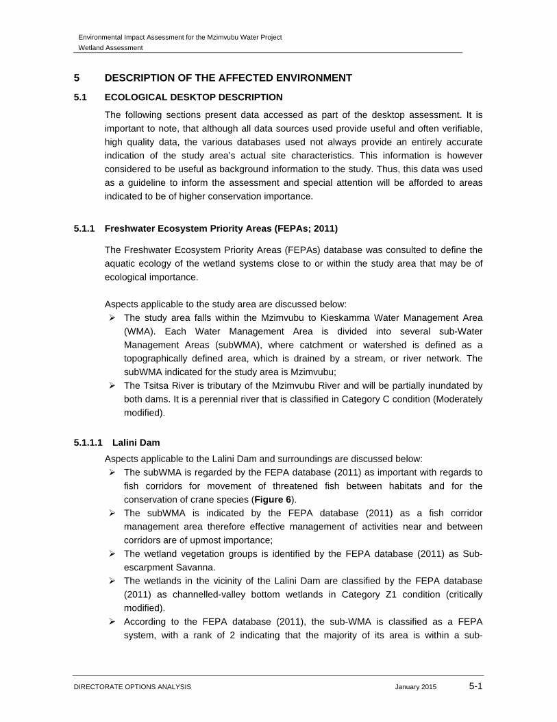
Uplands Aquatic Ecoregion. Four WetVeg groups apply to the proposed Mzimvubu Water
Project area, namely Sub-Escarpment Grassland Group 5 (endangered), Sub-Escarpment
Grassland Group 6 (least concern), Sub-Escarpment Grassland Group 7 (critically
endangered) and Sub-Escarpment Savanna (endangered). These WetVeg groups are
depicted in Figure 8.
The results of the classification of the systems are illustrated in the table below.
Table 19: Classification system for the wetland and riparian features within the study area.
Level 3: Landscape unit Level 4: Hydrogeomorphic (HGM) unit
HGM Type Longitudinal zonation / landform / Inflow drainage
Valley floor: The base of a valley, situated between two distinct valley side-slopes.
Channelled valley-bottom wetland: a valley-bottom wetland with a river channel running through it.
Not applicable
Slope: an included stretch of ground that is not part of a valley floor, which is typically located on the side of a mountain, hill or valley.
Seep: a wetland area located on (gently to steeply) sloping land, which is dominated by the colluvial (i.e. gravity-driven), unidirectional movement of material down-slope. Seeps are often located on the side-slopes of a valley but they do not, typically, extend into a valley floor.
Without channelled outflow
Valley floor: The base of a valley, situated between two distinct valley side-slopes.
River: a linear landform with clearly discernible bed and banks, which permanently or periodically carries a concentrated flow of water.
Not applicable
Valley floor: The base of a valley, situated between two distinct valley side-slopes; and Bench (hilltop/saddle/shelf): an area of mostly level or nearly level high ground (relative to the broad surroundings), including hilltops/crests (areas at the top of a mountain or hill flanked by down-slopes in all directions), saddles (relatively high-lying areas flanked by down-slopes on two sides in one direction and up-slopes on two sides in an approximately perpendicular direction), and shelves/terraces/ledges
Depression: a landform with closed elevation contours that increases in depth from the perimeter to a central area of greatest depth, and within which water typically accumulates.
Unknown

Environmental Impact Assessment for the Mzimvubu Water Project
Wetland Assessment
DIRECTORATE OPTIONS ANALYSIS January 2015 5-7
Level 3: Landscape unit Level 4: Hydrogeomorphic (HGM) unit (relatively high-lying, localised flat areas along a slope, representing a break in slope with an up-slope one side and a down-slope on the other side in the same direction).
The features identified during the assessment where further divided into either wetland or
riparian habitat based on the characteristics as defined by the NWA No 36 of 1998,
provided below.
Wetland habitat is land which is transitional between terrestrial and aquatic systems
where the water table is usually at or near the surface, or the land is periodically covered
with shallow water, and which land in normal circumstances supports or would support
vegetation typically adapted to life in saturated soil (NWA; Act No. 36 of 1998).
Riparian habitat includes the physical structure and associated vegetation of the areas
associated with a watercourse which are commonly characterised by alluvial soils, and
which are inundated or flooded to an extent and with a frequency sufficient to support
vegetation of species with a composition and physical structure distinct from those of
adjacent land areas.
The rivers assessed (Tsitsa River, Inxu River and the unnamed tributaries of the Tsitsa
River) were defined as systems containing riparian habitat due to the presence of alluvial
soil as well as the presence of vegetation, with a composition and physical structure,
distinct from adjacent areas.
Although seep wetlands do not characteristically extend into a valley floor, they can be
further categorised at Level 4B by their outflow drainage characteristics, i.e. they can be
categorised into those “with channelled outflow” and those “without channelled outflow”
(Ollis et al., 2013). The seeps associated with the channelled valley bottom wetlands
identified within the study area are classified as “seeps without a channelled outflow”;
according to Ollis et al., (2013) seeps which abut a distinct river channel and which feed
into the channel via diffuse surface flow or subsurface flow without having a channelised
outlet from the seepage area to the adjacent channel should be classified as such.
In the sections that follow riparian habitat was assessed with use of the VEGRAI, Wetland
Function Assessment, and Wetland IHI. Wetland habitat was assessed with the use of
Wet-Health and the Wetland Function Assessment as described in Section 3.2 of this
report.
Environmental Impact Assessment for the Mzimvubu Water Project
Wetland Assessment
DIRECTORATE OPTIONS ANALYSIS January 2015 5-8
Figure 8: NFEPA WetVeg Groups applicable to the proposed Mzimvubu Water Project.

Environmental Impact Assessment for the Mzimvubu Water Project
Wetland Assessment
DIRECTORATE OPTIONS ANALYSIS January 2015 5-9
5.1.3 RIPARIAN HABITAT
5.1.3.1 Riparian Vegetation Response Index (VEGRAI)
The abundance and diversity of vegetation associated with the Tsitsa River and its various
tributaries was assessed at several sites along the river courses. In order to obtain an
overall VEGRAI rating for the Tsitsa River, the method was applied to all aquatic
biomonitoring points assessed, and a mean score was then calculated. In addition,
VEGRAI was applied at each of the aquatic sampling points along the Inxu River and the
smaller unnamed tributaries of the Tsitsa River. The results of these assessments are
presented in Table 20 below.
Table 20: Summary of results obtained from the VEGRAI assessment.
Riparian System / Sampling Point
VEGRAI Score (%) Riparian Vegetation PES
Tsitsa River 75.6 C
Inxu River (TS 5) 63.7 C
TS 2 & TS 3 75.0 C
TS 6 63.7 C
TS 9 57 D
The floral species composition of the riparian zone has undergone varying degrees of
modification, principally as a result of anthropogenic activities such as grazing of cattle,
harvesting of thatching grass and firewood, and sand winning. Incision and erosion of the
river banks in some areas has resulted in a loss of vegetation cover; in some areas the
loss is considered severe. Disturbances to the natural vegetation composition has resulted
in the proliferation of alien species such as Acacia mearnsii and Eucalyptus cameldulensis
in many sites although some indigenous woody species such as Salix mucronata remain
in the less disturbed areas. The non-woody component consisted of largely indigenous
species such as Arundinella nepalensis, Miscanthus junceus and Cyperus spp. Figures 9
to 11 show representative photographs of the riparian vegetation along the Tsitsa River.
Figure 9: Representative photographs of portions of the Tsitsa River, showing the proliferation of Acacia mearnsii within the riparian zone.
Environmental Impact Assessment for the Mzimvubu Water Project
Wetland Assessment
DIRECTORATE OPTIONS ANALYSIS January 2015 5-10
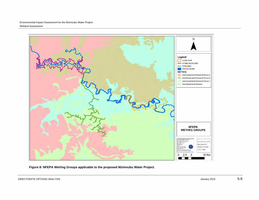
Figure 10: Representative photographs of portions of the Tsitsa River, showing largely natural vegetation cover.
Figure 11: Representative photographs showing severe incision and erosion of river banks (left) and sediment winning (right).
Riparian floral species composition was relatively homogenous along the Tsitsa and Inxu
Rivers, as well as along the unnamed tributaries of the Tsitsa River. Community structure
varied depending on the nature of impacts experienced at each site as discussed above.
Species identified in the regions of the proposed Ntabelanga and Lalini Dams are
presented in the tables below. Floral species composition was similar along the tributaries,
and therefore it is not presented separately.
Table 21: Riparian floral species identified in the Ntabelanga Dam site. Alien species are indicated with an asterisk.
Terrestrial zone Seasonal / temporary zone Permanent zone
*Acacia baileyana Andropogon contortus Phragmites australis
Acacia karroo *Cynodon dactylon Schoenoplectus corymbosus
*Acacia dealbata Eragrostis curvula Typha capensis
*Acacia mearnsii Eragrostis gummiflua Bulbostylis hispidula
Acacia polycantha Hyparrhenia hirta
Environmental Impact Assessment for the Mzimvubu Water Project
Wetland Assessment
DIRECTORATE OPTIONS ANALYSIS January 2015 5-11
Terrestrial zone Seasonal / temporary zone Permanent zone
Helichrysum cerastioides Paspalum dilatatum
Helichrysum nudifolium Persicaria serrulata
Helichrysum krebsianum Persicaria attenuata
Hyparrhenia hirta Phragmites australis
Senecio decurrens Schoenoplectus corymbosus
*Taraxicum officinale Sporobulus africanus
Typha capensis
Table 22: Riparian floral species identified in the Lalini Dam site. Alien species are indicated with an asterisk.
Terrestrial zone Seasonal / temporary zone Permanent zone
Acacia karroo *Cynodon dactylon Phragmites australis
*Acacia mearnsii Hypoxis hemerocallidea Schoenoplectus corymbosus
Acacia polycantha Persicaria serrulata Typha capensis
Asparagus laricinus Persicaria attenuata
Combretum erythrophyllum Phragmites australis
*Eucalyptus grandis Schoenoplectus corymbosus
*Eucalyptus camaldulensis Typha capensis
Gynmosporia senegalensis
Searsia pyroides
Senecio decurrens
*Taraxicum officinale
5.1.3.2 Wetland Function Assessment
The function and service provision was calculated for the Tsitsa River and the various
tributaries according to the characteristics discussed in Section 3.2.3 of this report. The
detailed results of the assessment are presented in Appendix A of this report. Table 23
presents a summary of the results obtained.
Table 23: Summary of wetland function (Wet-Ecoservices) results obtained for the Tsitsa River and tributaries.
Riparian System / Sampling Point Ecoservices score Ecoservices Category
Tsitsa River 2.3 Moderately High
TS 2 & TS3 2.2 Moderately High
Inxu River (TS5 site) 2.2 Moderately High
TS 6 2.2 Moderately High
TS 9 2.2 Moderately High

Environmental Impact Assessment for the Mzimvubu Water Project
Wetland Assessment
DIRECTORATE OPTIONS ANALYSIS January 2015 5-12
The results of this assessment indicate that the Tsitsa River and the tributaries assessed
are considered to have moderately high levels of ecological service provision, with specific
mention of sediment trapping capabilities. It is also clear that the rivers are considered to
be of value in terms of erosion control, assimilation of nutrients and toxicants originating in
the catchment, and for its flood attenuation capabilities.
The most important socio-cultural service provided by the rivers at present is their potential
to provide water to the surrounding communities, as the supply of potable water is
currently very limited due to the remoteness of many of these communities. It should be
noted that the scores obtained in the assessments for water supply for human use,
harvestable resources and cultivated foods were increased due to the location of the rivers
within rural communal areas, where substitutability for these resources is deemed to be
relatively low under present conditions.
Wetlands (and riparian areas) contribute to the maintenance of biodiversity through the
provision of habitat and maintenance of natural processes. The integrity of a wetland or
riparian feature contributes strongly to the capacity of such a feature to provide this
benefit, in addition to specific attributes such as the presence of threatened faunal or floral
species (Kotze et al., 2009). The Tsitsa River and its tributaries are considered to have
marginally high levels of biodiversity maintenance primarily due to the presence of
threatened species such as Balearica pavonina (Grey Crowned Crane), Sagittarius
serpentarius (Secretary Bird) and Podocarpus sp. as observed during the site
assessments. Furthermore the potential of the river to provide breeding and foraging
habitat for a number of faunal species is considered relatively high due to the connectivity
of the river to other natural features within the catchment.
In summary the Tsitsa River and the tributaries assessed are deemed to have
conservation value due to the moderately high levels of ecological and socio-cultural
services provided by the feature.
5.1.3.3 WET-IHI
The WET-IHI method (as discussed in Section 3.2.4) was applied to the Tsitsa River and
the tributaries in order to ascertain the PES of the river systems. WET-IHI assesses four
modules, namely hydrology, geomorphology, water quality and vegetation (Appendix B).
The results of the assessments are summarised in Table 24.
Table 24: Results of the WET-IHI assessment applied to the Tsitsa River.
Riparian System / Sampling Point WET-IHI Score (%) PES Category
Tsitsa River 76.7 C
TS2 & TS3 73.3 C
Inxu River (TS5) 75.9 C
TS6 76.2 C
TS9 76.7 C

Environmental Impact Assessment for the Mzimvubu Water Project
Wetland Assessment
DIRECTORATE OPTIONS ANALYSIS January 2015 5-13
These results indicate that the PES of the Tsitsa River as well as that of the tributaries
assessed is Category C (moderately modified; loss and change of natural habitat and
biota have occurred, but the basic ecosystem functions are still predominantly
unchanged).
Geomorphology is considered to have undergone greater levels of transformation than
hydrology, water quality and vegetation. This is attributed to the severity of river bank
incision observed in sections of the river courses both during the site assessments and on
digital satellite imagery, and the increased sediment inputs as a result of this erosion.
Furthermore, it is deemed highly likely that due to the extensive erosion within the
catchment, particularly within the drainage lines feeding into the rivers, that the sediment
regime is significantly altered (Figure 12).
Figure 12: Representative photographs showing examples of the typical erosion patterns within the catchment.
The hydrology of the systems are deemed to be in a relatively natural state, having
obtained scores in all assessments which placed it in a PES Category B/C. Primary
impacts on the rivers include altered channel size and competency as a result of erosion
of the banks, and stands of alien invasive species such as Acaci mearnsii and Eucalyptus
cameldulensis resulting in localised reduction of water inputs to the river due to on site
water usage by these species. Small scale abstraction for domestic use in neighbouring
rural homesteads and for subsistence farming is also responsible for a slight reduction of
water although the levels of abstraction are not considered significant within the context of
the catchment. Additional modifications to the hydrology include flow-modifying
infrastructure within the river, such as weirs, support structures for bridges and gabions
(Figure 13).

Environmental Impact Assessment for the Mzimvubu Water Project
Wetland Assessment
DIRECTORATE OPTIONS ANALYSIS January 2015 5-14
Figure 13: Representative photographs of the Tsitsa River showing flow modifying infrastructure such as gabions (left) and bridges (right).
The water quality and physico-chemical characteristics of the Tsitsa River is discussed in
greater detail in the Water Quality Study (SAS, 2014); however based on the information
in that report and for the purposes of this assessment, the water quality was considered to
be relatively good, and therefore obtained a score placing it in a PES Category B/C.
Impacts on water quality are considered to be relatively low and are primarily domestic in
nature, as the rivers are utilised by the surrounding communities for washing and bathing.
The water can be considered suitable for use for domestic supply, if treated, and in
support of an aquatic community of high diversity and sensitivity.
The riparian vegetation, as discussed in Section 5.1.2 of this report, has undergone
varying degrees of modification due to factors such as grazing, trampling by domestic
livestock, and harvesting of woody species for use as firewood or fencing. As a result,
floral species composition of the vegetation communities has been altered, and
encroachment by alien invasive species is considered serious in some sections of the
rivers, although in relation to the catchment size the encroachment is not considered
severe.
5.1.3.4 Ecological Importance and Sensitivity (EIS)
The EIS assessment was applied to the Tsitsa River in order to determine the ecological
importance and sensitivity of the river. The results obtained indicate that due to the
presence of suitable breeding and foraging habitat for a number of faunal species of
conservation concern, the high level of integrity of the river and levels of ecological service
provision, the Tsitsa River and the tributaries assessed are deemed to be in an EIS
Category B. Systems in this category are considered to be highly ecologically important
and sensitive on a national – sometimes international – level. Biodiversity of these
systems are usually highly sensitive to habitat and flow modifications. The results of the
assessment are summarised in Table 25 and are presented in detail in Appendix D.

Environmental Impact Assessment for the Mzimvubu Water Project
Wetland Assessment
DIRECTORATE OPTIONS ANALYSIS January 2015 5-15
Table 25: Results of the EIS Assessments applied to the Tsitsa River and the tributaries.
Riparian System / Sampling Point EIS Score EIS Category
Tsitsa River 2.89 B
TS2 & TS3 2.67 B
Inxu River (TS5) 2.67 B
TS6 2.67 B
TS9 2.56 B
5.1.3.5 Recommended Ecological Category (REC)
The results of the VEGRAI, wetland function, WET-IHI and EIS assessments were used to
determine the REC of the Tsitsa River. The results obtained from these assessments
indicate that the Tsitsa River is considered to be in a largely natural condition, although
impacts to the riparian zone arising from anthropogenic activities have resulted in
modifications on a localised scale. Furthermore, the relatively high integrity of the river
increases its ability to provide essential ecological and socio-cultural services. For these
reasons, an REC B/C was assigned to the Tsitsa River; however it should be noted that
the aquatic ecological integrity of the resource is deemed to have undergone lower levels
of transformation than the riparian zone, thus should be managed accordingly to maintain
the good condition of the river.
The tributaries of the Tsitsa River which were assessed were shown to be in a PES C, and
due to their importance in terms of providing important ecological functions such as
suitable habitat for a number of faunal and floral species, are considered to be in an EIS
Category B. An REC B/C was therefore assigned to these systems, and suitable
management measures should be implemented to prevent further deterioration, and where
possible improve the condition, of these systems.
5.1.4 WETLAND HABITAT
Aside from the rivers, four basic HGM units were identified within the study area, namely
channelled valley bottom, hillslope seeps, depressions and drainage lines. A few artificial
dams were identified during desktop inspection of digital satellite imagery; however as
these are unlikely to be impacted upon by the construction of the proposed Ntabelanga
and Lalini dams and their associated infrastructure, the artificial dams were not assessed.
The wetland features in relation to the Ntabelanga and Lalini dam sites, and in relation to
the roads and pipelines, are conceptually presented in Figures 14 to 16 below.
Due to the extent of the study area, the numerous wetland features present, and the
relatively homogeneous characteristics of the wetland features, the features were grouped
into HGM units for the purposes of assessment, and were not assessed as individual
wetland features. It should be noted that although the wetland features identified may
extend outside of the study area, only the portions located within the study area were

Environmental Impact Assessment for the Mzimvubu Water Project
Wetland Assessment
DIRECTORATE OPTIONS ANALYSIS January 2015 5-16
assessed and ground truthed. Nonetheless, the potential impacts of activities such as
irrigation agriculture, extensive erosion and clearing of natural vegetation within the
greater catchment were taken into consideration during the assessment. If the assessment
was applied on a broader scale results may have differed, however the assessment and
the scale used is considered the most applicable to the study for the proposed Mzimvubu
Water Project and the assessment addresses all habitat units and wetland resources to be
directly affected by the project. Since a Section 21 c & i WUL will be applied for and due to
the vast extent of the various components of the project mapping of wetlands did not take
place to inform regulation GN1199 of the NWA.
Environmental Impact Assessment for the Mzimvubu Water Project
Wetland Assessment
DIRECTORATE OPTIONS ANALYSIS January 2015 5-17
Figure 14: Wetland features identified within the study area, in relation to the proposed Ntabelanga Dam site.
Environmental Impact Assessment for the Mzimvubu Water Project
Wetland Assessment
DIRECTORATE OPTIONS ANALYSIS January 2015 5-18
Figure 15: Wetland features identified within the study area, in relation to the proposed Lalini Dam site.
Environmental Impact Assessment for the Mzimvubu Water Project
Wetland Assessment
DIRECTORATE OPTIONS ANALYSIS January 2015 5-19
Figure 16: Wetland features identified within the study area, in relation to the proposed roads and pipelines associated with the Mzimvubu Water Project.

Environmental Impact Assessment for the Mzimvubu Water Project
Wetland Assessment
DIRECTORATE OPTIONS ANALYSIS January 2015 5-20
5.1.4.1 Wetland Vegetation
Wetland vegetation was relatively homogenous throughout the study area, with many
species common to all HGM units, regardless of factors such as altitude, local topography,
etc. Differences in species composition were however noticeable where wetlands had
been subjected to disturbances such as historical and/or current agricultural activities,
sand winning or over-utilisation of vegetation by domestic livestock.
The wetland species identified in the wetland areas throughout the study area are
presented in Table 26.
Table 26: Wetland floral species identified in the wetland areas throughout the study area. Alien species are indicated with an asterisk.
Terrestrial Temporary Seasonal Permanent
Aristida congesta subsp. congesta Arundinella nepalensis Brachyaria sp. Cyperus longus
Aristida congesta subsp. barbicolus Andropogon contortus Cyperus mariscus Leersia hexandra
Berkheya bergiana Cymbopogon sp. Cyperus longus Miscanthus junceus
Chloris virgata Cyperus mariscus Helichrysum sp. Miscanthus capensis
*Cynodon dactylon Eragrostis chloromelas Imperata cylindrica Phragmites australis
Dactyloctenium giganteum Eragrostis gummiflua Miscanthus junceus Schoenoplectus corymbosus
Datura sp Eragrostis plana Persicaria attenuata Typha capensis
Helichrysum cerastioides Imperata cylindrica Persicaria serrulata
Helichrysum krebsianum Paspalum dilatatum Phragmites australis
Helichrysum nudifolium Setaria sphacelata var. sericea
Schoenoplectus brachycerus
Hyparrhenia hirta Sporobulus festivus Schoenoplectus
corymbosus
Hyparrhenia hirta Sporobuls africana
Paspalum dilitatum Typha capensis
Senecio decurrens
5.1.4.2 Drainage Lines
Numerous drainage line features were identified throughout the study area, and were
considered to be wetland features due to the prolonged presence of water throughout the
year, which has resulted in the formation of wetland characteristics as defined by the NWA
(1998). This includes the presence of obligate and facultative vegetation, the presence of
gleyed soils, and the degree of soil saturation noted within the soil samples.
Representative photographs of the drainage lines are presented in Figure 17 below.

Environmental Impact Assessment for the Mzimvubu Water Project
Wetland Assessment
DIRECTORATE OPTIONS ANALYSIS January 2015 5-21
Figure 17: Representative photographs of drainage line features within the study area.
Wetland Function Assessment
The drainage line features are considered particularly important in terms of sediment
trapping, and obtained a score of 3.2 (High) for this function. This capacity to filter
sediment prior to water entering the river system is especially important in the context of
the extensive and often severe erosion in the catchment. Furthermore, the drainage lines
are considered valuable in terms of water supply into the river systems. The potential
capacity of the drainage lines to assimilate phosphate, nitrates and other toxicants is
deemed to be moderately high.
The drainage lines are not necessarily suitable hosts for a diverse faunal assemblage;
however they are nonetheless deemed to be important for biodiversity maintenance as
they provide suitable habitat for smaller faunal species such as amphibians and avifauna.
Furthermore, they contribute to the overall integrity of the site through the provision of
essential ecological services such as streamflow regulation. These systems are deemed
to be of conservation value.
Whilst some of the drainage line features may be ephemeral, those observed during the
site assessments in April and June 2014 contained surface water. Local residents were
observed utilising this water for domestic purposes, and therefore the features are
considered to hold socio-cultural value. Additionally, their potential to provide harvestable
resources such as reeds for weaving, and where the terrain allows, to grow subsistence
crops, is considered moderately high.
In summary, the drainage line features obtained an overall score of 1.9 in the wetland
function assessment, indicating intermediate importance for the provision and
maintenance of ecological and socio-cultural services. The detailed results of the wetland
function assessment are presented in Appendix A of this report.
WET-IHI Assessment

Environmental Impact Assessment for the Mzimvubu Water Project
Wetland Assessment
DIRECTORATE OPTIONS ANALYSIS January 2015 5-22
The WET-IHI method as described by DWAF (2007) was applied to ascertain the PES of
the drainage line features. Table 27 below illustrates the results of this assessment.
Table 27: Summary of results obtained from the WET-IHI assessment applied to the drainage line features.
OVERALL PRESENT ECOLOGICAL STATE (PES) SCORE
Ranking Weighting Score Confidence Rating
PES Category
DRIVING PROCESSES: 100 1,7
Hydrology 1 100 1,1 3,0 B/C
Geomorphology 2 80 2,8 3,8 D
Water Quality 3 30 0,8 2,0 B
WETLAND LANDUSE ACTIVITIES: 80 0,9 3,7
Vegetation Alteration Score 1 100 0,9 3,7 B/C
OVERALL SCORE: 1,4 Confidence
Rating
PES % 72,8
PES Category: C 1,6
The results of the assessment indicates that the drainage lines can be considered to be in
a PES Category C, indicating that they have undergone moderate levels of modification;
however basic ecosystem functions and process remain. Due to the scale at which the
assessment was applied, and the variability of conditions in different sections of the study
area, it should be noted that some features may be considered to be in a slightly healthier
or inferior condition in comparison to others. Nonetheless, the result obtained is
considered to be an accurate indication of the overall condition of the drainage line
features observed and evaluated during both site assessments.
As shown in Table 27 above, the hydrology of the drainage lines is considered overall to
be in a relatively natural state, having obtained a score placing it in a PES Category B/C.
Ecological Importance and Sensitivity (EIS)
The EIS assessment was applied to the drainage lines to ascertain their perceived
ecological importance and sensitivity to habitat and flow modifications. The results of the
assessment are presented in Table 28 below.
Table 28: Results of the EIS Assessment applied to the drainage line features.
Determinant Score Confidence
PRIMARY DETERMINANTS
1. Rare & Endangered Species 2 4
2. Populations of Unique Species 1 4
3. Species/taxon Richness 1 3
4. Diversity of Habitat Types or Features 1 3 5. Migration route/breeding and feeding site for wetland species 2 3
6. PES as determined by WET-Health assessment 3 4
Environmental Impact Assessment for the Mzimvubu Water Project
Wetland Assessment
DIRECTORATE OPTIONS ANALYSIS January 2015 5-23
Determinant Score Confidence
7. Importance in terms of function and service provision 2 4
MODIFYING DETERMINANTS
8. Protected Status according to NFEPA Wetveg 4 4
9. Ecological Integrity 2 4
TOTAL 18
MEAN 2
OVERALL EIS C
The score obtained indicates that the drainage lines fall within an EIS Category C; i.e. they
are considered ecologically important and sensitive on a localised or potentially provincial
scale. Biodiversity of these features is unlikely to be sensitive to flow and habitat
modifications.
Recommended Ecological Category (REC)
Whilst the EIS assessment indicated that the drainage lines are considered highly
ecologically important and sensitive, the ecological integrity of the features has undergone
transformation, lowering the integrity of the features. Thus, an REC C is deemed
appropriate to maintain the features in their Present State.
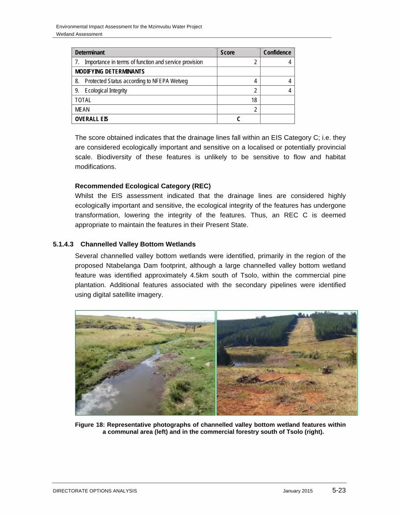
5.1.4.3 Channelled Valley Bottom Wetlands
Several channelled valley bottom wetlands were identified, primarily in the region of the
proposed Ntabelanga Dam footprint, although a large channelled valley bottom wetland
feature was identified approximately 4.5km south of Tsolo, within the commercial pine
plantation. Additional features associated with the secondary pipelines were identified
using digital satellite imagery.
Figure 18: Representative photographs of channelled valley bottom wetland features within a communal area (left) and in the commercial forestry south of Tsolo (right).

Environmental Impact Assessment for the Mzimvubu Water Project
Wetland Assessment
DIRECTORATE OPTIONS ANALYSIS January 2015 5-24
Wetland Function Assessment Although channelled valley bottom wetlands are generally considered to contribute less towards sediment trapping when compared to other HGM units such as floodplains (Kotze et al., 2009), the extent and severity of erosional features within the study area and the greater catchment increases the potential to provide this function. Thus, sediment trapping is considered to be the most important ecological service provided by the channelled valley bottom wetland features identified in the study area. Their potential capacity in terms of nutrient cycling and toxicant assimilation was also considered to be moderately high. Due to the steep terrain on which many of these features are located, flood attenuation is deemed an important function of these wetland features. As with the drainage lines, these wetland features are deemed to have conservation value in terms of their contribution to streamflow regulation, contributing to the sustenance of downstream flow of the Tsitsa River and its tributaries during low flow periods. Biodiversity maintenance obtained a moderately high score, largely due to the presence of suitable habitat within the wetland features for water-dependent species, particularly water birds. These features are located within a catchment area identified by NFEPA as having sightings and/or suitable breeding habitat for the threatened Anthropoides paradiseus (Blue Crane) and Balearica pavonina (Grey Crowned Crane) thus increasing their conservation value and contribution towards biodiversity maintenance. Socio-cultural functions supplied by the channelled valley bottom wetland features include provision of water for domestic use by surrounding communities, harvestable resources and cultivated foods such as Zea mays. Whilst tourism and education and research did not obtain high scores during the assessment, the aesthetic value and relatively natural condition of the wetlands means that they do have potential to be utilised for these purposes. In summary, the overall score obtained for the wetland function assessment of the channelled valley bottom wetland features was 2.1, indicating a moderately high contribution towards ecological and socio-cultural service provision. The results of this assessment are contained in Appendix A of this report. Wet-Health Assessment As described in Section 3.2.5 of this report, the PES of the channelled valley bottom wetland features was assessed using the method described by Macfarlane et al. (2008). The method evaluates three modules, namely hydrology, geomorphology and vegetation, in order to obtain an indication of the ‘health’ of the features, and an area weighted score obtained. The results of this assessment are illustrated in Table 29.
Table 29: Summary of results obtained from the Wet-Health assessment of the channelled valley bottom wetland features.
Hydrology Geomorphology Vegetation
Impact Score Trajectory of
change Impact Score Trajectory of change Impact Score
Trajectory of change

Environmental Impact Assessment for the Mzimvubu Water Project
Wetland Assessment
DIRECTORATE OPTIONS ANALYSIS January 2015 5-25
C ↓ C ↓ C ↓
The overall score which aggregates the scores for the three modules, namely hydrology,
geomorphology and vegetation, was calculated using the formula 7 as provided by the
Wet-Health methodology. These wetland features obtained a score of 3.3, placing them in
a PES Category C (moderately modified; a moderate change in ecosystem processes and
loss of natural habitats has taken place but the natural habitat remains predominantly
intact).
Hydrology in the features has been modified as a result of flow-modifying structures such
as weirs within the channels, as well as anthropogenic activities such as abstraction of
water for crop growing. Small-scale abstraction of water from the features associated with
the proposed Ntabelanga Dam for subsistence farming is considered likely, as is
increased on-site water usage by the commercially grown Pinus spp from the feature
located within the forestry south of Tsolo. Further, the inherent susceptibility of the soils to
erosion combined with sand winning have resulted in channel widening, thus altering the
transport capacity of the wetlands. However, changes to water input volumes and
distribution and retention of water passing through the wetlands are not considered to be
greatly changed from natural conditions.
Geomorphology of the features has been impacted by erosional processes, as evidenced
by stream bank incision in several locations. These processes contribute to increased
sediment inputs to the wetland features, altering channel size as discussed above. These
processes along with activities such as sediment mining, are also responsible for
modifications to existing channels, such as stream shortening and creation of artificial
drainage channels to divert water to crops.
The structure and species composition of floral communities associated with the
channelled valley bottom wetland features has been altered to some extent by removal of
vegetation, grazing, and trampling by domestic livestock. As with the riparian vegetation,
encroachment by alien invader species such as Acacia mearnsii is evident in some areas
of the wetland features although it is not extensive at this time.
The anticipated trajectory of change in integrity for all three modules based on current
conditions is a gradual, slight decrease over the next five years. Activities related to the
construction of the proposed Ntabelanga Dam and the infrastructure associated with both
this and the Lalini Dam, do however pose a threat to the overall integrity and condition of
the wetland features particularly those in the vicinity of the proposed Ntabelanga Dam
footprint.
Ecological Importance and Sensitivity (EIS)
7 ((Hydrology score) x 3 + (geomorphology score) x2 + (vegetation score) x 2))/ 7 = PES

Environmental Impact Assessment for the Mzimvubu Water Project
Wetland Assessment
DIRECTORATE OPTIONS ANALYSIS January 2015 5-26
The EIS assessment applied to the channelled valley bottom wetland features indicates
that the features fall within an EIS Category B. Such features are considered to be highly
ecologically important and sensitive, and biodiversity of these features is likely to be
sensitive to flow and habitat modifications. The results of this assessment are presented
below.
Table 30: Results of the EIS Assessment applied to the channelled valley bottom wetland features.
Determinant Score Confidence
PRIMARY DETERMINANTS
1. Rare & Endangered Species 3 4
2. Populations of Unique Species 2 4
3. Species/taxon Richness 2 3
4. Diversity of Habitat Types or Features 2 3 5. Migration route/breeding and feeding site for wetland species 2 3
6. PES as determined by WET-Health assessment 3 4
7. Importance in terms of function and service provision 3 4
MODIFYING DETERMINANTS
8. Protected Status according to NFEPA Wetveg 4 4
9. Ecological Integrity 2 4
TOTAL 23
MEAN 2,56
OVERALL EIS B
Recommended Ecological Category (REC)
Whilst the ecological importance and sensitivity of the channelled valley bottom wetland
features is deemed to be slightly higher than their PES, an REC C was assigned.
Appropriate management measures should be implemented in order to prevent further
degradation to the ecological integrity and overall condition of these features, and where
possible, to improve their condition.
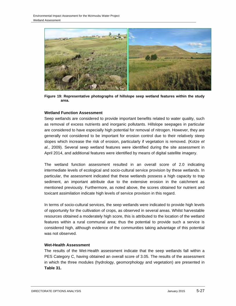
5.1.4.4 Hillslope and Seasonal Seep Wetlands
According to Ollis et al., (2013) seeps are characterised by their association with
geological formations and topographic positions, which result in groundwater discharging
to the land surface, or rain-derived water “seeping” down-slope as subsurface interflow.
Seeps can occur in relatively flat or very gently sloping landscapes, provided that there is
sufficient slope for there to be a uni-directional subsurface flow of water. Several such
seeps were identified within the study area; the majority are associated with the pipelines
or roads. However, two seep wetlands were identified within the proposed Ntabelanga
Dam footprint towards the western end of the dam and careful mitigation should be
implemented to limit the impacts on the portions of these wetlands that are not
submerged.
Environmental Impact Assessment for the Mzimvubu Water Project
Wetland Assessment
DIRECTORATE OPTIONS ANALYSIS January 2015 5-27
Figure 19: Representative photographs of hillslope seep wetland features within the study area.
Wetland Function Assessment
Seep wetlands are considered to provide important benefits related to water quality, such
as removal of excess nutrients and inorganic pollutants. Hillslope seepages in particular
are considered to have especially high potential for removal of nitrogen. However, they are
generally not considered to be important for erosion control due to their relatively steep
slopes which increase the risk of erosion, particularly if vegetation is removed. (Kotze et
al., 2009). Several seep wetland features were identified during the site assessment in
April 2014, and additional features were identified by means of digital satellite imagery.
The wetland function assessment resulted in an overall score of 2.0 indicating
intermediate levels of ecological and socio-cultural service provision by these wetlands. In
particular, the assessment indicated that these wetlands possess a high capacity to trap
sediment, an important attribute due to the extensive erosion in the catchment as
mentioned previously. Furthermore, as noted above, the scores obtained for nutrient and
toxicant assimilation indicate high levels of service provision in this regard.
In terms of socio-cultural services, the seep wetlands were indicated to provide high levels
of opportunity for the cultivation of crops, as observed in several areas. Whilst harvestable
resources obtained a moderately high score, this is attributed to the location of the wetland
features within a rural communal area; thus the potential to provide such a service is
considered high, although evidence of the communities taking advantage of this potential
was not observed.
Wet-Health Assessment
The results of the Wet-Health assessment indicate that the seep wetlands fall within a
PES Category C, having obtained an overall score of 3.05. The results of the assessment
in which the three modules (hydrology, geomorphology and vegetation) are presented in
Table 31.
Environmental Impact Assessment for the Mzimvubu Water Project
Wetland Assessment
DIRECTORATE OPTIONS ANALYSIS January 2015 5-28
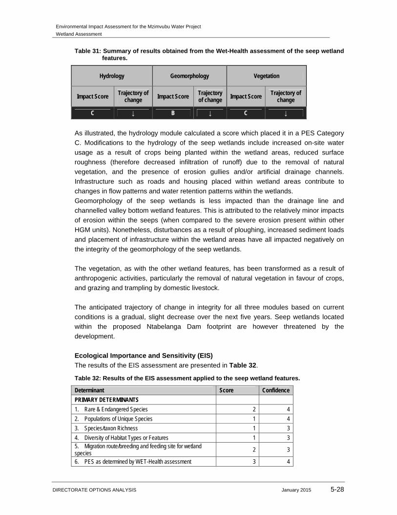
Table 31: Summary of results obtained from the Wet-Health assessment of the seep wetland features.
Hydrology Geomorphology Vegetation
Impact Score Trajectory of change Impact Score Trajectory
of change Impact Score Trajectory of change
C ↓ B ↓ C ↓
As illustrated, the hydrology module calculated a score which placed it in a PES Category
C. Modifications to the hydrology of the seep wetlands include increased on-site water
usage as a result of crops being planted within the wetland areas, reduced surface
roughness (therefore decreased infiltration of runoff) due to the removal of natural
vegetation, and the presence of erosion gullies and/or artificial drainage channels.
Infrastructure such as roads and housing placed within wetland areas contribute to
changes in flow patterns and water retention patterns within the wetlands.
Geomorphology of the seep wetlands is less impacted than the drainage line and
channelled valley bottom wetland features. This is attributed to the relatively minor impacts
of erosion within the seeps (when compared to the severe erosion present within other
HGM units). Nonetheless, disturbances as a result of ploughing, increased sediment loads
and placement of infrastructure within the wetland areas have all impacted negatively on
the integrity of the geomorphology of the seep wetlands.
The vegetation, as with the other wetland features, has been transformed as a result of
anthropogenic activities, particularly the removal of natural vegetation in favour of crops,
and grazing and trampling by domestic livestock.
The anticipated trajectory of change in integrity for all three modules based on current
conditions is a gradual, slight decrease over the next five years. Seep wetlands located
within the proposed Ntabelanga Dam footprint are however threatened by the
development.
Ecological Importance and Sensitivity (EIS)
The results of the EIS assessment are presented in Table 32.
Table 32: Results of the EIS assessment applied to the seep wetland features.
Determinant Score Confidence
PRIMARY DETERMINANTS
1. Rare & Endangered Species 2 4
2. Populations of Unique Species 1 4
3. Species/taxon Richness 1 3
4. Diversity of Habitat Types or Features 1 3 5. Migration route/breeding and feeding site for wetland species 2 3
6. PES as determined by WET-Health assessment 3 4

Environmental Impact Assessment for the Mzimvubu Water Project
Wetland Assessment
DIRECTORATE OPTIONS ANALYSIS January 2015 5-29
Determinant Score Confidence
7. Importance in terms of function and service provision 2 4
MODIFYING DETERMINANTS
8. Protected Status according to NFEPA Wetveg 4 4
9. Ecological Integrity 2 4
TOTAL 18
MEAN 2,00
OVERALL EIS C
As shown above, the seep wetlands are considered to be in an EIS Category C. Wetlands
in this category are likely to be considered ecologically important and sensitive on a local
or provincial scale, although biodiversity is unlikely to be sensitive to habitat and flow
modifications.
Recommended Ecological Category (REC)
The results of the wetland function, WET-Health and EIS assessments indicate that the
seep wetland features are considered to be of a lower integrity and sensitivity in
comparison to the drainage lines and channelled valley bottom wetland features. It was
therefore deemed appropriate to assign an REC C to the seep wetland features.
5.1.4.5 Depression Wetlands
Depression wetlands are characterised by their closed (or near-closed) contour shape,
making them relatively easy to identify on topographic maps (Ollis et al., 2013) and digital
satellite imagery. Whilst only no depression wetlands were identified during the course of
the two site assessments in April and June 2014, several small depression wetland
features were identified with the aid of digital satellite imagery. For this reason, the wetland
function and WET-Health assessments were applied utilising the background information
relevant to the study area and catchment as well as wetland-specific information obtained
for the other wetland features evaluated (e.g. floral species composition). Digital satellite
imagery was utilised to ascertain the presence of modifying factors such as erosion gullies
or infrastructure within the depression wetland features.
Wetland Function Assessment
The depression wetland features obtained an overall score of 1.8 in the assessment,
indicating that they provide intermediate levels of ecological and socio-cultural services.
Due to the closed or near-closed contour characteristics of depression wetlands, they do
not contribute to streamflow regulation, however they are considered of value in terms of
flood attenuation capabilities, nutrient cycling and toxicant assimilation, and to some
extent, sediment trapping and erosion control.
The contribution of the depression wetlands to biodiversity maintenance, as with the other
HGM units assessed, is considered to be moderately high, due to the relatively
widespread “buffer zone” around the wetlands affording smaller wetland faunal species

Environmental Impact Assessment for the Mzimvubu Water Project
Wetland Assessment
DIRECTORATE OPTIONS ANALYSIS January 2015 5-30
suitable breeding and foraging habitat. Due to the small size of the depression wetlands
they are however considered unlikely to support large populations of conservation
important species.
Wet-Health Assessment
The results of the Wet-Health assessment indicate that the depression wetland features
fall in a PES Category C, having obtained an overall area-weighted score of 2.4. The
summary of results for each module assessed are illustrated in Table 33.
Table 33: Summary of results obtained from the Wet-Health assessment of the depression wetland features.
Hydrology Geomorphology Vegetation
Impact Score Trajectory of change
Impact Score Trajectory of change
Impact Score Trajectory of change
C ↓ B ↓ C ↓
The hydrology of the depression wetlands is likely to be impacted by factors such as
small-scale abstraction for domestic and agricultural use and increase on-site water use
due to alien vegetation encroachment.
Geomorphology, as with the seep wetland features, is considered to be in a largely natural
condition, as few modifications are apparent. It is however considered likely that the
severe erosion within the study area and greater catchment will have an effect on these
wetland features, particularly increased sediment load entering the wetland features with
runoff.
Based on information gleaned through the assessment of the other wetland features such
as the seeps and channelled valley bottoms, floral species composition and vegetation
community structure is deemed likely to have undergone transformation. Many of the
depression features are located within close proximity to rural settlements, thus is it
probable that natural vegetation removal in favour of crops will have occurred, as well as
grazing and trampling by domestic livestock.
The anticipated trajectory of change for these features is a slight deterioration in integrity
over the next five years, under current conditions. It is deemed unlikely that any of these
features will be negatively impacted by the proposed dam construction, provided suitable
mitigation measures are taken.
Ecological Important and Sensitivity (EIS)
The results of the EIS assessment applied to the depression wetland features are
presented in Table 34.
Environmental Impact Assessment for the Mzimvubu Water Project
Wetland Assessment
DIRECTORATE OPTIONS ANALYSIS January 2015 5-31
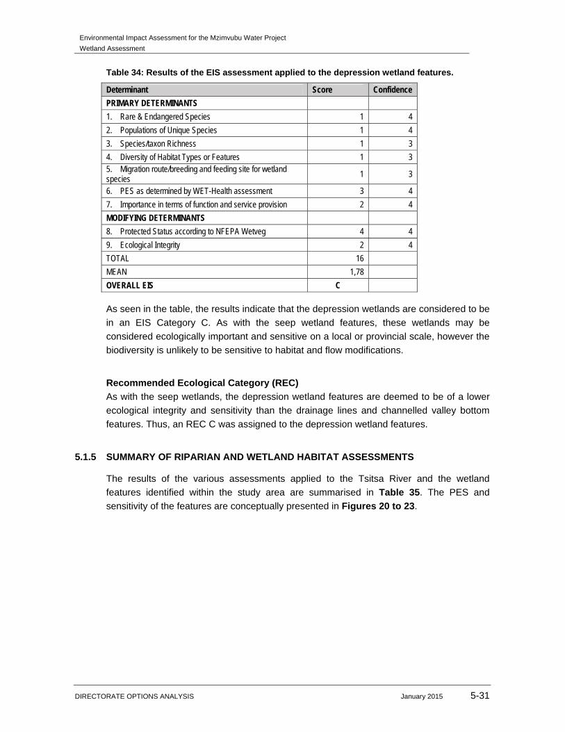
Table 34: Results of the EIS assessment applied to the depression wetland features.
Determinant Score Confidence
PRIMARY DETERMINANTS
1. Rare & Endangered Species 1 4
2. Populations of Unique Species 1 4
3. Species/taxon Richness 1 3
4. Diversity of Habitat Types or Features 1 3 5. Migration route/breeding and feeding site for wetland species 1 3
6. PES as determined by WET-Health assessment 3 4
7. Importance in terms of function and service provision 2 4
MODIFYING DETERMINANTS
8. Protected Status according to NFEPA Wetveg 4 4
9. Ecological Integrity 2 4
TOTAL 16
MEAN 1,78
OVERALL EIS C
As seen in the table, the results indicate that the depression wetlands are considered to be
in an EIS Category C. As with the seep wetland features, these wetlands may be
considered ecologically important and sensitive on a local or provincial scale, however the
biodiversity is unlikely to be sensitive to habitat and flow modifications.
Recommended Ecological Category (REC)
As with the seep wetlands, the depression wetland features are deemed to be of a lower
ecological integrity and sensitivity than the drainage lines and channelled valley bottom
features. Thus, an REC C was assigned to the depression wetland features.
5.1.5 SUMMARY OF RIPARIAN AND WETLAND HABITAT ASSESSMENTS
The results of the various assessments applied to the Tsitsa River and the wetland
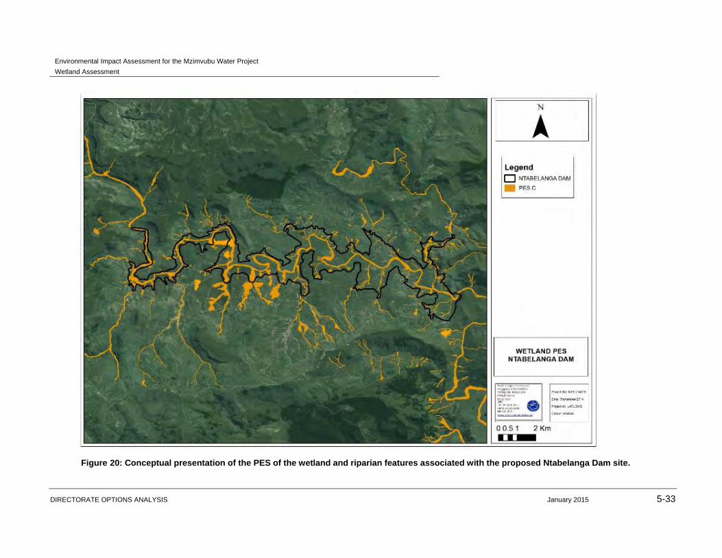
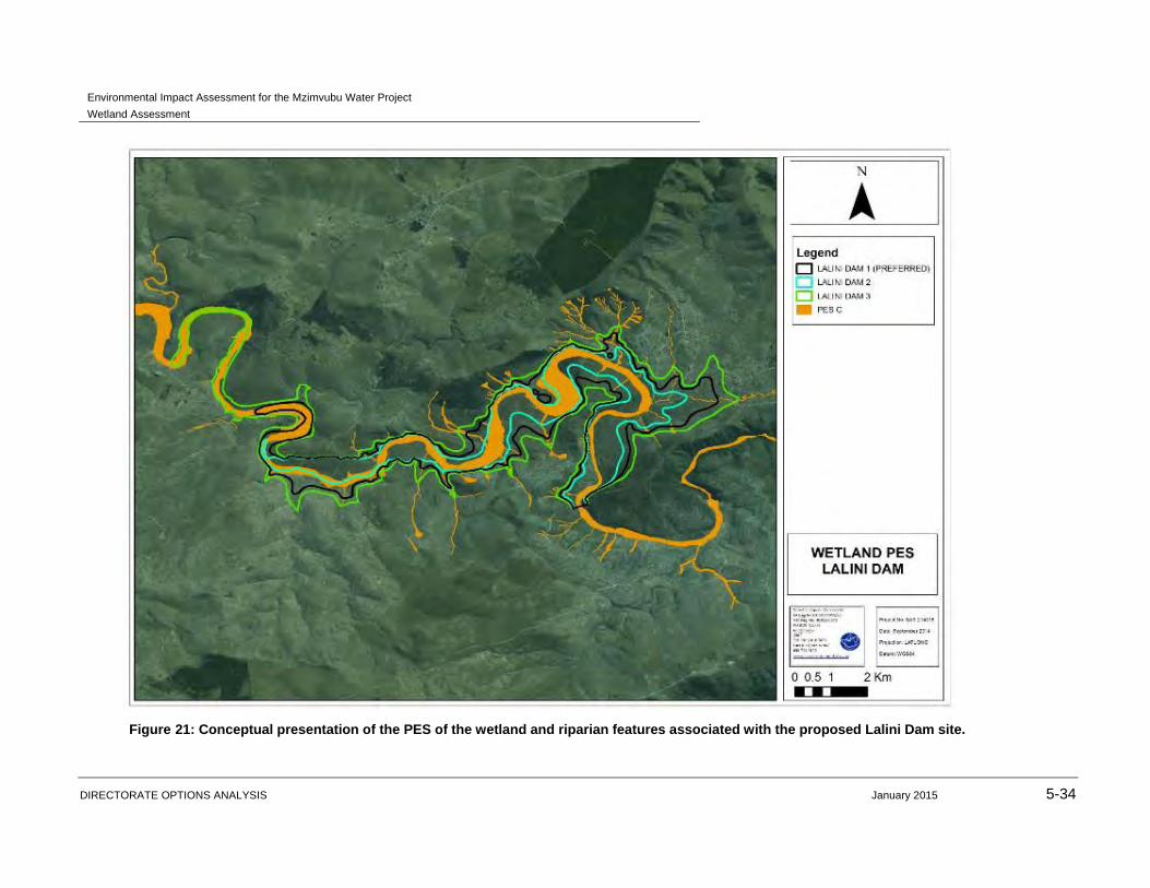
features identified within the study area are summarised in Table 35. The PES and
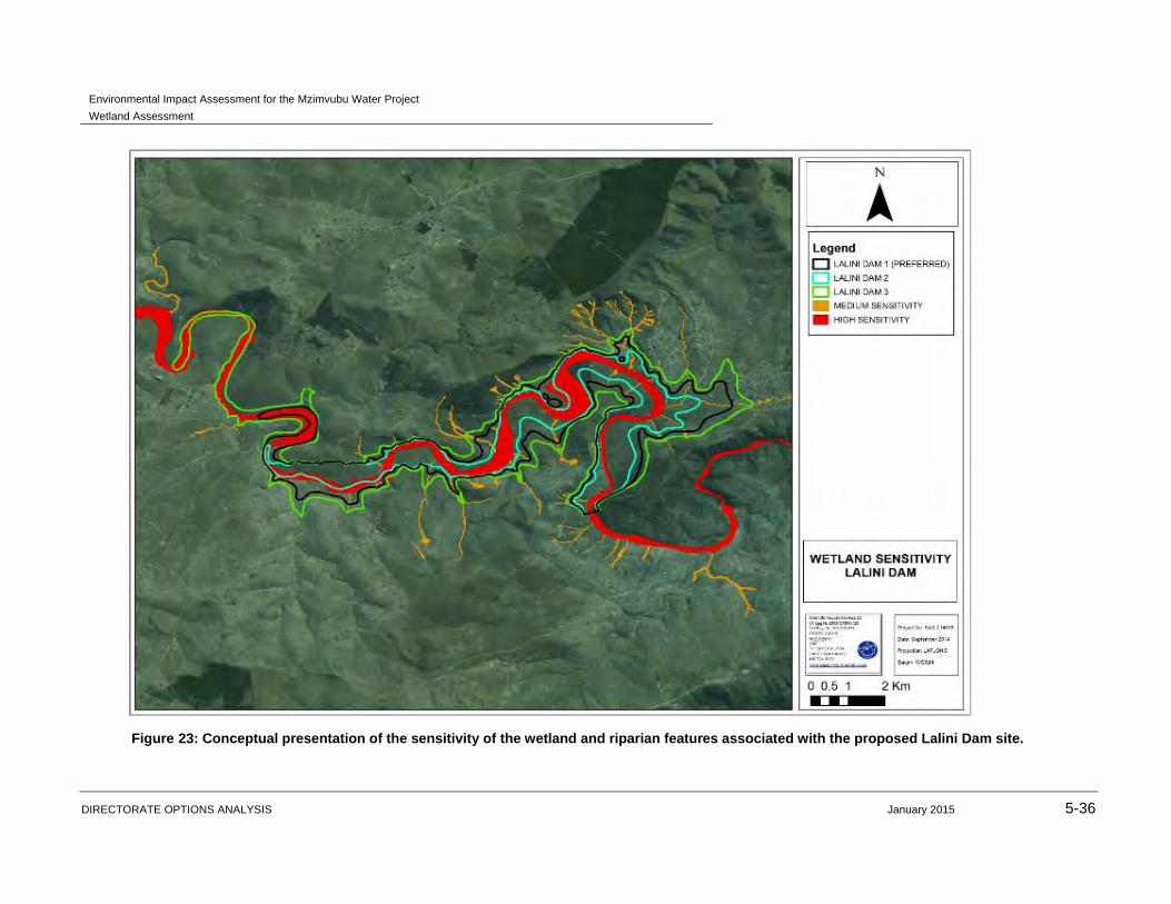
sensitivity of the features are conceptually presented in Figures 20 to 23.
Environmental Impact Assessment for the Mzimvubu Water Project
Wetland Assessment
DIRECTORATE OPTIONS ANALYSIS January 2015 5-32
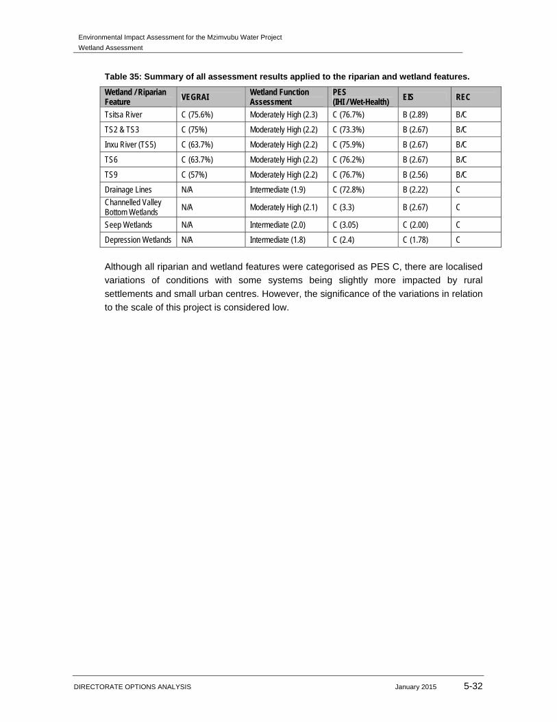
Table 35: Summary of all assessment results applied to the riparian and wetland features.
Wetland / Riparian Feature VEGRAI Wetland Function
Assessment PES (IHI / Wet-Health) EIS REC
Tsitsa River C (75.6%) Moderately High (2.3) C (76.7%) B (2.89) B/C
TS2 & TS3 C (75%) Moderately High (2.2) C (73.3%) B (2.67) B/C
Inxu River (TS5) C (63.7%) Moderately High (2.2) C (75.9%) B (2.67) B/C
TS6 C (63.7%) Moderately High (2.2) C (76.2%) B (2.67) B/C
TS9 C (57%) Moderately High (2.2) C (76.7%) B (2.56) B/C
Drainage Lines N/A Intermediate (1.9) C (72.8%) B (2.22) C
Channelled Valley Bottom Wetlands N/A Moderately High (2.1) C (3.3) B (2.67) C
Seep Wetlands N/A Intermediate (2.0) C (3.05) C (2.00) C
Depression Wetlands N/A Intermediate (1.8) C (2.4) C (1.78) C
Although all riparian and wetland features were categorised as PES C, there are localised
variations of conditions with some systems being slightly more impacted by rural
settlements and small urban centres. However, the significance of the variations in relation
to the scale of this project is considered low.
Environmental Impact Assessment for the Mzimvubu Water Project
Wetland Assessment
DIRECTORATE OPTIONS ANALYSIS January 2015 5-33
Figure 20: Conceptual presentation of the PES of the wetland and riparian features associated with the proposed Ntabelanga Dam site.
Environmental Impact Assessment for the Mzimvubu Water Project
Wetland Assessment
DIRECTORATE OPTIONS ANALYSIS January 2015 5-34
Figure 21: Conceptual presentation of the PES of the wetland and riparian features associated with the proposed Lalini Dam site.

Environmental Impact Assessment for the Mzimvubu Water Project
Wetland Assessment
DIRECTORATE OPTIONS ANALYSIS January 2015 5-35
Figure 22: Conceptual presentation of the sensitivity of the wetland and riparian features associated with the proposed Ntabelanga Dam site.
Environmental Impact Assessment for the Mzimvubu Water Project
Wetland Assessment
DIRECTORATE OPTIONS ANALYSIS January 2015 5-36
Figure 23: Conceptual presentation of the sensitivity of the wetland and riparian features associated with the proposed Lalini Dam site.

Environmental Impact Assessment for the Mzimvubu Water Project
Wetland Assessment
DIRECTORATE OPTIONS ANALYSIS January 2015 5-37
5.1.6 DELINEATION AND BUFFER ZONES
All features were delineated on a desktop level with the use of aerial photographs, digital
satellite imagery and topographical maps. As described in Section 3.2.1 of this report,
points of interest were identified prior to the site assessments in order to guide the field
assessment. Where wetland features were identified during the field survey at these points
of interest, portions of the features were verified according to the guidelines advocated by
DWA (2005) and the wetland delineations as presented in this report are regarded as a
best estimate of the temporary zone boundaries based on the site conditions present at
the time of assessment.
Terrain units (Figure 24) were used to determine in which parts of the landscape the
wetland feature is most likely to occur, as wetlands occupying the valley bottom
landscape unit are easily distinguishable, and the extent of the associated wetland
area can often readily be determined.
The soil form indicator (Figure 25) was used to determine the presence of soils that
are associated with prolonged and frequent saturation, as well as variation in the
depth of the saturated soil zone within 50cm of the soil surface. This indicator was
used to identify gleyed soils where the soil is a greyish/greenish/bluish colour due to
the leaching out of iron. Whilst mottling was not extensive, it was present in the
temporary zone. These factors were utilised to aid in determining the location of the
wetland zones and their boundaries.
The vegetation indicator (Figure 26) was used where possible in the identification of
the wetland boundary through the identification of the distribution of both facultative
and obligate wetland vegetation associated with soils that are frequently saturated.
Key species utilised, particularly in the seep wetlands, included Schoenoplectus
brachycerus, Eragrostis chloromelas, Sporobulus africanus and Arundinella
nepalensis. Changes in vegetation density and levels of greening were also
considered during the delineation process, particularly in instances such as in the
seep wetlands where terrestrial species are more abundant.
Figure 24: Representative photographs of slope (left) and valley bottom (right) terrain units found within the study area.

Environmental Impact Assessment for the Mzimvubu Water Project
Wetland Assessment
DIRECTORATE OPTIONS ANALYSIS January 2015 5-38
Figure 25: Representative photographs of soil samples taken within two different seep wetland features.
Figure 26: The presence and distribution of hydrophytic wetland vegetation such as Schoenoplectus brachycerus (left) aids in determining the boundaries of the wetland (right).
The use of buffer zones for wetlands is alluded to in: Environmental Best Practice
Guidelines: Planning (Water supply and water resource infrastructure) as published by
DWA in 2005, and the legislative principles as enshrined in the National Environmental
Management Act (NEMA) (Activity 9 and 11 listing 1 of Government Notice R544 and
Activity 16 Listing 3 of Government Notice R546 of 2010) prescribe a minimum 32m buffer
around the wetland and riparian resource. Any activities proposed within the wetland or
riparian boundaries, including rehabilitation, must be authorised by the DWA in terms of
Section 21 (c) & (i) of the National Water Act (Act 36 of 1998). Since a Section 21 c & i
WUL will be applied for, and due to the vast extent of the various components of the
project, detailed mapping of unaffected wetlands within 500m of the proposed
infrastructure did not take place in the field, but were mapped utilising digital satellite
imagery and are presented in Figures 27 to 29.

Environmental Impact Assessment for the Mzimvubu Water Project
Wetland Assessment
DIRECTORATE OPTIONS ANALYSIS January 2015 5-39
Figure 27: Conceptual representation of wetland and riparian resources located within 500m of the Ntabelanga Dam and its associated infrastructure footprint.
Environmental Impact Assessment for the Mzimvubu Water Project
Wetland Assessment
DIRECTORATE OPTIONS ANALYSIS January 2015 5-40
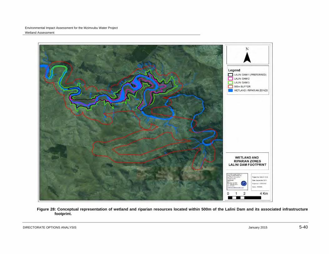
Figure 28: Conceptual representation of wetland and riparian resources located within 500m of the Lalini Dam and its associated infrastructure footprint.

Environmental Impact Assessment for the Mzimvubu Water Project
Wetland Assessment
DIRECTORATE OPTIONS ANALYSIS January 2015 5-41
Figure 29: Conceptual representation of wetland and riparian resources located within 500m of the Mzimvubu Water Project footprint.

Environmental Impact Assessment for the Mzimvubu Water Project
Wetland Assessment
DIRECTORATE OPTIONS ANALYSIS January 2015 5-42
It is recognised however that due to the nature of the Mzimvubu Water Project, adherence
to the stipulation of a 32m buffer zone is not feasible for all riparian and wetland features
identified within the study area, as the construction of the dams will entail inundating
several wetland features. Additionally, roads and pipelines may be planned to traverse
wetland features; thus it will not be feasible to implement a buffer zone around all wetland
features affected by the project. Effective mitigation must be implemented in order to
reduce the level of impacts on the wetland features which will be negatively impacted by
the construction of the proposed Ntabelanga Dam in particular, as it is anticipated that this
will result in the loss of wetland and drainage line features or portions thereof.
Furthermore, due to the linear nature of roads and pipelines, it is acknowledged that a
buffer zone cannot be effectively implemented around the wetland features which will be
crossed by such infrastructure. Nevertheless, mitigation measures must be implemented
in order to decrease impacts on such features.
Based on the above discussion, it is clear that the wetlands which will be directly impacted
by the proposed development, provide important ecological services in the way of
sediment trapping, nutrient cycling and toxicant assimilation, flood attenuation and
biodiversity maintenance. In view of the extensive, and often severe, erosion within the
study area and greater catchment, sediment trapping is especially important. Wetlands
can be seen as one of the most valuable ecosystems in the world. In 1980 the
International Union for the Conservation of Nature (IUCN) identified wetlands as being the
third most vital life support systems on the planet (Emery et. al. 2002). Thus, preservation
of the water quality, habitats, vegetation and soils of wetlands is as essential as
preservation of the ecological services they provide. The wetland features present in the
study area are considered to be ‘ecologically sensitive’ to changes such as flow
modifications, floral composition and structure of vegetation communities, as such
modifications will impact on faunal composition and community structures as well.
Habitat destruction is the alteration of a natural habitat to the point that it is rendered unfit
to support the species dependent upon it as their home territory. Many organisms
previously using the area are displaced or destroyed, reducing biodiversity. Globally
modification of habitats for agriculture is the chief cause of such habitat loss. Other causes
of habitat destruction include surface mining, deforestation, slash and burn practices and
urban development. Habitat destruction is presently ranked as the most significant cause
of species extinction worldwide. Additional causes of habitat destruction include water
pollution, introduction of alien species, overgrazing and overfishing. Riverine systems and
particularly ephemeral riverine systems or river systems that have very low flows as part of
their annual hydrological cycles are particularly susceptible to changes in habitat condition.
The proposed Mzimvubu Water Project has significant potential to lead to loss of loss of
niche habitat and/or alteration of the aquatic and riparian resources on the study area, with
particular mention of the impacts that the two dams will have on the Tsitsa River and its
tributaries, as well as the wetland resources.

Environmental Impact Assessment for the Mzimvubu Water Project
Wetland Assessment
DIRECTORATE OPTIONS ANALYSIS January 2015 5-43
The anticipated cumulative loss of riparian and wetland habitat arising from the
construction of the dams is estimated to be 1034.30 hectares; overall this is deemed to be
a relatively insignificant fraction of the wetland resources within the Mzimvubu subWMA. It
should be noted that the ultimate loss is dependent on the final full supply level. The
approximate loss of wetlands as a result of the construction of each dam is presented in
the table below:
Table 36: Anticipated approximate loss of riparian and wetland habitat as a result of the construction of the dams.
Ntabelanga Dam Lalini Dam
Resource Hectares lost Resource Hectares lost
Tsita River 246.09 Tsita River 550.91
Tributaries 23.20 Tributaries 0
Seeps 15.11 Seeps 0
Channelled Valley Bottom 37.20 Channelled Valley Bottom 0
Drainage Lines 89.93 Drainage Lines 71.85
TOTAL 411.53 TOTAL 622.76

Environmental Impact Assessment for the Mzimvubu Water Project
Wetland Assessment
DIRECTORATE OPTIONS ANALYSIS January 2015 5-44
Figure 30: Conceptual presentation of the riparian and wetland delineations, with the associated buffer zone, in the Ntabelanga Dam vicinity.

Environmental Impact Assessment for the Mzimvubu Water Project
Wetland Assessment
DIRECTORATE OPTIONS ANALYSIS January 2015 5-45
Figure 31: Conceptual presentation of the riparian and wetland delineations, with the associated buffer zones, in the Lalini Dam vicinity.