Embed Size (px)
Citation preview

•' t
4inesw0aee ea HA i BLEZARD 010
CM THB OBOLOCT OT T ER
WIVTRRS* OftCGP
AKD
R. Siwurd Oooaultiag Otologivt
Toronto^ IMS
REPORT
ON THE GEOLOGY OF THE
WINTERS'
PROPERTY
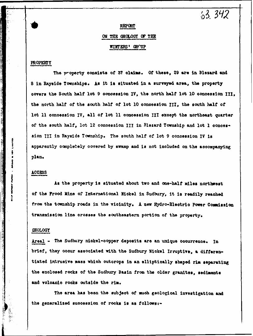
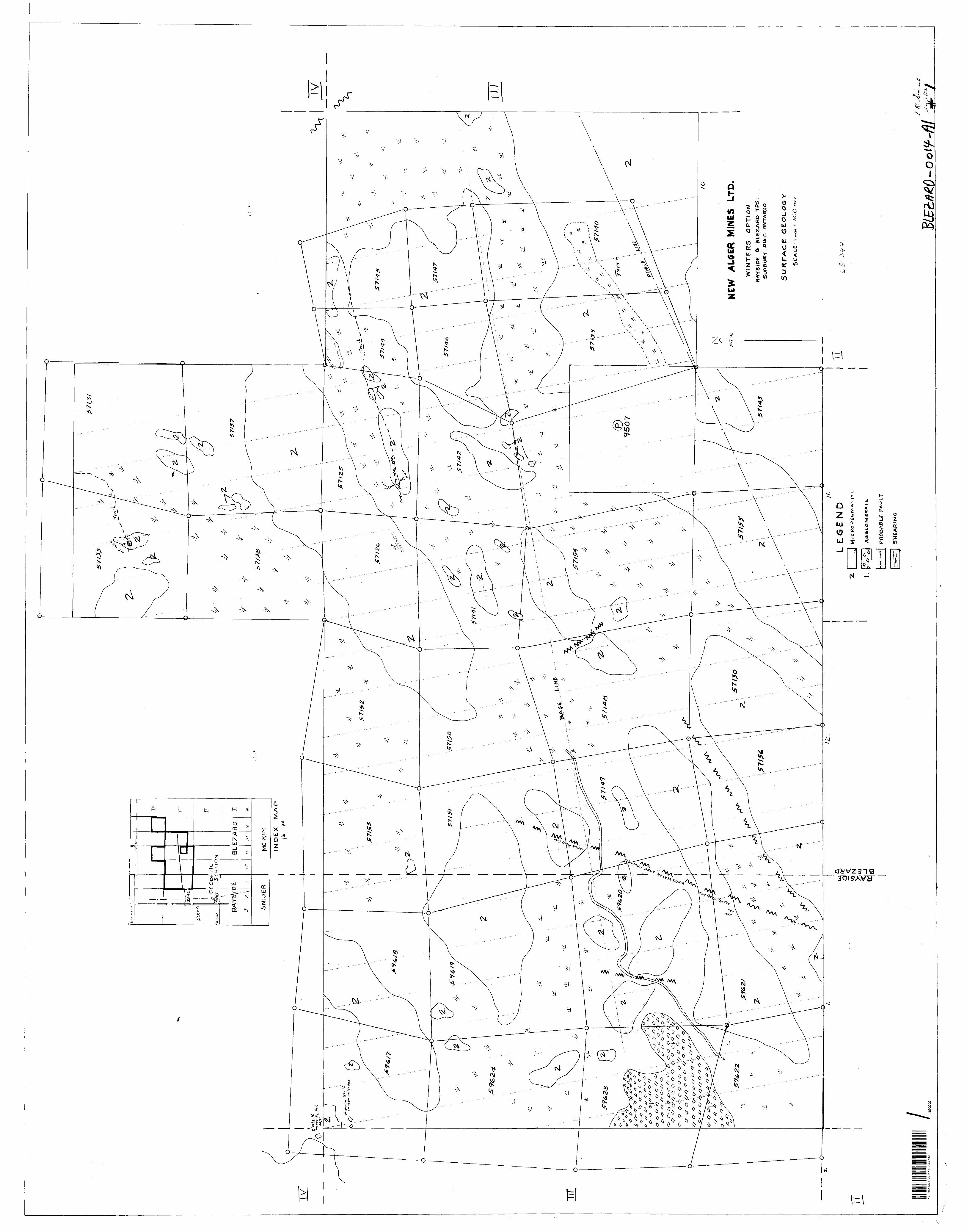
The property consists of 37 claims. Of these, 29 are in Blezard and
8 in Bayside Townships* AB it is situated in a surveyed area, the property
corer* the South half lot 9 concession IV, the north half lot 10 concession III,
the north half of the south half of lot 10 concession III, the south half of
lot 11 concession 17, all of lot 11 concession III except the northeast quarter
of the south half, lot 12 concession III in Blezard Township and lot l conces
sion III in Rayside Township* The south half of lot 9 concession IV is
apparently completely covered by swamp and is not included on the accompanying
plan*
ACCESS
As the property is situated about two and one-half miles northwest
of the Prood Mine of International Nickel in Sudbury, it is readily reached
from the township roads in the rioinity* A new Hydro-Electric Power C omission
transmission line crosses the southeastern portion of the property*
OEOLOQY
Areal - The Sudbury nickel-copper deposits are an unique occurrence* In
brief, they occur associated with the Sudbury Nickel Irruptive, a differen
tiated intrusive mass which outcrops in an elliptical ly shaped rim separating
the enclosed rocks of the Sudbury Basin from the older granites, sediments
and volcanic rooks outside the rim*
The area has been the subject of much geological investigation and
the generalized succession of rocks is as follows t-
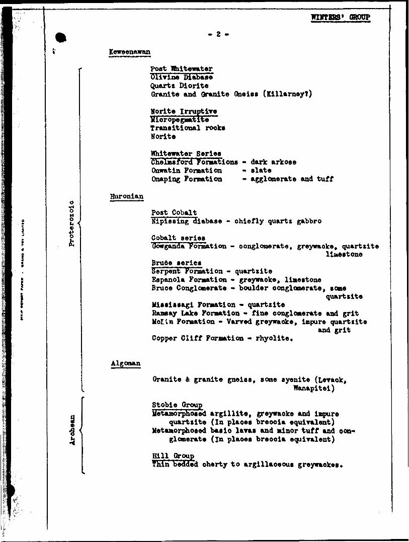
wnrrsBs* GROUP- e -
Keweenawan
Post WhitewaterOlivine DiabaseQuartz DioriteGranite and Granite Qneiaa (KillarneyT)
Norite Irruptive Mioropegmatite'~ Transitional rook*Norite
Huroniano-6HO
Whitewater Series Chelmsford Formations Qawatin Formation Onaping Formation
dark arkosealateagglomerate and tuff
Post CobaltNipissing diabase - chiefly quart* gabbro
Cobalt seriesGowganda Formation - conglomerate, greywacke, quartzite
liteeatone Bru6e seriesSerpent Formation - quartzite Espanola Formation - greywacke, limestone Bruce Conglomerate - boulder conglomerate, some
quartziteMiaaiaaagi Formation - quartzite Ramsay Lake Formation - fine conglomerate and grit MollB Formation - Varred greywacke, impure quartzite
and grit Copper Cliff Formation - rhyolite.
Algonan
s s
Oranite 4 granite gneiss, some syenite (Leraok,Wanapitei)
Stobie GroupMetamorphosed argillite, greywacke and impure
quartzite (In plaoea breooia equiralent) Metamorphosed basic laras and minor tuff and con
glomerate (In plaoea breooia equivalent)
HillThin bedded cherty to argillaceous greywaokea

CROUP
- 5 -
In a general way the assemblage of rooks constituting the Whitewater
series occur as a synclinal basin isolated and completely surrounded by the
Nickel Irruptire.
To a certain extent the Basin can be represented as a giant or outbit*
inclusion in the intrusive mass* The Nickel Irruptire apparently was
emplaoed at the unconformity at the base of the Whitewater Series nore or
less ooncordantly, somewhat like a sill* In many respects it can be compared
to the Nipissing diabase in other parts of the country. This Irruptive mass
now is exposed as a rim averaging l to 3 miles in width and complete surroun
ding the basin. It dips inward in all directions, probably at varying angles,
but is thought to be present beneath the basin at ever increasing depths
towards its centre* Because of a ffcir irregularities in the outline of its
upper contact, not explainable by topography or definite faulting, it appears
that the upper contact of the Irruptive is irregular or varies in dip* Such
behaviour of the upper portion of the Irruptive may suggest a similar
condition in the lower (Norite) portion and related to it, but it is not
necessarily so. If such irregularity indicates a flexure of the whole mass,
interesting eoonondo possibilities may be present* The Irruptive mass, while
still in a fluid condition is considered to have separated into a generally
acidic (micropegmatite) upper portion and a more basic (Norite) lower portion
with a transitional intermediate rook type solidifying between the two
extremes. The micropegmatite upper portion is considerably wider or thicker
than the norite base, the transition rook occupying a relatively narrow cone.
The thickness of the Irruptive mass is generally of the order of about 4,000
feet with the micropegmatite forming about two-thirds of this.
There are two main types of copper-nickel orebodies. The more
important "marginal" type occurs fairly closely associated with the norite.

WIHTRBS* GROUP
o**-
ij
l*l
- 4 - t
The sulphide bodies usually occur at or just below the contact of the norite
with the underlying rocks. This usually occurs where there is present a
bulge or irregularity in the norite contact and this area is intersected by
faulting or shearing* The ore is present in the underlying rook rather than
in the norite*
The type of host rook does not seem to be as important as the
physical properties* There is more than a suggestion that the basic require
ment is a competent or brittle rook which was in a fractured or brecciated
condition at the right time and place* The other important kind of ore
deposit is usually referred to as the offset type* These are mineralised
dikes* Some of these offset dikes are directly connected to the norite. In
others the connection is not apparent at the surface horizon at least. No
copper-nickel ore deposit is known occurring above the norite.
Looal - The property is characterised by rocky hills rising out of swampy
ground* The hills for the most part are lightly covered with overburden
carrying low bushes and very little in the way of other vegetation. They
trend generally northeasterly, in line with the direction of the rim. Examin-*
ation of topographic maps and aerial photographs reveals the presence of at
least one lineament striking northwesterly across the narrow portion of the
property near the northeast corner of lot 10, concession III* This lineament
lies along the strike of a portion of an irregular northeasterly striking
fault occurring at the top of the Copper Cliff formation to the east of the
Frood Mine* The portion of the property through which this feature passes,
being all swamp, is devoid of outcrop. It is presumed that a fault is
responsible for this valley but this could not be substantiated* Unverified
information is to the effect that a diabase dike is present rather than a

WINTERS' GROUP
a fault* A diabase dike occupying a fault could well be present* In any case
it is questionable whether such a feature would be of economic significance*
The four northeastern claims covering the south half lot 9 concession 17 are
almost entirely swamp and were not mapped*
The property is underlain almost in its entirety by the micropegmatite.
This is a generally massive holocrystalline rock peculiar to the district and
has been repeatedly described in geologic literature. It varies little in
grain size from its upper margin near the north boundary of the property
to the southern border of the area under consideration. It exhibits few
structural or other features and is best described as rather monotonous inR
nature. Southwest from the western boundary of the property a "tongue" of
micropegmatite extends towards the town of Aeilda in Rayside township. A
corresponding tongue of the agglomerate of the Onaping formation of the Basin
extends into the southwesterly claims of the group. As this feature suggests
a major bulge in the upper surface of the micropegmatite it was hoped that
something could be found to favor the possibility of the presence of orebodies
at not too great depth below the surface on the property. However nothing
could be found to indicate that the lower contact of the norite also bulged
upwards in sympathy.
Two mineralized showings are indicated on the plan* These are not
considered to be of economic significance. They "ve r e previously diamond
drilled with negative results. The showings consist of short narrow quarts
veins mineralized with a little chalcopyrite, sphalerite, galena and very
minor pyrrhotite. The veins are not persistent and are associated with weak
shearing or faulting. The veins and mineralisation were more typical of
"Basin" deposits than the nickel type. A zone of barren quarts veins occurs
just north of the power line and roughly paralleling it in the southeastern
part of the property.

WINTERS' OSOOP
- 6 -
Because of the eoonomic importance of faulting and shearing in this
district, such features were particularly looked for on the property* The
possible or probable locations of inferred faults are shown on the accompany
ing plan* It should be pointed out here that interpretation of the magnet
ometer surrey did not suggest the presence of any of the faults indicated on
the plan* This is to be expected if no increase in magnetic mineral content
resulted from the faulting or subsequent filling.
The northeast striking fault is inferred front topographic features
on the ground. The extension of the Creighton-North Star-Whitewater Lake
fault is shown as a possible fault because of the presence of tones of light
oxidation and a system of flat fractures or jointing which occurs on the
east wall. This feature is well exposed near the northwest corner of lot l
concession I, Rayside township and just east of the geodetic station a short
distance northeast of this point. The uniform character of the micropegmatite
makes the recognition of a fault in the field rather difficult and unsure so
that more faults than shown may well be present*
CONCLUSIONS
The property is almost entirely underlain by rooks of the upper portion
of the Sudbury Irruptive. This is at some very considerable distance above
the base of the norite, below which occur the host rooks for the copper-nickel
orebodies. While the vertical depth to the lower norite contact at any point
on the property is thought to be large, it can not be estimated with any
degree of assurance*
Surface showings on the property, previously diamond drilled with
negative results, are not considered to be of economic significance.
The Creighton-North-Star-Whitewater Lake fault is considered to extend
onto the property* While it is reported that ore is present associated with

WINTERS' GROUP
- 7 -
this fault to the south, there are rery long portions along it where no ore-
bodies are known. There seems to be little reason to expect that it will
make ore on the ground under consideration* A theoretical case might be
made out - by taking into account the bulge in the micropegmatite to the
southwest and projecting this in some way to the norite footwall, the structure
then being out by a fault which had made ore at some point along its length
could arouse interesting speculation as to the presence of orebodies at depth
in this area. The postulates are highly theoretical and no information could
be obtained to shed light on the problem*
RECOMMENDATIONS
It is considered that insufficient favorable information was obtained
regarding the possibility of the occurrence of commercial ore on this
property to justify its further investigation at this time.
' l
Lionel R. Simard Consulting Geologist*
Toronto, Ontario December 9th, 1952

- 8 -
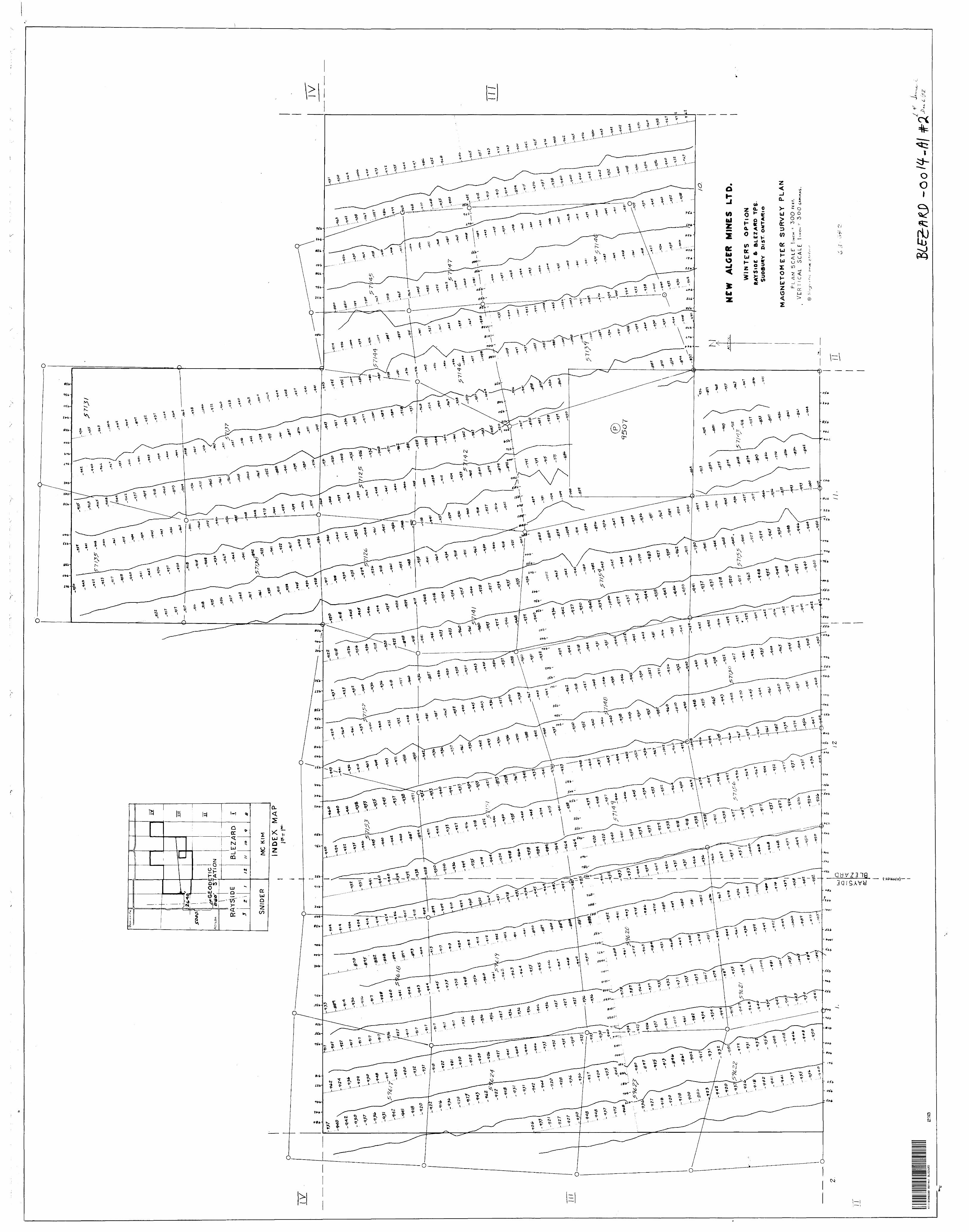
REPORT OK THE MAGNETOMETER SURVEY
OF THE
WINTERS' GRODP
BLEZARD AND RJLTtSIpE TOWNSHIPS DISTRICT OP SUDBURY
CTTARIU
INTRODUCTION
The property consists of 57 claims, 29 in Bleiard and 8 in Bayside
townships* It comprises claims Nos. S-57125, 57126, 57150 to 57156 inclusive
in Blezard township and 59617 to 59625 inclusive in Rayside township*
The property is situated in the Sudbury Mining Division and is located
some 2^ to 5 miles northwesterly from the Frood Mine of International Nickel
Company in Sudbury* It may be reached from the township roads in the area*
An Hydro-Electric Power Commission transmission line was under process of
erection across the southeastern portion of the property while this survey
was being conducted*
GENERAL GEOLOGY iinesweaee ea MA i BLEZARD 020
The property is characterised by generally rounded glaciated hills,
lightly covered by overburden, in places rising out of swampy ground.
Vegetation is sparse consisting mostly of low bushes.
The property is underlain, almost entirely, by very uniform micro
pegmatite, the upper portion of the Sudbury Irruptive mass.
In the district orebodies which are usually magnetic occur at the
base of or below the norite, the lower differentiate of the Sudbury Irruptive*
It was considered possible that if magnetic bodies were present, even at con
siderable depth below the surface, their presence might be detected by a
magnetometer survey. Such an investigation has repeatedly disclosed the
presence of faulting (often due to the development of secondary magnetite) in

WIITERS* GROUP
other areas and it was felt that a magnetometer surrey here could be of con
siderable assistance in indicating faults or fault extensions* As faulting
or shearing is normally present, associated with the orebodies, the detection
of their presence was considered important.
MAGNETOMETER SURVEY
The magnetic intensity readings taken during the surrey were found
to be all relatively weak and uniform. No areas of high or low readings were
found and the maximum range between the highest and lowest readings recorded
was of the order of 335 gammas, a very small range indeed* No magnetic
anomalies were noted in the interpretation, nor did the probable faults and
contacts show up in any recognizable pattern even within the range of
intensities measured*
A base line running east and west (magnetic) was established near the
middle of the property and picket lines were turned off normal to this at
400-foot intervals. Stations were established at 100-foot intervals along
the picket lines and the magnetometer readings were taken at these points*
As the property lies in surveyed townships and because no township
posts or other markers could be definitely located, it was decided that, to
be sure the proper ground was surveyed, it was advisable to run a traverse to
the geodetic station located in lot 2 concession II, Rayside township. This
was done and the relative locations are indicated on the accompanying plans*
Claims numbers 57132, 33, 34 and 36 in the northeast corner of the
property are entirely covered by swamp and so cannot be traversed during the
summer* They were not included in this survey*
A Sharpe Model DIM Magnetometer was used in this survey with a coil
constant of 26*1 gammas per milliamp. Corrections were made for diurnal and
dally variations.

WIBTRBS* GROUP- 10 -
COHCLUSIQH3
It is considered that the survey revealed remarkably uniform magnetic
conditions over the whole property and no particular portion in of unusual
interest because of magnetic properties* No further work can be recommended
as a result of this survey*
Lionel R. Simard Consulting Geologist*
Toronto, Ontario Decenfaer 9, 1952
dODP
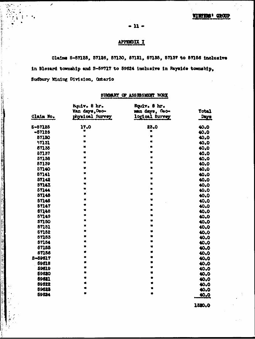
- U-
OlaisM 8-57126, 57130, 87130, 57181, 67155, 67137 to 6715*
in Blotard township and 8-59717 to 59624 iaoluaiv* la Raytid* township.
Sudbury MlalnR Division, Ontario
stnoaunr op ASSBBSMEVT TTOK
Hoi
tejuiv. 8 hr. Kan phyii pai
8-57125 11-6712867130 msl
671376715867139671406n416714257148.67144571486714667147671488714987160571616716267153571646716567166
8-8961769618596196962069621696226962169624
'.0
T. 6 hr* nan days, 0*o* logjoal
28.0
Total
40.0 40.0 40.0 40.0 40.0 40.0 40.0 40.0 40.0 40.0 40.0 40.0 40.0 40.0 40.0 40.0 40.0 40.0 40.0 40.0 40.0 40.0 40.0 40.0 40.0 40*0 40.0 40.0 40.0 40*0 40.0 40.0 40.0
1520.0

- 12 -
Line putting and Chaining - Period July Ifrth to Sept* 17th. 1962
Sudbury* Ontarior. M. VoDovellS. X. Uwin L. R* Blaard C. MoDowell J. L. MoDowell Hou (fciinn J. Pellet B. Briocon R. Veixtotte L. Youne T. Simrd A. Landrie R. Chartrand P. Touohette A. Duguay W. Couter 2. Deauolair U. Yinowit O. Douoette H. Pitre A. Bodaon
Oeophytioal (
530 Bay St., Toronto l, Obt. Sudbury. Ontario
M M
590 Bay St., Toronto l, Oofc. Sudbury, Ontario
rtoaeter) Survey - Fjeld Kork Period Aug. l&th to Sept. 17th, 10&2
Tb. Qulao 590 Bay St., Toronto l, Ontario
Field OaloulationaQuina 550 Bay Ct., Toronto l, Ontario
Qeologioal Survey - field york
L.H. 8iMurd 550 Bay St., Toronto l, Ontario Period July Uth to Aug. 22nd, 1962
Quina 550 Bay St., Toronto l, Ontario Period Sept. 16th to Hov. 1st, 1962
Draught iofi, Interpretationa, Reports,
L. R. Sinard 550 Bay St., Toronto l, Ontario

t* r
m vrm1 often?. is .
Breakdown
Line cutting and chaining July 19th - Sept* 17th, 1952
Uan Brs./ Total Hours z Factor
175 10 1750 4
Geophysical Survey (Kield Work)
20 10 200 4
Geophysical Surrey (Calculations)
14 4 56 4
Geological Surrey (Field Work)
46 10 480 4
Draughting Interpretations A Results
20 6 160 4
Total Hrs. x Factor
7000
800
224
1920
840
10584
Equivalent B hr. aan days
878
100
28
240
80
This work has been apportioned as follows on each of the 33 olaims.
Oeophysioal GeologicalSurvey
Lin* Outtinc 13.25 Geophysical field work 3.00 Oeophysioal calculations .76 Geological field work Draughting, Interpretation, Reports 1.25
Totals 18.25
On par Olain basis -Oeophysioal Surrey 18.25 Geological Survey 21.75
Survey
13.26
7.261.25
21.76
Total
28.83.00
.787.282.60
40.00
Total per claim 40.0

GA
RS
ON
T
WP
-V

Tt i*l
V\\
®
l \
l l
i U
.J '
L--r•H .;@
iri i
i
•r ^4
'^ l.iffr itu
©
,*-" i--f ©.
•^ ;re
J o-^ 'l i
M®!.
SPC'J'"is[f s ®l: S •.'f•-^•zs
. \1?
. ' ^
®!-4f'^y
®
''.'IM i-^. i ©f i *!
OD
•x
PATENTED LAND
CROWN LAND SALE LEASESLOCATED LAND
LICENSE OF OCCUPATION MINING RIGHTS ONLYSURFACE RIGHTS ONLY ROADSIMPROVED ROADS KING'S HIGHWAYS RAILWAYS POWER LINES MARSH OR MUSKEGMINES
NOTES
or CA
|P:^-i:- - *;- ^T^&jag
RAYSlbiDISTRICT OF
SUDBURY ;
SUDBURYMINING DIVISION t i
fALB 1-INCH'40 CHAINS
LEGEND
J®\*"*4
JS; ; Tj
^fei-
**?*\'-a*
fc '^
W-
V®o*
3. i.5*701l
l \ l l h ••' S jS'E ^•'^I-r,s

(X")
/V/A/I
939
~eeo
' S
TA
TIO
N
PA
YS
\(D
BLE
ZA
RD
SNID
ERMC
iv
MIN
DE
X
MA
P
S7
'14
Z
f 9
6.2O
o o
c- o
o
NE
W
AW
ER
M
INE
S
LT
D.
WIN
TE
RS
O
PT
ION
8,
BL
EZ
AR
D
TP
S.
J* IS
T-
ON
TA
RIO
SU
RF
AC
E
GE
OL
OG
Y
SCAU
E iHC
H -
300
PR
OB
AB
LE
F
AU
LT
\\ 41I1
0S
W0200
00 M
A l
BLE
ZAR
D2
00
7
*
ft
S
NE
W
AL
CE
R
MIN
ES
L
TD
.
WIN
TE
RS
O
PT
ION
RA
YS
lOC
fr
B
LE
ZA
RD
T
p S
SUD
BU
RY
DIS
T. O
NTA
RIO
MA
GN
ET
OM
ET
ER
S
UR
VE
Y
PL
AN
PL
AN
S
CA
LE
|IW
CM -
- 3O
O
VE
RT
ICA
L
SC
AL
E
I INC
H ^
3 00
LU
(O
o cr Kl
CD
/Z
wU
——
^4-
r.
5
0 -fl
l
^
i
* *
to-
*-
o- 0
-*f
0 \
J-7
\
1 -
***
U \
Aofl?
t ——
— , —
——
——
i — rt
——
r-| —
— i —
——
*4*i
— *-
i ——
— - —
——
——
— - —
— L^
——
— ' —
——
' ——
— -4 —
— ' —
——
— - —
— G
8-12
+ ——
——
——
—v
* o \
Ai\
-l 1 'A
,;
o*
o- o-
T -
" '
' ——
T ——
— T —
——
——
— i —
— n
1 l
* \
' '
^x
i
1 s
,ft 1
J i
3 ^
5 S
Jy/
.
——
——
——
——
——
——
\ —
——
\ ——
——
— ! —
——
——
——
——
— l
f- *
'2?
"2
J
* r-
Y
A*
K
*-
*
*
o
cc CL
o.
4i n
asw
esae
BLEZ
ARD
W-o
o If
-61


![Natural State Modeling of Singapore Geothermal Reservoir jan.pdf · Singapore has four main formations [7]: the igneous rock consisting of the Bukit Timah granite and the Gombak norite](https://img.dokumen.tips/doc/110x75/5ac7b2627f8b9a51678ba809/natural-state-modeling-of-singapore-geothermal-janpdfsingapore-has-four-main-formations.jpg)