Embed Size (px)
Citation preview
Le Baron Prospecting Port Renfrew, BC
Geochemical and Technical Assessment Report
Loss Creek Project Tenure 867658
Victoria Mining Division
092C059 / 092C049
48 degrees -29' - 51" N Y 124 degrees - 15' - 27"W
MtnoaTT Online
V f: 1
I. Loss Creek Projec 2012
X warn
i BUM t
\ 1 I'
90S269
IO0S88Z
Mm
M
,i , ...
L
: 90S269
IO0S88Z
M
,i , ...
L
d MM a
tow wen
M
,i , ...
L m MM i /• i :'
147 www
4 -
I E f ~ M
,i , ...
L - T N = 1— -i — • —
www
4 -
I E f ~ M
,i , ...
L
! 1 \~-\ - ¬i
_ — . . .
— > 1
1 i *
T ——4 . '" •-! 1
\~-\ - ¬i
_ — . . .
— > 1
1 i *
T ——4 . '" •-! 1
\~-\ - ¬i
_ —
- - -— > —m i f -
- —Ml
T
Ml
! 1 \~-\ - ¬i
_ —
- - -—
r w r - —Ml
Report by Le Baron Prospecting 16977 Tsonaquay Dr Port Renfrew BC V0S-1K0 Author: Scott Phillips
GEOLOGICAL SURVEY BRANCH 2012 ASSESSMENT REPORT

B R I T I S H C O L U M B I A Hit BrM Piait cm ti-irih
Ministry of Energy and Miiifs BC Geological Survey
Assessment Report Title Page and Summary
T Y P E OF REPORT [type of survey(s)]: Geochemical Assessment TOTAL COST: $2850.00
AUTHOR(S): Le Baron Prospecting - Scott Phillips SIGNATURE(S):
NOTICE OF WORK PERMIT NUMBER(S)/DATE(S): _ _ _ _ Y E A R O F WORK: 2012
STATEMENT O F WORK - C A S H PAYMENTS EVENT NUMBER(S)/DATE(S): Event # 5396419
PROPERTY NAME : Loss Creek Project
CLAIM NAME(S) (on which the work was done): Le Baron - tenure # 867658
COMMODITIES SOUGHT : Ag, Au - no analysis _ _ _ _ _
MINERAL INVENTORY MINFILE NUMBER(S), IF KNOWN:
MINING DIVISION: Victoria NTS/BCGS: M092CQ59 / M092C049
LATITUDE: 48 ° 29 "51 " LONGITUDE: 124 ° 15 '27 " (at centre of work}
OWNER(S):
1) Scott Phillips 2)
MAILING ADDRESS:
3317 Henry Rd Chemainus BC V0R-1K4
OPERATOR(S) [who paid for the work]: 1) same 2)
MAILING ADDRESS:
same
PROPERTY G E O L O G Y KEYWORDS (lithology, age, stratigraphy, structure, alteration, mineralization, size and attitude): Wrangella, Jurassic era, Cretaceous Leech River Formation, Metchosin Igneous Complex, greenschists, metamorphic rock
volcanic intrusives, biotite garnet schists, mica phyllite, shale, interbedded sandstone, quartz vein swarms, quartz, Au
R E F E R E N C E S T O PREVIOUS A S S E S S M E N T WORK AND A S S E S S M E N T REPORT NUMBERS:
Next Page

TYPE OF WORK IN THIS REPORT
EXTENT OF WORK (IN METRIC UNITS)
ON WHICH CLAIMS PROJECT COSTS APPORTIONED
(incl. support)
GEOLOGICAL (scale, area)
Ground, mapping tenure # 867658 $2850.00
Photo interpretation several photos
GEOPHYSICAL (line-kilometres) Ground
Magnetic
Electromagnetic
Induced Polarization
Radiometric
Seismic
Other
Airborne
GEOCHEMICAL
(number of samples analysed for...)
Soil silt
Rock 4 rock chip samples analyized Certificate of analysis
Other VA13144214
DRILLING
(total metres; number of holes, size)
Core Non-core
RELATED TECHNICAL
Sampling/assaying 14 rock chip samples obtained 4 moss matt samples obtained
Petrographic
Mineralographic
Metallurgic
PROSPECTING (scale, area)
PREPARATORY / PHYSICAL
Line/grid (kilometres) 523 G P S meters of survey line established in field
Topog raphic/Photog rammetric (scale, area)
Legal surveys (scale, area)
Road, local access (kilometres)/!
Trench (metres)
rait Road, local access (kilometres)/!
Trench (metres)
Underground dev. (metres)
other 1 test pit excavated - 43 - five gallon buckets of classified material processed sluicebox
TOTAL COST: $2850.00

Le Baron Prospecting Port Renfrew, BC
Table of Contents
• Title Page #1 • Table of Contents #2 • Tenure ownership, location, #3 • Exploration overview #4 • Tenure geology, google earth map #5 to #7 • Author, disclaimer #8 • Costs #9
• Appendix A - Sampling Specific - technical information #10 to #13
Figure maps C to E
• Discussion of the assays, element specific #14 to #16
• Appendix B - Certificates of analysis #17 to #18
• E-mail conformation of event #19 to #20
2
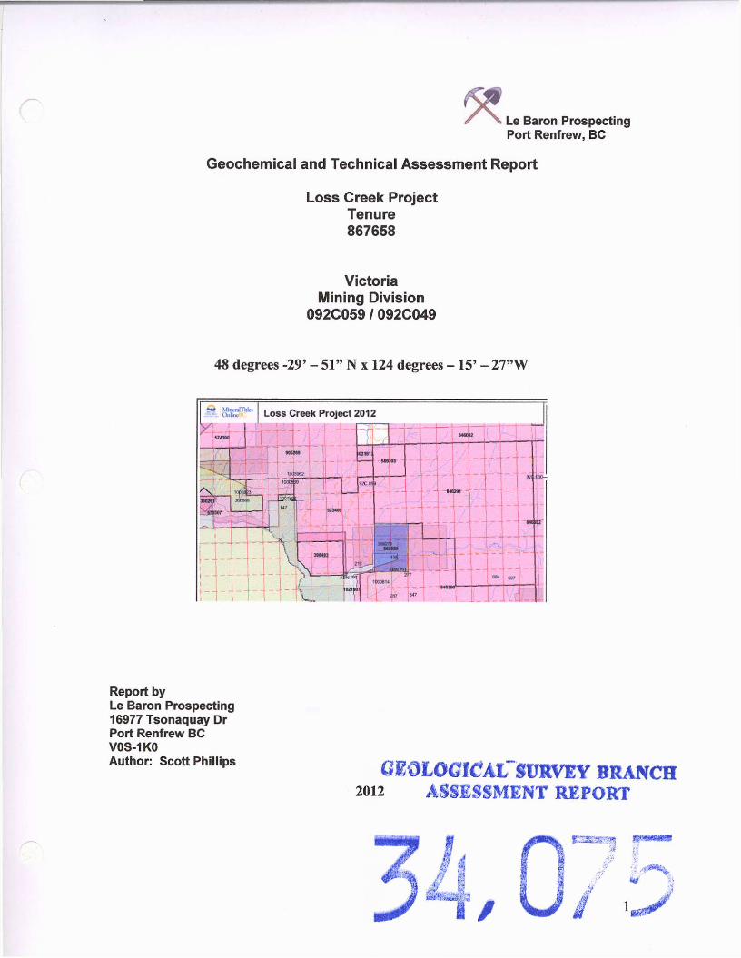
MineralTides OnlineBC Loss Creek Project 2012
This map is a user generated static output from an Internet mapping site and is for general reference only. Data layers that appear on this map may or may not be accurate, current, or otherwise reliable. TH!S M A P IS NOT TO BE U S E D FOR NAVIGATION.
Notes: Tenure location map
Fort St . John
Que Wi l l iams Lake
Revels toke Vernon
Vancouver Trail ...Victoria
Legend • Indian Reserves
• National Parks Q Conservancy Areas
• Parks
Q Federal Transfer Lands , MTO Grid (MTO,
Mineral Tenure (current)
• Mineral Claim • Mineral Lease
Mineral Reserves (current)
I—| Placar Claim Designation [—I Placer Lease Designation r—| No Staking Reserve I—| Conditional Reserve p-j Release Required Reserve m Surface Restriction |—| Recreation Area |—| Others j- -j First Nations Treaty Related
Lands
j—j First Nations Treaty Lands r—I Survey Parcels
• BCGS Grid Contours (1:25QK)
Contour - Index Contour - Into mediate A rsaof Exclusion Areaof Indefinite Contours Transportation - Points (TRIM)
a Helipad
Transportation - Lines (TRIM)
Scale: 1:50,000

MineralTides OnfineBC Loss Creek Project
This map is a user generated static output from an Internet mapping site and is for general reference only. Data layers that appear on this map may or may not be accurate, current, or otherwise reliable. THIS M A P IS NOT TO B E U S E D FOR NAVIGATION.
Notes: Tenure location and access roads
John
* e l stoke /ernon. ...
Victor ia _
Legend • Indian Reserves
• National Parks j—j Conservancy Areas
Q Parks
• Federal Transfer Lands MTO Grid (MTO) Mineral Tenure (current)
£3 Mineral Claim n Mineral Lease
Mineral Reserves (current)
I—| Placar Claim Designation I—| Placer Lease Designation j—j No Slaking Reserve |—| Conditional Reserve :—-i Release Required Reserve • Surface Restriction I—| Recreation Area [—| Others HUH First Nations Treaty Related
Lands
j—I First Nations Treaty Lands r—I integrated Cadastral Fabric r-j Survey Parcels
• BCGS Grid Contours (1:250K)
Contour - Index Contour - Intermediate
?* Areaof Exclusion Areaof indefinite Contours Annotation (1:20K) Transportation - Points (TRIM)
Scale: 1:31,140
(

Tenure Ownership:
Le Baron Prospecting Port Renfrew, BC
Scott Phillips: F M C 1 4 5 8 1 7 - 1 0 0 %
Tenure name owner issue date good to date status area 867658 Le Baron
LossCreek 145817 2011/Jul/25 2015/Jul/25 good 128 ha
Tenure Location, access The Loss Creek tenure is located within the Victoria Mining Division, Southwestern Vancouver Island, BC , Canada. [See Location Map, 1:80,000]. The property is located approximately 85 kilometers west of Victoria on the NTS Map # M092C059 / M092C049
The tenures consist of six distinct cells for a total of 128 ha. Highway 14 runs through the tenure (#574453). The Loss Creek Park is located partially within this tenure. The town of Port Renfrew is approximately 20 km from the Loss Creek Tenure and offers some basic services.
3

Exploration overview
Le Baron Prospecting Port Renfrew, BC
The Loss Creek Park Project is one of importance. In reference to several articles in the Minfile from previous authors, and especially reference to Yorath, Geology of Southern Vancouver Island, first addition, it is very clear that something of great magnitude happened right here. The age of reference seems to be between 40 and 50 million years ago.
This tenure resides over the Leech River Fault, on your way to this tenure from Victoria you will pass by outcrops of the Metchosin Igneous Complex of the Crescent Terrene, as well as few exposures of the Sooke Formation. As you traverse down into the Loss Creek Park you pass intensely shattered and sheared volcanic rocks of the Metchosin Volcanics. Upon crossing over the Loss Creek Bridge, the next set of out crops you'll see is the greenish -grey schist of the Leech River Complex of the Pacific Terrene. So by crossing over the bridge, you cross over the Leech River Fault which extends offshore beneath the Juan de Fuca Strait.
The exploration conducted consisted of plotting the tenure boundary lines where they cross over Highway #14, to conduct rock chip sampling, geochemical analysis, and stream sediment sampling within the Loss Creek (outside of the Park boundary) and a tributary creek to the Jack Elliott Creek.
There was very nice course Au recovered from the Loss Creek.
4
Le Baron Prospecting Port Renfrew, BC
Area Geology: The descriptions that follow are based in part on the writer's geological knowledge, field observations and reference material from area reports. Other material has been referenced from the historic information publicly available in the ARIS data bank and the Natural Resources of Canada web site.
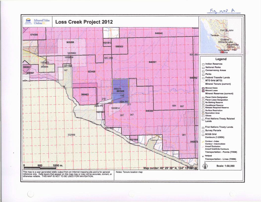
Vancouver Island lies within what is known as the Canadian Cordillera and is also classified as Wrangella. The Southwestern part of Vancouver Island is predominantly underlain by Paleozoic and Mesozoic strata intruded by Jurassic and Tertiary Intrusions. These tenures are underlain by the San Juan River Fault, which is composed of the Leech River Formation to the south and the Bonanza Group Volcanics to the north. The San Juan Fault is best described as a plate boundary fault, where the Leech River Formation is severely interrupted as a subduction complex.
The Leech River Fault is a reverse or thrust fault that strikes east and dips 45-75 degrees north, and is at least 40 miles long. The Leech River Fault is a remarkably linear feature that formed in an active plate margin tectonic regime. A s a result, Eocene Leech River Fault movement was coeval with the emplacement of the Metchosin and Sooke mafic volcanic intrusive complex. North of the Leech River Fault, a distinctly more mountainous terrain is underlain by Cretaceous Leech River Formation amphibolites to upper green schist grade metamorphic rocks consisting of biotite-garnet schist, mica-rich phyllite. The Leech River Formation consists of Cretaceous sediments (probably shale and interbeded sandstone) and minor volcanic rocks (intermediate tuffs/flows)
Geoscape -Natural Resources Canada NW
5

Le Baron Prospecting Port Renfrew, BC
Leech River Fault information Geoscape -Natural Resources Canada Leech River Fault in its relationship to Southern Vancouver Island and the traversing of the Leech River Fault from east to west.
6

Le Baron Prospecting Port Renfrew, BC
Tenure Geology / exploration: A s described in the summary, the Loss Creek Park tenure resides over the Leech River Fault. Here in the valley bottom is the division between two very dominant terrains, the Pacific Rim Terrene to the north / west and the Metchosin Igneous Complex to the south / east. The Leech River Fault runs "gun barrel straight" for over 153 kilometers from the Sombrio Point in the west to the Esquimaft Lagoon in the east. This is a north / west dipping structure, with an inclination of 60 degrees at the surface decreasing to between 35 and 45 degrees at a depth of 3 kilometers {Yorath - Nasmith) It is no surprise to someone the complexity of the area; it is like the sun and the moon once you cross over the Loss Creek Bridge, from igneous volcanics in the south / east to the greenish -grey schist's in the north / west. This truly is one of the more predominate features of Vancouver Island. Geoscape -Natural Resources Canada
Google Earth map - Loss Creek Project - #867658
Le Baron Prospecting Port Renfrew, BC
Author
• Scott Phillips [FMC # 145817] • Owner of Le Baron Prospecting, Port Renfrew B C . • Many years experience prospecting the Port Renfrew area. • Member in good standing with VIPMA. [Vancouver Island Placer Miners Assn]. • Member of VIX [Vancouver Island Exploration Group] • Owns several mineral and placer tenures within the Port Renfrew Area. • Author of many prospecting reports accepted within the Ministry standards. • Is presently studying the formation of Wrange!!, West Coast Crystalline Complex and the
Leech River Complex.
Author Disclaimer
• I, Scott Phillips have a joint valued interest in all the tenure that is mentioned in this report.
• I consent to the use of the material within this prospecting report to further enhance the exploration and development of the subject tenure.
• This report is correct in the information within and any use of this information to a second or third party is the responsibilities of those parties.
Author
Amended • Date o2 ~Qt~ ' Zo /V
8

Le Baron Prospecting Port Renfrew, BC
Statement of costs:
Dates: 10 / 08, 27 / 2011 - 02 /14 / 2012 - 07 / 24 / 2012 Scott Phillips (FMC #145817) Tenure owner $300.00 / day x 2 day =$600.00 Total =$600.00 $600.00
Shelly Cole (FMC 145828) labor $200.00 / day x 1 day =$200.00 Total = $200.00 $200.00
Bob Morris (FMC 118959) Labor $200.00 / day x 1 day =$200.00 Total = $200.00 $200.00
Thompson and sons Field contractors x 4 $200 / day x 1 day x 4 =$800.00 Total =$800.00 $800.00
Transportation Truck(s) $50.00 / day x 6 days =$300.00 Quad $50.00 / day x 2 day =$100.00 Total =$400.00 $400.00
Accomidation $70.00 / day x 4 days = $280.00 Total =$280.00 $280.00
Field supplies (flagging tape) =$20.00 $20.00
Report Le Baron Prospecting $350 / day x 1 day =$350.00 Total =$350.00 $350.00
Total $2850.00
9
Le Baron Prospecting Port Renfrew, BC
Appendix A
Rock chip sampling site Stream sediment sampling and surveying
Loss Creek Project
Figure Maps C to E 1-15,000 1 - 8,000
10

•jwf MineralTitles iSXSX* Onli
This map is a user generated static output from an Internet mapping site and is for general reference only. Data layers that appear on this map may or may not be accurate, current, or otherwise reliable. THIS MAP IS NOT TO BE USED FOR NAVIGATION.
Notes: index reference map
Que WllliarfraLaie^
Revelstoke
Vancouver Trail
Legend —. Indian Reserves
Q National Parks |—I Conservancy Areas
• Parks • Federal Transfer Lands
MTO Grid (MTO) Mineral Tenure (current)
• Mineral Claim f ] Mineral Lease
Mineral Reserves (current)
r-j Placer Claim Designation Q Placer Lease Designation j—j No Staking Reserve I—| Conditional Reserve j—| Release Required Reserve I—| Surface Restriction BH Recreation Area • Others r~j First Nations Treaty Related
Lands
.— First Nations Treaty Lands
:• . Integrated Cadastral Fabric
Q Survey Parcels
BCGS Grid Contours (TRIM)
Contour-Index Contour - Index.In definite Contour - In derepression Contour - Index. Depress ion Indefinite Contour - Intermediate Contour • Intermediate .Indefinite Contour - Intermediate .Depression
•
•
Scale: 1:16,908

Technical Information
Le Baron Prospecting Port Renfrew, BC
Overview of field work
There was four sample locations conducted during this short exploration period. The locations are labeled A to D. at each location, several samples were obtained and one sample was submitted for geochemical analysis, the results are included in the Certificate of analysis. All field work conducted utilized hand tools such as hammers, chisels, sluice box, a Garrett metal detector and a Lorance G P S . All field work has been flagged infield and plotted on reference maps.
Site A Location - Hwy #14 - roadside GPS - 406835 x 5371895 - See figure map D Description - Multilayer clay seams, with fine minerals defining most layers. This location as described is an excellent example of the Leech River Formation, there is an abundance of glacial till with a distinct banded layer of fine glacial clay that is 12" thick. On either side of this exposure is the metamorphic exposures and the Basalts of the Metchosin Volcanics. Conglomerates overlie this exposure
4 rock chip samples were obtained from this area, one of the samples sent away for geochemical analysis. ALS J677863
11

Le Baron Prospecting Port Renfrew, BC
Technical Information SiteB Location - Loss Creek River GPS - 407394 x 5372000 - See figure map D Description - sluice box sampling, rock chip sampling At this location, access is 156 meters west of the eastern tenure boundary, located off of the Loss Creek Forest Service Road, directly in the Loss Creek River. A test pit was excavated by a crew of three workers over the course of a day behind a large boulder in the river, the pit measured 1.5 meters by 1.5 meters by 1 meter deep. This was a great undertaking, as the gravels of the Loss Creek are rocky. The material was classified into five gallon buckets and then processed through a sluice box. A wing dam was constructed in the creek to allow for ample flow of water through the sluice box. The remaining material from the sluice box was washed into bucket from the miners moss and then hand panned into a concentrate, the concentrate samples were analyzed and placed in separate plastic bags for future consideration. The sluice box was cleaned out on three occasions.
Rock chip sample obtained from in creek large quarts veined boulder - ALS J677862
Clean out A 14 - five gallon buckets of classified material processed through sluice box = bucket of concentrate
Observation - lots of black sand, fine Au, 5 to 10 flakes to the pan
Clean out B 21 - five gallon buckets of classified material processed through sluice box = !4 bucket of concentrate
Observation - lots of black sand, fine Au, 10 flakes to pan
Clean out C 8 - five gallon buckets of classified material processed through sluice box = 1/4 bucket of concentrate Observation - lots of black sand, fine Au, 35 to 40 flakes to the pan - rich
12

M A P D
This map is a user generated static output from an Internet mapping site and is for general reference only. Data layers that appear on this map may or may not be accurate, current, or otherwise reliable. THIS M A P IS NOT TO B E U S E D FOR NAVIGATION.
Q u e s n e l v r Wil l iams, L a k e - J ,
Revels toke
• \
3rja_
Legend • Indian Reserves • National Parks j—j Conservancy Areas
• Farks • Federal Transfer Lands
MTO Grid (MTO) Mineral Tenure (current)
Miners) Claim Q Mineral Lease
Mineral Reserves (current)
r-̂ PlacerClalm Designation j—j PlacerLease Designation j—j No Staking Reserve — Conditional Reserve p-j Release Required Reserve [~| Surface Restriction Q Recreation Area Q Others Q First Nations Treaty Related
Lands
r-j First Nations Treaty Lands
r-j Integrated Cadastral Fabric
Q Survey Parcels
• BCGS Grid Contours (TRIM)
Contour-Index Contour - Index.Indefinite Contour • Index. Depression Contour - index.Depression Indefinite Contour - Intermediate Contour - Intermediate-Indefinite Contour - Intermediate-Depression
Scale: 1:8,454
Notes: Working reference map G P S sample specific locations

Le Baron Prospecting Port Renfrew, BC
Technical Information •?
SiteC Location - Jack Elliott Creek tributary GPS - 406686 x 5372720 - See figure map E Access to this sample location is off of Hwy 14, just meters east of the Jack Elliott Creek Bridge, a short survey trail 90 meters north / east to sample site C, (see figure map E), this sample location several rock chip samples were obtained from the bedrock within this tributary creek of the Jack Elliott. On this side of the Loss Crrek the bed rock is the schists of the Leech River Formation, much different than the basalts of the Metchosin Volcanics of the southern part of the tenure. Within this tributary creek is an abundance of quartz veins, many are oxidized, large singular veins are present dissecting the tributary. One rock chip sample sent away for analysis.
R C #1 - 4" white quartz vein, milky white quartz R C #2 - 2" quartz, oxidized - ALS J677861 R C #3 - quartz vein swarm, multi quartz veins 1" width R C # 4 - 2 " quartz vein
2 - moss matt samples were obtained from moss within the tributary, hand panned, 8 flakes of Au
SiteD Location - Jack Elliott Creek tributary GPS - 407040 x 5372725 - See figure map E Access to this sample location is 520 meters east of H W Y 14 along the G-main logging road at the first creek to cross, G P S location 407157 x 5372657. A survey trail is established aan one must traverse this trail to the west for 120 meters to sample site D where a small creek enters this tributary creek. Several quartz veins are present in the bed rock, 4 rock chip samples were obtained from the quartz veins, the structure of the bedrock is folded and very heated, most of the quartz veins are oxidized. One rock chip sample sent away for analysis. R C #1 - quartz, oxidization R C #2 - 2" quartz vein, oxidized - ALS J677860 R C #3 - 3" quartz vein R C #4 - quartz vein, oxidized
2 - moss matt samples were obtained from moss within the tributary, hand panned, 14 flakes of fine Au obtained.
Summary of work completed 14 rock chip samples obtained 4 rock chip samples geochemical analysis 1 test pit excavated in the loss creek 43 - five gallon bucket of material obtained from test pit 4 moss matt samples
523 meters of survey sampling trail established.
Summary of exploration The results of the geochemical analysis are disappointing, Au was not analyized for with the method used, the results of hand panning all showed several flakes of Au to the pan, this tenure is a valuable asset to Le Baron Prospecting's portfolio and will be secured long term.
13

*** MineralTitles Online Loss Creek Project
a?
846391
92C.QS9
G Main
This map is a user generated static output from an Internet mapping site and is for general reference only. Data layers that appear on this map may or may not be accurate, current or otherwise reliable. THIS M A P IS NOT TO BE U S E D FOR NAVIGATION.
15' 25.4" W Notes: Working reference map G P S sample specific locations, sediment sampling survey
Queeirel , WiiHarnsLske
/ Vernon V a W q w e r ^ F r a n '
Legend [3 Indian Reserves • National Parks r—I Conservancy Areas
• Parks
• Federal Transfer Lands MTO Grid (MTO) Mineral Tenure (current)
I—| Mineral Claim Q Mineral Lease
Mineral Reserves (current)
r—| Placer Claim Designation j—j Placer Lease Designation m No Staking Reserve ~ Conditional Reserve j—| ReleaSB Required Reserve r**| Surface Restriction I—| Recreation Area Q Others r-j First Nations Treaty Related
Lands
r-j First Nations Treaty Lands r~l Integrated Cadastral Fabric J—J Survey Parcels
• BCGS Grid Contours (TRIM)
Contour - Index Contour - Index .In definite Contour - Index.Depression Contour - Index. Depress ion indefinite Contour - intermediate Contour - Intefmediate.lndelinite Contour' intermediate. Depression
Scale: 1:8,454
c
Le Baron Prospecting Port Renfrew, BC
An overview discussion of the samples submitted for assaying
Silver:
Four samples submitted present no values in anomalous concentrations (<0.5 ppm)
Aluminum Four samples submitted present values in anomalous concentrations (7.46 ppm to 8.08 ppm) the Al shows a moderate concentration Arsenic: Four samples submitted presented arsenic values in anomalous concentrations (<5 ppm to 13 ppm) the As shows a correlation to the possible values of Au which may be present but were not analyized for.
Barium Four samples submitted presented elevated values in anomalous concentrations (630 ppm to 730 ppm)
Beryllium
Four samples submitted presented low values in anomalous concentrations (1.1 ppm to 1.3 ppm)
Bismuth
Four samples submitted presented low values in anomalous concentrations (<2ppm to 2)
Calcium
Four samples submitted presented calcium in anomalous concentrations (0.71% to 1.85%)
Cadmium
Four samples submitted presented no values in anomalous concentrations (<0.5 ppm)
Cobalt Four samples submitted presented moderate values in anomalous concentrations (12 ppm to 23 ppm) Chromium Four samples submitted presented elevated values in anomalous concentrations (103 ppm to 135 ppm) Copper: Four samples submitted presented moderate values in anomalous concentrations (39 ppm to 45 ppm) Iron: Four samples submitted presented elevated values in anomalous concentrations (3.84% to 4.97%) Gallium: Four samples submitted presented low values in anomalous concentrations (20 ppm)
14

Le Baron Prospecting Port Renfrew, BC
An overview discussion of the samples submitted for assaying - continued
Potassium Four samples submitted presented elevated values in anomalous concentrations (1.61% to 1.84%)
Lanthanum
Four samples submitted presented low values in anomalous concentrations (10 ppm to 20 ppm)
Magnesium Four samples submitted presented high values in anomalous concentrations (725 ppm to 1010 ppm) Molybdenum
Four samples submitted presented low values in anomalous concentrations (<1 ppm to 1 ppm)
Sodium
Four samples submitted presented low values in anomalous concentrations (1.58% to 1.84%)
Nickel Four samples submitted presented elevated values in anomalous concentrations (31 ppm to 69 ppm) Phosphorous Four samples submitted presented high values in anomalous concentrations (570 ppm to 1030 ppm Lead:
Four samples submitted presented low values in anomalous concentrations (7 ppm to 13 ppm)
Sulphur Four samples submitted presented low values in anomalous concentrations (0.06 ppm to 0.31 ppm)) Antimony
Four samples submitted presented low values in anomalous concentrations (<5 ppm to 5 ppm)
Scandium
Four samples submitted presented low values in anomalous concentrations (15 ppm to 19 ppm)
Strontium Four samples submitted presented elevated values in anomalous concentrations (106 ppm to 304 ppm) Thorium
Four samples submitted presented no values in anomalous concentrations (<20 ppm)
Tantalum Four samples submitted presented low values in anomalous concentrations (0.39 ppm to 0.45 ppm)
15

Le Baron Prospecting Port Renfrew, BC
An overview discussion of the samples submitted for assaying - continued
Thallium
Four samples submitted presented no values in anomalous concentrations (<10 ppm)
Uranium
Four samples submitted presented no values in anomalous concentrations (10 ppm)
Vanadium Four samples submitted presented elevated values in anomalous concentrations (132 ppm to 177 ppm) Tungsten
Four samples submitted presented no values in anomalous concentrations (< 10 ppm)
Zinc Four samples submitted presented elevated values in anomalous concentrations (36 ppm to 134 ppm)
Summary of assays
The limited samples submitted for analysis the summary of the findings of the assays is conclusive to the serpentine rock chip samples submitted.
No Au was analyized for utilizing this method.
Future analysis will be strictly Au
Visiable Au was recovered in all hand pan samples obtained and from the concentrate from the sluice box samples.
16

Le Baron Prospecting Port Renfrew, BC
Appendix B
Certificate of Analysis
Loss Creek Project
ALS Laboratory
Certificate VA13144214
17

Le Baron Prospecting Port Renfrew, BC
Technical Information
Trace Level Methods Using Conventional ICP-AES Analysis
Aqua Regia Digestion
This package is an economical tool for fiist pass exploration geochemistry. Again, although some base metals may dissolve quantitatively, in the majority ol geological matrices, data reported from an aqua regia leach should be considered as represenling only the leachable portion of the particular analyte. Minimum sample size is ig,
Four Acid "Near-Total" Digestion
Four acid digestions are able to dissolve most minerals and although the term "near-total" is used, not all elements are quantitatively extracted in some sample matrices. Minimum sample size is 1g.
33 Elements by Four Acid ICP-AES ANALVTES & RANGES (ppm) PRICE PER SAMPLE ($)
Ag U.j-IUU Cr 1-10,000 Hd U .0110 Tl o.o v-^-m--Al 0.01%-50% Cu 1-10,000 Ni 1-10.000 Tl IO- IO.OOO
As S-10.000 Fe Q.OIIb-50% p 10-10,000 u IU-IU.0UU ME-1CP61 14.901 u in pie If package ol
B.20 plus 0.G5/clemeni Ba 10-10.000 Gd lo-io.uoo rt! 2-10,000 V 1-10,000 ME-1CP61 14.901 u in pie If package ol
B.20 plus 0.G5/clemeni
Be 0,5-1.000 K D.01%-10* s U.EJViVlU ... w 10-10.000
Bi La 10-10,000 5b 5-10.000 in 2-10.000 ME-iCP61m 24.75 Ca U.UI'fu-iO1*, Mg 0.01*rSO*. Sx 1-10,000 ME-iCP61m 24.75
Cd 0.5-1,000 Mn i- IUU.UIJIJ Sr 1-10.000
Co 1-10.000 Me 1-10,000 Ih iU-IO.UUU
Note: lu inilude Hy in Die suite ul elements above, please reouesl inclhud ME-ICP61m instead of ML-ICP61.
18

minera l s
ALS Canada Ltd.
2103 Dollarton Hwy North Vancouver BC V7H 0A7 Phone: 604 984 0221 Fax: 604 984 0218 vvvvw.alsglobal.com
To: LE BARON PROSPECTING 3317 HENRY ROAD CHEMAINUS BC VOR 1K4
CERTIFICATE VA13144214
Project: Loss Creek Mineral Claim P.O. No.: This report is for 4 Rock samples submitted to our lab in Vancouver, BC, Canada on 8- AUG- 2013. The following have access to data associated with this certificate:
BOB MORRIS I SCOTT PHILLIPS I
Page: 1 Finalized Date: 1 5- AUG- 2013
This copy reported on 16- AUG- 2013
Account: LEBPRO
SAMPLE PREPARATION ALS CODE DESCRIPTION
WEI- 21 Received Sample Weight LOG- 21 Sample logging - ClientBarCode CRU-31 Fine crushing - 70% <2mm SPL-21 Split sample - riffle splitter PUL-31 Pulverize split to 85% < 75 urn
ANALYTICAL PROCEDURES ALS CODE DESCRIPTION INSTRUMENT
ME- ICP61 33 element four acid ICP- AES ICP- AES
To: LE BARON PROSPECTING ATTN: SCOTT PHILLIPS 3317 HENRY ROAD CHEMAINUS BC VOR 1K4
This is the Final Report and supersedes any preliminary report with this certificate number. Results apply to samples as submitted. All pages of this report have been checked and approved for release.
***** See Appendix Page for comments regarding this certificate * **** Signature:
Colin Ramshaw, Vancouver Laboratory Manager

A minera l s
ALS Canada Ltd.
2103 Dollarton Hwy North Vancouver BC V7H 0A7 Phone: 604 984 0221 Fax: 604 984 0218 vvwv.alsglobal.com
To: LE BARON PROSPECTING 331 7 HENRY ROAD CHEMAINUS BC VOR 1K4
Project: Loss Creek Mineral Claim
Page: 2 - A Total # Pages: 2 (A C)
Plus Appendix Pages Finalized Date: 15- AUG- 2013
Account: LEBPRO
CERTIFICATE OF ANALYSIS VA13144214
Sample Description
J677860 J677861 J677862 J677863
Method Analyte
Units LOR
WEI-21 Recvd Wt.
kg 0.02
0.46 0.44 0.46 0.42
ME- ICP61 Ag
ppm 0.5
<0.5 <0.5 <0.5 <0.5
ME- ICP61 Al %
0.01
8.08 7.46 8.04 7.57
ME-ICP61 As
ppm 5
13 <5 13 <5
ME-ICP61 Ba
ppm 10
750 750 660 630
ME- ICP61 Be
ppm 0.5
1.1 1.3 1.1 1.3
ME- ICP61 Bi
ppm 2
<2 2 <2 <2
ME- ICP61 Ca %
0.01
0.71 1.62 1.16 1.85
ME-ICP61 Cd
ppm 0.5
<0.5 <0.5 <0.5 <0.5
ME-ICP61 Co
ppm 1
21 12 23 14
ME- ICP61 Cr
ppm 1
125 103 135 115
ME-ICP61 Cu
ppm 1
45 41 41 39
ME-ICP61 Fe %
0.01
4.65 3.84 4.97 4.37
ME-1CP61 Ga
ppm 10
20 20 20 20
ME- ICP61 K %
0.01
1.61 1.84 1.52 1.77
See Appendix Page for comments regarding this certificate

A minera l s
ALS Canada Ltd.
2103 Dollarton Hwy North Vancouver BC V7H 0A7 Phone: 604 984 0221 Fax: 604 984 0218 wvvw.alsglobal.com
To: LE BARON PROSPECTING 3317 HENRY ROAD CHEMAINUS BC VOR 1K4
Project: Loss Creek Mineral Claim
Page: 2 - B Total # Pages: 2 (A - C)
Plus Appendix Pages Finalized Date: 15- AUG- 2013
Account: LEBPRO
CERTIFICATE OF ANALYSIS VA13144214
Sample Description
J677860 J677861 J677862 J677863
Method Analyte
Units LOR
ME- ICP61 La
ppm 10
10 20 10 20
ME- ICP61 Mg %
0.01
1*52 1.36 1.60 1.56
ME-ICP61 Mn
ppm 5
848 725 1010 919
ME- ICP61 Mo
ppm 1 -
1 <1 1
ME-ICP61 Na %
0.01
1.58 1.69 1.65 1.84
ME- ICP61 Ni
ppm 1
31 76 44
ME-ICP61 P
ppm 10
690 570 1030 790
ME- ICP61 Pb
ppm 2
8 13 7 12
ME- ICP61 S %
0.01
0.21 0.06 0.25 0.33
ME-ICP61 Sb
ppm 5
<5 5 <5 <5
ME- ICP61 Sc
ppm 1
—
15 19 17
ME- 1CP61 Sr
ppm 1
106 304 115 282
ME-ICP61 Th
ppm 20
<20 <20 <20 <20
ME-ICP61 Tt %
0.01
0.39 0.41 0.41 0.45
ME- ICP61 Tl
ppm 10
<10 <10 <10 <10
See Appendix Page for comments regarding this certificate

A minera l s
ALS Canada Ltd.
2103 Dollarton Hwy North Vancouver BC V7H 0A7 Phone: 604 984 0221 Fax: 604 984 0218 vvww.alsglobal.com
To: LE BARON PROSPECTING 3317 HENRY ROAD CHEMAINUS BC VOR 1K4
Project: Loss Creek Mineral Claim
Page: 2- C Total # Pages: 2 (A C)
Plus Appendix Pages Finalized Date: 15- AUG- 2013
Account: LEBPRO
CERTIFICATE OF ANALYSIS VA1 3144214
Sample Description
Method Anaiyte
Units LOR
ME- ICP61 U
ppm 10
ME-ICP61 V
ppm 1
ME-ICP61 W
ppm 10
ME- ICP51 Zn
ppm 2
J677860 <10 177 <10 125 J677861 <10 132 <10 36 J677862 <10 175 <10 134 J677863 <10 154 <10 64
See Appendix Page for comments regarding this certificate