Embed Size (px)
Citation preview
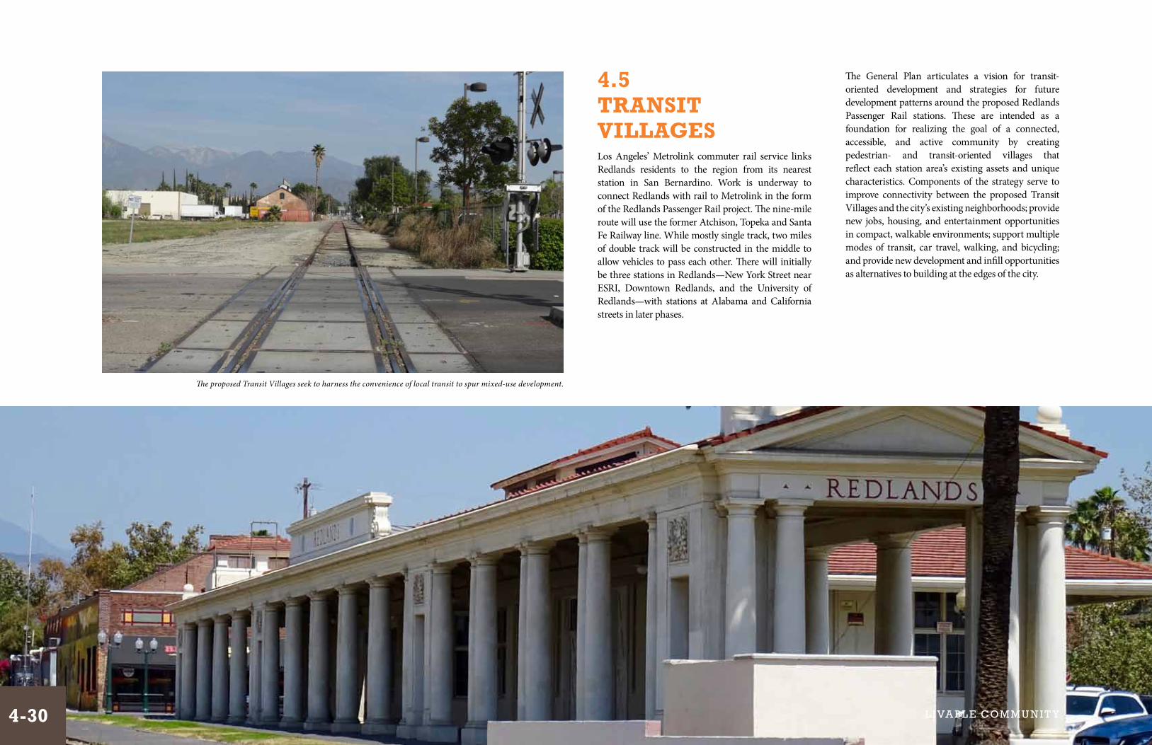
4.5 TRANsiT villAGEsLos Angeles’ Metrolink commuter rail service links Redlands residents to the region from its nearest station in San Bernardino. Work is underway to connect Redlands with rail to Metrolink in the form of the Redlands Passenger Rail project. The nine-mile route will use the former Atchison, Topeka and Santa Fe Railway line. While mostly single track, two miles of double track will be constructed in the middle to allow vehicles to pass each other. There will initially be three stations in Redlands—New York Street near ESRI, Downtown Redlands, and the University of Redlands—with stations at Alabama and California streets in later phases.
The General Plan articulates a vision for transit-oriented development and strategies for future development patterns around the proposed Redlands Passenger Rail stations. These are intended as a foundation for realizing the goal of a connected, accessible, and active community by creating pedestrian- and transit-oriented villages that reflect each station area’s existing assets and unique characteristics. Components of the strategy serve to improve connectivity between the proposed Transit Villages and the city’s existing neighborhoods; provide new jobs, housing, and entertainment opportunities in compact, walkable environments; support multiple modes of transit, car travel, walking, and bicycling; and provide new development and infill opportunities as alternatives to building at the edges of the city.
The proposed Transit Villages seek to harness the convenience of local transit to spur mixed-use development.
4-30 L i va bL e Com m u n i t y

Transit Village Area Strategy
Background
Transit Villages are areas surrounding a transit station in which the neighborhood is planned, designed, and integrated so that residents, workers, shoppers, and others find it convenient and attractive to patronize transit and other choices in transportation. Transit Villages have the following characteristics:
• Densities and intensities that promote working and living environments proximate to transit;
• Pedestrian and bicycle access to the station, with safe and comfortable pathways; and
• A transportation system that encourages and facilitates intermodal service and access.
The development of Transit Villages results in public benefits such as relief of traffic congestion, improved air quality, revitalization of neighborhoods, live/travel options for community members who rely on transit, additional job opportunities, and development of attractive neighborhoods.
The State of California’s Transit Village Development Planning Act of 1994 (Government Code Section 65460-65460.11) allows for cities to prepare Transit Village plans for designated Transit Village districts. Such districts would cover areas of up to a half-mile radius surrounding a given transit station. This Transit Village Areas Strategy of the General Plan will be supplemented with a Transit Village Plan that would provide more specific policies, land uses, development and design standards for the proposed Transit Villages and build upon the principles in the General Plan.
The City of Redlands has a history of transit-oriented development. Early Redlands developed around railroad and stagecoach lines in the late 1800s, and Downtown Redlands, near the Santa Fe and Southern Pacific depots, grew to accommodate a variety of different transportation modes, including the train, a local trolley system, carriages, horses, cars, pedestrians, and bicyclists.
It had a mix of uses including retail, eateries, professional services, and residential. Shop keepers often lived above their stores. Hotels provided accommodations to visitors. Downtown was a compact, walkable, and mixed-use neighborhood in which it was easy to move around.
Transit Villages Concept
The Transit Village Areas Strategy consists of the following:
• A Transit Village Overlay Zone (TVOZ) of mixed uses, which includes an area of focused streetscape and public realm improvements.
• Base land uses consistent with the land use classifications described in Section 3.1 of the General Plan, designed to foster higher intensities and compact development patterns.
• A Mixed Use Core where a mix of uses and higher densities and intensities would be encouraged through policies and standards in the Transit Village Plan.
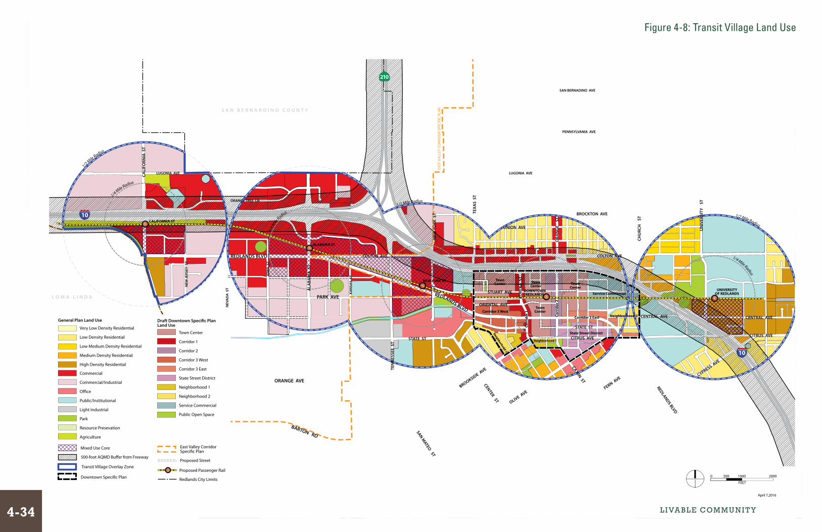
These components are described below. Figure 4-7 illustrates the Transit Village concept, and Figure 4-8 shows proposed land uses within the Transit Village areas.
Examples of higher density housing types near the Claremont, CA Metro-link Station
Redevelopment of the Claremont Packing House into walkable retail near the Clare-mont, CA Metrolink Station.
Early Redlands developed with centers of civic and economic activity located near transit opportunities.
The historic streets accommodated pedestrians as well as a variety of different transportation modes.
Transit Village Overlay Zone
The TVOZ is proposed for areas within a half-mile radius (10-minute walking distance) of each proposed rail station, and includes sites with the greatest potential to support transit ridership and benefit from proximity to the transit system. The TVOZ will feature enhancements to vehicular, pedestrian, and bicycle access, and strong connections to the station throughout. It would also be covered by design guidelines and standards established in the Transit Village Plan that would address issues such as architectural treatments for development, building massing and spacing, public realm improvements, transit amenities, street trees and landscaping, parking lots, public art, and transitions between the core and surrounding neighborhoods. Mixed-use development may also take place in the TVOZ, and is not limited to the Mixed Use Core areas.
Some major streets within the TVOZ that serve high traffic flows are designated for strengthened connections between major destinations and the Mixed Use Cores, and for design improvements for all modes of transportation. These are shown as Multi-modal Streets in Figure 4-7.
New residential units are encouraged to be located at least 500 feet away from the pavement edge of the I-10 and I-210 freeways, and at greater distances if needed to address roadway noise and air quality concerns. A 500-foot buffer along the freeways is shown in Figure 4-7 and Figure 4-8.
TA bl E 4 - 3: l A N d U s E s W i TH i N TH E T vOZ
Land Use Description
Low Medium Density Residential (modified)
Applies to the use of land primarily for single family detached residences, but can also include townhouse developments that are clustered to provide open space. Allows for residential development of 0 to 8 gross units per acre.
Medium Density Residential (modified)
Applies to the use of land for duplexes, townhomes, low-rise apartment buildings, and other less intense multi-family residential development types. Allows for densities of 9 to 15 gross units per acre.
High Density Residential (modified)
Allows for multi-family residential development at densities of 16 to 27 gross units per acre.
Commercial Provides land for retail stores, hotels, motels, automobile sales and services, offices, and entertainment facilities. It also permits residential, mixed-use development.
Commercial/Industrial
Allows compatible commercial and light industrial land uses, including auto services, commercial retail and services, and manufacturing. Includes flex commercial space and business parks.
Office Facilitates development of business and professional offices.
Public/Institutional Consists of education, cultural, and community facilities such as public schools, the University of Redlands, and the civic center. While these areas provide for education, cultural, and community facilities, residential uses at a density of up to 15 dwelling units per gross acre and agricultural uses are also allowed.
Park Includes both public and private facilities of park-like character.
Agriculture Designates areas suitable for agricultural production of crops, including citrus.
4-31

Principles4-P.41 Foster a connected, accessible,
and active community by creating attractively designed pedestrian- and transit-oriented villages with a mix of uses in a compact area.
4-P.42 Provide for new jobs, housing, and entertainment opportunities in com-pact, walkable environments.
4-P.43 Ensure that each Transit Village has a unique character and identity that reflects its existing assets and unique characteristics, and provides appropri-ate services at that location.
4-P.44 Provide choices for travel options, including walking, biking, vehicular, and transit.
4-P.45 Accommodate all appropriate modes of transportation in Transit Villages, and promote seamless transitions between modes.
4-P.46 Improve connectivity between Transit Villages and existing neighborhoods.
4-P.47 Provide for appropriate transitions between Transit Villages and sur-rounding neighborhoods.
4-P.48 Provide development and infill oppor-tunities as alternatives to building at the edges of the city.
Mixed Use Core
Mixed Use Core covers areas within a quarter-mile radius (a 5-minute walking distance) of proposed passenger rail stations. A Mixed Use Core indicates areas in the Transit Villages with the potential for the highest development intensity and ability to support transit ridership. These areas would have policies and standards detailed in the Transit Village Plan intended to create vital, mixed-use environments in close proximity to the proposed transit stations. Mixed Use Cores are proposed for four of the Transit Villages: California Street, Alabama Street, New York Street, and the University of Redlands. A Mixed Use Core is not proposed for the Downtown station, as that station area would be covered by the Downtown Specific Plan (DTSP) upon adoption of that Specific Plan. It is important to note that while the Mixed Use Cores indicate areas where high-density/intensity mixed-use development would be encouraged, such development may take place in the TVOZ outside of the cores as well, where appropriate.
Within the Mixed Use Core areas, some streets, as shown in Figure 4-7, are designated as boulevards. These are corridors that are connected to the stations, where high levels of pedestrian activity and flow would be anticipated. Therefore, pedestrian activity and comfort are emphasized, and ground-level active uses would be required in buildings along the corridors.
Multi-Modal Connections
The proposed Transit Villages are centered at passenger rail stations, but are intended to accommodate and improve travel for all modes of transportation. The Transit Villages would act as hubs, allowing for convenient transitions between different modes. Some travelers may go to a station to take the train, but others may go simply to switch to a different mode transportation that better gets them to their destination. The mix of modes in the Transit Villages would include:
• Pedestrians, including those using walkers or wheelchairs
• Bicycles, including personal bicycles and bikeshare
• Vehicles, including personal vehicles, carshare, carpools, ride-hailing, and taxis
• Transit, including buses and courtesy vans
• Trains
Facilities and improvements to accommodate these modes include wider sidewalks, ramps, bicycle paths and markings, bicycle racks and lockers, parking lots and garages, turnouts, bus shelters, and signage.
Transit-oriented residential, San Diego, CA Transit-oriented development, San Jose, CA
Orange Street, Redlands, CA Mixed uses, San Mateo, CA Pedestrian environment, Oakland, CAStreetscaping, Alameda, CA
4-P.49 Allow residential and mixed-use proj-ects in the Mixed Use Core at densi-ties up to the High Density Residential standard.
4-P.50 Allow for density bonuses in the Tran-sit Village Overlay Zone contingent on the provision of public benefits. Den-sity bonuses shall be a minimum of 25 percent within a quarter-mile of each transit station, and 10 percent in areas located between a quarter-mile and a half-mile radius of each transit station. Public benefits may include but are not limited to amenities such as a public park, plaza, or playground; enhanced streetscaping; public art; or participa-tion in a voluntary transfer of develop-ment rights program.
4-P.51 Complete a Transit Village Plan that will define: village character, design guidelines for architecture and site development, permitted and condi-tional uses, building setbacks and heights, yards, interfaces with the public streets and sidewalks, security measures, and transitions to existing neighborhoods.
4-P.52 Encourage stops of larger trains (Metrolink) in stations that can ade-quately accommodate their size and have greater availability of and access to parking.
POliciEs
L i va bL e Com m u n i t y4-32

L O M A L I N D A
50
0-
Fo
ot
Bu
�e
r
5 0 0 - F o o t B u f f e r
Mill Creek Zanja Trail
1/2Mile R
adius
1/4Mile Ra
dius
1/2Mile Radius
1/2Mile Radius
1/4M
ileRa
dius
1/4Mile Radius
SplashKingdomWater Park
San BernadinoCounty Museum
Pavillion at RedlandsShopping Center
Tri-CityShoppingCenter
ESRI Headquarters
RedlandsMall
Santa FeDepot
Orange St PlazaShopping Center
Jennie Davis Park
Smiley Park
Sylvan Park
University of Redlands
FranklinElementary
RedlandsHigh School
OrangewoodHigh School
RedlandsAdventistAcademyArrowhead
ChristianAcademy
MissionElementary
School
OrangeGroves
OrangeGroves
The Zanja
Orange Blossom Trail
East
Valle
y Cor
ridor
Bike
way
T h e C o l o n y
W e s t E n d
ytisrevinUainoguLD i s t r i c t
Chur
ch St
to Sa
nta An
a Rive
r Trai
lCALIFORNIA ST
ALABAMA ST
NEW YORK ST
DOWNTOWNREDLANDS
LUGONIA AVE CALI
FORN
IA S
T
ALA
BAM
A S
T
KAN
SAS
ST
NEW
YO
RK S
T
REDLANDS BLVD
TEXA
S S
T
IOW
A S
T
REDLANDS BLVD
ORA
NG
E
ST
CHU
RCH
S
T
UN
IVER
SITY
S
T
CITRUS AVE
STATE ST
STATE ST
PARK AVE
TEN
NES
SEE
ST
CENTRAL AVE
UNION AVE
BROCKTON AVE
CENTRAL AVE
CITRUS AVE
COLTON AVECOLTON AVE
NEW
JERS
EY S
T
NEV
AD
A S
T
LUGONIA AVE
EURE
KA S
T
STUART AVE
REDLANDS BLVD
BROOKSIDE AVE
OLIVE AVEFERN AVE
CYPRESS AVE
CAJON ST
CENTER ST
ORANGE AVE
ORANGE TREE LN5 0 0 - F o o t B u � e r
FEET
1000500 00020
MARCH 28, 2016
10
10
210
Orange Groves Orange Groves
Orange Blossom Trail
Orange Blossom Trail
AK SmileyPublic Library
LincolnMemorialShrine
Packinghouse
Lugo
nia Tr
ail
Police/City Yard
UNIVERSITYOF REDLANDS
Wallichs/LoeweTheatres
Citrus Avenue Bicycle Trail
S A N B E R N A R D I N OC O U N T Y
EAST
VALL
EY CO
RRID
OR SP
ECIFI
C PLA
N
FEET
1000500
MARCH 28, 2016
00020
Figure X-X: Transit Village ConceptFigure 4-7: Transit Village Concept
Mixed Use Core
DTSP - Town Center and Key Corridors
DTSP - State Street District
Transit Village Overlay Zone
Multi-modal Street
Boulevard
Proposed Street
Primary Pedestrian Route
Primary Bicycle Route
Intersection/Undercrossing Improvement
Points of Interest
Potential New Park
Proposed Passenger Rail
Downto
East Valley C
Redlands City Limits
500-foot AQMD Bu�er from Freeway
4-33
1/2Mile R
adius
1/4Mile Ra
dius
1/2Mile Radius
1/2Mile Radius
1/4M
ileRa
dius
1/4Mile Radius
CALIFORNIA ST
ALABAMA ST
NEW YORK ST
DOWNTOWNREDLANDS
UNIVERSITYOF REDLANDS
LUGONIA AVECALI
FORN
IA S
T
ALA
BAM
A S
T
KAN
SAS
ST
NEW
YO
RK S
T
REDLANDS BLVD
TEXA
S S
T
IOW
A S
T
ORA
NG
E
ST
CHU
RCH
S
T
UN
IVER
SITY
S
T
CITRUS AVESTATE ST
PARK AVE
TEN
NES
SEE
ST
CENTRAL AVE
UNION AVE
BROCKTON AVE
CENTRAL AVE
CITRUS AVE
COLTON AVECOLTON AVE
NEW
JERS
EY S
T
NEV
AD
A S
T
LUGONIA AVE
EURE
KA S
T
STUART AVE
REDLANDS BLVD
BROOKSIDE AVE
OLIVE AVEFERN AVE
CYPRESS AVE
CAJON ST
CENTER ST
BARTON RD
ORANGE AVE
ORANGE TREE LN
TownCenter Town
Center
TownCenter
TownCenter
Corridor 3 West
Corridor 3 EastCorr
idor
2
REDLANDS BLVD
Corr
idor
1
State Street District
Neighborhood 2
Service Commercial
Neighborhood 1
Neighborhood 2
ORIENTAL AVE
STATE ST
PENNSYLVANIA AVE
SAN BERNADINO AVE
SAN MATEO ST
10
10
210
FEET
1000500 00020
April 7,2016
Figure X-X: Transit Village and General Plan Land Use
Very Low Density Residential
Low Density Residential
Low Medium Density Residential
Medium Density Residential
High Density Residential
Mixed Use Core
Commercial
Commercial/Industrial
O�ce
Public/Institutional
Light Industrial
Park
Resource Presevation
Agriculture
500-foot AQMD Bu�er from Freeway
Transit Village Overlay Zone
Downtown Speci�c Plan
East Valley CorridorSpeci�c Plan
Proposed Street
General Plan Land Use
Town Center
Corridor 1
Corridor 2
Corridor 3 West
Corridor 3 East
State Street District
Neighborhood 1
Neighborhood 2
Service Commercial
Public Open Space
Proposed Passenger Rail
Redlands City Limits
Draft Downtown Speci�c PlanLand Use
EAST
VA
LLEY
CO
RRID
OR
SPEC
IFIC
PLA
N
L O M A L I N D A
S A N B E R N A R D I N O C O U N T Y
Figure 4-8: Transit Village Land Use
L i va bL e Com m u n i t y4-34

FEET
1000500
MARCH 28, 2016
00020
Figure X-X: Transit Village Concept
50
0-
Fo
ot
Bu
�e
r
5 0 0 - F o o t B u f f e r
Mill Creek Zanja Trail
1/2Mile R
adius
1/4Mile Ra
dius
1/2Mile Radius
1/2Mile Radius
1/4M
ileRa
dius
1/4Mile Radius
SplashKingdomWater Park
San BernadinoCounty Museum
Pavillion at RedlandsShopping Center
Tri-CityShoppingCenter
ESRI Headquarters
RedlandsMall
Santa FeDepot
Orange St PlazaShopping Center
Jennie Davis Park
Smiley Park
Sylvan Park
University of Redlands
FranklinElementary
RedlandsHigh School
OrangewoodHigh School
RedlandsAdventistAcademyArrowhead
ChristianAcademy
MissionElementary
School
OrangeGroves
OrangeGroves
The Zanja
Orange Blossom Trail
East
Valle
y Cor
ridor
Bike
way
T h e C o l o n y
W e s t E n d
ytisrevinUainoguLD i s t r i c t
CALIFORNIA ST
ALABAMA ST
NEW YORK ST
DOWNTOWNREDLANDS
UNIVERSITYOF REDLANDS
LUGONIA AVECALI
FORN
IA S
T
ALA
BAM
A S
T
KAN
SAS
ST
NEW
YO
RK S
T
REDLANDS BLVD
TEXA
S S
T
IOW
A S
T
REDLANDS BLVD
ORA
NG
E
ST
CHU
RCH
S
T
UN
IVER
SITY
S
T
CITRUS AVE
STATE ST
STATE ST
PARK AVE
TEN
NES
SEE
ST
CENTRAL AVE
UNION AVE
BROCKTON AVE
CENTRAL AVE
CITRUS AVE
COLTON AVECOLTON AVE
NEW
JERS
EY S
T
NEV
AD
A S
T
LUGONIA AVE
EURE
KA S
T
STUART AVE
REDLANDS BLVD
BROOKSIDE AVE
OLIVE AVEFERN AVE
CYPRESS AVE
CAJON ST
CENTER ST
ORANGE AVE
ORANGE TREE LN5 0 0 - F o o t B u � e r
FEET
1000500 00020
MARCH 28, 2016
10
10
210
Orange Groves Orange Groves
Orange Blossom Trail
Orange Blossom Trail
AK SmileyPublic Library
LincolnMemorialShrine
Packinghouse
Lugo
nia Tr
ail
Police/City Yard
Chur
ch St
to Sa
nta An
a Rive
r Trai
l
Wallichs/LoeweTheatres
Citrus Avenue Bicycle Trail
EAST
VALL
EY CO
RRID
OR SP
ECIFI
C PLA
N
L O M A L I N D A
S A N B E R N A R D I N O C O U N T Y
1/2Mile R
adius
1/4Mile Ra
dius
1/2Mile Radius
1/2Mile Radius
1/4M
ileRa
dius
1/4Mile Radius
1/2Mile R
adius
1/4Mile Ra
dius
1/2Mile Radius
1/2Mile Radius
1/4M
ileRa
dius
1/4Mile Radius
CALIFORNIA ST
ALABAMA ST
NEW YORK ST
DOWNTOWNREDLANDS
UNIVERSITYOF REDLANDS
LUGONIA AVE
CALI
FORN
IA S
T
ALA
BAM
A S
T
KAN
SAS
ST
NEW
YO
RK S
T
REDLANDS BLVD
TEXA
S S
T
IOW
A S
T
ORA
NG
E
ST
CHU
RCH
S
T
UN
IVER
SITY
S
T
CITRUS AVESTATE ST
PARK AVE
TEN
NES
SEE
ST
TEN
NES
SEE
ST
CENTRAL AVE
UNION AVE
BROCKTON AVE
CENTRAL AVE
CITRUS AVE
COLTON AVECOLTON AVE
NEW
JERS
EY S
T
NEV
AD
A S
T
LUGONIA AVE
EURE
KA S
T
STUART AVE
REDLANDS BLVD
BROOKSIDE AVE
OLIVE AVEFERN AVE
CYPRESS AVE
CAJON ST
CENTER ST
BARTON RD
ORANGE AVE
ORANGE TREE LN
TownCenter Town
Center
TownCenter
TownCenter
Corridor 3 West
Corridor 3 EastCorr
idor
2
REDLANDS BLVD
Corr
idor
1
State Street District
Neighborhood 2
Service Commercial
Neighborhood 1
Neighborhood 2
ORIENTAL AVE
STATE ST
10
10
210
ALA
BAM
A S
T
FEET
1000500
MARCH 28, 2016
00020
Figure X-X: Transit Village Concept
EAST
VA
LLEY
CO
RRID
OR
SPEC
IFIC
PLA
N
L O M A L I N D A
S A N B E R N A R D I N OC O U N T Y
Proposed Passenger Rail500-foot AQMD Bu�er from Freeway
Redlands City Limits
Commercial
Public/Institutional
Commercial/Industrial
Transit Village Overlay Zone
Proposed Street
High Density Residential
Agriculture
East Valley Corridor Speci�c Plan
General Plan Land Use
Mixed Use Core
Transit Village Overlay Zone
Multi-modal Street
Primary Pedestrian Route
Primary Bicycle Route
Intersection/UndercrossingImprovement
Proposed Passenger Rail
500-foot AQMD Bu�er from Freeway
Redlands City Limits
Points of Interest
Proposed Street
Mixed Use Core
California Street Transit VillageA retail destination that builds on existing uses and creates a distinctive gateway between cities
The California Street Transit Village would be located near California Street and Redlands Boulevard, at the city’s western border with Loma Linda. Existing (2016) land uses within a half-mile of the (still to be finalized) station location include commercial, office, and industrial uses at low intensities; multi-family residential; some vacant land; and some land under citrus cultivation.
The strategy for the proposed Transit Village seeks to reinforce the existing strong cluster of commercial uses, while promoting opportunities for reinvestment and infill development. The Transit Village would introduce mixed uses into the East Valley Corridor to serve workers in the warehouse area, the medical facilities such as the VA Center and Kaiser medical facility, as well as visitors to destinations such as the San Bernardino County Museum and Splash Kingdom.
Circulation improvements focus on enhancing major streets, including California Street and Redlands Boulevard, for all modes of travel. Freeway undercrossings at California Street will be enhanced to ensure pedestrian safety and comfort. Bicycle route improvements would include the completion of the East Valley Corridor Bikeway and the Orange Blossom Trail.
From an overall identity perspective, this Transit Village would serve as a western gateway to the city of Redlands, as well as Loma Linda. Thus, the strategy would seek to create a sense of arrival. The strategy would preserve the presence of citrus groves in the Transit Village to highlight the city’s citrus heritage for travelers.
Actions4-A.98 Create greater opportunity to intensify
and consolidate land uses on adjacent parcels and connect existing assets through infill development.
4-A.99 Promote mixed uses to serve a range of users, including local workers and visi-tors to nearby tourist destinations.
4-A.100 Provide streetscape improvements along the major corridors of Califor-nia Street and Redlands Boulevard to enhance comfort and safety for all modes of travel.
4-A.101 Implement bicycle route improvements that provide intra-city and regional con-nections, connecting to Loma Linda, the City of San Bernardino, and north to the Santa Ana River Trail.
4-A.102 Create a “sense of arrival” at the city’s western gateway through aesthetic improvements such as landscaping, citrus groves, and signage.
4-A.103 Preserve citrus groves for visual effect and to distinguish the station area from others.
4-A.104 Improve the I-10 undercrossing at California Street to increase comfort and safety for all modes of travel and enhance north-south circulation.
San Bernadino County Museum will remain as one of the visitor destinations in the California Street Transit Village.
Commercial uses within the Mixed Use Core would provide internal circulation prioritizing walking patrons.
Existing orange groves will be preserved to highlight Red-lands’ citrus heritage.
Principal land uses within the Mixed Use Core would include neighborhood retail, commu-nity facility, and potentially residential.
The East Valley Corridor Bike-way and the Orange Blossom Trail would enhance bicycle con-nectivity in the Transit Village.
An undercrossing improve-ment at California Street will enhance connectivity between the station to local destina-tions.
4-35

FEET
1000500
MARCH 28, 2016
00020
Figure X-X: Transit Village Concept
50
0-
Fo
ot
Bu
�e
r
5 0 0 - F o o t B u f f e r
Mill Creek Zanja Trail
1/2Mile R
adius
1/4Mile Ra
dius
1/2Mile Radius
1/2Mile Radius
1/4M
ileRa
dius
1/4Mile Radius
SplashKingdomWater Park
San BernadinoCounty Museum
Pavillion at RedlandsShopping Center
Tri-CityShoppingCenter
ESRI Headquarters
RedlandsMall
Santa FeDepot
Orange St PlazaShopping Center
Jennie Davis Park
Smiley Park
Sylvan Park
University of Redlands
FranklinElementary
RedlandsHigh School
OrangewoodHigh School
RedlandsAdventistAcademyArrowhead
ChristianAcademy
MissionElementary
School
OrangeGroves
OrangeGroves
The Zanja
Orange Blossom Trail
East
Valle
y Cor
ridor
Bike
way
T h e C o l o n y
W e s t E n d
ytisrevinUainoguLD i s t r i c t
CALIFORNIA ST
ALABAMA ST
NEW YORK ST
DOWNTOWNREDLANDS
UNIVERSITYOF REDLANDS
LUGONIA AVECALI
FORN
IA S
T
ALA
BAM
A S
T
KAN
SAS
ST
NEW
YO
RK S
T
REDLANDS BLVD
TEXA
S S
T
IOW
A S
T
REDLANDS BLVD
ORA
NG
E
ST
CHU
RCH
S
T
UN
IVER
SITY
S
T
CITRUS AVE
STATE ST
STATE ST
PARK AVE
TEN
NES
SEE
ST
CENTRAL AVE
UNION AVE
BROCKTON AVE
CENTRAL AVE
CITRUS AVE
COLTON AVECOLTON AVE
NEW
JERS
EY S
T
NEV
AD
A S
T
LUGONIA AVE
EURE
KA S
T
STUART AVE
REDLANDS BLVD
BROOKSIDE AVE
OLIVE AVEFERN AVE
CYPRESS AVE
CAJON ST
CENTER ST
ORANGE AVE
ORANGE TREE LN5 0 0 - F o o t B u � e r
FEET
1000500 00020
MARCH 28, 2016
10
10
210
Orange Groves Orange Groves
Orange Blossom Trail
Orange Blossom Trail
AK SmileyPublic Library
LincolnMemorialShrine
Packinghouse
Lugo
nia Tr
ail
Police/City Yard
Chur
ch St
to Sa
nta An
a Rive
r Trai
l
Wallichs/LoeweTheatres
Citrus Avenue Bicycle Trail
EAST
VALL
EY CO
RRID
OR SP
ECIFI
C PLA
N
L O M A L I N D A
S A N B E R N A R D I N O C O U N T Y
1/2Mile R
adius
1/4Mile Ra
dius
1/2Mile Radius
1/2Mile Radius
1/4M
ileRa
dius
1/4Mile Radius
1/2Mile R
adius
1/4Mile Ra
dius
1/2Mile Radius
1/2Mile Radius
1/4M
ileRa
dius
1/4Mile Radius
CALIFORNIA ST
ALABAMA ST
NEW YORK ST
DOWNTOWNREDLANDS
UNIVERSITYOF REDLANDS
LUGONIA AVE
CALI
FORN
IA S
T
ALA
BAM
A S
T
KAN
SAS
ST
NEW
YO
RK S
T
REDLANDS BLVD
TEXA
S S
T
IOW
A S
T
ORA
NG
E
ST
CHU
RCH
S
T
UN
IVER
SITY
S
T
CITRUS AVESTATE ST
PARK AVE
TEN
NES
SEE
ST
TEN
NES
SEE
ST
CENTRAL AVE
UNION AVE
BROCKTON AVE
CENTRAL AVE
CITRUS AVE
COLTON AVECOLTON AVE
NEW
JERS
EY S
T
NEV
AD
A S
T
LUGONIA AVE
EURE
KA S
T
STUART AVE
REDLANDS BLVD
BROOKSIDE AVE
OLIVE AVEFERN AVE
CYPRESS AVE
CAJON ST
CENTER ST
BARTON RD
ORANGE AVE
ORANGE TREE LN
TownCenter Town
Center
TownCenter
TownCenter
Corridor 3 West
Corridor 3 EastCorr
idor
2
REDLANDS BLVD
Corr
idor
1
State Street District
Neighborhood 2
Service Commercial
Neighborhood 1
Neighborhood 2
ORIENTAL AVE
STATE ST
10
10
210
ALA
BAM
A S
T
FEET
1000500
MARCH 28, 2016
00020
Figure X-X: Transit Village Concept
EAST
VA
LLEY
CO
RRID
OR
SPEC
IFIC
PLA
N
L O M A L I N D A
S A N B E R N A R D I N OC O U N T Y
Proposed Passenger Rail
500-foot AQMD Bu�er from Freeway
Redlands City Limits
Commercial/Industrial
O�ce
Public/Institutional
Park
Transit Village Overlay Zone
Proposed Street
Commercial
General Plan Land Use
East Valley Corridor Speci�c Plan
Mixed Use Core
Transit Village Overlay Zone
Multi-modal Street
Boulevard
Proposed Street
Primary Pedestrian Route
Primary Bicycle Route
Intersection/UndercrossingImprovement
Points of Interest
Potential New Park
Proposed Passenger Rail
500-foot AQMD Bu�er from Freeway
Redlands City Limits
East Valley Corridor Speci�c Plan
Mixed Use Core
Alabama Street Transit VillageA complete neighborhood with a mix of uses and ample parkland
The Alabama Street Transit Village would be located near Alabama Street and Redlands Boulevard. Existing (2016) land uses within a half-mile of the (still to be finalized) station location are primarily commercial, with some industrial and office uses and several vacant properties. Development in the area is primarily currently auto-centric.
The strategy for the proposed Transit Village would establish a complete neighborhood, including a Mixed Use Core with a higher-density mix of residential and commercial uses; and commercial and office uses with the potential for residential mixed use in the TVOZ outside of the core. The Transit Village would serve as a gateway to regional shopping to the north, and create both a gateway and transition area between the station and light industrial uses to the south. Residential uses would be discouraged within 500 feet of interstate I-10. New parks would be sited in the area to serve the needs of new residents and employees within walking distance of the transit station. Additionally, there would be the potential to reuse commercial sites as office centers.
Within the Transit Village, primary pedestrian routes along new streets would allow people to safely and comfortably walk between the station, neighborhood parks, and residences. Boulevards would be established along Redlands Boulevard and Colton Avenue, where improvements would focus on the pedestrian experience and ground-floor active uses would be required along the street frontage. Primary bicycle routes would include the Orange Blossom Trail, which provides strong east-west connections to the other Transit Villages, as well as to other bicycle routes providing access to neighborhoods north and south of the rail line.
The Mixed Use Core would combine high density residen-
tial and ground-floor retail.
Residential uses will be pro-hibited within the 500-foot
buffer from the freeway.
Potential new parks would serve residents and visitors of
the Transit Village.
Redlands Boulevard is envi-sioned as a multi-modal
street with ground-floor retail near the station.
Streetscape design would prioritize pedestrian comfort
along primary pedestrian routes.
Actions4-A.105 Create an active and compact transit-
oriented core with a mix of residential and commercial/office uses. Allow for the reuse of commercial sites as office centers.
4-A.106 Add new streets to create a finer-grained (shorter blocks), pedestrian-scaled road network, connecting residential areas to parks and the Mixed Use Core.
4-A.107 Provide streetscape improvements along the major corridors of Alabama Street and Redlands Boulevard to enhance comfort and safety for all modes of travel and strengthen north-south connections between major desti-nations and east-west routes.
4-A.108 Establish boulevards along Redlands Boulevard and Colton Avenue with pedestrian-oriented streetscape improvements and ground-floor active uses.
4-A.109 Ensure that adequate parkland is avail-able to serve new residents and employ-ees in the area.
4-A.110 Implement bicycle route improvements that provide strong east-west connec-tions to other Transit Villages and the city’s wider bicycle network. Routes would include the Orange Blossom Trail and potentially a trail along Redlands Boulevard in this location.
4-A.111 Plan for the Alabama Street station to be the eastern terminus for the larger Metrolink trains where space is avail-able to accommodate the larger trains and there is greater availability of land for parking.
L i va bL e Com m u n i t y4-36

New York Street Transit VillageAn employment hub with easy access to Downtown and surrounding neighborhoods
The New York Street Transit Village would be located near New York Street and Redlands Boulevard. The area surrounding the proposed station location is currently (2016) characterized mainly by office and auto-oriented commercial uses, including the ESRI campus. Other nearby points of interest and buildings include Jennie Davis Park, Orangewood High School, and the Redlands Police Department.
The strategy for the New York Street Transit Village would build on the presence of existing employment activity in the area, particularly ESRI, to create a hub where the expansion of available office space and commercial uses provides a concentration of opportunities for jobs and innovation such as new businesses and start-ups. The Transit Village would also serve as a gateway to Downtown.
The Mixed Use Core would be higher-intensity mixed uses—with office, retail, and services, as well as housing, including live/work lofts. Outside of the core, lower-density office uses and residential would provide a transition to the edge of the Transit Village.
The Transit Village would feature a variety of connections and streetscape improvements to facilitate movement between the station, core, and surrounding neighborhoods. New York Street would be extended northwards to provide a connection to commercial areas in Lugonia. Streetscape improvements along the major corridors of Colton Avenue, Redlands Boulevard, and New York Street would enhance travel for all modes. Boulevards would be established along Redlands Boulevard and Colton Avenue, where improvements would focus on the pedestrian experience and ground-floor active uses would be required along the street frontage. Primary pedestrian routes would allow for walkable connections to and from Downtown and the proposed residential neighborhood at Alabama Street. Primary bicycle routes would include the Orange Blossom Trail, which provides east-west connections to the other Transit Villages, and routes along New York Street and Texas Street to provide access to neighborhoods north of I-10.
Actions4-A.112 Create an active and compact transit-
oriented core with office uses that pro-vide opportunities for jobs and innova-tion, as well as commercial and residen-tial uses to serve the needs of the area’s workers.
4-A.113 Provide streetscape improvements along the major corridors of Colton Ave-nue, Texas Street, and Redlands Boule-vard to enhance comfort and safety for all modes of travel and increase acces-sibility to and from surrounding areas.
4-A.114 Establish boulevards along Redlands Boulevard and Colton Avenue with pedestrian-oriented streetscape improvements and ground-floor active uses.
4-A.115 Provide pedestrian routes between offices, neighborhoods, and Downtown.
4-A.116 Implement bicycle route improvements that provide strong east-west connec-tions to other Transit Villages as well as north-south connections to improve access to existing neighborhoods to the north. Routes would include the Orange Blossom Trail, the Lugonia Trail on New York Street, and a route along Texas Street.
4-A.117 Implement intersection improvements, including pedestrian improvements, at the I-10 undercrossings at New York and Texas Street to increase comfort and safety for all modes of travel.
4-A.118 Ensure safe railway crossings at Ten-nessee Street, Texas Street, and New York Street for bicyclists and pedestri-ans.
4-A.119 Maintain single-family residential neighborhoods designated as low- and low medium-density residential in the General Plan within the TVOZ. Transition higher density housing when adjacent to these neighborhoods.
FEET
1000500
MARCH 28, 2016
00020
Figure X-X: Transit Village Concept
50
0-
Fo
ot
Bu
�e
r
5 0 0 - F o o t B u f f e r
Mill Creek Zanja Trail
1/2Mile R
adius
1/4Mile Ra
dius
1/2Mile Radius
1/2Mile Radius
1/4M
ileRa
dius
1/4Mile Radius
SplashKingdomWater Park
San BernadinoCounty Museum
Pavillion at RedlandsShopping Center
Tri-CityShoppingCenter
ESRI Headquarters
RedlandsMall
Santa FeDepot
Orange St PlazaShopping Center
Jennie Davis Park
Smiley Park
Sylvan Park
University of Redlands
FranklinElementary
RedlandsHigh School
OrangewoodHigh School
RedlandsAdventistAcademyArrowhead
ChristianAcademy
MissionElementary
School
OrangeGroves
OrangeGroves
The Zanja
Orange Blossom Trail
East
Valle
y Cor
ridor
Bike
way
T h e C o l o n y
W e s t E n d
ytisrevinUainoguLD i s t r i c t
CALIFORNIA ST
ALABAMA ST
NEW YORK ST
DOWNTOWNREDLANDS
UNIVERSITYOF REDLANDS
LUGONIA AVECALI
FORN
IA S
T
ALA
BAM
A S
T
KAN
SAS
ST
NEW
YO
RK S
T
REDLANDS BLVD
TEXA
S S
T
IOW
A S
T
REDLANDS BLVD
ORA
NG
E
ST
CHU
RCH
S
T
UN
IVER
SITY
S
T
CITRUS AVE
STATE ST
STATE ST
PARK AVE
TEN
NES
SEE
ST
CENTRAL AVE
UNION AVE
BROCKTON AVE
CENTRAL AVE
CITRUS AVE
COLTON AVECOLTON AVE
NEW
JERS
EY S
T
NEV
AD
A S
T
LUGONIA AVE
EURE
KA S
T
STUART AVE
REDLANDS BLVD
BROOKSIDE AVE
OLIVE AVEFERN AVE
CYPRESS AVE
CAJON ST
CENTER ST
ORANGE AVE
ORANGE TREE LN5 0 0 - F o o t B u � e r
FEET
1000500 00020
MARCH 28, 2016
10
10
210
Orange Groves Orange Groves
Orange Blossom Trail
Orange Blossom Trail
AK SmileyPublic Library
LincolnMemorialShrine
Packinghouse
Lugo
nia Tr
ail
Police/City Yard
Chur
ch St
to Sa
nta An
a Rive
r Trai
l
Wallichs/LoeweTheatres
Citrus Avenue Bicycle Trail
EAST
VALL
EY CO
RRID
OR SP
ECIFI
C PLA
N
L O M A L I N D A
S A N B E R N A R D I N O C O U N T Y
1/2Mile R
adius
1/4Mile Ra
dius
1/2Mile Radius
1/2Mile Radius
1/4M
ileRa
dius
1/4Mile Radius
1/2Mile R
adius
1/4Mile Ra
dius
1/2Mile Radius
1/2Mile Radius
1/4M
ileRa
dius
1/4Mile Radius
CALIFORNIA ST
ALABAMA ST
NEW YORK ST
DOWNTOWNREDLANDS
UNIVERSITYOF REDLANDS
LUGONIA AVE
CALI
FORN
IA S
T
ALA
BAM
A S
T
KAN
SAS
ST
NEW
YO
RK S
T
REDLANDS BLVD
TEXA
S S
T
IOW
A S
T
ORA
NG
E
ST
CHU
RCH
S
T
UN
IVER
SITY
S
T
CITRUS AVESTATE ST
PARK AVE
TEN
NES
SEE
ST
TEN
NES
SEE
ST
CENTRAL AVE
UNION AVE
BROCKTON AVE
CENTRAL AVE
CITRUS AVE
COLTON AVECOLTON AVE
NEW
JERS
EY S
T
NEV
AD
A S
T
LUGONIA AVE
EURE
KA S
T
STUART AVE
REDLANDS BLVD
BROOKSIDE AVE
OLIVE AVEFERN AVE
CYPRESS AVE
CAJON ST
CENTER ST
BARTON RD
ORANGE AVE
ORANGE TREE LN
TownCenter Town
Center
TownCenter
TownCenter
Corridor 3 West
Corridor 3 EastCorr
idor
2
REDLANDS BLVD
Corr
idor
1
State Street District
Neighborhood 2
Service Commercial
Neighborhood 1
Neighborhood 2
ORIENTAL AVE
STATE ST
10
10
210
ALA
BAM
A S
T
FEET
1000500
MARCH 28, 2016
00020
Figure X-X: Transit Village Concept
EAST
VA
LLEY
CO
RRID
OR
SPEC
IFIC
PLA
N
L O M A L I N D A
S A N B E R N A R D I N OC O U N T Y
The Transit Village will expand on existing employ-ment activity.
The Orange Blossom Trail would be one of the two major bicycle routes connecting the Transit Villages.
Railway crossings will be improved to ensure safe con-nections within the Transit Village.
Proposed Passenger Rail
500-foot AQMD Bu�er from Freeway
Transit Village Overlay Zone
Downtown Speci�c Plan
East Valley Corridor Speci�c Plan
Proposed Street
Commercial
O�ce
Public/Institutional
Park
Commercial/Industrial
Light Industrial
Low Density Residential
High Density Residential
General Plan Land Use
Mixed Use Core
Mixed Use Core
Transit Village Overlay Zone
Multi-modal Street
Proposed Street
Primary Pedestrian Route
Primary Bicycle Route
Intersection/UndercrossingImprovement
Potential New Park
Proposed Passenger Rail
500-foot AQMD Bu�er from Freeway
Downtown Speci�c Plan
East Valley Corridor Speci�c Plan
Points of Interest
Undercrossing improvements and a new bicycle route along Texas street would facilitate north-south accessibility.
The Mixed Use Core would be primarily office, with some retail and potential for hous-ing.
4-37
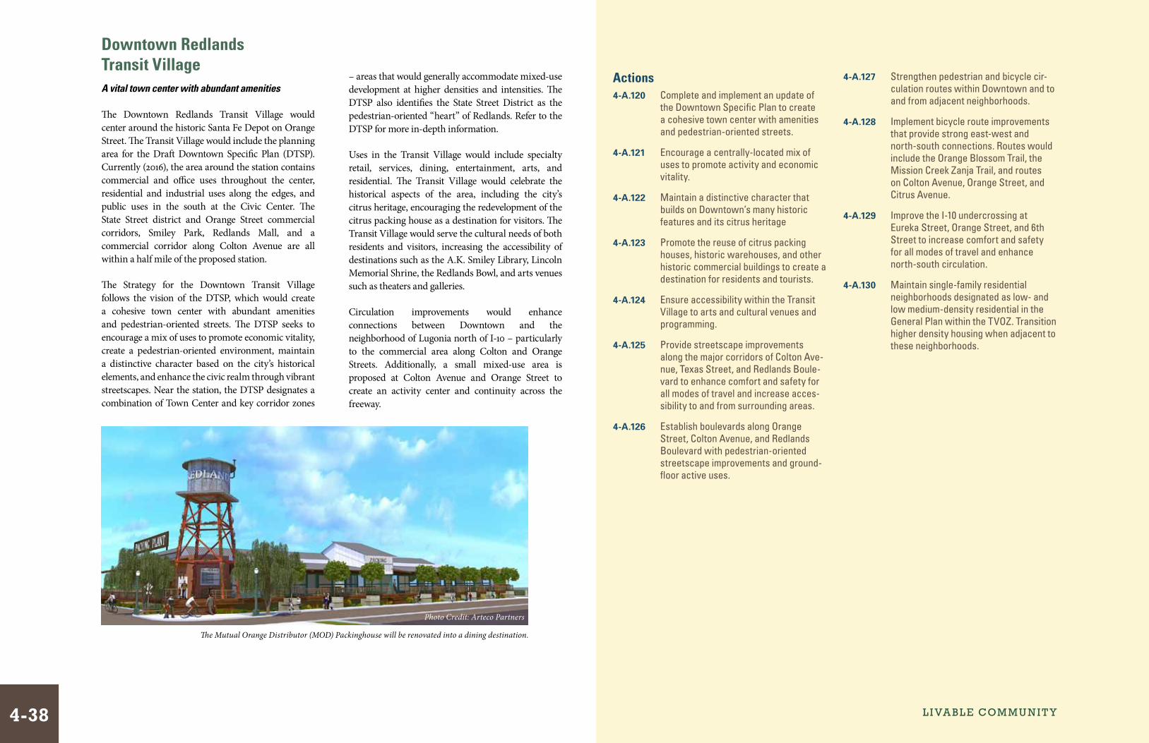
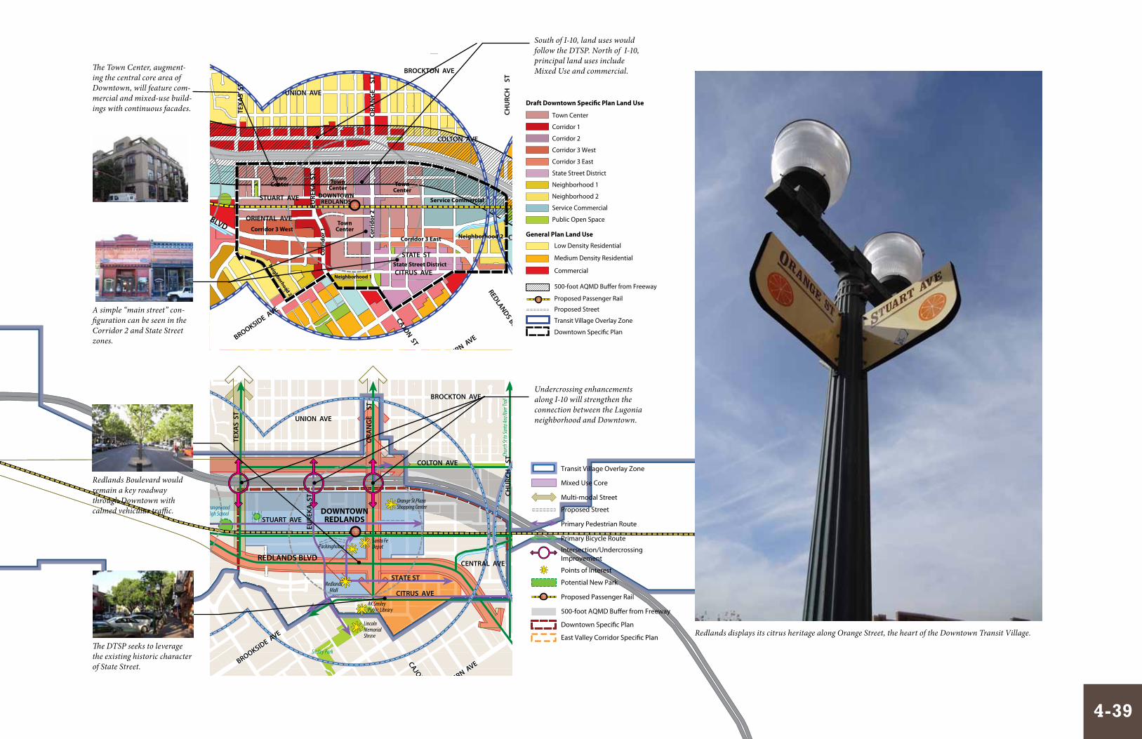
Downtown Redlands Transit VillageA vital town center with abundant amenities
The Downtown Redlands Transit Village would center around the historic Santa Fe Depot on Orange Street. The Transit Village would include the planning area for the Draft Downtown Specific Plan (DTSP). Currently (2016), the area around the station contains commercial and office uses throughout the center, residential and industrial uses along the edges, and public uses in the south at the Civic Center. The State Street district and Orange Street commercial corridors, Smiley Park, Redlands Mall, and a commercial corridor along Colton Avenue are all within a half mile of the proposed station.
The Strategy for the Downtown Transit Village follows the vision of the DTSP, which would create a cohesive town center with abundant amenities and pedestrian-oriented streets. The DTSP seeks to encourage a mix of uses to promote economic vitality, create a pedestrian-oriented environment, maintain a distinctive character based on the city’s historical elements, and enhance the civic realm through vibrant streetscapes. Near the station, the DTSP designates a combination of Town Center and key corridor zones
Actions4-A.120 Complete and implement an update of
the Downtown Specific Plan to create a cohesive town center with amenities and pedestrian-oriented streets.
4-A.121 Encourage a centrally-located mix of uses to promote activity and economic vitality.
4-A.122 Maintain a distinctive character that builds on Downtown’s many historic features and its citrus heritage
4-A.123 Promote the reuse of citrus packing houses, historic warehouses, and other historic commercial buildings to create a destination for residents and tourists.
4-A.124 Ensure accessibility within the Transit Village to arts and cultural venues and programming.
4-A.125 Provide streetscape improvements along the major corridors of Colton Ave-nue, Texas Street, and Redlands Boule-vard to enhance comfort and safety for all modes of travel and increase acces-sibility to and from surrounding areas.
4-A.126 Establish boulevards along Orange Street, Colton Avenue, and Redlands Boulevard with pedestrian-oriented streetscape improvements and ground-floor active uses.
4-A.127 Strengthen pedestrian and bicycle cir-culation routes within Downtown and to and from adjacent neighborhoods.
4-A.128 Implement bicycle route improvements that provide strong east-west and north-south connections. Routes would include the Orange Blossom Trail, the Mission Creek Zanja Trail, and routes on Colton Avenue, Orange Street, and Citrus Avenue.
4-A.129 Improve the I-10 undercrossing at Eureka Street, Orange Street, and 6th Street to increase comfort and safety for all modes of travel and enhance north-south circulation.
4-A.130 Maintain single-family residential neighborhoods designated as low- and low medium-density residential in the General Plan within the TVOZ. Transition higher density housing when adjacent to these neighborhoods.
– areas that would generally accommodate mixed-use development at higher densities and intensities. The DTSP also identifies the State Street District as the pedestrian-oriented “heart” of Redlands. Refer to the DTSP for more in-depth information.
Uses in the Transit Village would include specialty retail, services, dining, entertainment, arts, and residential. The Transit Village would celebrate the historical aspects of the area, including the city’s citrus heritage, encouraging the redevelopment of the citrus packing house as a destination for visitors. The Transit Village would serve the cultural needs of both residents and visitors, increasing the accessibility of destinations such as the A.K. Smiley Library, Lincoln Memorial Shrine, the Redlands Bowl, and arts venues such as theaters and galleries.
Circulation improvements would enhance connections between Downtown and the neighborhood of Lugonia north of I-10 – particularly to the commercial area along Colton and Orange Streets. Additionally, a small mixed-use area is proposed at Colton Avenue and Orange Street to create an activity center and continuity across the freeway.
The Mutual Orange Distributor (MOD) Packinghouse will be renovated into a dining destination.
Photo Credit: Arteco Partners
L i va bL e Com m u n i t y4-38
FEET
1000500
MARCH 28, 2016
00020
Figure X-X: Transit Village Concept
50
0-
Fo
ot
Bu
�e
r
5 0 0 - F o o t B u f f e r
Mill Creek Zanja Trail
1/2Mile R
adius
1/4Mile Ra
dius
1/2Mile Radius
1/2Mile Radius
1/4M
ileRa
dius
1/4Mile Radius
SplashKingdomWater Park
San BernadinoCounty Museum
Pavillion at RedlandsShopping Center
Tri-CityShoppingCenter
ESRI Headquarters
RedlandsMall
Santa FeDepot
Orange St PlazaShopping Center
Jennie Davis Park
Smiley Park
Sylvan Park
University of Redlands
FranklinElementary
RedlandsHigh School
OrangewoodHigh School
RedlandsAdventistAcademyArrowhead
ChristianAcademy
MissionElementary
School
OrangeGroves
OrangeGroves
The Zanja
Orange Blossom Trail
East
Valle
y Cor
ridor
Bike
way
T h e C o l o n y
W e s t E n d
ytisrevinUainoguLD i s t r i c t
CALIFORNIA ST
ALABAMA ST
NEW YORK ST
DOWNTOWNREDLANDS
UNIVERSITYOF REDLANDS
LUGONIA AVECALI
FORN
IA S
T
ALA
BAM
A S
T
KAN
SAS
ST
NEW
YO
RK S
T
REDLANDS BLVD
TEXA
S S
T
IOW
A S
T
REDLANDS BLVD
ORA
NG
E
ST
CHU
RCH
S
T
UN
IVER
SITY
S
T
CITRUS AVE
STATE ST
STATE ST
PARK AVE
TEN
NES
SEE
ST
CENTRAL AVE
UNION AVE
BROCKTON AVE
CENTRAL AVE
CITRUS AVE
COLTON AVECOLTON AVE
NEW
JERS
EY S
T
NEV
AD
A S
T
LUGONIA AVE
EURE
KA S
T
STUART AVE
REDLANDS BLVD
BROOKSIDE AVE
OLIVE AVEFERN AVE
CYPRESS AVE
CAJON ST
CENTER ST
ORANGE AVE
ORANGE TREE LN5 0 0 - F o o t B u � e r
FEET
1000500 00020
MARCH 28, 2016
10
10
210
Orange Groves Orange Groves
Orange Blossom Trail
Orange Blossom Trail
AK SmileyPublic Library
LincolnMemorialShrine
Packinghouse
Lugo
nia Tr
ail
Police/City Yard
Chur
ch St
to Sa
nta An
a Rive
r Trai
l
Wallichs/LoeweTheatres
Citrus Avenue Bicycle Trail
EAST
VALL
EY CO
RRID
OR SP
ECIFI
C PLA
N
L O M A L I N D A
S A N B E R N A R D I N O C O U N T Y
1/2Mile R
adius
1/4Mile Ra
dius
1/2Mile Radius
1/2Mile Radius
1/4M
ileRa
dius
1/4Mile Radius
1/2Mile R
adius
1/4Mile Ra
dius
1/2Mile Radius
1/2Mile Radius
1/4M
ileRa
dius
1/4Mile Radius
CALIFORNIA ST
ALABAMA ST
NEW YORK ST
DOWNTOWNREDLANDS
UNIVERSITYOF REDLANDS
LUGONIA AVE
CALI
FORN
IA S
T
ALA
BAM
A S
T
KAN
SAS
ST
NEW
YO
RK S
T
REDLANDS BLVD
TEXA
S S
T
IOW
A S
T
ORA
NG
E
ST
CHU
RCH
S
T
UN
IVER
SITY
S
T
CITRUS AVESTATE ST
PARK AVE
TEN
NES
SEE
ST
TEN
NES
SEE
ST
CENTRAL AVE
UNION AVE
BROCKTON AVE
CENTRAL AVE
CITRUS AVE
COLTON AVECOLTON AVE
NEW
JERS
EY S
T
NEV
AD
A S
T
LUGONIA AVE
EURE
KA S
T
STUART AVE
REDLANDS BLVD
BROOKSIDE AVE
OLIVE AVEFERN AVE
CYPRESS AVE
CAJON ST
CENTER ST
BARTON RD
ORANGE AVE
ORANGE TREE LN
TownCenter Town
Center
TownCenter
TownCenter
Corridor 3 West
Corridor 3 EastCorr
idor
2
REDLANDS BLVD
Corr
idor
1
State Street District
Neighborhood 2
Service Commercial
Neighborhood 1
Neighborhood 2
ORIENTAL AVE
STATE ST
10
10
210
ALA
BAM
A S
T
FEET
1000500
MARCH 28, 2016
00020
Figure X-X: Transit Village Concept
EAST
VA
LLEY
CO
RRID
OR
SPEC
IFIC
PLA
NL O M A L I N D A
S A N B E R N A R D I N OC O U N T Y
Town Center
Corridor 1
Corridor 2
Corridor 3 West
Corridor 3 East
State Street District
Neighborhood 1
Neighborhood 2
Service Commercial
Public Open Space
Proposed Passenger Rail
500-foot AQMD Bu�er from Freeway
Transit Village Overlay Zone
Proposed Street
Draft Downtown Speci�c Plan Land Use
Commercial
Low Density Residential
Medium Density Residential
Downtown Speci�c Plan
General Plan Land Use
Mixed Use Core
Transit Village Overlay Zone
Multi-modal Street
Proposed Street
Primary Pedestrian Route
Primary Bicycle Route
Intersection/UndercrossingImprovement
Potential New Park
Proposed Passenger Rail
500-foot AQMD Bu�er from Freeway
Downtown Speci�c Plan
East Valley Corridor Speci�c Plan
Points of Interest
A simple “main street” con-figuration can be seen in the Corridor 2 and State Street zones.
Redlands Boulevard would remain a key roadway through Downtown with calmed vehicular traffic.
The DTSP seeks to leverage the existing historic character of State Street.
South of I-10, land uses would follow the DTSP. North of I-10, principal land uses include Mixed Use and commercial.The Town Center, augment-
ing the central core area of Downtown, will feature com-mercial and mixed-use build-ings with continuous facades.
Undercrossing enhancements along I-10 will strengthen the connection between the Lugonia neighborhood and Downtown.
Redlands displays its citrus heritage along Orange Street, the heart of the Downtown Transit Village.
4-39
FEET
1000500
MARCH 28, 2016
00020
Figure X-X: Transit Village Concept
50
0-
Fo
ot
Bu
�e
r
5 0 0 - F o o t B u f f e r
Mill Creek Zanja Trail
1/2Mile R
adius
1/4Mile Ra
dius
1/2Mile Radius
1/2Mile Radius
1/4M
ileRa
dius
1/4Mile Radius
SplashKingdomWater Park
San BernadinoCounty Museum
Pavillion at RedlandsShopping Center
Tri-CityShoppingCenter
ESRI Headquarters
RedlandsMall
Santa FeDepot
Orange St PlazaShopping Center
Jennie Davis Park
Smiley Park
Sylvan Park
University of Redlands
FranklinElementary
RedlandsHigh School
OrangewoodHigh School
RedlandsAdventistAcademyArrowhead
ChristianAcademy
MissionElementary
School
OrangeGroves
OrangeGroves
The Zanja
Orange Blossom Trail
East
Valle
y Cor
ridor
Bike
way
T h e C o l o n y
W e s t E n d
ytisrevinUainoguLD i s t r i c t
CALIFORNIA ST
ALABAMA ST
NEW YORK ST
DOWNTOWNREDLANDS
UNIVERSITYOF REDLANDS
LUGONIA AVECALI
FORN
IA S
T
ALA
BAM
A S
T
KAN
SAS
ST
NEW
YO
RK S
T
REDLANDS BLVDTE
XAS
ST
IOW
A S
T
REDLANDS BLVD
ORA
NG
E
ST
CHU
RCH
S
T
UN
IVER
SITY
S
T
CITRUS AVE
STATE ST
STATE ST
PARK AVE
TEN
NES
SEE
ST
CENTRAL AVE
UNION AVE
BROCKTON AVE
CENTRAL AVE
CITRUS AVE
COLTON AVECOLTON AVE
NEW
JERS
EY S
T
NEV
AD
A S
T
LUGONIA AVE
EURE
KA S
T
STUART AVE
REDLANDS BLVD
BROOKSIDE AVE
OLIVE AVEFERN AVE
CYPRESS AVE
CAJON ST
CENTER ST
ORANGE AVE
ORANGE TREE LN5 0 0 - F o o t B u � e r
FEET
1000500 00020
MARCH 28, 2016
10
10
210
Orange Groves Orange Groves
Orange Blossom Trail
Orange Blossom Trail
AK SmileyPublic Library
LincolnMemorialShrine
Packinghouse
Lugo
nia Tr
ail
Police/City Yard
Chur
ch St
to Sa
nta An
a Rive
r Trai
l
Wallichs/LoeweTheatres
Citrus Avenue Bicycle Trail
EAST
VALL
EY CO
RRID
OR SP
ECIFI
C PLA
N
L O M A L I N D A
S A N B E R N A R D I N O C O U N T Y
1/2Mile R
adius
1/4Mile Ra
dius
1/2Mile Radius
1/2Mile Radius
1/4M
ileRa
dius
1/4Mile Radius
1/2Mile R
adius
1/4Mile Ra
dius
1/2Mile Radius
1/2Mile Radius
1/4M
ileRa
dius
1/4Mile Radius
CALIFORNIA ST
ALABAMA ST
NEW YORK ST
DOWNTOWNREDLANDS
UNIVERSITYOF REDLANDS
LUGONIA AVE
CALI
FORN
IA S
T
ALA
BAM
A S
T
KAN
SAS
ST
NEW
YO
RK S
T
REDLANDS BLVD
TEXA
S S
T
IOW
A S
T
ORA
NG
E
ST
CHU
RCH
S
T
UN
IVER
SIT Y
S
T
CITRUS AVESTATE ST
PARK AVE
TEN
NES
SEE
ST
TEN
NES
SEE
ST
CENTRAL AVE
UNION AVE
BROCKTON AVE
CENTRAL AVE
CITRUS AVE
COLTON AVECOLTON AVE
NEW
JERS
EY S
T
NEV
AD
A S
T
LUGONIA AVE
EURE
KA S
T
STUART AVE
REDLANDS BLVD
BROOKSIDE AVE
OLIVE AVEFERN AVE
CYPRESS AVE
CAJON ST
CENTER ST
BARTON RD
ORANGE AVE
ORANGE TREE LN
TownCenter Town
Center
TownCenter
TownCenter
Corridor 3 West
Corridor 3 EastCorr
idor
2
REDLANDS BLVD
Corr
idor
1
State Street District
Neighborhood 2
Service Commercial
Neighborhood 1
Neighborhood 2
ORIENTAL AVE
STATE ST
10
10
210
ALA
BAM
A S
T
FEET
1000500
MARCH 28, 2016
00020
Figure X-X: Transit Village Concept
EAST
VA
LLEY
CO
RRID
OR
SPEC
IFIC
PLA
N
L O M A L I N D A
S A N B E R N A R D I N OC O U N T Y
Proposed Passenger Rail
500-foot AQMD Bu�er from Freeway
Transit Village Overlay Zone
Downtown Speci�c Plan
Proposed Street
Park
High Density Residential
Public/Institutional
Low Density Residential
Medium Density Residential
Low Medium Density Residential
General Plan Land Use
Mixed Use Core
Mixed Use Core
Transit Village Overlay Zone
Multi-modal Street
Proposed Street
Primary Pedestrian Route
Primary Bicycle Route
Intersection/UndercrossingImprovement
Potential New Park
Proposed Passenger Rail
500-foot AQMD Bu�er from Freeway
Downtown Speci�c Plan
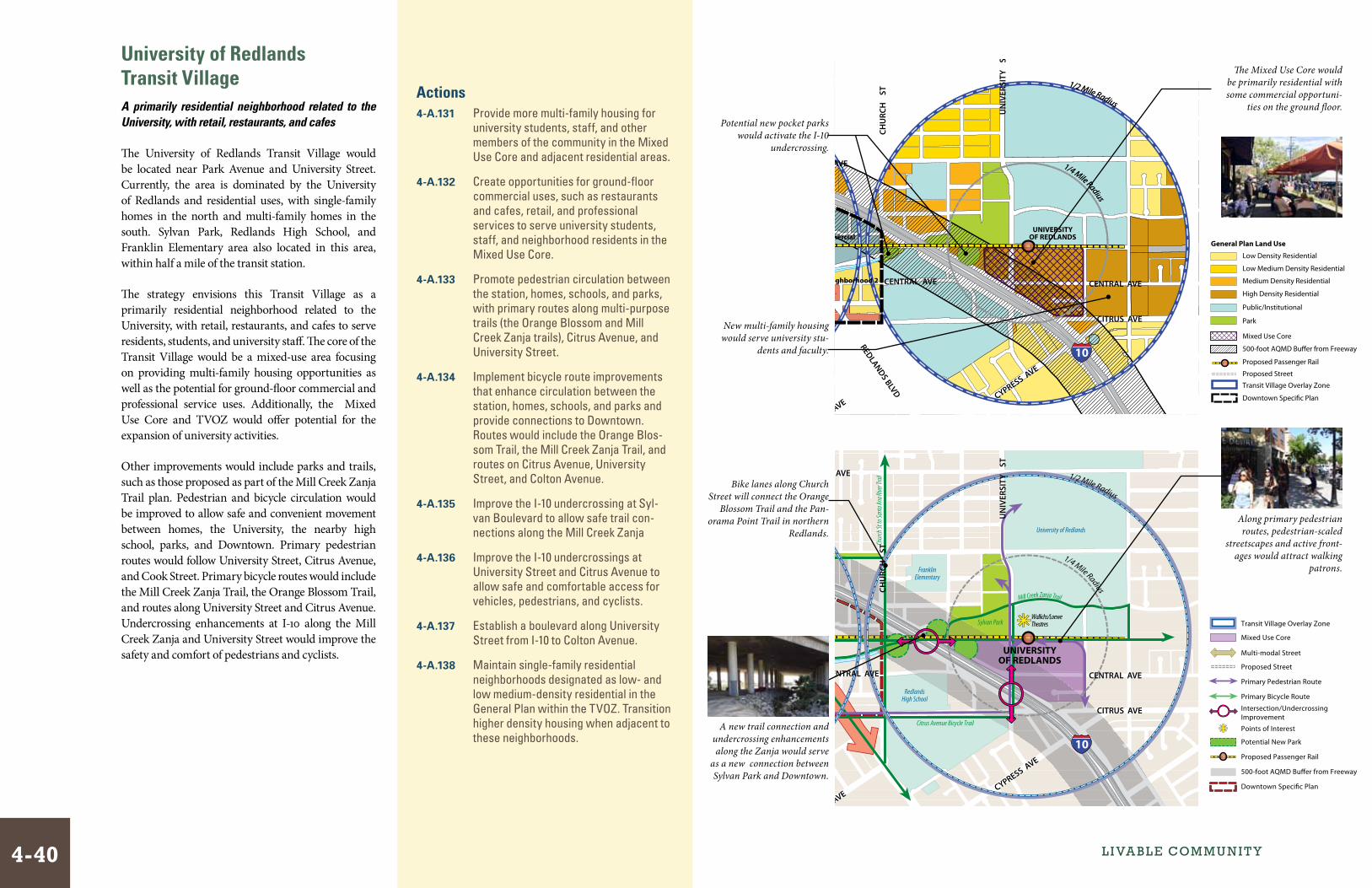
Points of InterestA new trail connection and undercrossing enhancements along the Zanja would serve
as a new connection between Sylvan Park and Downtown.
University of Redlands Transit VillageA primarily residential neighborhood related to the University, with retail, restaurants, and cafes
The University of Redlands Transit Village would be located near Park Avenue and University Street. Currently, the area is dominated by the University of Redlands and residential uses, with single-family homes in the north and multi-family homes in the south. Sylvan Park, Redlands High School, and Franklin Elementary area also located in this area, within half a mile of the transit station.
The strategy envisions this Transit Village as a primarily residential neighborhood related to the University, with retail, restaurants, and cafes to serve residents, students, and university staff. The core of the Transit Village would be a mixed-use area focusing on providing multi-family housing opportunities as well as the potential for ground-floor commercial and professional service uses. Additionally, the Mixed Use Core and TVOZ would offer potential for the expansion of university activities.
Other improvements would include parks and trails, such as those proposed as part of the Mill Creek Zanja Trail plan. Pedestrian and bicycle circulation would be improved to allow safe and convenient movement between homes, the University, the nearby high school, parks, and Downtown. Primary pedestrian routes would follow University Street, Citrus Avenue, and Cook Street. Primary bicycle routes would include the Mill Creek Zanja Trail, the Orange Blossom Trail, and routes along University Street and Citrus Avenue. Undercrossing enhancements at I-10 along the Mill Creek Zanja and University Street would improve the safety and comfort of pedestrians and cyclists.
The Mixed Use Core would be primarily residential with some commercial opportuni-
ties on the ground floor.
Along primary pedestrian routes, pedestrian-scaled
streetscapes and active front-ages would attract walking
patrons.
Potential new pocket parks would activate the I-10
undercrossing.
Bike lanes along Church Street will connect the Orange
Blossom Trail and the Pan-orama Point Trail in northern
Redlands.
New multi-family housing would serve university stu-
dents and faculty.
Actions4-A.131 Provide more multi-family housing for
university students, staff, and other members of the community in the Mixed Use Core and adjacent residential areas.
4-A.132 Create opportunities for ground-floor commercial uses, such as restaurants and cafes, retail, and professional services to serve university students, staff, and neighborhood residents in the Mixed Use Core.
4-A.133 Promote pedestrian circulation between the station, homes, schools, and parks, with primary routes along multi-purpose trails (the Orange Blossom and Mill Creek Zanja trails), Citrus Avenue, and University Street.
4-A.134 Implement bicycle route improvements that enhance circulation between the station, homes, schools, and parks and provide connections to Downtown. Routes would include the Orange Blos-som Trail, the Mill Creek Zanja Trail, and routes on Citrus Avenue, University Street, and Colton Avenue.
4-A.135 Improve the I-10 undercrossing at Syl-van Boulevard to allow safe trail con-nections along the Mill Creek Zanja
4-A.136 Improve the I-10 undercrossings at University Street and Citrus Avenue to allow safe and comfortable access for vehicles, pedestrians, and cyclists.
4-A.137 Establish a boulevard along University Street from I-10 to Colton Avenue.
4-A.138 Maintain single-family residential neighborhoods designated as low- and low medium-density residential in the General Plan within the TVOZ. Transition higher density housing when adjacent to these neighborhoods.
L i va bL e Com m u n i t y4-40